Embed Size (px)
Citation preview

Monroe TownshipBicycle and Pedestrian Planning Study
Roadway Network Development PlanFINAL
Prepared For: The Township of Monroe and The New Jersey Department of Transportation
Prepared by:Michael Baker, Jr., Inc.
March 2010

Monroe Township Bicycle & Pedestrian Planning Study Roadway Network Improvement Guide
i
TABLE OF CONTENTS
I. INTRODUCTION………………………….……………………………………………………………………. 1
II. STUDY AREA………………………………………………………………………………………………………. 2
III. ROADWAY NETWORK RESOURCES…………………………………………………………………….. 4
A. Traffic Volumes………………………………………………………………………………………. 4
B. Bicycle and Pedestrian Crashes…………………………………………….…………………. 6
C. Sidewalk Survey……………………………………………………………………….……………… 9
D. Bicycle Compatibility………………………………………………………………………………. 14
E. Intersections………………………………………….……………………………………….......... 21
IV. IMPLEMENTATION GUIDE………………………………………………………………………………….. 27
A. North Business District Pedestrian Improvements….……………………………. 30
B. Community Center Connections…………………………………………….……………….. 33
C. Texas Road and Matchaponix Road Community Links…………………………… 37
D. Barclay Brook and Brookside Schools Walking Route……………………………. 44
E. Thompson Park Shared Use Path…………………………………………………………….. 48
F. County Route 615, Union Valley Road, Share the Road…………………………… 52
G. County Route 614 Sidewalk Improvements…………………………………………….. 57
V. FUNDING THE IMPROVEMENTS…………………………………………………………………………. 60
A. Funding Sources……………………………………………………………………………………… 60
B. Safe Routes to School…………………………………………………………………………….. 60
VI. MAINTENANCE, EDUCATION AND ENFORCEMENT…………………………………………….. 61
A. Roadway Maintenance…………………………………………………………………………… 61
B. Education………………..…………………………………………………………………………….. 61
C. Enforcement……………..…………………………………………………………………………… 62
VII. CONCLUSIONS……………………………………………………………………………………………….. 63

Monroe Township Bicycle & Pedestrian Planning Study Roadway Network Improvement Guide
ii
FIGURES
Figure 1: Corridors and Areas Investigated
Figure 2: Bicycle and Pedestrian Crash Map
Figures 3 – 8: Sidewalk Survey Results
Figure 9: Bicycle Compatibility Map
Figures 10 – 14: Intersection Inventory and Assessment Results
Figure 15: Proposed Roadway Network Improvements
TABLES
Table 1: Traffic Volumes for Township Roadways
Table 2: Sidewalk Inventory Results
Table 3: Monroe Township Bicycle Compatibility Matrix
Table 4: Bicycle Compatibility Matrix for Additional Identified Roadways
APPENDICES
Appendix A: NJDOT Cost Estimating Spreadsheets
Appendix B: NJDOT “Funding Pedestrian and Bicycle Planning, Programs and Projects”
Appendix C: Transportation Enhancements

Monroe Township Bicycle & Pedestrian Planning Study Roadway Network Improvement Guide
1
I. INTRODUCTION Monroe is a township rich in history, recreation and agriculture. Founded in 1838, the township was named in honor of President James Monroe and for a century remained largely a farming community. As portions of the township grew into more defined neighborhoods, they seceded (e.g., Jamesburg). In the past several decades, residential and retail development has patterned the landscape, and many age-restricted communities and services call Monroe home. According to the 2000 Census, nearly half (44%) of the township’s population was 65 years of age or older.1 Monroe’s transportation network includes major north/south and east/west county roadway corridors, NJ Transit bus and shuttle bus services, a park-and-ride facility and recreational trails. State Route 33 bisects the southern portion of the township, while the NJ Turnpike traverses the township to the west. Monroe does not have designated on-road bicycle facilities and while sidewalk is being constructed adjacent to new development, there are sidewalk network gaps in areas that are active pedestrian zones.
http://mapmaker.rutgers.edu/MIDDLESEX_COUNTY/MonroeMidCoZoning_1968.gif
1 History and demographic data was obtained from the following resources: http://www.monroetwp.com; http://www.city-data.com; and http://www.census.gov/.

Monroe Township Bicycle & Pedestrian Planning Study Roadway Network Improvement Guide
2
This document, The Roadway Network Improvement Guide, accompanies the Trail Network Development Plan and together they serve as a planning, and implementation resource for bicycle and pedestrian opportunities in the township. This document focuses on existing data and conditions as related to the roadway network, and recommends improvements to enhance bicycle and pedestrian mobility and access.
II. STUDY AREA Specific areas of investigation for the roadway network analysis included:
1) Key corridors and roadways with the potential to provide bicycle and pedestrian connections to major generators, attractors and destinations, including schools, commercial developments, recreational areas and parks, and residential developments.
2) Specific intersections, or areas, where pedestrian and bicycle safety and/or mobility were identified as a concern by local officials, through field investigation, and/or through a review of bicycle and pedestrian crash data.
Figure 1 illustrates the corridors, intersections and areas investigated.
Resident reviewing the existing trails map at Public Information Center #1

Monroe Township Bicycle & Pedestrian Planning Study Roadway Network Improvement Guide
3
Figure 1. Corridors and Areas Investigated

Monroe Township Bicycle & Pedestrian Planning Study Roadway Network Improvement Guide
4
III. ROADWAY NETWORK RESOURCES Data collection was performed to obtain existing resources related to bicycle and pedestrian facilities. Data and documents were obtained from Monroe Township, the Central Jersey Transportation Forum, Middlesex County, the North Jersey Transportation Planning Authority (NJTPA) and the State of New Jersey. Traffic volumes, bicycle and pedestrian crash data, GIS data, NJDOT Straight Line Diagrams and available plans and mapping were requested and received. To supplement data from public agencies, an inventory of sidewalk, roadway attributes (for bicycle compatibility) and pedestrian facilities at identified intersections was performed through several field visits. A summary of existing conditions, as identified through the data collection process, is detailed in this section.
A. TRAFFIC VOLUMES Available traffic volumes were collected for roadways in the township. Table 1 lists the collected volumes by roadway.
Table 1. Traffic Volumes for Township Roadways
Roadway Limits AADT (veh./day)
Source Year
Route 619 (Applegarth Rd.) Centre Dr. and
Route 612 (Forsgate Dr.) 10,000
So. Midd. Co. Traffic Study
2001
Route 619
Route 614 (Prospect
Plains Rd.) and
S. Middlesex Ave.
14,000 So. Midd. Co. Traffic Study
2001
Route 619
Blackberry Wy. and
Route 614 (Prospect
Plains Rd.)
12,000 So. Midd. Co. Traffic Study
2001
Route 619 Wycoff Mill Rd. and
Halsey Reed Rd. 9,400 NJDOT 2006
Route 619 Route 33 and Bentley Rd. 5,700 NJDOT 2006
Route 522 (Buckelew Ave.)
Ralston Wy. and
Route 614 (Mounts Mill
Rd.)
6,400 NJDOT 2006

Monroe Township Bicycle & Pedestrian Planning Study Roadway Network Improvement Guide
5
Roadway Limits AADT (veh./day)
Source Year
Butcher Rd. Route 33 and
Disbrow Rd. 4,400 NJDOT 2006
Cranbury Rd. Route 522 (Buckelew Rd.)
and Docks Corner Rd. 13,600 NJDOT 2006
Route 612 Half Acre Rd. and
Centre Dr. 15,000
So. Midd. Co. Traffic Study
2001
Route 612 Rossmoor Dr. and
Monroe Twp. boundary 20,000
So. Midd. Co. Traffic Study
2001
Jamesburg-Englishtown Rd. School House Rd. and
Spotswood Rd. 8,200 NJDOT 2008
Route 619 (Possum Hollow Rd.)
Route 612 and
the railroad tracks 3,200
So. Midd. Co. Traffic Study
2001
Mount Rd. England Rd. and
Route 619 400 NJDOT 2005
Perrineville Rd. Route 33 and
Mills Rd. 10,400 NJDOT 2005
Prospect Plains Rd. Route 619 and
Engelghard Rd. 13,100 NJDOT 2008
Route 33 Bentley Rd. and
Perrineville Rd. 30,600 NJDOT 2005
Route 33 Route 619 and
Bentley Rd. 26,400 NJDOT 2006
Route 33 Mercer County boundary
and Route 619 27,900 NJDOT 2007
Route 613 (Spotswood-Englishtown Rd.)
Old Texas Rd. and
Cornell Ave. 8,900 NJDOT 2006

Monroe Township Bicycle & Pedestrian Planning Study Roadway Network Improvement Guide
6
B. BICYCLE AND PEDESTRIAN CRASHES Bicycle and pedestrian crash reports were requested from the NJDOT – Bureau of Safety Programs (BSP) and the Monroe Township Police Department for the most recent three (3) years available (2006, 2007 and 2008). The reports were requested to determine the crash history of bicyclists and pedestrians on the township’s roadway network.
There were eleven (11) reported crashes involving bicyclists or pedestrians between 2006 and 2008. Six (6) crashes involved bicyclists and five (5) crashes involved pedestrians. Reported crashes are illustrated in Figure 2.
1. October 01, 2007 (4:19pm) – A crash involving a pedestrian and vehicle occurred on Lower Matchaponix Road approximately a 1/2 mile south of Spotswood-Gravel Hill Road. The pedestrian wandered into the roadway and was struck by a vehicle traveling east on Lower Matchaponix Road. The pedestrian was a 1-year old and the crash resulted in a pedestrian fatality.
2. February 13, 2008 (7:09am) – A crash involving a pedestrian and a vehicle occurred on Tyndale Avenue approximately 0.2 miles east of Monmouth Road. A pedestrian was walking east along the westbound shoulder of Tyndale Road and was struck by a vehicle traveling westbound, which immediately left the scene. The pedestrian was 40-years old and suffered minor injuries.
3. June 6, 2008 (9:33pm) – A crash involving a bicycle and vehicle occurred on Route 527 (Englishtown Road) 100’ feet south of Union Valley Road. The bicyclist was traveling south on the roadway and was struck by a vehicle traveling in the same direction, and which immediately left the scene. The bicyclist, who was 24-years old, was severely injured from the crash.
4. July 9, 2008 (10:23pm) – A crash involving a pedestrian and a vehicle occurred on Tyndale Avenue approximately a 25’ east of Route 613 (Spotswood-Englishtown Road). A pedestrian exited a vehicle and was struck by the door of the vehicle as it pulled away. The pedestrian was 19-years old and suffered minor injuries.
5. July 24, 2008 (11:55am) – A crash involving a bicycle and vehicle occurred at the intersection of First Avenue and Route 613. The crash occurred when the vehicle attempted to make a left turn from Route 613 onto First Avenue and then struck the bicyclist who was traveling northbound on Route 613. The bicyclist was 25-years old and suffered minor injuries.
6. August 23, 2008 (11:02pm) – A crash involving a pedestrian and two (2) vehicles occurred on Hoffman Station Road approximately a 0.15 miles west of Route 522 (Buckelew Avenue). A vehicle stopped in the eastbound lane of travel on Hoffman Station Road to pick up a passenger and was struck by another vehicle traveling eastbound. The pedestrian was then struck by the vehicle stopped in the travel lane. The pedestrian was 24-years old and suffered minor injuries.
7. September 29, 2008 (6:28pm) – A crash involving a bicycle and vehicle occurred at the intersection of Taylor Avenue and Route 613. The vehicle was attempting to make a right

Monroe Township Bicycle & Pedestrian Planning Study Roadway Network Improvement Guide
7
turn from Route 613 onto Taylor Avenue, and failed to yield, striking the bicyclist who was traveling northbound on Route 613. The bicyclist was 37-years old and suffered minor injuries.
8. September 10, 2008 (10:46am) – A crash involving a bicycle and vehicle occurred on Route 619 (Applegarth Road) approximately 1/4 mile south of Lilac Road. The bicyclist was traveling north on Route 619 and was struck by a vehicle traveling in the same direction, which immediately left the scene. The bicyclist was 43-years old and suffered moderate injuries.
9. October 03, 2008 (11:25am) – A crash involving a pedestrian and vehicle occurred at the intersection of Route 619 and Cranbury-Half Acre Road. The pedestrian was crossing the intersection with a green light, when a vehicle attempted to turn right onto Route 619 and struck the pedestrian. The age of the pedestrian was not noted and the pedestrian suffered minor injuries as a result of the crash.
10. October 12, 2008 (5:21pm) – A crash involving a bicycle and vehicle occurred on Route 619 approximately a 1/4 mile south of Old Church Road. The bicyclist was traveling north on Route 619 and was struck by the side view mirror of a vehicle traveling in the same direction. The bicyclist was 46-years old and suffered moderate injuries.
11. December 14, 2008 (8:07am) – A crash involving a bicycle and a vehicle occurred at the intersection of Perrineville Road and Federal Road. The bicyclist and vehicle entered the intersection at the same time, and the bicycle struck the vehicle causing the crash. The bicyclist was 56-years old and suffered moderate injuries.

Monroe Township Bicycle & Pedestrian Planning Study Roadway Network Improvement Guide
8
Figure 2. Bicycle and Pedestrian Crash Map

Monroe Township Bicycle & Pedestrian Planning Study Roadway Network Improvement Guide
9
C. SIDEWALK SURVEY The presence and condition of sidewalks were inventoried within a ¼ mile of identified trip generators and attractors to determine where sidewalk network improvements may be needed to enhance pedestrian access and mobility. Additionally, NJDOT County Sidewalk Inventory data was utilized to identify the presence and condition of sidewalk on county routes in the township.
Sidewalk conditions were rated based on the following criteria:
Excellent Condition: Well maintained or new sidewalk with no cracks, overgrowth (encroaching landscape) or obstacles.
Good Condition: Nearly new sidewalk with very little distress.
Fair Condition: Sidewalk with minor cracking, some overgrowth and/or a few obstacles.
Poor Condition: Cracks in several sections with overgrowth and/or trees uprooting the sidewalk several obstacles in the walkway.
Very Poor Condition: Extremely deteriorated sidewalks with severe cracks and/or sections completely covered by dirt, overgrowth or mud.
The sidewalk inventory resulted in six (6) general survey areas. Those areas were:
1. Route 613/ Spotswood-Englishtown Road and Monmouth Road 2. Route 522/Buckelew Avenue 3. Route 612/Forsgate Road and Route 619/Possum Hollow/Applegarth Road 4. Route 619/Applegarth Road and Route 614/Prospect Plains Road 5. Route 614/Prospect Plains Road and Perrineville Road 6. Route 619/Applegarth Road, Route 615/ Union Valley Road and Halsey Reed Road The results of the sidewalk inventory are illustrated below in Figures 3 – 8 and detailed in Table 2.

Monroe Township Bicycle & Pedestrian Planning Study Roadway Network Improvement Guide
10
Figure 3. Route 613 and Monmouth Road Figure 4. Route 522
Figure 5. Route 612 and Route 619 Figure 6. Route 619 and Route 614

Monroe Township Bicycle & Pedestrian Planning Study Roadway Network Improvement Guide
11
Figure 7. Route 614 and Perrineville Figure 8. Route 619, Route 615 and Road Halsey Reed Road

Mon
roe
Tow
nshi
p Bi
cycl
e &
Ped
estr
ian
Plan
ning
Stu
dy
Roa
dway
Net
wor
k Im
prov
emen
t Gui
de
12
Tabl
e 2.
Sid
ewal
k In
vent
ory
Resu
lts
Road
way
Si
de o
f St
reet
D
escr
ipti
on
(dis
tanc
es a
re a
ppro
xim
ate)
A
vg.
Wid
th
Buff
er
Avg
. Co
ndit
ion
Side
wal
k Su
rvey
Are
a
Rout
e 61
3 W
est
Conc
rete
sid
ewal
k ex
tend
s fr
om 3
20’
sout
h of
Rou
te 6
12 t
o Br
andy
Pla
ce
4’
Ye
s, G
rass
Fa
ir
1
Rout
e 61
3 Ea
st
Conc
rete
sid
ewal
k ex
tend
s fr
om 3
30’
sout
h of
Bra
ndy
Plac
e to
350
’ no
rth
of B
rand
y Pl
ace
4’
Ye
s, G
rass
Fa
ir
1
Rout
e 61
3 W
est
A m
ixtu
re a
spha
lt p
aved
and
con
cret
e si
dew
alk
exte
nds
from
Cam
elot
Dri
ve t
o M
orto
n Av
enue
4’
Yes,
Gra
ss
Fair
(P
oor
sect
ion
betw
een
Corn
ell A
ve.
and
10th
Ave
.)
1
Rout
e 61
3 Ea
st
Conc
rete
sid
ewal
k ex
tend
s fr
om L
ori S
tree
t to
Fir
st A
venu
e 4’
Ye
s, G
rass
Fa
ir
1
Rout
e 61
3 W
est
Conc
rete
sid
ewal
k ex
tend
s fr
om P
ark
Aven
ue t
o M
onm
outh
Roa
d 4’
Ye
s, G
rass
Fa
ir
1
Rout
e 61
3 Ea
st
Conc
rete
sid
ewal
k ex
tend
s fr
om 1
20’
sout
h of
Har
riga
n Av
enue
to
the
mun
icip
al b
orde
r.
4’
Ye
s, G
rass
Fair
(P
oor
sect
ion
betw
een
Eric
kson
Ave
. an
d m
unic
ipal
bo
rder
)
1
Mon
mou
th R
oad
Wes
t Co
ncre
te s
idew
alk
exte
nds
from
Bra
ndy
Plac
e to
230
’ so
uth
of C
orne
ll Av
enue
4’
Yes,
Gra
ss
Fair
1
Mon
mou
th R
oad
East
Co
ncre
te s
idew
alk
exte
nds
from
Bra
ndy
Plac
e to
Rou
te 6
13
4’
Yes,
Gra
ss
Fair
1
Mon
mou
th R
oad
Wes
t Co
ncre
te s
idew
alk
exte
nds
from
350
’ so
uth
of S
heff
ield
Ave
nue
to F
ores
t Pa
rk T
erra
ce
4’
Ye
s, G
rass
Fa
ir
1
Corn
ell A
venu
e Ea
st a
nd W
est
Conc
rete
sid
ewal
k ex
tend
s fr
om R
oute
613
to
Mon
mou
th R
oad
4’
Ye
s, G
rass
Fa
ir
1
10th
Ave
nue
East
and
Wes
t Co
ncre
te s
idew
alk
exte
nds
from
Rou
te 6
13 t
o M
onm
outh
Roa
d
4’
Yes,
Gra
ss
Fair
1
1st
Ave
nue
East
and
Wes
t Co
ncre
te s
idew
alk
exte
nds
from
Rou
te 6
13 t
o M
onm
outh
Roa
d
4’
Yes,
Gra
ss
Fair
1
Rout
e 52
2 W
est
Conc
rete
sid
ewal
k ex
tend
s fr
om B
arcl
ay B
rook
ES
to 1
,120
’ fe
et n
orth
of
Scho
olho
use
Road
5’
Yes,
Gra
ss
Fair
2
Rout
e 52
2 Ea
st a
nd W
est
Conc
rete
sid
ewal
k ex
tend
s fr
om
Rals
ton
Way
and
Mou
nts
Mill
Roa
d 5’
Ye
s, G
rass
Fa
ir
2
Rout
e 52
2 W
est
Side
wal
k ex
tend
s fr
om 2
55’
nort
h of
Sad
dle
Cour
t to
210
0’ s
outh
of
Fox
Hun
t D
rive
5’
Yes,
Gra
ss
Fair
2
Rout
e 52
2 Ea
st
Side
wal
k ex
tend
s fr
om 2
55’
nort
h of
Sad
dle
Cour
t to
Fox
Hun
t D
rive
5’
Yes,
Gra
ss
Fair
2
Mou
nt M
ills
Road
Ea
st
Side
wal
k ex
tend
s fo
r 78
0’ f
rom
Rou
te 5
22
5’
Yes,
Gra
ss
Fair
2
Rout
e 61
2 N
orth
Co
ncre
te s
idew
alk
exte
nds
from
760
’ w
est
of F
awn
Cour
t to
the
mun
icip
al b
orde
r
4’
Yes,
Gra
ss
Fair
3

Mon
roe
Tow
nshi
p Bi
cycl
e &
Ped
estr
ian
Plan
ning
Stu
dy
Roa
dway
Net
wor
k Im
prov
emen
t Gui
de
13
Road
way
Si
de o
f St
reet
D
escr
ipti
on
(dis
tanc
es a
re a
ppro
xim
ate)
A
vg.
Wid
th
Buff
er
Avg
. Co
ndit
ion
Side
wal
k Su
rvey
Are
a
Rout
e 61
9 W
est
Asph
alt
pave
d si
dew
alk
exte
nds
from
the
rai
l lin
e to
Aft
on D
rive
5’
Yes,
Gra
ss
Fair
3
Rout
e 61
9 Ea
st
Asph
alt
pave
d si
dew
alk
exte
nds
from
Aft
on D
rive
to
200’
nor
th o
f Ro
ute
612
5’
Ye
s, G
rass
Fa
ir
3
Rout
e 61
9 Ea
st
Conc
rete
sid
ewal
k ex
tend
s fr
om C
entr
e D
rive
to
Sout
h M
iddl
esex
Ave
nue
4’
Ye
s, G
rass
Fa
ir
3
Rout
e 61
9 W
est
Conc
rete
sid
ewal
k ex
tend
s fr
om 3
00’
nort
h of
the
Hal
f Ac
re R
oad
to 8
00’
sout
h of
Hal
f Ac
re R
oad
5’
Ye
s, G
rass
Fa
ir
4
Hal
f A
cre
Road
Ea
st a
nd W
est
Conc
rete
sid
ewal
k ex
tend
s fo
r 58
0’ f
rom
Rou
te 6
19
5’
Yes,
Gra
ss
Goo
d 4
Rout
e 61
4 N
orth
Co
ncre
te s
idew
alk
exte
nds
from
the
mun
icip
al b
orde
r to
80’
fee
t w
est
of t
he b
orde
r
4’
Yes,
Gra
ss
Fair
4
Rout
e 61
4 So
uth
Conc
rete
sid
ewal
k ex
tend
s 29
0’ f
rom
the
Mon
roe
Tow
n Ce
nter
dri
vew
ay in
to t
he E
ncor
e re
side
ntia
l de
velo
pmen
t 6’
Ye
s, G
rass
Fa
ir
4
Rout
e 61
4 So
uth
Conc
rete
sid
ewal
k ex
tend
s fr
om K
elly
Cou
rt a
nd R
oute
615
/Uni
on V
alle
y-H
alf
Acre
Roa
d.
Ther
e ar
e tw
o (2
) ga
ps i
n th
e si
dew
alk
betw
een
Kell
y Co
urt
and
Ceda
r Br
ook
Road
4’
Ye
s, G
rass
Fa
ir
4
Rout
e 61
4 N
orth
An
asp
halt
pav
ed s
idew
alk
exte
nds
appr
oxim
atel
y 30
0’ w
est
of G
rave
l Hill
Roa
d to
300
’ ea
st o
f Pe
rrin
evill
e Ro
ad.
8’
Yes,
Gra
ss
Goo
d 5
Rout
e 61
4 So
uth
Conc
rete
sid
ewal
k ex
tend
s f
rom
300
’ ea
st o
f Pe
rrin
evill
e Ro
ad t
o W
hitt
ingh
am D
rive
4’
Yes,
Gra
ss
Fair
5
Perr
inev
ille
Road
W
est
Conc
rete
sid
ewal
k ex
tend
s fr
om R
oute
614
to
Scho
olho
use
Road
5’
Yes,
Gra
ss
Fair
5
Perr
inev
ille
Road
Ea
st
Conc
rete
sid
ewal
k ex
tend
s 72
0’ n
orth
of
Rout
e 61
4
5’
Yes,
Gra
ss
Fair
5
Perr
inev
ille
Road
Ea
st
Conc
rete
sid
ewal
k ex
tend
s 45
0’ s
outh
of
Scho
olho
use
Road
5’
Ye
s, G
rass
Fa
ir
5
Perr
inev
ille
Road
an
d Sc
hool
hous
e Ro
ad
(Int
erse
ctio
n)
Conc
rete
sid
ewal
k at
eac
h co
rner
of
the
inte
rsec
tion
, w
ith
a 5’
wid
e co
ncre
te s
idew
alk
exte
ndin
g fr
om t
he in
ters
ecti
on t
o th
e M
onro
e M
unic
ipal
Bui
ldin
g --
- --
- Fa
ir
5
Rout
e 61
9 W
est
Conc
rete
sid
ewal
k ex
tend
s fr
om R
oute
615
to
Oak
Tre
e ES
5’
Yes,
Gra
ss
Fair
6
Rout
e 61
9 Ea
st
Conc
rete
sid
ewal
k ex
tend
s fr
om 1
,050
’ so
uth
of R
oute
615
to
Hal
sey
Reed
Roa
d
5’
Yes,
Gra
ss
Fair
6
Rout
e 61
5 N
orth
Co
ncre
te s
idew
alk
exte
nds
2700
’ fe
et f
rom
mun
icip
al b
orde
r to
5’
Yes,
Gra
ss
Fair
6
Rout
e 61
5 So
uth
Conc
rete
sid
ewal
k ex
tend
s 1,
060’
fee
t ea
st o
f th
e m
unic
ipal
bor
der
to R
oute
619
5’
Yes,
Gra
ss
Fair
6
Rout
e 61
5 So
uth
Conc
rete
sid
ewal
k ex
tend
s 65
0’ f
eet
east
of
to R
oute
619
to
350’
wes
t of
Old
Chu
rch
Road
4’
Yes,
Gra
ss
6

Monroe Township Bicycle & Pedestrian Planning Study Roadway Network Improvement Guide
14
D. BICYCLE COMPATIBILITY Roadways with available traffic volumes were inventoried to determine bicycle compatibility based on NJDOT guidelines.
NJDOT maintains that “bicycle compatible roadway improvements are intended for the shared use of all highway users” and that a “well designed bicycle compatible roadway should reduce accidents and exposure to liability by allowing a safer environment.”2 Roadway pavement widths were inventoried and compared to traffic volumes, the percentage of truck traffic, posted speed, and parking conditions to determine if sufficient width exists for the roadway to be shared by bicycle traffic. The following sections of roadways were inventoried for bicycle compatibility:
Route 619 (Applegarth Rd.) Route 522 (Buckalew Ave.) Butcher Rd. Cranbury Rd. Route 612 (Forgate Drive) Mount Rd. Perrineville Rd. Route 614 (Prospect Plains Rd.) Route 33 Route 613 (Spotswood-Englishtown Rd.)
Data collected for the above listed roadways included posted speed limits, pavement width (lane width and shoulder width), pavement condition, on-street parking, bicycle compatibility of drainage grates, existing bicycle facilities (designated bicycle lanes and/or routes), location of traffic signals, lighting condition, roadway geometry, and potential horizontal and vertical sight distance issues. A matrix was developed to illustrate the compatibility results. The Bicycle Compatibility Matrix for roadways with traffic volumes in Monroe Township is presented in Table 3 and illustrated in Figure 9.
2 Bicycle Compatible Roadways and Bikeways, Planning and Design Guidelines, New Jersey Department of Transportation, page 6, 1996.

Mon
roe
Tow
nshi
p Bi
cycl
e &
Ped
estr
ian
Plan
ning
Stu
dy
Roa
dway
Net
wor
k Im
prov
emen
t Gui
de
15
Tabl
e 3.
Mon
roe
Tow
nshi
p Bi
cycl
e Co
mpa
tibi
lity
Mat
rix
3
Stre
et
From
To
A
AD
T Sp
eed
Lim
it
On
Stre
et
Park
ing
Perm
itte
d
Tota
l Pa
vem
ent
Wid
th
Dir
ecti
on
Lane
N
B//S
B
Shou
lder
Wid
th 4
NB/
/SB
Dir
ecti
on
Lane
EB
//W
B
Shou
lder
Wid
th 4
EB//
WB
Bicy
cle
Com
pati
ble
5, 6
Rout
e 62
5
Rout
e 33
M
ills
Road
10
,400
45
MPH
N
o 25
’ 11
’//1
1’
1.5’
//1.
5’
No
6’ s
houl
der r
equi
red
Rout
e 61
9
Dis
brow
Hill
Roa
d Ro
ute
33
4,40
0 45
MPH
N
o 26
’ 11
’//1
1’
2’//
2’
No
4’ s
houl
der r
equi
red
Rout
e 61
9 W
ycko
ffs
Mill
s Ro
ad
Hal
sey
Reed
Roa
d/
Fede
ral R
oad
9,
400
40 M
PH
No
29’
11.5
’//1
1.5’
3’
//3’
Ye
s
Rout
e 61
9
Hal
sey
Reed
Roa
d/
Fede
ral R
oad
U
nion
Val
ley
Road
/ Cr
anbu
ry S
tatio
n Ro
ad
TBD
45
MPH
N
o 46
’ 12
’//1
2’
0’-1
1’//
0’-1
1’
(NB
shou
lder
end
app
rox.
100
’ so
uth
of U
nion
Val
ley
Road
; SB
shou
lder
end
s at
Oak
Tre
e ES
, th
en e
nds
at a
ppro
x. 2
00’
nort
h of
Fed
eral
Roa
d)
Yes
w
here
6’’+
sho
ulde
rs a
re
mai
ntai
ned
8’ s
houl
der r
ecom
men
ded
Rout
e 61
9
Uni
on V
alle
y Ro
ad/
Cran
bury
Sta
tion
Road
Cran
bury
- H
alf A
cre
Road
TB
D
Not
Pos
ted
Part
ial
26’ –
45’
11
’-13’
//11
’-12’
2’
-9’/
/2’-1
1’
Yes
w
here
6’’+
sho
ulde
rs a
re
mai
ntai
ned
8’ s
houl
der r
ecom
men
ded
Rout
e 61
9 Cr
anbu
ry-
Hal
f Acr
e Ro
ad
Rout
e 61
4 12
,000
40
MPH
N
o 30
’ 12
’//1
2’
3.5’
//2.
5’
(12’
NB
shou
lder
from
P&
R to
M
onro
e To
wn
Cent
er
driv
eway
)
No
8’ s
houl
der r
ecom
men
ded
Rout
e 61
9
Rout
e 61
4/
Pros
pect
Pla
ins
Road
Ro
ssm
oor
Dri
ve
14,0
00
35 –
45
MPH
N
o 50
’ 14
’ Gra
ss M
edia
n (T
otal
= 6
4’)
13’/
12’/
/12’
/13’
0’
//0’
N
o 4’
sho
ulde
r req
uire
d
Rout
e 61
9
Cent
re D
rive
Rout
e 61
2 10
,000
35
MPH
N
o 50
’ 14
’ Gra
ss M
edia
n (T
otal
= 6
4’)
13’/
12’/
/12’
/13’
0’
//0’
N
o 4’
– 6
sho
ulde
r req
uire
d
Rout
e 61
9
Rout
e 61
2
Dea
d En
d/
Railr
oad
Brid
ge
3,20
0 35
MPH
N
o 24
’ 11
’//1
1’
1’//
1’
No
3’ s
houl
der r
equi
red
Rout
e 61
4
Rout
e 61
9 En
gelh
ard
Road
13
,100
45
MPH
N
o 33
’ – 5
0’
13’/
/13’
1’
-18’
//6’
Yes
w
here
6’’+
sho
ulde
rs a
re
mai
ntai
ned
8’ s
houl
der r
ecom
men
ded
3 Com
patib
ility
was
det
erm
ined
bas
ed o
n N
JDO
T G
uide
lines
for B
icyc
le C
ompa
tible
Roa
dway
Pav
emen
t Wid
ths.
4 O
n ro
adw
ays w
ith a
n A
vera
ge A
nnua
l Dai
ly T
raffi
c (A
AD
T) g
reat
er th
an 1
0,00
0, a
sho
ulde
r wid
th o
f 8’
shou
ld b
e pr
ovid
ed w
here
ver p
ossi
ble
5 If p
arki
ng o
ccur
s int
erm
itten
tly th
en b
icyc
lists
cou
ld sh
are
the
road
way
as f
ew c
onfli
cts w
ith v
ehic
les w
ould
pot
entia
lly e
xist
. H
owev
er, i
f par
king
occ
urs f
requ
ently
, the
n th
e lik
elih
ood
for p
oten
tial c
onfli
cts i
ncre
ase
and
shar
ing
the
road
way
s is n
ot re
com
men
ded.
6 If
traf
fic v
olum
e w
as u
nkno
wn,
road
way
was
ass
esse
d un
der C
ondi
tion
III (
AA
DT
over
10,
000)
of t
he N
JDO
T gu
idel
ines

Mon
roe
Tow
nshi
p Bi
cycl
e &
Ped
estr
ian
Plan
ning
Stu
dy
Roa
dway
Net
wor
k Im
prov
emen
t Gui
de
16
Stre
et
From
To
A
AD
T Sp
eed
Lim
it
On
Stre
et
Park
ing
Perm
itte
d
Tota
l Pa
vem
ent
Wid
th
Dir
ecti
on
Lane
N
B//S
B
Shou
lder
Wid
th 4
NB/
/SB
Dir
ecti
on
Lane
EB
//W
B
Shou
lder
Wid
th 4
EB//
WB
Bicy
cle
Com
pati
ble
5, 6
Rout
e 61
2
Ross
moo
r D
rive
Ro
ute
619
20
,000
45
MPH
N
o 63
’ – 7
4’
30’ G
rass
Med
ian
(Tot
al =
93’
-104
’)
12’/
13’/
/13’
/12’
0’
– 1
1’’/
/9’
(2’ i
nsid
e EB
//W
B sh
ould
er)
Yes
w
here
6’’+
sho
ulde
rs a
re
mai
ntai
ned
8’ s
houl
der r
ecom
men
ded
Rout
e 61
2
Cent
re D
rive
Ra
ilroa
d Cr
ossi
ng
15,0
00
40 M
PH
No
50’
16’ G
rass
Med
ian
(Tot
al =
64’
)
12
’/12
’//1
2’/1
2’
1’//
1 (2
’ ins
ide
EB//
WB
shou
lder
)
No
4’ s
houl
der r
equi
red
8’ s
houl
der r
ecom
men
ded
Rout
e 61
2
Railr
oad
Cros
sing
Ro
ute
615
15
,000
40
MPH
N
o 42
’
15
’//1
5’
5’//
5’
Yes
8’ s
houl
der r
ecom
men
ded
Rout
e 61
3 Co
rnel
l Ave
nue
Cam
elot
Ave
nue
8,90
0 45
MPH
Ye
s 42
’ – 4
8’
14’/
/14’
4’
– 1
0’//
10’
Yes
inte
rmitt
ent p
arki
ng
obse
rved
Rout
e 61
3
Cam
elot
Ave
nue
Bran
dy P
lace
8,
900
45 M
PH
No
30’
14’/
/14’
1’
//1’
N
o 4’
sho
ulde
r req
uire
d
Rout
e 61
3
Bran
dy P
lace
Te
xas
Road
8,
900
45 M
PH
Yes
42’ –
48’
14
’//1
4’
4’ –
10’
//10
’
Ye
s in
term
itten
t par
king
ob
serv
ed
Rout
e 52
2
Scho
olho
use
Road
G
rave
l Hill
-Spo
tsw
ood
Road
8,
200
50 M
PH
No
27’
12.5
’//1
2.5’
1’
//1’
N
o 6’
sho
ulde
r req
uire
d
Rout
e 52
2
Rals
ton
Way
M
ount
s M
ills
Road
6,
400
50 M
PH
No
52’
12’/
/12’
14
’//1
4’
Yes
Rout
e 53
5
Doc
ks C
orne
r Ro
ad
Rout
e 52
2 13
,600
50
MPH
N
o 36
’ 12
’//1
2’
3’//
3’
No
4’ s
houl
der r
equi
red
8’ s
houl
der r
ecom
men
ded
Mou
nt R
oad
Engl
and
Road
O
ld C
hurc
h Ro
ad
400
Not
Pos
ted
No
20’
10’/
/10’
0’
//0’
Ye
s
Rout
e 33
To
wns
hip
Boun
dary
Pe
rrin
evill
e Ro
ad
25,0
00 –
30
,000
55
MPH
N
o 70
’ 32
’ Gra
ss M
edia
n (T
otal
= 1
02’)
12’/
12’/
/12’
/12’
10
’//1
2’
Yes

Monroe Township Bicycle & Pedestrian Planning Study Roadway Network Improvement Guide
17
Figure 9. Bicycle Compatibility Map
Bicycle Compatibility Assessment Locations

Monroe Township Bicycle & Pedestrian Planning Study Roadway Network Improvement Guide
18
Additional roadways without available traffic volumes were inventoried based on the on-road trail recommendations from the Monroe Township Proposed Trails plan and input from township officials and stakeholders. Since volumes were not available for these roadways, they were assessed under Condition III (AADT over 10,000) under NJDOT guidelines for bicycle compatible roadways.
The Bicycle Compatibility Matrix for these roadways in Monroe Township is presented in Table 4.
Bicyclists on Halsey Reed Road

Mon
roe
Tow
nshi
p Bi
cycl
e &
Ped
estr
ian
Plan
ning
Stu
dy
Roa
dway
Net
wor
k Im
prov
emen
t Gui
de
19
Tabl
e 4.
Bic
ycle
Com
pati
bilit
y M
atri
x 7 fo
r A
ddit
iona
l Ide
ntifi
ed R
oadw
ays
Stre
et
From
To
A
AD
T Sp
eed
Lim
it
On
Stre
et
Park
ing
Perm
itte
d
Tota
l Pa
vem
ent
Wid
th
Dir
ecti
on
Lane
N
B//S
B
Shou
lder
Wid
th 4
NB/
/SB
Dir
ecti
on
Lane
EB
//W
B
Shou
lder
Wid
th 8
EB//
WB
Bicy
cle
Com
pati
ble
9, 1
0
Mat
chap
onix
Roa
d Ro
ute
613
Texa
s Ro
ad
Not
A
vaila
ble
35 M
PH
No
40’
17’/
/17’
0’
//6’
N
o 4’
sho
ulde
r req
uire
d
Texa
s Ro
ad
Tow
nshi
p Bo
unda
ry
Rive
r Ro
ad
Not
A
vaila
ble
35 M
PH
No
40’
12’/
/12’
8’
//8’
Ye
s
Texa
s Ro
ad
Rive
r Ro
ad
App
rox.
300
’ wes
t of
Rive
r Ro
ad
Not
A
vaila
ble
35 M
PH
No
36’
18’/
/14’
0’
//2’
N
o 4’
sho
ulde
r req
uire
d
Texa
s Ro
ad
App
rox.
300
’ wes
t of
Rive
r Ro
ad
Mat
chap
onix
Roa
d N
ot
Ava
ilabl
e 35
MPH
N
o 40
’
24
’//1
6’
0’//
0’
No
4’ s
houl
der r
equi
red
Hal
sey
Reed
Roa
d Ro
ute
619
Wyc
koff
s M
ill R
oad
Not
A
vaila
ble
40 M
PH
No
26’ -
40’
12
’//1
2’
1’-
8’//
1’ -8
’ (S
houl
der
redu
ced
appr
ox. 3
00’ w
est o
f Ro
ute
619)
Yes
whe
re 4
”+ s
houl
ders
are
m
aint
aine
d
Hal
sey
Reed
Roa
d/
Ely
Dri
ve
Wyc
koff
s M
ill R
oad
Rout
e 61
5 N
ot
Ava
ilabl
e N
ot P
oste
d N
o 24
’ 10
.5’/
/10.
5’
1.5’
-8’/
/1.5
’ (R
oadw
ay e
nds
in a
re
side
ntia
l dev
elop
men
t w
ith 1
6’ tr
avel
lane
s an
d no
sho
ulde
rs)
Yes
whe
re 4
’+ s
houl
ders
are
m
aint
aine
d no
rthb
ound
Rout
e 61
5 El
y D
rive
Ro
ute
619
Not
A
vaila
ble
50 M
PH
No
34’ -
52’
12
’- 13
’//1
2’ -
13’
4’ -
13’/
/6’ -
13’
Ye
s
whe
re 6
’’+ s
houl
ders
are
m
aint
aine
d
Rout
e 61
5 Ro
ute
619
Uni
on V
alle
y Ro
ad
Not
A
vaila
ble
50 M
PH
No
37’ -
44’
11
-12’
//12
’ 1’
-13’
//1’
-8’
(sho
ulde
r w
idth
s va
ry)
Yes
w
here
6’’+
sho
ulde
rs a
re
mai
ntai
ned
Rout
e 61
5 U
nion
Val
ley
Road
Ro
ute
614
Not
A
vaila
ble
50 M
PH
Yes
44’ -
50’
14
’//1
4’
8’-1
1’//
8’-1
1’
(Sho
ulde
rs e
nd a
ppro
x.
200’
sou
th o
f Rou
te
614)
Yes
Rout
e 61
5 Ro
ute
614
Mun
icip
al B
orde
r N
ot
Ava
ilabl
e 50
MPH
Ye
s 40
’ – 5
4’
14’/
/14’
6’-2
0’’/
/6’
(Sho
ulde
rs s
tart
s ap
prox
. 100
’ nor
th o
f Ro
ute
614)
Yes
7 Com
patib
ility
was
det
erm
ined
bas
ed o
n N
JDO
T G
uide
lines
for B
icyc
le C
ompa
tible
Roa
dway
Pav
emen
t Wid
ths.
8 O
n ro
adw
ays w
ith a
n A
vera
ge A
nnua
l Dai
ly T
raffi
c (A
AD
T) g
reat
er th
an 1
0,00
0, a
sho
ulde
r wid
th o
f 8’
shou
ld b
e pr
ovid
ed w
here
ver p
ossi
ble
9 If p
arki
ng o
ccur
s int
erm
itten
tly th
en b
icyc
lists
cou
ld sh
are
the
road
way
as f
ew c
onfli
cts w
ith v
ehic
les w
ould
pot
entia
lly e
xist
. H
owev
er, i
f par
king
occ
urs f
requ
ently
, the
n th
e lik
elih
ood
for p
oten
tial c
onfli
cts i
ncre
ase
and
shar
ing
the
road
way
s is n
ot re
com
men
ded.
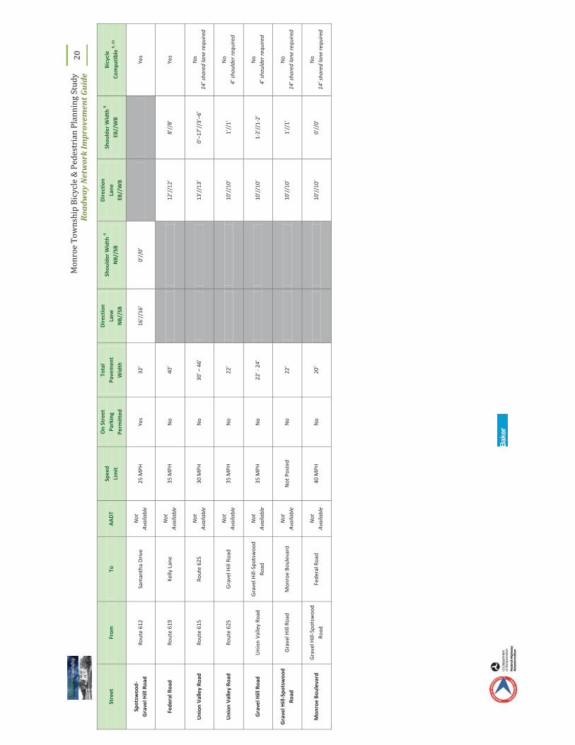
10
If tr
affic
vol
ume
was
unk
now
n, ro
adw
ay w
as a
sses
sed
unde
r Con
ditio
n II
I (A
AD
T ov
er 1
0,00
0) o
f the
NJD
OT
guid
elin
es
Mon
roe
Tow
nshi
p Bi
cycl
e &
Ped
estr
ian
Plan
ning
Stu
dy
Roa
dway
Net
wor
k Im
prov
emen
t Gui
de
20
Stre
et
From
To
A
AD
T Sp
eed
Lim
it
On
Stre
et
Park
ing
Perm
itte
d
Tota
l Pa
vem
ent
Wid
th
Dir
ecti
on
Lane
N
B//S
B
Shou
lder
Wid
th 4
NB/
/SB
Dir
ecti
on
Lane
EB
//W
B
Shou
lder
Wid
th 8
EB//
WB
Bicy
cle
Com
pati
ble
9, 1
0
Spot
swoo
d-
Gra
vel H
ill R
oad
Rout
e 61
2 Sa
man
tha
Dri
ve
Not
A
vaila
ble
25 M
PH
Yes
32’
16’/
/16’
0’
//0’
Ye
s
Fede
ral R
oad
Rout
e 61
9 Ke
lly L
ane
Not
A
vaila
ble
35 M
PH
No
40’
12’/
/12’
8’
//8’
Ye
s
Uni
on V
alle
y Ro
ad
Rout
e 61
5 Ro
ute
625
Not
A
vaila
ble
30 M
PH
No
30’ –
46’
13
’//1
3’
0’–1
7’//
3’–6
’ N
o 14
’ sha
red
lane
requ
ired
Uni
on V
alle
y Ro
ad
Rout
e 62
5 G
rave
l Hill
Roa
d N
ot
Ava
ilabl
e 35
MPH
N
o 22
’
10
’//1
0’
1’//
1’
No
4’ s
houl
der r
equi
red
Gra
vel H
ill R
oad
Uni
on V
alle
y Ro
ad
Gra
vel H
ill-S
pots
woo
d Ro
ad
Not
A
vaila
ble
35 M
PH
No
22’ -
24’
10
’//1
0’
1-2’
//1-
2’
No
4’ s
houl
der r
equi
red
Gra
vel H
ill-S
pots
woo
d Ro
ad
Gra
vel H
ill R
oad
Mon
roe
Boul
evar
d N
ot
Ava
ilabl
e N
ot P
oste
d N
o 22
’
10
’//1
0’
1’//
1’
No
14’ s
hare
d la
ne re
quire
d
Mon
roe
Boul
evar
d G
rave
l Hill
-Spo
tsw
ood
Road
Fe
dera
l Roa
d N
ot
Ava
ilabl
e 40
MPH
N
o 20
’
10
’//1
0’
0’//
0’
No
14’ s
hare
d la
ne re
quire
d

Monroe Township Bicycle & Pedestrian Planning Study Roadway Network Improvement Guide
21
E. INTERSECTIONS Five (5) intersections were identified by Monroe Township local officials for inventory and assessment. These intersections included:
Route 613 (Spotswood-Englishtown Road), Monmouth Road and Erickson Avenue
Route 613 and Texas Road
Route 613 and Matchaponix Avenue
Route 522 (Buckelew Avenue) and Schoolhouse Road
Route 619 (Applegarth Road) and Route 614 (Prospect Plains Road)
NJDOT Pedestrian Compatible Planning and Design Guidelines state that “there are 32 possible vehicle to pedestrian conflicts at the 4-way intersection of two roads.”11 At signalized intersections, vehicle turning movements account for many of these potential conflicts. Monroe intersections were inventoried for the presence and condition of pedestrian facilities, including curb ramps, crosswalks, warning signage, and, if signalized, pedestrian signals and push buttons. Potential conflicts with turning vehicles, and through movements at unsignalized intersections, were observed during field inventory and noted for future development of conceptual improvements. The results of the inventory are detailed in Figures 10 through 14.
11 Pedestrian Compatible Planning and Design Guidelines, New Jersey Department of Transportation, page 28, 1997.

Monroe Township Bicycle & Pedestrian Planning Study Roadway Network Improvement Guide
22
Figure 10. Route 613, Monmouth Road and Erickson Avenue
Intersection Control: Free flow movements on Route 613 Stop Control on Erickson Avenue and Monmouth Road
Crosswalks: One (1) standard striped crosswalk across Monmouth Road
Curb Ramps: Two (2) curb ramps for crosswalk across Monmouth Road
Warning Signs: No existing warning signs
Pedestrian Signals or Push Buttons:
No existing pedestrian signals or push buttons
Observations: Vehicles waiting to turn from Monmouth Road onto Route 613 block the crosswalk.
Multiple rolling stops were observed at stop sign on Monmouth Road
Pedestrians observed crossing Monmouth Road at Cooper Avenue.

Monroe Township Bicycle & Pedestrian Planning Study Roadway Network Improvement Guide
23
Figure 11. Route 613 and Texas Road
Intersection Control: Signalized Intersection
Crosswalks: One (1) standard striped crosswalk across Texas Road
Curb Ramps: Two (2) curb ramps for crosswalk across Texas Road
Warning Signs: No existing warning signs
Pedestrian Signals or Push Buttons:
No existing pedestrian signals or push buttons
Observations:
Crosswalk striping faded on Texas Road No crosswalks to facilitate movements between
existing partial sidewalk on northbound and southbound Route 613

Monroe Township Bicycle & Pedestrian Planning Study Roadway Network Improvement Guide
24
Figure 12. Route 613 and Matchaponix Avenue
Intersection Control: Signalized intersection
Crosswalks: Standard striped crosswalks across all four (4) intersection approaches
Curb Ramps: Two (2) recessed curbs on southern approach. No curb ramps on the northern approach.
Warning Signs: No existing warning signs
Pedestrian Signals or Push Buttons:
Pedestrian signal heads and push buttons with walk/don’t walk symbols are provided for all approaches.
Observations: No pedestrian activity was observed during site visits

Monroe Township Bicycle & Pedestrian Planning Study Roadway Network Improvement Guide
25
Figure 13. Route 522 and Schoolhouse Road
Intersection Control: Signalized intersection
Crosswalks: Standard striped crosswalks across all four (4) intersection approaches.
Curb Ramps: Curb ramps are provided on all corners to facilitate movements to the crosswalks.
Warning Signs: No existing warning signs
Pedestrian Signals or Push Buttons:
Pedestrian signal heads with walk/don’t walk text are provided for all approaches.
Pedestrian push buttons are provided for all approaches.
Notes: Crosswalk striping is faded. Existing sidewalk only at the corners of the intersection.

Monroe Township Bicycle & Pedestrian Planning Study Roadway Network Improvement Guide
26
Figure 14. Route 619 and Route 614
Intersection Control: Signalized intersection
Crosswalks: Standard striped crosswalks across all four (4) intersection approaches
Curb Ramps: No existing curb ramps
Warning Signs: No existing warning signs
Pedestrian Signals or Push Buttons:
No existing pedestrian signals Pedestrian push buttons provided on western approach
of Route 614. Notes: A concentration of pedestrian travel was observed at
the intersection, and mid-block to the east of the intersection.
No existing sidewalk at the intersection or connecting to adjacent commercial centers and residential development.

Monroe Township Bicycle & Pedestrian Planning Study Roadway Network Improvement Guide
27
IV. IMPLEMENTATION GUIDE Recommendations to upgrade and enhance bicycle and pedestrian facilities in Monroe were determined based on findings from data collection, site evaluations, crash analysis and public outreach. Although this guide identifies only seven (7) recommended improvement areas, there are other locations in Monroe Township that could benefit from the installation of bicycle and pedestrian facilities.
1) North Business District Pedestrian Improvements (sidewalk installation and intersection improvements on County Route 613/Spotswood-Englishtown Road)
2) Community Center Connections (Veteran’s Park to Community Center Bicycle Route and sidewalk installation on Monmouth Road)
3) Texas and Matchaponix Community Links (Matchaponix Share the Road and sidewalk installation on County Route 613/Spotswood-Englishtown Road)
4) Barclay Brook and Brookside Schools Walking Route (County Route 522, Buckelew Avenue and Schoolhouse Road intersection improvements, and sidewalk installation on County Route 522)
5) Thompson Park Shared Use Path
6) County Route 615, Union Valley Road Share the Road
7) County Route 614 Sidewalk Installation
Worksheets were created to detail existing conditions, recommended improvements, potential constraints, time to implement and order-of-magnitude cost (preliminary cost estimating spreadsheets are included in Appendix A). One (1) of the recommended improvements will require additional planning, preliminary design, and final design prior to construction (e.g., Thompson Park Shared Use Path). However, the balance of recommended roadway improvements will not require additional planning or design and could potentially be constructed as funding becomes available. Proposed improvements to the roadway network
Intersection of County Route 614, Prospect Plains Road and County Route 619,

Monroe Township Bicycle & Pedestrian Planning Study Roadway Network Improvement Guide
28
are illustrated on Figure 15. Other locations that could benefit from the installation of bicycle and pedestrian facilities, most notably trail network connections, are detailed in the Trail Network Development Plan.
Recommended improvements identified in this guide were developed in accordance with NJDOT guidelines for bicycle and pedestrian facilities (Bicycle Compatible Roadways and Bikeways, Planning and Design Guidelines and Pedestrian Compatible Planning and Design Guidelines), American Association of State Highway and Transportation Officials (AASHTO) guidelines (Guide for the Planning, Design, and Operations of Pedestrian Facilities and Guide for the Development of Bicycle Facilities), and the Federal Highway Administration (FHWA) Manual on Uniform Traffic Control Devices (MUTCD), including 2009 revisions and 2010 proposed amendments .

Monroe Township Bicycle & Pedestrian Planning Study Roadway Network Improvement Guide
29
Figure 15. Proposed Roadway Network Improvements

Monroe Township Bicycle & Pedestrian Planning Study Roadway Network Improvement Guide
30
A. NORTH BUSINESS DISTRICT PEDESTRIAN IMPROVEMENTS
Existing School Crossing location at Route 613 and Clayton Avenue
Existing School Crossing location at Route 613 and Monmouth Road
1. Existing Condition Summary Speed Limit: 45 mph AADT: 8,900 Sidewalk: Intermittent Land Use: Concentrated retail on Route 613
Residential side streets School
Deficiencies: Sidewalk network gaps with observed pedestrian activity Faded or missing crosswalks at school crossing locations
Opportunities Provide children with a continuous walking route to school Improved access and mobility for pedestrians in business district Enhanced pedestrian crossing accommodations

Monroe Township Bicycle & Pedestrian Planning Study Roadway Network Improvement Guide
31
2. Recommended Improvements
i) Install 225’ of sidewalk on northbound Route 613 between Morton Avenue and Park Avenue.
ii) Install 120’ of sidewalk on southbound Route 613 between Brunswick Avenue and Harrison Avenue.
iii) Install 135’ of sidewalk on southbound Route 613 between Harrison Avenue and Clayton Avenue.
iv) Install 70’ of sidewalk on southbound Route 613 between Clayton Avenue and Sherman Avenue
v) Install 500’ of sidewalk on southern side of Clayton Avenue between Route 613 and Woodland Elementary School.
vi) Install longitudinal striped crosswalks, ADA-compliant curb ramps and school crossing warning signage at designated school crossing location at Clayton Avenue and Route 613. As part of improvement, consider supplemental flashing beacons that would be automated during school hours.
vii) Install longitudinal striped crosswalks, ADA-compliant curb ramps and school crossing warning signage at designated school crossing location at Monmouth Road and Route 613.
North Business District Pedestrian Improvements

Monroe Township Bicycle & Pedestrian Planning Study Roadway Network Improvement Guide
32
3. Potential Constraints
Impacts to right-of-way, traffic, utilities, drainage and the environment are not anticipated for the sections of Route 613 where new sidewalk is proposed. Clayton Avenue has a right-of-way of 40’ and sidewalk installation could potentially impact on-street parking if two (2) travel lanes are maintained and a 5’ sidewalk with 3’ buffer is constructed.
Coordination with Middlesex County is needed during the design phase of the sidewalk and crosswalk improvements as the roadway is within the county’s jurisdiction. Since the sidewalk improvements may increase impervious cover, the improvement will need to be evaluated for compliance with New Jersey Department of Environmental Protection (NJDEP) Stormwater Management rules (NJAC 7:8), NJDEP Flood Hazard Area Control Act rules (NJAC 7:13) and NJDEP Freshwater Wetlands rules (NJAC 7:7A). Development of a Stormwater Management Plan and permit review should be considered in the project schedule.
4. Time to Implement
The potential time to implement the improvements is estimated to be mid-term (signing and striping with regards to intersection improvements are short-term, while sidewalk installation will require preliminary and final design prior to construction).
5. Order of Magnitude Cost = $300,000

Monroe Township Bicycle & Pedestrian Planning Study Roadway Network Improvement Guide
33
B. COMMUNITY CENTER CONNECTIONS
Existing sidewalk on the western side
of Monmouth Road south of the Community Center Existing conditions on Lori Street, west of Route 613
1. Existing Condition Summary Speed Limit: 25 MPH on Monmouth Road, Cornell Avenue, Lori Street, Carnegie
Street, Samantha Drive, Dynasty Drive and Avenue K, 45 MPH on Route 613 south of Cornell Avenue 35 MPH on Route 613 north of Cornell Avenue
AADT: Varies Sidewalk: Continuous Land Use: Residential
Civic – Community Center Institutional – Elementary School
Deficiencies: Sidewalk gap with observed pedestrian activity
Missing pedestrian and bicycle crossing accommodations at Cornell Avenue
Opportunities Provide children with a continuous walking route to school Enhanced pedestrian and bicycle crossing accommodations
Sidewalk network connection to civic use
A bicycle route and directional signage to connect between civic use and open space (Veteran’s Park), approximately 2.65 miles

Monroe Township Bicycle & Pedestrian Planning Study Roadway Network Improvement Guide
34
2. Recommended Improvements
i) Install 900’ of sidewalk on northbound Monmouth Road between Cornell Avenue and the Community Center.
ii) Install 1,230’ of sidewalk on northbound Route 613 between Morton Avenue and Park Avenue.
iii) Install 770’ of sidewalk on southbound Route 613 between Brunswick Avenue and Harrison Avenue.
iv) Install bicycle route signage with destination (e.g., Veteran’s Park) and distance information (mileage to destination) between the Community Center and Veteran’s Park. Proposed route includes Monmouth Road, Cornell Avenue, Lori Street, Carnegie Street, Samantha Drive, Dynasty Drive and Avenue K. Route signage is recommended every 1,000’ eastbound and westbound.
v) Install longitudinal striped crosswalks, curb ramps and pedestrian crossing warning signs for crossing location at Route 613 north of Lori Street.
vi) Widen existing 6’ wide, 600’ long sidewalk between Lori Street and Carnegie Street to 8’ for shared use by bicyclists and pedestrians.
vii) Install 8’ wide, 450’ long shared use path between Samantha Drive and Dynasty Drive.
Community Center Connections – Improvement Overview Map

Monroe Township Bicycle & Pedestrian Planning Study Roadway Network Improvement Guide
35
Community Center Connections – Bicycle Route Improvements Detail
Community Center Connections – Existing Conditions at Lori Street and Route 613

Monroe Township Bicycle & Pedestrian Planning Study Roadway Network Improvement Guide
36
3. Potential Constraints
Impacts to right-of-way, traffic, and the environment are not anticipated for the section of Monmouth Road where new sidewalk is proposed, on the sections of Route 613 where sidewalk is proposed and at the crossing locations where the crosswalk improvements are proposed. Additionally, impacts are not anticipated for installation of bicycle route signage and related improvements between Lori Street and Carnegie Street and between Samantha Drive and Dynasty Drive.
Coordination with Middlesex County is needed during the design phase of the crosswalk improvements and sidewalk improvements on Route 613 as the roadway is within the county’s jurisdiction.
4. Time to Implement
The potential time to implement the improvements is estimated to be mid-term (signing and striping with regards to intersection improvements are short-term, while sidewalk installation will require preliminary and final design prior to construction).
5. Order of Magnitude Cost = $800,000

Monroe Township Bicycle & Pedestrian Planning Study Roadway Network Improvement Guide
37
C. TEXAS ROAD AND MATCHAPONIX ROAD COMMUNITY LINKS
Intersection of Route 613 and Matchaponix Road Texas Road, between River Road
and Matchaponix Road
1. Existing Condition Summary Speed Limit: 45 MPH on Route 613
35 MPH on Matchaponix Avenue and on Texas Road
AADT: --- Sidewalk: Intermittent Land Use: Residential
Commercial
Deficiencies: Lack of on-road bicycle facility connections
Missing pedestrian accommodations signalized intersection
Opportunities On-road bicycle facility to connect to proposed trail network and Community Center
Enhanced pedestrian crossing accommodations
Enhanced pedestrian access to connect to proposed trail network

Monroe Township Bicycle & Pedestrian Planning Study Roadway Network Improvement Guide
38
2. Recommended Improvements
i) Restripe Texas Road between the township boundary and Matchaponix Avenue to have two (2) 12’ travel lanes and two 6’ – 8’ paved shoulders. Install ‘Share the Road’ bicycle signage along the restriped section of roadway.
ii) Restripe Matchaponix Avenue between the Texas Road and Route 613 to have two (2) 12’ travel lanes and two 8’ paved shoulders. Install ‘Share the Road’ bicycle signage along the restriped section of roadway.
iii) Install pedestrian countdown signal heads, longitudinal striped crosswalks and ADA-compliant curb ramps for pedestrian movements at the intersection of Route 613 and Matchaponix Avenue.
iv) Install pedestrian countdown signal heads, longitudinal striped crosswalks and ADA-compliant curb ramps for pedestrian movements at the intersection of Route 613 and Texas Avenue.
v) Install longitudinal striped crosswalks and ADA-compliant curb ramps for pedestrian movements across Matchaponix Road and the southern approach of Centennial Court at the intersection of Texas Road and River Road/ Centennial Court.
Texas Road and Matchaponix Road Community Links – Improvement Overview Map

Monroe Township Bicycle & Pedestrian Planning Study Roadway Network Improvement Guide
39
Texas Road and Matchaponix Road Community Links – Matchaponix Road ‘Share the Road’ Improvements
Texas Road and Matchaponix Road – Existing Conditions on Matchaponix Road

Monroe Township Bicycle & Pedestrian Planning Study Roadway Network Improvement Guide
40
Texas Road and Matchaponix Road Community Links – Texas Road and River Road/Centennial Court Improvement Detail
Texas Road and Matchaponix Road Community Links – Existing Conditions on Texas Road

Monroe Township Bicycle & Pedestrian Planning Study Roadway Network Improvement Guide
41
Texas Road and Matchaponix Road Community Links – Matchaponix Road and Route 613 Intersection Improvement Detail
Texas Road and Matchaponix Road Community Links – Existing Conditions at Matchaponix Road and Route 613 Intersection

Mon
roe
Tow
nshi
p Bi
cycl
e &
Ped
estr
ian
Plan
ning
Stu
dy
Roa
dway
Net
wor
k Im
prov
emen
t Gui
de
42
Co
ncep
t sk
etch
of p
oten
tial
impr
ovem
ents
at t
he in
ters
ecti
on T
exas
Roa
d an
d M
atch
apon
ix R
oad
Monroe Township Bicycle & Pedestrian Planning Study Roadway Network Improvement Guide
43
3. Potential Constraints
Impacts to right-of-way, traffic and the environment are not anticipated for the sections of Texas Road and Matchaponix Avenue where re-striping and signage is proposed.
Coordination with Middlesex County is needed during the design phase of the crosswalk, curb ramp and pedestrian signal head improvements at the intersection of Route 613 and Matchaponix Avenue, since Route 613 is within the county’s jurisdiction.
Potential future connections from intersection into proposed trail network on open space (at southwest corner of intersection) may be constrained by potential environmental remediation work on land.
4. Time to Implement
The potential time to implement the improvements is estimated to be short-term.
5. Order of Magnitude Cost = $300,000

Monroe Township Bicycle & Pedestrian Planning Study Roadway Network Improvement Guide
44
D. BARCLAY BROOK AND BROOKSIDE SCHOOLS WALKING ROUTE
Southern approach at the intersection of
Route 522 and Schoolhouse Road Existing sidewalk on Route 522, north of Ralston Way
1. Existing Condition Summary Speed Limit: 50 MPH on Route 522
AADT: 8,200 on Route 522, north of Schoolhouse Road
6,400 on Route 522, south of Schoolhouse Road
Sidewalk: Minimal – present only in vicinity of recent residential developments
Land Use: Residential Commercial Institutional – Elementary Schools
Deficiencies: Sidewalk network with major gap between residential uses and nearby schools
Missing and faded pedestrian crossing accommodations at intersection of Route 522 and Schoolhouse Road
Opportunities Provide children with a continuous walking route to school Enhanced pedestrian crossing accommodations

Monroe Township Bicycle & Pedestrian Planning Study Roadway Network Improvement Guide
45
2. Recommended Improvements
i) Install 2140’ of sidewalk on northbound Route 522 between Ralston Way and the Schoolhouse Road.
ii) Install 1,030’ of sidewalk on northbound Route 613 between Schoolhouse Road and Devonshire Boulevard.
iii) Install longitudinal striped crosswalks and ADA-compliant curb ramps across three (3) approaches at the intersection of Route 522 and Schoolhouse Road, excluding the western approach of Schoolhouse Road.
iv) Install pedestrian countdown signal heads for each permitted pedestrian movement at the intersection of Route 522 and Schoolhouse Road.
Barclay Brook and Brookside Schools Walking Route – Improvements Overview Map

Monroe Township Bicycle & Pedestrian Planning Study Roadway Network Improvement Guide
46
Barclay Brook and Brookside Schools Walking Route – Route 522 and Schoolhouse Road Intersection Improvement Detail
Barclay Brook and Brookside Schools Walking Route –
Existing Conditions at the intersection of Route 522 and Schoolhouse Road

Monroe Township Bicycle & Pedestrian Planning Study Roadway Network Improvement Guide
47
3. Potential Constraints
Potential impacts to right-of-way, utilities, drainage and the environment may occur for the section of Route 522 where new sidewalk is proposed. Recent sidewalk additions appear to have avoided utility impacts. North of Schoolhouse Road, there is existing guiderail and a wooded area, which could be county-owned open space, along northbound Route 522 that would likely be impacted.
Coordination with Middlesex County is needed during the design phase of the sidewalk and crosswalk improvements as the roadway is within the county’s jurisdiction. Since the sidewalk improvements may increase impervious cover, the improvement will need to be evaluated for compliance with New Jersey Department of Environmental Protection (NJDEP) Stormwater Management rules (NJAC 7:8), NJDEP Flood Hazard Area Control Act rules (NJAC 7:13) and NJDEP Freshwater Wetlands rules (NJAC 7:7A). Development of a Stormwater Management Plan and permit review should be considered in the project schedule. Also, if there is the removal of 0.5 acre or more of contiguous forest, the New Jersey No Net Loss Reforestation Act (N.J.S.A. 13:1L-14.1 et seq.) may require the development and execution of a reforestation plan.
4. Time to Implement
The potential time to implement the improvements is estimated to be mid-term (signing and striping with regards to intersection improvements are short-term, while sidewalk installation will require preliminary and final design prior to construction).
5. Order of Magnitude Cost = $700,000 (not including right-of-way impacts and environmental mitigation)

Monroe Township Bicycle & Pedestrian Planning Study Roadway Network Improvement Guide
48
E. THOMPSON PARK SHARED USE PATH
New driveway for Monroe High School
adjacent Thompson Park Thompson Park along Perrinevill Road,
south of park entrance
1. Existing Condition Summary Speed Limit: 45 MPH on Perrineville Road
AADT: --- Sidewalk: Limited Land Use: Recreational/Open Space
Civic – Municipal Complex Institutional – High School
Deficiencies: Missing pedestrian and bicycle accommodations between high school, municipal complex and park entrance
Opportunities Enhanced connection between high school, municipal complex and park
Connection to pedestrian facilities at, and south of, Schoolhouse Road
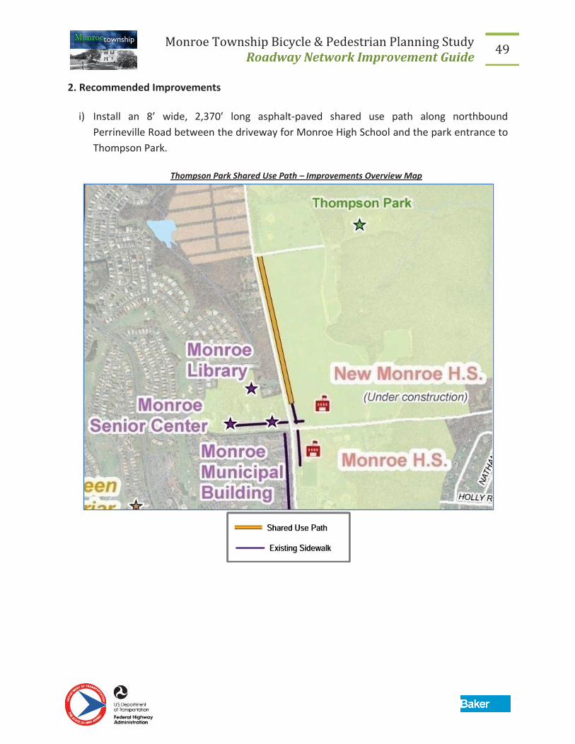
Monroe Township Bicycle & Pedestrian Planning Study Roadway Network Improvement Guide
49
2. Recommended Improvements
i) Install an 8’ wide, 2,370’ long asphalt-paved shared use path along northbound Perrineville Road between the driveway for Monroe High School and the park entrance to Thompson Park.
Thompson Park Shared Use Path – Improvements Overview Map

Monroe Township Bicycle & Pedestrian Planning Study Roadway Network Improvement Guide
50
Thompson Park Shared Use Path –Shared Use Path Improvements Detail

Monroe Township Bicycle & Pedestrian Planning Study Roadway Network Improvement Guide
51
3. Potential Constraints
Impacts to right-of-way, traffic, and utilities are not anticipated for the section of Perrineville Road where the shared use path is proposed.
Since the shared use path improvement may increase impervious cover there may be potential drainage and environmental impacts. The improvement will need to be evaluated for compliance with New Jersey Department of Environmental Protection (NJDEP) Stormwater Management rules (NJAC 7:8), NJDEP Flood Hazard Area Control Act rules (NJAC 7:13) and NJDEP Freshwater Wetlands rules (NJAC 7:7A). Development of a Stormwater Management Plan and permit review should be considered in the project schedule.
The grassed area along northbound Perrineville Road was noted as a temporary parking location during recreational activities at the park (e.g., soccer games). An impact to the availability of parallel parking on the grassed area is not anticipated since the shared use path will have a 10’ setback from the roadway. Township officials would however like to discourage parking in the grass by installing a split rail fence parallel to the path in the buffer.
4. Time to Implement
The potential time to implement the improvements is estimated to be mid-term.
5. Order of Magnitude Cost = $300,000

Monroe Township Bicycle & Pedestrian Planning Study Roadway Network Improvement Guide
52
F. COUNTY ROUTE 615, UNION VALLEY ROAD SHARE THE ROAD
Route 615 between Union Valley Road
and Cranbury-Half Acre Road Route 615 north of Route 614 intersection
1. Existing Condition Summary Speed Limit: 50 MPH on Route 615
AADT: --- Land Use: Residential
Opportunities North-south bicycle connection through the central section of the township
Bicycle facility spine for additional network development
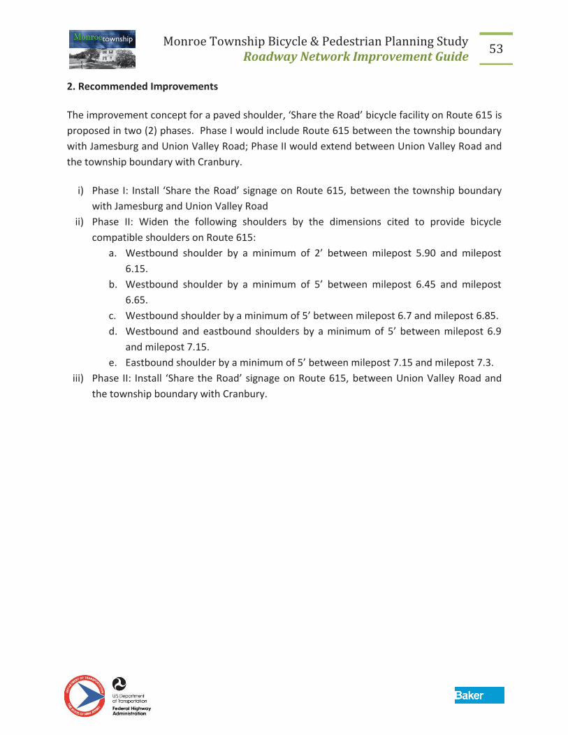
Monroe Township Bicycle & Pedestrian Planning Study Roadway Network Improvement Guide
53
2. Recommended Improvements
The improvement concept for a paved shoulder, ‘Share the Road’ bicycle facility on Route 615 is proposed in two (2) phases. Phase I would include Route 615 between the township boundary with Jamesburg and Union Valley Road; Phase II would extend between Union Valley Road and the township boundary with Cranbury.
i) Phase I: Install ‘Share the Road’ signage on Route 615, between the township boundary with Jamesburg and Union Valley Road
ii) Phase II: Widen the following shoulders by the dimensions cited to provide bicycle compatible shoulders on Route 615:
a. Westbound shoulder by a minimum of 2’ between milepost 5.90 and milepost 6.15.
b. Westbound shoulder by a minimum of 5’ between milepost 6.45 and milepost 6.65.
c. Westbound shoulder by a minimum of 5’ between milepost 6.7 and milepost 6.85. d. Westbound and eastbound shoulders by a minimum of 5’ between milepost 6.9
and milepost 7.15. e. Eastbound shoulder by a minimum of 5’ between milepost 7.15 and milepost 7.3.
iii) Phase II: Install ‘Share the Road’ signage on Route 615, between Union Valley Road and the township boundary with Cranbury.

Monroe Township Bicycle & Pedestrian Planning Study Roadway Network Improvement Guide
54
Route 615 ‘Share the Road’ Improvement Concept – Improvements Overview Map
Phase 1
Phase 2

Monroe Township Bicycle & Pedestrian Planning Study Roadway Network Improvement Guide
55
Route 615 ‘Share the Road’ Improvement Concept – ‘Share the Road’ Improvement Detail
Route 615 ‘Share the Road’ Improvement Concept - Existing Condition on westbound Route 615, east of Chianti Drive, with shoulder drop-off location

Monroe Township Bicycle & Pedestrian Planning Study Roadway Network Improvement Guide
56
3. Potential Constraints
Potential impacts to right-of-way, utilities, drainage and the environment are not anticipated for the section of Route 615 where Phase I ‘Share the Road’ improvements are proposed. Potential impacts to right-of-way, utilities, drainage and the environment may occur for the section for Route 615 where Phase II ‘Share the Road’ improvements are proposed. These impacts could be anticipated due to the widening proposed.
Coordination with Middlesex County is needed during the design phase of ‘Share the Road’ improvements as the roadway is within the county’s jurisdiction. Since the Phase II roadway improvements would likely increase impervious cover, these improvements will need to be evaluated for compliance with New Jersey Department of Environmental Protection (NJDEP) Stormwater Management rules (NJAC 7:8), NJDEP Flood Hazard Area Control Act rules (NJAC 7:13) and NJDEP Freshwater Wetlands rules (NJAC 7:7A). Development of a Stormwater Management Plan and permit review should be considered in the project schedule.
4. Time to Implement
The potential time to implement the improvements is estimated to be long-term.
5. Order of Magnitude Cost = $2,400,000

Monroe Township Bicycle & Pedestrian Planning Study Roadway Network Improvement Guide
57
G. COUNTY ROUTE 614 SIDEWALK IMPROVEMENTS
Existing sidewalk from Encore residential development to Monroe Town Center Driveway
Existing worn footpath on Route 614, between
Englehard Drive and Apple Plaza
1. Existing Condition Summary Speed Limit: 45 MPH on Route 614
AADT: 13,800, between Route 619 and Englehard Drive
Sidewalk: Intermittent
Land Use: Residential Commercial Industrial
Deficiencies: Sidewalk gaps with observed pedestrian activity
Missing sidewalk connections to commercial destinations
Opportunities Enhanced pedestrian route to commercial destinations
Connection to planned county-sponsored improvements at the intersection of Route 614 and Route 619

Monroe Township Bicycle & Pedestrian Planning Study Roadway Network Improvement Guide
58
2. Recommended Improvements
i) Install 170’ of sidewalk on eastbound Route 614 between Route 619 and Monroe Town Center driveway.
ii) Install 1,540’ of sidewalk on westbound Route 614 between Route 619 and Englehard Drive.
iii) Install 2,550’ of sidewalk on eastbound Route 614 between existing sidewalk (from Encore development) and Kelley Court.
iv) Install a 200’ sections of sidewalk and a 140’ section of sidewalk on eastbound Route 614 between Kelley Court and Cedar Brook Road.

Monroe Township Bicycle & Pedestrian Planning Study Roadway Network Improvement Guide
59
3. Potential Constraints
Impacts to right-of-way, traffic, utilities and drainage are not anticipated for the new sidewalk proposed along eastbound Route 614. The existing sidewalk on westbound Route 614 appears to have avoided utility impacts and is set behind overhead utility poles. There may be potential right-of-way impacts for the sidewalk proposed along Route 614 westbound since the right-of-way narrows east of Englehard Drive.
Coordination with Middlesex County is needed during the design phase of the sidewalk and as the roadway is within the county’s jurisdiction. Since the sidewalk improvements may increase impervious cover, the improvement will need to be evaluated for compliance with New Jersey Department of Environmental Protection (NJDEP) Stormwater Management rules (NJAC 7:8), NJDEP Flood Hazard Area Control Act rules (NJAC 7:13) and NJDEP Freshwater Wetlands rules (NJAC 7:7A). Development of a Stormwater Management Plan and permit review should be considered in the project schedule.
4. Time to Implement
The potential time to implement the improvements is estimated to be mid-term
5. Order of Magnitude Cost = $500,000
Monroe Township Bicycle & Pedestrian Planning Study Roadway Network Improvement Guide
60
V. FUNDING THE IMPROVEMENTS Costs associated with implementing the improvements will vary. Interim improvements (e.g., crosswalk striping at Texas Road) will have fewer design requirements and will therefore be lower in cost than an improvement that would need funding for feasibility assessment and design prior to construction (e.g., Thompson Park Shared Use Path). Preliminary cost estimates for each improvement concept are presented with a description of the recommended improvement in this Report. Cost estimates for roadway construction included costs for modifying drainage, the extent of which cannot be determined until preliminary and/or final design. Cost estimating spreadsheets are contained in Appendix A.
A. FUNDING SOURCES Funding sources for bicycle and pedestrian improvements are contained in Appendix B: “Funding Pedestrian and Bicycle Planning, Programs and Projects.” The funding sources identified in the document were compiled by NJDOT to identify major funding sources that can be used to fund bicycle and pedestrian planning and project development activities. Improvements documented in this report may also qualify for Transportation Enhancements (TE) funding (Appendix C).
B. SAFE ROUTES TO SCHOOL The Safe Routes to School (SRTS) Program provides funding for programs and projects to encourage and facilitate children walking and biking to school safely. SRTS was created through Section 1404 of the Safe, Accountable, Flexible, Efficient Transportation Equity Act: A Legacy for Users Act (SAFETEA-LU). It is a Federal-Aid program administered by State Departments of Transportation (DOTs).
The purposes of the program according to the FHWA are:
1. To enable and encourage children, including those with disabilities, to walk and bicycle to school;
2. To make bicycling and walking to school a safer and more appealing transportation alternative, thereby encouraging a healthy and active lifestyle from an early age; and,
3. To facilitate the planning, development, and implementation of projects and activities that will improve safety and reduce traffic, fuel consumption, and air pollution in the vicinity (approximately 2 miles) of primary and middle schools (Grades K-8). Note: New Jersey

Monroe Township Bicycle & Pedestrian Planning Study Roadway Network Improvement Guide
61
State Law mandates that school districts bus students living more than two (2) miles from their respective public elementary and middle schools.12
The SRTS Program provides two (2) types of funding: infrastructure projects and non-infrastructure activities. SAFETEA-LU specifies that eligible infrastructure-related projects include planning, design, and construction of projects that will improve the capability of students walking and biking to school including:
Sidewalk improvements; Traffic calming and speed reduction improvements; Pedestrian and bicycle crossing improvements; On-street bicycle facilities; Off-street bicycle and pedestrian facilities; Secure bicycle parking facilities; and, Traffic diversion improvements in the vicinity of schools.
In New Jersey, NJDOT determines the specific types of infrastructure projects that are eligible for the SRTS Program. For infrastructure improvements specifically, funding must be spent on projects within the public right-of-way.
VI. MAINTENANCE, EDUCATION AND ENFORCEMENT Maintenance of roadways; education of bicyclists, pedestrians and motorists; and, enforcement of state laws and statues by law enforcement are important considerations in implementing recommended improvements.
A. ROADWAY MAINTENANCE The condition, specifically smoothness, of a roadway’s surface is an important factor in bicycle comfort and safety. When a surface is irregular it not only causes an unpleasant ride, but also poses a risk to the bicyclist as these hazards may cause a bicyclist to swerve into motor vehicle traffic to avoid the obstacle. AASHTO recommends the routine maintenance of roadways to provide “good riding conditions."13
B. EDUCATION To properly plan for future growth of bicycle and pedestrian use in a community, it is important to implement educational programs that encourage lawful and safe practices among bicyclists,
12 Pietrafesa, Gianfranco A., Policy Update, Fundamentals of School Busing, School Leader, September/October 2003. 13 American Association of State Highway and Transportation Officials, Guide for the Development of Bicycle Facilities, page 73.

Monroe Township Bicycle & Pedestrian Planning Study Roadway Network Improvement Guide
62
pedestrians and motorists. When educating a community it is important to dispel myths, encourage courteous and lawful behavior, and enhance awareness. By utilizing the resources of the local police, schools and libraries, education programs have the potential of reaching a broader audience and cross section of the community.
The following four (4) primary groups should be educated about bicycle safety and awareness:
1. Young bicyclists
2. Parents of young bicyclists
3. Adult bicyclists
4. Motorists
The National Highway Traffic Safety Administration (NHTSA) distributes a packet called “Getting to School Safely Community Action Kit.” Within the packet there are fact sheets about bicycle and pedestrian safety. Another organization that distributes a guide about how to properly walk to school is the Department of Health and Human Services, Center for Disease Control and Prevention (CDC). The CDC gives parents fun tips for teaching their children the proper way to walk to school.
NJDOT uses several messages to educate citizens about bicycle and pedestrian safety. The two (2) messages used primarily for pedestrian safety education include: “Cross the street where you can see and be seen” (intended to encourage pedestrians to be aware of motorists) and “Yield to Pedestrians” (intended to encourage motorists to stop for pedestrians in a crosswalk).
C. ENFORCEMENT The key to encouraging a safe and well traveled transportation system is an enforcement program for traffic regulations as they apply to all roadway users: motorists, bicyclists and pedestrians. Monroe Township can act to both reduce poor travel behavior and encourage beneficial travel habits through enforcement. This process should include reviewing current ordinances and regulations related to travel to identify elements that may unnecessarily affect users, especially in terms of bicyclists and pedestrians. In addition, this review may assist in

Monroe Township Bicycle & Pedestrian Planning Study Roadway Network Improvement Guide
63
identifying opportunities to partner with community, county or state organizations to inform users about safe travel behavior, such as yielding to pedestrians in crosswalks and use of helmets by bicyclists under the age of 17.
1. Yielding to a Pedestrian in a Crosswalk According to Chapter 4 of the New Jersey Driver Manual (www.njmvc.gov), if a motorist fails to yield for a pedestrian in a crosswalk as per state law (N.J.S.A 39:4-36), the penalty carries a $100 fine, up to 15 days in jail and two (2)-points on their driver’s license.
2. Bicycle Helmets New Jersey state law (N.J.S.A 39:4-10.1) requires anyone under the age of 17 years riding a bicycle to wear a safety helmet. The most common cause of death for a bicyclist is a head injury and in 1992, New Jersey became the first state to enforce a law that children under the age of 14 years wear a helmet. As a first offense, violators of the helmet law will receive a warning and the parent or legal guardian may be fined a maximum of $25. For subsequent offenses, a maximum fine of $100 could be imposed if a lack of parental supervision contributed to the offense.
VII. CONCLUSIONS Monroe Township has an opportunity to enhance roadway conditions to improve bicycle and pedestrian mobility and access to commercial, residential and recreational areas. The Roadway Network Improvement Guide is intended to serve as a resource for the township in improving the roadway network for present and future generations of bicyclists and walkers. The data and findings presented herein will assist Monroe Township officials in obtaining funding for bicycle and pedestrian improvements.