Embed Size (px)
Citation preview
Roads: Instruments for RainwaterHarvesting, Food Security and ClimateResilience in Arid and Semi-arid Areas
Frank van Steenbergen, Kifle Woldearegay, Marta Agujetas Perez,Kebede Manjur and Mohammed Abdullah Al-Abyadh
Abstract With an investment of 7–10 billion USD in sub-Saharan Africa, thedevelopment of roads is a major factor in the change of landscapes and the drainagepatterns. Thus, roads often act as conveyance systems, but the impact is oftennegative, leading to erosion, waterlogging and flooding. These impacts come downhardest on the more vulnerable and least resilient, such as poor female-headedhouseholds. Yet these negative effects can be turned around and roads can be madeinto instruments for rainwater harvesting, food security and climate resilience. Inthis regard, there is a variety of techniques that can be used—ranging from simpleinterventions in the area surrounding the roads to modified designs of road bodies.What drives the transformation of roads is a change in governance too—bettercoordination between road builders and water resource and agricultural departmentsand closer interaction with roadside communities. This chapter provides evidencefrom Yemen and Tigray region in Ethiopia, where road water harvesting has sys-tematically been introduced in all districts since 2014. The chapter describes theprocess of promoting road water harvesting, the techniques used, the potential ofroad water harvesting to increase resilience and the hydrological andsocio-economic effects.
Keywords Road water harvesting � Erosion � Ethiopia � Yemen
F. van Steenbergen (&) � M. Agujetas PerezMetaMeta Research, Postelstraat 2, 5211, EA Hertogenbosch, The Netherlandse-mail: [email protected]
K. WoldearegayDepartment of Applied Geology, Mekelle University, 203, Mekelle, Ethiopia
K. ManjurDepartment of Agricultural Extension and Rural Development, Mekelle University,231, Mekelle, Ethiopia
M. A. Al-AbyadhRoad Maintenance Fund, Ministry of Public Works and Highways, Sana’a, Yemen
© Springer International Publishing AG 2018W. Leal Filho and J. de Trincheria Gomez (eds.), Rainwater-Smart Agriculturein Arid and Semi-Arid Areas, https://doi.org/10.1007/978-3-319-66239-8_7
121
1 Introduction
Roads have a major impact on the landscapes immediately surrounding them—determining the movement of water, sediment, dust and others (Forman et al. 2003).Roads have an important impact on runoff because they often act as either anembankment or a conveyance system, bringing major changes to the naturalhydrology (Forman et al. 2003). These changes often have negative impacts: roadscause local floods and waterlogging along the way, whereas the more concentrateddischarge from drains and culverts causes erosion and sedimentation(Garcia-Landarte et al. 2014; Demenge et al. 2015). This undermines the resilienceof roadside communities, who lose crops or property or suffer health effects fromroad dust (Greening 2011).
However, this negative aspect can be reversed if roads are systematically used asinstruments for rainwater harvesting (Nissen-Petersen 2006). Thus, road harvestingcan generate substantial positive impacts: more secure water supply, better soilmoisture, reduced erosion and respite from harmful damage (Demenge et al. 2015).In addition, rainwater harvesting leads to better returns to land and labour, and ahigher ability of people, households and communities to deal with and prosperregardless of shocks and stresses (Dile et al. 2013). With the investment in roads inmany countries exceeding that of any other programme, this is a large opportunityto improve the productive environment and increase the resilience of the populationin the vicinity of the road.
This chapter describes the process of promoting road water harvesting toincrease resilience. It first describes the techniques and approaches to road waterharvesting (Sect. 2). It then zooms in on the experience of Tigray region in Ethiopia(Sect. 3) where the collection of water from roads has been introduced as a sys-tematic feature in the water conservation and moisture management campaignssince 2014. Section 4 describes the link between road water harvesting and resi-lience, providing examples from Tigray. The chapter concludes with a suggestionon how to systematically build-up resilience by connecting road development andwater resources management in sub-Saharan Africa.
2 Methodology
2.1 Study Area
The region of Tigray in Northern Ethiopia and large areas in Yemen are subject torainfall variability, land degradation and undernutrition. Thus, rainfall is unpre-dictable and unreliable with a higher concentration between June and August whenabout 70% of the total runoff is obtained in Tigray (Abebe et al. 2012). However,not all is negative. The Northern Ethiopia highlands in Tigray are greener than atany time in the last 145 years (Nyssen et al. 2014). Since 1980s, soil and water
122 F. van Steenbergen et al.
conservation (SWC) and water harvesting techniques have been widely imple-mented to tackle land degradation and foster development by reducing surfacerunoff and enhancing infiltration, sediment deposition and vegetation growth(Nyssen et al. 2014). There are a large range of options to collect water with roadsand join the SWC efforts in the region such as diverting water from culverts, usingthe springs that are opened up with road construction or reusing excavation pits asstorage reservoirs.
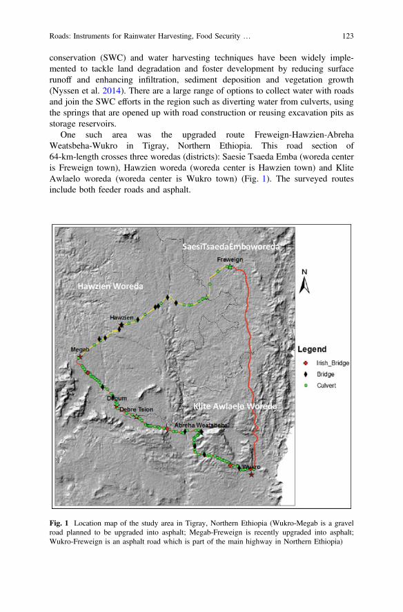
One such area was the upgraded route Freweign-Hawzien-AbrehaWeatsbeha-Wukro in Tigray, Northern Ethiopia. This road section of64-km-length crosses three woredas (districts): Saesie Tsaeda Emba (woreda centeris Freweign town), Hawzien woreda (woreda center is Hawzien town) and KliteAwlaelo woreda (woreda center is Wukro town) (Fig. 1). The surveyed routesinclude both feeder roads and asphalt.
Fig. 1 Location map of the study area in Tigray, Northern Ethiopia (Wukro-Megab is a gravelroad planned to be upgraded into asphalt; Megab-Freweign is recently upgraded into asphalt;Wukro-Freweign is an asphalt road which is part of the main highway in Northern Ethiopia)
Roads: Instruments for Rainwater Harvesting, Food Security … 123
2.2 Methods
If water from roads is not handled properly, the result is erosion, flooding, andsiltation/sedimentation due to the disturbance of natural drainage systems. Such wasthe case along the Freweign-Hawzien-AbrehaWeatsbeha-Wukro road section aswell. A detailed assessment was done of: locations of culverts, Irish bridges andbridges; areas affected by gully erosion; sites affected by waterlogging and flooding;and sites where efforts have been made to implement different soil and waterconservation measures along a 5-km-radius from the main route. The survey wascarried out in the period of July to September 2013.
Moreover, a socio-economic study was conducted in Saesi Tsaeda Emba districtof Northern Ethiopia along the newly constructed Freweign-Hawzen highway. Datawere collected from document reviews and randomly selected respondents repre-senting all social groups of the community (such as women, men and wealth groupsbetter off, middle class poor) along the road and water harvesting structures. Bothparticipatory and structured surveys were used to collect data. The participatoryrural appraisal (PRA) tools included: participatory mapping, transect walks, wealthranking matrix, gender matrix, seasonal calendars and interviews with leaders andofficials at the tabia, woreda and regional level. Participants of the PRA includedmen and women, representatives of different wealth groups, members of house-holds that practice irrigated and rainfed agriculture and individuals particularlyaffected by the road. Overall, data were collected from 129 householdsemi-structured survey and 15 interactive discussions. Finally, data were analysedusing descriptive statistics, triangulation and content analytical tools.
3 Results
3.1 Collecting Water from Roads and Road Catchments
Tropical drylands are exposed to significant rainfall variability which leads torecurrent periods of water deficiency and make them particularly vulnerable todroughts, floods and other extreme events (Falkenmark and Rockstrom 2008). Atthe same time, drylands cover 42% of the world’s population on 40% of the world’sland area and host two billion people (United Nations 2011). Moreover, povertyand undernutrition are to great extent concentrated in tropical drylands, which arealso suffering from water and land degradation. Thus, resilience against droughtsand dry spells is fundamental for water and food security in these areas(Falkenmark and Rockstrom 2008).
Farming systems in sub-Saharan Africa drylands consume less than 10% of theseasonal rainfall available, whereas the remaining rainfall constitutes massive waterlosses (Falkenmark and Rockstrom 2008). At the same time, millions of cubicmetres are being drained through the road surface and drainage systems every rainy
124 F. van Steenbergen et al.
season. There is an estimated 5.55 million km of roads in sub-Saharan Africa(Kubbinga 2012). Of this, 2.36 million km are in drylands, respectively, inrangelands (1.57 million km) and in cultivated areas (0.80 million km) (Kubbinga2012). If these water losses could be put to productive use, sustainable productivitylevels of farming systems could be multiplied by four (Falkenmark and Rockstrom2008).
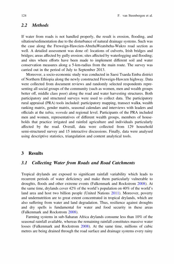
Road water harvesting potential depends on several landscape characteristics.Table 1 presents drainage characteristics, erosion susceptibility and road waterharvesting potential for different landscapes.
Rainwater harvesting has repeatedly been suggested as a prime option for asustainable water management strategy to increase agricultural production(Rosegrant et al. 2002; Reij et al. 2009). Water harvesting systems result in higherfarm productivity (Dile et al. 2013) increasing farm productivity by 78% on average(Bouma et al. 2016). Unlocking the potential of roads and road-related infrastruc-ture in order to harvest the massive amount of water being currently lost will help to
Table 1 Roads versus landscape
Drainagecharacteristics
Erosion susceptibility Water harvestingpotential
Lowland andplateau
Higher difficulty todrain but depends onsoil characteristics.Road embankmentcan interfere withsubsurface andsurface flows,especially when noclearly developeddrainage pattern
Waterlogging andundermining of roadpavements can be aproblem. Side drainsand embankmentstability depends ondesign standards
Borrow pits, rollingdips, tanks, crossdrainage toinfiltration areas,hand-dug wells,manually drilledshallow boreholesand flood waterspreading. Borrowpits can serve as dugout ponds withnatural seepage
Mountain-valley Easier to drain attoeslopes andmoderate verticalprofile slope.However, ridge topand valley bottom areharder to drain
Depending onroughness of surface,soil characteristicsand slope. Deep,portable soils andsteep slopes are proneto trigger erosionissues
Several rainwaterharvesting techniquescan be applied: springcapture, recharge ofborrow pits, retentionponds, water cisternsand tanks, side drains/culverts leading sheetwater flows to nearbyfields and terraces,canals from culvertsto fields, spillwaysfrom road surface tofarms
Source Garcia-Landarte et al. 2014
Roads: Instruments for Rainwater Harvesting, Food Security … 125
improve the livelihoods of rural dwellers now suffering from water scarcity,degradation and malnutrition.
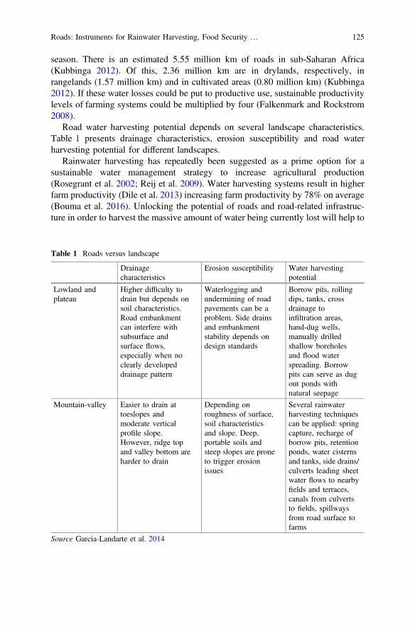
There is a large range of options to collect water with roads (Table 2), most ofthem falling within two main approaches: “adapting to the road” and “adjusting theroad”. The first approach involves utilizing directly or indirectly the runoff andwater flows generated by roads. The latter relates to optimizing road design forwater harvesting and erosion control. Making roads climate and waterproof areoften costly and less roads can be built. Instead, road development should beoptimized to lead to food security and climate resilience.
3.2 Adapting to the Road: Using Runoff and Water FlowsGenerated by Roads
There are several interventions that can be implemented to nearby already con-structed roads and appurtenant infrastructure. A technique that can be easilyimplemented is spreading water directly to farmlands from road surfaces by usingstone bunds or digging shallow canals. Alternatively, water can also be diverted to
Table 2 Overview of road water harvesting techniques and their benefits
Approach Techniques Benefits
Adaptingto the road
Spreading water from road surface and culverts Groundwater rechargeSoil moisture increaseErosion/flooding control
Harvesting water from culverts, side drains anddepressions (borrow pits, small reservoirs,infiltration ponds, infiltration trenches andswales)
Groundwater rechargeWater storageSoil moisture increaseErosion/flooding controlPollution control by naturallyfiltering
Gully plugging Soil moisture increaseErosion controlGroundwater recharge
Spring capture Reliable source of cleanwater (unless naturallypolluted)
Adjustingthe road
Fords combined with sand dams Groundwater rechargeWater storageFlood control
Carefully planning road alignment and culvertlocation
Groundwater rechargeWater storageErosion/flooding control
Permeable road foundations Groundwater rechargePollution control by filtering
126 F. van Steenbergen et al.
structures for surface storage or groundwater recharge. Below is a brief explanationof what can be done with runoff and water flows generated by roads.
3.2.1 Spreading Water from Road Surface and Culvertsinto Farmland
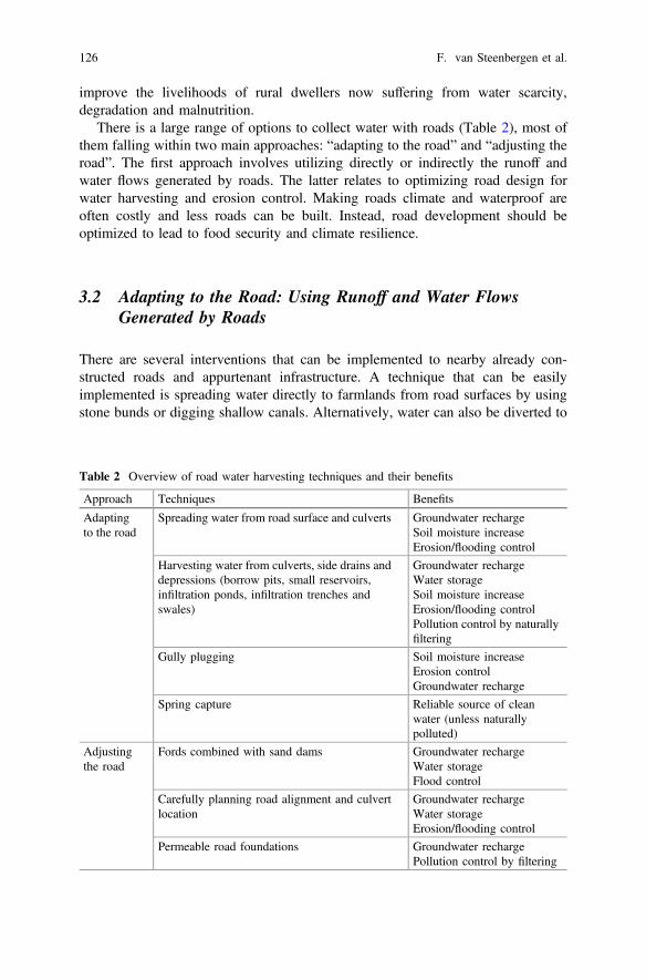
During rain events, road surfaces generate a large amount of runoff. In addition, avast amount of water coming from the upper catchment passes through culverts andside drains (Fig. 2). This water can be easily utilized by diverting it to nearbyfarmlands for supplemental irrigation. Roadside farmers in Tigray region havereported to have an increase of up to 50% in yields as compared to farmers far fromthe road.
3.2.2 Harvesting Water from Culverts, Side Drains and Depressions
Road drainage structures can be used not only for cross drainage but also to feed asthe water source for borrow pits and storage ponds or for enhanced recharge areassuch as infiltration ponds, swales and infiltrations pits.
(a) Converted borrow pits
Borrow pits are the result of the excavations made to extract materials for roadconstruction. Borrow pits are often left open and located nearby roads, which offeran opportunity for water harvesting. They can be used as storage reservoirs forrainwater for instance connecting them with culverts and other cross-drainagestructures through a canal. However, some measures are needed to improve the
Fig. 2 Water spreading from road surface to farmlands in Tigray, Ethiopia. Photograph KifleWoldearegay
Roads: Instruments for Rainwater Harvesting, Food Security … 127
design, safety and accessibility. These measures include technical considerationssuch as improving the geometry to facilitate access and increase capacity, compressthe base and sides to reduce permeability and construction of well for waterextraction to allow filtration and improve water quality (AFCAP 2011).
(b) Small reservoirs for water storage
Runoff can also be channelled for storage in small reservoirs (Nissen-Petersen2006). This water can be later utilized by roadside communities for small-scaleirrigation purposes and for livestock watering. There are two main types of pondsthat can be built, namely embankment ponds and excavated ponds (USDA 1997).Embankment ponds are built by constructing an embankment or dam across awaterway where the land is depressed enough to allow for water storage. Excavatedponds are built by digging a pit or dug out in an almost flat area. Since they requiremore labour and machinery, excavated ponds are mostly used where only a smallsupply of water is needed. Dug outs are particularly useful in dry areas whereevaporation losses are high and water is scarce, since they can be built to expose aminimum water surface. A combination of both types of ponds can be built ingently to moderately sloping areas where the capacity is achieved both by exca-vating and by building a dam or embankment.
(c) Infiltration ponds
Infiltration ponds are designed to capture and retain runoff, letting it to infiltrate forgroundwater recharge (Desta et al. 2005). They are advantageous in places whererunoff might be polluted (such as next to highways) and where shallow wells andhand-pumps are viable. According to Massman and Allen (2003), the first step todesign infiltration ponds is to estimate the volume of runoff that must be infiltrated.Secondly, a trial geometry must be defined. The next step is to estimate the infil-tration rate by multiplying gradient and hydraulic conductivity and finally conductpost-design evaluations.
(d) Infiltration trenches
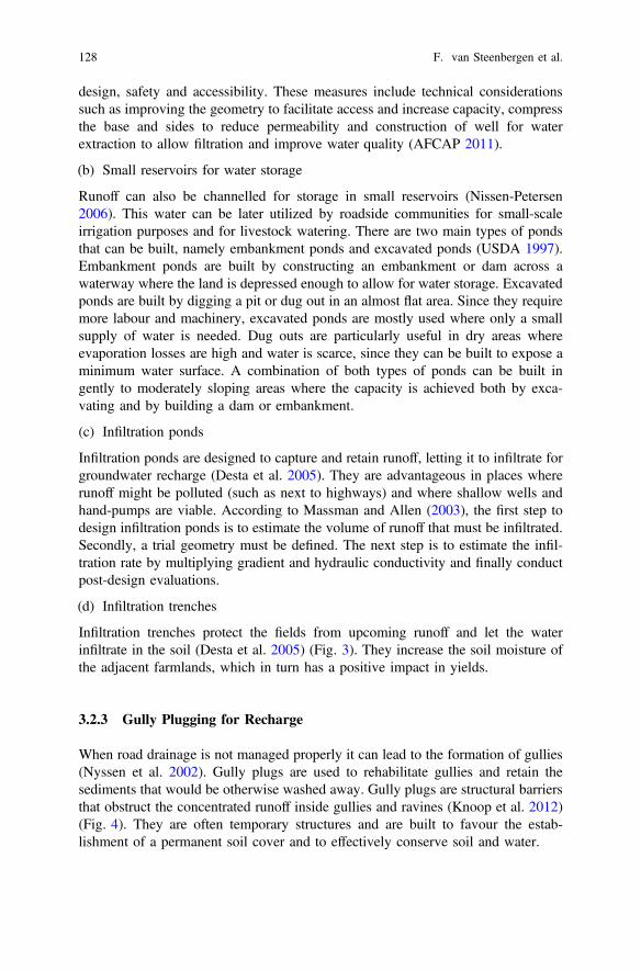
Infiltration trenches protect the fields from upcoming runoff and let the waterinfiltrate in the soil (Desta et al. 2005) (Fig. 3). They increase the soil moisture ofthe adjacent farmlands, which in turn has a positive impact in yields.
3.2.3 Gully Plugging for Recharge
When road drainage is not managed properly it can lead to the formation of gullies(Nyssen et al. 2002). Gully plugs are used to rehabilitate gullies and retain thesediments that would be otherwise washed away. Gully plugs are structural barriersthat obstruct the concentrated runoff inside gullies and ravines (Knoop et al. 2012)(Fig. 4). They are often temporary structures and are built to favour the estab-lishment of a permanent soil cover and to effectively conserve soil and water.
128 F. van Steenbergen et al.
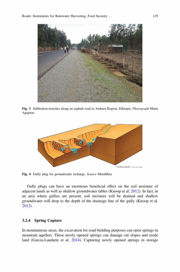
Gully plugs can have an enormous beneficial effect on the soil moisture ofadjacent lands as well as shallow groundwater tables (Knoop et al. 2012). In fact, inan area where gullies are present, soil moisture will be drained and shallowgroundwater will drop to the depth of the drainage line of the gully (Knoop et al.2012).
3.2.4 Spring Capture
In mountainous areas, the excavation for road building purposes can open springs inmountain aquifers. These newly opened springs can damage cut slopes and erodeland (Garcia-Landarte et al. 2014). Capturing newly opened springs in storage
Fig. 3 Infiltration trenches along an asphalt road in Amhara Region, Ethiopia. Photograph MartaAgujetas
Fig. 4 Gully plug for groundwater recharge. Source MetaMeta
Roads: Instruments for Rainwater Harvesting, Food Security … 129
reservoirs that are adequately dimensioned and have spillways facilities is a safeway to make available a source of water that otherwise would be lost. When thespring water is not of good quality, it can be diverted to infiltration structures suchas ponds or swales.
3.3 Adjusting the Road: Improving Road Designfor Multiple Functions
Improved and integrated road designs can increase groundwater recharge andretention while controlling water-related damage (Garcia-Landarte et al. 2014).Optimized designs can particularly improve water storage in the vicinity of theroad, in open ponds and cisterns, but also as secure soil moisture and as shallowgroundwater.
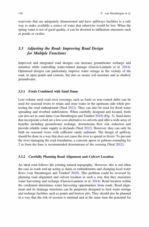
3.3.1 Fords Combined with Sand Dams
Low-volume rural road river crossings such as fords or non-vented drifts can beused for seasonal rivers to retain and store water in the upstream side while pro-tecting the road embankment (Neal 2012). They can also be used for flood waterspreading and riverbed stabilization. When carefully designed and located, fordscan also act as sand dams (van Steenbergen and Tuinhof 2010) (Fig. 5). Sand damsthat incorporate a ford are a low-cost alternative to culverts and offer a wide array ofbenefits including groundwater recharge, downstream flow risk reduction andprovide reliable water supply in drylands (Neal 2012). However, they can only bebuilt on seasonal rivers with sufficient sandy sediment. The design of spillwayshould be done in a way that does not cause the river to spread or divert. To preventthe river damaging the road foundation, a concrete apron or gabions extending for2 m from the base is recommended downstream of the crossing (Neal 2012).
3.3.2 Carefully Planning Road Alignment and Culvert Location
An ideal road follows the existing natural topography. However, this is not oftenthe case as roads end up acting as dams or embankments and changing local waterflows (van Steenbergen and Tuinhof 2010). This problem could be reversed byplanning road alignment and culvert location in such a way that they maximizewater harvesting and recharge (Garcia-Landarte et al. 2014). Road location withinthe catchment determines water harvesting opportunities from roads. Road align-ment and its drainage structures can be purposely designed to feed water storageand recharge facilities such as ponds and borrow pits. They should also be plannedin a way that the risk of erosion is minimal and at the same time the potential for
130 F. van Steenbergen et al.
water harvesting is the highest. For instance, culverts often concentrate runoff inspecific spots and often cause gullies and erosion. By studying the hydrology of anarea, culverts could be strategically placed to distribute road drainage and preventerosion.
3.3.3 Permeable Road Foundations
Especially on tarmac roads, the use of permeable substrata would allow percolationor infiltration of runoff through the road surface into the soil. Besides reducingstorm water runoff and flooding and replenishing groundwater, it also poses asolution to road-related water quality issues since the water is naturally filtered bythe soil underneath. So far, this technology is mostly used in parking lots, side-walks, low-traffic roads, fire lanes and emergency access roads. However, thepotential to harvest storm water is huge due to the expanding road infrastructure insub-Saharan Africa.
3.4 Case Study in Tigray Region, Ethiopia
Triggered by a research project, the Tigray Bureau of Agriculture and RuralDevelopment introduced in 2014 several road water harvesting technologies in all
Fig. 5 Road crossing doubling up as a sand dam in Makueni, Kenya. Photograph MetaMeta
Roads: Instruments for Rainwater Harvesting, Food Security … 131
of its districts as part of the watershed program. Hundreds of road water harvestingstructures were built, all indigenous solution to the areas where they were imple-mented. Monitoring established significant impact in terms of reduced fear offlooding, increased moisture (30–50%), higher shallow groundwater tables (inmetres) and higher yields. There is scope to do a lot more—not only in system-atically using the water runoff from road catchments but also by even adjusting thedesign of the roads themselves or consideration of road water harvesting options indesign standards. The approaches used to promote road water harvesting in Tigrayincluded: (a) assessment of issues on water and roads along selected routes inTigray, (b) understanding the perception of the communities on road developmentversus water-related challenges, (c) designing methods of involving stakeholders totake the lead in the implementation of the interventions, (d) implementing differentwater harvesting options, and (e) monitoring the effects of the interventions inselected/representative sites where there was prior data (baseline data).
The survey result revealed that several problems have been created due to waterfrom roads including erosion in downstream areas and roadsides and siltation/sedimentation of downstream, upstream and side drainage areas. Waterlogging anddamage on dwelling houses and on water harvesting systems (groundwater wellsand ponds) were also observed in the study area. In the 64 km of roads, there were159 problems spots—close to 3 per km.
Until the year 2013/2014, there was no systematic approach for road waterharvesting in Tigray, as elsewhere in Ethiopia. There were, however, sporadicpractices implemented as part of the soil and water conservation efforts. Since theyear 2013/2014, efforts were made to introduce road water harvesting in a moresystematic manner. Main practices of water harvesting from roads implemented inthe study area thus far were financed by the government (particularly the TigrayBureau of Agriculture and Rural Development) and implemented during a massmobilization campaign of June–July 2014 when farmers provided labour days forwatershed moisture improvement. The main technologies and approaches imple-mented are presented below:
• Use of ponds/pits to harvest water from roads: Since 2010, ponds have beenconstructed to collect water from any source including roadside drainages.Along the study route, five ponds have been constructed for surface waterstorage and groundwater recharge. It is common to have water from a culvertchannelled into a properly design pond. The storage of rainwater can provide anextra source of water for irrigation, helping to improve the food security in thearea.
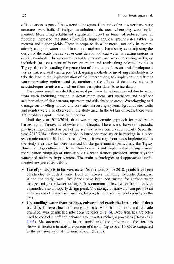
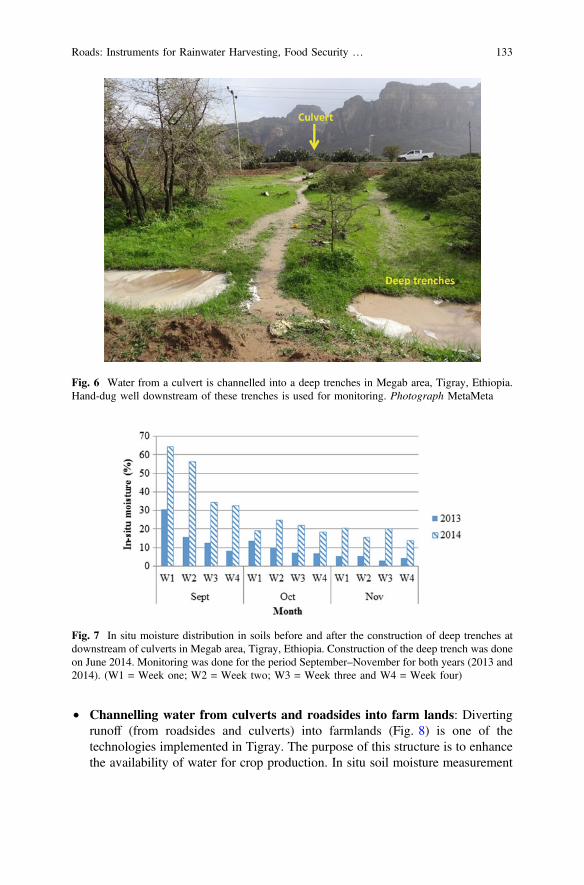
• Channelling water from bridges, culverts and roadsides into series of deeptrenches: In seven locations along the route, water from culverts and roadsidedrainages was channelled into deep trenches (Fig. 6). Deep trenches are oftenused to control runoff and enhance groundwater recharge processes (Desta et al.2005). Measurement of the in situ moisture of the soils around the trenchesshows an increase in moisture content of the soil (up to over 100%) as comparedto the previous year of the same season (Fig. 7).
132 F. van Steenbergen et al.
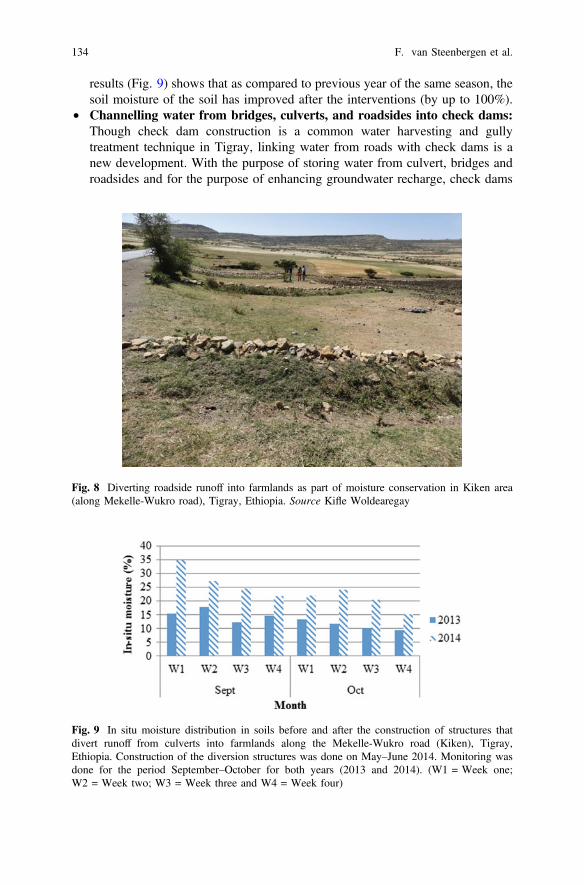
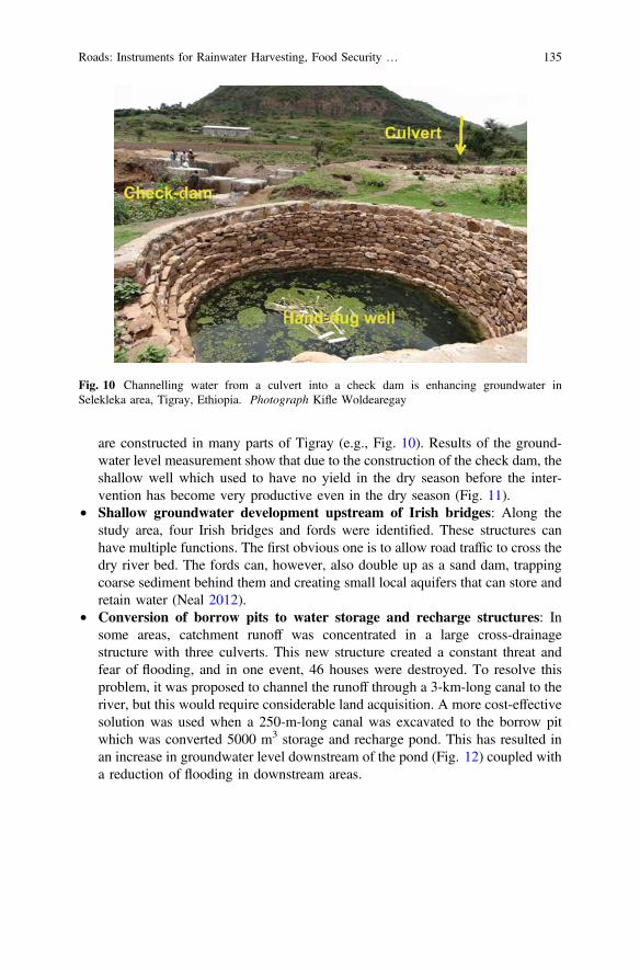
• Channelling water from culverts and roadsides into farm lands: Divertingrunoff (from roadsides and culverts) into farmlands (Fig. 8) is one of thetechnologies implemented in Tigray. The purpose of this structure is to enhancethe availability of water for crop production. In situ soil moisture measurement
Fig. 6 Water from a culvert is channelled into a deep trenches in Megab area, Tigray, Ethiopia.Hand-dug well downstream of these trenches is used for monitoring. Photograph MetaMeta
Fig. 7 In situ moisture distribution in soils before and after the construction of deep trenches atdownstream of culverts in Megab area, Tigray, Ethiopia. Construction of the deep trench was doneon June 2014. Monitoring was done for the period September–November for both years (2013 and2014). (W1 = Week one; W2 = Week two; W3 = Week three and W4 = Week four)
Roads: Instruments for Rainwater Harvesting, Food Security … 133
results (Fig. 9) shows that as compared to previous year of the same season, thesoil moisture of the soil has improved after the interventions (by up to 100%).
• Channelling water from bridges, culverts, and roadsides into check dams:Though check dam construction is a common water harvesting and gullytreatment technique in Tigray, linking water from roads with check dams is anew development. With the purpose of storing water from culvert, bridges androadsides and for the purpose of enhancing groundwater recharge, check dams
Fig. 8 Diverting roadside runoff into farmlands as part of moisture conservation in Kiken area(along Mekelle-Wukro road), Tigray, Ethiopia. Source Kifle Woldearegay
Fig. 9 In situ moisture distribution in soils before and after the construction of structures thatdivert runoff from culverts into farmlands along the Mekelle-Wukro road (Kiken), Tigray,Ethiopia. Construction of the diversion structures was done on May–June 2014. Monitoring wasdone for the period September–October for both years (2013 and 2014). (W1 = Week one;W2 = Week two; W3 = Week three and W4 = Week four)
134 F. van Steenbergen et al.
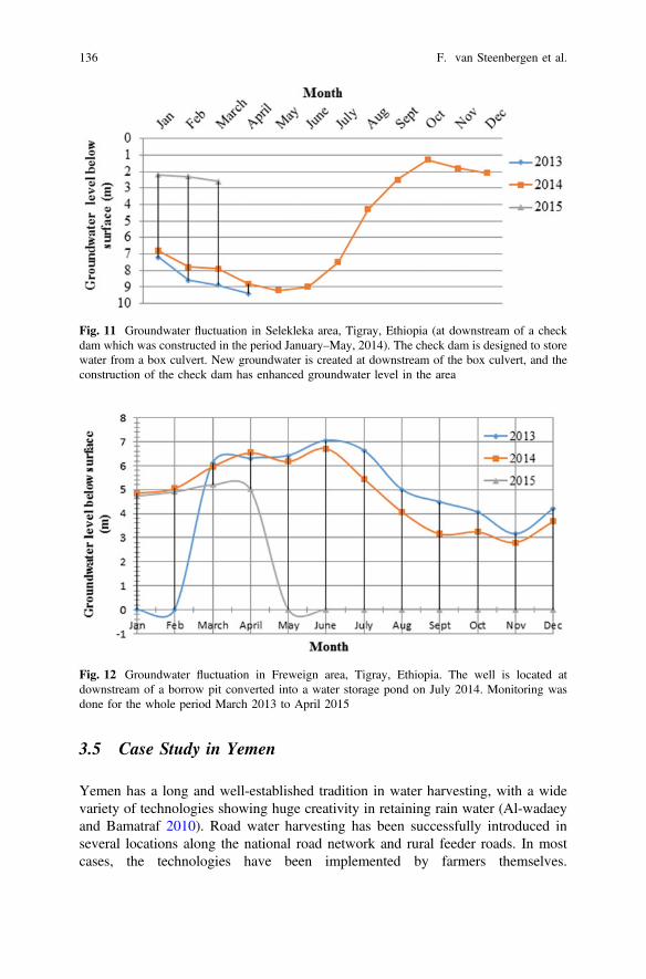
are constructed in many parts of Tigray (e.g., Fig. 10). Results of the ground-water level measurement show that due to the construction of the check dam, theshallow well which used to have no yield in the dry season before the inter-vention has become very productive even in the dry season (Fig. 11).
• Shallow groundwater development upstream of Irish bridges: Along thestudy area, four Irish bridges and fords were identified. These structures canhave multiple functions. The first obvious one is to allow road traffic to cross thedry river bed. The fords can, however, also double up as a sand dam, trappingcoarse sediment behind them and creating small local aquifers that can store andretain water (Neal 2012).
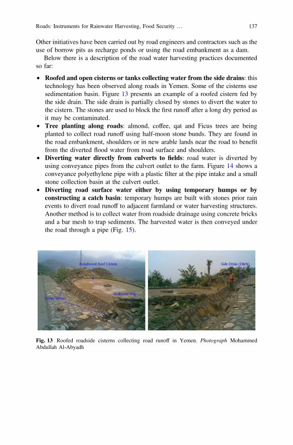
• Conversion of borrow pits to water storage and recharge structures: Insome areas, catchment runoff was concentrated in a large cross-drainagestructure with three culverts. This new structure created a constant threat andfear of flooding, and in one event, 46 houses were destroyed. To resolve thisproblem, it was proposed to channel the runoff through a 3-km-long canal to theriver, but this would require considerable land acquisition. A more cost-effectivesolution was used when a 250-m-long canal was excavated to the borrow pitwhich was converted 5000 m3 storage and recharge pond. This has resulted inan increase in groundwater level downstream of the pond (Fig. 12) coupled witha reduction of flooding in downstream areas.
Fig. 10 Channelling water from a culvert into a check dam is enhancing groundwater inSelekleka area, Tigray, Ethiopia. Photograph Kifle Woldearegay
Roads: Instruments for Rainwater Harvesting, Food Security … 135
3.5 Case Study in Yemen
Yemen has a long and well-established tradition in water harvesting, with a widevariety of technologies showing huge creativity in retaining rain water (Al-wadaeyand Bamatraf 2010). Road water harvesting has been successfully introduced inseveral locations along the national road network and rural feeder roads. In mostcases, the technologies have been implemented by farmers themselves.
Fig. 11 Groundwater fluctuation in Selekleka area, Tigray, Ethiopia (at downstream of a checkdam which was constructed in the period January–May, 2014). The check dam is designed to storewater from a box culvert. New groundwater is created at downstream of the box culvert, and theconstruction of the check dam has enhanced groundwater level in the area
Fig. 12 Groundwater fluctuation in Freweign area, Tigray, Ethiopia. The well is located atdownstream of a borrow pit converted into a water storage pond on July 2014. Monitoring wasdone for the whole period March 2013 to April 2015
136 F. van Steenbergen et al.
Other initiatives have been carried out by road engineers and contractors such as theuse of borrow pits as recharge ponds or using the road embankment as a dam.
Below there is a description of the road water harvesting practices documentedso far:
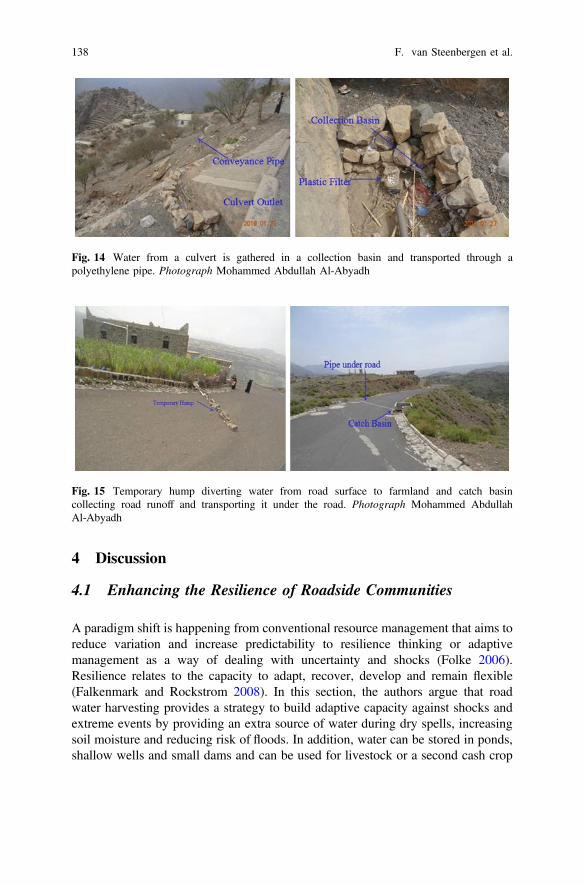
• Roofed and open cisterns or tanks collecting water from the side drains: thistechnology has been observed along roads in Yemen. Some of the cisterns usesedimentation basin. Figure 13 presents an example of a roofed cistern fed bythe side drain. The side drain is partially closed by stones to divert the water tothe cistern. The stones are used to block the first runoff after a long dry period asit may be contaminated.
• Tree planting along roads: almond, coffee, qat and Ficus trees are beingplanted to collect road runoff using half-moon stone bunds. They are found inthe road embankment, shoulders or in new arable lands near the road to benefitfrom the diverted flood water from road surface and shoulders.
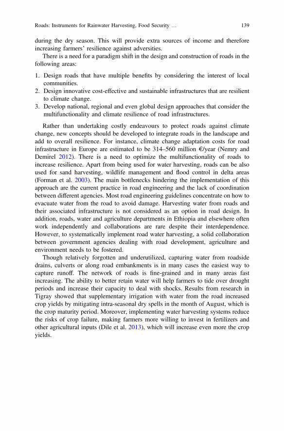
• Diverting water directly from culverts to fields: road water is diverted byusing conveyance pipes from the culvert outlet to the farm. Figure 14 shows aconveyance polyethylene pipe with a plastic filter at the pipe intake and a smallstone collection basin at the culvert outlet.
• Diverting road surface water either by using temporary humps or byconstructing a catch basin: temporary humps are built with stones prior rainevents to divert road runoff to adjacent farmland or water harvesting structures.Another method is to collect water from roadside drainage using concrete bricksand a bar mesh to trap sediments. The harvested water is then conveyed underthe road through a pipe (Fig. 15).
Fig. 13 Roofed roadside cisterns collecting road runoff in Yemen. Photograph MohammedAbdullah Al-Abyadh
Roads: Instruments for Rainwater Harvesting, Food Security … 137
4 Discussion
4.1 Enhancing the Resilience of Roadside Communities
A paradigm shift is happening from conventional resource management that aims toreduce variation and increase predictability to resilience thinking or adaptivemanagement as a way of dealing with uncertainty and shocks (Folke 2006).Resilience relates to the capacity to adapt, recover, develop and remain flexible(Falkenmark and Rockstrom 2008). In this section, the authors argue that roadwater harvesting provides a strategy to build adaptive capacity against shocks andextreme events by providing an extra source of water during dry spells, increasingsoil moisture and reducing risk of floods. In addition, water can be stored in ponds,shallow wells and small dams and can be used for livestock or a second cash crop
Fig. 14 Water from a culvert is gathered in a collection basin and transported through apolyethylene pipe. Photograph Mohammed Abdullah Al-Abyadh
Fig. 15 Temporary hump diverting water from road surface to farmland and catch basincollecting road runoff and transporting it under the road. Photograph Mohammed AbdullahAl-Abyadh
138 F. van Steenbergen et al.
during the dry season. This will provide extra sources of income and thereforeincreasing farmers’ resilience against adversities.
There is a need for a paradigm shift in the design and construction of roads in thefollowing areas:
1. Design roads that have multiple benefits by considering the interest of localcommunities.
2. Design innovative cost-effective and sustainable infrastructures that are resilientto climate change.
3. Develop national, regional and even global design approaches that consider themultifunctionality and climate resilience of road infrastructures.
Rather than undertaking costly endeavours to protect roads against climatechange, new concepts should be developed to integrate roads in the landscape andadd to overall resilience. For instance, climate change adaptation costs for roadinfrastructure in Europe are estimated to be 314–560 million €/year (Nemry andDemirel 2012). There is a need to optimize the multifunctionality of roads toincrease resilience. Apart from being used for water harvesting, roads can be alsoused for sand harvesting, wildlife management and flood control in delta areas(Forman et al. 2003). The main bottlenecks hindering the implementation of thisapproach are the current practice in road engineering and the lack of coordinationbetween different agencies. Most road engineering guidelines concentrate on how toevacuate water from the road to avoid damage. Harvesting water from roads andtheir associated infrastructure is not considered as an option in road design. Inaddition, roads, water and agriculture departments in Ethiopia and elsewhere oftenwork independently and collaborations are rare despite their interdependence.However, to systematically implement road water harvesting, a solid collaborationbetween government agencies dealing with road development, agriculture andenvironment needs to be fostered.
Though relatively forgotten and underutilized, capturing water from roadsidedrains, culverts or along road embankments is in many cases the easiest way tocapture runoff. The network of roads is fine-grained and in many areas fastincreasing. The ability to better retain water will help farmers to tide over droughtperiods and increase their capacity to deal with shocks. Results from research inTigray showed that supplementary irrigation with water from the road increasedcrop yields by mitigating intra-seasonal dry spells in the month of August, which isthe crop maturity period. Moreover, implementing water harvesting systems reducethe risks of crop failure, making farmers more willing to invest in fertilizers andother agricultural inputs (Dile et al. 2013), which will increase even more the cropyields.
Roads: Instruments for Rainwater Harvesting, Food Security … 139
4.2 Impacts on Food Security and Poverty Alleviation
Water resilience in agriculture aims at safeguarding water availability under periodsof shocks, such as persistent droughts (Falkenmark and Rockstrom 2008). Atpresent, current road building practice reduces resilience of roadside population.Thus, in 100 km of roads there may be 13–25 problem spots—from flooding,waterlogging, erosion or uncontrolled sand deposition. Several studies have foundthat a reduction in the quality of natural resources often leads to a loss of resilience(Kelly et al. 2015).
This is the case in our study area. Out of 129 respondents, 53.5% of themperceived an increase in water runoff during peak rainy season due to the waterwaycreated along the roads. Thus, many farmers faced flooding, waterlogging andsiltation of fields, making land less productive and more difficult to cultivate whichin turn resulted in loss of arable land and soil infertility (Table 3).
In the case study site, land holding size was 0.79 ha and crop productivity was1422.21 kg/ha.
In terms of economic loss, on average about 0.07 ha (11%) of land and 69.23 kg(9%) of yield of crop was lost due to road-induced runoff (Table 4).
Table 3 Impact of road runoff on rainfed farming, living house and runoff intensity
Affected attributes Frequency %
Rainfed farm Flooded 67 51.9
Silted 67 51.9
Eroded 39 30.2
Grazing land Flooded 58 45
Silted 56 43.4
Eroded 20 15.5
House Flooded 32 24.8
Runoff Increased 69 53.5
Table 4 Impact of road runoff on agriculture
Minimum Maximum Mean Std. deviation
Farm size 0.25 1.5 0.79 0.28
Farm land loss (ha) 0 0.25 0.07 0.09
Annual yield (kg) 200 5400 1422.20 1002.03
Total yield loss (kg) 0 400 69.26 91.25
Percentage of farm land loss 0 100 10.88 15.70
Percentage of yield loss 0 72.73 8.95 13.05
Monetary loss (ETB) 0 3200 589.76 738.39
140 F. van Steenbergen et al.
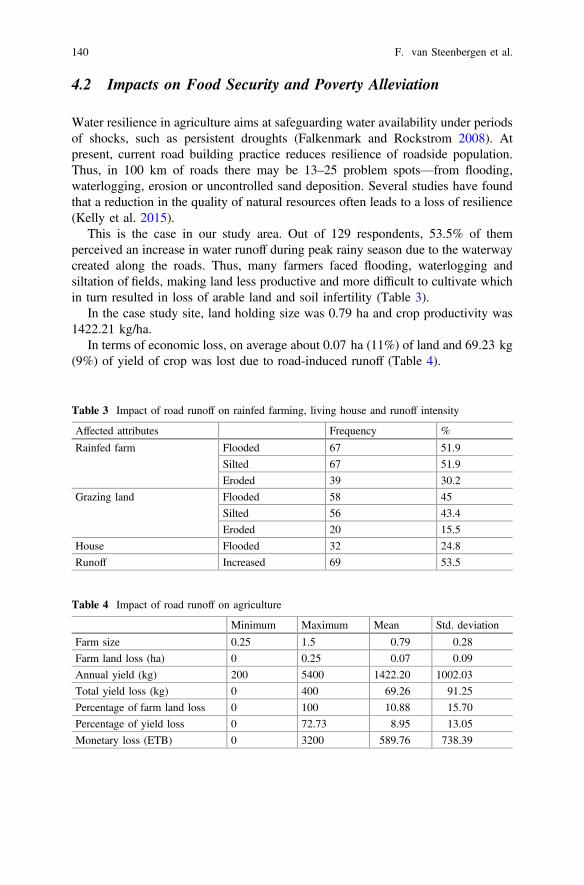
However, road runoff can also have positive impacts if managed wisely.Figure 16 shows that the implementation of road water harvesting structuresrestored productivity in 2014 even though this was a relatively low-rainfall year.
Figure 16 presents the yield trend of the study area, seven years. From 2008 to2009, there was slight yield increment due to availability of rainfall while in 2010there was a decline due to low rainfall. Suddenly, during road construction period(2011–2013), as there was flooding and erosion, crop yield was reduced to 4.56 qt/ha. In response to this decrease on yields, from 2014 the water was diverted to anearby borrow pit to retain road runoff and increase steady percolation of water.The yields were re-established and the maximum crop yield reached 15.8 qt/ha.There is hence a clear link between making use of roads for water and increasedproductivity and resilience. Some estimations determine that every 10% increase inyields in Africa leads to a 7% reduction in poverty (Pretty et al. 2011).
5 Conclusions
Road development is not only one of the major investments worldwide but also oneof the practices that cause changes in runoff patterns in landscapes. Roads act asconveyance systems or as barriers and can cause water-related problems, if notmanaged. For road water to be managed and to minimize all the negative effects,there is a need to move towards the development of proper standards andapproaches in the design and construction of roads.
The main reason for the link between roads and water not taking place at presentis governance. At present, road development is largely single objective. The solepurpose of building roads is that of creating transport corridors. In many countries,there is no cooperation with other stakeholders for instance in agriculture or waterresources nor a culture or practice of consulting roadside communities. Thoughindicated in the design guidelines to take care of environmental concerns, in
Fig. 16 Yield (in quintal) per hectares in Sinqata before and just after the road construction in2013
Roads: Instruments for Rainwater Harvesting, Food Security … 141

practice, roads remain among the major causes of environmental problems. Thedesigns and guidelines for road development do not consider the possible beneficialuse of water along roads, but are primarily concerned with safeguarding roads fromwater damage. Among road builders, there is generally little consideration of theimpact of roads on the environment immediately surrounding them, though indi-cated in their design manuals and standards.
To move from ‘roads that cause harm’ to ‘roads for resilience’ requires changesin the technology used, appreciation of the different contexts in which roads aredeveloped, the introduction of consultative processes and importantly changes ingovernance. Governance needs to be multi-stakeholder and recognize the reductionof risk and the distribution of access to benefits. It requires sensitivity of the impactof different road water harvesting options for male and female livelihoods, betterlinkages to male/female roles in different socio-economic contexts, ensuring femalerepresentation in local consultation processes and consideration of special measuresto engage and support female-headed households in better road water harvestingand other opportunities created by roads for resilience.
Acknowledgements The support of Netherlands Scientific Council (NWO) under the program‘Feeder road development for inclusive productive employment’ in preparing this paper isacknowledged as well as the Global Resilience Partnership Program ‘Connecting Roads, Waterand Livelihoods for Resilience’. All the collaborating institutions mainly Tigray Bureau of WaterResources, Tigray Bureau of Transport and Road Construction, Tigray Bureau of Agriculture andRural Development, REST, Amhara Bureau of Agriculture, Oromia Bureau of Water Mines andEnergy, Oromia Bureau of Road Transport and Ethiopian Roads Authority are highly acknowl-edged for their relentless support.
References
Abebe A, Lasage R, Alemu E, Gowing J, Woldearegay K (2012) Ethiopia: Opportunities forbuilding on tradition—time for action. In: Critchley W, Gowing JW (eds) (2012) WaterHarvesting in Sub-Saharan Africa. Routledge, UK.
AFCAP (2011). Using ‘road works’ to enhance community water supply in Mozambique. AfricanCommunity Access Programme, Phase 1 Final Report: Feasibility Study. Department ofInternational Development, UK. Available at: https://assets.publishing.service.gov.uk/media/57a08aed40f0b652dd0009ac/roads-water-Mozambique.pdf.
Al-wadaey A, Bamatraf A (2010) Indigenous knowledge of water harvesting for sustainablerainfed farming systems in North Yemen. 10th International Conference on Development ofDrylands: Meeting the Challenge of Sustainable Development in Drylands under ChangingClimate—Moving from Global to Local. Cairo, Egypt on 12–15 Dec 2010.
Bouma, J. A., Hegde, S. S., Lasage, R. (2016). Assessing the returns to water harvesting: Ameta-analysis. Agricultural Water Management, 163, 100–109.
Demenge, J., Alba, R., Welle, K., Manjur, K., Addisu, A., Mehta, L., Woldearegay, K. (2015).Multifunctional Roads The Potential Effects of Combined Roads and Water HarvestingInfrastructure on Livelihoods and Poverty in Ethiopia. Journal of Infrastructure Development,7(2), 165–180.
142 F. van Steenbergen et al.
Desta L, Carucci V, Wendem-Agenehu A (2005) Community Based Participatory WatershedDevelopment: A Guideline. Ministry of Agriculture and Rural Development, Addis Ababa,Ethiopia.
Dile, Y. T., Karlberg, L., Temesgen, M., Rockström, J. (2013). The role of water harvesting toachieve sustainable agricultural intensification and resilience against water related shocks insub-Saharan Africa. Agriculture, ecosystems & environment, 181, 69–79.
Falkenmark, M., Rockström, J. (2008, May). Building resilience to drought in desertification‐prone savannas in Sub‐Saharan Africa: The water perspective. In Natural ResourcesForum (Vol. 32, No. 2, pp. 93–102). Blackwell Publishing Ltd.
Folke C (2006) Resilience: the emergence of a perspective for social-ecological system analyses.Global Environ Change 16 (3): 253–267.
Forman RTT, Sperling D, Bissonette JA, Clevenger AP, Cutshall CD, Dale VH, Fahrig L,France R, Goldman CR, Heanue K, Jones JA, Swanson FJ, Turrentine T, Winter TC (2003)Road ecology: science and solutions. Island Press, Washington DC, USA.
Garcia-Landarte Puertas D, Woldearegay K, Mehta, L, Beusekom M, Agujetas M, vanSteenbergen F (2014) Roads for water: the unused potential. Waterlines 33: 120–138.
Greening T (2011) Quantifying the impacts of vehicle-generated dust: a comprehensive approach.Transport Research Support Program. Washington DC: World Bank.
Kelly C, Ferrara A, Wilson GA, Ripullone F, Nolè A, Harmer N, Salvati L (2015) Communityresilience and land degradation in forest and shrubland socio-ecological systems: a case studyin Gorgoglione, Basilicata region, Italy. Land Use Policy 46: 11–20.
Knoop L, Sambalino F, Van Steenbergen F (2012) Securing Water and Land in the Tana Basin: aresource book for water managers and practitioners. Wageningen, The Netherlands: 3R WaterSecretariat.
Kubbinga B (2012) Road Runoff Harvesting in the Drylands of Sub-Saharan Africa: Its Potentialfor Assisting Smallholder Farmers in Coping with Water Scarcity and Climate Change. Basedon Case Studies in Eastern Province, Kenya [MSc thesis]. Amsterdam, Vrije University.
Massmann JW, Allen T (2003) A design manual for sizing infiltration ponds. Final ResearchReport, Research Project Agreement No Y8265, Implementation of Infiltration PondsResearch. Washington State Department of Transportation, Olympia, WA.
Neal I (2012) The potential of sand dam crossings. Dams and Reservoirs, 22: 29–143Nemry F, Demirel H (2012) Impacts of Climate Change on Transport: A focus on road and rail
transport infrastructures. European Commission, Joint Research Centre (JRC), Institute forProspective Technological Studies (IPTS). Publications Office of the European Union,Luxembourg.
Nissen-Petersen E (2006) Water from Roads: A handbook for technicians and farmers onharvesting rain water from roads. ASAL Consultants Ltd. Nairobi, Kenya.
Nyssen J, Poessen J, Moeyersons J, Luyten E, Veyret-Picot M, Deckers J, Haile M, Govers G(2002) Impact of Road Building On Gully Erosion Risk: A Case Study From The NorthernEthiopian Highlands. Earth Surf Processes and Landforms 27: 1267–1283.
Nyssen, J., Frankl, A., Haile, M., Hurni, H., Descheemaeker, K., Crummey, D., Munro, N. (2014).Environmental conditions and human drivers for changes to North Ethiopian mountainlandscapes over 145 years. Science of the total environment, 485, 164–179.
Pretty, J., Toulmin, C., Williams, S. (2011). Sustainable intensification in Africanagriculture. International journal of agricultural sustainability, 9(1), 5–24.
Reij C, Tappan G, Smale M (2009) Agroenvironmental Transformation in the Sahel: Another Kindof “Green Revolution.” IFPRI Discussion Paper (International Food Policy Research Institute,Washington, USA.
Rosegrant M, Cai X, Cline S, Nakagawa N (2002) The Role of Rainfed Agriculture in the Futureof Global Food Production. Food Policy. International Food Policy Research Institute,Washington, DC, USA, pp. 127.
Roads: Instruments for Rainwater Harvesting, Food Security … 143

Steenbergen F van, Tuinhof A (2010). Managing the Water Buffer for Development and ClimateChange Adaptation. Groundwater Recharge, Retention, Reuse and Rainwater Storage 1–98.MetaMeta Research, Wageningen, The Netherlands.
United Nations (2011) Global Drylands: A UN system-wide response. Available at: http://www.unccd.int/Lists/SiteDocumentLibrary/Publications/Global_Drylands_Full_Report.pdf.
USDA (1997) Ponds: Planning, design, construction. Agriculture Handbook 590. NRCS,Washington, USA.
144 F. van Steenbergen et al.