Embed Size (px)
Citation preview
Formanand
Anna M. HerspergerHarvard University
Graduate School of DesignCambridge, MA 02138
Road Ecology and Road Density in DifferentLandscapes, with International Planning and
Mitigation Solutions
By:
Richard T. T.
: ‘(1) surface water in streams; (2) groundwater and aquiferflows; (3) wildlife in major corridors; (4) soil, snow, and seedscarried by wind; (5) recreationists on trails; and (6) vehiclestransporting people and goods on roads. Mapping these as arrowscrisscrossing each other highlights the dynamic processes parallel
__to the state of Georgia, is covered by roads and their roadsides.The ecological effects, from noise to hydrology and fragmentationto vehicle emissions, significantly impact a much larger area.
Scientists, engineers, and society basically see roads asbackground infrastructure for transporting people and goods fromhere to there. Yet the road with its vehicles is but one of manyinterdigitating structures creating a pattern on the landscape.
Consider the following six major types of flows crossing theland
_
implegntingresearching road ecology,
Introduction
More than two percent
successful existing technology,and educating the public.
of the conterminous United States, equal
mi/mi2) is a useful summary index, because it integrates so manyecological impacts of roads and vehicles. A road density effecton wildlife is illustrated. Suburban, open, and forestedlandscapes are shown to have markedly different road effects onspecies, habitat, water, soil, and atmosphere. Roads cause moreeffects and have a greater cumulative effect than vehicles. Aplanning framework used in Holland is outlined, which maps thelandscape ecological network, superimposes the road network,identifies bottlenecks, examines stretches of road and landscapein detail, and uses an array of ecological and technologicalsolutions for avoidance, mitigation, and compensation. Majormitigation techniques, including diverse tunnels, overpasses, andlandscape connectors are outlined, along with animals using them.Very little of this ecological technology yet exists in the UnitedStates. A brief opportunity remains to lead the public, byconcurrently
framework for such a transportation analysis. Road density (e.g.,
mcvements, e.g., in wildlife corridors,across the land. Landscape ecology provides a useful theoretical
&cological impacts of roads. Mostimportant are flows and
Forman and Anna M. HerspergerHarvard University, Graduate School of Design,Cambridge, Massachusetts 02138, USA
Abstract
Understanding spatial pattern of the broad landscape isessential for addressing the
PLANNING AND MITIGATION SOLUTIONS
Richard T. T.
ROAD ECOLOGY AND ROAD DENSITY IN DIFFERENT LANDSCAPES,
WITH INTERNATIONAL
tims.Change in both spatial structure
Every point in a landscape is either in a patch, a corridor,or the background matrix. Therefore a patch-corridor-matrix model
Functioning refers to the flows and movements of species, energy,and materials across the mosaic.and function occurs over
Forman 1995). The landscape is a specific objectwhere local ecosystems or land uses recur over a kilometers-widearea. It exhibits structure, functioning, and change. Itsstructure is the spatial arrangement of the land uses.
Pick&t 1995, Godron 1986, Turner 1989, Hobbs 1995,& For-man Lieberman 1984,
t
Bcoloav for Roads in a Land Mosaic
A road (or highway) connects human population centers, andalso divides the surrounding mosaic of natural ecosystems and landuses. Thus to understand the ecological effects of roads and toprovide solutions to society, we must place roads squarely in thecontext of the broader landscape.
Landscape ecology has mushroomed in the past fifteen years asa discipline, and directly provides theory at this scale (Naveh
Sunxnarize existing mitigation techniques used internationallyfor reducing the barrier effect of roads on wildlife.
A. Landscane
E.
C. Pinpoint the primary widespread ecological impacts of roadsand of vehicles in three major landscape types.
D. Illustrate a conceptual planning framework for addressingconflicts between roads and nature.
msaic,landscape ecology.
and the consequent central role of
B. Examine road density as a simple overall index of theecological effects of roads.
Fo Breedina Birds in The Netherlands (Reijnen 1995).
The broad objective of this article is to provide a succinctpicture of how roads and traffic affect ecological processes andpatterns, together with approaches for minimizing impacts. Thespecific goals are to:A. Examine roads and their effects in the context of the
surrounding land
a8 a Threat bv Car TrafficMotorwavs) (1995); Disturbance (Natur Across uen
& Kaule 1993); Natuur overNature1 (Reck Lebensraume (Roads and und(Langton 1989); Strassen Roads Amnhibians and are:
to the land surface. Then add circles on the map around the mostimportant places in the landscape, such as large patches ofnatural vegetation, rare habitats, wetlands, erodible spots, andtowns. How many road arrows cross other arrows? How many roadscross the circles? Those crossings, doubtless numerous, are whereroads cause particularly acute ecological effects.
The ecological literature on the subject is embryonic andscattered in specific research articles. The primary broad orsynthetic studies on the ecological effects of roads and vehicles
= lower.N=normal;H= higher; L
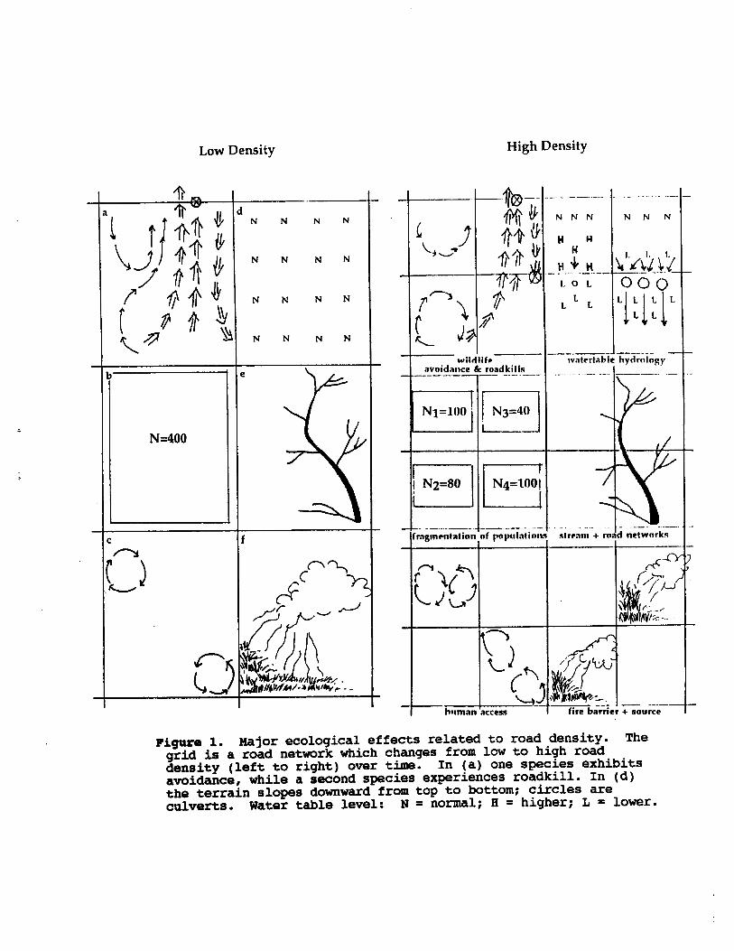
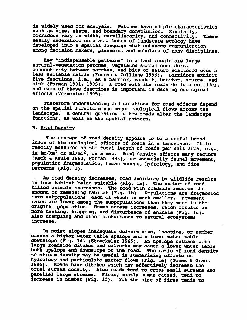
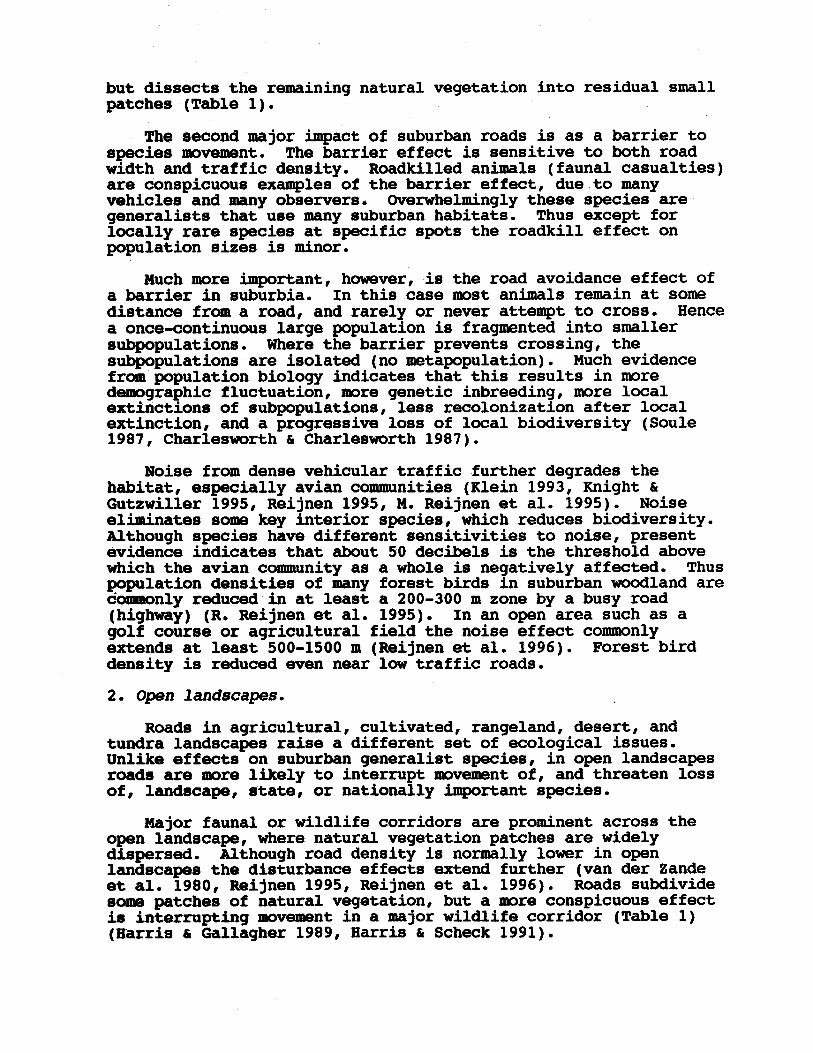
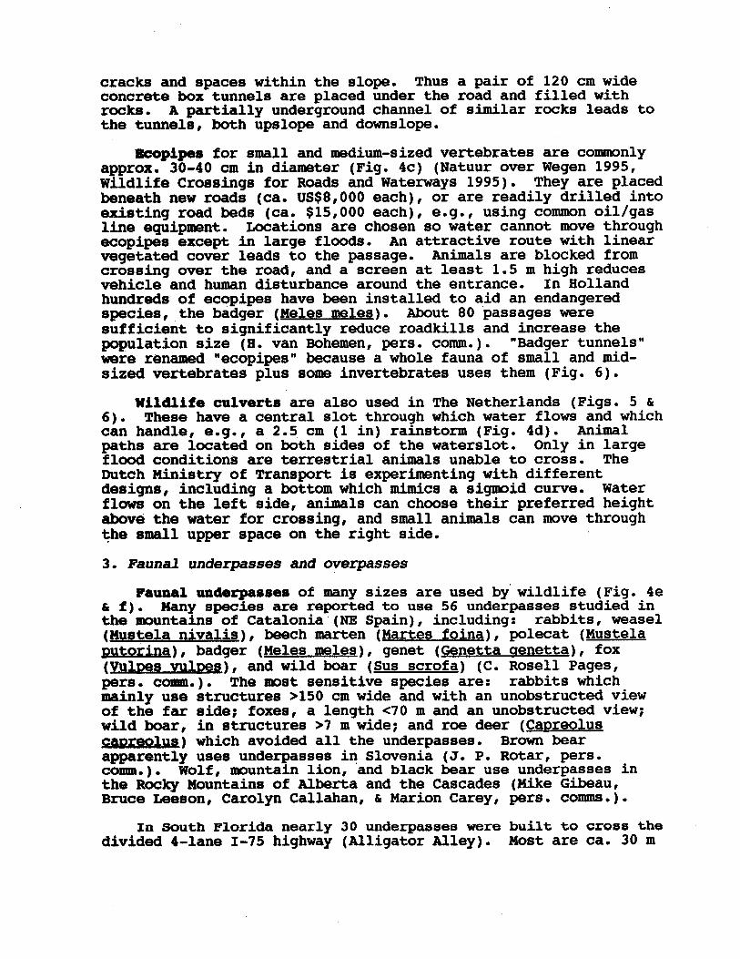
-,-Figure 1. Major ecological effects related to road density. Thegrid is a road network which changes from low to high roaddensity (left to right) over time. In (a) one species exhibitsavoidance, while a second species experiences roadkill. In (d)the terrain slopes downward from top to bottom; circles areculverts. Water table level:
>’Y3
-..-
._- .
- __
,
/
L
--
--.-
fire barrier + source------I-. I -_. _
rodd networks
1
stream +
watertable hydrology_.-__.- ----
n
_
N N N NNN
H
._ ._.__. 1. -.-.-.._ ._.__
poyulalinnrngmentation,nf 4 ..__. _--_ --...--.. .-
__--.--_~ k roadkillswilailife
avoidance
--I
e
iN N N N
N N N N
N N N N
N N N N
4c0
N=400
Low Density High Density
If). Yet the size of fires tends to
61 Grant1996). Roads have ditches which may effectively increase thetotal stream density. Also roads tend to cross small streams andparallel large streams. Fires, mostly human caused, tend toincrease in number (Fig.
upslope and downslope of the road. The ratio of road densityto stream density may be useful in summarizing effects onhydrology and particulate matter flows (Fig. le) (Jones
cutbank withlarge roadside ditches and culverts may cause a lower water tableboth
upslope upslope and a lower water table
downslope (Fig. ld) (Stoeckeler 1965). An
amrount of remaining habitat (Fig. lb).into subpopulations,
Populations are fragmentedeach of which is much smaller. Movement
rates are lower among the subpopulations than they wore in theoriginal population. Human access increases, which results inmore hunting, trapping, and disturbance of animals (Fig. lc).Also trampling and other disturbance to natural ecosystemsincrease.
On moist slopes inadequate culvert size, location, or numbercauses a higher water table
As'road density increases, road avoidance by wildlife resultsin less habitat being suitable (Fig. la). The number of roadkilled animals increases. The road with roadside reduces the
1995), but especially fauna1 movement,population fragmentation,patterns (Fig. 1).
human access, hydrology, and fireForman 61 Kaule 1993,
mi/mi2, on a Rap. Road density affects many factors(Reck
km/km2 or
(Fonnan 1991, 1995). A road with its roadside is a corridor,and each of these functions is important in causing ecologicaleffects (Vermeulen 1995).
Therefore understanding and solutions for road effects dependon the spatial structure and major ecological flows across thelandscape. A central question is how roads alter the landscapefunctions, as well as the spatial pattern.B. Road Densitv
The concept of road density appears to be a useful broadindex of the ecological effects of roads in a landscape. It isreadily measured as the total length of roads per unit area, e.g.,in
61 Collinge 1996). Corridors exhibitfive functions, i.e., as a barrier, conduit, habitat, source, andsink
is widely used for analysis. Patches have simple characteristicssuch as size, shape, and boundary convolution. Similarly,corridors vary in width, curvilinearity, and connectivity. Theseeasily understood core attributes of landscape ecology havedeveloped into a spatial language that enhances communicationamong decision makers, planners, and scholars of many disciplines.
Key "indispensable patterns" in a land mosaic are largenatural-vegetation patches, vegetated stream corridors,connectivity between patches, and bits of nature scattered over aless suitable matrix (For-man
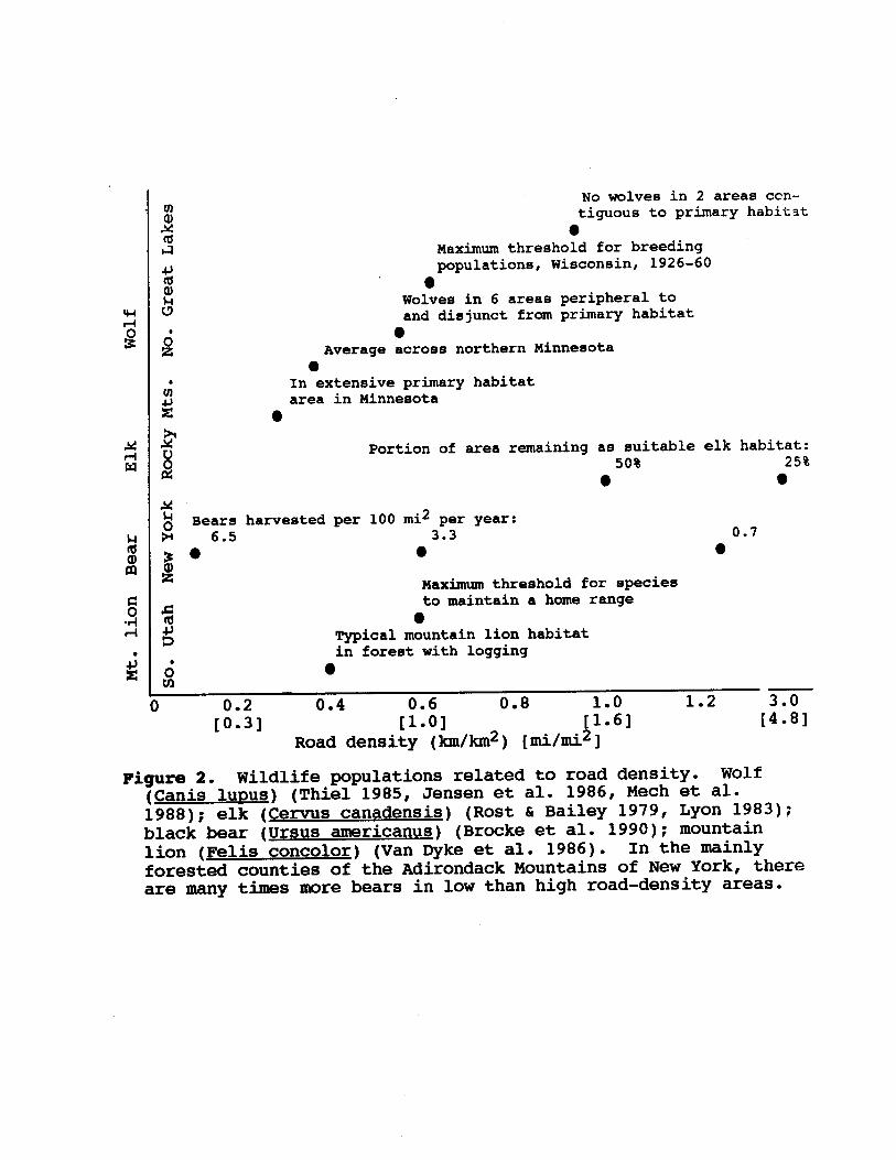
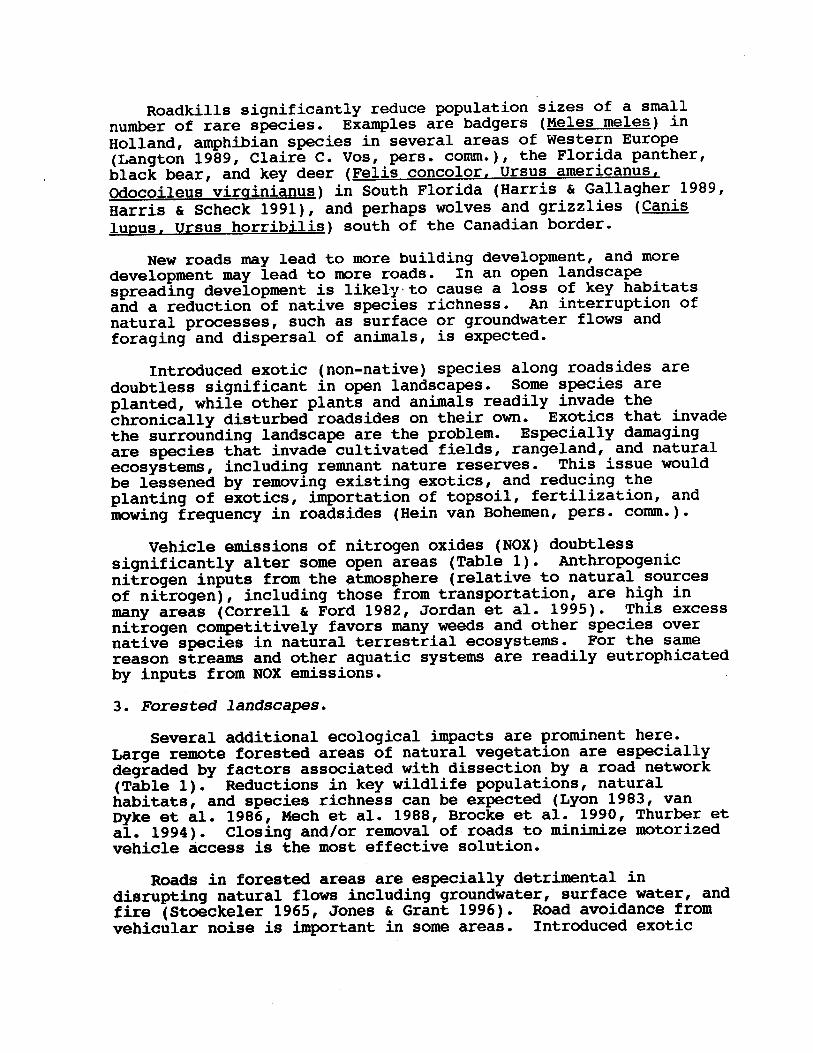
Dyke et al. 1986). In the mainlyforested counties of the Adirondack Mountains of New York, thereare many times more bears in low than high road-density areas.
(Brocke et al. 1990); mountainlion (Felis concolor) (Van
L Bailey 1979, Lyon 1983);black bear (Ursus americanus)
Mech et al.1988); elk (Cervus canadensis) (Rost
lupus) (Thiel 1985, Jensen et al. 1986, (Canis
[mi/mi*]
1.2
Figure 2. Wildlife populations related to road density. Wolf(km/km*)
,:::,Road density
,;::,0.8
0
0.4
g Typical mountain lion habitatin forest with logging
0Sto maintain a home range
#Maximum threshold for species
00308 6.5 3.3 0.7
mi2 per year:e Bears harvested per 100
00
pPortion of area remaining as suitable elk habitat:
50% 25%
02area in Minnesota
tn' In extensive primary habitat0
0Average across northern Minnesota8
.c!J
wolves in 6 areas peripheral toand disjunct from primary habitat
08z
populations, Wisconsin, 1926-60
0k-a Maximum threshold for breeding%
con-tiguous to primary habitatE
No wolves in 2 areas
Kev.Issues in Different Landscanes
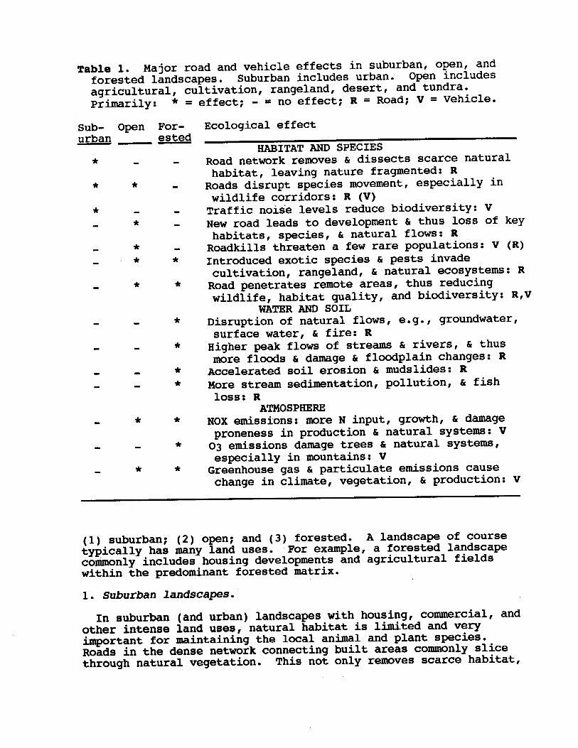
Ecological structure and processes differ sharply in differentlandscapes, and hence road effects are quite distinctive (Table 1).To simplify we group all landscapes into three categories:
may be the best indicator.In short, road density is a useful summary index of ecological
conditions in a landscape. This is because of the manifoldeffects of both the road imprint and vehicle usage on naturalsystems, especially flows and movements across the landscape.
C.
Mech1989). The presence of a few large areas of very low road density
(Mech et al. 1988,
roadless areasurrounded by a moderately high road density in a landscape may besufficient to support sustained populations of wildlife, eventhough total road density is excessive
(Fonuan 1995). A particularly large
Hlsasure, and that several more specificvariables operate in producing a particular road density effect.In the elk and bear examples traffic density (often correlatedwith road width) is important. Also the degree of networkconnectivity is important, e.g., main roads between nodes versusdead-end extensions into remote areas.
Some index of variance or unevenness in mesh size or size ofenclosed patches is also important in understanding the roaddensity effect
"first-order" roads that permit hunters to easily reach remote areas(Brocke et al. 1990). Therefore solutions to maintaining orincreasing elk and bear are different.
This highlights the point that road density itself is asummary integrating
& Bailey 1979, Lyon 1983). In contrast, the pattern forblack bear is due to human access, specifically the tiny
1983), and brown bear (Ursus arctos)(Elgmork 1978 cited in Brocke et al. 1990). This apparentthreshold is a tentative conclusion or working guideline, sincethe number of studies available is limited (Fig. 2).
The pattern for elk (Fig. 2) is due to road avoidance, in thiscase avoiding roads with some level of busy vehicular disturbance(Rost
1982), white-tailed deer (Odocoileusvirainianus) (Sage et al.
Gallath & Timmnrmann alces) (Crete et al. 1981,(Alces
mi/mi2 appears to be the maximum to have anaturally functioning landscape containing sustained populationsof large mammals. Other species have also been linked to roaddensity, including moose
km/Ian2 or 1.0
1988), a rough congruenceemerges for a threshold effect. A road density of approximately0.6
Mech et al. Dyke et al.
1986, Jensen et al. 1986,
decrease due to the road barrier, plus human access forextinguishing fire.
Different species are readily compared for their sensitivityto roads using road density (Fig. 2). Based on the empiricalstudies for wolves and mountain lion (Thiel 1985, Van
6i production: v
(1) suburban; (2) open; and (3) forested. A landscape of coursetypically has many land uses. For example, a forested landscapecommonly includes housing developments and agricultural fieldswithin the predominant forested matrix.1. Suburban landscapes.
In suburban (and urban) landscapes with housing, commercial, andother intense land uses, natural habitat is limited and veryimportant for maintaining the local animal and plant species.Roads in the dense network connecting built areas commonly slicethrough natural vegetation. This not only removes scarce habitat,
& particulate emissions causechange in climate, vegetation,
& natural systems,especially in mountains: VGreenhouse gas
61 natural systems: V03 emissions damage trees
& damageproneness in production
ATMOSPHERHNOX emissions: more N input, growth,
& fishloss: R
& mudslides: RMore stream sedimentation, pollution,
& floodplain changes: RAccelerated soil erosion
c damage & thus
more floods & rivers,
61 fire: RHigher peak flows of streams
c natural ecosystems: RRoad penetrates remote areas, thus reducingwildlife, habitat quality, and biodiversity: R,V
WATER AND SOILDisruption of natural flows, e.g., groundwater,surface water,
&I pests invadecultivation, rangeland,
& natural flows: RRoadkills threaten a few rare populations: V (R)Introduced exotic species
& thus loss of keyhabitats, species,
& dissects scarce naturalhabitat, leaving nature fragmented: RRoads disrupt species movement, especially inwildlife corridors: R (V)Traffic noise levels reduce biodiversity: VNew road leads to development
HABITAT AND SPECIESRoad network removes
= no-effect; R = Road; V = Vehicle.
Ecological effect
-
*
effect;
*
*
**
*
*
*
*
*
*
*
**
*
*
For-urban ested--Sub- Open
aqricultural, cultivation, rangeland, desert, and tundra.Primarily: * =
Table 1. Major road and vehicle effects in suburban, open, andforested landscapes. Suburban includes urban. Open includes
Scheck 1991).b 8 Gallagher 1989, Harris movemsnt in a major wildlife corridor (Table 1)
(Harris
mre likely to interrupt movement of, and threaten lossof, landscape, state, or nationally important species.
Major fauna1 or wildlife corridors are prominent across theopen landscape, where natural vegetation patches are widelydispersed. Although road density is normally lower in openlandscapes the disturbance effects extend further (van der Zandeet al. 1980, Reijnen 1995, Reijnen et al. 1996). Roads subdividesome patches of natural vegetation, but a more conspicuous effectis interrupting
&mmonly reduced in at least a 200-300 m zone by a busy road(highway) (R. Reijnen et al. 1995). In an open area such as agolf course or agricultural field the noise effect commonlyextends at least 500-1500 m (Reijnen et al. 1996). Forest birddensity is reduced even near low traffic roads.2. Open landscapes.
Roads in agricultural, cultivated, rangeland, desert, andtundra landscapes raise a different set of ecological issues.Unlike effects on suburban generalist species, in open landscapesroads are
soms key interior species, which reduces biodiversity.Although species have different sensitivities to noise, presentevidence indicates that about 50 decibels is the threshold abovewhich the avian community as a whole is negatively affected. Thuspopulation densities of many forest birds in suburban woodland are
bGutzwiller 1995, Reijnen 1995, M. Reijnen et al. 1995). Noiseeliminates
8 Charlesworth 1987).Noise from dense vehicular traffic further degrades the
habitat, especially avian communities (Klein 1993, Knight
where the barrier prevents crossing, thesubpopulations are isolated (no metapopulation). Much evidencefrom population biology indicates that this results in moredemographic fluctuation, more genetic inbreeding, more localextinctions of subpopulations, less recolonization after localextinction, and a progressive loss of local biodiversity (Soule1987, Charlesworth
roadkill effect onpopulation sizes is minor.
Much more important, however, is the road avoidance effect ofa barrier in suburbia. In this case most animals remain at somedistance from a road, and rarely or never attempt to cross. Hencea once-continuous large population is fragmented into smallersubpopulations.
but dissects the remaining natural vegetation into residual smallpatches (Table 1).
The second major impact of suburban roads is as a barrier tospecies movement. The barrier effect is sensitive to both roadwidth and traffic density. Roadkilled animals (fauna1 casualties)are conspicuous examples of the barrier effect, due to manyvehicles and many observers. Overwhelmingly these species aregeneralists that use many suburban habitats. Thus except forlocally rare species at specific spots the
C Grant 1996). Road avoidance fromvehicular noise is important in some areas. Introduced exotic
Brocke et al. 1990, Thurber etal. 1994). Closing and/or removal of roads to minimize motorizedvehicle access is the most effective solution.
Roads in forested areas are especially detrimental indisrupting natural flows including groundwater, surface water, andfire (Stoeckeler 1965, Jones
Mech et al. 1988,
C Ford 1982, Jordan et al. 1995). This excessnitrogen competitively favors many weeds and other species overnative species in natural terrestrial ecosystems. For the samereason streams and other aquatic systems are readily eutrophicatedby inputs from NOX emissions.
3. Forested landscapes.
Several additional ecological impacts are prominent here.Large remote forested areas of natural vegetation are especiallydegraded by factors associated with dissection by a road network(Table 1). Reductions in key wildlife populations, naturalhabitats, and species richness can be expected (Lyon 1983, vanDyke et al. 1986,
comm.).
Vehicle emissions of nitrogen oxides (NOX) doubtlesssignificantly alter some open areas (Table 1). Anthropogenicnitrogen inputs from the atmosphere (relative to natural sourcesof nitrogen), including those from transportation, are high inmany areas (Correll
(Hein van Bohemen, pers.
be lessened by removing existing exotics, and reducing theplanting of exotics, importation of topsoil, fertilization, andmowing frequency in roadsides
""to cause a loss of key habitatsand a reduction of native species richness. An interruption ofnatural processes, such as surface or groundwater flows andforaging and dispersal of animals, is expected.
Introduced exotic (non-native) species along roadsides aredoubtless significant in open landscapes. Some species areplanted, while other plants and animals readily invade thechronically disturbed roadsides on their own. Exotics that invadethe surrounding landscape are the problem. Especially damagingare species that invade cultivated fields, rangeland, and naturalecosystems, including remnant nature reserves. This issue would
likelJ
lupus. Ursus horribilis) south of the Canadian border.
New roads may lead to more building development, and moredevelopment may lead to more roads. In an open landscapespreading development is
(Canisgrizzlies 1991), and perhaps wolves and Scheck c & Gallagher 1989,
Harris
comm.), the Florida panther,black bear, and key deer (Felis concolor, Ursus americanus,Odocoileus virainianus) in South Florida (Harris
(Langton 1989, Claire C. Vos, pers.
Roadkills significantly reduce population sizes of a smallnumber of rare species. Examples are badgers (Meles meles) inHolland, amphibian species in several areas of Western Europe
cantly interrupted.where natural patterns or processes areThen the array of solutions available
are used to alleviate a bottleneck.signif x
are "bottlenecks",
people and goods do too.nature's patterns and processes.
We start by mappingThen the the road network is
superimposed. We examine intersections of the two networks to seeif the
Plannina Framework for Addressina Road and Nature Conflicts
Most existing roads were built before the explosion inecological knowledge, and hence society's recognition of itsdependence on nature and natural processes. Thus a proceduredeveloped in The Netherlands is outlined (with slightmodification) for identifying the most important conflicts betweenexisting roads and nature, and thus targeting mitigation projects.The approach is equally useful for avoiding environmental problemsin new construction.
Surface water, groundwater, fire, pollinators, dispersingseeds, and foraging, dispersing and migrating animals move acrossthe landscape.
Do
sedtinted with fine material.areas are degraded.
Fish spawning grounds and foragingFish and fishermen become scarce.
Vehicular emissions, especially ozone (03) and NOX, havediverse effects in forested landscapes. High elevation forestssubject to ozone and other pollutant accumulations experienceextensive tree die-offs and other ecosystem degradation. Nitrogeninputs to nutrient-poor terrestrial systems increase plant growtha bit, but apparently make the plants more susceptible to pestoutbreaks and other stresses. Nitrogen runoff into nutrient-poorstreams also alters the natural stream ecosystems.
In summary, the major ecological effects of transportationdiffer markedly in different landscapes. Planning and mitigationsolutions must differ accordingly. Roads, i.e., the imprint onthe land, cause more effects and doubtless have a greatercumulative effect than vehicles.over human generations,
But both factors are operatingthat is, both must be addressed for
creating a sustainable environment.
1996), with consequent effects on human structuresas well as floodplain morphology.
The downslope flowing surface water also carries particulatematter; mineral nutrients, and heat to streams. Turbidity andother streamwater alterations increase, and stream bottoms are
b Grant
upslope ditch flow, under-roadculverts, and downslope channels. Peak flows increase markedly(Jones
cutbank seepage,
species and pests, especially light-requiring plants, fromroadsides may invade logged and disturbed clearings.
The linked effects on hydrology, erosion, streams, and fishare particularly important in these landscapes (Table 1). Forexample, logging roads on slopes convert ground water to surfacewater through
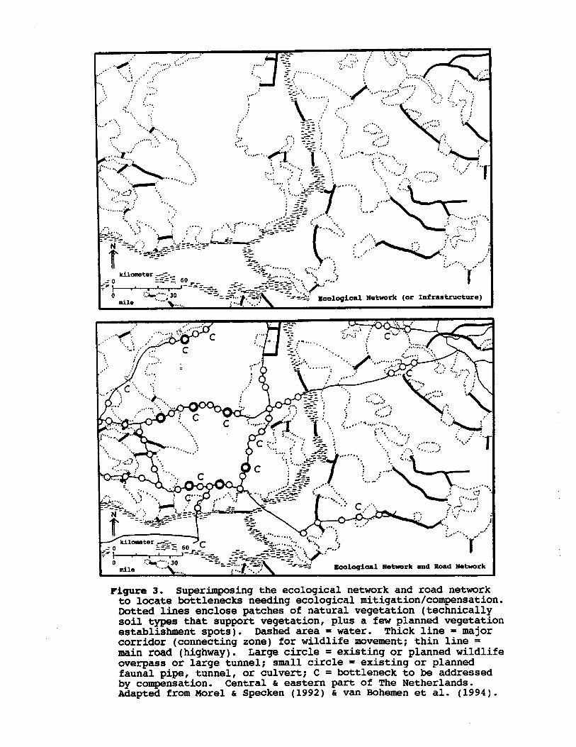
Bohemen et al. (1994).h van Specken (1992) c & eastern part of The Netherlands.
Adapted from Morel
= bottleneck to be addressedby compensation. Central
= existing or plannedfauna1 pipe, tunnel, or culvert; C
= existing or planned wildlifeoverpass or large tunnel; small circle
=main road (highway). Large circle
= majorcorridor (connecting zone) for wildlife movement; thin line
= water. Thick line
Infrastructure)
Figure 3. Superimposing the ecological network and road networkto locate bottlenecks needing ecological mitigation/compensation.Dotted lines enclose patches of natural vegetation (technicallysoil types that support vegetation, plus a few planned vegetationestablishment spots). Dashed area
~""'j,.., Ecological Network (or mile
coxua.). The network of main roads (Fig. 3b) is thensuperimposed on the "National Ecological Network" (Fig. 3a).Bottlenecks are identified where a road interrupts majorecological movements and flows (Fig. 3b).
persr. "corridorsn, and "nature development areas**
are prime locations within more suitable areas (H. van Hohemen,
Specken 1992, van Bohemen et al.1994). The largest national park and forest at the heart of thenation is on the left. Several large patches of naturalvegetation are found eastward to the German border. Majorwildlife corridors and river corridors connect the large patches.The more suitable and less suitable areas are not mapped here, butvirtually all the major wildlife corridors go through moresuitable areas. In Holland large patches are called **cores**,major corridors are
h
Forman 1995). In essence, we map nature'snetwork (the ecological network of nodes and corridors), which isjuxtaposed with more suitable and less suitable areas.
Then the road network is superimposed on the ecologicalnetwork. Locations where the two cross are identified aspotential "bottlenecks", i.e., where major ecological flows orpatterns are interrupted by roads. Techniques of avoidance,mitigation, or compensation are then selected to minimize oreliminate the ecological impacts.
An example from the central and eastern Netherlands isinstructive (Fig. 3a) (Morel
movmnt of such species(Knaapen et al. 1992;
extreme resistance to
a-am, such as commercial, dense residential, industrial,and urban areas, normally could only be converted to naturalvegetation over extended periods. In addition, more suitableareas are partially compatible for movement by some speciescharacteristic of native vegetation. However, less suitable areasoften provide
ruitable
su&able areas,such as many cultivated fields, pastures, golf courses, and mowedparkland, are readily transformed into natural vegetation. Less
comm.). More
movements and water flows across the landscape are added. Thelarge patches and major corridors form the primary "ecologicalnetwork or infrastructure" of the landscape.
The remaining land is differentiated into two types based onhow rapidly or easily the land use could be converted into naturalvegetation (H. van Hohemen, pers.
(Fonnan 1995). Then the major corridors or routes of animal
large-home-range species, sustainable populations of interior species, and soforth mapped* These are surrogates for aquifer protection,
IIK)re integrative landscape-ecology approach istaken. Here the large patches or areas of natural vegetation are
Aanerican state or province or region. Individual speciespopulations, dispersal routes, groundwater flows, and the likeform a preliminary network. But generally these details areinadequately known.
Thus a broader,
nature:8 patterns and processes across the land, e.g., for a NorthThe first major step is to determine and map the network of
3a), as well as in a landscape withmany dispersed vegetation patches. Within the large forest, sixwildlife overpasses or large tunnels exist or are planned, plus 18areas for pipes, tunnels, or culverts (Fig. 3b). Eightbottlenecks require compensation. In the surrounding fragmentedlandscape one wildlife overpass or large tunnel, 35 bottleneckareas for smaller structures, and four compensations exist or areplanned. Bottlenecks are identified on five wildlife corridors(four at left and one at bottom).
In summary, the planning framework for addressing conflictsbetween nature and roads focuses on making the ecological networkor green infrastructure of the landscape explicit, in order toidentify the road-caused bottlenecks. The array of avoidance,mitigation, and compensation techniques available to scientistsand engineers is used to eliminate or minimize the ecologicalimpacts, especially at bottlenecks.
&Keller 1995). Patches, corridors, and more and less suitableareas are mapped at this relatively fine scale using aerialphotographs, topographic maps, site visits, and other information.At this scale detailed information on species populations,dispersal routes, groundwater flows, etc. are more readilyavailable or can be researched.
At this point the array of techniques for avoiding,mitigating, and compensating ecological impacts comes into play(van Bohemen et al. 1994, Natuur over Wegen 1995). Usuallyseveral techniques are used for a bottleneck on a new road, inwidening an existing road, or alleviating impacts of previousconstruction.
The first consideration is avoidance. How can ecologicalimpacts be avoided altogether, e.g., by removing a road,constructing it differently, building it in another place, or notbuilding a road? If this is not possible, the second step ismitigation. How can ecological impacts be reduced or minimized,e.g., through restricted access, reduced vehicle speed, wildlifetunnels, fencing, etc.? If significant ecological impactsremain, the third step is compensation. How can an ecologicalimpact be compensated to provide an equivalent amount ofecological enhancement to a nearby area? For example, a wildlifecorridor may be widened, a naturally functioning wetlandconstructed, or a patch of natural vegetation enlarged. No netloss of ecological value is the guiding principle in compensation.
The region illustrated is chosen to show patterns in the largeforested area on left (Fig.
lo-30km in length, and the surrounding landscape area within about 5-10km, are examined in detail (Natuur over Wegen 1995, Pfister
For each bottleneck identified a stretch of road approx.
Scott8 1989). The animals normally move through the network of&mic a natural rocky slope area (Fig. 4b) (Mansergh
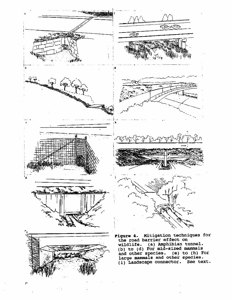
Rocky tunnels for the threatened mountain pygmy-possum inAustralia
t other species& culverts for mid-sized mammals
m length, and 150 cm wide when longer than 50 m.2. Pipes, tunnels,
comnly used to lead animals to the tunnel entrance.Tunnel dimensions largely depend on the species and the tunnellength. Sections of the commercially available polymer-concretetunnel with inside dimensions of ca. 30x30 cm, are easily insertedinto the road so the top is flush with the road surface.Slots in
the top of the tunnel permit light, air, and water to enter.Larger underground amphibian tunnels are rectangular, ca. 100 cmwide for up to 20
30-50 cm highwith an overhang at the top, and preferably obscured from theroad, are
b Tyning 1989, Wildlife Crossings for Roads and Waterways1995). Amphibian migration routes tend to be narrow so tunnellocation is critical. Drift fences or barriers ca.
(Langton 1989,Jackson
comms.), which has had sometechnical problems and some successes.
Many designs for amphibian tunnels have been tested, and atleast one model is commercially available (Fig. 4a)
pers. Kim Jenkins, Greibel and e Tyning 1989). One tunnel for a toad was built in Texas (Thomas
(Ambvstoma maculatum)exist in Amherst, Massachusetts, and are quite successful (Jackson
comm.).Two tunnels for spotted salamanders
(Langton1989, Claire C. Vos, pers.
roadkillnumbers cause a significant decrease in population size
soms cases evidence indicates that
(Langton 1989). Techniques directed at the driver of a vehicleare used to reduce amphibian mortality in Belgium, Wales, andFinland. These mitigation methods are for toads, frogs, and newtswhich live on one side of a road, but which cross the road andreturn in massive numbers within a brief period of breeding in apond or wetland on the other side of the road. Huge numbers ofroadkills occur. In
mntioned, as well as twomitigations for surface and ground water systems. Four groups ofstructures or passages are recognized: (1) amphibian tunnels; (2)pipes, tunnels, and culverts for mid-sized mammals and otherspecies; (3) wildlife underpasses and overpasses; and (4)landscape connectors.1. Amphibian tunnels
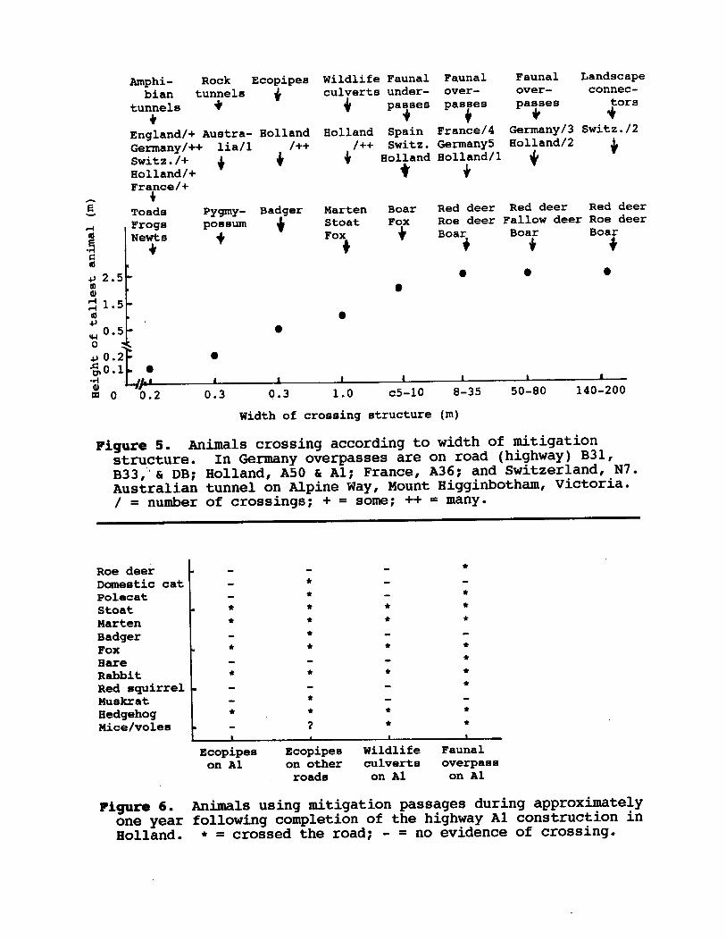
Amphibian tunnels are widely used in Europe, includingEngland, Germany, Switzerland, Holland, and France (Fig. 5)
Techniaues for Wildlife Crossing Roads
Since major corridors for fauna1 movement are so ofteninterrupted by roads or rails, a series of mitigation techniquesis illustrated (Fig. 4). The focus is on techniques used andtested in nations outside of North America. A few examples fromthe United States and Canada are
Mitiaation fiaior E.
‘.
Figure 4. Mitigation techniques forthe road barrier effect onwildlife . (a) Amphibian tunnel.(b) to (d) For mid-sized mammalsand other species. (e) to (h) Forlarge mammals and other species,(i) Landscape connector. See text.
r
‘f. ‘..’
_‘.
.
cr
'd
mwere built to cross the
divided I-lane I-75 highway (Alligator Alley). Most are ca. 30
comms.).
In South Florida nearly 30 underpasses
& Marion Carey, pers. Leeson, Carolyn Callahan,
colmn.). Wolf, mountain lion, and black bear use underpasses inthe Rocky Mountains of Alberta and the Cascades (Mike Gibeau,Bruce
canreolus) which avoided all the underpasses. Brown bearapparently uses underpasses in Slovenia (J. P. Rotar, pers.
m wide; and roe deer (Caoreolus>7 m and an unobstructed view;
wild boar, in structures <70
>150 cm wide and with an unobstructed viewof the far side; foxes, a length
comm.). The most sensitive species are: rabbits whichmainly use structures pers.
Pages,vulnes), and wild boar (Sus scrofa) (C. Rose11 (Vulnes meles), genet (Genetta aenetta), fox
f). Many species are reported to use 56 underpasses studied inthe mountains of Catalonia (NH Spain), including: rabbits, weasel(Mustela nivalis), beech marten (Martes foina), polecat (Mustelaputorina), badger (Meles
Fauna1 underpasses of many sizes are used by wildlife (Fig. 4ea
simid curve. Waterflows on the left side, animals can choose their preferred heightabove the water for crossing, and small animals can move throughthe small upper space on the right side.
3. Fauna1 underpasses and overpasses
6). These have a central slot through which water flows and whichcan handle, e.g., a 2.5 cm (1 in) rainstorm (Fig. 4d). Animalpaths are located on both sides of the waterslot. Only in largeflood conditions are terrestrial animals unable to cross. TheDutch Ministry of Transport is experimenting with differentdesigns, including a bottom which mimics a
&Nildlife culverts are also used in The Netherlands (Figs. 5
mid-sized vertebrates plus some invertebrates uses them (Fig. 6).
"ecopipes" because a whole fauna of small and comm.). "Badger tunnels"
were renamed
m high reducesvehicle and human disturbance around the entrance. In Hollandhundreds of ecopipes have been installed to aid an endangeredspecies, the badger (Meles meles). About 80 'passages weresufficient to significantly reduce roadkills and increase thepopulation size (H. van Bohemen, pers.
equiprtlent. Locations are chosen so water cannot move throughecopipes except in large floods. An attractive route with linearvegetated cover leads to the passage. Animals are blocked fromcrossing over the road, and a screen at least 1.5
US$8,000 each), or are readily drilled intoexisting road beds (ca. $15,000 each), e.g., using common oil/gasline
4c) (Natuur over Wegen 1995,Wildlife Crossings for Roads and Waterways 1995). They are placedbeneath new roads (ca.
medium-sized vertebrates are commonlyapprox. 30-40 cm in diameter (Fig.
Bcopipes for small and
upslope and downslope.
cracks and spaces within the slope. Thus a pair of 120 cm wideconcrete box tunnels are placed under the road and filled withrocks. A partially underground channel of similar rocks leads tothe tunnels, both
- = no evidence of crossing.
Fauna1on Al on other culverts overpass
roads on Al on Al
Figure 6. Animals using mitigation passages during approximatelyone year following completion of the highway Al construction inHolland. l = crossed the road;
1
Ecopipes Ecopipee WildlifeaI
*
*
*
*
I
*
l
l
**
**l
l
l
l
*
l
l
*
?
*
. *
*
.
*
.
. l
.
/ = number of crossings; + = some; ++ = many.
Roe deerDomestic catPolecatStoatMartenBadgerFoxBareRabbitRed squirrelMuskratHedgehogMice/voles I
& Al; France, A36; and Switzerland, N7.Australian tunnel on Alpine Way, Mount Higginbotham, Victoria.B33,'C DB; Holland, A50
c5-10 8-35 50-80 140-200Width of crossing structure (m)
Figure 5. Animals crossing according to width of mitigationstructure. In Germany overpasses are on road (highway) B31,
1
0.2 0.3 8.3 1.0I1I II 1L-/P
go4
#++
4
Marten Boar Red deer Red deer Red deerStoat Fox Roe deer Fallow deer Roe deerFox Boar Boar
/++ Switz. Germany5 Holland/ZHolland Holland/lG
Switz./2Germany/3 Eolland Spain France/4 +
connec-tors
over-over-under-
+
Wildlife Fauna1 Fauna1 Fauna1 Landscapeculverts
f
Pygmy- Badgerpossum
fToadsz
JIHolland/+France/+
$Switz./+ /++lia/l
+England/+ Auatra- HollandGermany/++
+4
tunnels
Amphi- Rock Ecopipeebian tunnels
c 6). Narrow passages may permit small numbers of these animalsto cross, which may be sufficient for gene flow, but insufficientto mitigate demographic fluctuation and local extinction.Apparently few species other than amphibians and someinvertebrates use the amphibian tunnels. Ecopipes and wildlifeculverts may be effective for moving whole faunas of small andmid-sized terrestrial vertebrates (Fig. 6). Mid-sized mammalsreadily use the underpasses and overpasses.. lines of tree stumps,
If "stump walls",i.e., are added, the small terrestrialvertebrate fauna crosses underpasses, and presumably overpasses,in much greater numbers (Natuur over Wegen 1995).
m soil berm along each side whichshields the overpass from vehicle noise (Fig. 4h). The soiltypically is 40-50 cm thick, but sometimes much thicker, over asystem of drainage pipes and gravel. One or two small ponds fedby rainwater falling on the overpass may be present.
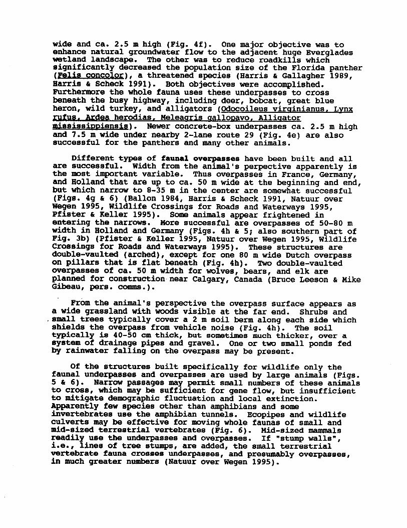
Of the structures built specifically for wildlife only thefauna1 underpasses and overpasses are used by large animals (Figs.5
.small trees typically cover a 2
comms.).
From the animal's perspective the overpass surface appears asa wide grassland with woods visible at the far end. Shrubs and
pers. & Mike
Gibeau, Leeson
m width for wolves, bears, and elk areplanned for construction near Calgary, Canada (Bruce
m wide Dutch overpasson pillars that is flat beneath (Fig. 4h). Two double-vaultedoverpasses of ca. 50
& Keller 1995, Natuur over Wegen 1995, WildlifeCrossings for Roads and Waterways 1995). These structures aredouble-vaulted (arched), except for one 80
& 5; also southern part ofFig. 3b) (Pfister
mwidth in Holland and Germany (Figs. 4h
& Keller 1995).entering the narrows.
Some animals appear frightened inMore successful are overpasses of SO-80
& Scheck 1991, Natuur overWegen 1995, Wildlife Crossings for Roads and Waterways 1995,Pfiater
1984# Harris (Ballon C 6) ---.(Figs. 4g .~ __-. m in the center are somewhat successfulm wide at the beginning and end,
which narrow to 8-35
perpective apparently ismost important variable.Holland that are up to ca.
Thus overpasses in France, Germany,50
2-lane route 29 (Fig. 4e) are alsosuccessful for the panthers and many other animals.
aretheandbut
Different types of fauna1 overpasses have been built and allsuccessful. Width from the animal's
m wide under nearby m high
and 7.5 slsainniensis). Newer concrete-box underpasses ca. 2.5 .. aallonavo, Alliuatorrufus. Ardea herodias. Meleaaris
61 Scheck 1991). Both objectives were accomplished.Furthermore the whole fauna uses these underpasses to crossbeneath the busy highway, including deer, bobcat, great blueheron, wild turkey, and alligators (Gdocoileus virainianus, Lvnx
c Gallagher 1989,Harris (Felix concolor), a threatened species (Harris
m high (Fig. 4f). One major objective was toenhance natural groundwater flow to the adjacent huge Evergladeswetland landscape. The other was to reduce roadkills whichsignificantly decreased the population size of the Florida panther
wide and ca. 2.5
-wespen) inhabit the site.Small ponds on the structure itself are designed to attractamphibians on their way to spawning sites. Despite the temporaryopen environment at present, numerous animal species move betweenforest on adjoining sides, including hare, fox, and deer.
c Keller1995). Native shrubs are planted only at the highway entrances toshield animals from traffic disturbance and to enhance the visualappearance of the connector. Otherwise the site is designed forpioneer vegetation and natural succession. Within two years aftercompletion, 60 plant species are recorded on the connector. Rareinsects (including Toepferbinen and
m. This soil depth allows growth ofnatural forest vegetation without irrigation.
The Aspiholz connector is planted sparsely (Pfister
m thick and aminimum soil cover of 1.5
IQ-lane highway, where all environmentalmitigations were 10% of the total cost. A twin vault structure(Zwillingsgewoelbe) was chosen, with concrete 0.4
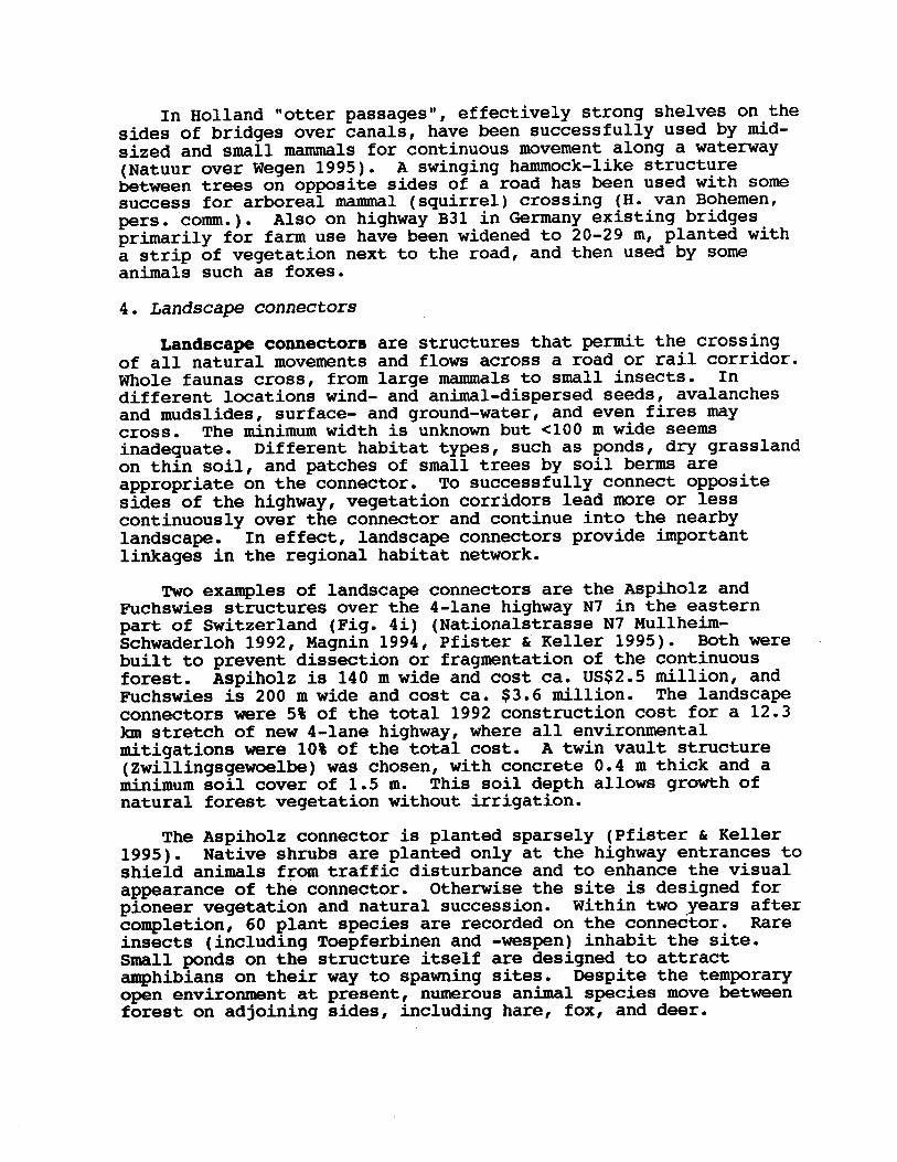
m wide and cost ca. $3.6 million. The landscapeconnectors were 5% of the total 1992 construction cost for a 12.3km stretch of new
USS2.5 million, andFuchswies is 200
m wide and cost ca.
c Keller 1995). Both werebuilt to prevent dissection or fragmentation of the continuousforest. Aspiholz is 140
Mullheim-Schwaderloh 1992, Magnin 1994, Pfister
m wide seemsinadequate. Different habitat types, such as ponds, dry grasslandon thin soil, and patches of small trees by soil berms areappropriate on the connector. To successfully connect oppositesides of the highway, vegetation corridors lead more or lesscontinuously over the connector and continue into the nearbylandscape. In effect, landscape connectors provide importantlinkages in the regional habitat network.
Two examples of landscape connectors are the Aspiholz andFuchswies structures over the 4-lane highway N7 in the easternpart of Switzerland (Fig. 4i) (Nationalstrasse N7
<lOO
wind- and animal-dispersed seeds, avalanchesand mudslides, surface- and ground-water, and even fires maycross. The minimum width is unknown but
s&ily for farm use have been widened to 20-29 m, planted witha strip of vegetation next to the road, and then used by someanimals such as foxes.
4. Landscape connectors
Landscape connectors are structures that permit the crossingof all natural movements and flows across a road or rail corridor.Whole faunas cross, from large mammals to small insects. Indifferent locations
comm.). Also on highway B31 in Germany existing bridges
mid-sized and small mammals for continuous movement along a waterway(Natuur over Wegen 1995). A swinging hammock-like structurebetween trees on opposite sides of a road has been used with somesuccess for arboreal mammal (squirrel) crossing (H. van Bohemen,
In Holland "otter passages", effectively strong shelves on thesides of bridges over canals, have been successfully used by
0 R.I. Miller, eds.DeGraaf regione. In R.M. biodivereity in landscape and 8.X. Collinge. 1996. The 'spatial solution' to conservinge Forznan, R.T.T.
Press, Cambridge.Univermity Hooiacer The Ecology of Landscapes and Regions.
Cambridge Forman, R.T.T. 1995. Land
pP.71-84.Corridore. Surrey Beatty, Chipping Norton, Auetralia.2:
The Role of Conservation Hobbs, ede. Nature L R.J. Saunderm polioy. In D.A.
fran theoretical foundation8 topublic
Forman, R.T.T. 1991. Landscape corridormr Management 45: 598-611.Quebeo. Journal of Wildlife mouthwemtern
moome harvest inGptiraination of (I P.A. Jordan. 1981.
emtuarine nitrogen. Hetuarine, Coastal and Shelf Science 15:45-56.
Crete, w., R.J. Taylor
eourcem of Comparison of precipitation and land runoff
a8 C D. Ford. 1982.Correll, D.L.
18:237-268.
In
Syetematics tcology and coneequencee. Annual Review of Charlesworth. 1987. Inbreeding depression and its
evolutionary L B. Charlemworth, D.
Penna. Pp. 13-17.Forest Service, Radnor, Teohnical Report NH-140, 0.8. Iaaue in the Northeast? GeneralManagement Fotamt Fragmentation a 10
mchrme, mitigating impact of road networks on sensitive wildlife species.H.A. Guetafeon. 1990. A forest managementL O'Petio Brooke, R.H., J.P.
20-24.(Parim) 76: Chamee 1'Office National de laMen6uel de l'autoroute A36. Bulletin cur gibier
passages dede8 l'efficacite mur obmervationo Prcwierem Ballon, P. 1984.
Hein van Bohemen formany stimulating discussions on the subjects presented.
Godwin and the National ResearchCouncil for making possible the collection of much information inthis paper; Debra Friedman, David Fitzhenry, Allen Chen, and JayMartin for excellent literature reviews and thoughtful insights;Debra Friedman for drawing the figures; and
owleduement~
We warmly thank: Stephen R.
Ian wide, designed primarilyfor cultural, visual, and nature continuity.
In short, a series of mitigation approaches is available forreducing the barrier effect of roads on wildlife movement. Manyother approaches have been tried, and research, experimentation,and technological development is ongoing. Very little of thistechnology has yet reached and been implemented in the UnitedStates. Implementation of existing successful technology,research on ecological and fauna1 interactions with roads, andeducation of the public on these conflicts and solutions shouldaccelerate concurrently and promptly.
Finally, it bears reemphasis that roads must be explicitlyconsidered part of the broad landscape in order to identify andmitigate their ecological effects.
is for a landscape connector 1.5 km wide, primarilyfor wildlife and cultural continuity. The connector in the Swissplan for extending highway N7 is 1.7
comm.) and Switzerland.The Dutch plan
pers. Plans for lowering roads into long tunnels are being evaluated
in The Netherlands (van Bohemen,
C A.S. Liebennan. 1984. Landscape Ecology: Theory and Application.Springer-Verlag, New York.
2.
Hydraulic Engineering Department), Delft, TheNetherlands. 103 pp.
Naveh,
PP.Natuur over Wegen (Nature across motorways). 1995. Rijkewaterstaat(Directorate-General for Public Works and Water Management), Dienst Weg- enWaterbouwkunde (Road and
Kanton Thurgau, Switzerland. 43 zur Verkehrsubergabe vom 27.
November 1992. 1992. Eerausgeber,
Dee1 4(H. Duel, achrijver). Directoraat-Generaal Rijkawaterstaat, Dienst Weg- enWaterbouwkunde, Delft, The Netherlands. 105 pp.
Nationaletrasse N7 Mullheim-Schwaderloh: Bericht
Specken. 1992. Versnippering van de ecologiachehoofdstructuur door de natte infraatructuur. Project Versnippering
& B.P.M.
61 W.J. Paul. 1988. Wolf distribution androad density in Minnesota. Wildlife Society Bulletin 16: 85-87.
Morel, G.A.
S.E. Fritts, G.L. Radde Mech, L.D.,
Mech, L.D. 1989. Wolf population survival in an area of high road density.American Midland Naturalist 121: 387-389.
Scotts. 1989. Habitat continuity and socialorganisation of the mountain pygmy-possum restored by tunnel. Journal ofWildlife Management 53: 701-707.
61 D.J. l/94: 16-18.
Manaergh, I.M.
Damit Rehe und Wildschweine weiterhin wandern konnen:Grunbrucken uber Autobahnen. BUWAL Bulletin (Bundesamt fur Umwelt, Wald undLandechaft, Switzerland)
AC0 Polymer Products Ltd.,Shefford, Bedfordshire, England. 202 pp.
Lyon, L.J. 1983. Road density models describing habitat effectiveness forelk. Journal of Forestry 81: 592-595.
Magnin, B. 1994.
Langton, T.E.S., ed. 1989. Amphibians and Roads.
& K.J. Gutzwiller, eds. 1995. Wildlife and Recreationists:Coexistence through Management and Research. Island Press, Washington, D.C.
6r B. Banns. 1992. Estimating habitat isolation inlandscape planning. Landscape and Urban Planning 23: l-16.
Knight, R.L.
M. Scheffer
& N.M. Goff. 1995. Temporalvariation in precipitation chemistry on the shore of the Chesapeake Bay.Water, Air, and Soil Pollution 83: 263-284.
Klein, M.L. 1993. Waterbird behavioral responses to human disturbances.Wildlife Society Bulletin 21: 31-39.
Knaapen, J.P.,
.E., D.L. Correll, D.E. Weller
61 G.E. Grant. 1996. Peak flow responses to clearcutting androads in small and large basins, Western Cascades, Oregon. Water ResourcesResearch (in press).
Jordan, T
lupus)distribution on the Ontario-Michigan border near Sault Ste. Marie. CanadianField-Naturalist 100: 363-366.
Jones, J.A.
(Canis 61 W.L. Robinson. 1986. Wolf
AC0 Polymer Products Ltd., Shefford,Bedforshire, England. Pp. 93-98.
Jensen, W.F., T.K. Fuller
Langton, ed. Amphibians and Roads.
8 T.F. Tyning. 1989. Effectiveness of drift fences and tunnelsfor moving spotted salamanders Ambvstoma maculatum under roads. In T.E.S.
Eobbs, eds. Nature Conservation 2: TheRole of Corridors. Surrey Beatty, Chipping Norton, Australia. Pp. 189-220.
Hobbs, R.J. 1995. Landscape ecology. Encyclopedia of Environmental Biology2: 417-428.
Jackson, S.D.
& R.J.
Scheck. 1991. From implications to applications: thedispersal corridor principle applied to the conservation of biologicaldiversity. In D.A. Saunders
& J. Earris, L.D.
h P.B. Gallagher. 1989. New initiatives for wildlifeconservation: the need for movement corridors. In G. Mackintosh, ed.Preserving Conununities and Corridors. Defenders of Wildlife, Washington,D.C. Pp. 11-34.
Godron. 1986. Landscape Ecology. John Wiley, New York.Harris, L.D.
61 M. Forman, R.T.T.
& Hall,London. Pp. 537-568.Conservation of Fauna1 Diversity in Forested Landscapes. Chapman

PP.Waterznanagement, Delft, The Netherlands. 16
HydraulicEngineering Division (DWW), Ministry of Transport, Public Works and
Gpen Areas. Thesis Landbouw UniversiteitWageningen, Wageningen, The Netherlands. 131 pp.
Wildlife Crossings for Roads and Waterways. 1995. Road and
Babitat and Corridor for CarabidBeetles of Poor Sandy and
Venneulen, H.J.W. 1995. Road-side Verges:
Lindsey. 1986. Reactions of mountain lions to logging and human activity.Journal of Wildlife Management 50: 95-102.
L F.G.Hemker Brocke, E.G. Shaw, B.B. Ackerman, T.P. R.E.
-evidence of a long distance effect. Biological Conservation 18: 299-321.
Van Dyke, F.B.,
C W.J. van der Weidjen. 1980. The impactof roads on the densities of four bird species in an open field habitat
Zande, A.N., W.J. ter Keurs 1994(3): 15-25.
van der
onderzoek bij verkeer en waterstaat. Landschap-
ontsnipperingr Beleid en Vries. 1994. Versnippering 8. de (I Pa-8 H., C. Bohmmnen,
Alces 18: 301-328.Turner, M.G. 1989. Landscape ecology: the effect of pattern on process.Annual Review of Ecology and Systematic8 20: 171-197.
van
Goliath. 1982. Age and sex structure of harvestedmoose related to season manipulation and access.
C R. E.R. Tinmnemnn,
C S.A. Thomasma. 1994. Gray wolfresponse to refuge boundaries and roads in Alaska. Wildlife SocietyBulletin 22: 61-68.
r DrummeWisconsin. American Midland Naturalist 113: 404-407.
Thurber, J.M., R.O. Peterson, T.D.
Thiel, R.P. 1985. Relationship between road densities and wolf habitatsuitability in
framnorthern Europe. Journal of Forestry 63: 772-776.
J.E. 1965. Drainage along swamp forest roads: lessons Stoeckeler,
M. 1987. Viable Populations for Conservation. Cambridge UniversityPress, Cambridge.
47: 940-962.Soule,
C D.F. Behrend. 1983. White-taileddeer visibility and behavior along forest roads. Journal of Wildlife
Management
W.C. 'Pierson, G.F. Mattfeld
& J.A. Bailey. 1979. Distribution of mule deer and elk inrelation to roads. Journal of Wildlife Management 43: 634-641.
Sage, R.W.,
Root, G.R.
Meeuwmen. 1996. The effects of car traffic onthe density of breeding birds in Dutch agricultural grasslands. BiologicalConservation (in press).
8. C Foppen
C J. Thiseen. 1995. The effects of cartraffic on breeding bird populations in woodland. III. Reduction of densityin relation to the proximity of main roads. Journal of Applied Ecology 32(in press).
Reijnen, R., R.
ter Braak C. Foppen,
PP*Reijnen, R. 1995. Disturbance by Car Traffic as a Threat to Breeding Birds
in The Netherlands. Thesis, DLG-Institute for Forestry and Nature Research,Wageningen, The Netherlands. 140 pp.
Reijnen, R., R.
Foppen. 1995. Predicting the effectsof motorway traffic on breeding bird populations. Road and HydraulicEngineering Division, Directorate-General for Public Works and WaterManagement, Delft, and DLO-Institute for Forestry and Nature Research, TheNetherlands. 92
I R.P.B.
vam Bundesminister fur Verkehr, Bonn-Bad Godesberg, Germany.230 pp.
Reijnen, M.J.S.M., G. Veenbaas
Eerausgegeben Lebensrauxm. Forschung Strassenbau und Strassenverkehrstechnik, Heft 654.
'ihreTier8 und Beurteilung strassenbedingter Auswirkungen auf Pflanzen, Ennittlung undKaule. 1993. Strassen und Lebensraumer G. C R-k, H.
C H.L. Cadenasso. 1995. Landscape ecology: spatialheterogeneity in ecological systems. Science 269: 331-334.
Pickett, S.T.A. l/95: 26-30.Losung? BIL (Switzerland)
61 V. Keller. 1995. Strassen und Wildtiere.-SindGrunbrucken eine
E.P. Pfister, Von