Embed Size (px)
Citation preview
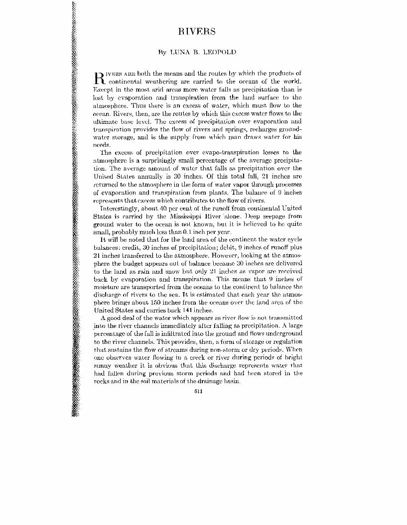
RIVERS
By LUNA B. LEOI’OLD
IVISRY ARE both the means and the routes by which tlic products of K continental weathering are carried to the oceans of the world. Except in the most arid areas more water falls as precipitation than is lost by evaporation and transpiration from the land surfacc to the atmosplicre. Thus there is an excess of water, which must flow to the occwi. Rivers, then, are the routes by which this excess water flows to the ultimatc basc level. The excess of precipitation over evaporation and transpiration provides the flow of rivers and springs, recharges ground- water storage, and is the supply from which man draws water for his needs.
The excess of precipitation over evapo-transpiration losses to the atmosphere is a surprisingly small percentage of the average precipita- tion. The average amount of water that falls as precipitation over the United States annually is 30 inches. Of this total fall, 21 inches are returned to the atmosphere in the form of water vapor through processes of evaporation and transpiration from plants. The balance of 9 inches represents that excess which contributes to the flow of rivers.
Interestingly, about 40 per cent of the runoff from continental lJnited States is carried by the Mississippi River alone. Deep seepage from ground water to the ocean is not known, but i t is believed to he quite small, probably much less than 0.1 inch pcr year.
It will bc noted that for the land area of the continent the water cycle balances: credit, 30 inches of precipitation; debit, 0 inches of runoff plus 21 inches transferred to the atmosphere. However, looking a t the atmos- phere the budget appears out of balance because 30 inches are delivered to the land as rain and snow but only 21 inches as vapor are received back by evaporation and transpiration. This means that 9 inches of moisture are transported from the oceans to the contincnt to balance the discharge of rivers to the sea. It is estimated that each year the atmos- phere brings about 150 inches from the occans ovcr thc land area of the United States and carries back 141 inches.
A good deal of the water which appears as river flow is not transmitted into the river channels immediately after falling as precipit)ation. A large percentage of the fall is infiltrated into the ground and fiows underground to the river channels. This provides, then, a form of storage or regulation that sustains the flow of streams during non-storm or dry periods. Whcn one observes water flowing in a creek or river during periods of txighl sunny weather it is obvious that this discharge represents water that had fallen during previous storm periods and had Ixlen storcd in the rocks and in the soil materials of the drainage basin.
511
,512 AMI~CILTCAN S(’1ENTIST
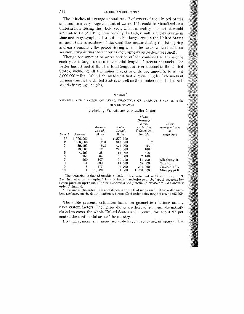
The 9 inches of average annunl runoff of rivers of ihe linitcd States amounts to a very large amount of water. If it (.odd be visiializcd as a uniform flow during the whole year, which in reality it is not, it would amount to 1.4 X 10” gallons per day. In fact, runoff is highly erratic in time and in geographic distribiition. E’or large areas in thc United States an important percentage of the total flow occurs during the late spring and early summer, the period during which the water which lind bcen accumulating during the winter as snow appears as melt-water runoff.
Though the amount of w a i c ~ (wried off thc continent to the oceans each year is largc, so also is the total Irngth of stream channels. The writer 1ins cstim:bted that the tot nl lcngt~li of r iwr channcl in thc IJnited States, inchding :dl the minor cwcks and draws, amounts to about 3,000,000 miles. Tnl)le 1 shonrs thr cstimnted gross I~ng th of channels of various sizes in the IJnitcd States, as wc~ll ns thr m i m h of sii~li channels : ~ n d thvir :tver:~g(~ length.
T \T31,15 1 NIJICIIII~CIL A N I ) T,~:NGT’II OF I ~ I V I C I ~ CIIANNELS OF v2\itTous SIZI:S IN y’rm
Ihcluding l’ributarics of Smnller Order UNITEI) STATICS
Mean Draanacjr
Area, /?ZlJP?
i l veraqe Total Inrliidancl Rrpiecenlatztv I.rngth, Lenqth, Trzlmtm ies, of
order’ Nzmber Miles nllles Sq. M a . Ench Saze l 2 1,570,000 1 1 ,570,000 I 2 350,000 2 3 81 0,000 4 7 3 80,000 5 3 420,000 23 4 18,000 12 220,000 1 on 5 4,200 28 11 6,000 518 6 950 64 61,000 2,460 7 200 147 30,000 11,700 Allegheny R. 8 41 388 14,000 55,600 Gila It. 9 8 777 (i ,200 204,000 Columbia R.
10 1 1,800 1 ,800 1 ,250,000 Mississippi R.
The definition is that of Strahler: Ordei J is cl~nnncl without trihiitai-irs; order 2 is channcl with only order 1 tributnrirs, but includos only the length scgrnent be- tween junction upstream of order l channels and junction downstrrain \\ ith another order 2 channel.
2 The size of the order 1 rlianncl depends on sc*sle of maps used; 1 hesr order niim- hers are based on the determination of the simllcst order using maps of sc:Llc 1 62,500.
The table presents estimates based on geometric relations among river system factors. Thc iigiircs sliomn arc derived from samples extlrap- olated to cover the whole United States and account for nhout 97 per cent of the continental area of the couniay.
Stmngcly, most Americans probably have never heard of many of the
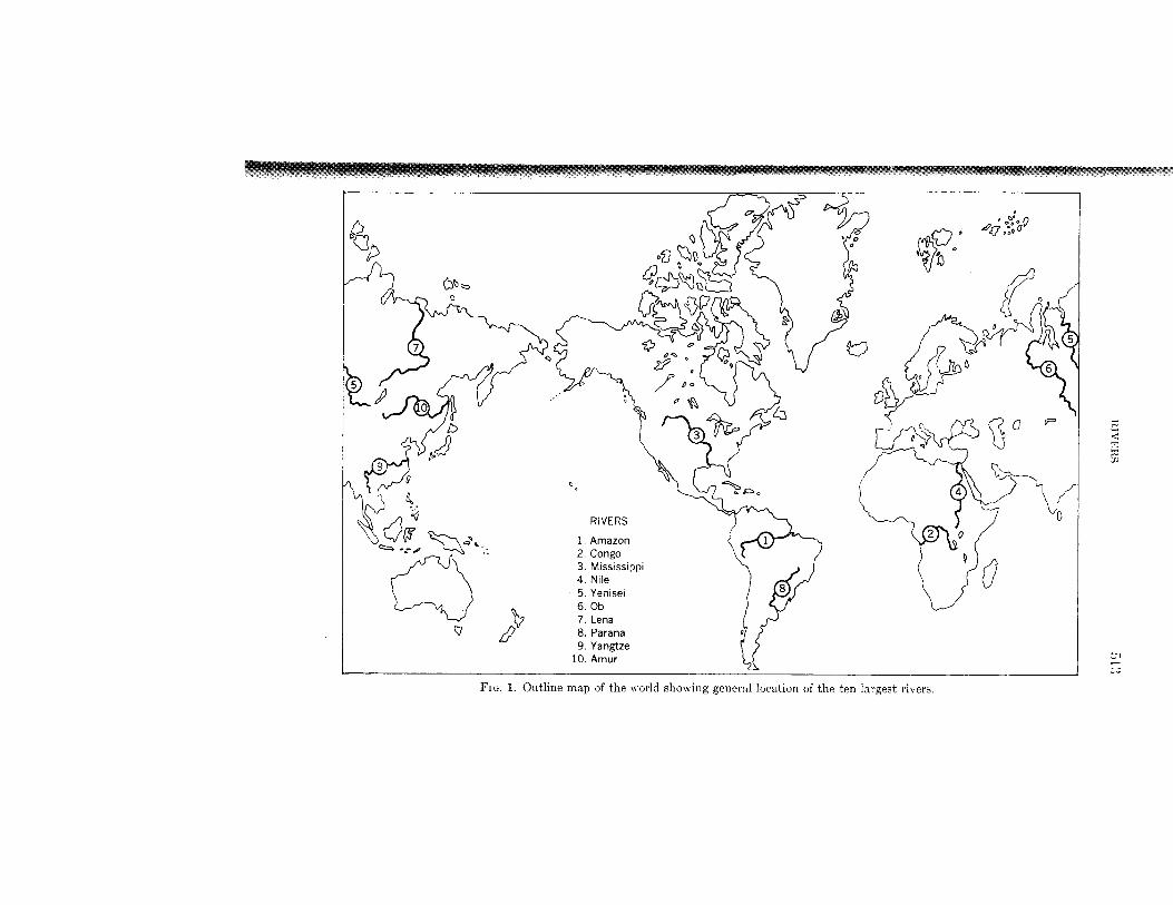
FIG. 1. Outline map of the xorld showing general location of the ten largest rivers.
,514 AMERICAN SCIENTIST
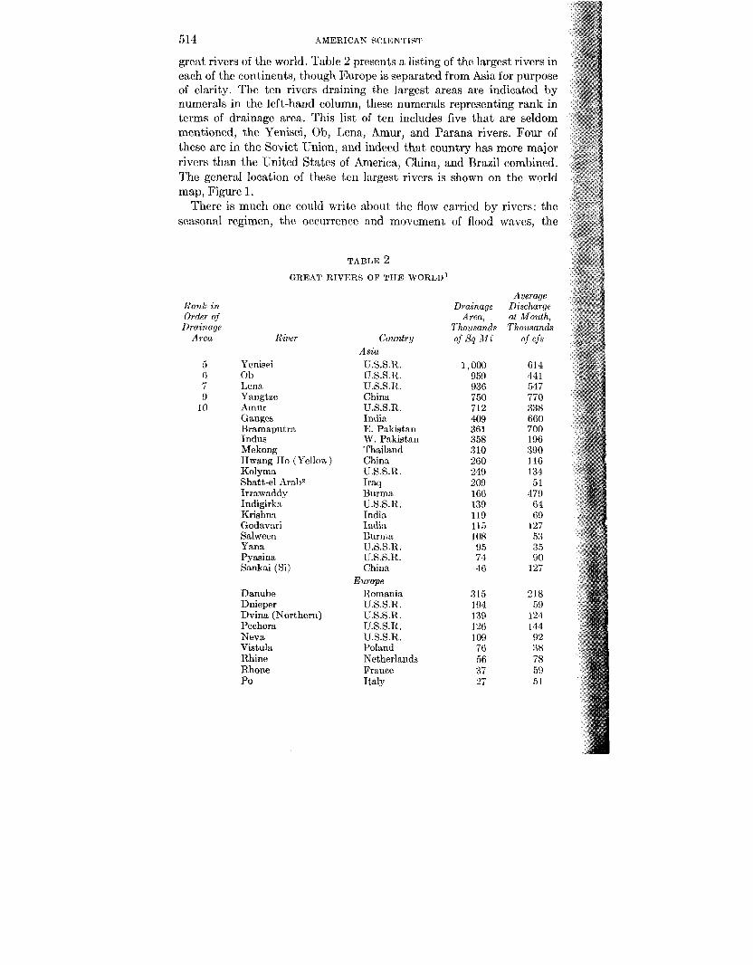
great rivers of the world. Table 2 presents a listing of the largest rivers in each of the contincnts, though Europe is separated from Asia for purpose of clarity. The ten rivers draining the largest areas are indicated by numerals in the left-hand column, these numerals representing rank in terms of drainage area. This list of ten includes five that are seldom mentioned, the Yenisei, Ob, Lena, Amur, and Parana rivers. Four of these are in the Soviet Union, and indeed that country has more major rivers than the United States of America, China, and Brazil combined. The general location of these t m largest rivers is shown on the world map, Figure 1.
There is much onc could writc about the flow cnrricd by rivers: the seasonal regimen, thc occurrence and movcment, of flood waves, the
TABLE 2 GREAT RIVERS OF TIIE WORLD^
Rank in Order qf
Drainage Area
5 ti 7 9
10
Railer
Ycnisei 0 b Lena Yangtze Amur Ganges Bramaputma Indus Mckong Hwang €10 (Yellow) Kolyma Shatt-el Arab2 Irrawadrly Indigirlca Kris hn:i Godavnri Salwecn Y a m Pyaaina Smkai (Si)
Danube Dnieper Dvina (Northern) Pechora Neva Vistula Rhine Rhone Po
Country Asia U.S.S.R. U.S.S.R. U.S.S.R. China U.S.S.R. India E. Pakistan W. Pakistan Thailand China U.S.S.R. Iraq Burma U.S.S.R. India India Buriita U.S.S.R. U.S.S.R. China
Romania U.S.S.R. U.S.S.R. [J.S.S.R. U.S.S.B. Poland Netherlands France Italy
Europe
Drainage Area,
Thousands of s q Mi
1,000 959 936 750 712 409 361 358 310 260 249 200 166 139 119 115 I08 95 74 40
315 194 139 126 I09 76 56 37 27
Average Discharge at Mouth, Thousands
of cfs
614 44 1 547 770 338 060 700 196 390 116 134 51
479 ti4 69
127 5:3 3 5 00
127
218 59
124 I44 9 2 38 75 59 51
RIVERS 515
chemistry of river waters, and a host of other subjects that make river hydrology a valid realm for the pursuit of fundamental scientific inquiry. I shall limit this paper to a description of the form of rivers and river systems.
The three million miles of stream channels in the United States vary widely in size and occur in a wide variety of topographic and geologic circumstances. Included in this figure of total length are those high mountain streams epitomizing wilderness beauty, -the dirty and trash- filled channels too often coursing through our cities, and the majestic but turbid large rivers flowing in wide valleys of central United States and thc flat expanses of the coastal plain.
One might suppose then, from the variety of geographic and geologic environments through which these channels are carved, that there would exist such a variety of river types that but little could be said about river characteristics in general. Each geographic situation might be supposed to have its own special kind of river and each would be a law unto itself.
Africa 2 Congo Congo 1,550 1,400
Zamhrzi Mozambique 500 250 Niger Nigeria 430 215
3 Mississippi3 U.S.A. 1,244 61 1 Mackenzie Canada 697 280 St. Lawrence U.S.A. and 498 500
Canada Nelson Canada 414 80 Yukon Canada 360 180 Columbia U.S.A. 258 256 Frazer Canada 92 113 Mobile U.S.A. 42 58 Susquehanna U.S.A. 28 38
4 Nile Egypt 1 ,150 100
North America
South America 1 Amazon Brazil 2,231 4
8 Parana Argentina 890 526 Tocantins Brazil 350 360 Orinoco Venezuela 340 600 Sao Francisco Brazil 260 100 Magdalena Columbia 93 265 Uruguay Argentina and
Uruguay 90 136
Note.-This table includes only rivers that discharge over 35,000 cubic feet per second a t the mouth. It does not include many rivers like the Colorado for example, that drain large areas in an arid climate and therefore discharge relatively little water.
1 Rivers with average discharge of 35,000 cubic feet per second, or greater; from information collected as part of study on world-wide runoff of dissolved solids.
Tigris, Euphrates, and Karun Rivera.
3 million to 4 million cubic feet per second. 3 Includes Atchafalaya River.
51G AMERICAN SCIENTIST
As a matter of fact, thc subtle but pervasive unity that exists, despite the tremendous diversity, is probably the most important characteristic of river systems.
There is not only unity displayed by important similarities between rivers in different settings, but also an amazing organization of river systems. This in part results from a delicate balance between the forces of erosion and the forces of resistance.
Thc characteristics of river systems which can be used to dcmonstrate the unity among forms fall under three gencral categories, the river channcl, the rivcr valley, and the drainage net-the tcrm applied to the system of branching channels ramifying to the smallest tributaries.
The first and most important aspcct of the river channel is that i t is self-formed nrid sclf-maintained. The flowing wat cr carves the groove in which i t flows. The watcr fashions tlic depth, the cross section, the areal configuration, and the longitudinal profile.
Existing river channels have had a history in many respects analogous to the history of a s p c c h in tlw biological world. An existing river is inherited from an cnrlicr one, which in turn was dcrived from a still earlier progrnitor. Thc scyurncc extends backward to that time when the contincnt:d area now being drninrd hy the river was once under the ocean.
Thus the river channcl usually cannot tic spoken of as having becn formcd, i n that no particular timc or place of origin of a given rivcr can be specified. Rather, i t is best to think that a river has evolved through geologic timc, and that the processes of change that may be observed a t present arc indccd the same processes by which this evolution took place. The changes during the. river history in geologic time were brought about by changes in the external conditions, such as a change in climate (including glaciation), a change in elcvation of the continental mass and the concomitant changes in vegetation, in rates and types of weathering, and in the amounts and kinds of matcrials flowing under the influence of gravity toward base-lcvcl-thc ocean.
The forccs involved in shaping and maintaining thc channel are related to thc fluid flow. Thr fiow of (lie fluid cxurts :L shrar on both bed and bank and i t is this shcnr which ~auses particles comprising t,he bed and bank to be moved along in trartion by the water, that! is, by pushing, rolling, and skipping. This portion of the debris in transport is referred to as the txdload. The same shear crratcs the turbulent cddics in the flowing fluid which entrains some' particlcs of mattcr and throws them up into the main mass of the fluid, thus carrying them as thc suspended load.
Thr transport of sediment drhris by rivrrs to thc oceans is a phenom- cmon ltnown to cvcryonr. It is far lrss wcll known that the quantity of dissolvotl mat crinls carried hy rivers to the ocran is also very lnrgc. 13cc:iiiso t l i c transport proccss is not) visually cvidcnt, nor are dcposits of
RIVERS 51’7
dissolved materials obvious, it is hard to visualize that slightly morc tlmn half of all the materials carried by river water from continent to occan is carried as dissolved load. This fact was quantitatively verified in results recently published by Durum, Heidel, and Tison, describing an inter- national project designed to sample the dissolved load of tlie great rivcrs of the world.
Fluid shear shapes the river channel. It can be visualized in a general way that if a channel were vcry deep and vcry narrow there would lw far more shearing action on the channel sides than on the channel bed. It seems logical that, as a result, there would be a tendency in such :L channel for erosion to take place along the banks, whereas along the hcd tl .,re would be a tendency for insuficient shear to carry along the eroded material. Such a channel would widen and become shallower.
An opposite extreme can be visualized, in which a channcl were very wide and shallow. The great expanse of bed exposed to the shearing xc- tion of the flow would tend to erode and thus degrade the bed, cstablish- ing in time a channel of more modest breadth but greater depth. Indeed, some such action does take place, for the width-depth ratios of rivcrs of comparable size have a great consistency.
If the shearing force on the channel banks is sufficient to overcome the cohesion of the bank materials, erosion takes place, and the eroded particles are swept away from their original position and become a part of the bed materials, there either to be moved or temporarily lodged. On the stream bed, scour takes place when the shear exceeds some critical value, and this occurs during relativcly high flow. At low flow i t is usual for the shearing forces on the bed to he sufficiently small that the txd materials do not move. Scour, then, occurs primarily during high dis- charges. The relatively long time periods represented hy modest and low flow are periods of but little movement of bed material.
A river increases downstream in size owing to the increase of drainage area as tributaries enter. This increase in size is manifested not only in the amount of water (discharge) but also by an increase in channel width and depth. To accommodate an increase in discharge rcsultirig from tributary entrance, the channel may enlarge in width or in depth, or the increased flow could he achicvcd by an increase in flow velocity. Because discharge (cubic feet per second) is the product of cross-sectional area times velocity
Q = av
and area is the width times depth
Q = wdv
an increase in discharge may be accommodated by an increase in any of these three factors, or by some combination of them.
518 AMERICAN SCIENTIST
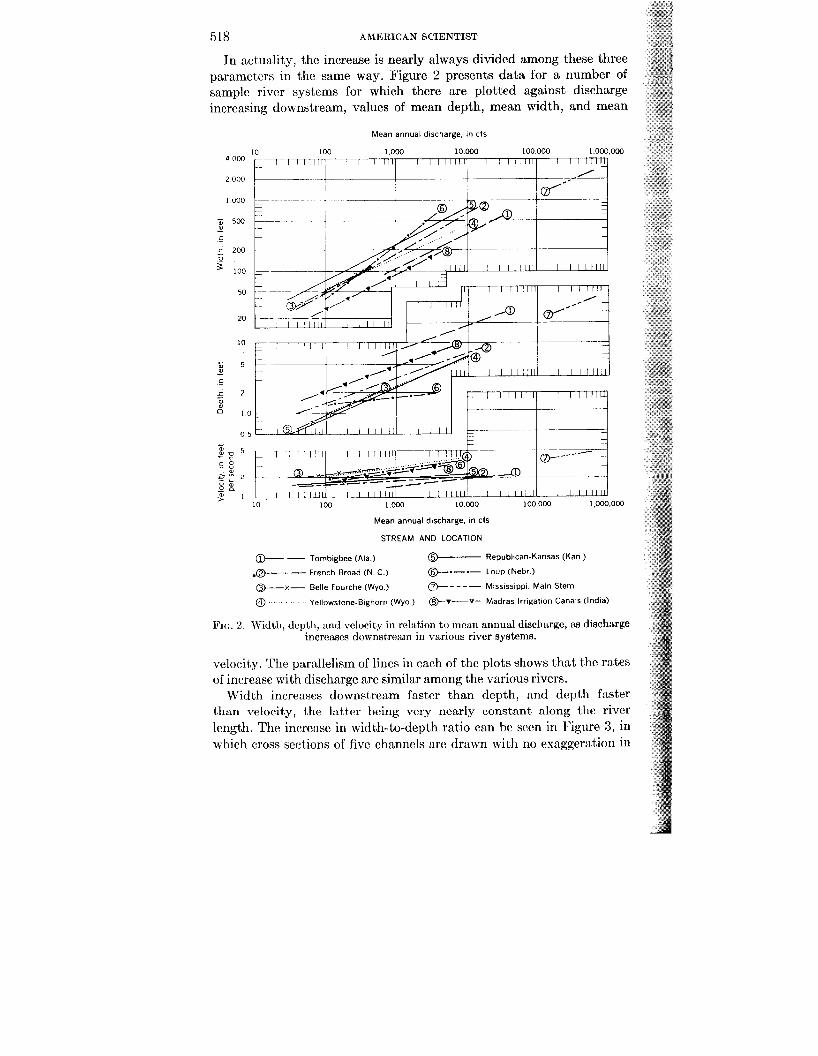
In act,uxlity, the increase is nearly always divided among these three parameters in the same way. Figure 2 presents data for a number of sample river systems for which there are plotted against discharge increasing downstream, values of mean depth, mean width, and mean
f n W
Mean annual discharge. in cfs
10 100 1 000 10 000 100 000 1 000 000
10.000 100.000 1,000.000 10 100
Mean annual discharge. in CIS
STREAM AND LOCATION
@--- - Tombigbee (Ala ) 0 Republican-Kansas (Kan )
.Q- - - French Broad (N C )
0 - x - Belle Fourche (Wyo ) *- Mississippi. Main Stem
0 Yellowstone Bighorn (Wyo ) @-v-v- Madras Irrigation Canals (India)
@--e--- Loup (Nebr )
FIG. 2. Width, dcptli, and vclocity in rclation to incan annual discharge, as discharge increascs downstream in various river systems.
velocity. The parallelism of lines in each of the plots shows that the rates of inrrcasc with discharge are similar among the various rivers.
Width increases downstream faster than depth, and depth faster than velocity, the latter being very nearly constant along the river lcngth. The increase in width-to-depth ratio can be sccn in Ipigure 3, in which cross sections of five channels arc drawn with no cxaggeration in
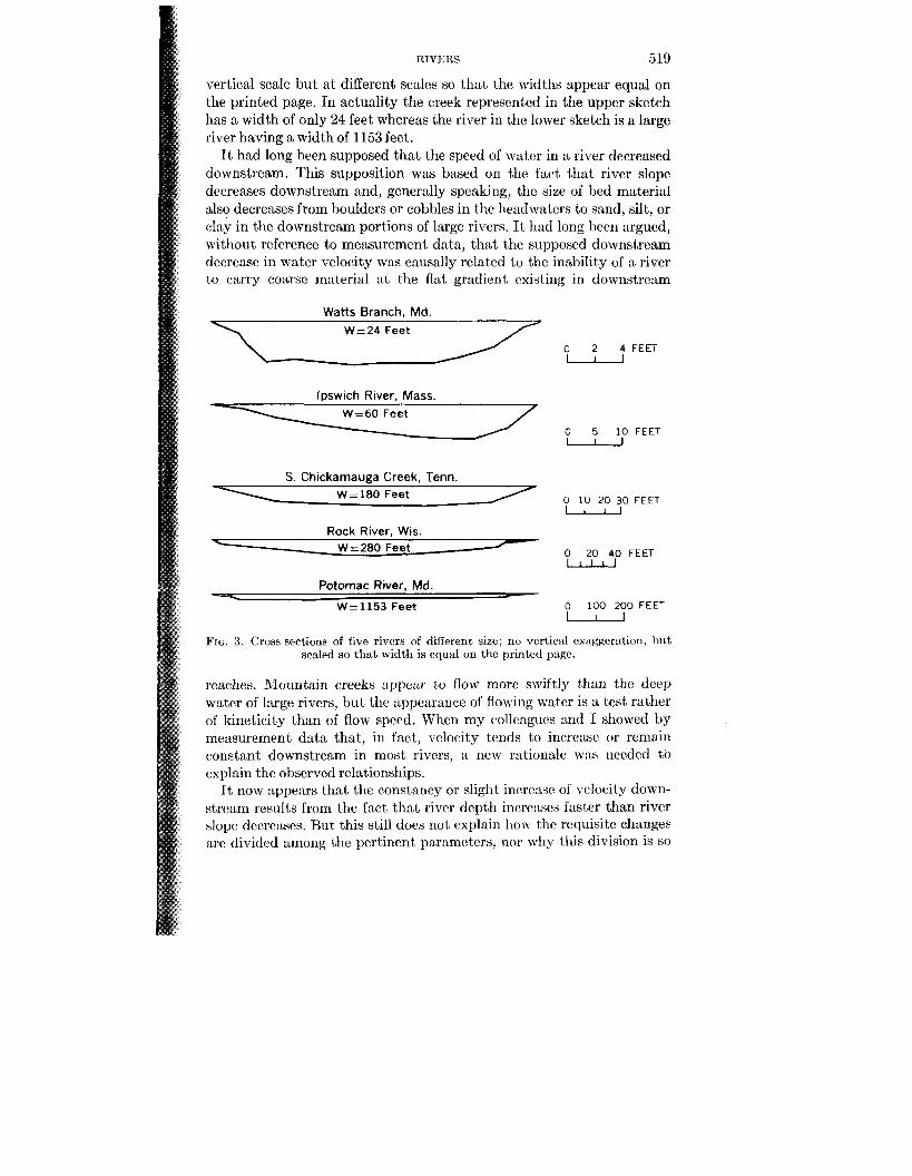
RIVERS 519
vertical scale but a t different scales so that the widths appear equal on the printed page. In actuality the creek represent,cd in the upper sketch has a width of only 24 feet whereas thc river in the lower sketch is a large river having a width of 1153 feet.
It had long been supposed that the speed of water in a river decreased downstream. This supposition was based on the fact that river slope decreases downstream and, generally speaking, the size of bed material also decreases from boulders or cobbles in the headwaters to sand, silt, or clay in the downstream portions of large rivers. It 1i:d long hecn argued, without reference to measurement data, that the supposed downstream decrease in water velocity was causally related to the inahilit,y of a river to carry coarsc' material a t the flat gradient, cxisting in downstream
Watts Branch, Md. W=24 Feet
lpswich River, Mass. W = 6 0 Feet
S. Chickarnauga Creek, Tenn. W = 180 Feet
Rock River, Wis. W=280 Feet --
Potornac River, Md. W=1153 Feet
\ c
0 2 4 FEET - 0 5 10 FEET - 0 10 20 30 FEET u
0 20 40 FEET u
0 100 200 FEET W
FIG. 3. Cross sections of five rivers of different size, no vertical csitggerntion, but scaled so that width is cqual on the printed page.
reaches. Mountain creeks appear lo flow mom swiftly than the deep water of large rivers, but the appearance of flowing water is a test rather of kineticity than of flow speed. When my collcngucs and I showed by measurement data that, in fact, velocity tends to incrc:w or remain constant downstream in most rivers, a new rationale was needed to explain thc observed relationships.
It now appears that, the constancy or slight increase of vclocity down- stream results from the fact that river depth increases fastcr than river slope decreases. But this still does not, explain liom the requisite changes are divided among the pertinent parameters, nor why this division is so
520 AMERICAN SCIJSNTIST
nearly the same in all rivers regardless of size or physiographic sc This division turns out to be that which most nearly causes entro increase equally in each unit of length along the river as will be mcntio later.
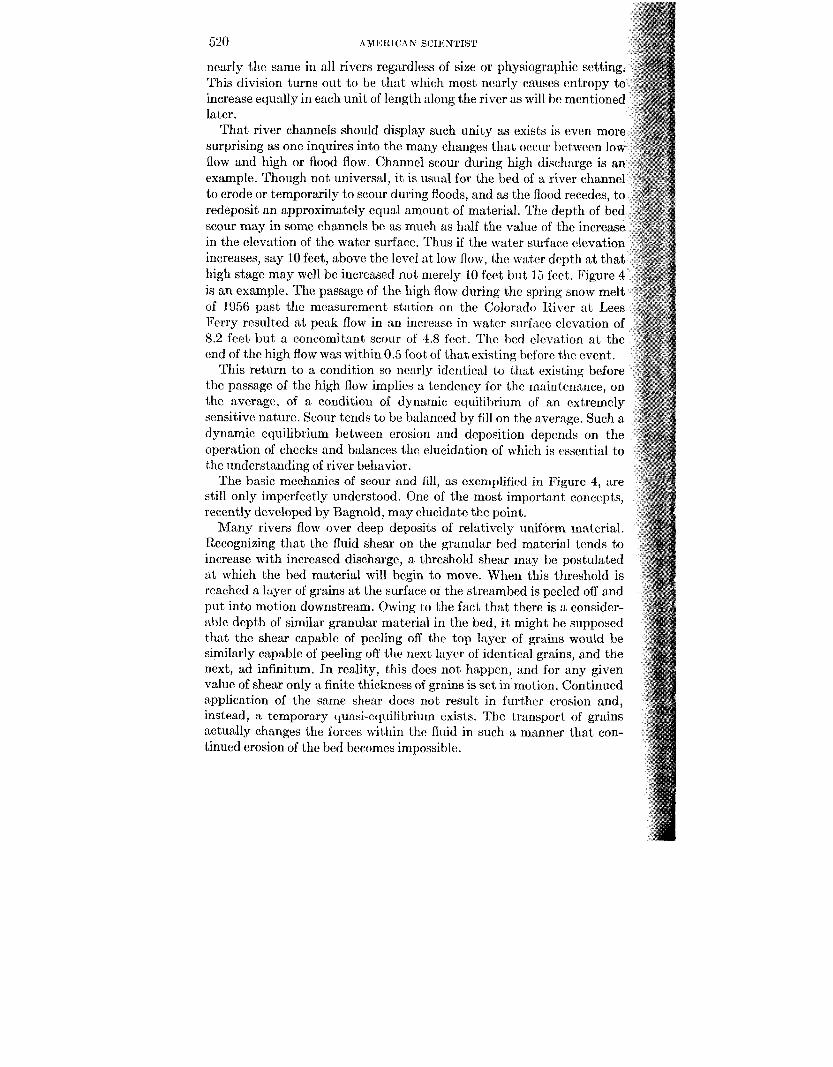
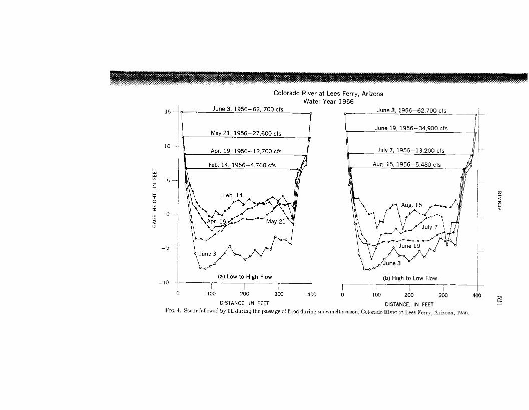
That river channels should display such unity as exists is even mo surprising as one inquires into the many changes that occiir between lo flow and high or flood flow. Channel scour during high discharge is example. Though not universal, it is usual for the bed of a river chan to erode or temporarily to scour during floods, and as the flood recedes, to redeposit an approximately equal amount of material. The depth of bed scour may in some channels be as much as half the value of the increase in the elevation of the water surface. Thus if the water surface elevation increases, say 10 feet, above the level a t low flow, the water depth a t that high stage may well be increased not merely 10 feet but 15 feet. Figure 4 is an example. The passage of the high flow during the spring snow melt of 1056 past the measurement station on the Colorado River a t Lees lkrry resulted a t peak flow in an increase in water surface elevation of 8.2 feet but a concomitant scour of 4.8 feet. The bed elevation a t the end of the high flow was within 0.5 foot of that existing hcforc the event.
This return to a condition so nearly identical to that existing before the passage of the high flow implies a tcndency for the maintenance, on the average, of a condition of dynamic cquilibrium of an extremely sensitive nature. Scour tends to be balanced by fill on the average. Such a dynamic cquilibrium between erosion and deposition depmds on the operation of checks and balances the elucidation of which is vssential to the understanding of river behavior.
The basic mechanics of scour and fill, as exemplified in Figure 4, are still only imperfectly understood. One of the most important concepts, recently developed by Bagnold, may elucidate the point.
Many rivers flow over deep deposits of relatively uniform material. Recognizing that the fluid shear on the granular bed material tends to increase with increased discharge, a threshold shear may be postulated at which the bed material will begin to move. When this threshold is reached a layer of grains a t the surface 01 the streambed is peeled off and put into motion downstream. Owing to the fact that there is a consider- able depth of similar granular material in the bed, i t might be supposed that the shear capable of pecling off the top laycr of grains would be similarly capable of peeling off the next laycr of identical grains, and the next, ad infinitum. In reality, this does not happen, and for any given value of shear only a finite thickness of grains is set in motion. Continued application of the same shear does not result in further erosion and, instead, a temporary quasi-equilibrium exists. The transport of grains actually changes the forces within the fluid in such a manner that con- tinued erosion of the bed becomes impossible.
15
10 -
F w W LL
5 - z +- I? r w 0 - a
I
W
c7 u
- 5 -
-19 -
Colorado River at Lees Ferry, Arizona Water Year 1956
(a) Low to High Flow (b) High to Low Flow I I I I
I I I
4 0 0 - 4GO 0 100 200 300 0 100 200 300 to F DISTANCE, IN FEET DISTANCE, IN FEET
FIG. 4. Scour folloxed by fill during the passage of flood during snon iiielt season, Colorado River at Lees Ferry, Arizona, 1956.
522 AMEIEICAN scrmmsr
Bagnold's 1956 research has shown, first theoretically and then by experiment, that grains in traction create a downward-acting stress which actually tends to hold the exposed grains on the stream bed and thus prevent their erosion. This downward force results from grain collision during transport. Collisions between grains tend to knock an individual grain in a direction that may be forward, up, or down. There will be enough grains directed downward against the bed actually to create a downward stress which tends to prevent further erosion of bed grains.
Until Bagnold's work, i t had not been recognized that hydraulic relations developed for clear water would not apply directly to water carrying a debris load. The forces within a fluid are altered by the trans- port of sediment debris.
Knowledge of sediment transport and its relation to river hydraulics has been slow to develop, both in theory and in practice, owing t,o the fact that i t is still impossible to make consistent and accurate measure- ments of the amounts of debris being transportcd as bedload in natural rivers. Instruments have long been in use that measured adequately the sediment being transportcd in suspension, but bedload, bein, 0' concen- trated in a thin zone near the stream bottom, is interrupted by the insertion of any obstacle, no matter how streamlined. The inscrtiori of a sampling device a t the stream bed changes the conditions of transport locally in such a manner that a representative sample of the bedload in transport is impossible. Though rates of bcdload transport can be suc- cessfully measured in experimental flumes, the conditions represented in the laboratory are much more limited than those extant in the field.
Water discharge in a river fluctuates widely from year to year, season to season, and day to day. Thus the forces governing erosion and depo- sition are highly variable. The channel flows at shallow depth most of the time and is filled to the top of the banks relatively scldom. On still less frequent occasions, the discharge exceeds the channel capacity and flows overbank. An overbank flow is a flood by definition. Reccntly it was shown that the frequency of the bankfull condition is surprisingly uni- form among rivers in diverse settings and among rivers of widely different size. The bankfull stage may he expeibed on the average about once a ycar to once in two years.
7'0 state this in another wily so that the prxticnl application is ap- parent, the river channel is largc cnough to :wcommod:ite a11 the water coming from the drainage area only in thr rclativcly frequent, went . The flat area bordering most channcls-t,bc flood pl:iirl-must flood to some extent on the average every other year. To ovcrflom the flood plain is an inherent charactcristjic of u river.
It has Iwcn surmised that vhanncl formation and maintenance are accomplished primarily during periods of flood flow. This would seem to follow from the general observation that many of the most obvious
100,000 I I~
EXPLANATION
Meanders of rivers and in flumes
Meanders of Gulf Stream
Meanders on glacier ice
0
X
e
I 1 0
0 98 , ‘ In
- -
1
1 10 100 1000 5 10 100 1000 10,000 1c C H A N N E L WIDTH, IN FEET MEAN RADIUS OF CURVATURE, IN FEET
A B
00,000
.o,ooo L W LL
Fig. 5. Relations between meander length and channel width (left diagram) and mean radius of curvature (right diagram)
524 AMEKICAN scIEwrisr
changes in form or configuration are accomplished by the catastrophic event-by the flood of large magnitude. To the extent this were true, it would be inferred that the events most worthy of study in attempting to isolate the general controlling principles would be extraordinary occurrences.
As recently as 19G0, Wolman and Miller introduced another conception that has had an impact on thinking about rivers and, indeed, alters the view of the action of geomorphic processes in general. The principal work in fashioning landscape forms is not done during the frequent event or the predominant condition because the processes acting are incompe- tent to have any significant effect. Nor is the principal work accomplished by the very effective but very rare event-the catastrophic incident. Rather, i t appears that the landscape is fashioned primarily by the cvent of intermediate freyucncy and effectiveness.
For example, the total sediment load transported by a river past a given point over a period of time is the sum of the amount transported during a variety of flow events; that is, during many days of low flow, a modest number of days of intermediate flows, and a decreasing number of increasingly great floods. The data indicate that the intermediate flows have a cumulative significance far greater than those of either greater or smaller magnitude, 1 ecause the product of effectiveness times frequency is grcatest. This concept is a fundamental contribution to thinking about landscape moulding processes.
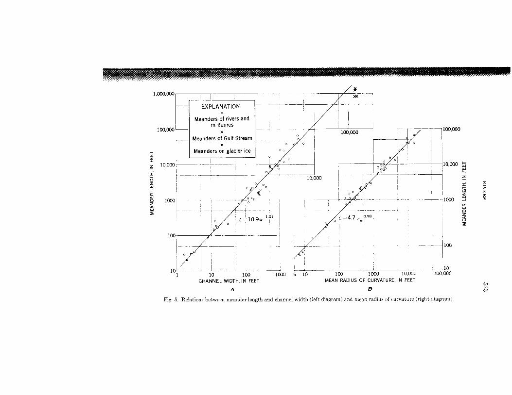
Thcre arc other attributes of river channels which also demonstrate the unity that exists among channels, even channels widely different in size. Nearly all natural channels are sinuous to some extent. Indeed, natural channels w e rarely straight for a distance greater than ten channel widths. Not only do channels exhibit a more or less regular aspect of sinuosity, hut also the size of the curves assumed by a channel bear a constant rclationship to the channel itself. Small channels wind in small curves and large channels in large curves.
Measurement data show that there is quite a constant relationship between channel width and the radius of the curves which the channel exhibits. Also, the meander length or wave length is generally propor- tional to channel width. These characteristics can be seen on Figure 5 , where the meander length is plotted separately against channel width and against the mean radius of curvat,ure. It can be seen that there is essentially a linear relationship between the wave length of the channel curves, channel width, and the radius of curvature. This linear relation occurs not only in most natural rivers but also to meltwater channels developed on the surface of a glacier and in the flow path of the gulf stream which is not confined by channel banks.
The consistency of the relation of radius of curvature to channel width is indicated by the following measurement data. In a sltmple of 50
525
- 1
Mississ ippi River at Point Breeze, from Corps of Engineer’s d
10000 FEET
, CONTOUR INTERVAL % MEAN HEIGHT OF BANKS
ZFRO A 1 MEAN BED
FLOOD PLAIN Approximate elev 9 2 feet
Vew Fork River near Pinedale , W y o m i n g
CONTOUR INTERVAL 0 5 FEFT DATUM A R B I T R A R Y
Approximate elev 94 0 feet
Average 8 feet width r-;i \ Ji
0 20 F T E T /
/ I
NOTE Sections A-A’ 0 - 0 ’ and C - C ’ are Vertical scale twice scale ~t plan view
undistorted _- ,Y
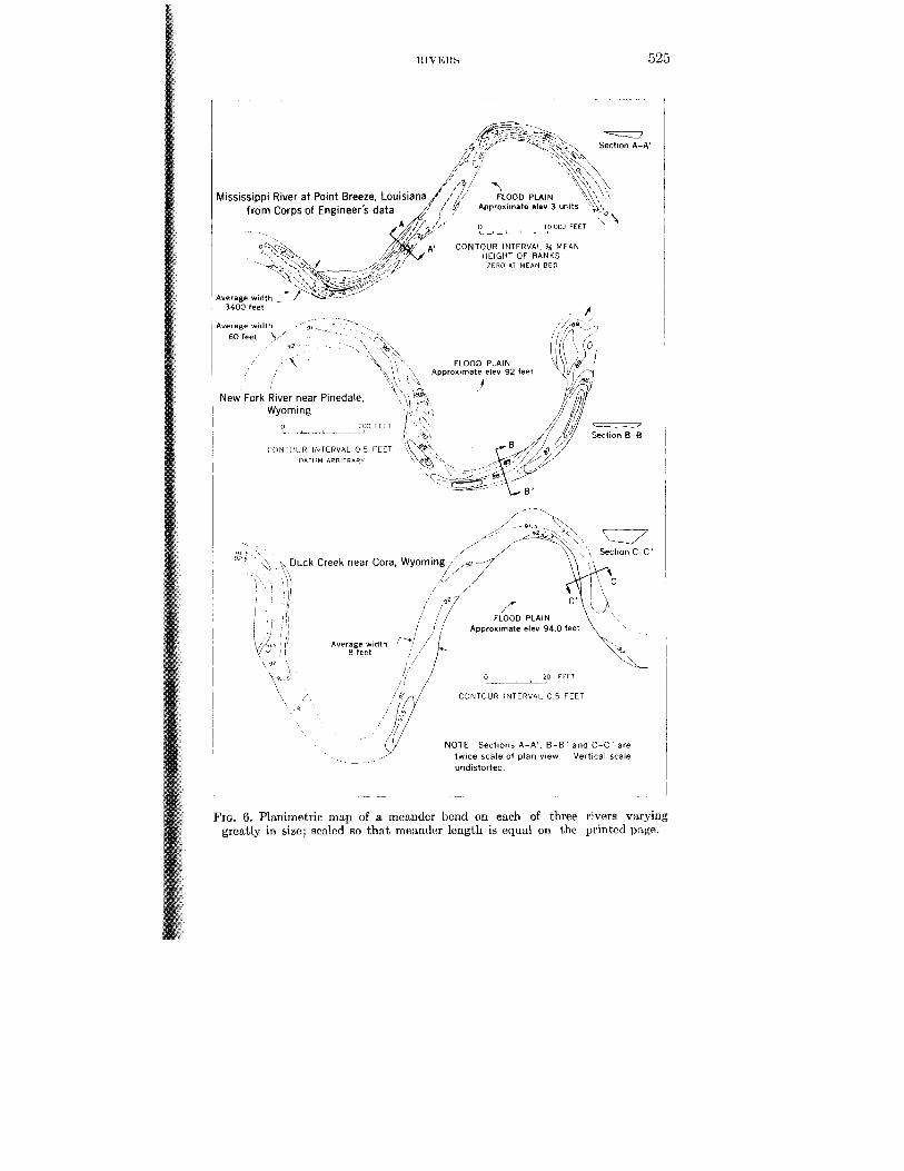
FIG. 6. Planirnetric map of a meander bend on each of three rivers varying greatly in size; scalcd 80 that meander length is equal on thc printcd p:ige.
526 AMERICAN SCIENTIST
rivers of various sizes the median value of the ratio of curvature divided by width was 2.7, the mean 3.1, and two-thirds of the cases occurred between the values of 1.5 and 4.3. The tendency for a constant ratio of radius to width makes all rivers look quite similar on planimetric maps, as is suggested by Figure 6. In fact, when one inspects a plani- metric map of a river without first glancing a t the map scale, i t is not immediately obvious whether the river is large or small owing to this tendency for a similar ratio of radius to width.
When the sinuous bends of a river are relatively symmetrical the channel is said to be meandering. Such a large variation in degree of sinuosity exists in natural channels that the definition of a meandering stream-in contrast with one which is merely sinuous-becomes a matter of arbitrary definition. There is represented in nature, then, an unbroken continuum between slightly wavy channels and well developed meanders which can assume the form of horseshoe loops. Owing to the fact that the meandering character of river channels has long been considered to be associated in basic mechanics with the movement of sediment, the observation that sediment-free channels carved by melt- water on the surface of a glacier can also meander is of considerable interest. Tentatively, the mechanical principles resulting in the meander- ing form of meltwater channels in the absence of sediment load and those causing the meandcring of rivers are probably the same. The similarity in channel form implies that the basic cause is essentially hydrodynamic, rather than a direct result of bank erosion and the lateral transfer of sediment across the channel.
The mechanics of a meandering channel are by no means well under- stood. Certain physical characteristics have been known for a long time but the basic mechanism is still elusive. Measurements made in meander- ing streams and in curved flumes allow the construction of a generalized picture of the flow pattern in a meander which is presented in simplified form in Figure 7. The isometric view of the two principal components of velocity a t various positions in the bend show the main features. The scale of the sketch is such that the super-elevation of the water surface in the bend does not show in the diagranils but is implied in the velocity distribution.
The velocity in a meander crossover, or point of inflection, is not symmetrically distributed. As would be expected, proceeding down- stream from the axis of the bend the thread of maximum velocity is much closer to the concave bank than to the center of the channel. The high velocity, moreover, continues to hug tthis side through the point of in- flection of the curve. At least in narrow channels, a cross-channel velocity component is directed toward thc convcx bank (usually called the point bar) near the bed and toward the concave bank near the surface.
Continuity requires, then, that surface watcr plunge downward near
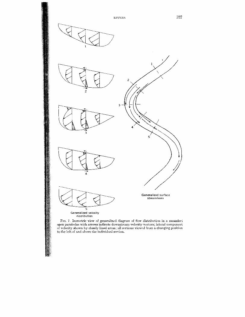
HIVEItS 527
2
3
b 5
3
Generalized surface streamlines
Generalized velocity distribution
FIG. 7. Isomctric view of generalized diagram of flow distribution in a meander; open parabolas with arrows indicate downstreani velocity vectors; lateral component of velocity shown by closely lined areas; all sections viewed from a changing position to the lcft of and ahove the individual scction.
5%
the concave hank and that some bed water emerge at the surface near t Convex bank. This circwlatory motion in the cross-sectional plane of channel mas first observed and cxplaincd by Thomson in 1879. It resul from the largclr centrifugal force on fast-moving siirface parcels than dower-moving ones ncar the bed. The motion gives to an individual mater parcel a pat,h resembling a helix. As a result of this circulatory motion, material a t the bed tends to be swept toward the convex bank, thus to be deposited in part on the point bar.
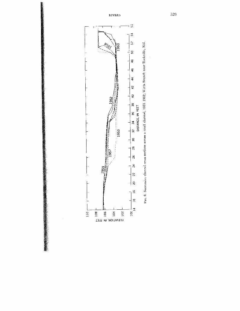
The accretion of matcrial on tkc point bar gradually pushes the convex hank into the channel and this tendency is compensated by a tendency for erosion of the concave hank. Thus, it is usual for a river channel gradually to migrate latcrally across thc valley floor. During such lat migration the channel width remains thc same. An example of the b ing of the point, bar balanced by bank erosion on the opposite side o stream is demonstrated by a series of observations made on Watts 13ranch, a small stream near Washington, D.C., for which the cross sections during a period of nine years arc presented in Figure 8.
The manner in which a channel moves across thc valley floor, eroding one hank and building a nearly flat flood plain on the other, all the while maintaining a cross scction similar in shape and size, is another aspcct of t,hc dynamic cquilibrium that apprars to charactcrizc many channel systems.
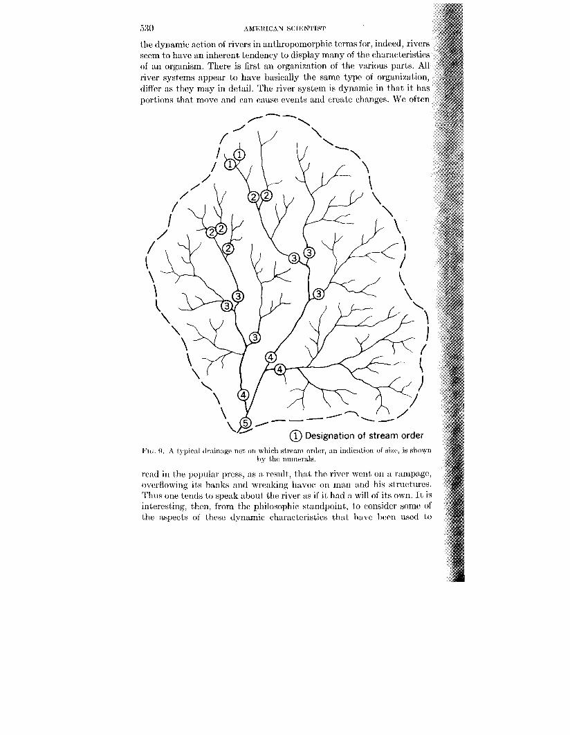
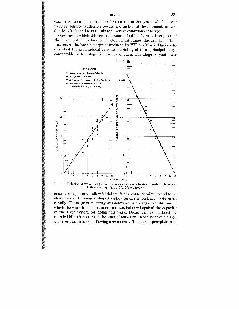
Another aspect of the unil,y rxhihitcd by stream systems is cxemplifi in the branching network of tributaries comprising what is called t drainage net. In 1945, Robert E. Horton showed that thc size of a giv stream is related to the number of streams of that size, th length, and average slope. There is a very constant quantitative rela tionship between these factors which can best be dernonstratcd by so actual data. Figure 0 is a sketch to define stream order, a measure stream size. Horton defined order in the following manner. The small unbranched tributary in the headwaters is, by convention, designat order 1 ; a stream which has only tributaries of order 1 size is called scco order; a third-order stream is one in which all tributaries arc of second order or smaller, ctc. Figure 10 shows that there is a logarithmic relation hctween stream order and length of streams of a given order and be- tween stream order and numbers of streams. After this logarithmic relation within the drainage network was pointed out, by Florton, i t has heen testcd by many workers and fouiid applicable, essentially without cxccption, to drainage basins of all sizes, including t,he very smallest rills and large river basins.
One of the basic problems in the study of rivers is the identification of a general lam or princaiplc, which provides a rationale in physical terms for the different types of unity exhibited by river channcls and the nctworks which they comprise. It is only too easy to speak of the rcsiilts of
I\ Al l : 11 I( 'A\ Y SCI I5NTIs,l'
L
> >
t
U 7
3 7
P 0
3 U
3 *
8 m N
W N
d N
N hl
0 N
2
2
530 AMXl1IChN SCIICNTIST
the dynamic action of rivers in anthropomorphic terms for, indeed, rivers seem to have an inherent tendency to display many of the characteristics of s n organism. There is first an organization of the various parts. All river systems appear to have basically the same type of organization, differ as they may in detail. The river system is dynamic in that i t has portions that move and can cause events and create changes. We often
@ Designation of stream order
FIG 9 , A typic:d dr:~in:tg(\ nct, on whicll s t r ( u n order, an iritlicntio~~ o f size,, is shown by thc 11ulrlc.rcLls.
read in the popular press, as a result, I hat the river W C ~ I on a rampage, overflowing its banks and wrcakirlg havoc. on man and his strnctures.
ItIVEIlS 531
express portions or the totality of the actions of the system which appear to have definite tendencies toward a direction of development, or ten- dencies which tend to maintain the average conditions observed.
One way in which this has been approached has been a description of thc river system as having developmental stages through time. This was one of the basic concepts introduced by William Morris Davis, who described the geographical cycle as consisting of three principal stages comparable to the stages in the life of man. The stage of youth was
EXPLANATION I 0- 0 Average values, Arroyo Caliente
Arroyo de 10s Frijoles V Arroyo de las Trampas to Rio Santa Fe 0 Rio Santa Fe. Rio Galisteo, and
Caliada Ancha (del oriente)
6 7 8 9 1 0 I 1 1
STREAM ORDER
2 3 4 5 6 7 8 9 1 0 1 1
Fro. 10. Relation of strcitiri lcrigth arid riuinhcr of streams to stream order in bitsins of 1 I th order near Santa Fc, New Mexico.
considered by him to follow initial uplift of a continental mass and to be characterized by deep V-shaped valleys having a tendency to downcut rapidly. The stage of maturity was described as a stage of equilibrium in which the work to be done in erosion was balanced against the capacity of the river system for doing this work. Broad valleys bordered by rounded hills characterized the stage of maturity. In the stage of old age. thc river was pictured as flowing over a nearly flat plain or peneplain, arid
53% AMIGILICAN SClISNTIbT
during this relatively long period in the cycle the rivcr was considcred to be unable to do large amounts of work in erosion as a result of rela- tively low relief and flat gradients. Similarly, a t any one point in time the headwaters of a river system could be in the stage of youth, the central portion in the stage of maturity, and the downstream portion in the stage of old age. This characterization of a river system was extremely useful for teaching purposes, but from a quantitative standpoint many aspects are difficult to particularize.
There followed, then, more detailed consideration of the concept of equilibrium, or grade, which Davis had thought of as characteristic of the stage of maturity. A graded stream was described by J. Hoovcr Mackin as one “in which, over a period of years, slope is delicately adjusted to provide, with available dischsrge and with prevailing channel characteristics, just the velocity required for the transportation of the load supplied from the drainage basin. The graded stream is a system in equilibrium; its diagnostic characteristic is that any change in any of the controlling factors will cause a displacement of the equilibrium in a direction that will tend to absorb the effect of the change ( I 948, p. 471) .”
Wolman extended this concept and pointcd out that the concept of grade had two aspects, involving adjustability and stability. In one respect, the quasi-equilibrium of a graded stream is, as RIackin pointcd out, characterized primarily by its ability to adjust to changes in external conditions. Wolman believed that a concept of quasi-equilibrium may be characterized by the stability of the system, but that adjustability perhaps was no less important a criterion.
Another aspect which, under certain circumstances, had been used to describe the underlying tendency for a river toward a quasi-equilibrium condition was what might be called the principle of least work. There are certain characteristics, particularly hydraulic ones, which point to thc tendency for minimization of work in a system.
Recently, Lnngbein and I considered the various factors governing the direction of river work and reasoned as follows. Inspecting the physical principles which recur most often in analyses of differcnt aspects of rivcr morphology, the basic equatims which are most promincnt arc the equation of conservation and the equation of continuity. These laws are so ohviously general that they characterize each element or rcach in any fluvial system. They must also characterize each unit of any path and a t each instant in time. However necessary these equations might be, they arc insufficient to explain the paths of particles moving in the river systems, or the relation between one part of the path to another. Thercforc, they can alone tell us nothing about the surface form of the landscape, nor can they treat cmmpletely the progressive development or change of form with time.
There must, thercforc, be some other law of cqual gcncrality which
IZIVERS 5:3:;
would deal with energy distributions and their relation l o changes of land forms in space and time. We proposed that implications of the stwind law of thermodynamics satisfy thesc requiremmts.
The dcvelopment of landscape involves not only the total available cnergy hiit also its distribution. The lattcr may lie described by the caoncept of entropy, adapting that term from the comparable concept in thermodynamics. The essential idea is t h t the entropy of the system is a function of the distribution or availability of energy within the sys- tcm and not a function of the total energy within it. Thus, entropy has come to concern order and disorder, an aspcct of the conception which has been utilized in physical chemistry and information theory. The degree of order or disorder in a system may be described in terms of the probability or improbability of any observed state.
An increase in entropy is, then, a measure of the decrease in avail- ability of the energy in the sense that a certain amount of energy is no longer available for conversion to mechanical work. The distribution of energy may be stated in terms of the probability of the given distribution occurring relative to alternative distributions possible.
The statistical conception of entropy is that aspect which appears to have application to geomorphic systems. The distribution of energy in a geomorphic system is one way of expressing the relative elevation of particles of water and of sediment which gradually will, in the process of landscape evolution, move downhill toward base level. The longitudinal profilc of the river, for example, is a statement of the spatial distribution of stream-bed materials with regard to their elevation and, thus, with regard to their potential energy.
In thermodynamics, hcat energy is referred to absolute! temperature as a base. The absolute temperature defines an absolute limit or base datum, the situation in which molecular motion becomes zero. It is, then, the base level, or the datum, against which the energy content of a thermal system can be measured. Systems in geomorphology also have a base datum with regard to the distribution of energy. This base datum is the datum of elevation, in most cases represented by mean sea levcl. Rut the classical treatment of entropy in thermodynamics deals with closed systems in which cntropy continuously increases to a maximum stationary level at equilibrium. In closed systems there is no loss or addition of energy.
Geomorphic processes operate, on the other hand, in open systems in which energy is being added in some places while in other places energy is being degraded to heat and is thus lost insofar as further me- chanical work is concerned. A river system, then, we consider to be an example of an open system, defining the system as the water and the debris in the river channel. As the water flows down the channel it gives up potential energy which is converted first to kinetic energy of the
554 AMRILICAN SCIENTIST
flowing water and which in the process of flow is dissipated into heat along the channel margins. Precipitation brings increments of energy into the system because water enters atj various elcvations and thus with various amounts of potential energy. Heat is lost by yonvcrtion, conduc- tion, or radiation, yet the channel may be considcrrd in dynamic equilibrium.
The steady state possible in open systems differs from t]be steady state of static equilibrium of closed systems. Wc elqimte, therefore, the term steady state with dynamic equilibrium in geomorphology as defined early in the century by Gilbert and, more recently, by 1I:wk. In :in open system in dynamic eqiiilibrium the rate of incrmse of entropy in the system is zero. The continuity of mtropy then takes t,lie form that the rate of outflow of entropy equals the rate of intrrnd generation of entropy. In a river system in equilibrium, the rate of outflow of entropy is the rate of dissipation of energy as heat. This is equated to the rate of generation of entropy represented by t,hc energy gradient toward h s e level. The stlationmy state of an open system is charac conditions in which the rate of production of entropy per unit volume of flow is a minimum compatible with the conditions imposed on the system. Hence a stable system corresponds to one of least work, a con- ception we were able to demonstrat,c in mathematic*al terms for certain conceptual models.
to the longitudinal profile of the river, the probability of the particular combination of values of energy in various unit distances along the course of the open system of the river could be described as proportional to the negative exponential of its ratio to the total energy of all possible st,ntcs. This led to the conclusion that the most probable scquence of energy losses in successive units of river lengths corresponds to a uniform increase in ent,ropy in each unit, length along the river system. When this spccifica- tion is fiilfilled without constraintj on river length tbc 1ongitndin:rl profile of the river tends to become exponential in form, :I rcsiilt i n :rgrerment) with many actual river profiIes.
In the development of this probabilist,ic argummt,, random-walk models were constructed to demonstrate several aspects of the river system. Longitudinal profiles romparablc to thosc of rivers may hc constructed hy random walks. As one example, beginning at an arbitrary point on Cartesian graph paper, the walk inovcs from t,he initial point in unit steps to the right wit,h various probabilities of a downward move- ment simultaneously. Such random walks may be constructed from a series of random numbers or with special packs of' cards, and the results from such mechanical construction of random walks wert caompared with a larger number of random walks developed on a digital computer.
An example is shown in Figure 11. In this model an initial point was
The argument was developed that, witth rcyx
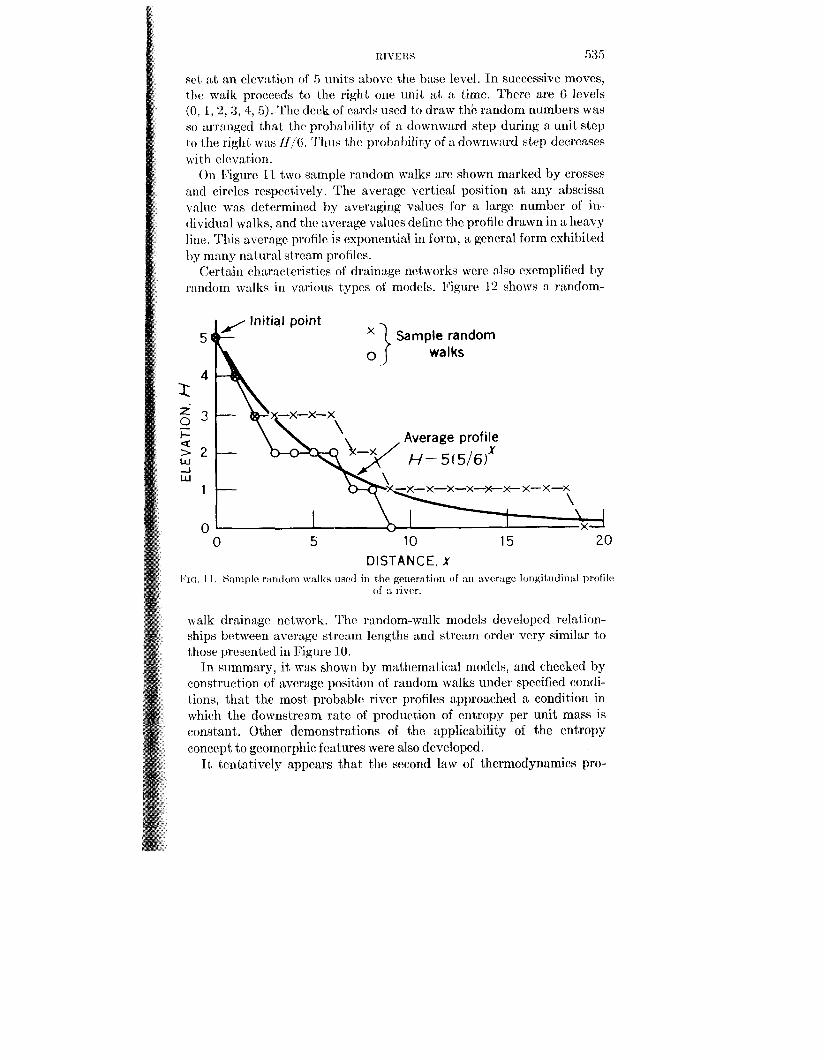
ItIV IC 11s 535
a t an clcvation of 5 units above the h s c lcvel. In successive moves, lhc walk proceeds to the right on(’ mit at :L time. There are G levels (0, 1,2,3, 4, 5 ) . Thc deck of cards uscd to draw thc random numbers was so :Lrr:tngcd t,hat the prohntdil y of :L down\vard step during a unit step to the right WLH U / G . Thus thc prol)aldit y of n don.nward stcp decreases \vi t h clevat,ion.
On Figure 11 two sample random walks are shown marked by crosses and cirrles respectively. The average vertical position a t any abscissa v:ilire was determined by averaging values for a large number of in- dividual walks, and the average values define the profilc drawn in a heavy line. This average proiilr is exponential in form, :L general form exhibited by many natural stream profiles.
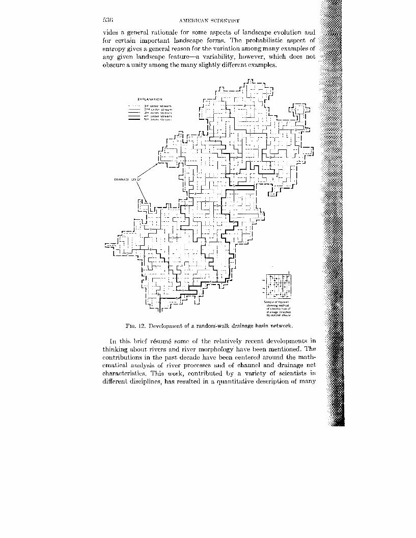
Certain ch:Lrnctcristics of drainage iwt works wwe also exemplified by rnndom walks in varioirs typcs of models. lcigure 12 shows a random-
5
4
2-7
5 2
o e I-
W -I w
1
0 0 5 10 15 20
DISTANCE, X FIG. I 1 . S:mlplc r:intlom w:ilks used in thc grneration of nn nvcr:~ge 11~11git~idir~:d profilc
of :t rivrr.
5
4
-7 e
2
1
0 0 5 10 15 20
DISTANCE, X . I 1 . S:mlplc r:intlom w:ilks used in thc grneration of nn nvcr:~ge 11~11git~idir~:d profilc
of :t rivrr.
walk drainage network. The random-walk models developed relation- ships between average strcam lengths and stream order very similar to those presented in Figure 10.
In siimmnrg, it, was shown by mutbrmatical models, and checked by construction of average position of random walks under specified condi- tions, that the most probable river profiles approached a condition in whicah the downstream rate of production of entropy per unit mass is constant. Other demonstrations of the applicability of the entropy roncept to geomorphic features were also developed.
It tentatively appears that the second law of thermodynamics pro-
530 AMEILIVAN SCIIGNTTST
vides a general rationale for some aspects of landscape evolution and for certain important landscape forms. The probabilistic aspect of entropy gives a general reason for the variation among many examples of any given landscape feature-a variability, however, which does not obscure a unity among the many slightly different examples.
In this h i d r6sumk some of the relativcly recent dcvclopmcnts in thinking about rivers and river morphology have been mentioned. The contributions in the past dwade have been centered around the math- ematical analysis of river processes and of channel and drainage net characteristics. This work, contributed by a variety of scientists in different disciplines, has resulted in a quantitative description of many
RIV1~Cll.l 537
of the physical characteristics of' rivws arid, at least l o some extent,, a dwcription of some processes in basic physicd terms.
The most immediate general prohlcms still facing the geomorphologist arc centered around three types of questions. The first concerns the mechanics of sediment transportation, particularly related to the mow- mcnt of bedload, which a t present still ran not be measured satisfactorily in real rivers under field conditions. The second general area seems to center in the question of the location and mode of energy dissipation in rivers and the effect of the energy utilization on erosion and deposition. This particular area, therefore, involves the relation of hydraulic factors t- soil or lithologic factors. Among the latter is the erodibility of different types of materials particularly in relation to their stratigraphy and scdimentational characteristics.
The third general area concerns the mode of transport of materials from slopes into the river channel. To :L great extent, recent work in river morphology has been more concerned with river channels than with the hillslopes shedding debris toward the channels. Thus slope development, slope processes, and the relationship of slopes to the channels to which they are tributary remain an integral part of the study of rivers. These subjects encompass an area of nearly unlimited scope for research by engineers, geologists, soil scientists, botanists, physical chemists, and those possessing a variety of other skills.
REFERENCES I~AGNCILD, RALPH A. 1956. The flow of cohesionless grains in fluids, Phil. Trans.
Royal Soc., 249, A., 964, p,p. 235-297; ,. I ~ J R U M , W. H., HEIDEL, b. G., and Iison, 1,. J. 1960. The worldwide runoff of
dissolvcd solids, IASH Publ. No 51, Commission of Surface Waters, pp. 618-628. HACK, .J. 'i'. Interpretation of erosional topography in humid temperate
regions, Am. Journ. Sci., Bradley Volume, 268-A, pp. 80-97. HORTON, R. E. 1945. Erosional development of streams and their drainage
basins, Geol. Am. R~l l . , 56, pp. 275-370. ~ O P O L D , L. B., and h N r r R E I N , w. E. The concept of entropy in landsrspr
evolution, U S . Geol. Survey, Prof. Paper 500A. LEOPOLD, L. B., and Maddock, T. The hydraulic geometry of stream chan-
nels and some physiographic implications, U S . Geol. Survey, Prof. Paper 25'2. MACKIN, J. H. 1948. Concept of the graded river, Geol. SOC. A m . Bull., 59, pp.
WOLMAN, M. G., and MILLER, JOHN P. Magnitude and Frequency of forces
1960.
19Ci3.
1953.
463-51 2. 1060.
in geomorphic processes, Joum. of Geo/., 68, No. 1.