Embed Size (px)
Citation preview

2013
River Protection Workgroup for the Animas
River
Final Report
May 2013
an initiative of
the
River Protection Workgroup
http://ocs.fortlewis.edu/riverprotection

1
The River Protection Workgroup (RPW) project was formed as an outgrowth of discussions starting in 2006 among various regional water planning and resource protection organizations where a need became apparent for a collaborative process to select long-term, reliable, federal and/or state and/or other measures to protect the identified values of regional streams while allowing water development to continue. A project steering committee formed and then met for over a year to get organized, design the process model, and begin to work at the community level for these five river/stream segments: Hermosa Creek; upper Animas River and Mineral and South Mineral Creeks; upper San Juan River - East and West Forks; Vallecito Creek/Pine River; and the Piedra River. The first step for each river and stream segment was to organize a meeting at the community level to see if there was interest in forming a public workgroup – one that would entail learning, discussions and issuing a final report of findings, agreements and conclusions. The River Protection Workgroup for the Animas kicked off in June of 2011 and concluded its work in May 2013. Each of the RPW Workgroups’ reports can be found on the project Web site along with meeting notes, handouts, maps, and more: http://ocs.fortlewis.edu/riverprotection/ For more information about the RPW, please refer to Attachment A which gives detailed information including the next step which is a “Regional Discussion.”
Contacts:
Web site:
http://ocs.fortlewis.edu/riverprotection/
(click on “River Protection Workgroup for the
Animas River” on the left side) Marsha Porter‐Norton, Facilitator (970‐247‐
8306 or [email protected]) and/or
Bruce Whitehead or Steve Fearn,
Southwestern Water Conservation District
(970‐247‐1302 or [email protected])
and/or
Jimbo Buickerood, San Juan Citizens Alliance
(970‐259‐3583 or
A note of thanks is extended to Tami Graham, meeting recorder,
and Kathy Sherer and Jane Maxson, project assistants. Also, the
San Juan RC&D and the Dolores Water Conservancy District are
thanked for serving as the fiscal agents for this project.

2
The River Protection Workgroup Steering Committee would like to thank the Colorado Water Conservation Board for its support, funding and technical assistance, as well as all other funders and contributors.
The following members of the River Protection Workgroup for the Animas River are thanked for their time, interest and work, including those who were on the email tree throughout the process. The Workgroup was made of people who represented groups or interests and also individuals who did not represent a formal entity. Jerry Abboud Vicki Alper Terra Anderson Kevin Baldwin Linda Bassi Mary Beaber Denny Beggrow Marcie Bidwell Aaron & JenBrill Evan Buchanan Jimbo Buickerood Peter Butler Michael Carroll Wanda Cason Melissa Childs Ty Churchwell Bob Cloud Andy Corra Dean Cox Lisa Cribbs Kevin DeKay Gary Derck Ron DeWitz Bill Dodge Anthony Edwards Duke Eggleston Ken Emery Ernie Etchart Steve Fearn John Ferguson Ray Ferguson Kent Ford Ric Foster Whitney Gaskill Emily Gentry Melissa Gillon Grady Ham Drayton Harrison Brian Hawthorne Kevin Heiner Todd Hennis DebbyHoover Ryan Huggins
Alfred Hughs Rory James Paul Joyce Steve Kandell Joe Kerby Aaron Kimple Ted Kowalski Courtney Krueger Ernest Kuhlman Dennis Kurtz Gwen Lachelt Austin Lashley Chuck Lawler Diana Lawrence Rege Leach Bobby Leib Danni Lorrigan Casey Lynch Darlene Marcus Wendy McDermott Garth McMillan Cathy Metz Keri Metzler Ann McCoy-Harold Alex Michael Molly Mickel Ann Morgenthaler Martin Moses Bob Nevins Ann Oliver John Ott Alice Outwater Chris Peltz Dave Pichard Josh Pollock Jim Poole Ken Portz Rose Raab Dan Randolph Stephanie Reigh John Reiter Barbara & Ron Renowden Beverly Rich
Lisa Richardson Stephan Saltsman Amanda Saunders Charlie Schonalz Paul Schranck Suzanne Sellers Shelley Silbert Bill Simon Buck Skillen D. Adam Smith Joanne Spina John Squire John Taylor Jeff Titus Willy Tookey Mark Tucker Chuck Wanner Jason Wells Julie Westendorff Jim White Bruce Whitehead Mely Whiting John Whitney Jeff Widen James Wilkes Gary Wilkinson Matt Wilson Thurman Wilson Sandy Young Larry Zauberis Ed Zink The RPW thanks all the USFS and BLM employees who attended meetings, and provided information. Any elected officials or governments who are noted in this list are thanked and their listing does not indicate formal support for a particular idea or recommendation.
THANKS!

3
Top: October, 2011 Work Group Field Trip &
Bottom: Working Group Picture, May 2013

4
Table of Contents
Topic Page(s)
Overview of the River Protection Workgroup……………………………………... 1
Thanking Workgroup Participants…........................................…………………... 2
Area of Focus and Map………………………………………………………………… 5 - 6
Executive Summary…………………………………………………………………….. 7
Getting Started & Process …………………………………………………………….. 8 - 10
Education and Invited Speakers………………………………………………………10 - 13
Values Statement and Information Sheet…………………………………………....13 - 15
Interests…………………………………………………………………………………....15
Segment by Segment Work, and Workgroup Findings and Conclusions
Main Stem of the Animas (Baker’s Bridge to below Silverton)…………16 - 22
Mineral and South Mineral Creeks………………………………………….. .22 - 28
Upper Animas (above Silverton)…………………………………………….. 29
Cement Creek…………………………………………………………………… 30 - 31
Animas River to Cement Creek (small segment through Silverton)……32
Other Discussion Points and Agreements or Areas Where a Range of Ideas Exist………………………………………………………….32 - 36
- Downstream meeting in Durango
- Private property
- Potential Reservoir Sites
- Water Quality
- Wild and Scenic River (WSR) Issues
- Watershed-wide Issues
- Additional Information or Concerns
Conclusion…………………………………………………………………………………..36
Guide to the Attachments
A - Information on the RPW and Regional Discussion…………………….37 - 38
B - Information Sheet for the upper Animas River………………………….39 - 68
C - Questions Generated about WSR (Wild and Scenic River)……………69 - 70

5
Area of Focus The area of focus that the Workgroup discussed over its 23 months of meetings includes the Animas River above Baker’s Bridge up to Silverton; Cement Creek; the section of the Animas River that flows through the Town of Silverton; Mineral and South Mineral Creeks; and the Upper Animas (the section above Silverton). Please find a very detailed, 29-page “Information Sheet” in Attachment B which covers: values; description of the area; river protections in place now; water information; foreseeable economic development; and other issues.
The area covers two counties: San Juan and La Plata. This river system helps define a region as a commerce corridor and a region whose identity is intertwined with mining, both past and present. The area is enjoyed by many, many recreationists, anglers, off highway vehicle users, hikers, skiers, and snowmobilers. Many live in the Town of Silverton, in San Juan County, or in adjacent communities and are working in the area and/or are interested in various types of economic development. About 42% of La Plata County is public land. In San Juan County, public federal lands account for about 86% of the county. See the map below. The San Juan Public Lands (USFS/BLM) 2007 Draft Land Management Plan (find it at: (http://ocs.fortlewis.edu/forestPlan/DEIS/) found three (3) river segments totaling 43.25 miles in the area of focus and in the Animas River Watershed above Baker’s Bridge to be “Preliminarily Suitable” for the Wild and Scenic River (WSR) status. The Workgroup discussed this tool at length in its meetings. More details and information about this particular river protection tool can be found in this report, in the minutes, and on the Web site. This river protection tool is one of many discussed.
10/11 -- Workgroup Field Trip, South Mineral Creek with speaker Kay Zillich, BLM

6
Upper Animas Cement Creek
Mineral and South
Mineral Creeks
Animas Main Stem
San Juan County
La Plata County
Map: Courtesy of
Colorado Division
of Water
Resources

7
Executive Summary The River Protection Workgroup for the Animas River met 23 times from June of 2011 to May of 2013. Through a series of speakers, learning and other exercises, the group extensively studied all the segments shown on page 6. They focused on values (what people care about), current protections in place and they brainstormed a list of ideas for the future. Eventually through discussions they arrived at conclusions and findings. These agreements are shown in the underlined statements on pages 15 – 35. Some highlights of their agreements include:
The group does not desire major impoundments in the entire area of focus. There are some clarifications stated in the narrative relating to water rights for the Animas-La Plata project.
The black swift birds and iron fens (a rare plant / bog community) received attention and ideas for further protection were noted and agreed to. These ideas could be explored for implementation by willing entities and groups or individuals.
Private property rights are an important value and they should be protected. The group supports the work of the Animas River Stakeholders Group and the concept
of passing, at the federal level, “Good Samaritan” legislation. Notably, there were several tools, by segment, the group agreed should not be explored
or pursued for various reasons. There was not agreement on one tool that received a lot of “air time” and that is Wild and
Scenic River or “WSR”. However, the group did agree that there is a range of views and ideas about this tool.
The upper reaches of the Animas River make up a very complex river system with many stakeholders and users from all over the state, country and indeed, the world. This report sums up the sentiments, feelings, values and beliefs of a diverse group of people who worked very hard over 23 months to learn, understand and develop ideas for the future.
Please go to the River Protection Workgroup’s Web site for this
workgroup’s handouts, maps, meeting notes, Power Point
presentations, and more: (refer to the buttons on the left side for
the River Protection Workgroup for the Animas River):

8
Getting Started The River Protection Workgroup for the Animas River kicked off in the summer of 2011 as part of a regional effort called the River Protection Workgroup (RPW). More information about the RPW and the model the Workgroup used can be found in Attachment A. Over 70+ people attended the first meeting which kicked off in June in Silverton. Then, roughly 25-30 people attended the 23 meetings held which were open to anyone. Extensive outreach was done to invite groups and individuals to the process. Then, at the first meeting, the group was asked who they felt needed to be invited and those groups were contacted before the next meeting. For each meeting, notices were placed in Durango-area and San Juan County newspapers and media, notices were advertised to the email tree, and also placed on the project Web site. The Working Group received several documents in the beginning for orientation and education purposes including a Glossary of Water Terms and Agencies, a beginning list of river and stream protection tools, and information on the regional RPW effort. This report does not attempt to document each entity or participant’s specific concerns; detailed comments made by members; details about protections tools or ideas that were not agreed to; or extensive details about each river protection tool discussed. Rather, this report sums up the process and focuses on values, ideas and agreements. A professional recorder took meeting notes, and they were made available in hard copy at each meeting. In order to gain a thorough understanding of the Workgroup’s deliberations, please read the meeting notes, all of which can be found here: http://ocs.fortlewis.edu/riverprotection/animas/summaries.htm
Process The group was informed in the first meetings of the suggested “RPW Workgroup process.” There was agreement to use it and the process is described in Attachment A and below. This general three-phased process framework, developed by the RPW Steering Committee, was used. The group added steps to these phases as it progressed. Phase I
- Introductions - Agreement on process and a determination if there is interest in proceeding - Decision to proceed - Information: “Information Sheet” developed, field trip, speakers, handouts on a
Glossary of Water Terms and Glossary of Water Agencies, handouts on the River Protection Workgroup project and the model, and other information as requested by the group
Phase II - Discussion of important values to protect (see a Values Statement below) - Generation of options, including understanding tools (speakers, handouts,
research by staff of public land or water agencies) - Discussion of options (pro/con, what people like/don’t like, accessing affected
stakeholders, understanding opportunities, concerns and ideas)

9
Phase III - Continue discussion of options - Reach conclusions for the future and develop agreements and findings, identify
areas of agreement and where there is a “range of opinion” - Define action plan(s), if any, next steps, and make plans for dissemination of a
group report The RPW for the Animas River added several process steps to this general outline and those are described in this report. The group ground rules included: 1. Respect 2. One person talks at a time 3. Every person’s opinion is important 4. Determine truth and facts based on solid data 5. Speak up and raise issues for discussion 6. Only one person talks at a time – no side conversations 7. Turn off cell phones or put them on vibrate 8. This group is issue-focused, not people-focused; please respect others’ opinions even if
you do not agree 9. If you need to catch up from a missed meeting or missed a portion of a meeting, please
be responsible to catch yourself up (project staff can assist) This set of process principles was used and announced at each meeting as well as displayed: Anyone with an interest is a stakeholder… has a seat at the table Respectful dialogue Solutions that meet the needs of a diversity of interests Everyone’s opinion counts, even if you do not agree Use of accurate facts and information Lots of interaction – consensus – collaboration – possible negotiations Fair, open, transparent process Available tools and data
At every meeting, because there were usually new people, the process was explained. Decision making is by consensus which is defined as: • Includes steps to ensure that all views are heard and considered • Recognizes that differences of opinion are natural and expected • Group makes a good faith effort to reach a decision that everyone can support

10
It was stated on several occasions that while consensus is a hoped-for goal of the RPW process, an inability to gain agreement certainly does not mean failure. This report outlines agreements the group made and key areas where there was a range of viewpoints and no consensus.
Education and Invited Speakers After agreeing that launching an effort such as this one had sufficient interest and support, the Workgroup was formed and started learning. In the fall of 2011, speakers were invited to talk about various topics including:
“Water 101” by Bruce Whitehead of the Southwestern Water Conservation District http://ocs.fortlewis.edu/riverprotection/animas/pdf/Animas-RPWG-Water-101_10-27-11.pdf
Various river and stream protection tools that accompanied a 14-page handout given to the group by the River Protection Workgroup Steering Committee http://ocs.fortlewis.edu/riverprotection/importantDocuments.htm
Speakers included Linda Bassi with the Colorado Water Conservation Board; Steve Fearn with the Southwestern Water Conservation District; Roy Smith with the state BLM office; and Chuck Wanner with the Five Rivers Chapter of Trout Unlimited. These presentations were not done to make decisions or advocate a certain river protection tool(s) but rather, to continue the group’s education process about various river/stream protection tools either in place now or ones that might be discussed or considered. Ms. Linda Bassi’s Power Point: http://ocs.fortlewis.edu/riverprotection/animas/pdf/LBAnimasWorkgroupNov11%20[Compatibility%20Mode].pdf Mr. Roy Smith’s Power Point: http://ocs.fortlewis.edu/riverprotection/animas/pdf/RoySmithPresentationNovember2011meetingWSR.pdf Please note: Mr. Smith wrote to the group, via sending emails to the facilitator, on two occasions to answer questions brought up after his presentation. The answers he gave are in the “Handouts” section of the Web site.
In October of 2011, the Workgroup participated in a field trip that included information about the Iron Fens (a rare wetland or “bog” community), Black Swift (birds), and local and present mining issues and history. Also, the group toured a cleanup site done by the Animas River Stakeholders Group (note: ARSG is a separate group but ARSG representatives attended all Workgroup meetings). Speakers on the field trip included Kay Zillich, a hydrologist with the BLM and Steve Fearn, with the Animas River Stakeholders Group. Ms. Zillich presented information about the Black Swift birds given to her by Chris Shultz, a wildlife biologist with the USFS, and she presented on the Iron Fens. The field trip was an almost day-long affair and included much discussion, learning and dialogue. The handout on the Black Swift birds is here: http://ocs.fortlewis.edu/riverprotection/animas/pdf/BlackSwift_FieldTripHandout_Sept2011.pdf
San Juan County Government and the Town of Silverton provided information and maps on the mining claims overlaid with the Wild and Scenic River (WSR) corridor (which is ¼ mile from the center of a stream on both sides should the river be kept suitable or designated as a Wild and Scenic River), and also provided a map of where San Juan County’s roads are located: http://ocs.fortlewis.edu/riverprotection/animas/animasMaps.htm Note: Three segments are currently “preliminarily suitable” and it takes an act of Congress to designate a WSR. Read on for more information.

11
The Animas River Stakeholders Group (ARSG) gave a presentation in September of 2011 on their efforts which date back to the group’s formation in 1994. Their work is about collaboratively accomplishing water quality improvement projects: http://ocs.fortlewis.edu/riverprotection/animas/pdf/ARSG%20Community%20Update%20-%20River%20Protection.pdf
The group received a handout that documented the various planning processes occurring in the area. This was provided because several members said the various planning processes occurring are confusing. It was clarified that the RPW process is a community-driven process, is not led by a governmental entity, is not required by law, and is not formally part of the USFS or BLM’s land management planning or travel management efforts.
Information about the area’s economic statistics was provided via a handout prepared by the Region 9 Economic Development District of Southwest Colorado.
As the group deliberated and issues were studied in-depth, more information was provided as per their request:
A presentation was given by Workgroup member Todd Hennis in October of 2012 on green energy minerals. Mr. Hennis was concerned that any new levels of protection would prevent future extraction of minerals, affect property rights, hurt the local economy and people, and would involve too much government regulation. He focused especially on minerals required for green and new, emerging technologies. The information Mr. Hennis provided is here: http://ocs.fortlewis.edu/riverprotection/animas/handouts.htm
Suzanne Sellers, a water engineer with the Colorado Water Conservation Board (CWCB), gave an extensive presentation on the hydrograph of the river. She also provided information on the water rights associated with the hydrograph and on where SWSI (Statewide Water Supply Initiative ) storage sites are located. She was answering the basic question: How much water is pulled through the canyon (Main Stem) due to existing water rights?
Aaron Kimple of the Mountain Studies Institute (MSI) provided a fact sheet on the Iron Fens as per the request of the group in February, 2013 which included information about this rare wetland or “bog” community as well as what level of regulation, if any, surrounding counties have in place to protect Iron Fens. The information sheet also included a map of the fens.
The Tall Timbers Resort and the Durango Silverton Narrow Gauge Railroad attended, at the group’s invite, to discuss their views on one tool, Wild and Scenic River. The minutes reflect their reasoning for not being in favor of this tool.
Several handouts were prepared by either contract staff or staff from the Columbine Ranger District of the USFS, the Colorado Division of Water Resources or the Colorado Water Conservation Board. Topics covered include the overall “condition” of the watershed; rare plants in the area; current USFS and BLM management and policy guidance for the Black Swift birds and Iron Fen wetland community; SWSI-identified storage sites (Statewide Water Supply Initiative); questions related specifically to Wild and Scenic Rivers (WSR) including follow up information provided by Roy Smith with the State BLM Office; information on mining and minerals; wildlife; water rights; Research Natural Areas (a protection tool used on USFS Lands); and the area’s hydrograph.

12
Handouts and/or Power Points from all of the presentations given to the Workgroup are on the Web site: http://ocs.fortlewis.edu/riverprotection/animas/handouts.htm and also here: http://ocs.fortlewis.edu/riverprotection/animas/resourceDocuments.htm. If you cannot find something, please email the facilitator.
Values and Information Sheet The next step was completing a Values Statement and an extensive “Information Sheet.” These steps took a number of meetings. The purpose of the Values Statement was to document all the things people care about or “value.” It was noted that everyone’s values matter and that debates about whether values were “good” (acceptable) or “bad” (unacceptable) were not part of the RPW process because this discourse is not productive. The statement below shows a summation of everyone’s values without prioritizing or placing emphasis.

13
VALUES STATEMENT for the Area of Focus
The area being studied by the River Protection Workgroup for the Animas River is very unique and serves as a regional hub and destination. There is a very notable and strong sense of community and camaraderie among the residents in the area, including regional or “basin” residents as well. And, there are distinct communities of stakeholders in this stretch of river including the Upper Animas reach and the residents of San Juan County. Then, there are those who care about the lower stretches which includes residents of La Plata County. And, many others have an interest including visitors and those who live downstream of this stretch but who still rely on the Animas River. So, many people care about the future of river protections and water planning and development, and this diversity of values is reflected in this values statement. Mining and mineral extraction are valued for many reasons including local jobs, extraction of minerals for national uses, and because this industry is part of the very fabric and character of the area. Mining and heritage history is a very important part of the area and brings in current-day visitors experiencing niche tourism opportunities. Tourism, in general, is a very important economic driving value. Visitors come here from all over the world for a variety of experiences including events, festivals and unique happenings that are tied to the beauty and character of the area including the wild lands. And, many of them enjoy the Durango and Silverton Narrow Gauge Railroad. The railroad is a living celebration of the mining and transportation history of the entire region. It connects Durango and Silverton but also, the railroad itself is tied to the river since the train and Animas River share the same north/south corridor. Recreation – both motorized and non-motorized – is valued because the possibilities for enjoying the mountains, scenery, plants and wildlife are abundant. Also, the ability for businesses and workers to earn a living from recreation, hunting, whitewater sports, fishing, and exploration (e.g., outfitting, guiding, and tours) is valued. The natural values are renowned including the presence of several rare plant and animal communities. The “wild-ness” of the area is valued by many and there is a sense that much of the area is untouched, has a diversity of wildlife, and that human-made structures and influences are minimal. The fact that this stretch of river is free-flowing is valued. The presence of intact ecosystems that cover very diverse life zones is important as is the highly visible geologic record, including evidence of spectacular volcanics in the Silverton area. Education and the arts are important as many seek these experiences through regional or local organizations – especially since the area is an outdoor learning lab and classroom of national significance.

14
Because the area is made up of both private and public lands, access to these public and private lands is valued as are future economic opportunities including hydropower and various types of natural resource development. The health and vitality of the alpine forested lands and high-elevation tundra is critical for economic, ecological, aesthetic and tourism purposes. The health of the surrounding forested lands is important especially as forests across Colorado are undergoing transformation due to climate change, insects and wildfire. Local residents value the area for the same reasons visitors and those who live downstream do. They desire to continue to be able to make a living in Silverton and in the surrounding counties. Earning a livelihood here is challenging and people want as many opportunities as possible. A sense of strong independence is valued by local residents. Along with this, there is a desire for community and local solutions, and the protection of individual property rights. Local, creative problem solving is an ethic of the area. The County Roads in the area are popular. Their use and continued maintenance is critical. The thoroughfare transportation corridors (highways) are necessary from a statewide and national view in terms of transporting people, goods and services north/south on the Western Slope. These local and state roads are key thoroughfares for multitudes of people recreating in various ways including locals and visitors enjoying the nationally-identified scenic routes. A healthy watershed, good water quality and flows are important not only for Silverton and San Juan County but because this area is the headwaters serving so many downstream neighbors, farms, municipal water users, fisheries and interests reaching through the Animas Valley, through Durango, and eventually into New Mexico where the Animas River meets the San Juan River. Also, the Upper Animas serves as the water supply for municipal and consumptive uses for the Town of Silverton and San Juan County. This area characterizes the best of the west. A vast diversity of organizations, governments, and people deeply care about the Upper Animas River for all kinds of reasons. Approved by the Workgroup: 12/19/11

15
The “Information Sheet”, it was noted by the facilitator, was the longest and most complicated of the five rivers studied through the RPW project (find it in Attachment B). The Animas River and the upper tributaries make up a complex river system with a variety of users, stakeholders, water rights, economic development, ecological, leisure, historical/cultural activities and processes occurring. The Workgroup reviewed the document many times, which was written by contract staff, giving input both by email and in the meeting(s). The document was accepted by consensus with the agreement that it could be changed in the future as requested by the group.
Interests Next, the group began to tackle the key questions related to the appropriate level of protection needed to protect values. It was recognized by the group that many values are in play – economic, mining, ecological, recreation (both motorized and non-motorized), and also that there is a wide range of opinion about the tools that could be considered and/or used. The group went through an exercise to identify the various interests represented by those attending the meetings (see list below). The group was reminded that their charge was to discuss various ways to protect the values while recognizing or “bearing in mind” this list of interests. It was acknowledged that sometimes these interests can be in conflict with one another.
Water quality Balance between uses, demand and preservation of
values; balance in the ways the group finds solutions Developing resources Accommodation of each other’s interests Economic interests: recreation, mining, tourism Maintaining the way things are now Maintaining jobs and employment Recognize our place in the greater scheme of things – we
are the trustees of natural resources for the whole country
River in a natural, unimpeded state – free-flowing Product development and sales Historic structures and activities Freedom to enjoy and access nature Water availability and development Public land resource Ecological integrity

16
Segment-by-Segment Work, and Workgroup Findings and Conclusions The segments discussed in great detail include: Baker’s Bridge to just below the Town of Silverton (a.k.a. “Main Stem”) Mineral Creek South Mineral Creek Cement Creek The section of the Animas River that goes through the Town of Silverton up to Cement
Creek Upper Animas above Silverton (aka “Upper Animas”)
All but the Upper Animas, Cement Creek and the section of the Animas that begins approximately five miles downstream of Silverton and then goes up through the town are being considered by the USFS and BLM in their draft Land Management Plan as “suitable” for Wild and Scenic River status. Please refer to the “Information Sheet” in Attachment B for more details. Next, the group began to formulate their conclusions, findings and agreements. This took about eight meetings. They did this by developing and then working through a process where all the specific segments were focused on in much greater detail, discussed and ideas for the future were listed and debated. For each segment, the group reviewed or brainstormed: a) the specific values for that area or stretch of river/creek; b) the existing protection tools; c) new ideas for protection; and d) agreements or areas where a range of opinion(s) was noted. The following sums up the group’s deliberations by segment, and agreements are reflected using underlining.
Main Stem of the Animas (Baker’s Bridge up to below Silverton) Values Identified by the Workgroup – Main Stem - Recreation and scenery: the river canyon and surrounding landscape; well known for
rock and ice climbing, backpacking, and rafting/kayaking (this stretch is the only two-day, class 5 river trip in the United States and it is “iconic nationally”)
- Train: thousands of visitors every year – train is a major economic driver for San Juan County
- The area is in its natural state; is remote; hard to get to - Geology - Local control - Durable and long term preservation
Please refer to the map on page 6

17
USFS- or BLM-Identified Values (taken from the USFS and BLM 2007 Draft Land Management Plan): Main Stem Recreation and scenery: The Durango-Silverton Narrow Gauge Railroad runs along the river throughout this entire segment. Visitors from all over the country and the world take the train each year to see the canyon and scenery associated with the river. The Durango-Silverton Narrow Gauge Railroad is a unique recreation opportunity in that it combines the historic aspects of the steam-powered train with the dramatic setting of the Animas River Canyon. It draws more than 200,000 visitors annually and is a primary economic engine for both Durango and Silverton during the summer months. This is a one-of-a-kind opportunity not duplicated by the Cumbres and Toltec Railroad or the diesel train that accesses the rim of the Grand Canyon. Seventeen commercial outfitter and guide operators with Forest Service permits utilize the Upper Animas River corridor including guided whitewater boating, fishing, hiking, backpacking, hunting, mountain-climbing and horse packing. Both private recreationists and commercial outfitters’ clients are drawn to the Upper Animas from all over the U.S. and internationally due to the unique and rare opportunities the area offers. The free-flowing Upper Animas River provides the highest commercial whitewater put-in point elevation (over 9,300 feet) in Colorado. The Class V-rated (violent rapids, extremely difficult hazards) whitewater is also one of just a few rivers in Colorado that provides this type of extreme whitewater for commercial passengers. The Animas River has also been the site of numerous national competitive kayaking, rafting and fishing events. Its listing on American Whitewater’s national river inventory, while not sufficient by itself to be an ORV, supports the above analysis. Cultural/historical: The Animas River has historically served as a transportation corridor linking the hardrock mining community of Silverton to the larger communities of Animas City/Durango. The Animas Canyon wagon road was the first transportation route to connect Silverton to Animas City/Durango. The site has been determined eligible for the National Register of Historic Places. The road ran alongside the Animas River for much of its route. The Durango-Silverton Narrow Gauge Railroad, a designated National Historic Landmark, is a popular way to observe remote portions of the Animas River. Portions of the railroad in the Animas Canyon overlay the Animas Canyon wagon road. The town of Silverton, located on the Animas River, and the terminus of the railroad, are both a National Historic District and a National Historic Landmark. The Tacoma power plant, a site listed on the National Register of Historic Places, and the associated residences are located on the banks of the Animas River. The power plant supplied electricity to Silverton and several milling operations in the vicinity of Silverton. Electricity from the power plant was supplied to Silverton via a transmission line that was located adjacent to the Animas River. Protections in Place – Main Stem - BLM & USFS managed land (current and future management) - historic and scenic railroad corridor - Wilderness Study Areas: there are three that border the existing Weminuche Wilderness
and two of them are adjacent to the WSR suitability corridor - Special Management Area (Alpine Triangle) in the upper reaches

18
- preliminarily suitable for Wild and Scenic River (WSR) in the San Juan Public Lands 2007 Draft Land Management Plan
- all laws, requirements, guidelines, etc. that protect wetlands, rivers and streams including ones required under the Federal Clean Water Act, the Mine Reclamation Act and the Colorado Department of Public Health and Environment
- the conservation protections that private land owners may be doing such as forest restoration, easements, etc., (specifically in this stretch, Tall Timbers Resort told the group of their efforts)
- efforts to improve the water quality in the river such as what is being done by the Animas River Stakeholders Group
Brainstormed List of Proposed Ideas for Protection – Main Stem 1. State in-stream flow (ISF) 2. “Status quo” (i.e. clarified as meaning that to protect the values, existing management
and available tools are enough; means the current protections are adequate) a) Status quo includes support for actions to clean up the river 3. Wild and Scenic River scenarios:
a) Leaving it Preliminarily Suitable for the WSR designation (like it is now in the San Juan Public Lands Draft Land Management Plan, a plan that is soon to be final)
b) Remove suitability in the San Juan Public Lands Draft Land Management Plan c) Wild & Scenic River status only change the stretch to remove an area to the
north – due to mineral claims d) Wild & Scenic River status only remove the parts in San Juan County and retain
the part that is in La Plata County 4. Use county land use codes, San Juan & La Plata (additional ideas: any mining
operations in the area that would ever be approved would need to look like a historic site and the two counties should make their codes consistent in this corridor around densities and setbacks)
5. Designate the two WSAs adjacent as Wilderness Areas 6. Mineral withdrawal on Federal Lands between the Wilderness and private land (note:
this does not propose to withdraw minerals on private land in the corridor) 7. Management scheme by USFS such as a planning tool in their Land Mgmt. Plan 8. Design a special area (see the St. Vrain example in the Tool Kit) – the idea is to craft a
tool that would likely require legislation that is unique to this area 9. National Recreation Area (NRA) 10. Recommend in the report that no new major impoundments be built in this segment 11. Support efforts to improve water quality in this section 12. New tool suggestion: Establish a Local Advisory Council that could help weigh in on how
to protect values in the watershed 13. Remove WSR suitability all together for this stretch in exchange for a mineral withdrawal
in the corridor on federal lands (see #6 above); making the three remaining WSAs permanent Wilderness (excluding the part that is currently proposed for removal of WSA status due to historic motorized use in the winter); and no major impoundments with no federal money allocated to building major impoundments.

19
Agreements and Ideas for Main Steam (underlined items = consensus) Please refer to the meeting notes for much, much more detail. Refer to Attachment C for a list of questions and issues the Workgroup raised about the tool of Wild and Scenic Rivers.
There could be an opportunity for a mineral withdrawal in this corridor to protect ecological and scenic values (please refer to #6 above for clarification). The withdrawal would have to be defined but would essentially be in the “strip” or corridor where WSR suitability or full designation would come into play. There wasn’t agreement on this point but this idea could be part of the Regional Discussion.
There could be an opportunity to make permanent two Wilderness Study Areas on the
east side of the Main Stem section. There wasn’t agreement on this point but this idea was raised and might be part of the Regional Discussion.
Flows in the Animas:
Consensus agreement that there be no new major impoundments in the Main Stem of the Animas River with the following note about Animas-La Plata: This statement accompanies this recommendation and was given to the group by Bruce Whitehead, executive director for the Southwestern Water Conservation District: The Animas Workgroup expressed a strong sentiment to recommend that no new major impoundments be developed on the Animas River main stem above Silverton which would include the decreed location and SWSI site for the Howardsville Reservoir. The Southwestern Water Conservation District holds the water rights for the Howardsville site, which is still an active conditional water right associated with the Animas-La Plata Project. Under the Animas-La Plata as constructed, water is stored in Ridges Basin Reservoir (a.k.a, Lake Nighthorse) utilizing the alternate point of storage water right associated with Howardsville Reservoir. The SWCD has participated in the River Protection Workgroup process and acknowledges the sentiment of the group, but wants the record to reflect that these active conditional water rights exist at the Howardsville site. In the interest of achieving consensus on the River Protection Workgroup discussion, the District can concur with the recommendation, noting that nothing in this recommendation shall be used to adversely impact the water rights associated with the Animas-La Plata as decreed in Case No. 1751B and as changed in Case No. 80CW237.
• Consensus that a State In-Stream Flow (ISF) is not an applicable tool for this section
• The group agreed that there is a range of views and ideas on Wild and Scenic River
(WSR):
A) Keep it suitable for Wild and Scenic River status (this means that when the USFS and BLM release their final plan, suitability would remain). Highlights of the reasons stated (please read the meeting notes for more detail): to protect ecological values; to support tourism and recreation; because this is a protection
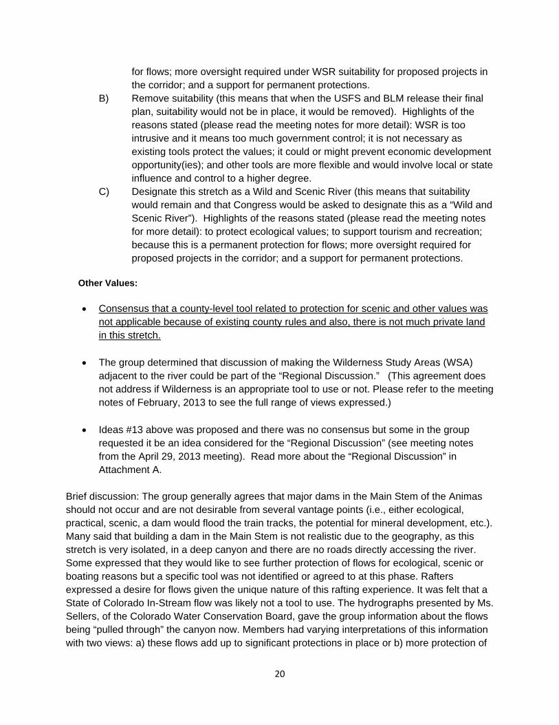
20
for flows; more oversight required under WSR suitability for proposed projects in the corridor; and a support for permanent protections.
B) Remove suitability (this means that when the USFS and BLM release their final plan, suitability would not be in place, it would be removed). Highlights of the reasons stated (please read the meeting notes for more detail): WSR is too intrusive and it means too much government control; it is not necessary as existing tools protect the values; it could or might prevent economic development opportunity(ies); and other tools are more flexible and would involve local or state influence and control to a higher degree.
C) Designate this stretch as a Wild and Scenic River (this means that suitability would remain and that Congress would be asked to designate this as a “Wild and Scenic River”). Highlights of the reasons stated (please read the meeting notes for more detail): to protect ecological values; to support tourism and recreation; because this is a permanent protection for flows; more oversight required for proposed projects in the corridor; and a support for permanent protections.
Other Values:
Consensus that a county-level tool related to protection for scenic and other values was not applicable because of existing county rules and also, there is not much private land in this stretch.
The group determined that discussion of making the Wilderness Study Areas (WSA)
adjacent to the river could be part of the “Regional Discussion.” (This agreement does not address if Wilderness is an appropriate tool to use or not. Please refer to the meeting notes of February, 2013 to see the full range of views expressed.)
Ideas #13 above was proposed and there was no consensus but some in the group requested it be an idea considered for the “Regional Discussion” (see meeting notes from the April 29, 2013 meeting). Read more about the “Regional Discussion” in Attachment A.
Brief discussion: The group generally agrees that major dams in the Main Stem of the Animas should not occur and are not desirable from several vantage points (i.e., either ecological, practical, scenic, a dam would flood the train tracks, the potential for mineral development, etc.). Many said that building a dam in the Main Stem is not realistic due to the geography, as this stretch is very isolated, in a deep canyon and there are no roads directly accessing the river. Some expressed that they would like to see further protection of flows for ecological, scenic or boating reasons but a specific tool was not identified or agreed to at this phase. Rafters expressed a desire for flows given the unique nature of this rafting experience. It was felt that a State of Colorado In-Stream flow was likely not a tool to use. The hydrographs presented by Ms. Sellers, of the Colorado Water Conservation Board, gave the group information about the flows being “pulled through” the canyon now. Members had varying interpretations of this information with two views: a) these flows add up to significant protections in place or b) more protection of

21
flows was necessary or hoped-for that would permanently protect what is not affected by existing water rights or the RICD or “Recreational In Channel Diversion” (see text box below). The group discussed the Wilderness Study Areas adjacent to the corridor and some felt, while there was not a consensus, that these could make permanent Wilderness as part of a larger negotiation, perhaps to take place in the Regional Discussion. The group did not agree on the general concept of using Wilderness as a protection tool though.
Top: The beautiful mountains and the river and creek segments in the Area of Focus draw people from all over the world and represent a very special region in Colorado. Location: Ice Lakes above Silverton Bottom: Black Swift bird and Iron Fens on Mineral Creek.

22
South Mineral Creek Values Identified by the Workgroup - South Mineral Creek- Known mineralized area - Ice Lakes – hiking - Grazing - Fishing - Widely used - All season usage - Biological and geological classroom - Easily accessible to Silverton - Possible heli-skiing - Firewood collection - Wildlife – Black Swift - Unusual wetlands - Hunting
- Migration route for animals not usually migrating, i.e. Lynx
- Mining - Hard rock 100 race - Backpacking - Ice climbing - Motorized recreation: 4-wheeling, single
track and Jeeping - Good fishery and high water quality - Local control - Durable and long term preservation - Private property - Horseback riding
From page 25 of the “Information Sheet” in Attachment B: Stipulated Recreational In-Channel Diversion (RICD) Settlement: In 2006, the City of Durango filed a water court application for a Recreational In-Channel Diversion (RICD) to support kayaking and boating. A conditional water right was granted for recreational flows for four structures in the Animas River near Santa Rita Park and Smelter Rapids with flows ranging from 185 cfs in the fall and winter to 1,400 cfs during the peak June runoff. The case was contested with over 50 individuals and entities filing Statements of Opposition, and numerous applications for water rights were filed in 2005 and 2006 in anticipation of or response to the application by the City. Due to the potential impacts to future water development in the Animas River basin, conditional water rights applications were filed for by La Plata County in Case 06CW99, and by the Southwestern Water Conservation District in Case 06CW127. Intensive negotiations resulted in a stipulated settlement that granted the recreational water rights while allowing some future development to occur in the basin. La Plata County was granted conditional water rights of 1 cfs on Junction Creek, and 2 cfs on Lightner Creek, and up to 6 cfs on the Animas River. These water rights are two days senior by appropriation date to the RICD. La Plata County joined the Southwestern Water Conservation District as co-owner of the future depletion allocation conditionally decreed in Case 06CW127 for depletion flow rates ranging from 20 cfs in low flow periods and 40 cfs during the peak of the hydrograph. This depletion water right is one day senior by appropriation date to the RICD. These future depletions can occur on the main stem of the Animas River and its tributaries from the upper RICD structure to the headwaters of the basin. Although not without controversy, the settlement of the RICD and related cases was viewed as a “win-win” for all involved and avoided lengthy litigation and court costs.

23
USFS- or BLM-Identified Values: Mineral Creek (and portions of Cataract Creek, Porcupine Creek and unnamed tributaries) being “Preliminarily Suitable” for WSR - Ecology: There is an iron fen/wetland complex at the mouth of South Fork Mineral Creek. Currently
there are only 13 iron fens known globally, four of which occur in San Juan County. - Wildlife: Four breeding colonies of black swifts (a bird type) occur at waterfalls within South Fork
Mineral Creek corridor, on Porcupine Creek, Cataract Creek and unnamed tributaries. The species nests behind or adjacent to waterfalls, where the mists water the mosses that make up the nest. The San Juan Planning area provides a significant contribution to the species’ worldwide breeding distribution, which is limited to a narrow portion of the Rocky Mountains from Mexico to British Columbia and a narrow band along sea cliffs from California to Alaska.
Protections in Place – South Mineral Creek: - Mix of USFS-owned land (94%) with some mining claims and private land - This stretch travels through inventoried roadless area - Has In-Stream Flow held by CWCB - Preliminarily suitable for WSR - All state, county and federal protections in place including all laws, requirements, guidelines, etc.,
that protect wetlands, rivers and streams including ones required under the Federal Clean Water Act, the Mine Reclamation Act and the Colorado Department of Public Health and Environment
- Black Swifts (birds) are a “species of concern” - Stream standards are set by Water Quality & Control Commission - Efforts to improve the water quality in the river such as what is being done by the Animas River
Stakeholders Group Brainstormed List of Proposed Ideas for Protection - South Mineral Creek: 1. “Status quo” (i.e. clarified as meaning that to protect the values, existing management and
available tools are enough; means the current protections are adequate) a) Status quo includes support for actions to clean up the river (see #3 below) 2. Wild and Scenic River scenarios:
a) Leaving it Preliminarily Suitable for the WSR designation (like it is now in the San Juan Public Lands Draft Land Management Plan, a plan that is soon to be final)
b) Remove suitability in the San Juan Public Lands Draft Land Management Plan c) Wild and Scenic River designation.
3. Continue efforts to improve water quality including: a) support the removal of barriers to improvement of Water Quality Act, i.e., Good Samaritan Act and b) support the Animas River Stakeholders in their continued work (note: work has been done above Chattanooga to date).
4. Additional flow protection tool for In-Stream Flows (tool to be developed). 5. Further increase flows that protect consumptive use of flows in streams (tool to be developed –
could be a part of 4). 6. Protect hydrology of fens (tool to be developed – could be a part of 4). 7. Tool to prevent trans-basin diversion (tool to be developed). 8. Research Natural Area (RNA) 9. Establish a Local Advisory Council that could help weigh in on how to protect values in the
watershed.

24
10. Proposed Sheep Mountain Special Management Area from Clear Lake Road west (this was added to the list of tools instead of being listed as “Protection in Place” because the bill has not passed yet in Congress).
11. Iron Fens (plant or “bog” community) a) Protect hydrology of fens (possible In-Stream Flow) b) Request an inventory from the USFS around the fens they would really like to see
protected (the specific areas) 12. Establish an Area of Critical Environmental Concern (to protect fens).
Mineral Creek
Values Identified by the Workgroup - Mineral Creek: - Mining - Backcountry skiing - History - Motorized recreation: 4-wheeling, Jeeping and single track - Non-motorized recreation - Chattanooga Fen - Scenic - Hunting - Potential fish barrier for South Mineral - Zinc loading has been cut in half – goal is to allow fish to be able to survive below the confluence
to the Animas - Mineral Creek corridor is historic right-of-way for train - Local control - Durable and long term preservation - Private property
USFS- or BLM-Identified Values: Mineral Creek being “Preliminarily Suitable” for WSR - Recreation and scenery: Mineral Creek is along the San Juan Skyway, designated as an All-American
Road and a National Scenic Byway. The Skyway attracts national and international visitors. Scenic values include wetlands and colorful geology from exposed mineral/ore deposits. The creek runs through a U-shaped glacial valley marked by avalanche runs where aspen grows.
- Ecology: The Chattanooga iron fen borders Mineral Creek and supports a rare moss, sphagnum
balticum that has not been documented anywhere else in the continental United States. Currently, there are only 13 iron fens known globally, four of which occur in San Juan County.
- Protections in Place – Mineral Creek: - Passes through USFS-owned land (85%) and private land - Much of it is in scenic byway - Colorado in-stream flows on main stem and two tributaries - A portion of Middle-Fork of Mineral Creek (Ophir Creek) is inventoried roadless – includes most of
Mount Molly - Is in scenic view corridor overlay district of San Juan County - A portion of the lower section is in the town/county mutual interest zone - Needs cooperative approval to move forward with development or projects

25
- 1996 Act, some historic structures are protected - A short portion (maybe a mile) is in Silverton Special Recreation Management Area of BLM - State game laws - Preliminarily Suitable for WSR - Efforts to improve the water quality in the river such as what is being done by the Animas River
Stakeholders Group - All state, county and federal protections in place including all laws, requirements, guidelines, etc.,
that protect wetlands, rivers and streams including ones required under the Federal Clean Water Act, the Mine Reclamation Act and the Colorado Department of Public Health and Environment
Brainstormed List of Proposed Ideas for Protection - Mineral Creek: 1. “Status quo” (i.e. clarified as meaning that to protect the values, existing management and
available tools are enough; means the current protections are adequate) a) Status quo includes support for actions to clean up the river (see #3 below) 2. Wild and Scenic River scenarios:
a) Leaving it Preliminarily Suitable for the WSR designation (like it is now in the San Juan Public Lands Draft Land Management Plan, a plan that is soon to be final)
b) Remove suitability in the San Juan Public Lands Draft Land Management Plan c) Wild and Scenic River designation.
3. Continue efforts to improve water quality (consensus); Animas River Stakeholders continue work (all work has been done above Chattanooga to date) – numerous ARS projects have positively impacted water quality in Mineral Creek.
4. Removal of barriers to improvement of Water Quality Act, i.e., Good Samaritan Act. 5. Wild & Scenic River designation. 6. Flow protection tool for additional in-stream flows. 7. Further increase flows that protect consumptive use of flows in streams. 8. Iron Fens (plant community)
a) Protect hydrology of fens (possible In-Stream Flow?) b) Request an inventory from the USFS around the fens they would really like to see
protected (the specific areas) c) Area of Critical Environmental Concern (to protect iron fens)
9. Tool to prevent trans-basin diversion. 10. New tool suggestion: Establish a Local Advisory Council that could help weigh in on how to protect
values in the watershed. Agreements and Findings for Mineral and South Mineral Creeks (underlined items = consensus) Please refer to the meeting notes for much, much more detail. Iron Fens (plant community): Groundwater
The group gained general agreement that the fens are a special wetland or “bog” community and that
a potential goal for the future is to consider more county-level protections for the fens. These protections would need to balance ecological protection and keep the integrity of the fens intact, with economic opportunities, private protection rights and sensible regulation. The group agreed that two fens, the Chattanooga and one on South Mineral Creek just above the confluence with Mineral Creek, were particular areas deserving protection and focus.

26
Several suggested ideas were to work with San Juan County in a collaborative fashion to add to their County Land Use Code a provision that would have the county consider the sources of the ground water for the fens in development applications. There was concern expressed about more regulation and what this could mean for applicants in the county land use process. Nothing in this report forces or mandates a county to do anything. This is an idea being published in this report and could be worked on in the future.
There was agreement that the sources of water (ground or surface) for the iron fens is somewhat confusing, or information about the hydrology is simply not known. Another action that was agreed to is to further study the water sources for the fens because the group felt they did not have enough information to develop more specific recommendations until such information was made available.
Another idea that gained support is that any mapping currently available or potential new mapping
may be a necessary tool that would be followed by a prioritization of which fens are most important for protection. Perhaps any Land Use Code amendment would apply only to those areas.
Continue efforts to improve water quality including supporting work being done by the Animas River Stakeholders
Brief discussion: The fens are a biological resource that the Workgroup recognizes as an important value. These ideas could be taken forward but it is very important to work with all affected stakeholders and to assess impacts to all those stakeholders, including the involved counties and private land and property rights. Through refined information gathering and mapping, certain iron fens might be protected, via any new regulation, more than others. Please refer to the “Handouts” on the Web site for more information prepared for the group by Mountain Studies Institute (at the March, 2013 meeting, a fact sheet was handed out and explained).
Iron Fens – Surface water (plant community) A potential goal was noted as being: Protect the source(s) of the surface water that feed the Iron Fens. There was no consensus on a recommendation but these ideas were noted:
a) Use of Colorado’s ISF program to augment the existing ISFS (the discussion here was if the existing ISF should be increased as one is already in place.)
b) Prevent surface water interruption (this would primarily occur through more regulation related to any development)
c) Study what level of water is needed and get a baseline
Brief discussion: The fens are a biological resource that the Workgroup recognizes as an important value. The surface water going to the fens was a point of discussion. The group realized they cannot develop a solid recommendation because there is not enough information on the amount of water needed, so this could be an area of future inquiry. Black Swifts (birds)
Consider exploring a Colorado In Stream Flow as a potential tool to protect the habitat for the Black Swifts. The segment would end at the bottom of the waterfall and begin at the top. The CWCB could be asked to file an application.

27
The USFS should explore instituting a seasonal recreational closure of the waterfall to protect habitat.
The USFS could do a study to find out what the impacts of human activity are and what specific times of year are the most sensitive.
Brief discussion: There was general support for finding ways to ensure that these species of birds have protection due to their uniqueness. The group said that they support the above but before this would move forward, an understanding of water rights above the waterfall would be important (note: this step is a normal part of a filing to the state for an ISF). The group felt more information was needed here and wanted to guard against unintended consequences but there was general agreement that this would be an interesting tool to explore because it is voluntary, occurs at the state level, could potentially help the bird species, and is relatively uncontroversial. And, there is precedence for this tool being used to protect this bird species.
General Flows of the Creeks (both Mineral and South Mineral)
Support a policy of “no new major impoundments” on these segments. This consensus point is accompanied by this statement:
The Town of Silverton holds water rights on Bear Creek and South Mineral Creek, which are
tributary to Mineral Creek and the Animas River, as decreed in Case No. 1751-B. The San Juan County BOCC has participated in the Animas Workgroup process, and have also represented the
interests of the Town during these discussions. The members of the Animas Workgroup have expressed a consensus opinion to recommend that no new major impoundments be developed on
these reaches, which extend from the confluence to the headwaters of Mineral Creek. The representative interests of the Town and County can support this recommendation by the group, with the acknowledgement that impoundment of water for the decreed purposes of the Town’s
water system is referenced as a part of the decree and/or supporting documentation in Case No. B-1751, and that the recommendation of the Animas Workgroup shall in no way be used to adversely
impact the use, development, or maintenance of the Town’s water rights.
• The group agreed that there is a range of views and ideas on Wild and Scenic River (WSR):
A) Keep both Mineral and South Mineral Creeks suitable for Wild and Scenic River status (this means
that when the USFS and BLM release their final plan, suitability would remain). Highlights of the reasons stated (please read the meeting notes for more detail): to protect ecological values; to support tourism and recreation; because this is a protection for flows; more oversight required under WSR suitability for proposed projects in the corridor; and a support for permanent protections.
B) Remove suitability (this means that when the USFS and BLM release their final plan, suitability would not be in place, it would be removed). Highlights of the reasons stated (please read the meeting notes for more detail): WSR is too intrusive and it means too much government control; it is not necessary as existing tools protect the values; it could or might prevent economic development opportunity(ies); and other tools are more flexible and would involve local or state influence and control to a higher degree.
C) Designate these stretches as Wild and Scenic Rivers (this means that suitability would remain and that Congress would be asked to designate this as a “Wild and Scenic River”). Highlights of the reasons stated (please read the meeting notes for more detail): to protect ecological values; to

28
support tourism and recreation; because this is a permanent protection for flows; more oversight required for proposed projects in the corridor; and a support for permanent protections.
Upper Animas (above Silverton) Values Identified by the Workgroup - Upper Animas: - Significant mineral resources - On Alpine Loop – historic - Recreation – skiing, fishing, hiking, etc. - Historic tourism - Educational camps - Hardrock 100 (a high elevation running race) - The most visitors of any BLM land in Colorado (600,000+ / visitor days/ yr.) - Timber - Bighorn sheep habitat - Sheep grazing - Tundra - Potential for mineral development (including rare earth minerals and their importance to
national security) - Mill - Local control - Motorized recreation: 4-wheeling, single track and Jeeping - Mining tours - Durable and long term preservation of the natural area USFS- or BLM-Identified Values: None. This segment has not been found suitable for WSR so there are no values identified by the USFS or BLM in their Draft Land Management Plan. Protections in Place – Upper Animas: - Water Quality Control Stream Standards - Backcountry development regulations (limits size of homes) (Note: This is in place) - In-stream flows - County Code: scenic overlay from Eureka to Headwaters - Laws and regulations in place - Boulder Creek mineral withdrawal area to protect water supply - Wilderness Study Area – Handies Peak - Roadless inventoried area - Cunningham Gulch has its headwaters in Wilderness - All state, county and federal protections in place including all laws, requirements,
guidelines, etc., that protect wetlands, rivers and streams including ones required under the Federal Clean Water Act, the Mine Reclamation Act and the Colorado Department of Public Health and Environment
- Abandoned mine mitigations/reclamations laws - Efforts to improve the water quality in the river such as what is being done by the Animas
River Stakeholders Group

29
Brainstormed List of Proposed Ideas for Protection - Upper Animas: 1. National Conservation Area (NCA) 2. Special Management Area as an alternative to an NCA 3. Wilderness Study Area going to Wilderness 4. BOCC land use regulations 5. Mineral withdrawal 6. Increase the number of In Stream Flows 7. Area of Critical Environmental Concern (ACEC) designation 8. Howardsville development site – explore whether it should stay as a
proposed dam site 9. New tool suggestion: Establish a Local Advisory Council that could help weigh in on how to
protect values in the watershed 10. Status quo” (clarified as meaning that to protect the values, existing management and
available tools are enough; means the current protections are adequate) a) Status quo includes effort to clean up the river
Agreements and Findings – Upper Animas: (underlined items = consensus) Please refer to the meeting notes for much more information.
- The Workgroup agreed that while some may desire more protections for this area, there is agreement
that the current protections are generally adequate to protect the values. - Support ARSG and their efforts to improve water quality - Support for no major impoundment at Howardsville site accompanied by this statement:
This statement went into the recommendation and was given to the group by
Bruce Whitehead, executive director for the Southwestern Water Conservation District: The Animas Workgroup expressed a strong sentiment to recommend that no new major impoundments be
developed on the Animas River main stem above Silverton which would include the decreed location and SWSI site for the Howardsville Reservoir. The Southwestern Water Conservation District holds the water rights for the
Howardsville site, which is still an active conditional water right associated with the Animas-La Plata Project. Under the Animas-La Plata as constructed, water is stored in Ridges Basin Reservoir (a.k.a Lake Nighthorse)
utilizing the alternate point of storage water right associated with Howardsville Reservoir. The SWCD has participated in the River Protection Workgroup process and acknowledges the sentiment of the group, but wants
the record to reflect that these active conditional water rights exist at the Howardsville site. In the interest of achieving consensus on the River Protection Workgroup discussion, the District can concur with the
recommendation, noting that nothing in this recommendation shall be used to adversely impact the water rights associated with the Animas-La Plata as decreed in Case No. B-1751 and as changed in Case No. 80CW237.
Opportunity: There is a potential to discuss protection of the area around Animas Forks. The group
talked about the potential of a small mineral withdrawal around and adjacent to this historic site. This could be an area worked on in the future involving all affected stakeholders and the BLM. At the February 2013 meeting, the group received a map that showed where Animas Forks is located and showed a map of a mineral withdrawal currently in place on the Alpine Loop.

30
Cement Creek Values Identified by the Workgroup - Cement Creek: - Iron fens - Ski area - Mines - Significant mineral potential - Timber - Hydroelectric potential - Access point to other recreation - Motorized recreation: 4 wheeling, single track and Jeeping - Hunting - Identified as a growth area in County Land Use Plan, “economic corridor” - Lynx habitat - Wildlife - Sheep grazing - Waterfront amenity for Silverton - Historical mining, mills - Old railroad grade - Economic - River functioning at risk, well known area of concern - Local control - Winter recreation including snowmobiling and skiing - AMC Mitigation (Note: The ARSG is working with the American Mining Congress to
provide financial support for water quality improvement initiatives) - Durable and long term preservation
USFS- or BLM-Identified Values: None. This segment has not been found suitable for WSR so there are no values identified by the USFS or BLM in their Draft Land Management Plan. Protections in Place - Cement Creek: - Special recreation management area - San Juan County Land Use Code - Everything in the information sheet about applicable laws and regulations - No in-stream flows - Animas River Stakeholders recommendations on water quality - Efforts to improve the water quality in the river such as what is being done by the Animas River
Stakeholders Group - All state, county and federal protections in place including all laws, requirements, guidelines, etc.,
that protect wetlands, rivers and streams including ones required under the Federal Clean Water Act, the Mine Reclamation Act and the Colorado Department of Public Health and Environment
Brainstormed List of Proposed Ideas for Protection - Cement Creek: 1. Superfund site (Note: this is off the table for now) 2. Animas River Stakeholders work 3. San Juan County Code 4. Potential transfer of BLM lands to county lands 5. In-stream flow

31
6. Good Samaritan Law 7. Mine permitting 8. Laws and regulations, i.e., Clean Water Act 9. Major testing ground for demineralization 10. “Status quo” (clarified as meaning that to protect the values, existing management and
available tools are enough; means the current protections are adequate) a) Status quo includes effort to clean up the river b) Action step that relates to an existing tool under Status Quo:
Understand more about the local standards and tools that the Columbine Ranger District of the USFS has in place to protect the Fens (e.g., Plan guidelines, standards, laws, etc.) identified as an area where we need more information.
Agreements or Findings for Cement Creek: (underlined items = consensus) - Support work of ARSG (Animas River Stakeholders Group) - Status quo protects the values
Animas up to Cement Creek (small segment that goes through Town)
Values Identified by the Workgroup - Animas up to Cement Creek (small segment that goes through Town) : - Railroad and its facilities - Town - Historic - River properties - Dog runs - Rafting - Events - Kendall Mountain Recreation Area - Wetlands - Fishing ponds - Mineral resources - Local control - Recreation – skiing, fishing, hiking, etc. - Historic tourism - Educational camps - Hardrock 100 (a high elevation running race) - The most visitors days of any BLM land in Colorado (600,000+/yr.) - Timber - Bighorn sheep habitat - Grazing - Tundra - Local control - Motorized recreation: 4 wheeling, single track and Jeeping - Mining tours - Durable and long term preservation

32
USFS- or BLM- Identified Values: None. This segment has not been found suitable for WSR so there are no values identified by the USFS or BLM in their Draft Land Management Plan. Protections in Place - Animas up to Cement Creek (small segment that goes through Town): - Water Quality Control Standards - Mutual zone of interest between Town and County - County land use code - Town of Silverton restrictions - SRMA - Deed restrictions - Scenic Byway - Efforts to improve the water quality in the river such as what is being done by the Animas River
Stakeholders Group - All state, county and federal protections in place including all laws, requirements, guidelines, etc.,
that protect wetlands, rivers and streams including ones required under the Federal Clean Water Act, the Mine Reclamation Act and the Colorado Department of Public Health and Environment
Brainstormed List of Proposed Ideas for Protection - Animas up to Cement Creek (small segment that goes through Town): 1. Recreation and Public Purposes Act – could expand via BLM 2. Town/County Master Plan 3. Special Management Area 4. “Status quo” (clarified as meaning that to protect the values, existing management and available
tools are enough; means the current protections are adequate) 4.1 Status quo includes effort to clean up the river
5. New tool suggestion: Establish a Local Advisory Council that could help weigh in on how to protect values in the watershed
6. A watershed tool the group designs (new….maybe one that is not existing) Agreements and/or Ideas- Animas up to Cement Creek (small segment that goes through Town): (underlined items = consensus) - Support work of ARSG (Animas River Stakeholders Group) - Status quo protects the values Other Discussion Points and Agreements or Areas Where a Range of Ideas Exist These are listed in alphabetical order. (underlined items = consensus)
Downstream meeting in Durango: In June of 2012, a meeting was held in Durango to educate any “downstream” stakeholders and again, to invite anyone to participate who wished. At the next meeting, the facilitator gave a summation as follows:
o About 40 people attended (not all signed in so the number could have been higher) o A presentation was given on the RPW process, how the group formed and why, and key issues being
discussed o All the documents being handed out at meetings were available o Some people commented about specific interests they would like to see represented o Some felt that water quality needs to be a continued focus upstream o Some people would have liked more of the meetings to be downstream o Some people thanked the group for their hard work over the last year

33
o Many of the comments seemed to reflect views and issues that have been raised in the group to date (this was given as the facilitator’s viewpoint)
o All who are interested were encouraged to get involved
Private Property: The group supports and has consensus on the concept of protecting private property rights. Potential Reservoir Sites: Given the recommendations of the group, information was gathered about potential dam or reservoir sites. “SWSI” or the Statewide Water Supply Initiative was used as the source of information for where such sites are located. Below is information from the “Information Sheet” on SWSI: Note: If a site is identified through SWSI, this does not mean there are rights associated with it nor does it mean that any planning is occurring to build a reservoir.
Potential New Water Diversion and Storage Locations:
The State Water Supply Initiative ("SWSI") is a basin-by-basin process conducted by the CWCB to examine Colorado's water uses, water supply needs, and future water planning efforts. It has gone through several phases, including SWSI I, SWSI II and SWSI 2010. SWSI I focused on using a common technical basis for identifying and quantifying water needs and issues and it catalogued the specific projects, plans, and processes that local water
suppliers have identified and are undertaking as components of their own water supply planning efforts to meet the needs they themselves have identified. In addition, pursuant to House Bill 1117 and the Water for the 21st Century
Act, the Southwest Water Roundtable is evaluating the consumptive and non-consumptive needs in the basin.
SWSI I identified seven (7) potential dam sites within the Area of Focus. See SWSI (2004) at http://cwcbweblink.state.co.us/WebLink/ElectronicFile.aspx?docid=144066&searchid=2c16c041-d0b2-4ec5-ac42-
8b95aa0c04e3&dbid (Figure 10-11, page 10-20).
According to CWCB, these sites were identified as part of a CWCB dam site inventory conducted in 1997 to fulfill a statutory requirement. The inventory was a compilation of all the potential dam sites from feasibility studies, conditional water rights, and reservoirs with potential for expansion that existed
at the time. Apparently, any such site was included, independent of whether it was deemed feasible or not. The inventory has not been updated, but may be in the future.
Water Quality: It was stated at the first meeting that this group was not meant to replace, supplant or duplicate the work of the Animas River Stakeholders Group. However, for all the segments, the group agreed that water quality is important, they affirmed and supported the continued work of the Animas River Stakeholders Group, and, stated that federal legislation that would make mining cleanup easier for later generations, should be supported.
- There is consensus that this is a very important value and goal. There is agreement that the
Animas River Stakeholders Group’s (ARSG) work should continue and where possible, the RPW for the Animas River Workgroup’s report and recommendations should bolster and support the ARSG.
- There is consensus that the group supports the passage of legislation (known as “the Good
Samaritan Act”). Note: The group did not ever review an actual piece of legislation.
34
To read about the presentation made by the ARSG to the RPW for the Animas River, see pages 2 and 3 at this link: http://ocs.fortlewis.edu/riverprotection/animas/meetings/summary_9-22-11.pdf.
This information was provided about water quality in the “Information Sheet” under Water Quality (pp. 23):
The Colorado Water Quality Control Commission (the Commission) is the agency responsible for developing specific
state water quality policies to implement the broader policies set forth by the Colorado Legislature in the Colorado Water Quality Control Act. The Commission adopts water quality classifications and standards for surface and ground waters of the state, as well as regulations aimed at achieving compliance with those classifications and standards. There are various categories that apply to measuring water quality. Basic standards are the general water-quality standards that apply to all surface waters of the state. For more detail on water quality standards,
please refer to the handouts at the meeting and/or the State of Colorado’s Water Quality Control Division.
Above the Weminuche Wilderness Area boundary, all tributaries to the Animas River, including all wetlands, lakes and reservoirs, have a designation as “Outstanding Waters”, as do all streams in Wilderness Areas within Colorado.
Outside of the wilderness boundary, several reaches of the Animas River and its tributaries above Baker’s Bridge have elevated levels of metals, which may be related to past mining activities and/or natural geology.
The Animas River Stakeholders is a group working, “…to improve water quality and habitats in the Animas River
through a collaborative process designed to encourage participation from all interested parties.” Participants include mining companies, elected officials, local citizens and interest groups, environmental organizations and landowners,
including federal and state agencies. In 1995 the Colorado Water Quality Control Commission adopted stricter standards for certain segments of the Upper Animas with a delayed effective date at the Stakeholders’ request. The
Commission then empowered the Animas River Stakeholders to locate and evaluate sources of metals contamination, determine potential improvement, and prioritize sites for remediation in order to recommend
achievable water quality standards and use classifications. The Stakeholder process involves collection and analysis of data to assess the impacts of contamination on aquatic life throughout the watershed. Using a watershed approach, the Stakeholders synthesize scientific findings with economic, social, and political consideration to
influence future regulatory and land management decisions (http://www.animasriverstakeholders.org/).
For specific water quality classifications and standards by segment, please refer to: http://www.cdphe.state.co.us/regulations/wqccregs/34_2010(06)-2011(06)tables.pdf.
Wild and Scenic River: This tool was a controversial aspect of the Workgroup’s deliberations. There was no agreement on whether any of the segments currently preliminarily suitable should remain so in the final USFS and BLM Land Management Plan (set to be released in final in 2013) and/or if the suitability should ever lead to Congress actually creating a WSR. On the one hand, some said they feared the federal reserved water rights associated with a WSR designation; they did not trust the federal government; and/or it could impact local people, landowners or businesses. How a WSR would affect the train also was a major point of discussion and debate. Others said they would like to see the river or some of the tributaries become WSR because of the ecological protections and to keep the river “free flowing” for rafting and boating flows; and for general economic development (i.e., the attention it would bring to the area). At a meeting in mid-2012, the group agreed that a list of questions generated by this one tool would be part of the record. That list is below in Attachment C. The facilitator noted to the group that answers to all these questions in a way that suited everyone likely was not possible and that in some cases, answers were not definitive or clear. This would take a huge amount of staff time to collect, and the answers are dependent on the WSR, the state it is located in, and/or local circumstances. Another step in the process related to this issue is that the San Juan County Commissioners submitted a list of questions about WSR and Roy Smith, the speaker from the State BLM office, submitted his opinion on the answers to those questions. The group asked questions about WSR and minerals/mining and he answered those questions too, from his position with the State BLM Office. These answers were given to the facilitator in an email and are on the “Handouts” section of the Web site.

35
Watershed Wide Issues or Protections: Early on, the group asked what the overall condition or “grading” of the watershed is and this answer was given in the minutes:
Watershed Condition Framework handout
A new handout, “Watershed Condition Framework”, was discussed. The complete document can be found at http://www.fs.fed.us/publications/watershed/. This
document is the result of an internal process by the USFS to determine where they put funding for watershed improvements. It’s an informational document only, not a protection tool, Mark said. A ranking process was done looking at
various qualities. There was a request for a short definition of terms in the document. Ann told the group that this is being provided because a question had come up earlier as to whether there was any document that rated the “health” or
condition of the entire watershed. The group discussed a proposal submitted by a group member, Mr. Bill Dodge that would have created a new mechanism for all the interests in the basin around water quality and quantity to join together and bring stream segments up to proper functioning, and would have separated out actions around water quality and quantity from mining and development. Find Mr. Dodge’s proposal under “Handouts” on the Web site. There was not consensus on this idea but a recognition that these topics are important and the Animas River Stakeholders Group (ASRG) would be the appropriate entity to consider such a proposal(s). It should be noted that in the fall of 2012, the group was encouraged to write their ideas down and give to the group for discussion. Additional Information and Concerns or Issues During the proceedings, a ground rule was that anyone who wished to provide information to the group could either do it verbally or could provide written materials. Some people brought handouts to other members and in some cases, one handout was provided and placed in a file by the sign-in station. These materials were either given out to everyone or one copy was made available. Here is a list of the written materials provided:
Todd Hennis provided handouts on mineral development and potential, specific kinds of green
energy and rare earth minerals and his thoughts on the makeup of the RPW Steering Committee. Ken Emory provided a letter stating the “Keep the Alpine Triangle Like It Is” coalition’s opposition
to WSR and an opinion that the group should end because it has accomplished what it set out to do.
Ken Emory from the “Keep the Alpine Triangle Like It Is” coalition submitted another letter expressing a concern about the makeup of the RPW-Steering Committee and was concerned there was no motorized representative on the steering group.
The RPW-Steering Committee handed out a letter that had been written to Mr. Emory in response to his concerns.
Chris Peltz, a member of the group, provided an economic study that showed WSR benefits from a designated river in from Fort Benton, MT (Missouri River Breaks section) and showed the economic impacts of National Conservation Areas.
Kevin Heiner, a boater from Durango, provided a letter stating a group of boaters’ support for designation of the Animas as a Wild and Scenic River as his/their preferred protection tool to protect all current values and uses and also expressed support for a prohibition of federal dollars

36
for new impoundments. The letter also stated he/they support WSR but would favor any strategy that would accomplish the same result in protecting the values.
Andy Corra of Four Corners River Sports provided a letter stating support for WSR from the boating business perspective. It was signed by Mr. Corra along with Dan Bechtel of Mountain Waters Rafting, Rory James, Southwest Whitewater, and Matt Wilson with 4Corners Whitewater.
Mr. Bill Simon submitted a letter explaining his support for more protections of the iron fens through county code.
A letter from Todd Hennis voiced his opposition to WSR and a National Conservation Area as well as any changes to the Alpine Loop area management. The letter conveyed that he feels the management for the Animas River should not change and the Steering Committee is biased towards WSR.
Note: Any letter submitted to the group is available upon request.
Conclusion: As stated, this stretch of the Animas River and its tributaries make up a very complex river system. The ways the land and water are used are varied. There are many diverse interests and voices that are to be considered when discussing the future. The Workgroup presents this report to all interested citizens, groups, government entities and elected officials in hopes that consensus ideas might move forward and that the full range of views and values are reflected from an in-depth study, discussion and deliberative Workgroup process that spanned two years.
Top: Durango and Silverton Narrow Gauge
Railroad.
Right: Mining represents both economic
development opportunity and also is an important
part of this area’s heritage.

37
Attachment A Information on the River Protection Workgroup Regional Project and the Upcoming “Regional Discussion” Background, Membership and Funding: Organized in late 2006 by the Southwestern Water Conservation District and the San Juan Citizens Alliance, a River Protection Workgroup Steering Committee planned a community process to involve the public in developing measures to protect the natural values of selected streams in the region while allowing water development to continue. Entities participating in the River Protection Workgroup Steering Committee include:
• Colorado Department of Natural Resources (Divisions of Parks and Wildlife and Water Resources,
and the Colorado Water Conservation Board (CWCB)) • San Juan Citizens Alliance (SJCA) • San Juan Public Lands (USFS) (The project links with the Tres Rios BLM Field Office when
necessary.) • Southern Ute Indian Tribe • Southwestern Water Conservation District (SWCD) • Staff from the local offices of U.S. Senator Michael Bennet, U.S. Senator Mark Udall and U.S.
Representative Scott Tipton • The Wilderness Society - Wilderness Support Center • Trout Unlimited – Five Rivers Chapter
Note: The Colorado Division of Water Resources participated until 2012 when budget cuts necessitated this entity could no longer send a representative.
The River Protection Workgroup project was formed as an outgrowth of discussions among various regional water planning and resource-protection organizations where a need became apparent for a collaborative process to select long-term, reliable, federal and state and/or other measures to protect the identified values of regional streams. Funding is from in-kind donations from many of the entities involved as well as grants from SJCA, SWCD, Trout Unlimited, CWCB, the Southern Ute Indian Tribe, The Wilderness Society, and the National Forest Foundation. Any funding given to the RPW does not guarantee the findings or conclusions of a workgroup. The Dolores Water Conservancy District serves as the project’s fiscal agent.
Activities: The River Protection Steering Committee designed and is carrying out a public process that includes forming Local Workgroups on these streams: Hermosa Creek; the San Juan River - East and West Forks; portions of the upper Animas River; Piedra River - Middle and East Forks; the Pine River; and Vallecito Creek. Three of the Workgroups have completed reports and those documents are at the Web site at the top and include: Hermosa Creek, Vallecito Creek/Pine River and the San Juan. The Piedra and Animas Workgroups are currently in progress and their reports are expected to be completed by summer of 2013. Local Workgroup participants are asked to attend and contribute to facilitated meetings, to share information, including stream protections already in place. They are asked to reach an understanding of available protection “tools” and develop plans for the future through consensus and/or negotiations, and/or reflect a range of views. The goal of the local Workgroup process is to engage a diversity of people in collaboratively striking a balance between the protection of natural resources and suitable water

38
development. A wide range of “tools” are considered in the Workgroup’s deliberations, including, but not limited to, the federal Wild and Scenic Rivers Act ("WSR"). The success for each Workgroup is defined as: a) implementation and completion of a collaborative community process that includes diverse stakeholders; and b) establishment of agreements (or a range of opinions) regarding future action(s) or a determination that current stream protections are adequate to protect priority values.
After the five Workgroups finish this phase, there will be a “Regional Discussion” led by the RPW Steering Committee. This regional discussion will: • draw on the work done by the local Public Workgroups and develop, if possible, a consensus
approach(es) to protection of rivers and river segments in the region while allowing water development to continue;
• honor and include the discussions, recommendations and conclusions of the 5 local River Protection Workgroups;
• be an inclusive process where the local Public Workgroups will remain informed and involved; • involve the RPW Steering Committee looking carefully at the work done by the five local
Workgroups to see if there are any potential next steps and ideas that could be explored across the five basins;
• be based on the river specific Workgroups: their consensus recommendations; their issues and concerns; their ideas; and
• be considered Phase II of the RPW effort, with a target date for completion of summer, 2014. The Regional Discussion will be a carried out through:
• remaining flexible; • the RPW Steering Committee developing an initial set of draft ideas and these ideas will then be
discussed at the Public Workgroup level; • using the transparent, inclusive and collaborative principles and process steps that the Public
Workgroups use; • continued funding from a variety of stakeholders; • understanding that various forms of dialogue and problem solving may be needed, including
negotiations or mediation; and • striving towards consensus, communication and transparency with the Public Workgroups
throughout all steps and phases.

39
Attachment B
River Protection Workgroup Information Sheet for the Animas River
http://ocs.fortlewis.edu/riverprotection (click on “RPW for the Animas River” on the left buttons)
This Information Sheet is prepared to support the discussions of participants involved in the River Protection Workgroup for the Animas River (“Workgroup”). Please refer to the Glossary of Terms and the Glossary of Agencies handouts for clarification on any terms used or agencies/entities mentioned (available on the Web site and at meetings).
Area of Focus (Area) The Animas River helps define a region as a commerce corridor, source of a uniting sense of place, defining feature to both Silverton and Durango, and by tying together a region whose identity is intertwined with mining, both past and present. This Information Sheet provides information about the whole watershed of the Animas River upstream of Baker’s Bridge, so as to provide a broad context for the Workgroup’s discussions. The area drained by the Animas River at Baker’s Bridge falls in La Plata and San Juan Counties. Throughout the document this area will be referred to as the Area of Focus. However, it is important to recognize that the Workgroup may elect to direct its discussions, conclusions and/or recommendations at the whole Area of Focus, or at much more limited areas within that larger watershed boundary. There is no foregone conclusion that the Workgroup will take a broad watershed approach, although it might choose to do so. About 42% of La Plata County is public land. In San Juan County, public federal lands account for about 86% of the county. The San Juan Public Lands (USFS/BLM) 2007 Draft Land Management Plan (http://ocs.fortlewis.edu/forestPlan/DEIS/) found three (3) river segments totaling 43.25 miles in the Animas River Watershed above Baker’s Bridge to be “Preliminarily Suitable” for the Wild and Scenic River (WSR) status. More details and information are provided below.
Values The word “values” means what is special or important about the river and the watershed. All values are considered to be of equal priority and weight. The following is a list of values identified by the Workgroup in August, 2011. They are listed here as they were written on the flip chart during the meeting:
desire to keep things as they are private land and water rights fewer regulations the terrain freedom tourism ability to make a livelihood in this community the train fall colors changing (scenery) mines, mining, mineral development (economic angle) equal access for motorized cultural tours
A comprehensive Values Statement was approved by consensus on December 19, 2011. This statement can be viewed at http://ocs.fortlewis.edu/riverprotection/animas/pdf/ANIMAS-VALUES-STATEMENT_2012.pdf.
A comprehensive Values Statement was approved by consensus on December 19, 2011. This statement can be viewed at http://ocs.fortlewis.edu/riverprotection/animas/pdf/ANIMAS-VALUES-STATEMENT_2012.pdf.

40
picnicking in cars camping hunting wilderness – wild places where man leaves no influence and no human influence is evident general winter activities: ice skating, sledding, ice climbing, snowball throwing, snowshoeing motorized rec. – backcountry loop (4 wheeling, single track and Jeeping) scenic byway sheep grazing four wheeling with all types of vehicles outfitting heritage tourism alternative energies historical sites clean water horseback riding water sports: boating, tubing building vibrant community for those who live here preserving special community for grandchildren develop capacity to deal with very hard community issues (presented as the term “black swans”) value of community being responsive to unexpected community problems timber harvesting educational opportunities outdoor education, research & tourism (the links between these) unusual things such as the iron fens community sustainability wildlife health and safety public lands access transportation rallies/competitions/iron horse/jamboree/community events/hard rock 100 (events that capitalize
on the uniqueness of the area) healthy forest management transportation and future transportation – US Hwy 550, county roads need thought and protection federal/state cooperation to help with livelihoods & cooperative federal/state participation in
general access to forests for fire protection rescue services including ambulance invasive species knowledge and protection against healthy ecosystems rock climbing mountain biking water for sustaining life along the river for human and other, flows still driven by snow melt value local revenues to pay for services (i.e., retain adequate mill levy) the Animas as an undammed river local decision-making San Juan County is truly unique from any other county in state sense of place unique water and various uses of it (including produced water from mineral development) value for understanding that water contamination is complex and can be from natural sources
Next, this list of values below, which is in alphabetical order, was brainstormed by the RPW Steering Committee and added to by the Workgroup at the first two meetings. These areas may be duplicative with the list above:

41
Economic: Mining, private lands use and development, agricultural, domestic and municipal water supplies, commercial skiing, motorized and non-motorized recreation, and outfitting businesses (off-road tours, water-related recreation, hunting, fishing, etc.) form the economic foundation within the Area of Focus and downstream as well. Fish: Rainbow, brown, brook, and cutthroat trout (both hybridized and non-hybridized fish) occupy the Animas River upstream of Baker’s Bridge. Native mottled sculpin, bluehead sucker, and flannelmouth sucker occupy areas in and around Baker’s Bridge, but probably are not present too much further upstream than the confluence with Cascade Creek. There are two Conservation Populations of Colorado cutthroat trout, each on creeks named Bear Creek (a Conservation Population of cutthroat trout is generally defined as being 90% or more genetically pure). The first is a tributary to the Animas River located upstream of Baker’s Bridge and the other is a small tributary to Mineral Creek near Silverton. Grasshopper Creek also contains pure Colorado Cutthroats. Above the confluence with Cement Creek, the Animas River and a few of the tributaries such as Cunningham, Minnie, and Maggie gulches show improving fish populations from historic surveys. The improvements are most likely associated with better water quality coming from the mine reclamation efforts completed by the Animas River Stakeholders Group. On the flipside, the water quality is so impaired in Mineral Creek near Silverton that no fish occupy that reach. Mineral Creek acts as a “chemical” fish barrier, protecting the Colorado cutthroat trout in Bear Creek from non-native salmonids. Some of the high lakes may act as a refuge for Colorado cutthroat trout. The Animas River is split into a number of management reaches by the CPW (Colorado Parks and Wildlife). From Baker’s Bridge to Mineral Creek is Animas #3 and from Mineral Creek to the headwaters is Animas #4. Both are managed as a “coldwater stocked stream.” Standard regulations apply in the mainstem of the Animas. In addition to the four (4) trout per day bag limit, an additional 10 brook trout can be harvested if they are less than eight inches. Most tributary streams to the Animas #1 and #2 are classified and managed as “salmonid recreation streams 302” where stocking is only done to restore a native or wild fishery. Exceptions are the S. Fork of Mineral Creek where catchable rainbows are stocked. Most of the high lakes are stocked with fingerling Colorado cutthroat trout (except Balsam Lake which is naturally high in heavy metals and does not support fish), as are the drive-to lakes like Big and Little Molas, and Andrews Lakes. The CDOW does not stock Electra Lake but it is routinely stocked with rainbow and cutthroat trout by the homeowners association. (Source: Jim White, fish biologist, CPW.)
Forest Resources and Forest Health: Since its early days, the towns and industry in the Area of Focus have benefited from the wealth of timber in the surrounding landscape. Local logging supplied the lumber for mining structures, as well as homes, commercial buildings, and the railroad. There have been numerous sawmills set up in different parts of the Area, including an early one on the southwest side of Silverton. Many of the mountains were logged in the past, and this can be seen in repeated photography at various locations. While there is little timber production occurring in the Area of Focus today, the health of the spruce fir, aspen, mixed conifer and ponderosa pine forests continues to be valued. Healthy Natural Landscape: The Animas Watershed above Baker’s Bridge is valuable because it provides large areas of natural habitat encompassing a diversity of life zones, from ponderosa pine up to alpine, with abundant stream and natural lake habitat. There are extensive healthy and relatively intact areas providing wildlife movement corridors that maintain a wild quality. The Weminuche Wilderness is the largest Wilderness area in Colorado, and makes up about 25% of the Area of Focus.

42
Human Values: Residents of Silverton and San Juan County as well as those living in communities downstream value their ability to continue to live in the area and make a sustainable living through employment based on the plentiful natural resources of the area. Residents value the ability to make and influence decisions about how the public lands in the area are used and managed. Minerals: Since 1873, the wealth of minerals in the mountains around Silverton has drawn prospectors, miners and the mining industry to the area. Mining families came from all over the United States as well as Europe to live and work in San Juan County. Silver, gold, copper, lead and zinc extracted by the hard and dangerous work of local miners, were the products that helped create a thriving town and community around the turn of the century. Copper and lead were economically important prior to 1910 and zinc after 1914. In the 1940 - 1970 periods, lead and zinc were the primary economic metals. While interest in extracting silver and gold remains, some new interest focuses on rare earth metals that are integral to today’s high tech, green and defense industries, and for which the area holds potential.
Recreation: The area is part of a highly-used regional recreation center in close proximity to Durango and other Southwestern Colorado communities. It is used for a variety of recreational activities including: Backcountry skiing Horseback riding and horse packing Backpacking Hunting Camping Mountaineering
Whitewater boating OHV use (Off Highway Vehicle) Snowmobiling Mountain biking Hiking Rock climbing Fishing Commercial skiing
Durango and Silverton Narrow Gauge Railroad Regional Identity: The Animas River helps define the region as a commerce corridor, a source of a uniting sense of place, and as a defining feature to both Silverton and Durango. It ties together a region whose identity is intertwined with mining, both past and present. Scenery: The area affords dramatic mountain vistas to travelers passing through the upper Animas Valley on the San Juan Skyway. Stunning views can be seen from the historic Durango Silverton Narrow-Gauge Railroad or by traveling the 4-wheel drive route known as the Alpine Loop, and/or by hiking on the Colorado Trail or the Continental Divide trail. Sensitive Plants and Plant Communities: The Colorado Bureau of Land Management (BLM) State Director and the United States Forest Service (USFS) Region 2 Forester both identify lists of Sensitive Species of animals and plants for which population viability is a concern based on significant current or predicted downward trends in populations and/or habitat (find them at: (http://www.blm.gov/co/st/en/BLM_Programs/botany/Sensitive_Species_List_.html and http://www.fs.fed.us/r2/projects/scp/sensitivespecies/). Also, refer to the handout entitled: Checklist of sensitive plant species known to occur, or with potential to occur, in the Animas River drainage above the San Juan National Forest boundary. There are no occurrences of plant species listed under the federal Endangered Species Act. For plants, the Endangered Species Act protections only apply to federal lands and actions, not to private lands. Plant communities are associations of plant species that tend to occur together on the landscape. Several globally rare and sensitive plant communities occur within the Area of Focus. An iron fen is a wetland plant community supported by unusual geologic and hydrologic conditions and composed of very rare plants. Currently there are only 13 iron fens known globally, four of which occur in San Juan County on Cement Creek and Mineral Creek. A rare plant community supporting Altai cottongrass and clustered sedge grows near the stream in Maggie Gulch. The cottongrass is vulnerable in the state of Colorado and the clustered sedge is considered globally vulnerable. Altai cottongrass and thickleaf whitlow grass communities, considered vulnerable in Colorado, grow along Cinnamon Creek and Maggie Gulch.

43
Terrestrial wildlife: Some of the wildlife species common in the area include: elk, mule deer, big horn sheep, black bear, coyote, bobcat, mountain lion, beaver, pika and snowshoe hare. Mountain goats and moose also use the area. The CPW reintroduced Canada lynx to the area in 1999. The CPW State Wildlife Action Plan (SWAP) identifies species most in need of proactive conservation measures. The SWAP identifies a 2-tiered list of Species of Greatest Conservation Need, with Tier I species having the most urgent need. Some of these species are also listed on the State Threatened & Endangered Species List. The USFS and BLM each identify lists of Sensitive Species, some of which are known or likely to occur in the area. Finally, the US Fish and Wildlife Service maintain a list of species identified as threatened or endangered under the Endangered Species Act. The only ESA listed species likely to occur in the Area of Focus are the lynx and the southwestern willow flycatcher. A separate handout is available summarizing this information for the Area of Focus.
USFS-Identified Outstandingly Remarkable Values or “ORVs”: As part of its mandated evaluation of rivers under the Wild and Scenic River (WSR) Act, the USFS analyzes rivers for any river-related values that are unique, rare, or exemplary, and that are significant on a regional or national scale. These features are identified as “Outstandingly Remarkable Values” (ORVs). The chart below provides a description of the ORVs identified for the three (3) segments found to be preliminarily suitable for designation under the WSR Act in the San Juan Public Lands 2007 Draft Land Management Plan. For more detail, refer to Appendix D, pages D-80 to 88 of the Plan for a complete description of the values associated with each of the segments and the WSR Suitability Analysis, including: 1) characteristics of the river, 2) current status of land ownership and use, and 3) potential uses and effects of WSR status on those uses (find it at: http://ocs.fortlewis.edu/forestPlan/DEIS/).
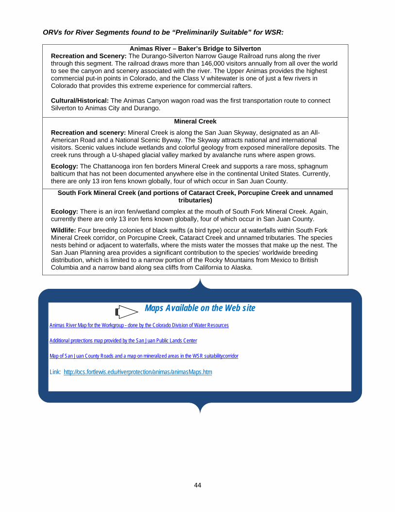
44
ORVs for River Segments found to be “Preliminarily Suitable” for WSR:
Animas River – Baker’s Bridge to Silverton Recreation and Scenery: The Durango-Silverton Narrow Gauge Railroad runs along the river through this segment. The railroad draws more than 146,000 visitors annually from all over the world to see the canyon and scenery associated with the river. The Upper Animas provides the highest commercial put-in points in Colorado, and the Class V whitewater is one of just a few rivers in Colorado that provides this extreme experience for commercial rafters. Cultural/Historical: The Animas Canyon wagon road was the first transportation route to connect Silverton to Animas City and Durango.
Mineral Creek
Recreation and scenery: Mineral Creek is along the San Juan Skyway, designated as an All-American Road and a National Scenic Byway. The Skyway attracts national and international visitors. Scenic values include wetlands and colorful geology from exposed mineral/ore deposits. The creek runs through a U-shaped glacial valley marked by avalanche runs where aspen grows.
Ecology: The Chattanooga iron fen borders Mineral Creek and supports a rare moss, sphagnum balticum that has not been documented anywhere else in the continental United States. Currently, there are only 13 iron fens known globally, four of which occur in San Juan County.
South Fork Mineral Creek (and portions of Cataract Creek, Porcupine Creek and unnamed tributaries)
Ecology: There is an iron fen/wetland complex at the mouth of South Fork Mineral Creek. Again, currently there are only 13 iron fens known globally, four of which occur in San Juan County.
Wildlife: Four breeding colonies of black swifts (a bird type) occur at waterfalls within South Fork Mineral Creek corridor, on Porcupine Creek, Cataract Creek and unnamed tributaries. The species nests behind or adjacent to waterfalls, where the mists water the mosses that make up the nest. The San Juan Planning area provides a significant contribution to the species’ worldwide breeding distribution, which is limited to a narrow portion of the Rocky Mountains from Mexico to British Columbia and a narrow band along sea cliffs from California to Alaska.
Maps Available on the Web site
Animas River Map for the Workgroup - done by the Colorado Division of Water Resources
Additional protections map provided by the San Juan Public Lands Center
Map of San Juan County Roads
Link: http://ocs.fortlewis.edu/riverprotection/animas/animasMaps.htm
Maps Available on the Web site
Animas River Map for the Workgroup - done by the Colorado Division of Water Resources
Additional protections map provided by the San Juan Public Lands Center
Map of San Juan County Roads and a map on mineralized areas in the WSR suitabilitycorridor
Link: http://ocs.fortlewis.edu/riverprotection/animas/animasMaps.htm

45
Land and Water Protections Currently in Place County Level: County Land Use Codes provide some protections. In San Juan County, Boulder Gulch and Bear Creek are sources of water for the Town of Silverton. They have been withdrawn from disturbance by the county land-use code. Also, San Juan County Land Use Code specifies view corridors in a “scenic overlay” where the county does require mitigation for activities. These corridors do not remove the mining “use by right,” but can affect the way land uses are carried out. The San Juan County Land Use Code specifies a 200ft building setback from the river. La Plata County also has various protections in its Land Use Code: http://co.laplata.co.us/departments_officials/planning Federal Level: In the Workgroup meetings, members discussed that an array of laws that affect both land and water and other related issues in the Area of Focus can be considered protections. What follows is an inventory of the laws the Workgroup mentioned. They are covered only briefly with available links for obtaining more information -Federal Energy Regulatory Commission (FERC): The FERC is an agency that regulates the interstate transmission of electricity, natural gas, and oil. The FERC reviews proposals to build liquefied natural gas (LNG) terminals and interstate natural gas pipelines, as well as licensing hydropower projects. Some additional responsibilities include: Regulating the transmission and wholesale sales of electricity in interstate commerce; Regulating the transmission and sale of natural gas for resale in interstate commerce; Regulating the transportation of oil by pipeline in interstate commerce; Approving siting and abandonment of interstate natural gas pipelines and storage facilities; Reviewing siting application for electric transmission projects under limited circumstances; Licensing and inspects private, municipal, and state hydroelectric projects; Protecting the reliability of the high voltage interstate transmission system through mandatory
reliability standards; and Overseeing environmental matters related to natural gas and hydroelectricity projects and
other matters. -Heritage Resource Laws: Heritage resources are protected by the Antiquities Act of 1906; the National Historic Preservation Act (NHPA) of 1966; and other legislation including NEPA (National Environmental Policy Act). Other relevant laws include the Archaeological and Historical Conservation Act of 1974; the Archaeological Resources Protection Act of 1979 and its regulations; the American Indian Religious Freedom Act; and the Native American Graves Protection and Repatriation Act of 1990. The 1971 Executive Order No. 11593 also requires that cultural resources be protected. Find out more at: http://www.blm.gov/pgdata/etc/medialib/blm/co/field_offices/columbine_field_office/alpine_triangle.Par.63400.File.dat/RAMP_Final_081610.pdf

46
-Wildlife Laws: Threatened and endangered flora and fauna are protected under the Endangered Species Act of 1973 (ESA). The Migratory Bird Treaty Act and the Bald and Golden Eagle Protection Act protect other sensitive wildlife species. Find out more at: http://www.blm.gov/pgdata/etc/medialib/blm/co/field_offices/columbine_field_office/alpine_triangle.Par.63400.File.dat/RAMP_Final_081610.pdf -Clean Air Act: The 1970 Clean Air Act, as amended (1990), establishes national ambient air quality standards to control air pollution. In Colorado, the state oversees air quality regulations and standards for stationary sources of air pollution. Impacts to air quality are managed through a case-by-case process. Find out more at: http://www.blm.gov/pgdata/etc/medialib/blm/co/field_offices/columbine_field_office/alpine_triangle.Par.63400.File.dat/RAMP_Final_081610.pdf -Clean Water Act: The Federal Water Pollution Control Act (AKA “the Clean Water Act”), protects surface water resources from pollution. Section 402 of the Clean Water Act directs the U.S. Environmental Protection Agency (EPA) to develop a phased approach to regulate stormwater discharges under the National Pollutant Discharge Elimination System (NPDES) program. Land disturbing activities may require permit coverage through a NPDES storm water discharge, depending on the acreage disturbed. Additionally, a U.S. Army Corps of Engineers (USACE) Section 404 Permit for the discharge of dredge and fill materials may also be required. Necessary permits and approvals may be required prior to any disturbance activities. Find out more at: http://www.blm.gov/pgdata/etc/medialib/blm/co/field_offices/columbine_field_office/alpine_triangle.Par.63400.File.dat/RAMP_Final_081610.pdf -Environmental Justice Executive Order: Executive Order 12898 of 1994, "Federal Actions to Address Environmental Justice in Minority Populations and Low-Income Populations," requires federal agencies to ensure that proposed projects under their jurisdictions do not cause a disproportionate environmental impact that would affect any group of people because of a lack of political or economic strength. Environmental justice requires, "…the fair treatment of people of all races, cultures, incomes, and educational levels with respect to the development, implementation, and enforcement of environmental laws, regulations, and policies.” Find out more at: http://www.blm.gov/pgdata/etc/medialib/blm/co/field_offices/columbine_field_office/alpine_triangle.Par.63400.File.dat/RAMP_Final_081610.pdf
-Federal Land Policy and Management Act of 1976 (FLPMA): FLPMA specifies that: “. . . the public lands be managed in a manner that will protect the quality of scientific, scenic, historical, ecological, environmental, air and atmospheric, water resource, and archeological values; that, where appropriate, will preserve and protect certain public lands in their natural condition; that will provide food and habitat for fish and wildlife and domestic animals; and that will provide for outdoor recreation and human occupancy and use . . .” Through FLPMA, Congress directed that public lands

47
will be retained in Federal ownership unless disposal of a particular parcel serves the national interest. The Act specifies that the United States receive fair market value for the use of the public lands and their resources unless otherwise provided for by statute. FLPMA requires the BLM to: “…use and observe the principles of multiple use and sustained yield” in developing land use plans for public lands. Multiple use involves: “a combination of balanced and diverse resource uses that takes into account the long-term needs of future generations for renewable and nonrenewable resources…” (FLPMA, Section 103). Sustained yield is: “the achievement and maintenance in perpetuity of a high-level annual or regular periodic output of the various renewable resources of the public lands consistent with multiple use” (FLPMA, Section 103). Find out more at: http://www.blm.gov/pgdata/etc/medialib/blm/co/field_offices/columbine_field_office/alpine_triangle.Par.63400.File.dat/RAMP_Final_081610.pdf
-Locatable Minerals: Locatable minerals are managed under the General Mining Law of 1872. Federal mineral estate in areas not under withdrawal will be open to entry and location under the general mining laws. Plans of operation will be required for proposed locatable mineral activity on the following lands: 1) lands under wilderness review, 2) lands closed to OHV travel, and 3) lands within designated Areas of Critical Environmental Concern (ACECs). Link: http://www.blm.gov/pgdata/etc/medialib/blm/co/field_offices/columbine_field_office/alpine_triangle.Par.63400.File.dat/RAMP_Final_081610.pdf) The Multiple Use Mining Act of 1955 details the classification of locatable minerals and establishes that unpatented mining claims may not be used for any purpose other than prospecting, mining, or processing operations upon the land. Link: http://www.fs.usda.gov/wps/portal/fsinternet/!ut/p/c5/04_SB8K8xLLM9MSSzPy8xBz9CP0os3gjAwhwtDDw9_AI8zPyhQoYAOUjMeXDfODy-HWHg-zDrx8kb4ADOBro-3nk56bqF-RGGGSZOCoCAPi8eX8!/dl3/d3/L2dJQSEvUUt3QS9ZQnZ3LzZfMjAwMDAwMDBBODBPSEhWTjJNMDAwMDAwMDA!/?navtype=BROWSEBYSUBJECT&cid=stelprdb5167636&navid=160120000000000&pnavid=160000000000000&ss=1102&position=Not%2520Yet%2520Determined.Html&ttype=detail&pname=Region%25202-%2520Resource%2520Management In addition to the laws listed above, the following are federal protections for land or water. -Roadless Area: (Please see updated information below) Portions of the East Animas (16,864 acres), Weminuche Adjacent (38,410 acres), and all of the West Needles (4,497 acres) 2006 Inventoried Roadless Areas fall within the Area of Focus. The 2001 Roadless Area Conservation Rule prohibits road construction and timber harvest, with limited exceptions, in Inventoried Roadless Areas. The 2001 rule is currently in litigation with different courts issuing conflicting decisions. It seems likely that some version of a roadless rule – although it is not clear which one (the Colorado Rule or the Federal Rule) – will be in place in the future, restricting road construction and timber harvest. Updated Information: -Roadless Area: Portions of the East Animas (16,864 acres), Weminuche Adjacent (38,410 acres), and all of the West Needles (4,497 acres) 2006

48
Inventoried Roadless Areas fall within the Area of Focus. The management of these areas is now addressed by the Colorado Roadless Rule (CRR), a detailed document with very specific allowances and prohibitions. The CRR, completed in 2012, prohibits road construction and timber harvest, with some exceptions, in Colorado Roadless Areas. A thorough examination of the CRR is necessary to understand its protective aspects - http://www.fs.usda.gov/detail/r2/home/?cid=stelprdb5200050 -Wilderness: Wilderness is defined by the Wilderness Act of 1964 as: “an area where the earth and its community of life are untrammeled by man, where man himself is a visitor who does not remain…” Wilderness areas are managed to protect opportunities for solitude and unconfined, primitive recreation, and to remain without permanent improvements or human habitation. The Animas River drainage above Baker’s Bridge includes 68,745 acres of the Weminuche Wilderness. Possession of motorized equipment and mechanized means of transport is not permitted within the wilderness area. Use of aircraft to land or drop people or materials is prohibited, with the exception of agency-approved administrative use or emergency search-and-rescue operations. -Wilderness Study Areas: Four BLM Wilderness Study Areas, Handies Peak (1,061 acres), Weminuche Contiguous (1,619 acres), Whitehead Gulch (1,764 acres) and West Needles Contiguous (958 acres) totaling 5,402 acres fall entirely within the drainage. WSAs are managed to protect their wilderness character until Congress designates them as Wilderness Areas or releases them for multiple-use. The general standard for management of WSAs is to not allow actions or impacts that will preclude Congress’s prerogatives in either designating the areas as wilderness or releasing them for other non-wilderness uses. Some uses prohibited in a designated wilderness may be permitted in a WSA if they are temporary, do not create surface disturbance, or do not involve placement of permanent structures. The website: http://www.blm.gov/wo/st/en/prog/blm_special_areas/NLCS/wilderness_study_areas/Wilderness_Study_Areas.html provides information on the management of WSAs. The following identifies some of the specific management of WSAs.
Fire Management – Natural and prescribed fires may be allowed to burn under certain conditions. In all cases, the equipment and tactics used to manage fires is designed to minimize the impact to wilderness values. When fire threatens human life or property, motorized equipment may be used to eliminate or minimize the threat.
Landowner Access – Landowners have the right to access their property. In addition, owners of in-holdings may continue to use them for a wide variety of purposes.
Land Transactions – Generally, public lands within WSAs may not be sold, leased, or exchanged.
Livestock Grazing – The vast majority of WSAs are grazed by domestic livestock. Livestock grazing may continue in the same manner and degree as it took place in 1976. Developments such as fences, wells, and pipelines may be maintained.

49
New livestock facilities may be constructed if they are temporary, or if they benefit overall management of wilderness values.
Mining – Mineral activities that occurred in WSAs before 1976 may continue. Miners with valid claims may develop those claims even if wilderness characteristics are impaired. New mining claims can be located in WSAs. Activity on new claims must meet the non-impairment criteria and essentially avoid creating surface disturbance. Miners must contact the nearest BLM office before starting mineral development that has not been authorized. Plans of Operations are required for mining operations in WSAs.
Mineral Leasing – Leases for such resources as oil, gas, and potash may operate according to the terms and conditions of the lease. No new leases will be issued in WSAs.
Recreation – Off-highway vehicles and bicycles are not allowed in the WSAs within the Area of Focus.
Search and Rescue – Search and rescue occurs within WSAs. Vehicles may be used on designated routes. Vehicles may be used for cross country travel when required in an emergency.
Wood Cutting – Standing trees may not be cut for personal or commercial use.
Table 10 in the Draft Land Management Plan (below) provides a useful summary of the suitability of major management activities and uses within Designated Wilderness and Wilderness Study Areas (as well as other lands assigned to the MA 1 management prescription) within the San Juan Public Lands: From DLMP p. 134, Table 10 - Management Area 1 - Natural Process Dominate, Suitability: Activities and Uses Allowable- Restricted- Prohibited Wildland Fire Use Allowable Prescribed Burning Allowable Mechanical Fuels Treatment Restricted (Mechanical Treatments would generally
involve the use of hand-portable tools and generally be applied only in areas outside designated wilderness and WSAs)
Timber Harvesting as a Tool Prohibited Timber Production (schedule on a rotation basis) Prohibited Commercial Use of Special Forest Products and Firewood
Prohibited
Livestock Grazing Allowable Recreation Facilities Prohibited Motorized (Summer) Prohibited Motorized (Winter) Prohibited Non-motorized (Summer) Allowable Non-motorized (Winter) Allowable Motorized Tools for Administrative Work Restricted (Motorized tools may be used in the Piedra
Area and in areas outside of designated wilderness and WSAs.)
Mechanized (e.g., mountain bikes) Restricted (Mountain bikes are suitable in MA 1 landscapes outside of designated wilderness and WSAs.)
Road Construction (permanent or temporary) Prohibited Minerals - Leasable (oil and gas, and other) Restricted (Designated Wilderness is withdrawn from
mineral leasing. WSAs are administratively not available

50
for mineral leasing. A No Surface Occupancy Stipulation would be applied to IRAs outside of designated Wilderness and WSAs.)
Minerals - Saleable Prohibited Minerals - Locatable Restricted (Designated Wilderness, and WSAs are
withdrawn from locatable mineral entry. Limited road access and other constraints may increase the cost and complexity of locatable mineral exploration in other MA 1 lands.)
-Scenic, Historic and Backcountry Byways: Portions of the San Juan Skyway and the Alpine Loop National Backcountry Byway pass through the Area of Focus. Consistent with the USFS National Scenic Byway Program goals, managers, “…guide the appropriate physical development of these travel corridors and their associated facilities, direct the conservation of unique and valued attributes surrounding the planning area, and provide leadership for Byway management that supports efforts to benefit these routes.” (San Juan Public Lands 2007 Draft Land Management Plan, page 174.) The San Juan Public Lands 2007 Draft Land Management Plan assigns these byways to the Management Area 4 High Use Recreation Emphasis management prescription, which also reflects the current management of these corridors. Table 12 of the plan specifies the land use suitability for MA 4 areas: From p. 136 of the DLMP: Table 12 – Management Area 4 Suitability: Activities and Uses Allowable- Restricted- Prohibited Wildland Fire Use Prohibited Prescribed Burning Allowable Mechanical Fuels Treatment Allowable Timber Harvesting as a Tool Allowable Timber Production (schedule on a rotation basis) Prohibited Commercial Use of Special Forest Products and Firewood
Restricted (Key areas for cone, mushroom, and other gathering, and commercial firewood collection can be beneficial.)
Livestock Grazing Allowable Facilities Allowable Motorized (Summer) Allowable Motorized (Winter) Allowable Non-motorized (Summer) Allowable Non-motorized (Winter) Allowable Motorized Tools for Administrative Work Allowable Mechanized (e.g., Mountain Bikes) Allowable Road Construction (permanent or temporary) Allowable Minerals - Leasable (oil and gas, and other) No Leasing (per SJPL, will be corrected to read No
Surface Occupancy in final plan) Minerals - Saleable
Restricted (Developed recreation facilities are proposed to be withdrawn from mineral entry.)
Minerals - Locatable Restricted (Developed recreation facilities are proposed to be withdrawn from mineral entry.)

51
-National Recreation and Scenic Trails, and National Historic Trails: Portions of the Continental Divide National Scenic Trail and the Colorado Trail pass through the Area of Focus. These are federally-recognized trails that are: “recognized through establishment reports and management plans for their scenic, historic, interpretive, and recreation values.” (San Juan Public Lands 2007 Draft Land Management Plan, page 176.) Neither of them have any congressionally-designated protections, however the National Recreation and Scenic Trails Standards and Guidelines direct that: “other resource activities should be designed in order to meet scenic quality objectives.” The trails are currently managed under guidance provided by the 1980 Continental Divide National Scenic Trail Comprehensive Plan; the 1998 USFS Decision Notice, Colorado Trail Management Direction and Route Selection EA, Region 2; the USFS Master Plan for the Colorado Trail; and the FSM 2300, Chapter 2353, National Scenic and Historic Trails (San Juan Public Lands 2007 Draft Land Management Plan, page 177). The San Juan Public Lands 2007 Draft Land Management Plan specifies that: “other resource activities should be designed in order to meet scenic quality objectives for these special designation trails (generally, a foreground and middleground of very high to high scenic integrity or visual resource management (VRM) Class II).” The Continental Divide Trail and the Colorado Trail are designated for non-motorized travel only within the Columbine District. Where they run through Wilderness, the protections of wilderness apply. -Special Recreation Management Area: The Silverton Special Recreation Management Area or “SRMA” (186,252 acres) lies within the Area of Focus. It is part of the American Flats/Silverton-Lower Lake Fork Special Recreation Management Area (SRMA). In 1981, the BLM designated the American Flats/Silverton-Lower Lake Fork Special Recreation Management Area to protect the important recreational values. This administrative designation recognized the area as both a highly valued recreation resource and an area requiring enhanced management for the protection of these recreation-related resources, including a notable number of unique and nationally significant historic mining sites. The original SRMA, together with the Alpine Loop Scenic Byway, are now known and managed as the “Alpine Triangle SRMA.” In October 2010, the BLM released a final Recreation Area Management Plan (RAMP) for the Alpine Triangle SRMA identifying goals for the BLM recreation program in the Project Area and the supporting management actions necessary to achieve those goals and protect the intrinsic natural and heritage qualities of the area. For more information go to: http://www.blm.gov/co/st/en/fo/gfo/loop_plan.html
Quoting the BLM: “The Alpine Triangle is a Special Recreation Management Area made up of over 150,000 acres managed by the U.S. Bureau of Land Management in the San Juan Mountains of southwest Colorado. An SRMA is a place where we recognize the outstanding recreation values and opportunities available in this area and focus extra time, effort and funding on managing these outstanding resources. Our basic goals are simple:

52
1. To facilitate the public’s enjoyment of these recreation opportunities 2. To minimize the negative effects that recreation has on other resources in the
area
The plan provides extensive broad guidance for management within the Alpine Triangle, as well as some very specific management guidance with respect to specific recreational activities.” Those areas are:
Motorized Recreation: Under the Columbine Field Office’s Resource Management Plan or “RMP”, travel designations limit motorized vehicles (e.g., street legal vehicles, motorcycles, ATVs) to designated roads. No motorized vehicles may travel off designated roads unless authorized by BLM. Mountain bikes are added to the list of equipment that must stay on designated roads and trails. Winter motorized recreation (e.g., snowmobile) is not limited to designated roads and trails, but participants are encouraged to not travel in potential avalanche areas.
Rock Climbing: Climbing areas that are discovered to have active cliff nesting birds should be temporarily closed to climbing within 100 yards on either side of the nest, until the birds have left the nest for the season.
Camping/Cultural and Heritage Tourism: Prohibit camping or fires within 100 feet of historical structures to minimize modern impacts to these resources from vandalism or damage from inappropriate activities. There is currently a 14-day camping limit in undeveloped sites for recreationists to allow other campers an opportunity to use the area, and to prevent impacts that often come from long-term stays. Squatters are prohibited in all cases.
Horseback riding and pack animals: Any feed that is used on public lands must be certified weed free hay or pellets to reduce the chances of spreading invasive weeds. Downhill skiing, snowboarding, cross-country skiing and snow shoeing: Proposals for grooming may be considered in the future but an environmental analysis must occur that evaluates the potential for impacts to other resources such as Canada lynx.
Visual Resources: The proposed RMP designates the entire Project Area as BLM Visual Resource Management (VRM) Class II, which encourages management to place a high value on protecting the integrity of scenic resources. The objectives of VRM Class II are, “…to retain the existing character of the landscape. The level of change to the characteristic landscape should be low. Management activities may be seen, but should not attract the attention of the casual observer. Any changes must repeat the basic elements of form, line, color, and texture found in the predominant natural features of the characteristic landscape” (BLM 1986b).

53
Table 38 of the San Juan Public Lands 2007 Draft Land Management Plan proposes the following suitability for land management activities and uses within the Silverton SRMA (but see Scenic Byways section above for management suitability specific to the Alpine Loop and San Juan Skyway corridors):
Silverton Area Suitability (p.225, DLMP): Activities and Uses Allowable- Restricted- ProhibitedWildland Fire Use Restricted (Wildland fire use would be allowed in high-elevation spruce-fir,
and in order to protect historic structures and private property.) Prescribed Burning Restricted (May be used in order to improve wildlife habitat, including for
bighorn sheep.) Mechanical Fuels Treatment Prohibited
Timber Harvesting as a Tool Restricted
Timber Production (schedule on a rotation basis) Prohibited
Commercial Use of Special Forest Products and Firewood
Restricted to Christmas trees, post and poles, mushrooms and medicinal plants collected in the area.
Livestock Grazing Restricted to grazing allotments.
Facilities Restricted in order to protect resources, direct traffic, and to provide essential visitor services.
Motorized (Summer) Allowable (designated routes only, per RAMP)
Motorized (Winter) Allowable
Non-motorized (Summer) Allowable
Non-motorized (Winter) Allowable
Motorized Tools for Administrative Work Allowable
Mechanized (e.g., Mountain Bikes) Allowable (designated routes only, per RAMP) (CONT.)
Road Construction (permanent or temporary) Restricted (Allowable for access to valid existing rights and for effective public access.)
Minerals - Leasable (oil and gas, and other) Prohibited
Minerals - Locatable Allowable
Minerals - Saleable (materials)
Restricted (Allowable where natural, cultural, and/or scenic values are not degraded.)
-USFS and BLM management (current and proposed under the Draft Plan):

54
Public Lands Management in the Animas River Drainage above Baker’s Bridge Current management: The areas of USFS public land within the Area of Focus are allocated to large areas of: MA1W which means: “Natural Processes Dominate: Designated Wilderness Study Areas and Piedra Area” (Weminuche Wilderness surrounding the Animas River east of HWY 550, upstream of Cascade Creek and downstream of Molas Creek) and MA3 “Natural Landscape with Limited Management” (area northwest of HWY 550 between Cascade Creek and Silverton). Smaller areas are allocated to: MA1 “Natural Processes Dominate” (roadless area within Weminuche Wilderness), MA4 “High Use Recreation Emphasis” (linear areas near HWY 550 and along Mineral Creek and South Fork Mineral Creek), and MA5 “Active Management” (Missionary Ridge and portions of Cascade Creek drainage, and an area between Lime Creek and HWY 550. The BLM public lands are all managed as MA2 “Special Areas and Unique Landscapes.” Proposed management: Under the San Juan Public Lands Center’s - 2007 Draft Land Management Plan some changes to allocations under these management areas would occur. The USFS lands between Cascade Creek, HWY 550, West Lime Creek and South Fork Mineral Creek would change from MA3 “Natural Landscape with Limited Management” to MA1 “Natural Processes Dominate.” The Elbert Creek drainage would change from MA4 “High Use Recreation Emphasis” to MA5 “Active Management.” The USFS lands north of Middle Fork Mineral Creek and east of Mineral Creek would change from largely MA4 “High Use Recreation Emphasis” to MA2 “Special Areas and Unique Landscapes.” The corridors of BLM lands along Cement Creek and the Animas River upstream of Silverton would change from MA2 “Special Areas and Unique Landscapes” to MA4 “High Use Recreation Emphasis.” There is a proposed Electra RNA (Research Natural Area) (2,450ac) adjacent to the west bank of the Animas River between Cascade Creek and Glacier Creek. This area is currently a MA3 “Natural Landscape with Limited Management;” it would change to a MA2 “Special Areas and Unique Landscapes.”There is one area (1,428ac) of the Weminuche Adjacent Inventoried Roadless Area recommended for wilderness in the DLMP. If the plan is approved, this area will be managed to maintain its wilderness characteristics until Congress designates it as Wilderness or releases it for multiple-use management (San Juan Public Lands 2007 Draft Land Management Plan, page 171). Silverton BLM lands provide for motorized use on designated roads and trails only. The USFS and BLM will be commencing travel management planning for various portions of the Area within the next five years.
State Level: -State Level Mining-Related Resources: The Colorado Division of Reclamation Mining and Safety (DRMS) is responsible for mineral and energy development, policy, regulation and planning for mines and mined land reclamation. Under the Division’s Office of Mined Land Reclamation, the Minerals Program and the Coal Program regulate mining and reclamation activities at coal, metal, aggregate and other mineral mines. These programs review and issue mining and reclamation permit applications and inspect mining operations to make sure that reclamation plans are being followed. The Colorado Office of Active and Inactive Mines reclaims and safeguards abandoned mine sites that are dangerous and create environmental

55
hazards. The program also provides safety training for mine operators and employees. Link: http://mining.state.co.us/About%20DMG.htm
-Wildlife: Colorado Parks and Wildlife is the lead agency enforcing regulations (http://wildlife.state.co.us/RulesRegs/Regulations/Pages/Regulations.aspx) to protect both non-game and game wildlife by limiting how wildlife can be hunted, possessed, transported, used or traded within the state. The State of Colorado’s non-game and small game and migratory bird regulations protect designated nongame species and subspecies, including threatened or endangered wildlife, from harassment, taking or possession, except in specified situations. The state’s game regulations address how, when and where hunting for game species can occur in order to maintain sustainable populations of these species into the future.
-Water Quality: The Colorado Water Quality Control Division is recognized as Colorado’s leading agency for monitoring and reporting on the quality of state waters, preventing water pollution, protecting, restoring and enhancing the quality of surface and groundwater, and assuring that safe drinking water is provided from all public water systems. The Colorado Water Quality Control Division regulates the discharge of pollutants into the state's surface and ground waters and enforces the Colorado Primary Drinking Water Regulations. The Colorado Water Quality Control Commission is the administrative agency responsible for developing specific state water quality policies in a manner that implements the broader policies set forth by the Legislature in the Colorado Water Quality Control Act. Link: http://www.cdphe.state.co.us
-Air Quality:
Created in 1970 by the Colorado Legislature, the Air Quality Control Commission develops air pollution control policy, regulates pollution sources and conducts hearings involving violations of the state’s air pollution laws. The Colorado Air Quality Regulations that apply to the Area of Focus set Ambient Air Quality Standards; limit emissions of particles, smokes, carbon monoxide and sulfur oxides; control odor contamination; require notification and permits from air pollution sources; control hazardous air pollutants; require permits for open burning and prescribed fire; provide for inspection of diesel vehicle emissions; require control of ozone depleting compounds; and require implementation of the Colorado acid rain program. Link: http://www.cdphe.state.co.us -Noise Levels: Under Colorado State Law 08-063, state and federal agencies have the ability to educate and enforce state sound limits. The law sets a limit of 96 decibels on most OHVs and authorizes the use of the Society of Automotive Engineers 20-inch sound test. This test makes it possible to field test OHVs for sound education and enforcement purposes. Link: http://www.blm.gov/pgdata/etc/medialib/blm/co/field_offices/columbine_field_office/alpine_triangle.Par.63400.File.dat/RAMP_Final_081610.pdf -Colorado Water Rights Prior Appropriation System: The Colorado Division of Water Resources is responsible for administering all water rights according to the Appropriation Doctrine (in short, 1st in time, 1st in right). This work is done through the local Division Office (located in Durango).

56
Local water commissioners ensure the priority system is followed, enforcing the decrees and water laws of the State of Colorado. The Colorado Ground Water Law of 1957 established the permitting requirement of ground water wells, and surface and ground water rights were administered together. Link: http://water.state.co.us/SurfaceWater/SWRights/Pages/default.aspx -Downstream Senior Water Rights: Senior water rights existing downstream of the Area of Focus act to maintain some flows through the area in years when natural conditions provide sufficient water. -In-Stream Flows and Minimum Lake Levels: As background, in-stream flow is an in-channel appropriation of non-consumptive water between two specific points and is appropriated by the Colorado Water Conservation Board (CWCB) for the purpose of protecting the natural environment to a reasonable degree. A Minimum Lake Level is a non-consumptive, in-lake use of water made exclusively by the CWCB for minimum levels in natural lakes in order to preserve or improve the natural environment to a reasonable degree. Both in-stream flow and natural lake level rights are administered within the State of Colorado’s water right priority system. In-Stream Flows in the Animas River Drainage above Baker’s Bridge (As of November 16, 2011, there are 69.93 stream miles within the area of focus that have some level of In-stream Flow):
Stream Name Case Number Upper End Lower End Amounts in cfs (Dates)
Appropriation Date
MAGGIE GULCH 05CW051 headwaters confl Animas River 2.5 (5/1-10/31) 1.5 (11/1-4/30)
1/25/2005
MILL CREEK 7-76W1491 headwaters confl N Mineral
Creek 3 (1/1 - 12/31) 7/30/1976
MINERAL CREEK 04CW040 confl with Big Horn Gulch confl SFK Mineral
Creek 15 (5/1-10/31)
7/13/1954*
MINNIE GULCH 83CW087 headwaters confl Animas River 1 (1/1-12/31) 5/5/1983
MINNIE GULCH 05CW052 headwaters confl Animas River .7 (5/1-10-31) 1/25/2005
Stream Name Case Number Upper End Lower End Amounts in cfs (Dates)
Appropriation Date
SOUTH FORK MINERAL CREEK
84CW272 headwaters confl Mineral Creek
18 (1/1-12/31) 7/13/1984

57
WEST LIME CREEK 7-84CW274 headwaters confl E Lime Creek 4 (5/1 - 8/31) 2.5 (9/1 - 4/30) 7/13/1984
ANIMAS RIVER 10CW086 confl Cunningham Creek confl Arrastra
Creek 21 (5/1-10/31) 9 (11/1-4/30)
1/26/2010**
ANIMAS RIVER 10CW087 Confluence w/Minnie Gulch
Confluence w/Cunningham
Crk.
12.2 (5/1-10/31) 6.1 (11/1-4/30)
1/26/2010**
BIGHORN GULCH 7-04CW040* hdgt Carbon Lake Ditch
#1
confl unnamed trib at lat 37 53 09N long 107 42 47W
5 (5/15 - 10/31)
7/13/1954
BIGHORN GULCH 7-04CW040* confl unnamed trib at lat 37 53 09N long 107 42
47W
confl Mineral Creek
10 (5/15 - 10/31) 7/13/1954
BIGHORN GULCH (UNNAMED TRIBUTARY)
7-04CW040* hdgt Carbon Lake Ditch #2
confl Big Horn Gulch
15 (5/15 - 10/31) 7/13/1954
CASCADE CREEK 7-83CW089 headwaters hdgt Cascade
Canal div 15 (1/1 - 12/31) 5/5/1983
CUNNINGHAM CREEK 7-84CW271 headwaters confl Animas River 12 (4/1 - 8/31) 4 (9/1 - 3/31)
7/13/1984
DEER PARK CREEK 7-05CW050 headwaters confl Animas River 1 (11/1 - 4/30) 2 (5/1 - 10/31)
1/25/2005
EAST LIME CREEK 7-84CW275 outlet Andrews Lake confl W Lime
Creek 1 (1/1 - 12/31) 7/13/1984
LIME CREEK 7-84CW273 confl E & W Lime Creeks confl Cascade
Creek 6 (1/1 - 12/31)
7/13/1984
* Donated water **Pending cases
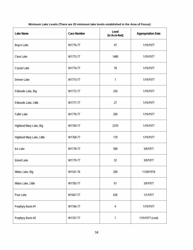
58
Minimum Lake Levels (There are 20 minimum lake levels established in the Area of Focus):
Lake Name Case Number Level
(in Acre-feet) Appropriation Date
Boyce Lake W1776-77 47 1/19/1977
Clear Lake W1775-77 1480 1/19/1977
Crystal Lake W1774-77 78 1/19/1977
Denver Lake W1773-77 1 1/19/1977
Eldorado Lake, Big W1772-77 250 1/19/1977
Eldorado Lake, Little W1771-77 27 1/19/1977
Fuller Lake W1770-77 200 1/19/1977
Highland Mary Lake, Big W1769-77 2370 1/19/1977
Highland Mary Lake, Little W1768-77 170 1/19/1977
Ice Lake W1778-77 580 3/9/1977
Island Lake W1779-77 32 3/9/1977
Molas Lake, Big W1541-76 200 11/30/1976
Molas Lake, Little W1783-77 91 3/9/1977
Pear Lake W1667-77 630 1/1/1977
Porphyry Basin #1 W1766-77 4 1/19/1977
Porphyry Basin #2 W1767-77 1 1/19/1977 (cont)
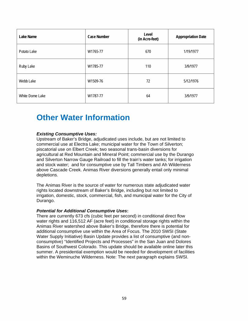
59
Other Water Information
Existing Consumptive Uses: Upstream of Baker’s Bridge, adjudicated uses include, but are not limited to commercial use at Electra Lake; municipal water for the Town of Silverton; piscatorial use on Elbert Creek; two seasonal trans-basin diversions for agricultural at Red Mountain and Mineral Point; commercial use by the Durango and Silverton Narrow Gauge Railroad to fill the train’s water tanks; for irrigation and stock water; and for consumptive use by Tall Timbers and Ah Wilderness above Cascade Creek. Animas River diversions generally entail only minimal depletions. The Animas River is the source of water for numerous state adjudicated water rights located downstream of Baker’s Bridge, including but not limited to irrigation, domestic, stock, commercial, fish, and municipal water for the City of Durango. Potential for Additional Consumptive Uses: There are currently 673 cfs (cubic feet per second) in conditional direct flow water rights and 116,512 AF (acre feet) in conditional storage rights within the Animas River watershed above Baker’s Bridge, therefore there is potential for additional consumptive use within the Area of Focus. The 2010 SWSI (State Water Supply Initiative) Basin Update provides a list of consumptive (and non-consumptive) “Identified Projects and Processes” in the San Juan and Dolores Basins of Southwest Colorado. This update should be available online later this summer. A presidential exemption would be needed for development of facilities within the Weminuche Wilderness. Note: The next paragraph explains SWSI.
Lake Name Case Number Level
(in Acre-feet) Appropriation Date
Potato Lake W1765-77 670 1/19/1977
Ruby Lake W1785-77 110 3/9/1977
Webb Lake W1509-76 72 5/12/1976
White Dome Lake W1787-77 64 3/9/1977

60
Potential New Water Diversion and Storage Locations: The State Water Supply Initiative ("SWSI") is a basin-by-basin process conducted by the CWCB to examine Colorado's water uses, water supply needs, and future water planning efforts. It has gone through several phases, including SWSI 1, SWSI II and SWSI 2010. SWSI 1 focused on using a common technical basis for identifying and quantifying water needs and issues and it catalogued the specific projects, plans, and processes that local water suppliers have identified and are undertaking as components of their own water supply planning efforts to meet the needs they themselves have identified. In addition, pursuant to House Bill 1117 and the Water for the 21st Century Act, the Southwest Water Roundtable is evaluating the consumptive and non-consumptive needs in the basin. SWSI I identified seven (7) potential dam sites within the Area of Focus. See SWSI (2004) at http://cwcbweblink.state.co.us/WebLink/ElectronicFile.aspx?docid=144066&searchid=2c16c041-d0b2-4ec5-ac42-8b95aa0c04e3&dbid=0, Figure 10-11, page 10-20. According to CWCB, these sites were identified as part of a CWCB dam site inventory conducted in 1997 to fulfill a statutory requirement. The inventory was a compilation of all the potential dam sites from feasibility studies, conditional water rights, and reservoirs with potential for expansion that existed at the time. Apparently any such site was included, independent of whether it was deemed feasible or not. The inventory has not been updated, but may be in the future. Other Water-Related Efforts: The SWSI process continues and the recent SWSI 2010 document includes lists of both consumptive and non-consumptive projects and processes (IPPs) identified by local roundtables around the state. The IPPs inventoried by the Southwest Basin Roundtable will be available to be viewed online this summer. Stream-Flow Data: Several U.S. Geological Survey gauges have been operated in the area. The following chart shows the gauge sites’ number, name and dates of operation.
Gauge Site Number Site Name Dates of Operation
09359500 ANIMAS RIVER AT TALL TIMBER RESOURT ABOVE TACOMA
1945-1956 2006-present
09359100 LIME CREEK NEAR SILVERTON, CO 10/1/56-9/30/61 09359020 ANIMAS RIVER BELOW SILVERTON,
CO
10/1/91-present
09359010 MINERAL CREEK AT SILVERTON, CO
10/1/91-present
09358000
ANIMAS RIVER AT SILVERTON, CO 10/1/91-present
09357500
ANIMAS RIVER AT HOWARDSVILLE, CO
10/1/35-present
09358550 CEMENT CREEK AT SILVERTON, CO 10/1/91 – 9/93 10/94-present

61
Note: Stream-flow data for each of these gauges is available in a variety of formats on the U.S. Geological Survey Water Data Web site at http://waterdata.usgs.gov/nwis/ and the Colorado Division of Water Resources (CDWR) Web site at http://water.state.co.us/. Water Rights: The following charts summarize water rights for direct flow and storage, not including instream flow or minimum lake level rights held by CWCB in the Animas River watershed above Baker’s Bridge. There are two trans-basin rights from the Animas River basin above Baker’s Bridge, one for 11 cfs and the other for 6 cfs. They are both privately owned and go to the Gunnison Basin. Please refer to the Glossary of Terms (handed out at the meetings and also on the Web site) to understand these various types of water rights. Please see the tabulation of water rights available at http://ocs.fortlewis.edu/riverprotection for more detailed information on each water right within the area. CWCB periodically issues a list of water rights deemed abandoned available for review at http://water.state.co.us/DWRDocs/Reports/Pages/Abandonment.aspx under the “Division 7” link.
Direct Flow Water Rights above Baker’s Bridge Total # of Rights Total cfs
(cubic feet per second)
Absolute 90 972
Conditional 115 673* * Conditional right for Animas Diversion Canal is 600 cfs
Storage Water Rights above Baker’s Bridge Total # of Rights Total AF
(acre feet)
Absolute 60 32,931*
Conditional 40 116,512^ * Absolute right for Cascade Reservoir is 23,254 AF ^ Conditional right for Howardsville Reservoir is 93,700 AF and for Cascade Reservoir is 22,000 AF
Pending Applications: (please see the updated information below) After improvements were made to the embankment and small dam at Molas Lake, the Town of Silverton (town) filed an application in Case No. 04CW50 for the storage above the minimum lake level held by the CWCB. The application was for multiple uses and included an augmentation plan for the town. The case had objectors including the CWCB and the United States Forest Service, but upon development of an area capacity table acceptable to the CDWR, the case will be settled with a decree and augmentation plan for approximately 113 AF of storage. In response to the anticipated filing of a RICD (see below for more information on RICD) application by the City of Durango, the town filed for additional surface and storage water rights (including an enlargement of Molas Lake) in Case No. 05CW87 to meet the future needs of the town. On behalf of San Juan County (county), the Southwestern Water Conservation District (SWCD) filed an application in 05CW88 for multiple points of diversion in San Juan County to provide future supplies for the anticipated growth and demands in the county. Both of these cases are pending, but would be senior to the RICD granted to Durango. For Case # 04CW50 there are no statements of opposition. There are objectors in both of the 2005

62
cases: Case # 05CW87 is opposed by the State of Colorado AG’s office and Trout Unlimited, and Case #05CW88 is opposed by Trout Unlimited. The Town of Silverton case has been delayed, in part, pending the outcome and settlement of Case 04CW50. The town and county have done additional work to verify the amount of the claims, and it is believed that more aggressive settlement discussions will begin in the near future. Pending Water Rights Case Case # Amount (cfs or AF)
Pending (Town of Silverton filing, Molas Lake) 04CW50 113 AF
Pending (Town of Silverton filing) 05CW87 7.5 cfs
Pending (Town of Silverton filing, Molas Lake Enlgt) 05CW87 137 AF
Pending (SWCD on behalf of San Juan County filing) 05CW88 14.5 cfs
Pending (to change the use for the Red Mtn. trans-mountain diversion)
11CW0006 6 cfs.
Updated Information (May 2013) Case No. 04CW50 has been decreed, and was signed by Judge Lyman on January 11, 2012. Case No. 05CW87 (Silverton) has been decreed, and was signed by Judge Lyman on March 11, 2013 The San Juan County/SWCD case (05CW88) is getting closer with one of the main objectors willing to stipulate in the case, but it has not been finalized by the water court. Case No. 11CW6 was dismissed “without prejudice” on March 3, 2013. Water Quality: The Colorado Water Quality Control Commission (the Commission) is the agency responsible for developing specific state water quality policies to implement the broader policies set forth by the Colorado Legislature in the Colorado Water Quality Control Act. The Commission adopts water quality classifications and standards for surface and ground waters of the state, as well as regulations aimed at achieving compliance with those classifications and standards. There are various categories that apply to measuring water quality. Basic standards are the general water-quality standards that apply to all surface waters of the state. For more detail on water quality standards, please refer to the handouts at the meeting and/or the State of Colorado’s Water Quality Control Division.
Above the Weminuche Wilderness Area boundary, all tributaries to the Animas River, including all wetlands, lakes and reservoirs, have a designation as “Outstanding Waters”, as do all streams in Wilderness Areas within Colorado. Outside of the wilderness boundary, several reaches of the Animas River and its tributaries above Baker’s Bridge have elevated levels of metals, which may be related to past mining activities and/or natural geology.
The Animas River Stakeholders is a group working, “…to improve water quality and habitats in the Animas River through a collaborative process designed to encourage

63
participation from all interested parties.” Participants include mining companies, elected officials, local citizens and interest groups, environmental organizations and landowners, including federal and state agencies. In 1995 the Colorado Water Quality Control Commission adopted stricter standards for certain segments of the Upper Animas with a delayed effective date at the Stakeholders’ request. The Commission then empowered the Animas River Stakeholders to locate and evaluate sources of metals contamination, determine potential improvement, and prioritize sites for remediation in order to recommend achievable water quality standards and use classifications. The Stakeholder process involves collection and analysis of data to assess the impacts of contamination on aquatic life throughout the watershed. Using a watershed approach, the Stakeholders synthesize scientific findings with economic, social, and political consideration to influence future regulatory and land management decisions (http://www.animasriverstakeholders.org/).
For specific water quality classifications and standards by segment, please refer to: http://www.cdphe.state.co.us/regulations/wqccregs/34_2010(06)-2011(06)tables.pdf. 2007 Draft Wild and Scenic River (WSR) Information: The San Juan Public Lands 2007 Draft Land Management Plan found three (3) segments (43.25 miles) to be “preliminarily suitable” for Wild and Scenic Rivers (“WSR”) designation. To be considered “eligible” for designation under the Act, a segment must be free flowing and must meet state water quality standards or at least have a plan in place to attain those standards. Please refer to Appendix D, pages D-80 to 88 of the plan for a complete description of the values associated with these streams and the Suitability Analysis provided, including: 1) characteristics of the river, 2) current status of land ownership and use, and 3) potential uses and effects of WSR status on those uses. The following chart provides information:
Source: San Juan Public Lands 2007 Draft Land Management Plan, Appendix D Anyone interested in more information can access the actual Wild and Scenic Rivers Act of 1968 and its amendments by going to http://www.rivers.gov/ and looking under the Information Tab for “WSR Act.” This site also offers more user-friendly summaries of the Act under the Publications Tab in “Technical Papers.” Note: The website, www.rivers.org, is maintained by the interagency Wild and Scenic Rivers Council.
According to the Website: “The Council consists of representatives of the four wild and scenic rivers administering agencies—the Bureau of Land Management, National Park Service, U.S. Fish and Wildlife Service, and U.S. Forest Service. Other federal agencies with river interests have key contacts and participate in discussions affecting their interests. The public has an opportunity to provide input at all Council meetings; their support is crucial to the Council's success.”
Stream Segment Classification
Length
ORVs
Animas River Baker’s Bridge to 3.58 miles below Silverton Recreational 27.19 mi Recreation
Scenery
Mineral Creek From where creek becomes 3rd –order stream to
confluence with Animas
Recreational 8.65 mi Recreation
Scenery
Ecological
South Fork Mineral
Creek
From where creek becomes 3rd –order stream to
confluence with Animas
Recreational 7.41 mi Wildlife
Ecological

64
USFS Reserved Rights: A case is pending (USFS Reserved Rights Application in Case W-1605-76B) that involves whether the USFS is entitled to water rights "reserved" as of the date Congress reserved land for the National Forest for fluvial geomorphological (stream-channel maintenance) purposes and, if so, how much water per stream across USFS land. In short, this case relates to whether or not the USFS holds a Federally Reserved Water Right and, if so, its size. Negotiations to resolve the case have been limited since 2003. Federal Energy Regulatory Commission (FERC) Licensing: Xcel Energy diverts 250-400 cfs at the Cascade Diversion on Cascade Creek into Electra Lake and uses that stored water to operate the Tacoma Power Plant at the dam to generate power. Xcel has been negotiating settlement of their relicensing and mitigation for impacts to Cascade Creek. That process is ongoing. Animas-La Plata Project (A-LP): A-LP diversions at the Durango Pumping Plant (DPP) are decreed as alternative points of diversion for locations at Teft (Animas Diversion Canal) and Howardsville. Stipulated Recreational In-Channel Diversion (RICD) Settlement: In 2006, the City of Durango filed a water court application for a Recreational In-Channel Diversion (RICD) to support kayaking and boating. A conditional water right was granted for recreational flows for four structures in the Animas River near Santa Rita Park and Smelter Rapids with flows ranging from 185 cfs in the fall and winter to 1,400 cfs during the peak June runoff. The case was contested with over 50 individuals and entities filing Statements of Opposition, and numerous applications for water rights were filed in 2005 and 2006 in anticipation of or response to the application by the City. Due to the potential impacts to future water development in the Animas River basin, conditional water rights applications were filed for by La Plata County in Case 06CW99, and by the Southwestern Water Conservation District in Case 06CW127. Intensive negotiations resulted in a stipulated settlement that granted the recreational water rights while allowing some future development to occur in the basin. La Plata County was granted conditional water rights of 1 cfs on Junction Creek, and 2 cfs on Lightner Creek, and up to 6 cfs on the Animas. These water rights are two days senior by appropriation date to the RICD. La Plata County joined the Southwestern Water Conservation District as co-owner of the future depletion allocation conditionally decreed in Case 06CW127 for depletion flow rates ranging from 20 cfs in low flow periods and 40 cfs during the peak of the hydrograph. This depletion water right is one day senior by appropriation date to the RICD. These future depletions can occur on the main stem of the Animas River and its tributaries from the upper RICD structure to the headwaters of the basin. Although not without controversy, the settlement of the RICD and related cases was viewed as a “win-win” for all involved and avoided lengthy litigation and court costs.

65
Other Important Information Potential Conflicts: To be discussed thoroughly in the River Protection Workgroup for the Animas meetings. Air Quality: According to the San Juan Public Lands 2007 Draft Land Management Plan, “…the Weminuche Wilderness Class I Area has been recognized by Congress as being an ‘outstanding special area’ – deserving the highest air quality protection in the nation” and maintaining Class I air conditions within the Weminuche is a high priority. Under the Clean Air Act of 1963, as amended, federal land managers are responsible for protecting the air quality related values within Class I areas. According to recent findings, there is an increasing trend for nitrates, but no trend for sulfates, organics or fine soil in the Weminuche Wilderness. Ongoing monitoring of air quality and air quality related values is carried out under the Weminuche Wilderness Monitoring Plan (USFS 1991) and through agreements with the EPA and State of Colorado. Climate: Climate plays a large role in the area’s hydrology. Projections about future climate conditions can provide useful input to planning efforts around the water resources which sustain the values in the area. The CWCB has prepared several reports on climate projections, water availability, and drought planning in Colorado. These can be viewed and downloaded at: http://cwcb.state.co.us/environment/climate-change/Pages/main.aspx. A two-page summary is available at: http://cwcb.state.co.us/environment/climate-change/Documents/COClimateReportOnePager.pdf. For information specific to the San Juans, the Mountain Studies Institute has compiled a summary of studies of projected future climate in Southwest Colorado. This report is available at: http://www.mountainstudies.org/sites/default/files/pdf/publications/MSI_CC_Observ_Sum_2011.pdf. Table E.S.1 Pages 18 and 19 present a concise summary of projected climate changes for southwestern Colorado, with references cited: http://www.mountainstudies.org/sites/default/files/pdf/research/Climate/Climate_Summary.pdf Watershed Condition: In May 2011, the United States Forest Service completed a Watershed Condition Classification on National Forest System Lands. For complete information on the methods, results and application of this classification, please go to http://www.fs.fed.us/publications/watershed/. The classification established and applied a consistent protocol for characterizing the health and condition of National Forest System lands in more than 15,000 watersheds across the country. For each watershed, the condition of each of 12 watershed condition indicators was given a rating based on the best available information. These condition indicators included: aquatic biota, riparian wetland
66
vegetation, water quality, water quantity, aquatic habitat, roads and trails, soil, fire effects regime, forest cover, forest health, invasive species, and rangeland vegetation. By combining individual ratings, an overall watershed condition rating was developed. The protocol is documented in the Watershed Condition Classification Technical Guide available at http://www.fs.fed.us/publications/watershed/watershed_classification_guide.pdf. The results of the Watershed Condition Classification are available in table and interactive map format at http://www.fs.fed.us/publications/watershed/. The Forest Service is using the Watershed Condition Classification to assess the relative condition of watersheds across a forest unit and to identify priority watersheds on which to focus in a consistent and accountable manner. New investments in watershed restoration will provide economic and environmental benefits to local communities. Managers have begun to develop Watershed Restoration Action Plans for priority watersheds. Watershed Restoration Action Plans are programmatic documents in which the Forest Service describes existing resource conditions and identifies possible management actions that could be taken to move towards a desired future condition. In order to move forward with any of these plans, the proposed actions will be subject to National Environmental Policy Act (NEPA) requirements.
Reasonably Foreseeable Economic Development: Logging – Small portions of the non-wilderness USFS lands west of Silverton may be suitable and available for timber production under the San Juan Public Lands 2007 Draft Land Management Plan. Land within designated wilderness is not available for timber production. Most of the non-wilderness public lands (BLM/USFS) are generally not suitable for timber production. Oil, Gas, and Mineral Development – Designated Wilderness Areas are withdrawn from mineral entry, including oil and gas leasing. There are numerous privately owned patented mining claims and approximately 100 unpatented mining claims within the Area of Focus. About 30 of these unpatented claims are within the W&SR Preliminarily Suitable river corridor. Mining in San Juan County is a use by right, so there is no county permit needed (State of Colorado permits are required). However, the county can require visual protections. San Juan County Land Use Code specifies “view" corridors where the county may require mitigation for activities. While these corridors do not remove the "use by right", they can affect the way land uses are carried out. San Juan County above Silverton contains highly mineralized geologic formations that have supported significant past metal mining operations and contain significant resources that may be mined in the future. Metal mining has been the primary economic driver in the county since 1871 until the closing of the last large mine in 1991. Mining and tourism have historically existed side by side and the historic features (railroad, back country roads, mine sites, Town of Silverton historic buildings, etc.) form a significant basis of the tourism economy.

67
Mineral loading in streams from both natural and past mining related sources occurs throughout the watershed. Extensive work has been conducted by the Animas River Stakeholders Group and others to identify sources and potential remediation projects that may be accomplished to improve water quality in the watershed. There has been uranium prospecting at Elk Park in the past. Mining and milling operations require relatively small consumptive use amounts of water. Future milling operations will likely have zero discharge requirements. Future mining operations will require NPDES permits for water discharges and appropriate treatment to comply with permit terms. Note: the National Pollutant Discharge Elimination System (NPDES) permit program controls water pollution.
There is no oil and gas production within the area. Generally speaking, there is only low potential for oil and gas resources in the portion of the Area of Focus west of Highway 550, but no potential in the portion east of the highway. Private Land Development – There are about 34,498 acres of private land in the Area of Focus including about 9,082 in the La Plata County portion, and about 25,416 acres in the San Juan County portion. About 754 acres of private land fall within the Animas Mainstem “Preliminarily Suitable” for WSR segment. About 382 acres of private land fall within the Mineral Creek segment corridor, and about 83 acres of private land fall within the South Fork of Mineral Creek segment corridor. In recent years, there has been interest in development of vacation residences in the areas around Silverton. The Town of Silverton/San Juan County Planning Department has completed a GIS analysis in February 2012 quantifying the current San Juan County build out. A table summarizing this analysis is available on the RPW website. Commercial Outfitting – Commercial outfitters require a permit to operate on USFS and BLM lands. There are numerous outfitting permits of all kinds within the area (e.g., hunting, biking, snowmobiling, fishing, rafting, horseback riding, mountaineering, plus two ski areas). The Columbine District of the San Juan Public Lands Center is in the initial stages of doing a capacity analysis for outfitting permits. Livestock Grazing – Livestock owners require a permit to graze on public lands. As of June 2011, there are four (4) active cattle allotments and 14 active sheep allotments within the area. There are two (2) reserve allotments, both vacant at this time. Ski Areas – It is possible for both Silverton Mountain and Durango Mountain Resort to expand their operations. Additional ski areas include Kendall Mountain Recreation Area, two snowcat operations and two helicopter operations. Hydroelectric Power Generation – San Juan County, outside of the Wilderness areas, contains many sites for small hydroelectric generation projects. One project is under development by the San Juan County Historical Society and several other sites are under consideration by others.

68
Transportation: The Colorado Department of Transportation (CDOT) has designated Highway 550 as a scenic highway called the San Juan Skyway. The DSNGRR has a Right-of-Way (ROW) through the public lands. There are three train bridges within the ROW, and a footbridge at Purgatory Flats. There are water tanks, sidings at Elk Park, and a wye at Elk Park/Cascade Creek Picnic Area. There are roughly 300-400 miles of roads in the Area of Focus, including USFS, BLM, and county roads. San Juan County asserts RS 2477 authority over routes in the county. There is potential for new mining roads to be constructed. San Juan County roads will support loads of up to 300 tons. If more weight is carried, road mitigation is needed, so county roads may change over time. A new tram could be installed for mining purposes, as they have been used in the past and may be used in the future, and may be a way to minimize the impact of some future mining operations. Tall Timbers uses helicopters to access their facility which is on private land. Utility Corridors and Telecommunication Sites: There are three telecommunication sites located on public lands within the area serviced by roads and transmission lines. San Juan County and residents continue to push for a high-speed fiber-optic connection, as has been provided to all the other counties in Colorado, through the Governor’s Office of Information Technology and Qwest/Centurylink. There are major electrical transmission lines running parallel to Hwy. 550 between Durango, Silverton and Ouray. There is an electrical transmission line running over Ophir Pass to Telluride. There is a utility line from Tacoma to Tall Timbers. There are currently no major oil or gas pipelines existing or proposed within the area. Weeds: The San Juan National Forest’s Invasive Species Action Plan for Fiscal Year 2007-2009 identifies as priorities for treatment the following weed species that are known to occur in the area: scentless chamomile, dames rocket, yellow toadflax, hounds tongue, spotted knapweed, leafy spurge, oxeye daisy, hoary cress, Scotch thistle, musk thistle, bull thistle, and Canada thistle. Weed infestations are largely focused along trails, roads, and other disturbed areas.

69
Attachment C River Protection Workgroup for the Animas River Summary of Wild & Scenic questions generated by the members attending meetings (as of September 2012) Below is a summary of questions, to date, regarding the impact of potential Wild & Scenic River designation for the Animas River focus area. August 25, 2011: - Does WSR conflict with Colorado Water Law? December 15, 2011: - Silverton to Baker’s Bridge section: -Do we want more people accessing this if it a WSR? Will that increase access hurt the values, hurt the corridor? -What would be the amount of water that would be in the water right if it were determined to be WSR? January 30, 2012: - San Juan County Commissioners have questions about the quarter-mile segment that would surround the Animas corridor, if designated as Wild & Scenic. Interested in water rights and how they would be impacted. Also interested in the idea generated about a potential tool being a mineral withdrawal of this area, as well as upper Mineral Creek. Is there access to 3.7 miles down the canyon where Wild & Scenic is proposed? - There was a question raised about the flexibility of a WSR corridor width – could the ¼ mile width be shrunken down a bit? If so, it might allow Commissioners to feel more willing to support Wild & Scenic. - A working group member wanted more information on the economic impact of WSR status. - Would new mining claims be encumbered by a designation? - Would the value of a new mining claim by impacted if it is location by a Wild & Scenic designated area? - What would be the implications for the Tacoma Power Plant if WSR was enacted?

70
February 23, 2012: - What types of resources might be available in terms of resources and funds if WSR was designated? - What would potential WSR designation do to water quality work? April 30, 2012: - To what degree would WSR protect the Train? - What rights of condemnation, if any, come with a WSR designation? - What are the impacts of a WSR on private lands, property rights and adjacent land owners? - Would the pollution impacts of the train be mitigated under WSR designation? - Wind, water and solar energy potential – is it excluded under WSR? May 24, 2012: - Would WSR designation impact the train’s ability to clear rock fall? - For Mineral and South Mineral Creek: Are there any other WSR designations on a section of river this short (7.41 miles)? June 29, 2012: - How do RNA’s (Research Natural Areas) compare to WSR’s? - Could a Good Samaritan Law could be enacted with a WSR designation? -Would WSR prevent or inhibit any efforts going on now to clean up the river? If so, how?