Embed Size (px)
DESCRIPTION
This paper presents risk based design approach and its application for a case study of coastal flood defences in Nam Dinh province, Vietnam
Citation preview

Reliability, Risk and Safety: Theory and Applications – Briš,Guedes Soares & Martorell (eds)
© 2010 Taylor & Francis Group, London, ISBN 978-0-415-55509-8
Risk based design of coastal flood defences - A vietnam case
C. Mai Van, P.H.A.J.M. van Gelder & J.K. VrijlingDepartment of Hydraulic Engineering, Faculty of Civil Engineering and Geo Sciences,Delft University of Technology, Delft, The Netherlands
ABSTRACT: This paper presents risk based design approach and its application for a case study of coastalflood defences in Nam Dinh province, Vietnam. In accordance with present situation analysis, the coastal flooddefences in Vietnam is not strong enough to withstand the actual sea boundary condition and ensure the safetyfor protected areas in views of present socio-economic development. In the last years annual economic damagesof Vietnam due to floods and typhoons is estimated 1.0 to 1.2 % of its GDP. This loss often associates withthe human life, environmental, cultural and further intangible values which are difficult to quantify. Methodsare critically reviewed, developed and explored on how to deal with this problem and how to include them in arisk analysis of coastal and fluvial floods. Furthermore, investigation of accepted risks in the coastal and fluvialflood-prone areas is made to answer the question if safe is safe enough and to determine the acceptable risk levels.Application of the methods is made to define the optimal safety standard for the case study. As part of knowledgetransfers, the analysis results could contribute to fundamental base for long-term planning rehabilitation of thesea defences in Vietnam.
1 INTRODUCTION
In the low-lying coastal regions where inland eleva-tions are lower than high sea water levels, coastal flooddefence systems are important to protect the low-lyinghinterland from sea flood. Typically, the system con-tains sea dikes, dunes, estuarine river levees, dams,sluices, etc. In principle, failure of any element willlead to flooding of the polders and may cause seriousconsequences. In order to have a better design solu-tion over the recent years, considerable effort has beendevoted to improving the knowledge of how to designthe defence system to protect the low-lying regionsafely. Risk based design, with acceptable risk as thebasic criteria for design, appears as a useful approachby considering the balance of the potential risk dueto flooding and the characteristic value of the defencesystem and has been widely applied in the fields ofwater defences (Dantzig 1956, Vrijling et al. 1995).
Acceptable risk is strongly related with the accept-able probability of failure and the acceptable amountof losses. There is general agreement in the literatureand in regulatory circles that risk should at least bejudged from two points of view in relation to inunda-tion consequences.The first point of view concerns therisk assessment by society on a national level whichrelates to the number of casualties due to a certain haz-ardous event. Risk is defined as “the relation betweenfrequency and the number of people suffering froma specified level of harm in a given population fromthe realisation of specified hazards”. If the specifiedlevel of harm is limited to loss of life, the societalrisk may be modelled by the frequency of exceedancecurve of the number of deaths, FN-curve. Secondly, the
acceptable level of risk can be formulated in a view ofeconomic cost-benefit. Basically, the total costs of asystem are determined by the sum of the expenditurefor a safer system and the expected value of the losses.The acceptable risk level can be estimated by compar-ing the cost of protection to a characteristic value ofthe consequences of flooding.
Coastal- and fluvial floods have a large impact onnot only economic value of the area, but also humanlife and environmental, cultural and further intangibleaspects. How the public perceives the seriousness ofdifferent environmental or cultural problems is verydifficult to measure.
In this paper methods are critically reviewed, devel-oped and explored on how to deal with this problemand how to include them in a risk analysis of coastal-and fluvial floods. An investigation of accepted risksin the coastal and fluvial flood-prone areas is made toanswer the question if safe is safe enough and to definethe acceptable risk levels. A risk-based approach indefining optimal safety levels of water defence systemis developed. Application is made to define the opti-mal safety standard for a case of coastal flood defencesin Nam Dinh province, Vietnam.
2 COASTAL FLOOD DEFENCE IN VIETNAM
Vietnam lies in a tropical monsoon climate region thathas a long coastline along the South China Sea thatis regularly substantial suffering due to floods andtyphoons. Typhoons arrive on average 4 to 6 times peryear at the Vietnam coast. The deltaic coastal areas to adistance of about 20 km behind, which are protected by
1125

the 2000 km of sea dikes, is threatened by storm surgesand high tides from the sea and high water level fromthe rivers.Thus, water defences are crucially importantto protect the country from flooding.
The applied design safety levels of sea dikes are rel-atively low.This was also noticed in 1996 after the visitof Dutch expertise missions (DWW/RWS, 1996). Mostdesigns of the sea dikes in Vietnam are based on thesea loads with return period 20 years. Besides this factthe Dutch mission marked that most Vietnamese dikeswere in poor and disputable conditions (DWW/RWS,1996). Consequently, the true probability of failureof the Vietnamese sea flood defense system exceedsby far the design frequency (Mai et al., 2006, 2007).Although designed to fail once in 20 years the seadefense system might well fail almost every year. Theexperiences in the past years support this statement.
Since 1953, Vietnam was affected by numbers offlood disasters, each disaster responsible for the lossof hundreds of lives and considerable damage toinfrastructure, crops, rice paddy, fishing boats andtrawlers, houses, schools, hospitals, etc. . . The totalmaterial damage of the flood disasters over last 60years exceeded $ US 7.5 billion. Additionally, floodsand storms caused the loss of more than 20,000 lives(ADRC, 2006 & DDMFC, 2007).
Currently, thedesignguidelines for seadikes,named14TCN-130-2002, are used for all sea dike designin Vietnam. In this guidelines the design water levelcomprises of two components of i) sea water level of5% exceedence frequency (1/20 year return period) ofoccurrence of tidal levels, and ii) storm surge heightscause by the design storm which corresponds to thewind speeds at the Beauford scale 9 to 10. The stormsurge heights in dike design were fixed in the code byspecific values. Arbitrary selection of 5% tidal leveland artificial treating storm surge level and tidal levelas two independent components does not reflect wellthe physic of total water level due to typhoon occur-rence. In addition, selection of the design storms doesnot properly reflect statistical sense with no associatingby any frequency of occurrence. Therefore, the safetylevel in the design guidelines only explicitly refers toa 1/20 year return period of the tidal level; it does notstatistically count for extreme events i.e. typhoons.
The improvement of this situation calls for the useof present available knowledge on all levels. Vietnamhas profound practical experience in the field of floodprotection, however, the theoretical knowledge in thefields of dike design, reliability and safety approach,risk analysis, policy analysis, statistics in relation toboundary conditions and mathematical modeling isnot up to date. Therefore, the transfer of this knowl-edge was strongly recommended (DWW/RWS, 1996;Vrijling et al., 2000; Mai et al., 2006).
3 RISK ANALYSIS AND RISK BASED DESIGN
Risk can be defined as the probability of a disas-ter, e.g. a flood, related to the consequences (usually
the multiplication of both variables), see CUR/TAW1990. The idea of acceptable risk for differentregions/countries may be influenced by a single spec-tacular accident or incident like 1953 flood disaster inthe Netherlands; tsunami disaster 2004 in Asia; Kat-rina in New Orleans, USA 2005; Typhoon Damreyin Vietnam 2005; and large flooding in Bangladesh2007. These unwanted events could be starting/ turn-ing points of any new safety policy establishment forthe countries.
As mentioned in section 1, the acceptance of riskin a public view should be studied from two differ-ent points of view in relation to the estimation of theconsequences: societal and economic risks.
3.1 Societal risk
Societal risk concerns the risk assessment by societyon a national level related to the number of casual-ties due to a certain hazardous event (Vrijling et al.,1998). The societal risk can be modelled by the fre-quency of exceedance curve of the number of fatalities,a FN-curve. The FN curve can be described on a dou-ble logarithmic scale in the following form (Jonkman,2007).
Where: fn(x)the probability density function (pdf) ofthe number of fatalities per year; FN (x)probability dis-tribution function of the number of fatalities per year,signifying the probability of fewer than x fatalities peryear.
Vrijling et al. (1998) notes that the societal riskshould be judged on a national level by limiting thetotal number of casualties in a given year. The totalnumber of casualties is tested against the norm ofβ∗
i MF by the following form:
The multiplication factor MF is country-specific andbased on: the value of the minimum death rate of thepopulation, the ratio of the involuntary accident deathrate (exclusive diseases) with the minimum death rate,the number of hazardous activities in a country (onaverage about 20 sectors) and the size of population.In Mai Van et al. (2008) the multiple factor was deter-mined, MF=550, for the Vietnam situation. This valueis reasonable while comparing to that of Netherlands(MFNL = 100), and of South Africa (MFSA = 750)by van Gelder et al. (2004). Therefore, the norm forVietnam situation can be set at β∗550 and used for allsuccessive calculations.
3.2 Economic approach in determination ofacceptable risk
In this approach, the total costs of a system (Ctot) aredetermined by the sum of the expenditure for a safer
1126

system (I�H ) and the expected value of the mainte-nance cost M and the expected economic damage D(van Dantzig, 1956). The total cost of the system withdike heightening �H is:
Where: Pf is probability of failure per year; M is yearlyexpected maintenance cost; D is expected damage incase of flood, this can be determined from FD-curve,an exceedance frequency of the economic damage; r isreal effective rate of interest; T is planning period, inyears.
The optimal level of safety indicated by Pf −optcorresponds to the point of minimal cost.
4 DESCRIPTION OF THE CASE STUDY
Nam Dinh coastal zone is protected by 70 km of seadikes. The dikes system has been constructed on thebasis of sea load with 20 year return period. However,the true probability of failure of the Nam Dinh defensesystem is 0.78 per year (Mai et al. 2007). This exceedsby far the design frequency and reflects that failure ofthe dike system occurs almost every year.
Typhoon Damrey occurred in September 2005 andhitted the Nam Dinh coasts caused approximatelymore that 8 km of sea dike breaches.Total direct loss ofthe effected region is over 500 million USD (DMWG2005).
In attempt to rehabilitate the sea dike system in along run, a huge sea dikes program has been estab-lished by the Ministry of Agriculture and Rural Devel-opment (MARD). One of the main tasks of the programis assessment of the present situation of the seadefence regarding safety aspect and establishment ofnew safety standards for protecting the coastal regions.Coastal flood defence system of Nam Dinh provincewas selected as a pilot location for implementation ofthe new sea dikes. In 2005 several dikes sections wereconstructed closure of breaches. However, these dikesis still based on existing safety standards (with adopteddesign frequency of 1/20 year), which is known as outof date. It is necessary to check the current safety of thenew constructed dike system in Nam Dinh to see if thecurrent rehabilitation works provide enough safety forthe protected region. If not, to which level of protectthe system should be designed.
5 ACCEPTABLE RISK IN VIETNAM
5.1 Individual risk due to flood in Vietnam
The individual risk for coastal flooding, IRflood, inVietnam can be estimated by:
Where:– pf−flood is actual probability of inundation.
In Vietnam the existing coastal flood defences arerequired to meet 1/20 year design safety standard.Therefore, the inundation probability can be taken as0.05 per year.
– pd/F−flood is conditional probability which meanthat probability that an individual who lives in the pro-tected coastal region would be killed given occurrenceof the sea flood.
In general the conditional probability depends onvarious factors namely e.g: Type of floods: predictableor unpredictable; Warning time before flood occur-ring; Effectiveness of evacuation; Possible shelters/degree of exposure to flood, etc.
Regarding these above aspects in estimating theconditional probability, since there is hardly any infor-mation e.g in form of report or written paper availablein Vietnam it is suggested to base the estimation onexpert opinions and past experiences of coastal flood-ing in Vietnam. The following information has beencollected by means of meetings and/or remote com-munication with Vietnamese experts who have muchknowledge on coastal flooding in Vietnam and othersubject-matter experts in the Netherlands.
The Vietnamese coast is hit (almost) every year bytyphoons. Therefore the populations in coastal areasare relatively well aware and prepared. It is expectedthat this will lead to high evacuation percentages(93–98%). Given the relatively limited size of theflooded areas there are good opportunities to evacu-ate or find shelter within the area. The exposed rate inthis case can be taken as 5% of the total population inthe affected area.
In addition to that, in many coastal areas the moresevere and deep flooding is limited to the area very nearthe coast (over 1 to 3 km, depths can reach 1 to 3 m).Areas further away from the coast may effected byflooding but generally with limited depth (<1m).
Jonkman (2007) has shown that the mortality due tothese events is generally around 1%. This research wasbased on of historical information of coastal floodsin the Netherlands, U.K, U.S and Bangladesh. This“1% -rule of thumb” was considered relatively highfor flood events along theVietnamese coast.A value of0.2% is proposed in Jonkman 2009 for Vietnam basedon discussions with Vietnamese experts. In previoussection, based on the historical data of loss of life andtotal number of effected people due to storm inducedflood of the coastal regions in the last century (ADRC2006) the rate is estimated approximately of 0.3%.Thismeans that 0.3% of the exposed population will notsurvive.
The conditional probability then can be deter-mined by:
pd/F−flood = p(exposure)∗ p(decease when exposure)= (0.05 ÷ 0.1)∗ 3.10−3 = (1.5 ÷ 3)∗10−4
Substitutes pf−flood and pd/F−flood to (4) the individ-ual risk due to flooding in Vietnam is approximately10−5. Referring this IR value to the individual riskcriteria (Eq. 6–1), the policy factor for flooding inVietnam becomes 0.1. Comparing IRflood to individ-ual risk due to traffic accident (IRtraffic = 1.45 × 10⁻⁴
1127

Figure 1. Vietnam flood FN-curve.
per year, see also Mai Van et al. 2008), the risk dueto flood is lower and a factor of approximately 10 isfound.
5.2 Societal risk for flooding in Vietnam
The FN-curve due to flooding on a national scale ofVietnam are in Fig. 1 (Mai Van et al. 2008). It isnoted that these curves were established on the basis ofhistorical loss information in terms of economic dam-ages and human lives due to all-cause-flood events ofVietnam in the last century. The most important andreliable source of information used in these analysis isthe top 25 flood disasters of Vietnam in the 20th cen-tury, which currently available in the report of AsianDisaster Reduction Centre (ADRC, 2006).
The FN-curve has the shape which is best modeledby exponential distribution with a shape parameterα = 728 fat/year (Fig. 1). The FD-curve has lognor-mal shape with µ = 1108 and sigma = 309.5 millionUSD.
The societal risk at national level can be limited by:
k Total risk
1 2060.82 3382.83 4704.8
Where CN is the position constant and NA takes intoaccount number of independent places where a consid-ered hazardous may take place in a country. Regardingflooding in Vietnam, number of independent placesNA = 6 on a national scale is supposed as simi-lar as independent climate zones, in which each zoneis characterized on the basis of similarity of naturalconditions (e.g weather characteristics, topographicalfeature, frequency of storms and typhoons landing and
Figure 2. Societal risk criteria for vietnam.
flooding characteristics and frequency) and has a sizeapproximately as large as the size of a typhoon affectedarea.
Inspection of the FN-curve and limit lines in Fig. 2the following points can be drawn:
Flood risk is completely unaccepted by the nationallimit in accordance with the policy factor β = 0.1(characteristic for an involuntary activity with somebenefit: IR= 10−5 per year), which is found for indi-vidual risk due to flood in Vietnam in Section 5.1.The limit line corresponds to the constant value ofCN = 56.
A flood event which would claim less than 100 fatal-ities is accepted with the limit in accordance with thepolicy factor taken a value of 1.0, which is similar toacceptable risk limit for traffic accidents.
With the policy factor β = 10 the limit line liesabove the FN-curve. This means that flooding in Viet-nam is acceptable if flood accident is viewed as similaras a voluntary activity with direct benefit. This mightbe true only for some specific rural areas in the low-lying Mekong river delta where floating house arepopular and annual flood brings fertilizing rice fields.
Total societal risk at national scale for Vietnam incase of k=3 gives β = 8.6. The limit line in this caseexpresses the present risk due to flooding in Vietnam.The actual flood risks would be acceptable for a limitline that corresponds to CN
∼= 5.105.
5.3 Potential loss of life estimation for Nam Dinh
An important input for establishment of individual andsocietal acceptable risk of an activity is the numberof fatalities due to the activity. In flood risk analysisthe number of fatalities due to flood can be based oncollecting of historical data on loss of life which asso-ciated historical flood events of the interested area.This way is not always possible as the data is not oftenavailable.
Another way for estimation of potential loss of lifeis based on flooding characteristics (depth, velocity,duration etc.), flooded area and the characteristics ofthe effected area (number of inhabitants, emergency
1128
evacuation, etc.). In Jonkman (2007) a general methodhas been developed for the estimation of loss of lifedue to flooding of low-lying areas. The estimation ofloss of life due to a flood event includes the followingsteps:
– Estimation of the flooded area and flooding charac-teristics (depth, velocity, etc.)
– Estimation of the number of inhabitants in theflooded area (NPAR) and the effects of evacuationand shelter % (FE).
– Estimation of mortality in flooded area (FD) (mor-tality refers to the fraction or percentage of theexposed population that does not survive thedisaster).
An estimate of loss of life for an event can begiven by:
It is noted that the mortality fraction is generallymodeled dependent on flood characteristics, such aswater depth, flow velocity and rise rate.
There are two ways of mortality estimation whichare often used in practice i.e. i) a general overall aver-age mortality estimate; ii) a average depth-dependentmortality function.
The first approximation can be used if no informa-tion on local flood depths and flooded areas is availableto come to a rapid first order estimate of the overallmortality and loss of life.The second approach is moresuitable when information on the local flood depthsand their variability throughout the affected area isavailable. In general the second approach is used incombination with flood (depth) maps for an area.
In this paper due to lack of information, the firstapproach is applied as a first estimate of potential lossof life. Based on the historical data on loss of life andtotal number of effected people due to storm inducedflood of the coastal regions in the last century (ADRC2006) the overall average mortality rate is determinedapproximately of 0.3%. For Nam Dinh coastal regionthere approximately 41 fatalities are estimated due tooccurrence of the sea flood.
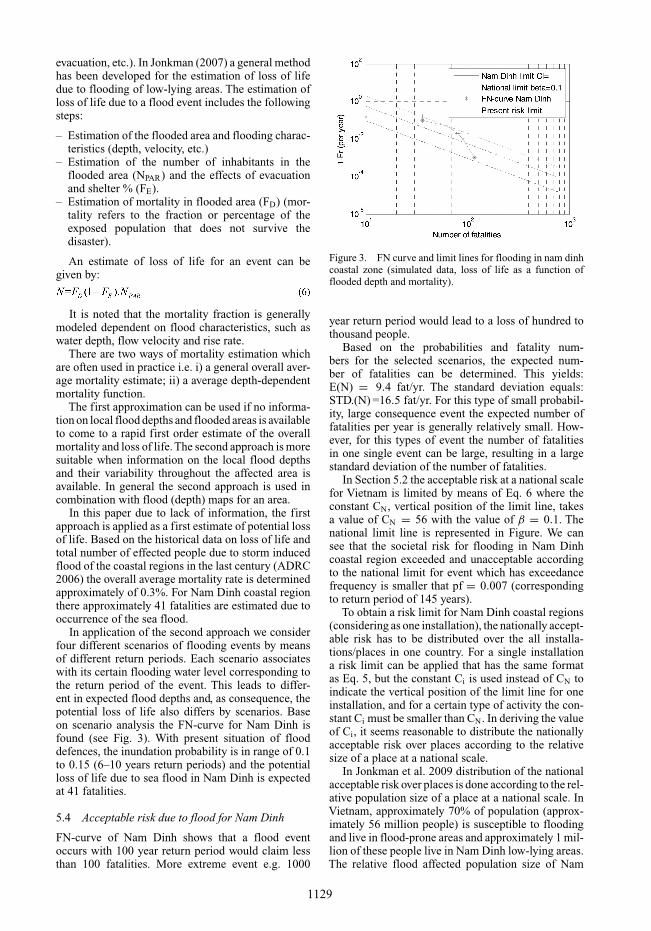
In application of the second approach we considerfour different scenarios of flooding events by meansof different return periods. Each scenario associateswith its certain flooding water level corresponding tothe return period of the event. This leads to differ-ent in expected flood depths and, as consequence, thepotential loss of life also differs by scenarios. Baseon scenario analysis the FN-curve for Nam Dinh isfound (see Fig. 3). With present situation of flooddefences, the inundation probability is in range of 0.1to 0.15 (6–10 years return periods) and the potentialloss of life due to sea flood in Nam Dinh is expectedat 41 fatalities.
5.4 Acceptable risk due to flood for Nam Dinh
FN-curve of Nam Dinh shows that a flood eventoccurs with 100 year return period would claim lessthan 100 fatalities. More extreme event e.g. 1000
Figure 3. FN curve and limit lines for flooding in nam dinhcoastal zone (simulated data, loss of life as a function offlooded depth and mortality).
year return period would lead to a loss of hundred tothousand people.
Based on the probabilities and fatality num-bers for the selected scenarios, the expected num-ber of fatalities can be determined. This yields:E(N) = 9.4 fat/yr. The standard deviation equals:STD.(N) =16.5 fat/yr. For this type of small probabil-ity, large consequence event the expected number offatalities per year is generally relatively small. How-ever, for this types of event the number of fatalitiesin one single event can be large, resulting in a largestandard deviation of the number of fatalities.
In Section 5.2 the acceptable risk at a national scalefor Vietnam is limited by means of Eq. 6 where theconstant CN, vertical position of the limit line, takesa value of CN = 56 with the value of β = 0.1. Thenational limit line is represented in Figure. We cansee that the societal risk for flooding in Nam Dinhcoastal region exceeded and unacceptable accordingto the national limit for event which has exceedancefrequency is smaller that pf = 0.007 (correspondingto return period of 145 years).
To obtain a risk limit for Nam Dinh coastal regions(considering as one installation), the nationally accept-able risk has to be distributed over the all installa-tions/places in one country. For a single installationa risk limit can be applied that has the same formatas Eq. 5, but the constant Ci is used instead of CN toindicate the vertical position of the limit line for oneinstallation, and for a certain type of activity the con-stant Ci must be smaller than CN. In deriving the valueof Ci, it seems reasonable to distribute the nationallyacceptable risk over places according to the relativesize of a place at a national scale.
In Jonkman et al. 2009 distribution of the nationalacceptable risk over places is done according to the rel-ative population size of a place at a national scale. InVietnam, approximately 70% of population (approx-imately 56 million people) is susceptible to floodingand live in flood-prone areas and approximately 1 mil-lion of these people live in Nam Dinh low-lying areas.The relative flood affected population size of Nam
1129

Dinh and wholeVietnam would be approximately 1/56times. This would imply that the value of the constantthat determines the vertical height of the limit line forthe dike ring (Ci) would be 1/56 times of the con-stant that has been derived for the national scale (CN).This leads to Ci = 1 for Nam Dinh. The risk limitline for Nam Dinh by means of Eq. 6 where the con-stant Ci = 1 and the value of β = 0.1 is shown inFig. 5. Results show that the flood risks for Nam Dinhwould be unacceptable for this value of Ci. The actualflood risks would be considered acceptable for a limitline that corresponds to Ci = 198. It is clear that thesocietal risk for flooding in Nam Dinh coastal regionexceeded and unacceptable according to the limit forany event that has exceedance frequency of smallerthan pf = 1.1 × 10⁻³ (corresponding to return periodof 1200 years). This means flood risk is acceptable ifthe low lying coastal region of Nam Dinh is protectedunder a safety standard of less than 1/1100 per year.
6 ECONOMIC RISK BASED DESIGN
Based on design documents and expense reports ofexisting Nam Dinh sea dikes given by DDMFC/MARD2005 and taken into account the actual inflation ratesofVietnam, the costs of dike heightening are estimatedin Mai Van et al. (2008).
Sea water level and required dike heightSea water levels along the Vietnamese coasts are mea-sured at several stations. These water levels comprisealready tidal and storm surge components and all othercauses induced water level rising. Therefore, these areconsidered as the total sea water levels which are usedfor design of sea defences. For sea defences of NamDinh coastal region the water data from station Phu Leis used.
Based on the observed water level data at Phu Lestation, water level along the Nam Dinh Coast is bestfitted modeling by a mixed Gamma and Exponentialdistributions. In the frequency domain of interest forthe design purpose of the sea flood defences (0.1 to10−5) the tail of exceedance frequency curve is bestmodeled by exponential distribution:
Where: h (cm) is the sea water level in cm; Pfr (peryear) is annual exceedance frequency of correspond-ing sea water level h.
The required crest level of the sea dike is generallyfollowed by:
Where: DWL is called design water level, this is theall-cause-induced maximum sea water and dependson the specified design condition with regarding thedesign frequency of design return period. In this
Figure 4. The required dike height in relation to exceedancefrequency of sea water level.
case, DWL can be determined from the water levelexceedance frequency curve Eq. 8.
Rc is the required crest freeboard height, which canbe determined from wave overtopping condition of 10litter/m/s.
The required dike heights are calculated with dif-ferent design conditions which associate with differentdesign frequencies. A linear relation is found betweenthe required dike height and the design frequency inlogarithms scale (Fig. 4).
Economic optimal safety for Nam Dinh sea dikesTwo situations are considered in economic risk analy-sis of Nam Dinh coastal flood defences.
Situation 1: current situation: Considering theactual economic wealth presents in the region and tak-ing into account the actual effective economic growthrate of the region: r′ = r − i = 3.0%.
Situation 2: fast economic growth situation: Con-sidering the actual economic wealth presents in theregion plus the future wealth incensement as the resultof fast development. The effective economic growthrate of the region is assumed at 6.5%.
Economic risk analysis is implemented for thewhole coastal regions of Nam Dinh with these twoabove situations and by considering difference cases.Case 1: Nam Dinh sea defence system as a whole dikering, with total length of the sea defences is 70 km;Case 2: considered coastal region of Nam Dinh con-sists of three independent protected areas which areadministratively divided by three districts and pro-tected by its own independent dike ring with its certainlength: Giao Thuy system, Hai Hau system and NghiaHung system.
Determination of potential economic risk:The expected damages is determined based on aadjusted mean and standard deviation from FD-curve,E(D)= µ + k∗σ, for Nam Dinh. Where the adjustedexpected total economic loss/damage for Nam Dinh is:Daverage = 1108/(4 ÷ 6 storm events per year =184 ÷277 million USD/year.
Based on statistics of economic losses due to seaflood in the last recent years happened at the NamDinh coastal regions, especially the loss due to Damreytyphoon which occurred in 2005, the direct economic
1130

Table 1. Economic loss due to coastal flood in Nam Dinh.
economic loss in million USD LengthDistrict Situation 1 Situation 2 km
Giao Thuy 67.3 107.0 27.0Hai Hau 61.1 97.8 27.0Nghia Hung 42.8 73.4 16.0Nam Dinh (total) 171.2 278.2 70.0
Table 2. Optimal safety for nam dinh coastal regions.
Optimal safetyDike ring Situation 1 Situation 2
Case 2 Giao Thuy district 1/45 1/95Hai Hau district 1/35 1/55Nghia Hung district 1/50 1/90
Case 1 Nam Dinh 1/50 1/100
loss for coastal districts of Nam Dinh is estimated.Considered a fast economic growth situation in thefuture, the potential economic loss for the consideredregions can be determined. Loss estimates for bothsituations are in Table 1 (see also Hillen 2008 and MaiVan et al. 2008).
Summary result: Summary of the analysis resultsare in Table 2 and Figs 5a and b;
Sensitivity analysisThe value of potential loss which has been used inthe above analysis are considered as an average esti-mated mean value of the direct economic loss. Theseoften associate with uncertainty due to uncertain inthe social, economic situations, future development ofthe considered area as well as the uncertainty of thesea boundary condition. If these uncertainties are tak-ing into account somehow, the expected loss would bediffered. It is suggested determining by:
E(D) = µ + k∗σ (10)
Where: µ is the estimated loss from Table 2; σ isstandard deviation, is determined from the FD-curve;and k is a multiple factor.
By different values of k (from 1 to 3) it clearly showsthat the optimal level of safety is in range of 1/95 to1/45 years for situation 1 (see Fig. 5a) and from 1/90to 1/100 for situation 2 (see Fig. 5b).
Sensitivity analysis can also be done for a widerrange of economic risk due to flood. Figure 6 presentscontour lines of the total costs, as sum of investmentcost in the defence system and the economic risk of thesystem, in relation to economic risk and exceedancefrequency of the corresponding flood events. Contourline Zero expresses a set of the optimal solution whilethe total cost of the system is minimum. For NamDinh case the potential economic loss would be inrange of less than 500 million USD, the optimal safety
Figure 5. Optimal safety with k values of 1, 2 and 3.
Figure 6. Contour lines of total costs of the system.
can be chosen from 1/50 to 1/100 as the ln(Pf), in thehorizontal axis, takes value in range of 4.0 to 4.5
7 DISCUSSIONS
Economic risk analysis while considering the NamDinh coastal flood defences as a whole dike ring showsthat the safety standard of 1/50 years or more shouldbe applied for the present economic situation (Situa-tion 1). While taking into account the fast economicgrowth and accumulated wealth in the future the safetystandard of 1/100 or more should be chosen.
Regarding the present situation of Nam Dinhcoastal regions, a supplementary design for a returnperiod 100 years might turn out to be an even bet-ter choice since double safety level is archived withrelatively small increment of investment cost. In addi-tion, this return period is inline well with analysisresult from the fast economic development situation(Situation 2).
When using economic risk based curves in decisionmaking it should be note that the chosen solutionsshould never be on the right side of the interactionpoint between the risk and investment curves. Because,from the economic investment point of view, the solu-tion is not worth as the risk is higher than the cost ofthe system. In this considered example for Nam Dinhcase, selection of the design return periods of less than30 years leads to very high risk and is therefore a badchoice in this situation. Selection from 50 to 100 yearsreturn period is, therefore, recommended for the futureplanning of coastal protection in Nam Dinh. Invest
1131

nothing, dike height remains at 5.5 m with annual fail-ure probability of the Nam Dinh dike system is 0.78,may lead to an economic risk of over $ US million500, which is similar to the total direct loss due to thetyphoon Damrey in 2005.
8 CONCLUSIONS
Societal risk analysis for flooding on a national scalefor Vietnam based on historical flood informationshows that Vietnam should apply a safety standard of1/100÷1/1000 to protect the country from flooding.
Potential loss of life due to flood is preliminaryestimated in this study based on the actual informa-tion. The coastal flood defence in Nam Dinh shouldbe upgraded to ensure that the inundation probabil-ity is less than 1/145 per year, in order to satisfy theindividual and societal acceptable risk.
Economic risk analysis showed that the actual safetystandards in design of coastal flood defences of theVietnamese case study (1/20 years) are not safe enoughin views of the current Vietnamese development. Anoptimal choice of the acceptable risk level was found ata return period of 100 years. This is in good agreementwith the upper bound of the societal acceptable risklevel of Vietnam.
Sensitivity analysis in estimation of expected dam-ages shows that by different k values ranging from 1 to3 it does not give significant influence on the optimalpoint. These risk curves have a converged tendencywhen return period increases.
REFERENCES
ADRC-Asian Disaster Reduction Centre 2006. Top 25thnatural disasters of Vietnam in 20th Century.
CUR/TAW 1990. Probabilistic design of flood defences.Report 141, Gouda, Netherlands.
DDMFC-Department of Dikes Management and Flood Con-trol of Vietnam. 2007. Flood damage reports.
Disaster Management Working Group (DMWG) 2005-JointAssessment of Disaster and needs 2005. Rapid NeedsAssessment of typhoon Damrey.
DWW/RWS, Ministry of transport, public works and watermanagement, Rijkswaterstaat 1996a. Sea dikes northernpart of Viet Nam (Red River Delta). Review report, TheNetherlands, May 1996.
DWW/RWS, Ministry of transport, public works and watermanagement, Rijkswaterstaat 1996b. Flood control inViet Nam, Red River Delta Area, mission report, TheNetherlands, October 1996.
Jonkman, S.N., 2007. Loss of Life estimation in floodrisk assessment: Theory and applications. Phd-thesis,TUDelft, 2007, ISBN: 978-90-9021950-9.
Jonkman, S.N., 2009. Mission report. Technical assistantsfor Vietnam sea dikes research program. TUDelft, March2009.
Mai Van, C., van Gelder, P.H.A.J.M. and Vrijling, J. K.2006. Safety of coastal defences and flood risk analysis.Safety and Reliability for Managing Risk, ISBN 13: 978-0-415-41620-7, Taylor & Francis/Balkema, Leiden, TheNetherlands, Vol. 2, pp: 1355–1366.
Mai Van, C., Van Gelder, P.H.A.J.M. & Vrijling, J.K. 2007.Failure Mechanisms of Sea dikes: inventory and sensi-tivity analysis. In: Proceedings of the Coastal Structures2007- COPRI of ASCE, CORILA Venezia.
Mai Van, C., van Gelder, P.H.A.J.M., Vrijling J.K. & Mai, TC(2008). Risk analysis of coastal flood defences – A Viet-nam case. Proceedings of the 4th international symposiumon flood defence; managing flood risk, reliability &vulnerability (Pp. 93-1-93-8). Toronto: Institute for catas-trophic loss reduction.
TAW-Technical Advisory Committee on Water Defences1985. Some considerations of an acceptable level of riskin the Netherlands.
Van Dantzig, V.D. 1956. Economic decision problems forflood prevention. Econometrica 24.
Van Gelder, P.H.A.J.M. and Ouwerkerk, S.J. 2004. Riskacceptance and perception. In: New model in survivalanalaysis related to AIDS, final report, SANPAD project2004.
Vrijling, J.K., van Hengel, W. and Houben, R. J. 1995.A framework for risk evaluation, Journal of HazardousMaterials. Vol. 43, Issue 3, pp. 245–261.
Vrijling, J.K., van Hengel, W. and Houben, R. J. 1998.Accept-able risk as a basic for design. Journal of ReliabilityEngineering and System Safety, pp. 141–150. Elsevier.
Vrijling,J.K. and Hauer, M. 2000. Probabilistic design andrisk analysis of water defences in relations to Vietnamesecondition. Mission report, Delft University ofTechnology.
1132