Embed Size (px)
Citation preview
CHAPTER 3 RISK ASSESSMENT: WIND/TORNADOES
STATE OF IDAHO HAZARD MITIGATION PLAN 2013 3.13-1
3.13 RISK ASSESSMENT: WIND/TORNADOES DESCRIPTION The term “straight-line winds” is used to distinguish common, non-rotating winds from tornado-related winds. Straight-line winds are responsible for most thunderstorm wind damage, with wind speeds in excess of 100 miles per hour on occasion. A “downburst,” a small area of rapidly descending air beneath a thunderstorm, is a particularly damaging type of straight-line wind. Downbursts can have wind velocities equal to that of a strong tornado and can be extremely dangerous to aviation and cause significant damage to some buildings.
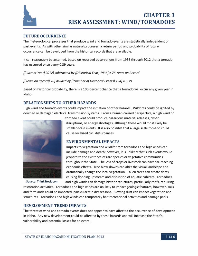
A tornado is a violently rotating column (a vortex) of air that bridges between thunderclouds and the earth. A funnel-shaped cloud, spinning like a top, is commonly generated. Wind speeds within the vortex range from 40 to over 300 miles per hour. The tornado itself can move across the ground at up to 70 miles per hour. Damage is generally confined to a narrow path (approximately one-quarter mile), but the tornado may travel over and devastate a large distance (typically up to 10 miles, but 200-mile tracks have been reported). Multiple tornadoes may occur during a single storm, resulting in highly destructive events.
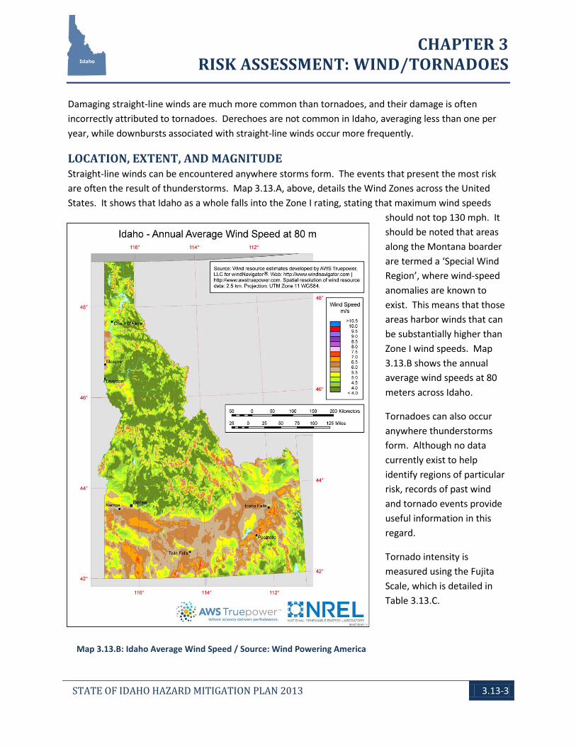
Tornado intensity is measured on the Fujita Scale (see Table 3.13.C below). This table also describes characteristic damages.
Straight-line winds of concern are “high winds,” defined by the NWS as “sustained wind speeds of 40 mph or greater lasting for 1 hour or longer, or winds of 58 mph or greater for any duration.” High wind advisories, watches, and warnings are issued by the NWS according to the following criteria:
High Wind Advisory is issued by the NWS when wind speeds may pose a hazard. The criteria for this advisory vary from State to State. In Idaho, the criterion is the potential for sustained winds at 30-39 mph or gusts of 45-57 mph, covering a significant part of at least one zone, and lasting several hours.
High Wind Watch is issued by the NWS when there is the potential of high wind speeds developing that may pose a hazard or be life threatening. The criteria for this watch vary from State to State. In Idaho,
Tornado in Boise, ID / Source: www.kboi2.com/weather/blog/44562952.html

CHAPTER 3 RISK ASSESSMENT: WIND/TORNADOES
STATE OF IDAHO HAZARD MITIGATION PLAN 2013 3.13-2
the criterion is the potential for sustained winds at 30-39 mph or gusts of 45-57 mph, covering a significant part of at least one zone, and lasting several hours.
High Wind Warning is issued by the NWS when high wind speeds may pose a hazard or be life threatening. The criterion for this warning varies from State to State. In Idaho, the criterion is the potential for sustained winds greater or equal to 35 knots (kts) lasting at least 1 hour, or gusts of 50 kts for any time.
Like tornadoes, strong straight-line winds are generated by thunderstorms and can cause similar damage. Straight-line wind speeds can approach 150 mph, equivalent to those in an F3 tornado. Two categories of straight-line winds are “downbursts” and “derechoes.” A downburst is a small area of rapidly descending rain and rain-cooled air beneath a thunderstorm. The winds produced from a downburst often travel in one direction, and the worst damage is usually on the forward side of the downburst. Derechoes are created by the merging of many thunderstorm cells into a cluster or solid line extending for many miles. The width of such a storm can range from 20 to 65 miles, and the length can reach 100 miles or more. In extreme cases, these storms can create maximum wind gusts of 150 mph and are also capable of producing small tornadoes.
Map 3.13.A: United States Wind Zones / Source: FEMA
CHAPTER 3 RISK ASSESSMENT: WIND/TORNADOES
STATE OF IDAHO HAZARD MITIGATION PLAN 2013 3.13-3
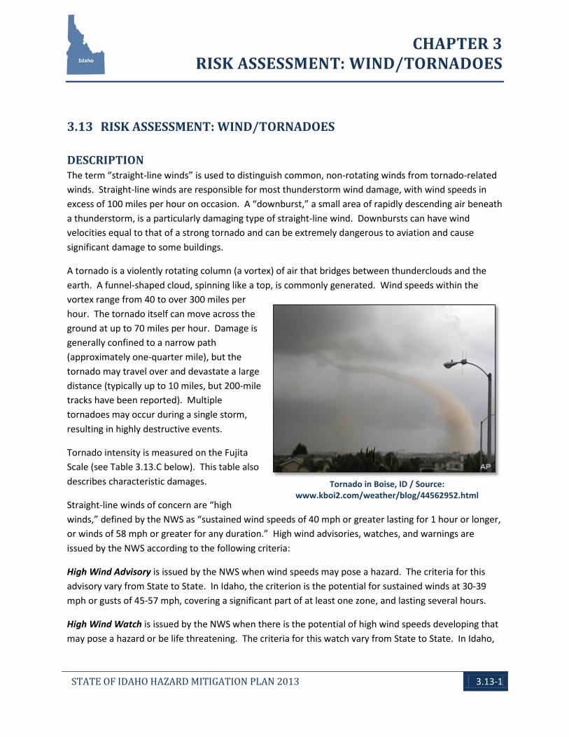
Map 3.13.B: Idaho Average Wind Speed / Source: Wind Powering America
Damaging straight-line winds are much more common than tornadoes, and their damage is often incorrectly attributed to tornadoes. Derechoes are not common in Idaho, averaging less than one per year, while downbursts associated with straight-line winds occur more frequently.
LOCATION, EXTENT, AND MAGNITUDE Straight-line winds can be encountered anywhere storms form. The events that present the most risk are often the result of thunderstorms. Map 3.13.A, above, details the Wind Zones across the United States. It shows that Idaho as a whole falls into the Zone I rating, stating that maximum wind speeds
should not top 130 mph. It should be noted that areas along the Montana boarder are termed a ‘Special Wind Region’, where wind-speed anomalies are known to exist. This means that those areas harbor winds that can be substantially higher than Zone I wind speeds. Map 3.13.B shows the annual average wind speeds at 80 meters across Idaho.
Tornadoes can also occur anywhere thunderstorms form. Although no data currently exist to help identify regions of particular risk, records of past wind and tornado events provide useful information in this regard.
Tornado intensity is measured using the Fujita Scale, which is detailed in Table 3.13.C.
CHAPTER 3 RISK ASSESSMENT: WIND/TORNADOES
STATE OF IDAHO HAZARD MITIGATION PLAN 2013 3.13-4
TABLE 3.13.C: TORNADO INTENSITY (FUJITA SCALE)
Level Wind Speed Description
F0 40-72 mph Damage to chimneys, branches broken off
F1 73-112 mph Surface peeled off roof, mobile homes pushed off foundations or overturned
F2 113-157 mph Roofs torn off frame houses, mobile homes demolished, trees snapped or uprooted
F3 158-206 mph Roof and some walls torn off, most trees uprooted, heavy cars lifted off ground
F4 207-260 mph Well-constructed houses leveled, cars thrown and large missiles generated
F5 261-318 mph Strong frame houses carried considerable distance, steel reinforced structures badly damaged
Source:www.tornadoproject.com
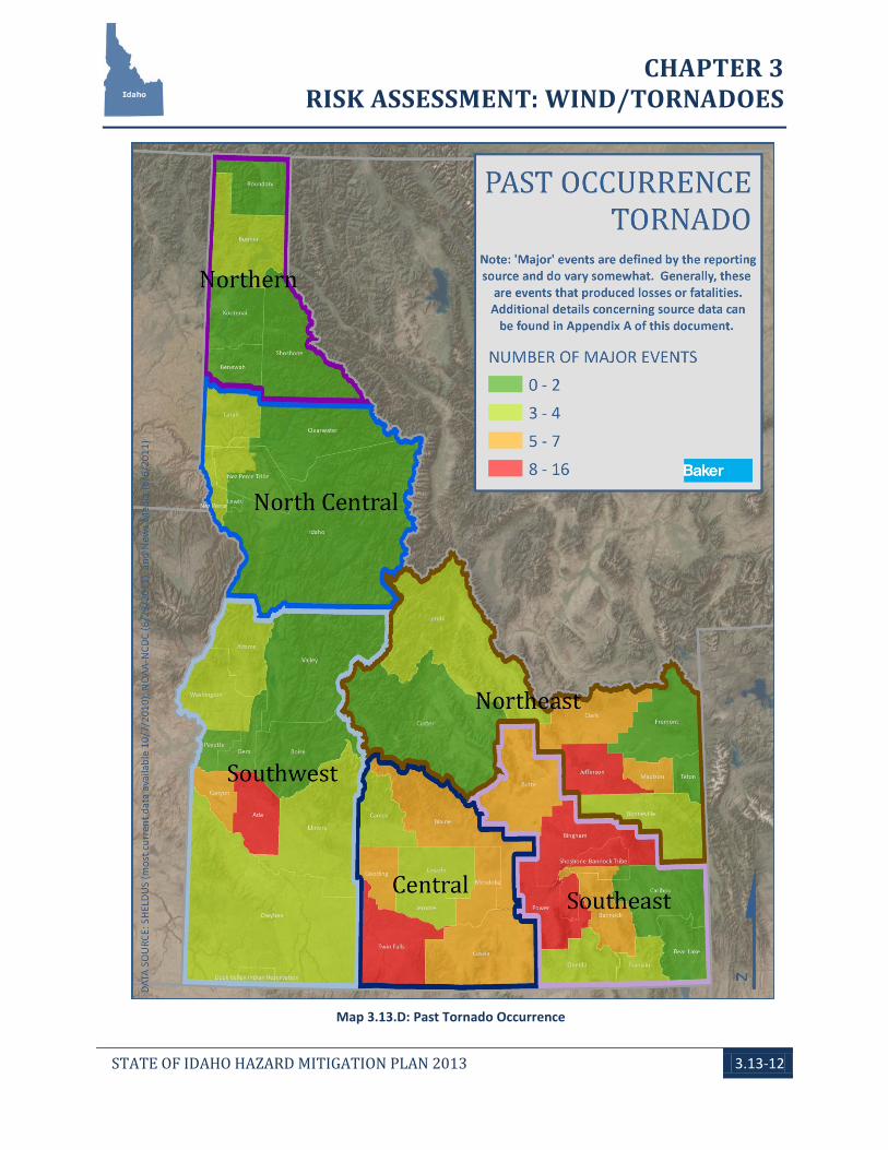
PAST OCCURRENCE On average, there are about two tornadoes per year in the State of Idaho. Past events compiled from multiple sources document a recorded 194 tornadoes between 1936 and 2012; all were F2 or less, and only a single reported death (from the earliest recorded event in 1936). Map 3.13.D, at the end of this section, shows the breakdown by county for past major tornado events.
The following tornado events resulted in either death or injury:
June 7, 1936, 12:30 p.m., two dead A tornado hit north of Reubens in Nez Perce County. A house and a barn were nearly leveled.
April 26, 1940, 4:00 p.m., two 2 injured The widely visible funnel hit five farms west of Gooding. Three homes were destroyed.
April 7, 1978, 2:20 p.m., one injured Hit the edge of Idaho Falls in Bonneville County. Nine homes and 23 businesses had roof damage.
August 19, 1978, 1:50 p.m., one injured A poorly formed tornado did minor damage in Sandpoint, Bonner County; a woman was struck by a tree.
June 5, 1987, 11:30 a.m., three injured A funnel cloud briefly touched down at a street fair in Pinehurst, Shoshone County.
CHAPTER 3 RISK ASSESSMENT: WIND/TORNADOES
STATE OF IDAHO HAZARD MITIGATION PLAN 2013 3.13-5
Source: ThinkStock.com
Source: ThinkStock.com
April 9, 1991, 7:15 p.m. A tornado touched down at Priest River, Bonner County. There were no injuries reported.
June 11, 1993, 3:40 p.m., two injured A tornado traveled 10 miles south to southeast of Pocatello, ending in the Town of Inkom. The tornado uprooted several trees, knocked down a grain elevator, overturned a truck, and knocked down several outbuildings. This event resulted in a State Disaster declaration for Bannock County.
May 29, 1994 4:25 p.m. Tornado recorded near Priest Lake, Bonner County with no injuries. April 25, 1995, 11:38 a.m., one injured A series of tornadoes touched down in central Bingham County, causing damage to mobile homes, highway signs, and recreational equipment.
July 10, 1998, 4:00 p.m., one injured A manufactured home was flipped over by an F0 tornado at Oreana in Owyhee County.
February 14, 2000, 3:47 p.m., one injured June 25, 2004, 6:12 p.m. Priest Lake, Bonner County experienced a tornado with no injuries. June 4, 2006, one injured
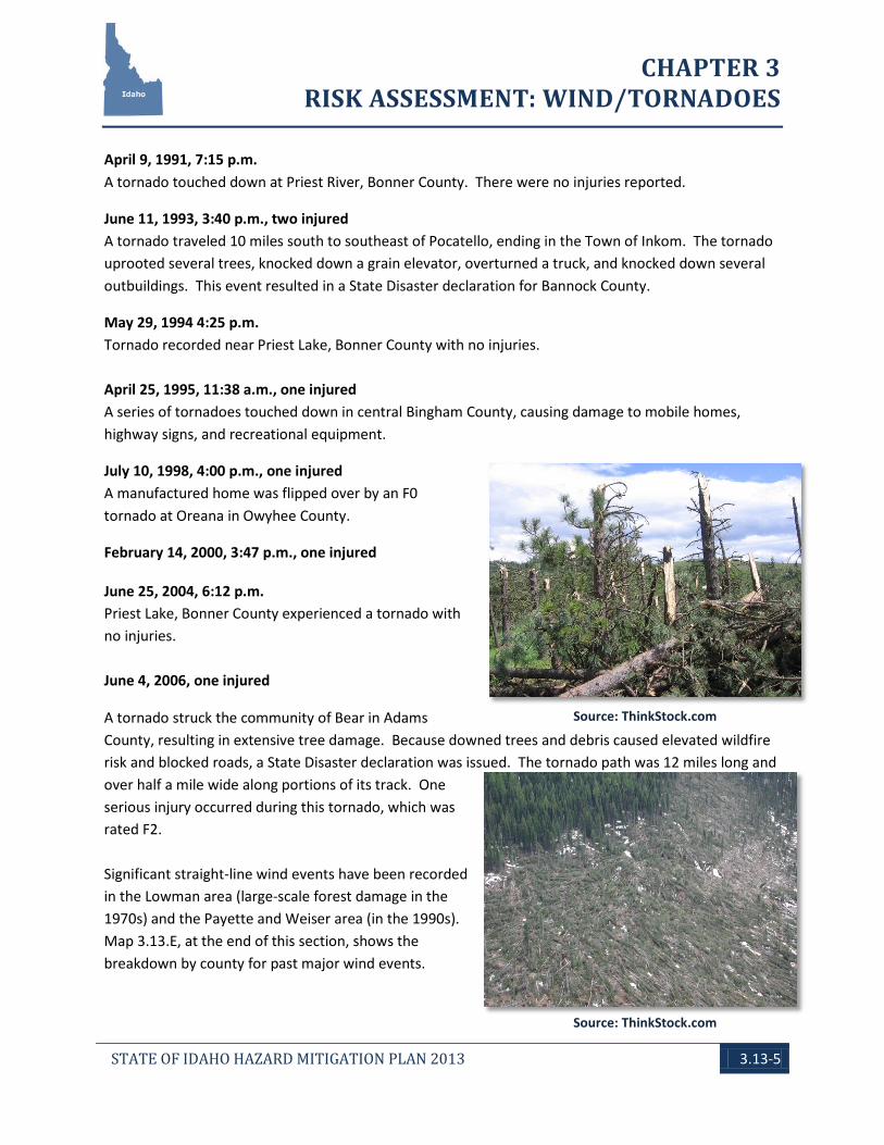
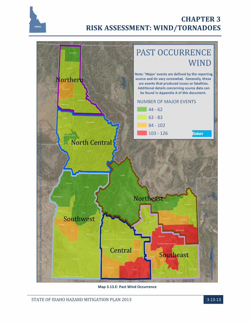
A tornado struck the community of Bear in Adams County, resulting in extensive tree damage. Because downed trees and debris caused elevated wildfire risk and blocked roads, a State Disaster declaration was issued. The tornado path was 12 miles long and over half a mile wide along portions of its track. One serious injury occurred during this tornado, which was rated F2. Significant straight-line wind events have been recorded in the Lowman area (large-scale forest damage in the 1970s) and the Payette and Weiser area (in the 1990s). Map 3.13.E, at the end of this section, shows the breakdown by county for past major wind events.
CHAPTER 3 RISK ASSESSMENT: WIND/TORNADOES
STATE OF IDAHO HAZARD MITIGATION PLAN 2013 3.13-6
Source: ThinkStock.com
FUTURE OCCURRENCE The meteorological processes that produce wind and tornado events are statistically independent of past events. As with other similar natural processes, a return period and probability of future occurrence can be developed from the historical records that are available.
It can reasonably be assumed, based on recorded observations from 1936 through 2012 that a tornado has occurred once every 0.39 years.
[(Current Year) 2012] subtracted by [(Historical Year) 1936] = 76 Years on Record
[(Years on Record) 76] divided by [(Number of Historical Events) 194] = 0.39
Based on historical probability, there is a 100-percent chance that a tornado will occur any given year in Idaho.
RELATIONSHIPS TO OTHER HAZARDS High wind and tornado events could impact the initiation of other hazards. Wildfires could be ignited by downed or damaged electrical transmission systems. From a human-caused perspective, a high wind or
tornado event could produce hazardous material releases, cyber disruptions, or energy shortages, although these would most likely be smaller-scale events. It is also possible that a large scale tornado could cause localized civil disturbances.
ENVIRONMENTAL IMPACTS Impacts to vegetation and wildlife from tornadoes and high winds can include damage and death; however, it is unlikely that such events would jeopardize the existence of rare species or vegetative communities throughout the State. The loss of crops or livestock can have far-reaching economic effects. Tree blow-downs can alter the visual landscape and dramatically change the local vegetation. Fallen trees can create dams, causing flooding upstream and disruption of aquatic habitats. Tornadoes
and high winds can damage historic structures, particularly roofs, requiring restoration activities. Tornadoes and high winds are unlikely to impact geologic features; however, soils and farmlands could be impacted, particularly in dry seasons. Blowing dust can impact vegetation and structures. Tornadoes and high winds can temporarily halt recreational activities and damage parks.
DEVELOPMENT TREND IMPACTS The threat of wind and tornado events does not appear to have affected the occurrence of development in Idaho. Any new development could be affected by these hazards and will increase the State's vulnerability and potential losses for an event.
CHAPTER 3 RISK ASSESSMENT: WIND/TORNADOES
STATE OF IDAHO HAZARD MITIGATION PLAN 2013 3.13-7
Source: ThinkStock.com
CRITICAL INFRASTRUCTURE AND STATE FACILITY IMPACTS No critical or State facilities in Idaho are completely free of the threat of wind or tornados. Threats include loss of power and productivity from damages to utilities and the means of transportation to these places of work. Wind and tornado events can directly affect these facilities through damage to roofs/structures or falling trees and limbs.
As part of the 2010 Plan update, one action that the State identified was the need to collect improved and up-to-date State-owned facility and infrastructure data in a geospatial format. As of the writing of the 2013 Plan update, this action is still considered in progress, although great strides have been made. The State Chief Information Officer (CIO) is currently working towards the realization of a State-owned facilities and infrastructure geodatabase. This on-going process has been slowed by recent budget shortfalls in addition to inconsistent data holdings across many of the State’s Agencies. Once available, this database will enable for a more in-depth review of State-owned facilities and infrastructure, as it relates to both vulnerabilities to hazards and the associated loss estimations.
VULNERABILITY ASSESSMENT Based on past events, tornadoes can be expected to occur infrequently, averaging two to three events per year. Most Idaho tornadoes are considered “moderate,” with winds less than 113 miles an hour. A few have had winds up to 130 miles an hour, which are considered “significant.”
Tornadoes in Idaho have usually occurred from March to October, with the majority occurring in June. The majority also occur during the afternoon; between 12:00 and 6:00 p.m. Tornadoes are most often reported in the Magic and Upper Snake River valleys.
The Disaster Center (www.disastercenter.com) performed a nation-wide risk assessment for tornadoes. The
assessment was performed “by dividing the square mileage of each state against the frequency of death, injury, number of tornadoes, and cost of damages for each state. We then rank each State by these individual categories. We then add the total of each State's individual rankings and divided by the number of factors (four). The data used covers the period of 1950 -1995.” The results of this assessment have Idaho ranked as the 46th lowest state at risk to tornado.
Windstorms often occur in eastern Idaho with power outages as a cascading effect. Economic loss may occur as business are without power, phones service, and communications are down and not restored
CHAPTER 3 RISK ASSESSMENT: WIND/TORNADOES
STATE OF IDAHO HAZARD MITIGATION PLAN 2013 3.13-8
ranging from hours to days. Medical services including hospitals are also impacted as backup generators and fuel are used. Counties should plan for these contingencies especially for windstorms during the winter season.
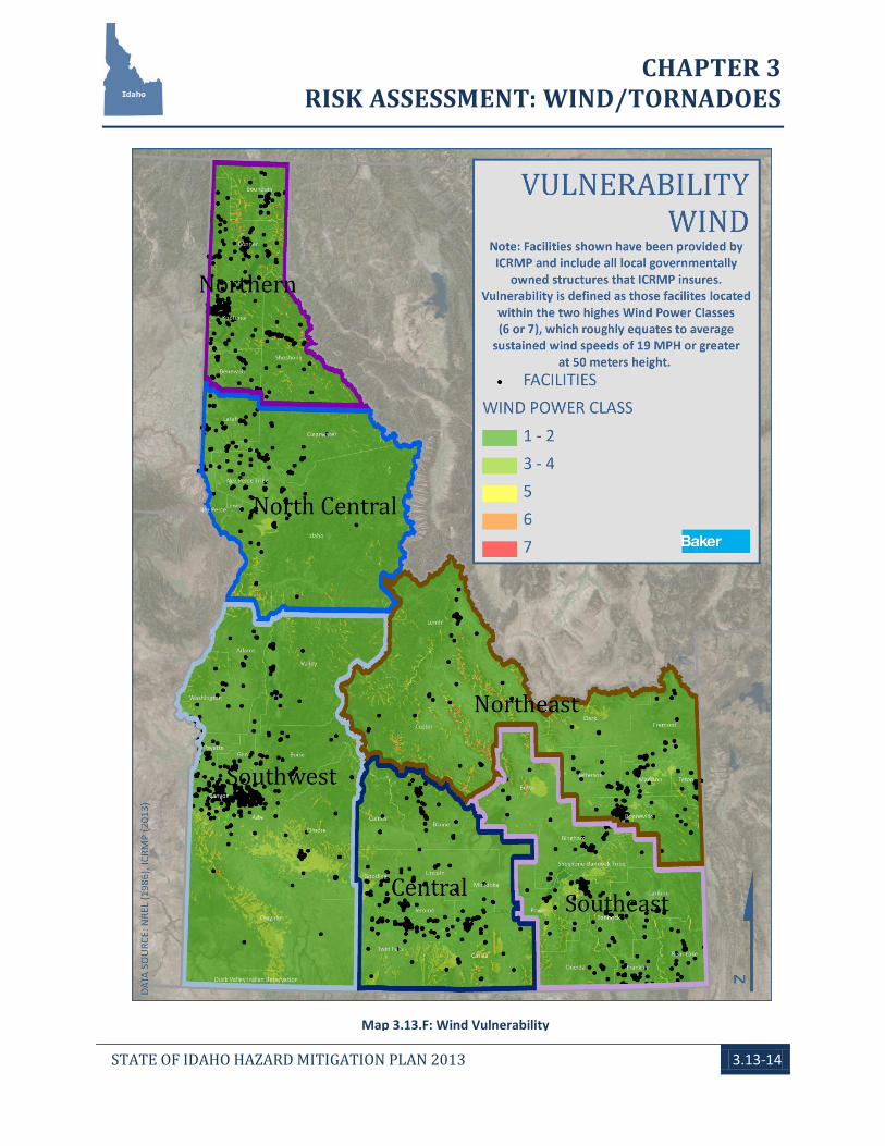
The National Renewable Energy Laboratory (NREL) has produced a GIS dataset that defines the average annual sustained wind speeds across the State. This data was produced as part of a Wind Power Classification study and the wind speeds are measured at a height of 50 meters. Although a majority of the state facilities in Idaho do not reach this height, it was assumed for the sake of analysis that a higher sustained wind speed at 50 meters would equate to a higher wind speed at the structure level.
Using the NREL data layer, vulnerability analysis was performed on the ICRMP locally-owned facilities data. Vulnerability was defined as those regions that were classified as being in the two highest Wind Power Classes (6 or 7), which roughly equates to average sustained wind speeds of 19 MPH or greater (at 50 meters height). The results of this analysis show that none of these facilities fall within those highest wind risk areas. Map 3.13.F at the end of this chapter presents this information, although it is difficult to visually present structure-related information on a State-wide map. Additional details regarding the ICRMP data can be found in the introductory section of this chapter, Section 3.0.
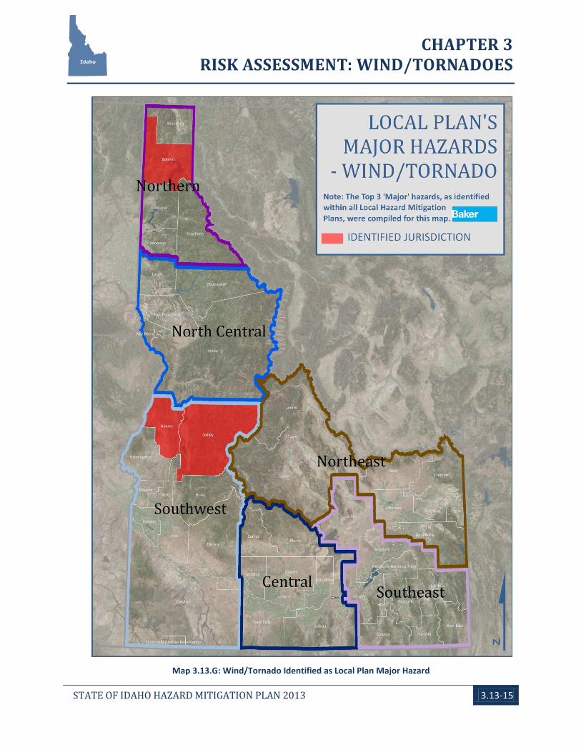
Local Hazard Mitigation Plan Vulnerability Assessments Forty-seven local mitigation plans were analyzed to determine the major hazards in each jurisdiction. Of those, three localities ranked wind and tornadoes as major hazards (see Map 3.13.G, at the end of this section). It is generally noted that while several of the local plans indicated that high wind events occur regularly, they are not considered to be significant. BHS recognizes that these events occur with strong regularity and that almost all damage occurs on private property and does not directly affect county operations or State-level emergency management.
In 2010, the data presented a different story, as eight jurisdictions had wind and tornadoes documented as one of their three primary hazards. Further review of the five localities whose priorities changed seems to reveal that improved risk assessments may be the driving force. It also appears that these improved assessments may be helping to better align these jurisdiction’s primary hazards to their Regional counterparts.
LOSS ESTIMATION No specific, statewide loss estimation exists for the tornado hazard. Historical losses tend to be related to property damage and loss of life and injury. From a general perspective, tornadoes damage and destroy public, commercial, and private property. The resulting costs are for debris removal, maintenance, repair, and response. The economic costs of these disruptions can be significant, especially in areas with limited access options.
Direct costs can be defined as the cost of debris removal, property damage, and response for a specific tornado event. All other costs are indirect and include loss of industrial and commercial productivity as
CHAPTER 3 RISK ASSESSMENT: WIND/TORNADOES
STATE OF IDAHO HAZARD MITIGATION PLAN 2013 3.13-9
a result of damage to infrastructure, facilities, or interruption of services. As a result, most estimates of loss are far too conservative.
The vulnerability assessment documented above was unable to also provide any loss estimates as they relate to possible State losses for the hazard of wind. None of the ICRMP facilities were located in the wind zones termed of highest risk.
Local Hazard Mitigation Plan Loss Estimations Bonner County was the only local plan that provided loss estimation data. The county estimated that $4,585,672,000 in damage could be caused by a tornado event.
MITIGATION RATIONALE Two types of significant wind hazards are possible in Idaho, straight-line winds and tornadoes. Both are generally associated with severe thunderstorms.
Lesser, similar wind events (such as “dust devils”) may occur during small storms and even during clear weather, but they generally do no damage. Strong winds are also often associated with dramatic atmospheric pressure differentials across weather fronts. These winds may be accelerated by terrain features such as canyons and mountain passes, where they can reach high speeds. Although they may contribute to the overall impact of a storm, they are rarely damaging by themselves.
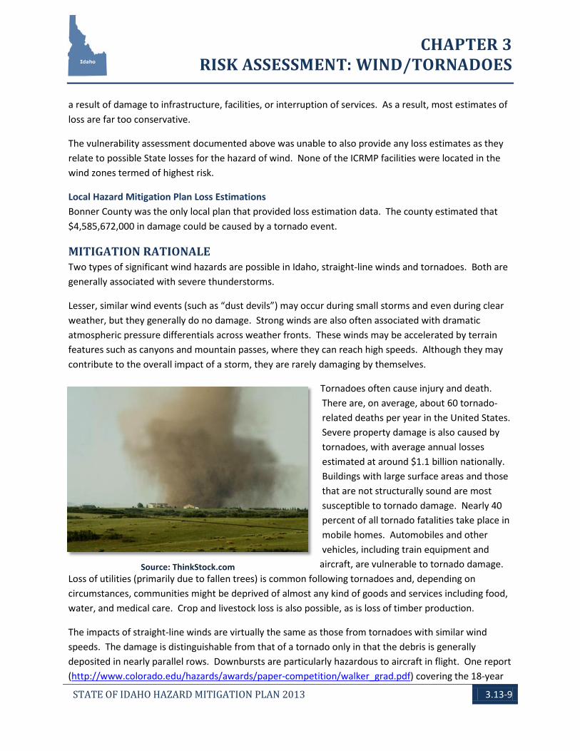
Tornadoes often cause injury and death. There are, on average, about 60 tornado-related deaths per year in the United States. Severe property damage is also caused by tornadoes, with average annual losses estimated at around $1.1 billion nationally. Buildings with large surface areas and those that are not structurally sound are most susceptible to tornado damage. Nearly 40 percent of all tornado fatalities take place in mobile homes. Automobiles and other vehicles, including train equipment and
aircraft, are vulnerable to tornado damage. Loss of utilities (primarily due to fallen trees) is common following tornadoes and, depending on circumstances, communities might be deprived of almost any kind of goods and services including food, water, and medical care. Crop and livestock loss is also possible, as is loss of timber production.
The impacts of straight-line winds are virtually the same as those from tornadoes with similar wind speeds. The damage is distinguishable from that of a tornado only in that the debris is generally deposited in nearly parallel rows. Downbursts are particularly hazardous to aircraft in flight. One report (http://www.colorado.edu/hazards/awards/paper-competition/walker_grad.pdf) covering the 18-year
Source: ThinkStock.com
CHAPTER 3 RISK ASSESSMENT: WIND/TORNADOES
STATE OF IDAHO HAZARD MITIGATION PLAN 2013 3.13-10
period from 1986 through 2003 attributed 153 deaths and 2,605 injuries to derechoes (a type of straight-line wind) nationally. This report also estimated the economic loss from a single derechoes event on May 31, 1998, which struck the States of Michigan, Minnesota, and Wisconsin at nearly $0.5 billion. In the areas around Twin Falls County (U.S. Highway 93) and Cassia County (U.S. I-84), anecdotal information indicates that there have been fatalities along both of these corridors attributable to straight-line winds.
GENERAL MITIGATION APPROACHES
Hazard Management Structures in wind-hazard areas should be designed and built to withstand the projected wind speeds. Wind-resistant construction techniques include proper anchoring of walls to foundations, use of hurricane straps and clips to hold the roof of a structure to its walls, and lateral roof and wall bracing. Manufactured and mobile homes, in particular, need anchoring. Structural retrofitting of existing structures can reduce damages; particular concern should be given to the roof, windows, doors, and anchoring to the ground or foundation. In areas of very high hazard, hardened “safe roofs” can be constructed for shelter during events.
Nonstructural retrofitting can also be effective at reducing damages (and will mitigate seismic hazards). Examples of nonstructural retrofitting include anchoring loose objects (potential missiles) and water heaters, removing trees from the immediate vicinity of the house, securely anchoring outbuildings and other outdoor objects, and installing plastic film on windows and doors to minimize the impact of shattering glass. Other nonstructural methods might include both natural vegetation and engineered windbreaks, which would serve in all seasons (i.e., snow fences).
Information/Outreach and Public Education In areas that have not seen recent wind events, the hazard may be seriously undervalued. Many residents and property owners may be unaware that their lives and properties are in high-risk areas. Residents and property owners should be informed of known wind hazards and educated in mitigation techniques. Manufactured and mobile homes is high-risk areas should be specifically targeted by education efforts.
Infrastructure Wind-susceptible critical facilities should not be placed in high-risk areas.
Regulatory Adoption and enforcement of wind-resistant building codes and construction standards can significantly reduce damages caused by high winds. Manufactured and mobile homes should be restricted, or sufficient anchoring should be required, in very high-risk areas.

CHAPTER 3 RISK ASSESSMENT: WIND/TORNADOES
STATE OF IDAHO HAZARD MITIGATION PLAN 2013 3.13-11
Mapping / Analysis / Planning An accurate understanding of a hazard is the first step towards successful mitigation. To fully understand a hazard and the risk that it poses, the ability to accurately assess vulnerability is vital. After vulnerability is determined, it is then possible to assess potential losses if a state inventory of facilities and infrastructure is available.
At the time of the 2013 Plan update, major advances in the availability of various data inputs allowed for an improved vulnerability and loss assessment to be performed. Continued refinement of both vulnerability and inventory data will enable for continued refinements in the risk assessment process.
CHAPTER 3 RISK ASSESSMENT: WIND/TORNADOES
STATE OF IDAHO HAZARD MITIGATION PLAN 2013 3.13-12
Map 3.13.D: Past Tornado Occurrence
CHAPTER 3 RISK ASSESSMENT: WIND/TORNADOES
STATE OF IDAHO HAZARD MITIGATION PLAN 2013 3.13-13
Map 3.13.E: Past Wind Occurrence
CHAPTER 3 RISK ASSESSMENT: WIND/TORNADOES
STATE OF IDAHO HAZARD MITIGATION PLAN 2013 3.13-14
Map 3.13.F: Wind Vulnerability
CHAPTER 3 RISK ASSESSMENT: WIND/TORNADOES
STATE OF IDAHO HAZARD MITIGATION PLAN 2013 3.13-15
Map 3.13.G: Wind/Tornado Identified as Local Plan Major Hazard
CHAPTER 3 RISK ASSESSMENT: WIND/TORNADOES
STATE OF IDAHO HAZARD MITIGATION PLAN 2013 3.13-16
THIS PAGE INTENTIONALLY
LEFT BLANK