Embed Size (px)
Citation preview

Preliminary Investigation Caltrans Division of Research, Innovation and System Information
Right of Way Information Management Systems
Requested by
Jean-Marie Hunter, Division of Right of Way and Land Surveys
August 15, 2016 The Caltrans Division of Research, Innovation and System Information (DRISI) receives and evaluates numerous research problem statements for funding every year. DRISI conducts Preliminary Investigations on these problem statements to better scope and prioritize the proposed research in light of existing credible work on the topics nationally and internationally. Online and print sources for Preliminary Investigations include the National Cooperative Highway Research Program (NCHRP) and other Transportation Research Board (TRB) programs, the American Association of State Highway and Transportation Officials (AASHTO), the research and practices of other transportation agencies, and related academic and industry research. The views and conclusions in cited works, while generally peer reviewed or published by authoritative sources, may not be accepted without qualification by all experts in the field. The contents of this document reflect the views of the authors, who are responsible for the facts and accuracy of the data presented herein. The contents do not necessarily reflect the official views or policies of the California Department of Transportation, the State of California, or the Federal Highway Administration. This document does not constitute a standard, specification, or regulation. No part of this publication should be construed as an endorsement for a commercial product, manufacturer, contractor, or consultant. Any trade names or photos of commercial products appearing in this publication are for clarity only.
Table of Contents
Executive Summary ................................................................................................................. 2 Background ............................................................................................................................ 2 Summary of Findings .............................................................................................................. 2 Gaps in Findings ..................................................................................................................... 5 Next Steps .............................................................................................................................. 5
Detailed Findings ..................................................................................................................... 6 Survey of Practice ................................................................................................................... 6 Follow-Up Contacts for System Details ..................................................................................10
Appendix A: Survey Results .................................................................................................19

Produced by CTC & Associates LLC 2
Executive Summary
Background Caltrans’ Division of Right of Way and Land Surveys is responsible for real property acquisition, management and oversight of California’s highway projects. The multiple database tools Caltrans uses to manage its right of way (ROW) project and parcel data are outdated and do not interface with each other. Caltrans would like to replace these tools with a more inclusive tool that will improve efficiency and contribute to timely project delivery. To inform an investigation of alternatives to replace its current multiple-tool system, the Caltrans Right of Way Program Steering Committee is interested in learning about the electronic systems used by other state departments of transportation (DOTs) to manage ROW data. Of particular interest is a commercially available tool that integrates with other Caltrans systems and databases and requires little or no customization. To assist with this information-gathering effort, CTC & Associates conducted a survey of state DOTs to gather information about the type of system used to manage ROW data, basic system functionality and future plans for system use. Initial survey findings are supplemented by follow-up inquiries made to selected survey respondents to gather additional details about each system.
Summary of Findings CTC conducted a brief survey to gather preliminary information from transportation agencies expected to have experience with electronic ROW information management systems. Of the 13 transportation agencies responding to the survey, 11 indicated experience with an electronic ROW information management system. Seven of these agencies use custom-designed systems; the remaining agencies use stock or customized commercial off-the-shelf (COTS) products. System functionality (assessed in terms of the business processes and functions supported) ranged from comprehensive coverage to quite limited support of only high-level ROW-related functions or processes. Two agencies are moving to new systems: Ohio DOT is replacing its legacy system with a COTS product, and South Carolina DOT uses a temporary system while preparing an RFP to purchase a new one. Caltrans selected six of the survey respondents to participate in a follow-up effort that gathered additional details about the agencies’ ROW information management systems: California High-Speed Rail Authority (HSRA) and DOTs in Missouri, Ohio, Oregon, Vermont and Wisconsin. The table below identifies the products used by these six agencies; details about the ROW information management systems follow the table.
Respondents’ ROW Information Management Systems
Agency/State Vendor Product/Web Site
California HSRA
QuickBase Inc.
(formerly a division of Intuit)
QuickBase
http://quickbase.intuit.com/

Produced by CTC & Associates LLC 3
Respondents’ ROW Information Management Systems
Agency/State Vendor Product/Web Site
Missouri Custom legacy system
Realty Asset Inventory
Right of Way Parcel Acquisition
Spatial Editor
Ohio geoAMPS dotAMPS*
http://www.geoamps.com/products/dotamps
Oregon Flairsoft Flairdocs
http://flairdocs.com/
Vermont Applied Geographics Inc.
Esri
AppGeo
http://www.appgeo.com
Esri
http://www.esri.com/
Wisconsin BEM Systems Inc. PAECETrak
http://bemsys.com/paecetrak/
* Ohio DOT is preparing to replace its current legacy system with dotAMPS.
System Description All but one of the respondents uses a COTS product. Of these, California HSRA’s QuickBase system provides only the platform; modules must be created and modified by the agency. Platforms for other systems are either Oracle (Missouri and Wisconsin) or Microsoft SQL server (Ohio, Oregon and Vermont). The time required to implement respondent systems varied widely, from six months for California HSRA’s build-out of base modules to the multiple-year implementation in Vermont. Costs also ranged widely, from a low of $200,000 to $300,000 reported by California HSRA to a high of $1.215 million to implement Vermont’s system. Missouri and Ohio DOTs reported a $1 million price tag for implementation, with Wisconsin DOT’s implementation cost coming in slightly lower, at $850,000. Annual ongoing costs tend to be much lower, ranging from $8,000 in Missouri and $65,000 and $75,000 in Wisconsin and Oregon, respectively, up to $200,000 for California HSRA. Unlike other respondents, California HSRA’s $200,000 annual costs are similar to its implementation cost. This is likely due to the agency’s responsibility for build-out of new modules and modification of existing ones.
System Improvements All respondents reported positive experiences with vendors when adding to or modifying their systems, and all respondents have some type of system modification in process or planned. Some of these enhancements will be completed by in-house staff, others with vendor assistance.

Produced by CTC & Associates LLC 4
Two agencies manage system enhancements in-house. California HSRA is working on a forms generator module and implementing true integration with the agency’s GIS mapping system. Missouri DOT is rewriting the agency’s two nonmapping ROW applications to switch platforms, a change intended to improve the user experience and capitalize on Missouri DOT staff experience. Oregon DOT relies on its vendor, Flairsoft, to make system improvements, with each change requiring an amendment to the vendor contract. In Vermont, the current vendor-based software is being transitioned to an Esri platform to allow the agency to more cost-effectively manage the system in-house.
System Integration The initial survey asked respondents about four types of internal computer systems or databases that could potentially integrate with their ROW systems: GIS and financial, project and document management systems. Follow-up inquiries gathered information about the type of software used for each of these systems, and where each system and the data associated with it are stored. Only three systems—Missouri’s legacy system, Oregon’s Flairdocs and Wisconsin’s PAECETrak—permit integration with all four types of internal systems.
System Features All six systems provide workflow components, but not all agencies use them. While Ohio DOT’s dotAMPS system will offer workflow components, the agency does not plan to use them, preferring to allow the agency’s project managers to have flexibility in managing projects. Oregon DOT takes the opposite approach, making active use of Flairdocs’ workflow components to “ensure quality and consistency throughout the state.” The availability of a mobile application is limited to Ohio DOT’s dotAMPS, which provides most functions of the system; mobile apps are in development for the ROW systems used in Oregon (Flairdocs) and Vermont (AppGeo/Esri). Respondents offered no consensus when asked about their systems’ most important feature, citing adaptability and flexibility (California HSRA), ability to generate forms and mobile functionality (Ohio) and a simple interface that is easy to use (Vermont).
Managing the System All respondent systems track a wide range of data elements, and respondents offered no consensus when asked about the type of data most important to track. Most, if not all, of the data populating five of the six systems is manually entered by staff or consultants. In Vermont, a conversion process to automatically update system data is in development. Reporting tools can be housed within the ROW system or employed as a separate system. Internal tools include PAECETrak’s full-featured reporting module and Flairdocs’ Izenda, a proprietary reporting tool. When opting not to use internal reporting tools, or when they are not available, agencies use Microsoft SQL Server Reporting Services, Cognos and SAP Crystal Reports. Vermont uses a data extraction tool to select and extract desired data as a downloadable zip file; a reporting tool is in development.

Produced by CTC & Associates LLC 5
Gaps in Findings The survey and follow-up contacts gathered information from a relatively small group of respondents. Other commercial or custom-designed products might meet Caltrans’ needs. The scope of this Preliminary Investigation limited the depth of the inquiries made to survey respondents. Further investigation could uncover additional details about respondents’ systems.
Next Steps Moving forward, Caltrans could consider:
• Identifying the processes most critical to the Caltrans ROW workflow and matching them with the system features and functionality described in this Preliminary Investigation.
• Contacting Ohio and South Carolina DOTs, agencies just beginning to implement a system or solicit proposals for a new one, to learn more about the solicitation, review and implementation processes.
• Contacting one or more of the agencies with systems highlighted in this Preliminary Investigation to learn more about these systems and how they might apply to the Caltrans environment.
• Requesting product demonstrations from the vendors offering the products of greatest interest to Caltrans.

Produced by CTC & Associates LLC 6
Detailed Findings
Survey of Practice
Survey Approach Members of the AASHTO Subcommittee on Right of Way, Utilities and Outdoor Advertising Control and a contact at California HSRA received an online survey that included these questions:
1. Does your agency use an electronic information management system to track ROW project and parcel data?
2. Please indicate the type of ROW information management system you’re using: • Customized software developed specifically for your agency. • Single commercial off-the-shelf (COTS) product. • Single COTS product customized for agency use. • Multiple products (COTS and/or custom-designed systems). • Other (please specify).
3. If you use a commercial product(s), please provide the product name(s) and vendor(s). 4. Which systems used by your agency does your ROW information management system
integrate with? Select all that apply. • Geographic information system (GIS). • Financial management system or database. • Project management system or database. • Document management system. • Other systems (please describe).
5. What business processes/functions are supported by your ROW information management system (even if you’re not currently using them)? Select all that apply.
• Acquisition/condemnation. • Airspace leases. • Appraisals. • Capital and support costs. • Clearance and demolition. • Estimating. • Excess lands. • GIS. • Local assistance projects. • Mitigation.
• Project certification. • Project coordination. • Property management. • Railroad payments. • Real estate leases. • Relocation assistance. • Report generation (custom). • Report generation (standard). • ROW engineering. • Utility relocation.
6. Please use this space to provide any comments or additional information about your answers above.

Produced by CTC & Associates LLC 7
Note: Seven states—Idaho, Kentucky, Maryland, Minnesota, South Dakota, Tennessee and West Virginia—were excluded from the survey distribution list. Information about these states’ systems is available in the July 2015 Federal Highway Administration publication Implementation of Electronic Right-of-Way Management Systems Versus Paper Systems, available at http://www.fhwa.dot.gov/real_estate/publications/e-row_management/fhwahep16001.pdf.
Summary of Survey Results Respondents from 13 transportation agencies and California HSRA responded to the survey. Of these, 11 agencies reported experience with an electronic ROW information management system:
• Alabama.
• Alaska.
• California HSRA.
• Missouri.
• Ohio.
• Oregon.
• Pennsylvania.
• South Carolina.
• Utah.
• Vermont.
• Wisconsin.
See Appendix A of this Preliminary Investigation for the full text of survey responses. The following summarizes results from the survey in four topic areas:
• System type.
• System integration.
• Supported business processes/functions.
• Future system plans.
System Type The survey asked respondents to identify their ROW system using one of four types. The table below summarizes survey responses.
ROW Information Management Systems Used by Respondents
System Type Product/Vendor Agency/State Customized software developed specifically for the agency
N/A Alabama, Alaska, Missouri, Ohio*, South Carolina, Utah
Multiple products (COTS and/or custom-designed systems)
AppGeo/Applied Geographics Inc. Esri
Vermont
Single COTS product Right of Way Office/Bentley Systems Inc. Pennsylvania

Produced by CTC & Associates LLC 8
ROW Information Management Systems Used by Respondents
System Type Product/Vendor Agency/State
Single COTS product customized for agency use
QuickBase/QuickBase Inc. (formerly a division of Intuit)
California HSRA
Flairdocs/Flairsoft Oregon
PAECETrak/BEM Systems Inc. Wisconsin
* Ohio DOT is replacing its legacy system with a new commercial product (dotAMPS, available through geoAMPS).
System Integration The survey asked respondents if their ROW systems interfaced with these internal systems:
• GIS.
• Financial management.
• Project management.
• Document management. Missouri DOT’s custom software, Oregon DOT’s Flairdocs and Wisconsin DOT’s PAECETrak offer the greatest interface capability, allowing ROW system users to interface with all four internal systems. Other ROW systems permit an interface to two of the four internal systems (California HSRA, Ohio, Pennsylvania, South Carolina and Vermont Agency of Transportation) or three (Alabama and Utah). The custom-developed eDocs ROW system used in Alaska Department of Transportation and Public Facilities is the only one among respondent systems to not permit an interface with other systems. Alaska’s eDocs, developed many years ago by an intern, has not been fully developed and is not well-utilized.
Supported Business Processes/Functions Oregon DOT’s customized Flairdocs software supports all but one of the 20 business processes or functions identified in the survey—utility relocation. (The agency is considering adding a module to address utilities.) Acquisition/condemnation is the only process/function supported by all respondent systems. The table on the next page reflects the business processes or functions supported by respondents’ ROW systems.

Produced by CTC & Associates LLC 9
Business Processes/Functions Supported by Respondents’ ROW Systems
Business Processes or Functions
Ala
bam
a
Ala
ska
Cal
iforn
ia H
SRA
Mis
sour
i
Ohi
o
Ore
gon
Penn
sylv
ania
Sout
h C
arol
ina
Uta
h
Verm
ont
Wis
cons
in
Acquisition/condemnation x x x x x x x x x x x
Airspace leases x x x x
Appraisals x x x x x x x x x
Capital and support costs x
Clearance and demolition x x x x
Estimating x x x x x x x
Excess lands x x x x x x x x x
GIS x x x x x
Local assistance projects x x x x x x
Mitigation x x x x
Project certification x x x x x x x x x
Project coordination x x x x x
Property management x x x x x x x x x x
Railroad payments x x x
Real estate leases x x x x x x
Relocation assistance x x x x x x x x x
Report generation (custom) x x x x x x x x x x
Report generation (standard) x x x x x x x x
ROW engineering x x
Utility relocation x x x
Number of Processes or Functions Supported 7 3 14 15 13 19 9 9 11 12 13

Produced by CTC & Associates LLC 10
Future System Plans Some respondents reported plans to add functionality to or replace a current ROW system:
• Ohio DOT is replacing its legacy system, launched in the late 1990s, with a COTS web-based system—dotAMPS from geoAMPS—to provide the consultant access and GIS capability the current system lacks.
• Oregon DOT is considering the addition of outdoor advertising and utilities modules to its current Flairdocs system.
• South Carolina DOT uses a temporary system while preparing an RFP to purchase a new system.
• Now that all of its ROW plans are in GIS, Vermont is expanding its application of the ROW system to better integrate with other internal systems.
Not a current electronic ROW information management system user, Arkansas State Highway and Transportation Department is exploring options for implementing a system that fits the agency’s needs and is within its budget.
Follow-Up Contacts for System Details CTC contacted six of the agencies responding to the initial survey—California HSRA and transportation departments in Missouri, Ohio, Oregon, Vermont and Wisconsin—to gather more details about these agencies’ systems. (Ohio DOT is preparing to implement a new commercial ROW system to replace its custom-designed legacy system; the responses highlighted below are specific to the new system.) See Appendix A of this Preliminary Investigation for the full text of responses to these follow-up contacts. The following summarizes results from these follow-up contacts in five topic areas:
• System description.
• System improvements.
• System integration.
• System features.
• Managing the system.

Produced by CTC & Associates LLC 11
System Description The table below describes the ROW systems used by the six survey respondents, including implementation and costs.
System Description of Respondents’ ROW Systems
Agency/State System Type Vendor Product/Web Site Platform Time to Implement Implementation Cost
Ongoing Cost (Annual)
California HSRA COTS
QuickBase Inc. (formerly a division of Intuit)
QuickBase http://quickbase.intuit.com/
QuickBase proprietary platform
Six months for build-out of base modules.
Three months to transition and train users.
$200,000 to $300,000 $200,000
Missouri Modification of custom legacy system
N/A
Realty Asset Inventory
Right of Way Parcel Acquisition
Spatial Editor
Oracle One year to implement each of three system modules.
$1 million $8,000
Ohio COTS geoAMPS dotAMPS http://www.geoamps.com/products/dotamps
Microsoft SQL server 2008 or newer
Six to nine months. ~$1 million ~$125,000
Oregon COTS Flairsoft Flairdocs http://flairdocs.com/
Microsoft SQL server Six to 12 months. Negotiate with
vendor.
$374,984 (over five years)
$74,997 (annual)
Vermont COTS Applied Geographics Inc.
Esri
AppGeo http://www.appgeo.com
Esri http://www.esri.com/
Microsoft SQL server
2009: Began planning.
Mid-2012: Began implementation.
Mid-2017: Full implementation.
$1,215,000 plus
0.25 full-time employee
One full-time employee
Wisconsin COTS BEM Systems Inc.
PAECETrak http://bemsys.com/paecetrak/
Oracle 18 months. $850,000 $65,000

Produced by CTC & Associates LLC 12
Additional Perspective on System Implementation and Costs A few respondents offered additional details about their experiences when implementing a ROW system. Oregon DOT’s implementation of Flairdocs unfolded over a five-year period due to management turnover and changes in direction on what the system was to accomplish. The respondent estimated that an agency wishing to implement the same Flairdocs system without similar challenges could do so in six to 12 months. For California HSRA, implementation and maintenance costs include the cost of database administrators but do not include monthly licensing fees paid to QuickBase. To contain ongoing costs, Oregon DOT found that maintenance costs are lower when prepaying in a lump sum for a specified number of years.
System Improvements Respondents were asked to indicate the level of difficulty in working with the vendor or other responsible party to update their ROW systems, and to identify any system improvements in process. Two agencies are managing system improvements in-house:
• QuickBase provides only the base platform for California HSRA’s ROW system. Any modules added to that system are created and modified by the agency. Modules or applications developed by the agency or in process include:
o Parcel and leasing tables.
o Tracking of appraisals, offers and contracts.
o Additional build-out for tracking of relocation cases (partially developed).
o True integration with the agency’s GIS mapping system (in process). Currently the data is manually migrated between the two systems.
o Forms generator module that will allow printing of prepopulated ROW forms from the database (under consideration).
• Over the next several years, Missouri DOT will rewrite its Realty Asset Inventory and Right of Way Parcel Acquisition applications to move them from a COOL:Gen platform to a .NET platform. The new platform is expected to be more user-friendly and easier to maintain, and more agency staff have experience maintaining .NET applications.
Other respondents described effective working relationships with vendors and system improvements currently underway:
• Changes to Oregon DOT’s Flairdocs system begin with an amendment to the vendor contract. The agency “built the system from scratch,” and now that it’s being used statewide has found that certain elements work well and others require improvement. The respondent noted that “[t]he vendor is very easy to work with as far as all changes we’ve requested,” and that “anything we can dream, they’re able to make reality.”
A new contract amendment includes the addition of 58 new line items and a user-friendly tickler/notification system that will be available for future Flairdocs users.

Produced by CTC & Associates LLC 13
• Vermont had two options when implementing its ROW system: manage customization of the open-source software (AppGeo) in-house, or ask the vendor to customize it. Limited resources prompted the agency to go with the latter. While the vendor was responsive to agency needs (the respondent rated the agency’s vendor, Applied Geographics Inc., as a 3 out of 10, with 10 being the most difficult to work with), the respondent noted that it would have been more effective to use in-house staff to customize the system. The agency is now transitioning from the vendor-based software to an Esri platform, having determined that it is more cost-effective to manage the system in-house.
• The Wisconsin DOT respondent noted that BEM Systems Inc., the vendor providing PAECETrak, has been “very good to work with.” The agency will soon use the system for the local public agency work it oversees.
System Integration The initial survey asked respondents about four types of internal systems that could potentially integrate with their ROW systems (see page 8 of this Preliminary Investigation). Follow-up inquiries prompted five respondents to share more information about these systems, including the type of software used for each system, and where each system and the data associated with it are stored. (Ohio DOT, which has not yet implemented its system, did not address these questions.) The tables below summarize responses.
Integration with Geographic Information System
Agency/State Software/Web Site Storage/Process
California HSRA Stand-alone ESRI-based system http://www.esri.com/
Data in the ROW database can be tracked at the subparcel level to allow for sharing of data with the agency’s GIS system.
Data is exchanged through a data export that is then imported into the GIS system. Automated data exchanges can be created with the use of application program interfaces (APIs), but this has not been implemented.
Missouri Esri, Javascript API Data stored in Oracle.
Oregon Currently working with vendor to implement integration.
Vermont
Esri ArcGIS for Desktop and server suites http://www.esri.com/software/arcgis/arcgis-for-desktop
Esri ArcSDE http://downloads.esri.com/support/documentation/sde_/706Understanding_ArcSDE.pdf
The agency stores ROW data in SQL server databases that are integrated with Esri ArcSDE (spatial database engine). ArcGIS is used to create feature and map services from ArcSDE databases.
Wisconsin Esri Data comes from multiple DOT-built applications.
Produced by CTC & Associates LLC 14
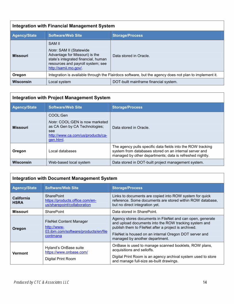
Integration with Financial Management System
Agency/State Software/Web Site Storage/Process
Missouri
SAM II
Note: SAM II (Statewide Advantage for Missouri) is the state’s integrated financial, human resources and payroll system; see http://samii.mo.gov/.
Data stored in Oracle.
Oregon Integration is available through the Flairdocs software, but the agency does not plan to implement it.
Wisconsin Local system DOT-built mainframe financial system.
Integration with Project Management System
Agency/State Software/Web Site Storage/Process
Missouri
COOL:Gen
Note: COOL:GEN is now marketed as CA Gen by CA Technologies; see http://www.ca.com/us/products/ca-gen.html.
Data stored in Oracle.
Oregon Local databases The agency pulls specific data fields into the ROW tracking system from databases stored on an internal server and managed by other departments; data is refreshed nightly.
Wisconsin Web-based local system Data stored in DOT-built project management system.
Integration with Document Management System
Agency/State Software/Web Site Storage/Process
California HSRA
SharePoint https://products.office.com/en-us/sharepoint/collaboration
Links to documents are copied into ROW system for quick reference. Some documents are stored within ROW database, but no direct integration yet.
Missouri SharePoint Data stored in SharePoint.
Oregon
FileNet Content Manager http://www-03.ibm.com/software/products/en/filecontmana
Agency stores documents in FileNet and can open, generate and upload documents into the ROW tracking system and publish them to FileNet after a project is archived.
FileNet is housed on an internal Oregon DOT server and managed by another department.
Vermont Hyland’s OnBase suite https://www.onbase.com/
Digital Print Room
OnBase is used to manage scanned booklets, ROW plans, acquisitions and selloffs.
Digital Print Room is an agency archival system used to store and manage full-size as-built drawings.

Produced by CTC & Associates LLC 15
Integration with Document Management System
Agency/State Software/Web Site Storage/Process
Wisconsin
Esri data viewer (Explorer) http://www.esri.com/software/arcgis/explorer
Highway Access Management System
Documents are stored on file servers and accessible by the ROW system and by a DOT-built, web-based Esri data viewer and DOT-built, Esri- and web-based Highway Access Management System (HAMS).
Note: HAMS uses a GIS interactive web-mapping interface to provide search and retrieval of access-related information such as location of driveway permits and controlled access sites.
System Features
Workflow Component
Systems used by all six respondents provide workflow components, but not all agencies use them. California HSRA’s QuickBase workflow components include change control. Missouri DOT’s Realty Asset Inventory automatically notifies selected employees a specified number of days before the expiration of leases, insurance and inspections. The PAECETrak system used by Wisconsin DOT includes built-in and user-customizable workflow tools. While Ohio DOT’s dotAMPS system will offer workflow components, the agency does not plan to use them, preferring to allow the agency’s project managers to have flexibility in managing projects. Oregon DOT takes the opposite approach and considers the workflow components to be “extremely important.” According to the respondent:
Many pieces of the system will not allow you to move forward with the next step in the process or a payment until the workflow is completed. We implemented the workflows to ensure quality and consistency throughout the state. We have notifications attached to the end of most workflows and can modify the users that receive the notification in case our needs change.
In Vermont, an update process is currently in development that will likely include an email-triggered notification process.
Mobile Application Only Ohio DOT’s dotAMPS has a mobile application that provides most functions of the system and offers the ability to work offline in areas without service. While their systems do not provide a separate mobile app, respondents from California HSRA and Vermont reported that their web-based ROW systems can be viewed from mobile devices. Mobile apps are in development for the ROW systems used in Oregon and Vermont (Oregon will soon test the new Flairdocs mobile app). Missouri and Wisconsin respondents report no mobile applications for their customized legacy system and PAECETrak, respectively.

Produced by CTC & Associates LLC 16
Most Important Feature When asked about their systems’ most important feature, respondents said:
• California HSRA. The agency is still determining what should be tracked and reported on, and the system’s adaptability and flexibility, coupled with the agency’s total control of system development, allows the agency to adapt to project needs.
• Missouri. The Spatial Editor module is considered the most important element of the agency’s three-module system.
• Ohio. The agency’s new web-based dotAMPS system will be open to consultants, avoiding duplicate data entry. Other key features include the ability to generate forms from the system, the GIS component and mobile functionality.
• Oregon. The system is “very comprehensive in its tracking abilities,” allowing the agency to track every aspect of the ROW process.
• Vermont. The system offers a simple interface and is easy to use despite the large amount of data it tracks.
• Wisconsin. The system does what the agency required and more, including integrating well with several of the agency’s internal systems. The respondent also highlighted system security, noting that the system is secured using a state of Wisconsin LDAP (Lightweight Directory Access Protocol) system and permits configuration of granular security.
Managing the System Note: Respondents use a variety of external or internal proprietary programs to manage and
report on ROW data. See Related Resources on page 18 for additional information about the programs referenced in this section.
Most Significant Data to Track Respondents highlighted the following when asked about the type of data that is most critical to track in their ROW systems:
• California HSRA. Milestone activities (appraisal mapping, appraisals, setting of just compensation, offers made, Resolutions of Necessity adopted, suits filed, legal possession, parcel delivery); task management/pipeline reports; and status comments for weekly status reporting.
• Missouri. Realty asset tracking of inventory and property management, followed by realty asset acquisition tracking.
• Ohio. All parcel data for ROW acquisition for each discipline (title, appraisal, negotiation, closing, relocation), including deliverables and agent assignment information.
• Oregon. All ROW data from the beginning of the ROW acquisition process to the end, and all areas of property management. The agency’s system tracks every piece of data related to ROW work and can satisfy all reporting requirements from other agencies.
• Vermont. Existing ROW, new acquisitions, selloffs and property parcels.
• Wisconsin. Appraisal, acquisition, relocation, property management and litigation data.

Produced by CTC & Associates LLC 17
Populating the System with Data Most, if not all, of the data populating five of the six systems is manually entered by staff or consultants. Some respondents provided details on the entry process:
• Ninety percent of the data contained in California HSRA’s QuickBase-based ROW system is manually entered by staff or consultants/agents. The remaining 10 percent of data is imported from HoudiniEsq, Caltrans’ web-based legal case management system, and the GIS mapping tool.
• Data will be manually entered in Ohio DOT’s new dotAMPS system to prepare for system implementation. After the system’s launch, the agency plans to pull higher-level project information and consultant contracts from its in-house systems, both of which are under consideration for update.
• The majority of information managed by Oregon DOT’s Flairdocs system is manually entered by field agents, with clerical staff providing some assistance.
Most of the legacy data contained in Vermont’s ROW system are scanned plans digitized by a consultant and projects converted from CAD format. The agency’s workflow includes the update of ROW information via conversion from CAD to GIS when the Right of Way Parcel Acquisition application is updated with each completed project. A conversion process in development will employ a combination of GIS, FME data integration software and Python scripting language.
Data Extraction/Reporting Respondents use reporting tools inside and outside their ROW information systems. These ROW systems provide reporting tools:
• California HSRA’s QuickBase-based system, which generates reports by extracting data to a CSV file that can be imported into other databases and reporting tools.
• Oregon DOT’s Flairdocs, which includes Izenda, a reporting tool that allows the user to select tables and fields to generate reports. Ad hoc reports and customized reports can be produced.
• Wisconsin DOT’s PAECETrak, which includes a full-featured reporting module. Three states use external reporting tools:
• Missouri DOT uses Cognos and SAP Crystal Reports to create reports.
• Ohio DOT plans to use Microsoft SQL Server Reporting Services standard and ad hoc reporting options.
• While the Izenda reporting tool is available within Flairdocs, Oregon DOT’s business system administrator prefers to use Microsoft SQL Server Management Studio to generate reports and run quality assurance reporting on data entered in the ROW system.
Using its data extraction tool, users of Vermont’s ROW system can define an area of interest within the web application and extract the desired data as a downloadable zip file that is a complete copy of the requested data. A reporting tool is in development.

Produced by CTC & Associates LLC 18
Related Resources Information about the related systems used by respondents to manage and report on ROW data is provided below:
Cognos, IBM Corporation, undated. http://www.ibm.com/analytics/us/en/technology/cognos-software/ The Cognos software provides query and reporting capabilities. FME, Safe Software Inc., 2016. http://www.safe.com/ This vendor web site describes the various elements of FME software, which is used to connect applications, transform data and automate workflows. HoudiniEsq Legal Practice Software Knowledge Base, Archives: Caltrans Specific, LogicBit Software LLC, 2015. http://support.houdiniesq.com/category/caltrans/ This web page provides links to articles, lessons and other support for Caltrans users of HoudiniEsq, the agency’s legal case management software. Izenda, Izenda Inc., 2016. https://www.izenda.com/ This vendor web site describes Izenda as delivering “self-service reporting.” SAP Crystal Reports, SAP SE, undated. http://go.sap.com/product/analytics/crystal-reports.html Crystal Reports is a business intelligence and reporting tool. SQL Server Management Studio, “Use SQL Server Management Studio,” Microsoft, 2016. https://msdn.microsoft.com/en-us/library/ms174173.aspx This web page describes SQL Server Management Studio as “an integrated environment for accessing, configuring, managing, administering, and developing all components of SQL Server and Azure SQL Database.” SQL Server Reporting Services, “Reporting Services (SSRS),” Microsoft, 2016. https://msdn.microsoft.com/en-us/library/ms159106.aspx This web page offers information on how users can use SQL Server Reporting Services to create and manage mobile and paginated reports.

Produced by CTC & Associates LLC 1
Appendix A: Survey Results
The full text of each survey response is provided below. For reference, we have included an abbreviated version of each question before the response. Responses from agencies using an electronic right of way (ROW) information management system begin below; responses from agencies not using such a system appear on page 19. The full question text appears on page 6 of this Preliminary Investigation. Responses to follow-up inquiries made to six agencies—California High-Speed Rail Authority and departments of transportation in Missouri, Ohio, Oregon, Vermont and Wisconsin—appear below the survey response for that agency.
Agencies Using Electronic Right of Way Information Management Systems
Alabama Contact: Michael Pickett, Central Office/Chief Relocation and Acquisition Officer, Alabama Department of Transportation, 334-242-6193, [email protected]. 1. Use electronic ROW information management system? Yes. 2. Type of system: Customized software developed specifically for our agency. 3. Commercial product name/vendor: N/A. 4. ROW system integrates with:
• Financial management system or database.
• Project management system or database.
• Document management system. 5. Business processes/functions supported:
• Acquisition/condemnation.
• Appraisals.
• Excess lands.
• Project coordination.
• Property management.
• Relocation assistance.
• Report generation (custom). 6. Additional comments: [No response.]

Produced by CTC & Associates LLC 2
Alaska Contact: Heather Fair, Statewide ROW Chief, Alaska Department of Transportation and Public Facilities, 907-232-5414, [email protected]. 1. Use electronic ROW information management system? Yes. 2. Type of system: Customized software developed specifically for our agency. 3. Commercial product name/vendor: N/A. 4. ROW system integrates with: eDocs is a stand-alone system. 5. Business processes/functions supported:
• Acquisition/condemnation.
• Project certification.
• Property management. 6. Additional comments: eDocs was started by an intern many years ago. It is not fully
developed or integrated and thus is not well utilized.
California High-Speed Rail Authority Contact: Cuong Nguyen, ROW/Senior Technical Specialist, California High-Speed Rail Authority, 916-384-0874, [email protected]. 1. Use electronic ROW information management system? Yes. 2. Type of system: Single commercial off-the-shelf product customized for agency use. 3. Commercial product name/vendor: QuickBase/Intuit. [QuickBase is now supported
by QuickBase Inc., formerly a division of Intuit; see http://quickbase.intuit.com/.] 4. ROW system integrates with:
• Geographic information system.
• Document management system. 5. Business processes/functions supported:
• Acquisition/condemnation.
• Appraisals.
• Estimating.
• Excess lands.
• GIS.
• Project certification.
• Project coordination.
• Property management.
• Railroad payments.
• Real estate leases.

Produced by CTC & Associates LLC 3
• Relocation assistance.
• Report generation (custom).
• Report generation (standard).
• ROW engineering. 6. Additional comments: [No response.]
Follow-Up Inquiry: System Implementation Q: How long did it take to implement your ROW information management system?
A: It took six months for the original build-out of the base modules. Another three months to transition and train users.
Q: What are the costs for:
A: System implementation. Approximately $200,000 to $300,000 for initial build-out.
• Cost of one database administrator (DBA) developer/programmer.
• Cost of one junior DBA.
• Not including monthly licensing fees paid to Intuit.
A: Ongoing maintenance. Approximately $200,000 per year, including costs associated with development of additional modules or functionality.
• Cost of one DBA developer/programmer, part-time.
• Cost of one junior DBA, full-time.
• Not including monthly licensing fees paid to Intuit.
Q: What type of ROW-related data was of greatest interest when selecting data to track?
A: Milestone activities (appraisal mapping, appraisals, setting of just comp[ensation], offers made, RONs [Resolutions of Necessity] adopted, suits filed, legal possession, parcel delivery); task management/pipeline reports; and status comments for weekly status reporting.
Q: In your survey response, you indicated that you’re using a commercial off-the-shelf product that has been customized for agency use (QuickBase/Intuit).
Q: Please describe the level of difficulty in working with the vendor to add or modify modules.
A: The vendor only provides the base platform. We create and modify the individual modules (parcels table, appraisals, offers, contracts).
Q: Are there system improvements pending? If so, what are they and why was improvement necessary?
A: The vendor only provides the base platform. We had to create the individual modules (parcels table, appraisals, offers, contracts). Additional build-out for tracking of relocation cases is partially developed. A leasing table is being created.

Produced by CTC & Associates LLC 4
A forms generator module is being considered, which will allow printing of prepopulated ROW forms from the database.
True integration with our GIS mapping system. Currently the data is manually migrated between our two systems.
System Functionality Q: In your survey response, you indicated that your ROW information management system
integrates with the systems listed below. Can you tell me more about these systems, including the type of software used for each system, and where each system and the data associated with it are stored?
A: Geographic information system. The GIS mapping tool is a stand-alone Esri-based system. Data in the ROW database can be tracked at the subparcel level, which allows for sharing of data with our GIS system. Data is exchanged by way of a data export that gets imported into the GIS system. Automated data exchanges can be created by way of APIs [application programming interfaces], but this has not been implemented yet.
A: Document management system. SharePoint [see https://products.office.com/en-us/sharepoint/collaboration ] is the official project document repository. Links to documents are copied into our system for quick reference. Some documents are stored within the ROW database. There is no direct integration yet.
Q: Is most of the data managed by your ROW information management system pulled from other systems, or is it manually entered by clerical staff, a field agent, etc.?
A: 90 percent of the data is manually entered by staff or consultants/agents. Another 10 percent is imported from Caltrans’ case management system, Houdini [see http://support.houdiniesq.com/category/caltrans/], and the GIS mapping tool.
Q: Is there a workflow component in your system? For example, will an approved ROW map automatically generate a notification to the appraisal unit?
A: Yes. We have workflows for the various ROW processes including change control.
Q: Does your system include a data extraction/reporting tool that allows the user to pull data and create/run/share individual reports? Please describe.
A: Users can create/run reports directly from the system. Data can be extracted to a CSV [comma separated values] file, which can be imported into other databases and reporting tools.
Q: What database platform(s) is used as the backend for your system (e.g., Oracle, MySQL)?
A: Intuit has [its] own proprietary platform.
System Features Q: Does your system offer a mobile application? If so, what functions are available with the
mobile app?
A: No separate app. The system can be viewed via web browser on the phone.
Q: What do you feel is the best feature of your system?
A: Adaptability and flexibility. We are still figuring out what it is we need to track and report on, and having total control of the development allows us to adapt to project needs.

Produced by CTC & Associates LLC 5
Missouri Contacts: Kelly Lucas, ROW Director, Missouri Department of Transportation, 573-751-7458, [email protected]. Mendy Sundermeyer, ROW Liaison, Missouri Department of Transportation, 573-751-6774, [email protected]. 1. Use electronic ROW information management system? Yes. 2. Type of system: Customized software developed specifically for our agency. 3. Commercial product name/vendor: N/A. 4. ROW system integrates with:
• Geographic information system.
• Financial management system or database.
• Project management system or database.
• Document management system.
5. Business processes/functions supported:
• Acquisition/condemnation.
• Airspace leases.
• Appraisals.
• Clearance and demolition.
• Estimating.
• Excess lands.
• GIS.
• Mitigation.
• Project certification.
• Property management.
• Railroad payments.
• Real estate leases.
• Relocation assistance.
• Report generation (custom).
• Report generation (standard). 6. Additional comments: [No response.]
Follow-Up Inquiry: System Implementation Q: How long did it take to implement your ROW information management system?

Produced by CTC & Associates LLC 6
A: Our ROW information management system is compiled of three applications: Realty Asset Inventory (RAI), Right of Way Parcel Acquisition (RWPA) [and] Spatial Editor (geographic depiction of inventory). It took one year to implement each one of these systems.
Q: What are the costs for:
A: System implementation. Approximately $1 million for all three.
A: Ongoing maintenance. Approximately $8,000 for all three.
Q: What type of ROW-related data was of greatest interest when selecting data to track?
A: Realty asset tracking of our inventory and property management followed by realty asset acquisition tracking.
Q: In your survey response, you indicated that you’re using customized software developed specifically for your agency. Is that system a modification or upgrade of a legacy system?
A: Modification.
Q: Please describe the level of difficulty in working with the vendor or other responsible party to add or modify modules, if applicable.
A: Minimal level of difficulty.
Q: Are there system improvements pending? If so, what are they and why was improvement necessary?
A: Within the next couple of years, RAI and RWPA systems will be rewritten from COOL:Gen platform to .NET. MoDOT wants the applications in a more modern platform to make it more user-friendly and easier to maintain. MoDOT also has more internal staff that have expertise with .NET applications.
System Functionality Q: In your survey response, you indicated that your ROW information management system
integrates with the systems listed below. Can you tell me more about these systems, including the type of software used for each system, and where each system and the data associated with it are stored?
A: Geographic information system. Type of software: Esri, JavaScript API; data stored in Oracle.
A: Financial management system or database. Type of software: SAM II [Statewide Advantage for Missouri, the state’s integrated financial, human resources and payroll system; see http://samii.mo.gov/]; data stored in Oracle.
A: Project management system or database. Type of software: COOL:Gen [see http://www.ca.com/us/products/ca-gen.html for a discussion of CA Gen, previously known as COOL:Gen and other names, marketed by CA Technologies]; data stored in Oracle.
A: Document management system. Data managed and stored in SharePoint.
Q: Is most of the data managed by your ROW information management system pulled from other systems or is it manually entered by clerical staff, a field agent, etc.?
A: Manually entered by staff.

Produced by CTC & Associates LLC 7
Q: Is there a workflow component in your system? For example, will an approved ROW map automatically generate a notification to the appraisal unit?
A: In RAI, the system automatically notifies specific employees so many days before leases expire, insurance expires and inspections expire.
Q: Does your system include a data extraction/reporting tool that allows the user to pull data and create/run/share individual reports? Please describe.
A: MoDOT uses Cognos [IBM Cognos software; see http://www.ibm.com/analytics/us/en/technology/cognos-software/] and Crystal [SAP Crystal Reports; see http://go.sap.com/product/analytics/crystal-reports.html] to run/create/share reports.
Q: What database platform(s) is used as the backend for your system (e.g., Oracle, MySQL)?
A: Oracle.
System Features Q: Does your system offer a mobile application? If so, what functions are available with the
mobile app?
A: No.
Q: What do you feel is the best feature of your system?
A: Spatial Editor.
Ohio Contact: Matt Kouskouris, Real Estate Section Manager, Ohio Department of Transportation, 614-995-3554, [email protected]. 1. Use electronic ROW information management system? Yes. 2. Type of system: Customized software developed specifically for our agency. 3. Commercial product name/vendor: Paradox 9.0. 4. ROW system integrates with:
• Financial management system or database.
• Project management system or database. 5. Business processes/functions supported:
• Acquisition/condemnation.
• Appraisals.
• Estimating.
• Excess lands.
• Local assistance projects.
• Mitigation.
• Project certification.

Produced by CTC & Associates LLC 8
• Project coordination.
• Property management.
• Relocation assistance.
• Report generation (custom).
• Report generation (standard).
• Utility relocation. 6. Additional comments: We are in the process of replacing our current system that has
been in place since the late ’90s. We are planning to implement a COTS [commercial off-the-shelf] web-based system to provide consultant access and GIS since our current system does not have the capability.
Follow-Up Inquiry: Note: The questions below address Ohio DOT’s implementation of a new ROW information
management system, not the system currently in use.
System Implementation Q: Have you selected a new commercial system? If so, please provide the name of the tool and
the vendor.
A: geoAMPS is the name of the firm selected. dotAMPS is the transportation-specific system [see http://www.geoamps.com/products/dotamps].
Q: How long do you expect it to take to implement the new ROW information management system?
A: 6-9 months.
Q: Have you estimated the costs for:
A: System implementation. ~$1 million.
A: Ongoing maintenance. ~$125,000.
Q: What type of ROW-related data is of greatest interest when selecting data to track?
A: All parcel data for ROW acquisition for each discipline (title, appraisal, negotiation, closing, relocation), including deliverables and agent assignment information.
System Functionality Q: Do you expect that most of the data managed by the new system will be pulled from other
systems or manually entered by clerical staff, a field agent, etc.?
A: Initially it will be manually entered, but we plan to have the higher-level project information pulled from our overall system at a later date. Same way with our consultant contracts. However, both those systems are being looked at for upgrade.
Q: Is there a workflow component in the new system? For example, will an approved ROW map automatically generate a notification to the appraisal unit?
A: They do have workflow components; however, we don’t want to be locked into a set sequence as we expect our project managers to have flexibility running projects.

Produced by CTC & Associates LLC 9
Q: Will the new system include a data extraction/reporting tool that allows the user to pull data and create/run/share individual reports?
A: Yes, the system has lots of reporting options. Microsoft SSRS [SQL Server Reporting Services; see https://msdn.microsoft.com/en-us/library/bb630404.aspx] canned and ad hoc options.
Q: What database platform(s) is used as the backend for the system (e.g., Oracle, MySQL)?
A: SQL Server 2008 or newer.
System Features Q: Will the new system offer a mobile application? If so, what functions are available with the
mobile app?
A: Yes, GPS and camera. Most functions of system and ability to work offline in areas without service.
Q: What do you feel is the best feature of the new system?
A: The fact that it is a web-based system that will be open to our consultants, which will avoid duplicate data entry; ability to generate forms from the system and the GIS component; and mobile functionality.
Oregon Contact: Joseph Gray, State ROW Manager, Oregon Department of Transportation, 503-986-3615, [email protected]. 1. Use electronic ROW information management system? Yes. 2. Type of system: Single commercial off-the-shelf product customized for agency use. 3. Commercial product name/vendor: Flairsoft/Flairdocs [see http://flairdocs.com/]. 4. ROW system integrates with:
• Geographic information system.
• Financial management system or database.
• Project management system or database.
• Document management system. 5. Business processes/functions supported:
• Acquisition/condemnation.
• Airspace leases.
• Appraisals.
• Capital and support costs.
• Clearance and demolition.
• Estimating.
• Excess lands.
Produced by CTC & Associates LLC 10
• GIS.
• Local assistance projects.
• Mitigation.
• Project certification.
• Project coordination.
• Property management.
• Railroad payments.
• Real estate leases.
• Relocation assistance.
• Report generation (custom).
• Report generation (standard).
• ROW engineering. 6. Additional comments: We are currently looking at adding the Outdoor Advertising and
Utilities modules. This is a great product and a great company to work with. We would be more than happy to show you the system if you would like.
Follow-Up Inquiry: System Implementation Q: How long did it take to implement your ROW information management system?
A: It took approximately five years to implement the ROW information management system because we at ODOT had some turnover with management and changed direction on what we wanted the system to look like several times, which required we start from the beginning. I believe the system is at a point today where it could be modified and rolled out within six months to one year for other states.
Q: What are the costs for:
A: System implementation. This will depend [on] what you’re able to negotiate with the vendor. Due to the extensive work ODOT has done with the vendor, the cost to other states should be much lower.
A: Ongoing maintenance. We prepaid for five years of maintenance through the original contract. We found that the price is better when prepaying for a lump sum of years. Our initial contract included five years of maintenance priced at $374,984.27.
Q: What type of ROW-related data was of greatest interest when selecting data to track?
A: We were interested in tracking all ROW data as we are consistently required to provide information to the Oregon Transportation Commission, Oregon Civil Liberties Office (??) and the FHWA. We needed a comprehensive tracking system to capture all information from the beginning of the ROW acquisition process to the end, and all areas of property management as well. The system the vendor built working with us has the ability to track every piece of data related to ROW work and thus can satisfy all reporting requirements from other agencies.

Produced by CTC & Associates LLC 11
Q: In your survey response, you indicated that you’re using a commercial off-the-shelf product that has been customized for agency use (Flairdocs).
Q: Please describe the level of difficulty in working with the vendor to add or modify modules.
A: All changes to the system go through an amendment to the contract we have with the vendor. The vendor is very easy to work with. As far as all changes we’ve requested, they’ve been able to implement. Basically, anything we can dream, they’re able to make reality.
Q: Are there system improvements pending? If so, what are they and why was improvement necessary?
A: We are currently in the process of improving the system with a new amendment and have 58 line items, including a tickler/notification system that will be very user-friendly and work for all future users of Flairdocs. In the technology age, constant improvement is necessary as one can see with app updates com[ing] through daily on the phone, and every application used in business and personal lives are constantly undergoing improvements resulting in updated versions. There is no reason why one would not expect the same thing with this kind of advanced and complex information tracking system. The changes we’ve requested we have encountered during a year of using the system. We built the system from scratch and now that it’s being used statewide, we’ve found certain things work well and others could really work better.
System Functionality Q: In your survey response, you indicated that your ROW information management system
integrates with the systems listed below. Can you tell me more about these systems, including the type of software used for each system, and where each system and the data associated with it are stored?
A: Geographic information system. This is a capability of the system. We are currently working with the vendor to implement this integration.
A: Financial management system or database. This is a capability of the system, but we do not plan on integrating our financial management system with the ROW tracking system at this time.
A: Project management system or database. We pull specific data fields from these systems into the ROW tracking system and have it refresh the data nightly. The databases are stored on an internal server with ODOT and managed by other departments.
A: Document management system. We use FileNet to store all of our documents, but we can open, generate and upload documents into the ROW tracking system and publish them to FileNet after the project is archived. This integration has worked very well. FileNet is housed on internal ODOT servers and managed by another department.
Q: Is most of the data managed by your ROW information management system pulled from other systems, or is it manually entered by clerical staff, a field agent, etc.?
A: The majority of the information managed by our system is manually entered by field agents, as that information is the most important for our tracking purposes. The
Produced by CTC & Associates LLC 12
information pulled from other systems is to help our agents track the outside project factors that affect their ROW work. Clerical staff enter some information to help the agents.
Q: Is there a workflow component in your system? For example, will an approved ROW map automatically generate a notification to the appraisal unit?
A: Yes, workflows are extremely important to our system. Many pieces of the system will not allow you to move forward with the next step in the process or a payment until the workflow is completed. We implemented the workflows to ensure quality and consistency throughout the state. We have notifications attached to the end of most workflows and can modify the users that receive the notification in case our needs change.
Q: Does your system include a data extraction/reporting tool that allows the user to pull data and create/run/share individual reports? Please describe.
A: We have two ways of pulling the data for reporting purposes. The first is Izenda [see https://www.izenda.com/], which is a tool inside the system that allows for the selection of tables and fields in order to pull the report. We have some ad hoc reports built through this system. Due to the complexity of the system (because of the complexity of the ROW process), however, our Business System Administrator prefers to use SQL Server Management Studio [see https://msdn.microsoft.com/en-us/library/ms174173.aspx] to pull miscellaneous report requests and run QA [quality assurance] on data entered into the system. There are options as to how to pull ad hoc reports based on the personal preference of your reporting administrator. We also have set reports available to agents that the vendor helped to create and can develop based on the needs of your agency.
Q: What database platform(s) is used as the backend for your system (e.g., Oracle, MySQL)?
A: We use SQL on the backend of the database.
System Features Q: Does your system offer a mobile application? If so, what functions are available with the
mobile app?
A: The vendor has developed a mobile app and should be providing that to us for testing shortly.
Q: What do you feel is the best feature of your system?
A: The ability to track every aspect of the ROW process. The system is very comprehensive in its tracking abilities.
Pennsylvania Contact: Jack Clark, Utilities and ROW Section/Chief of Administration Unit, Pennsylvania Department of Transportation, 717-787-7370, [email protected]. 1. Use electronic ROW information management system? Yes. 2. Type of system: Single commercial off-the-shelf product. 3. Commercial product name/vendor: ROW Office Bentley Systems.

Produced by CTC & Associates LLC 13
4. ROW system integrates with:
• Financial management system or database.
• Project management system or database. 5. Business processes/functions supported:
• Acquisition/condemnation.
• Appraisals.
• Clearance and demolition.
• Excess lands.
• Project certification.
• Property management.
• Real estate leases.
• Relocation assistance.
• Report generation (custom). 6. Additional comments: [No response.]
South Carolina Contact: Hugh Hadsock, ROW Administrator, South Carolina Department of Transportation, 803-737-1406, [email protected]. 1. Use electronic ROW information management system? Yes. 2. Type of system: Customized software developed specifically for our agency. 3. Commercial product name/vendor: [No response.] 4. ROW system integrates with:
• Project management system or database.
• Document management system. 5. Business processes/functions supported:
• Acquisition/condemnation.
• Appraisals.
• Estimating.
• Local assistance projects.
• Project certification.
• Relocation assistance.
• Report generation (custom).
• Report generation (standard).
• Utility relocation.

Produced by CTC & Associates LLC 14
6. Additional comments: We have a temporary system in place. Currently getting an RFP to go out for new system.
Utah Contact: Lyle McMillan, Right of Way, Utah Department of Transportation, 801-633-6243, [email protected]. 1. Use electronic ROW information management system? Yes. 2. Type of system: Customized software developed specifically for our agency. 3. Commercial product name/vendor: N/A. 4. ROW system integrates with:
• Financial management system or database.
• Project management system or database.
• Document management system. 5. Business processes/functions supported:
• Acquisition/condemnation.
• Appraisals.
• Estimating.
• Excess lands.
• Local assistance projects.
• Project certification.
• Project coordination.
• Property management.
• Relocation assistance.
• Report generation (custom).
• Report generation (standard). 6. Additional comments: [No response.]
Vermont Contacts: Nina Safavi, Survey and GIS Project Manager, Vermont Agency of Transportation, 802-279-8686, [email protected]. Ryan R. Cloutier, Survey, Plans and Titles Chief, Vermont Agency of Transportation, 802-828-2374, [email protected]. 1. Use electronic ROW information management system? Yes. 2. Type of system: Multiple products (commercial off-the-shelf and/or custom-designed
systems).

Produced by CTC & Associates LLC 15
3. Commercial product name/vendor: Used the AppGeo [see http://www.appgeo.com] general purpose viewer with some customization for initial data visualization and QA/QC [quality assurance/quality control]. Transitioning to the Esri AGO [ArcGIS Online] interface [see https://www.arcgis.com/home/index.html].
4. ROW system integrates with:
• Geographic information system.
• Document management system.
It connects to our plan management system. We are currently creating a link to our document management system. The plans have a unique id (pin #) that allows for some integration with other project management systems.
5. Business processes/functions supported:
• Acquisition/condemnation.
• Airspace leases.
• Excess lands.
• GIS.
• Local assistance projects.
• Mitigation.
• Project certification.
• Property management.
• Real estate leases.
• Report generation (custom).
• Report generation (standard).
• Utility relocation. 6. Additional comments: Now that all of our ROW plans are in GIS, we are expanding
the project to better integrate with other internal systems.
Follow-Up Inquiry: System Implementation Q: How long did it take to implement your ROW information management system?
A: We started the planning phase in 2009 and began implementing our plan in mid-2012, with full implementation planned for in mid-2017.
Q: What are the costs for:
A: System implementation. $1,215,000 in contractor costs to date + 0.25 full-time employee (internal staff).
A: Ongoing maintenance. One full-time employee (internal staff).
Q: What type of ROW-related data was of greatest interest when selecting data to track?
A: Existing ROW, new acquisitions, selloffs, and property parcels.

Produced by CTC & Associates LLC 16
Q: In your survey response, you indicated that you’re using multiple products (commercial off-the-shelf and custom-designed systems).
Q: Please describe the level of difficulty in working with the vendor(s) and other responsible parties to add or modify modules.
A: 3 (out of 1-10, with 10 being the most difficult). We had two options: 1) It was open source so we could do the customization, or 2) Ask the vendor to customize. Due to our limited resources at the time, we chose option 2. The vendor was pretty responsive to our needs, but it would have been more effective to go with option 1.
Q: Are there system improvements pending? If so, what are they and why was improvement necessary?
A: We are transitioning from the vendor-based software to Esri. We are making this change because it is more cost-effective in the long run for us to manage the system ourselves.
System Functionality Q: In your survey response, you indicated that your ROW information management system
integrates with the systems below. Can you tell me more about these systems, including the type of software used for each system, and where each system and the data associated with it are stored?
A: Geographic information system. The Geographic Information System we utilize is the Esri ArcGIS for Desktop and server suites. We interact with and perform management of our Right of Way data using ArcGIS for Desktop. We store our Right of Way data in SQL server databases that are Esri ArcSDE-integrated [spatial database engine]. We use ArcGIS for [S]erver to create feature and map services from our ArcSDE databases.
A: Document management system. We use Hyland’s OnBase suite [see https://www.onbase.com/] to manage scanned Booklets, ROW Plans, Acquisitions, and Selloffs. We use an agency archival system called the Digital Print Room to store and manage full-sized as-built drawings.
Q: Is most of the data managed by your ROW information management system pulled from other systems, or is it manually entered by clerical staff, a field agent, etc.?
A: The majority of legacy data that were included in our system were scanned plans that were digitized by a consultant, and a number of projects were converted from CAD format. The current and ongoing workflow includes updating ROW information via conversion from CAD to GIS when ROW is updated with each completed project. The conversion process is currently in development, and it includes a combination of GIS, Safe Software’s FME [data integration software for use with spatial and other data; see http://www.safe.com/], and the Python scripting language.
Q: Is there a workflow component in your system? For example, will an approved ROW map automatically generate a notification to the appraisal unit?
A: The update process is currently in development, and will likely include an email-triggered process that utilizes Python, FME and GIS.
Q: Does your system include a data extraction/reporting tool that allows the user to pull data and create/run/share individual reports? Please describe.

Produced by CTC & Associates LLC 17
A: Our system includes a data extraction tool that enables [the] user to define an area of interest within our web application, then extract the desired data as a downloadable zip file that is a complete copy of the data in question. A reporting tool is currently in development.
Q: What database platform(s) is used as the backend for your system (e.g., Oracle, MySQL)?
A: Microsoft SQL Server.
System Features Q: Does your system offer a mobile application? If so, what functions are available with the
mobile app?
A: Our application is a web application and can be viewed from mobile devices, although [a] slimmed-down version that is friendlier for smaller screens is in development.
Q: What do you feel is the best feature of your system?
A: Its simple look and ease of use despite the large amount of data available.
Wisconsin Contact: Drew Kottke, DTSD/ROW Systems Engineer, Wisconsin Department of Transportation, 715-836-2816, [email protected]. 1. Use electronic ROW information management system? Yes. 2. Type of system: Single commercial off-the-shelf product customized for agency use. 3. Commercial product name/vendor: PAECETrak (BEM Systems Inc.) [see
http://bemsys.com/paecetrak/]. 4. ROW system integrates with:
• Geographic information system.
• Financial management system or database.
• Project management system or database.
• Document management system.
5. Business processes/functions supported:
• Acquisition/condemnation.
• Airspace leases.
• Appraisals.
• Clearance and demolition.
• Estimating.
• Excess lands.
• GIS.

Produced by CTC & Associates LLC 18
• Local assistance projects.
• Property management.
• Real estate leases.
• Relocation assistance.
• Report generation (custom).
• Report generation (standard). 6. Additional comments: [No response.]
Follow-Up Inquiry: System Implementation Q: How long did it take to implement your ROW information management system?
A: Approximately 18 months.
Q: What are the costs for:
A: System implementation. Approximately $850,000.
A: Ongoing maintenance. Approximately $65,000 annually.
Q: What type of ROW-related data was of greatest interest when selecting data to track?
A: Required that the system track appraisal, acquisition, relocation, property management and litigation data.
Q: In your survey response, you indicated that you’re using a commercial off-the-shelf product that has been customized for agency use (PAECETrak).
Q: Please describe the level of difficulty in working with the vendor to add or modify modules.
A: The vendor has been very good to work with.
Q: Are there system improvements pending? If so, what are they and why was improvement necessary?
A: Adding the ability to use the system for local public agency work where DOT oversees.
System Functionality Q: In your survey response, you indicated that your ROW information management system
integrates with the systems listed below. Can you tell me more about these systems, including the type of software used for each system, and where each system and the data associated with it are stored?
A: Geographic information system. We use Esri software and have numerous DOT-built applications.
A: Financial management system or database. DOT-built mainframe financial system.
A: Project management system or database. DOT-built, web-based project management system.

Produced by CTC & Associates LLC 19
A: Document management system. Documents are stored on file servers and are accessible by the system and by DOT-built, web-based, Esri data viewer as well as by DOT-built, Esri- and web-based Highway Access Management System [HAMS uses a GIS interactive web-mapping interface to provide location-based search and retrieval of access-related information such as location of driveway permits and controlled access sites].
Q: Is most of the data managed by your ROW information management system pulled from other systems, or is it manually entered by clerical staff, a field agent, etc.?
A: Most data is manually entered.
Q: Is there a workflow component in your system? For example, will an approved ROW map automatically generate a notification to the appraisal unit?
A: There are built-in and user-customizable workflow tools in the system.
Q: Does your system include a data extraction/reporting tool that allows the user to pull data and create/run/share individual reports? Please describe.
A: There is a full-featured reporting module that allows users [to] pull data and create/run/share individual reports.
Q: What database platform(s) is used as the backend for your system (e.g., Oracle, MySQL)?
A: Oracle.
System Features Q: Does your system offer a mobile application? If so, what functions are available with the
mobile app?
A: No.
Q: What do you feel is the best feature of your system?
A: The vendor has been excellent to work with. The system does what we required and more. It integrates well with several of our existing systems. You didn’t ask about security, but our implementation of the system is secured using the State of WI Dept. of Admin[istration] LDAP [Lightweight Directory Access Protocol] system and granular security within the system is configurable.
Agencies Not Using Electronic Right of Way Information Management Systems
Arizona Contact: John Eckhardt, Deputy Chief ROW Agent, Arizona Department of Transportation, 602-712-7900, [email protected]. 1. Use electronic ROW information management system? No. ADOT is in the process
of securing funds to purchase an electronic information system. We would be interested in seeing the results of your survey. You can forward to [email protected].

Produced by CTC & Associates LLC 20
Arkansas Contact: Jennifer Williams, ROW Division/Assistant Division Head, Arkansas State Highway and Transportation Department, 501-569-2311, [email protected]. 1. Use electronic ROW information management system? No. We are exploring
options for implementing an electronic information management system that will best fit the Division’s needs and is within our budget.
Colorado Contact: Christine Rees, ROW Program Manager, Colorado Department of Transportation, 303-757-9836, [email protected]. 1. Use electronic ROW information management system? No. We have researched it
on and off and had demos from a few firms.