Embed Size (px)
DESCRIPTION
Rhinebeck's Local Waterfront Revitalization Program
Citation preview
TABLE OF CONTENTSPREFACEINTRODUCTIONSECTION I LOCAL WATERFRONT REVITALIZATION AREA BOUNDARYNew York State Coastal Management Program Boundary . . . . . . . . . . . . SECTION I - 1Proposed Change to the New York State Coastal Management Program Boundary and Justification for the Boundary Change . . . . . . . . . SECTION I - 1Rhinebeck Local Waterfront Revitalization Program (LWRP) Boundary SECTION I - 2Map 1 Town of Rhinebeck Waterfront Boundary . . . . . . . . . . . . . SECTION I - 3SECTION II INVENTORY AND ANALYSISA. OVERVIEW . . . . . . . . . . . . . . . . . . . . . . . . . . . . . . . . . . . . . . . . SECTION II - 1B. EXISTING LAND USE . . . . . . . . . . . . . . . . . . . . . . . . . . . . . . . . SECTION II - 3C. ZONING . . . . . . . . . . . . . . . . . . . . . . . . . . . . . . . . . . . . . . . . . . . SECTION II - 8D. ENVIRONMENTAL FEATURES . . . . . . . . . . . . . . . . . . . . . . SECTION II - 11E. RECREATION AND OPEN SPACE AREAS . . . . . . . . . . . . . SECTION II - 23F. COASTAL ACCESS POINTS . . . . . . . . . . . . . . . . . . . . . . . . . SECTION II - 25G. HISTORIC AND SCENIC FEATURES . . . . . . . . . . . . . . . . . SECTION II - 27H. PUBLIC AND FRANCHISE UTILITIES . . . . . . . . . . . . . . . . . SECTION II - 39I. TRANSPORTATION . . . . . . . . . . . . . . . . . . . . . . . . . . . . . . . . SECTION II - 40Map 2 Existing Land Use . . . . . . . . . . . . . . . . . . . . . . . . . . . . . . SECTION II - 45Map 3 Zoning . . . . . . . . . . . . . . . . . . . . . . . . . . . . . . . . . . . . . . . SECTION II - 46Map 4 Natural Resources Inventory . . . . . . . . . . . . . . . . . . . . . . SECTION II - 47Map 5 Coves . . . . . . . . . . . . . . . . . . . . . . . . . . . . . . . . . . . . . . . SECTION II - 48Map 6 Coastal Access Points . . . . . . . . . . . . . . . . . . . . . . . . . . . SECTION II - 49Map 7 Historic Shorelands Scenic Area . . . . . . . . . . . . . . . . . . SECTION II - 50Map 8 Estates Within the Coastal Area . . . . . . . . . . . . . . . . . . . SECTION II - 51Map 9 Major Transportation Route . . . . . . . . . . . . . . . . . . . . . . SECTION II - 52Map 10 Summary of Major Development Considerations . . . . SECTION II - 53SECTION III LOCAL WATERFRONT REVITALIZATION PROGRAM POLICIESDEVELOPMENT POLICIES . . . . . . . . . . . . . . . . . . . . . . . . . . . . . . . SECTION III - 3POLICY 1 . . . . . . . . . . . . . . . . . . . . . . . . . . . . . . . . . . . . . . . . . . SECTION III - 3POLICY 1A . . . . . . . . . . . . . . . . . . . . . . . . . . . . . . . . . . . . . . . . SECTION III - 5POLICY 2 . . . . . . . . . . . . . . . . . . . . . . . . . . . . . . . . . . . . . . . . . . SECTION III - 6POLICY 3 . . . . . . . . . . . . . . . . . . . . . . . . . . . . . . . . . . . . . . . . . . SECTION III - 8POLICY 4 . . . . . . . . . . . . . . . . . . . . . . . . . . . . . . . . . . . . . . . . . . SECTION III - 8
POLICY 5 . . . . . . . . . . . . . . . . . . . . . . . . . . . . . . . . . . . . . . . . . . SECTION III - 8POLICY 6 . . . . . . . . . . . . . . . . . . . . . . . . . . . . . . . . . . . . . . . . . SECTION III - 10FISH AND WILDLIFE POLICIES . . . . . . . . . . . . . . . . . . . . . . . . . . SECTION III - 11POLICY 7 . . . . . . . . . . . . . . . . . . . . . . . . . . . . . . . . . . . . . . . . . SECTION III - 11POLICY 7A . . . . . . . . . . . . . . . . . . . . . . . . . . . . . . . . . . . . . . . SECTION III - 13POLICY 7B . . . . . . . . . . . . . . . . . . . . . . . . . . . . . . . . . . . . . . . . SECTION III - 13POLICY 7C . . . . . . . . . . . . . . . . . . . . . . . . . . . . . . . . . . . . . . . . SECTION III - 13POLICY 7D . . . . . . . . . . . . . . . . . . . . . . . . . . . . . . . . . . . . . . . . SECTION III - 14POLICY 7E . . . . . . . . . . . . . . . . . . . . . . . . . . . . . . . . . . . . . . . . SECTION III - 14POLICY 8 . . . . . . . . . . . . . . . . . . . . . . . . . . . . . . . . . . . . . . . . . SECTION III - 15POLICY 9 . . . . . . . . . . . . . . . . . . . . . . . . . . . . . . . . . . . . . . . . . SECTION III - 16POLICY 10 . . . . . . . . . . . . . . . . . . . . . . . . . . . . . . . . . . . . . . . . SECTION III - 17FLOODING AND EROSION HAZARDS POLICIES . . . . . . . . . . SECTION III - 19POLICY 11 . . . . . . . . . . . . . . . . . . . . . . . . . . . . . . . . . . . . . . . . SECTION III - 19POLICY 12 . . . . . . . . . . . . . . . . . . . . . . . . . . . . . . . . . . . . . . . . SECTION III - 20POLICY 13 . . . . . . . . . . . . . . . . . . . . . . . . . . . . . . . . . . . . . . . . SECTION III - 21POLICY 14 . . . . . . . . . . . . . . . . . . . . . . . . . . . . . . . . . . . . . . . . SECTION III - 22POLICY 15 . . . . . . . . . . . . . . . . . . . . . . . . . . . . . . . . . . . . . . . . SECTION III - 22POLICY 16 . . . . . . . . . . . . . . . . . . . . . . . . . . . . . . . . . . . . . . . . SECTION III - 23POLICY 17 . . . . . . . . . . . . . . . . . . . . . . . . . . . . . . . . . . . . . . . . SECTION III - 23GENERAL POLICY . . . . . . . . . . . . . . . . . . . . . . . . . . . . . . . . . . . . . . SECTION III - 25POLICY 18 . . . . . . . . . . . . . . . . . . . . . . . . . . . . . . . . . . . . . . . . SECTION III - 25PUBLIC ACCESS POLICIES . . . . . . . . . . . . . . . . . . . . . . . . . . . . . . SECTION III - 25POLICY 19 . . . . . . . . . . . . . . . . . . . . . . . . . . . . . . . . . . . . . . . . SECTION III - 25POLICY 20 . . . . . . . . . . . . . . . . . . . . . . . . . . . . . . . . . . . . . . . . SECTION III - 27POLICY 20A . . . . . . . . . . . . . . . . . . . . . . . . . . . . . . . . . . . . . . . SECTION III - 30RECREATION POLICIES . . . . . . . . . . . . . . . . . . . . . . . . . . . . . . . . SECTION III - 31POLICY 21 . . . . . . . . . . . . . . . . . . . . . . . . . . . . . . . . . . . . . . . . SECTION III - 31POLICY 21A . . . . . . . . . . . . . . . . . . . . . . . . . . . . . . . . . . . . . . . SECTION III - 33POLICY 21B . . . . . . . . . . . . . . . . . . . . . . . . . . . . . . . . . . . . . . . SECTION III - 33POLICY 22 . . . . . . . . . . . . . . . . . . . . . . . . . . . . . . . . . . . . . . . . SECTION III - 34HISTORIC AND SCENIC RESOURCES POLICIES . . . . . . . . . . SECTION III - 35POLICY 23 . . . . . . . . . . . . . . . . . . . . . . . . . . . . . . . . . . . . . . . . SECTION III - 35POLICY 23A . . . . . . . . . . . . . . . . . . . . . . . . . . . . . . . . . . . . . . SECTION III - 39SCENIC QUALITY POLICIES . . . . . . . . . . . . . . . . . . . . . . . . . . . . . SECTION III - 39POLICY 24 . . . . . . . . . . . . . . . . . . . . . . . . . . . . . . . . . . . . . . . . SECTION III - 39POLICY 24A . . . . . . . . . . . . . . . . . . . . . . . . . . . . . . . . . . . . . . . SECTION III - 40POLICY 24B . . . . . . . . . . . . . . . . . . . . . . . . . . . . . . . . . . . . . . . SECTION III - 42POLICY 24C . . . . . . . . . . . . . . . . . . . . . . . . . . . . . . . . . . . . . . . SECTION III - 43POLICY 25 . . . . . . . . . . . . . . . . . . . . . . . . . . . . . . . . . . . . . . . . SECTION III - 45
AGRICULTURAL LANDS POLICY . . . . . . . . . . . . . . . . . . . . . . . . SECTION III - 45POLICY 26 . . . . . . . . . . . . . . . . . . . . . . . . . . . . . . . . . . . . . . . . SECTION III - 45ENERGY AND ICE MANAGEMENT POLICIES . . . . . . . . . . . . . SECTION III - 50POLICY 27 . . . . . . . . . . . . . . . . . . . . . . . . . . . . . . . . . . . . . . . . SECTION III - 50POLICY 28 . . . . . . . . . . . . . . . . . . . . . . . . . . . . . . . . . . . . . . . . SECTION III - 51POLICY 29 . . . . . . . . . . . . . . . . . . . . . . . . . . . . . . . . . . . . . . . . SECTION III - 51WATER AND AIR RESOURCES POLICIES . . . . . . . . . . . . . . . . . SECTION III - 52POLICY 30 . . . . . . . . . . . . . . . . . . . . . . . . . . . . . . . . . . . . . . . . SECTION III - 52POLICY 31 . . . . . . . . . . . . . . . . . . . . . . . . . . . . . . . . . . . . . . . . SECTION III - 53POLICY 32 . . . . . . . . . . . . . . . . . . . . . . . . . . . . . . . . . . . . . . . . SECTION III - 53POLICY 33 . . . . . . . . . . . . . . . . . . . . . . . . . . . . . . . . . . . . . . . . SECTION III - 54POLICY 34 . . . . . . . . . . . . . . . . . . . . . . . . . . . . . . . . . . . . . . . . SECTION III - 54POLICY 35 . . . . . . . . . . . . . . . . . . . . . . . . . . . . . . . . . . . . . . . . SECTION III - 55POLICY 36 . . . . . . . . . . . . . . . . . . . . . . . . . . . . . . . . . . . . . . . . SECTION III - 55POLICY 37 . . . . . . . . . . . . . . . . . . . . . . . . . . . . . . . . . . . . . . . . SECTION III - 56POLICY 38 . . . . . . . . . . . . . . . . . . . . . . . . . . . . . . . . . . . . . . . . SECTION III - 57POLICY 39 . . . . . . . . . . . . . . . . . . . . . . . . . . . . . . . . . . . . . . . . SECTION III - 58POLICY 40 . . . . . . . . . . . . . . . . . . . . . . . . . . . . . . . . . . . . . . . . SECTION III - 59POLICY 41 . . . . . . . . . . . . . . . . . . . . . . . . . . . . . . . . . . . . . . . . SECTION III - 59POLICY 42 . . . . . . . . . . . . . . . . . . . . . . . . . . . . . . . . . . . . . . . . SECTION III - 59POLICY 43 . . . . . . . . . . . . . . . . . . . . . . . . . . . . . . . . . . . . . . . . SECTION III - 60POLICY 44 . . . . . . . . . . . . . . . . . . . . . . . . . . . . . . . . . . . . . . . . SECTION III - 60SECTION IV PROPOSED USES AND PROJECTSINTRODUCTION . . . . . . . . . . . . . . . . . . . . . . . . . . . . . . . . . . . . . . . . . SECTION IV - 2A. PROPOSED LAND AND WATER USES AND PROPOSED PROJECTS . . . . . . . . . . . . . . . . . . . . . . . . . . . . . SECTION IV - 3B. PROPOSED PUBLIC AND PRIVATE PROJECTS . . . . . . . . SECTION IV - 5Map 11 Waterfront Revitalization Area Land Use Plan . . . . . SECTION IV - 13Map 12 Public and Private Projects . . . . . . . . . . . . . . . . . . . . . SECTION IV - 14SECTION V TECHNIQUES FOR LOCAL IMPLEMENTATION OF THE PROGRAMA. LOCAL LAWS AND REGULATIONS NECESSARY TO IMPLEMENT THE LWRP . . . . . . . . . . . . . . . . . . . . . . . . . . . SECTION V - 2B. OTHER PUBLIC AND PRIVATE ACTIONS NECESSARY TO IMPLEMENT THE LWRP . . . . . . . . . . . . . . . . . . . . . SECTION V - 9C. MANAGEMENT STRUCTURE NECESSARY TO IMPLEMENT THE LWRP . . . . . . . . . . . . . . . . . . . . . . . . . . . . . SECTION V - 13

D. SUMMARY CHART OF LOCAL IMPLEMENTATION OF LWRP POLICIES . . . . . . . . . . . . . . . . . . . . . . . . . . . . . . . . . SECTION V - 15E. COST IMPLICATIONS OF PROJECTS AND PROGRAMS IN THE LWRP . . . . . . . . . . . . . . . . . . . . . . . . . . . . . . . . . . . . . . SECTION V - 21F. FINANCIAL RESOURCES TO IMPLEMENT THE PROJECTS AND PROGRAMS IN THE LWRP . . . . . . . . . . . . . . . . . . . . . . SECTION V - 22
SECTION VI STATE AND FEDERAL ACTIONS AND PROGRAMS LIKELY TOAFFECT IMPLEMENTATIONA. STATE AND FEDERAL ACTIONS AND PROGRAMS WHICH SHOULD BE UNDERTAKEN IN A MANNER CONSISTENT WITH THE LWRP . . . . . . . . . . . . . . . . . . . . . . . . . . . . . . . . . . . SECTION VI - 2B. STATE AND FEDERAL PROGRAMS NECESSARY TO FURTHER THE LWRP . . . . . . . . . . . . . . . . . . . . . . . . . . . . . . SECTION VI - 26SECTION VII LOCAL COMMITMENT AND CONSULTATIONAPPENDICESAppendix A Scenic Areas of Statewide Significance (SASS)Appendix B Coastal Fish and Wildlife HabitatsAppendix C Town of Rhinebeck Draft Waterfront Consistency Review LawAppendix D Town of Rhinebeck Historic Buildings Protection LawAppendix E NYS Freshwater Wetlands MapAppendix F Guidelines for Notification and Review of State Agency Actions Where LocalWaterfront Revitalization Programs are in EffectProcedural Guidelines for Coordinating NYS Department of State (Dos) & LwrpConsistency Review of Federal Agency Actions
PREFACEThe Local Waterfront Revitalization Program (LWRP) for the Town of Rhinebeck has beendeveloped consistent with national and State objectives embodied in the Federal Coastal ZoneManagement Act of 1972, the New York State Waterfront Revitalization of Coastal Areas and InlandWaterways Act (Article 42, Executive Law) and the Coastal Erosion Hazard Areas Act of 1981(Article 34, Environmental Conservation Law) and presented in the State of New York CoastalManagement Program and Final Environmental Impact Statement of August 1982. The New YorkState Coastal Management Program describes the State's implementation of Federal coastalregulations. It includes a series of forty-four policies outlining appropriate approaches to coastal landand water use activities. The State's Coastal Management Program has been designed to addressimportant coastal issues by advocating specific types of actions enumerated in the summary of theProgram:
.....promoting waterfront revitalization; promoting water-dependent uses; protecting fish andwildlife habitats; protecting and enhancing scenic areas; protecting and enhancing historicareas; protecting farmlands; protecting and enhancing small harbors; protecting andenhancing public access; providing research, data, and information for participation ofgovernment agencies and citizens concerned with the State's coastal area; and coping witherosion and flooding hazards.* The local program has been developed to focus these concerns in view of Rhinebeck's particularproblems and goals. The current version of the LWRP supersedes an earlier version adopted by theTown of Rhinebeck in February 1989 but neither adopted by the Village of Rhinebeck nor approvedby the New York State Department of State. The present version requires no action by the Villageof Rhinebeck for the LWRP has been revised to exclude all lands within the incorporated Village.An amendment of the New York State Coastal Management Program Boundary is proposed to makethe coastal area boundary coincident with the Mid-Hudson Historic Shorelands Scenic Districtboundary within Rhinebeck.The adoption of this local program in its current form will help to ensure the consideration of thesepolicies in making decisions on Federal and State levels, as well as on the local Town and Countylevels to determine that proposed actions will be consistent with local goals and concernsincorporated within Rhinebeck's LWRP.______________________________* State of New York Coastal Management Program and Final Impact Statement prepared bythe U.S. Department of Commerce, Office of Coastal Zone Management and New YorkDepartment of State, August 1982, p. I-4. All references to the New York State CoastalManagement Program (NYSCMP) refer to this document.
INTRODUCTIONThe Local Waterfront Revitalization Area (LWRA) of the Town of Rhinebeck presents manyopportunities to maintain and improve the economic, social and environmental well-being of thismunicipality and the surrounding areas. Over the years, the citizens of Rhinebeck have recognizedthe special value of the Town's natural, historic, scenic and recreational resources and have beeninvolved in many efforts to preserve, enhance and make wise use of these resources.Much of what has already been accomplished in Rhinebeck forms the basis of the Town's LocalWaterfront Revitalization Program (LWRP). Preparation of the LWRP gives Rhinebeck anopportunity to take previous efforts a significant step further and to create a cohesive and vitalprogram to guide the future of its waterfront area.The LWRP is a valuable planning tool which provides the Town with an opportunity to establishobjectives and specific projects and implementation steps as part of its planning and developmentprocess. Actions proposed by either private project sponsors or by local Town and County, State orFederal agencies to be undertaken in the Rhinebeck Waterfront Revitalization Area, will beexamined for consistency with the policies and purposes of the LWRP. This will furtheropportunities to preserve and enhance the scenic and historic qualities of the Town, promote thebeneficial use of coastal resources, avoid the impairment of these resources and establish a systemto manage major activities that may substantially affect coastal resources. The Local WaterfrontRevitalization Area for Rhinebeck is co-terminus with the Mid-Hudson Historic Shorelands ScenicDistrict in order to continue and expand upon a variety of efforts already undertaken, including thosediscussed below, to protect and enhance the waterfront.The Rhinebeck LWRP includes: 1. A description of the Town's Waterfront Revitalization Area; 2. An inventory and analysis of existing conditions in the LWRA, including discussionsof important coastal resources and major issues and opportunities;3. Statements and descriptions of local and State policies, coupled with descriptions ofcriteria or standards that will be used to evaluate compliance with the policies;4. Descriptions of proposed land and water uses and proposed public and privateprojects within the LWRA; and 5. A discussion of techniques for local implementation of the program, including locallaws and regulations, as well as other public and private actions.In addition, Rhinebeck's LWRP describes procedures to be followed by Federal, State and localagencies to insure consistency of their actions with the Local Waterfront Revitalization Program, andidentifies those Federal and State agencies that are likely to undertake actions that might affect the
implementation of this program. The LWRP describes consultation activities that the Town carriedout with adjacent municipalities and appropriate Federal, State and regional agencies. It alsodescribes local activities that have been, and are being, undertaken to obtain commitment andsupport for the LWRP.Moreover, while the LWRP concentrates attention on the Local Waterfront Revitalization Area(LWRA), in some instances, sites within the whole Town or issues affecting the entire Town areexamined. Where this is the case, e.g., in examination of recreation sites, the text will specify thearea under consideration. In all other cases not so specified, the study area will be the LWRA.
SECTION I - 1
SECTION ILOCAL WATERFRONTREVITALIZATION AREA BOUNDARYThe New York State Legislature in 1981 enacted the Waterfront Revitalization and CoastalResources Act (Article 42 of the Executive Law) to implement the State Coastal ManagementProgram (CMP) at the State level of administration. The CMP and Article 42 establish a balancedapproach for managing development and providing for the protection of resources within the State'sdesignated coastal area by encouraging local municipalities to prepare Local WaterfrontRevitalization Programs (LWRPs). A LWRP may expand the coastal boundary to add areas thatwould contribute to or benefit from the coastal area by amending the coastal boundary to includeappropriate adjacent areas.New York State Coastal Management Program BoundaryThe existing NYS Coastal Management Program boundary description for Rhinebeck is as follows:From the northern Rhinebeck boundary with the Town of Red Hook, the coastal area boundary islocated along Lemon Lane, southerly to Hook Road to Old Post Road, then southwesterly on OldPost Road to Route 9, then southerly on Route 9 through the Town of Rhinebeck to the southerlytown boundary with Hyde Park.The existing coastal area boundary also encompasses the coastal waters of the Hudson River. Thenorthern and southern Rhinebeck town boundaries extend westward to the centerline of the HudsonRiver. The centerline of the Hudson River is the western CMP boundary line for the Town.Proposed Change to the New York State Coastal Management Program Boundary andJustification for the Boundary ChangeIn furtherance of the policies and purposes of the Coastal Management Program and the RhinebeckLWRP, the Town proposes to amend the State coastal area boundary as follows:Extend the landward CMP boundary 500 feet east of the centerline of Lemon Lane, HookRoad, Old Post Road, and Route 9 within the Town of Rhinebeck.The Town recognizes the significance of the scenic and historic resources, such as stone walls andhistoric properties, along the State route and other roads that define the eastern coastal areaboundary. These resources are located within the Town's portion of the Hudson River nationalHistoric Landmarks District, the Mid-Hudson Historic Shorelands Scenic District, and the EstatesDistrict Scenic Area of Statewide Significance (SASS). However, the Mid-Hudson HistoricShorelands Scenic District established an eastern boundary line "500 feet east of the centerline" ofthe scenic roads, while the current Coastal Management Program boundary "follows" along the road.
SECTION I - 2
In order to include historic and scenic resources along the eastern boundary roads, the Town decidedto take the opportunity presented by preparing the LWRP to adjust the coastal area boundary toinclude elements of the Mid-Hudson Historic Shorelands Scenic District boundary. This requiresa boundary change to add in "500 feet east of the centerline" for each roadway on the eastern coastalarea boundary line.Rhinebeck Local Waterfront Revitalization Program (LWRP) BoundaryThe amended State CMP coastal area boundary for the Town of Rhinebeck retains the north, southand west State coastal area boundaries unchanged and changes the eastern CMP boundarydescription within the Town.The new eastern boundary is described in the following boundary description:Beginning at the Town's municipal boundary with the Town of Red Hook within themid-channel of the Hudson River, the LWRA proceeds east along the Rhinebeck-Red Hookmunicipal boundary to a point 500 feet east of the centerline of Lemon Lane; then southalong a line 500 feet east of, and parallel to, Lemon Lane to a point 500 feet north of thecenterline of Hook Road; then east along a line 500 feet north of, and parallel to, Hook Roadto a point 500 feet east of Old Post Road; then south along a line 500 feet east of, and parallelto, Old Post Road to the Village of Rhinebeck municipal boundary; then west, south, and eastalong the Village of Rhinebeck municipal boundary to a point 500 feet east of the centerlineof U.S. Route 9; then south along a line 500 feet east of, and parallel to, U.S. Route 9 to theTown of Hyde Park boundary; then west along the Rhinebeck-Hyde Park boundary to theTown's boundary in the Hudson River; then north along the Town's municipal boundarywithin the Hudson River to the point of origin.See Map 1, "Waterfront Revitalization Area Boundary", which displays the location of the LWRA.Note: The Hudson River national Historic Landmark District was designated by the U.S. Secretaryof the Interior in 1990. The 32- square mile district stretches from Germantown in Columbia Countyto Hyde Park in Dutchess County. The District includes over 40 riverfront estates, two villages, fourhamlets, and the significant designed landscapes and farmlands in between.


SECTION II - 1
SECTION IIINVENTORY AND ANALYSISA. OVERVIEWNestled in the historic Mid-Hudson Valley, adjacent to the magnificent river that gives the valley itsname and character, the western portion of the Town of Rhinebeck is of unique natural and man-made beauty. This natural beauty has been admired for centuries and has inspired many from allwalks of life to settle here and leave their stamp upon the landscape. These ranged from Dutchfarmers and businessmen who built sturdy farmhouses to financial magnates who oversaw theconstruction of large riverfront estates with landscaped gardens designed in the romantic style.The attractiveness of the juxtaposition of the active farms together with the open and wooded areas,the interest and beauty of the historic buildings -- particularly residences in the areas of Rhinecliffhamlet and the large estates paralleling the River -- as well as views of the majestic Hudson Riveritself and west bank, including vistas of the Catskill Mountains, have long been recognized as worthyof preservation.Historically, the Town of Rhinebeck has been a rural area intermixed with more intensive residentialand commercial activity focused in and around the Village of Rhinebeck. Farms devoted to vegetableand fruit growing, wholesale flower production, the raising of cattle and milk production, and horsefarms are important features in the economic life of the Town. In addition, the visual and scenicappeal of these farms provides a sense of desirable openness and well-being to residents, businesspeople and tourists.In the past, the Town was on the periphery of areas where major development had occurred. Whilethe Kingston-Rhinecliff Bridge brought increasing numbers of people through the Town ofRhinebeck, growth in the Town was relatively slow. Economic activity fueled by the emergence ofIBM in Kingston, Poughkeepsie and Southern Dutchess County, caused residential and commercialgrowth to be centered there but some “spillover” effect obviously was felt within the Town ofRhinebeck.The Town of Rhinebeck's largest population increase occurred in the decade between 1970 and 1980when the number of residents in the Town grew by approximately 25 percent. The rate of growth hadbeen about 23 percent in the 1960 to 1970 decade and much smaller in the preceding decades. Thecombined population of the Town and Village of Rhinebeck in 1980 was 7,062. Change Change 1960-1970 1970-19801960 1970 Percent 1980 PercentTotal Town Population 4,612 5,658 22.7 7,062 24.8Unincorporated Town 2,519 3,322 31.9 4,520 36.1Village of Rhinebeck 2,093 2,336 11.6 2,542 8.8

SECTION II - 2
As shown, during this 20-year period the growth in the unincorporated portion of the Town was evenmore substantial. From 1960 to 1970, the unincorporated Town population increased about 32%, andfrom 1970 to 1980 more than 36%.Since 1980 the pace of growth in population has slowed considerably, at least in part due to a nation-wide trend in decrease in average household size but perhaps even more so due to an increase in thenumber of persons who have a second residence in Rhinebeck, generally a weekend home, whilemaintaining their principal residence and being counted by the U.S. Census Bureau elsewhere. Overall growth within the Town during the 20-year period, 1980 to 2000, was approximately 10.0percent, with an increase of approximately 21 percent from 2,542 persons to 3,077 persons occurringwithin the Village of Rhinebeck and an increase of less than 4 percent from 4,520 persons to 4,686persons occurring within the unincorporated portion of the Town, i.e. those lands outside the Village.On-going build-out of The Gardens, a 255-unit multi-family townhouse development within theLocal Waterfront Revitalization Area (LWRA) and in the unincorporated portion of the Town, willin itself cause a significant change in this trend when the 2010 Census occurs. Change Change 1979-1990 1990-20001980 1990 Percent 2000 PercentTotal Town Population 7,062 7,558 7.0 7,763 2.7Unincorporated Town 4,520 4,833 6.9 4,686 (3.0)Village of Rhinebeck 2,542 2,725 7.2 3,077 12.9While not all projects discussed have come to fruition, Rhinebeck has been experiencingdevelopment pressures throughout the past few decades. These development pressures have includedproposed projects on both sides of the River that could directly or indirectly impact local residents.More than fifteen hundred units of conventional subdivision and large scale residential developmentproposals (e.g. Weingarten, Creed and The Gardens) have come before the Town Board andPlanning Board in the past two decades and some, like The Gardens, are now in construction. Alsoof concern throughout the period have been several other large parcels of land in Rhinebeck that maybe subject to development pressures, e.g. a Dutchess County ash landfill site which had once beenproposed within the southern waterfront area of the Town which could have significant impacts onthe Town's ground and surface waters and scenic resources, and the expanded programming at theCounty Fairground that has continued to attract increasing numbers of visitors. A major planningissue is the effect of these pressures on the large river estates in visual terms, as well as with regardto access.Town residents and officials have repeatedly voiced concern about plans for proposed projects in thearea which they feel could be detrimental to Rhinebeck from environmental and scenic points ofview. A couple of decades ago these included a proposed coal port in the Kingston area; a Hudson
SECTION II - 3
River water skimming project; a proposed Con Edison power plant on the Dutchess / ColumbiaCounty border; and toxic waste disposal areas. Today, such issues as potential Metropolitan TransitAuthority (MTA) expansion within the waterfront area of the Town or alternatively the establishmentof rail passenger service on the west bank of the Hudson, The Landing at Kingston and Ulster projectacross the Hudson on the Tilcon Site in Kingston, the St. Lawrence Cement project, also on the westbank of the Hudson and north of the Dutchess / Columbia County line, and potential transmissioncorridor improvements are considered significant by the Town.Fortunately, Rhinebeck has a rich history of people, citizens and officials caring about theircommunity. Since the 1970's, several groups have been formed, studies have been undertaken, andefforts have been made to preserve and enhance the natural and man-made environments ofRhinebeck. The Town has also worked with adjacent communities in the Mid-Hudson Valley torespond in a coordinated manner to development pressures and threats to the area's scenic, historicand environmental resources.The initial preparation of this Local Waterfront Revitalization Program in the late 1980’s and itscompletion today represent a major planning and policy initiative consistent with the Town’s statustoday like all of its neighboring communities as a member of the Hudson River Valley Greenwayand a Hudson River Valley Greenway Compact community. More specifically, the RhinebeckLWRP through its policies, proposed land and water uses, and proposed projects incorporates thefive basic criteria identified as the basis for attaining the goal of a Hudson River Valley GreenwayCompact community, namely commitments to natural and cultural resource protection, regionalplanning, economic development, public access and heritage environmental education.The following portion of Section II is composed of various inventory subsections relating to currentconditions within the Town and an analysis of issues or areas of concern, problems andopportunities. Some of the issues presented are of a general nature and others express more specificconcerns.B. EXISTING LAND USE See Map 2, “Existing Land Use”.The Town's LWRA, extending more than seven miles north to south (with more than eight miles ofshoreline) and varying from three-quarters to two and three-quarters miles east to west, is a rural andestate area to the west of the commercial and higher density residential area centered in the Villageof Rhinebeck. The hamlet of Rhinecliff, a historic landing area, provides a second, but smaller,commercial and high density residential focus. The Village and hamlet are well-defined incomparison with the less intensely developed rural and open space areas surrounding them.
SECTION II - 4
1. AgricultureAgricultural lands are located throughout the LWRA. Agriculture has represented thepredominant land use historically in the LWRA and remains significant to the Town asan important economic resource for the community and as an important visual resourcefor both residents and visitors.Currently, the primary agricultural activities in the Town are fruit, vegetable, nursery stock andwholesale flower production, a dairy farm, cattle breeding operation and numerous horsefarms. Timber and firewood harvesting is also ongoing.Many of the farms within the LWRA have been included within the State agriculturaldistricting program (see Map 10, “Summary of Major Development Considerations”). In thisprogram, enrolled farmers grossing over $10,000 income from agricultural activity are able tobenefit from reduced land assessments, and thereby a reduction in taxes, in return for a multi-year (at least eight year) commitment to remaining in farming. In addition, some owners ofhorse farms have been able to obtain tax benefits from horse breeding.2. Higher Density ResidentialResidential uses, including homes on relatively small lots, (generally less than one-half acre)and apartment and town house development are located primarily within the hamlet ofRhinecliff, as well as long the Route 308 corridor. There is also a scattering of homes north ofthe Village along Route 9. The Village and hamlet areas are quite clearly defined because ofthe extent of relatively undeveloped (i.e., agricultural, vacant, wooded or wetland) areassurrounding them.3. Rural/Estate ResidentialThe Rural/Estate Residential category consists of large estates lining the River, generally westof River Road and Mill Road. While the Land Use Map shows the location of the house andaccessory building(s) and some surrounding land in the residential designation, but the majorportion of the estate properties is shown as vacant or agricultural. Scattered houses away fromthe Village and hamlet, but along major roads, are also included in this category.4. CommercialCommercial uses in the waterfront area are found within the hamlet of Rhinecliff. In addition,a few commercial sites are located south of the Village along Route 9, along Route 308, northof Rhinecliff and at the intersection of Hook Road and Old Post Road.
SECTION II - 5
5. IndustrialIndustrial activity is limited in terms of light manufacturing to several small uses in the HookRoad area of the Town.6. Utilities and CommunicationsSites in the utilities category include the water treatment plant on Slate Dock Road, the sewagetreatment plants on Astor Drive and at Vanderburgh Cove, a property located on Morton Roadused for a radio transmission tower, and the cable television tower and accessory facilities onTator Hill Road.7. TransportationIncluded in this category are the Rhinecliff train station and the Town Landing at Rhinecliff(a portion of the Town Landing is also listed under “Recreation”) as well as the Town HighwayDepartment facility and a private bus garage on Rhinecliff Road.8. RecreationRecreation uses located within the waterfront area include the Town Recreation Center andPark, the adjacent and recently-acquired Rhineson property which is presently being plannedfor park expansion, the Town Landing at Rhinecliff (a portion of which is also included in theTransportation category), Ferncliff Forest, the Southland Foundation and Wildersteinproperties and the Town’s portion of a 25-mile bike / hike trail.9. Public/Semi-PublicSeveral properties throughout the waterfront area of the Town, or on nearby lands, are shownin the public/semi-public designation. These include the aforementioned Town HighwayDepartment garage, churches and church-related operations, cemeteries, libraries, the areahospital and nursing homes.10. VacantMore than fifty percent of the land in the waterfront area of the Town is considered vacant, i.e.,without an identified active use. The vacant areas include wooded, wetland and brush areas.These vacant, wooded and wetland areas serve as an important visual resource complementingthe agricultural areas, the historic structures and the beauty and open space setting providedby the Hudson River. In addition, they serve an important ecological function in providingwatershed areas and habitats and breeding areas for plants, fish and wildlife. Maintained intheir natural state, the bush, wooded and wetland areas serve to assist in flood and erosioncontrol, air quality amelioration and noise absorption.

SECTION II - 6
11. Water-Dependent UsesAt this time, the primary publicly available site for water-related use is the Town Landing inRhinecliff, which the Town is improving to enhance water-dependent uses and which ispresently used by cruise boats, recreational fishermen, boaters (including ice boaters) and bycommercial shad fishermen. Fishermen also utilize the shores of the Hudson River throughoutthe waterfront area and to a lesser extent Crystal Lake in the Village of Rhinebeck and outsidethe LWRA.Fishermen with and/or without specific permission fish off the shores of the Landsman Killand other streams at a variety of locations and enter the areas primarily across private property.Moreover, fishermen and duck hunters enter the Astor Cove and Vanderburgh Cove area undersimilar conditions.Property owners of landing sites included in the inventory subsection on Coastal Access Pointsmay launch or dock boats at those locations for private recreational use, but these activities aregenerally limited by the need to cross the railroad tracks at grade level at most locations. Thereare no retail commercial or industrial uses located adjacent to the River.12. Water-Enhanced UsesAll properties not dependent on the water, but located adjacent to, and with views of, theHudson River or any of its tributaries can be considered water-enhanced uses. The largestpercentage of land adjacent to the River remains in estate properties. Most of the estates arecurrently in residential use; however, some are or have historically been in institutional uses,such as Ferncliff Nursing Home, the former Holy Cross School property and Linwood Sistersof St. Ursula. In addition, some commercial enterprises in Rhinecliff, including restaurants, aninn and small offices, could be considered water-enhanced, but at this point these businessesdo not capitalize as extensively as they might on their riverfront views. Other activities, suchas picnicking at the Town Dock, also are enhanced by waterfront location and views. 13. Analysis of Existing Land Usea. Preservation of the Rural/Low Density Qualities of the TownPreservation of agriculture within the waterfront area of the Town is important from aneconomic perspective, as well as a means of protecting open space and scenic resources. Inorder to insure the continuation of an important element in the Town's economy and topreserve the rural qualities of the Town, it is important to have viable agricultural activities.Currently, the agricultural district program (preferential assessment) provides some financialrelief to farmland owners and farmers in the Town.
SECTION II - 7
Several Rhinebeck farm owners have renewed or joined the County Agricultural District,signing up for a multi-year commitment to agricultural activities. As land values increase, taxeson agricultural land rise and pressure for residential and/or commercial development increases,it may become more and more difficult to keep land in agricultural uses. Rollback penalties,which are part of the agricultural districting program, may serve as a limitation, but not anabsolute deterrent to development. In the recent past, some newer agricultural activities in thewaterfront area, such as raising horses, appear to be adding other positive dimensions to theviability of agriculture in the Town.The rural/low density appearance and qualities of the Town are also being threatened byincreasing proposals for development on estates and large parcels of land. How, when andwhere the parcels are developed, how much land will be preserved for agriculture and/or openspace, how development is sited on a property relative to road frontage and preservation ofnatural features, and whether an agricultural and/or open space greenbelt will be maintainedaround the Village core, will all affect the rural open space appearance and qualities of theTown. The use of conservation easements is being employed as another prime method ofpreserving active agricultural land. The Winnakee Land Trust and other not-for-profit agenciesare working to acquire conservation easements on land in the Town's waterfront area. Possiblefinancing support for this effort may be available through the Dutchess County Bond Fund,from the NYS Hudson River Valley Greenway or in the form of matching funds from the NYSDepartment of Agriculture and Markets under their farmland preservation initiatives. b. Preservation of Scenic and Historic Structures and Scenic ViewsIt is desirable to maintain the scenic and historic qualities of the estates as they are viewedfrom major roads and from the River, or from the western shore of the Hudson River. Thus,preservation and restoration of existing historic structures, e.g., Wilderstein, siting ofdevelopment relative to roads and to River frontage, and preservation of natural features alongthe roads and the riverside must be important planning considerations.c. Preservation of Village Core FocusWhile there has been historically a significant difference in the level of development withinthe Village and in the coastal areas of the Town, the distinction between the more rural andVillage/hamlet areas has become difficult to maintain.Increased pressure for residential development in the Town and at the boundaries of the Villageand Town will make it necessary to take deliberate steps to maintain the rural open appearanceof the Town and to continue the concentration of more intense uses in or near the Village. Anissue of concern to Village and Town residents, as evident during on-going 2003-2005discussions led by the Town’s Comprehensive Plan Committee, is how to maintain, over time,those greenbelts of agriculture and open space that currently substantially surround the Villageof Rhinebeck and the hamlet of Rhinecliff.
SECTION II - 8
Pressure for commercial sprawl also exists and it is desirable to continue with the Village asthe primary center and Rhinecliff as the secondary center of social, cultural, recreational andcommercial activity, with only limited commercial activity in other portions of the Town'swaterfront area.d. Water-Dependent and Water-Enhanced UsesAt this time, water-dependent uses are limited (see also discussion under Coastal AccessPoints). Future proposals for development of estate properties and/or landing sites by publicor private interests may include plans for water-enhanced or water-dependent uses. Animportant consideration is retaining, enhancing and creating, wherever possible, water-dependent uses such as marinas, fishing stations, launching ramps; a related consideration ismaintaining, enhancing and/or creating public access to and use of the new facilities.C. ZONING The below discussion of “Zoning” is based on the Town’s Zoning Law, as adopted in 1989 andbased upon the Town’s then-current Comprehensive Plan. The Comprehensive Plan has beenupdated and is presently undergoing SEQRA review with adoption by the Town Board expected inFall of 2006. The Master Plan Committee made recommendations for amendments to the ZoningLaw to reflect even more strongly the land use policies discussed in Section III of this LWRP. Thezoning changes reinforce the protection of agricultural land and scenic and historic resources. Theformer five-acre zones were recommended to be increased to ten- and twenty-acre zones thatpromote cluster developments. The hamlet and former one-acre zoned areas were recommended forTraditional Neighborhood Design compatible with hamlet-scaled development of grid streets andsmall lots.See Map 3, “Zoning”.1. ResidentialThe majority of the land in the waterfront area of the Town is zoned Residential 5-Acre (R5A)District, a classification “intended to allow limited development in rural areas at a density that,if appropriately sited, including through the encouragement of cluster development, will helppreserve the sense of openness in the Town’s scenic and agricultural areas and respect theenvironmental sensitivity and aesthetic qualities of these lands”. The R5A District generallyrequires five acres per single-family or two-family dwelling and covers all Riverfront areas ofthe Town except the hamlet of Rhinecliff and its immediate environs.One and two-family dwellings and associated accessory uses and structures are permitted byright in the R5A District, as well as agricultural and conservation uses including stables. Thespecial permit uses requiring approval by the Planning Board reflect a wide variety of uses
SECTION II - 9
such as elderly residential development, educational and/or institutional uses, hospitals, nursinghomes, alternate care facilities, and offices, conference centers, and land-extensive recreationalfacilities that are suitable for large lot, low-density areas and that might serve as appropriateadaptive re-use possibilities for the large estates within this District. Permitted waterfront usesinclude marinas, boat clubs, docks and boat ramps.The Residential 3-Acre (R3A) District, a low-density residential classification where theminimum lot area for a single-family or two-family dwelling is three acres, is found within thatportion of the LWRA on the east side of NYS Route 9 in areas both north and south of theVillage of Rhinebeck. The permitted uses in this District are the same as in the R5A District,but the authorized density is slightly higher. Additional special permit uses within the R3ADistrict include but are not limited to fairgrounds, hotels and motels, extractive operationsincluding soil mining, and public or franchise utility stations or structures.The second most predominant zoning district in the local waterfront revitalization area isResidential 1-Acre (R1A) District, a classification “intended to allow more concentrated,medium density residential development near the Village of Rhinebeck and where potentiallyserved by municipal central water and common sewage facilities” and wherein “clustering isencouraged … to preserve significant open spaces and foster pedestrian and bikeway linkagesbetween residential neighborhoods and the business, service and recreational facilities locatednear the Village center”.The R1A District permits single-family or two-family dwellings on minimum one-acre lots inthe hamlet of Rhinecliff and on land adjacent to the Village of Rhinebeck, including areasalong Rhinecliff Road and Old Post Roads, as well as an area east of Route 9 (south of theVillage), and authorizes multi-family residential development by special use permit. Thenumber of permitted and special permit uses, while including residential and agricultural uses,is somewhat more restrictive in this District, reflecting a more densely populated area wheresome of the special permit uses which require large parcels of the R5A and R3A would not beappropriate. As in the case of the R5A District, the earlier-cited waterfront uses are permitted.Clustering of residential development is both permitted and encouraged in any of the abovethree districts, R5A, R3A or R1A, with subdivision and/or site plan approval required from theTown Planning Board. 2. CommercialCommercial zoning is limited within the Town’s LWRA. A small area of Highway Business Park (HBP) District land lies between Hook Road andRoute 9G, while a small zone of Gateway (G) District is adjacent to Route 9 south of theVillage. A variety of general uses, business and service uses, and commercial uses, includingboth retail and wholesale activities, are authorized either by right or special use permit within

SECTION II - 10
the HBP District. The Gateway District is far more restrictive in its authorization of “small-scale professional, administrative and related office uses at the southern approach or gatewayto the Village of Rhinebeck”.In addition, an area of about two square blocks in the hamlet of Rhinecliff has been designatedas Rhinecliff Business (RB) District. This District permits a variety of retail commercial andoffice uses, as well as hotel and tourist home uses which could be appropriate to this smallcentral business area. In the words of the Zoning Law, the RB District “is intended to allowsmall-scale commercial uses to service the local needs of the Rhinecliff hamlet”.3. Land ConservationThe Town’s Land Conservation (LC) District “is intended to provide for conservation, openspace and limited recreational use of the Town’s most ecologically-sensitive lands, includingthose most closely related to the principal watercourses throughout the Town”. The LCDistrict includes Ferncliff Forest, a wooded area that has been recognized as necessary forpreservation, and land on both sides of the Mudder Kill, which rises out of the Snyder Swamparea in the northern part of the Town. Also included in this District are lands extending 75 feetfrom the mean high water mark on either side of NYSDEC-classified streams. This District hasbeen designed to protect environmentally sensitive and flood-prone areas and permits verylimited uses, generally recreational or nature-oriented, with minimal site improvement orstructures required.The LC District is complemented by a Flood-Fringe Overlay (FF-O) District implementing theFEMA program and a more recently adopted Water Resource Protection Overlay (WRP-O)District providing both for additional protection of stream corridors and wetland buffers andfor protection of groundwater aquifers.4. Planned DevelopmentThe Planned Residential Development Overlay (PRD-O) District “encompasses those landsdescribed within the Town Comprehensive Plan as areas with strong potential for provisionof municipal water and sewer service through a cooperative private and public developmentprogram”.Among the early recommendations of the present Master Plan Committee is a proposal for theTown Board’s adoption of a Zoning Code amendment eliminating the PRD-O District.5. Analysis of ZoningThe zoning classification of lands and related provisions for clustering throughout the Town’sLWRA have been designed to protect the rural and open space qualities and environmentalfeatures of this area, to provide for a range of densities suitable for a variety of housing types
SECTION II - 11
and for limited commercial development where appropriate. Maintenance of large-lot zoningin the western portion of the Town also serves to aid in protection and enhancement of scenicand historic areas, of ground water supplies and, to some extent, agricultural areas.Authorization for water-dependent recreational uses is also provided within the framework ofthe R5A and R1A Districts.In addition, the R1A and Rhinecliff Business Districts correspond to a more dense residentialdevelopment pattern and a small concentration of commercial activity within the hamlet ofRhinecliff. While some additional areas along the highway corridors of the Town to the northof the Village (and outside the LWRA) have been zoned for highway business activities andoffice and research park uses, partially reflecting the presence of the Kingston-RhinecliffBridge, generally the Town Plan and zoning regulations reflect a desire to maintain and buildupon the vitality of the traditional Village and hamlet centers and avoid commercial sprawl.D. ENVIRONMENTAL FEATURES See Map 4, “Natural Resources Inventory”. 1. Geology, Soils and TopographyBedrock in the waterfront area of the Town is Austin Glen graywacke and shale. The AustinGlen formation consists of coarse, dark gray sandstone or fine-grained conglomerate composedof firmly cemented rounded fragments. The cliffs that rise 50 to 100 feet above the railroad atRhinecliff and the Sturgeon Point Cliffs are shale, however, most of the small outcrops ofbedrock are sandstone. Elevations generally range from mean tide level to 50 to 200 feet, butthe summit of Mt. Rutsen located in Ferncliff Forest, the highest point in the waterfront area,is 350 feet above mean tide level.Most of the waterfront area consists of clay soils with a high water table which necessitateslimitations on allowable development densities without the provision of central sewer andwater supply systems (See Map 10, “Summary of Major Development Considerations”). Soilmaterials are also comprised of glacial till, lake clay and terrace sand, as well as recent depositsof alluvium, tidal marsh sediments and fill. Many of the soils in the Town are suitable forvarious types of agriculture (see Map 4, “Natural Resources Inventory”). Hudson soils,including clay and sand, tend to intermix near the River where they form sloping bluffs whichare subject to erosion or slumping and sliding. Alluvium, or stream deposited silt, is found inSnyder Swamp. Also, fill has been utilized to form the railroad beds.2. GroundwaterThe Village of Rhinebeck and portions of the hamlet of Rhinecliff, adjacent areas along Route308, including the on-going multi-family development known as The Gardens at Rhinebeck,
SECTION II - 12
and a small section of River Road to the Ferncliff Nursing Home are serviced with publicwater from the Rhinebeck Village system, which utilizes water from the Hudson River. Thebulk of the Town relies on groundwater from individual wells. Most of the waterfront area iscomposed of thick glacial till and lacustrine silt and clay surficial aquifers. The till has a lowrecharge capability and the silt and clay recharge rate is even lower; both have yield rates thatare similarly low. In addition, densities for any uses relying on septic systems must be low toavoid negative impact on groundwater, since it takes a relatively long time to dilute effects ofany pollutants.* A few portions of the waterfront area have sand and gravel aquifers that aremore productive in terms of yield. The bedrock aquifers are primarily shale and the averagedepth of wells into bedrock is over 120 feet.* See Robert Gerber, Water Resources Study for Dutchess County, June 1982.3. The RiverThe Hudson River is a 315 mile long river that flows from the Adirondack Mountains in thenorthern part of the State to New York City. At sea level below Troy, the River becomes tidaland navigable. Tidal freshwater, which extends from Troy south generally to Hyde Park, isavailable in Rhinebeck. The River, classified "A" by the NYS Department of EnvironmentalConservation, in fact, serves as the source for the water supply system serving the Village ofRhinebeck, the hamlet of Rhinecliff, and other properties in the vicinity. It also serves as awater source for the Port Ewen area of the Town of Esopus on the west bank.The mid-line of the Hudson River is the western boundary of the Town. The Riverprovides many opportunities for residents and visitors. The Hudson offers a unique andan essential open space, as well as a scenic area that is a major visual focus within thewestern-most portions of the Town.The scenic attributes of the River are further discussed in the sections on historic andscenic features and scenic roads and vistas. Its presence is both overpowering andcalming, and the benefits to residents of the Town are many-fold. The Hudson providesa travel way for long and short distance commercial and recreational boating and fishing.At this time, boat docking in Rhinebeck is limited, but use of the renovated TownLanding in Rhinecliff and consideration of other prospective access locations is certainto increase.The Hudson, within the waterfront area of the Town, also provides a deep-water estuarysystem unique in the northeastern United States. The deep holes off Sturgeon Point serveas a winter habitat area for much of the resident population of the short-nose sturgeon (anendangered species); the River also serves as a spawning area for the American shad.Two deep water areas within the Town portion of the River have been categorized assignificant habitat areas by the New York Department of Environmental Conservation.(See below Section 10 on Significant Coastal Fish and Wildlife Habitats.)
SECTION II - 13
4. IslandsJones Island, a small private island just north of Vanderburgh Cove, is available only forprivate recreation purposes, but can serve as a scenic interest area and an orientationpoint for boaters.5. Freshwater Wetlands Affected by Tides See Map 5, “Coves / Freshwater – Tidal Wetland Areas”. These habitats are among the Town's most significant scenic and biological resources. Thewetlands are found in the natural and railroad-impacted coves of the Town, supportingextensive and varied vegetation and animal life.In his 1978 report Hudson River East Bank Natural Areas, Clermont to Norrie, Erik Kiviat,presently the Executive Director of Hudsonia, lists the following cove areas from north tosouth within the Town: Mandara South Cove, Matambeson Cove, Clifton Point Cove, AstorCove, Slate Dock Cove North, Slate Dock Cove Middle, Long Cove, Cattail Cove, StreamCove, Suckley Cove and Vanderburgh Cove. Of the several coves in the Town, Astor Cove,Suckley Cove and Vanderburgh Cove are considered the most ecologically significant.Mr. Kiviat indicates that whereas the Tivoli Bays cove area in the Town of Red Hook is themost significant wetland resource area between Clermont and Norrie Point, theSuckley/Vanderburgh area is rated second in importance because of its size, uniqueness andrelatively unspoiled estuarine condition. Vanderburgh Cove is important to spawning andfeeding fish and migrating ducks and an osprey feeding area. It is used by resting marsh wrens,herons, and egrets in late summer.The New York State Department of State has designated the Vanderburgh Cove and Shallowsas a Significant Fish and Wildlife Habitat (see Appendix B.).The Dutchess County Environmental Management Council (EMC) has also named AstorCove, the Vanderburgh Cove with surrounding ridges, Jones Island, Suckley Cove, andnearby shallows of the Hudson River as a Significant Natural Area. Astor Cove, a habitatwhich also supports extensive fish and birdlife, is particularly important because its standof wild rice provides a valuable feeding area for ducks.6. Freshwater Wetlands BufferSee Map 10, “Summary of Major Development Considerations”.Extending up from the River, wooded areas with steep slopes form a framework around thewetlands. These areas are periodically cut with streams and drainage ways. Much of this area
SECTION II - 14
is underlain with clay or sand soils that are subject to sliding or slumping if vegetation isremoved. The forested/vegetated slopes provide habitat for small animal and wildlife. Thereare also some portions of the buffer areas that are highlighted with cliffs and promontories,such as those found at Sturgeon Point.7. Freshwater Wetlands/Standing Water AreasSee Map 4, “Natural Resources Inventory”.Many isolated wetlands exist throughout the waterfront area of the Town. The open water areassurrounded by varied wetland vegetation are valuable from ecological and scenic points ofview. The major freshwater wetland in the Town is Snyder Swamp, a hardwood swamp withpermanent standing water in parts. It provides a source for both the Mudder Kill and theRhinebeck Kill. This extensive area of approximately 110 acres adjacent to Ferncliff Forest,is regulated under the New York State Freshwater Wetlands Act because of its extensive landarea, being far greater than the threshold of 12.4 acres, and is further zoned Land Conservation(LC) District by the Town. Activities such as draining, filling, dredging and other possiblealterations are not permitted in this wetland area, which is currently in private ownership andzoned for residential use. Erik Kiviat prepared an extensive study, commissioned by HudsonRiver Heritage Inc., on the Mudder Kill and Snyder Swamp, and the Dutchess CountyEnvironmental Management Council (EMC) designated Snyder Swamp (together withFerncliff Forest and the Mudder Kill) as Significant Natural Areas.The Town has over thirty freshwater wetlands protected under Article 24 of the StateEnvironmental Conservation Law (the Freshwater Wetlands Act) in the Kingston East andRock City series of designations in Dutchess County. Within the Town’s Coastal Area thereare eleven designated freshwater wetlands, and they are as follows:KE-4 - - Class IIKE-5 - - Class IIKE-6 - - Class IIIKE-7 - - Class IIIKE-8 - - Class IIIKE-9 - - Class IIIKE-24 - - Class IIKE-26 - - Class IIKE-27 - - Class IIKE-29 - - Class IIHP-31 - - Class IThese designated wetlands are indicated on a NYS Freshwater Wetlands Map that waspromulgated on July 15, 1987 pursuant to Article 24.
SECTION II - 15
Refer to LWRP Appendix E for the location of the above designated freshwater wetlands onthe NYS Freshwater Wetlands Map.8. StreamsTwo primary streams, the Landsman Kill and the Rhinebeck Kill, join and flow across thewaterfront area of the Town and drain southwest into Vanderburgh Cove and then into theHudson. The Landsman Kill is stocked with fish and provides recreational fishing for anglersof all ages. These two streams merge at the millpond located on Mill Road. The FallsburgCreek also drains into Vanderburgh Cove. In the northern portion of the waterfront area, theMudder Kill flows in a northerly direction from Snyder Swamp and reaches the Hudson Riverwithin the Town of Red Hook. As noted above, the Mudder Kill, together with Ferncliff Forestand Snyder Swamp have been designated as Significant Natural Areas by the Dutchess CountyEnvironmental Management Council.The Town Conservation Advisory Council developed and has carried out a program to monitorthe quantity and the quality of the Rhinebeck Kill and Landsman Kill. The portion of theLandsman Kill between the Millpond and Vanderburgh Cove has been classified "C" by theDepartment of Environmental Conservation, indicating that the Kill is "suitable for fishing andall other uses except as a source of water supply for drinking, culinary or food processingpurposes and primary contact recreation." The remaining portions of the Landsman Kill in thearea (except Crystal Lake), the Fallsburg Creek, the Rhinebeck Kill and the Mudder Kill aredesignated "D" waters, which indicates that these waters are suitable for "secondary contactrecreation, [and]... will not support the propagation of fish, but must be suitable for fishsurvival." Crystal Lake is classified "B" which indicates that the waters should be usable forswimming. In addition, Crystal Lake must meet the “B(T)” water quality standards whichfurther indicates that dissolved oxygen levels should be appropriate for trout waters.The Town has requested that DEC upgrade the classification of the following major streamsin order to maintain or improve water quality: the Landsman Kill from the Millpond to itssource to "B(T)," the Rhinebeck Kill to "C(T)", the Fallsburg Creek to "C(T)" and the MudderKill to "C".9. Forested AreasMany stands of mature hardwood trees are dispersed throughout the Town. The mostsignificant area is Ferncliff Forest, which has extensive deciduous stands with scattered whitepine and groves of hemlock. This area has been set aside as a preserve with limited recreationaluses, such as hiking trails and picnic and camping sites. Mt. Rutsen, within Ferncliff Forest,is the highest point of land in the waterfront area. The observation tower on the mountain isin a state of disrepair; the securing of funds for the rehabilitation or reconstruction of the towerwould be desirable but may not be an attainable objective. Also within Ferncliff Forest, Mt.Rutsen Pond, a semi-natural pond, drains into nearby Snyder Swamp. A management plan for

SECTION II - 16
the 192 acre Ferncliff Forest area is currently in preparation by a not-for-profit group, FerncliffForest Preserve, Inc., which has taken over responsibility for the property after more than 20years of management by the Town Rotary Club. Ferncliff Forest has been zoned for LandConservation, which limits development of the site. As mentioned above, Ferncliff Forest has been designated together with Snyder Swamp andthe Mudder Kill, as a Significant Natural Area by the Dutchess County EnvironmentalManagement Council.10. Significant Fish and Wildlife Habitats (see Appendix B)Four of the thirty-nine Significant Coastal Fish and Wildlife Habitats within the HudsonRegion lie within or adjacent to the Rhinebeck LWRA. These important habitats weredesignated by the Department of State Division of Coastal Resources.a. Vanderburgh Cove and Shallows. Vanderburgh Cove and Shallows is located onthe east side of the Hudson River, approximately four miles south of the Village ofRhinebeck, in the Towns of Rhinebeck and Hyde Park, Dutchess County (7.5'Quadrangles: Kingston East, N.Y.; and Hyde Park, N.Y.). Vanderburgh Cove is anapproximate 100 acre, shallow, (less than 10 feet deep at mean low water), tidal,freshwater bay, separated from the open river by the Conrail tracks and land. Thecove is connected by hydrology to the River via two bridges under the railroadtracks, and contains dense beds of water chestnut, wild celery, Eurasian watermilfoil, pickerel weed, and yellow pond lily. Emergent marsh vegetation (e.g., riverbulrush and cattail) is present only around the margin of Vanderburgh Cove.Outside of the railroad is an approximate 1,000 foot wide extension of the shallowwater area in Vanderburgh Cove, encompassing approximately 300 acres. Thelatter area is predominantly sub-tidal, with a silt substrate and beds of aquaticvegetation. These shallows are located adjacent to a natural deepwater channel inthe Hudson River, so the area is not subject to habitat disturbance from periodicmaintenance dredging. The land area bordering Vanderburgh Cove and Shallowsis predominantly deciduous forest on moderate to steep slopes. However, since the1970's, new residential development has been increasing in adjacent areas.Vanderburgh Cove and Shallows is one of the largest contiguous areas of shallow,freshwater, sub-tidal flats in Dutchess County. Areas such as this are extremelyvaluable fish and wildlife habitats. However, the importance of this area is limitedsomewhat by its small size relative to similar habitats elsewhere in the HudsonRiver, and possibly by the abundance of water chestnut within Vanderburgh Cove.Suckley Cove is a high quality portion of the habitat, with minimal humandisturbance.
SECTION II - 17
Vanderburgh Cove and Shallows is a productive littoral area located near the lowestreaches of shallow freshwater in the Hudson River, which is a critical area for many fishspecies. The shallow, sub-tidal beds provide spawning, nursery, and feeding habitats forandronomous species such as striped bass, American shad, and white perch, and for avariety of resident freshwater species, such as largemouth bass, carp, brown bullhead,yellow perch, and shiners. The Landsman Kill and Fallsburg Creek also attract spawningruns of smelt, alewife, and blue-back herring, although the extent of reproduction has notbeen documented. Concentrations of spawning andronomous fish generally occur in thearea between mid-March and July, with substantial numbers of young fish remainingwell into the fall (October-November). Vanderburgh Cove and Shallows may also serveas a feeding area for populations of short-nose sturgeon wintering in the adjacentdeepwater channel. The abundant fisheries resources in Vanderburgh Cove and Shallowsprovide valuable opportunities for recreational (and possibly commercial) fishing,attracting anglers from throughoutDutchess County. Fishing pressure is generally concentrated near the tributary streammouths and at railroad bridges.b. Kingston Deepwater Habitat. The Kingston Deepwater Habitat encompasses a six-milestretch of the Hudson River extending approximately from the City of Kingston in UlsterCounty and the hamlet of Rhinecliff in Dutchess County south to the southern boundaryof the Margaret Lewis Norrie State Park in Dutchess County. The area is located in theTowns of Rhinebeck and Hyde Park in Dutchess County and the Town of Esopus inUlster County (U.S.G.S. 7.5' Quadrangles: Hyde Park, N.Y. and Kingston East, N.Y.).The significant habitat area is a nearly continuous river bottom trench, where waterdepths of 50 feet or greater occur.The Kingston Deepwater Habitat is the northern-most extensive section of deepwaterhabitat in the Hudson River. Deepwater estuaries such as this are rare in the easternUnited States and the Hudson River is the only river in New York State that containsthese ecosystems.Deep water areas trap pockets of denser saline water, providing wintering habitat forshort-nose sturgeon and supporting a diversity of marine species in the Hudson River.Recent fisheries investigations of the Hudson River in this area indicate spawning, aswell as wintering of sturgeon in the Kingston Deepwater Habitat area. This area is alsosignificant since it is largely responsible for the abundance of marine species upriver (thenorthern range limit for many in New York), especially during periods of low freshwaterflows (summer). The majority of both Atlantic and short-nose sturgeon taken for age-growth analysis during the 1936 biological survey came from Rhinecliff and Port Ewen.During the spring spawning run of shad, commercial drift netting takes place in the area.
SECTION II - 18
c. The Flats. The Flats is located in the middle of the Hudson River, roughly between thehamlet of Barrytown and the City of Kingston, in the Town of Ulster and City ofKingston, Ulster County, and the Towns of Red Hook and Rhinebeck, Dutchess County(7.5' Quadrangle: Kingston East, N.Y.). The fish and wildlife habitat is an approximatefour and one-half mile long underwater ridge, most of which is shallow (less than 10 feetdeep at mean low water), fresh-water, inter-tidal mud flats, and sub-tidal aquatic beds(predominantly wild celery and Eurasian water milfoil). The Flats is bordered to the westby the Hudson River navigation channel, resulting in potential habitat disturbance fromperiodic maintenance dredging.The Flats is one of the largest contiguous areas of shallow, freshwater, tidal flatsin the Hudson River. Areas such as this are extremely valuable fish and wildlifehabitats, and are not found in other coastal regions of New York State.The Flats is one of the primary Hudson River spawning grounds for Americanshad. Between mid-March and June, adult shad concentrate between Kingston andCoxsackie, and spawning occurs primarily on extensive flats, shoals, sandbars, andshallow areas near the mouths of tributary creeks. These fish may move intoadjacent deeper areas while tidal currents are strong. Reproduction by shad in theFlats area supports much of the commercial gillnet fishery for this species on theHudson River, which is one of the largest such fisheries in the U.S. The importanceof the Flats is highlighted by the fact that it is the only area on the Hudson wherecommercial fishing is prohibited during the shad spawning period. The Flats alsoserves as spawning, nursery, and feeding habitat for striped bass, white perch, andvarious resident freshwater species. Concentrations of the early developmentalstages of several andronomous species occur in this area.Short-nose sturgeon and Atlantic sturgeon may also use the area to feed (especiallyduring slack water in late spring and summer), or as a resting area during river-wide movements, or as a slightly preferable habitat when water temperatures arewarmer than in adjacent deeper waters (i.e., in early spring and fall). High catchesof short-nose sturgeon occur in channels adjoining the Flats, particularly on the eastside. The abundant fisheries resources in this area provide an excellent recreationalfishery, attracting anglers from nearby portions of Ulster and Dutchess Counties.Significant concentrations of waterfowl also occur in The Flats area. Densegrowths of wild celery provide valuable feeding areas for many species of ducks,and are especially important during spring (March-April) and fall (mid-September--early December) migrations. Concentrations of diving ducks, such as redhead,canvasback, common goldeneye, and mergansers, are regularly found out in theFlats. During calm weather, this open river area is also used by dabbling ducks,including mallard, black duck and blue-winged teal, and provides a refuge fromhunting pressure in shoreline areas.
SECTION II - 19
d. Rondout Creek. The Rondout Creek Habitat, along the westerly shore of the HudsonRiver, lies near the confluence of Rondout Creek and the Hudson River within the Cityof Kingston and the Town of Esopus.Each of the four (4) Significant Fish and Wildlife Habitats is more fully described withinLWRP Appendix A.11. Flood and Erosion Hazard AreasSee Map 10, “Summary of Major Development Considerations”.The flood hazard areas within the Town, as displayed in the Flood Insurance Rate Map (FIRM)prepared by the Federal Emergency Management Agency (FEMA), include the cove areasalong the Hudson, as well as areas surrounding the Rhinebeck Kill, the Landsman Kill and theFallsburg Creek, all draining southwestward toward the River. In the northern part of theTown, Snyder Swamp with waters flowing into the Mudder Kill is also delineated as a floodhazard area.Stream bank erosion from tidal action or navigation on the Hudson is not considered aserious problem at this time. The fact that the railroad has elevated the tracks along theRiver and maintains its rail bed lessens tidal erosion impacts on other areas. The steepslopes along much of the river bank, however, are subject to slides and need to beprotected, especially the area near Suckley Cove, north of Jones Island, which isconsidered an area of critical erosion. Moreover, the surface waters need to be protectedfrom excessive sediment loading and siltation.12. Air QualityAir quality in the waterfront area of Rhinebeck has been classified as Level II as definedby Title 6 Part 272.3 NYCRR, which is used for areas of "predominantly single and two-family residences, small farms and limited commercial services and industrialdevelopment." While there are no monitoring stations either within or adjacent to theTown of Rhinebeck, the nearest being in Millbrook, it is known the Mid-Hudson Regionof which Rhinebeck is a part has become in recent years a non-attainment area for ozoneand also experiences more isolated instances of particulate concentrations in excess ofaccepted standards.
SECTION II - 20
13. Analysis of Environmental Featuresa. Protection of Ground and Surface Water. It is important to protect the Town ground andsurface waters against pollution from a variety of residential, commercial and industrialsources. These include contamination and runoff from inadequate septic systems, roadsalting and the use of herbicides, pesticides and/or fertilizers by farmers, home gardenersand railroad maintenance crews. Any negative impacts on streams tend to affect the coveand ultimately the River as well.Of particular concern more than fifteen years ago was a Dutchess County ash landfill siteproposed for the southern portion of the coastal area, on the Southlands Foundation tractjust west of Route 9. Such a use could have been detrimental to groundwater, as well asto the Fallsburg Creek, the Landsman Kill and to Vanderburgh Cove, in addition tocausing the loss of an outstanding equestrian facility.Moreover, since the Hudson River serves as a source of drinking water for somecommunities, including the Village of Rhinebeck water system, as well as an importantecological habitat, all efforts to protect and improve the quality of the water should beencouraged and activities which could threaten the quality of the water should bediscouraged.The NYS Department of Environmental Conservation is responsible for classificationof streams in the State. Rhinebeck has previously requested and will continue to requestreclassification, or upgrading, of streams in the Town -- particularly the Landsman Kill,Rhinebeck Kill, Mudder Kill and Fallsburg Creek -- to attempt to improve the waterquality of these streams and, in the case of Landsman Kill, to derive further protectionunder the NYS Stream Protection Act (ECL Article 15).b. Protection of Environmentally Sensitive Areas. Environmentally sensitive areas of theTown need to be retained and protected from alteration and pollution.Among the Town's most valuable natural resources are the tidal coves and wetlands,particularly the Astor Cove and the Vanderburgh and Suckley Cove areas, which arebeing threatened to some extent by various development factors including pollution ofstreams (e.g., by runoff from road maintenance practices and agricultural uses, butparticularly by railroad maintenance practices). The railroad practices historicallyincluded: (1) the spraying of the railroad bed and surrounding area with herbicides tolimit the growth of vegetation near the tracks, a practice which may kill plant life in thecove wetland areas and threaten fish, animals and bird life and habitats, and (2) scatteringof old railroad ties permeated with creosote or other wood preservatives that can both addchemicals to the coves which can harm plant, fish and animal life within the cove andcan block water passing through areas under railroad bridges (thus interfering with tidalflow), which also affects plant, fish and wildlife in the cove areas.
SECTION II - 21
The freshwater wetland/standing water areas of the Town, especially the large SnyderSwamp area, also need to be protected against pollution and encroachment or alteration --as do the several creeks and forested areas of the Town. Snyder Swamp, while regulatedunder the NYS Freshwater Wetlands Act, may be under some future pressure,particularly along its outer edges, since the property is entirely in privately hands andzoned for residential use.Erik Kiviat, the present Executive Dirtector of Hudsonia, in his 1978 and 1982 report onThe Mudder Kill and Snyder Swamp, recommended that an integrated stewardshipshould be considered for Ferncliff Forest and Snyder Swamp because of a continuationof vegetation species, an inter-relationship between water and drainage systems,extensive wildlife use (including the significant cerulean warbler population) -- all ofwhich tie the two areas together ecologically.c. Impact Assessments for Significant Habitat Areas. Impact assessments are essential indealing with the following significant habitat areas either within or adjacent to theRhinebeck LWRA:Vanderburgh Cove and Shallows - Any activity that would substantially degrade waterquality in Vanderburgh Cove and Shallows could affect the biological productivity of thisarea. All species of fish and wildlife may be adversely affected by water pollution, suchas chemical contamination (including food chain effects), oil spills, excessive turbidityor sedimentation, and waste disposal. Continued efforts should be made to improve waterquality in the Hudson River, which is primarily dependent upon controlling dischargesfrom combined sewer overflows, industrial point sources, and ships. Application ofherbicides or insecticides along the railroad right-of-way or adjacent uplands may resultin adverse impacts on the fish and wildlife resources of the area. Alteration of tidalfluctuations in Vanderburgh Cove and Shallows could have significant impacts on fishand wildlife; increased tidal exchange may improve habitat quality in the cove. Duringthe early 1980's, a railroad bridge opening to the cove was made smaller, and this mayhave had detrimental effects. Disruption of natural plant communities or benthos in thearea could reduce its value as a fish and wildlife habitat, although control of waterchestnut may be desirable or necessary to maintain certain species. Any physicaldisturbance of the habitat, through dredging or filling (including dredge spoil disposal),would result in a direct loss of valuable habitat area; any dredging activities needed tomaintain the existing channel should be scheduled in mid to late summer to minimizepotential impacts on most aquatic organisms and migratory birds. Thermal discharges,depending on time of year, may have variable effects on use of the area by aquaticspecies and survival is often directly affected by water temperature. Installation andoperation of water intakes could have significant impacts on fish concentrations throughimpingement of juveniles and adults, or entrainment of eggs and larval stages. Significanthuman encroachment into adjacent areas may limit use of Vanderburgh and SuckleyCoves by certain species, but potential impacts may be mitigated somewhat by
SECTION II - 22
controlling soil erosion and discharges of polluted runoff. Existing areas of naturalvegetation bordering Vanderburgh Cove and Shallows should be maintained for theirvalue as cover, perch sites, and buffer zones. Enhancement of public access to increasecompatible human uses of fish and wildlife resources in the area may be desirable.Kingston Deepwater Habitat. Activities that would affect the water quality, temperature,turbidity or freshwater to saline distribution in the deep water portions of the River mayadversely impact on the estuarine community. Major reduction in overall depths withinthe deep water trench may also have adverse effects on the sturgeon spawning, wintering,and continued use of the habitat. Deposition of dredged material or natural sediments,especially if contaminated, may degrade the quality of this unusual area.The Flats. Any activity that would substantially degrade water quality in the Flats couldaffect the biological productivity of this area. All species of fish and wildlife may beadversely affected by water pollution, such as chemical contamination (including foodchain effects), oil spills, excessive turbidity or sedimentation, and waste disposal.Continued efforts should be made to improve water quality in the Hudson River, whichis primarily dependent upon controlling discharges from combined sewer overflows,industrial point sources, and ships. Oil and other hazardous substance spills are anespecially significant threat to this area, because the biological activity of tidal flats isconcentrated at the soil surface, much of which may be directly exposed to thesepollutants. Disruption of plant communities or benthos in the area through dredging orfilling (including dredge spoil disposal), could reduce its value as a fish and wildlifehabitat, no new navigation channels should be cut through the area. Thermal discharges,depending on time of year, may have variable effects on use of the area by aquaticspecies; shad spawning activities and survival are directly affected by water temperature.Installation and operation of water intakes could have significant impacts on fishpopulations in the area, through impingement of juvenile and adult fish, or entrainmentof eggs and larval stages.Rondout Creek Habitat. As in the case of the three Significant Coastal Fish and WildlifeHabitats within the Rhinebeck LWRA, any activity that would substantially degradewater quality in the Rondout Creek or near its confluence with the Hudson River couldaffect the biological productivity of this area which lies on the westerly shore of theHudson opposite Rhinebeck.d. Flood and Erosion Prevention and Control. Many portions of the Town, primarily alongthe creeks, are subject to flooding, and other portions of the Town, particularly along theHudson shore, are subject to erosion. Development of large estates along the riverfront,use of land for agricultural purposes, and the availability of sufficient amounts of vacant,more easily buildable land, as well as limited development pressures, all have helped topreserve the bulk of such flood and erosion-prone areas in their natural state. However,as further development is proposed, the issue of preservation of natural features to avoid
SECTION II - 23
flood and erosion hazards needs to be considered. In particular, development must be setback from streams and bluff areas and maintenance of natural vegetation in these areasmust be required. In addition, local and State officials, owners and would-be owners ofwaterfront property (including proprietors of the railroad) should bear in mind that themean level of the Hudson River and its tidewater bays, coves and tributaries is subjectto change. Scientists have estimated that due to both accelerating glacial melt and to thesubsidence of coastal lands, the mean river level in this area has risen approximately onefoot during the past century, and it is expected that, during the next century, it will risethree to five feet.e. Analysis of Air Quality. Because of the rural character of Rhinebeck, the air quality hasfor the most part remained satisfactory though, as cited, the Mid-Hudson Region hasbecome in recent years a non-attainment area for ozone. Any proposed industrial activitythat could negatively impact air quality must be avoided.E. RECREATION AND OPEN SPACE AREAS1. Recreation and Open Space SitesA variety of recreation and open space areas are important elements of the waterfront, as wellas components in the everyday lives of Rhinebeck residents and assets for visitors to the area.These areas provide opportunities for passive and active recreation and provide desirableundeveloped, naturally landscaped settings for visual appeal and environmental protection.They are needed by young and old, able-bodied, as well as handicapped persons.It was felt that to best assess recreational needs in the waterfront area, it was desirable todetermine the availability of recreation and open space areas in the whole Town as part of theLWRP preparation. The recreation and open space areas available throughout the Town andVillage were subsequently inventoried (a full listing appears in the appendix to this report anda overlay map of Recreation and Open Space is available in the Planning Board Office ofTown Hall). Those areas designated as public refer to sites where owner-ship is public or semi-public and access is available without permission or fee. Sites listed in the private category areprivately owned and public access is not always available. These latter sites, therefore,represent open space and limited recreation resources.Generally, the recreation areas can be further classified as active or passive recreation areas.The active recreation areas contain facilities such as basketball courts, tennis courts, soccer,field hockey, softball and other playing fields, and boat docking and launching facilities. Theseinclude Town, Village, and school-owned sites.The open space and passive recreation areas are generally utilized for visual appeal and for lessorganized/non-facility oriented activities, such as hiking, utilizing nature trails or bird
SECTION II - 24
watching. Included within the passive recreation/open space areas of the Town are FerncliffForest, the Wilderstein property, the Rhineson property recently acquired by the Town andVillage, cemeteries, the Southlands Foundation property and other farmland propertiesincluded within the agricultural district program and small subdivision parkland propertieswhich were never developed for active use.In addition, an extensive trail network is maintained throughout the Town on private andpublic lands by equestrian and snowmobile organizations. Bicycle routes, as planned by theWinnakee Land Trust and adopted by the Town Board, have been designated throughout theLWRA including along River, Morton and Mill Roads and along Route 308 between theVillage of Rhinebeck and Rhinecliff. The Town is exploring various locations for expandinga public bikeway/trail system, including utilization of portions of the abandoned Central NewEngland railroad bed which extends in a northeasterly direction from the hamlet of Rhinecliff.All of this activity is consistent with the regional objective of developing within the LWRAkey sections of a continuous north-south Hudson River Greenway Trail with direct linkagesto Red Hook, Hyde Park and the Village of Rhinebeck.Wetland and flood-prone areas of the Town adjacent to the River and creeks are also includedin the open space category. They serve important ecological and scenic functions and need tobe preserved in their natural state to avoid flooding and erosion hazard problems. The creeksand cove areas are used for recreational fishing and the Vanderburgh Cove area is alsosometimes utilized for duck hunting.Use of coastal access points for recreational purposes is discussed below.2. Analysis of Recreation and Open Space OpportunitiesThe Town currently has several recreation sites, including different types of facilities (seeinventory chart in appendix); however, the need for certain types of public sites and facilitiesremains. Some of the issues facing Rhinebeck residents and officials are: how to gainadditional access points to the River and/or its tributaries for water-related recreation activities;where and how to provide for expanded recreation activities; where and how to provide anexpanded recreation parking area at the Town Recreation Park, located on the south side ofRhinecliff Road at the Town/Village boundary and additional ball fields for Town-wide use;how to provide a Town-owned ball field in Rhinecliff; and how and where to create a publictrail system that could be used by hikers, bicyclists, horseback riders and cross country skiers.The recent acquisition by the Town and Village of the Rhineson property provides a locationfor focusing the Town’s effort to expand its recreational facilities, with an on-going masterplanning process underway to define the type and timing of improvements to be undertakenthere. Consideration also continues to be given to acquiring easements for a pedestrian trailfrom the Village of Rhinebeck to Wilderstein and the Town Dock, and it is anticipated that atsome future time, the lawns, woods, cove, and river access at Wilderstein will be more
SECTION II - 25
available to the public for low intensity recreational uses. Morton Landing, adjacent toWilderstein, has been deeded to Wilderstein Preservation, Inc.The need for maintaining open space is also very great. Some of the issues involved withprotection of open space areas are included under discussions of agricultural areas andenvironmentally sensitive natural areas. The appearance of the Town, as well as protection ofnatural features, requires attention to preservation of significant portions of these open spaceareas now devoted to agriculture, creek beds, wetlands or as part of wooded or brush landareas. The major issue involved with open space areas is how to protect them in their entirety,where desirable or necessary, and/or how to minimize negative impacts of some developmentproposed within current open space areas.F. COASTAL ACCESS POINTS1. Coastal Access Sites See Map 6, “Coastal Access Points”.The coastal access points, or points of access to the Hudson River, represent outstanding shortand long range recreational and open space assets for the Town of Rhinebeck. They are treatedseparately from the other recreation and open space areas because of their importance towaterfront planning in the Town.In recent years, the Hudson River itself has played a relatively minor role in the life of theTown, primarily because of the limited public access to the River. The railroad tracks alongthe shoreline have severely limited safe access to the River for commercial and recreationalactivities. In addition, the presence of the large estates bordering the Rhinebeck shore (exceptat Rhinecliff) restricted enjoyment of the vistas of the River and significantly limit utilizationof land near the River to a very few individuals and groups.The historic Town Landing at Rhinecliff has provided the only major public access toRhinebeck's Hudson River shore since the construction of the railroad. The first ferry serviceon the Hudson River was conducted at Rhinecliff and ferry service to Kingston was availableuntil the late 1950's.Revitalization of the site was begun in 1979 with the reconstruction of the landing and launchsites. Steel bulkhead was initially installed in the northern and central portions of the site andfill was added to create a recreation area. A boat ramp was then created and areas were setaside for temporary mooring of boats. Efforts have continued to improve the dock and provideexpanded parking in order to enhance this major recreation area of the Town. Additional workhas been undertaken to add bulkhead to stabilize the southern portions of the site and to addequipment and landscaping in the seating/picnic area to create opportunities for enjoying the
SECTION II - 26
scenic vistas. Related maintenance and upgrading is a perpetual project, The Clearwater, aHudson River education ship, has utilized the dock for promotion of the environmentalprotection, preservation and enhancement of the Hudson River, as has Fireboat Harvey, andother vessels including tour boats use the site. They will be encouraged to continue use of thedock to stimulate tourism and economic activity in the Town. Limited pedestrian ferry servicewas initiated in 1985 between Kingston and Rhinecliff but has since been terminated.Restoration of this service would be desirable; an exploratory committee is meeting at this timeto consider restoration of this service and expansion to include other location(s), includingTivoli.The desirability of there being additional locations for public access to the River has long beenrecognized and remains under study by the Town Dock Committee. As part of the preparationof the LWRP and as depicted on Map 6, an inventory was undertaken of all properties, docksites, landing and points in the Town that currently or historically have provided River access.Preliminary analysis has been undertaken to determine: (1) which, if any, of the inventoriedsites might provide opportunities for future public access, and (2) some of the advantages anddisadvantages of specific sites. At this time, only the Rhinecliff Dock area is usable for directpublic access to the River; however, Long and Slate Docks, Wilderstein and VanderburghCove offer possibilities for access which the Town would like to facilitate and study further.2. Analysis of Coastal Access OpportunitiesSeveral factors have limited public access to the River for the last century. A primary factorhas been the development of the railroad along the shore-line of the Town and the policies andpractices of railroad management which have severely restricted public and private access tothe River. Higher speed train traffic has limited what were once considered usable gradecrossings and bridges over the tracks and are now in various stages of disrepair. The Town ofRhinebeck and the NYS Department of Transportation (NYSDOT) have recently restored thepedestrian and vehicular bridges which lead to the Town Dock. The only other overheadcrossing presently allowing access to the River in Rhinebeck is a crossing on the private estate,the Meadows (Leacote). There is strong public interest in seeing the existing overheadcrossings preserved and maintained, and new ones installed at Slate Dock and at Morton'sDock.A further issue, also particularly timely because of continuing concern over the future statusof railroad holdings, is the future of land holdings beyond the minimal road bed requirements.The railroad owns many parcels which once gave the public some access to the water -- e.g.,Long Dock and Slate Dock, which are of significance as possible future public access sites.Additionally, the Central New England railroad bed from its terminus in Rhinecliff to the RedHook Town line is an important link in creating a public trail system.Another factor limiting access has been the pattern of the large estate development along allparts of the Town's riverfront (except in Rhinecliff), which has restricted access to all but a
SECTION II - 27
small minority of Town residents. As estates are rehabilitated, renovated or possiblysubdivided, it will be important to examine the inventoried access points to determine howaccess can be enhanced or increased, e.g., how can the land west of the railroad tracks whichnow forms, or subsequently will form, a part of Wilderstein best be utilized.While the Town Landing at Rhinecliff remains the Town's only public access, it is importantthat this area continue to be improved to include a variety of recreational and transportationopportunities for residents and visitors. The Town needs to continue efforts to secure restoredand expanded ferry service and consider the issue of increasing opportunities, if appropriate,for commercial fishing and boating interests and excursion boat dockage. G. HISTORIC AND SCENIC FEATURES See Map 7, “Mid-Hudson Historic Shorelands Scenic Area”.The beauty and value of Rhinebeck's historic and scenic assets cannot be overstated. Theuniquely attractive visual character of the Town results from the combined impact of naturaland manmade settings.The historic and scenic features that have inspired both residents and visitors for centuries areset amidst the majesty of the Hudson River and the adjacent land forms such as the CatskillMountains, coastal bluffs, forests, and wetlands, together with riverfront estates with theirarchitecturally interesting structures and expansive landscaped grounds. The riverfront estateareas have been complemented by village-scale historic residential and commercialdevelopment in the Village of Rhinebeck and Rhinecliff and by the rural historic structures andattractive farm fields.Beginning in the 1970's several significant steps have been taken to officially recognize thehistoric and scenic features of the Town and surrounding areas and to make efforts to enhanceand preserve the natural and manmade environments. Some of the major steps that wereundertaken are listed briefly below and further description of groups formulated, actions takenand studies completed presented where otherwise pertinent within this LWRP.• The Hudson River Shorelands Task Force was established in 1976 with representativesfrom Hyde Park, Rhinebeck, Red Hook and Tivoli to act as a liaison between privateproperty holders, the relevant State and Federal agencies, institutional property ownersand local government officials. Funding through private grants was obtained to gatheradditional data to continue documentation of the scenic and historic features of the areaand to develop plans to aid in restoration and maintenance, as well as to protect the visualenvironment. Working with local government, State and Federal regulatory agencies andprivate interests, the Task Force (now reconstituted as The Winnakee Land Trust) strives
SECTION II - 28
to interpret the unique environment for the benefit of the Historic Districts, the ScenicDistrict and the region as a whole.• The Mid-Hudson Historic Shorelands Scenic District, so designated, includes not onlythe Sixteen Mile Historic District (discussed below) and the Clermont Historic District,but also the River landings and pastoral lands connecting the River and the major Stateroad paralleling the River.• A Management Plan for the Scenic District was completed in 1983 and endorsed by thecommunities in the District. Moreover, since the scenic quality of the District is greatlyenhanced by views across the Hudson River, the Management Plan included adescription of the Scenic Zone which encompasses the river frontage extending 2,000feet west of the high tide line (see Map 7). Thus, portions of the Towns of Esopus,Kingston, Ulster and Saugerties, the City of Kingston and Village of Saugerties in UlsterCounty and the Town of Catskill in Greene County are considered part of the viewscapecommunities in the Scenic District. Sections of the City of Kingston and Towns of Ulsterand of Esopus are notably directly across the Hudson River from Rhinebeck.1. Architectural Sites, Structures and Features Discussion of Architectural Sites, Structures and FeaturesSee Map 8, “Estates within the Coastal Area”.In 1979 the Sixteen Mile Historic District* was surveyed by Hudson River Heritage, Inc., inan effort to document historic sites and facilitate the preservation of the area's riverfront estateproperties. Buildings within this historic district encompassing the riverfront estate areas of theTowns of Clermont, Red Hook, Rhinebeck and Hyde Park were placed on the NationalRegister of Historic Places; in the Town of Rhinebeck, the Sixteen Mile Historic District areawas generally west of River Road, Morton Road and Mill Road, but excludes the hamlet ofRhinecliff, except for the train station and land between tracks and the River. The estates,wholly or partially incorporated within the District, include (from north to south) Mandara(Steen Valetje), Orlot (Ravenswood), The Meadows (Leacote), Valeur (Marienruh), Ferncliff,Ankony, Ellerslie, Wilderstein, Wildercliff, Wyndcliffe (Linden Grove), Whispering Pines andLinwood (Sisters of St. Ursula)**.* This District was later expanded and re-named the Twenty Mile Historic District.** Grasmere, Elmwood, Fox Hollow and Glenburne are estates that are included inthe coastal area (on Map 8), but are not located within the Historic District.These magnificent estates were built along the Hudson's eastern banks in the eighteenth,nineteenth and early twentieth centuries, representing the architectural and social history of the

SECTION II - 29
times. They included the residences of New York's wealthy families, from the early patenteesand landlords to the later financiers.Complementing these carefully designed estates are a number of excellent examples of sturdyDutch or Palatine architecture, representing the early settlers of the area. Many unusual andinteresting design features are found in these stone houses.Individually, most of these estate residences would meet the National Register criteria asdistinctive architectural specimens, and many assume additional importance from the roles thattheir occupants played in State and national history. However, the special significance of thearea is derived from its location along the Hudson River. The views of the River and theCatskill Mountains add a scenic dimension which rivals and enhances its historic andarchitectural importance.Beginning in 1980, surveying and documentation of important historic structures throughoutthe unincorporated areas of the Town, including the hamlet of Rhinecliff, were undertaken. ATown of Rhinebeck Multi-Resource Area Historic District was formulated and entries werenominated by the New York State Historic Preservation Officer for inclusion on the NationalRegister of Historic Places. See “Summary of Major Development Considerations”, Map 10,for locations of Multi-Resource Historic District Sites and the Sixteen Mile Historic District.Later, in 1990, Hudson River Heritage undertook the task of elevating the Twenty MileHistoric District to National Landmark status. The District was expanded both eastward,including within the Town of Rhinebeck, and to include hamlet areas such as Rhinecliff andas such is one of the largest historic districts in the nation.Most of the buildings in these historic districts are in quite good condition; however, as theinventories of historic buildings were completed, structures (particularly those of publicinterest) that were in need of repair were noted. Over the past few years, steps have beenplanned and/or taken to upgrade several properties. Among the most prominent properties thatare currently being restored are: Wilderstein, a riverfront estate being renovated by a not-for-profit preservation group; the former Valeur, now Marienruh, another riverfront estate whichis undergoing continuing renovation by private interests; and The Meadows, where a newmansion has replaced one destroyed in 1977, and the grounds, farm buildings, and fields havebeen rehabilitated. Furthermore, the Rhinecliff Railroad Station has been renovated by Amtrak,and improvements to the Kip-Beekman-Hermance property, site of one of Rhinebeck's earliestresidences is under the care of the Rhinebeck Historical Society.Analysis of Architectural Sites, Structures and FeaturesResidents of the Town are interested in, and concerned about, the preservation of historicstructures, sites, landscapes and other features. As mentioned above, many steps have alreadybeen taken in designating historic structures, sites, and districts. At this time and for the future,
SECTION II - 30
community (public and private) efforts must focus on restoration, preservation andenhancement of existing historic sites, structures, landscapes and other features such as stonewalls and street trees, and on creation of opportunities for adaptive re-use of historic structures.An issue that arises in regard to historic properties is the means and extent of providinginformation to the public regarding the characteristics and location of the site. Moreover, theissue of gaining full or limited public access to historic properties also needs to be considered.Some properties may be open to the public on a regular basis, some may be available only onoccasional specific non-profit or commercial tours, others may be viewed as a result of theircommercial or institutional re-use, while the remaining properties are strictly private andinaccessible to the public.Another area of concern is the encouragement of development that is compatible with existinghistoric development and discouragement of development that is incompatible. It is importantthat new development in the Town be compatible with existing development especially interms of scale, proportion, and color. Such new development need not be architecturallyidentical to existing structures, but it should not present a discordant appearance to heretofore-developed areas or to more open rural settings and estate environments -- especially as seenfrom public roads, adjacent properties, or the Hudson River.2. Landscape DistinctionDiscussion of Landscape DistinctionThe Mid-Hudson Historic Shorelands Scenic District Management Plan highlights fourcategories of landscape distinction that contribute to the scenic character of the Town: (1)Estate Landscape and Grounds, (2) Pastoral Countryside, (3) Parkland, and (4) LandscapeAppurtenances, including stone walls and tree-lined roads. A discussion of parkland can befound above in the subsection on Recreation and Open Space Areas.The Hudson River estates within the Town have been noted not only for their architecturalinterest but also for the significance and interest of their landscaped grounds. The HistoricShorelands Scenic District Management Plan indicates that there are thirteen estates in theTown that are important "for their common design themes and date of construction asidentified in the American Romantic Landscape Style," i.e. primarily during the period 1820to 1880. These include those previously mentioned in the discussion of the Sixteen MileHistoric District (from north to south): Mandara (Steen Valetje), Orlot (Ravenswood), TheMeadows (Leacote), Valeur (Marienruh), Ferncliff, Ankony, Ellerslie, Wilderstein, Wildercliff,Wyndcliffe (Linden Grove), Whispering Pines, and Linwood. Additional properties within thecoastal area should be considered in this context, including Elmwood, Grasmere, Foxhollow(Linden Hill), and Glenburn. Landscape designers represented include, among many otherprominent personages, Louis Ehlers, Frederick Olmstead and Calvert Vaux.
SECTION II - 31
The pastoral countryside refers to a combination or interweaving of visual components familiarin the rural areas of the Town; wooded areas, pastures, cropland, orchards and vineyards,irregularly placed residences and farmsteads. Within the pastoral countryside, severalproperties have been included in an agricultural district under the New York State Agriculturaland Markets Law, which helps to encourage the protection and maintenance of substantialareas of the Town in agricultural/open space use. (See earlier discussion of agriculture under“Existing Land Use”.) To encourage sound forest management practices, a complementaryForest Tax Law provision of the State Environmental Conservation Law (the “Fisher ForestTax Act”) is also available to qualifying landowners making appropriate forestry andconservation use, including selective cutting and reforestation activities, of their lands.Analysis of Landscape DistnctionThe need and value of protecting and restoring estate grounds to maintain and enhance thescenic beauty of the Town needs to be addressed. The landscape planning, as well as thearchitectural design of the major structures, is important from a historic point of view, but theyare also very important as they contribute to the visual amenities of the Town. The design ofestate grounds should not be overlooked in any plans to restore and renovate existing estatesand/or plans to further develop or subdivide properties.3. Stone WallsDiscussion of Stone Walls Of the landscape appurtenances mentioned in the Mid-Hudson Historic Shorelands ScenicDistrict Management Plan, stone walls were determined to be the most significant. These stonewalls, fronting on many of the estates, have great value as historic and scenic resources. Theyare representative of an earlier period in the history of the Town when labor was relativelyinexpensive, personal pride in one's work was high and the quality of craftsmanship wasimportant. The walls at Steen Valetje, Ferncliff and Linwood, and along River and Mill Roads,are prime examples of walls of quite elaborate construction, with dressed and coursed facingsof tooled stone, heavy granite capstones, and gently cambered rear faces designed to retain soilpressures. Found throughout the coastal area are dry-laid schist walls; both lining the roads anddividing farm fields. These form a picturesque contrast with their more formal counterparts,giving a pleasantly rustic character to the landscape.Analysis of Stone WallsWhile techniques for protection and repair of the walls are known and have been outlined inthe 1980 Stone Walls report by Hudson River Heritage, many people are not cognizant of thevalue of the walls; the process for repair is costly and few are trained to do the repairs.
SECTION II - 32
Prime concern is for the protection, repair and maintenance of the formal stone walls liningroads near the River. Many are in disrepair, and others are threatened by road maintenance andmodification techniques. Salt, used to de-ice roads, can lead to disintegration of the mortarused in the wall construction. Poor drainage systems, road widening and repaving will lead toa weakening or destruction of these walls. The dry-laid schist walls experience the sameimpacts, but because of a lesser cost factor, have a greater potential for repair. In 1984 - 1985,walls at the Town Community Center and the adjoining property to the west were privatelyrestored. In the same year, the Town Highway Department replaced several feet of stone wallremains during road realignment. These are examples of community interest just outside thewaterfront area that can serve as inspiration for similar efforts. Hudson River Heritage, Inc.attempted a number of years ago a pilot program for the repair of walls on River Road inRhinebeck. Plans included an in-depth inventory of all the walls, workshops for the lay personto learn how to repair walls, and an effort to find funding, which will allow some repair to bedone. Such an effort might be rekindled with the Town boards, Highway Department andresidents utilizing the Scenic Roads Maintenance and Management Guidelines and the ScenicRoads Handbook and the Scenic District Handbook when considering the care of stone walls.4. Stone Bridges and CulvertsScattered throughout the LWRA, i.e. on River, Ryan, Morton and South Mill Roads, arehistoric stone culverts and bridges. These represent a craftsmanship which should be preservedand maintained.5. Street TreesDiscussion of Street Trees Large old trees, many planted in the mid-to-late 1800's, contribute to the scenic beauty ofRhinebeck. They are found lining Town streets and roads, as well as on riverfront estates.Prime examples are the maples on Astor Drive and River Road and along the driveway at TheMeadows (Leacote). Currently, many of these fine old trees are indistinguishable, as thesurrounding land has been poorly maintained. A second prime example is the locusts borderingthe former Grasmere property on Mill Road and Route 9. These are of significant historicvalue, since such a planting was made by Janet Livingston Montgomery in honor of herhusband, General Richard Montgomery, during the Revolutionary War. Many have beendestroyed.Analysis of Street TreesUnfortunately, it takes a long time to grow a large tree, but a short time to destroy such avaluable asset. The issues of how to best protect and maximize the life of existing large treesand implementing a sound tree planting program need to be addressed. The problem of safetyand sight-distance causes a conflict between those concerns and consideration of aesthetic or

SECTION II - 33
historic quality. Healthy trees have had to be removed in order to relieve these concerns. Treesare subject to damage through lack of care and pruning, indiscriminate removal, inappropriatepruning in efforts to clear utility lines and rights-of-way, inadequate consideration during siteplanning, destroying of root systems during development and runoff of salt from the roadsduring the winter, as well as disease and other natural causes. Any tree-management/plantingprogram should address these issues and should include a cooperative arrangement betweenthe public sector and the utility companies.6 Scenic Roads and Scenic VistasDiscussion of Scenic Roads and Scenic VistasIn 1981, following provisions of Article 49 of the Environmental Conservation Law, the StateLegislature empowered the DEC to designate scenic highways and develop programs for theirpreservation and enhancement and to undertake a study regarding the "protection andenhancement" of certain roadways in the Hudson River Valley. The Heritage Task Force forthe Hudson River Valley, Inc. established by the DEC in 1980, was given responsibility toadvise the Department on the preparation of the study. These roadways were consideredimportant cultural and scenic features in the landscape, providing visual and physical accessto the Hudson River. Preserving and enhancing the appearance of the roadway and surroundingareas, as well as providing opportunities for better viewing of scenic vistas, were among thegoals of the Scenic Roads Program. This program was designed to create a greater publicawareness of the importance of scenic resources and to recommend preservation andenhancement measures. It is expected to promote the tourism economy as well.Several scenic roads providing outstanding scenery, views to the River and mountains andaccess to historical, cultural and recreational facilities were outlined for the Town in the ScenicRoads Program, Volume I, prepared for the Heritage Task Force in 1983. The Rhinebeck TownBoard subsequently recommended revisions to the original list of roads presented and hasdetermined that the following roads (from south to north) should be named the official scenicroads for the Town:a. NY Route 9 from the Hyde Park/Rhinebeck town line to the intersection with South MillRoad;b. * South Mill Road from the intersection with U.S. Route 9 to the intersection withMorton Road;c. * Morton Road from the intersection with South Mill Road to the intersection with KellyStreet;d. * Mill Road from the intersection with Morton Road north to the intersection with U.S.Route 9;
SECTION II - 34
e. Kelly Street from the intersection with Morton Road to the intersection with NY Route308;f. Charles Street from the intersection with Kelly Street to the intersection with NY Route308;g. NY Route 308 from the intersection with Charles Street to the intersection with U.S.Route 9;h. * River Road from the intersection with NY Route 308 to the Red Hook/Rhinebeck townline;i. NY Route 199 from the Dutchess/Ulster County line on the Kingston/Rhinecliff Bridgeto the intersection with NY Route 9G;j. U.S. Route 9 from the intersection with South Mill Road to the intersection withMontgomery Street in the Village of Rhinebeck;k. Astor Drive from the intersection with River Road to the intersection with MontgomeryStreet in the Village of Rhinebeck;l. Montgomery Street from the intersection with Route 9 to the intersection with Old PostRoad on the Town/Village line;m. Mt. Rutsen Road from the intersection with Old Post Road (just north of the Village ofRhinebeck) to the intersection with River Road;n. Old Post Road from the intersection with Montgomery Street to the intersection withRoute 9G; ando. NY Route 9G from the intersection with Old Post Road in the Town of Rhinebeck to theRhinebeck/Red Hook town line.* Named as Scenic Roads by the New York State Department of EnvironmentalConservation.In 1985, the State Department of Environmental Conservation conferred scenic status on roadslisted as b, c, d and h. The Town will in addition to its own local designation encourage theDEC to designate additional roads in the Town as Scenic Roads.In addition to the above mentioned land-based roads, the Hudson River (the east channelof which is within Rhinebeck's boundaries) may be considered the Town's greatest scenichighway or travel way. The Hudson offers splendid landward views for boaters of the
SECTION II - 35
historic estates and natural areas within the LWRA. In a less dramatic and more confinedway, the railroad corridor provides another and different view of the Town’s waterfront.Although considered within the context of scenic roads, scenic vistas merit special attentionand treatment. The term "scenic vistas" is used to refer to those locations or vantage pointswhere sights of some broad expanse of unique and outstanding beauty are apparent. Generally,the vantage point for such a vista is elevated from the surrounding area to increase the extentof the view, and identified scenic vistas of primary interest are those readily available alonga major road. The extent of the vista may change depending on the season of the year and theamount of foliage.As part of the preparation of the LWRP, scenic vistas of great interest were identified (SeeMap 4, “Natural Resources Inventory”). The majority of those vistas identified in Rhinebeckincluded views of the Hudson River and Catskill Mountains. Other views are of Rivertributaries, wetland areas near the River, or agricultural and open space areas. Most of thevistas are located along the "scenic roads" of the Town, but one of the major vantage pointsis at the top of Ferncliff Forest, where an observation tower is currently in a state of disrepair.In addition, extended views from the Kingston-Rhinecliff Bridge and the Hudson River ofAtalanta (former Mandara) and Orlot estates make these areas critical scenic resources.Analysis of Scenic Roads and VistasIt is widely recognized that the scenic roads and vistas provide valuable resources forresidents and visitors to Rhinebeck. However, full appreciation of the scenic roads andvistas is not possible since many of the views are not easily enjoyed by residents andtourists for a variety of reasons including the following: (1) the scenic view areas are notmarked, so that locating them may be a problem; (2) pulling off the road and parking toenjoy any vistas is difficult in most places; (3) overgrown trees and brush may obscureknown views and/or (4) utility lines may negatively impact on otherwise scenic areas.A series of major issues and considerations for the preservation and enhancement ofthese areas are:a. Protection and enhancement of the scenic values of land areas on both sides of a givenscenic road including treatment of vegetation, permitting development that is compatiblewith the natural and man-made environment and discouraging incompatibledevelopment, management of physical elements such as guide rails and utility poleswithin road rights-of-way, protection of historic and attractive features, such as stonewalls and older street trees.b. Creation of pull-off and parking areas to improve the appreciation of scenic roads andscenic vistas.
SECTION II - 36
c. Removal or minimizing of elements that tend to detract from scenic roads and vistas,such as inappropriately placed utility poles and wires, visually incompatible structures,and excess foliage, oftentimes of invasive vegetation, that may limit appreciation ofvistas.d. Protection of natural vegetation while creating vistas in order to minimize erosion of claybanks.7. Scenic Areas of Statewide SignificanceThe Rhinebeck LWRA is located wholly within the Estates District and Esopus Lloyd DistrictScenic Areas of Statewide Significance (SASS) which consists of the Hudson River and itseastern shorelands extending from north to south for a distance of approximately 27 miles inthe Towns of Germantown and Clermont, Columbia County, and in the Towns of Red Hook,Rhinebeck and Hyde Park and the Villages of Tivoli and Rhinebeck in Dutchess County. The Estates District SASS consists of twenty-nine (29) subunits, including subunits 10 through18 located in whole or in part within the Rhinebeck LWRA. As its name implies, the EstatesDistrict SASS is dominated by over twenty major and numerous minor historic estates and theHudson River toward which they are oriented. The beauty of the region's landscape, includingviews of the Hudson and the distant Catskill Mountains, has been celebrated for generations,most notably in the paintings of the Hudson River School, the first indigenous art movementin the United States. The Estates SASS is of statewide aesthetic significance by virtue of the combined aestheticvalues of landscape character, uniqueness, public accessibility and public recognition. Thereexists in the SASS unusual variety as well as unity of major components and striking contrastsbetween scenic elements. The SASS is generally free of discordant features. The scenic qualityof the Town of Rhinebeck's waterfront has been recognized by inclusion in the Estates ScenicArea of Statewide Significance (SASS), as designated by the Secretary of State on July 22,1993. The portion of the Estates District SASS located in the Town of Rhinebeck isapproximately twenty miles long, extending from the northern town boundary line with theTown of Red Hook, Dutchess County, to the south town boundary line with the Town of HydePark, Dutchess County. The collection of large estates set in designed landscapes, manyundisturbed natural features and significant public historic sites render the Estates DistrictSASS unique in the Hudson River coastal area, the State and the nation.Views of the Hudson River and views to the west shore in the Town of Esopus, the Town ofUlster, and City of Kingston are afforded from various spots within the Rhinebeck WaterfrontArea, including unobstructed views from the passenger trains along the entire Town waterfront.The most expansive public views are seen from the Rhinecliff dock, train station, and adjacentareas. Other unobstructed views exist along the river at private estates. Some areas provideviews of the Kingston-Rhinecliff Bridge and exceptional views of the City of Kingston at

SECTION II - 37
Kingston Point Park and the Rondout Creek. The Hudson River can been glimpsed fromcertain spots along the town's historic roads where trees have been cleared for farms andhomes. The River is more visible during late fall, early spring, and winter.Many of the finest scenic features of the Rhinebeck Waterfront Area are best appreciated fromthe River or the opposite shore in the Town of Esopus and the Town of Ulster and City ofKingston. The Town of Rhinebeck's coastline can be described as bucolic when seen from thisadvantage. From the River or the western shore one can see the small developed area atRhinecliff and adjacent waterfront roads lined with single-family homes, many of possiblehistoric interest. A natural escarpment and wooded bluffs rising from the River characterizethe remainder of the waterfront area. Homes, estates, or farms can be seen at intervals betweenwoodland along the top of the bluff. The Estates District SASS is comprised of 29 subunits. The section of the Estates SASSwithin the Town of Rhinebeck is located within the following subunits:• ED-10 Astor Cove• ED-11 River Road• ED-12 Mount Rutsen,• ED-13 Rhinebeck Center• ED-14 Rhinecliff Road• ED-15 Rhinecliff• ED-16 Rhinecliff Woods• ED-17 Mill Road Meadows• ED-18 Vanderburgh CoveThe scenic quality of the Estates SASS and the nine subunits within the Town of Rhinebeckare summarized below and discussed in more detail in Appendix A.The Estates SASS is a highly scenic and valued region of the Hudson River Valley, rich innatural beauty, cultural and historical features. It is characterized by highly varied topographywith steep slopes. For its whole length, the landform rises steeply as a bluff from the HudsonRiver to an upland area. Above the bluffs, the upland landscape is dominated by a series ofknolls, ridges, and low hills that have irregular or rolling relief, with occasional flat depressionscontaining farm fields or surface water features, including ponds and wetlands. The rollingupland above the Hudson River is covered with a combination of mixed woodlands andclearings comprised of farms, open pasture and meadows, orchards and vineyards andlandscaped estates with formal gardens and sweeping lawns. Scattered development is situatedthroughout the upland above the bluffs, nestling into the woodland coverage and surroundedby the agricultural landscape.
SECTION II - 38
Wooded bluffs dominate the Hudson River shoreline area. A shoreline railroad, including therock-armored ballast on a series of man-made dikes that separates the coves from the river,presents a barrier between the town and the foreshore of the Hudson River.Land use in the Estates SASS reflects the historic settlement pattern based on large estates thatdeveloped along the Hudson River. A rural pattern of development prevails with a mixture oforchards, fields, estates, and religious institutions occupying large parcels of land. Severalhistoric estates are located at the top of the bluffs, establishing an historic architectural accentto the natural landscape. The stately lawns of the estates sweep toward the Hudson River.Views afforded from these vantage points are extensive. Most of the recent development hasbeen carefully sited out of the major viewshed of the river, leaving the large historic estates asfocal points. The entire bluff area of the Town of Rhinebeck from Red Hook to Hyde Park is included aspart of the Estates Scenic Area of Statewide Significance. The area has a variety of positivescenic components including historic estates, historic hamlet, and farmland which are unifiedby landform. The contrast between the wooded bluffs and the open cultivated landscape of thefarmland is marked and dominates the subunit. The rolling upland hills beyond the bluffs area patchwork of open spaces, largely maintained as woodlands and farmlands.The historic landscape of the Subunits is comprised of estates, cultivated farms, and woodlandsin a unique remnant of the 19th century land use in the Mid-Hudson region. Important Nationalhistoric landscapes, landmarks, sites, and structures listed on or eligible for listing on theNational Register of Historic Places make preservation of this scenic area a state issue as wellas a local concern. The subunits offer full, unobstructed views of the Hudson River of fivemiles or more in length and broader than 180 degree. To the west, the Catskill Mountains arevisible and provide a dramatic distant backdrop. Views across the Hudson River include parts of the Esopus LLoyd District SASS, City ofKingston, and the Town of Ulster. The southern part of the Town of Rhinebeck is included inthe very northern portion of the Esopus Lloyd District SASS and constitutes the middlegroundof its viewshed. The Esopus Lloyd District SASS extends across the Hudson River to theshoreline at Rhinebek. The two northernmost subunits of the Esopus/Lloyd District SASS are located within the Townof Rhinebeck since the SASS includes the river and its eastern shore. The Subunits are: • EL-1, Big Rock and Hemlock Points • EL-2, Esopus Uplands• EL-3, Esopus BluffsThese Subunits (EL-1, Big Rock and Hemlock Points, EL-2, Esopus Uplands, and EL-3,Esopus Bluffs) extend to the mean high water line on the eastern shore of the Hudson Riverin the Town of Rhinebeck. The scenic quality of these subunits are described in Appendix A.
SECTION II - 39
H. PUBLIC AND FRANCHISE UTILITIESSee Map 10, “Summary of Major Development Considerations”.Discussion of Public and Franchise Utilities1. Water SupplyThe municipal water supply system for the Village of Rhinebeck, the hamlet ofRhinecliff and properties along Route 308 and a portion of River Road currently utilizeswater from the Hudson River. The treatment plant is located on a 10.7 acre site on SlateDock Road just off Rhinecliff Road. The plant has a treatment capacity of one milliongallons per day, but is operating in excess of one-half of its capacity, or about 400,000gallons per day with peaks of approximately 800,000 gallons per day. There are somesmall community well systems in the southern part of the Town and some residents onSouth Mill Road in the southern portion of the waterfront area get water from the HydePark Fire and Water District, but most residents and businesses in other portions of theTown's waterfront area get their water from individual wells.2. Sewage TreatmentCurrently, only a portion of the Village of Rhinebeck is served by a public sewer system,which system also serves The Gardens multi-family residential development locatedwithin the LWRA. The Rhinebeck sewage treatment plant (STP), located on Astor Drive,has a recently-upgraded capacity of 260,000 gallons per day, but is currently treatingapproximately 130,000 gallons per day. Because of relatively large lot zoning in mostareas of the Town, use of individual septic systems is generally an acceptable practice.In the hamlet of Rhinecliff, where residential density is greater, there are frequentproblems resulting from faulty individual systems. While installation of a public sewersystem in this area would be costly, there is some consideration underway of thefeasibility of linking Rhinecliff to the Village sewer system or more practicably carryingout an alternative improvement. In addition to the Village of Rhinebeck STP, there are both several institutional sewagetreatment plants in the waterfront area, including Ferncliff Nursing Home, the formerEllerslie / Holy Cross School and the Springwood Campus of Daytop, as well as anothermunicipal facility, the Vanderburgh Cove STP with a far lesser treatment capacity andsewage flow.3. Solid Waste DisposalAt the time of initial preparation of the LWRP, the Town was operating a landfill locatedoutside the waterfront area, off Stone Church Road and Pells Road. This landfill (in the

SECTION II - 40
northeastern portion of the Town) included ample land area (some 236 acres inRhinebeck and 71 acres in Red Hook) to meet the Town’s requirements but was closedas a matter of State and local policy. The facility has been replaced by a more modernTown transfer station / recycling center on a small portion of the tract.4. Other UtilitiesElectric power is provided for area residents by Central Hudson, telephone service is availablefrom local providers, and cable television service is available for some portions of the coastalarea. Where these services are currently available, they have generally utilized utility poles;however, most new development requires under-ground placement of utilities.Analysis of UtilitiesAt this time, limited availability of public water and sewer service in the waterfront portion ofthe Town restricts development opportunities in this area. Generally, widespread increases inthe availability of utilities does not seem desirable, since current low density zoning in mostof the waterfront area appears appropriate, relative to the Town Comprehensive Plan,groundwater conditions, other environmental constraints and desirable quality of life in thearea. Use of utility poles for electric, telephone and cablevision services often results in aestheticallyunpleasant situations. Poles and wires mar scenic vistas and sights along scenic roads.Wherever possible, Town officials are encouraging underground placement of utility wires,particularly in new development areas. Where this is not possible, relocation of poles and/orcombining of wires to reduce the number of poles will be encouraged.I. TRANSPORTATION See Map 9, “Major Transportation Routes”.1. Highways, Roads and Streets / Related Traffic ConditionsDiscussion of Highways, Roads and Streets / Related Traffic ConditionsThe major roads in the waterfront area are the north-south oriented U.S. Route 9, within andsouth of the Village, and Route 308 (West Market Street-Rhinecliff Road) from RhinebeckVillage to Rhinecliff hamlet. Since parking is permitted on both of these highways, theeffective travel way is now two lanes. The intersection of Routes 9 and 308 is signalized.Route 308 has recently been resurfaced and a narrow bike path has been incorporated on thepaved shoulder.

SECTION II - 41
Most other roads in the waterfront area, except for residential streets, are paved two lane ruralroads of varying widths with shoulders of varying widths and conditions. Some of the roadsin developments are being dedicated to the municipality and others are remaining in privateownership.Many early roads are substandard by current specifications; however, roads in the Townconstructed since 1971 have been built to the Town's specifications, whether in privateownership or dedicated to the municipality by the developer. At present, only one developmentin the Town has private interior road systems, although there are numerous shared driveways.Traffic flow throughout the rural areas of the waterfront area is light to moderate. U.S. Route9 has steady traffic throughout the day, causing intermittent delays for cars entering from sideroads.Congestion has been increasing on Route 9 throughout the years as traffic has been increasingfrom additional residents, shoppers and tourists traveling to and through the Town. Traffic onRoute 308 near the Village is also steadily increasing, but shorter waits are necessary than forRoute 9. Montgomery Street, Mount Rutsen Road and River Road are also impacted by trafficsince they serve as a direct route between the Village of Rhinebeck and the Kingston-Rhinecliff Bridge for commuters, tourists and those using the Amtrak Station. The intersectionof Route 199 and River Road bears heavy traffic during peak hours.At peak hours of the working day and on weekends, Routes 9 and 308 bear a heavy traffic load.At the intersection of these two roads in the Village center, cars generally may have to waitmore than a single light change before moving through. In the summer months traffic increasesin each of these areas.During special events at the Dutchess County Fairgrounds, such as Fair Days in August orother special event days, traffic may be backed up on Route 9 to the north of the Village(extending outside of the coastal area) and south to Mill Road.There is recognition that with the development of projects now under construction and thepotential development that might take place on major parcels within the Town, as well as withsome increased use of the Rhinebeck Town Landing, Rhinebeck's road system will be furtherimpacted.The Dutchess County Planning Department* has indicated that the intersection of Routes 9 and308, and secondarily the intersection of Route 9 and Montgomery Street (key intersections thatcurrently experience traffic delay described above), are locations that are expected to be themost heavily impacted by future development.
SECTION II - 42
* Problems connected with impacts of proposed development were first studied by theDutchess County Department of Planning in their Rhinebeck Transportation Study, July1984, prepared with the assistance of the New York State Department of Transportation.Analysis of Highways, Roads and Streets / Related Traffic ConditionsIn response to local concern about the issue of increasing traffic congestion in the Town, theDutchess County Planning Department in the Rhinebeck Transportation Study, 1984, exploredways to improve the capacity of Route 9 without significantly altering the rural appearance ofthe area. The Department recognized that the major problem is the intersection of Routes 9 and308 and outlined several options, including (1) removing parking from the Route 9 and Route308 intersectional approaches in order to create three-lane roads (two lanes of through trafficand one turning lane); (2) providing alternate streets upon which traffic could divert to avoidthe intersection of Routes 9 and 308; and (3) encouraging and promoting alternatives to cartravel, including walking and bicycling.To this point, it has been the position of the community to continue monitoring the situation,provide readily-accessible off-street parking to the extent possible and encourage the use ofalternatives to car travel.Today and into the future the Town and the Village must continually consider what types,location and amount of development and tourist activities they wish to encourage or permit inorder to attempt to limit, or lessen, impacts of traffic congestion and to avoid negative impactson the scenic qualities, the scenic roads and the life style of Rhinebeck residents.2. ParkingDiscussion of ParkingExcept in the case of the hamlet of Rhinecliff where some on-street parking exists, parkingthroughout the residential areas of the Town’s LWRA is primarily in driveways andsecondarily along the shoulders of roads. Within the hamlet of Rhinecliff, a private parking lotfor use by railroad customers is available at the Rhinecliff train station and one small publiclot is located in the center of the hamlet. Analysis of ParkingPublic parking in the hamlet of Rhinecliff continues to be very inadequate. Increased useof the Town Dock will place additional pressure on the available space. The Town willurge the NYS Department of Transportation and other responsible entities to expand theirexisting parking facilities and will carefully examine any new development proposals toensure that adequate parking is available to accommodate the use.
SECTION II - 43
3. Transportation ServicesDiscussion of Transportation Services• Public or private-for-hire transportation facilities in the waterfront area are limited to thefollowing:• The Amtrak train, which makes its first stop north of New York City to dischargepassengers at the Poughkeepsie Station and stops at the Rhinecliff Station, servicesarrivals and departures to and from New York City and Albany (and points north andwest) several times per day.• The County Loop Bus provides service from Rhinebeck and Red Hook to Poughkeepsievia Route 9 several times daily, Monday through Friday, and less frequently on Saturday.• An additional private bus company provides service to Poughkeepsie and points southseveral times daily.• A local taxi service has a fleet of vehicles.• A bus company located within the waterfront area contracts with the public schoolsystem to transport approximately eight hundred to one thousand children to school daily.School buses may also be chartered by groups for outings.• An airport limousine service provides transportation to Kennedy and LaGuardia airportson multiple occasions daily.• Emergency transportation to local hospitals is provided by fire department rescue squadsin Rhinecliff and the Village of Rhinebeck and a private ambulance service.As cited within Section II(F), “Coastal Access Points”, consideration is being given toinstituting ferry service, at least a seasonal "water bus" connecting Kingston, Saugerties andTivoli, among other potential locations with the Town Dock, to coordinate with train arrivalsand departures and otherwise promote tourism and recreational opportunities with the Townand its environs.Private transportation modes, except for buses owned by area nursing homes and institutions,consist of use of automobiles, bicycles and walking.Analysis of Transportation ServicesPublic transportation service seems adequate at present, but there is concern that if projectedgrowth materializes, there will be a heavy impact of traffic on the road system and a need for

SECTION II - 44
community mini-bus service within Rhinebeck operating on a regular schedule to better servethe community.Amtrak now offers commuter fares and free parking to the extent there is capacity in its lot.The round trip cost to New York City is still substantially more expensive than the cost of around trip to New York City via MTA from Poughkeepsie, just 18 miles to the south. Becauseof the past inferiority of the MTA system, many train passengers preferred traveling by Amtrakin spite of the higher cost. Amtrak now has its first full pick-up and discharge stop out of NewYork City at Poughkeepsie, the economic hub of the County, thus alleviating the potentialburdening of the road system by some from outside the community who had been travelingthrough the Town in order to get to the station at Rhinecliff.
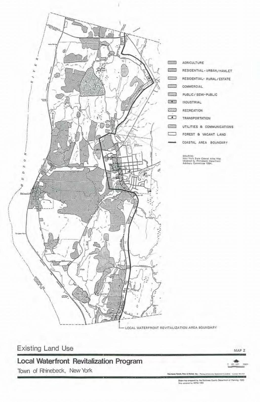
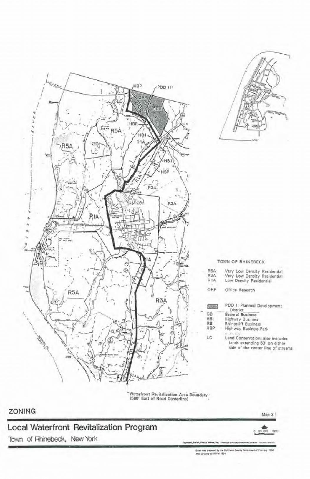


SECTION III - 3
SECTION IIILOCAL WATERFRONT REVITALIZATION PROGRAM POLICIESThe Policies Section is divided according to subject headings of the State Coastal Zone ManagementProgram. Each of the 44 policies included in the State Program is indicated by arabic numeral, e.g.1. Additional policies that are relevant to local conditions and/or can strengthen the basic policy bylocal actions are indicated by a capital letter following the arabic number, e.g. 1A. In some instances,the original State policy is not applicable to Rhinebeck and that statement is so indicated. However,all policies once included in the Town LWRP and determined to be applicable, whether of State orlocal origin, become Rhinebeck's policies.Policies respond to and identify solutions to issues that have been identified in Section II, Inventoryand Analysis. They may contain general statements, or they may be action- and/or location-specific.There will be a not less than tri-annual review of the LWRP by the Town Conservation AdvisoryCouncil in its role as Waterfront Advisory Committee to be certain that the policies remainapplicable to the Town.Following the policy statements are explanations of the policies and descriptions of criteria,standards or guidelines that will be used to evaluate compliance with a particular policy or policies.In general, Town decisions on public expenditures, land use decisions and review of privatedevelopment plans will be measured in terms of compliance with the various policies.In a number of instances where the basic policy covers local plans, projects or programs, the latterare incorporated into the explanation of how the policy is to be implemented.DEVELOPMENT POLICIESPOLICY 1 RESTORE, REVITALIZE, AND REDEVELOP DETERIORATED ANDUNDERUTILIZED WATERFRONT AREAS FOR COMMERCIAL,INDUSTRIAL, CULTURAL, RECREATIONAL, AND OTHERCOMPATIBLE USES.Explanation of PolicyThe Local Waterfront Revitalization Area (LWRA) in Rhinebeck is characterized as a historic,scenic, rural estate area paralleling the shore of the Hudson River which surrounds higher densityresidential and commercial uses centered in the hamlet of Rhinecliff and to the west of the Villageof Rhinebeck. This area, encompassing the western portions of the Town, has been established asco-terminus with the State-designated Mid-Hudson Historic Shorelands Scenic District. See Map 7.
SECTION III - 4
Improvements to the Rhinebeck Town Landing / Rhinecliff Dock facilities need to be continued andmaintenance tasks undertaken. Once completed, these facilities will serve as a riverfront park,providing recreational boating, ice boating, fishing, picnicking and scenic viewing opportunities forarea residents and opportunities for docking of cruise boats. Other coastal access points, such asSlate Dock and Long Dock, which currently have only on-grade crossing of the railroad tracks(which have been closed due to safety considerations), need to be further studied for re-utilizationand redevelopment possibilities. (See chart in Inventory for initial analysis of conditions, advantagesand disadvantages of sites and Map 6 for location of sites.) Use of portions of the abandoned railroadright-of-way which originates at the River in Rhinecliff and continues in a northeasterly directionfor hiking and/or biking trails needs to be further examined.In recent years and in some cases decades, some of the large estates and various waterfront parcelsand docks along the Hudson River have shown signs of deterioration because of neglect, highmaintenance cost and problems in crossing the tracks. Preservation and, in some cases,redevelopment of these properties is desirable and possible. In the case of Wilderstein, ownershipof the property has been transferred to a not-for-profit organization and a series of renovations hasbeen undertaken with both public and private funding. The restoration site is open to the public withuse of the mansion and landscaped grounds available to the public.The following guidelines will be used in evaluating development or redevelopment actions:1. Along the shoreline of the Town, priority should be given to uses which are compatible withthe historic and scenic character of the area and which are dependent on a location adjacent tothe water;2. The action should enhance existing and anticipated uses;3. Public action should, whenever possible, serve as a catalyst to private investment in the area;4. The action should improve the deteriorated condition of a site and, at a minimum, must notcause further deterioration (i.e. a building should not be abandoned without protecting itagainst vandalism and/or structural decline);5. The action must lead to development which is compatible with the character of the area, withconsideration given to scale, architectural style, density, and intensity of use;6. The action should have the potential to improve the existing economic base of the communityand, at a minimum, must not jeopardize this base;7. The action should improve adjacent and upland views of the water and shoreline, and, at aminimum, must not affect these views in an insensitive manner; and

SECTION III - 5
8. The action should have the potential or improve the potential for multiple uses of the site(particularly recreational uses).See Policies 19A, 20A, 22, 23 and 23A.POLICY 1A ENCOURAGE GROWTH OF THE TOURISM SECTOR OF THE TOWNECONOMY THROUGH: (1) REVITALIZATION, REDEVELOPMENT,PRESERVATION OR ENHANCEMENT OF AREAS AND STRUCTURESWITHIN THE WATERFRONT REVITALIZATION AREA / HISTORICSHORELAND SCENIC DISTRICT / ESTATES DISTRICT SCENIC AREAOF STATEWIDE SIGNIFICANCE AND (2) TAKING STEPS TO INFORMTHE PUBLIC OF EXISTING AREAS OF HISTORIC, SCENIC, ANDRECREATIONAL INTEREST.Explanation of PolicyEfforts to promote recreational fishing and boating, cultural activities, marinas, water-relatedrecreational facilities, historic preservation, natural resource preservation, the preservation of vistasand views, and other activities which will make the waterfront area vital for residential, commercialand recreational usage and appealing for tourists in appropriate locations will be pursued. This willbe accomplished through promoting the use of historic estates for cultural purposes, working withrailroad interests to secure access to Long Dock, Slate Dock and Morton's Dock, creative use of lowdensity zoning, clustering, and conservation easements.In addition, the development of tourist-related activities, such as shops, small offices and personalservice establishments, restaurants and bed and breakfast enterprises in the hamlet of Rhinecliff andRiver cruises and festivals at the Rhinebeck Town Dock, all at a limited scale, will be encouragedas a means of revitalizing these waterfront areas. Concurrently, accommodations for public parkingwill need to be enhanced or innovative solutions considered, such as development of additionalparking on CSX lands and the use of valet parking at a satellite lot, both as recently discussed as partof the on-going renovation proposal for the Rhinecliff Hotel.Tourism is a growing industry in the Town economy. A cultural resources map will be utilized toinform residents and visitors of local areas of historic scenic and recreational interest.See Policies 1, 2, 19A, 23, 23A, 24A, 24B.
SECTION III - 6
POLICY 2 FACILITATE THE SITING OF WATER-DEPENDENT USES ANDFACILITIES ON OR ADJACENT TO COASTAL WATERS.Explanation of PolicyAt this time, the primary water-dependent use in the LWRA is the Town Landing in Rhinecliff. Itis currently used by recreational boaters and fisherman, ice boaters, and also by commercialfishermen. While some cruise boats stop at the dock during summer months, its expanded routineuse by scheduled ferry service linking Rhinebeck, Kingston, Tivoli and other communities wouldbe on balance quite desirable provided recreational use opportunities there are not lost for the peopleof Rhinebeck. There are no retail commercial or industrial uses located adjacent to the River.The following uses and facilities are considered as water-dependent. All proposals will be examinedfor appropriateness in Rhinebeck.1. Uses which depend on the utilization of resources found in coastal waters (for example:fishing, mining of sand and gravel, aquaculture activities);2. Recreational activities which depend on access to coastal waters (for example: swimming,fishing, boating, wildlife viewing);3. Structures needed for navigational purposes (for example: dams, beacons, lighthouses);4. Flood and erosion protection structures (for example: breakwaters, bulkheads);5. Facilities needed to store and service boats and ships (for example: marinas, boat repair, boatconstruction yards);6. Scientific/educational activities which, by their nature, require access to coastal waters (forexample: certain meteorological and oceanographic activities); and7. Support facilities which are necessary for the successful functioning of permittedwater-dependent uses (for example: parking lots, snack bars, first aid stations, short-termstorage facilities). Though these uses must be near the given water-dependent use they shouldas much as possible, be sited inland from the dependent use rather than on the shore.Expanding the utilization and/or area of existing water-dependent uses and attracting additionalwater-dependent uses and activities that are consistent with Town planning objectives is a priority.See list of Hudson River "Coastal Access Points" in Section II which includes several sites that couldbe developed for water-related recreation purposes and/or public access including the Town Landingin Rhinecliff, Wilderstein Landing/Morton Dock, Slate Dock and Long Dock.

SECTION III - 7
Marinas, boat clubs, docks and boat ramps are, and will continue to be allowed, as special permituses in the R-1A and R-5A Districts.When reviewing subdivision proposals or site plans, the Planning Board or other agency of the Townwill carefully examine plans for development of waterfront sites and will negotiate for public accessto the water.The following guidelines will be utilized in promoting and facilitating compatible water-dependentuses:1. Water-dependent uses that are compatible with the natural and built environment and will notnegatively impact the natural, scenic or historic resources of the Town will be favored whenconsidering new developments.2. If, or when, publicly-owned property within the waterfront area becomes available for re-use,water-dependent uses will be considered first. Water-enhanced uses will be given secondpriority.3. Permit procedures for the development of water-dependent uses will be facilitated whenconsistent with planning objectives.4. Uses which are water-enhanced will be encouraged within the waterfront area, but not at theexpense of water-dependent uses.5. If there are no immediate demands for water-dependent uses within the waterfront area, butfuture demands are foreseeable, temporary non-water-dependent uses will be considered.In promoting water-dependent uses, the following kinds of actions will be considered:1. Favored treatment to areas for proposed compatible water-dependent uses with respect to useof public investment. Particular priority will be give to the construction and maintenance ofdocking facilities, roads, railroad facilities (including above-grade crossings), and publictransportation within areas appropriate for compatible water-dependent uses.2. Where areas suitable for water-dependent uses are publicly-owned, favored leasingarrangements will be considered for suitable or compatible water-dependent uses, ifappropriate.3. Where appropriate, consideration will be given to providing pursuant to applicable laws andregulations water-dependent uses with property tax abatements, loan guarantees, or loans atbelow market rates.

SECTION III - 8
4. Local planning and economic development agencies will work with the State to activelypromote suitable water-dependent uses on appropriate sites.5. Local agencies will work together with State and Federal agencies to streamline permittingprocedures that may be burdensome to compatible water-dependent uses.In addition to water-dependent uses, uses which are enhanced by a waterfront location should beencouraged to locate along the shore, though not at the expense of water-dependent uses. Awater-enhanced use is defined as a use that has no critical dependence on obtaining a waterfrontlocation, but the profitability of the use and/or the enjoyment level of the users would be increasedsignificantly if the use were adjacent to, or had visual access to, the waterfront. A restaurant whichuses good site design to take advantage of a waterfront view, and a golf course which incorporatesthe coastline into the course design, are two examples of water-enhanced uses.See Policies 1, 19A, 20A, 21, 21A, 22.POLICY 3 THE STATE COASTAL POLICY REGARDING THE DEVELOPMENTOF MAJOR PORTS IS NOT APPLICABLE TO THE TOWN OFRHINEBECK.Explanation of PolicyPolicy 3 is not applicable to the Town of Rhinebeck as the Town is not one of the identified majorports of New York State. POLICY 4 THE STATE COASTAL POLICY REGARDING THE STRENGTHENINGOF SMALL HARBORS IS NOT APPLICABLE TO THE TOWN OFRHINEBECK.Explanation of PolicyPolicy 4 is not applicable to the Town of Rhinebeck because the Town's waterfront does not contain a small harbor area as referred to in this policy. The town operates a short dock forsmall-scale recreational boating and provides a ramp for boat trailer access. POLICY 5 ENCOURAGE THE LOCATION OF DEVELOPMENT IN AREAS WHEREPUBLIC SERVICES AND FACILITIES ESSENTIAL TO SUCHDEVELOPMENT ARE ADEQUATE, EXCEPT WHEN SUCHDEVELOPMENT HAS SPECIAL FUNCTIONAL REQUIREMENTS OROTHER CHARACTERISTICS WHICH NECESSITATE ITS LOCATIONIN OTHER COASTAL AREAS.

SECTION III - 9
Explanation of PolicyDevelopment within the LWRA will be encouraged to locate within or in close proximity to areaswhere infrastructure and public services are adequate or can easily be expanded, and wheretopography, geology and other environmental conditions are suitable for, and able to, accommodatedevelopment. Specifically, the policy is intended to:1. Strengthen existing residential, industrial and commercial centers, as appropriate;2. Foster an orderly pattern of growth where outward expansion is occurring;3. Increase the productivity of existing public services and moderate the need to provide newpublic services in outlying areas;4. Preserve open space; and5. Where desirable, foster energy conservation by encouraging proximity between home, workand leisure activities.The hamlet of Rhinecliff has public water service, but is in need of a public sewage disposal system.The feasibility of extending the Village of Rhinebeck sewage system to Rhinecliff, or providing analternative means for sewage collection and treatment to meet the needs of the hamlet, has beenexplored in the past and continues to be discussed during the Town's on-going 2003 -2005Comprehensive Plan Update. Funding remains an obstacle to carrying out this improvement forprotection of the quality of surface waters which are used for public water supply. Those local, Stateand Federal agencies charged with allocating funds for investment in such facilities should give highpriority to these needs. (See Inventory Section on Utilities.)In general, the proposed land uses and current zoning in the waterfront area of the Town correspondto a desire to protect the natural features and historic and scenic assets, as well as to the availabilityor lack of availability of utilities. The bulk of the Town's waterfront area is zoned for very lowdensity uses where utility service does not exist and is unlikely to exist. In the hamlet of Rhinecliff,and within the corridor between the hamlet and the Village of Rhinebeck, medium density ispermitted reflecting the availability of water service.For any action that could result in large scale development or an action which would facilitate orserve future development, determination shall be made as to whether the action is within, contiguousto, or in close proximity to an area of concentrated development where infrastructure and publicservices are adequate.The following guidelines will be used in making this determination:1. The proposed site is served by, or is near to, public or private sewer and water lines;

SECTION III - 10
2. Public transportation service is available within one mile of the proposed site; and3. A cluster of commercial and/or industrial activity is within one-half mile of the proposed site.In reviewing proposed uses or actions, and when assessing the adequacy of infrastructure and publicservice for proposed developments, the following guidelines should be considered:1. Where water-dependent uses are to be located within portions of the waterfront area that arenot currently serviced or cannot easily be serviced, the type and intensity of such uses shall beconsistent with the capacity of the land to accommodate such use and the compatibility of theproposed project with the existing natural and built environment of the community.2. Utility systems constructed as part of new subdivisions or commercial projects must meetTown specifications for possible inclusion in future Town-wide water or sewer systems.3. Proposed development in waterfront areas shall be limited to levels that will not burden roadsor cause congestion or safety problems or require widening, substantial grading or re-alignmentof scenic roads.4. Energy needs of the proposed land development can be accommodated by existing utilitysystems.5. Storm water runoff from the proposed site can be accommodated by on-site and/or off-sitefacilities.6. Schools, police and fire protection, and health and social services are adequate to meet theneeds of the population expected to live, work, shop, or conduct business in the area as a resultof the development.Priority will be given in allocation of funds for water, sewer and roadway improvements and otherpublic services to activities which promote compatible waterfront revitalization, particularly in thehamlet of Rhinecliff.POLICY 6 EXPEDITE PERMIT PROCEDURES IN ORDER TO FACILITATE THESITING OF DEVELOPMENT ACTIVITIES AT SUITABLE LOCATIONS.Explanation of PolicyFor specific types of development activities, and in areas suitable for such development, the Townwill make every effort to coordinate and synchronize existing permit procedures and regulatoryprograms, and will work with Federal and State agencies to coordinate procedures as long as theintegrity of the regulations' objectives is not jeopardized. These procedures and programs will becoordinated within each agency. Also, efforts will be made to ensure that each board and agency's

SECTION III - 11
procedures and programs are synchronized with other agencies' procedures at each level ofgovernment. Finally, regulatory programs and procedures will be coordinated and synchronizedbetween levels of government, and if necessary, legislative and/or programmatic changes will berecommended.When proposing new regulations, an agency will determine the feasibility of incorporating theregulations within existing procedures, if this reduces the burden on a particular type of developmentand does not jeopardize the integrity of the regulations' objectives.FISH AND WILDLIFE POLICIESPOLICY 7 SIGNIFICANT COASTAL FISH AND WILDLIFE HABITATS, ASIDENTIFIED ON THE COASTAL AREA MAP, SHALL BE PROTECTED,PRESERVED, AND WHERE PRACTICABLE, RESTORED SO AS TOMAINTAIN THEIR VIABILITY AS HABITATS.Explanation of PolicyHabitat protection is recognized as fundamental to assuring the survival of fish and wildlifepopulations. Certain habitats are critical to the maintenance of a given population and, therefore,merit special protection. Such habitats exhibit one or more of the following characteristics: (1) areessential to the survival of a large portion of a particular fish or wildlife population (e.g. feedinggrounds, nursery areas); (2) support populations of rare and endangered species; (3) are found at avery low frequency within a coastal region; (4) support fish and wildlife populations havingsignificant commercial and/or recreational value; and (5) would be difficult or impossible to replace.A "habitat impairment test" must be met for any activity that is subject to consistency review underfederal and State laws, or under applicable local laws contained in an approved local waterfrontrevitalization program. If that proposed action is subject to consistency review, then the habitatprotection policy applies, whether the proposed action is to occur within or outside the designatedarea.The specific habitat impairment test that must be met is as follows:In order to protect and preserve a significant habitat, land and water uses or development shall notbe undertaken if such actions would either destroy the habitat or significantly impair the viability ofa habitat.For this purpose "habitat destruction" is defined as the loss of fish or wild life use through directphysical alteration, disturbance, or pollution of a designated area, or through the indirect effects ofthese actions on a designated area. Habitat destruction may be indicated by changes in vegetation,substrate, or hydrology, or increases in runoff, erosion, sedimentation, or pollutants.
SECTION III - 12
"Significant impairment" is defined as reduction in vital resources (e.g., food, shelter, living space)or change in environmental conditions (e.g., temperature, substrate, salinity) beyond the tolerancerange of an organism. Indicators of a significantly impaired habitat focus on ecological alterationsand may include, but are not limited to, reduced carrying capacity, changes in community structure(food chain relationships, species diversity), reduced productivity and/or increased incidence ofdisease and mortality.The "tolerance range" of an organism is not defined as the physiological range of conditions beyondwhich a species will not survive at all, but as the ecological range of conditions that supports thespecies' population or has the potential to support a restored population, where practical. Either theloss of individuals through an increase in emigration or an increase in death rate indicates that thetolerance range of an organism has been exceeded. An abrupt increase in death rate may occur as anenvironmental factor falls beyond a tolerance limit (a range has both upper and lower limits). Manyenvironmental factors, however, do not have a sharply defined tolerance limit, but produceincreasing emigration of death rates with increasing departure from conditions that are optimal forthe species.The range parameters which should be considered in applying the habitat impairment test include:1. Physical parameters, such as living space circulation, flushing rates, tidal amplitude, turbidity,water temperature, depth (including loss of littoral zone), morphology, substrate type,vegetation, structure, erosion and sedimentation rates;2. Biological parameters, such as community structure, food chain relationships, species diversity,predator/prey relationships, population size, mortality rates, reproductive rates, behavioralpatterns and migratory patterns; and3. Chemical parameters, such as dissolved oxygen, carbon dioxide, acidity, dissolved solids,nutrients, organics, salinity, and pollutants (heavy metals, toxics and hazardous materials).Significant coastal fish and wildlife habitats are evaluated, designated and mapped pursuant to theWaterfront Revitalization of Coastal Areas and Inland Waterways Act (Executive Law of New York,Article 42). The New York State Department of Environmental Conservation (DEC) evaluates thesignificance of coastal fish and wildlife habitats, and following a recommendation from the DEC,the Department of State designates and maps specific areas, three of which (Vanderburgh Cove andShallows, Kingston Deepwater Habitat, and The Flats) lie within the Rhinebeck LWRA and aresubject of below Policies 7A, 7B and 7C, with a fourth, Rondout Creek Habitat, found along theopposite westerly shore of the Hudson within the City of Kingston and Town of Ulster.
SECTION III - 13
POLICY 7A THE VANDERBURGH COVE AND SHALLOWS HABITAT SHALL BEPROTECTED, PRESERVED AND, WHERE PRACTICAL, RESTORED SOAS TO MAINTAIN ITS VIABILITY AS A HABITAT.Any activity that would substantially degrade water quality in Vanderburgh Cove and Shallows couldaffect the biological productivity of this area. All species of fish and wildlife may be adverselyaffected by water pollution, such as chemical contamination (including food chain effects), oil spills,excessive turbidity or sedimentation, and waste disposal. Continued efforts should be made toimprove water quality in the Hudson River, primarily by controlling discharges from combinedsewer overflows. The use of herbicides along the railroad right-of-way or adjacent uplands mayresult in adverse impacts on the fish and wildlife resources of the area. Alteration of tidal fluctuationsin Vanderburgh Cove and Shallows could have significant impacts on fish and wild life; increasedtidal exchange may improve habitat quality in the cove. During the early 1980's, a railroad bridgeopening to the cove was made smaller, and this may have had detrimental effects. Disruption ofnatural plant communities or benthos in the area could reduce its value as a fish and wildlife habitat,although control of water chestnut may be desirable or necessary to maintain certain species. Anyphysical disturbance of the habitat, through dredging or filling (including dredge spoil disposal),would result in a direct loss of valuable habitat area; any dredging activities needed to maintain theexisting channel should be scheduled in mid to late summer to minimize potential impacts on mostaquatic organisms and migratory birds. Thermal discharges, depending on time of year, may havevariable effects on use of the area by aquatic species and wintering waterfowl; fish spawningactivities and survival are often directly affected by water temperature. Installation and operation ofwater intakes could have significant impacts on fish concentrates, through impingement of juvenilesand adults, or entrainment of eggs and larval stages. Significant human encroachment into adjacentareas may limit use of Vanderburgh and Suckley Coves by certain species, but potential impacts maybe mitigated somewhat by controlling soil erosion and discharges of polluted runoff. Existing areasof natural vegetation bordering Vanderburgh Cove and Shallows should be maintained for theirvalue as cover, perch sites, and buffer zones. Enhancement of public access to increase compatiblehuman uses of fish and wildlife resources in the area may be desirable.POLICY 7B THE KINGSTON DEEPWATER HABITAT SHALL BE PROTECTED,PRESERVED AND, WHERE PRACTICAL, RESTORED SO AS TOMAINTAIN ITS VIABILITY AS A HABITAT.Activities that could affect the water quality, temperature, turbidity or freshwater to salinedistribution in the deepwater portions of the river may adversely impact on the estuarine community.Major reduction in overall depths within this deepwater trench may also have adverse effects on thesturgeon spawning, wintering, and continued use of the habitat. Deposition of dredged material ornatural sediments, especially if contaminated, may degrade the quality of this unusual area.POLICY 7C THE FLATS HABITAT SHALL BE PROTECTED, PRESERVED AND,WHERE PRACTICAL, RESTORED SO AS TO MAINTAIN ITSVIABILITY AS A HABITAT.
SECTION III - 14
Any activity that would substantially degrade water quality in the Flats could affect the biologicalproductivity of this area. All species of fish and wildlife may be adversely affected by waterpollution, such as chemical contamination (including food chain effects), oil spills, excessiveturbidity or sedimentation, and waste disposal. Continued efforts should be made to improve waterquality in the Hudson River, which is primarily dependent upon controlling discharges fromcombined sewer overflows, industrial point sources, and ships. Oil and other hazardous substancespills are an especially significant threat to this area, because the biological activity of tidal flats isconcentrated at the soil surface, much of which may be directly exposed to these pollutants.Disruption of plant communities or benthos in the area through dredging or filling (including dredgespoil disposal), could reduce its value as a fish and wildlife habitat; no new navigation channelsshould be cut through the area. Thermal discharges, depending on time of year, may have variableeffects on use of the area by aquatic species; shad spawning activities and survival are directlyaffected by water temperature. Installation and operation of water intakes could have significantimpacts on fish populations in the area, through impingement of juvenile and adult fish, orentrainment of eggs and larval stages.Other locally important coastal habitats identified in Policies 7D and E shall be protected, preservedand, where practical, restored so as to maintain their viability as habitat areas.See Policies 8, 9, 12, 17, 30, 34, 35, 36, 37, 44.POLICY 7D SUPPORT EFFORTS TO PROTECT AND ENHANCE THE NATURALRESOURCES OF FERNCLIFF FOREST, SNYDER SWAMP AND THEMUDDER KILL.POLICY 7E PROTECT THE CREEKS, FRESHWATER TIDAL WETLANDS, ANDFRESHWATER TIDAL COVE AREAS DRAINING INTO ANDADJACENT TO THE HUDSON RIVER FROM ALTERATION AND/ORPOLLUTANT DISCHARGE BY RESIDENTIAL, COMMERCIAL,AGRICULTURAL OR INDUSTRIAL USES.The Landsman Kill and Rhinebeck Kill which join and flow into Vanderburgh Cove (a StateDEC-designated habitat area), as does the Fallsburg Creek, must be protected. These creeks containa variety of fresh water fish and the Landsman Kill is regularly stocked with trout. TheSuckley-Vanderburgh freshwater-tidal cove area is considered a significant habitat of local andregional importance because of its size, uniqueness and relatively unspoiled estuarine condition. Itis important to spawning and feeding fish and migrating ducks and serves as an osprey feeding area.It is used by marsh wrens, herons, and egrets in the late summer. The Astor Cove and Slate DockCove areas, as well as other freshwater-tidal cove areas of the Town that need to be protected areincluded on Map 5, "Coves / Freshwater – Tidal Wetland Areas", in the Environmental Featureschapter of the Inventory and Analysis Section.

SECTION III - 15
Ferncliff Forest, with its stands of mature hardwood trees with scattered white pine and hemlockgroves is an area of local and county-wide significance. Ferncliff Forest is part of a larger ecologicalarea with Snyder Swamp, a freshwater wetland area, and the Mudder Kill, which flows in a northerlydirection. These wooded, pond, wetland and stream areas must be preserved as animal and birdhabitat areas (cerulean warblers are among the significant bird populations that utilize this area), aswell as for local recreational purposes (see Inventory and Analysis Section). (The Ferncliff Forestarea has extensively used trails for hiking and horseback riding. The lookout tower, if it could berebuilt, at the top of Mount Rutsen in the forest area would provide significant opportunities forviewing scenic vistas.)Protection will be achieved through application of a combination of implementation tools, including:strict enforcement of wetland regulations; clustered development; limited to low density residentialzoning within the R5A and R3A District classifications; protection of streams through the LandConservation (LC) District's limitation on development within 75 feet from each side of a stream;a Water Resources Protection Overlay (WRP-O) District, which serves as an expansion of the LandConservation District to include such areas as Snyder Swamp and the Millpond area, as well asHudson River shoreline areas, including wetlands and bluffs; preservation of open space areasthrough conservation easements held by non-profit preservation groups; and through environmentalquality review, special use permit review (for all development within 100 feet of the normalstreambank of a classified stream or NYSDEC Freshwater Wetland) and site plan review todetermine that any proposed development will not be inconsistent with habitat protection.In addition, the Town has requested that DEC upgrade the classification of these streams -- theLandsman Kill to "B(T)", the Rhinebeck Kill to "C(T)", the Fallsburgh Creek to "C(T)", and theMudder Kill to "C" -- in order to protect and, if possible, improve the water quality. A "B(T)"classification would further protect the Landsman Kill by extending coverage under the NYS StreamProtection Act (ECL Article 15). Moreover, in an attempt to preserve the existing habitats andencourage fish and wildlife reproduction in and near the creeks and the River, the water qualitylevels in Rhinebeck will be maintained and improved, if possible. Dumping into the creeks, kills andriver are prohibited. Adequate sewage and storm water facilities will be maintained and expandedfacilities will be installed where necessary to support new development.Moreover, the Town's Conservation Advisory Council (CAC) has recently undertaken training andis pursuing a project in bio-diversity study and associated mapping of the entire Town, including theLWRA, which will assist both project sponsors and the local boards in evaluating ecological andenvironmental impact of proposed development. POLICY 8 PROTECT FISH AND WILDLIFE RESOURCES IN THE COASTAL AREAFROM THE INTRODUCTION OF HAZARDOUS WASTES AND OTHERPOLLUTANTS WHICH BIO-ACCUMULATE IN THE FOOD CHAIN ORWHICH CAUSE SIGNIFICANT SUBLETHAL OR LETHAL EFFECTS ONTHOSE RESOURCES.
SECTION III - 16
Explanation of PolicyHazardous wastes are unwanted by-products of manufacturing processes and are generallycharacterized as being flammable, corrosive, reactive, or toxic. More specifically, hazardous wasteis defined in Environmental Conservation Law [Section 27-0901(3)] as "waste or combination ofwastes which because of its quantity, concentration, or physical, chemical or infectiouscharacteristics may: (1) cause, or significantly contribute to, an increase in mortality or an increasein serious irreversible, or incapacitating reversible illness; or (2) pose a substantial present orpotential hazard to human health or the environment when improperly treated, stored, transported,disposed or otherwise managed." A list of DEC-defined hazardous wastes can be found in 6NYCRRPart 371.The handling (storage, transport, treatment and disposal) of the materials included on the hazardouswaste list is being strictly regulated in New York State to prevent their entry or introduction into theenvironment, particularly into the State's air, land and waters. Such controls should effectivelyminimize possible contamination of, and bio-accumulation in, the State's coastal fish and wildliferesources at levels that cause mortality or create physiological and behavioral disorders.Other pollutants refer to conventional wastes generated from point and non-point sources which arenot identified as hazardous wastes, but which also cause physiological or behavioral effects andmortality of fish and wildlife. Such pollutants are also controlled by State regulations.Fish and wildlife resources in the Hudson River (source of drinking water for the Village ofRhinebeck and hamlet of Rhinecliff and significant fish habitat and spawning area), as well as inTown creeks need to be protected. Monitoring of streams, the former Town landfill, and any otherlandfill sites will be used to identify pollutants from existing or prior uses. Zoning, land use controls,and site plan review procedures will be used to avoid the siting of uses within the waterfront areathat could introduce hazardous wastes into air, ground and surface waters or other features of theenvironment and threaten fish, bird and wildlife resources, or could be directly or indirectly toxicor dangerous to humans. Any development proposed in the waterfront area must incorporate properdisposal plans to avoid ground and/or surface water pollution that could accumulate in the foodchain.See Policies 7A, 7C, 30, 33, 34, 36, 37, 39, 40.POLICY 9 EXPAND RECREATIONAL USE OF FISH AND WILDLIFE RESOURCESIN COASTAL AREAS BY INCREASING ACCESS TO EXISTINGRESOURCES, SUPPLEMENTING EXISTING STOCKS, ANDDEVELOPING NEW RESOURCES. SUCH EFFORTS SHALL BE MADEIN A MANNER WHICH ENSURES THE PROTECTION OF RENEWABLEFISH AND WILD-LIFE RESOURCES AND CONSIDERS OTHERACTIVITIES DEPENDENT ON THEM.
SECTION III - 17
Explanation of PolicyRecreational uses of coastal fish and wildlife resources include consumptive uses, such as fishingand hunting, and non-consumptive uses, such as wildlife photography, bird watching and naturestudy. Any efforts to increase recreational usage of these resources in or along Rhinebeck's creeks,cove areas and Hudson River shoreline must be made in a manner which does not negatively affectexisting resources or activities. (See sub-sections on Water-Related Uses and Coastal Access Pointsin the Inventory and Analysis Section.) Such efforts must be done in accordance with existing Statelaw and in keeping with sound management practices. Consideration of proposed actions willinclude evaluation of information on the biology of an affected species, the carrying capacity of theresources, public demand, costs and available technology.The following additional guidelines shall be utilized to determine whether or not any proposed actionis consistent with this policy:1. Consideration shall be made as to whether an action will harm or impede existing or futureutilization of Town recreational fish and wildlife resources.2. Efforts to increase access to recreational fish and wildlife resources shall not lead toover-utilization of that resource or cause impairment of the habitat. Sometimes, suchimpairment can be more subtle than actual physical damage to the habitat. For example,increased human presence can deter animals from using the habitat area.3. The impacts of increasing access to recreational fish and wildlife resources shall be determinedon a case-by-case basis, consulting the significant habitat narrative (see Policy 7) and/orconferring with a trained fish and wildlife biologist.4. Any public or private sector initiatives to supplement existing stocks (e.g., stocking theLandsman Kill or other stream with fish reared in a hatchery) or develop new resources (e.g.,creating private fee-hunting or fee-fishing facilities) shall be continued or expanded in accordwith existing State and local laws.Finally, Town recommendations to DEC to upgrade classification of streams should result inmaintaining or improving water quality, and thus in maintaining or increasing the supply of fish forrecreational uses.See Policies 1, 7A, 19, 19A, 20, 21, 21A, 22 and 31.POLICY 10 FURTHER DEVELOP COMMERCIAL FINFISH, SHELLFISH, ANDCRUSTACEAN RESOURCES IN THE COASTAL AREA BY: (1)ENCOURAGING THE CONSTRUCTION OF NEW, OR IMPROVEMENTOF EXISTING ON-SHORE COMMERCIAL FISHING FACILITIES; (2)INCREASING MARKETING OF THE STATE'S SEAFOOD PRODUCTS;
SECTION III - 18
AND (3) MAINTAINING ADEQUATE STOCKS AND EXPANDINGAQUACULTURE FACILITIES. SUCH EFFORTS SHALL BE IN AMANNER WHICH ENSURES THE PROTECTION OF SUCHRENEWABLE FISH RESOURCES AND CONSIDERS OTHERACTIVITIES DEPENDENT ON THEM.Explanation of PolicyThe renovation of the Town Dock facilities in Rhinecliff may in the future provide some opportunityand impetus to increasing commercial fishing in the Town, which is currently limited by the fact thatthere is only one species, the shad, that is commercially caught and legally sold (PCB concentrationslimit sales of other species such as striped bass), and by the fact that there are limited dockingfacilities and some waning of interest by Hudson River east bank fishermen. Significant shellfish andcrustacean resources are not indigenous to the area and there are currently no aquaculture activitiesor facilities in the Town. Moreover, as any new marina facilities may be proposed, facilities fordocking and servicing commercial fishing vessels will be encouraged. In addition, on-landaquaculture activities could be considered, if the operation would be compatible with existing uses.Any commercial fishery development activities must occur within the context of sound fisheriesmanagement principles developed and enforced within the State's waters by the New York StateDepartment of Environmental Conservation.Sound resource management considerations include optimum sustained yield levels developed forspecific commercial fish species, harvest restrictions imposed by State and Federal governments, andthe economic/political (use conflicts), and technological constraints to utilizing these resources.The following additional guidelines should be considered in determining the consistency of aproposed action with the policy:1. A public agency's commercial fishing development initiative should not pre-empt or displaceprivate sector initiative.2. A public agency's efforts to expand existing or create new on-shore commercial fishing supportfacilities should be directed towards unmet development needs rather than merely displacingexisting commercial fishing activities from a nearby port.3. An action should not impede existing utilization or future development of the State'scommercial fishing resources.4. Commercial fishing development efforts should be made in a manner which ensures themaintenance and protection of the renewable fishery resources.See Policy 21A.
SECTION III - 19
FLOODING AND EROSION HAZARDS POLICIESPOLICY 11 BUILDING AND OTHER STRUCTURES WILL BE SITED INTHECOASTAL AREA SO AS TO MINIMIZEDAMAGE TO PROPERTYAND THE ENDANGERING OF HUMAN LIVES CAUSED BY FLOODINGAND EROSION.Explanation of PolicyThe erosion aspects of this policy are not applicable, since there are no identified Coastal ErosionHazard Areas within the Rhinebeck Waterfront Revitalization Area.The Town participates in the National Flood Insurance Program. The flood hazard areas for 100 yearfloods in the Town of Rhinebeck, as defined in the Flood Insurance Rate Map (FIRM) prepared bythe Federal Emergency Management Agency include the tidal cove areas along the Hudson River,as well as areas surrounding the Rhinebeck Kill, the Landsman Kill and the Fallsburg Creek, alldraining southwestward toward the River. In the northern part of the Town, Snyder Swamp withwaters flowing into the Mudder Kill is also in a 100 year flood zone.In the future, there will be some enlargement of the flood areas of the Town, since the mean floodlevel of the Hudson River and its bays, coves and tributaries is rising.Development within the flood hazard areas of the Town indicated above shall be restricted asfollows:1. Building or other structures along the stream banks and river banks (where there are no bluffs)will be setback at least 75 feet to avoid dangers of flooding and of construction on clay soilssubject to erosion. Where bluffs exist along the Hudson River, greater setback will be required(see below).2. All new construction and substantial improvement of residential and non-residentialdevelopment shall have the lowest floor, including basement, elevated to the level of the baseflood elevation and/or shall have flood proofing of non-residential structures.3. Development along streams in the Town is limited within 75 feet of each side of a stream'smean high water mark in the Land Conservation (LC) District and 100 feet thereof under thestandards set forth for the Water Resources Protection Overlay (WRP-O) District.Stream bank erosion from tidal action or navigation on the Hudson River is considered a moderateproblem at this time. Strong bulkheading has been required at the Town Landing to combat waveaction and winter ice. The fact that the railroad has elevated the tracks along the River and maintainsits railbed lessens tidal erosion impacts on nearby areas. However, the sloping to steep banks along
SECTION III - 20
the River are subject to slumping and need to be protected, especially the area near Suckley Cove,north of Jones Island, which is considered an area of critical erosion.Vegetation needs to be maintained along the sloping banks. In some cases, a grass surface that canaccommodate run-off without erosion can be utilized for relatively small areas. In most cases, theexisting forested conditions should be continued wherever slopes are over 10%, up to the 100 footcontour, or for a distance of 200 feet inland.Selective trimming can be utilized to maintain or recreate viewing areas.See Policies 12, 14, 17.POLICY 12 ACTIVITIES OR DEVELOPMENT IN THE COASTAL AREA WILL BEUNDERTAKEN SO AS TO MINIMIZE DAMAGE TO NATURALRESOURCES AND PROPERTY FROM FLOODING AND EROSION BYPROTECTING NATURAL PROTECTIVE FEATURES INCLUDINGBEACHES, DUNES, BARRIER ISLANDS AND BLUFFS. PRIMARYDUNES WILL BE PROTECTED FROM ALL ENCROACHMENTS THATCOULD IMPAIR THEIR NATURAL PROTECTIVE CAPACITY.Explanation of PolicyBeaches, dunes and barrier islands, as such, are not found along the Hudson in the Town.Bluffs, wetlands (including tidal shallow and mudflats) and other natural protective features helpsafeguard coastal lands and property from damage, as well as reduce the danger to human life,resulting from flooding and erosion. A bluff is an earthen bank with a precipitous or rounded faceadjoining a beach or body of water. Where there is no beach present (which is the case in Rhinebeck)the waterward limit is the mean low water of the Hudson River. The landward limit is 25 feetlandward of the receding edge. The shoreline areas in Rhinebeck that rise from the River include:(1) areas of exposed bedrock, e.g. near the Kingston-Rhinecliff Bridge (Route 199) in thenorthwestern portion of the waterfront area, Clifton Point, near the hamlet of Rhinecliff, and in thearea of Sturgeon Cliffs, and (2) areas of mixed clay and sand that form gently-to-steeply slopingbluffs which are subject to erosion. Wetlands are discussed in Policy 44.Excavation of coastal features, improperly designed structures, inadequate site planning, or othersimilar actions which fail to recognize their fragile nature and high protective values, lead to theweakening or destruction of those landforms. Activities of development in, or in proximity to,natural protective features must ensure that any adverse actions are avoided or eliminated.Many portions of the Town are subject to flooding; other portions of the Town, particularly alongthe Hudson shore, are subject to erosion of slopes and exacerbation of dangerous slump areas.Development of large estates along the riverfront, use of land for agricultural purposes, the

SECTION III - 21
availability of sufficient amounts of vacant, more easily buildable land, use of very low densityresidential or land conservation zoning along creeks, as well as limited development pressures, allhave helped to preserve the bulk of such flood and erosion-prone areas in their natural state.However, as further development is proposed, the issue of preservation of natural features to avoidflooding and erosion hazards needs to be considered during site plan and subdivision review. Whereappropriate, development will be clustered away from sensitive areas. Maintenance of existingvegetation, setbacks of at least 50 feet from the streams, bluffs, and erosion prone clay soils will berequired and excavation and grading of riverbank areas will not be permitted.See Policies 1, 2, 11, 16, 17, 44.POLICY 13 THE CONSTRUCTION OR RECONSTRUCTION OF EROSIONPROTECTION STRUCTURES SHALL BE UNDERTAKEN ONLY IFTHEY HAVE A REASONABLE PROBABILITY OF CONTROLLINGEROSION FOR AT LEAST THIRTY YEARS AS DEMONSTRATED INDESIGN AND CONSTRUCTION STANDARDS AND/OR ASSUREDMAINTENANCE OR REPLACEMENT PROGRAMS.Explanation of PolicySince no Coastal Erosion Hazard Areas have been designated within the Town, this policy haslimited applicability for Rhinebeck.This policy will help ensure the reduction of damage or loss from erosion protection structures (suchas bulkheads that might be used for docks or other water-related uses) that because of improperdesign, construction and maintenance standards fail to give the protection which they are presumedto provide. If proposed as part of development or redevelopment of a parcel, the Town PlanningBoard and/or other agencies will examine proposed structures through site plan and subdivisionreview processes. Otherwise, permit reviews will be consistent with this policy.Within waters under Rhinebeck's jurisdiction, no person may construct or alter any erosionprotection structures without providing:1. Plans and the detailed explanation necessary to determine exactly what is proposed.2. Evidence that the structure is not likely to fail and become a danger or obstruction tonavigation.3. Evidence that the structure will effectively control erosion for at least 30 years or that amaintenance program will be undertaken to ensure its continuation for that period.See Policies 1, 2, 14, 16, 19A, 21A.
SECTION III - 22
POLICY 14 ACTIVITIES AND DEVELOPMENT, INCLUDING THE CONSTRUCTIONOR RECONSTRUCTION OF EROSION PROTECTION STRUCTURES,SHALL BE UNDERTAKEN SO THAT THERE WILL BE NOMEASURABLE INCREASE IN EROSION OR FLOODING AT THE SITEOF SUCH ACTIVITIES OR DEVELOPMENT, OR AT OTHERLOCATIONS.Explanation of PolicyErosion and flooding are processes which occur naturally. However, by his actions, man can increasethe severity and adverse effects of those processes, causing damage to, or loss of property, andendangering human lives. Those actions include: the use of erosion protection structures such asgroins, jetties and bulkheads, or the use of impermeable docks which block the littoral transport ofsediment to the adjacent shorelands, thus increasing their rate of recession; and the failure to observeproper drainage or land restoration practices, thereby causing run-off and the erosion and weakeningof the shorelands.Site plan review, subdivision review and permit review will be used to monitor projects anddevelopments to ensure that actions will not be taken which may result in the damage to or loss ofproperty and endangerment of human lives. Developments along the river bank will be sited to avoidconstruction on clay soils and soils subject to erosion, and the following practices will be utilizedfor construction in the waterfront area:1. Any proposed development shall conform with existing geological and topographic features,to the end that the most appropriate use of land is encouraged.2. Any proposed development shall be so designed as to provide for proper surface watermanagement through a system of controlled drainage that preserves existing drainage patternsand protects other properties. See Policies 1, 2, 11, 12, 13, 16, 21A and 21B.POLICY 15 MINING, EXCAVATION OR DREDGING IN COASTAL WATERS SHALLNOT SIGNIFICANTLY INTERFERE WITH THE NATURAL COASTALPROCESSES WHICH SUPPLY BEACH MATERIALS TO LANDADJACENT OF SUCH WATERS AND SHALL BE UNDER-TAKEN IN AMANNER WHICH WILL NOT CAUSE AN INCREASE IN EROSION OFSUCH LAND.Explanation of PolicyCoastal processes, including the movement of beach materials or shoreline sediment by water, andany mining, excavation or dredging in near-shore or offshore waters changing the supply and net
SECTION III - 23
flow of such materials can deprive shorelands of their natural regenerative powers. Such mining,excavation and dredging should be accomplished in a manner so as not to cause a reduction ofsupply, and thus an increase of erosion, to such shorelands.Off-shore mining for sand and gravel deposits is a future alternative option to land mining for sandand gravel deposits which are needed to support building and other industries.At the present time there are no dredging, mining or excavation activities in Rhinebeck's waters.Moreover, there are no sites in the Town suitable for the deposit of dredge spoils nor are commercialexcavation and/or soil mining authorized under the Town's Zoning Law within either the R5A or LCDistricts which comprise the most extensive land areas within the LWRA. Any dredging, excavationor mining activities will be accomplished in a manner that will not increase erosion or negativelyaffect significant habitat areas. All applicants for any such activity must receive permits from theArmy Corps of Engineers and NYSDEC, which can only be issued if consistent with the LWRP.See Policy 35.POLICY 16 PUBLIC FUNDS SHALL ONLY BE USED FOR EROSION PROTECTIVESTRUCTURES WHERE NECESSARY TO PROTECT HUMAN LIFE, ANDNEW DEVELOPMENT WHICH REQUIRES A LOCATION WITHIN ORADJACENT TO AN EROSION HAZARD AREA TO BE ABLE TOFUNCTION, OR EXISTING DEVELOPMENT; AND ONLY WHERE THEPUBLIC BENEFITS OUTWEIGH THE LONG-TERM MONETARY ANDOTHER COSTS INCLUDING THE POTENTIAL FOR INCREASINGEROSION AND ADVERSE EFFECTS ON NATURAL PROTECTIVEFEATURES.Explanation of PolicyThis policy recognizes the public need for the protection of human life and existing investments indevelopment and for new development which may require a location in proximity to the waterfrontarea or in adjacent waters to be able to function. However, it also recognizes the potential adverseimpacts of such activities on the rate of erosion and on natural protective features. It requires thatcareful analysis be made of such benefits and long-term costs prior to expending public funds forerosion protection measures.See Policies 1, 2, 17, 19A, 21A.POLICY 17 WHENEVER POSSIBLE, USE NON-STRUCTURAL MEASURES TOMINIMIZE DAMAGE TO NATURAL RESOURCES AND PROPERTYFROM FLOODING AND EROSION. SUCH MEASURES SHALLINCLUDE: (1) THE SET BACK OF BUILDINGS AND STRUCTURES; (2)THE PLANTING OF VEGETATION AND THE INSTALLATION OF
SECTION III - 24
SAND FENCING AND DRAINING; (3) THE RESHAPING OF BLUFFS;AND (4) THE FLOOD-PROOFING OF BUILDINGS OR THEIRELEVATION ABOVE THE BASE FLOOD LEVEL.Explanation of PolicyThis policy recognizes both the potential adverse impacts of flooding and erosion upon developmentand upon natural protective features in the coastal area, as well as the costs of protection againstthose hazards which structural measures entail.Non-structural measures shall include, but not be limited to:1. The setbacks of buildings from steep riverbank and streambank areas;2. The strengthening of coastal landforms by the retention or planting of appropriate vegetationand, where appropriate, by the installation of drainage systems to reduce runoff and internalseepage of waters which erode or weaken the landforms;3. Whenever possible, the avoidance of risk or damage from flooding by the siting of buildingsoutside the hazard area; and4. The flood-proofing of buildings or their elevation above the base flood level.The installation of sand fencing, however, would generally not be appropriate for the Hudson Rivershoreline at Rhinebeck.This policy shall apply to the planning, siting and design of proposed activities and development,including measures to protect existing activities and development. To find out whether or not anaction is consistent with the policy, it must be determined if any one, or a combination of,non-structural measures would appropriately protect both the character and purpose of the activityor development, and eliminate or reduce hazards. If non-structural measures are determined to offersufficient protection, then consistency with the policy would require the use of such measures,whenever possible.In determining whether or not non-structural measures to protect against erosion or flooding willoffer appropriate protection, an analysis, and if necessary, other materials such as plans or sketchesof the activity or development, of the site and of the alternative protection measures should beprepared to allow an assessment to be made.The sloping to steep earthen banks along the Hudson River are subject to land slides and erosion.These areas, and particularly the area near Suckley Cove, north of Jones Island, which is classifiedas an area of critical erosion, must be protected through site plan and/or subdivision review. See Policies 1, 2, 11, 12, 14, 16, 21A, 22.
SECTION III - 25
GENERAL POLICYPOLICY 18 TO SAFEGUARD THE VITAL ECONOMIC, SOCIAL ANDENVIRONMENTAL INTERESTS OF THE STATE AND OF ITSCITIZENS, PROPOSED MAJOR ACTIONS IN THE COASTAL AREAMUST GIVE FULL CONSIDERATION TO THOSE INTERESTS, AND TOTHE SAFEGUARDS WHICH THE STATE HAS ESTABLISHED TOPROTECT VALUABLE COASTAL RESOURCE AREAS.Explanation of PolicyProposed major actions may only be undertaken in the waterfront area if they will not significantlyimpair valuable coastal waters and natural, cultural, scenic, historic, resources. Proposed actionsmust take into account the social, cultural, economic and environmental interests of the State andTown and its citizens in such matters that would affect natural resources, historic and scenic assets,water levels and flows, shoreline damage, hydro-electric power generation, and recreation. Anyproposals to develop a power generating plant or major transmission lines, to withdraw water fromthe Hudson, or to construct a bridge across the Hudson, a limited access highway, an enlargementof the railroad right-of-way or operations, or to begin any other major project within the LWRA ofthe Town of Rhinebeck, adjacent towns or nearby areas, including the west bank of the Hudson,must be thoroughly examined to determine that there will be no significant negative impacts on theTown's residents or resources. All local agencies and the Waterfront Advisory Committee will abideby this policy in their environmental review of major activities.PUBLIC ACCESS POLICIESPOLICY 19 PROTECT, MAINTAIN, AND INCREASE THE LEVEL AND TYPES OFACCESS TO PUBLIC WATER-RELATED RECREATION RESOURCESAND FACILITIES SO THAT THESE RESOURCES AND FACILITIESMAY BE FULLY UTILIZED IN ACCORDANCE WITH REASONABLYANTICIPATED PUBLIC RECREATION NEEDS AND THE PROTECTIONOF HISTORIC AND NATURAL RESOURCES. IN PROVIDING SUCHACCESS, PRIORITY SHALL BE GIVEN TO PUBLIC BEACHES,BOATING FACILITIES, FISHING AREAS AND WATERFRONT PARKS.Explanation of PolicyIt is important in the Town to protect, maintain and increase pedestrian and, where appropriate,vehicular access to public water-related recreation resources and facilities, including opportunitiesfor swimming, boating (including excursion boats and ice boats), fishing and appreciation of scenicvistas. The major access problem in Rhinebeck involves crossing of the railroad tracks. The onlypublic above-grade crossing (excluding the Kingston-Rhinecliff Bridge which takes travelers beyondthe Rhinebeck shores) is located within the hamlet of Rhinecliff and has been a focus of Town

SECTION III - 26
rehabilitation and improvement efforts for the past two to three decades. The private bridge at theMeadows provides the only other vehicular bridge in the Town. Currently at-grade crossing of therailroad tracks is required to reach Wilderstein Landing / Morton Dock, Long Dock, Slate Dock, andmost of the Town's other potential waterfront areas. Improved access could be accomplished in thefuture by public, private or a combination of efforts.This policy calls for a balance among the following factors: the level of access to a resource orfacility; the capacity of a resource or facility; and the protection of natural resources.The following guidelines will be used in determining the consistency of a proposed action with thispolicy.1. The existing access from public lands or facilities to public water-related resources andfacilities shall neither be reduced, nor should the possibility of increasing access in the futurefrom public lands or facilities to public water-related recreation resources and facilities beeliminated, unless there is a significant threat to public safety from a current or proposed use.2. Any proposed project to increase public access to public water-related recreation resources andfacilities shall be analyzed according to the following factors:a. The level of access to be provided should be in accord with estimated public use.b. The level of access to be provided shall not cause a degree of use which would exceedthe physical capability of the resource of facility.c. The level or type of use shall be conditioned on the requirements of public safety.3. A State or Federal agency will not undertake or fund any project which increases access to awater-related resource or facility that is not open to all members of the public.4. The following activities will not be permitted unless the actions are found necessary for, or tobe of great benefit to, or for the common good of Town residents.a. Construction of public facilities which physically prevent the provision of convenientpublic access to public water-related recreation resources and facilities.b. Construction of private facilities which physically prevent the provision of convenientpublic access to public water-related recreation resources or facilities from public landsand facilities.c. Sale, lease, or other transfer of public lands that could provide public access to a publicwater-related recreation or facility.

SECTION III - 27
5. In their plans and programs for increasing public access to public water-related resources andfacilities, State agencies shall give priority in the following order to projects located: withinthe boundaries of the Federal-Aid Metropolitan Urban Area and served by publictransportation; within the boundaries of the Federal-Aid Metropolitan Urban Area but notserved by public transportation; outside the defined Urban Area boundary and served by publictransportation; and outside the defined urban Area boundary but not served by publictransportation.Land use policies of the Town (see Section IV) and zoning districts (see Section V) must beevaluated in terms of traffic impacts, as well as in terms of effects on: protection of ground andsurface waters; protection of historic and scenic areas; preservation of environmentally sensitivefeatures; and development in coastal areas should be limited to levels that will not burden roads orcause congestion or safety problems. Continuation of the predominance of limited to low densityzoning and maintenance of the low density residential and agricultural uses in the waterfront areawill serve to lessen potential impacts of future traffic.See Policies 20, 20A, 21, 21A, 21B, 22, 23A and 24B.POLICY 20 ACCESS TO THE PUBLICLY-OWNED FORESHORE AND TO LANDSIMMEDIATELY ADJACENT TO THE FORESHORE OR THE WATER'SEDGE THAT ARE PUBLICLY-OWNED SHALL BE PROVIDED, AND ITSHOULD BE PROVIDED IN A MANNER COMPATIBLE WITHADJOINING USES. SUCH LANDS SHALL BE RETAINED IN PUBLICOWNERSHIP.Explanation of PolicyAccess to the publicly-owned foreshore and adjacent land within the waterfront area shall beprovided for water-related recreational activities, as well as for those activities which require onlyminimal facilities for their enjoyment. Examples of activities requiring access would include:boating, walking along the waterfront, the enjoyment of scenic resources, bicycling, bird watching,photography, nature study, hunting and fishing. In Rhinebeck there are two significant limitationsto the extent of possible public access: (1) the railroad extends along the entire shore-line physicallyrestricting safe and ready access to the foreshore and (2) several shorefront owners have been grantedunderwater rights to parcels west of and adjacent to the railroad and only a portion of the Town'sforeshore has remained in public (State) hands.The following guidelines will be used in determining the consistency of a proposed action with thispolicy:1. Existing access from public lands or facilities to existing public coastal lands and/or watersshall not be reduced, nor shall the possibility of increasing access in the future from adjacentor nearby public lands or facilities to public coastal lands and/or waters be eliminated, unlesssuch actions are demonstrated to be of overriding public benefit.
SECTION III - 28
A reduction in the existing level of public access includes, but is not limited to, the following:a. Pedestrian access is diminished or eliminated because of hazardous crossings requiredat new or altered transportation facilities, electric power transmission lines, or similarlinear facilities.b. Pedestrian access is diminished or blocked completely by public or private development.An elimination of the possibility of increasing public access in the future includes, but is notlimited to, the following:a. Construction of public facilities which physically prevent the provision of convenientpublic access to public coastal lands and/or waters from public lands and facilities.b. Construction of private facilities which physically prevent the provision of convenientpublic access to public coastal lands and/or waters from public lands and facilities.c. Sale, lease, or other conveyance of public lands that could provide public access to publiccoastal lands and/or waters.1. Public access from the nearest public roadway to the shoreline and along the coast shall beprovided by new land use or development, except where:a. It is inconsistent with public safety or the protection of identified fragile coastalresources;b. Adequate public or quasi-public access already exists in the vicinity; orc. Agriculture would be adversely affected.Such access shall not be required to be open to public use until a public agency or privateassociation agrees to accept maintenance and liability responsibility for the accessway.3. The Town, State, and Federal governments will not undertake or directly fund any projectwhich increases access to a water-related resource or facility that is not open to all membersof the public.4. Proposals for increased public access to coastal lands and waters shall be analyzed accordingto the following factors:a. The level of access to be provided should be in accord with estimated public use.b. The level of access to be provided shall not cause a degree of use which would exceedthe physical capability of the resource.
SECTION III - 29
5. Within the Hudson River waters of the Town, most underwater lands --- including theforeshore, tidal waters and submerged lands under tidal waters below the mean high water line--- are owned by the State under the Public Trust Doctrine, but the rights to some underwaterlands are held by private owners whose lands abut the River. While publicly-owned lands shallbe retained in public ownership, traditional sales of easements on lands underwater to adjacentonshore property owners could be consistent with this policy, provided such easements do notsubstantially interfere with continued public use of the public lands on which the easement isgranted. Also, public use of such publicly-owned underwater lands and lands immediatelyadjacent to the shore shall be discouraged where such use would be inappropriate for reasonsof public safety or the protection of fragile coastal resources.In New York State, the courts have interpreted the Public Trust Doctrine to mean, whenapplied to recreation, that the public has the right to use public trust lands and waters forbathing, boating, fishing and other lawful purposes when the tide is in; and when the tide isout, to walk along the foreshore to gain access to the water for these purposes and to loungeand recline on the foreshore. Upland property owners whose lands abut public trust resourceshave certain rights of their own. The public cannot access public trust land across private landwithout the owner's permission. Additionally, these upland owners possess riparian rights tothe Hudson River. These rights entitle the owner to access navigable water. These rights arehowever limited as to the type of use which may be placed in the water, and they must bereasonably exercised. By the nature of location over the water, the exercise of these rightsalmost always interferes with public use of the water and the lands subject to the Public TrustDoctrine.In New York State, adjacent upland owners can also apply to purchase or lease underwaterlands. While such acquisitions in the 18th and 19th centuries were generally of large expansesof public trust lands and waters to promote the development of commerce, more recent privateuses of public trust lands include marinas, commercial fishing operations and recreationalboating. While the courts have consistently recognized the Public Trust Doctrine as asovereign right held for the people, they have also recognized the validity of grants of publictrust lands to riparian owners. The courts have held that where some types of grants have beenmade by the State without any express reservation of the public rights, the public trust andaccompanying public rights have been extinguished, although the State may still regulate suchlands under its police power and may authorize local governments to do so as well. The courtshave also held that some grants may be invalid if the grant is not in the public interest.The importance of the Public Trust lands for public access and as a recreational resource andthe use of the Public Trust Doctrine to better protect the State's coastal areas, their livingresources, and the public's right to access and enjoy them have recently been re-emphasized.Private actions that interfere with the public's opportunity to use and enjoy these commerciallyand recreationally productive resources have increasingly come into question.In 1992, the NYS Legislature passed Chapter 791, codifying, in part, the public trust inunderwater lands. The Legislature found that regulation of projects and structures, proposed
SECTION III - 30
to be constructed in or over State-owned land underwater, was necessary to responsiblymanage the State's proprietary interests in trust lands. Additionally, the regulation wouldseverely restrict alienation into private ownership of public trust lands owned by the State. Theintent of the Act was to ensure that waterfront owners' reasonable exercise of riparian rightsand access to navigable waters did not adversely affect the public's rights. The Legislaturestated that use of trust lands is to be consistent with the public interest in reasonable use andresponsible management of waterways for the purposes of navigation, commerce, fishing,bathing, recreation, environmental and aesthetic protection, and access to the navigable watersand lands underwater of the State. Increased access to the publicly-owned foreshore will be sought through review of proposedsite plans and subdivision plans for waterfront parcels and possible negotiation with developersof proposed projects, particularly where waterfront access sites have been identified (see Map6, "Coastal Access Points" and the related inventory chart on Coastal Access Sites). Inaddition, the establishment of scenic lookout/parking areas such as the one proposed atVanderburgh Cove will also increase opportunities for passive and active recreational use ofthe public foreshore areas.See Policies 1, 2, 20A, 21A, 21B, 22, 24A, 24B.POLICY 20A REASONABLE VEHICULAR ACCESS AND PEDESTRIAN ACCESSSHALL BE PROVIDED, WHENEVER FEASIBLE, TO THE PUBLICLYOWNED FORESHORE AND PUBLIC OWNERSHIP OR EASEMENTOVER ADJOINING LAND WILL BE PURSUED, WHERE APPROPRIATE.Current access to the foreshore is extremely limited because of the location of the railroad relativeto the Hudson shoreline and the development of estates lining the River, which have, for the mostpart, remained in private hands. For the future, there may be several methods of providing access inaddition to the Town Landing area at Rhinecliff. These include: reinforcement of the 25-mile historichike and bike trail, development of a complementary trail system (utilizing portions of theabandoned railroad bed extending northeastward from Rhinecliff to the Red Hook Town line); theprovision of access across transportation facilities to the waterfront; and the promotion of mixed andmulti-use development.As mentioned also in the explanation to Policy 19, the Town has significant problems with gainingphysical access to the water's edge. Town, County and State officials need to continue to workclosely with railroad interests to assure that the rail corporation maintains and repairs the bridgesover the railroad. Moreover, in the remainder of the Town, any crossing of the tracks must now bedone at grade except at the Astor tunnel, the Town Landing, and the vehicular bridge at TheMeadows (see chart of coastal access points in Inventory and Analysis Section).As indicated in Policy 21B, it may be desirable in the future to develop other sites, such as SlateDock, Long Dock and/or Morton's Dock to gain access to the publicly-owned foreshore and toestablish water-related public/private recreational uses.See Policies 1, 2, 21S, 21B, 22.

SECTION III - 31
RECREATION POLICIESPOLICY 21 WATER-DEPENDENT AND WATER-ENHANCED RECREATION WILLBE ENCOURAGED AND FACILITATED, AND WILL BE GIVENPRIORITY OVER NON-WATER-RELATED USES ALONG THE COAST,PROVIDED IT IS CONSISTENT WITH THE PRESERVATION ANDENHANCEMENT OF OTHER COASTAL RESOURCES AND TAKESINTO ACCOUNT DEMAND FOR SUCH FACILITIES. IN FACILITATINGSUCH ACTIVITIES, PRIORITY SHALL BE GIVEN TO AREAS WHEREACCESS TO THE RECREATION OPPORTUNITIES OF THE COASTCAN BE PROVIDED BY NEW OR EXISTING PUBLICTRANSPORTATION SERVICES AND TO THOSE AREAS WHERE THEUSE OF THE SHORE IS SEVERELY RESTRICTED BY EXISTINGDEVELOPMENT.Explanation of PolicyWater-related recreation includes such obviously water-dependent activities as boating, swimming,fishing, trapping and waterfowl hunting, as well as certain activities which are enhanced by a coastallocation and increase the general public's access to the coast such as bike and other trails, picnicareas, scenic overlooks and passive recreation areas that take advantage of coastal scenery.Since the railroad borders the entire shore of the Town, there are only limited opportunities fordevelopment of water-related recreation. Sites with potential for development or redevelopment ofwater-related recreation and/or public access to the water are included in the list of Coastal AccessSites in the Inventory and Analysis Section. Reservation of recreational lands shall be considered inthe subdivision review process. Moreover, public -- Town, County, State or Federal -- acquisitionof lands for recreational purposes shall be considered, as appropriate.Because of the sensitive environmental conditions along portions of the Hudson River in Rhinebeck,new development or activities should generally not be intensive. Bicycling, hiking, walking and otherforms of passive recreation would be desirable in some locations and boating facilities in others. Sitespecific studies will need to be done to determine the most appropriate use for coastal access sitesnamed.As part of the initial preparation of this LWRP, Rhinebeck's recreation areas and facilities and openspace areas were inventoried and needed improvements were noted (see Inventory and AnalysisSection). Improvements given priority include those at: (1) the Town Dock / Landing Area atRhinecliff; and (2) the Town Recreation Center and Park. More recently, the Town and Villageacquired the Rhineson property on the south side of Route 308 within the LWRA and has begun thedevelopment of a master plan for long-term recreational use of this property.
SECTION III - 32
Efforts to improve recreation facilities shall be undertaken with consideration of several factors,including the following:1. Provision of access to waterfront areas and facilities.2. Improvement of areas heavily utilized by youth for sports activities and ballgames.3. Improvement of areas used by all age groups and household types, ranging from very youngchildren to senior citizens.4. In general, encouragement of some centralization of recreational facilities; however, wheredesirable and appropriate, in order to preserve environmentally sensitive areas and to providea variety of passive and active recreational opportunities, sites throughout the coastal area ofthe Town shall be included in the recreation/open space network.5. Wherever possible, the connection of recreation and open space areas through an off-road trailsystem.In addition, in developing and reviewing specific recreation facility proposals, the community willneed to consider the following factors:1. The amount, location, type, condition and use of existing water-related recreation facilities andthe demand for additional facilities.2. The location and type of existing and proposed residential, commercial and industrialdevelopment, and the degree of pressure for additional development.3. The development of water-related recreation must be consistent with the preservation andenhancement of such important coastal resources as fish and wildlife habitats, aestheticallysignificant areas, historic and cultural resources, agriculture and significant mineral and fossildeposits.4. If demand exists, water-related recreation development is to be increased and such uses shallhave a higher priority than any non-coastal-dependent uses, including non-water-relatedrecreation uses. In addition, water-dependent recreation uses shall have a higher priority overwater-enhanced recreation uses.5. Ensuring that proposals for large scale development to be located on the waterfront containwater-related recreation facilities as multiple uses whenever appropriate and practicable.6. The extent of public and/or private financial resources available for acquiring lands forrecreation purposes and developing specific facilities.
SECTION III - 33
7. Priority for increasing water-related recreation opportunities shall be to those areas whereaccess can be provided by new or existing public transportation and those areas where use ofthe shore is severely restricted by railroads.8. The siting or design of new development in a manner which would result in a barrier to therecreational use of a major portion of the Town's shore should be avoided as much as possible.9. Provision of adequate boating services to meet future demand is a priority to be encouraged.The siting of boating facilities must be consistent with preservation and enhancement of othercoastal resources and with their capacity to accommodate demand. The provision of new publicboating facilities is essential in meeting this demand, but such public actions should avoidcompetition with private boating development if any is established in the Town of Rhinebeck.Boating facilities will, as appropriate, include parking, areas for excursion boat dockage andice boating, park-like surroundings, toilet facilities, and pump-out facilities.See Policies 1, 2, 20, 21A, 21B and 22.POLICY 21A PROTECT, MAINTAIN, AND INCREASE FACILITIES AVAILABLE ATTHE RHINEBECK DOCK TOWN/LANDING TO PROVIDE PUBLICACCESS FOR WATER-RELATED RECREATION ACTIVITIESINCLUDING FISHING, BOATING AND EXCURSION VESSELDOCKAGE.The Rhinebeck Dock / Town Landing area provides the only direct public waterfront access in theTown. Boat launching and docking areas have been provided and further improvements continue tobe undertaken to stabilize portions of the site and to furnish additional areas and amenities forpassive recreational activities, such as picnicking and viewing the scenic vista. The landing area canbe used by excursion passenger vessels and special visitors like the Clearwater, in the interest ofpromoting education and the tourist economy.Priority will be given to improving physical access to, and facilities available at, this existing Townwaterfront recreation site. Efforts will be made to increase the ability of the public to get to thisrecreation area by making necessary transportation improvements, e.g., providing bus routes andrestoring ferry service to the dock area. At this time, there is barely sufficient parking available nearthe Town Dock; the Town is requesting that appropriate agencies enlarge the parking area so thatparking space will correspond to recreational use needs.Since the Town Landing provides resources and facilities including boating facilities, fishing areasand a waterfront park, it shall receive priority for Town, State and Federal funding opportunities.See Policies 1, 2, 7C, 9, 20A, 21B, 22, 35, 44.POLICY 21B EXPLORE THE FEASIBILITY OF UTILIZING WATERFRONT ACCESSAREAS SUCH AS WILDERSTEIN LANDING/MORTON'S DOCK, SLATEDOCK, OR LONG DOCK AREAS FOR PUBLIC AND/OR PRIVATE

SECTION III - 34
WATER-RELATED AND/OR WATER-ENHANCED RECREATIONALPURPOSES SUCH AS BOAT-LAUNCHING SITES, FISHING AREAS ANDWATERFRONT PARKS.The Wilderstein Landing/Morton Dock area is expected to be improved as part of the restorationefforts at the Wilderstein estate.Long Dock and Slate Dock areas located slightly north of Rhinecliff (see Map 6), currently ownedby CSX, are in poor condition and in need of refurbishing or redevelopment. Any major developmentwould require construction of a bridge across the railroad tracks. The development of a waterfrontwalkway (or boardwalk) from the Town Dock to Slate Dock and ultimately to Long Dock wouldprovide an important amenity along the riverfront. Priority should be given, therefore, to recreational development of the Wilderstein Landing/Morton'sDock, Slate Dock, or Long Dock areas as the primary use or as a multiple use of the parcels,particularly since use of most of the shore of Rhinebeck is severely restricted by the presence of therailroad.Public access to the Hudson River at regular intervals should be accomplished by various meansincluding acquisition of parcels through gift or purchase, acquisition of easements or throughsubdivision regulation and/or site plan review requiring provision of recreation lands and/or publicaccess as part of the development plan. See Policies 1, 2, 19, 22.POLICY 22 DEVELOPMENT, WHEN LOCATED ADJACENT TO THE SHORE, WILLPROVIDE FOR WATER-RELATED RECREATION, AS A MULTIPLEUSE, WHENEVER SUCH RECREATIONAL USE IS APPROPRIATE INLIGHT OF REASONABLY ANTICIPATED DEMAND FOR SUCHACTIVITIES AND THE PRIMARY PURPOSE OF THE DEVELOPMENT.Explanation of PolicyIn Rhinebeck, railroad tracks parallel the Hudson River shore, so that construction of a safe meansto cross the tracks must be an integral part of plans for River water-related recreation.Some developments may present opportunities for providing recreation facilities as an additional useof the site or facility. Therefore, whenever developments are located along the shore, they should,to the fullest extent permitted by existing law, provide for some form of water-related recreation useunless there are compelling reasons why any form of such recreation would not be compatible withthe development, or a reasonable demand for public use cannot be foreseen. Parcels located adjacentto streams or coves would have fewer access problems than those associated with riverfront parcels;however, the types of water-related recreation opportunities would differ somewhat.
SECTION III - 35
The types of development which can generally provide water-related recreation as a multiple useinclude, but are not limited to, parks, highways, utility transmission rights of way, sewage treatmentfacilities, hospitals*, schools and universities*, nature preserves*, major residential subdivisions (5building lots or more), and office buildings.The types of recreation uses likely to be compatible with hospital, university, and nature preservefacilities are limited to the more passive forms, such as trails or fishing access. In some cases, landareas not directly or immediately needed by the facility could be used for recreation.In determining whether compelling reasons exist which would make recreation inadvisable as amultiple use, public safety should reflect recognition that some risk is acceptable in the use ofrecreation facilities.Whenever a proposed development is compatible with the natural and built environments of theTown and consistent with the LWRP policies and the development could, through the provision ofrecreation and other multiple uses, significantly increase public use of the shore, then suchdevelopment should be encouraged to locate adjacent to the shore. Such developments in Rhinebeckmight include the reuse or redevelopment of the large waterfront estates along the Hudson, of dockareas such as Long Dock and Slate Dock (currently owned by CSX), Wilderstein Landing / MortonDock or other access points listed in the inventory, or of properties along the streams of the Town,such as the Millpond area of the Landsman Kill. The provision of water-related recreation shall beencouraged and/or required, if appropriate, as a multiple use through review of site plans andsubdivision plans. This review will include consideration of the use of clustered development toprotect sensitive environmental features and to provide areas for public access. Moreover, ifpractical, water-related recreation shall be available for public use.Factors for consideration in examining recreational proposals listed in Policy 21 should be utilizedfor examining the recreation component of a proposed mixed-use development. See Policies 1, 2, 20A, 21, 21A and 21B.HISTORIC AND SCENIC RESOURCES POLICIESPOLICY 23 PROTECT, ENHANCE AND RESTORE STRUCTURES, DISTRICTS,AREAS OR SITES THAT ARE OF SIGNIFICANCE IN THE HISTORY,ARCHITECTURE, ARCHAEOLOGY OR CULTURE OF THE STATE, ITSCOMMUNITIES, OR THE NATION.Explanation of PolicyStructures, districts, areas or sites that are of significance in the history, architecture, archaeology orculture of the State, its communities, or the Nation comprise the following resources:
SECTION III - 36
1. A resource, which is in a Federal or State park established, among other reasons, to protect andpreserve the resource.2. A resource on, nominated to be on, or determined eligible to be on the National or StateRegisters of Historic Places.3. A resource designated by the State Nature and Historic Preserve Trust.4. An archaeological resource which is on the State Department of Education's inventory ofarchaeological sites or identified by the State Office at Parks, Recreation and HistoricPreservation.5. A designated local landmark, a park, or locally designated historic district that is located withinthe boundary of the Rhinebeck Local Waterfront Revitalization Area / Mid-Hudson HistoricShorelands Scenic District.All practicable means to protect structures, districts, areas or sites that are of significance in thehistory, architecture, archaeology or culture of the Town, the State, its communities or the Nationinclude the consideration and adoption of any techniques, measures, or controls to prevent asignificant adverse change to such significant structures, districts, areas or sites.1. Alteration of or addition to one or more of the architectural, structural, ornamental orfunctional features of a building, structure, or site that is a recognized historic, cultural, orarchaeological resource, or component thereof. Such features are defined as encompassing thestyle and general arrangement of the exterior of a structure and any original or historicallysignificant interior features including type, color and texture of building materials; entry waysand doors; fenestration; lighting fixtures; roofing, sculpture and carving; steps; rails; fencing;windows; vents and other openings; grillwork; signs; canopies; and other appurtenant fixturesand, in addition, all buildings, structures, outbuildings, walks, fences, steps, topographicalfeatures, earthworks, paving and signs located on the designated resource property. (To theextent they are relevant, the Secretary of the Interior's "Standards for Rehabilitation andGuidelines for Rehabilitating Historic Buildings" shall be adhered to.)2. Demolition or removal in full or part of a building, structure, or earthworks that is a recognizedhistoric, cultural, or archaeological resource or component thereof, to include all those featuresdescribed in (a) above plus any other appurtenant fixtures associated with a building structureor earthwork.3. All proposed actions within 500 feet of the perimeter of the property boundary of the historic,architectural, cultural, or archaeological resource and all actions within an historic district thatwould be incompatible with the objective of preserving the quality and integrity of theresource. Primary considerations to be used in making a judgment about compatibility shouldfocus on the visual and location relationship between the proposed action and the specialcharacter of the historic, cultural, or archaeological resource. Compatibility between the
SECTION III - 37
proposed action and the resource means that the general appearance of the resource should bereflected in the architectural style, design material, scale, proportion, composition, mass, line,color, texture, detail, setback, landscaping and related items of the proposed actions. Withhistoric districts, this would include infrastructure improvements or changes, such as street andsidewalk paving, street furniture and lighting.This policy shall not prevent the construction, reconstruction, alteration, or demolition of anybuilding, structure, earthworks, or component thereof of a recognized historic, cultural orarchaeological resource which has been officially certified as being imminently dangerous to life orpublic health. Further, this policy shall not prevent the ordinary maintenance, repair, or properrestoration according to the U.S. Department of Interior's "Standards for Rehabilitation andGuidelines for Rehabilitating Historic Buildings" of any building, structure, site or earthwork, orcomponent thereof of a recognized historic, cultural or archaeological resource.In 1979 a sixteen-mile long area, encompassing the riverfront estates in the Towns of Germantown,Red Hook, Rhinebeck and Hyde Park, was surveyed by the preservation organization, Hudson RiverHeritage, in an effort to document historic sites and facilitate the preservation of the area's riverfrontestate properties. This work, which did not include the hamlets, became the foundation of a Stateand Federal designation to be known as the Sixteen-Mile Historic District, later expanded to theTwenty Mile Historic District. In 1990 further efforts by Hudson River Heritage elevated the district to Landmark status, becomingThe Hudson River National Historic Landmark District. At that time in Rhinebeck the boundarieswere expanded to include the hamlet of Rhinecliff and encompass land within the bounds of HookRoad, Route 9 north of the Village, the west side of the Village, excepting the site of The Gardensmulti-family development between Astor Drive and Route 308, and south down Route 9 to the townline.About 400 buildings in the Village of Rhinebeck have also been designated as a historic district,which was placed on the National Register of Historic Places in 1979. There are also a number ofindividual residences and other structures of historic interest located throughout the Town and thehamlet of Rhinecliff that were incorporated into the Rhinebeck Multi-Resource Area HistoricDistrict (1987), including Grasmere, which have been listed on the National Register. In addition,Wilderstein, the Quitman House, the Old Stone Church and the Palatine Farmstead, the latter threelocated to the north of the LWRA, have been designated as "local landmarks" by the Town ofRhinebeck.Most of these individual estate and rural residences would meet the National Register criteria asdistinctive architectural specimens and may assume additional importance from the roles that theiroccupants played in State and national history. However, the special significance of the area iscollectively derived from the great number of properties involved and its location along the HudsonRiver. The views of the River and the Catskill Mountains add a scenic dimension which rivals andenhances its historic and architectural significance.

SECTION III - 38
Over the past few years steps have been planned or taken to upgrade several properties consistentwith the above guidelines. A list of those being restored and expected to be restored in the nearfuture are included in the Inventory and Analysis Section. Careful restoration/preservation effortsand appropriate reuse of historic structures, estate buildings and grounds will continue to beencouraged, especially those visible from the Hudson River or major travelled roads.Plans for more profitable re-use of some of these estates, such as a conference center, have beenconsidered. Well designed adaptive re-use plans which respect the historic landscape features andpreserve the character of natural lands will be encouraged, particularly those which includepreservation of structures, landscaped grounds and a means for crossing the railroad tracks andfacilities for public water-related recreation.Most of the Local Waterfront Revitalization Area along the Hudson River shoreline of the Town(excluding the Rhinecliff hamlet area) is zoned Residential 5-Acre (R5A) District. This limiteddensity zoning classification assists the Town in preserving its rural, low density qualities andappearance and in protecting the scenic, historic and natural features of the waterfront areas of theTown. Permitted uses in the R5A District include primarily agriculture, conservation and forestryuses, private stables, one- and two-family dwellings (preferably in cluster configuration), homeoccupations and government buildings. Special permit uses in this District include elderly housing,alternate care housing; cemetery; crematorium; educational institutions; golf course; hospital;conference center; rod and gun club; waterfront uses such as marinas, boat clubs, docks and ramps.This range of uses provides opportunity for adaptive re-use of historic estates which helps to preservethe historic and scenic areas of the Town.Efforts of local and regional groups working to preserve and enhance the scenic and historic featuresof the Local Waterfront Revitalization Area, such as the Hudson River Shorelands Task Force,Hudson River Heritage, Inc., Heritage Task Force for the Hudson River Valley Inc., WildersteinPreservation, Inc., Rhinebeck Historical Society and Scenic Hudson, Inc. have been made throughoutthe past three decades. Their continuing efforts and the efforts of other interests which have evolvedin the interim, including The Winnakee Land Trust (successor to the Hudson River Shorelands TaskForce), the Quitman Resource Center for Preservation and the NYS Hudson River Valley Greenway,will be supported.Many techniques will be utilized to implement this policy including but not limited to:1. Establishing historic preservation programs which will be initiated to make and keep residentsaware of technical and funding assistance or tax benefits that could be received for historicpreservation efforts on designated significant structures, or for certain new business enterpriseswithin the coastal area, and provide or coordinate provision of low cost loans for preservationof historic structures; 2. Site plan and subdivision review; 3. Use of conservation easements and/or facade easements; and
SECTION III - 39
4. Administration of the Town of Rhinebeck's newly-enacted Historic Buildings Protection Law(2005). See Appendix D.See Policies 1, 1A, 2, 23A, 24A, 24B.POLICY 23A CONSERVE, PROTECT, PRESERVE AND PROMOTE THE ADAPTIVERE-USE OF PLACES, SITES, STRUCTURES, VIEWS AND FEATURES INTHE COASTAL AREA OF THE TOWN OF RHINEBECK OF SPECIALHISTORIC, CULTURAL OR ARCHAEOLOGICAL SIGNIFICANCE ORWHICH BY REASON OF ASSOCIATION WITH NOTABLE PERSONS OREVENTS, THE ANTIQUITY OR UNIQUENESS OF ARCHITECTURALAND LANDSCAPE DESIGN ARE OF PARTICULAR SIGNIFICANCE TOTHE HERITAGE OF THE TOWN.A majority of the sites, structures, buildings and features in the waterfront area of the Town, whichcontribute to the historic and scenic character of the area, have been listed on the State or NationalRegisters of Historic Places, whether by individual listing or inclusion within the Hudson RiverNational Historic Landmark District. Additional buildings, sites, cemeteries and other features thatneed to be protected and preserved may be important locally and contribute to the historic and scenicqualities of the Town.Public and private efforts will be undertaken to maintain and preserve the important features of thearea, such as the trees and stone walls lining many roads within the LWRP area. Education programswill be established on techniques for preservation and repair of stone walls. Existing stone walls,stone culverts and bridges, and trees along roads shall also be protected through such measures assetting up a public/private maintenance program for wall repair and stabilization; working withhighway/transportation departments to plan road improvements together with the protection of thesefeatures; and making their preservation a priority in site plan and subdivision review. Trees and wallswill be protected along scenic roads by requiring the provision of scenic easements along the roads.Workshops such as those conducted during the past two years by the Quitman Resource Center onrepairing and maintaining stone walls will be encouraged. See Policies 1, 1A, 2, 23, 24A, 24B.SCENIC QUALITY POLICIESPOLICY 24 PREVENT IMPAIRMENT OF SCENIC RESOURCES OF STATEWIDESIGNIFICANCE AS IDENTIFIED ON THE COASTAL AREA MAP.IMPAIRMENT SHALL INCLUDE: (i) THE IRREVERSIBLEMODI-FICATION OF GEOLOGIC FORMS, THE DESTRUCTION ORREMOVAL OF STRUCTURES, WHENEVER THE GEOLOGIC FORMS,VEGETATION OR STRUCTURES ARE SIGNIFICANT TO THE SCENICQUALITY OF AN IDENTIFIED RESOURCE; AND (ii) THE ADDITION
SECTION III - 40
OF STRUCTURES WHICH BECAUSE OF SITING OR SCALE WILLREDUCE IDENTIFIED VIEWS OR WHICH BECAUSE OF SCALE,FORM, OR MATERIALS WILL DIMINISH THE SCENIC QUALITY OFAN IDENTIFIED RESOURCE.POLICY 24A PREVENT IMPAIRMENT OF SCENIC RESOURCES INCORPORATEDWITHIN THE MID-HUDSON HISTORIC SHORELANDS SCENICDISTRICT AND THE ESTATES DISTRICT SCENIC AREA OFSTATEWIDE SIGNIFICANCE.The following siting and facility-related guidelines will be used to review proposed development,and should be included in the design of new projects to avoid impairment of scenic resources,recognizing that each development situation is unique and that guidelines will have to be appliedaccordingly:1. Siting structures and other development such as highways, power lines, and signs, back fromshorelines, roadways, or in other inconspicuous locations to maintain the attractive quality ofthese areas and to retain views to and from important resources;2. Clustering or orienting structures to retain views, save open space and provide visualorganization to a development;3. Incorporating structurally sound, existing structures (especially historic buildings) into theoverall development scheme;4. Removing deteriorated and/or degrading features;5. Maintaining or restoring the original land form and vegetation, except when changes screenunattractive features and/or add appropriate interest;6. Maintaining or adding vegetation and appropriately pruning or trimming trees to provideinterest, encourage the presence of wildlife, blend structures into the site, and obscureunattractive features, except when selective clearing removes unsightly, diseased or hazardousvegetation and when selective clearing creates views of important resources such as historicresources, open lands, the Catskill Mountains or the Hudson River;7. Maintaining and enhancing landscaped grounds of estate areas;8. Wherever possible, placing utility lines underground or minimizing the number of poles bycombining wires to the extent possible to diminish negative visual impacts;9. Maintaining and preserving stone walls, gateways to estates and landscape features alongroadways;

SECTION III - 41
10. Using appropriate scales, forms and materials to ensure buildings and other structures arecompatible with and add interest to the landscape;11. Minimizing the effects, as much as possible, of facility operation (i.e., lighting, noise andodor); and12. Providing waterfront access whenever possible.The Scenic District Handbook and the Town of Rhinebeck Design Standards, each incorporatingmany of the above guidelines, will be utilized in the review of projects. The State-designated Mid-Hudson Historic Shorelands Scenic District, which is co-terminus withthe Local Waterfront Revitalization Area of the Town, contains several historic districts noteworthyfor their historic and scenic qualities. The historic aspects are discussed in the Inventory and Analysissection and under Policy 23.The Sixteen Mile Historic District, later expanded to the Hudson River National Historic LandmarkDistrict and listed on the National Register of Historic Places, contains a series of estates along theRiver which are scenic resources of great worth based primarily on the architecture of the structures,the landscaped grounds and open space surrounding the primary buildings, and the scenic views ofthe Hudson River and the Catskill Mountains. These estates and other historic structures, such asthose in the Town of Rhinebeck Multi-Resource Area Historic District included on the NationalRegister, need to be protected and enhanced. Any re-use or redevelopment of the east bank estateswill follow the guidelines set forth above. Identification and protection of existing trees of asignificant size, that is eight inches or over in diameter, and of stone walls will be required throughspecial permit, site plan and subdivision review requirements. Limitations on signs as to type, sizeand placement is regulated through the zoning ordinance. In addition, efforts will be undertakenthrough the environmental review process to attempt to protect the viewscape on the west bank ofthe River from any significant deterioration or alteration.Portions of the Orlot and Atalanta (former Mandara) estates which are plainly visible from theKingston-Rhinecliff Bridge and from the Hudson River are scenic resources of the utmostsignificance and visual accessibility and sensitivity. Any proposed plans for any development ofthese two estates will be reviewed with consideration of preserving these scenic resources.In addition, the public benefit of restoring or maintaining wide views of the River from overlookareas on such estates as Linwood and Wilderstein should be recognized. Judicious tree trimming willbe necessary to provide scenic vistas while protecting the environment.Views and scenic vistas must be protected wherever they occur in the coastal area. Most ofRhinebeck's vistas are located along the "scenic roads" of the Town, but one major vantage point isat the top of Ferncliff Forest. There is an observation tower located at the top of Ferncliff Forest, butit is currently in a state of disrepair. Efforts need to be undertaken to protect Ferncliff Forest, a

SECTION III - 42
significant habitat area (see Policy 7A), to restore the observation tower, if feasible, and to carry outselective cutting of vegetation to enhance the vistas.In addition, efforts will be undertaken to establish a Town program comparable to the Villageprograms for tree planting and preservation. Existing trees of a significant size (with a caliper ofeight inches in diameter or more), hearty and of non-invasive species shall be protected through siteplan and subdivision review. See Policies 23, 23A, 25.POLICY 24B PROTECT AND ENHANCE THE SCENIC QUALITIES OF ROADS INTHE TOWN NOMINATED AS SCENIC ROADS UNDER THE HUDSONVALLEY SCENIC ROADS PROGRAM AND THOSE DESIGNATED ASSCENIC ROADS BY THE NEW YORK STATE DEPARTMENT OFENVIRONMENTAL CONSERVATION.The Heritage Task Force for the Hudson River Valley, Inc., established by the New York StateDepartment of Environmental Conservation in 1980, was responsible for the preparation of the studyto nominate scenic highways in the Hudson River Valley and develop programs for their preservationand enhancement. These roadways plus others identified by the Town Board, listed in the Inventoryand Analysis Section, are considered important cultural and scenic features in the landscape whichprovide a means of visual and physical access to the Hudson River. The goals of the Scenic RoadsProgram are appropriate to this LWRP policy: preserve and enhance the appearance of the roadwaysand surrounding areas, provide opportunities for better viewing of scenic vistas, create a greaterpublic awareness of the importance of the scenic resources and recommend preservation andenhancement measures.In 1985, the State Department of Environmental Conservation designated four roads in the Town asscenic roads; Route 199 (from and including the Kingston-Rhinecliff Bridge to Route 9G), RiverRoad, Morton Road, Mill Road and South Mill Road.Full appreciation of scenic roads and vistas is usually difficult because there are no pull-offs alongroads where one can enjoy them; some roads are very narrow or in disrepair; important resourceshave not been well preserved; and vegetation and stone walls which give these roadways their uniquecharacter have not been well maintained. The development and continuation of programs dedicatedto protecting and enhancing these resources is important to preserving the unique character ofRhinebeck.Various local and State agencies, including the Town Board, the Town Highway Department, theCounty Department of Public Works and the State Department of Transportation need to coordinateefforts to: (1) provide pull-offs to view scenic vistas at appropriate locations and to (2) improveconditions of scenic roads that may be too narrow or dangerous, e.g. River Road, Astor Drive, SouthMill Road and Rhinecliff Road, without extensive widening, substantial grading or rebuilding thatwould jeopardize specimen trees and stone walls. In addition, local boards need to work with the
SECTION III - 43
abovementioned highway, public works or transportation departments, as well as local utilitycompanies (Central Hudson Gas and Electric and local communication carriers) to protect andenhance the scenic qualities of the scenic roads by careful trimming and pruning trees along roadsand by placing utilities underground whenever practicable. The Scenic Roads Handbook andMaintenance and Management Guidelines for Scenic Roads will be used by State, County, and Townofficials and applicants.Where pull-offs are created on State roads, the Town will be responsible for their maintenance.POLICY 24C PREVENT IMPAIRMENT OF THE ESTATES DISTRICT ANDESOPUS/LLOYD SCENIC AREAS OF STATEWIDE SIGNIFICANCE.Explanation of PolicyThe Town of Rhinebeck is included in both the Estates District Scenic Area of StatewideSignificance and Esopus/Lloyd Scenic Area of Statewide Significance (SASS), as designated by theSecretary of State. The Estates District and Esopus/Lloyd SASS are of statewide aestheticsignificance by virtue of the combined aesthetic values of landscape character, uniqueness, publicaccessibility and public recognition. There exists in each SASS an unusual variety as well as unityof major components and striking contrasts between scenic elements. Each SASS is generally freeof discordant features. The section of the Estates District SASS within the Town of Rhinebeck isincluded within the following subunits:• ED-10 Astor Cove• ED-11 River Road• ED-12 Mount Rutsen,• ED-13 Rhinebeck Center• ED-14 Rhinecliff Road• ED-15 Rhinecliff• ED-16 Rhinecliff Woods• ED-17 Mill Road Meadows• ED-18 Vanderburgh CoveThe section of the Esopus/Lloyd SASS within the Town of Lloyd is included within the followingsubunits:• EL-1, Big Rock and Hemlock Points • EL-2, Esopus Uplands• EL-3, Esopus BluffsThe scenic quality of these subunits and actions which could impair their quality are described indetail in Appendix A.
SECTION III - 44
When considering a proposed action, agencies shall determine whether the action could affect theEstates District or Esopus/Lloyd SASS and, if so, whether the types of activities proposed would belikely to impair the quality of an identified resource. Impairment includes:(i) the irreversible modification of geologic forms; the destruction or removal of vegetation;the modification, destruction, or removal of structures, whenever the geologic forms,vegetation or structures are significant to the scenic quality of an identified resource; and(ii) the addition of structures which because of siting or scale will reduce identified viewsor which because of scale, form, or materials will diminish the scenic quality of anidentified resource.The following siting and facility-related guidelines will be used to review proposed development,redevelopment or re-use plans and should be included in the design of new projects to avoidimpairment of scenic resources, recognizing that each development situation is unique and thatguidelines will have to be applied accordingly. These guidelines are further specified in theimpact assessments contained in the narratives of the SASS and each of its subunits, presented inAppendix A.1. Siting structures and other development such as highways, power liens, and signs, backfrom shorelines or in other inconspicuous locations to maintain the attractive quality of theshoreline and to retain views to and from the shore;2. Clustering or orienting structures to retain views, save open space and provide visualorganization to a development;3. Incorporating sound, existing structures (especially historic buildings) into the overalldevelopment scheme;4. Removing deteriorated and/or degrading elements;5. Maintaining or restoring the original land form, except when changes screen unattractiveelements and/or add appropriate interest;6. Maintaining or adding vegetation to provide interest, encourage the presence of wildlife,blend structures into the site, and obscure unattractive elements, except when selectiveclearing removes unsightly, diseased or hazardous vegetation and when selective clearingcreates views of coastal waters;7. Using appropriate materials, in addition to vegetation, to screen unattractive elements; and8. Using appropriate scales, forms and materials to ensure that buildings and other structuresare compatible with and add interest to the landscape.

SECTION III - 45
POLICY 25 PROTECT, RESTORE OR ENHANCE NATURAL AND MAN-MADERESOURCES WHICH ARE NOT IDENTIFIED AS BEING OFSTATEWIDE SIGNIFICANCE, BUT WHICH CONTRIBUTE TO THEOVERALL SCENIC QUALITY OF THE COASTAL AREA.Explanation of PolicyBecause of the NYSDOS designation as the Estates District Scenic Area of Statewide Significanceand the Esopus/Lloyd Scenic Area of Statewide Significance and because the entire Local WaterfrontRevitalization Area of Rhinebeck is co-terminus with the DEC-designated Mid-Hudson HistoricShorelands Scenic District, the scenic resources of this waterfront area are discussed under policies24A, 24B, and 24C as local resources of State-wide significance. See Policies 24, 24A, 24B, and 24C.AGRICULTURAL LANDS POLICYPOLICY 26 TO CONSERVE AND PROTECT AGRICULTURAL LANDS IN THESTATE'S COASTAL AREA, AN ACTION SHALL NOT RESULT IN ALOSS, NOR IMPAIR THE PRODUCTIVITY, OF IMPORTANTAGRICULTURAL LANDS, AS IDENTIFIED ON THE COASTAL AREAMAP, IF THAT LOSS OR IMPAIRMENT WOULD ADVERSELY AFFECTTHE VIABILITY OF AGRICULTURE IN AN AGRICULTURALDISTRICT OR IF THERE IS NO AGRICULTURAL DISTRICT, IN THEAREA SURROUNDING SUCH LANDS.Land used for agriculture can be found throughout the waterfront area of the Town. Many of thefarms are included in the State agricultural district program (see Map 10, "Summary of MajorDevelopment Considerations") pursuant to the NYS Agriculture and Markets Law. Under thisprogram, farmers grossing over $10,000 in income from agricultural activity can benefit fromreduced land assessments if they make a commitment to farming that land for at least eight years.This program alleviates some of the pressure for residential or commercial development because ofincreasing land values and rising taxes. By reducing some of the financial burden facing farmerstoday, the Town will promote the conservation of agricultural lands and the preservation ofagriculture as a local industry.Implementing a policy of promoting agricultural use of land must concentrate on controlling thereplacement of agricultural land uses with non-agricultural land use as the result of some publicaction. Many factors such as markets, taxes, and regulations, which influence the viability ofagriculture in a given area, can only be addressed on a Statewide or national basis.This policy requires a concern for the loss of any important agricultural land.* However, the primaryconcern must be with the loss of agricultural land when that loss would have a significant effect on
SECTION III - 46
an agricultural area's ability to continue to exist, to prosper, and even to expand. In the Town ofRhinebeck, there is also concern for the maintenance of agricultural lands which are a componentof "pastoral landscapes" in the Scenic District Management Plan and contribute to the scenicqualities of the shorelands areas. * Important agricultural land shall include all land within an agricultural district or subject toan eight-year commitment which has been farmed within at least two of the last five years, orany land farmed within at least two of the five years in soil groups 1-4 as classified by the LandClassification System established by the New York State Department of Agriculture andMarkets, or any land farmed within at least two of the last five years which is influenced byclimate conditions which support the growth of high value crops. Additionally, agriculturalland not meeting the above criteria but located adjacent to any such land and forming part ofan on-going agricultural enterprise shall be considered important agricultural land.A series of determinations are necessary to establish whether a public action is consistent with theconservation and protection of agricultural lands, or whether it is likely to be harmful to the healthof an agricultural area. First, it must be determined whether a proposed public action would resultin the loss of important agricultural lands as mapped on the Coastal Inventory (See theaforementioned Map 10 for lands within an agricultural district and Map 4, "Natural ResourcesInventory", for areas with prime agricultural soils). If it would not result, either directly or indirectly,in the loss of identified important agricultural lands, then the action is consistent with this policy.If it is determined that the action would result in a loss of identified important agricultural lands, butthat loss would not have an adverse effect of the viability of agriculture in the surrounding area, theaction may also be consistent with this policy. In that case, however, the action must be undertakenin a manner that would minimize the loss of important farmland. If the action is determined to resultin a significant loss of important agricultural land, that is if the loss is to a degree sufficient toadversely affect surrounding agriculture's viability -- its ability to continue to exist, to prosper, andeven to expand -- then the action is not consistent with this policy. The following guidelines define what needs to be considered when determining the impact of apublicly-supported activity on agricultural lands:1. A public action would be likely to significantly impair the viability of an agricultural area inwhich identified important agricultural lands are located if:a. The action would occur on identified important agricultural land and would either (1)consume more than 10% of the land of an active farm* containing such identifiedimportant agricultural lands, (2) consume a total of 100 acres or more of identifiedimportant agricultural land, or (3) divide an active farm with identified importantagricultural land into two or more parts, thus impeding efficient farm operation.* A farm is defined as an area of at least 5 acres devoted to agricultural productionas defined in the Agricultural District Law and from which agricultural productshave yielded gross receipts of $10,000 in the past year.

SECTION III - 47
b. The action would result in environmental changes which may reduce the productivity oradversely affect the quality of the product of any identified important agricultural lands.c. The action would create real estate market conditions favorable to the conversion of largeareas of identified important agricultural land to non-agricultural uses. Such conditionsmay be created by:1). Public water or sewer facilities to serve non-farm structures.2). Transportation, improvements, except for maintenance of, and safety improvementsto, existing facilities, serving non-farm or non-farm related development.3). Major non-agribusiness commercial development adjacent to identified agriculturallands.4). Major public institutions.5). Residential uses other than farm dwellings.6). Any change in land use regulations applying to agricultural land which wouldencourage or allow uses incompatible with the agricultural use of the land.2. The following types of facilities and activities should not be construed as having adverseeffects on the preservation of agricultural land:a. Farm dwellings, barns, silos, and other accessory uses and structures incidental toagricultural production or necessary for farm family supplemental income.b. Agribusiness development, which includes the entire structure of local support servicesand commercial enterprises necessary to maintain an agricultural operation, e.g., milkhauler, grain dealer, farm machinery dealer, veterinarian, food processing plants.3. In determining whether an action that would result in the loss of farmland is of overridingregional or Statewide benefit, the following factors should be considered:For an action to be considered overriding, it must be shown to provide significantly greaterbenefits to the Town, region or State than are provided by the affected agricultural area (notmerely the land directly affected by the action). In determining the benefits of the affectedagricultural land to the region or State, consideration must be given to its social and culturalvalue, its economic viability, its environmental benefits, its existing and potential contributionto food or fiber production in the State and any State food policy, as well as its direct economicbenefits.
SECTION III - 48
a. An agricultural area is an area predominantly in farming and in which the farms producesimilar products and/or rely on the same agribusiness support services and are to be asignificant degree economically inter-dependent. At a minimum, this area should consistof at least 500 acres of identified important agriculture land. For the purpose of analyzingimpacts of any action on agriculture, the boundary of such area need not be restricted toland within the coastal boundary. If the affected agricultural lands lie within anagricultural district then, at a minimum, the agricultural area should include the entireagricultural district.b. In determining the benefits of an agricultural area, its relationship to agricultural landsoutside the area should also be considered.c. The estimate of the economic viability of the affected agricultural area should be basedon an assessment of:1). soil resources, topography, conditions of climate and water resources;2). availability of agribusiness and other support services, and the level and conditionof investments in farm real estate, livestock and equipment;3). the level of farming skills as evidenced by income obtained, yield estimates forcrops, and costs being experienced with the present types and conditions ofbuildings, equipment, and cropland;4). use of new technology and the rates at which new technology is adopted;5). competition from substitute products and other farming regions and trends in totaldemand for given products; and 6). patterns of farm ownership for their effect on farm efficiency and the likelihoodthat farms will remain in use.d. The estimate of the social and cultural value of farming in the area should be based onan analysis of:1). the history of farming in the area;2). the length of time farms have remained in one family;3). the degree to which farmers in the area share a cultural or ethnic heritage;4). the extent to which products are sold and consumed locally; and5). the degree to which a specific crop(s) has become identified with a community.
SECTION III - 49
e. An estimate of the environmental benefits of the affected agriculture should be based onanalysis of:1). the extent to which the affected agriculture as currently practiced provides a habitator food for wildlife;2). the extent to which a farm landscape adds to the visual quality of an area;3). any regional or local open space plans, and degree to which the open spacecontributes to air quality; and4). the degree to which the affected agriculture does, or could, contribute to theestablishment of a clear edge between rural and village or hamlet development.4. Whenever a proposed action is determined to have an insignificant adverse effect on identifiedimportant agricultural land, or whenever it is permitted to substantially hinder the achievementof the policy according to DOS regulations, Part 600, or as a result of the findings of an EIS,then the required minimization should be undertaken in the following manner:a. The proposed action shall, to the extent practicable, be sited on any land not identifiedas important agricultural, or, if it must be sited on identified important agricultural land,sited to avoid classes of agricultural land according to the following priority:1). prime farmland in orchards or vineyards;2). unique farmland in orchard or vineyards;3). other prime farm land in active farming;4). farmland of Statewide importance in active farming;5). active farmland identified as having high economic viability; 6). prime farmland not being farmed; and7). farmland of Statewide importance not being farmed.b. To the extent practicable, agricultural use of identified important agricultural land notdirectly necessary for the operation of the proposed non-agricultural action should beprovided for through such means as lease arrangements with farmers, direct undertakingof agriculture, or sale of surplus land to farmers. Agricultural use of such land shall havepriority over any other proposed multiple use of the land.The following activities would be considered appropriate in pursuing this policy:

SECTION III - 50
a. Use of clustering to preserve areas suitable for agriculture and to allow for a critical massof land area necessary for the continuation of agriculture.b. Support of the agricultural district program which reduces assessments on farmlandwithin the district.c. Use of large lot, very low density, zoning.d. Encouragement, e.g., through zoning, of a variety of agricultural activities, includingbreeding of race horses and raising of cattle, growing nurseries, orchards, vineyards andhorticultural production from commercial greenhouses which will help maintain and/orstrengthen the agricultural sector of the Town's economy.e. Use of conservation easements to protect significant portions of farms.f. Use of transfer or acquisition/purchase of development rights to promote continuationof farming activities.See Policies 1, 2, 22, 25.ENERGY AND ICE MANAGEMENT POLICIESPOLICY 27 DECISIONS ON THE SITING AND CONSTRUCTION OF MAJORENERGY FACILITIES IN THE COASTAL AREA WILL BE BASED ONPUBLIC ENERGY NEEDS, COMPATIBILITY OF SUCH FACILITIESWITH THE ENVIRONMENT, AND THE FACILITY'S NEED FOR ASHOREFRONT LOCATION.Explanation of PolicyDemand for energy in New York will increase, although at a rate lower than previously predicted.The State expects to meet these energy demands through a combination of conservation measures;traditional and alternative technologies; and use of various fuels, including coal, in greaterproportion.A determination of public need for energy is the first step in the process for siting new facilities. Thedirectives for determining this need are set forth in the New York State Energy Law. With respectto transmission lines, Articles VII of the State's Public Service Law requires additional forecasts andestablishes the basis for determining the compatibility of these facilities with the environment andthe necessity for a shorefront location. With respect to electric generating facilities, environmentalimpacts associated with siting and construction will be considered by one or more State agencies or,if in existence, an energy siting board. The policies derived from these proceedings are entirelyconsistent with the general coastal zone policies derived from other laws, particularly the regulations
SECTION III - 51
promulgated pursuant to the Waterfront Revitalization of Coastal Resources and Inland WaterwaysAct. That Act is used for the purposes of ensuring consistency with the Coastal ManagementProgram.In consultation with the Town, the Department of State will comment on the State Energy MasterPlan; present testimony for the record during the relevant certification proceedings under State law;and use the State SEQR and DOS regulations to ensure that decisions on other proposed energyfacilities (other than those certified under the Public Service Law) which would impact thewaterfront area, are made consistent with policies and purposes of this Local WaterfrontRevitalization Program.See Policies 1, 2, 7A, 18, 30,40.POLICY 28 ICE MANAGEMENT PRACTICES SHALL NOT DAMAGE SIGNIFICANTFISH AND WILDLIFE AND THEIR HABITATS, INCREASE SHORELINEEROSION OR FLOODING, OR INTERFERE WITH THE PRODUCTIONOF HYDROELECTRIC POWER.Explanation of PolicyBefore taking any actions required for ice management, the potential effects of such actions will becarefully considered. If such actions have an adverse effect on the production of hydroelectric power;fish, wildlife or their habitats; flood levels and damage; shoreline erosion; and/or other natural orprotective features, adequate methods of mitigation or avoidance of potential negative effects willbe utilized.In addition, site plan review of any waterfront development shall consider prevention of damagefrom ice and methods to prevent icing of near-shore waters, such as use of bubbler machinesespecially around docks and marinas, if appropriate. However, since ice skating and ice boating arepopular winter sports in the Town, consideration will be given to leaving some or most coastalaccess areas in an undisturbed state to allow for enjoyment of these activities. Moreover, recognizingthat there is a need to maintain navigation on the River, efforts will be made to minimize disruptionof ice used for these recreational activities.POLICY 29 THE STATE COASTAL POLICY REGARDING DEVELOPMENT OFENERGY RESOURCES ON THE OUTER CONTINENTAL SHELF IS NOTAPPLICABLE TO THE TOWN.Explanation of PolicyThis policy is not applicable. The types of energy resources addressed by this policy are not likelyto be found in the Hudson River.
SECTION III - 52
WATER AND AIR RESOURCES POLICIESPOLICY 30 MUNICIPAL, INDUSTRIAL, AND COMMERCIAL DISCHARGE OFPOLLUTANTS, INCLUDING BUT NOT LIMITED TO, TOXIC ANDHAZARDOUS SUBSTANCES, INTO COASTAL WATERS WILLCONFORM TO STATE AND NATIONAL WATER QUALITYSTANDARDS.Explanation of PolicyMunicipal, industrial and commercial discharges include not only "end-of-the pipe" discharges intosurface and groundwater but also plant site runoff, leaching, spillages, sludge and other wastedisposal, and drainage from raw material storage sites. Regulated industrial discharges are both thosewhich directly empty into receiving coastal waters and those which pass through municipal treatmentsystems before reaching the waterways of the Town or State. The Town utilizes the Hudson Riverwater for drinking water and recreational purposes.Currently only the Village of Rhinebeck, an adjacent area within the Town-outside-Village on whichis being developed The Gardens multi-family residential development, and the area of VanderburghCove are served by a public sewage system and associated treatment plant. Most other developmentis served by individual septic systems; a few institutional uses have private treatment plants.Implementation of this policy is primarily the responsibility of the State and Federal agenciesadministering water quality standards, and is mandated by the following laws: State PollutionDischarge Elimination System (Environmental Conservation Law, Article 17, Title 8), IndustrialHazardous Waste Management (ECL, Article 27, Title 9), Substances Hazardous to the Environment(ECL, Article 37) and the State Certification of Public Sewage Treatment Plant Operations (ECL,Article 3-0301, Public Health Law, Section 225). Implementation of these laws is critical sincepollution from sources outside the Town, as well as inside could significantly affect the waterresources. Of particular concern are discharges of industrial plants north of the Town.Moreover, proposed new commercial and industrial developments within the waterfront area willbe reviewed through site plan and environmental quality review to ensure the adequacy of theexisting water supply and sewage disposal facilities to support them, as well as to ensure that anyunderground storage tanks are constructed of non-corrosive materials to prevent leakage. Whereverpossible or desirable, necessary improvements and expansions will be made in areas where the wateror sewer system is inadequate. Priority will be given to water and sewer projects which will eliminateor prevent the discharge of pollutants into the Hudson River, its tributaries and other water resources,e.g., extending the sewer service to Rhinecliff to solve problems created by faulty individual septicsystems.In the past, the railroad's vegetation management and railroad tie disposal practices have causedpollution and disturbance of the Town's wetland cove areas. Use of pesticides and herbicides must

SECTION III - 53
be reduced and, if possible, eliminated and used ties must be properly removed from the roadbedarea.See Policies 7A and 33.POLICY 31 STATE COASTAL AREA POLICIES AND PURPOSES OF APPROVEDLOCAL WATERFRONT REVITALIZATION PROGRAMS WILL BECONSIDERED WHILE REVIEWING COASTAL WATERCLASSIFICATIONS AND WHILE MODIFYING WATER QUALITYSTANDARDS; HOWEVER, THOSE WATERS ALREADYOVERBURDENED WITH CONTAMINANTS WILL BE RECOGNIZED ASBEING A DEVELOPMENT CONSTRAINT.Explanation of PolicyPursuant to the Federal Clean Water Act of 1977 (PL 95-217) the State has classified its coastal andother waters in accordance with considerations of best usage in the interest of the public and hasadopted water quality standards for each class of waters. These classifications and standards arereviewable at least every three years for possible revision or amendment. Local WaterfrontRevitalization Programs and State coastal management policies shall be factored into the reviewprocess for coastal waters. However, such consideration shall not affect any water pollution controlrequirement establishment by the State pursuant to the Federal Clean Water Act.The streams of the Town are generally classified as "C" or "D" waters, which permits use for fishing,but not swimming. The Landsman Kill is classified "D" from Crystal Lake to, and including, theMillpond area and is classified "C" from south of the Millpond to Vanderburgh Cove, whereas theRhinebeck Kill, Fallsburg Creek and the Mudder Kill areclassified "D". Crystal Lake in the Village of Rhinebeck, actually a portion of the Landsman Kill,is classified "B" which indicates that the waters should be usable for swimming. In addition, CrystalLake must meet the standards for "B(T)" waters, which indicates that dissolved oxygen levels shouldbe appropriate for trout waters. The Hudson River is classified "A" in this area because of its use asthe water supply for several communities including Rhinebeck.The DEC in recent years reviewed the classification of all Rhinebeck streams as part of a State-widereview. The Town had requested upgrading of the Landsman Kill from the Millpond to the sourceto "B(T)" so that it can be protected under provisions of the Stream Protection Act. In addition, theTown also requested upgrading of the Fallsburg Creek to "C(T)", the Rhinebeck Kill to "C(T)", andthe Mudder Kill to "C" to improve water quality in these streams. To the extent theserecommendations were not embraced by NYSDEC, the Town continues to request consideration ofthese upgrades in stream water quality classification.POLICY 32 ENCOURAGE THE USE OF ALTERNATIVE OR INNOVATINGSANITARY WASTE SYSTEMS IN SMALL COMMUNITIES WHERE THECOSTS OF CONVENTIONAL FACILITIES ARE UNREASONABLY
SECTION III - 54
HIGH, GIVEN THE SIZE OF THE EXISTING TAX BASE OF THESECOMMUNITIES.Explanation of PolicyAlternative systems include individual septic tank systems and other subsurface disposal systems,small systems serving clusters of households or commercial establishments, and/or pressure orvacuum sewers. These types of systems may be more cost effective in smaller, less populated areas,such as most of the unincorporated portions of the Town of Rhinebeck (i.e., areas outside the hamletof Rhinecliff and the corridor between Rhinecliff and the Village of Rhinebeck) and in areas wherethe installation of conventional facilities are too expensive.Plans for the use of alternative and/or innovative sanitary waste systems for developments in areasof the Town where construction of conventional facilities is not currently feasible or desirable willbe encouraged and reviewed for suitability and effectiveness during site plan and/or subdivisionreview and in accordance with the Town Comprehensive Plan. The Town is investigating standardsfor such facilities and, if appropriate, may require municipal or other governmental, e.g. DutchessCounty Water and Wastewater Agency, ownership and operation.See Policy 33.POLICY 33 BEST MANAGEMENT PRACTICES WILL BE USED TO ENSURE THECONTROL OF STORMWATER RUNOFF AND COMBINED SEWEROVERFLOWS DRAINING INTO COASTAL WATERS.Explanation of PolicyBest management practices include both structural and non-structural methods of preventing ormitigating pollution caused by the discharge of stormwater runoff and sewer overflows. The hamletof Rhinecliff has historically had a problem with failing septic systems caused by poor soilconditions and a moderately-dense pattern of development. The Town continues to explore thefeasibility of extending the Village sewer system to the hamlet or providing alternative andaffordable means for addressing this environmental issue. Installation of new combinationsanitary/storm water sewer systems is not permitted. All newly installed facilities must be separate.The construction of on-site retention basins or other on-site retention facilities will be encouragedand/or required for new developments, as necessary, in order to maintain or reduce runoff to theHudson or other water bodies. In addition, non-structural approaches, such as improved streetcleaning and reduced use of road salt, will be encouraged to reduce pollution in runoff.See Policies 31, 32, and 37.POLICY 34 DISCHARGE OF WASTE MATERIALS INTO COASTAL WATERSFROM VESSELS WILL BE LIMITED SO AS TO PROTECT
SECTION III - 55
SIGNIFICANT FISH AND WILDLIFE HABITATS, RECREATIONALAREAS AND WATER SUPPLY AREAS.Explanation of PolicyThe discharge of sewage, garbage, rubbish, and other solid and liquid materials from watercraft andmarinas into the State's waters is regulated (Navigation Law 33-C, provides for the disposal ofsewage and litter in waterways). Significant fish and wildlife habitats, beaches, and public watersupply intakes need protection from contamination by vessel wastes. Specific effluent standards formarine toilets have been set by the Department of Environmental Conservation (6 NYCRR, Part657). These standards will be followed. The Hudson River along much of the shoreline of the Townserves as a significant habitat area for finfish, including shad and short-nosed sturgeon, and alsoserves as the source of drinking water for the Village of Rhinebeck, portions of the Town ofRhinebeck along Route 308 and River Road, and the hamlet of Port Ewen area of the Town ofEsopus. The River areas need to continue to be protected by State regulations.POLICY 35 DREDGING AND DREDGE SPOIL DISPOSAL IN COASTAL WATERSWILL BE UNDERTAKEN IN A MANNER THAT MEETS EXISTINGSTATE DREDGING PERMIT REQUIREMENTS, AND PROTECTSSIGNIFICANT FISH AND WILDLIFE HABITATS, SCENIC RESOURCES,NATURAL PROTECTIVE FEATURES, IMPORTANT AGRICULTURALLANDS, AND WETLANDS.Explanation of PolicyDredging is often essential for waterfront revitalization and development, maintaining navigationchannels at sufficient depths, pollutant removal and meeting other coastal management needs.Dredging projects, however, may adversely affect water quality, fish and wildlife habitats, wetlandsand other important coastal resources. These adverse effects can be minimized through carefuldesigning and timing of the dredging operation and proper siting of the dredge spoil disposal site.The Town shall refer all applicants for mining, dredging or excavation activities to the Army Corpsof Engineers and NYSDEC for appropriate permits.Dredging permits will be granted if it has been satisfactorily demonstrated that these anticipatedadverse effects have been reduced to levels which satisfy State dredging permit standards set forthin regulations developed pursuant to Environmental Conservation Law, (Articles 15, 24, 25, and 34),and are consistent with policies pertaining to the protection of coastal resources (Policies 7A, 24, 15,26 and 44). If dredging activities become necessary, all applicable standards and policies will befollowed.POLICY 36 ACTIVITIES RELATED TO THE SHIPMENT AND STORAGE OFPETROLEUM AND OTHER HAZARDOUS MATERIALS WILL BECONDUCTED IN A MANNER THAT WILL PREVENT OR AT LEASTMINIMIZE SPILLS INTO COASTAL WATERS; ALL PRACTICABLE
SECTION III - 56
EFFORTS WILL BE UNDERTAKEN TO EXPEDITE THE CLEANUP OFSUCH DISCHARGES; AND RESTITUTION FOR DAMAGES WILL BEREQUIRED WHEN THESE SPILLS OCCUR.Explanation of PolicySee definition of hazardous wastes at Policy 8.Applicants for the development of non-residential uses will be required to identify any hazardousmaterials associated with the proposed use and disclose information on use, storage, treatment anddisposal.As indicated in the Town's Zoning Law, "all activities involving handling, and all storage of,inflammable and explosive materials shall be provided with adequate safety devices against thehazard of fire or explosion and with adequate firefighting and fire suppression equipment anddevices standard in the industry". In addition, "all applicable requirements of the New York StateUniform Fire Prevention and Building Code, NYSDEC regulations, as well as the provisions of theNational Fire Protective Association (NFPA) Code, shall be fully observed". These regulationscollectively provide for the design, placement, and monitoring of tank installations.Further, the Town of Rhinebeck through the existing Water Resources Protection Overlay (WRP-O)District has provided complementary local regulations in environmentally-sensitive stream corridorsand aquifer protection areas. These regulations include the specific prohibition of certain uses,including gasoline stations, within the aquifer protection area and prescribe additional localrequirements for handling of hazardous materials and the design and installation of bothabove-ground and underground storage tanks and sewage disposal systems there. Pursuant to local requirements and NYSDEC Part 612 through 614 regulations, all in-ground tanksof 1,100 gallon or over capacity for the storage of petroleum must be constructed of non-corrosivematerials.See Policies 8, 30 and 39.POLICY 37 BEST MANAGEMENT PRACTICES WILL BE UTILIZED TO MINIMIZETHE NON-POINT DISCHARGE OF EXCESS NUTRIENTS, ORGANICSAND ERODED SOILS INTO COASTAL WATERS.Explanation of PolicyImportant fish and wildlife habitats and public water supply areas need protection fromcontamination by non-point discharge of excess nutrients, organics and eroded soils. Actions tocontrol stormwater surface runoff, minimize erosion and to encourage the use of alternative (organic)methods of fertilization and pest control will greatly minimize discharge. By promoting suchactivities and providing information on organic methods, surface drainage control and erosion
SECTION III - 57
control, and by carrying out thorough site plan and subdivision review processes, natural habitats andresources, recreational areas and water quality of the Town will be maintained and/or protected.Environmental Quality Review practices and application of Land Subdivision and Site Plan Reviewregulations will be used to ensure that best management practices are employed to mitigateconstruction impacts.See Policies 14, 33, 38 and 44.POLICY 38 THE QUALITY AND QUANTITY OF SURFACE WATER ANDGROUND-WATER SUPPLIES, WILL BE CONSERVED ANDPROTECTED, PARTICULARLY WHERE SUCH WATERS CONSTITUTETHE PRIMARY OR SOLE SOURCE OF WATER SUPPLY.Explanation of PolicyBoth surface and groundwater are the sources of drinking water in the Town and therefore must beprotected. The Hudson River is already the source of water for the Rhinebeck Water District, whichincludes the Village of Rhinebeck, the hamlet of Rhinecliff and some limited portions of the Town.A high level of water treatment and sewage treatment will be maintained. The River should beprotected as a water supply to meet unknown future demands.Large scale Hudson River water withdrawal projects such as once proposed by the Corps ofEngineers for New York City (the flood-skimming project) and Exxon's "water-lifting" practices,could, however, seriously threaten the freshwater supply. These types of water-withdrawal couldadversely affect the water supply by resulting in northward movement of the salt front and woulddemand close scrutiny. The remainder of the Town relies on individual wells. These wells must be protected fromover-pumping and contamination, particularly from septic systems, agricultural chemicals andindustrial uses. In addition, where there are no sewers, zoning will be used to establish appropriatedensities (at least one acre per residence, but in the bulk of the waterfront area five acres will berequired for each residence) and coverage to assure protection of groundwater.The streams within the waterfront area are important fishing locations and drain into the HudsonRiver. Stream corridors need to continue to be protected through use of the Land Conservation (LC)District and Water Resource Protection Overlay (WRP-O) District designations and relatedregulations set forth under the Town's Zoning Law or through other protection mechanisms,including conservation easements, restricting development along streambeds. In addition, the TownCAC has undertaken a pilot a water quality testing program on the Landsman Kill and RhinebeckKill to monitor water quality with it desirable that this program both be expanded and made eithera continuing or periodic effort.
SECTION III - 58
Site plan review procedures and approval, and permit approvals for new or expanded industrial,energy, transportation, or commercial facilities will require appropriate environmental approvals toexamine possible impacts on water quality.See Policies 7A, 8 and 37.POLICY 39 THE TRANSPORT, STORAGE, TREATMENT AND DISPOSAL OFSOLID WASTES, PARTICULARLY HAZARDOUS WASTES, WITHINCOASTAL AREAS WILL BE CONDUCTED IN SUCH A MANNER SO ASTO PROTECT GROUNDWATER AND SURFACE WATER SUPPLIES,SIGNIFICANT FISH AND WILDLIFE HABITATS, RECREATIONAREAS, IMPORTANT AGRICULTURAL LANDS AND SCENICRESOURCES.Explanation of PolicySee Policy 8 for definition and regulation of hazardous wastes.The definitions of terms "solid wastes" and "solid wastes management facilities" are taken from NewYork's Solid Waste Management Act (Environmental Conservation Law, Article 27). Solid wastesinclude sludges from air or water pollution control facilities, demolition and construction debris andindustrial and commercial and agricultural wastes, as well as unused biocides, paints, lubricants,fuels, etc., which may become more solid than liquid.Examples of solid waste management facilities include resource recovery facilities, sanitary landfillsand solid waste reduction facilities. Although a fundamental problem associated with the disposaland treatment of solid wastes is the contamination of water resources, other related problems mayinclude: filling of wetlands and littoral areas; atmospheric loading; and degradation of scenicresources. Transportation of solid wastes, particularly hazardous wastes, must be carried out so thatno negative environmental impacts result.An important effort undertaken by the Town since the initial preparation of the LWRP has been theclosure of the former Town landfill on Stone Church Road (located outside the coastal area). Theassociated development of a local transfer station and resource recovery facility as a substitute forthe landfill has contributed to protection of groundwater supplies and surface waters.Through local site plan review procedures, including through application of the earlier-citedrequirements of the Town's Water Resources Protection Overlay (WRP-O) District, applicants forproposed commercial or light industrial uses shall be required to identify hazardous wastes and othersolid wastes as described above. Information as to the transport, storage, treatment and disposal ofsuch wastes must be disclosed. Only those actions that assure consistency with the LWRP policiesand contain environmentally appropriate handling of wastes will be approved.See Policies 8 and 36.
SECTION III - 59
POLICY 40 EFFLUENT DISCHARGED FROM MAJOR STEAM ELECTRICGENERATING AND INDUSTRIAL FACILITIES INTO COASTALWATERS WILL NOT BE UNDULY INJURIOUS TO FISH ANDWILDLIFE AND SHALL CONFORM TO STATE WATER QUALITYSTANDARDS.Explanation of PolicyA number of factors must be considered when reviewing a proposed site for facility construction.One of these factors is the facility discharge no effluent that will be unduly injurious to thepropagation and protection of fish and wildlife, the industrial development of the State, the publichealth, and public enjoyment of the receiving waters. The effects of thermal discharges on waterquality and aquatic organisms will be considered by State agencies or, if applicable, a siting boardwhen evaluating any applicant's request to construct a new steam electric generating facility.POLICY 41 COASTAL MANAGEMENT POLICIES WILL BE CONSIDERED IF THESTATE RECLASSIFIES LAND AREAS PURSUANT TO THEPREVENTION OF SIGNIFICANT DETERIORATION REGULATIONS OFTHE FEDERAL CLEAR AIR ACT.Explanation of PolicyProposed or existing land use in the waterfront of the Town or adjacent areas shall not cause thegeneration of significant amounts of nitrates or sulfates. The Town will utilize environmental qualityreview procedures to examine applications for proposed commercial, light industrial and institutionaluses and ensure that appropriate air quality permits have been granted before any project approvalsare given to assist in the State's efforts to control acid rain. These efforts will enhance the continuedviability of coastal fish and wildlife habitat areas, agricultural areas, historic and scenic resources,and water resources.POLICY 42 COASTAL MANAGEMENT POLICIES WILL BE CONSIDERED IF THESTATE RECLASSIFIES LAND AREAS PURSUANT TO THEPREVENTION OF SIGNIFICANT DETERIORATION REGULATIONS OFTHE FEDERAL CLEAN AIR ACT.Explanation of PolicyThe State air quality classification for the waterfront area of the Town is Level II, which is used forareas of "predominantly single and two-family residences, small farms, and limited commercialservices and industrial development." The coastal policies of Rhinebeck's LWRP will be consideredif the State proposes reclassification of Rhinebeck land areas so that standards shall be equal to ormore restrictive than current standards.
SECTION III - 60
POLICY 43 LAND USE OR DEVELOPMENT IN THE COASTAL AREA MUST NOTCAUSE THE GENERATION OF SIGNIFICANT AMOUNTS OF ACIDRAIN PRECURSORS: NITRATES AND SULFATES.Explanation of PolicyProposed or existing land use in the waterfront area of the Town or adjacent areas shall not causethe generation of significant amounts of nitrates or sulfates. The Town will utilize environmentalquality review procedures to examine applications for proposed commercial and industrial uses andensure that appropriate air quality permits have been granted before any project approvals are givento assist in the State's efforts to control acid rain. These efforts will enhance the continued viabilityof coastal fish and wildlife habitat areas, agricultural areas, historic and scenic resources, and waterresources.POLICY 44 PRESERVE AND PROTECT TIDAL AND FRESHWATER WETLANDSAND PRESERVE THE BENEFITS DERIVED FROM THESE AREAS.Explanation of PolicyNo salt water or marine tidal wetlands are found within the Local Waterfront Revitalization Area orelsewhere within the Town of Rhinebeck.Freshwater wetlands include marshes, swamps, bogs, and flats supporting aquatic and semi-aquaticvegetation and other wetlands so defined in the NYS Freshwater Wetlands Act and the NYSProtection of Waters Act. Some of the wetlands along the Hudson River shore are subject to tidalaction and may be called freshwater-tidal wetlands. The benefits derived from the preservation of freshwater wetlands include, but are not limited to:1. habitat for wildlife and fish, including a substantial portion of the State's commercial fin andshellfish varieties, and contribution to associated aquatic food chains;2. erosion, flood and storm control;3. natural pollution treatment;4. groundwater protection;5. recreational opportunities;6. educational and scientific opportunities; and7. aesthetic open space.

SECTION III - 61
Freshwater wetlands affected by tides are among the Town's most significant scenic and biologicalresources. These wetlands, found in the natural and railroad-created coves of the Town, support avariety of vegetation types and wildlife habitats. Cove areas from north to south within the Town are:Mandara South Cove, Matambeson Cove, Clifton Point Cove, Astor Cove, Slate Dock Cove North,Slate Dove Middle, Long Cove, Cattail Cove, Stream Cove, Suckley Cove and Vanderburgh Cove.Of the several natural coves in the Town, Vanderburgh, Suckley, and Astor Coves are consideredthe most ecologically significant.Vanderburgh Cove, together with Suckley Cove and adjacent shallows areas, has been designateda Significant Coastal Fish and Wildlife Habitat by the NYS Department of State and a SignificantNatural Area by the Dutchess County Environmental Management Council (EMC). It is importantto spawning and feeding fish, migrating ducks and as an osprey feeding area. It is used by restingmarsh wrens and by herons and egrets in late summer. See Map 4, "Natural Resources Inventory",and Policy 7AAstor Cove, also named a Significant Natural Area by the EMC, supports extensive fish and birdlife.It is unique because of its stand of wild rice and as a valuable feeding area for ducks. See Map 4,"Natural Resources Inventory", and Policy 7B.Those areas surrounded by wetland vegetation, and in some cases wooded areas, are valuable fromecological and scenic points of view. Snyder Swamp, a hardwood swamp with permanent standingwater in parts, must be preserved. This area of approximately 110 acres adjacent to Ferncliff Forestis regulated under the New York State Wetlands Act because of its extensive area. Activities suchas draining, filling, dredging and other possible alteration are not permitted in this wetland areawhich is currently in private ownership and zoned for residential use. The Dutchess CountyEnvironmental Management Council (EMC) further designated Snyder Swamp, together withFerncliff Forest and the Mudder Kill, as Significant Natural Areas. In addition to the above identified freshwater wetland areas, the New York State Department ofEnvironmental Conservation has designated eleven freshwater wetland areas within the Town'sCoastal Area. These wetland areas are as follows and shall be protected according to the provisionsof this policy (See Map 4, the NYS Freshwater Wetlands Map in Appendix E, and Policies 7D and7E.):

SECTION III - 62
KE-4 - - Class IIKE-5 - - Class IIKE-6 - - Class IIIKE-7 - - Class IIIKE-8 - - Class IIIKE-9 - - Class IIIKE-24 - - Class IIKE-26 - - Class IIKE-27 - - Class IIKE-29 - - Class IIHP-31 - - Class ITo protect wetlands it will be necessary to:1. Avoid negative affects of various development factors including pollution of streams, e.g., byrunoff from railroad and highway maintenance practices and agricultural areas.2. Work with the railroad to ensure that the railroad either stops (or does not resume) particularlynegative railroad maintenance practices including:a. the spraying of the railroad bed and surrounding area with herbicides to limit the growthof vegetation near the tracks which may kill plant life in the cove wetland areas andthreaten wildlife habitats;b. scattering of old railroad ties permeated with creosote or other wood preservatives thatcan both add chemicals to the coves and can block water passing through areas underrailroad bridges interfering with tidal flow; andc. pushing vegetation into the coves which can increase the herbicide and nitrogen levelsof the coves.3. Continue the use of the Land Conservation (LC) and Water Resource Protection Overlay(WRP-O) District requirements which includes setback of development from Town streamsand wetlands areas including the Hudson River shoreline, bluff and wetland areas, streamcorridors, Snyder Swamp and the Millpond.4. Utilize site plan and subdivision reviews and large lot, low density zoning to require adequatesetback from the Hudson River shores.5. Utilize strict enforcement of applicable wetland regulations, both State regulations aspromulgated and administered by NYSDEC and Federal regulations as promulgated andadministered by the U.S. Army Corps of Engineers.See Policies 1, 2, 7, 7B and 7C.

SECTION IV - 2
SECTION IVPROPOSED USES AND PROJECTSINTRODUCTIONThe description and map of the proposed land and water uses within the Local WaterfrontRevitalization Area boundaries of the Town of Rhinebeck reflects a series of revisions ormodifications to the Comprehensive Plan first prepared for the Town in 1969. See Map 11,"Proposed Land and Water Uses".The modifications to the 1969 Comprehensive Plan were responses to planning issues or concernsthat became apparent during the initial late 1980's preparation of the LWRP and reflect issues raisedby a variety of groups and sources during the period including: the Dutchess County Planning Boardin the Rhinebeck Transportation Study; the Hudson River Shorelands Task Force in the Mid-HudsonHistoric Shorelands Scenic District Management Plan; the Rhinebeck Conservation AdvisoryCouncil in its role as Waterfront Advisory Committee and the Town's planning consultant.These issues or areas of concern, which were concurrently reflected in the Town's then concurrentComprehensive Plan Update (1989), include:• Preservation of rural, low density qualities of the Town;• Protection of environmentally sensitive areas;• Provision of public access to the Hudson River and its tributaries;• Preservation of historic sites, buildings, landscaped grounds and features;• Preservation and enhancement of scenic vistas/areas/roads;• Preservation of stone walls, culverts and bridges;• Provision of public access to scenic vistas;• Preservation of ground and surface waters;• Preservation of agriculture and important agricultural / farmland soils;• Preservation and, where appropriate, expansion or addition of recreation and open spaceareas and their uses;• Promotion of tourism with appropriate controls;

SECTION IV - 3
• Improvement or mitigation of traffic and parking problems;• Compatibility of future development with existing development, including compatibility ofnew architecture with historic structures;• Limitation on sprawl of commercial development and setting of design standards to bothimprove existing commercial sites and guide new construction;• Appropriate siting of development with regard to flood hazard areas or steep riverbank areas;and • Creation and utilization of linkages for recreation and open areas.Today, as this LWRP is being updated, the Town is nearing completion of a highly-participatoryprocess (2003 – 2005) for Comprehensive Plan Update and refining of the community's approachto carrying out these long-standing, and still very appropriate, land use policy choices. A draft Planhas been issued and proposed amendments to the Town's land use controls that would implementthe Plan are being prepared for consideration by the Town Board in 2006.A. PROPOSED LAND AND WATER USESIn a manner similar to the discussion of "Zoning" in Section II of this LWRP, the below discussionof "Town Plan for Proposed Uses" is based upon the Town's current Comprehensive Plan, as adoptedin 1989. The Comprehensive Plan is presently being updated with it anticipated that land usepreferences will be expressed by the Master Plan Committee within the updated Plan that will reflecteven more strongly the land use policies discussed in Section III of this LWRP.Town Plan for Proposed Uses See Map 11, "Proposed Land Uses".The land and water uses plan for the Local Waterfront Revitalization Area of the Town of Rhinebecklargely reflects a desire to preserve the existing historic, scenic and environmental features of thecoastal area and a desire to maintain open, low density rural and estate areas along the shoreline andsurrounding the commercial and residential centers of activity in the Village of Rhinebeck and thehamlet of Rhinecliff.Most of the waterfront revitalization area is shown in limited or low-density residential use whichwill permit no more than a single-family or two-family dwelling per five acres and encourageclustering and the related retention of natural environmental features, agricultural activity,preservation of historic and scenic estates and estate grounds, location of water-related recreationfacilities and avoidance of construction in areas of flood or erosion hazards.
SECTION IV - 4
Areas north of the Village and east of the Old Post Road, as well as areas to the south of the Villageand east of Route 9, are also indicated for low-density residential use with single-family residences;however, in these locations, single-family and two-family dwellings will be permitted on three acresof land.Moderate-density residential uses, with densities of one dwelling per acre are permitted within thehamlet of Rhinecliff, within the Route 308 corridor between Rhinecliff and the Village ofRhinebeck, and along Old Post Road.Commercial use is indicated for some of the northeastern portion of the coastal area in the vicinityof Hook Road and Route 9G. Neither public water nor sewer service is available in these areas andany use must not be a nuisance or detriment to either the environment or neighboring properties. Anarea of less than four blocks in the center of the hamlet of Rhinecliff is zoned Rhinecliff Business(RB) District and recommended for small-scale commercial uses. While this area currently haspublic water service its development is constrained by both lack of municipal sewage facilities andlimited parking opportunities.Substantial land area within the LWRA is depicted within the "public / quasi-public" category, whichmeans that it is the policy of this LWRP to perpetuate these types of uses. These lands include theFerncliff Nursing Home; the Astor Home; the former Holy Cross School; the Linwood Sisters of St.Ursula Retreat; the Daytop facilities (the former Rhinebeck Country School) and both theWilderstein Preserve and Southlands Foundation properties. Smaller areas in this category includethe Town Garage, water treatment plant, a firehouse, the Amtrak train station, the Starr and MortonLibraries, and a number of churches.In addition, the Ferncliff Forest and Snyder Swamp areas are shown in a Conservation category, asare the major streams in the Town -- the Landsman Kill, the Rhinebeck Kill, Fallsburg Creek andthe Mudder Kill. This category indicates environmentally sensitive and flood-prone areas wheredevelopment needs to be severely limited.The Town Recreation Center / Park, including the recently-acquired Rhineson property, is shownin the Parks category, as is a substantially smaller area in Rhinecliff, Memorial Park.The Rhinecliff Dock/Town Landing is shown in a Water-Related Recreation category. At the TownDock, the Town installed its first set of low floating docks for paddle sports in Spring of 2005 andrebuilt the trailer ramp for use in Spring of 2006. Additional sites are shown with an asterisk toindicate that these areas would be suitable for possible future water-related recreational uses, if itbecomes feasible to provide a safe means of crossing the railroad tracks at these locations. Additional use of the Rhinecliff Dock/Town Landing may be forthcoming as a result of the on-goingstudy of potential passenger ferry service linking Rhinecliff with Kingston, Tivoli and other nearbyriverfront communities.

SECTION IV - 5
The Town dock is currently used for boating, fishing, and passive recreation. Floating docks werebuilt in 2004 for canoe/kayak launch and retrieval, and four bulkhead tie-up posts were installed toaccommodate four boats. A gazebo, two grills, and four picnic tables were also built. The boattrailer launch ramp was renovated in time for use in 2006. It is preferred to the floating docks forcartop boat launch and recovery by paddle boaters since the floating docks require carrying the boatfurther to the car parking areas. The dock area has been used for embarking and debarking ferrypassengers and fishermen angling during the annual Hudson River striped bass spawn from Marchto June. Reinforcing the dock for new ferry service has been considered to accommodate a newlarger ferryboat. Currently, the Town is focused on scheduling special events at the dock such as asummer concert series and second annual Rhinebeck Waterfront Day. B. PROPOSED PUBLIC AND PRIVATE PROJECTS1. Public Projects See Map 12, "Proposed Projects".a. Improvements to the Town Dock / Town Landing at RhinecliffThe Town has undertaken a series of improvements at the Town Dock/TownLanding, previously utilized as the location of the Kingston-Rhinecliff Ferry dock,and plans other improvements. (See description in Coastal Access Points Section ofthe Inventory Part II).b. Waterfront Walkway.The Town has suggested development of a waterfront walkway, or "boardwalk",along the riverfront linking the Town Dock first to Slate Dock and ultimately to LongDock.c. Evaluate areas suitable for establishment of Scenic Lookout / Pull-off or ParkingArea(s)The Town wishes to establish a series of scenic lookout/pull-off or parking areasthroughout the Town for use of the public; generally for viewing the Hudson Riverwith west shore areas in the background and for viewing adjacent cove areas. A studywill need to be undertaken to evaluate scenic vistas shown on Map 4 and to identifyappropriate areas for pull-offs or parking areas. Officials will seek to utilize oracquire an easement or title to a portion of land, possibly through subdivision review,suitable for parking that will give visual access or, in some cases, physical access toa stream or cove for active and passive recreation purposes. The Town will, where

SECTION IV - 6
appropriate, negotiate with the New York State Department of Transportation or theCounty Highway Department to construct pull-off areas that the Town will maintain.d. Continuation of a Stream Quality Monitoring ProgramMany Town officials and residents wish to continue and expand the flow data andwater quality testing program begun several years ago on the Landsman Kill andRhinebeck Kill. This program under the auspices of the Conservation AdvisoryCouncil included monitoring the streams at four to six locations along the LandsmanKill and three locations along the Rhinebeck Kill. Flow gauging equipment isrequired for the effort as well as funds for simple tests to examine alkalinity,hardness, chlorides, nitrates and phosphates and more sophisticated tests to examineother water quality aspects including bacterial level.e. Bio-Diversity Assessment and Mapping ProjectThe Town's Conservation Advisory Council has recently undertaken training and ispursuing a project in bio-diversity study and associated mapping of the entire Town,including the LWRA, which will assist both project sponsors and local boards inevaluating ecological and environmental impact of proposed development.f. Geographic Information System (GIS)The Town with the assistance of the Dutchess County Planning Department isdeveloping a GIS-based series of land use and environmental features maps of theTown, including the LWRA, which will be coordinated with the bio-diversityassessment and likewise be a useful tool for both project sponsors and the localboards in planning and evaluating proposed development.g. Improvements to the Town Recreation Center and Park / Master Planning of theRhineson Property The Town of Rhinebeck continues to provide maintenance and undertakeimprovements to the Town Recreation Center and Park on Rhinecliff Road. Recentinitiatives have included the acquisition of additional land, i.e. the Rhineson property,and the initiation of a master planning process (2004 – 2005) to develop a physicalplan, time schedule and budget for the development of the property for expandedpark and recreation use. h. Establishment of a Trail SystemThe Town is interested in establishing expanded trail systems for bicyclists, hikers,horseback riders and cross-country skiers utilizing portions of the abandoned Central
SECTION IV - 7
New England Railroad right-of-way, as well as portions of major subdivisions setaside for this purpose. A priority link of this trail system is a path connecting theRhinecliff Dock area and the Town Recreation Center. A 25-mile "bike and hike"trail system has, in fact, been initiated throughout the LWRA. This initiative is consistent with the regional objective of developing within theLWRA a portion of a continuous, north-south Hudson River Greenway Trail whichwould include direct linkages to Red Hook, Hyde Park and the Village of Rhinebeck.i. Study of Alternatives to Extending the Village of Rhinebeck Sewer System toInclude the Hamlet of Rhinecliff and Other Locations Proposed for FutureDevelopmentThe hamlet of Rhinecliff periodically experiences problems associated with faultyindividual on-site septic systems supported by poor soil conditions and serving toogreat a density of development. Examination of the feasibility of extending theRhinebeck Village sewer system and a fruitful search for funding to complete theproject has long been an objective of the Town; alternative arrangements that mightinvolve a combined private / public initiative that would not involve the Village'sfacilities and would accomplish the same objective are being considered by the Townas part of its on-going Comprehensive Plan Update.j. Efforts to Secure Agreements and/or Funding for Necessary Construction,Maintenance and/or any Repair of Bridges across the Railroad TracksIn addition to the efforts recently undertaken by the Town and NYSDOT whichsecured pedestrian and vehicular access to the Hudson River at the Town Dock /Landing in the hamlet of Rhinecliff, efforts will be encouraged to preserve theexisting vehicular bridge at The Meadows and provide for the installation of bridgesat Long Dock, Slate Dock, and Morton's Dock where there are existing legal rightsto crossings of the railroad tracks.k. Roadscape Improvement / Efforts to Preserve Existing Trees and to Plant New TreesEfforts will be undertaken to establish a Town program for tree maintenance andplanting. Such programs will serve to protect and enhance these natural resources thatcontribute substantially to the scenic quality of the landscaped grounds and scenicroads of the coastal area.l. Preparation of a Harbor Management PlanThe Town of Rhinebeck has recognized the need to manage its near shore areas ofthe Hudson River and intends in the future to prepare a Harbor Management Plan

SECTION IV - 8
(HMP). The HMP would expand upon the discussion in the LWRP and more fullyaddress potential conflict, congestion, and competition for space in the use of acommunity's surface waters and underwater lands and provides the opportunity toidentify various alternatives for the optimum use of the waterfront and adjacent watersurfaces. Section II defined the key harbor management issues of local and regionalsignificance concerning use of the waters and near shore areas in the Town ofRhinebeck. These are the lack of public boat docking and launch area, limitedpotential marina space opportunities, the limited facilities available for transientboaters and commercial tour boats, potential opportunities for shoreline trails andwalkways, and the potential competing demands on the Rhinecliff Dock/TownLanding that may occur if ferry service, as presently being studied, is establishedbetween Rhinecliff, Kingston and other nearby riverfront communities. The Town of Rhinebeck has identified throughout this Section proposed projects toaddress many of these issues and has established as policy the following order ofpriority for land uses on the immediate waterfront: water-dependent uses,water-enhanced uses, and non-water-dependent uses. In its application of the above order of priority, the following uses and facilities areconsidered as water-dependent:• uses which depend on the utilization of resources found in coastal waters;• recreational activities which depend on access to coastal waters;• structures needed for navigational purposes;• flood and erosion protection structures;• facilities needed to store and service boats;• scientific/educational activities which, by their nature, require access tocoastal waters;• support facilities which are necessary for the successful functioning ofpermitted water-dependent uses; and• commercial/recreational water transportation.In addition to water-dependent uses, which were specifically authorized through theZoning Law Amendments cited in Section V-A (2) and enacted in 1991, uses whichare enhanced by a waterfront location should be encouraged to locate along the shore,though not at the expense of water-dependent uses. Water-enhanced uses are thosethat may benefit economically from a waterfront location, but do not require it fortheir operation, and provide for public enjoyment of the waterfront. Water-enhanceduses, such as hotels, restaurants or parks often attract people to the waterfront,providing economic stimulus within the community and passive recreational publicaccess opportunities for the general public. Allowing water-enhanced uses is often
SECTION IV - 9
necessary and important in order to generate revenue to support or maintainwater-dependent uses. Appropriate water-enhanced uses should be part of a mix ofuses on the waterfront in the Town of Rhinebeck. Non-water related uses are notsuitable for the Rhinebeck waterfront and the Town and other governmental agencieswill make every effort to direct such uses to suitable inland locations.In addition, upon preparation of a Harbor Management Plan, the Town will examineand consider the desirability of enacting a local law to extent Town authority toregulate structures and other activities in the Hudson River, pursuant to authoritygiven to the Town under Article 42 of the NYS Executive Law.m. Underwater Lands Inventory.In consideration of the Public Trust Doctrine and related Chapter 791 of the NYSLaws of 1992, as discussed within Section III in the explanation of Policy 20, theTown will undertake a study within the Rhinebeck LWRA of the public trust landsand those lands that have been leased or granted to private interests. This inventoryand assessment will have three principal objectives:• to identify nearshore areas (underwater land) where ownership, jurisdictionand right to use the property may be unclear or undocumented in current localcodes, programs and/or plans;• to document and clarify the ownership, jurisdiction, and usage rights on theseproperties; and• to evaluate how this information may affect local and State management ofwater and waterfront areas and, more specifically, how this information canbe best utilized by the Town to improve public access and recreationalopportunities, protect and promote water-dependent uses and maintain scenicquality. 2. Private or Not-for-Profit Organization Projectsa. Preservation of Wilderstein Property and Adjacent LodgeThe Wilderstein Estate, located on Morton Road two miles south of Rhinecliff andincluding a landmark Queen Anne-style main house, large carriage house and 35acres (much of it landscaped), was donated about 15 years ago by its owner toWilderstein Preservation, Inc., a not-for-profit organization committed to preservingand enhancing this property for public, educational and light recreation purposes. An abutting property, once part of the Wilderstein Estate, containing a lodge /residence and one acre of land was also purchased by Wilderstein Preservation, Inc.,

SECTION IV - 10
jointly with Scenic Hudson, also a not-for-profit organization, to assure preservationand adaptive re-use of the lodge.Negotiations with other property owners adjacent to the two parcels have beensuccessfully undertaken to secure buffer areas and/or easements to assure access tothe Hudson River waterfront (Wilderstein / Morton Dock area), to protect the parcelsfrom impacts of future adjacent development, to facilitate adaptive reuse of thecarriage house, and to provide opportunity for improvement of the dock area.b. Repair to or Replacement of the Observation / Look-Out Tower at Ferncliff ForestFerncliff Forest Inc., a not-for-profit corporation which manages the forest preservearea, is seeking funds for the repair or replacement of the observation tower at the topof Mount Rutsen, the highest location in the coastal area of the Town. Theobservation tower, no longer usable because of deteriorated condition, once offeredexcellent views of the Hudson, the west bank of the River and the CatskillMountains. Hiking trails lead through the forest, an environmentally importantrecreation area, to the top of Mount Rutsen.c. Southlands FoundationSouthlands Foundation, located three miles south of the Village of Rhinebeck onU.S. Route 9, is a seventy year-old horse farm on 200 acres within the LWRA. Itsmission is to instill in the public a love of the land, chiefly through the sport ofhorseback riding. In addition to a regular boarding and riding program, SouthlandsFoundation offer use of a marked trail system, reduced rate riding lessons for schoolchildren through an arrangement with the Rhinebeck PTSO, and a therapeutic ridingprogram for disadvantaged students at the Anderson School in Staatsburg. This yearthe trails at Southlands will additionally be utilized by the local high school forconditioning athletes in its track program. The Foundation welcomes the responsibleuse of its facilities for similar activities. The majority of Southlands is under aconservation easement held by Scenic Hudson, Inc. 3. Joint Public/Private Projectsa. Roadscape Improvement / Efforts to Promote the Repair of Stone WallsA Town committee was formed in the early 1980's to promote the repair of stonewalls, with restoration of walls along River Road as the group's first priority.Education efforts were intended to be undertaken to inform property owners,highway/public works departments and utility companies on techniques formaintenance and repair of walls. Funding was intended to be sought for repair andmaintenance of walls in order to preserve these features which significantly

SECTION IV - 11
contribute to the character and beauty of roads designated as "Scenic Roads" in theTown. Rejuvenation of this effort would be a worthy objective.b. Efforts to Establish Historic Preservation ProgramsTown officials will work with local and regional groups interested in historicpreservation to provide education programs to make and keep residents aware oftechnical assistance, funding assistance for and/or tax benefits that could be receivedfor historic preservation efforts on designated significant structures. Educationprograms can also be used to inform residents, officials, and utilities on techniquesfor maintenance and repair of historic features such as stone walls and historiclandscapes. Local officials and interested citizens will also attempt to establish aprogram to provide and/or coordinate provision of low-interest loans for historicpreservation.c. Efforts to Establish Water-Related Recreation Facilities at Possible Coastal AccessPointsPublic and private efforts need to be encouraged that would permit or facilitate thesiting of water-related recreation facilities at locations identified as possible futurepublic or public/private access points, such as the Slate Dock, Long Dock orWilderstein / Morton Dock areas (see list in Section II for other possible access sites).Careful consideration needs to be given to, and funding will have to be sought for,construction of safe above-grade railroad crossings.d. Efforts to Restore and Expand Ferry ServicePublic and private efforts need to be encouraged to restore ferry service from theTown Landing to Kingston, with links to other communities, including Tivoli,desirable.e. Continue Municipal Support of Winnakee Land Trust Activities and Those of OtherConservation OrganizationsThe Winnakee Land Trust is an outgrowth of the former Mid-Hudson ScenicShorelands Task Force. Land Trust activities have been undertaken by publicofficials and private citizens for projects in the public interest largely supported byprivate funds. Continued participation by Rhinebeck residents in Winnakee LandTrust activities, and the activities of like-minded conservation organizations, toimplement recommendations outlined in the LWRP and Scenic District ManagementPlan will be desirable.
SECTION IV - 12
f. Identify Open Space Areas for Preservation and/or ProtectionIdentify sites in the coastal area that would be desirable for preservation and/orprotection as open space or agricultural lands through such means as acquisition ortransfer of development rights, use of scenic or conservation easements or clustering,most particularly focusing on those lands that by virtue of their location or theirownership might be most opportune for development.
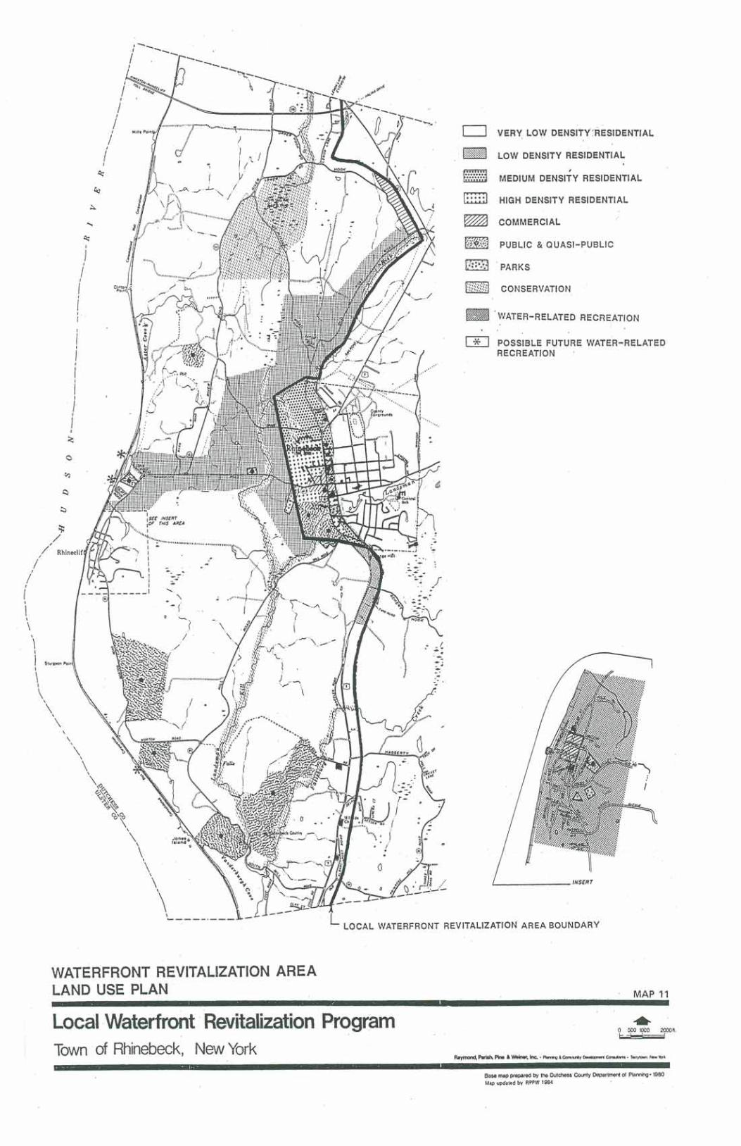
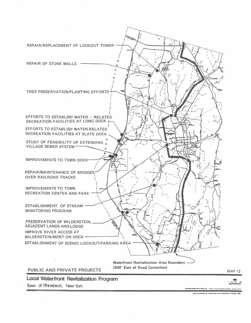

SECTION V - 1
SECTION VTECHNIQUES FOR LOCAL IMPLEMENTATION OF THE PROGRAMA. LOCAL LAWS AND REGULATIONS NECESSARY TO IMPLEMENT THE LWRP1. Existing Town Laws and Regulationsa. Zoning Law (Town Code Chapter A 136)As stated earlier in Section II of this LWRP, the below discussion of the "ZoningLaw" is based on the Town's Zoning Law, as adopted in 1989 and underpinned bythe Town's then-current Comprehensive Plan. The Comprehensive Plan ispresently being updated and with it anticipated recommendations will be made bythe Master Plan Committee for amendments to the Zoning Law to reflect evenmore strongly than does the present Zoning Law the land use policies discussed inSection III of this LWRP. 1) The Zoning Law regulates how land is to be used, at what density andintensity and under what conditions. Most of the Local WaterfrontRevitalization Area within the Town is zoned for residential use and the bulkis designated within the R5A Residential District for limited residentialdensity (one single-family or two-family dwelling permitted for each 5 acres).Utilization of this five acre category assists the Town is preserving its rural,low density qualities and appearance and in protecting the scenic, historic andnatural features of the waterfront areas of the Town.Permitted uses in the R5A District include primarily agriculture andconservation uses, private stables, and one-and two-family dwellings. Specialpermit uses in this District include: elderly residential development,educational and/or institutional uses, hospitals, nursing homes, alternate carefacilities, and offices, conference centers and land-extensive recreational andother uses, e.g. cemeteries, that are suitable for large lot, low-density areasand might serve as appropriate adaptive re-use opportunities for the largeestates within the District. Authorized waterfront uses include marinas, boatclubs, docks and boat ramps.The R3A Residential District, where the minimum residential lot area is threeacres, is found north of the Village and east of the Rhinebeck Kill, as well assouth of the R1A Residential District adjacent to the Village and east ofRoute 9. Permitted uses in the R3A District are the same as those in the R5ADistrict are the same as those in the R5A District; however, some additional

SECTION V - 2
special permit uses are indicated for the R3A District which include but arenot limited to fairgrounds, hotel or motel, public or franchise utility stationsor structures, and extractive operations including soil mining.Some portions of the waterfront area, primarily the hamlet of Rhinecliff, bothsides of the Route 308 corridor between Rhinecliff and the Village ofRhinebeck and the Old Post Road corridor north of the Village, are zonedwithin the R1A Residential District, which generally requires a minimum lotarea of one acre. Permitted uses are slightly more restrictive in the R1ADistrict, and special permit uses are somewhat fewer than in the in the othertwo residential districts; however, multi-family or row dwellings andtownhouses are allowed as a special permit use in this district as is privatecommercial parking on land abutting a business district.Pursuant to Section 278 (formerly Section 281) of New York State TownLaw, and with the specific authorization of the Town Board, the PlanningBoard may authorize clustering of dwelling units in the R5A, R3A ad R1ADistricts, provided that the density remains the same as is required forsingle-family dwellings. In fact, the Planning Board is further empowered tomandate the use of open space or cluster subdivision as a land developmenttechnique where the Board finds this approach to be desirable to carry out abeneficial development pattern while protecting natural and otherenvironmental features of a project site and its adjoining lands.The Town's Land Conservation (LC) category has been designed forenvironmental preservation purposes. Ferncliff Forest and portions of theMudder Kill are included in this designation, as are lands extending 75 feetfrom the high water mark on both sides of NYSDEC-classified streamswithin the Town of Rhinebeck. The LC District is complemented byFlood-Fringe Overlay (FF-O) and Water Resource Protection Overlay(WRP-O) Districts.Commercial zoning within the Town's waterfront revitalization area is quitelimited with one area within the hamlet of Rhinecliff designated RhinecliffBusiness (RB), an area along Hook Road in the northern portion of the Town(close to the Kingston-Rhinecliff Bridge approach) designated for HighwayBusiness Park (HBP), and an area south of the Village boundary and east ofRoute 9 designated Gateway (G) District. Sign regulations, parking standards, general performance standards, includingcriteria on storage of flammable liquids and descriptions of the thresholdlevels of noise, smoke, odor, particulate matter, noxious gases, glare or
SECTION V - 3
radioactivity that would be considered a nuisance or be detrimental toneighboring properties are also included within the Zoning Law.In addition, a detailed site plan review procedure and associated submissionrequirements and review criteria are incorporated within the Zoning Law,including reference to the Town's Design Guidelines. Site plan review isused to assure that the proposed development of a site is acceptable andconsistent with all of the regulations. Since much of the land in the coastalarea includes large estates that are to some extent subject to developmentpressures, thorough site plan review is necessary to preserve the desirableresources of the Town. Currently, site plans are generally required within theTown for use other than individual one- or two-family dwellings andagricultural or conservation uses permitted as a matter of right.2. The Zoning Law deals most closely with Policies 1 and 2 of the LWRP relating todevelopment in the waterfront revitalization areas. However, the large lot, low densityresidential zoning, particularly when coupled with clustering, can help to: • Protect historic properties along the riverfront, so that this ordinance also can serveto implement Policies 23 and 23A; • Provide sufficient area for buffer and setback areas to preserve scenic vistas andscenic roads implementing Policies 24A and 24B;• Provide a means to preserve natural habitat and environmentally sensitive areas toenforce Polices 7, 7A, 7B and 44; and• Continue agricultural activity in the Town, furthering Policy 26A. The Land Conservation District regulations particularly address Policy 7A on theprotection of the natural resources of Ferncliff Forest, Policy 7B on protection of streams,Policies 11 and 17 on flooding hazards and Policy 44 on protection of wetlands.Sign regulations primarily implement the scenic quality policies 24A and 24B, and thesection on storage of flammable liquids, complemented by the standards set forth for theWRP-O District, implements Policy 36 relating to the shipment and storage of petroleumand other hazardous materials.The General Performance Standards can be used to implement policies dealing withprotection of the natural environment, particularly Policies 7 and 44; protection of groundand surface waters, Policies 30 and 38; and maintenance of air quality standards, Policy41.
SECTION V - 4
In addition, since a site plan shows existing and proposed uses, structures, and featuresfor a particular parcel of land and includes an inventory of open space, major natural andman-made landscape features, utility and drainage plans and access and circulationpatterns, the reviewing board can examine each component part of the plan, theinterrelationship of the parts and how the proposed plan relates to the surrounding area.In this way, the following policies of the LWRP can be implemented: Policies 1, 2 and5 on development of waterfront areas; Policies 23, 23A on protection of historic sites andareas; Policies 24A and 24B on protecting and enhancing scenic resources, e.g. byrequiring suitable buffer areas to maintain the open space appearance of scenic roads;Policies 7, 7A, 7B and 44, by requiring suitable setbacks to protect environmentallysensitive areas such as wetlands or animal habitat areas; Policies 11, 12 and 17 onsuitable siting of buildings and other structures and undertaking activities to minimizeflooding and erosion hazards; Policies 18 and 27 on possible siting of major facilities inthe coastal area; and Policies 33, 38 and 39 on protecting coastal waters.b. Local Law Regulating Usage of the Town Dock (Town Code Chapter 58)1) This local law indicates that the Town dock areas are closed to the generalpublic and to all vehicles between 10:30 PM and 5:30 AM.2) This local law has been designed to regulate the hours of public use of theTown dock in order to try to promote safe use of a public site that offersopportunities for public access for waterfront recreation activities andcommercial fishing activities. This law therefore implements or enforcespublic access Policy 19A relating to the Rhinebeck Town Dock.c. Local Law Regulating Disposal of Solid Wastes (Town Code Chapter 95)1) This local law regulates the disposal of garbage and rubbish in the Town byestablishing a comprehensive solid waste management / resource recoveryfacility program.2) This local law implements Policy 38 of the LWRP by protecting the qualityof groundwater and surface water supplies.d. Historic Buildings Protection Law (Town Code Chapter 78) (See Appendix D)1) This local law provides for the recognition of historic buildings within theTown and establishes a process providing for "careful, thoughtful evaluationof any proposed action that would cause the demolition or removal of anysuch recognized historic building".
SECTION V - 5
2) This local law implements Policies 23 and 23A on the protection of historicstructures.e. Environmental Quality Review Regulations (Town Code Chapter 68)1) These Town regulations implement the State Environmental Quality ReviewAct. These regulations adopt the State regulations by reference and establishthresholds and procedures to assure full review of environmental impacts ofproposed actions, improvements and developments within Rhinebeck. 2) These regulations further specify the Town's lead agency for certain directactions and should be modified, in response to intervening changes in Stateenabling legislation, to provide for the Town Board, instead of the PlanningBoard, as lead agency for consideration of the Town's Comprehensive Plan.3) These regulations implement and enforce many policies described in theLWRP, but they are especially relevant to: Policies 1, 2, and 5 onredevelopment of waterfront areas; Policies 7, 7A, 7B and 44 on protectionof natural areas and fish and wildlife habitats; Policy 8 on protection of fishand wildlife from the introduction of hazardous wastes; Policies 11 through17 relating to flood and erosion hazards; Policy 18 regarding proposedactions; Policy 21 involving water-dependent and water-enhanced recreation;Policies 23 and 23A involving protection of historic sites; Policies 24A and24B, regarding scenic quality; Policy 26A, involving the protection ofagricultural lands; Policy 27, about siting energy facilities in the coastal area;Policy 28 on ice management practices; Policy 29 relating to anydevelopment of energy resources; and Policies 30, 32, 33 and 35 through 41pertaining to water and air resources.f. Flood Damage Prevention Local Law (Town Code Chapter 73)1) This local law regulates development within the flood hazard areas of theTown, as defined on the Flood Insurance Rate Maps (FIRM) prepared by theFederal Emergency Management Agency (FEMA).2. This local law can be used to minimize danger to life and damage to property,thus implementing the following flood hazard prevention policies of theLWRP: Policy 11, on siting of structures to minimize damage; Policy 12, onprotection of natural protective features including bluffs; Policy 14,preventing increase in flooding; and Policy 17, on use of non-structuralmeasures to minimize damage from flooding.
SECTION V - 6
g. Land Subdivision Regulations (Town Code Chapter 101)1) The Town's Land Subdivision Regulations specify how vacant land in thecoastal area can be divided into building lots. The regulations includedprocedures for submitting plans; how lots are to be laid out; how sanitarywastes must be treated; how the water supply and distribution system is to behandled; how road and drainage improvements must be implemented. TheTown Planning Board can mandate the use of cluster or open spacesubdivision for a particular parcel.2) The Land Subdivision Regulations are important in implementing severalpolicies of the LWRP including: Policies 1 and 2 on appropriate utilizationor redevelopment of waterfront parcels; Policy 5, for suitable location ofdevelopment with regard to public services and facilities; and Policy 17 onuse of non-structural means of erosion control whenever possible. Moreover,by utilization of "open space subdivision" or clustering arrangements, theseregulations can be used to: protect historic sites and areas, Policies 23 and23A; to protect and enhance scenic resources, Policies 24A and 24B; protectenvironmentally significant areas, Policies 7, 7A, 7B and 44; maintainagricultural areas, Policy 26A; and require appropriate siting of buildings andstructures and undertaking of activities to avoid flooding and erosion hazards,Policies 11 and 12.As in the instance of the Town's Zoning Law, it is anticipated the LandSubdivision Regulations will also be amended upon recommendation of thepresent Master Plan Committee to more strongly reflect the land use policiesset forth in Section III of this LWRP.3. Additional Local Laws, Amendments to Existing Local Laws and Regulations Adoptedor Proposed to Further LWRP Implementationa. Proposed Draft LWRP Waterfront Consistency Review Law (See Appendix C)1) This proposed law is to be adopted under the authority of the MunicipalHome Rule Law and the Waterfront Revitalization of Coastal Areas andInland Waterways Act of the State of New York (Article 42 of the ExecutiveLaw).2) The purpose of this proposed law is to provide a framework for agencies ofthe Town of Rhinebeck to incorporate the policies and purposes contained inthe Town of Rhinebeck Local Waterfront Revitalization Program (LWRP)when reviewing applications for actions or direct agency actions within the
SECTION V - 7
coastal area; and to assure that such actions and direct actions by Townagencies are consistent with the LWRP policies and purposes.3) It is the intention of the Town of Rhinebeck that the preservation,enhancement and utilization of the unique coastal area of the Town take placein a coordinated and comprehensive manner to ensure a proper balancebetween protection of natural resources and the need to accommodate limitedpopulation growth and economic development. Accordingly, this proposedlocal law is intended to achieve such a balance, permitting the beneficial useof coastal resources while preventing loss and degradation of living coastalresources and wildlife; diminution of open space areas or public access to thewaterfront; disruption of natural coastal processes; impairment of scenic,cultural or historical resources; losses due to flooding, erosion andsedimentation; impairment of water quality; or permanent adverse changesto ecological systems.4) This local law defines the role of various Town officials, boards and agenciesin the review process to determine consistency and provides for theConservation Advisory Council (CAC) to serve in the role of WaterfrontAdvisory Committee.b. Zoning Law Amendment / Uses Authorized in R1A and R5A Zoning Districts(Town Code Chapter A 136)1. The uses authorized within the R1A and R5A Districts under the Town'sZoning Law were amended in 1991 such that marinas, boat clubs, docks andboat ramps were added as special permit uses.2. These revisions primarily serve to implement Policy 2 on siting ofwater-dependent uses and Policy 12 on preservation of natural protectivefeatures.c. Zoning Law Amendment / Regulations for the Siting of Utilities and TransmissionTowers (Town Code Chapter A 136)1) The Town Zoning Law was revised in 1999 to include conditions for theappropriate siting of utilities and transmission towers (i.e. communicationsfacilities and towers) to protect environmental features, scenic resources andpublic access to the water.2) Such revisions serve to implement Policies 7A, 7B and 44 on protection ofenvironment features, Policies 24A and 24B on protection of scenic
SECTION V - 8
resources, Policies 2 and 22 on siting of water-dependent uses and Policies19 and 20 on public access to the shorefront.B. OTHER PUBLIC AND PRIVATE ACTIONS NECESSARY TO IMPLEMENT THE LWRPIn addition to the local laws and regulations identified in subsection A above, a number ofother public and private actions will be necessary to implement to Town's LWRP:1. Local Government Actions Necessary to Implement the LWRPa. Preparation and Use of Zoning GuidesThese zoning guides will be used to clarify and interpret existing regulations andprocedures for municipal officials, reviewing boards and applicants. The guideswill consist of a series of pamphlets which will be distributed, as appropriate,according to the types of action.These zoning guides will primarily be used to implement Policy 6 by expeditingpermit procedures. In addition, since the guides provide information andclarification on procedures for site plan review and subdivision review, they maystrengthen use of above implementation steps discussed above.Ultimately it is the Town's hope these guides and similar materials will be availableon the Town web-site.b. Preparation and Use of a Cultural Resources MapRhinebeck has prepared a cultural resources brochure with map which describesand locates places of scenic and historic importance, recreational sites andcommunity points of interest within the Town, as well as a description and map ofthe Mid-Hudson Historic Shorelands Scenic District / Local WaterfrontRevitalization Area.This brochure with map is to be used by residents and visitors to increase theirknowledge of and interest in natural and man-made resources of the Town. Assuch, it primarily implements Policy 1A on encouraging economic growth of thebusiness sector of the Town. In addition, by increasing community awareness of itsvaluable historic, scenic and recreational resources, in the long run it may serve toincrease the extent of efforts to preserve those resources.

SECTION V - 9
c. Establishment of Position of Historic Preservation AdvisorThe historic preservation advisor works with Town boards and applicants topreserve, protect and enhance historic properties.The efforts of historic preservation advisor will serve to implement Policies 23Aand 24A on protection of historic and scenic resources.d. Use of the Scenic District HandbookThe Handbook includes development and design guidelines so that natural andhistoric features can be protected, proposed developments can be designed to beconsistent with the character or quality of the existing natural, scenic and historicenvironment. Developers can utilize the guidelines in planning projects ordevelopments that will preserve and enhance scenic, historic and natural featuresof the Town and that will be compatible with existing development consistent withthe recommendations set forth in the Mid-Hudson Historic Shorelands ScenicDistrict Management Plan. The Handbook will be used by municipal boards whenreviewing proposed development projects, primarily in site plan and subdivisionreview.The guidelines in the Handbook can be used to implement several policies in theLWRP, including Policy 1 on revitalizing and redeveloping waterfront areas;Policy 2 on siting of water-dependent uses; Policies 7A, 7B and 7C on protectingsignificant fish and wildlife habitats; Policy 11 on siting of structures in the coastalarea relative to flooding and erosion hazard areas; Policies 23, 23A, 24A and 24Bon protection and enhancement of historic and scenic structures, features and areas;Policy 26A on protection of agricultural lands; and Policy 44 on protection ofwetlands.e. Use of the Scenic Roads Handbook and Efforts to Improve and/or MaintainRoadside ConditionsA variety of techniques will be utilized to improve or maintain roadside conditions,particularly on designated scenic roads. Conservation easements held bynot-for-profit groups or municipalities will be encouraged to limit developmentimmediately adjacent to the roadway. Local boards will use guidelines in the ScenicRoads Handbook as they work with local utility companies and local, County andState highway, transportation and/or public works departments to accomplish theunderground placement of utility wires, appropriate preservation or trimming oftrees, and appropriate road maintenance and improvement procedures to increasesafety and protect stone walls and existing trees. Decisions on road realignments,
SECTION V - 10
resurfacing, speed postings, drainage work, snow removal, de-icing and any otherroadway procedures should be made with regard to protection of scenic concerns.Coordination of efforts to improve roadside conditions and to maintain andenhance scenic and historic areas and features will serve primarily to implementPolicies 23, 23A, 24A and 24B.f. Efforts to Reduce or Minimize Traffic Congestion at IntersectionsLocal boards and agencies at the Town and Village levels will work with the TownHighway Department, County Department of Public Works and/or StateDepartment of Transportation to improve traffic conditions and reduce or minimizecongestion at the intersection of major highways, particularly at the junction ofRoutes 9 and 308 in the Village of Rhinebeck and preferably through non-structuralmeans including the encouragement of greater reliance on non-vehicular travelmodes, including restoration of ferry service linking the Town Landing atRhinecliff with nearby communities such as Kingston and Tivoli.The Dutchess County Department of Planning undertook a transportation studywhich included a series of recommendations for improving present and futureconditions at the intersections that are currently the most congested and that willprobably be most heavily impacted by future development. The Town needs todetermine which recommendation(s) it wishes to implement and work with theVillage of Rhinebeck, the Town Highway Department, the County Department ofPublic Works and/or State DOT, as appropriate, to effectuate necessary changes.Efforts to improve traffic conditions in the coastal area will implement Policy 19.g. Use of Tax Incentives for New Waterfront BusinessesUnder Section 485-b of the Real Property Tax Law the Town could initiate aprogram to grant tax incentives for new businesses that may locate along theshoreline for water-related uses that would be compatible with the existing builtand natural environments, particularly where water-related recreation facilitiesrepresent a primary or multiple use of a parcel. Initial reduction of taxes could beup to 50% with decreasing incentives for the next nine years.The Town's granting of tax incentives for development of compatible water-relateduses would serve primarily to implement Development Policies 1, 1A and 2.

SECTION V - 11
h. Expanded Use of Land Conservation District or Other Protective MechanismsConsideration might be given to expanded use of the Land Conservation District,the Water Resources Protection Overlay (WRP-O) District, or other mechanism toprotect bluff areas, ridgelines, the Snyder Swamp and Millpond areas, and otherenvironmentally sensitive areas within the LWRA.Expanded use of the Land Conservation District or other mechanism wouldprimarily implement Policies 7A and 7B on protection of significant habitat areasand Policy 44 on preservation of wetlands. i. Request for Expansion of Railroad Station Parking AreaTown officials will continue to seek the cooperation and assistance of the NewYork State Department of Transportation and other concerned parties to enlarge theparking area near the Rhinecliff railroad station to accommodate additionalnumbers of train passengers and users of the Town Landing / Rhinecliff Dockfacilities. This request will primarily implement Policy 19A on providing facilitiesto assure public access to Rhinebeck Dock area. j. Request for Reclassification of StreamsThe Town will continue to request that stream classifications be upgraded byNYSDEC so that stream corridors are adequately protected under the NYS StreamProtection Act.k. Communication with Dutchess County Department of Public Works ConcerningLWRPPortions of River Road, South Mill Road, Morton Road and Mill Road areState-designated Scenic Roads. It is important to the preservation of the sceniccharacter of these roadways that Dutchess County DPW employ maintenance andmanagement techniques that will enhance and not destroy the scenic elements ofthese highway corridors, including such features as the presence of mature trees,stone walls, stone culverts and bridges, and limited but adequate cartway width.l. Local Law No. 1, 2004, Greenway.The Town Board's enactment of Local Law No. 1 of the Year 2004 provided for (1)the adoption of Greenway Connections: Greenway Compact Program and Guidesfor Dutchess County Communities as a statement of land use policies andprinciples and guides to supplement other established land use policies in the Townand (2) through related amendments to the Town's Zoning Law and Land

SECTION V - 12
Subdivision Regulations for guidance to reviewing agencies that the adoptedpolicies, principles and guides may be taken into account in consideration of anydiscretionary action under these land use regulations.Use of appropriate maintenance and management techniques would serve toimplement Policies 24A and 24B on preservation and enhancement of scenicresources.2. Joint Public and Private or Not-for-Profit Organization Efforts Necessary toImplement the LWRPa. Use of Conservation Easements1) Conservation easements may be held by municipalities or qualifiednot-for-profit organizations, such as local land trusts, as a means of limitingdevelopment in areas of historic, scenic, agricultural or environmental value.2) Use of conservation easements could serve to preserve scenic, historic,agricultural and environmentally sensitive areas and thus can implement:Policies 7 and 44 on preservation of natural features and habitats; Policies 23,23A, 24A and 24B on scenic and historic resources, and Policy 26A onagricultural resources.b Use of Facade Easements1) Facade easements held by municipalities or not-for-profit organizations canbe used to prevent the alteration of, and facilitate the renovation of,historically significant buildings. 2) The use of façade easements can serve to implement Policies 23 and 23A onpreservation and enhancement of historic structures.C. MANAGEMENT STRUCTURE NECESSARY TO IMPLEMENT THE LWRP1. Local ActionsAt the local government level, cities, towns, or villages with adopted Local WaterfrontRevitalization Programs (LWRPs) are required to enact consistency provisions applicableto municipal agency decision-making, such as decisions involving actions requiringzoning changes, subdivisions, site plans, special use permits, municipal constructionprojects, and funding activities.
SECTION V - 13
LWRP consistency review procedures are distinct but integrally tied to the StateEnvironmental Quality Review Act (SEQRA) procedures. All Town agenciescontemplating a direct action or receiving an application for approval of an action byothers shall follow review and certification procedures set forth in the Town's proposedLWRP Consistency Review Law. (See Appendix C)The Supervisor of the Town of Rhinebeck and the Town Board will be responsible foroverall management and coordination of the LWRP. Each Town agency will beresponsible for determining whether its actions are consistent with the LWRP. AWaterfront Advisory Committee (WAC), as presently constituted pursuant to Town CodeChapter 118 in its entirety of all appointed members of the Town's ConservationAdvisory Council (CAC), has been and will continue to be appointed by the Town Boardto make recommendations to the Town Supervisor, the Town Board and otherresponsible Town agencies involved in the financing, permitting or approval of projectswithin the LWRA concerning consistency of actions with the Coastal Policies. Whenever a proposed action is located with the waterfront area, the local agency underwhose jurisdiction that action falls shall, prior to approving or permitting, funding orundertaking the action, seek the advice of the CAC. The CAC's advice shall be presentedin writing and include, along with its consistency recommendation, any suggestions formodifications the referring official or agency might consider that would make theproposed action more consistent with the LWRP or help advance the LWRP policies andstandards.Upon receipt of the CAC's report, the local agency with jurisdiction to approve or permit,fund or undertake the proposed action will consider the recommendations of the CACand make its own determination as to whether the proposed action is consistent to themaximum extent practicable with the LWRP or, absent such a finding, either recommendor impose, as pertinent, modifications that would have to be incorporated in the proposedaction to merit a determination of consistency with the LWRP.If the agency determines that the action would cause a substantial hindrance to theachievement of LWRP policy standards and conditions, such action shall not beundertaken unless the agency determines with respect to the proposed action that:• No reasonable alternatives exist which would permit the action to be undertakenin a manner which will not substantially hinder the achievement of such LWRPpolicy standards and conditions;• The action would be undertaken in a manner which will minimize all adverseeffects on such LWRP policy standards and conditions to the maximum extentpracticable; and
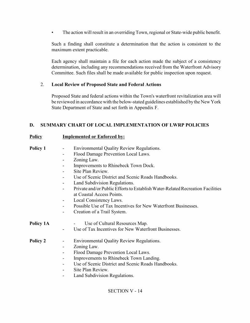
SECTION V - 14
• The action will result in an overriding Town, regional or State-wide public benefit.Such a finding shall constitute a determination that the action is consistent to themaximum extent practicable.Each agency shall maintain a file for each action made the subject of a consistencydetermination, including any recommendations received from the Waterfront AdvisoryCommittee. Such files shall be made available for public inspection upon request.2. Local Review of Proposed State and Federal ActionsProposed State and federal actions within the Town's waterfront revitalization area willbe reviewed in accordance with the below-stated guidelines established by the New YorkState Department of State and set forth in Appendix F.D. SUMMARY CHART OF LOCAL IMPLEMENTATION OF LWRP POLICIESPolicy Implemented or Enforced by:Policy 1 - Environmental Quality Review Regulations.- Flood Damage Prevention Local Laws.- Zoning Law.- Improvements to Rhinebeck Town Dock.- Site Plan Review.- Use of Scenic District and Scenic Roads Handbooks.- Land Subdivision Regulations.- Private and/or Public Efforts to Establish Water-Related Recreation Facilitiesat Coastal Access Points.- Local Consistency Laws.- Possible Use of Tax Incentives for New Waterfront Businesses.- Creation of a Trail System.Policy 1A - Use of Cultural Resources Map.- Use of Tax Incentives for New Waterfront Businesses.Policy 2 - Environmental Quality Review Regulations.- Zoning Law.- Flood Damage Prevention Local Laws.- Improvements to Rhinebeck Town Landing.- Use of Scenic District and Scenic Roads Handbooks.- Site Plan Review.- Land Subdivision Regulations.
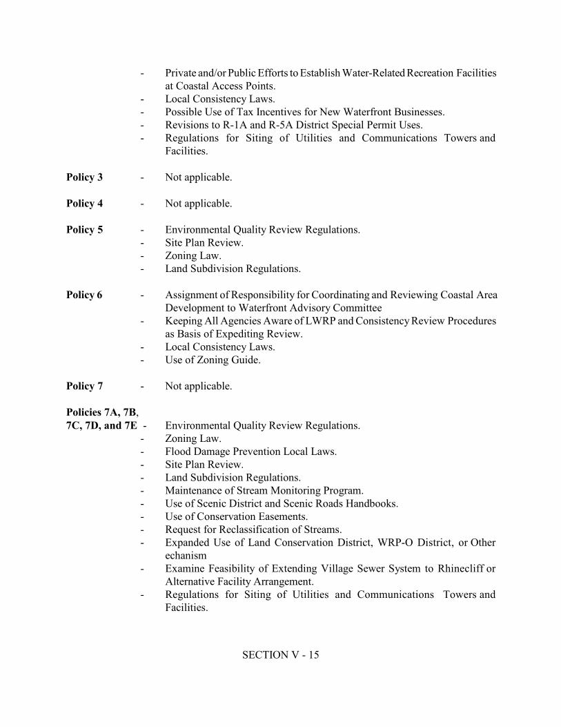
SECTION V - 15
- Private and/or Public Efforts to Establish Water-Related Recreation Facilitiesat Coastal Access Points.- Local Consistency Laws.- Possible Use of Tax Incentives for New Waterfront Businesses.- Revisions to R-1A and R-5A District Special Permit Uses.- Regulations for Siting of Utilities and Communications Towers andFacilities.Policy 3 - Not applicable.Policy 4 - Not applicable.Policy 5 - Environmental Quality Review Regulations.- Site Plan Review.- Zoning Law.- Land Subdivision Regulations.Policy 6 - Assignment of Responsibility for Coordinating and Reviewing Coastal AreaDevelopment to Waterfront Advisory Committee- Keeping All Agencies Aware of LWRP and Consistency Review Proceduresas Basis of Expediting Review.- Local Consistency Laws.- Use of Zoning Guide.Policy 7 - Not applicable.Policies 7A, 7B, 7C, 7D, and 7E - Environmental Quality Review Regulations.- Zoning Law.- Flood Damage Prevention Local Laws.- Site Plan Review.- Land Subdivision Regulations.- Maintenance of Stream Monitoring Program.- Use of Scenic District and Scenic Roads Handbooks.- Use of Conservation Easements.- Request for Reclassification of Streams.- Expanded Use of Land Conservation District, WRP-O District, or Otherechanism- Examine Feasibility of Extending Village Sewer System to Rhinecliff orAlternative Facility Arrangement.- Regulations for Siting of Utilities and Communications Towers andFacilities.

SECTION V - 16
Policy 8 - Environmental Quality Review Regulations.- Review of Proposals through Land Use Permitting Procedures Included in theZoning Law.Policy 9 - Creation of Scenic Lookout / Parking Areas.- Improvements to Rhinebeck Town Dock.Policy 10 - Improvements to Rhinebeck Town Dock.Policy 11 - Flood Damage Prevention Local Laws.- Environmental Quality Review Regulations.- Zoning Law.- Land Conservation District and WRP-O District in Zoning Law.- Land Subdivision Regulations.- Site Plan Review.- Use of Scenic District and Scenic Roads Handbooks.Policy 12 - Flood Damage Prevention Local Laws.- Environmental Quality Review Regulations.- Land Conservation District and WRP-O District in Zoning Law.- Land Subdivision Regulations.- Site Plan Review.- Use of Scenic District and Scenic Roads Handbooks.- Revision to R-5A District Setback Requirements.Policy 13 - Environmental Quality Review Regulations.Policy 14 - Flood Damage Prevention Local Laws.- Environmental Quality Review Regulations.Policy 15 - Environmental Quality Review Regulations.Policy 16 - Environmental Quality Review Regulations.Policy 17 - Flood Damage Prevention Local Laws.- Environmental Quality Review Regulations.- Zoning Law.- Land Subdivision Regulations.- Site Plan Review.- Use of Scenic District and Scenic Roads Handbooks.Policy 18 - Environmental Quality Review Regulations.- Zoning Law.

SECTION V - 17
- Site Plan Review.Policy 19 - Improvements to Rhinebeck Town Dock.- Creation of Scenic Lookout / Parking Areas.- Regulations for Siting of Utilities and Communications Towers and Facilities- Efforts to Secure Agreements and/or Funding for Maintenance, Repair and/orInstallation of Bridges over the Railroad Tracks.- Local Law Regulating Usage of the Town Dock.- Request for Expansion of Railroad Parking Area.- Restoration and Expansion of Ferry Service.Policy 20 - Improvements to Rhinebeck Town Dock.- Regulations for Siting of Utilities and Communications Towers andFacilities.Policy 20A - Efforts to Secure Agreements and/or Funding for Repair, Maintenance and/orInstallation of Bridge(s) over the Railroad Tracks.Policy 21 - Environmental Quality Review Ordinances.- Improvements to the Rhinebeck Dock.- Creation of Scenic Lookout / Parking Areas.- Establishment of a Trail System.Policy 21A and 21B - Private and/or Public Efforts to Establish Water-related Recreation Facilitiesat Coastal Access Points.- Restoration and Expansion of Ferry Service.Policy 22 - Zoning Law.Policy 23 - Environmental Quality Review Regulations.- Zoning Law.- Land Subdivision Regulations.- Site Plan Review.- Historic Buildings Protection Law.- Efforts of Historic Preservation Advisor.- Use of Scenic District and Scenic Roads Handbooks.- Work with Utility Companies, Town Highway- Department, County Department of Public Works and/or State Departmentof Transportation to Maintain and Improve Roadside Conditions.- Private Efforts to Preserve Wilderstein Property, Lodge and Adjacent Lands.- Efforts to Establish Historic Preservation Programs.- Use of Conservation Easements.- Use of Facade Easements.
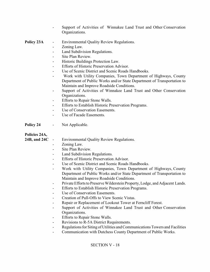
SECTION V - 18
- Support of Activities of Winnakee Land Trust and Other ConservationOrganizations.Policy 23A - Environmental Quality Review Regulations.- Zoning Law.- Land Subdivision Regulations.- Site Plan Review.- Historic Buildings Protection Law.- Efforts of Historic Preservation Advisor.- Use of Scenic District and Scenic Roads Handbooks.- Work with Utility Companies, Town Department of Highways, CountyDepartment of Public Works and/or State Department of Transportation toMaintain and Improve Roadside Conditions.- Support of Activities of Winnakee Land Trust and Other ConservationOrganizations.- Efforts to Repair Stone Walls.- Efforts to Establish Historic Preservation Programs.- Use of Conservation Easements.- Use of Facade Easements.Policy 24 - Not Applicable.Policies 24A, 24B, and 24C - Environmental Quality Review Regulations.- Zoning Law.- Site Plan Review.- Land Subdivision Regulations.- Efforts of Historic Preservation Advisor.- Use of Scenic District and Scenic Roads Handbooks.- Work with Utility Companies, Town Department of Highways, CountyDepartment of Public Works and/or State Department of Transportation toMaintain and Improve Roadside Conditions.- Private Efforts to Preserve Wilderstein Property, Lodge, and Adjacent Lands.- Efforts to Establish Historic Preservation Programs.- Use of Conservation Easements.- Creation of Pull-Offs to View Scenic Vistas.- Repair or Replacement of Lookout Tower at Ferncliff Forest.- Support of Activities of Winnakee Land Trust and Other ConservationOrganizations.- Efforts to Repair Stone Walls.- Revisions to R-5A District Requirements.- Regulations for Siting of Utilities and Communications Towers and Facilities- Communication with Dutchess County Department of Public Works.
SECTION V - 19
- Efforts to Preserve Existing Trees and Plant New Trees.Policy 25 - See Policies 24A and 24B.Policy 26 - Environmental Quality Review Regulations.- Land Subdivision Regulations.- Site Plan Review.- Zoning Law.- Use of Scenic District and Scenic Roads Handbooks.- Use of Conservation Easements.- Identify Open Space Areas for Preservation and/or Protection.Policy 27 - Environmental Quality Review Regulations.- Site Plan Review- Zoning Law.Policy 28 - Environmental Quality Review Regulations.Policy 29 - Not applicablePolicy 30 - Environmental Quality Review Regulations.- Site Plan Review.- Maintenance of Stream Monitoring Program.- Possible Extension of the Rhinebeck Village Sewer System to Rhinecliff ofAlternative Facility ArrangementPolicy 31 - Request for Reclassification of Streams.Policy 32 - Environmental Quality Review Regulations.Policy 33 - Environmental Quality Review Regulations.- Site Plan Review.- Efforts to Provide Public Sewer Service to Hamlet of Rhinecliff.Policy 34 - Environmental Quality Review Regulations.Policy 35 - Environmental Quality Review Regulations.Policy 36 - Environmental Quality Review Regulations.- Zoning Law, including General Performance Standards on Storage ofFlammable Liquids and WRP-O District Regulations.Policy 37 - Environmental Quality Review Regulations.
SECTION V - 20
Policy 38 - Environmental Quality Review Regulations.- Town Regulations on Solid Wastes Mangaement / Recycling Facilities.- Site Plan Review.- Maintenance of Stream Monitoring Program.- Possible Extension of Rhinebeck Village Sewer System to Hamlet ofRhinecliff or Alternative Facility Arrangement.Policy 39 - Environmental Quality Review Regulations.- Zoning Law.- Site Plan Review.Policy 40 - Environmental Quality Review Regulations.- Site Plan Review.Policy 41 - Environmental Quality Review Regulations.- Zoning Law.Policy 42 - Request for Reclassification of Streams.Policy 43 - General Performance Standards Section of Zoning Law.Policy 44 - Environmental Quality Review Regulations.- Zoning Law.- Use of Conservation Easements.- Expanded use of Land Conservation District, WRP-O District, or OtherMechanism.- Flood Damage Prevention Local Laws.- Land Subdivision Regulations.- Use of Scenic District and Scenic Roads Handbooks.- Identify Open Space Areas for Preservation and/or Protection.- Regulations for Siting of Utilities and Communications Towers and FacilitiesE. COST IMPLICATIONS OF PROJECTS AND PROGRAMS IN THE LWRPThere are three main funding implications associated with implementation of the Town'sLWRP. These are the administrative costs involved in the continued local management of theLWRP, the capital and revenue costs involved in project implementation, and the costs relatedto maintenance and upkeep of projects.
SECTION V - 21
Administration CostsManagement costs associated with the administration of the LWRP must be budgeted by theTown and financed out of general revenues. This may involve creating a separate budget itemfor the administration of the LWRP to cover the costs of consistency reviews, fulfillingreporting requirements, and general administrative and clerical needs if the Town finds thatthis adds significantly to the Town Board costs.Capital ImprovementsThe second funding implication is the capital and revenue costs involved in projectimplementation. The Town has identified a number of LWRP projects designed to address andimplement many of the LWRP Policies identified in Section III. These projects are discussedin detail in Section IV. Although the Town will need to take the lead in achieving theimplementation of these projects, it is not necessary that the Town provide all of the financialresources to implement LWRP projects since financial assistance is available from publicagencies or as part of a public/private partnership.Upkeep CostsMaintenance and upkeep of public LWRP improvements will vary from year to year dependingon the types of materials chosen during design and construction, and normal wear and tearfrom weather. Costs will likely be built into the Town annual budget.F. FINANCIAL RESOURCES TO IMPLEMENT THE PROJECTS AND PROGRAMSIN THE LWRPPossible sources of funding are listed here as available grant programs. Most of these sourcesrequire a percentage contribution or funding match from the Town. This match is essential inleveraging public or private sector money. The local match generally can take a number offorms including money, the provision of materials by the Town, Town public works labor,and the monetary value of in-kind services or volunteer work and staff time. It is alsoadvantageous to try to link LWRP project implementation to other capital improvement workthat is going on within the Town, such as a public development proposal, property acquisition,or public water supply project, stretching the benefits of limited public funds and achievingmultiple objectives. The Town should evaluate the requirements necessary to obtain funds from a variety of publicand private environmental and economic development programs. The Town may work withthe New York State Department of State Division of Coastal Resources and WaterfrontRevitalization to identify possible funding sources. Primary available government fundingprograms include:
SECTION V - 22
The New York State Clean Water/Clean Air Bond - Environmental Conservation LawArticle 56. Project eligibility should be evaluated under different Bond Act funds, includingthe Safe Drinking Water Fund (Title 2), the Clean Water Fund (Title 3), and the MunicipalEnvironmental Restoration Project Fund (Title 5).The New York State Environmental Protection Fund - Environmental Conservation LawArticle 54. The fund, administered by NYSOPRHP, provides assistance for park, recreationand historic preservation projects. Funding for the implementation of Local WaterfrontRevitalization Programs, administered by the NYSDOS, is also available through this program.The Federal "Superfund" - Comprehensive Environmental Response, Compensation andLiability Act (CERCLA). This fund provides the federal government with funds toimplement short-term "removal" actions, or longer term remedial investigation and remediationof hazardous waste sites listed on the National Priorities List (NPL). The NYSDEC mustrequest that a site be listed on the NPL. This fund was used to implement limited clean-upactivities at the former Diamond International site.Federal Environmental Response and Spill Compensation Fund - Navigation Law Article12. This fund is available to states to implement investigation and clean-up of petroleumdischarges and removal of underground storage tanks. The fund is also available to compensateinjured parties, including municipalities which have lost revenue as a result of the dischargeof petroleum.Clean Water State Revolving Fund for Water Pollution Control. Financing is availableto respond to non-point source pollution projects. Non-point source refers to water pollutionfrom diffuse sources that are not directly related to a piped discharge. Examples includeremediation of contamination from leaking underground storage tanks or collection andtreatment of road runoff, and water body restoration such as stream bank stabilization, drainageerosion, and sediment control.Industrial Finance Program. Provides low interest loans to private businesses forenvironmental improvement capital projects, including Brownfields site remediation and solidwaste management.The State Revolving Fund Program is one of the largest environmental infrastructurefinancing programs in the nation. Three primary loans are available through EFC:Bond-Funded Loans, Financial Hardship Loans, (including interest-free long-term), andInterest-Free Short-Term (up to two years).Community Development Block Grant (CDBG). This program provides direct funding fromthe Department of Housing and Urban Development (HUD) for activities that support the reuseof industrial sites. CDBG funds are used for grants, loans, loan guarantees, and technical
SECTION V - 23
assistance activities. Formally a federal program, New York State has been administering theprogram since 2000.Section 108 Federal Loan Guarantees. Another HUD program, may also be applicable tothe industrial site reuse effort. Eligible projects include rehabilitation of obsolete structures,property acquisition and site preparation activities that could include removal of contaminationfrom a property.New York State and U.S. Departments of Transportation. Grants and loans may beavailable pursuant to the DOT Safe Accountable Flexible Efficient Transportation Equity Act:A legacy for users (SAFE TEA-LU) replacing the Intermodal Surface TransportationEfficiency Act (ISTEA) formerly the Transportation Equity Act for the 21 Century (TEA-21).stOther funds may be available throuth the Industrial Access Program (IAP) Chap 54 of Lawsof 1985 - appropriations bill.New York State Empire State Development Corporation (EDC). Program grants and loansare available as incentives to attract commercial development and may be applicable toBrownfields development. The Economic Development Fund is the primary funding program.U.S. Department of Commerce Economic Development Administration. Grants areavailable to assist economic development projects.New York State Nonpoint Source Implementation Grants Program. The NYSDEC hasa grant program under its Nonpoint Source Implementation Grants Program. The Programprovides grants for up to fifty percent (50%) of the cost of eligible nonpoint source waterpollution assessment, planning, and abatement projects.Private Foundation Grants. The Environmental Grantmaker's Association, 1290 Avenue ofthe Americas, Suite 3450 New York, New York, 10104 compiles a listing of hundreds ofpotential foundations and trusts which may provide funding assistance to creativeenvironmental/economic development initiatives. The Foundation Center's satellite locationat the Yonkers Public Library has a searchable database of charitable foundations.Greenway Communities Grant Program. Provides funding for natural and cultural resourceprotection, regional planning, economic development, heritage and environmental education,and promotion of access to the Hudson River.Greenway Conservancy. Provides funding for trail-related projects.The Environmental Protection Fund. A legislatively designated long-term source ofrevenues available to meet the pressing environmental needs of the State. A portion of thisfunding is administered by NYS DOS for LWRP implementation.
SECTION V - 24
Land and Water Conservation Fund. Federal monies allocated to the States by theDepartment of the Interior for land acquisition and development of outdoor recreation.Pittman-Robertson Program. Federal monies from the Federal Aid in Wildlife RestorationAct, apportioned to the states for wildlife conservation and hunter education. Sport Fish Restoration Program. Also known as the Dingell-Johnson program and amendedby the Wallop Breaux Act, collects taxes on sport fishing related items and returns the moniesto the states for use in fisheries management and research programs.Biodiversity Stewardship and Research Fund. A legislatively designated vehicle to receivefunds from a variety of sources; federal, state, and private; to support biodiversity stewardship,research, and education in New York State.Forest Legacy Program. Federal monies designed to identify and protect environmentallysensitive forests that are threatened with conversion to non-forest uses.Environmental Benefit Project Funds and Natural Resource Damages. If appropriate andin accord with law and guidance, may be provided for open space conservation.Bird Stamp and Print. A dedicated source of revenue for management and acquisition ofwetlands and associated migratory bird habitat in New York State and Canada.Return a Gift to Wildlife. A state income tax donation program. The revenues are used fora variety of projects that benefit fish and wildlife.State Revolving Loan Fund. Provides low-interest loans to municipalities to construct andexpand sewage treatment facilities. Continuation of the state revolving loan fund depends onperiodic reauthorization of the Clean Water Act with grants to states to capitalize the loan fund.Federal Non-Game Wildlife Funding Initiative. Under consideration by the InternationalAssociation of Fish and Wildlife Agencies, would provide a flexible program of grants to thestates, funded through a federal excise tax on backpacks, mountain bicycles, tents, climbinggear, and similar outdoor recreational equipment.Army Corps of Engineers, Civil Work Water Resources Development Program. Monies havebeen committed for the purpose of determining ecosystem restoration opportunities on theHudson River. Additional federal funds are available on a matching basis for feasibility studiesand implementation. Gifts and Donations. A way for individuals and businesses to contribute directly to theconservation of open space through donations of land or easements.

SECTION V - 25
Natural Resource Damage Claims. For harm to natural resources within the Hudson Riverecosystem may be used for restoration projects to the extent consistent with law. A potentialsource of these funds is General Electric's settlement regarding the company's PCBcontamination of the Hudson River. The Wallace Fund for the Hudson Highlands. A private foundation supporting landacquisition in the Hudson Valley. Shared funding may be possible for properties identified foracquisition in this plan.The Hudson River Foundation. A private foundation supporting research, education andpublic access to the river. Its purpose is to contribute to the development of sound public policyconcerning the river's ecosystem. The Hudson River Improvement Fund. In the fall of 1985, the Hudson River Foundationreceived $1.5 million from the State of New York to endow the Hudson River ImprovementFund. Originally this money was paid to the state to settle litigation concerning the out-of-stateexport of Hudson River water by oil tankers--an issue first brought to public attention by theHudson River Fisherman's Association. Through the combined efforts of Hudson Riverenvironmental groups, including Scenic Hudson, Clearwater and the New York StateDepartment of Environmental Conservation, the Improvement Fund was created to fundprojects that stress the enhancement of public use and enjoyment of the natural, scenic andcultural resources of the Hudson River and its shores. The Hudson River Estuary Program. Administered by NYSDEC funds several categoriesof projects to improve open space and public access to the Hudson River.NYS Council on the Arts. Several categories of design, program, and facility developmentsupport are available in an annual funding program.
SECTION VI - 1
SECTION VISTATE AND FEDERAL ACTIONS AND PROGRAMSLIKELY TO AFFECT IMPLEMENTATIONState and federal actions will affect and be affected by implementation of a Local WaterfrontRevitalization Program (LWRP). Under State law and the U.S. Coastal Zone Management Act,certain State and federal actions within or affecting the local waterfront area must be "consistent"or "consistent to the maximum extent practicable" with the enforceable policies and purposes of theLWRP. This consistency requirement makes the LWRP a unique, intergovernmental mechanismfor setting policy and making decisions and helps to prevent detrimental actions from occurring andfuture options from being needlessly foreclosed. At the same time, the active participation of Stateand federal agencies is also likely to be necessary to implement specific provisions of the LWRP.Pursuant to the State Waterfront Revitalization of Coastal Areas and Inland Waterways Act(Executive Law, Article 42), the Secretary of State notifies affected State agencies of those agencyactions and programs which are to be undertaken in a manner consistent with approved LWRPs. Thefollowing list of State actions and programs is that list. The State Waterfront Revitalization ofCoastal Areas and Inland Waterways Act requires that a LWRP identify those elements of theprogram which can be implemented the local government, unaided, and those that can only beimplemented with the aid of other levels of government or other agencies. Such statement shallinclude those permit, license, certification, or approval programs; grant, loan, subsidy, or otherfunding assistance programs; facilities construction; and planning programs which may affect theachievement of the LWRP. Federal agency actions and programs subject to consistencyrequirements are identified in the New York State Coastal management Program and by theimplementing regulations of the U.S. Coastal Zone Management Act.The second part of this section is a more focused and descriptive list of State and federal agencyactions which are necessary to further implementation of the LWRP. It is recognized that a State orfederal agency's ability to undertake such actions is subject to a variety of factors and considerations;that the consistency provisions referred to above, may not apply; and that the consistencyrequirements cannot be used to require a State or federal agency to undertake an action it could notundertake pursuant to other provisions of law. Reference should be made to Section IV and SectionV, which also discuss State and federal assistance needed to implement the LWRP.

SECTION VI - 2
A. STATE AND FEDERAL ACTIONS AND PROGRAMS WHICH SHOULD BEUNDERTAKEN IN A MANNER CONSISTENT WITH THE LWRP1. STATE AGENCIESOFFICE FOR THE AGING1.00 Funding and/or approval programs for the establishment of new or expandedfacilities providing various services for the elderly.DEPARTMENT OF AGRICULTURE AND MARKETS1.00 Agricultural Districts Program2.00 Rural Development Program3.00 Farm Worker Services Programs4.00 Permit and approval programs:4.01 Custom Slaughters/Processor Permit4.02 Processing Plant License4.03 Refrigerated Warehouse and/or Locker Plant License5.00 Farmland Protection Grants from the Environmental Protection FundDIVISION OF ALCOHOLIC BEVERAGE CONTROL/ STATE LIQUORAUTHORITY1.00 Permit and Approval Programs:1.01 Ball Park - Stadium License1.02 Bottle Club License1.03 Bottling Permits1.04 Brewer's Licenses and Permits1.05 Brewer's Retail Beer License1.06 Catering Establishment Liquor License1.07 Cider Producer's and Wholesaler's Licenses1.08 Club Beer, Liquor, and Wine Licenses1.09 Distiller's Licenses1.10 Drug Store, Eating Place, and Grocery Store Beer Licenses1.11 Farm Winery and Winery Licenses1.12 Hotel Beer, Wine, and Liquor Licenses1.13 Industrial Alcohol Manufacturer's Permits1.14 Liquor Store License1.15 On-Premises Liquor Licenses1.16 Plenary Permit (Miscellaneous-Annual)1.17 Summer Beer and Liquor Licenses
SECTION VI - 3
1.18 Tavern/Restaurant and Restaurant Wine Licenses1.19 Vessel Beer and Liquor Licenses1.20 Warehouse Permit1.21 Wine Store License1.22 Winter Beer and Liquor Licenses1.23 Wholesale Beer, Wine, and Liquor LicensesDIVISION OF ALCOHOLISM AND SUBSTANCE ABUSE SERVICES 1.00 Facilities, construction, rehabilitation, expansion, or demolition or the funding ofsuch activities.2.00 Permit and approval programs:2.01 Certificate of approval (Substance Abuse Services Program)3.00 Permit and approval:3.01 Letter Approval for Certificate of Need3.02 Operating Certificate (Alcoholism Facility)3.03 Operating Certificate (Community Residence)3.04 Operating Certificate (Outpatient Facility)3.05 Operating Certificate (Sobering-Up Station)COUNCIL ON THE ARTS1.00 Facilities construction, rehabilitation, expansion, or demolition or the funding ofsuch activities.2.00 Architecture and environmental arts program.DEPARTMENT OF BANKING1.00 Permit and approval programs:1.01 Authorization Certificate (Bank Branch)1.02 Authorization Certificate (Bank Change of Location)1.03 Authorization Certificate (Bank Charter)1.04 Authorization Certificate (Credit Union Change of Location)1.05 Authorization Certificate (Credit Union Charter)1.06 Authorization Certificate (Credit Union Station)1.07 Authorization Certificate (Foreign Banking Corporation Change of Location)1.08 Authorization Certificate (Foreign Banking Corporation PublicAccommodations Office)
SECTION VI - 4
1.09 Authorization Certificate (Investment Company Branch)1.10 Authorization Certificate (Investment Company Change of Location)1.11 Authorization Certificate (Investment Company Charter)1.12 Authorization Certificate (Licensed Lender Change of Location)1.13 Authorization Certificate (Mutual Trust Company Charter)1.14 Authorization Certificate (Private Banker Charter)1.15 Authorization Certificate (Public Accommodation Office - Banks)1.16 Authorization Certificate (Safe Deposit Company Branch)1.17 Authorization Certificate (Safe Deposit Company Change of Location)1.18 Authorization Certificate (Safe Deposit Company Charter)1.19 Authorization Certificate (Savings Bank Charter)1.20 Authorization Certificate (Savings Bank De Novo Branch Office)1.21 Authorization Certificate (Savings Bank Public Accommodations Office)1.22 Authorization Certificate (Savings and Loan Association Branch)1.23 Authorization Certificate (Savings and Loan Association Change of Location)1.24 Authorization Certificate (Savings and Loan Association Charter)1.25 Authorization Certificate (Subsidiary Trust Company Charter)1.26 Authorization Certificate (Trust Company Branch)1.27 Authorization Certificate (Trust Company-Change of Location)1.28 Authorization Certificate (Trust Company Charter)1.29 Authorization Certificate (Trust Company Public Accommodations Office)1.30 Authorization to Establish a Life Insurance Agency1.31 License as a Licensed Lender1.32 License for a Foreign Banking Corporation BranchNEW YORK STATE BRIDGE AUTHORITY (regional agency) 1.00 Acquisition, disposition, lease, grant of easement and other activities related to themanagement of land under the jurisdiction of the Authority.2.00 Facilities construction, rehabilitation, expansion, or demolition.OFFICE OF CHILDREN AND FAMILY SERVICES1.00 Facilities construction, rehabilitation, expansion, or demolition or the funding ofsuch activities.2.00 Homeless Housing and Assistance Program.3.00 Permit and approval programs:3.01 Certificate of Incorporation (Adult Residential Care Facilities)3.02 Operating Certificate (Children's Services)3.03 Operating Certificate (Enriched Housing Program)3.04 Operating Certificate (Home for Adults)

SECTION VI - 5
3.05 Operating Certificate (Proprietary Home)3.06 Operating Certificate (Public Home)3.07 Operating Certificate (Special Care Home)3.08 Permit to Operate a Day Care CenterDEPARTMENT OF CORRECTIONAL SERVICES1.00 Facilities construction, rehabilitation, expansion, or demolition or the funding ofsuch activities.DORMITORY AUTHORITY OF THE STATE OF NEW YORK1.00 Financing of higher education and health care facilities.2.00 Planning and design services assistance program.EMPIRE STATE DEVELOPMENT/ EMPIRE STATE DEVELOPMENTCORPORATION1.00 Preparation or revision of statewide or specific plans to address State economicdevelopment needs.2.00 Allocation of the state tax-free bonding reserve.EDUCATION DEPARTMENT1.00 Facilities construction, rehabilitation, expansion, demolition or the funding of suchactivities.2.00 Permit and approval programs:2.01 Certification of Incorporation (Regents Charter)2.02 Private Business School Registration2.03 Private School License2.04 Registered Manufacturer of Drugs and/or Devices2.05 Registered Pharmacy Certificate2.06 Registered Wholesale of Drugs and/or Devices2.07 Registered Wholesaler-Re-packer of Drugs and/or Devices2.08 Storekeeper's Certificate3.00 Administration of Article 5, Section 233 of the Education Law regarding the removal of archaeological and paleontological objects under the waters of the State.
SECTION VI - 6
NEW YORK STATE ENERGY RESEARCH AND DEVELOPMENT AUTHORITY1.00 Issuance of revenue bonds to finance pollution abatement modifications inpower-generation facilities and various energy projects.DEPARTMENT OF ENVIRONMENTAL CONSERVATION1.00 Acquisition, disposition, lease, grant of easement and other activities related to themanagement of lands under the jurisdiction of the Department.2.00 Classification of Waters Program; classification of land areas under the Clean AirAct.3.00 Facilities construction, rehabilitation, expansion, or demolition or the funding ofsuch activities.4.00 Financial assistance/grant programs:4.01 Capital projects for limiting air pollution4.02 Cleanup of toxic waste dumps4.03 Flood control, beach erosion and other water resource projects4.04 Operating aid to municipal wastewater treatment facilities4.05 Resource recovery and solid waste management capital projects4.06 Wastewater treatment facilities5.00 Planning, construction, rehabilitation, expansion, demolition, or the funding of suchactivities and/or projects funded through the Environmental Protection Fund(Environmental Protection Act of 1993) or Clean Water/Clean Air Bond Act of1996.6.00 Funding assistance for issuance of permits and other regulatory activities (NewYork City only).7.00 Implementation of the Environmental Quality Bond Act of 1972, including:(a) Water Quality Improvement Projects(b) Land Preservation and Improvement Projects including Wetland Preservationand Restoration Projects, Unique Area Preservation Projects, MetropolitanParks Projects, Open Space Preservation Projects and Waterways Projects.8.00 Marine Finfish and Shellfish Programs.9.00 New York Harbor Drift Removal Project.10.00 Permit and approval programs:
SECTION VI - 7
Air Resources10.01 Certificate of Approval for Air Pollution Episode Action Plan10.02 Certificate of Compliance for Tax Relief - Air Pollution Control Facility10.03 Certificate to Operate: Stationary Combustion Installation; Incinerator;Process, Exhaust or Ventilation System10.04 Permit for Burial of Radioactive Material10.05 Permit for Discharge of Radioactive Material to Sanitary Sewer10.06 Permit for Restricted Burning10.07 Permit to Construct: a Stationary Combustion Installation; Incinerator;Indirect Source of Air Contamination; Process, Exhaust or VentilationSystemConstruction Management10.08 Approval of Plans and Specifications for Wastewater TreatmentFacilitiesFish and Wildlife10.09 Certificate to Possess and Sell Hatchery Trout in New York State10.10 Commercial Inland Fisheries Licenses10.11 Fishing Preserve License10.12 Fur Breeder's License10.13 Game Dealer's License10.14 Licenses to Breed Domestic Game Animals10.15 License to Possess and Sell Live Game10.16 Permit to Import, Transport and/or Export under Section 184.1(11-0511)10.17 Permit to Raise and Sell Trout10.18 Private Bass Hatchery Permit10.19 Shooting Preserve Licenses10.20 Taxidermy License10.21 Permit - Article 15, (Protection of Water) - Dredge or Deposit Materialin a Waterway10.22 Permit - Article 15, (Protection of Water) - Stream Bed or BankDisturbances10.23 Permit - Article 24, (Freshwater Wetlands)Hazardous Substances10.24 Permit to Use Chemicals for the Control or Elimination of AquaticInsects10.25 Permit to Use Chemicals for the Control or Elimination of AquaticVegetation10.26 Permit to Use Chemicals for the Control or Extermination ofUndesirable Fish

SECTION VI - 8
Lands and Forest10.27 Certificate of Environmental Safety (Liquid Natural Gas and LiquidPetroleum Gas)10.28 Floating Object Permit10.29 Marine Regatta Permit10.30 Navigation Aid PermitMarine Resources10.31 Digger's Permit (Shellfish)10.32 License of Menhaden Fishing Vessel10.33 License for Non-Resident Food Fishing Vessel10.34 Non-Resident Lobster Permit10.35 Marine Hatchery and/or Off-Bottom Culture Shellfish Permits10.36 Permits to Take Blue-Claw Crabs10.37 Permit to Use Pond or Trap Net10.38 Resident Commercial Lobster Permit10.39 Shellfish Bed Permit10.40 Shellfish Shipper's Permits10.41 Special Permit to Take Surf Clams from Waters other than the AtlanticOcean10.42 Permit - Article 25, (Tidal Wetlands)Mineral Resources10.43 Mining Permit10.44 Permit to Plug and Abandon (a non-commercial, oil, gas or solutionmining well)10.45 Underground Storage Permit (Gas)10.46 Well Drilling Permit (Oil, Gas, and Solution Salt Mining)Solid Wastes10.47 Permit to Construct and/or Operate a Solid Waste Management Facility10.48 Septic Tank Cleaner and Industrial Waste Collector PermitWater Resources10.49 Approval of Plans for Wastewater Disposal Systems10.50 Certificate of Approval of Realty Subdivision Plans10.51 Certificate of Compliance (Industrial Wastewater Treatment Facility)10.52 Letters of Certification for Major Onshore Petroleum Facility Oil SpillPrevention and Control Plan10.53 Permit - Article 36, (Construction in Flood Hazard Areas)10.54 Permit for State Agency Activities for Development in Coastal ErosionHazards Areas

SECTION VI - 9
10.55 State Pollutant Discharge Elimination System (SPDES) Permit10.56 Approval - Drainage Improvement District10.57 Approval - Water (Diversions for) Power10.58 Approval of Well System and Permit to Operate10.59 Permit - Article 15, (Protection of Water) - Dam10.60 Permit - Article 15, Title 15 (Water Supply)10.61 River Improvement District Approvals10.62 River Regulatory District Approvals10.63 Well Drilling Certificate of Registration10.64 401 Water Quality Certification11.00 Preparation and revision of Air Pollution State Implementation Plan.12.00 Preparation and revision of Continuous Executive Program Plan.13.00 Preparation and revision of Statewide Environmental Plan.14.00 Protection of Natural and Man-made Beauty Program.15.00 Urban Fisheries Program.16.00 Urban Forestry Program.17.00 Urban Wildlife Program.ENVIRONMENTAL FACILITIES CORPORATION1.00 Financing program for pollution control facilities for industrial firms and smallbusinesses.FACILITIES DEVELOPMENT CORPORATION1.00 Facilities construction, rehabilitation, expansion, or demolition or the funding ofsuch activities.OFFICE OF GENERAL SERVICES1.00 Administration of the Public Lands Law for acquisition and disposition of lands,grants of land, grants of easement and issuance of licenses for land underwater,including for residential docks over 5,000 square feet and all commercial docks,issuance of licenses for removal of materials from lands under water, and oil andgas leases for exploration and development.2.00 Administration of Article 4-B, Public Buildings Law, in regard to the protection andmanagement of State historic and cultural properties and State uses of buildings of
SECTION VI - 10
historic, architectural or cultural significance.3.00 Facilities construction, rehabilitation, expansion, or demolition.GREENWAY HERITAGE CONSERVANCY FOR THE HUDSON RIVERVALLEY (regional agency)1.00 Acquisition, disposition, lease, grant of easement and other activities related to themanagement of lands under the jurisdiction of the Conservancy.2.00 Financial assistance/grant programs3.00 Model Greenway Program4.00 Greenway Trail ActivitiesDEPARTMENT OF HEALTH1.00 Facilities construction, rehabilitation, expansion, or demolition or the funding ofsuch activities.2.00 Permit and approval programs:2.01 Approval of Completed Works for Public Water Supply Improvements2.02 Approval of Plans for Public Water Supply Improvements.2.03 Certificate of Need (Health Related Facility - except Hospitals)2.04 Certificate of Need (Hospitals)2.05 Operating Certificate (Diagnostic and Treatment Center)2.06 Operating Certificate (Health Related Facility)2.07 Operating Certificate (Hospice)2.08 Operating Certificate (Hospital)2.09 Operating Certificate (Nursing Home)2.10 Permit to Operate a Children's Overnight or Day Camp2.11 Permit to Operate a Migrant Labor Camp2.12 Permit to Operate as a Retail Frozen Dessert Manufacturer2.13 Permit to Operate a Service Food Establishment2.14 Permit to Operate a Temporary Residence/Mass Gathering2.15 Permit to Operate or Maintain a Swimming Pool or Public Bathing Beach2.16 Permit to Operate Sanitary Facilities for Realty Subdivisions2.17 Shared Health Facility Registration CertificateDIVISION OF HOUSING AND COMMUNITY RENEWAL AND ITSSUBSIDIARIES AND AFFILIATES1.00 Facilities construction, rehabilitation, expansion, or demolition.
SECTION VI - 11
2.00 Financial assistance/grant programs:2.01 Federal Housing Assistance Payments Programs (Section 8 Programs)2.02 Housing Development Fund Programs2.03 Neighborhood Preservation Companies Program2.04 Public Housing Programs2.05 Rural Initiatives Grant Program2.06 Rural Preservation Companies Program2.07 Rural Rental Assistance Program2.08 Special Needs Demonstration Projects2.09 Urban Initiatives Grant Program2.10 Urban Renewal Programs3.00 Preparation and implementation of plans to address housing and communityrenewal needs.HOUSING FINANCE AGENCY1.00 Funding programs for the construction, rehabilitation, or expansion of facilities.2.00 Affordable Housing CorporationHUDSON RIVER VALLEY GREENWAY COMMUNITIES COUNCIL (regionalagency)1.00 Greenway Planning and Review2.00 Greenway Compact Activities3.00 Financial Assistance/Grants Program4.00 Greenway Trail ActivitiesINTERSTATE SANITATION COMMISSION (regional agency)1.00 Adoption and enforcement of air and water pollution standards within the InterstateSanitation District.JOB DEVELOPMENT AUTHORITY1.00 Financing assistance programs for commercial and industrial facilities.
SECTION VI - 12
MEDICAL CARE FACILITIES FINANCING AGENCY1.00 Financing of medical care facilities.OFFICE OF MENTAL HEALTH1.00 Facilities construction, rehabilitation, expansion, or demolition or the funding ofsuch activities.2.00 Permit and approval programs:2.01 Operating Certificate (Community Residence)2.02 Operating Certificate (Family Care Homes)2.03 Operating Certificate (Inpatient Facility)2.04 Operating Certificate (Outpatient Facility)OFFICE OF MENTAL RETARDATION AND DEVELOPMENT DISABILITIES1.00 Facilities construction, rehabilitation, expansion, or demolition, or the funding ofsuch activities.2.00 Permit and approval programs:2.01 Establishment and Construction Prior Approval2.02 Operating Certificate Community Residence2.03 Outpatient Facility Operating CertificateMETROPOLITAN TRANSPORTATION AUTHORITY (regional agency)1.00 Facilities construction, rehabilitation, expansion, or demolition, or the funding ofsuch activities.2.00 Increases in special fares for transportation services to public water-relatedrecreation resources.DIVISION OF MILITARY AND NAVAL AFFAIRS1.00 Preparation and implementation of the State Disaster Preparedness Plan.NATURAL HERITAGE TRUST1.00 Funding program for natural heritage institutions.

SECTION VI - 13
OFFICE OF PARKS, RECREATION AND HISTORIC PRESERVATION (includingRegional State Park Commission)1.00 Acquisition, disposition, lease, grant of easement or other activities related to themanagement of land under the jurisdiction of the Office.2.00 Facilities construction, rehabilitation, expansion, or demolition or the funding ofsuch activities.3.00 Funding program for recreational boating, safety and enforcement.4.00 Funding program for State and local historic preservation projects.5.00 Land and Water Conservation Fund programs.6.00 Nomination of properties to the Federal and/or State Register of Historic Places.7.00 Permit and approval programs:7.01 Floating Objects Permit7.02 Marine Regatta Permit7.03 Navigation Aide Permit7.04 Posting of Signs Outside State Parks8.00 Preparation and revision of the Statewide Comprehensive Outdoor Recreation Planand the Statewide Comprehensive Historic Preservation Plan and other plans forpublic access, recreation, historic preservation or related purposes.9.00 Recreation services program.10.00 Urban Cultural Parks Program.11.00 Planning, construction, rehabilitation, expansion, demolition, or the funding of suchactivities and/or projects funded through the Environmental Protection Fund(Environmental Protection Act of 1993) or Clean Water/Clean Air Bond Act of1996.PORT AUTHORITY OF NEW YORK AND NEW JERSEY (regional agency)1.00 Acquisition, disposition, lease, grant of easement and other activities related to themanagement of land under the jurisdiction of the Commission.2.00 Facilities construction, rehabilitation, expansion, or demolition or the funding ofsuch activities.3.00 Waterfront development project activities.

SECTION VI - 14
POWER AUTHORITY OF THE STATE OF NEW YORK1.00 Acquisition, disposition, lease, grant of easement and other activities related to themanagement of land under the jurisdiction of the Authority.2.00 Facilities construction, rehabilitation, expansion, or demolition.NEW YORK STATE SCIENCE AND TECHNOLOGY FOUNDATION1.00 Corporation for Innovation Development Program.2.00 Center for Advanced Technology Program.DEPARTMENT OF STATE1.00 Appalachian Regional Development Program.2.00 Coastal Management Program.2.10 Planning, construction, rehabilitation, expansion, demolition, or the funding of suchactivities and/or projects funded through the Environmental Protection Fund(Environmental Protection Act of 1993) or Clean Water/Clean Air Bond Act of1996.3.00 Community Services Block Grant Program.4.00 Permit and approval programs:4.01 Billiard Room License4.02 Cemetery Operator4.03 Uniform Fire Prevention and Building CodeSTATE UNIVERSITY CONSTRUCTION FUND1.00 Facilities construction, rehabilitation, expansion, or demolition or the funding ofsuch activities.STATE UNIVERSITY OF NEW YORK 1.00 Acquisition, disposition, lease, grant of easement and other activities related to themanagement of land under the jurisdiction of the University.2.00 Facilities construction, rehabilitation, expansion, or demolition or the funding ofsuch activities.
SECTION VI - 15
THRUWAY AUTHORITY /CANAL CORPORATION (regional agency)1.00 Acquisition, disposition, lease, grant of easement and other activities related to themanagement of land and other resources under the jurisdiction of the ThruwayAuthority and the Canal Corporation.2.00 Facilities construction, rehabilitation, expansion, or demolition.3.00 Permit and approval programs:3.01 Advertising Device Permit3.02 Approval to Transport Radioactive Waste3.03 Occupancy Permit3.04 Permits for use of Canal System lands and waters.4.00 Statewide Canal Recreationway Plan5.00 Direct and financial assistance related to improvements and enhancements to theState Canal System.DEPARTMENT OF TRANSPORTATION1.00 Acquisition, disposition, lease, grant of easement and other activities related to themanagement of land under the jurisdiction of the Department.2.00 Construction, rehabilitation, expansion, or demolition of facilities, including, butnot limited to:(a) Highways and parkways(b) Bridges on the State highways system(c) Highway and parkway maintenance facilities(d) Rail facilities3.00 Financial assistance/grant programs:3.01 Funding programs for construction/reconstruction andreconditioning/preservation of municipal streets and highways (excludingroutine maintenance and minor rehabilitation)3.02 Funding programs for development of the ports of Albany, Buffalo, Oswego,Ogdensburg, and New York3.03 Funding programs for rehabilitation and replacement of municipal bridges3.04 Subsidies program for marginal branchlines abandoned by Conrail3.05 Subsidies program for passenger rail service

SECTION VI - 16
3.06 Financial assistance to local governments for transportation enhancementactivities.4.00 Permits and approval programs:4.01 Approval of applications for airport improvements (construction projects)4.02 Approval of municipal applications for Section 18 Rural and Small UrbanTransit Assistance Grants (construction projects)4.03 Approval of municipal or regional transportation authority applications forfunds for design, construction and rehabilitation of omnibus maintenance andstorage facilities4.04 Approval of municipal or regional transportation authority applications forfunds for design and construction of rapid transit facilities4.05 Certificate of Convenience and Necessity to Operate a Railroad4.06 Highway Work Permits4.07 License to Operate Major Petroleum Facilities4.08 Outdoor Advertising Permit (for off-premises advertising signs adjacent tointerstate and primary highway)4.09 Real Property Division Permit for Use of State-Owned Property5.00 Preparation or revision of the Statewide Master Plan for Transportation andsub-area or special plans and studies related to the transportation needs of the State.6.00 Water Operation and Maintenance Program--Activities related to the containment ofpetroleum spills and development of an emergency oil-spill control network.URBAN DEVELOPMENT CORPORATION and its subsidiaries and affiliates1.00 Acquisition, disposition, lease, grant of easement or other activities related to themanagement of land under the jurisdiction of the Corporation.2.00 Planning, development, financing, construction, major renovation or expansion ofcommercial, industrial, and civic facilities and the provision of technical assistanceor financing for such activities, including, but not limited to, actions under itsdiscretionary economic development programs such as the following:(a) Tax-Exempt Financing Program(b) Lease Collateral Program(c) Lease Financial Program(d) Targeted Investment Program
SECTION VI - 17
(e) Industrial Buildings Recycling Program3.00 Administration of special projects.4.00 Administration of State-funded capital grant programs.DIVISION OF YOUTH1.00 Facilities construction, rehabilitation, expansion, or demolition or the funding orapproval of such activities.

SECTION VI - 18
2. FEDERAL AGENCIESDIRECT FEDERAL ACTIVITIES AND DEVELOPMENT PROJECTSDEPARTMENT OF COMMERCENational Marine Fisheries Services1.00 Fisheries Management PlansDEPARTMENT OF DEFENSEArmy Corps of Engineers1.00 Proposed authorizations for dredging, channel improvements, break-waters, othernavigational works, or erosion control structures, beach replenishment, dams or floodcontrol works, ice management practices and activities, and other projects with potential toimpact coastal lands and waters.2.00 Land acquisition for spoil disposal or other purposes.3.00 Selection of open water disposal sites.Army, Navy and Air Force4.00 Location, design, and acquisition of new or expanded defense installations (active orreserve status, including associated housing, transportation or other facilities).5.00 Plans, procedures and facilities for landing or storage use zones.6.00 Establishment of impact, compatibility or restricted use zones.DEPARTMENT OF ENERGY1.00 Prohibition orders.GENERAL SERVICES ADMINISTRATION1.00 Acquisition, location and design of proposed Federal Government property or buildings,whether leased or owned by the Federal Government.2.00 Disposition of Federal surplus lands and structures.
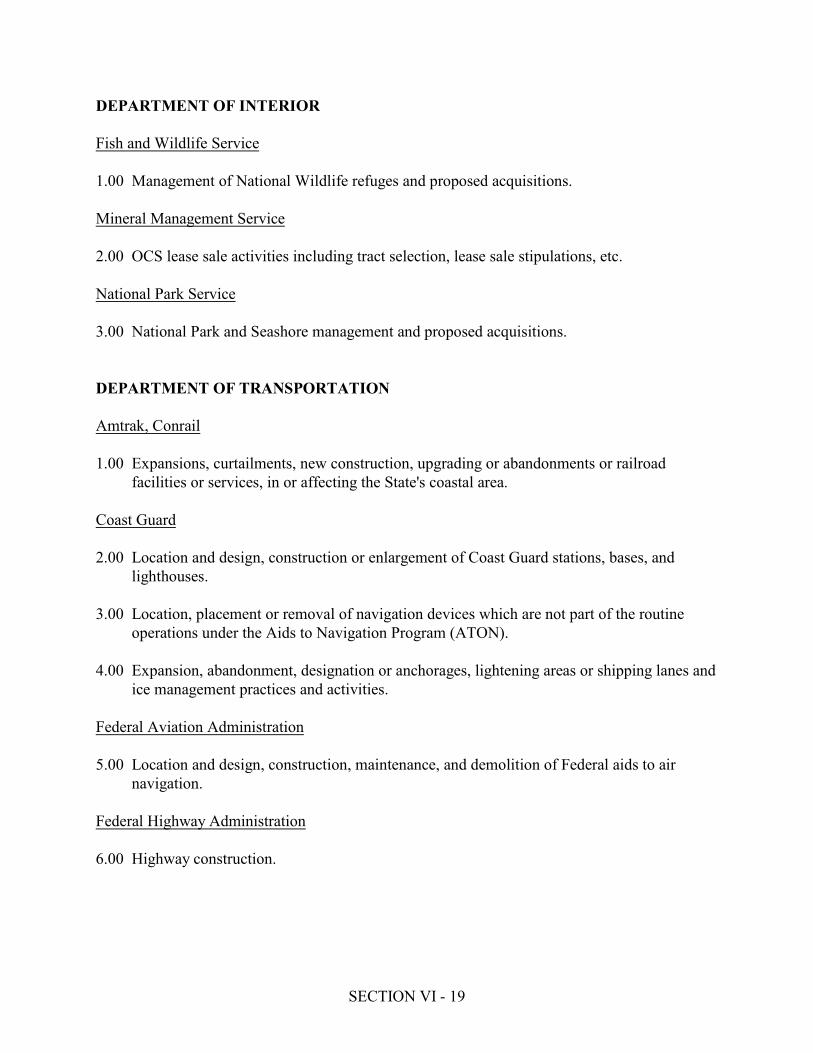
SECTION VI - 19
DEPARTMENT OF INTERIORFish and Wildlife Service1.00 Management of National Wildlife refuges and proposed acquisitions.Mineral Management Service2.00 OCS lease sale activities including tract selection, lease sale stipulations, etc.National Park Service3.00 National Park and Seashore management and proposed acquisitions.DEPARTMENT OF TRANSPORTATIONAmtrak, Conrail1.00 Expansions, curtailments, new construction, upgrading or abandonments or railroadfacilities or services, in or affecting the State's coastal area.Coast Guard2.00 Location and design, construction or enlargement of Coast Guard stations, bases, andlighthouses.3.00 Location, placement or removal of navigation devices which are not part of the routineoperations under the Aids to Navigation Program (ATON).4.00 Expansion, abandonment, designation or anchorages, lightening areas or shipping lanes andice management practices and activities.Federal Aviation Administration5.00 Location and design, construction, maintenance, and demolition of Federal aids to airnavigation.Federal Highway Administration6.00 Highway construction.
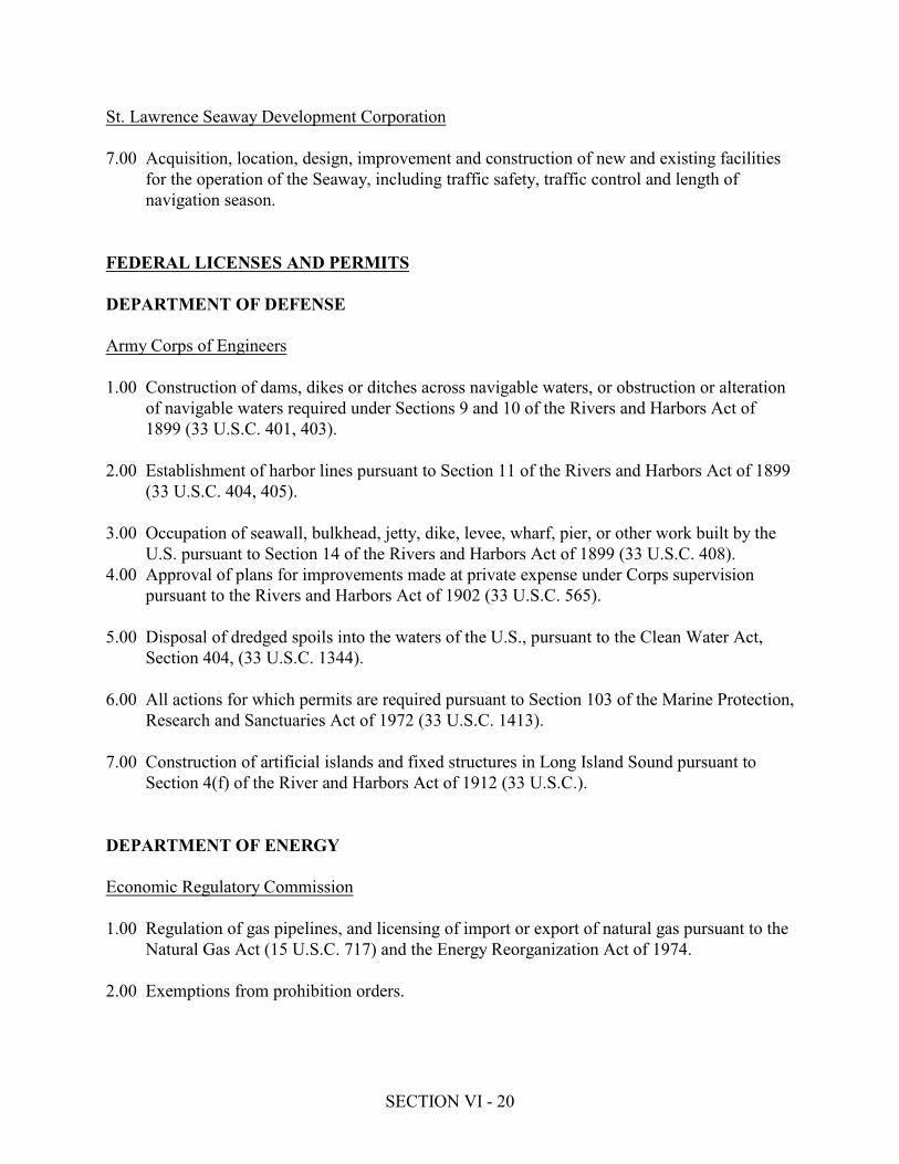
SECTION VI - 20
St. Lawrence Seaway Development Corporation7.00 Acquisition, location, design, improvement and construction of new and existing facilitiesfor the operation of the Seaway, including traffic safety, traffic control and length ofnavigation season.FEDERAL LICENSES AND PERMITSDEPARTMENT OF DEFENSEArmy Corps of Engineers1.00 Construction of dams, dikes or ditches across navigable waters, or obstruction or alterationof navigable waters required under Sections 9 and 10 of the Rivers and Harbors Act of1899 (33 U.S.C. 401, 403).2.00 Establishment of harbor lines pursuant to Section 11 of the Rivers and Harbors Act of 1899(33 U.S.C. 404, 405).3.00 Occupation of seawall, bulkhead, jetty, dike, levee, wharf, pier, or other work built by theU.S. pursuant to Section 14 of the Rivers and Harbors Act of 1899 (33 U.S.C. 408).4.00 Approval of plans for improvements made at private expense under Corps supervisionpursuant to the Rivers and Harbors Act of 1902 (33 U.S.C. 565).5.00 Disposal of dredged spoils into the waters of the U.S., pursuant to the Clean Water Act,Section 404, (33 U.S.C. 1344).6.00 All actions for which permits are required pursuant to Section 103 of the Marine Protection,Research and Sanctuaries Act of 1972 (33 U.S.C. 1413).7.00 Construction of artificial islands and fixed structures in Long Island Sound pursuant toSection 4(f) of the River and Harbors Act of 1912 (33 U.S.C.).DEPARTMENT OF ENERGYEconomic Regulatory Commission1.00 Regulation of gas pipelines, and licensing of import or export of natural gas pursuant to theNatural Gas Act (15 U.S.C. 717) and the Energy Reorganization Act of 1974.2.00 Exemptions from prohibition orders.
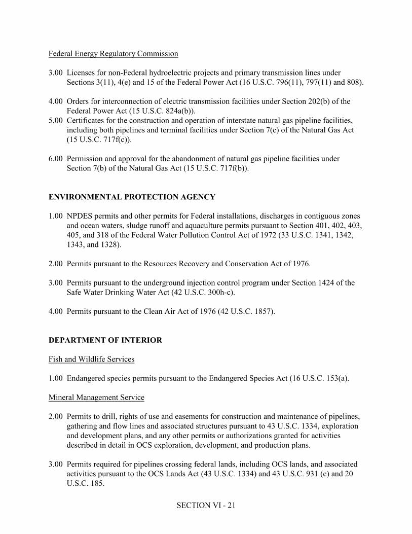
SECTION VI - 21
Federal Energy Regulatory Commission3.00 Licenses for non-Federal hydroelectric projects and primary transmission lines underSections 3(11), 4(e) and 15 of the Federal Power Act (16 U.S.C. 796(11), 797(11) and 808).4.00 Orders for interconnection of electric transmission facilities under Section 202(b) of theFederal Power Act (15 U.S.C. 824a(b)).5.00 Certificates for the construction and operation of interstate natural gas pipeline facilities,including both pipelines and terminal facilities under Section 7(c) of the Natural Gas Act(15 U.S.C. 717f(c)).6.00 Permission and approval for the abandonment of natural gas pipeline facilities underSection 7(b) of the Natural Gas Act (15 U.S.C. 717f(b)).ENVIRONMENTAL PROTECTION AGENCY1.00 NPDES permits and other permits for Federal installations, discharges in contiguous zonesand ocean waters, sludge runoff and aquaculture permits pursuant to Section 401, 402, 403,405, and 318 of the Federal Water Pollution Control Act of 1972 (33 U.S.C. 1341, 1342,1343, and 1328).2.00 Permits pursuant to the Resources Recovery and Conservation Act of 1976.3.00 Permits pursuant to the underground injection control program under Section 1424 of theSafe Water Drinking Water Act (42 U.S.C. 300h-c).4.00 Permits pursuant to the Clean Air Act of 1976 (42 U.S.C. 1857).DEPARTMENT OF INTERIORFish and Wildlife Services1.00 Endangered species permits pursuant to the Endangered Species Act (16 U.S.C. 153(a).Mineral Management Service2.00 Permits to drill, rights of use and easements for construction and maintenance of pipelines,gathering and flow lines and associated structures pursuant to 43 U.S.C. 1334, explorationand development plans, and any other permits or authorizations granted for activitiesdescribed in detail in OCS exploration, development, and production plans.3.00 Permits required for pipelines crossing federal lands, including OCS lands, and associated activities pursuant to the OCS Lands Act (43 U.S.C. 1334) and 43 U.S.C. 931 (c) and 20U.S.C. 185.

SECTION VI - 22
NUCLEAR REGULATORY COMMISSION1.00 Licensing and certification of the siting, construction and operation of nuclear power planspursuant to Atomic Energy Act of 1954, Title II of the Energy Reorganization Act of 1974and the National Environmental Policy Act of 1969.SURFACE TRANSPORTATION BOARD1.00 Authority to abandon railway lines (to the extent that the abandonment involves removal oftrackage and disposition of right-of-way); authority to construct railroads; authority toconstruct coal slurry pipelines.DEPARTMENT OF TRANSPORTATIONCoast Guard1.00 Construction or modification of bridges, causeways or pipelines over navigable waterspursuant to 49 U.S.C. 1455.2.00 Permits for Deepwater Ports pursuant to the Deepwater Ports Act of 1974 (33 U.S.C.1501).Federal Aviation Administration3.00 Permits and licenses for construction, operation or alteration of airports.FEDERAL ASSISTANCE*DEPARTMENT OF AGRICULTURE10.068 Rural Clean Water Program10.409 Irrigation, Drainage, and Other Soil and Water Conservation Loans10.410 Low to Moderate Income Housing Loans10.411 Rural Housing Site Loans10.413 Recreation Facility Loans10.414 Resource Conservation and Development Loans10.415 Rural Renting Housing Loans10.416 Soil and Water Loans10.418 Water and Waste Disposal Systems for Rural Communities10.422 Business and Industrial Loans10.424 Industrial Development Grants10.426 Area Development Assistance Planning Grants10.429 Above Moderate Income Housing Loans
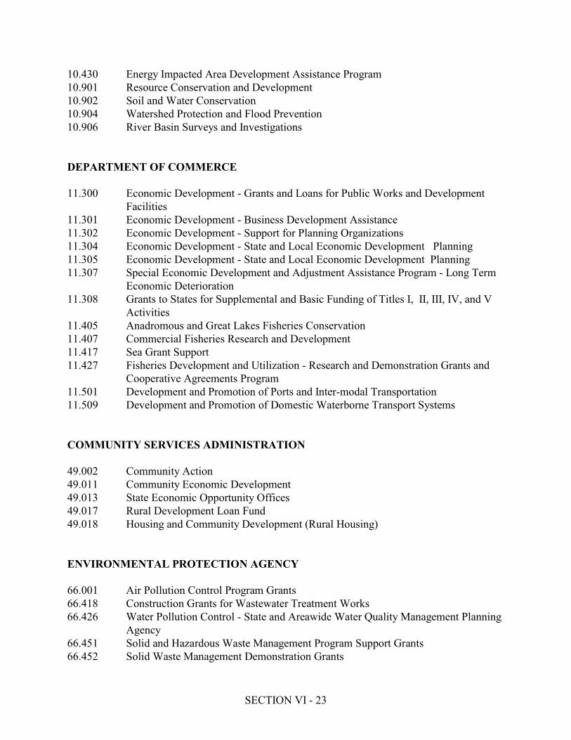
SECTION VI - 23
10.430 Energy Impacted Area Development Assistance Program10.901 Resource Conservation and Development10.902 Soil and Water Conservation10.904 Watershed Protection and Flood Prevention10.906 River Basin Surveys and InvestigationsDEPARTMENT OF COMMERCE11.300 Economic Development - Grants and Loans for Public Works and DevelopmentFacilities11.301 Economic Development - Business Development Assistance11.302 Economic Development - Support for Planning Organizations11.304 Economic Development - State and Local Economic Development Planning11.305 Economic Development - State and Local Economic Development Planning11.307 Special Economic Development and Adjustment Assistance Program - Long TermEconomic Deterioration11.308 Grants to States for Supplemental and Basic Funding of Titles I, II, III, IV, and VActivities11.405 Anadromous and Great Lakes Fisheries Conservation11.407 Commercial Fisheries Research and Development11.417 Sea Grant Support11.427 Fisheries Development and Utilization - Research and Demonstration Grants andCooperative Agreements Program11.501 Development and Promotion of Ports and Inter-modal Transportation11.509 Development and Promotion of Domestic Waterborne Transport SystemsCOMMUNITY SERVICES ADMINISTRATION49.002 Community Action49.011 Community Economic Development49.013 State Economic Opportunity Offices49.017 Rural Development Loan Fund49.018 Housing and Community Development (Rural Housing)ENVIRONMENTAL PROTECTION AGENCY66.001 Air Pollution Control Program Grants66.418 Construction Grants for Wastewater Treatment Works66.426 Water Pollution Control - State and Areawide Water Quality Management PlanningAgency66.451 Solid and Hazardous Waste Management Program Support Grants66.452 Solid Waste Management Demonstration Grants
SECTION VI - 24
66.600 Environmental Protection Consolidated Grants Program Support ComprehensiveEnvironmental Response, Compensation and Liability (Super Fund)GENERAL SERVICES ADMINISTRATION39.002 Disposal of Federal Surplus Real PropertyDEPARTMENT OF HOUSING AND URBAN DEVELOPMENT14.112 Mortgage Insurance - Construction or Substantial Rehabilitation of CondominiumProjects14.115 Mortgage Insurance - Development of Sales Type Cooperative Projects14.117 Mortgage Insurance - Homes14.124 Mortgage Insurance - Investor Sponsored Cooperative Housing14.125 Mortgage Insurance - Land Development and New Communities14.126 Mortgage Insurance - Management Type Cooperative Projects14.127 Mortgage Insurance - Mobile Home Parks14.218 Community Development Block Grants/Entitlement Grants14.219 Community Development Block Grants/Small Cities Program14.221 Urban Development Action Grants14.223 Indian Community Development Block Grant ProgramDEPARTMENT OF INTERIOR15.400 Outdoor Recreation - Acquisition, Development and Planning15.402 Outdoor Recreation - Technical Assistance15.403 Disposal of Federal Surplus Real Property for Parks, Recreation, and HistoricMonuments15.411 Historic Preservation Grants-in-Aid15.417 Urban Park and Recreation Recovery Program15.600 Anadromous Fish Conservation15.605 Fish Restoration15.611 Wildlife Restoration15.613 Marine Mammal Grant Program15.802 Minerals Discovery Loan Program15.950 National Water Research and Development Program15.951 Water Resources Research and Technology - Assistance to State Institutes15.952 Water Research and Technology - Matching Funds to State InstitutesSMALL BUSINESS ADMINISTRATION59.012 Small Business Loans59.013 State and Local Development Company Loans
SECTION VI - 25
59.024 Water Pollution Control Loans59.025 Air Pollution Control Loans59.031 Small Business Pollution Control Financing GuaranteeDEPARTMENT OF TRANSPORTATION20.102 Airport Development Aid Program20.103 Airport Planning Grant Program20.205 Highway Research, Planning, and Construction20.309 Railroad Rehabilitation and Improvement - Guarantee of Obligations20.310 Railroad Rehabilitation and Improvement - Redeemable Preference Shares20.506 Urban Mass Transportation Demonstration Grants20.509 Public Transportation for Rural and Small Urban Areas * Numbers refer to the Catalog of Federal Domestic Assistance Programs, 1980 and its twosubsequent updates.

SECTION VI - 26
B. STATE AND FEDERAL PROGRAMS NECESSARY TO FURTHER THE LWRP1. STATE ACTIONS OR PROGRAMSa. Department of Environmental ConservationUnder the Stream Protection Act Regulations, the Department of EnvironmentalConservation should upgrade the stream classifications of the Landsman Kill to "B(T(," theRhinebeck Kill to "C(T)," the Fallsburg Creek to "C(T)" and the Mudder Kill to "C."b. Department of TransportationMaintenance of the Rhinecliff vehicular bridge and the refurbishing of the pedestrian bridgeover the railroad tracks are essential to continued use of recreational facilities on theHudson River in Rhinecliff. The Department of Transportation should give these overheadcrossings high priority in whatever ways necessary and appropriate for maintaining thesepublic access facilities.c. Office of General ServicesPrior to any development occurring in the water or on the immediate waterfront, OGSshould be consulted for a determination of the State's interest in underwater or formerlyunderwater lands and for authorization to use and occupy these lands.2. FEDERAL ACTIONS OR PROGRAMSa. Department of Transportation, Amtrak, ConrailAmong the Town's most valuable natural resources are the various coves andwetlands along the Hudson River, particularly the Vandenburgh and Suckley Coves.These are threatened by railroad maintenance practices including (1) the spraying ofthe railroad bed and surrounding area with herbicides, (2) the scattering of discardedrailroad ties which are permeated with creosote or other wood preservatives, and (3)the pushing of vegetation from near the tracks into the coves which may addherbicides or increase nitrogen levels of the coves.The Department of Transportation through Amtrak and Conrail should developmaintenance practices which will not contribute pollution to the Hudson Rivercoves and wetlands.The Rhinecliff Bridge provides access to a substantial amount of shorefront land,including the Rhinebeck Town Landing/Dock area, and is the only public vehicularabove grade crossing in the Town. The feasibility of maintaining the public park

SECTION VI - 27
and dock along the Hudson River in Rhinecliff depends largely upon the continuedexistence of the Rhinecliff vehicular bridge. Continuing maintenance of thepedestrian bridge at Rhinecliff would facilitate approach to the dock.In addition, the private vehicular bridge located at The Meadows could providepublic access in the future as part of new development or negotiations with thelandowners.The cooperation of the Department of Transportation through the Conrail andAmtrak operations is necessary to keep all of these bridges in place and provideadequate maintenance to the Rhinecliff vehicular bridge and upgrading andsubsequent maintenance of the Rhinecliff pedestrian bridge.b. Federal Highway AdministrationRoad Construction.
SECTION VII - 1
SECTION VIILOCAL COMMITMENT AND CONSULTATIONLocal Commitment and Involvement in development of the Town of Rhinebeck Draft LocalWaterfront Revitalization Program.This Draft Local Waterfront Revitalization Program (LWRP) is an appropriate extension ofsignificant past and on-going planning efforts undertaken by the Town of Rhinebeck. Throughvarious entities of the Town, the community’s historic ties to the Hudson River and its environs,were examined for new opportunities to strengthen its connection to the River. The variousTown committees involved in the process were comprised of community leaders, concernedcitizens, and various stakeholders. The LWRP development process has involved committee meetings, public meetings, numerousmeetings with other local, regional, County, State and Federal agencies. To facilitatedevelopment of the Draft LWRP, numerous Town meetings were held. In addition, workshops,public meetings, interviews and field visits were conducted. For purposes of preparing the DraftLWRP document, the Town and its consultants met several times with staff of the New YorkState Department of State to address and refine waterfront issues and enhance the Draft LWRPdocument.The current Draft LWRP document was accepted for public review and comment by the Town ofRhinebeck Town Board on June 19, 2006. Similarly, the Rhinebeck Draft LWRP has beenaccepted by the New York State Department of State as complete and ready for public review. Copies of the Rhinebeck Draft LWRP will be distributed by the New York State Department ofState to local, regional, State, and Federal agencies for review during a 60-day review period. Inaddition, the Draft LWRP document will be posted on the Town’s website at:www.rhinebeckny.gov. At the close of the 60-day review period, the Department of State andTown of Rhinebeck will jointly coordinate responses to comments received, and appropriatemodifications to the LWRP document will be made to address comments.

SCENIC AREAS OF STATEWIDE SIGNIFICANCE
FOR
THE TOWN OF RHINEBECK LOCAL WATERFRONT
REVITALIZATION PROGRAM
ESTATES DISTRICT
ESOPUS/ LLOYD
Table of Contents
NEW YORK STATE DEPARTMENT OF STATE
DIVISION OF COASTAL RESOURCES AND
WATERFRONT REVITALIZATION
Excerpts from
JULY 1993
"Reprinted for Public August 2004"
Mario M. Cuomo, Governor
Gail S. Shaffer, Secretary of State
A publication of the New York State Department of State pursuant to National Oceanic and Atmospheric Administration Award No.
NA270Z0285-01.

TABLE OF CONTENTS
DETERMINATION OF THE SECRETARY OF STATE
ACKNOWLEDGEMENTS
INTRODUCTION
HUDSON RIVER SCENIC AREAS MAP
ESTATES DISTRICT
ESTATES DISTRICT LOCATION
ESTATES DISTRICT MAP
ESTATES DISTRICT SUBUNITS
ESTATES DISTRICT SUBUNIT MAPS
ESTATES DISTRICT SHEET 1
ESTATES DISTRICT SHEET 2
ESTATES DISTRICT SHEET 3
ESTATES DISTRICT SHEET 4
ESTATES DISTRICT SHEET 5
ESTATES DISTRICT SHEET 6
ESOPUS/LLOYD
ESOPUS/LLOYD LOCATION
ESOPUS/LLOYD MAP
ESOPUS/LLOYD SUBUNITS
ESOPUS/LLOYD SUBUNIT MAPS
ESOPUS/LLOYD SHEET 1
ESOPUS/LLOYD SHEET 2
ESOPUS/LLOYD SHEET 3
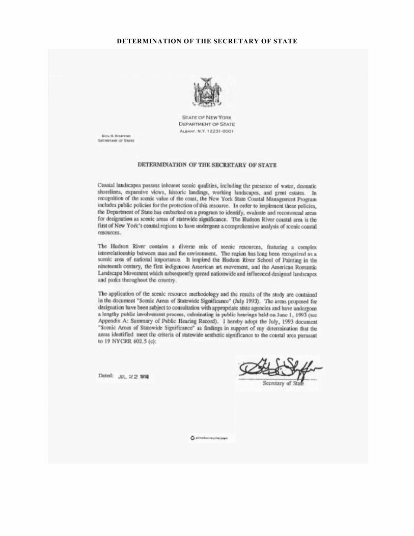
DETERMINATION OF THE SECRETARY OF STATE
ACKNOWLEDGEMENTS
The Hudson River scenic area study has been a collaborative effort among the Department of State, the
consultants, other State agencies and experts in the field of scenic landscape assessment, and the people of
the Hudson River coastal region. The study was funded by the Office of Ocean and Coastal Resource
Management, National Oceanic and Atmospheric Administration, with a grant provided under the Coastal
Zone Management Act of 1972, as amended.
The records of the State Historic Preservation Office have provided a wealth of information regarding the
history of the landscape as have the publications of the Olana and Clermont State Historic Sites and the
Franklin D. Roosevelt and Vanderbilt Mansion National Historic Sites. The assistance of James Ryan, site
manager at the Olana State Historic Site, has been extensive and invaluable. The description of the estates
in the Estates District Scenic Area of Statewide Significance is based in large part on the National Historic
Landmark District documentation of properties published by the National Park Service. Additional assistance
regarding the historic resources has been provided by J. Winthrop Aldrich, Special Assistant to the
Commissioner, and Frances Dunwell, Special Assistant to the Commissioner for the Hudson River, NYS
Department of Environmental Conservation; and John Doyle, Executive Director, Greenway Heritage
Conservancy (formerly the Heritage Task Force for the Hudson River Valley). Carol Sondheimer,
Environmental Director of Scenic Hudson, provided extensive comment and guidance as a member of the
regional panel.
The Department of State extends special recognition to the public and private sector members of the statewide
and regional panels whose experience in the field of scenic landscape evaluation and whose collective
knowledge of the Hudson River and its shorelands helped shape the study's design and application. The
following groups, agencies and institutions are among those which provided important information and
insights throughout the study period.
! Local officials from the Hudson River communities of Claverack, Cold Spring, Esopus, Garrison,
Grandview-on-Hudson, Highland, Highland Falls, Kingston, New Paltz, and Rhinebeck.
! The planning departments of Albany County, Greene County, Columbia County, Dutchess County,
Orange County, Putnam County, Rensselaer County, Rockland County, Ulster County, and
Westchester County.
! The following New York State agencies: Department of Economic Development; Department of
Environmental Conservation; Department of Public Service; Department of Transportation; New
York Power Authority; Office of General Services; and the Office of Parks, Recreation and Historic
Preservation.
! The National Park Service and the Office of Ocean and Coastal Resource Management of the
National Oceanic and Atmospheric Administration.
! Alpine Development Corporation, Bard College, College of Environmental Science and Forestry at
Syracuse, Greenway Heritage Conservancy (formerly the Heritage Task Force for the Hudson river
Valley), Hudson River Sloop Clearwater, International Paper Corporation Research Center, Mid-
Hudson Patterns, The Parks Council, Regional Plan Association, Scenic Hudson, Seaway Trail,
Tappan Zee Preservation Coalition, and the University of Wisconsin at Madison.
This report was prepared by the Department of State, Division of Coastal Resources and Waterfront
Revitalization (DOS) under the supervision of George R. Stafford, Division Director; Charles T. McCaffrey,
Chief of the Bureau of Local and Regional Programs; and William F. Barton, Chief of the Bureau of
Consistency Review and Analysis.
The initial inventory and documentation was prepared by the consultant team of Harry Dodson, Joanne
Jackson, Cecily Kihn, and Bob Yaro. Preparation of the final document was completed under the supervision
of Loretta Simon of DOS with the assistance of Steve Ridler.
Consultant Mary Lou Lamping Lutters designed the public participation process in consultation with DOS.
Laura Zeisel, counsel for the consultant team, conducted legal research of New York State environmental
laws relevant to scenic resource protection. Legal review was provided by DOS counsels Paul Heyman,
Richard Hoffman, and the late James Coon.
Alan Lillyquist and Nancy Rucks of DOS were responsible for study design and project management during
the initial inventory and documentation phases, assisted by Kevin Cross and Thomas Hart. DOS staff, Jeff
Beach, Fitzroy Collins and Gerald Morrison assisted with the numerous community informational meetings.
Kevin Millington managed document production and distribution with the assistance of Mary Ann Butler,
Deborah DeLeonardis and Gary Nankey.
INTRODUCTION
New York State has a long history of recognizing the importance of scenic resources. The first widely known
recognition of American landscape beauty was expressed during the 19th century in the work of the Hudson
River School of painters. The American Romantic Landscape Movement also developed in the Hudson
Valley before spreading to the rest of the nation. Thus, New York's landscape tradition includes appreciation
of both the natural and the cultural landscape and its coastal scenic landscapes usually include elements of
each.
When the State Legislature established the Coastal Management Program in 1981, their findings included:
"...that New York State's coastal area and inland waterways are unique with a variety of natural,
recreational, industrial, commercial, ecological, cultural, aesthetic and energy resources of statewide
and national significance." (Article 42 § 910)
The Act declares that the public policy of the State within the coastal area is "...to achieve a balance between
economic development and preservation that will permit the beneficial use of coastal resources while
preventing the loss of living marine resources and wildlife, diminution of open space areas or public access
to the waterfront, shoreline erosion, impairment of scenic beauty, or permanent damage to ecological
systems." (Article 42 § 912). The Federal Coastal Zone Management Act also recognizes the importance of
aesthetic values in managing coastal resources. The Act states that it is the national policy "to encourage and
assist the states to...achieve wise use of the land and water resources of the coastal zone, giving full
consideration to ecological, cultural, historic, and aesthetic values...."
SCENIC POLICIES
In recognition of the scenic value of the coast, New York's Coastal Management Program (CMP) includes
two policies which provide for the protection and enhancement of this unique resource. Policy 24 provides
for the designation and protection of scenic areas of statewide significance; and Policy 25 requires that
proposed actions located outside a designated SASS must protect, restore or enhance the overall scenic
quality of the coastal area. Both policies call for agencies to determine if a proposed action would impair
scenic quality.
The policies state that impairment of a landscape's scenic quality can occur in two principal ways: 1) through
the irreversible modification or destruction of landscape features and architectural elements which contribute
significantly to the scenic quality of the coast, and 2) through the addition of structures which reduce views
or are discordant with the landscape because of their inappropriate scale, form, or construction materials.
Regulations governing the designation of scenic areas of statewide significance are found in 19 NYCRR Part
602.5.
Both policies include siting and design guidelines which are to be used to evaluate the impact of proposed
development, recognizing that each situation is unique and that the guidelines must be applied accordingly.
The guidelines address the appropriate siting of new structures and other development; the use of scale, form
and materials which are compatible with the landscape's existing scenic components; the incorporation of
historic elements in new development; the maintenance of existing landforms and vegetation; and the removal
and screening of discordant features.

EVALUATING NEW YORK'S COASTAL SCENIC RESOURCES
The New York coast is a mixture of developed and undeveloped areas. Central to the growth of the state, the
coast is replete with evidence of the state's economic and cultural history. The interaction of man with the
landscape provides part of the character that makes the New York coast a visually exciting and valued place.
Its historic and working landscapes stimulate as much interest and attract as many visitors as its more natural
landscapes.
Because the New York coastal landscape is so diverse, a method for evaluating the scenic quality of the state's
coastal landscape must be capable of evaluating both developed and undeveloped areas of the coast. In
addition, public recognition of the landscape's scenic quality is included in the criteria for identification of
scenic areas of statewide significance under the Coastal Management Program. The landscape must also be
visually accessible to the general public.
In order to develop and apply a method for evaluating scenic quality, the Department of State sought
proposals in 1987 for the development of a scenic evaluation method. The firms of Jackson & Kihn of
Philadelphia, Pennsylvania and Dodson Associates of Ashfield, Massachusetts were chosen to develop the
method and apply it first in the Hudson River coastal area.
Dodson Associates had completed a scenic evaluation of the Connecticut River Valley for the Center for
Rural Massachusetts of the University of Massachusetts at Amherst. Dodson Associates' approach to visual
analysis recognizes the interrelatedness of landscape elements and is not limited to identifying specific
viewing points and evaluating viewsheds. It is a descriptive approach which identifies the landscape elements
and rates their scenic quality, taking public values into account. The Department of State first met with the
consultants on January 7, 1988. Preliminary study area visits began on April 6, 1988.
New York's Scenic Evaluation Method
New York's scenic evaluation method is a participatory process involving government agencies and the
general public in the development of criteria and the review of study results. The State regulations specify
that the Secretary of State shall consult with appropriate State agencies before identifying and designating
scenic areas of statewide significance. Accordingly, in 1988 the Department of State established a statewide
panel of State agency representatives and experts in scenic landscape evaluation to assist in developing the
coastal scenic evaluation method. The first meeting of the state panel was held on June 28, 1988.
The method developed recognizes the diversity of natural and cultural elements that shape scenic coastal
landscapes. In order to identify and define coastal scenic components, the physical and cultural character of
the coastal landscape and the geologic and historical forces which have shaped the development patterns are
examined. A comprehensive listing of coastal landscape elements is developed, including geological features,
water features, vegetation, historical and cultural features, and views. Those elements found in the study
landscape which influence the scenic quality of the landscape are identified as scenic components.
Characteristics which would render each scenic component as distinctive, noteworthy or common are
described. Also rated is the extent of discordant elements in the landscape.
For example, a bluff which is very high, prominent and of varied configuration, with dramatic backdrop and
shoreline and no incompatible development, is considered to be distinctive. A bluff of noteworthy scenic
quality would be high with a moderately varied configuration, strong backdrop and shoreline, and minor
incompatible development. Low, uniform bluffs with monotonous backdrop and shoreline and a major
presence of incompatible development would be rated common.
The landscape elements and their scenic characteristics are presented in the Table of Scenic Components.
The table also provides for the evaluation of the aesthetic significance of the landscape composition, the
landscape's uniqueness, and its public accessibility and public recognition. The evaluation of the landscape
composition focusses on the interrelationships of the landscape elements and the composition of views.
For further discussion of the rating system, see Appendix A. Appendix A also includes a sample visual
evaluation form. The Table of Scenic Components is found in Appendix B.
Application of the Method
An important aspect of the scenic evaluation method is that the entire coastal area of the region under study
is evaluated. After an initial survey of the entire coastal region, the Table of Scenic Components is adjusted
so that it contains only those landscape elements found in the study landscape. This adjusted table is called
the Regional Table of Scenic Components.
The coastal area of the region is then divided into geographic subunits based on topography and land use.
Each subunit is evaluated for its scenic quality. The landscape elements of each subunit are rated individually
according to the criteria on the regional table of scenic components, and the ratings are recorded on field
sheets along with the evaluator's comments. The relationship of the elements to each other, the quality of the
views, and the uniqueness of the landscape are also evaluated to determine the scenic quality of the subunit
as a whole.
The degree of public accessibility to the subunit and the degree of public recognition of the landscape's scenic
values are rated for each subunit. Public recognition is evaluated in three ways: first, through public
meetings and surveys during which landscape elements are rated for scenic quality and specific areas
considered scenic are identified; second, through official recognition such as government designations and
public investment; and third, through evidence found in the public statements of literature and the arts.
Candidate Scenic Areas of Statewide Significance
Based on the above evaluation, candidate scenic areas of statewide significance (SASS) are identified.
Candidate SASS are composed of large clusters of subunits rated distinctive. Subunits with ratings of
noteworthy and common may be included in a SASS if they link distinctive subunits or otherwise contribute
to the cohesiveness of the SASS, provided that the total rating of the SASS remains distinctive. Isolated
subunits or small clusters of subunits rated distinctive are not considered for designation unless the subunit
or cluster has an exceptionally high distinctive rating. Note should be made that the scenic resources within
a candidate SASS sometimes extend beyond the boundaries of the Coastal Management Program and cannot,
therefore, be included within the candidate SASS.
Detailed, descriptive narratives for each subunit and for the SASS as a whole are prepared. Scenic area maps
which delineate the boundaries of the SASS and its subunits accompany the narratives. After designation,
the narratives will be used by reviewers in evaluating the consistency of proposed projects with the coastal
scenic policies.
Based on the field sheets, the narratives describe the nature of scenic landscape elements and their
interrelationships, the significance of their scenic quality, and the degree of public accessibility and public
recognition of the landscape. The historic context of the landscape is described, focussing on the forces that
shaped the landscape. Understanding these historic forces enriches the appreciation of the existing scene and
can serve as a guide for future management decisions. Actions which may impair the scenic quality of the
SASS also are identified in the narratives. These are to function as guidelines during the review of projects
proposed within the designated SASS. The candidate SASS are subject to public review. Public hearings
on the proposed designations must be held and findings made by the Secretary of State before SASS may be
designated.
SCENIC AREAS OF STATEWIDE SIGNIFICANCE IN THE HUDSON RIVER REGION
The Hudson River coastal area between New York City and the federal dam at Troy is the first area to be
evaluated under Policy 24. The Hudson River coastal landscape has a wealth and variety of scenic resources,
shaped by a unique combination of geological forces and historical events. Majestic mountains and

formidable bluffs rise above the Hudson's waters in some stretches of the river. In others, forested slopes,
estate lawns, extensive marshlands and farm fields line its shorelands.
The Hudson River region has played an important role in the nation's history. It spawned the Hudson River
School of Painting and the Romantic Landscape style. World renowned artists have responded to its beauty,
and the works of major architects line the river's corridor. Historic river landings and villages evidence the
Hudson's past as a bustling transportation corridor. Today, tourism is the major industry; and national and
State parks and historic sites attract visitors from around the nation and the world.
Six stretches of the Hudson River and it's shorelands have been designated as scenic areas of statewide
significance. These are the Columbia-Greene North SASS, the Catskill-Olana SASS, the Estates District
SASS, the Ulster North SASS, the Esopus-Lloyd SASS and the Hudson Highlands SASS. They include a
fiord in the Hudson Highlands, an impressive collection of significant estates along the Hudson River's mid-
section, the landscape where Thomas Cole and Frederic Church made their homes, and the pastoral landscape
south of the State capital. Each designated SASS encompasses unique, highly scenic landscapes which are
accessible to the public and recognized for their scenic quality.
Each designated SASS is comprised primarily of clusters of distinctive subunits. Occasionally, a noteworthy
or common subunit is included in a SASS because it links distinctive subunits or contributes to the
cohesiveness of the SASS. No individual distinctive subunits are proposed for designation in the Hudson
River region at this time.
BENEFITS OF DESIGNATION
Designation affords special protection from potentially adverse federal or State actions which could impair
the scenic quality of the SASS. Narratives prepared for each SASS describe the character and scenic quality
of the SASS landscape, providing guidance to the public and regulatory agencies as to which landscape
elements should be protected and which actions could impair the scenic quality of the SASS.
Additional protection of SASS can be afforded by municipalities which prepare Local Waterfront
Revitalization Programs (LWRP). Local land use authority is an important tool for the protection of scenic
resources. In communities with an approved LWRP all three levels of government - federal, State and local -
are working toward a common goal. Of the 44 municipalities included within the candidate SASS, 25 have
prepared or are preparing LWRPs. Most of the LWRPs already address to some degree the protection of
scenic landscapes. Designation of the SASS does not impinge on local government decisions.
THE HUDSON RIVER STUDY
The Hudson River coastal area was evaluated from the air, from the Hudson River, from the road network
and on foot. To ensure public participation in the scenic assessment process, a regional panel was appointed
to oversee the study. The panel is composed of State agency members of the statewide panel, representatives
of county and local government and environmental organizations, and individual citizens of the region. The
Department of State and the consultants met frequently with the regional panel regarding the conduct of the
study and its results. The statewide panel was also kept informed of the study's progress, and joint meetings
with both panels were held as appropriate. The panels provided information to the consultants regarding the
resources of the valley and reviewed the consultants' work for accuracy and reasonableness.
Meetings with both panels attending were held at the Norrie Point Environmental Center in Staatsburg on July
12, August 2, September 20 and November 15, 1988 and on September 16, 1989.
In order to assess public values regarding the scenic quality of Hudson River coastal scenic components,
public workshops were held in Poughkeepsie and Greenport at which those attending were asked to rate
various regional landscape elements for their scenic quality. Questionnaires were also published in area
weekly newspapers, inviting the public to identify landscapes they thought were of high scenic quality. The

responses generated at the workshops and through the survey were considered during the development of the
Hudson River Regional Table of Scenic Components.
When candidate SASS were initially identified, draft narratives were prepared and distributed widely in the
region. The following public information meetings were held throughout the region during which residents
could examine the narratives and accompanying maps:
May 14, 1990 Ulster County Office Building, Kingston
May 15, 1990 Norrie Point Environmental Center, Staatsburg
June 11, 1990 Piermont Village Hall, Piermont
June 12, 1990 Philipstown Town Hall, Cold Spring
June 13, 1990 Bear Mountain Inn, Bear Mountain State Park
June 25, 1990 Columbia-Greene Community Collage, Greenport
June 26, 1990 Coxsackie Village Board Room, Coxsackie
The draft narratives were sent to all municipalities in the study area for review and comment. Presentations
were also made at public meetings of the following local government bodies in communities located in the
candidate SASS:
May 23, 1990 Hyde Park Town Board
June 5, 1990 Coxsackie Town and Village Boards
June 11, 1990 Athens Town and Village Boards
June 12, 1990 Philipstown Town Board
June 12, 1990 Cortlandt Town Board
June 26, 1990 Greene County Environmental Management Council
July 3, 1990 Stockport Town Board
July 9, 1990 Haverstraw Town Board
July 10, 1990 Kingston City Council
July 12, 1990 Stuyvesant Town Board
October, 1990 Saugerties Town and Village Boards
Based on comments received during this initial period of public review, the SASS narratives and maps were
revised. Additional field visits were made and additional research conducted concerning the history and
resources of the candidate SASS. The information collected was incorporated into the document "Scenic
Areas of Statewide Significance Proposed for Designation" (April 1993). This document was the subject of
further public review throughout the Hudson River region. Public hearings on the areas proposed for
designation as scenic areas of statewide significance were held on June 1, 1993 at the following locations:
Columbia-Greene Community College, Greenport, Columbia County
Rhinebeck Town Hall, Dutchess County
Bear Mountain Inn, Rockland County
After reviewing the hearing record and all written comments received within the comment period, several
minor factual revisions were made to the narratives and these are incorporated into this document. As a result
of the material contained in this document, the Secretary of State determined that the six areas proposed for
designation were of statewide aesthetic significance to the coastal area pursuant to the factors set forth in 19
NYCRR 602.5 (c). Policy 24 of the Coastal Management Program know applies to those areas encompassed
by the SASS designation. Management plans for each SASS will be prepared as resources allow. Local
governments with approved local waterfront revitalization programs will be encouraged to evaluate their
program for adequacy of protection of the identified scenic resources. Municipalities not participating in the
Coastal Management Program will be encouraged to prepare LWRPs, but will not be required to change
current local government decision making.
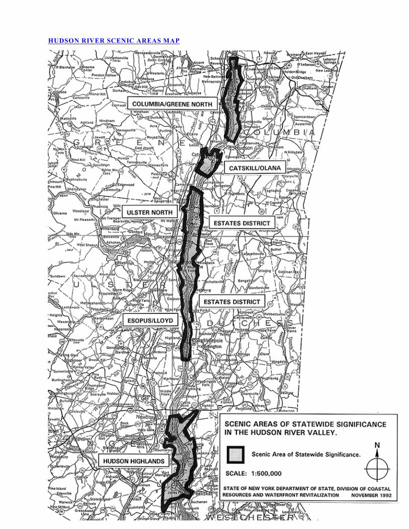
HUDSON RIVER SCENIC AREAS MAP

ESTATES DISTRICT SCENIC AREA OF STATEWIDE SIGNIFICANCE
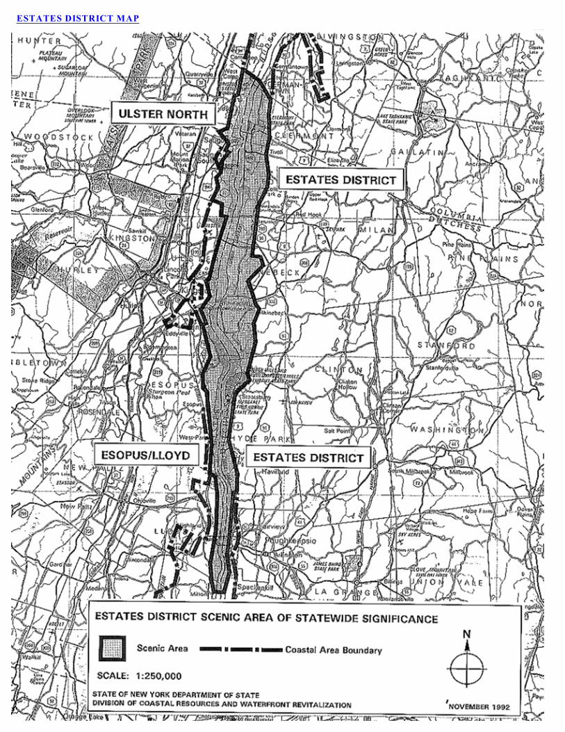
ESTATES DISTRICT MAP

ED Page 1
ESTATES DISTRICT SCENIC AREA OF STATEWIDE SIGNIFICANCE
I. Estates District Location
The Estates District Scenic Area of Statewide Significance (SASS) consists of the Hudson River and its
eastern shorelands in the Towns of Germantown and Clermont, Columbia County, and in the Towns of Red
Hook, Rhinebeck and Hyde Park and the Villages of Tivoli and Rhinebeck in Dutchess County. The western
half of the Hudson River lies in the Towns of Saugerties, Ulster, Esopus and Lloyd, the Village of Saugerties
and the City of Kingston in Ulster County.
Cheviot Road in Cheviot Landing, Town of Germantown, constitutes the landward portion of the northern
boundary which continues due west across the Hudson River to meet the western boundary. The SASS
extends approximately 27 miles to south of the Franklin D. Roosevelt Home National Historic Site. Its
southern boundary lies 500 feet to the south of the Maritje Kill and follows the configuration of the Maritje
Kill, then crosses the Hudson due west. The western boundary is the mean high water line on the west bank
of the Hudson River. The eastern boundary follows NY Route 9G in Germantown, Clermont and Red Hook;
NY Route 9G, Hook Road, Old Post Road and NY Route 9 in Rhinebeck; and Old Post Road and NY Route
9 in Hyde Park.
Consult the Estates District SASS map for SASS boundaries.
II. DESCRIPTION
The Estates District SASS is comprised of 29 subunits:
ED-1 Clermont, ED-2 Clermont/Tivoli Estate Farmland, ED-3 Tivoli, ED-4 Montgomery
Place/Blithewood, ED-5 Tivoli Bays, ED-6 Bard College, ED-7 Annandale-on-Hudson, ED-8
Barrytown, ED-9 Astor Point, ED-10 Astor Cove, ED-11 River Road, ED-12 Mount Rutsen, ED-13
Rhinebeck Center, ED-14 Rhinecliff Road, ED-15 Rhinecliff, ED-16 Rhinecliff Woods, ED-17 Mill
Road Meadows, ED-18 Vanderburgh Cove, ED-19 Dinsmore Golf Course, ED-20 Mills State Park,
ED-21 Staatsburg, ED-22 Norrie Heights, ED-23 Norrie State Park, ED-24 Vanderbilt Mansion, ED-
25 Hyde Park Center, ED-26 Franklin D. Roosevelt Home Estate Entrance and ED-27 Franklin D.
Roosevelt Home National Historic Site.
Together the subunits constitute a landscape of national and international significance which evolved through
the development of a rich cultural heritage in an outstanding natural setting. As its name implies, the Estates
District SASS is dominated by over twenty major and numerous minor historic estates and the Hudson River
toward which they are oriented. The beauty of the region's landscape, including views of the Hudson and the
distant Catskill Mountains, has been celebrated for generations, most notably in the paintings of the Hudson
River School, the first indigenous art movement in the United States.
The Hudson River in this area is a tidal estuary whose flow reverses at high tide. The Hudson has served
many functions in both pre-historic and historic times which continue in the present day -- transportation
corridor, trade and migration route, water supply and nurturer of the creatures, both human and animal, which
make their home in or along the river. The Hudson corridor is also part of the Atlantic flyway which brings
migrating species to the numerous coves, flats and marshes.
The scenic environs and the bustling commerce generated by the Hudson River's presence have successfully
coexisted for centuries. Archeological evidence has been uncovered of native shoreland settlements, and

ED Page 2
canoes were the first ferries. The native American communities called the river Mukheakunnuk, "river that
flows two ways."
From colonial times this scenic landscape has attracted landed gentry, industrial magnates and historic figures
who built lavish mansions. Among those who established their country seats in this area are Frederick
Vanderbilt, Archibald Rogers, John Jacob Astor, Ogden Mills, Jacob Ruppert, Levi P. Morton, Chancellor
Robert R. Livingston, Morgan Lewis, James Roosevelt, Franklin H. Delano, Edward Livingston, Mrs.
Richard Montgomery, General DePeyser, General Armstrong and others. In the hamlets and villages is found
the vernacular architecture of the people who worked the land, maintained the mansions and were employed
in the commercial ventures. Evidence of the bustle of earlier times is found in the remains of old docks and
bridges and overgrown roads and trails.
In 1697 a single land grant called the Great Nine Partners patent incorporated approximately 149,000 acres
or one-third of what is now Dutchess County. Since there were no roads at the time, the Hudson River
provided the only route for transporting the lumber and furs harvested on the land. The partners were
guaranteed equal access to the Hudson through the division of the shorelands into nine equal lots. The early
estates such as Clermont and the Kip-Beekman house were sited close to the Hudson to facilitate the transport
of agricultural products via water to the urban markets.
By the early 1800s the natural landscape became the focal point; and the main houses, sited on rolling hills
and bluffs overlooking the Hudson River, were oriented to take advantage of panoramic views. The environs
of the earlier houses were altered and redesigned in the romantic style, an environmentally sensitive
movement that originated in New York State and provided the foundation for national trends in landscape
design and the 19th century urban parks movement.
The estates and manor houses were designed by renowned architects and landscape architects including
Richard Morris Hunt, Stanford White, Calvert Vaux, Andrew Jackson Downing, Charles Platt, Hans Jacob
Ehlers, Alexander Jackson Davis and the Olmsted Brothers. The region has traditionally been, and largely
remains, a shining example of how the human hand can carefully and creatively enhance the beauty of a
natural landscape through inspired design and the highest standards of construction, maintenance and
preservation. The historically harmonious blend of the built environment with the natural setting and the
remarkable lack of major discordant features, despite extensive contemporary development, has yielded a
remarkably well-preserved and visually unified historic landscape of both national and international
significance. The numerous coves, islands, marshes and creek beds compose a varied shoreline of great
interest, while the vegetative cover of forest, pasture, orchards, gardens and expansive lawns enhances the
rolling topography and frames views.
Punctuating the estate landscapes and gracing the hamlet and village streetscapes are fine examples of period
vernacular architecture, comprising the former homes of tenant farmers and independent farmers, mariners
and storekeepers. One room schoolhouses now adapted to other uses, inns, commercial buildings and ruins
of dams at former mill sites give further evidence of the history of the area and provide focal points in interior
views. The fact that so much of the fabric of the natural and cultural landscape remains is unusual and serves
to enrich the individual viewer's experience of the landscape by providing evocative elements to which the
he or she can relate.

ED Page 3
III. AESTHETIC SIGNIFICANCE
The Estates District SASS is of statewide aesthetic significance by virtue of the combined aesthetic values
of its landscape character and its uniqueness, public accessibility and public recognition.
There exists in the SASS variety as well as unity of major landscape components and striking contrasts
between lines, forms, textures and colors in the landscape. The collection of large estates with their designed
landscapes, the many undisturbed natural features and the significant public historic sites and architectural
treasures render this SASS unique in the Hudson River coastal area, the State and the nation. The Hudson
River and its influence on the historical development of the area constitute the major unifying features. The
SASS is generally free of discordant features, evidence of the strong conservation ethic operating there.
Although private estates cover most of the eastern shore of the Hudson River, the Estates District SASS is
publicly accessible to a great extent, both visually and physically, from the Hudson River, from public streets
and highways and from significant national and State parks and sanctuaries.
Because of the attraction these facilities create and because the SASS has been the subject of treatises and
art works, surveys and designations at both the State and national level, the Estates District Scenic Area is
well recognized by the public for its aesthetic values.
A. Landscape Character
1. Variety
The Estates District SASS exhibits an unusual variety of major components. The landform consists of rolling
topography behind steep bluffs which drop 150 feet to the Hudson River. Mt. Rutsen, the highest point in
the SASS at 350 feet above sea level, rises above the generally level terrain which surrounds it.
There is a variety of water features which contribute a myriad of linear elements to the landscape
composition. The Hudson River is the dominant water body, its shoreline configuration changing throughout
the SASS. Creeks, the principal ones being Stony Creek, Saw Kill, the Mudder Kill, the Landsman Kill,
Fallsburgh Brook, Staatsburg Creek, the Indian Kill, Bard Rock Creek, Crum Elbow Creek and the Maritje
Kill, meander through the landscape and cut deep ravines with waterfalls, particularly as they near the
Hudson. The shoreline of the Hudson is characterized by coves, marshes and scattered islands along the
eastern shore, Magdalen Island and Cruger Island in Red Hook being the two largest. When seen from a
distance, however, the east bank shoreline appears unbroken because railroad causeways bridge the natural
indentations and transform the east bank into a single fluid line.
The Hudson is alternately narrow and broad. It deepens to wind around points of land such as Crum Elbow
and then spreads thinly over shallows and tidal flats. The varied depths influence the landscape at the river's
edge, governing, along with the railroad causeway, the size and location of tidal marshes as well as the
surface texture. In the areas of broad expanse the water is of greater visual consequence, while narrow
sections of the river such as Crum Elbow cause each opposite shore to appear in certain perspectives as if not
separated by water at all.
The coves vary in size, but all present an intimate waterscape rich with flora and fauna. Tivoli North and
South Bays provide the broadest expanse of marsh vegetation interlaced with waterways. Other coves of note
are Vanderburgh Cove and Roosevelt Cove. Because fill was used to form the railroad bed, some of the
marshes were created when the causeways were built.
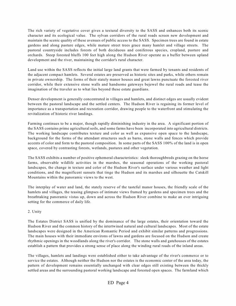
ED Page 4
The rich variety of vegetative cover gives a textural diversity to the SASS and enhances both its scenic
character and its ecological value. The sylvan corridors of the rural roads screen new development and
maintain the scenic quality of these avenues of public access to the SASS. Specimen trees are found in estate
gardens and along pasture edges, while mature street trees grace many hamlet and village streets. The
pastoral countryside includes forests of both deciduous and coniferous species, cropland, pasture and
orchards. Steep forested bluffs 100 feet high along the Hudson River operate as a buffer between upland
development and the river, maintaining the corridor's rural character.
Land use within the SASS reflects the initial large land grants that were farmed by tenants and residents of
the adjacent compact hamlets. Several estates are preserved as historic sites and parks, while others remain
in private ownership. The forms of their stately manor houses and great lawns punctuate the forested river
corridor, while their extensive stone walls and handsome gateways bejewel the rural roads and tease the
imagination of the traveler as to what lies beyond these estate guardians.
Denser development is generally concentrated in villages and hamlets, and distinct edges are usually evident
between the pastoral landscape and the settled centers. The Hudson River is regaining its former level of
importance as a transportation and recreation corridor, drawing people to the waterfront and stimulating the
revitalization of historic river landings.
Farming continues to be a major, though rapidly diminishing industry in the area. A significant portion of
the SASS contains prime agricultural soils, and some farms have been incorporated into agricultural districts.
The working landscape contributes texture and color as well as expansive open space to the landscape,
background for the forms of the attendant structures such as barns, stone walls and fences which provide
accents of color and form to the pastoral composition. In some parts of the SASS 100% of the land is in open
space, covered by contrasting forests, wetlands, pastures and other vegetation.
The SASS exhibits a number of positive ephemeral characteristics: sleek thoroughbreds grazing on the horse
farms, observable wildlife activities in the marshes, the seasonal operations of the working pastoral
landscapes, the change in texture and color of the Hudson River's surface under various weather and light
conditions, and the magnificent sunsets that tinge the Hudson and its marshes and silhouette the Catskill
Mountains within the panoramic views to the west.
The interplay of water and land, the stately reserve of the tasteful manor houses, the friendly scale of the
hamlets and villages, the teasing glimpses of intimate views framed by gardens and specimen trees and the
breathtaking panoramic vistas up, down and across the Hudson River combine to make an ever intriguing
setting for the commerce of daily life.
2. Unity
The Estates District SASS is unified by the dominance of the large estates, their orientation toward the
Hudson River and the common history of the intertwined natural and cultural landscapes. Most of the estate
landscapes were designed in the American Romantic Period and exhibit similar patterns and progressions.
The main houses with their immediate environs of lawns and gardens are focused on the Hudson and create
rhythmic openings in the woodlands along the river's corridor. The stone walls and gatehouses of the estates
establish a pattern that provides a strong sense of place along the winding rural roads of the inland areas.
The villages, hamlets and landings were established either to take advantage of the river's commerce or to
service the estates. Although neither the Hudson nor the estates is the economic center of the area today, the
pattern of development remains essentially unchanged with clear edges still existing between the thickly
settled areas and the surrounding pastoral working landscape and forested open spaces. The farmland which
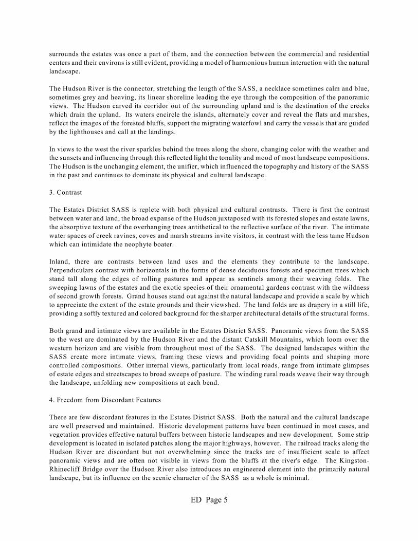
ED Page 5
surrounds the estates was once a part of them, and the connection between the commercial and residential
centers and their environs is still evident, providing a model of harmonious human interaction with the natural
landscape.
The Hudson River is the connector, stretching the length of the SASS, a necklace sometimes calm and blue,
sometimes grey and heaving, its linear shoreline leading the eye through the composition of the panoramic
views. The Hudson carved its corridor out of the surrounding upland and is the destination of the creeks
which drain the upland. Its waters encircle the islands, alternately cover and reveal the flats and marshes,
reflect the images of the forested bluffs, support the migrating waterfowl and carry the vessels that are guided
by the lighthouses and call at the landings.
In views to the west the river sparkles behind the trees along the shore, changing color with the weather and
the sunsets and influencing through this reflected light the tonality and mood of most landscape compositions.
The Hudson is the unchanging element, the unifier, which influenced the topography and history of the SASS
in the past and continues to dominate its physical and cultural landscape.
3. Contrast
The Estates District SASS is replete with both physical and cultural contrasts. There is first the contrast
between water and land, the broad expanse of the Hudson juxtaposed with its forested slopes and estate lawns,
the absorptive texture of the overhanging trees antithetical to the reflective surface of the river. The intimate
water spaces of creek ravines, coves and marsh streams invite visitors, in contrast with the less tame Hudson
which can intimidate the neophyte boater.
Inland, there are contrasts between land uses and the elements they contribute to the landscape.
Perpendiculars contrast with horizontals in the forms of dense deciduous forests and specimen trees which
stand tall along the edges of rolling pastures and appear as sentinels among their weaving folds. The
sweeping lawns of the estates and the exotic species of their ornamental gardens contrast with the wildness
of second growth forests. Grand houses stand out against the natural landscape and provide a scale by which
to appreciate the extent of the estate grounds and their viewshed. The land folds are as drapery in a still life,
providing a softly textured and colored background for the sharper architectural details of the structural forms.
Both grand and intimate views are available in the Estates District SASS. Panoramic views from the SASS
to the west are dominated by the Hudson River and the distant Catskill Mountains, which loom over the
western horizon and are visible from throughout most of the SASS. The designed landscapes within the
SASS create more intimate views, framing these views and providing focal points and shaping more
controlled compositions. Other internal views, particularly from local roads, range from intimate glimpses
of estate edges and streetscapes to broad sweeps of pasture. The winding rural roads weave their way through
the landscape, unfolding new compositions at each bend.
4. Freedom from Discordant Features
There are few discordant features in the Estates District SASS. Both the natural and the cultural landscape
are well preserved and maintained. Historic development patterns have been continued in most cases, and
vegetation provides effective natural buffers between historic landscapes and new development. Some strip
development is located in isolated patches along the major highways, however. The railroad tracks along the
Hudson River are discordant but not overwhelming since the tracks are of insufficient scale to affect
panoramic views and are often not visible in views from the bluffs at the river's edge. The Kingston-
Rhinecliff Bridge over the Hudson River also introduces an engineered element into the primarily natural
landscape, but its influence on the scenic character of the SASS as a whole is minimal.

ED Page 6
B. Uniqueness
The Estates District SASS, a major collection of significant estates with the integrity of their original settings
largely preserved, is unique. Some estates have become museums or institutional properties, but most still
serve their original function as country seats. The companion land uses of working farms, river landings and
villages remain essentially intact.
The activities of modern life coexist in a landscape with its constitutive historic and scenic elements
conserved. Designed landscapes which spawned the American Landscape Movement that subsequently
spread across the country remain, as does the work of renowned architects, some of whom were ingenious
innovators in the architectural history of the nation, including Calvert Vaux and Stanford White. Their works
have earned for a majority of the SASS a National Historic Landmark District designation.
The fact that the land uses of the working pastoral landscape remain visually distinct from the commercial
and residential centers is uncommon in the face of significant development pressure that usually yields
suburban sprawl. Because the historic development pattern has been continued, the original interdependence
of the hamlets and river landings with the estates and the Hudson River is still evident.
C. Public Accessibility
The Estates District SASS is moderately accessible to the public because most of the land is in private
ownership and the railroad tracks along the Hudson River effectively cut off most access between the Hudson
River and its shorelands. A number of former estates, however, are owned by the federal and State
government and operated as parks open to the public. These provide important visual and physical access
to the Hudson and its shorelands and foster public understanding and appreciation of the history and beauty
of the SASS. These public properties are the Franklin D. Roosevelt Home and the Vanderbilt Mansion
National Historic Sites, Clermont State Historic Site and Mills-Norrie State Park. Other sites operated by
non-profit organizations, such as Wilderstein and Montgomery Place, as well as some quasi-public
institutions, such as Bard College and the Linwood Retreat, provide additional, though more limited access.
The Hudson River provides visual access to the entire western portion of the SASS with views of the coves,
marshes and estate buildings and grounds on the east bank of the river. The Hudson is regaining its former
importance as a transportation corridor, although the presence of the railroad tracks severely limits docking
opportunities, increasing the importance of the existing landings. Rhinebeck Town Landing in Rhinecliff,
accessible via a bridge over the railroad tracks, provides docking for transient vessels and is a popular boat
launch and viewing area.
Because the railroad lies inland from the Hudson River within Norrie State Park, Norrie Point and the marina
in the park provide docking and slip rentals. Small boats can also be launched into Tivoli North and South
Bays from a State car-top boat launch accessible from NY Route 9G in Red Hook. The bays and much of
their associated shorelands constitute the National Estuarine Sanctuary and Research Reserve and are State-
owned. These extensive holdings provide public access to one of the most significant marshes on the Hudson
and to Cruger's Island.
As passenger vessels become more common on the Hudson, more members of the public other than
recreational boaters will be able to view the Hudson and its shorelands from the river, including views of
estate properties not otherwise accessible, thus increasing public understanding of the landscape's
significance.

ED Page 7
The railroad tracks, although minor discordant features in the landscape, provide visual access to the Estates
District SASS. Since the bluffs along the tracks block views in most cases to the estates and other upland
areas, the views from the trains are primarily of the Hudson River, its coves and creek mouths, islands,
lighthouses, wildlife and river traffic.
Municipal waterfront parks provide additional public access to the Hudson - visual access only at the Hyde
Park Railroad Station and both visual and physical access at the Rhinebeck Town Landing at Rhinecliff. In
addition, village-owned land in Tivoli provides visual and physical at- grade access to the Hudson, although
the land is not officially developed as a park. At Barrytown there is an above-grade vehicular bridge on a
public street.
The Hyde Park Trail, an initial segment of which is now open along the Hudson River between the Franklin
D. Roosevelt Home and Vanderbilt Mansion National Historic Sites with a second segment planned to
connect with the Mills-Norrie State Park, traverses private property through easement arrangements and
provides visual access to the Hudson River. As this trail is extended and others are developed elsewhere,
public access to the interior landscape of the SASS will increase.
Ferncliff Forest in Rhinebeck, which includes Mt. Rutsen, is a private nature preserve open to the public for
hiking. An observation tower at the top of the forested knob could provide panoramic views of the SASS if
it were repaired.
State highways and county and local roads provide visual access to the edges and interior of the SASS.
Dutchess County has included many roads in the county's network of designated Historic Tourways. Maps
for self-drive tours are available from the county.
D. Public Recognition
The Estates District SASS is highly recognized by the public for its scenic and historic values. The landscape
and panoramic views of the SASS were frequently the subject matter for artists of the 19th century Hudson
River School of Painting, the first indigenous art movement in the United States and of international renown.
Many scenes appearing in their works remain relatively unchanged.
The scenic quality of the Estates District SASS is recognized under Article 49 of the Environmental
Conservation Law through designation of the Mid-Hudson Historic Shorelands Scenic District and the
following Scenic Roads:
1. In Red Hook, Santage Road from its junction with Woods Road to its junction with Stony Brook
Street;
2. In Red Hook, Stony Brook Street from its junction with Santage Road to its junction with NY Route
9G;
3. In Red Hook, River Road and Annandale Road;
4. In Rhinebeck, Rhinecliff, Morton and South Mill Roads and parts of the road also known as County
Route 103;
5. In Rhinebeck, NY Route 199 from its junction with NY Route 9G west to the Kingston-Rhinecliff
Bridge;
ED Page 8
6. In Hyde Park, NY Route 9 from the southern border of the Vanderbilt Mansion National Historic
Site northerly 2.3 miles;
7. In Hyde park, Old Post Road in the hamlet of Staatsburg for its entire length between its intersections
with NY Route 9;
8. In Hyde Park, Golf Course Road in the Dinsmore Golf Course;
9. In Hyde Park, Norrie State Park Roads from the entrance to the park to both Norrie Point and the
camping area.
Many roads in the area have also been designated by Dutchess County as Historic Tourways.
For more detailed information concerning the designed landscapes of the estates, the Management Plan for
the Mid-Hudson Historic Shorelands Scenic District should be consulted.
Most of the SASS is included in the thirty two square mile Hudson River National Historic Landmark District
designated in 1990 as the nation's largest landmark district. In addition, the SASS contains three historic
districts listed on the State and National Registers of Historic Places - The Clermont Estates Historic District,
the Sixteen Mile Historic District and the Town of Rhinebeck Multi-Resource District. Most of the estates
included in these designations would individually meet the criteria for listing on the State and National
Registers, but they gain additional significance from their grouping along the Hudson River.
The Estates District SASS is also well recognized by the general public as the location of two National
Historic Sites, the Vanderbilt Mansion and the Franklin D. Roosevelt Home, both in Hyde Park. Also
frequented by the public are the Mills-Norrie State Park in Staatsburg and the Clermont State Historic Site
in Clermont. These public properties attract a large number of visitors each year.
During the tenure of President Franklin D. Roosevelt the SASS was the destination of international
dignitaries. President Roosevelt welcomed world leaders to his home in Hyde Park, often greeting them or
seeing them off at the Hyde Park Railroad Station. Photographs recording their visits are in the collection
of the Presidential Library at the F.D.R. Home National Historic Site and at the Hyde Park Railroad Station
Museum.
In addition to the public properties, other estates are being preserved and opened to the public, increasing the
number of visitors attracted to the SASS. Montgomery Place in Red Hook, operated by Historic Hudson
Valley, is open to the public. Wilderstein, in Rhinebeck, owned by Wilderstein Preservation and undergoing
restoration, is open to the public on a limited basis.
Several educational and religious institutions have been developed on former estates and provide limited
access to the SASS. Among them are Bard College and the Linwood Retreat.
IV. IMPACT ASSESSMENT
Whether within or outside a designated Scenic Area of Statewide Significance (SASS) all proposed actions
subject to review under federal and State coastal acts or a Local Waterfront Revitalization Program must be
assessed to determine whether the action could affect a scenic resource and whether the action would be likely
to impair the scenic beauty of the scenic resource.
ED Page 9
Policy 24 provides that when considering a proposed action, agencies shall first determine whether the action
could affect a scenic resource of statewide significance. The determination would involve:
(1) a review of the coastal area map to ascertain if it shows an identified scenic resource which
could be affected by the proposed action, and
(2) a review of the types of activities proposed to determine if they would be likely to impair the
scenic beauty of an identified resource.
Impairment includes:
(i) the irreversible modification of geologic forms; the destruction or removal of vegetation;
the modification, destruction, or removal of structures, whenever the geologic forms,
vegetation or structures are significant to the scenic quality of an identified resource; and
(ii) the addition of structures which because of siting or scale will reduce identified views or
which because of scale, form, or materials will diminish the scenic quality of an identified
resource.
Policy 24 sets forth certain siting and facility-related guidelines to be used to achieve the policy, recognizing
that each development situation is unique and that the guidelines will have to be applied accordingly. The
guidelines are set forth below, together with comments regarding their particular applicability to this Scenic
Area of Statewide Significance. In applying these guidelines to agricultural land it must be recognized that
the overall scenic quality of the landscape is reliant on an active and viable agricultural industry. This
requires that farmers be allowed the flexibility to farm the land in an economically viable fashion,
incorporating modern techniques, changes in farm operation and resultant changes in farm structures. Policy
24 guidelines include:
SITING STRUCTURES AND OTHER DEVELOPMENT SUCH AS HIGHWAYS, POWER LINES,
AND SIGNS BACK FROM SHORELINES OR IN OTHER INCONSPICUOUS LOCATIONS TO
MAINTAIN THE ATTRACTIVE QUALITY OF THE SHORELINE AND TO RETAIN VIEWS TO
AND FROM THE SHORE;
COMMENT: The most notable of views available in the SASS are the panoramic views which
include lawns or fields, the Hudson River and its shoreline and the distant Catskill Mountains. The
siting of structures in a manner that causes them to intrude upon, block, alter the composition of or
introduce discordant features into these views would impair the scenic quality of the SASS.
Interior views are less well known but equally contribute to the aesthetic significance of the
landscape. They tend to be views down winding rural roads and carriage trails and glimpses of small
clearings framed by vegetation. The essential character of these views is of pastoral or forested
landscapes. If commercial or industrial structures or large scale residential structures were introduced
into these views, they would constitute discordant features, impairing the scenic quality of the views
and, consequently, the scenic quality of the SASS.
CLUSTERING OR ORIENTING STRUCTURES TO RETAIN VIEWS, SAVE OPEN SPACE AND
PROVIDE VISUAL ORGANIZATION TO A DEVELOPMENT;
ED Page 10
COMMENT: Two types of views are found in the SASS. These are 1) panoramic views, generally
including fields or lawns, the Hudson River and its western shorelands and 2) intimate views of a
pastoral or forested nature. If care were not taken to cluster and orient structures to retain these
views, discordant features would be introduced into the views, reducing their scenic quality and
impairing the scenic quality of the SASS.
If agriculture were not to remain as a viable industry, a significant amount of open space could be
lost. Measures which stimulate the accelerated appreciation of farmland could lead to the loss of
farmland in the SASS, to the extent that pressure on farmers to sell farms for residential and
commercial development increases. Loss of the working farm landscape to other uses would reduce
the unifying element of the pastoral landscape and eliminate some of the ephemeral elements of the
SASS, thus impairing the scenic quality of the SASS. The failure to cluster new development at the
edges of fields and adjacent to existing population centers rather than allow it to sprawl across the
fields would obliterate the sharp edges between settled areas and open space, affecting the variety
and contrast of the landscape composition and impairing the scenic quality of the SASS.
Other types of open space in the SASS include estate lawns and forests. The latter provide an
opportunity to screen new development on the estates. Failure to preserve forested areas and to
cluster structures within them in order to retain the open lawns of the estates would reduce open
space and contrast in the landscape, impairing the scenic quality of the SASS. Failure to maintain
the forests and use them to screen new development would eliminate the contrast between the open
lawns and forested areas and impair the scenic quality of the SASS. Siting of structures in the lawn
areas would alter the composition of the views, reduce open space and, in some cases, block views
in the SASS, a significant component of its scenic quality.
The forested shorelands also contribute open space to the landscape composition and provide an
opportunity to screen new development. Failure to retain the forests to the maximum extent
practicable and screen new development within them would change the open space character of the
Hudson River corridor, reduce the amount of texture and contrast of the SASS, impair the visual
organization and verdant character of the Hudson River corridor and impair the scenic quality of the
SASS.
The expanse of the Hudson River is itself a significant open space element in the SASS. Its ever
changing surface provides a variety of contrasts with its forested shores and settled landings. The
siting of extensive dock and mooring facilities would reduce the open space of the Hudson and the
alternately tossing and reflective surface of the water. This would reduce the variety and contrast of
the landscape, impairing the scenic quality of the SASS.
INCORPORATING SOUND, EXISTING STRUCTURES (ESPECIALLY HISTORIC BUILDINGS)
INTO THE OVERALL DEVELOPMENT SCHEME;
COMMENT: The historic structures in the SASS relate the story of the cultural landscape as well
as contribute to the landscape and provide focal points in views. Architectural gems such as the
Hudson River lighthouses along the western shore, estate and farm structures, streetscapes and
specimen trees are examples of focal points. Other cultural elements include the estate houses and
their designed landscape environs including the expansive lawns; other estate features such as
gateways and entrance roads, historic barns and stone walls; historic streetscapes in the villages and
river landings; and the vernacular village and farm architecture reflecting earlier agricultural
practices. Failure to preserve these historic structures through incorporation in an overall
development scheme would alter the cultural landscape, reduce variety and contrast of the landscape

ED Page 11
and eliminate focal points from views, impairing the scenic quality of the SASS. Loss of historic
structures would also reduce the visible story of the landscape, reducing its symbolic value and
reducing public recognition of that history and value.
REMOVING DETERIORATED AND/OR DEGRADING ELEMENTS;
COMMENT: Some historic elements are deteriorated, such as stone walls and certain historic
structures, but removal of these important landscape components would result in the loss of important
cultural features and focal points in views as well as reduce the variety and contrast of the landscape,
thus impairing the SASS. Rehabilitation rather than removal is the more appropriate action for
historic structures.
The SASS is generally free of discordant features. The railroad tracks are discordant when they
figure prominently in the landscape, however. This occurs primarily when the viewer is close to the
tracks. Therefore, avoiding the application of herbicides in the railroad corridor which renders
vegetation unsightly or failure to control scrub growth along the corridor to maintain views, can
impair the scenic quality of the SASS. In addition, leaching of other pollutants from the tracks into
the adjacent marshes, if such leaching were to adversely affect the viability and visual character of
the marsh vegetation, would change the color and texture of the marsh and impair the scenic quality
of the SASS. This loss of vegetation and marsh viability could result in a reduction of wildlife
populations, reducing ephemeral elements of the SASS and impairing its scenic quality.
Bulkheads and docks in the river landings are evidencing signs of deterioration, and some waterfront
areas are cluttered with abandoned structures and discarded materials. Failure to invest in the river
landings, such as Rhinecliff, Barrytown and Tivoli, through repair of bulkheads and docks may
increase deterioration to the extent that the bulkheads and docks become discordant features.
Rehabilitation of these docks has the added advantage of preserving opportunities to increase public
access to the SASS in the future via passenger vessels and to reinforce the historic ties to the Hudson
River. Increased tourism could support the continued economic health of the public and private
attractions as well as of the landings and community centers, thus maintaining the character and good
repair of significant scenic elements of the SASS.
MAINTAINING OR RESTORING THE ORIGINAL LAND FORM, EXCEPT WHEN CHANGES
SCREEN UNATTRACTIVE ELEMENTS AND/OR ADD APPROPRIATE INTEREST;
COMMENT: The shoreline of the Hudson River is characterized by coves, marshes and scattered
islands which contribute to the variety and contrast of the SASS and the interest of an undulating
shoreline in many locations. Meandering streams cross the upland fields and rush through ravines
as they approach the river. Actions and development which would alter the configuration of the
shorelines or the relationship between water and land elements would impair the scenic quality of
the SASS.
The bluffs along the Hudson River are highly erodible and subject to slumping and sliding. Their
wooded character in certain portions of the Hudson River corridor significantly contributes to its
scenic quality. Failure to maintain the undisturbed nature of the bluffs and their woodlands would
alter the natural character of the landscape and the river corridor and impair the scenic quality of the
SASS.

ED Page 12
The topography behind the bluffs is generally rolling with some promontories. Alteration of this
underlying form would diminish a unifying element of the landscape and impair the scenic quality
of the SASS.
MAINTAINING OR ADDING VEGETATION TO PROVIDE INTEREST, ENCOURAGE THE
PRESENCE OF WILDLIFE, BLEND STRUCTURES INTO THE SITE, AND OBSCURE
UNATTRACTIVE ELEMENT, EXCEPT WHEN SELECTIVE CLEARING CREATES VIEWS OF
COASTAL WATERS;
COMMENT: The variety, type and arrangement of vegetation in the SASS contributes significantly
to the scenic quality. From marshes to wooded slopes to forests, to gardens and working farms, the
natural and designed landscapes exhibit a wide range of color and texture. Vegetation screens
discordant features, defines edges, softens harsh contrasts, frames views and provides focal points
such as specimen trees. The wildlife supported by the various vegetation constitutes ephemeral
effects on the landscape. Tree-lined scenic roads and carriage trails constitute important access ways
for public experience of the landscape. Failure to preserve vegetation and provide for its continuance
to the maximum extent practicable would alter the composition of the landscape, introduce discordant
features through the failure to screen development, change the nature of views and significantly
impair the SASS.
Vegetation also provides a buffer between the SASS and discordant elements outside the SASS and
preserves the ambience of historic landscapes by screening adjacent incompatible development. As
development and related traffic increase in the SASS, the importance of this buffer increases. Loss
of vegetation along the edge of the scenic district and the edges of historic sites would adversely
impact the historic context of the historic sites and impair the scenic quality of the SASS.
The failure to undertake selective clearing of brush along the railroad corridor at the Hyde Park
Railroad Station Park will result in further diminishment of visual public access to the Hudson River
and reduction in the quality of the views available there, impairing the scenic quality of the SASS.
USING APPROPRIATE MATERIALS, IN ADDITION TO VEGETATION, TO SCREEN
UNATTRACTIVE ELEMENTS;
COMMENT: The SASS is a living landscape which has successfully absorbed change over time
because each new period of development has been compatible with the scale, design and materials
of previous periods. Failure to use appropriate materials, the color and texture of which would blend
new development into the historic and natural landscape, would introduce discordant features into
the landscape which singularly or collectively would disrupt the unity of the SASS and impair its
scenic quality.
USING APPROPRIATE SCALES, FORMS AND MATERIALS TO ENSURE THAT BUILDINGS
AND OTHER STRUCTURES ARE COMPATIBLE WITH AND ADD INTEREST TO THE
LANDSCAPE.
COMMENT: The SASS is a living landscape which has successfully absorbed change over time
because each new period of development has been compatible with the scale, design and materials
of previous periods. Failure to continue to use appropriate scales, forms and materials in new
development that are compatible with neighboring structures and do not dominate the landscape
would introduce discordant features into the landscape which singularly or collectively would disrupt
the unity of the SASS and impair its scenic quality.
Estates District Scenic Area of State Significance
Index to Estates District Subunits
ED-1 Clermont Subunit
ED-10 Astor Cove Subunit
ED-11 River Road Subunit
ED-12 Mount Rutsen Subunit
ED-13 Rhinebeck Center Subunit
ED-14 Rhinecliff Road Subunit
ED-15 Rhinecliff Subunit
ED-16 Rhinecliff Woods Subunit
ED-17 Mill Road Meadows Subunit
ED-18 Vanderburgh Cove Subunit

ED-1 Page 1
ESTATES DISTRICT SCENIC AREA OF STATEWIDE SIGNIFICANCE
ED-1 Clermont Subunit
I. Location
The Clermont subunit constitutes part of the northernmost portion of the Estates District SASS. Its northern
boundary is Cheviot Road in the river landing of Cheviot, and its southern boundary is a common boundary
with the ED-Montgomery Place/Blithewood subunit bordering Tivoli Bay in the Village of Tivoli. Woods
Road constitutes the eastern boundary north of Callendar House, a common boundary with the ED-2
Clermont/Tivoli Estate Farmland subunit. The eastern boundary south of the village center is the edge of the
fields surrounding the village center, a common boundary with the ED-3 Tivoli subunit. On the west the
boundary is the mean high tide line on the west bank of the Hudson River, part of the Ulster North SASS.
The subunit is located in the Towns of Germantown and Clermont in Columbia County, in the Town of Red
Hook and the Village of Tivoli in Dutchess County and in the Town of Saugerties in Ulster County. Consult
the Estates District SASS map sheets, numbers 1 and 2, for subunit boundaries.
II. Scenic Components
A. Physical Character
The Clermont subunit consists of steep, wooded bluffs rising 150 feet above the Hudson River and a rolling
landscape behind them punctuated with rock outcrops. Meadows and lawns of several major estates create
clearings in the extensive woodlands. Vegetation is a mix of native species and the ornamental plantings of
the estates' landscapes, most designed in the American Romantic Landscape Style. Mature trees line Woods
Road and estate entrance roads. The land is laced with intermittent streams, and the White Clay Kill/Stony
Brook cut through the fields and woodlands on their way to the Hudson.
The Hudson River is about 2,200 feet in width in this area. The shoreline of the Hudson is primarily linear
with long gradual curves emphasized by the railroad tracks which are located on an eight foot high
embankment. Small points occasionally project into the Hudson west of the railroad tracks.
B. Cultural Character
The cultural character of the subunit is dominated by historic estates which are part of a unique grouping of
historic properties that stretches for twenty miles along the Hudson River. Some once had their own docks
on the Hudson, but the docks are now in ruins and separated from the upland by the railroad tracks. In this
subunit, there is only one bridge across the tracks - at Midwood - and it is in good repair and regular use.
Ruins of docks and ice houses are located along the Hudson on both sides of the railroad tracks. Dry laid
stone walls and rows of mature trees line Woods Road. Overgrown trails and paths on the estate grounds give
evidence of one pastime followed on these country seats.
One of the most scenic and historic of the Hudson river estates is Clermont, the heart of the original 162,248
acre Manor of Livingston charter given to Robert Livingston by Governor Dongan in 1686. This original
tract constituted the bottom third of Columbia County and reached east to the borders of what is now
Massachusetts and Connecticut. Clermont, or the "Lower Manor", consisting of 13,000 acres, was carved
out of the southwest corner of Livingston Manor for the third son of Robert Livingston, Robert of Clermont,
who built the first house at Clermont in 1728. His son, the third Robert Livingston, was a judge in the
Supreme Court of the Province of New York and, as delegate to the Stamp Act Congress, wrote the letter of
protest to the King of England. His son, Robert R. Livingston, was an advocate of colonial rights and a
ED-1 Page 2
member of the Second Continental Congress, one of five chosen to draft the Declaration of Independence.
During the Revolution the British, after burning Kingston, sailed up river and burned the buildings at
Clermont in 1777. Charred members of the original house are a part of the existing Clermont house,
constructed in 1782 on the original foundation.
Chancellor Livingston became prominent in the affairs of the new nation and, in 1781, was appointed the first
United States Minister of Foreign Affairs. He was interested in mechanics and formed a partnership with
Robert Fulton. Fulton's first steamboat, known to posterity as the Clermont, stopped at the Clermont wharf
on its maiden voyage up the Hudson River in 1807.
The original gift of 414 acres to the State of New York, which became Clermont State Historic Site, was
made by Alice Delafield Clarkson Livingston in 1962. In 1991 Honoria Livingston McVitty, the last
surviving direct descendant of Robert Livingston to have grown up at Clermont, gave the State an additional
71 acres of wooded shoreland and meadows plus 88 acres of underwater land adjacent to the State Historic
Site. Farm fields and woods east of Woods Road are part of the Historic Site. Ms. McVitty retained the
Sylvan Cottage, once the gatekeeper's cottage, and the remaining 15 acres of the Livingston holdings north
of the Historic Site.
The Clermont house is sited on bluffs overlooking the Hudson River amidst a pastoral, designed landscape
of tall locust trees and ornamental plantings. Enlarged and modified several times, the house was last
remodeled in the 1920s in the Colonial Revival Style. Other historic structures, including the Children's
Playhouse and the Livingston Family burial site built in 1750, are located in the newly acquired parkland.
The McVitty gift includes "The Avenue," the original Eighteenth Century entrance road to Clermont which
was used to transport produce from inland farms to the Clermont wharf. Stone walls and piers along Woods
Road mark the beginning of The Avenue, and the white pines that line it were planted by John Henry
Livingston around 1885. The Garden Path leads to a greenhouse and upper garden which includes historic
plants. Carriage roads and trails wind through the property.
The Clermont subunit stretches many miles along the Hudson River and includes many smaller estates. To
the south of Tivoli and north of Lower Dock Road is located The Pynes, once called Green Hill. Its main
house, built perhaps as early as 1762, predates the house at Clermont because it was not burned by the British,
its owner, Gilbert Livingston, having convinced the British soldiers that he was a Tory. This estate adjoins
the original river landing for the Tivoli area.
Callendar House, located in the southeastern corner of the subunit south of The Pynes, consists of 175 acres,
presently in two ownerships, separated by a wooded ravine. Some of this acreage is now called Tivoli Farms
and is located in the Tivoli subunit. The entrance road is bordered by mature pine trees. The original portion
of the main house, built in 1794, is Georgian in style and adorned with a Greek Revival colonnaded portico,
while the later south wing was designed by McKim, Mead and White. There is an Italianate carriage house
on the grounds.
Northwood, composed of 230 acres, most of which lie east of Woods Road, is the largest of the subunit's
estates. Orchards along Woods Road and an 1875 gatehouse notify the traveler of the estate's presence. The
stucco main house built in 1856 is approached through a wooded area. Other structures of note on the
property are a carriage house and mounting shed along with a collection of barns.
Oak Lawn, an 1872 Second Empire masonry structure, is built at the edge of a bluff that rises steeply above
the Hudson River. Then forty-six acres in size, the estate was the childhood home of Eleanor Roosevelt. The
long curving entrance road begins at an 1870 gatehouse with French inspired details. Overgrown trails and

ED-1 Page 3
paths are still identifiable on the property. The main house has, unfortunately, fallen into extensive disrepair,
and the property has been reduced to five acres and has lost its view.
Other estates, of which only a portion are located in the subunit, include Rose Hill and Teviot to the south
of Clermont. Rose Hill's masonry house with its Italianate tower was built in 1843. The estate's original
entry road, located just north of St. Paul's Church, is now overgrown; but its border of trees is still visible,
and its gate lodge and gates still stand. Also visible along Woods Road are former farm structures of Rose
Hill, some transformed into residences. Teviot still sports its 1843 Gothic Revival house graced by weeping
hemlocks.
North of Clermont are Ridgely, now the Motherhouse of the Carmelite Sisters and site of an 1850 farmhouse,
and Southwood and Chiddingstone, two other mid-19th century estates. The 1885 rambling main house of
Midwood, less formal in demeanor than its neighbors, was designed by Michael O'Connor as a year-round
home. Situated on a bluff above the Hudson River, it sports panoramic views of the Hudson and the distant
Catskills. The property also has access to the Hudson River via a bridge over the railroad tracks to a small
point of shoreland, the site of an old dock. Midwood is connected to the adjacent Oak Lawn via an interior
road. Holcroft and Northwood are located in the most northerly portion of the subunit.
Tivoli Landing, once a bustling wharf, is now a quiet spot on the Hudson. Passenger vessels and cargo
vessels alike once docked there, including the Saugerties-Tivoli ferry. Near the western shore of the Hudson
River to the north of the landing stands the Saugerties Lighthouse, the oldest existing Hudson River
lighthouse. Listed on the National Register of Historic Places, it has been restored as a museum and bed and
breakfast. (Refer to the UN-5 Esopus Creek subunit in the Ulster North SASS for more detailed information
about the Saugerties Lighthouse and other features of the western shore.)
The subunit has few discordant features. Some of the estates suffer from neglect and inappropriate bulky
additions, but the landscape is generally well kept and its integrity maintained.
The railroad bed is somewhat discordant. Located on an embankment eight feet high, it parallels the straight
shoreline at the foot of the bluffs and for the most part cannot be seen from the estates; but it does constitute
a discordant feature from nearby river perspectives. Its scale renders it insignificant in panoramic views,
however.
The railroad tracks, although not highly visible, do cut off access between the Hudson River and its uplands
except for a few individual landings, including Tivoli Landing. Hudson River landings developed over two
centuries of orientation to the river as an avenue of commerce. The village landing is no longer used and is
in a deteriorated condition that is discordant with the surrounding estate properties. However, it does still
evidence the close connection between the Hudson and historic development in the subunit.
C. Views
Views from the subunit are both deep and broad, especially from the grounds of the estates which have been
designed to create, frame, and enhance the composition of the views of both the natural riverfront setting of
the mansions and of the Hudson River and distant Catskills. The mansions, the river, the Saugerties
Lighthouse on the western shore and the Catskills are the focal points of these views. The shorelands of the
Ulster North SASS to the west are important as the middleground of these extensive views.
The Hudson River dominates many views, especially those from Tivoli Landing where the Hudson is
experienced as a broad and sometimes foreboding body of water. Rough water and large waves are
ephemeral effects generated on windy days.

ED-1 Page 4
Glimpses of the estate grounds are available along Woods Road, but in most locations the estate gatehouses
and stone walls provide the only hint of the landscape beyond. Portions of the estates are visible from the
Hudson River.
III. Uniqueness
The Clermont subunit, a collection of significant historic estates with both their architectural values and their
designed landscapes relatively unaltered, is unique. The historic setting is irreplaceable. The estates
exemplify a blending of exceptional architecture, beautifully integrated with an enhanced natural setting and
oriented to take full advantage of views of the Hudson Valley.
IV. Public Accessibility
Clermont State Historic Site is open to the public and provides the opportunity for the public to experience
the ambience, views and designed landscape available to the private landowner. The private estates of the
subunit are visible from the Hudson River and from some locations on its western shore in the Ulster North
SASS. Woods Road and other local roads provide access to the edge of the subunit and some limited visual
access to estate grounds. The subunit is also visible from the trains, although the bluffs limit views to the
east. Tivoli Landing provides access to the Hudson River.
V. Public Recognition
The subunit is included the Mid-Hudson Historic Shorelands Scenic District designated under Article 49 of
the Environmental Conservation Law. Woods Road is a designated Scenic Road under Article 49 and is an
Historic Tourway designated by Dutchess County. The subunit constitutes most of the Clermont Estates
Historic District and the northernmost portion of the Sixteen Mile Historic District, both listed on the State
and National Registers of Historic Places. The subunit is also located in the Hudson River National Historic
Landmark District.
VI. Reason for Inclusion
The Clermont subunit is included in the Estates District SASS because it contains a variety of vegetation,
water features and cultural elements. Woodlands, lawns, ornamental plantings and rows of mature trees along
the roadway grace the landscape. Intermittent streams, creeks and the Hudson River provide interest. Estate
houses from several architectural periods, gatehouses and stone walls signal the historical significance of the
area. The landscape is characterized by contrast between the lawns and mansions of the historic estates and
the woodlands and Hudson River of their surroundings. The distant Catskill Mountains provide additional
contrast in the sweeping views to the west from the estate grounds. The subunit is unified by the landscape
design and the degree of preservation of the historic architectural and landscape elements. It is generally well
kept and has few discordant features.
The subunit is unique. The estates exemplify the blending of exceptionally sited architecture integrated with
an enhanced natural setting that typifies the aesthetic sensibilities of the owners and the Age of Romanticism
which shaped the Estates District SASS.
The subunit is accessible via the Hudson River, Woods Road and other local roads. The Clermont State
Historic Site is accessible to the public and presents an excellent sense of the total scenic character of the
subunit. The remaining estates are in private (in one case institutional) ownership, but the buildings and
grounds of the estates are visible from the Hudson River and from some points on the western shore in the
ED-1 Page 5
Ulster North SASS. Their edges and some of their fields are visible from the public roads. Portions of the
subunit are also visible from the railroad trains, although the bluffs limit views to the east.
The subunit is very well known and is recognized through several designations. It is included in the Mid-
Hudson Historic Shorelands Scenic District designated under Article 49 of the Environmental Conservation
Law. Woods Road is a designated Scenic Road under Article 49 and is an Historic Tourway designated by
Dutchess County. The subunit is included in the Hudson River National Historic Landmark District and the
Clermont Estates Historic District and constitutes a portion of the Sixteen Mile Historic District listed on the
State and National Registers of Historic Places.
ED-10 Page 1
ESTATES DISTRICT SCENIC AREA OF STATEWIDE SIGNIFICANCE
ED-10 Astor Cove Subunit
I. Location
The Astor Cove subunit extends along the Hudson River from just north of the Rhinebeck/Red Hook town
line south to just north of Long Dock Road in Rhinecliff. Its northern boundary is a common boundary with
the ED-9 Astor Point subunit, and its southern boundary is a common boundary with the ED-14 Rhinecliff
Road subunit. The subunit is bounded on the east by the top of the bluffs along the Hudson River, a common
boundary with the ED-11 River Road subunit. The western boundary is the mean high tide line on the
western shore of the Hudson. The subunit is located in the Towns of Red Hook and Rhinebeck, Dutchess
County and in the City of Kingston and the Town of Ulster, Ulster County. Consult the Estates District SASS
map sheet number 3 for subunit boundaries.
II. Scenic Components
A. Physical Character
The Astor Cove subunit consists of the Hudson River, which is 2,000 feet wide in this area, and the 100 foot
high steep, wooded bluffs that constitute its eastern shore. The Hudson dominates the entire subunit. The
river's shoreline is straight, defined by the railroad embankment that parallels the shore, except at Mills Point
and Clifton Point. To the east of the tracks are located Astor Cove and wetlands, several other coves and
wetlands, and small streams and ponds. Small ravines have been cut through the bluffs by the streams.
Upland vegetation consists of mature woodland and occasional meadows. The designed landscapes of several
estates located in the subunit include unique specimen trees and other notable plantings.
B. Cultural Character
Land use in the subunit consists mainly of four large 20th century estates that line the bluffs and provide
dramatic views of the Hudson River. Although generally set at the summit of the bluffs and the properties
are primarily wooded, the houses are visible from the Hudson. Several of the mansions include extensive
landscaped grounds that extend into the adjacent River Road subunit. The southern portion of the Mandara
estate, located in the Astor Point subunit to the north, extends into this subunit. The estates include Orlot,
Ferncliff, Marienruh (now called Valeur), and The Meadows (formerly Leacote). The subunit also contains
numerous vernacular structures from the 18th and 19th centuries. Although past neglect led to the demolition
of Leacote, the subunit is currently well maintained.
In the northern portion of the subunit lies Orlot, its grounds flanked by ravines extending to the Hudson. The
estate entrance road predates the estate as it was in the 18th century a public road, an extension of Upper
Hook Road, which leads to a small settlement called Schultz's Landing. The original Orlot farmhouse still
stands, a 1 1/2 story frame house whose original fabric dates from the late 18th century. In 1940 its colonial
revival main house was built on terraces leading to the lawns and the Hudson River. The estates's 350 acres
were farmed and a portion was mined for iron deposits, the latter use having given the land its name. The
view to the 1950s Kingston-Rhinecliff Bridge to the north is less than successful, letting the discordant
features of traffic and industrial architecture intrude on the estate grounds.
Marienruh was purchased in 1868 by Louis Augustus Ehlers, the landscape gardener who designed the
grounds of Ferncliff. Ehlers' designed landscape for Marienruh has subsequently been altered, and his estate
house was demolished in 1908. The present mansion is the second main house on the property. Built in the
ED-10 Page 2
1920s for Prince Obolensky and his wife Alice Astor, the Georgian house is oriented to take advantage of the
long view to the south across Astor Cove, a view now blocked by forest growth.
The Ferncliff Casino, located south of Astor Cove, was designed in the Neo-classical style by McKim, Mead
& White in 1902 and was converted to a residence for Vincent Astor, son of John Jacob Astor, after the
Ferncliff mansion was demolished in 1941. A tea house, also designed for Vincent Astor by David Pleydell
Bouverie, is now located near the site of the original mansion. French Provincial barns and two arched
bridges from the early 1900s remain.
The most significant discordant features are the industrial and mining sites visible in Ulster and Kingston,
just outside the western boundary of the SASS. Because the railroad corridor along the eastern shore is not
highly visible, it is not a major discordant feature except when viewed from nearby locations. The Kingston-
Rhinecliff Bridge, which opened in 1957, is an undistinguished utilitarian structure that is not compatible with
the historic architecture in the subunit, but it does not significantly detract from the subunit's visual quality
because it is not visible from many places in the subunit.
C. Views
Views from the subunit are sweeping 180 degree panoramas from the grounds of the major estates, and many
include the Kingston-Rhinecliff Bridge. Many views are framed and enhanced by the designed landscapes
surrounding the mansions. In other areas of the subunit the dense forest cover limits views.
Except for Orlot and The Meadows, views have a focus to the southwest, and those downriver are three miles
in length. Views to the north from south of the Kingston-Rhinecliff Bridge are blocked by the bridge which
also limits somewhat the breadth of views. Views to the west extend to the Catskill Mountains. The
industrial sites on the western shore across from the southern portion of the subunit are somewhat discordant
and reduce the scenic quality of the views.
In the northern portion of the subunit the steep wooded bluffs along the western shore just north of the
Kingston-Rhinecliff Bridge are important as the middle ground of views to the west. Recent residential
development is located on the ridge of the bluffs, introducing an element of discordance to an otherwise
pristine length of wooded bluffs that extends northward to Glasco.
III. Uniqueness
While some of the historic integrity of the landscape has been lost, the grouping of the estates and their
grounds in the Astor Cove subunit remains unique, a grouping of historic estates designed by prominent
architects and landscape architects.
IV. Public Accessibility
The subunit consists primarily of private property which is not physically accessible to the public. The
subunit is visible from the Hudson River and its western shorelands and from the Kingston-Rhinecliff Bridge.
An abandoned railroad right-of-way which connects Slate Dock with NY Route 9G crosses the subunit and
could provide additional public access if developed as a hiking trail. A vehicular above-grade bridge crosses
the railroad tracts at The Meadows.
ED-10 Page 3
V. Public Recognition
The subunit is located in the Mid-Hudson Historic Shorelands Scenic District designated under Article 49
of the Environmental Conservation Law. The Kingston-Rhinecliff Bridge and the adjacent portion of N.Y.
Route 199 are designated Scenic Roads under Article 49 because of the views they offer. The Astor Cove
subunit is also part of the Hudson River National Historic Landmark District and of the Sixteen Mile Historic
District listed on the State and National Registers of Historic Places.
VI. Reason for Inclusion
The Astor Cove subunit is included in the Estates District SASS because it contains a variety of landscape
and architectural components including mature woodlands, unique specimen trees and estate plantings
associated with notable early 20th century mansions. Contrast exists between the buildings and the natural
elements of the surrounding grounds and woods, while the design of the estate grounds and their structures
effects a strong unity among these elements.
The subunit is visible to the public from the Hudson River and its western shore and from the Kingston-
Rhinecliff Bridge. The subunit is publicly recognized through its inclusion in the Mid-Hudson Historic
Shorelands Scenic District designated under Article 49 of the Environmental Conservation Law. The
Kingston-Rhinecliff Bridge is a designated Scenic Road under Article 49 because of the views it offers,
including views of the Astor Cove subunit. The subunit is also included in the Hudson River National
Historic Landmark District and in the Sixteen Mile Historic District listed on the State and National Registers
of Historic Places.

ED-11 Page 1
ESTATES DISTRICT SCENIC AREA OF STATEWIDE SIGNIFICANCE
ED-11 River Road Subunit
I. Location
The River Road Subunit extends for almost seven miles between the hamlet of Annandale-on-Hudson on the
north and Rhinecliff Road on the south. The subunit's western boundary is a common boundary with the ED-
10 Astor Cove, ED-9 Astor Point and ED-8 Barrytown subunits along the Hudson River to the west. Its
eastern boundary is coterminous with the boundary of the ED-12 Mount Rutsen subunit to the east, except
where the northern and southern ends of the subunit reach east to New York Route 9G. The northern
boundary is a common boundary with the ED-7 Annandale-on-Hudson subunit, and the southern boundary
is a common boundary with the ED-14 Rhinecliff Road subunit. The subunit is located in the Towns of Red
Hook and Rhinebeck, Dutchess County. Consult the Estates District SASS map sheets, numbers 2 and 3, for
the subunit boundaries.
II. Scenic Components
A. Physical Character
The physical character of the subunit consists of flat to moderately rolling upland plateau accentuated by
extensive estate farm fields and pastures and divided by small swales and gullies. Rock outcroppings are
found throughout. The water features of very small brooks and ponds do not play a major role in the
landscape. The Mudder Kill, which rises in Snyder Swamp in the adjacent subunit to the east, is a small
perennial stream that recedes to a trickle during dry summers. Vegetation consists of mature deciduous
forests, fields and pastures with large specimen trees located in fields and around estate houses. Large trees
also line the rural roads and estate entrance roads.
B. Cultural Character
River Road/Annandale Road winds generally north and south through the entire subunit. The corridor is lined
with trees and stone walls, some dry laid and some faced and topped with cap stones. The extensive pastoral
landscape which flanks both sides of the roadway is associated with estates, the main houses of which are
located in the adjacent riverfront subunits to the west. These estates include Massena, Edgewater, Sylvania,
Rokeby, Mandara, Orlot, Leacote, Marienruh (now called Valeur) at Clifton Point, Ferncliff and Ankony.
Some of the outbuildings, elaborate barns and farm buildings associated with the estates are located in the
subunit, along with stone walls, historic gate houses and winding entrance roads. More modest rural
buildings from the 18th and 19th centuries are located along the roadways. The structures in the subunit are
generally well maintained.
Kipsbergen, once located on the shore of the Hudson River just north of Slate Dock in the ED-14 Rhinecliff
Road subunit, was the first settlement in Rhinebeck. A railroad, its now abandoned right-of-way leading from
Slate Dock to NY Route 9G and beyond, once carried commodities from inland areas to the dock and the
main line of the New York Central Railroad.
The country seat of Ankony was established in the early 19th century and was named after the Indian Chief
who sold the land to the Kip family in the 1680s. Its three-story Greek Revival main house, dating from
1825 and 1860, was demolished in 1979. Stables and barns remain. Mature white pines and locusts line the
estate entrance road which crosses the undulating terrain.
ED-11 Page 2
In the southern portion of the subunit west of River Road is located a nursing home, a large institutional
structure built in the 1970s on property that was formerly a part of the Ferncliff estate. The landscape
designed by Louis Augustus Ehlers in part remains.
The straight, wide corridor of NY Route 199 cuts through the central portion of the subunit on its way to the
Kingston-Rhinecliff Bridge, its discordant qualities softened near the Hudson River by its sunken profile
there. NY Route 9G, where it borders the subunit, is also discordant. Some recent scattered roadside
development and a large institutional structure in the southern portion of the subunit create minor discordance
in this otherwise unified pastoral landscape.
C. Views
Views are generally of an upland landscape and can be either shallow and broad, or long, as much as two to
three miles in length across open fields. The composition of the views is enhanced by the fields and
vegetation, including specimen trees. Minor focal points abound, including elaborate stone walls and
entrance gates. Background views are limited to nearby woods and hills. The Hudson River is rarely visible
from the subunit.
Some glimpses of estate grounds are available through formal gateways and down winding entrance roads
which give a tantalizing hint of the elegance waiting at their termini.
III. Uniqueness
The River Road subunit is not unique, although its landscape of extensive estate grounds is of noteworthy
scenic quality.
IV. Public Accessibility
There is no public access to the private estates, but the edges of the subunit are visible to the public from
River Road/Annandale Road and other rural roads and from NY Routes 9G and 199. A panoramic view may
be had from the publicly accessible observation tower atop Mt. Rutsen in Ferncliff Forest Preserve. The
possible development of a trail along the old railroad bed that runs across the subunit from Slate Dock on the
Hudson River in the ED-10 Astor Cove subunit to NY Route 9G would greatly increase public access to the
interior of the subunit.
V. Public Recognition
The River Road subunit is part of the Mid-Hudson Historic Shorelands Scenic District designated under
Article 49 of the Environmental Conservation Law. River Road/Annandale Road and NY Route 199 are
designated Scenic Roads under Article 49. The subunit is included in the Hudson River National Historic
Landmark District and is part of the Sixteen Mile Historic District listed on the State and National Registers
of Historic Places. River Road/Annandale Road is an Historic Tourway designated by Dutchess County, and
has also been selected by a Washington D.C. interest group - Scenic America - as one of the ten most scenic
roads in the nation.

ED-11 Page 3
VI. Reason for Inclusion
The River Road subunit is included in the Estates District SASS because it contains a great variety of open
space, fields and woodlands which are unified by the pastoral estate setting and the general absence of
discordant features. There is moderate contrast between the fields, woods and estates. Although some
discordant features exist, they do not overwhelm the landscape. The edges of the subunit are visible from
the public roadways, including River Road/Annandale Road and NY Routes 9G and 199.
The subunit is recognized through the designations of the Mid-Hudson Historic Shorelands Scenic District
and of the River Road/Annandale Road Scenic Road under Article 49 of the Environmental Conservation
Law. The subunit is also included in the Hudson River National Historic Landmark District and in the
Sixteen Mile Historic District listed on the State and National Registers of Historic Places.
ED-12 Page 1
ESTATES DISTRICT SCENIC AREA OF STATEWIDE SIGNIFICANCE
ED-12 Mount Rutsen Subunit
I. Location
The Mount Rutsen subunit is located northwest of the Village of Rhinebeck adjacent to and including Mt.
Rutsen Road. The subunit's northernmost boundary extends to Rokeby Road in the Town of Red Hook. The
eastern boundary follows NY Route 9G, Hook Road and Old Post Road. The edge of the farmland north of
the Village of Rhinebeck constitutes the southern boundary. The western boundary lies east of the River
Road corridor, a common boundary with the ED-9 River Road subunit. The subunit is located in the Towns
of Rhinebeck and Red Hook, Dutchess County. Consult the Estates District SASS map sheet number 3 for
subunit boundaries.
II. Scenic Components
A. Physical Character
The Mount Rutsen subunit is dominated by Mount Rutsen, a 350 foot-high hill covered with mature
deciduous forest. The remaining terrain is flat to gradually rolling and is primarily forested. The forest on
Mount Rutsen is protected as part of the 192-acre Ferncliff Forest Preserve donated by Mrs. Vincent Astor
and composed of extensive stands of deciduous trees with white pine and hemlock groves interspersed.
Water features include Snyder Swamp, a 110 acre hardwood swamp with areas of permanent standing water
which spawns several woodland creeks. Snyder Swamp, a state-regulated freshwater tidal wetland, is the
source for both the Mudder Kill, which meets the Hudson River north of Astor Point, and the Rhinebeck Kill,
which joins the Landsman Kill to flow into the Hudson in Vanderburgh Cove.
B. Cultural Character
Land use in the subunit outside of the forested area consists of former farmlands, small historic farmsteads
and recent exurban development. The cultural character is of generally well kept residential areas and natural
surroundings enhanced by sightings of the wildlife.
Several winding rural roads border and cross the subunit, including River Road, Mt. Rutsen Road and Hook
Road. The northern portion of the subunit is bisected by NY Route 199 which leads to the
Kingston-Rhinecliff Bridge. The widened, heavily traveled highway corridor and the recent exurban
development constitute discordant features.
In the immediate vicinity of Mount Rutsen was once located a Methodist conference camp established in
memory of Rutsen Suckley. Evidence remains of the sites of 19th century camp buildings, roads and
landscape elements.
C. Views
Views within the subunit are limited by the generally flat terrain and dense forest cover. The interior views
of historic rural homes and woodlands, stream corridors, wetlands and small pastures are of moderate scenic
quality. Most views are narrow, consisting of roadway corridors and glimpses of fields. Some partial distant
views of the Hudson River are available through the trees on the upper flanks of Mount Rutsen. The
observation tower on the property is now open and accessible and provides long views in all directions.
ED-12 Page 2
III. Uniqueness
The 192-acre Mount Rutsen Ferncliff Forest Preserve is somewhat unusual, but not unique.
IV. Public Accessibility
The Mount Rutsen Ferncliff Forest Preserve is open to the public for hiking and wildlife viewing. Rural
roads, including River Road, Mt. Rutsen Road and Hook road, traverse the subunit, providing visual access
to the rest of the landscape. River Road is used by large numbers of commuters traveling to the Rhinecliff
railroad station from NY Route 199 and the Kingston-Rhinecliff Bridge.
V. Public Recognition
The Mount Rutsen subunit is included in the Mid-Hudson Historic Shorelands Scenic District designated
under Article 49 of the Environmental Conservation Law. The forested subunit also contributes to the rural
and wooded viewshed of River Road, a designated Scenic Road under Article 49. The northern portion of
the Mount Rutsen subunit is included in the Hudson River National Historic Landmark District and is part
of the Sixteen Mile Historic District listed on the State and National Registers of Historic Places. Individual
properties elsewhere are included in the Town of Rhinebeck Multi-Resource District, also listed on the State
and National Registers. River Road is an Historic Tourway designated by Dutchess County.
VI. Reason for Inclusion
Although the Mount Rutsen subunit is not distinctive, it is included in the Estates District SASS because it
lies adjacent to distinctive subunits and contributes positively to the scenic character of their viewsheds. The
forest cover and conservation theme of the Mount Rutsen Ferncliff Forest Preserve unifies the varied terrain
and the contrasting fields and water features. The Mount Rutsen Ferncliff Forest Preserve is open to the
public, and the subunit is publicly accessible via River Road, Mt. Rutsen Road and Hook Road. The subunit
is visible from the local roads and viewed by the large number of commuters using River Road.
ED-13 Page 1
ESTATES DISTRICT SCENIC AREA OF STATEWIDE SIGNIFICANCE
ED-13 Rhinebeck Center Subunit
I. Location
The Rhinebeck Center subunit consists of the central business district of the Town and Village of Rhinebeck
located within the coastal area boundary west of the Old Post Road and New York Route 9. The northern
boundary intersects Old Post Road just north of its junction with Mt. Rutsen Road. The western boundary
parallels Old Post Road and NY Route 9 and lies along the edge of the open fields that surround the business
district. The southern boundary intersects NY Route 9 south of Mill Road. Most of the district lies within
the village boundaries. The subunit has common boundaries with the ED-12 Mount Rutsen, ED-9 River
Road, ED-14 Rhinecliff Road and ED-17 Mill Road Meadows subunits. The subunit is located in the Town
and Village of Rhinebeck, Dutchess County. Consult the Estates District SASS map sheet number 3 for the
subunit boundaries.
II. Scenic Components
A. Physical Character
The terrain of the Rhinebeck Center subunit is flat to gently rolling. Vegetation consists of mature wooded
areas, garden plantings, lawns and street trees. Although there are small brooks and ponds, their shoreline
features are minor, and water does not play a major role in the landscape.
B. Cultural Character
The cultural character of the subunit is dominated by the tightly clustered grid pattern of Rhinebeck's historic
village center. Its visual character is defined by the contrast between the dense settlement and the
surrounding open fields and woodlands on gently rolling terrain. The ordered settlement pattern and adjacent
open space creates a strong sense of place.
The cultural character of the town center creates a distinct and unique historic visual character. Rhinebeck
has one of the Hudson Valley's most historic and best preserved village streetscapes. Accented by the
Beekman Arms, reputed to be the oldest continually operating inn in America, the 18th and 19th Century
architectural facades are very well preserved and maintained. Period styles range from Dutch vernacular to
Federal and Victorian. Other notable features include: the Delamater House (A. J. Davis, 1844); Wager-Parisi
House; Kiersted-Wells House; U. S. Post Office (replica of the Kip-Beekman house of 1700, built under the
personal supervision of President Franklin D. Roosevelt); the Astor Home (McKim, Mead and White, 1914);
and the Rhinebeck Community Cemetery.
Some discordant features such as gas stations and other recent development are present, but they are not major
detractions.
C. Views
Views are generally short in range and limited to the streetscape. They are narrow and have a strong linear
composition, framed by facades and street trees, with
the Beekman Arms and other historic buildings as focal points.

ED-13 Page 2
III. Uniqueness
The Rhinebeck Center subunit is a unique historic village center with a great variety of well preserved historic
architecture.
IV. Public Accessibility
The Rhinebeck Center subunit is accessible from the village streets and roadways. NY Route 9 is a major
north-south artery and brings both commuters and tourists through the community. Rhinecliff Road intersects
with NY Route 9 in the village center and connects the village with the hamlet of Rhinecliff, its railroad
station and the town dock on the banks of the Hudson River, about 2.5 miles to the west in the ED-15
Rhinecliff subunit.
V. Public Recognition
The Village of Rhinebeck is well known and attracts visitors to its historic business district. The subunit is
a part of the Mid-Hudson Historic Shorelands Scenic District designated under Article 49 of the
Environmental Conservation Law. It also is included in the Hudson River National Historic Landmark
District and constitutes a portion of the Rhinebeck Village Historic District, listed on the State and National
Registers of Historic Places.
VI. Reason for Inclusion
The Rhinebeck Center subunit is included in the Estates District SASS because it exhibits a great variety of
architecture styles unified by the intact historic character of the business district. There is some contrast
between the building facades and the associated lawns and street trees. The subunit is a unique historic town
center that is highly accessible to the public. It is well recognized as a tourist destination and is part of the
Mid-Hudson Historic Shorelands Scenic District designated under Article 49 of the Environmental
Conservation Law. The subunit is also included in the Hudson River National Historic Landmark District
and the Rhinebeck Village Historic District listed on the State and National Registers of Historic Places.

ED-14 Page 1
ESTATES DISTRICT SCENIC AREA OF STATEWIDE SIGNIFICANCE
ED-14 Rhinecliff Road Subunit
I. Location
The Rhinecliff Road subunit consists of a corridor of land along Rhinecliff Road connecting the hamlet of
Rhinecliff with the Village of Rhinebeck. The subunit is bounded on the west by the mean high water line
on the west bank of the Hudson River and on the east by the outskirts of the village center, a portion of which
is included in the ED-13 Rhinebeck Center subunit. The subunit's northern and southern boundaries are
common boundaries with the ED-9 River Road and the ED-17 Mill Road Meadows subunits, respectively.
The subunit is located in the Town of Rhinebeck, Dutchess County and in the City of Kingston, Ulster
County. Consult the Estates District SASS map sheet number 3 for the subunit boundaries.
II. Scenic Components
A. Physical Character
The physical character of the subunit consists of a flat to rolling upland along the corridor of Rhinecliff Road
and the 150 foot high bluffs along the east bank of the Hudson River which narrows to approximately 3000
feet in width as it rounds Kingston Point on the west shore. On the east bank the shoreline is straight, formed
by the railroad embankment. The construction of the railroad tracks and the piers and docks on the east bank,
now abandoned, has created some small man-made coves. Vegetation consists primarily of large street trees
and lawns associated with the houses along the Rhinecliff Road and the fields and pastures that lie behind
the houses.
B. Cultural Character
The cultural character of the subunit is centered in the Long Dock Road area near the Hudson River north of
Rhinecliff where a number of the oldest homes are located. The formerly bustling Long and Slate Docks once
serviced ferries and shipping traffic, but are now idle. The earliest settlement in Rhinebeck, called
Kipsbergen, was located just to the north of Slate Dock. Beside the Hudson on the north side of Slate Dock
Road stands the pre-1708 Jacob Kip House and Tavern, a stone and frame building. At the intersection of
Slate Dock Road and Rhinecliff Road is another ancient Kip house, and several hundred yards to the south
are the ruins of the Kip-Beekman-Hermance House.
Although such signs of the former farming and shipping heritage of the area remain, recent residential and
commercial development along the eastern portion of Rhinecliff Road has eroded a significant amount of the
historic architectural and scenic character of the landscape. The Rhinecliff Road corridor is an historic
landscape in a rural context that is undergoing changes associated with the growth of development along the
highway. The road is lined with a mixture of historic homes and farmsteads along with more recent
residential and commercial development.
The subunit is generally well maintained, but recent development has created numerous discordant features
which detract from the overall quality and composition of views, including unscreened equipment storage
areas, commercial land uses and the suburban development pattern. The railroad tracks along the Hudson
are also discordant, although they do not dominate the eastern shore. Ephemeral characteristics consist of
lights along the highway corridor.

ED-14 Page 2
C. Views
Views in the subunit are generally narrow or linear along the axis of the roadway or through clearings into
adjacent subunits and are framed by trees and fields. Broad views of the Hudson River are available,
however, from the western end of Rhinecliff Road. Views from the Hudson are primarily of the bluffs which
rise along the shoreline. There are no major focal points.
III. Uniqueness
The subunit is not unique. It is a fairly typical rural highway corridor that is being changed by spreading
development.
IV. Public Accessibility
The subunit is accessible via Rhinecliff Road and the Hudson River, but is limited to the highway and river
corridors. The fields behind the immediate highway corridor are visible from Rhinecliff Road which is well
travelled. Rhinecliff Road links NY Route 9, Rhinebeck Village and other areas outside the subunit with the
railway station in Rhinecliff and the Town of Rhinebeck Dock, a park and boat launch facility on the Hudson
River. The bluffs along the Hudson River are highly visible from the Hudson, from the trains that run along
the eastern shore and from the western shore.
V. Public Recognition
The Rhinecliff Road subunit is well known because of its association with the historic Rhinebeck Village and
Rhinecliff hamlet. Rhinecliff Road is also an important commuting route, providing access to the Rhinecliff
railroad station as well as to the Town of Rhinebeck Dock. The subunit is included in the Mid-Hudson
Historic Shorelands Scenic District designated under Article 49 of the Environmental Conservation Law, and
the western portion of Rhinecliff Road is a designated Scenic Road under Article 49. The subunit is also
included in both the Sixteen Mile Historic District and the Town of Rhinebeck Multi-Resource District listed
on the State and National Registers of Historic Places. The easterly segment of the highway corridor is one
of the few portions of the Estate District SASS that is not included in the Hudson River National Historic
Landmark District.
VI. Reason for Inclusion
Although the Rhinecliff Road subunit is not a distinctive landscape, it is included in the Estates District SASS
because it lies between and links two distinctive subunits. The subunit has a moderate variety of fields, trees
and historic structures which are unified by the highway corridor. The repetitive new development reduces
contrast to a moderate level as well.
The subunit is accessible to the public via the Hudson River and Rhinecliff Road, a heavily travelled Scenic
Road designated under Article 49 of the Environmental Conservation Law. The land adjacent to the highway
corridor is visible from the highway. The bluffs along the Hudson River are highly visible from the river and
its western shore and from the passenger trains that run along the eastern shore. The subunit is included in
the Mid-Hudson Historic Shorelands Scenic District, also designated under Article 49, and in both the Town
of Rhinebeck Multi-Resource District and the Sixteen Mile Historic District listed on the State and National
Registers of Historic Places.
ED-15 Page 1
ESTATES DISTRICT SCENIC AREA OF STATEWIDE SIGNIFICANCE
ED-15 Rhinecliff Subunit
I. Location
The Rhinecliff subunit consists of the hamlet of Rhinecliff in the Town of Rhinebeck and the associated
portion of the Hudson River west to the mean high tide line on its western shore, primarily the mouth of the
Rondout Creek. The subunit is bounded on the north by the ED-14 Rhinecliff Road subunit, on the east by
the ED-16 Rhinecliff Woods subunit and on the south by the ED-18 Vanderburgh Cove subunit. The subunit
is located in the Town of Rhinebeck, Dutchess County and the City of Kingston, Ulster County. Consult the
Estates District SASS map sheet number 3 for the subunit boundaries.
II. Scenic Components
A. Physical Character
The physical character of the Rhinecliff subunit is composed of a steep bluff rising from the banks of the river
to the height of 150 feet and the dramatic 20 to 30 foot high cliffs created by the railroad cut. Vegetation
consists of mature street trees in the hamlet of Rhinecliff and the meadows and dense deciduous woodlands
that surround the hamlet. The 5,000 foot wide Hudson River features prominently in the subunit.
B. Cultural Character
The historic hamlet of Rhinecliff, a compact cluster of buildings nestled in a grid pattern of streets on steep
slopes, was founded as Kipsbergen in 1686. Historic homes line tree-shaded streets in this small, compactly
developed Hudson River port surrounded by farmland. The varied period vernacular architecture gives hints
of the hamlet's history. A notable feature is the Morton Memorial Library and Community Hall, built by local
resident Levi P. Morton, a Vice President of the United States.
Across the Hudson River at the western edge of the subunit stands the Rondout 2 Lighthouse, an historic
sentinel which has been restored as a museum. Its flashing light constitutes an ephemeral feature on the
landscape.
Large passenger vessels once frequented the town-owned Rhinecliff Landing, and ferry boats plied the river
between Kingston and Rhinecliff until the 1950s. Today, Rhinecliff's historic role as a transportation center
continues in part, as the historic Rhinecliff railroad station hosts large numbers of commuters who come to
Rhinecliff daily to take the train. The railroad station was built in 1914 in the Mission style. Keystones
crown its corbelled arches, and light transoms and side lights frame the entrances.
Rhinecliff is well maintained, but some discordant features are present, including the Kingston industrial
waterfront visible in views to the west, the extensive macadam parking lots associated with the railroad
station and the railroad itself which cuts off access from the hamlet to the Hudson except at Rhinecliff
Landing, which is reached by a bridge over the tracks.
ED-15 Page 2
C. Views
Views from the subunit are extensive and include expanses of the Hudson River to the north and south, the
wooded bluffs of the opposite shore, the City of Kingston, and the distant Catskills which are visible from
the higher elevations in the subunit. The Rondout 2 Lighthouse in Kingston is a focal point in views from
the water and the eastern shore. The hamlet's tight residential street grid frames views of the river in a linear
composition. Rhinecliff Landing and the restored railroad station are dominant features in views from the
Hudson. Negative elements in the viewshed include the derelict industrial facilities on the East Kingston
waterfront and the recent housing development on the riverfront slopes at Port Ewen.
III. Uniqueness
The Rhinecliff subunit is unique because it is a scenic landscape which also retains its historic character and
some of its historic functions as a Hudson River port and transportation center.
IV. Public Accessibility
The subunit is accessible from the hamlet streets and the Hudson River and is visible from the river, the
passing railroad trains, the City of Kingston and the Rondout 2 Lighthouse. The Town-owned Rhinecliff
Landing attracts large numbers of boaters and other visitors wishing to get close to the Hudson River and
provides access to the hamlet from the river.
V. Public Recognition
The Rhinecliff subunit is publicly recognized through its inclusion in the Mid-Hudson Historic Shorelands
Scenic District designated under Article 49 of the Environmental Conservation Law. The western portion
of Rhinecliff Road is a designated Scenic Road under Article 49. Rhinecliff is well known as a stop for
AMTRAK passenger trains and vessels on the Hudson River. It is included in the Hudson River National
Historic Landmark District and in the Town of Rhinebeck Multi-Resource Historic District listed on the State
and National Registers of Historic Places. The railroad station has been maintained in a manner which
recognizes its architectural value.
VI. Reason for Inclusion
The Rhinecliff subunit is included in the Estates District SASS because it is a unique scenic and historic
Hudson River landing. The Rhinecliff subunit exhibits a variety of architectural styles unified by their
historic character and hamlet development pattern. Contrast is found between the hamlet form, the steep bluff
and the expansive Hudson River. The subunit is both visually and physically accessible via the Hudson
River, the railroad trains and local streets and roads. Rhinecliff is well known for its historic railroad station
and river landing. The hamlet is publicly recognized for its scenic and historic values through the
designations of the Mid-Hudson Historic Shorelands Scenic District and the Rhinecliff Road Scenic Road
under Article 49 of the Environmental Conservation Law. The hamlet is included in the Hudson River
National Historic Landmark District and in the Rhinebeck Multi-Resource Historic District listed on the State
and National Registers of Historic Places.

ED-16 Page 1
ESTATES DISTRICT SCENIC AREA OF STATEWIDE SIGNIFICANCE
ED-16 Rhinecliff Woods Subunit
I. Location
The Rhinecliff Woods subunit has two separate sections. The northern section is located east and southeast
of the hamlet of Rhinecliff. The southern section, along the Landsman Kill inland and north of Vanderburgh
Cove. The subunit has common boundaries with the ED-17 Mill Road Meadows and ED-18 Vanderburgh
Cove subunits and is located in the Town of Rhinebeck, Dutchess County. Consult the Estates District SASS
map sheets, numbers 3 and 4, for the subunit boundaries.
II. Scenic Components
A. Physical Character
The Rhinecliff Woods subunit is composed of two sections, neither of which border on the Hudson River.
The physical character of the sections differs, the terrain of the northern section being undulating, while the
southern section consists primarily of the 60 foot high banks of the Landsman Kill ravine. Both sections are
generally covered with dense second growth deciduous woodlands. Scattered small fields occasionally add
diversity to the forested landscape in the northern section. The vegetation in the southern section is that of
swamp forest. Water features include the meandering Landsman Kill, ponds and wetlands.
B. Cultural Character
The cultural character of the subunit is composed of scattered historic farm and estate buildings located at
its fringes and along the portions of Mill Road included in the subunit. The subunit includes portions of three
historic properties: Ellerslie, Graymere and Foxhollow. The pastures east of Rhinecliff have been
continuously farmed since the founding of the hamlet. Minor discordant features include a quarry and a radio
tower.
C. Views
Views within the subunit are primarily confined to the forest understory. Internal views in the southern
section of the subunit are predominately linear and include the Landsman Kill's forested steep valley and
associated wetlands. The Hudson River is not visible. Composition, distance, and breadth of views are
minimal due to the dense forest cover. The stream and its ravine constitute focal points.
III. Uniqueness
The Rhinecliff Woods subunit is not unique. It is a fairly typical wooded upland landscape.
IV. Public Accessibility
The edges of the subunit are moderately visible from local roads.
ED-16 Page 2
V. Public Recognition
The subunit is not well known on its own, but it is included in the Mid-Hudson Historic Shorelands Scenic
District designated under Article 49 of the Environmental Conservation Law. South Mill Road, which
borders portions of the southern section of the subunit, is a designated Scenic Road under Article 49. The
subunit is also part of the Hudson River National Historic Landmark District and is included in the Town of
Rhinebeck Multi-Resource Historic District listed on the State and National Registers of Historic Places.
VI. Reason for Inclusion
Although the subunit is not distinctive, it is included in the Estates District SASS because it is located
between and links distinctive subunits and does not detract from the overall scenic quality of the SASS. The
forest creates strong visual unity but lacks contrast. The Landsman Kill and its wooded ravine contribute
some localized variety. Visual access is limited to the landscape edges along local roads. The subunit is
neither unique nor well- known in itself, but it is part of the Mid-Hudson Historic Shorelands Scenic District
and the corridor of the South Mill Road Scenic Road designated under Article 49 of the Environmental
Conservation Law. The subunit is also included in the Hudson River National Historic Landmark District
and in the Town of Rhinebeck Multi-Resource Historic District listed on the State and National Registers of
Historic Places.

ED-17 Page 1
ESTATES DISTRICT SCENIC AREA OF STATEWIDE SIGNIFICANCE
ED-17 Mill Road Meadows Subunit
I. Location
The Mill Road Meadows subunit consists of an extensive area of farmland southwest of the Village of
Rhinebeck center. The subunit is bounded on the north by the Village of Rhinebeck center and the corridor
of Rhinecliff Road included in the ED-14 Rhinecliff Road subunit. New York Route 9 constitutes the eastern
boundary. Its other boundaries are common boundaries with the ED-16 Rhinecliff Woods and ED-18
Vanderburgh Cove subunits. The Mill Road Meadows subunit is located in the Town of Rhinebeck, Dutchess
County. Consult the Estates District SASS map sheets, numbers 3 and 4, for the subunit boundaries.
II. Scenic components
A. Physical Character
The physical character of the subunit is of flat to gradually rolling topography. Vegetation consists of open
meadows and pasture bounded by woods. Large specimen trees, including locust trees, are scattered
throughout the meadows and line their edges. There is a variety of small water features such as streams,
ponds and wetlands. The meandering streams have a varied but small-scale shoreline. Woodlands line the
shores of the Fallsburg Creek.
B. Cultural Character
The cultural character of the subunit consists of scattered historic rural residences, estates and farmsteads
located along narrow rural roads lined with stone walls and mature specimen trees. The pastoral landscape
is an historic remnant of a land use that once was predominant in the Hudson River Valley and contributes
to the Town of Rhinebeck's rural character. This open space also contributes to the defined edges of both the
Village of Rhinebeck and the hamlet of Rhinecliff. Historic Mill Road, South Mill Road and other rural
roads, lined with stone walls and locust trees, wind their way through the landscape.
Land use consists of farms, including horse farms, and estate grounds which compliment and enhance an
otherwise uninteresting landform. Grazing animals and wildlife dot the meadows, creating ephemeral
characteristics. Scattered older vernacular homes are reminders of the historic farm landscape.
Some of the meadows are part of the Wildercliffe and Linwood estates, the main houses of which are located
in the Vanderburgh Cove subunit to the west. Other farms were once purchased by Tracy Dows and added
to the Fox Hollow property in the early 20th century. Dows was an estate owner who was personally
involved in farming, belonging to local farm organizations. He was an early member of the Dutchess County
Agricultural Society and was partly responsible for bringing the Dutchess County Fair to Rhinebeck.
Glenburn, located near Fox Hollow Road, was inherited by Dows' wife, Alice Olin Dows. The dwelling was
built in 1850 and remodeled in the early 20th century. The collection of barns is an excellent example of a
19th century farm complex. The grounds include an intact designed landscape by the Olmsted Brothers. The
property also contains two humpback bridges built over the Fallsburg Creek in 1850 and 1875.
Located on the Glenburn property is the studio of the late Olin Dows, son of Tracy Dows and the painter of
the murals in the Rhinebeck Post Office which was constructed during the tenure of President Franklin D.
Roosevelt.

ED-17 Page 2
Southlands Farm, which borders NY Route 9, was also once part of the Dows property. Its open space along
the highway is an important landscape feature protected by a conservation easement held by Scenic Hudson,
Inc.
The estate lands of Grasmere also extend eastward to NY Route 9 as well. The 1750 Steenburg Tavern, now
a private home adjacent to NY Route 9, was a tenant house on the Grasmere estate. Grasmere was built by
Richard Montgomery and Janet Livingston Montgomery in 1775, the same Janet Montgomery who
subsequently built Montgomery Place in 1806. After the original main house of Grasmere was destroyed by
fire in 1824, it was rebuilt to retain the original character. The property has been subdivided over the years,
but 25 acres have remained with the main house, including early 20th century gardens in the English country
house style. The stone barns of the estate are in separate ownership, and the land is still farmed. The acreage
in farming has been reduced by new housing development, however.
A portion of this subunit includes farmlands formerly comprising part of Ellerslie, the 1000 acre county seat
of Levi P. Morton, Governor of New York and a Vice-President of the United States in the 1880s and 1890s.
Another portion encompasses the historically intact Van Steenburgh-McLaughlin farm.
The Mill Road Meadows subunit is well maintained. Except for some intrusive development along NY Route
9, the subunit is remarkably free of discordant features, considering its location along a main north-south
State highway.
C. Views
Views are primarily long interior views, some extending two miles along the local rural roads and across
fields and meadows to the surrounding low, forested hills. Some views across meadows may be wide, but
short, depending on the depth of the meadow. Nearby hills and woods provide background. The land
generally is too flat to afford views to the Hudson, but it does reach sufficient elevation at its eastern edge
to provide views from NY Route 9 west across the open meadows that border the highway. Varied wooded
edges and specimen trees along the roads and in the meadows frame views and create numerous and varied
visual compositions. The specimen trees also provide focal points in the views.
III. Uniqueness
Although the subunit's large, undeveloped meadows are uncommon, the Mill Road Meadows subunit is not
unique.
IV. Public Accessibility
The subunit is accessible and visible from NY Route 9, Mill Road, South Mill Road and the other rural roads
which traverse it.
V. Public Recognition
The Mill Road Meadows subunit is located in the Mid-Hudson Historic Shorelands Scenic District designated
under Article 49 of the Environmental Conservation Law. South Mill Road is a designated Scenic Road
under Article 49. The subunit is also included in the Hudson River National Historic Landmark District and
in the Town of Rhinebeck Multi-Resource Historic District which is listed on the State and National Registers
of Historic Places.

ED-17 Page 3
VI. Reason for Inclusion
The Mill Road Meadows subunit is included in the Estates District SASS because it has a variety of
vegetation and meadows unified by the agricultural and estate uses. Contrast exists between the forest and
the meadows, and the subunit is generally free of discordant features. It is accessible and visible from NY
Route 9 and local roads and is publicly recognized through the designation of the Mid-Hudson Historic
Shorelands Scenic District and the South Mill Road Scenic Road under Article 49 of the Environmental
Conservation Law. The subunit is also included in the Hudson River National Historic Landmark District
and in the Town of Rhinebeck Multi-Resource Historic District which is listed on the State and National
Registers of Historic Places.

ED-18 Page 1
ESTATES DISTRICT SCENIC AREA OF STATEWIDE SIGNIFICANCE
ED-18 Vanderburgh Cove Subunit
I. Location
The Vanderburgh Cove subunit extends from the southern end of Vanderburgh Cove north to Rhinecliff. The
subunit is bounded on the north by the hamlet of Rhinecliff in the ED-15 Rhinecliff subunit. Its eastern
boundary generally follows the crest of the Hudson River bluffs and is a common boundary with the ED-17
Mill Road Meadows and ED-16 Rhinecliff Woods subunits. The subunit is bounded on the south by the ED-
20 Mills State Park subunit and on the west by the mean high tide line on the western shore of the Hudson
River. The subunit is located in the Towns of Rhinebeck and Hyde Park, Dutchess County and in the Town
of Esopus, Ulster County. Consult the Estates District SASS map sheet number 4 for the subunit boundaries.
II. Scenic Components
A. Physical Character
The physical character of the subunit is composed of steep, wooded bluffs rising prominently 150 feet above
Vanderburgh Cove and Suckley Cove, and Hudson River wetlands and shorelands. The northern portion of
the subunit curves to the west to form Sturgeon Point. Vegetation consists of mature deciduous forest, estate
lawns, specimen trees and wetlands species.
Water features are the Hudson River and its coves and associated wetlands. The Landsman Kill and
Fallsburgh Creek cut through the bluffs and empty into Vanderburgh Cove. The Nature Conservancy and
Scenic Hudson, Inc. have collaborated to preserve lands encompassing the lower Fallsburgh Creek, a pristine,
partly tidal zone which provides habitat for significant species. This stretch of the Hudson River is about
6,000 feet wide with large shallows and mudflats along both shores.
B. Cultural Character
Eight historic estates figure prominently on the ridgeline overlooking Vanderburgh and Suckley Coves -
Ellerslie, Wilderstein, Wildercliffe, Wyndcliffe, Whispering Pines, Linwood, Foxhollow and Hopeland. They
evidence outstanding designed estate grounds and varied and unique architecture which accentuate their
settings. The status of these properties varies from excellent (Wildercliffe) to undergoing restoration
(Wilderstein), extreme disrepair (Wyndclyffe), and seriously compromised integrity (mansions destroyed at
Ellerslie, Linwood and Hopelands). Most of the estates originated in the late 18th and early 19th centuries.
The stucco main house of Whispering Pines was designed in 1906 in the Mission style, the main house at
Foxhollow in 1909. Hopeland continues as land only, its main house having been demolished in the 1950s.
Ellerslie lies north of Suckley Cove. Now the site of the Holy Cross School, 112 acres in size, the estate was
developed as a country seat by Maturin Livingston beginning about 1810. It is thought that the original
mansion was designed by Benjamin Latrobe. As an 800 acre country seat with a celebrated landscape
pleasure ground regularly open to the public, Ellerslie served as the house of William Kelly and his family
for some fifty years. By 1888 the house was replaced by one designed by Richard Morris Hunt for Levi P.
Morton, a Governor of New York State and a United States Vice-President. That house burned in 1940, and
the existing school quadrangle dates from the 1950s and 1960s.
ED-18 Page 2
The estate landscape, which included formal gardens, paths and roads, stone walls and a man-made lake,
survives, though in poor condition. Of note is the Ellerslie or Morton schoolhouse. A gable front Romantic
style building located on Mill Road, it is attributed to Alexander Jackson Davis.
Wilderstein overlooks Suckley Cove and provides long views across the Cove to the Hudson River and the
opposite shorelands. Its main house was originally designed in 1852 as an Italianate Villa. In 1888 it was
enlarged and altered into the Queen Anne country home it is today. Its wood panelled interior, leaded glass
windows and marble fireplaces were designed by J. B. Tiffany. In 1891 Calvert Vaux was engaged to
enhance the landscape in the American Romantic style. The Suckley family has donated the estate to
Wilderstein Preservation, a non-profit organization which is restoring the property which is now open to the
public on a limited basis.
Wildercliffe lies between Vanderburgh Cove and Suckley Cove. The main house exhibits several
architectural styles. The original wood-frame structure was a modest Federal style house built in 1799 for
Reverend Freeborn Garretson and his wife, Catherine Livingston. Reverend Garretson was a Methodist
minister who effectively propagated Methodism throughout the Hudson Valley, traveling long distances to
individual congregations. Additions to the structure during the 19th century consist of a gambrel roof, French
windows and library wings. Windows abound, presumably to take advantage of the views from the property,
including Esopus Meadows.
The Norman-style mansion of Wyndcliffe was built in 1853. Its central tower once commanded panoramic
views up and down the Hudson River, but today the house is in extreme disrepair, its grounds reduced to four
acres, and its river view wholly obscured by forest growth. It was built by an aunt of the novelist Edith
Wharton. She visited her aunt at Wyndcliffe. She disliked the estate and satirized it in her writings.
Linwood, which lies along the Landsman Kill, is now a private religious institution, but is accessible to the
public. First developed in the 1780s by Dr. Thomas Tillotson and his wife Margaret Livingston, it was later
owned by uncles of the writer Henry James, who spent his summers there as a youth, and later still by the beer
baron Jacob Ruppert.
When Thomas Wolfe was a college student, he spent time at Fox Hollow, the home of the Dowses whose son
Olin was a friend of Wolfe. He returned later to write Look Homeward, Angel while residing in the
gatehouse of the estate. The 1906 gatehouse is located on South Mill Road and overlooks a pond on the
Landsman Kill that had been impounded for an earlier mill. This sojourn inspired another work of Wolfe,
entitled Of Time and the River.
The subunit is generally free of discordant features except for the railroad causeways which figure
prominently at the mouth of the coves and somewhat reduce visual quality. The railroad does provide,
however, the interesting ephemeral effect of passing trains framed by the expanse of the Hudson River. Other
unsympathetic elements in the subunit are the institutional structures and exterior lighting at Ellerslie (Holy
Cross School) and the tract housing development east of Vanderburgh Cove.
C. Views
Most of the estates in the Vanderburgh Cove subunit command superb views, framed by the sweeping estate
lawns. These views are expansive, extending across Vanderburgh and Suckley Coves to the Hudson River,
the Esopus-Lloyd Scenic Area on the distant western shore and the distant Catskill Mountains. The views
to the north and south include the Hudson River. The Esopus Meadows Lighthouse forms a focal point in
the middle of the Hudson in views to the south from most of the subunit, as does the Hoyt-Norrie peninsula
and Esopus Island to a lesser degree.
ED-18 Page 3
A detailed analysis of the Wilderstein viewshed was performed by Scenic Hudson, Inc. in 1989. Two areas
identified as being of greatest importance in the viewshed are the northern half of Mills-Norrie State Park,
including the lands surrounding Mills Mansion and the Hoyt House and the shorelands that rise above the
Hudson River in Esopus, land included in the Esopus-Lloyd SASS in the EL-1 Big Rock and Hemlock Point,
EL-2 Esopus Uplands and EL-3 Esopus Bluff subunits. In the absence of significant visual intrusion, the
expanse of the Hudson River dominates the views. The viewshed of Wilderstein intersects with that of the
Mills Mansion and Hoyt House in Mills-Norrie State Park.
The corridor of the Hudson River in this subunit is primarily wooded punctuated with lawns of the estates
which provide visually interesting focal points in views of the eastern shore from the Hudson River and the
west shore.
III. Uniqueness
The Vanderburgh Cove subunit is a unique grouping of present or former estates and summer residences.
IV. Public Accessibility
Because the land in the Vanderburgh Cove subunit is in private ownership, the subunit is accessible only
within the corridors of the local public roads. Wilderstein, however, is owned by Wilderstein Preservation,
a non-profit corporation which is restoring the property for use as a house museum and nature preserve. As
Wilderstein's visitation schedule becomes more extended, physical access should increase significantly.
Local roads provide views of the portions of the subunit within their scenic corridors, mostly of a wooded
landscape. The shorelands of the subunit are highly visible from the Mills Estate in Mills-Norrie State Park
and from the Hudson River and its western shore. The steep bluffs generally block views of the estates from
the passing trains; but Vanderburgh Cove, Suckley Cove and their shorelands are visible from the passing
trains.
V. Public Recognition
The Vanderburgh Cove subunit is publicly recognized through the designation of the Mid-Hudson Historic
Shorelands Scenic District under Article 49 of the Environmental Conservation Law. South Mill Road, which
runs through the subunit, is designated a Scenic Road under Article 49. It is also an Historic Tourways
designated by Dutchess County. The subunit is also included in the Hudson River National Historic
Landmark District and in the Sixteen Mile Historic District which is listed on the State and National Registers
of Historic Places.
The Wilderstein Preservation Viewshed Report prepared by Scenic Hudson in 1989 is another indicator of
the importance the public attaches to the scenic quality of this portion of the Hudson River. Regional and
local land trusts and New York State agencies are engaged in acquiring land and conservation easements to
protect the scenic quality of the Hudson River corridor in this area.
ED-18 Page 4
VI. Reason for Inclusion
The Vanderburgh Cove subunit is included in the Estates District SASS because it is a unique collection of
historic estates with designed landscapes that incorporate dramatic views of the Hudson River, its western
shorelands and the distant Catskill Mountains. The landscape exhibits a variety of terrain, water features and
architectural styles unified by the estate land uses and views. The contrast between the forests, the estate
lawns and the mansions is distinctive. Except for the railroad causeways, the subunit is generally free of
discordant features.
The subunit is accessible via the Hudson River and local roads, although only the edges of the subunit are
visible. Public access should increase when restoration of Wilderstein is completed and the estate is open
to the public on a regular basis.
The Vanderburgh Cove subunit is publicly recognized through the designations of the Mid-Hudson Historic
Shorelands Scenic District and the South Mill Road Scenic Road under Article 49 of the Environmental
Conservation Law. The subunit is also included in the Hudson River National Historic Landmark District
and in the Sixteen Mile Historic District listed on the State and National Registers of Historic Places. South
Mill Road is also part of the Dutchess County system of Historic Tourways.
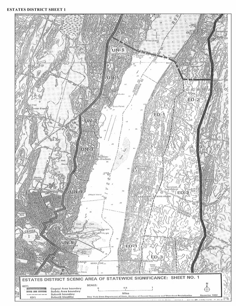
ESTATES DISTRICT SHEET 1
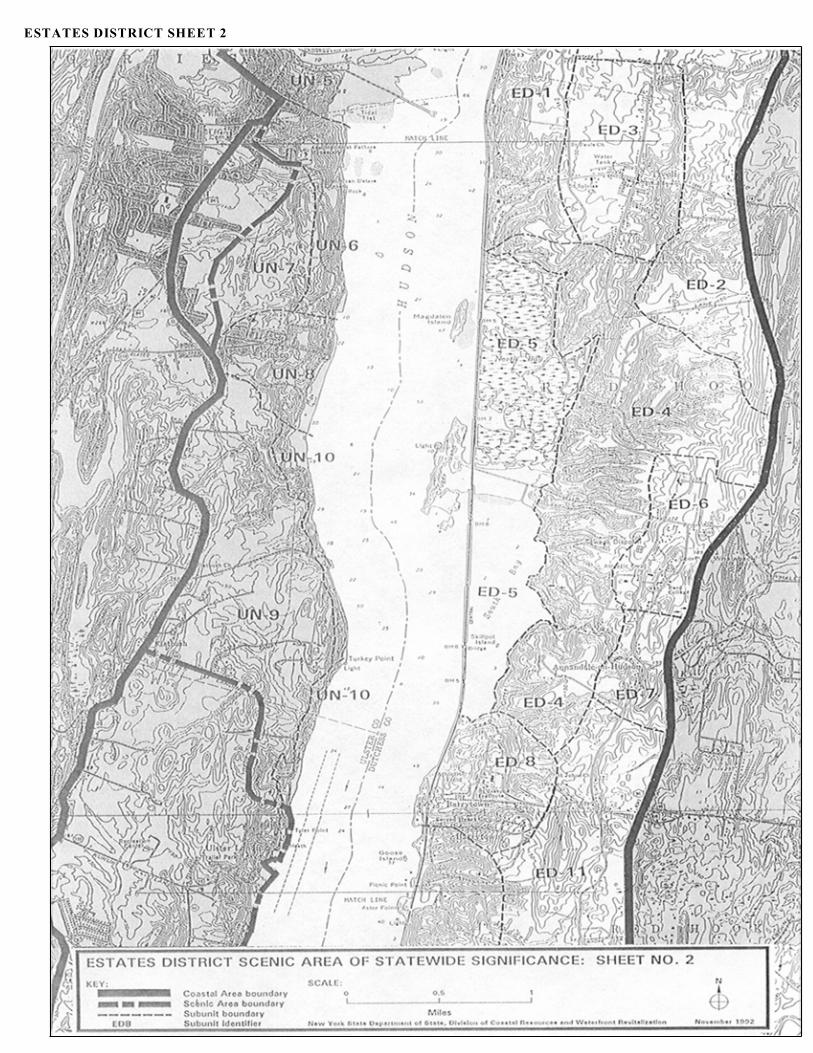
ESTATES DISTRICT SHEET 2
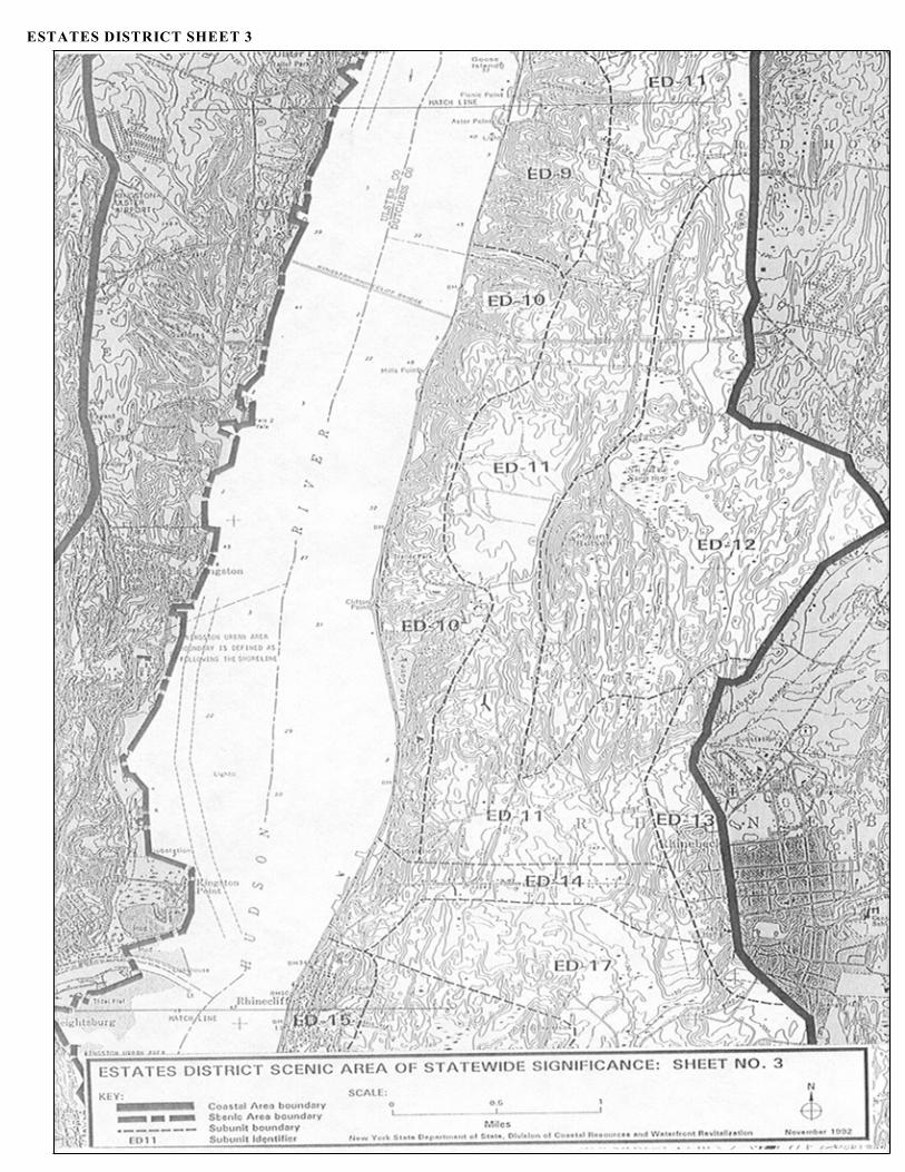
ESTATES DISTRICT SHEET 3
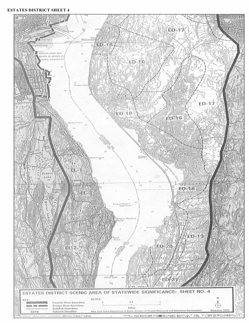
ESTATES DISTRICT SHEET 4
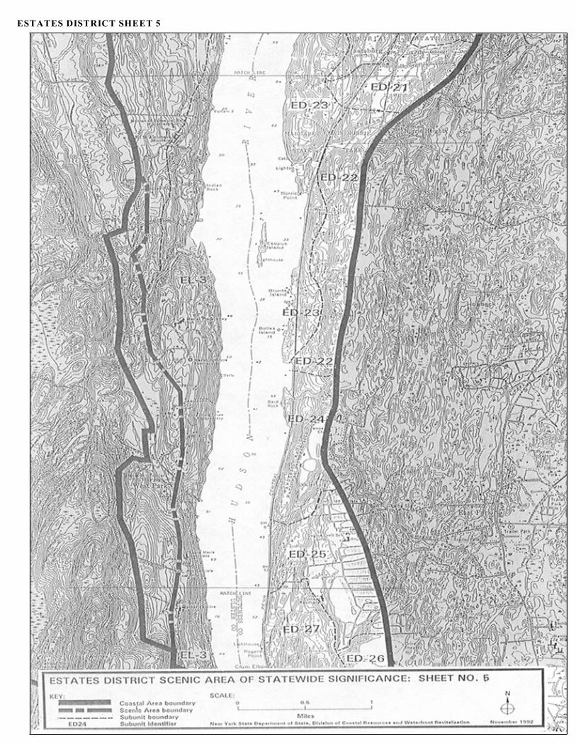
ESTATES DISTRICT SHEET 5
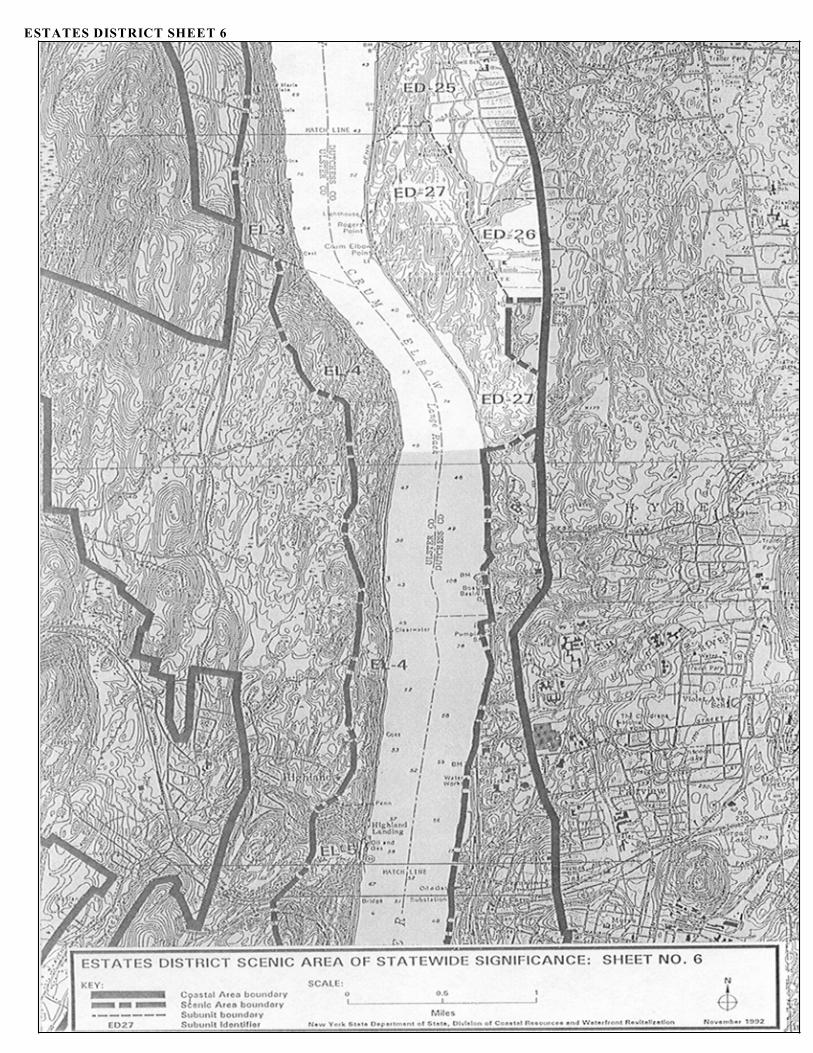
ESTATES DISTRICT SHEET 6

EL Page 1
ESOPUS/LLOYD SCENIC AREA OF STATEWIDE SIGNIFICANCE

Esopus/Lloyd Map
EL Page 3
I. Esopus/Lloyd Location
The Esopus/Lloyd SASS encompasses a seventeen mile stretch of the Hudson River and itsshorelands and varies significantly in width from 0.75 to 2 miles. The SASS extends from itsnorthern boundary, which runs from Riverview Cemetery on NY Route 9W to the Hudson River,south of the hamlet of Port Ewen, to its southern boundary on Church Road in the hamlet of Milton.The SASS includes the Hudson River from the mean high tide line on the eastern shore, for muchof its length sharing a common boundary with the Estates District SASS on the eastern shorelandsof the Hudson River, and land to the west of the Hudson River.
The western boundary of the SASS follows the coastal area boundary south from RiverviewCemetery to the hamlet of Esopus, where it runs five hundred (500) feet to the east of the center lineof Main Street, joining NY Route 9W to the south of the hamlet of Esopus, where it runs south alongNY Route 9W to the boundary of the Towns of Esopus and Lloyd, where it follows the viewshedof the Hudson River to the junction of Red Top and Bellevue Roads, where it follows Bellevue Roadto the hamlet of Highland Landing, where it follows the viewshed of the Hudson River to theintersection with the telephone lines which it follows to the intersection with NY Route 9W, thenalong NY Route 9W to the junction of NY Route 9W and Milton Road, where it follows MiltonRoad to the southern boundary of the SASS at the junction of Milton Road and Church Road, in thehamlet of Milton.
The Esopus/Lloyd SASS is located within the Towns of Esopus, Lloyd and Marlborough, UlsterCounty and the City of Poughkeepsie and the Towns of Rhinebeck, Hyde Park and Poughkeepsiein Dutchess County.
It is comprised of 6 subunits:
EL-1 Big Rock and Hemlock Points; EL-2 Esopus Uplands; EL-3 Esopus Bluffs; EL-4Lloyd Bluffs; EL-5 Highland Bluffs; EL-6 Blue Point.
Consult the Esopus/Lloyd SASS map for the SASS boundary.
II. DESCRIPTION
The Esopus/Lloyd SASS is a highly scenic and valued region of the Hudson River Valley, rich innatural beauty, cultural and historical features.
It is characterized by highly varied topography with steep slopes, thin rocky soils and much exposedbedrock. For its whole length the landform rises steeply from the Hudson River for 100-300 feetto an upland area. Bedrock escarpments are common along the length of the waterfront. Above thebluffs the landscape is dominated by a series of knolls, ridges, and low hills that have irregular orrolling relief, with occasional flat depressions containing surface water features, including pondsand wetlands. Rising up abruptly beyond the SASS are a series of ridges stretching in a north-southdirection, a northern extension of the Marlborough chain of the Appalachians. These quartziteridges include Hussey Hill, Shaupeneak Mountain, and Illinois Mountain which provide an imposingbackdrop that frames the SASS.
EL Page 4
The entire SASS is underlain by the Ordovician-aged Austin Glen Graywacke. Depositedapproximately 430 to 470 million years ago, Graywacke is an extremely hard sedimentary rockcharacterized by the presence of angular mineral and rock fragments in a dark claylike matrix. Thisformation has been highly folded and faulted causing the Austin Glen formation to become fairlyerodible and permeable. The ridges to the west of the SASS are Quassaic Quartzite outcrops. Thesewere folded at the same time as the Austin Glen Graywacke, but the quartzite is harder and lesserodible than the bedrock of the SASS and the ridges remain above the landscape of the SASS. ThePleistocene glaciation covered the area with glacial sediments filling preglacial valleys, modifyingthe drainage system and leaving the current topography of the SASS.
The most abundant soils in the SASS are those developed on glacial till and stratified drift. Theseare commonly used for orchards, meadow crops and pasture. In places the hilly topography androck outcrops are limitations to cultivation. The other soil type was developed on lake bedsediments. These soils are generally poorly drained, with a seasonably high water table. Most ofthe wetlands scattered throughout the SASS occur on these types of soils.
Most of the natural shoreline of the Hudson River is steep, rocky and, although quite stable,susceptible to erosion due to the very steep slopes, lack of vegetation, thin soils and exposed rockfaces. The shoreline configuration is relatively smooth with a few small points and coves while theRiver makes two gentle turns at Esopus Meadows Point and the Crum Elbow.
Most of the streams that drain the area flow northeasterly, following trends imposed by bedrocktopography, and eventually draining into the Hudson River which flows to the south. Black Creek,whose main branch flows north from the Town of Lloyd, drains much of the central part of theSASS. The Twaalfskill Creek is the main drainage system in the Lloyd waterfront, discharging tothe Hudson River at Highland Landing. Numerous unnamed streams drain to the Hudson River offthe bluff areas.
The rolling upland above the Hudson River is covered with a combination of mixed woodlands andclearings comprised of farms, open pasture and meadows, orchards and vineyards and landscapedestates with formal gardens and sweeping lawns. Scattered development is situated throughout theupland above the bluffs, nestling into the woodland coverage and surrounded by the agriculturallandscape. Wooded bluffs and cliffs dominate the Hudson River shoreline, except in the northernportion of the SASS where the relatively large, undisturbed area of shallow, freshwater tidal flat andassociated vegetation known as Esopus Meadows spreads out into the Hudson River. Once ameadow where cows grazed, the tidal wetland has become an extremely rare and valuable fish andwildlife habitat.
Land use in the Esopus/Lloyd SASS reflects the historic settlement pattern based around largeestates that developed along the Hudson River. A rural pattern of development prevails with amixture of orchards, fields, estates, religious institutions and seasonal resorts occupying largeparcels of land, especially along the steep rugged bluffs and shoreline of the Hudson River. Northof Esopus Meadows Point, River Road follows the shoreline. Intermittent residential developmentis sited along the shoreline and the road frontage. South of Esopus Meadows Point the steep slopeshave precluded any shoreline development until the historic waterfront of Highland Landing, wherethe Twaalfskill Creek breaks the bluffs. The Town of Esopus is fortunate in that it is the first
EL Page 5
community north of Rockland County in which the railroad tracks move inland and do not imposea physical or visual barrier at the water's edge.
The Hudson River Valley has long been significant in the culture and history of both the State ofNew York and the United States. The region at the confluence of the Rondout Creek and theHudson River is known to be an important archaeological area. It has been inhabited at least sincethe Woodland Period (100 B.C. - 1600 A.D.) and probably since Paleo-Indian times (c. 10,000B.C.). Although the main concentration of archaeological sites is located north of the SASS, siteshave been reported along the banks of the Hudson River, notably along River Road and in shelteredshoreline coves. Indians settled along the Hudson River long before European discovery of the NewWorld. In this area the river Indians were known as the Esopus Indians, a division of the Munsee.The name Esopus is a Dutch word with origins in the Indian language. It means "land of flowingwaters and high banks" and is an appropriate description of the Esopus/Lloyd SASS.
The Hudson River came to prominence when Henry Hudson explored the region in 1609. The ship'slog describes the spectacular landscape. Hudson named this stretch of the Hudson River "LangeRack", or Long Reach. Recent settlement of the Esopus/Lloyd area began in the second half of the17th century and was concentrated around the Rondout Creek. As more settlers moved in,development spread south to Black Creek, known then as the Klyne Esopus Creek. Land grants inthe Esopus Colony were given in the name of the Dutch ruler of the era.
The English took control of the Dutch Colony of New Netherlands in 1664, and the area south fromthe Rondout Creek to Black Creek, known as Klyne Esopus, became part of Ulster County underthe jurisdiction of the Town of Kingston. All land in the area had to be reclaimed from the KingstonCommons. The English encouraged further settlement of the area, and land was cleared foragriculture and houses built. In 1811 the Town of Esopus was organized. Land in the southern partof the SASS was part of the Paltz Patent issued by Governor Andros in September 1677, the originalHuguenot land grant that reached from the Hudson to the Shawangunks. This tract was sold off inthe mid-18th century as small parcels and cottage lots when it became a burden to the owners.
In 1754 Anthony Yelverton came over the Hudson from Poughkeepsie, built the first house in thearea now known as Highland Landing, set up a sawmill (1765) and operated the first ferry crossing(1777). His house still stands and is the oldest frame house in Ulster County. For a time this partof the hamlet of Highland was known as "Yelvertons Landing". Around this time other settlementsand landings were established along the narrow shoreline of the Hudson River. Scattereddevelopment extended south through the Lewisburg settlement, the area now below the western endof the Mid-Hudson Bridge, to Blue Point, and north to Crum Elbow, where there were docks on theriver serving the small bluestone quarrying activities in the immediate vicinity. Settlerssubsequently moved inland above the bluffs along the early roadways. By 1793 Noah Elting wasrunning a ferry to Poughkeepsie from the base of River Road. This area became known as EltingsLanding, the hub of riverside activity and a populous place. Various docks and landings in the areatook the names of their owners, although the riverfront area as a whole was known as New PaltzLanding. Finally, it was called Highland Landing following the formation of the hamlet.
The riverfront and inland settlements continued to grow, with residential and commercial growthaccompanied by industrial development based around mills on the many streams in the waterfront

EL Page 6
area. Orchards were first established around 1774 and spread throughout the area, along with adiversification of the agricultural base to include raspberries, currents, peaches, strawberries andgrapes. This part of the Hudson Valley became world famous for its agriculture, reaping naturalbenefits of soil, situation and climate. The Hudson River provided the main means of transportationof the produce to the metropolitan area of New York City and beyond.
Warehouses, storage for lumber and farm produce, stores, ice houses, factories, iron works,brickyards, stone cutting quarries, mechanic shops, woodworking mills, and coal yards sprang upalong the waterfront to accommodate produce and manufactured goods for shipping. Thedevelopment of commercial activity in the area was influenced by the ease of transportation offeredby the Hudson River. Sloops sailed from the area to New York City daily. A thriving waterfrontcommunity developed at Highland Landing. Away from the commercial settlements, wealthyfamilies built spacious homes set in landscaped estates of lawns, farmland and orchards, contributingmuch to the scenic quality of the area.
The development of the West Shore Railroad reduced river traffic and promoted inlanddevelopment. The railroad changed the character of the waterfront. The narrow strip of land at thebase of the steep bluffs was used for the tracks, displacing the waterfront industrial, commercial andshipping activity. Fruit growing became the main economic activity, with the railroad offering fastdistribution of produce to a wider market, replacing the Hudson River as the main distribution route. Although active orchards still survive today, the industry is of a much smaller scale, and once activefarmland and orchards have become woodland or built development.
Rowing, racing and regattas were a big sport on the Hudson River along the Lloyd waterfront from1839 to 1950. The best remembered are the Intercollegiate Regattas which began in 1895 andcontinued until 1950. Crews came from all over the East and spent several weeks in the area.Columbia University's boathouse, built on the site of the old Knickerbocker Ice House midwaybetween Highland Landing and Crum Elbow, is a reminder of this era, although the facility hasfallen into disrepair. Painted school emblems, faded with age, can still be seen on the rockescarpments above the Hudson River.
The physical character and cultural and historical development of the Esopus/Lloyd SASS, outlinedabove, has resulted in the current settlement and land use patterns and led to the present daylandscape and architectural character. This includes several historic estates, monasteries andreligious schools. These structures, located at the top of the bluffs, establish an historic architecturalaccent to the natural landscape. The stately lawns of the estates sweep toward the Hudson River.Views afforded from these vantage points are extensive. Most of the recent development has beencarefully sited out of the major viewshed of the river, leaving the large historic estates as focalpoints. The rolling upland hills beyond the bluffs are a patchwork of open spaces, largelymaintained as woodlands and farmlands.The working waterfront at Highland Landing; the well preserved historic estates with theirdistinctive individual architectural styles; and the active farms, orchards and vineyards represent aremnant of a traditional land use in the Mid-Hudson region. The long history of the evolution of theestates along the Hudson River with their many different owners, all with their own story to tell,gives a sense of continuity and meaning to the landscape. This helps to provide the Esopus/LloydSASS with a symbolic link to its historic past.

EL Page 7
The association of the Esopus/Lloyd SASS with the author John Burroughs, who lived at Riverby,has symbolic value and meaning for the area. He published his first significant nature essay in theAtlantic Monthly in 1865 and produced numerous articles and books about the natural world untilhis death in 1921. Burroughs is credited with creating a receptive environment for conservationlegislation and establishing the nature essay as a literary form.
III. Aesthetic Significance
The Esopus/Lloyd SASS is of Statewide aesthetic significance by virtue of the combined aestheticvalues of landscape character, uniqueness, public accessibility and public recognition.
There exists in the SASS an unusual variety of major components, a unity of major components;striking contrasts between scenic elements and a general lack of discordant features. The SASS isboth visually and physically accessible to the general public, and its scenic quality is well recognizedby the public. The scenic quality of the Esopus/Lloyd SASS is significant based on the existenceof the following physical and cultural characteristics.
A. Landscape Character
1. Variety
The Esopus/Lloyd SASS exhibits an unusual variety of major components. The main variety liesin the topography. The SASS is dominated by a long stretch of bluffs along the Hudson Rivershorelands. While this is by far the most striking of topographical features, there are also extensiveareas of rolling upland behind the bluffs, exposed rock faces along the bluffs and tidal flats andshallows along the base of the bluffs.
Variety also exists in vegetation coverage. Dense and mature mixed woodlands on the rollinguplands are interrupted by a combination of farmsteads, pastures and meadows, orchards andvineyards, and landscaped estates, residences and religious institutions. The bluffs are heavilywooded. A rich and varied wetland vegetation is found along the shoreline of the Hudson River andits coves and creeks, notably at Esopus Meadows. This is a relatively large, undisturbed area ofshallow, freshwater tidal flats. The diversity and abundance of wildlife and the changing patterns,colors and textures associated with the tidal flats provide a variety of ephemeral characteristicswhich enhance the scenic qualities of the SASS.
The land use pattern varies considerably within the SASS. There are a number of dispersed historicestates located on the bluffs above the Hudson River, surrounded by a mix of woodlands, farms, andmore recent development. The architectural style of the historic estates and buildings variesconsiderably throughout the scenic area. This reflects the tastes of individual landowners, the longhistory and evolution of estates in the SASS and the long standing picturesque movement throughoutthe Hudson Valley.
EL Page 8
2. Unity
The Esopus/Lloyd SASS is unified by its topography, dominated by the bluffs that front the HudsonRiver. While internally the individual landform components vary, the SASS is a coherent geologicalfeature. The vegetation, dominated by mature, mixed woodland, unifies the various landforms. Thepresence of the Hudson River is a unifying theme, shaping the topography, influencing culturalpatterns and providing a common scenic element central to the SASS.
3. Contrast
There are many striking contrasts between the basic scenic elements in the Esopus/Lloyd SASS.The contrasts in topography and landform are mainly one of contrast in line and form. The rollinguplands contrast with the steep bluffs. The shoreline configuration of these bluffs contrasts with thetidal flats of Esopus Meadows, the mouth of Black Creek and the numerous small points and coves.The Hudson River varies in width and depth; and its currents create varying patterns, contrastingwith the surrounding uplands.
There are many textural and color contrasts within the SASS, mostly associated with vegetation andgeology. The wooded areas contrast with the open meadows and orchards of the agriculturallandscape and the formal landscape estates and open residential spaces. This provides contrastingtextures in the landscape composition and rich color contrasts between vegetation types whichchange with the season. The rock composition varies within the SASS, resulting in many contrastsin surface features, textures and colors, as the natural form is impacted by geomorphologicalprocesses such as erosion and weathering, and deposition. The contrast between the colors andtexture of the water surface of the Hudson River and the surrounding vegetation and rockcomposition creates many and varied effects.
Certain contrasts of a more ephemeral nature are to be found in the SASS. The dramatic effects ofvarying weather conditions enhance the aesthetic feel of the landscape composition as storms, cloudformations, snow, mists, fog and the varying level and direction of sunlight all provide contrasts inline, shape, texture and color, enhancing the contrasts to be found in the area. The speed and patternof flow of the Hudson vary with the season and weather conditions, providing contrasts in textureand color. The spring colors of apple blossom contrast with the fresh greens of new leaves. Inparticular, the diversity and abundance of wildlife occurring in the Esopus Meadows area and thechanging patterns, colors and textures associated with the tidal flats provide ephemeralcharacteristics which enhance the scenic qualities of the SASS.
4. Freedom from Discordant Features
The Esopus/Lloyd SASS is generally well-preserved and free from discordant features. The mainconcentration of discordant features is to be found in the Highland Bluffs subunit, which historicallyhas featured a working waterfront. Recent residential and commercial development has taken placethroughout the SASS through subdivision of farmsteads and estates and along major highways. Thishas occurred with less respect for the topography of the area than was exhibited in the earlysettlement of the area, resulting in a dispersed settlement pattern and an increasing feel of
EL Page 9
suburbanization. The physical and cultural components of the SASS are generally well maintained.
B. Uniqueness
The historic estates of the Esopus/Lloyd SASS form part of a series of estates on both sides of theHudson River throughout the Mid-Hudson Region that is unique in the State. Each estate is uniquein its own right with a distinctive individual architectural style and history. Many of the estates havebeen maintained in their historic form. The well-preserved estates form a unique grouping ofhistoric landscaped estates and religious buildings. Unlike other parts of the Hudson River Valley,most have direct access to the shore of the Hudson River, unrestricted by the railroad. In additionto the estates, the landscape of the SASS is comprised of farms, orchards and vineyards andrepresents a unique remnant of a traditional land use of the Mid-Hudson Region.
The broad expanse of tidal flats of Esopus Meadows is a unique landform in the Hudson River, andtidal flats of a comparative size are rare in other coastal regions of New York State. Their presencecontributes to the scenic value of the subunit. At the border between shallow and deep water standsthe only wooden lighthouse on the Hudson River, the Esopus Meadows Lighthouse, a uniquemaritime feature in the region.
C. Public Accessibility
The land ownership pattern related to the low density development and large land holdings scatteredthroughout the Esopus/Lloyd SASS has resulted in few opportunities for public access. Publicaccessibility is mostly limited to local roads which run through the SASS. Physical access to theshoreline of the Hudson River is limited, both from the upland and from the Hudson River itself.
In the Town of Lloyd the upland parts of the SASS are separated from the waterfront by the WestShore Railroad, limiting physical access to the Hudson River. The Town of Esopus, however, isfortunate in that it is the first community north of Rockland County in which the railroad tracksmove inland and do not impose a physical or visual barrier at the water's edge. This increases theopportunity for physical access to the Hudson River in the northern half of the SASS.
The vehicle pull-in off River Road, to the south of Hemlock Point, provides opportunities for publicaccess to the Hudson River shoreline. A small park with river trails, owned by Scenic Hudson, Inc.and managed by the Town of Esopus, is located off River Road at Esopus Meadows Point. Knownas Lighthouse Park, it provides access to the Hudson River shoreline. Scenic Hudson also ownswaterfront land to the south of the park and has plans to develop an environmental education facilityon the property. Scenic Hudson has recently completed the purchase of 142 acres of riverfront landat the mouth of Black Creek. Future plans see the site developed for passive public recreation,improving public accessibility to the subunit.
Views from within the Esopus/Lloyd SASS are extensive and significant. From much of the area,long and broad views of the river and its surrounding landscape are available. Views from theHudson River include the historic estates, wooded bluffs, orchards, the Esopus Meadows Lighthouseand beyond the SASS to the Catskill Mountains. These views are often enclosed by the steep bluffs

EL Page 10
along the river corridor. Cross river views from the upland and shoreline of the Esopus/Lloyd SASSinclude the Hudson River and the Estates District SASS on the eastern shore. These views are oftenfull and unobstructed.
River Road runs along the bluff top before dropping down to the shoreline and offers extensiveviews of the Hudson River and the Estates District SASS on the eastern shore. NY Route 9Wprovides some vistas of the Hudson River and the Estate District SASS. Unfortunately, there areno opportunities to pull off the road to take advantage of this scenery, and the speed and volume oftraffic on the road makes it extremely hazardous to view while driving. The Hudson River can beseen from spots along Bellevue Road, notably in the late fall and winter when the leaves have fallen.
The most expansive views from the southern portion of the SASS are available from HighlandLanding which provides exceptional views of the Mid-Hudson Bridge, the Railroad Bridge (anengineering landmark listed on the National Register of Historic Places and now under considerationfor adaptation as a pedestrian promenade) and the Town and City of Poughkeepsie. The JohnsonIorio Memorial Park is located at the end of Haviland Road, adjacent to the western edge of the Mid-Hudson Bridge and set into the bluffs above Highland Landing. The park has no access to theHudson River and only limited views due to vegetation, although views of the Mid-Hudson Bridgeare spectacular. Views are available to the west and northwest from the pedestrian walkway on theMid-Hudson Bridge.
The Regent Champagne Cellar, formerly the Hudson Valley Winery, is open to the public for winetours, special events and functions. The access road, Blue Point Road, winds through the historicvineyard landscape to the main building complex which is set on the bluffs overlooking the HudsonRiver, the Mid-Hudson Bridge and the City of Poughkeepsie. Trails on the estate lead to Blue Point,which offers expansive views south down the Hudson Valley.
The Esopus/Lloyd SASS figures prominently in the middleground of views from the Estates DistrictSASS. Indeed, many of the finest scenic features of the Esopus/Lloyd SASS are best viewed fromthe river or the opposite shore. From the Hudson River, the estates and state parks and from localroads the rugged bluffs of the western shore dominate the views, with occasional glimpses ofwaterfront settlement, bluff top estates and agricultural activity. Views of the western shorelandsare significant from the Mills-Norrie State Park and the Vanderbilt Mansion and Franklin D.Roosevelt Home National Historic Sites. The Esopus/Lloyd SASS is clearly visible to passengersin the trains on the east bank of the Hudson River. The recent completion of the Hyde Park Trailon the eastern shore linking the Franklin D. Roosevelt and Vanderbilt Mansion National HistoricSites, with plans to continue to the Mills-Norrie State Park, will provide greater public visual accessto SASS. The SASS is also dominant as the middleground in views to the west from the City ofPoughkeepsie, which has extensive park areas and public land along the River.
The distant Catskill Mountains and the ridges of Hussey Hill, Shaupeneak Mountain, and IllinoisMountain, immediately beyond the Esopus/Lloyd SASS, provide a dramatic backdrop to the manyestates and monasteries gracing the landscape. The steep wooded bluffs above the Hudson Riverand the rolling upland provide a dramatic setting for the numerous landscape features. Thecomposition of the SASS is well balanced with many positive focal points including thePoughkeepsie Railroad Bridge, the Mid-Hudson Bridge, the architecture of the historic structures,
EL Page 11
the Esopus Meadows Lighthouse and the estates on the eastern shore. The variety of lengths ofviews, compositions, backgrounds and significant focal points combines to enhance the scenicquality of the views available in the Esopus/Lloyd SASS.
D. Public Recognition
The scenic and aesthetic quality of the Esopus/Lloyd SASS has achieved a high degree of publicrecognition. It receives strong public recognition as the view from River Road, a designated ScenicRoad under Article 49 of the Environmental Conservation Law. The SASS is well recognized asthe middleground of views to the west from the Estates District SASS on the eastern shore of theHudson River. The numerous estates include Wilderstein, the Franklin D. Roosevelt and VanderbiltMansion National Historic Sites and the Mills-Norrie State Park, all of which are visited by largenumbers of the general public. The SASS is also recognized as the middleground of views to thewest from the City and Town of Poughkeepsie and the Mid-Hudson Bridge, also a designated ScenicRoad, and from Locust Grove and the Hudson River State Hospital both National HistoricLandmarks.
There are four properties and structures in the Esopus/Lloyd SASS listed on the State and NationalRegisters of Historic Places, receiving public recognition for their historical and architecturalsignificance. These are the Esopus Meadows Lighthouse, Riverby, the Anthony Yelverton Houseand the Poughkeepsie Railroad Bridge.
The scenic and aesthetic quality of the SASS has received public recognition through the action ofthe State and environmental not-for-profit organizations which have sought to protect individualparcels of land within the SASS from development. Land has been purchased at Esopus Meadowsand Black Creek, while the scenic qualities of the Regent Champagne Cellar have been identifiedin the State's recent Open Space Plan.
IV. IMPACT ASSESSMENT
Whether within or outside a designated SASS all proposed actions subject to review under federaland State coastal acts or a Local Waterfront Revitalization Program must be assessed to determinewhether the action could affect a scenic resource and whether the action would be likely to impairthe scenic beauty of the scenic resource.
Policy 24 provides that when considering a proposed action, agencies shall first determine whetherthe action could affect a scenic resource of statewide significance. The determination wouldinvolve:
(1) a review of the coastal area map to ascertain if it shows an identified scenic resourcewhich could be affected by the proposed action, and
(2) a review of the types of activities proposed to determine if they would be likely toimpair the scenic beauty of an identified resource.
EL Page 12
Impairment includes:
(i) the irreversible modification of geologic forms; the destruction or removal ofvegetation; the modification, destruction, or removal of structures, whenever thegeologic forms, vegetation or structures are significant to the scenic quality of anidentified resource; and
(ii) the addition of structures which because of siting or scale will reduce identifiedviews or which because of scale, form, or materials will diminish the scenic qualityof an identified resource.
Policy 24 sets forth certain siting and facility-related guidelines to be used to achieve the policy,recognizing that each development situation is unique and that the guidelines will have to be appliedaccordingly. The guidelines are set forth below, together with comments regarding their particularapplicability to this Scenic Area of Statewide Significance. In applying these guidelines toagricultural land it must be recognized that the overall scenic quality of the landscape is reliant onan active and viable agricultural industry. This requires that farmers be allowed the flexibility tofarm the land in an economically viable fashion, incorporating modern techniques, changes in farmoperation and resultant changes in farm structures. Policy 24 guidelines include:
SITING STRUCTURES AND OTHER DEVELOPMENT SUCH AS HIGHWAYS, POWERLINES, AND SIGNS, BACK FROM SHORELINES OR IN OTHER INCONSPICUOUSLOCATIONS TO MAINTAIN THE ATTRACTIVE QUALITY OF THE SHORELINE ANDTO RETAIN VIEWS TO AND FROM THE SHORE;
COMMENT: For much of the length of the Esopus/Lloyd SASS, the Hudson River isbounded by steep undeveloped wooded bluffs that figure prominently in views within theSASS, notably from the Hudson River, and in views of the SASS from the easternshorelands of the Hudson River, part of the Estates District SASS. Siting of structures onthe slopes or crests of these bluffs would introduce discordant elements into the landscapeand impair the scenic quality of the SASS.
Esopus Meadows is a particularly critical scenic component in the northern portion of theSASS. Elimination of the shallow, freshwater tidal flats of Esopus Meadows and the marshyareas adjacent to the Hudson River shoreline through dredging, filling or bulkheading wouldresult in a direct impact on the shoreline, the vegetation of the Esopus Meadows, and thesetting of the Esopus Meadows Lighthouse, changing the character of the relationshipbetween the Hudson River and its shorelands that would impair the scenic quality of theSASS.
CLUSTERING OR ORIENTING STRUCTURES TO RETAIN VIEWS, SAVE OPEN SPACEAND PROVIDE VISUAL ORGANIZATION TO A DEVELOPMENT;
COMMENT: The Esopus/Lloyd SASS features a low intensity pattern of development thatincludes a large amount of functional open space. Historic farmsteads and estate housespunctuate, but do not dominate the landscape of rolling upland pastures, orchards, vineyards,

EL Page 13
landscaped estates and woodland. Recent, poorly sited residential development has notrespected the traditional patterns of development within the SASS and has disturbed thevisual organization that has been established through this traditional development pattern.Further expansion of new development into the open areas of the SASS would replace thevaried vegetation types, causing the textures, colors, contrast and expansiveness of thenatural landscape character and their interrelationship to be lost, thus impairing the scenicquality of the SASS. The use of topography and existing vegetation and the clustering ofnew development can assist in maintaining scenic quality.
INCORPORATING SOUND, EXISTING STRUCTURES (ESPECIALLY HISTORICBUILDINGS) INTO THE OVERALL DEVELOPMENT SCHEME;
COMMENT: The SASS is a unique natural and cultural landscape. The loss of historicstructures would alter the cultural character of the landscape, remove focal points from viewsand diminish the level of contrast between the natural landscape and the cultural landscape,thus impairing the scenic quality of the SASS.
REMOVING DETERIORATED AND/OR DEGRADING ELEMENTS;
COMMENT: The SASS is generally free of discordant features, and structures aregenerally well maintained.
MAINTAINING OR RESTORING THE ORIGINAL LAND FORM, EXCEPT WHENCHANGES SCREEN UNATTRACTIVE ELEMENTS AND/OR ADD APPROPRIATEINTEREST;
COMMENT: The landform of the SASS is primarily in an undisturbed state and is theunifying factor in the SASS. The contrast in elevation and the juxtaposition of water andland contribute to the scenic quality of the SASS. The failure to maintain existing landformsand their interrelationships would reduce the unity and contrast of the SASS and impair itsscenic quality.
MAINTAINING OR ADDING VEGETATION TO PROVIDE INTEREST, ENCOURAGETHE PRESENCE OF WILDLIFE, BLEND STRUCTURES INTO THE SITE, ANDOBSCURE UNATTRACTIVE ELEMENTS, EXCEPT WHEN SELECTIVE CLEARINGREMOVES UNSIGHTLY, DISEASED OR HAZARDOUS VEGETATION AND WHENSELECTIVE CLEARING CREATES VIEWS OF COASTAL WATERS;
COMMENT: The variety of vegetation in the SASS makes a significant contribution to thescenic quality of the SASS. The tidal flats of Esopus Meadows, open farm fields, orchards,vineyards, woodlands, and landscaped estates provide variety, unity and contrast to thelandscape. The wildlife supported by this vegetation adds ephemeral effects and increasesthe scenic quality of the SASS. Vegetation helps structures blend into the predominantlynatural landscape and plays a critical role in screening facilities and sites which wouldotherwise be discordant elements and impair the scenic quality of the SASS.
EL Page 14
Clearcutting or removal of vegetation on the wooded bluffs along the Hudson River wouldchange the character of the river corridor and impair its scenic quality. Esopus Meadowsis a particularly critical scenic component in the northern portion of the SASS. Eliminationof the shallow, freshwater tidal flats and the associated vegetation of Esopus Meadows andthe marshy areas adjacent to the Hudson River shoreline through dredging, filling orbulkheading would result in a direct impact on the shoreline, the vegetation of the EsopusMeadows, and the setting of the Esopus Meadows Lighthouse, changing the character of therelationship between the Hudson River and its shorelands and impairing the scenic qualityof the SASS.
USING APPROPRIATE MATERIALS, IN ADDITION TO VEGETATION, TO SCREENUNATTRACTIVE ELEMENTS;
COMMENT: The SASS is generally free of discordant elements. Existing developmentgenerally respects and is compatible with the landscape. The failure to blend new structuresinto the natural setting, both within the SASS boundaries and in the viewshed of the SASS,would impair the scenic quality of the SASS.
USING APPROPRIATE SCALES, FORMS AND MATERIALS TO ENSURE THATBUILDINGS AND OTHER STRUCTURES ARE COMPATIBLE WITH AND ADDINTEREST TO THE LANDSCAPE.
COMMENT: The existing structures located within the SASS generally are compatiblewith and add interest to the landscape because they are of a scale, design and materials thatare compatible with the predominantly natural landscape. Failure to design newdevelopment or alterations to existing structures in a form that complements the scenicquality of the SASS would adversely impact the SASS. Inappropriate scale, form, color andmaterials which are incompatible with the existing land use and architectural styles of thearea and cannot be absorbed into the landscape composition would impair the scenic qualityof the SASS. Failure to construct new buildings which are compatible with the culturalfabric of the SASS as represented in these historic structures would impair the scenic qualityof the SASS.
EL Page 15
Esopus/Lloyd Scenic Area of Statewide Significance
Index to Esopus/Lloyd Subunits
EL-1 Big Rock and Hemlock Points Subunit
EL-2 Esopus Uplands Subunit
EL-3 Esopus Bluffs Subunit
EL-1 Page 1
ESOPUS/LLOYD SCENIC AREA OF STATEWIDE SIGNIFICANCE
EL-1 Big Rock and Hemlock Points Subunit
I. Location
The Big Rock and Hemlock Points subunit is the most northerly subunit of the SASS, and itsnorthern boundary is the same as the northern boundary of the Esopus/Lloyd SASS, which runs fromRiverview Cemetery on NY Route 9W to the Hudson River. The subunit extends south forapproximately 2 miles to the vicinity of Prospect Hill, south of the hamlet of Port Ewen, and variesin width from one to two miles. The subunit includes the Hudson River from the mean high tide lineon the eastern shore, sharing a common boundary with the Estates District SASS on the easternshorelands of the Hudson River, and land to the west of the Hudson River, with its western boundarybeing the coastal boundary. It is located in the Town of Esopus, Ulster County and the Town ofRhinebeck, Dutchess County. Consult the Esopus/Lloyd SASS map sheet number 1 for subunitboundaries.
II. Scenic Components
A. Physical Character
The landform of this subunit is dominated by steep wooded bluffs averaging 200 to 250 feet inelevation and the rolling upland atop the bluffs. Vegetation consists of mature woodland, openmeadows, secondary and scrub growth and landscaped lawns. The shoreline exhibits a gentle curveand contains small coves and points, including Big Rock and Hemlock Points. The Hudson Riveris over a mile wide, with marshes and shallows at its edge. Esopus Meadows stretches south alongthe shoreline from Hemlock Point. This important landscape feature is a relatively large,undisturbed area of shallow, freshwater tidal flat.
B. Cultural Character
The subunit has scattered residential development, although recent subdivisions and the replacementof summer camps with permanent residential structures have led to the spread of residentialdevelopment in the subunit. River Road runs dramatically along the blufftop in the northern partof the subunit and alongside the Hudson River in the southern section.
Hemlock Point is an Indian burial site, discovered when River Road was widened. To the south ofHemlock Point is another point in the Hudson River. This is the site of the old Schleede Brickyards,which closed in the 1930's, the last of three brickyards in the Town of Esopus to remain in operation.Remains of old kilns and foundations can be seen amongst the vegetation, and broken brick still liesin the small bay, known as Brickyard Cove.
The subunit contains several historic houses and estates located along River Road. At the cornerof River Road and Broadway is a wood and stone house built in 1767 and restored in 1941. Thiswas the Van Vliet homestead, one of the early settlers in the area. The house was known as the "JugTavern" during Revolutionary times, and George Washington was reputed to have stopped there.
EL-1 Page 2
Inland from the old Schleede Brickworks is the site of the stone house built in the early 18th centuryby James Niese on a land grant from Queen Anne. This now is the site of a more modern home.Several of the historic estate structures are intact, set in a well-maintained estate landscape ofsweeping lawns. Well-maintained stone walls are an important landscape feature. Some of theestates are being developed, and suburban houses now dominate these properties creating adiscordant feature on the landscape.
Many of the summer camps that clustered along the shore of the Hudson River, located on thenarrow strip of land below River Road, have been converted into residences. On the wooded bluffand the open meadows of the rolling upland are the numerous deteriorated structures associated withCamp Chi-Wan-Da, a former boys camp. A number of interesting modern designs blend in wellwith the landscape, respecting the contours, existing vegetation and views from River Road. Despitethese examples of good design, the recent spread of residential development in the subunitoverpowers the historic settlement pattern and adds an element of discordance to the scenic qualityof the subunit. Ongoing construction at the Port Ewen Water Treatment Works alongside theHudson River just north of Hemlock Point provides a further discordant element. The diversity andabundance of wildlife occurring in the Esopus Meadows area and the changing patterns, colors andtextures associated with the tidal flats provides ephemeral characteristics which enhance the scenicqualities of the area.
C. Views
Views from the subunit provide full and unobstructed views of the Hudson River and its easternbank, part of the Estates District SASS. The views are up to 20 miles long and are very wide to thenorthwest and southeast. The historic Esopus Meadows Lighthouse is a focal point in the views tothe southeast and is important in views from the shorelands and the Hudson River. From the top ofthe bluff, the Catskill Mountains to the west provide a dramatic backdrop to the rolling woodlandsand farmlands that border the western edge of the subunit. The composition of the views is ofdistinctive quality, with a good balance of foreground, middleground and background components.Views within the subunit are wide and long from the Hudson River, featuring the bluffs on bothsides of the river, but are limited and constrained by the woodlands and steep slopes on the uplandareas.
III. Uniqueness
The broad expanse of tidal flats at Esopus Meadows is a unique landform in the Hudson River, andtidal flats of a comparative size are rare in other coastal regions of New York State.
IV. Public Accessibility
The land ownership pattern related to the low density development scattered throughout the subunithas resulted in few opportunities for public access, although the subunit is highly accessible fromthe Hudson River and from River Road, which runs close to the Hudson River throughout thesubunit. A parking area located to the south of Hemlock Point provides opportunities for directpublic access to the Hudson River shoreline. The subunit can be viewed from the eastern shoreline,part of the Estate District SASS, and is highly visible from the passenger trains on the east bank of
EL-1 Page 3
the Hudson River and from Wilderstein. Scenic Hudson, Inc. recently prepared detailed,comprehensive viewshed analyses for the Mills-Hoyt State Historic Site and for Wilderstein. Thissubunit was a focus of this work.
V. Public Recognition
The Big Rock and Hemlock Points subunit is recognized by the public as the view from the scenicRiver Road and as the middleground of views from the estates on the eastern shore of the HudsonRiver, especially Wilderstein. River Road, which passes along the shore in the southern half of thesubunit and rises to the top of the bluff in the northern half, is a designated Scenic Road underArticle 49 of the Environmental Conservation Law.
VI. Reason for Inclusion
The Big Rock and Hemlock Points subunit has high scenic quality and is both physically andvisually accessible to the public. It features historic estates located on a long and steep bluffoverlooking a wide section of the Hudson River. The landscape composition features a variety ofscenic components. A moderate contrast exists between the historic houses in a landscaped settingand the natural wooded areas and between the steep bluffs and the tidal flats of Esopus Meadows.The recent subdivision of the estates has resulted in the spread of residential development,contributing an element of discordance which detracts from the scenic quality of the subunit.

EL-2 Page 1
ESOPUS/LLOYD SCENIC AREA OF STATEWIDE SIGNIFICANCE
EL-2 Esopus Uplands Subunit
I. Location
The Esopus Uplands subunit is located inland on the western side of the Hudson River. It stretchessouth along the coastal boundary from River Road to the hamlet of Esopus and continues southalong NY Route 9W to Winding Brook Lane. It is nearly six miles in length and up to one mile inwidth. The crest of the steep bluffs of the Hudson River shoreline creates the eastern boundary, andthe western boundary follows the coastal boundary and NY Route 9W. The subunit is located in theTown of Esopus, Ulster County Consult the Esopus/Lloyd SASS map sheets, numbers 1 and 2, forsubunit boundaries.
II. Scenic Components
A. Physical Character
The landform of this subunit is the gently rolling upland plateau behind the Hudson River bluffs.The subunit exhibits generally moderate topographic relief at elevations of 100 to 225 feet andfeatures Prospect Hill rising to over 350 feet. The varied vegetation creates a diverse tapestry ofmature woodlands, meadows, orchards and landscaped lawns. Water features are not prominent inthe landscape.
B. Cultural Character
The land use in the subunit is a mix of farms, orchards, historic and modern residences and religiousproperties. The landscape and structures of the subunit are generally well-maintained. Stone wallsare an important landscape feature and provide a link to the historic landscape pattern of the subunit.Off River Road, just before it turns north to follow the Hudson River, is the old TerpeningCemetery. This is where many of the original settlers of the area were buried in the 18th and 19thcenturies. The cemetery is now maintained by the Town of Esopus. At the end of Hermance Road,running through the site of the historic Hermance Farm, is an old stone and wood tavern built in1807. It was remodeled in 1902 and is now a residence. An 1818 stone house, located on NY Route9W to the south of the Three Brothers Egg Farm, has an interesting history, having served as anunderground railroad for runaway slaves prior to and during the Civil War. Just south on NY Route9W is an 1837 frame house. Recent residential development mixes with these historic residentialstructures scattered along NY Route 9W and the few local roads passing through the subunit.
The historic landscape features are generally well maintained in open settings of landscaped lawnsurrounded by farmland and woodland. The landscaped setting of the Mount Saint AlphonsusSeminary, built on the historic Pell Estate, dominates the central part of the subunit. Stone walls andtrees front NY Route 9W, and long, tree lined driveways lead to the seminary buildings which arelocated in the adjacent Esopus Bluffs subunit. The face of an old gravel pit, now weathered into thelandscape, and a restaurant along NY Route 9W are minor discordant features, but have no
EL-2 Page 2
significant impact on the scenic quality of the subunit. The farming activities provide an importantephemeral element to the subunit.
C. Views
The Esopus Uplands subunit has limited direct views of the Hudson River. Where these exist, theviews from the subunit generally extend in varying directions for up to 2 to 3 miles in length and90 to 180 degrees in width, although longer and wider views are available in all directions fromProspect Hill. Views within the subunit are across large fields and are contained by the surroundingwoodlands and hedgerows which are set against the background of the Catskill Mountains to thewest and the distant rolling hills to the east of the Hudson River. The composition of the landscapecomprises many positive scenic components including architecturally significant structures,orchards, fields and woods. The scattered farmsteads and neighboring monasteries punctuate thelandscape composition, creating strong focal points.
III. Uniqueness
The subunit is not unique. The continued existence of large religious properties within a large estatesetting is uncommon in the State.
IV. Public Accessibility
The land ownership pattern of large land holdings and low density development scattered throughoutthe subunit has resulted in few opportunities for public access. Public accessibility in the subunitis limited to N.Y. Route 9W and local roads. The area around Prospect Hill is visible from theHudson River and the eastern shore, part of the Estates District SASS. Scenic Hudson, Inc. recentlyprepared detailed, comprehensive viewshed analyses for the Mills-Hoyt State Historic Site and forWilderstein. This subunit was a focus of this work.
V. Public Recognition
Public recognition is limited primarily to local and regional knowledge of the subunit.
VI. Reason for Inclusion
The Esopus Uplands subunit has a rich variety of scenic components including woodlands,hedgerows, open fields, orchards and architecture. The components provide contrast, yet are unifiedbecause they blend into the landscape. The subunit is moderately accessible to the public and isgenerally free from discordant features.
EL-2 Page 3
ESOPUS/LLOYD SCENIC AREA OF STATEWIDE SIGNIFICANCE
EL-3 Esopus Bluffs Subunit
I. Location
The Esopus Bluffs subunit is located on the western shore of the Hudson River extending from thebase of Prospect Hill in the north to the Cast benchmark at Crum Elbow in the south. The subunitis relatively long, comprising a 7.5 mile stretch of steep bluffs, and narrow, ranging from one to twomiles in width. The subunit includes the Hudson River from the mean high tide line on the easternshore, sharing a common boundary with the Estates District SASS on the eastern shorelands of theHudson River, and land to the west of the Hudson River, with its western boundary following theviewshed of the Hudson River from River Road south to Winding Brook Lane and south along NYRoute 9W to the Esopus/Lloyd Town line. The subunit is located in the Town of Esopus, UlsterCounty and the Towns of Rhinebeck and Hyde Park, Dutchess County. Consult the Esopus/LloydSASS map sheets, numbers 1, 2 and 3, for subunit boundaries.
II. Scenic Components
A. Physical Character
The landform of this subunit consists primarily of steep wooded bluffs overlooking the HudsonRiver. The shoreline of the Hudson River is curving with numerous small coves and points. Thewooded Esopus Meadows Point marks a significant curve in the Hudson River. Off the point liesEsopus Meadows, a relatively large, undisturbed area of shallow, freshwater tidal flats. This areawas once a meadow where cattle grazed but rises in the river level have covered this feature.Further south the heavily wooded course of Black Creek winds through the center of the subunit andenters the Hudson River at a small cove with accompanying tidal flats. Black Creek is named forthe black coloration of the creek's bottom due to tannic acid from the hemlocks which abound alongthe banks. Out in the Hudson River adjacent to the confluence with Black Creek is Esopus Island,located in the Estates District SASS. Vegetation in the subunit is varied with good contrast betweenmature woodland, meadows and landscaped lawns and estates.
B. Cultural Character
The land use in the subunit is a mix of religious institutions, historic estates and residences, andcontemporary residential development. The West Shore railroad runs along the shore in thesouthern part of the subunit before moving inland at West Park.
The subunit is rich in historic mansions carefully sited on the bluffs with sweeping lawns andlandscaped woodlands running down to the Hudson River. Many of these structures date back tothe late 19th century, although the history of estate development in the subunit goes back to the earlysettlements and the first Patents. Many of the main houses have been converted for institutional useby religious organizations and continue to be well-maintained today, allowing the traditional estatelandscape that has evolved from the early 18th century to continue in a modern day form.

EL-2 Page 4
Historic stone and brick walls and gatehouses mark the western boundary of the southern sectionof the subunit along NY Route 9W. Throughout the subunit stone walls and hedgerows areimportant scenic features, defining estate boundaries, edging clearings and separating fields,orchards and woodlands. They are constructed mostly of local fieldstone, although there are somemore ornate cobblestone boundary walls. The stone walls are generally well maintained.
The historic and religious structures include Esopus Meadows Lighthouse, Mount Saint AlphonsusSeminary, the former Alton B. Parker estate, the former Marist Preparatory School, the formerOliver Payne estate, Ascension Church, Riverby, Holy Cross Monastery, Santa Maria Novitiate, andMother Cabrini School.
During the 1800's, when the Hudson River was the main traffic artery from upstate to New YorkCity, the United States Lighthouse Service constructed a series of lighthouses along the River towarn traffic away from dangerous shallows. Over time the lighthouses were modernized andautomated. Located off Esopus Meadows Point is the Esopus Meadows Lighthouse, warning vesselsto stay away from Esopus Meadows shallows. Construction of the original structure began in 1838.Damage by ice floes brought the structure to ruin within 30 years. A new structure was built in 1871on an artificial island. It is the only Hudson River lighthouse to be built with a woodframe andsheathed in clapboard. The lighthouse-keeper was replaced with an automated navigational aidwhen the Coast Guard acquired the lighthouse service in 1965. Accessible only by water, thelighthouse is in a slightly deteriorated condition, although there are plans to restore the structuresince the Coast Guard has leased the lighthouse to the "Save Esopus Lighthouse Commission." Thelighthouse is listed on the State and National Registers of Historic Places and is a reminder that theHudson River has been an important navigation way for centuries.
Mount Saint Alphonsus Seminary is a massive grey stone building that stands out in the center ofthe subunit overlooking the Hudson River. This religious property is located on the site of theCliffwood Estate of Robert L. Pell, Esq. To the north of the present Seminary is Pelham Dock, areminder of the prosperous days of agriculture in the area when Pell ran his expansive model orchardand fruit farm. He had over 25,000 trees in his orchard and also produced large quantities of grapes,currants and small fruit. In his time he was one of the largest fruit shippers in the world. The Pellestate, with its Tuscan Revival Roman Villa set in a landscaped setting, was one of the finest countryseats in the region.
The Civil War blockade proved disastrous for overseas trade, and Pell was forced to mortgage hisfarm. It was acquired by his son-in-law in 1869, and in 1904 the 235 acre Pell estate was sold to theRedemptionist Fathers, who razed the mansion and built their House of Studies and Conventdedicated to their founder Saint Alphonsus. Completed in 1907, the four and a half story granitebuilding is 444 feet long with two wings and a 90 foot high tower. The structure has 200 dwellingrooms and a chapel seating 250. It is located 200 feet above the Hudson River and dominates theblufftop in views from the Hudson River, Norrie Point State Park and the Vanderbilt MansionNational Historic Site. In 1963 a convent was added to the property.
South of the seminary is Indian Rock, the site of the Walter P. Seaman House, a two story clapboardbuilding constructed in 1870. Indian Rock is so named because it once held a clearly visible carving

EL-2 Page 5
of an Indian. This so-called "petroglyph" is located on the Hudson River shore across from EsopusIsland, where Indian Councils were held. Indian artifacts have been found throughout the area.
Adjacent to Indian Rock is Rosemont, the former home of Judge Alton B. Parker, the presidentialcandidate who lost to Theodore Roosevelt in 1904. This is the site of an old tavern visited by someof the men from General Vaughn's fleet on the night before they attacked Kingston in October 1777.Rosemont and its gatehouse are situated on Parker Avenue, which winds through orchards andwoodland to the Hudson River at the old Esopus or Elmores Landing, located on Rosemont'sproperty. At its height Rosemont was a farm of about 200 acres comprising orchard, vineyards,dairy and livestock and landscaped gardens. Rosemont has been renamed Lamont Landing and isbeing restored to its former estate use.
South of Black Creek lies the site of the historic Payne Estate, focused on the Payne Mansion builtin 1905. The massive Mediterranean palazzo with an open central court is located on a 500 acreestate in a formal landscaped setting with barn complexes, greenhouses, a gatehouse and dock. Themain building is constructed of steel reinforced concrete faced with soft imported Italian limestone,which has not weathered well in the climate of the region. Other features of the mansion are a redterracotta tile roof and classic detailing, including balustrades, balconies, columns, and piazza.Oliver Hazard Payne, a leading financier who had been a founder of the Standard Oil Company,commissioned Carrere and Hastings, best known for the Main Branch of the New York PublicLibrary on Fifth Avenue, to design the mansion, the last and arguably the most luxuriousmillionaire's house built on the Hudson River.
The mansion stands on the site of two previous historic estates, themselves located on the site of partof the Pell's large landholding in the area. These were the estates of Colonel George Watson Prattand Colonel John Jacob Astor, grandson of the famous Astor. Astor built an imposing brick andstone mansion named Waldorf, which was later sold a couple of times, modified and the estateexpanded and extensively landscaped prior to being purchased by Payne. Waldorf was razed in1910, and the only remnants of the earliest era of the estate's development are a stone reservoir,driveways and garden paths, and some old specimen trees.
Payne died in 1917, and the estate went to one of his nephews. In 1933 it was turned over to theCity Mission Society of the Protestant Episcopal Diocese of New York. In 1942 the Marist Brothersbought all of the estate that lay between NY Route 9W and the Hudson River. The property wasused as a preparatory school, utilizing Payne's buildings, including the mansion, with new structuresadded. In 1963 the school moved to Cold Spring, and this property was used over time for amultitude of purposes. Today it is a retreat center and summer camp. The Marist Brothers havemaintained the buildings and grounds. More recently the Payne Mansion and the boathouse weresold, and the house has been faithfully restored to its former glory as a private residence.
South of the Marist Brothers Seminary is the historic Ascension Church and Rectory. The fieldstonechurch was consecrated in 1842, and the rectory was built in 1859. This Episcopal church wasattended by many of the descendants of the original settlers in the area and the rich estate owners,who over the years funded improvement works in the church.
EL-2 Page 6
The Holy Cross Monastery, located on portions of the former riverfront farm and estate of JohnMulford, a prominent figure in the ice house business, and before him by Major General DanielButterfield, was established at the turn of the 20th Century by Father John Huntington, founder ofthe Episcopal Order of the Holy Cross. Father Huntington established the monastery, dedicated in1904, which has remained the Mother House of the Order and a considerable influence throughoutthe Anglican world.
South of the Holy Cross Monastery is Riverby, the estate of the writer John Burroughs. In 1873Burroughs purchased a nine acre fruit farm, including an old Dutch farmhouse and barn. Here heconstructed a three story stone house that was to remain his permanent residence for the rest of hislife. In his early days at Riverby, Burroughs did his writing in the main house. However, in 1881he constructed a separate building to act as his study.
John Burroughs' study at Riverby is a small one story frame building with a shingled hip roof,located below the main house and above the riverbank, looking east across the Hudson River. Theinterior consists of a single room which still contains Burroughs' original furnishings and many ofhis mementos. The exterior and interior appear basically the same as in Burroughs' day. He lateradded a further 9 acres from the estate of John Mulford. The study at Riverby is listed on theNational Register of Historic Places.
John Burroughs published his first significant nature essay in the Atlantic Monthly in 1865. Heproduced numerous articles and books about the natural world until his death in 1921. Burroughsis credited with creating a receptive environment for conservation legislation and establishing thenature essay as a literary form. Burroughs entertained many famous people at Riverby includingTheodore Roosevelt, Oscar Wilde, Henry Ford, Thomas Edison and John Muir.
There is a cluster of historic homes around the junction of NY Route 9W and Floyd Ackert Roadrunning down to the Hudson River. These are close to the site of early farms in the area whichstretched along the route of the predecessor of NY Route 9W. Heartsease, although remodelled andenlarged, is in fact based on one of the original West Park farmhouses. This property was ownedby Hilda Smith, a significant national figure in the field of education of industrial workers. Sheopened the Vineyard Shore School on the site in 1929. This closed in 1932, and seven years laterthe Bryn Mawr Summer School, a summer school for women in industry, relocated to these buildingand became the Hudson Shore Labor School. The school remained here until 1952 when it becamepart of the Labor Management Program at Rutgers University.
South of Heartsease is Vinecroft, another site of an old farmhouse. It is a small estate encompassinga late 19th century stone mansion. Lawns now sweep down to the Hudson River where once therewas farmland and vineyards. South of Vinecroft, located on the east side of NY Route 9W near thejunction of Floyd Ackert Road, is a Greek Revival residence believed to have been designed byAlexander Jackson Davis and built in 1835. It is one of the best examples of this architectural stylein Ulster County. The large house has five bays and a portico with Ionic columns overlooking theHudson River. Later named "Aberdeen", the property was once part of Hilda Smith's LaborSchools, but is once again a residence. There is a stone house down by the dock on the HudsonRiver. Originally a dock-keeper's home, this building is now a residence. The building resemblesthe plan of the Ascension Church rectory.

EL-2 Page 7
Another large estate was once located in this part of the scenic area. The first deed recording a saleof this property was dated 1729 when the property was bought by Abraham Deyo from the earlyPatentees. In 1798 it was acquired by John Dumont after passing through the hands of MichaelDevoe. The Dumont Estate amounted to over 700 acres around the turn of the 19th century. Afterfurther changes in ownership this property became a much smaller riverfront estate of 101landscaped acres, owned by a Dr. Gill beginning in 1863. The West Shore Railroad split Dr. Gill'sproperty in the 1880's, separating the waterfront parcel from his upland farm. Gill's residence onthe property appeared to be one building but was in fact three older historic structures joinedtogether. The house was modified further by the next owner, Frank Seely, "the Soda Water King".Following further changes in ownership, including a spell as an hotel, the property is once again aresidence.
South of the original Dumont property lies what were once three estates. The site of Grace Hill, theestate of New York businessman John U. Brookman, lies just to the west of the SASS. OppositeGrace Hill, between NY Route 9W and the Hudson River, is the site of the Glyn Albyn estate. Thisfeatured a Gothic Revival residence, an architectural style popular in the mid-19th century, in alandscaped garden setting of 25 acres. This brick house has an asymmetrical plan and features atower, clustered chimneys, gables, balconies and ornate detailing. Glyn Albyn was once part of theestate to the south which featured a brick building, Malvern Hall, overlooking the Hudson River.This latter estate features the cobblestone wall that fronts NY Route 9W.
Between 1921 and World War II the three estates of Grace Hill, Glen Albyn and Malvern Hall wereacquired by the Congregation of Christian Brothers. The gothic house at Glen Albyn was modifiedand became their Novitiate while Malvern Hall was used for classes. In the early 1970's the ordersold about 800 acres of land to a development company, and shortly thereafter the former MalvernHall on the property was destroyed by fire.
The religious property at the southern end of the scenic area is the Mother Cabrini School. Onceagain the site of an early estate, this property was purchased in 1890 by Mother Cabrini, founder ofthe Missionary Sisters of the Sacred Heart. She purchased the property from a Jesuit group whichhad established a Novitiate on the site in 1873. The Sacred Heart Orphanage which was foundedhere has grown throughout the years, and the facilities expanded.
Esopus Meadows is a relatively large, undisturbed area of shallow, freshwater tidal flats. Thediversity and abundance of wildlife occurring in the Esopus Meadows area and the changingpatterns, colors and textures associated with the tidal flats provide ephemeral characteristics whichenhance the scenic qualities of the subunit. The area has historically been a rich fishing ground anda popular location for duck hunting. The duck blinds that dot the flats add visual interest.There are few discordant features in the subunit. The historic relationship of stately mansions withsweeping lawns overlooking the Hudson River, surrounded by woodlands, is largely intact with veryfew inappropriate structures or clearings. The subunit is very well maintained.
C. Views
The subunit offers full, unobstructed views of the Hudson River, while the Catskill Mountainsprovide a strong and dramatic backdrop. The many and varied mansions and monasteries set in
EL-2 Page 8
large well-maintained lawns amid landscaped estates provide striking focal points and contributeto the predominantly pristine character of the river corridor throughout the subunit. River Roadoffers sweeping views of the river and eastern shore, part of the Estate District. The EsopusMeadows Lighthouse is a prominent focal point in the view across Esopus Meadows, both from theshorelands and the Hudson River. The massive House of Studies at Mount Saint Alphonsus, located200 feet above the Hudson River, dominates the bluff top in views from NY Route 9W, the HudsonRiver, Norrie State Park and the Vanderbilt Mansion National Historic Site and is a prominent focalpoint in the northern half of the subunit. The Vanderbilt Mansion National Historic Site, EsopusIsland, Norrie Point, the Hoyt property, Mills Mansion, the Locusts and Wilderstein are focal pointson the eastern shore which feature in views from the subunit.
III. Uniqueness
The well preserved estates form a unique grouping of historic landscaped estates and religiousbuildings, and unlike other parts of the Hudson River Valley, most have direct access to the shoreof the Hudson River, unrestricted by the railroad. As the only wooden lighthouse on the HudsonRiver, the Esopus Meadows Lighthouse is a unique maritime feature in the region. The broadexpanse of tidal flats at Esopus Meadows is a unique landform in the Hudson River, and tidal flatsof a comparative size are rare in other coastal regions of New York State.
IV. Public Accessibility
The land ownership pattern of large land holdings and low density development scattered throughoutthe subunit has resulted in few opportunities for public access. Accessibility is provided by localroads, limited to the designated scenic River Road in the north and NY Route 9W in the south. Thesubunit is highly visible from the Hudson River within the subunit, the passenger trains that run onthe east bank of the Hudson River and from the eastern shorelands which are part of the EstateDistrict SASS. Several public parks and sites, located on the eastern shore, provide visual accessto the subunit. These include the heavily visited Vanderbilt Mansion National Historic Site,Franklin D. Roosevelt Home National Historic Site, Norrie State Park, Mills Memorial State Park,and Wilderstein. Scenic Hudson, Inc. recently prepared detailed, comprehensive viewshed analysesfor the Mills-Hoyt State Historic Site and for Wilderstein. This subunit was a focus of this work.The recent completion of the Hyde Park Trail on the eastern shore between the FDR Home andHyde Park, with plans to continue to the Mills-Norrie State Park, will provide greater public visualaccess to this subunit. Consult the Estates District SASS, subunits ED-23, ED-24, and ED-27 forthe location of viewing areas.
A small park with river trails, owned by Scenic Hudson, Inc., and managed by the Town of Esopus,is located off River Road at Esopus Meadows Point. The "Lighthouse Park" offers public accessto the Hudson River, and views from the park include the historic Esopus Meadows Lighthouse andestates on the eastern shore as focal points. Scenic Hudson also owns waterfront land to the southof the park and plans to develop an environmental education facility on the property. Scenic Hudsonhas recently completed the purchase of 142 acres of riverfront land at the mouth of Black Creek.Future plans see the site developed for passive public recreation, improving public accessibility tothe subunit.
EL-2 Page 9
V. Public Recognition
The Esopus Bluffs subunit is well recognized as the middleground of views to the west from theFranklin D. Roosevelt and Vanderbilt Mansion National Historic Sites and the Mills-Norrie StatePark, all of which are visited by large numbers of the general public. River Road in the northernportion of the subunit is known for its views of the Hudson River and is a designated Scenic Roadunder Article 49 of the Environmental Conservation Law. Riverby and the Esopus MeadowsLighthouse are listed on the State and National Registers of Historic Places, receiving publicrecognition for their architectural and historic significance.
The scenic and aesthetic quality of the subunit has received public recognition through the actionof Scenic Hudson, Inc., an environmental not-for-profit organization which has sought to protectviews and provide access in the vicinity of Esopus Meadows Point and Black Creek. This evidencesthe importance of the subunit in views from the eastern shorelands, part of the Estates District SASS,and in particular from the Ogden Mills and Ruth Livingston Mills Memorial State Park and theWilderstein Estate. Consult the Estates District SASS, subunits ED-20 and ED-18 for the locationof viewing areas.
VI. Reason for Inclusion
The Esopus Bluffs subunit exhibits a variety of landscape components unified by the landform.Vegetation is varied with good contrast between fields, landscaped estates, mature woodland andthe wetland vegetation of Esopus Meadows. There is a striking contrast between the architecturalform and the landscaped setting of the historic estates and the texture of the wooded bluffs, andbetween the steep bluffs and the tidal flats of Esopus Meadows. The subunit is an integral part ofviews to the west from the Estate District SASS on the eastern shore of the Hudson and forms themiddleground of views from several significant National Historic Sites and State Parks.
The subunit is recognized by the public through the designation of River Road as a scenic roadunder Article 49 of the Environmental Conservation Law, and the listing of Riverby and the EsopusMeadows Lighthouse on the National and State Registers of Historic Places. The significant landpurchases by Scenic Hudson, Inc. for public access also recognizes the importance of the subunitboth as a scenic landscape in itself and as the middleground of views from the eastern shore of theHudson River. The eastern shorelands are a designated Scenic Area under Article 49 of theEnvironmental Conservation Law and are included in the Estates District SASS, partially becauseof the views to the western shores.
The subunit is accessible via the Hudson River, NY Route 9W and local roads and is visible fromthe railroad trains and estates on the eastern shore of the Hudson, including Vanderbilt MansionNational Historic Site, Franklin D. Roosevelt Home National Historic Site, Norrie State Park, MillsMemorial State Park and Wilderstein. The subunit is also visible from the Hyde Park Trail.

ESOPUS/LLOYD SHEET 1

ESOPUS/LLOYD SHEET 2

ESOPUS/LLOYD SHEET 3
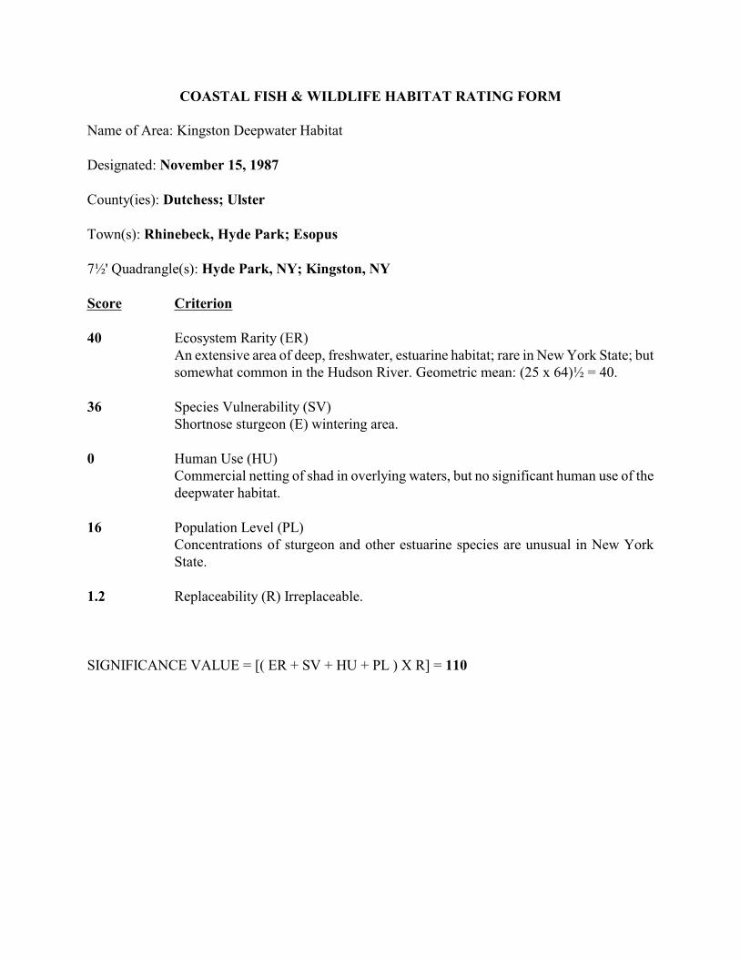
COASTAL FISH & WILDLIFE HABITAT RATING FORM
Name of Area: Kingston Deepwater Habitat
Designated: November 15, 1987
County(ies): Dutchess; Ulster
Town(s): Rhinebeck, Hyde Park; Esopus
7!' Quadrangle(s): Hyde Park, NY; Kingston, NY
Score Criterion
40 Ecosystem Rarity (ER) An extensive area of deep, freshwater, estuarine habitat; rare in New York State; butsomewhat common in the Hudson River. Geometric mean: (25 x 64)! = 40.
36 Species Vulnerability (SV) Shortnose sturgeon (E) wintering area.
0 Human Use (HU)Commercial netting of shad in overlying waters, but no significant human use of thedeepwater habitat.
16 Population Level (PL)Concentrations of sturgeon and other estuarine species are unusual in New YorkState.
1.2 Replaceability (R) Irreplaceable.
SIGNIFICANCE VALUE = [( ER + SV + HU + PL ) X R] = 110

SIGNIFICANT COASTAL FISH AND WILDLIFE HABITATS PROGRAM A PART OFTHE NEW YORK COASTAL MANAGEMENT PROGRAM
BACKGROUND
New York State's Coastal Management Program (CMP) includes a total of 44 policies which areapplicable to development and use proposals within or affecting the State's coastal area. Any activitythat is subject to review under Federal or State laws, or under applicable local laws contained in anapproved local waterfront revitalization program will be judged for its consistency with thesepolicies.
Once a determination is made that the proposed action is subject to consistency review, a specificpolicy aimed at the protection of fish and wildlife resources of statewide significance applies. Thespecific policy statement is as follows: "Significant coastal fish and wildlife habitats will beprotected, preserved, and, where practical, restored so as to maintain their viability as habitats." TheNew York State Department of Environmental Conservation (DEC) evaluates the significance ofcoastal fish and wildlife habitats, and following a recommendation from the DEC, the Departmentof State designates and maps specific areas. Although designated habitat areas are delineated on thecoastal area map, the applicability of this policy does not depend on the specific location of thehabitat, but on the determination that the proposed action is subject to consistency review.
Significant coastal fish and wildlife habitats are evaluated, designated and mapped under theauthority of the Coastal Management Program's enabling legislation, the Waterfront Revitalizationand Coastal Resources Act (Executive Law of New York, Article 42). These designations aresubsequently incorporated in the Coastal Management Program under authority provided by theFederal Coastal Zone Management Act.
This narrative constitutes a record of the basis for this significant coastal fish and wildlife habitat'sdesignation and provides specific information regarding the fish and wildlife resources that dependon this area. General information is also provided to assist in evaluating impacts of proposedactivities on parameters which are essential to the habitat's values. This information is to be used inconjunction with the habitat impairment test found in the impact assessment section to determinewhether the proposed activities are consistent with this policy.
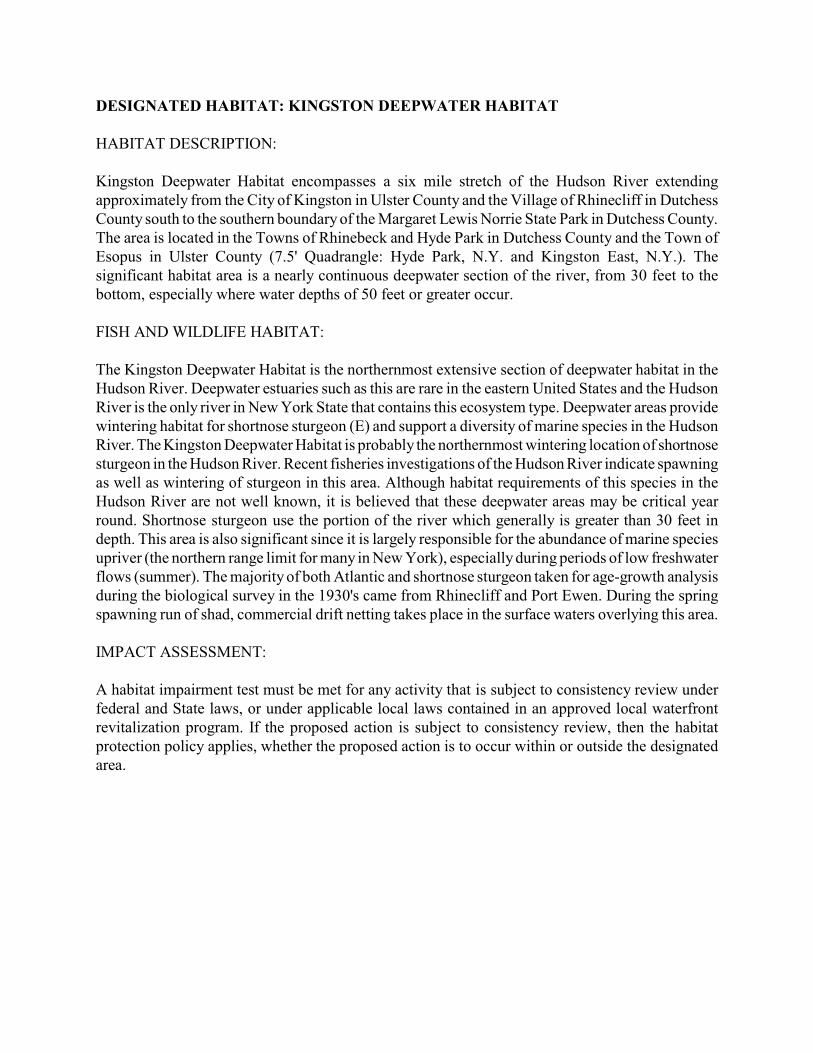
DESIGNATED HABITAT: KINGSTON DEEPWATER HABITAT
HABITAT DESCRIPTION:
Kingston Deepwater Habitat encompasses a six mile stretch of the Hudson River extendingapproximately from the City of Kingston in Ulster County and the Village of Rhinecliff in DutchessCounty south to the southern boundary of the Margaret Lewis Norrie State Park in Dutchess County.The area is located in the Towns of Rhinebeck and Hyde Park in Dutchess County and the Town ofEsopus in Ulster County (7.5' Quadrangle: Hyde Park, N.Y. and Kingston East, N.Y.). Thesignificant habitat area is a nearly continuous deepwater section of the river, from 30 feet to thebottom, especially where water depths of 50 feet or greater occur.
FISH AND WILDLIFE HABITAT:
The Kingston Deepwater Habitat is the northernmost extensive section of deepwater habitat in theHudson River. Deepwater estuaries such as this are rare in the eastern United States and the HudsonRiver is the only river in New York State that contains this ecosystem type. Deepwater areas providewintering habitat for shortnose sturgeon (E) and support a diversity of marine species in the HudsonRiver. The Kingston Deepwater Habitat is probably the northernmost wintering location of shortnosesturgeon in the Hudson River. Recent fisheries investigations of the Hudson River indicate spawningas well as wintering of sturgeon in this area. Although habitat requirements of this species in theHudson River are not well known, it is believed that these deepwater areas may be critical yearround. Shortnose sturgeon use the portion of the river which generally is greater than 30 feet indepth. This area is also significant since it is largely responsible for the abundance of marine speciesupriver (the northern range limit for many in New York), especially during periods of low freshwaterflows (summer). The majority of both Atlantic and shortnose sturgeon taken for age-growth analysisduring the biological survey in the 1930's came from Rhinecliff and Port Ewen. During the springspawning run of shad, commercial drift netting takes place in the surface waters overlying this area.
IMPACT ASSESSMENT:
A habitat impairment test must be met for any activity that is subject to consistency review underfederal and State laws, or under applicable local laws contained in an approved local waterfrontrevitalization program. If the proposed action is subject to consistency review, then the habitatprotection policy applies, whether the proposed action is to occur within or outside the designatedarea.
The specific habitat impairment test that must be met is as follows.
In order to protect and preserve a significant habitat, land and water uses or developmentshall not be undertaken if such actions would:
• destroy the habitat; or,
• significantly impair the viability of a habitat.
Habitat destruction is defined as the loss of fish or wildlife use through direct physical alteration,disturbance, or pollution of a designated area or through the indirect effects of these actions on adesignated area. Habitat destruction may be indicated by changes in vegetation, substrate, orhydrology, or increases in runoff, erosion, sedimentation, or pollutants.
Significant impairment is defined as reduction in vital resources (e.g., food, shelter, living space) orchange in environmental conditions (e.g., temperature, substrate, salinity) beyond the tolerance rangeof an organism. Indicators of a significantly impaired habitat focus on ecological alterations and mayinclude but are not limited to reduced carrying capacity, changes in community structure (food chainrelationships, species diversity), reduced productivity and/or increased incidence of disease andmortality.
The tolerance range of an organism is not defined as the physiological range of conditions beyondwhich a species will not survive at all, but as the ecological range of conditions that supports thespecies population or has the potential to support a restored population, where practical. Either theloss of individuals through an increase in emigration or an increase in death rate indicates that thetolerance range of an organism has been exceeded. An abrupt increase in death rate may occur as anenvironmental factor falls beyond a tolerance limit (a range has both upper and lower limits). Manyenvironmental factors, however, do not have a sharply defined tolerance limit, but produceincreasing emigration or death rates with increasing departure from conditions that are optimal forthe species.
The range of parameters which should be considered in appplying the habitat impairment test includebut are not limited to the following:
1. physical parameters such as living space, circulation, flushing rates, tidal amplitude,turbidity, water temperature, depth (including loss of littoral zone), morphology, substratetype, vegetation, structure, erosion and sedimentation rates;
2. biological parameters such as community structure, food chain relationships, speciesdiversity, predator/prey relationships, population size, mortality rates, reproductive rates,meristic features, behavioral patterns and migratory patterns; and,
3. chemical parameters such as dissolved oxygen, carbon dioxide, acidity, dissolved solids,nutrients, organics, salinity, and pollutants (heavy metals, toxics and hazardous materials).
Although not comprehensive, examples of generic activities and impacts which could destroy orsignificantly impair the habitat are listed below to assist in applying the habitat impairment test toa proposed activity.
Activities that would substantially degrade water quality, including changes in temperature, turbidity,or freshwater to saline distribution in the deepwater portions of the river, would result in significantimpairment of the habitat. This area may be especially sensitive to discharges of wastewater, sewageeffluent or agricultural runoff. Major reduction in overall depths within this deepwater trench wouldalso have significant adverse effects on use of the habitat by shortnose sturgeon. Deposition ofdredged material or natural sediments, especially if contaminated, would degrade the quality of thisecosystem. Impingement of shortnose sturgeon on water intake screens could affect the populationstatus of this endangered species.
KNOWLEDGEABLE CONTACTS:
Tom HartN.Y.S. Department of State Division of Coastal Resources & Waterfront Revitalization 162 Washington Avenue Albany, NY 12231 Phone: (518) 474-6000
Bob Brandt, Hudson River Fisheries Wayne Elliot, Fisheries ManagerNYS DEC, Region III New Paltz, New York 12561 Telephone: (914) 255-5453
NYSDECInformation Services700 Troy-Schenectady Road Latham, NY 12110 Phone: (518)783-3932

Kingston Deepwater Habitat Map Part 1
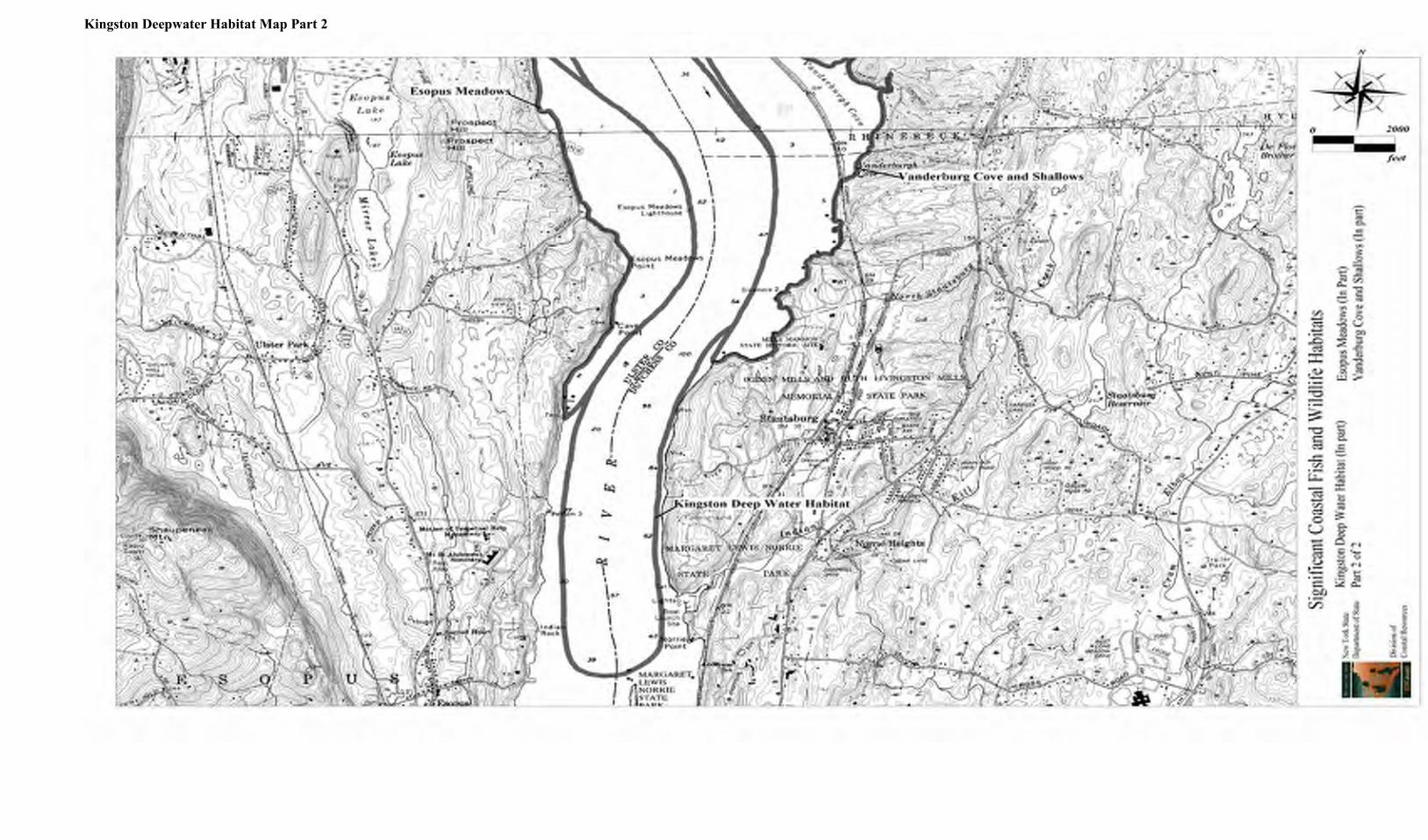
Kingston Deepwater Habitat Map Part 2

COASTAL FISH & WILDLIFE HABITAT RATING FORM
Name of Area: The Flats
Designated: November 15, 1987
County(ies): Ulster; Dutchess
Town(s): Ulster, Kingston; Red Hook, Rhinebeck
7!' Quadrangle(s): Kingston East, NY
Score Criterion
64 Ecosystem Rarity (ER) An extensive area of shallow, freshwater, tidal flats; rare in New York State.
0 Species Vulnerability (SV) Shortnose sturgeon (E) occur in the area, but habitat use is not adequatelydocumented.
18 Human Use (HU)Area supports a commercial shad fishery of statewide significance; recreationalfishing attracts anglers from Ulster and Dutchess Counties. Additive division: 16 +4/2 = 18.
16 Population Level (PL)One of the major shad spawning areas in the Hudson River; concen-trations areunusual in New York State.
1.2 Replaceability (R) Irreplaceable.
SIGNIFICANCE VALUE = [( ER + SV + HU + PL ) X R] = 118
SIGNIFICANT COASTAL FISH AND WILDLIFE HABITATS PROGRAM A PART OFTHE NEW YORK COASTAL MANAGEMENT PROGRAM
BACKGROUND
New York State's Coastal Management Program (CMP) includes a total of 44 policies which areapplicable to development and use proposals within or affecting the State's coastal area. Any activitythat is subject to review under Federal or State laws, or under applicable local laws contained in anapproved local waterfront revitalization program will be judged for its consistency with thesepolicies.
Once a determination is made that the proposed action is subject to consistency review, a specificpolicy aimed at the protection of fish and wildlife resources of statewide significance applies. Thespecific policy statement is as follows: "Significant coastal fish and wildlife habitats will beprotected, preserved, and, where practical, restored so as to maintain their viability as habitats." TheNew York State Department of Environmental Conservation (DEC) evaluates the significance ofcoastal fish and wildlife habitats, and following a recommendation from the DEC, the Departmentof State designates and maps specific areas. Although designated habitat areas are delineated on thecoastal area map, the applicability of this policy does not depend on the specific location of thehabitat, but on the determination that the proposed action is subject to consistency review.
Significant coastal fish and wildlife habitats are evaluated, designated and mapped under theauthority of the Coastal Management Program's enabling legislation, the Waterfront Revitalizationand Coastal Resources Act (Executive Law of New York, Article 42). These designations aresubsequently incorporated in the Coastal Management Program under authority provided by theFederal Coastal Zone Management Act.
This narrative constitutes a record of the basis for this significant coastal fish and wildlife habitat'sdesignation and provides specific information regarding the fish and wildlife resources that dependon this area. General information is also provided to assist in evaluating impacts of proposedactivities on parameters which are essential to the habitat's values. This information is to be usedin conjunction with the habitat impairment test found in the impact assessment section to determinewhether the proposed activities are consistent with this policy.
DESIGNATED HABITAT: THE FLATS
HABITAT DESCRIPTION:
The Flats is located in the middle of the Hudson River, roughly between the hamlet of Barrytownand the City of Kingston, in the Town of Ulster and City of Kingston, Ulster County, and the Townsof Red Hook and Rhinebeck, Dutchess County (7.5' Quadrangle: Kingston East, N.Y.). The fish andwildlife habitat is an approximate four and one-half mile long underwater ridge, most of which isshallow (less than 10 feet deep at mean low water), freshwater, intertidal mud flats, and subtidalaquatic beds (predominantly wild celery and Eurasian water milfoil). The Flats is bordered to thewest by the Hudson River navigation channel, resulting in potential habitat disturbance from periodicmaintenance dredging.
FISH AND WILDLIFE VALUES:
The Flats is one of the largest contiguous areas of shallow, freshwater, tidal flats in the HudsonRiver. Areas such as this are extremely valuable fish and wildlife habitats, and are not found in othercoastal regions of New York State.
The Flats is one of the primary Hudson River spawning grounds for American shad. Betweenmid-March and June, adult shad concentrate between Kingston and Coxsackie, and spawning occursprimarily on extensive flats, shoals, sandbars, and shallow areas near the mouths of tributary creeks.These fish may move into adjacent deeper areas while tidal currents are strong. Reproduction by shadin The Flats area supports much of the commercial gillnet fishery for this species on the HudsonRiver, which is one of the largest such fisheries in the U.S. The importance of the Flats ishighlighted by the fact that it is the only area on the Hudson where commercial fishing is prohibitedduring the shad spawning period. The Flats also serves as spawning, nursery, and feeding habitatfor striped bass, white perch, and various resident freshwater species. Concentrations of the earlydevelopmental stages of several anadromous species occur in this area.
Shortnose sturgeon (E) and Atlantic sturgeon may also use the area to feed (especially during slackwater in late spring and summer), or as a resting area during river-wide movements, or as a slightlypreferable habitat when water temperatures are warmer than in adjacent deeper waters (i.e., in earlyspring and fall). High catches of shortnose sturgeon occur in channels adjoining The Flats,particularly on the east side. The abundant fisheries resources in this area provide an excellentrecreational fishery, attracting anglers from nearby portions of Ulster and Dutchess Counties.
Significant concentrations of waterfowl also occur in The Flats area. Dense growths of wild celeryprovide valuable feeding areas for many species of ducks, and are especially important during spring(March-April) and fall (mid-September - early December) migrations. Concentrations of divingducks, such as scaups, redhead, canvasback, common goldeneye, and mergansers, are regularly foundout in The Flats. During calm weather, this open river area is also used by dabbling ducks, includingmallard, black duck, and blue-winged teal, and provides a refuge from hunting pressure in shorelineareas.
IMPACT ASSESSMENT:
A habitat impairment test must be met for any activity that is subject to consistency review underFederal and State laws, or under applicable local laws contained in an approved local waterfrontrevitalization program. If the proposed action is subject to consistency review, then the habitatprotection policy applies, whether the proposed action is to occur within or outside the designatedarea.
The specific habitat impairment test that must be met is as follows.
In order to protect and preserve a significant habitat, land and water uses or development shall not be undertaken if such actions would:
• destroy the habitat; or,
• significantly impair the viability of a habitat.
Habitat destruction is defined as the loss of fish or wildlife use through direct physical alteration,disturbance, or pollution of a designated area or through the indirect effects of these actions on adesignated area. Habitat destruction may be indicated by changes in vegetation, substrate, orhydrology, or increases in runoff, erosion, sedimentation, or pollutants.
Significant impairment is defined as reduction in vital resources (e.g., food, shelter, living space) orchange in environmental conditions (e.g., temperature, substrate, salinity) beyond the tolerance rangeof an organism. Indicators of a significantly impaired habitat focus on ecological alterations and mayinclude but are not limited to reduced carrying capacity, changes in community structure (food chainrelationships, species diversity), reduced productivity and/or increased incidence of disease andmortality.
The tolerance range of an organism is not defined as the physiological range of conditions beyondwhich a species will not survive at all, but as the ecological range of conditions that supports thespecies population or has the potential to support a restored population, where practical. Either theloss of individuals through an increase in emigration or an increase in death rate indicates that thetolerance range of an organism has been exceeded. An abrupt increase in death rate may occur asan environmental factor falls beyond a tolerance limit (a range has both upper and lower limits).Many environmental factors, however, do not have a sharply defined tolerance limit, but produceincreasing emigration or death rates with increasing departure from conditions that are optimal forthe species.
The range of parameters which should be considered in appplying the habitat impairment test includebut are not limited to the following:
1. physical parameters such as living space, circulation, flushing rates, tidal amplitude,
turbidity, water temperature, depth (including loss of littoral zone), morphology, substratetype, vegetation, structure, erosion and sedimentation rates;
2. biological parameters such as community structure, food chain relationships, speciesdiversity, predator/prey relationships, population size, mortality rates, reproductive rates,meristic features, behavioral patterns and migratory patterns; and,
3. chemical parameters such as dissolved oxygen, carbon dioxide, acidity, dissolved solids,nutrients, organics, salinity, and pollutants (heavy metals, toxics and hazardous materials).
Although not comprehensive, examples of generic activities and impacts which could destroy orsignificantly impair the habitat are listed below to assist in applying the habitat impairment test toa proposed activity.
Any activity that would substantially degrade water quality in The Flats would affect the biologicalproductivity of this area and result in significant impairment of the habitat. Species of fish andwildlife may be adversely affected by water pollution, such as chemical contamination (includingfood chain effects), oil spills, excessive turbidity or sedimentation, and waste disposal. Continuedefforts should be made to improve water quality in the Hudson River, which is primarily dependentupon controlling discharges from combined sewer overflows, industrial point sources, and ships. Oiland other hazardous substance spills are an especially significant threat to this area, because thebiological activity of tidal flats is concentrated at the soil surface, much of which may be directlyexposed to these pollutants. Disruption of plant communities or benthos in the area throughdredging or filling (including dredge spoil disposal), would reduce its value as a fish and wildlifehabitat; no new navigation channels should be cut through the area.
Thermal discharges, depending on time of year, may have variable effects on use of the area byaquatic species; shad spawning activities and survival are directly affected by water temperature.Installation and operation of water intakes could have significant impacts on fish populations in thearea, through impingement of juvenile and adult fish, or entrainment of eggs and larval stages.
KNOWLEDGEABLE CONTACTS:
Tom HartN.Y.S. Department of State Division of Coastal Resources & Waterfront Revitalization162 Washington Avenue Albany, NY 12231 Phone: (518) 474-6000
Wayne Elliott, Fisheries Manager or Glenn Cole, Wildlife Manager or Jack Isaacs, EnvironmentalProtection BiologistNYS DEC - Region321 So. Putt Corners Road New Paltz, NY 12561 Phone: (914)255-5453
William L. DovelRoute 1, Box 800 Venice, FL 33595 Phone: (813)493-4354
NYS DEC Information Services700 Troy-Schenectady Road Latham, NY 12110 Phone: (518)783-3932
Erik KiviatHudsonia Bard CollegeAnnandale, NY 12504 Phone: (914) 758-1881

The Flats Habitat Map Part 1
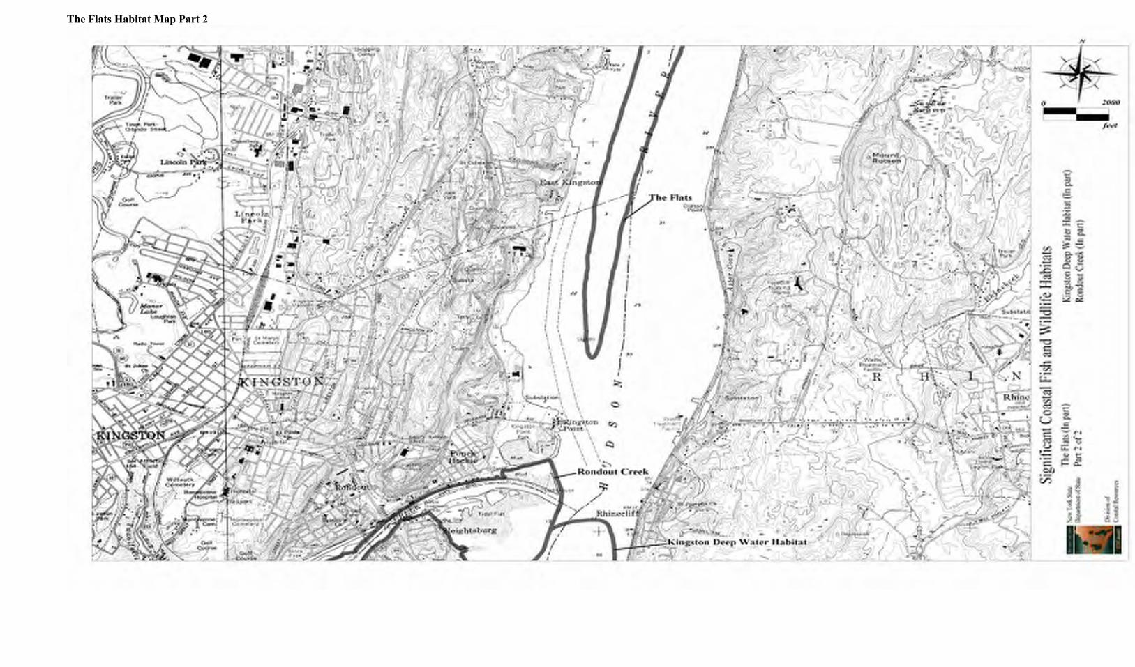
The Flats Habitat Map Part 2

COASTAL FISH & WILDLIFE HABITAT RATING FORM
Name of Area: Vanderburgh Cove and Shallows
Designated: November 15, 1987
County: Dutchess
Town(s): Rhinebeck, Hyde Park
7!' Quadrangle(s): Kingston East, NY; Hyde Park, NY
Score Criterion
9 Ecosystem Rarity (ER) Relatively large, sheltered, freshwater tidal coves andadjoining shallows; unusual in Dutchess County.
0 Species Vulnerability (SV) Shortnose sturgeon (E) may occur in the area, but habitatuse not adequately documented.
4 Human Use (HU) Waterfowl hunting attracts visitors from throughout DutchessCounty.
4 Population Level (PL) One of the major waterfowl concentration areas in DutchessCounty.
1.2 Replaceability (R) Irreplaceable.
SIGNIFICANCE VALUE = [( ER + SV + HU + PL ) X R] = 20
SIGNIFICANT COASTAL FISH AND WILDLIFE HABITATS PROGRAMA PART OF THE NEW YORK COASTAL MANAGEMENT PROGRAM
BACKGROUND
New York State's Coastal Management Program (CMP) includes a total of 44 policies which areapplicable to development and use proposals within or affecting the State's coastal area. Any activitythat is subject to review under Federal or State laws, or under applicable local laws contained in anapproved local waterfront revitalization program will be judged for its consistency with thesepolicies.
Once a determination is made that the proposed action is subject to consistency review, a specificpolicy aimed at the protection of fish and wildlife resources of statewide significance applies. Thespecific policy statement is as follows: "Significant coastal fish and wildlife habitats will beprotected, preserved, and, where practical, restored so as to maintain their viability as habitats." TheNew York State Department of Environmental Conservation (DEC) evaluates the significance ofcoastal fish and wildlife habitats, and following a recommendation from the DEC, the Departmentof State designates and maps specific areas. Although designated habitat areas are delineated on thecoastal area map, the applicability of this policy does not depend on the specific location of thehabitat, but on the determination that the proposed action is subject to consistency review.
Significant coastal fish and wildlife habitats are evaluated, designated and mapped under theauthority of the Coastal Management Program's enabling legislation, the Waterfront Revitalizationand Coastal Resources Act (Executive Law of New York, Article 42). These designations aresubsequently incorporated in the Coastal Management Program under authority provided by theFederal Coastal Zone Management Act.
This narrative constitutes a record of the basis for this significant coastal fish and wildlife habitat'sdesignation and provides specific information regarding the fish and wildlife resources that dependon this area. General information is also provided to assist in evaluating impacts of proposedactivities on parameters which are essential to the habitat's values. This information is to be usedin conjunction with the habitat impairment test found in the impact assessment section to determinewhether the proposed activities are consistent with this policy.
DESIGNATED HABITAT: VANDERBURGH COVE AND SHALLOWS HABITAT
DESCRIPTION:
Vanderburgh Cove and Shallows is located on the east side of the Hudson River, approximately fourmiles south of the Village of Rhinebeck, in the Towns of Rhinebeck and Hyde Park, DutchessCounty (7.5' Quadrangles: Kingston East, N.Y.; and Hyde Park, N.Y.). Vanderburgh Cove is anapproximate 100 acre, shallow, (less than 10 feet deep at mean low water), tidal, freshwater, bay,separated from the open river by the Penn Central railroad.
The cove is hydrologically connected to the river via two bridges in the railroad, and contains densebeds of water chestnut, wild celery, Eurasian water milfoil, pickerelweed, and yellow pond lily.Emergent marsh vegetation (e.g., river bulrush and cattail) is present only around the margin ofVanderburgh Cove, and where two small tributaries, the Landsman Kill and Fallsburg Creek, emptyinto the area. Also included in the habitat is Suckley Cove, a similar 30 acre area to the north ofVanderburgh Cove.
Outside of the railroad is an approximate 1,000 foot wide extension of the shallow water area inVanderburgh Cove, encompassing approximately 300 acres. The latter area is predominantlysubtidal, with a silt substrate and beds of aquatic vegetation. These shallows are located adjacent toa natural deepwater channel in the Hudson River, so the area is not subject to habitat disturbancefrom periodic maintenance dredging. The land area bordering Vanderburgh Cove and Shallows ispredominantly deciduous forest on moderate to steep slopes, including a portion of Ogden and RuthLivingston Mills Memorial State Park and Wilderstien, a not-for-profit historic site and naturepreserve. However, since the 1970's, new residential development has been increasing in adjacentareas.
FISH AND WILDLIFE VALUES:
Vanderburgh Cove and Shallows is one of the largest contiguous areas of shallow, freshwater,subtidal flats in Dutchess County. Areas such as this are extremely valuable fish and wildlifehabitats. However, the importance of this area is limited somewhat by its small size relative tosimilar habitats elsewhere in the Hudson River, and possibly by the abundance of water chestnutwithin Vanderburgh Cove. Suckley Cove is a high quality portion of the habitat, with minimalhuman disturbance. Vanderburgh Cove and Shallows is a productive littoral area located near thelowest reaches of shallow freshwater in the Hudson River, which is a critical area for many fishspecies. The shallow, subtidal beds provide spawning, nursery, and feeding habitats for anadromousspecies such as striped bass, American shad, and white perch, and for a variety of resident freshwaterspecies, such as largemouth bass, carp, brown bullhead, yellow perch, and shiners. The LandsmanKill and Fallsburg Creek also attract spawning runs of smelt, alewife, and blueback herring, althoughthe extent of reproduction has not been documented.
Concentrations of spawning anadromous fishes generally occur in the area between mid-March andJuly, with substantial numbers of young-of-the-year fish remaining well into the fall (October-November). Vanderburgh Cove and Shallows may also serve as a feeding area for populations of

shortnose sturgeon (E) wintering in the adjacent deepwater channel. The abundant fisheriesresources in Vanderburgh Cove and Shallows provide valuable opportunities for recreational (andpossibly commercial) fishing, attracting anglers from throughout Dutchess County. Fishing pressureis generally concentrated near the tributary stream mouths and at railroad bridges.
Significant concentrations of waterfowl also occur in the Vanderburgh Cove and Shallows area.Dense growths of submergent vegetation provide valuable feeding areas for many species of ducks,and are especially important during spring (March-April) and fall (mid-September - early December)migrations. Concentrations of diving ducks, such as scaups, redhead, canvasback, commongoldeneye, and mergansers, are regularly found out in the flats. The more shallow cove areas areused by dabbling ducks, including mallard, black duck, wood duck, and blue-winged teal, especiallyduring inclement weather. Rafts of several hundred birds have been observed in Vanderburgh Coveduring fall migrations. Consequently, this is one of the most popular waterfowl hunting areas inDutchess County, second only to Tivoli Bays. Depending on weather conditions, some waterfowlmay remain in the area throughout winter. Although occasional observations have been reported,the extent to which other bird species, such as loons, grebes, gulls, wading birds, shorebirds, andosprey (T), may use the area has not been well documented.
IMPACT ASSESSMENT:
A habitat impairment test must be met for any activity that is subject to consistency review underfederal and State laws, or under applicable local laws contained in an approved local waterfrontrevitalization program. If the proposed action is subject to consistency review, then the habitatprotection policy applies, whether the proposed action is to occur within or outside the designatedarea.
The specific habitat impairment test that must be met is as follows.
In order to protect and preserve a significant habitat, land and water uses or development shall not be undertaken if such actions would:
• destroy the habitat; or,
• significantly impair the viability of a habitat.
Habitat destruction is defined as the loss of fish or wildlife use through direct physical alteration,disturbance, or pollution of a designated area or through the indirect effects of these actions on adesignated area. Habitat destruction may be indicated by changes in vegetation, substrate, orhydrology, or increases in runoff, erosion, sedimentation, or pollutants.
Significant impairment is defined as reduction in vital resources (e.g., food, shelter, living space) orchange in environmental conditions (e.g., temperature, substrate, salinity) beyond the tolerance rangeof an organism. Indicators of a significantly impaired habitat focus on ecological alterations and mayinclude but are not limited to reduced carrying capacity, changes in community structure (food chainrelationships, species diversity), reduced productivity and/or increased incidence of disease andmortality.

The tolerance range of an organism is not defined as the physiological range of conditions beyondwhich a species will not survive at all, but as the ecological range of conditions that supports thespecies population or has the potential to support a restored population, where practical. Either theloss of individuals through an increase in emigration or an increase in death rate indicates that thetolerance range of an organism has been exceeded. An abrupt increase in death rate may occur asan environmental factor falls beyond a tolerance limit (a range has both upper and lower limits).Many environmental factors, however, do not have a sharply defined tolerance limit, but produceincreasing emigration or death rates with increasing departure from conditions that are optimal forthe species.
The range of parameters which should be considered in appplying the habitat impairment test includebut are not limited to the following:
1. physical parameters such as living space, circulation, flushing rates, tidal amplitude,turbidity, water temperature, depth (including loss of littoral zone), morphology, substratetype, vegetation, structure, erosion and sedimentation rates;
2. biological parameters such as community structure, food chain relationships, speciesdiversity, predator/prey relationships, population size, mortality rates, reproductive rates,meristic features, behavioral patterns and migratory patterns; and,
3. chemical parameters such as dissolved oxygen, carbon dioxide, acidity, dissolved solids,nutrients, organics, salinity, and pollutants (heavy metals, toxics and hazardous materials).
Although not comprehensive, examples of generic activities and impacts which could destroy orsignificantly impair the habitat are listed below to assist in applying the habitat impairment test toa proposed activity.
Any activity that would substantially degrade water quality in Vanderburgh Cove and Shallowswould result in significant impairment of the habitat. All species of fish and wildlife may beadversely affected by water pollution, such as chemical contamination (including foodchaineffects),oil spills, excessive turbidity or sedimentation, and waste disposal.
Continued efforts should be made to improve water quality in the Hudson River, which is primarilydependent upon controlling discharges from combined sewer overflows, industrial point sources,andships. Application of herbicides or insecticides along the railroad right-of-way or adjacent uplandsmay result in adverse impacts on the fish and wildlife resources of the area.
Alteration of tidal fluctuations in Vanderburgh Cove and Shallows could have significant impactson fish and wildlife; increased tidal exchange may improve habitat quality in the cove. During theearly 1980's, a railroad bridge opening to the cove was made smaller, and this may have haddetrimental effects. Disruption of natural plant communities or benthos in the area could reduce itsvalue as a fish and wildlife habitat, although control of water chestnut may be desirable or necessaryto maintain certain species. Any physical disturbance of the habitat, through dredging or filling(including dredge spoil disposal), would result in a direct loss of valuable habitat area; any dredgingactivities needed to maintain the existing channel should be scheduled in mid to late summer to
minimize potential impacts on most aquatic organisms and migratory birds. Thermal discharges,depending on time of year, may have variable effects on use of the area by aquatic species andwintering waterfowl; fish spawning activities and survival are often directly affected by watertemperature. Installation and operation of water intakes could have significant impacts on fishconcentrations, through impingement of juveniles and adults, or entrainment of eggs and larvalstages.
Significant human encroachment into adjacent areas may limit use of Vanderburgh and SuckleyCoves by certain species. Existing areas of natural vegetation bordering Vanderburgh Cove andShallows should be maintained for their value as cover, perch sites, and buffer zones. Enhancementof appropriate public access to increase compatible human uses of fish and wildlife resources in thearea may be desirable.
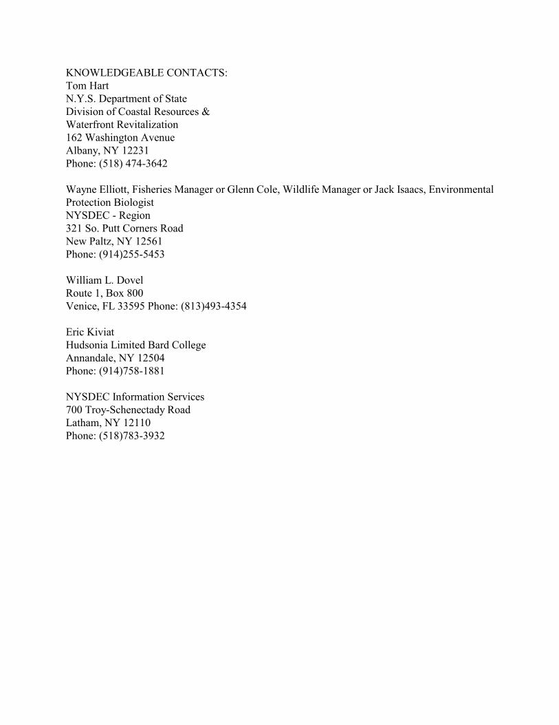
KNOWLEDGEABLE CONTACTS:Tom HartN.Y.S. Department of State Division of Coastal Resources & Waterfront Revitalization162 Washington AvenueAlbany, NY 12231 Phone: (518) 474-3642
Wayne Elliott, Fisheries Manager or Glenn Cole, Wildlife Manager or Jack Isaacs, EnvironmentalProtection BiologistNYSDEC - Region321 So. Putt Corners Road New Paltz, NY 12561 Phone: (914)255-5453
William L. DovelRoute 1, Box 800 Venice, FL 33595 Phone: (813)493-4354
Eric KiviatHudsonia Limited Bard CollegeAnnandale, NY 12504 Phone: (914)758-1881
NYSDEC Information Services700 Troy-Schenectady Road Latham, NY 12110 Phone: (518)783-3932
Esopus Meadows Vanderburgh Cove and Shallows Map

TOWN OF RHINEBECKDRAFT WATERFRONT CONSISTENCY REVIEW LAWBe it enacted by the Town Board of the Town of Rhinebeck follows:
GENERAL PROVISIONSI. Title.This Local law will be known as the Town of Rhinebeck Waterfront Consistency Review Law.II. Authority and Purpose.A. This local law is adopted under the authority of the Municipal Home Rule Law and theWaterfront Revitalization of Coastal Areas and Inland Waterways Act of the State of NewYork (Article 42 of the Executive Law).B. The purpose of this local law is to provide a framework for agencies of the Town ofRhinebeck to incorporate the policies and purposes contained in the Town of RhinebeckLocal Waterfront Revitalization Program (LWRP) when reviewing applications for actionsor direct agency actions within the coastal area; and to assure that such actions and directactions by Town agencies are consistent with the LWRP policies and purposes.C. It is the intention of the Town of Rhinebeck that the preservation, enhancement andutilization of the unique coastal area of the Town take place in a coordinated andcomprehensive manner to ensure a proper balance between protection of natural resourcesand the need to accommodate limited population growth and economic development.Accordingly, this local law is intended to achieve such a balance, permitting the beneficialuse of coastal resources while preventing loss and degradation of living coastal resources andwildlife; diminution of open space areas or public access to the waterfront; disruption ofnatural coastal processes; impairment of scenic, cultural or historical resources; losses dueto flooding, erosion and sedimentation; impairment of water quality; or permanent adversechanges to ecological systems.D. The substantive provisions of this local law shall only apply when there is in existence aTown of Rhinebeck Local Waterfront Revitalization Program which has been adopted inaccordance with Article 42 of the Executive Law of the State of New York.III. Definitions.A. “Actions” include all the following, except minor actions:(1) projects or physical activities, such as construction or any other activities that may

affect natural, manmade or other resources in the coastal area or the environment bychanging the use, appearance or condition of any resource or structure, that:(I) are directly undertaken by an agency; or(ii) involve funding by an agency; or(iii) require one or more new or modified approvals, permits, or review from anagency or agencies;(2) agency planning and policymaking activities that may affect the environment andcommit the agency to a definite course of future decisions;(3) adoption of agency rules, regulations and procedures, including local laws, codes,ordinances, executive orders and resolutions that may affect coastal resources or theenvironment; and(4) any combination of the above.B. "Agency" means any board, agency, department, office, other body, or officer of the Townof Rhinebeck.C. "Coastal area" means that portion of New York State coastal waters and adjacent shorelandsas defined in Article 42 of the Executive Law which is located within the boundaries of theTown of Rhinebeck, as shown on the coastal area map on file in the office of the Secretaryof State and as delineated in the Town of Rhinebeck Local Waterfront RevitalizationProgram (LWRP).D. "Coastal Assessment Form (CAF)" means the form, a sample of which is appended to thislocal law, used by an agency to assist in determining the consistency of an action with theLocal Waterfront Revitalization Program.E. "Consistent" means that the action will fully comply with the LWRP policy standards,conditions and objectives and, whenever practicable, will advance one or more of them.F. "Direct Actions" mean actions planned and proposed for implementation by an agency, suchas, but not limited to a capital project, rule making, procedure making and policy making.G. "Environment" means all conditions, circumstances and influences surrounding and affectingthe development of living organisms or other resources in the coastal area.H. "Local Waterfront Revitalization Program” or “LWRP" means the Local WaterfrontRevitalization Program of the Town of Rhinebeck, approved by the Secretary of Statepursuant to the Waterfront Revitalization of Coastal Areas and Inland Waterways Act(Executive Law, Article 42), a copy of which is on file in the Office of the Clerk of the Townof Rhinebeck.
I. "Minor actions" include the following actions, which are not subject to review under thischapter:(1) maintenance or repair involving no substantial changes in an existing structure orfacility;(2) replacement, rehabilitation or reconstruction of a structure or facility, in kind, on thesame site, including upgrading buildings to meet building or fire codes, except forstructures in areas designated by the Coastal Erosion Hazard Area (CEHA) lawwhere structures may not be replaced, rehabilitated or reconstructed without a permit;(3) repaving or widening of existing paved highways not involving the addition of newtravel lanes;(4) street openings and right-of-way openings for the purpose of repair or maintenanceof existing utility facilities;(5) maintenance of existing landscaping or natural growth, except where threatened orendangered species of plants or animals are affected, or within Significant CoastalFish and Wildlife Habitat areas;(6) granting of individual setback and lot line variances, except in relation to a regulatednatural feature, a bulkhead or other shoreline defense structure;(7) minor temporary uses of land having negligible or no permanent impact on coastalresources or the environment;(8) installation of traffic control devices on existing streets, roads and highways;(9) mapping of existing roads, streets, highways, natural resources, land uses andownership patterns;(10) information collection including basic data collection and research, water quality andpollution studies, traffic counts, engineering studies, surveys, subsurfaceinvestigations and soils studies that do not commit the agency to undertake, fund orapprove any action;(11) official acts of a ministerial nature involving no exercise of discretion, includingbuilding where issuance is predicated solely on the applicant's compliance ornoncompliance with the relevant local building code.(12) routine or continuing agency administration and management, not including newprograms or major reordering of priorities that may affect the environment;(13) conducting concurrent environmental, engineering, economic, feasibility and other

studies and preliminary planning and budgetary processes necessary to theformulation of a proposal for action, provided those activities do not commit theagency to commence, engage in or approve such action;(14) collective bargaining activities;(15) investments by or on behalf of agencies or pension or retirement systems, orrefinancing existing debt;(16) inspections and licensing activities relating to the qualifications of individuals orbusinesses to engage in their business or profession;(17) purchase or sale of furnishings, equipment or supplies, including surplus governmentproperty, other than the following: land, radioactive material, pesticides, herbicides,storage of road de-icing substances, or other hazardous materials;(18) adoption of regulations, policies, procedures and local legislative decisions inconnection with any action on this list;(19) engaging in review of any part of an application to determine compliance withtechnical requirements, provided that no such determination entitles or permits theproject sponsor to commence the action unless and until all requirements of this Parthave been fulfilled;(20) civil or criminal enforcement proceedings, whether administrative or judicial,including a particular course of action specifically required to be undertaken pursuantto a judgment or order, or the exercise of prosecutorial discretion;(21) adoption of a moratorium on land development or construction;(22) interpreting an existing code, rule or regulation;(23) designation of local landmarks or their inclusion within historic districts;(24) emergency actions that are immediately necessary on a limited and temporary basisfor the protection or preservation of life, health, property or natural resources,provided that such actions are directly related to the emergency and are performedto cause the least change or disturbance, practicable under the circumstances, tocoastal resources or the environment. Any decision to fund, approve or directlyundertake other activities after the emergency has expired is fully subject to thereview procedures of this Part;(25) local legislative decisions such as rezoning where the Town Board determines theaction will not be approved.
IV. Management and Coordination of the LWRPA. The Town of Rhinebeck Conservation Advisory Council (Council) shall be responsible forcoordinating review of actions in the Town's coastal area for consistency with the LWRP,and will advise, assist and make consistency recommendations to other Town agencies in theimplementation of the LWRP, its policies and projects, including physical, legislative,regulatory, administrative and other actions included in the program.B. The Council shall coordinate with the New York State Department of State regardingconsistency review of actions by Federal agencies and with State agencies regardingconsistency review of their actions. C. The Council shall assist the Town Board in making applications for funding from State,Federal, or other sources to finance projects under the LWRP.D. The Council shall perform other functions regarding the coastal area and direct such actionsor projects as the Town Board may deem appropriate, to implement the LWRP.V. Review of Actions.A. Whenever a proposed action is located within the Town's coastal area, each Town agencyshall, prior to approving, funding or undertaking the action, make a determination that it isconsistent with the LWRP policy standards summarized in Section H herein. No action inthe coastal area shall be approved, funded or undertaken by that agency without such adetermination.B. Whenever a Town agency receives an application for approval or funding of an action, or asearly as possible in the agency's formulation of a direct action to be located in the coastalarea, the agency shall refer a copy of the completed CAF to the Council within ten (10) daysof its receipt and prior to making its determination, shall consider the recommendation of theCouncil with reference to the consistency of the proposed action.C. After referral from an agency, the Council shall consider whether the proposed action isconsistent with the LWRP policy standards set forth in Section H herein. The Council shallrequire the applicant to submit all completed applications, CAFs, EAFs, and any otherinformation deemed necessary to its consistency recommendation.The Council shall render its written recommendation to the agency within thirty (30) daysfollowing referral of the CAF from the agency, unless extended by mutual agreement of theCouncil and the applicant or in the case of a direct action, the agency. The Council’srecommendation shall indicate whether the proposed action is consistent with or inconsistentwith one or more of the LWRP policy standards and shall elaborate in writing the basis forits opinion. The Council shall, along with a consistency recommendation, make anysuggestions to the agency concerning modification of the proposed action, including the
imposition of conditions, to make it consistent with LWRP policy standards or to greateradvance them. In the event that the Council’s recommendation is not forthcoming within the specified time,the agency shall make its consistency decision without the benefit of the Council'srecommendation.D. If an action requires approval of more than one Town agency, decision making will becoordinated between the agencies to determine which agency will conduct the finalconsistency review, and that agency will thereafter act as designated consistency reviewagency for the specific action being reviewed. Only one CAF per action will be prepared. Ifthe agencies cannot agree, the Town Board shall designate the consistency review agency.E. Upon receipt of the Council’s recommendation, the agency shall consider whether theproposed action is consistent with the LWRP policy standards summarized in Section Hherein. The agency shall consider the consistency recommendation of the Council, the CAFand other relevant information in making its written determination of consistency. Noapproval or decision shall be rendered for an action in the coastal area without a writtendetermination of consistency having first been rendered by a Town agency. The Zoning Board of Appeals is the designated agency for the determination of consistencyfor variance applications subject to this law. The Zoning Board of Appeals shall consider thewritten consistency recommendation of the Council in the event and at the time it makes adecision to grant such a variance and shall impose appropriate conditions on the variance tomake the activity consistent with the objectives of this law.F. Where an EIS is being prepared or required, the draft EIS must identify applicable LWRPpolicies standards in Section H and include a thorough discussion of the effects of theproposed action on such policy standards. G. In the event the Council’s recommendation is that the action is inconsistent with the LWRP,and the agency makes a contrary determination of consistency, the agency shall elaborate inwriting the basis for its disagreement with the recommendation and state the manner andextent to which the action is consistent with the LWRP policy standards.H. Actions to be undertaken within the coastal area shall be evaluated for consistency inaccordance with the following summary of LWRP policy standards, which are derived fromand further explained and described in Section III (Policies) of the Town of RhinebeckLWRP, a copy of which is on file in the Town Clerk's office and available for inspectionduring normal business hours. Agencies which undertake direct actions must also consultwith Section IV (Proposed Uses and Projects), in making their consistency determination.The action must be consistent with the policies to: 1. Restore, revitalize and redevelop deteriorated and underutilized waterfront areas foruses dependent on a waterfront location and compatible with the historic and scenic

character of the area (Policy 1).2. Encourage tourism through preservation, enhancement and/or appropriate resourcesof historic, scenic and recreational interest (Policy 1A);3. Retain and encourage the development of water dependent uses on or near coastalwaters (Policy 2);4. Ensure that development occurs where adequate public in fracture is available (Policy5);5. Streamline development permit procedures (Policy 6);6. Protect and preserve fish and wildlife habitats of local importance and those whichDOS has identified as significant, from human disruption and chemicalcontamination (Policies 7, 7A, 7B, 7C, 7D, 7E and 8);7. Maintain and expand the recreational use of existing fish and wildlife resources(Policy 9);8. Maintain, promote and expand commercial fishing opportunities (Policiy 10).9. Minimize flooding and erosion hazards through proper siting of buildings andstructures; protection of natural protective features; construction of carefully-selected, long-term structural measures; and the use of appropriate non-structuralmeans (Policies 11,12,13,14,15 and 17);10. Public funds shall be used for erosion protection structures only where necessary andin an appropriate manner (Policy 16);11. Safeguard vital economic, social and environmental interests in the coastal area whenmajor actions are undertaken (Policy 18);13. Maintain and improve public access to the shoreline and to water-related recreationalresources, while protecting the environment and adjacent land uses (Policies 19, 20,and 20A);14. Encourage and facilitate water-dependent and water-enhanced recreational resourcesand facilities near coastal waters (Policies 21, 21A and 21B);15. Encourage the development of water-related recreational resources and facilities, asmultiple-uses, in appropriate locations within the shore zone. (Policy 22);16. Protect and enhance scenic and aesthetic resources (Policies 23, 23A);
17. Protect and enhance scenic and aesthetic resources (Policies 24A, 24B, 24C and 25);18. Conserve and protect agricultural lands (Policy 26);19. Site and construct energy facilities in a manner which will be compatible with theenvironment and contingent upon the need for a shorefront location and in such amanner as to avoid adverse environmental impacts when in operation (Policies 27and 40);20. Undertake ice management practices to avoid adverse coastal impacts (Policy 28);21. Protect surface waters and ground waters from direct and indirect discharge ofpollutants and from overuse (Policies 30, 31, 32, 33, 34, 35, 36, 37 and 38);22. Ensure that dredging and dredge spoil disposal are undertaken in a manner protectiveof natural resources (Policies 15 and 35);23. Ensure that any transportation, handling or disposal of hazardous wastes and effluentis undertaken in a manner which will not adversely affect the environment (Policy39);24. Protect air quality (Policies 41, 42, and 43) and25. Preserve and protect tidal and freshwater wetlands (Policy 44).I. Each agency shall maintain a file for each action made the subject of a consistencydetermination, including any recommendations received from the Council. Such files shallbe made available for public inspection upon request. VI. Enforcement.No action within the Rhinebeck coastal area which is subject to review under this Chaptershall proceed until a written determination has been issued from a Town agency that theaction is consistent with the Town's LWRP policy standards. In the event that an activity isbeing performed in violation of this law or any conditions imposed thereunder, the BuildingInspector or any other authorized official of the Town shall issue a stop work order and allwork shall immediately cease. No further work or activity shall be undertaken on the projectso long as a stop work order is in effect. The Town Building Inspector, Town Attorney, CodeEnforcement Officer and Police Department shall be responsible for enforcing this Chapter.VII. Violations.A. A person who violates any of the provisions of, or who fails to comply with any conditionimposed by, this Chapter shall have committed a violation, punishable by a fine notexceeding two hundred and fifty dollars ($250.00) for a conviction of a first offense and
punishable by a fine of two thousand dollars ($500.00) for a conviction of a second orsubsequent offense. For the purpose of conferring jurisdiction upon courts and judicialofficers, each week of continuing violation shall constitute a separate additional violation.B. The Town Attorney is authorized and directed to institute any and all actions and proceedingsnecessary to enforce this local law. Any civil penalty shall be in addition to and not in lieuof any criminal prosecution and penalty.VIII. Severability.The provisions of this local law are severable. If any provision of this local law is foundinvalid, such finding shall not affect the validity of this local law as a whole or any part orprovision hereof other than the provision so found to be invalid.IX. Effective Date.This local law shall take effect immediately upon its filing in the office of the Secretary ofState in accordance with Section 27 of the Municipal Home Rule Law.

COASTAL ASSESSMENT FORMA. INSTRUCTIONS (Please print or type all answers) 1. Applicants, or in the case of direct actions, Town of Rhinebeck agencies, shall completethis CAF for proposed actions which are subject to the consistency review law. Thisassessment is intended to supplement other information used by a Town of Rhinebeckagency in making a determination of consistency. 2. Before answering the questions in Section C, the preparer of this form should review thepolicies and explanations of policy contained in the Local Waterfront RevitalizationProgram (LWRP), a copy of which is on file in the Town of Rhinebeck Clerk's office. Aproposed action should be evaluated as to its significant beneficial and adverse effectsupon the coastal area. 3. If any questions in Section C on this form is answered "yes", then the proposed actionmay affect the achievement of the LWRP policy standards contained in the consistencyreview law. Thus, the action should be analyzed in more detail and, if necessary, modifiedprior to making a determination that it is consistent with the LWRP policy standards. Ifan action cannot be certified as consistent with the LWRP policy standards, it shall not beundertaken.B. DESCRIPTION OF SITE AND PROPOSED ACTION 1. Type of agency action (check appropriate response):(a) Directly undertaken (e.g. capital construction, planning activity, agencyregulation, land transaction) ______(b) Financial assistance (e.g. grant, loan, subsidy) _____(c) Permit, approval, license, certification ______(d) Agency undertaking action: __________________________________________ 2. Describe nature and extent of action:____________________________________________________________________________________________________________________________________________________________________________________________________________________________________________ 3. Location of action:________________________________________________________

_________________________________________________________________Street or Site Description 4. Size of site:______________________________________________________________ 5. Present land use:__________________________________________________________ 6. Present zoning classification:________________________________________________ 7. Describe any unique or unusual land forms on the project site (i.e. steep slopes, swales,ground depressions, other geologicalformations):______________________________________________________________________________________________________________________________________________________________________________________________________________ 8. Percentage of site which contains slopes of 15% or greater:________ % 9. Streams, lakes, ponds or wetlands existing within or contiguous to the project area?(1) Name:_______________________________________________________________(2) Size (in acres):________________________________________________________ 10. If an application for the proposed action has been filed with the agency, the followinginformation shall be provided:(a) Name of applicant:_____________________________________________________(b) Mailing address:__________________________________________________________________________________________________________________(c) Telephone number: ____________________________________________________(d) Application number, if any:______________________________________________ 11. Will the action be directly undertaken, require funding, or approval by a state or federalagency?Yes___ No___ If yes, which state or federal agency?_____________________________C. COASTAL ASSESSMENT (Check either "Yes" or "No" for each of the following questions) 1. Will the proposed action be located in, or contiguous YES NOto, or have a potentially adverse effect upon any of the resource areas identified on the coastal area map:... ___ ___(a) Significant fish or wildlife habitats?.............. ___ ___(b) Scenic resources of local or statewide significance? ___ ___(c) Important agricultural lands?....................... ___ ___

(d) Natural protective features in an erosion hazard area................................................ ___ ___If the answer to any question above is yes, please explain in Section D any measureswhich will be undertaken to mitigate any adverse effects. 2. Will the proposed action have a significant effect upon: YES NO(a) Commercial or recreational use of fish and wildlife resources?.......................................... ___ ___(b) Scenic quality of the coastal environment?.......... ___ ___(c) Development of future, or existing water dependent uses?............................................... ___ ___(d) Operation of the State's major ports?............... ___ ___(e) Land or water uses within a small harbor area?..... ___ ___(f) Stability of the shoreline?......................... ___ ___(g) Surface or groundwater quality?.................... ___ ___(h) Existing or potential public recreation opportunities?...................................... ___ ___(i) Structures, sites or districts of historic, archeological or cultural significance to the Town of Rhinebeck, State or nation?............. ___ ___ 3. Will the proposed action involve or result in any of thefollowing: YES NO(a) Physical alteration of land along the shoreline, land under water or coastal waters?................. ___ ___(b) Physical alteration of two (2) acres or more of landlocated elsewhere in the coastal area?.............. ___ ___(c) Expansion of existing public services or infrastructure in undeveloped or low density areasof the coastal area?................................ ___ ___(d) Energy facility not subject to Article VII or VIII of the Public Service Law?.......................... ___ ___(e) Mining, excavation, filling or dredging in coastal waters?..................................... ___ ___(f) Reduction of existing or potential public access to or along the shore?.............................. ___ ___(g) Sale or change in use of publicly-owned lands located on the shoreline or under water?........... ___ ___(h) Development within a designated floor or erosion hazard area?........................................ ___ ___(i) Development on a beach, dune, barrier island or other natural feature that provides protectionagainst flooding or erosion?........................ ___ ___(j) Construction or reconstruction of erosion protective
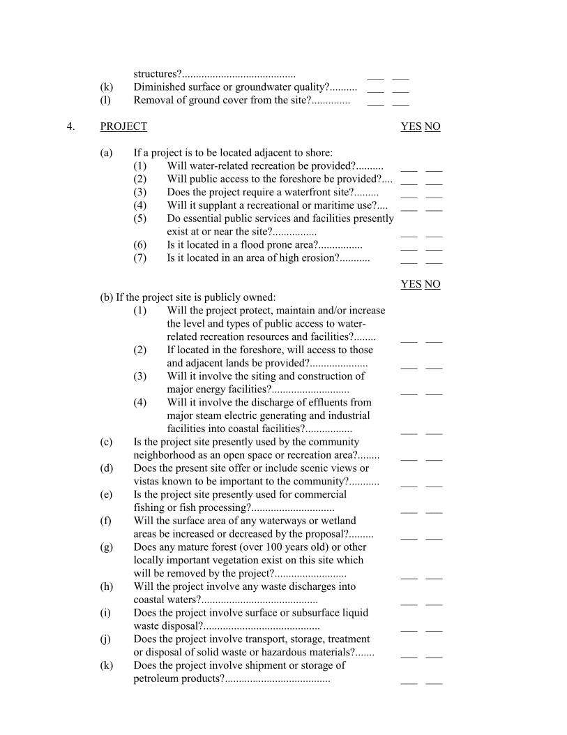
structures?......................................... ___ ___(k) Diminished surface or groundwater quality?.......... ___ ___(l) Removal of ground cover from the site?.............. ___ ___4. PROJECT YES NO(a) If a project is to be located adjacent to shore:(1) Will water-related recreation be provided?.......... ___ ___(2) Will public access to the foreshore be provided?.... ___ ___(3) Does the project require a waterfront site?......... ___ ___(4) Will it supplant a recreational or maritime use?.... ___ ___(5) Do essential public services and facilities presently exist at or near the site?................ ___ ___(6) Is it located in a flood prone area?................ ___ ___(7) Is it located in an area of high erosion?........... ___ ___YES NO(b) If the project site is publicly owned:(1) Will the project protect, maintain and/or increasethe level and types of public access to water-related recreation resources and facilities?........ ___ ___(2) If located in the foreshore, will access to those and adjacent lands be provided?..................... ___ ___(3) Will it involve the siting and construction of major energy facilities?............................ ___ ___(4) Will it involve the discharge of effluents frommajor steam electric generating and industrialfacilities into coastal facilities?................. ___ ___(c) Is the project site presently used by the communityneighborhood as an open space or recreation area?........ ___ ___(d) Does the present site offer or include scenic views or vistas known to be important to the community?........... ___ ___(e) Is the project site presently used for commercial fishing or fish processing?.............................. ___ ___(f) Will the surface area of any waterways or wetland areas be increased or decreased by the proposal?......... ___ ___(g) Does any mature forest (over 100 years old) or other locally important vegetation exist on this site whichwill be removed by the project?.......................... ___ ___(h) Will the project involve any waste discharges intocoastal waters?.......................................... ___ ___(i) Does the project involve surface or subsurface liquidwaste disposal?.......................................... ___ ___(j) Does the project involve transport, storage, treatmentor disposal of solid waste or hazardous materials?....... ___ ___(k) Does the project involve shipment or storage ofpetroleum products?...................................... ___ ___

(l) Does the project involve discharge of toxics, hazardoussubstances or other pollutants into coastal waters?...... ___ ___(m) Does the project involve or change existing icemanagement practices?.................................... ___ ___(n) Will the project affect any area designated as a tidal or freshwater wetland?................................... ___ ___(o) Will the project alter drainage flow, patterns or surface water runoff on or from the site?................ ___ ___(p) Will best management practices be utilized to controlstorm water runoff into coastal waters?.................. ___ ___(q) Will the project utilize or affect the quality or quantityof sole source or surface water supplies?................ ___ ___(r) Will the project cause emissions which exceed federal orstate air quality standards or generate significantamounts of nitrates or sulfates?......................... ___ ___
D. REMARKS OR ADDITIONAL INFORMATION: (Add any additional sheets tocomplete this form.)
If assistance or further information is needed to complete this form, please contact Townof Rhinebeck Clerk at ____________________________.Preparer's Name:_______________________Telephone Number:________________________Title:_____________________Agency:__________________________Date:______________

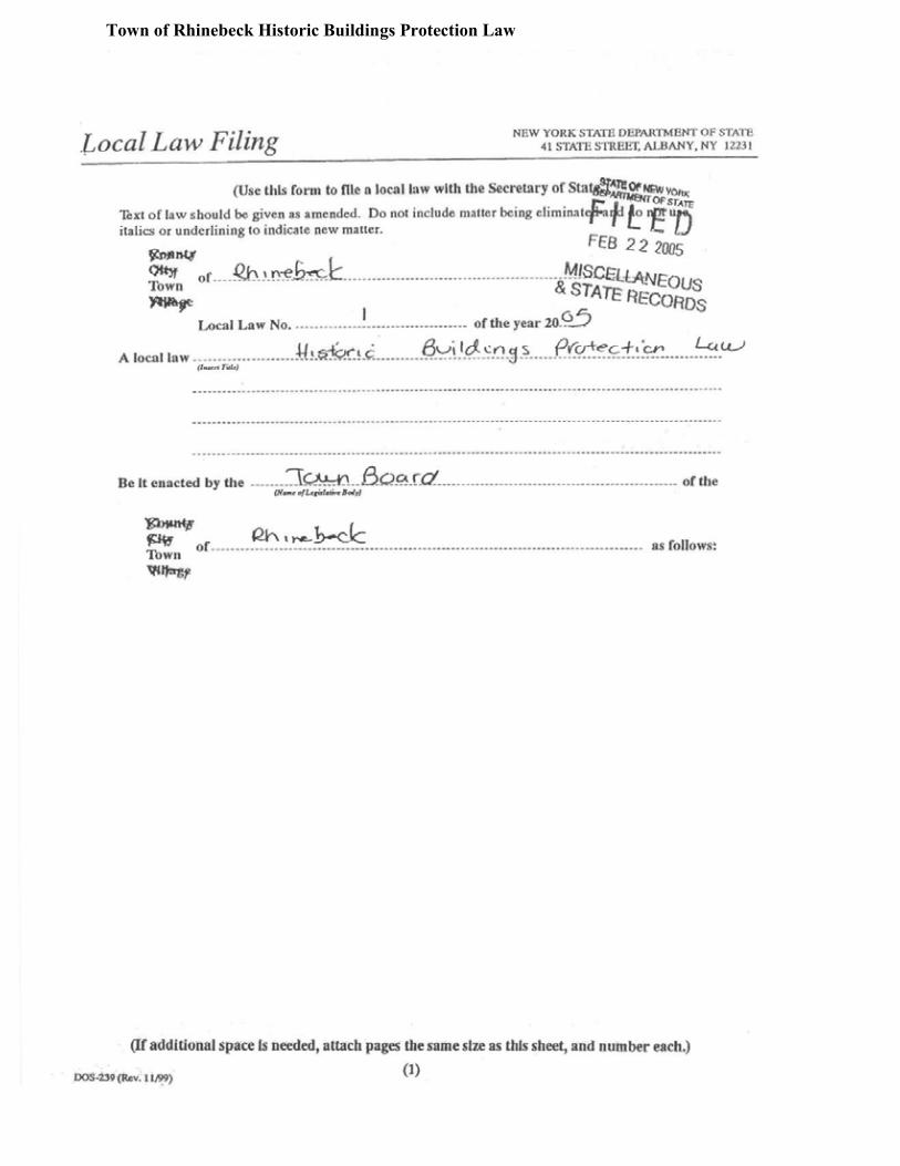
Town of Rhinebeck Historic Buildings Protection Law
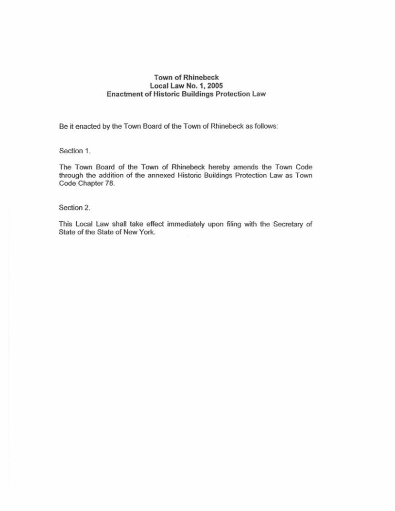


NEW YORK STATE DEPARTMENT OF STATECOASTAL MANAGEMENT PROGRAMGuidelines for Notification and Review of State Agency ActionsWhere Local Waterfront Revitalization Programs are in EffectI. PURPOSES OF GUIDELINESA. The Waterfront Revitalization of Coastal Areas and Inland Waterways Act(Article 42 of the Executive Law) and the Department of State's regulations (19NYCRR Part 600) require certain state agency actions identified by the Secretaryof State to be consistent to the maximum extent practicable with the policies andpurposes of approved Local Waterfront Revitaliza-tion Programs (LWRPs).These guidelines are intended to assist state agencies in meeting that statutoryconsistency obligation.B. The Act also requires that state agencies provide timely notice to the situs localgovernment whenever an identified action will occur within an area covered byan approved LWRP. These guidelines describe a process for complying with thisnotification requirement. They also provide procedures to assist localgovernments in carrying out their review responsibilities in a timely manner.C. The Secretary of State is required by the Act to confer with state agencies andlocal governments when notified by a local government that a proposed stateagency action may conflict with the policies and purposes of its approved LWRP.These guidelines establish a procedure for resolving such conflicts.II. DEFINITIONSA. Action means:1. A "Type 1" or "Unlisted" action as defined by the State EnvironmentalQuality Review Act (SEQRA);2. Occurring within the boundaries of an approved LWRP; and3. Being taken pursuant to a state agency program or activity which hasbeen identified by the Secretary of State as likely to affect the policies andpurposes of the LWRP.B. Consistent to the maximum extent practicable means that an action will notsubstantially hinder the achievement of any of the policies and purposes of anapproved LWRP and, whenever practicable, will advance one or more of suchpolicies. If an action will substantially hinder any of the policies or purposes of

an approved LWRP, then the action must be one:1. For which no reasonable alternatives exist that would avoid or overcomeany substantial hindrance;2. That will minimize all adverse effects on the policies or purposes of theLWRP to the maximum extent practicable; and3. That will result in an overriding regional or statewide public benefit.C. Local Waterfront Revitalization Program or LWRP means a program preparedand adopted by a local government and approved by the Secretary of Statepursuant to Executive Law, Article 42; which program contains policies on themanagement of land, water and man-made resources, proposed land uses andspecific projects that are essential to program implementation.III. NOTIFICATION PROCEDUREA. When a state agency is considering an action as described in II above, the stateagency shall notify the affected local government.B. Notification of a proposed action by a state agency:1. Shall fully describe the nature and location of the action;2. Shall be accomplished by use of either the State Clearinghouse, otherexisting state agency notification procedures, or through an alternativeprocedure agreed upon by the state agency and local government;3. Should be provided to the local official identified in the LWRP of thesitus local government as early in the planning stages of the action aspossible, but in any event at least 30 days prior to the agency's decisionon the action. (The timely filing of a copy of a completed CoastalAssessment Form with the local LWRP official should be consideredadequate notification of a proposed action.)C. If the proposed action will require the preparation of a draft environ-mentalimpact statement, the filing of this draft document with the chief executiveofficer can serve as the state agency's notification to the situs local government.IV. LOCAL GOVERNMENT REVIEW PROCEDUREA. Upon receipt of notification from a state agency, the situs local government willbe responsible for evaluating a proposed action against the policies and purposes
of its approved LWRP. Upon request of the local official identified in theLWRP, the state agency should promptly provide the situs local government withwhatever additional information is available which will assist the situs localgovernment to evaluate the proposed action.B. If the situs local government cannot identify any conflicts between the proposedaction and the applicable policies and purposes of its approved LWRP, it shouldinform the state agency in writing of its finding. Upon receipt of the localgovernment's finding, the state agency may proceed with its consideration of theproposed action in accordance with 19 NYCRR Part 600.C. If the situs local government does not notify the state agency in writing of itsfinding within the established review period, the state agency may then presumethat the proposed action does not conflict with the policies and purposes of themunicipality's approved LWRP.D. If the situs local government notifies the state agency in writing that the proposedaction does conflict with the policies and/or purposes of its approved LWRP, thestate agency shall not proceed with its consideration of, or decision on, theproposed action as long as the Resolution of Conflicts procedure established inV below shall apply. The local government shall forward a copy of the identifiedconflicts to the Secretary of State at the time when the state agency is notified.In notifying the state agency, the local government shall identify the specificpolicies and purposes of the LWRP with which the proposed action conflicts.V. RESOLUTION OF CONFLICTSA. The following procedure applies whenever a local government has notified theSecretary of State and state agency that a proposed action conflicts with thepolicies and purposes of its approved LWRP:1. Upon receipt of notification from a local government that a proposedaction conflicts with its approved LWRP, the state agency should contactthe local LWRP official to discuss the content of the identified conflictsand the means for resolving them. A meeting of state agency and localgovernment representatives may be necessary to discuss and resolve theidentified conflicts. This discussion should take place within 30 days ofthe receipt of a conflict notification from the local government.
2. If the discussion between the situs local government and the state agencyresults in the resolution of the identified conflicts, then, within seven daysof the discussion, the situs local government shall notify the state agencyin writing, with a copy forwarded to the Secretary of State, that all of theidentified conflicts have been resolved. The state agency can then

proceed with its consideration of the proposed action in accordance with19 NYCRR Part 600.3. If the consultation between the situs local government and the stateagency does not lead to the resolution of the identified conflicts, eitherparty may request, in writing, the assistance of the Secretary of State toresolve any or all of the identified conflicts. This request must bereceived by the Secretary within 15 days following the discussionbetween the situs local government and the state agency. The partyrequesting the assistance of the Secretary of State shall forward a copy oftheir request to the other party.4. Within 30 days following the receipt of a request for assistance, theSecretary or a Department of State official or employee designated by theSecretary, will discuss the identified conflicts and circumstancespreventing their resolution with appropriate representatives from the stateagency and situs local government.5. If agreement among all parties cannot be reached during this discussion,the Secretary shall, within 15 days, notify both parties of his/her findingsand recommendations.6. The state agency shall not proceed with its consideration of, or decisionon, the proposed action as long as the foregoing Resolution of Conflictsprocedures shall apply.

PROCEDURAL GUIDELINES FOR COORDINATINGNYS DEPARTMENT OF STATE (DOS) & LWRPCONSISTENCY REVIEW OF FEDERAL AGENCY ACTIONSDIRECT ACTIONS1. After acknowledging the receipt of a consistency determination and supportingdocumentation from a federal agency, DOS will forward copies of the determination andother descriptive information on the proposed direct action to the program coordinator(of an approved LWRP) and other interested parties.2. This notification will indicate the date by which all comments and recommenda-tionsmust be submitted to DOS and will identify the Department's principal reviewer for theproposed action.3. The review period will be about twenty-five (25) days. If comments andrecommendations are not received by the date indicated in the notification, DOS willpresume that the municipality has "no opinion" on the consistency of the proposed directfederal agency action with local coastal policies.4. If DOS does not fully concur with and/or has any questions on the comments andrecommendations submitted by the municipality, DOS will contact the municipality todiscuss any differences of opinion or questions prior to agreeing or disagreeing with thefederal agency's consistency determination on the proposed direct action.5. A copy of DOS' "agreement" or "disagreement" letter to the federal agency will beforwarded to the local program coordinator.PERMIT AND LICENSE ACTIONS1. DOS will acknowledge the receipt of an applicant's consistency certification andapplication materials. At that time, DOS will forward a copy of the submitteddocumentation to the program coordinator an will identify the Department's principalreviewer for the proposed action.2. Within thirty (30) days of receiving such information, the program coordinator willcontact the principal reviewer for DOS to discuss: (a) the need to request additionalinformation for review purposes; and (b) any possible problems pertaining to theconsistency of a proposed action with local coastal policies.3. When DOS and the program coordinator agree that additional information is necessary,DOS will request the applicant to provide the information. A copy of this informationwill be provided to the program coordinator upon receipt.4. Within thirty (30) days of receiving the requested additional information or discussing
possible problems of a proposed action with the principal reviewer for DOS, whicheveris later, the program coordinator will notify DOS of the reasons why a proposed actionmay be inconsistent or consistent with local coastal policies.5. After the notification, the program coordinator will submit the municipality's writtencomments and recommendations on a proposed permit action to DOS before or at theconclusion of the official public comment period. If such comments andrecommendations are not forwarded to DOS by the end of the public comment period,DOS will presume that the municipality has "no opinion" on the consistency of theproposed action with local coastal policies.6. If DOS does not fully concur with and/or has any questions on the comments andrecommendations submitted by the municipality on a proposed permit action, DOS willcontact the program coordinator to discuss any differences of opinion prior to issuinga letter of "concurrence" or "objection" letter to the applicant.7. A copy of DOS' "concurrence" or "objective" letter to the applicant will be forwardedto the program coordinator.FINANCIAL ASSISTANCE ACTIONS1. Upon receiving notification of a proposed federal financial assistance action, DOS willrequest information on the action from the applicant for consistency review purposes.As appropriate, DOS will also request the applicant to provide a copy of the applicationdocumentation to the program coordinator. A copy of this letter will be forwarded to thecoordinator and will serve as notification that the proposed action may be subject toreview.2. DOS will acknowledge the receipt of the requested information and provide a copy ofthis acknowledgement to the program coordinator. DOS may, at this time, request theapplicant to submit additional information for review purposes.3. The review period will conclude thirty (30) days after the date on DOS' letter ofacknowledgement or the receipt of requested additional information, whichever is later.The review period may be extended for major financial assistance actions.4. The program coordinator must submit the municipality's comments and recom-mendations on the proposed action to DOS within twenty days (or other time agreed toby DOS and the program coordinator) from the start of the review period. If commentsand recommendations are not received within this period, DOS will presume that themunicipality has "no opinion" on the consistency of the proposed financial assistanceaction with local coastal policies.5. If DOS does not fully concur with and/or has any questions on the comments andrecommendations submitted by the municipality, DOS will contact the programcoordinator to discuss any differences of opinion or questions prior to notifying theapplicant of DOS' consistency decision.6. A copy of DOS' consistency decision letter to the applicant will be forwarded to theprogram coordinator.


![UHDOL]DFH 0$ Y /LWRP LFtFK - dataplan.info · 6sroxsuifh v ppgll =dkudqlþqt vsroxsuifh ±3urmhnw Ä.dudydqd (yurs\³ Ä](https://img.pdfslide.us/doc/110x75/5c00b0ea09d3f2fa038b8be3/uhdoldfh-0-y-lwrp-lftfk-6sroxsuifh-v-ppgll-dkudqlbqt-vsroxsuifh-3urmhnw.jpg)