Embed Size (px)
Citation preview

BIOLOGICAL RESOURCES DRAFT EXISTING CONDITIONS REPORT
FOR THE GREATER TEHACHAPI AREA SPECIFIC PLAN
KERN COUNTY, CALIFORNIA
Prepared for:
RGP Planning and Development Services 8921 Research Drive
Irvine, California 92618 Contact: Sue Lamoureux
Prepared by:
Taya K. Cummins and Michael W. Tuma
SWCA Environmental Consultants 625 Fair Oaks Avenue, Suite 190
South Pasadena, CA 91030 Contact: Judy McKeehan
July 2008
SWCA Project Number: 13621

GREATER TEHACHAPI AREA SPECIF IC PLAN B IOLOGICAL RESOURCES
TABLE OF CONTENTS
1. Introduction/Summary ........................................................................................................................ 11.1 Purpose of Report...................................................................................................................... 11.2 Project Background ................................................................................................................... 1
1.2.1 Plan Area Location....................................................................................................... 11.2.2 Plan Area Description .................................................................................................. 1
1.3 Summary of Existing Conditions .............................................................................................. 22. Kern County General Plan.................................................................................................................. 2
2.1 Threatened and Endangered Species ......................................................................................... 22.2 Kern County Oak Tree Conservation Ordinance ...................................................................... 3
3. Other Regulatory Standards ............................................................................................................... 43.1 Federal Regulations................................................................................................................... 43.2 State Regulations....................................................................................................................... 5
4. Thresholds of Significance ................................................................................................................... 64.1 Kern County CEQA Thresholds................................................................................................ 6
5. Existing Conditions .............................................................................................................................. 65.1 Methods..................................................................................................................................... 7
5.1.1 Literature and Database Review................................................................................... 75.1.2 Geographic Information System (GIS) Analysis ......................................................... 9
5.2 Results ..................................................................................................................................... 105.2.1 Climate, Topography, and Hydrology........................................................................ 105.2.2 Soils............................................................................................................................ 105.2.3 Biogeography ............................................................................................................. 105.2.4 Vegetation Communities............................................................................................ 105.2.5 Sensitive Biological Resources .................................................................................. 275.2.6 Wildlife Corridors ...................................................................................................... 46
6. Significance Status of Existing Conditions....................................................................................... 476.1 Sensitive Habitats .................................................................................................................... 476.2 Wetlands and Other Waters..................................................................................................... 486.3 Special-status Species.............................................................................................................. 48
6.3.1 Special-status Plants ................................................................................................... 486.3.2 Special-status Wildlife ............................................................................................... 48
6.4 Other Sensitive Biological Resources ..................................................................................... 486.4.1 Nesting Migratory and Native Avian Species ............................................................ 486.4.2 Mapped Critical Habitat ............................................................................................. 496.4.3 Wildlife Corridors ...................................................................................................... 496.4.4 Oak Woodlands and Large Oak Trees........................................................................ 49
6.5 Potential Plan-wide Impacts .................................................................................................... 496.5.1 Invasive Species ......................................................................................................... 496.5.2 Wind Farms ................................................................................................................ 50
7. Environmental Issues/Mitigation Measures for GTASP ................................................................ 507.1 Sensitive Habitats .................................................................................................................... 517.2 Wetlands and Other Waters..................................................................................................... 517.3 Special-status Species.............................................................................................................. 51
7.3.1 Special-status Plants ................................................................................................... 517.3.2 Special-status Wildlife ............................................................................................... 52
7.4 Other Sensitive Biological Resources ..................................................................................... 527.4.1 Nesting Migratory and Native Avian Species ............................................................ 52
SWCA Env i ronmenta l Consu l tan ts ii

GREATER TEHACHAPI AREA SPECIF IC PLAN B IOLOGICAL RESOURCES
7.4.2 California Condor Critical Habitat ............................................................................. 537.4.3 Wildlife Corridors ...................................................................................................... 537.4.4 Oak Woodlands and Large Oak Trees........................................................................ 53
7.5 Mitigation of Plan-wide Impacts ............................................................................................. 537.5.1 Invasive Species ......................................................................................................... 537.5.2 Wind Farms ................................................................................................................ 53
8. References ........................................................................................................................................... 54
LIST OF TABLES Table 1. Terrestrial Habitats in the Project Area......................................................................................... 11Table 2. Aquatic Habitats in the Project Area............................................................................................. 25
LIST OF FIGURES Figure 1. Plan Area Map............................................................................................................................. 58Figure 2. Soils in the Plan Area .................................................................................................................. 59Figure 3. Vegetation Communities/Habitats in the Plan Area .................................................................... 60Figure 4. Wetlands and Other Waters in the Plan Area .............................................................................. 61Figure 5. CNDDB Special-status Species Occurrences.............................................................................. 62 Figure 6. Critical Habitat for California Condor Within the Plan Area...................................................... 63
LIST OF APPENDICES APPENDIX A: Special-status Plants and Wildlife Within the Plan Area
SWCA Env i ronmenta l Consu l tan ts iii

GREATER TEHACHAPI AREA SPECIF IC PLAN B IOLOGICAL RESOURCES
1. INTRODUCTION/SUMMARY
1.1 PURPOSE OF REPORT
SWCA Environmental Consultants (SWCA) was retained by RGP Planning and Development Services (RGP) to conduct a biological resources assessment in support of preparation of the Greater Tehachapi Area Specific Plan (GTASP) and the Program-Level Environmental Impact Report (Program EIR), which is required by the California Environmental Quality Act (CEQA). The plan area is located within the greater Tehachapi area, Kern County (County), California.
1.2 PROJECT BACKGROUND
1.2.1 Plan Area Location The Greater Tehachapi Area (GTA) is located in eastern Kern County along California Highway 58 between the San Joaquin Valley and the Mojave Desert. The GTA is known for its four seasons, rural communities, Tehachapi Loop, electricity generating wind turbines, proximity to Edwards Air Force Base, and gliding. The GTA generally refers to the City of Tehachapi and the surrounding rural communities of Alpine Forest, Golden Hills, Stallion Springs, Bear Valley, Cummings Valley, and Brite Valley.
For purposes of the GTASP, the boundary encompasses approximately 275 square miles, as shown in Figure 1. The eastern boundary of the Specific Plan area is predominantly west of Tehachapi Willow Springs Road and Oak Creek Pass. The western boundary is near Hart Flat Road just east of Highway 223. The northern boundary of the Specific Plan area is Orejano Ridge on the west to just south of Stevenson Peak on the east. The southern boundary is generally defined by Cummings Mountain, Double Mountain and Tehachapi Mountain, each of which has peaks at elevations above 7,700 feet in the Tehachapi Mountain range. The center of the plan area is located at an approximate latitude/longitude of 35°07’58” North, 118°26’53” West within the following U.S. Geologic Survey (USGS) 7.5-minute series quadrangle maps (quads): Oiler Peak , Tejon Hills, Loraine, Tejon Ranch, Arvin, Cummings Mountain, Bear Mountain , Tehachapi South, Keene, Monolith, Tehachapi North, and Tehachapi NE.
1.2.2 Plan Area Description Since 2000, the area’s population has grown from approximately 28,400 to approximately 35,000, an increase of about 23 percent. In response to this growth, the County of Kern is updating planning and environmental information in this unincorporated Greater Tehachapi Area and will prepare a new program-level GTASP that will rescind and consolidate the existing specific and other community plans in the area. This new Specific Plan will allow the County to identify and coordinate implementation strategies and policies for future land uses by balancing the competing social, economic, resource and environmental factors for future growth in the Greater Tehachapi area.
The County’s 2004 General Plan outlines the growth opportunities and challenges facing all of Kern County. These opportunities and challenges that are particularly relevant to the GTASP area include but are not limited to:
� Promoting managed economic growth � Providing for continued agricultural use and resource conservation
SWCA Env i ronmenta l Consu l tan ts 1

GREATER TEHACHAPI AREA SPECIF IC PLAN BIOLOGICAL RESOURCES
� Promoting smart growth concepts to effectively manage the County’s future development � Enhancing the linkage between land use and water supply planning � Air quality’s role in land use planning � Kern County’s importance in energy development
The GTASP will become the future development guidance for this 275-square mile GTA working in tandem with the County’s 2004 General Plan and Kern County Zoning Ordinance. Consistent with State and County requirements, the Specific Plan will set forth a definitive land use development plan, development regulations, and implementation plans and programs designed to ensure a successful future development consistent with the goals and policies of the County’s 2004 General Plan.
The purposes of the proposed GTASP are to more specifically identify and build upon these growth opportunities and challenges for the Greater Tehachapi Area. This planning process is three-fold:
� Identify existing conditions in the Specific Plan area � Establish a uniform set of planning assumptions (land use constraints and opportunities) � Implement 2004 General Plan goals and/or policies by coordinating and identifying
implementation strategies and policies for future land use in the Greater Tehachapi Area.
The GTASP planning effort will include three basic tasks: 1) the accumulation and consolidation of known information on existing conditions, particularly water availability; 2) the preparation of the Specific Plan document, and; 3) preparation of a Program EIR. The GTASP process is expected to take about two years with completion in late 2009. The public and public agencies will be included in this planning process at all stages of the planning effort.
1.3 SUMMARY OF EXISTING CONDITIONS
SWCA has identified several sensitive biological resources within the GTASP area including; five special-status habitats, twenty-four special-status plant species, six special-status invertebrate species, five special-status amphibian species, four special-status reptile species, twenty-seven special-status avian species, and six special-status mammal species. Six types of wetland habitats that may be considered jurisdictional by CDFG and/or USACE were identified including freshwater emergent wetlands, freshwater forested/shrub wetlands, freshwater ponds, lakes, riverine systems, and other wetland or mesic habitats. The southwesternmost portion of the plan area lies within critical habitat for the California condor. Other biological resource issues that are of potential biological concern within the plan area include the preservation of wildlife corridors, the protection of oak woodlands and mature oak trees per the County’s oak ordinance, the prevention of the spread and/or introduction of invasive species, and guidance for appropriate windfarm development to minimize impacts to wildlife.
2. KERN COUNTY GENERAL PLAN The following codes of the Kern County General Plan pertain to biological resources within the GTASP.
2.1 THREATENED AND ENDANGERED SPECIES
General Plan Map Code 1.10.5 of the Kern County General Plan protects and minimizes impacts to special status-species through the following measures:
SWCA Env i ronmenta l Consu l tan ts 2

GREATER TEHACHAPI AREA SPECIF IC PLAN BIOLOGICAL RESOURCES
� Threatened or endangered plant and wildlife species should be protected in accordance with State and federal laws.
� The County should work closely with State and federal agencies to assure that discretionary projects avoid or minimize impacts to fish, wildlife, and botanical resources.
� The County will seek cooperative efforts with local, State, and federal agencies to protect listed threatened and endangered plant and wildlife species through the use of conservation plans and other methods promoting management and conservation of habitat lands.
� The County will promote public awareness of endangered species laws to help educate property owners and the development community of local, State, and federal programs concerning endangered species conservation issues.
� Under the provisions of CEQA, the County, as lead agency, will solicit comments from the California Department of Fish and Game (CDFG) and the U. S. Fish and Wildlife Service (USFWS) when an environmental document (Negative Declaration, Mitigated Negative Declaration, or EIR) is prepared.
� Riparian areas will be managed in accordance with United States Army Corps of Engineers (USACE), and the CDFG rules and regulations to enhance the drainage, flood control, biological, recreational, and other beneficial uses while acknowledging existing land use patterns.
Under this Code, discretionary projects must implement the following measures:
� Consider effects to biological resources as required by CEQA.
� Consult and consider the comments from responsible and trustee wildlife agencies when reviewing a discretionary project subject to the California Environmental Quality Act.
� Pursue the development and implementation of conservation programs with State and federal wildlife agencies for property owners desiring streamlined endangered species mitigation programs.
2.2 KERN COUNTY OAK TREE CONSERVATION ORDINANCE
General Plan Map Code 1.10.10 of the Kern County General Plan protects oak woodlands and large individual oaks. Oak woodlands are defined as development parcels characterized by canopy cover by oak trees of at least ten percent (10%), as determined from base line aerial photography, or by site survey performed by a licensed or certified arborist or botanist. If an oak tree study is used in an EIR, then a Registered Professional Forester (RPF) shall perform the necessary analysis. The Oak Tree Conservation Ordinance affords the following measures to protect and conserve oak woodlands and/or large oak trees:
� Oak woodlands and large oak trees shall be protected where possible and incorporated into project developments.
� Promote the conservation of oak tree woodlands for their environmental value and scenic beauty.
The following implementation measures apply to discretionary development projects (General Plan Amendment, zone change, conditional use permit, tract maps, parcel maps, precise development plan) containing oak woodlands:
� Development parcels containing oak woodlands are subject to a minimum canopy coverage retention standard of thirty percent (30%). The consultant shall include recommendations regarding thinning and diseased tree removal in conjunction with the discretionary project.
SWCA Env i ronmenta l Consu l tan ts 3

GREATER TEHACHAPI AREA SPECIF IC PLAN BIOLOGICAL RESOURCES
� Use of aerial photography and a dot grid system shall be considered adequate in determining the required canopy coverage standard.
� Adjustments below thirty percent (30%) minimum canopy standard may be made based on a report to assess the management of oak woodlands.
� Discretionary development, within areas designated as meeting the minimum canopy standard, shall avoid the area beneath and within the trees unaltered drip line unless approved by a licensed or certified arborist or botanist.
The following implementation measures apply to development of parcels characterized by an oak tree canopy cover of less than ten percent (10%), but containing individual oak trees equal to or greater than a 12-inch diameter trunk at 4.5 feet breast height:
� Such trees shall be identified on plot plans.
� Discretionary development shall avoid the area beneath and within the trees unaltered drip line unless approved by a licensed or certified arborist or botanist.
� Specified tree removal related to the discretionary action may be granted by the decision making body upon showing that a hardship exists based on substantial evidence in the record.
3. OTHER REGULATORY STANDARDS
3.1 FEDERAL REGULATIONS
Federal Endangered Species Act (FESA; 16 USC 153 et seq.)
Applicants for projects that could result in adverse impacts to any federally listed species are required to mitigate potential impacts in consultation with the USFWS. Adverse impacts, defined as “take,” are prohibited except under authorization through Section 7 or Section 10 consultation, and Incidental Take Authorization. During consultations, determinations are made regarding the proposed project and its potential to jeopardize the continued existence of federally listed species, and reasonable and prudent mitigation measures required to avoid such ‘jeopardy.’ Mitigation is required for adverse impacts to any listed species or candidate species proposed for listing. Take, under Federal definition, currently includes actions that could result in “significant habitat modification or degradation” (50 CFR Section 17.3).
Candidate species are not protected under FESA. However, the USFWS advises project applicants that candidate species could be elevated to listed status at any time, and should receive special consideration.
Migratory Bird Treaty Act (MBTA 16 USC 703 to 711)
The MBTA prevents the take of all migratory birds, including their nests and eggs.
Bald and Golden Eagle Protection Act (16 USC 668)
This Act specifically protects bald and golden eagles from being killed or their eggs taken.
SWCA Env i ronmenta l Consu l tan ts 4

GREATER TEHACHAPI AREA SPECIF IC PLAN B IOLOGICAL RESOURCES
3.2 STATE REGULATIONS
California Environmental Quality Act (CEQA)
CEQA requires that a project’s effects on environmental resources must be analyzed and assessed using criteria determined by the lead agency. CEQA defines a rare species in a broader sense than the definitions of threatened, endangered, or Species of Concern (CSC). Under this definition, the lead agency can request additional consideration of species and habitats not otherwise protected.
California Endangered Species Act (CESA; Fish and Game Code Section 2050 et seq.)
Species listed under the CESA cannot be taken or harmed, except under specific permit. As currently stated in CESA, “take” means to hunt, pursue, catch, capture, or kill or to attempt to do so.
Fish and Game Code Sections 3511, 4700, 5050, and 5515
These CDFG Sections provide a provision for the protection of bird, mammal, reptile, amphibian, and fish species that are “fully protected.” Fully protected animals may not be harmed, taken, or possessed.
Fish and Game Code Section 3503
This Section states that it is unlawful to take, possess, or needlessly destroy the nest or eggs of any bird, except as otherwise provided by this Code or any regulation made pursuant thereto.
Fish and Game Code Section 3503.5
This Section provides protection for all birds-of-prey, including their eggs and nests.
Fish and Game Code Section 3513
This Section makes it unlawful to take or possess any migratory non-game bird as designated in the MBTA.
Fish and Game Code Sections 1900 et seq., or Native Plant Protection Act
This Section lists threatened, endangered, and rare plants so designated by the CDFG Commission.
Title 14, California Code of Regulations, Sections 670.2 and 670.5
These Sections list animals designated as threatened or endangered in California. In addition, the CDFG designates species that are considered declining at a rate that could result in their being listed, or that historically occurred in low numbers and known threats to their persistence currently exist, as California Species of Special Concern. California Species of Special Concern do not have special legal status, but are used by the CDFG as a management tool when considering the future use of any land parcel.
California Fish and Game Code (Sections 1601 through 1607)
SWCA Env i ronmenta l Consu l tan ts 5

GREATER TEHACHAPI AREA SPECIF IC PLAN BIOLOGICAL RESOURCES
These Sections prohibit alteration of any lake or streambed, including intermittent and seasonal channels and many artificial channels, without execution of a Streambed Alteration Agreement through the CDFG. This applies to any channel modifications that would be required to meet drainage, transportation, or flood control objectives of the project.
4. THRESHOLDS OF SIGNIFICANCE
4.1 KERN COUNTY CEQA THRESHOLDS
In support of the environmental analyses required for CEQA compliance, SWCA assessed potential impacts to biological resources, including special status species and sensitive habitats, within the project area that are likely to occur within the GTASP as a result of future development. The analysis included identification of potentially significant impacts based on the County Environmental Checklist Form which serves as the County’s CEQA thresholds. To reduce or avoid potentially significant impacts, SWCA also identified mitigation measures, which are presented in the final section of this report. Thresholds identified in the County’s General Plan used in analyzing these impacts include:
� Would the project have a substantial adverse effect, either directly or through habitat modifications, on any species identified as a candidate, sensitive, or special-status species in local or regional plans, policies, or regulations, or by the CDFG or USFWS?
� Would the project have a substantial adverse effect on any riparian habitat or other sensitive natural community identified in local or regional plans, policies, or regulations, or by the CDFG or USFWS?
� Would the project have a substantial adverse effect on federally protected wetlands as defined by Section 404 of the Clean Water Act (including, but not limited to, marsh, vernal pool, coastal, etc.) through direct removal, filling, hydrological interruption, or other means?
� Would the project interfere substantially with the movement of any native resident or migratory fish or wildlife species or with established native resident or migratory wildlife corridors, or impede the use of native wildlife nursery sites?
� Would the project conflict with any local policies or ordinances protecting biological resources, such as a tree preservation policy or ordinance?
� Would the project conflict with the provisions of an adopted Habitat Conservation Plan, Natural Community Conservation Plan, or other approved local, regional, or state habitat conservation plan?
5. EXISTING CONDITIONS No field surveys were conducted in association with this report. Instead, SWCA accessed available databases and other sources of biological resource information pertaining to the GTA plan area and the vicinity to identify and describe known biological resources within the plan area. Methods and results of this investigation are discussed in detail below.
SWCA Env i ronmenta l Consu l tan ts 6
GREATER TEHACHAPI AREA SPECIF IC PLAN B IOLOGICAL RESOURCES
5.1 METHODS
5.1.1 Literature and Database Review
Review of Existing General Plans and other Literature
SWCA reviewed existing general plans and other literature within and adjacent to the plan area. During this review, SWCA identified biological resource issues associated with the GTASP and incorporated their findings into the assessment process.
The following specific plan documents for areas within the GTASP area were reviewed.
Accepted County Plan Areas within the GTASP Area (General Plan Map Code 4.1):
� Bear Valley Springs - 26,000 acres/adopted 12/26/73 � Golden Hills – 5,846 acres/adopted 12/15/86 � Keene Rural Community (Rural Community Plan) – 667 acres/adopted 1/7/85 � Mendiburu Springs – 975 acres/adopted 11/12/84 � Monolith – 263 acres/adopted 11/14/83 � North Cummings Valley – 3,226 acres/adopted 4/24/73 � Old Towne – 982 acres/adopted 6/20/83 � Stallion Springs Phase II/Horsethief Flat – 10,429 acres/adopted 10/29/84 � Stallion Springs Tract 4286 – 90 acres/adopted 7/2/73 � Tamaron – 166 acres/adopted 11/25/91
Specific Plan Required Areas (General Plan Map Code 4.3):
� Alpine Forest – 2,100 acres/1,688 DU � Cummings Peak – 50 acres/10 DU � Cummings Ranch – 2,560 acres/128 DU � MacKenzie – 88 acres/19 DU � Stallion Springs Phase III – 6,021 acres/317 DU
The following general plan documents for areas adjacent to the GTASP area were reviewed.
Accepted County Plan Areas within the GTASP Area (General Plan Map Code 4.1):
� Cameron Canyon – 4,455 acres/6/19/86 � Keene Ranch – 12.52- acres/adopted 7/15/91 � Sand Canyon – 282,80 acres/adopted 11/22/76
Specific Plan Required Areas (General Plan Map Code 4.3):
� Comanche – 580 acres/272 DU
SWCA Env i ronmenta l Consu l tan ts 7

GREATER TEHACHAPI AREA SPECIF IC PLAN BIOLOGICAL RESOURCES
Additionally, SWCA conducted a literature search of peer reviewed literature, local species lists, and technical biological resource documents to further identify sensitive biological resources known to occur within the GTA and the vicinity. Findings were synthesized within the text and incorporated into the special-status species table.
Special-status Species and Sensitive Habitats Database Review
SWCA biologists reviewed existing sources of information regarding the occurrence of special-status species and sensitive habitats to compile a list of all sensitive biological resources with the potential to occur within the GTASP area. Special-status species are plants and animals are those in one or more of the following categories:
� Species listed or proposed for listing as threatened or endangered under FESA (50 CFR 17.12 [listed plants], 50 CFR 17.11 [listed animals], and various notices in the Federal Register [FR] [proposed species]).
� Species that are candidates for possible future listing as threatened or endangered under FESA (67 FR 40657).
� Species listed or proposed for listing by the State of California as threatened or endangered under CESA (14 California Code of Regulations 670.5).
� Species that meet the definitions of rare or endangered under CEQA (State CEQA Guidelines Section 15380).
� Plants listed as rare under the California Native Plant Protection Act (California Fish and Game Code Section 1900 et seq.).
� Plants considered by the CNPS to be “rare, threatened, or endangered in California” (Lists 1B and 2 in CNPS 2001).
� Plants listed by CNPS as plants about which more information is needed to determine their status and plants of limited distribution (Lists 3 and 4 in CNPS 2001), which may be included as special status species on the basis of local significance or recent biological information.
� Animal species of special concern as listed by CDFG (2006).
� Animals fully protected in California (California Fish and Game Code Sections 3511 [birds], 4700 [mammals], 5050 [amphibians and reptiles], and 5515 [fish]).
In addition, sensitive habitats are those habitats in one or more of the following categories:
� Habitats considered by CDFG as rare and worthy of special consideration and listing as high priority for inventory by the CNDDB due to highly limited distribution, regardless of presence or absence of rare, threatened, or endangered status species (CDFG 2003).
� Waters and wetland habitats considered jurisdictional by USACE and CDFG.
� Habitat designated as ‘Critical Habitat’ for any species listed under the FESA (16 USC 153 et seq.).
The following database sources of information were consulted in order to identify special-status species and habitats that may occur within the GTASP area:
SWCA Env i ronmenta l Consu l tan ts 8

GREATER TEHACHAPI AREA SPECIF IC PLAN BIOLOGICAL RESOURCES
� The CNDDB (2008) for the Oiler Peak , Cummings, Tejon Hills, Loraine, Tejon Ranch, ArvinMountain, Bear Mountain, Tehachapi South, Keene, Monolith, Tehachapi North, and Tehachapi NE USGS Quads.
� CNPS (2008) online Inventory of Rare and Endangered Plants of California for the Oiler Peak , Tejon Hills, Loraine, Tejon Ranch, Arvin , Cummings Mountain, Bear Mountain, Tehachapi South, Keene, Monolith, Tehachapi North, and Tehachapi NE USGS Quads.
� Sacramento USFWS Office Official Online Species List: accessed at http://www.fws.gov/sacramento/es/spp_list.htm on January 18, 2008 (USFWSa).
� Other resources including other consulting documents, regional species lists, and peer reviewed literature (including but not limited to: White et al. 2003, Tehachapi Mountains Birding Club (TMBS) 2007, etc.)
Special-status species included in the table were those that were either recorded within the plan area or are likely to occur there. Other species identified in the background search that are not likely to occur within the plan area were excluded from the analysis.
5.1.2 Geographic Information System (GIS) Analysis Because of the large scale of the plan area, SWCA analyzed existing Geographical Information Systems (GIS) databases to identify sensitive biological resources and to analyze the spatial occurrence of biological constraints. The following GIS databases, accessed between January 15th and February 15th, 2008, used for this analysis include:
� Aerial photographs (http://new.casil.ucdavis.edu/casil/remote_sensing/naip_2005/) � USGS Topographical Maps (http://archive.casil.ucdavis.edu/casil/maps/drg/) � CDFG special-status species and sensitive habitat occurrence location data
(http://www.dfg.ca.gov/biogeodata/) � USGS National Biological Information Infrastructure Gap Analysis Data (USGS
GAP)(http://gapanalysis.nbii.gov/portal/server.pt?open=512&objID=202&PageID=222&cached= true&mode=2&userID=2)
� NRCS Web Soil Survey (WSS) (http://www.ncgc.nrcs.usda.gov/products/datasets/ssurgo/) � USFWS Critical habitat portal (USFWSb; http://criticalhabitat.fws.gov/) � National Wetlands Inventory (NWI) (http://www.fws.gov/nwi/)
SWCA accessed these GIS databases and, using ESRI ArcMap Version 9.2 software, created layers that were overlain to assess the following parameters:
� USGS Quads on which special status species and habitats occur � Types of habitats within the plan area � Habitats in which special-status species occur � Location of California Condor Critical habitat within the plan area � Location and acreages of wetlands within the plan area � Soil types and locations within the plan area
SWCA Env i ronmenta l Consu l tan ts 9
GREATER TEHACHAPI AREA SPECIF IC PLAN B IOLOGICAL RESOURCES
5.2 RESULTS
The following discussion details the existing conditions within the plan area, including a summary of the climate, topography, hydrology, soils, and biogeography; the range of terrestrial and wetland habitats and their descriptions; sensitive biological resources that occur within the plan area and their descriptions;
5.2.1 Climate, Topography, and Hydrology The plan area is located in the southern end of the Sierra Nevada Mountains in the Tehachapi Mountains (McNab and Avers 1994). This region is characterized by hot to cold and semi-arid to subhumid climate. The topography of the region is characterized by steep mountains and valleys. Mountain ridges are slightly elongated with many different orientations, generally aligned near east-west. Surface water flows west to the Kern River or east to closed basins in the southern end of the Great Valley or in the Mojave Desert. Streams are typically dry through the summer and there are no natural lakes or ponds in the area. Elevation ranges from about 3500 up to 7981 feet on Double Mountain. The mean annual precipitation ranges from 12 to 30 inches, mostly occurring as snow at higher elevations. Mean annual temperature ranges between 42° to 56° F and the mean freeze-free period ranges from 75 to 175 days.
5.2.2 Soils Soils within the plan area were derived from metamorphic, igneous, and volcanic parent material which occur throughout the plan area, stream deposited sedimentary parent material in the eastern portion, marine sedimentary deposits in the far southwestern corner (Smith 1964), sandstone and shale in the far southwestern corner just north of Comanche Creek (Smith, 1964), coarse alluvial fan deposit northwest of the city of Tehachapi (Dibblee and Louke 1970), and an unbedded, unsorted boulders, cobbles, and pebbles in a weakly consolidated matrix of sand (Dibblee and Warne 1970) along the far southwestern boundary. Soils identified within the plan area are described in detail in the Soil Survey of the Antelope Valley (Woodruff et al. 1970). Figure 2 provides a list of all soil types known to occur within the plan area and an overview of soil localities.
5.2.3 Biogeography The Tehachapi Mountain Range lies in a biogeographically unique position between the Sierra Madre, Castaic, and Sierra Nevada Mountain Ranges. This area forms a linkage from the foothills and grasslands of the San Joaquin Valley to the west, to the high-elevation hardwood and coniferous forests within the Tehachapi Range itself, to the foothill transition into the Mojave Desert along the base of the southern Tehachapi Mountains. This unique setting has allowed for an equally unique suite of habitats as well as a diverse flora and fauna. It also facilitates movement of a variety of species to and from habitats within the Tehachapi Mountains and adjacent mountains and valleys. Habitats within the Tehachapi Mountains are relatively intact, providing a protected and contiguous corridor for successful migrations.
5.2.4 Vegetation Communities
Terrestrial Habitats
Twenty-three natural vegetation communities and two developed lands habitat are represented within the plan area (Table 1; Figure 3). Vegetation communities associated with forested habitats include: Black Oak Forest, Canyon Live Oak Forest, Interior Live Oak Forest, Jeffrey Pine Forest, Jeffrey Pine-Fir Forest, Knobcone Pine Forest, and Westside Ponderosa Pine Forest. Vegetation communities associated
SWCA Env i ronmenta l Consu l tan ts 10

GREATER TEHACHAPI AREA SPECIF IC PLAN B IOLOGICAL RESOURCES
with woodland habitats include: Black Oak Woodland, Blue Oak Woodland, Foothill Pine-Oak Woodland, Mojavean Pinyon and Juniper Woodlands, and Valley Oak Woodland. Vegetation communities associated with chaparral habitats include: Buck Brush Chaparral, Chamise Chaparral, Interior Live Oak Chaparral, Mixed Montane Chaparral, Montane Manzanita Chaparral, Northern Mixed Chaparral, Scrub Oak Chaparral, and Semi-Desert Chaparral. Vegetation communities associated with scrub habitats include Big Sagebrush Scrub. Vegetation communities associated with grassland habitats include Non-native Grassland with patches of Valley Needlegrass Grassland interspersed throughout. In addition to the natural vegetation communities within the plan area, man-made habitats associated with existing development include Agricultural Land and Urban or Built-up Land. Vegetation communities identified within the study area that are considered sensitive by CDFG and worthy of inclusion in the CNDDB due to highly limited distribution, regardless of the presence of special status species, include Jeffrey Pine-Fir Forest, Westside Ponderosa Pine Forest, Valley Oak Woodland, Big Sagebrush Scrub, and Valley Needlegrass Grassland. Terrestrial habitat acreages provided below are based on calculations performed using data provided by GIS databases (USGS GAP 2008).
Table 1. Terrestrial Habitats in the Project Area.
Habitat Type Topo Quads (Acres) Total Acreage Forest
Black Oak Forest Cummings Mountain (1,241.70) Tejon Ranch (16.58)
1,258.28
Canyon Live Oak Forest Bear Mountain (668.99) Cummings Mountain (1,033.26) Keene (8.96) Tehachapi North (2,227.42) Tehachapi South (837.32)
4,775.96
Interior Live Oak Forest Bear Mountain (1,171.40) Tehachapi South (815.49)
1,986.88
Jeffrey Pine Forest Cummings Mountain (495.92) Tehachapi South (980.78)
1,476.70
Jeffrey Pine-Fir Forest* Cummings Mountain (2,451.08) Tehachapi South (2,933.03)
5,384.10
Knobcone Pine Forest Cummings Mountain (2,141.99) 2,141.99
Westside Ponderosa Pine Forest* Bear Mountain (1,783.01) Cummings Mountain (535.92) Keene (267.87) Tehachapi South (471.03)
3,057.83
Woodland
Black Oak Woodland Oiler Peak (702.35) Tehachapi North (1,236.86)
1,939.21
Blue Oak Woodland Cummings Mountain (57.17) Keene (9,655.45) Loraine (4,071.72) Oiler Peak (2,274.84) Tehachapi North (14,372.06) Tejon Ranch (990.10)
31,421.34
SWCA Env i ronmenta l Consu l tan ts 11

GREATER TEHACHAPI AREA SPECIF IC PLAN B IOLOGICAL RESOURCES
Table 1. Terrestrial Habitats in the Project Area.
Habitat Type Topo Quads (Acres) Total Acreage Foothill Pine-Oak Woodland Arvin (302.95)
Bear Mountain (14,632.41) Cummings Mountain (2,127.72) Keene (5,465.70) Oiler Peak (77.17) Tehachapi South (1,388.76) Tejon Ranch (9,451.29)
33,446.01
Mojavean Pinyon and Juniper Woodlands
Loraine (217.04) Tehachapi NE (1,579.77) Tehachapi North (445.47) Tehachapi South (3,576.68)
5,818.97
Valley Oak Woodland* Cummings Mountain (521.86) Keene (847.54) Tehachapi North (169.40) Tehachapi South (486.99)
2,025.79
Chaparral Buck Brush Chaparral Keene (477.56) 477.56 Chamise Chaparral Cummings Mountain (2,624.26)
Tehachapi South (133.79) 2,758.05
Interior Live Oak Chaparral Bear Mountain (1,531.53) Keene (2,349.05) Loraine (1,493.66) Oiler Peak (450.14) Tehachapi North (4,802.12)
10,626.50
Mixed Montane Chaparral Cummings Mountain (1,904.48) Keene (568.03) Tejon Ranch (370.44)
2,842.95
Montane Manzanita Chaparral Oiler Peak (666.07) 666.07 Northern Mixed Chaparral Bear Mountain (613.52)
Cummings Mountain (460.25) Tehachapi South (164.38)
1,238.15
Scrub Oak Chaparral Tehachapi North (1,509.10) Tehachapi South (1,794.56)
3,303.66
Semi-Desert Chaparral Tehachapi North (313.18) 313.18 Scrub Big Sagebrush Scrub* Bear Mountain (1,998.72)
Keene (5,404.96) Tehachapi North (409.15) Tehachapi South (145.31)
7,958.14
Grasslands
SWCA Env i ronmenta l Consu l tan ts 12

GREATER TEHACHAPI AREA SPECIF IC PLAN B IOLOGICAL RESOURCES
Table 1. Terrestrial Habitats in the Project Area.
Habitat Type Topo Quads (Acres) Total Acreage Non-native Grassland Arvin (1,442.57)
Bear Mountain (3,566.42) Cummings Mountain (2,394.20) Keene (3,952.18) Monolith (1,401.75) Tehachapi NE (2,046.38) Tehachapi North (8,603.61) Tehachapi South (2,125.94) Tejon Hills (1,475.79) Tejon Ranch (4,453.52)
31,462.36
Valley Needlegrass Grassland* Interspersed among nonnative grasslands.
No acreage available.
Developed Agricultural Land Bear Mountain (1,227.44)
Cummings Mountain (7,423.15) Keene (2,367.00) Monolith (362.13) Tehachapi North (142.64) Tehachapi South (6,377.92) Tejon Ranch (1397.77)
19,298.06
Urban or Built-up Land Tehachapi North (20.64) Tehachapi South (14.02)
34.66
Approximate Total 175,712.39 * = Sensitive Habitat (CDFG 2003)
Forest
Black Oak Forest Black oak forest (Holland 1986) is a persistent subclimax hardwood forest with poorly developed shrub and herbaceous layers. Stands of trees tend to be even-aged and reflect past disturbances such as fire. This habitat is best developed and most extensive in the southern Cascade and Klamath Mountains and in the northern portions of the Coast Ranges and the Sierra Nevada between elevations of 1,500 and 3,000 feet. Elsewhere in the Sierra Nevada, and in the South Coast and Transverse Ranges, black oak forest is found at elevations as low as 200 feet and as high as 8000 feet. Within the plan area, this habitat type occurs within the Cummings Mountain and Tejon Ranch USGS Quads. This vegetation community occupies approximately 1,258.28 acres within the plan area (USGS GAP 2008). Native species of oaks within this habitat may be protected under the County’s oak tree conservation ordinance if they meet specific size requirements as per the ordinance.
Black oak (Quercus kelloggii) is the dominant species in this community. Other plant species that commonly occur within this habitat include madrone (Arbutus menziesii), incense cedar (Calocedrus decurrens), knobcone pine (Pinus attenuata), Jeffrey pine (Pinus jeffreyi), ponderosa pine (Pinus ponderosa), Douglas fir (Pseudotsuga menziesii), canyon live oak (Quercus chrysolepis), and California bay (Umbellularia californica) (Holland 1986, Sawyer and Keeler-Wolf 1995). Wildlife commonly found within this habitat is highly variable due to its wide geographic range. Mammal species that may occur in this habitat may, include western gray squirrel (Sciurus griseus), California ground squirrel
SWCA Env i ronmenta l Consu l tan ts 13

GREATER TEHACHAPI AREA SPECIF IC PLAN B IOLOGICAL RESOURCES
(Spermophilus beecheyi), dusky-footed woodrat (Neotoma fuscipes), black bear (Ursus americanus), and mule deer (Odocoileus hemionus). Birds that may occur within this habitat include scrub jay (Aphelocoma californica), Steller's jay (Cyanocitta stelleri), acorn woodpecker (Melanerpes formicivorus), and mountain quail (Oreortyx pictus). Amphibians and reptiles that may occur in this habitat include western fence lizard (Sceloporus occidentalis), sagebrush lizard (Sceloporus graciosus), rubber boa (Charina bottae), western rattlesnake (Crotalus viridus), California mountain kingsnake (Lampropeltis zonata), and sharp tailed snake (Contia tenuis) (Mayer and Laudenslayer 1988).
Canyon Live Oak Forest Canyon live oak forest (Holland 1986) has a dense canopy with little understory, Canyon live oak trees grow up to 20 m tall in canyons and on north-facing slopes at lower elevations and, on south-facing slopes at higher elevations, forms low chaparral-like stands less than 10 m tall. Trees often have multiple trunks as a result of crown-sprouting after fires. Canyon live oak forest is found throughout the inner North Coast Ranges from Siskiyou County to Lake County at elevations between 1000 and 4000 feet and throughout the South Coast Ranges from Tehama County to Kern County at elevations between 3000 and 6000 feet. Within the plan area, this habitat type occurs within the Bear Mountain, Cummings Mountain, Keene, Tehachapi North, and Tehachapi South USGS Quads. This vegetation community occupies approximately 4,775.96 acres within the plan area (USGS GAP 2008). In addition, native species of oaks within this habitat may be protected under the County’s oak tree conservation ordinance if they meet specific size requirements as per the ordinance.
Canyon live oak is the dominant species in this community. Other plant species that commonly occur within this habitat include incense cedar, tanoak (Lithocarpus densiflora), Coulter pine (Pinus coulteri), Douglas fir, and California bay (Holland 1986, Sawyer and Keeler-Wolf 1995). The wildlife found within this habitat is highly variable due to its wide geographic range. Mammal species that may occur in this habitat, however, include western gray squirrel, California ground squirrel, dusky-footed woodrat, black bear, and mule deer. Birds that may occur within this habitat include scrub jay, Steller's jay, acorn woodpecker, and mountain quail. Amphibians and reptiles that may occur in this habitat include western fence lizard, sagebrush lizard, rubber boa, western rattlesnake, California mountain kingsnake, and sharp tailed snake (Mayer and Laudenslayer 1988).
Interior Live Oak Forest Interior live oak forest (Holland 1986) is a dense, closed canopy evergreen forest with a brushy understory and little herbaceous cover. This habitat grows in a wide variety of conditions and can be found on mesic mountainsides in southern California, broad alluvial river banks in the Sierra Nevada foothills, and valley bottoms and foothills in the Coast Ranges. It is distributed throughout the Sierra Nevada foothills and North Coast Ranges below 2000 feet and discontinuously scattered in the South Coast and Transverse Ranges above 6000 feet. Within the plan area, this habitat type occurs within the Bear Mountain and Tehachapi South USGS Quads. This vegetation community occupies approximately 1,986.88 acres within the plan area (USGS GAP 2008). In addition, native species of oaks within this habitat may be protected under the County’s oak tree conservation ordinance if they meet specific size requirements as per the ordinance.
Interior live oak is the dominant species in this community. Other plant species that commonly occur within this habitat include foothill pine, blue oak, manzanita (Arctostaphylos spp.), yerba santa (Eriodictyon californicum), and poison oak (Toxicodendron diversilobum) (Holland 1986, Sawyer and Keeler-Wolf 1995). Wildlife species that are likely to occur in this habitat include western gray squirrel, California ground squirrel, scrub jay, and yellow-billed magpie (Pica nuttallii) (Mayer and Laudenslayer 1988). Special status species that have been observed within this habitat in the plan area include the
SWCA Env i ronmenta l Consu l tan ts 14

GREATER TEHACHAPI AREA SPECIF IC PLAN B IOLOGICAL RESOURCES
yellow-blotched salamander (Ensatina eschscholtzii croceator) and Baja navarretia (Navarretia peninsularis) (CNDDB 2008/USGS GAP 2008).
Jeffrey Pine Forest Jeffrey pine forest (Holland 1986) is a tall, open forest with a sparse understory. This habitat grows on cold, dry sites, often on well-drained slopes, ridges, or the margins of cold air accumulation basins. Jeffrey pine forest can be found scattered throughout the higher North Coast Ranges and Klamath Mountains and is abundant from Shasta and Lassen Counties southward through the Sierra Nevada to Kern County. It is also relatively abundant at higher elevations of the Transverse and Peninsular Ranges of southern California and Baja California. In the northern portion of its range, this habitat is found at elevations between 5500 and 7500 feet. In the south, it is found between 6500 and 9000 feet. Stands at lower elevations are probably on ultramafic substrates. Within the plan area, this habitat type occurs within the Cummings Mountain and Tehachapi South USGS Quads. This vegetation community occupies approximately 1,476.70 acres within the plan area (USGS GAP 2008).
Jeffrey pine is the dominant species in this community. Other plant species that commonly occur within this habitat include big sagebrush, bush chinquapin (Chrysolepis sempervirens), mountain whitethorn (Ceanothus cordulatus), curlleaf mountain mahogany (Cercocarpus ledifolius), pinemat manzanita (Arctostaphylos nevadensis), antelope bitterbrush (Purshia tridentata), and huckleberry oak (Quercus vaccinifolia) (Holland 1986, Sawyer and Keeler-Wolf 1995). Wildlife species that are likely to occur in this habitat include western gray squirrel, California ground squirrel, northern flying squirrel (Glaucomys sabrinus), mule deer, nuthatches (Sitta spp.), brown creeper (Certhia americana), acornwoodpeckers, and the southern rubber boa (Charina bottae umbratica) (Mayer and Laudenslayer 1988).
Jeffrey Pine-Fir Forest* Jeffery pine-fir forest (Holland 1986) is considered rare and worthy of consideration by CNDDB due to highly limited distribution (CDFG 2003). This habitat consists of a high canopy (up to 60m) with an open understory of scattered chaparral and smaller trees. Growth occurs in early to mid summer on well-drained slopes at high elevations (6000-8000 feet in the north and 7000-9000 feet in the south). This habitat is abundant from Mt. Lassen southward along the west side of the Sierra Nevada to Tulare County. It is more scattered on the eastern wide of the Sierra Nevada from Lake Tahoe to the Mt. Whitney region and in the higher portions of the North Coast Ranges and Klamath Mountains. Jeffrey pine-fir forest also occurs in the southern Sierra Nevada in Kern County, the higher portions of the Tehachapi Mountains, the Mt. Pinos region, the eastern San Gabriel Mountains, the San Bernardino Mountains, and the San Jacinto Mountains. Within the plan area, this habitat type occurs within the Cummings Mountain and Tehachapi South USGS Quads. This vegetation community occupies approximately 5,384.10 acres within the plan area (USGS GAP 2008).
Jeffrey pine is the dominant species in this community. Other plant species that commonly occur within this habitat include white fir (Abies concolor), red fir (Abies magnifica var. magnifica), mountain whitethorn, bush chinquapin, western white pine (Pinus monticola), and huckleberry oak (Holland 1986, Sawyer and Keeler-Wolf 1995). Wildlife species that are likely to occur in this habitat include western gray squirrel, California ground squirrel, northern flying squirrel (Glaucomys sabrinus), mule deer, nuthatches (Sitta sp.), brown creeper (Certhia americana), woodpeckers, and the southern rubber boa (Charina bottae umbratica) (Mayer and Laudenslayer 1988). Baja navarretia, a special status species has been observed within this habitat in the plan area (CNDDB 2008/USGS GAP 2008).
SWCA Env i ronmenta l Consu l tan ts 15

GREATER TEHACHAPI AREA SPECIF IC PLAN B IOLOGICAL RESOURCES
Knobcone Pine Forest Knobcone pine forest (Holland 1986) is a fire-maintained variable forest, 15-30m tall, with a sparse understory of chaparral shrubs. This habitat grows in shallow, dry, stoney sites, often with a serpentinite or other magnesium-rich ultramafic substrate, at elevations ranging from 1000 to 5000 feet and occasionally up to 6000 feet. It is well-adapted to frequent fires by early and abundant seed production in closed cones. Knobcone pine forest is abundant in the Siskiyou, Klamath, and North Coast Ranges away from the immediate coast, from southwestern Oregon to southern Sonoma and Napa Counties. It is also found on Mt. Diablo in Contra Costa County, in the Santa Cruz Mountains in Santa Cruz and Santa Clara Counties, in the Santa Lucia Mountains of Monterey County, near San Luis Obispo, eastward from the Klamath Mountains across the southern Cascade Range to Modoc County, on the western slope of the Sierra Nevada from Sierra to El Dorado Counties and Mariposa County. Farther south, it is found in the San Bernardino Mountains and Santa Ana Mountains in southern California and near Ensenada in Baja California. Within the plan area, this habitat type occurs within the Cummings Mountain USGS Quad. This vegetation community occupies approximately 2,141.99 acres within the plan area (USGS GAP 2008).
Knobcone pine (Pinus attenuata) is the dominant species in this community. Other plant species that commonly occur within this habitat include manzanita, Coulter pine, Monterey pine (Pinus radiata), huckleberry oak, and interior live oak (Holland 1986, Sawyer and Keeler-Wolf 1995). Knobcone pine provides habitat for a wide variety of wildlife species, including birds, rodents, and reptiles (Mayer and Laudenslayer 1988). Most notably, this habitat attracts cavity nesting birds and species that depend on acorns as a food source, including the acorn woodpecker.
Westside Ponderosa Pine Forest* Westside ponderosa pine forest (Holland 1986) is considered rare and worthy of consideration by CNDDB due to highly limited distribution (CDFG 2003). This habitat consists of an open park-like forest of coniferous evergreen trees up to 70m tall with a sparse understory of scattered chaparral shrubs and young trees. There is often a significant litter layer of needles and pine cones. Growth occurs from late spring to mid-summer and all plants are dormant in the winter. Westside ponderosa pine forest is found on coarse, well-drained, often granitic or basaltic, soils on south-facing slopes in areas with warm, dry summers and cool, moist winters with considerable snow accumulation. This habitat type is found at higher elevations on the interior North Coast Ranges and Siskiyou Mountains from Lake County to Siskiyou County and northward into Oregon. It is abundant on the west side of the Cascade Range and Sierra Nevada from the Siskiyou Mountains to northern Kern County and on the coastal sides of the eastern San Gabriel Mountains, the San Bernardino Mountains, and the San Jacinto Mountains. It is sparingly present in the San Rafael-San Emigdio Mountians, the Tehachapi Mountains, and the Palomar and Cuyamaca Ranges. The lowest occuring montane forest type over most of its range, westside ponderosa pine occurs at elevations between 2000 and 5000 feet in the north and 4500 and 6000 feet in the south. Within the plan area, this habitat type occurs within the Bear Mountain, Cummings Mountain, Keene, and Tehachapi South USGS Quads. This vegetation community occupies approximately 3,057.83 acres within the plan area (USGS GAP 2008).
Ponderosa pine is the dominant species in this community. Other plant species that commonly occur within this habitat include white fir, Greenleaf manzanita, incense-cedar, ceanothus, mountain misery (Chamaebatia foliolosa), tanoak, knobcone pine, coulter pine, sugar pine, canyon live oak, black oak, and hoary coffeeberry (Rhamnus tomentella) (Holland 1986, Sawyer and Keeler-Wolf 1995). Westside ponderosa pine forest is an important migratory habitat for deer and a vital nesting habitat for large raptors, most notably the California condor (Gymnogyps californianus). Other notable wildlife species that may be found in this habitat include the Sierra Nevada red fox (Vulpes vulpes necator), Siskiyou mountain salamander (Plethodon stormi), and Shasta salamander (Hydromantes shastae) (Mayer and
SWCA Env i ronmenta l Consu l tan ts 16

GREATER TEHACHAPI AREA SPECIF IC PLAN B IOLOGICAL RESOURCES
Laudenslayer 1988). Baja navarretia, a special status species has been observed within this habitat in the plan area (CNDDB 2008/USGS GAP 2008).
Woodland
Black Oak Woodland Black oak woodland (Holland 1986) consists of open to dense woodlands with partly open shrubby understories and well-developed ground cover. This habitat is largely maintained by fire. Black oak woodland is found discontinuously from the central Oregon Cascades south to the Mexican border. However, it is best developed in areas with 30-50 inches of annual rain at elevations between 1500 and 5000 feet, namely in the southern Cascades and Klamath Mountains and in the northern parts of the Coast Ranges and Sierra Nevada. Within the plan area, this habitat type occurs within the Oiler Peak and Tehachapi North USGS Quads. This vegetation community occupies approximately 1,939.21 acres within the plan area (USGS GAP 2008). Additionally, native species of oaks within this habitat may be protected under the County’s oak tree conservation ordinance if they meet specific size requirements as per the ordinance.
Black oak is the dominant species in this community and is almost always accompanied by ponderosa pine. Other plant species that commonly occur within this habitat include madrone, knobcone pine, Jeffrey pine, Douglas fir, bracken fern (Pteridium aquilinum), deerbrush (Ceanothus integerrimus), California bay, and poison oak (Holland 1986, Sawyer and Keeler-Wolf 1995). Wildlife found within this habitat is highly variable due to its wide geographic range. Mammal species that may occur in this habitat, however, include western gray squirrel, California ground squirrel, dusky-footed woodrat, black bear, and mule deer. Birds that may occur within this habitat include scrub jay, Steller's jay, acorn woodpecker, and mountain quail. Amphibians and reptiles that may occur in this habitat include western fence lizard, sagebrush lizard, rubber boa, western rattlesnake, California mountain kingsnake, and sharp tailed snake (Mayer and Laudenslayer 1988).
Blue Oak Woodland Blue oak woodland (Holland 1986) is a highly variable climax woodland which can vary from open savannahs with grassy understories (often at lower elevations) to fairly dense woodlands with shrubby understories. The habitat is found in well-drained soils at elevations just below 3000-4000 feet, as well as the northern slopes and canyons of mesic sites at lower elevations. Blue oak woodland is distributed throughout the valleys and lower slopes of the southern and interior North Coast Ranges, the South Coast Ranges, and the western foothills of the Sierra Nevada. Within the plan area, this habitat type occurs within the Cummings Mountain, Keene, Loraine, Oiler Peak, Tehachapi North, and Tejon Ranch USGS Quads. This vegetation community occupies approximately 31,421.34 acres within the plan area (USGS GAP 2008). In addition, native species of oaks within this habitat may be protected under the County’s oak tree conservation ordinance.
Blue oak (Quercus douglasii) is the dominant species in this community, although it is often accompanied by foothill pine (Pinus sabiniana) and other oak species including coast live oak (Quercus agrifolia), valley oak (Quercus lobata), and interior live oak (Quercus wislizenii). Other plant species that commonly occur within this habitat include whiteleaf manzanita (Arctostaphylos viscida), buck brush (Ceanothus cuneatus), Johnny-jump-up (Viola pedunculata), and woodland star (Lithophragma affine) (Holland 1986, Sawyer and Keeler-Wolf 1995). Wildlife species that may potentially be found within this habitat is highly variable due to its wide geographic range. However, species that are likely to occur
SWCA Env i ronmenta l Consu l tan ts 17

GREATER TEHACHAPI AREA SPECIF IC PLAN B IOLOGICAL RESOURCES
include western gray squirrel, California ground squirrel, scrub jay, and yellow-billed magpie (Mayer and Laudenslayer 1988). Special status species that have been observed within this habitat in the plan area include the Tehachapi slender salamander (Batrachoseps stebbinsi), sagebrush loeflingia (Loeflingia squarrosa var. artemisiarum), and calico monkeyflower (CNDDB 2008/USGS GAP 2008).
Foothill Pine-Oak Woodland Foothill pine-oak woodland (Holland 1986) is a climax woodland with mixed stands and understory vegetation dominated by introduced annuals. This habitat grows in well-drained, rocky or exposed sites along ridges or canyons with poor or shallow soils. It occurs along a nearly continuous belt around the Central Valley usually below 6,000 feet. Within the plan area, this habitat type occurs within the Arvin, Bear Mountain, Cummings Mountain, Keene, Oiler Peak, Tehachapi South, and Tejon Ranch USGS Quads. This vegetation community occupies approximately 33,446.01 acres within the plan area (USGS GAP 2008). In addition, native species of oaks within this habitat may be protected under the County’s oak tree conservation ordinance.
Foothill pine-oak woodland is dominated by foothill pine and blue oak. Other plant species that commonly occur within this habitat include California buckeye (Aesculus californica), coast live oak, black oak, live oak, interior live oak, toyon, and coffeeberry (Holland 1986, Sawyer and Keeler-Wolf 1995). Foothill pine-oak woodland provides habitat for a wide variety of wildlife species, including birds, rodents, and reptiles (Mayer and Laudenslayer 1988). Most notably, this habitat attracts cavity nesting birds and species that depend on acorns as a food source. Special status species that have been observed within this habitat in the plan area include the sagebrush loeflingia and calico monkeyflower (CNDDB 2008/USGS GAP 2008).
Mojavean Pinyon and Juniper Woodlands Mojavean pinyon and juniper woodland habitat (Holland 1986) is composed of a mix of Mojavean pinyon woodland and Mojavean juniper woodland and scrub. It forms an open woodland with a diverse open shrubby understory. This habitat type is found in desert mountain rainges between elevations of 4000 and 8000 feet. The pinyon-dominated woodland is better developed on steeper, very dry slopes while the juniper-dominated woodland prefers gentle slopes of alluvium at slightly lower elevations. Mojavean pinyon and juniper woodland is distributed throughout the southern Sierra Nevada, the Tehachapi Mountains, and along the desert slopes of the Transverse and Peninsular Ranges. It is also found in most mountain ranges in the Mojave Desert. Within the plan area, this habitat type occurs within the Loraine, Tehachapi NE, Tehachapi North, and Tehachapi South USGS Quads. This vegetation community occupies approximately 5,818.97 acres within the plan area (USGS GAP 2008).
Pinyon pine (Pinus monophylla) and juniper (Juniperus californicus) are the dominant species in this community. Other plant species that commonly occur within this habitat include big sagebrush, little-leaf mountain mahogany (Cercocarpus intricatus), blackbrush (Coleogyne ramosissima), cliff rose (Cowania mexicana stansburiana), Apache plume (Fallugia paradoxa), shrub live oak (Quercus turbinella), and Joshua tree (Yucca brevifolia) (Holland 1986, Sawyer and Keeler-Wolf 1995). Wildlife species commonly found in this habitat include pinyon mouse (Peromyscus truei), bushy-tailed woodrat (Neotoma cinerea), pinyon jay (Gymnorhinus cyanocephalus), plain titmouse (Parus inornatus), and bushtit (Psaltriparus minimus) (Mayer and Laudenslayer 1988). Special status species that have been observed within this habitat in the plan area include the yellow-blotched salamander, pale-yellow layia, calico monkeyflower, Baja navarretia, and the coast horned lizard (Phrynosoma coronatum) (CNDDB 2008/USGS GAP 2008).
SWCA Env i ronmenta l Consu l tan ts 18

GREATER TEHACHAPI AREA SPECIF IC PLAN B IOLOGICAL RESOURCES
Valley Oak Woodland* Valley oak woodland (Holland 1986) is considered rare and worthy of consideration by CNDDB due to highly limited distribution (CDFG 2003). In addition, native species of oaks within this habitat may be protected under the County’s oak tree conservation ordinance. This habitat consists of an open woodland reaching 15-35m with a grassy understory. It is found on deep, well-drained alluvial soils, usually in valley bottoms below 2000 feetand on non-alluvial soils in the South Coast and Transverse Ranges. Valley oak woodland is found in the Sacramento and San Joaquin valleys adjacent to the Sierra Nevada foothills and in the valleys of the Coast Ranges from Lake County to western Los Angeles County. Within the plan area, this habitat type occurs within the Cummings Mountain, Keene, Tehachapi North, and Tehachapi South USGS Quads. This vegetation community occupies approximately 2,025.79 acres within the plan area (USGS GAP 2008).
Valley oak (Quercus lobata) is the dominant species in this community. Other plant species that commonly occur within this habitat include blue oak, poison oak, and beardless wildrye (Leymus triticoides) (Holland 1986, Sawyer and Keeler-Wolf 1995). Wildlife species commonly found in this habitat include fox squirrel (Sciurus niger), western gray squirrel (Sciurus griseus), mule deer, California quail (Callipepla californica), plain titmouse, scrub jay, rufous-sided towhee (Pipilo erythrophthalmus), Bewick's wren (Thryomanes bewickii), bushtit, acorn woodpecker, and several species of hawks (Mayer and Laudenslayer 1988). Special status species that have been observed within this habitat in the plan area include Baja navarretia (CNDDB 2008/USGS GAP 2008).
Chaparral
Buck Brush Chaparral Buck brush chaparral (Holland 1986) is a dense chaparral growing up to 3 m tall on dry slopes and alluvial fans below 6000 feet. This habitat is widely distributed from southwestern Oregon to northern Baja California. Within the plan area, this habitat type occurs within the Keene USGS Quad. This vegetation community occupies approximately 477.56 acres within the plan area (USGS GAP 2008).
Buck brush ceanothus is the dominant shrub in this community. Other plant species that commonly occur within this habitat include chamise (Adenostoma fasciculatum), Fremont silktassle (Garrya fremontii), toyon (Heteromeles arbutifolia), scrub oak (Quercus dumosa), and poison oak (Holland 1986). Buck brush chaparral provides habitat for a wide variety of wildlife species, including nesting and foraging birds, rodents, and reptiles (Mayer and Laudenslayer 1988).
Chamise Chaparral Chamise chaparral (Holland 1986) is a 1-3m tall dense chaparral with little herbaceous understory or ground litter. The habitat is well-adapted to repeated fires by stump sprouting. Growth occurs in shallow dry soils at relatively low elevations on xeric slopes and ridges. Chamise chaparral is found on the interior slopes of the Klamath Mountains and North Coast Ranges, the coastal and interior slopes of the South Coast Ranges, the western foothills of the Sierra Nevada, and the slopes of the Transverse and Peninsular Ranges of southern California up to elevations of 5000 feet. It is the predominant chaparral type in Ventura, Los Angeles, San Bernardino, Riverside, and San Diego Counties. Within the plan area, this habitat type occurs within the Cummings Mountain and Tehachapi South USGS Quads. This vegetation community occupies approximately 2,758.05 acres within the plan area (USGS GAP 2008).
Chamise is the dominant shrub in this community. Other plant species that commonly occur within this habitat include bigberry manzanita (Arctostaphylos glauca), whiteleaf manzanita, wedgeleaf ceanothus,
SWCA Env i ronmenta l Consu l tan ts 19
GREATER TEHACHAPI AREA SPECIF IC PLAN B IOLOGICAL RESOURCES
California buckwheat (Eriogonum fasciculatum), white sage (Salvia apiana), black sage (Salvia mellifera), and chaparral yucca (Yucca whipplei) (Holland 1986, Sawyer and Keeler-Wolf 1995). Chamise chaparral provides habitat for a wide variety of wildlife species, including nesting and foraging birds, rodents, and reptiles (Mayer and Laudenslayer 1988). Special status species that have been observed within this habitat in the plan area include the Baja navarretia (CNDDB 2008/USGS GAP 2008).
Interior Live Oak Chaparral Interior live oak chaparral (Holland 1986) is a dense, tall (up to 20 feet) chaparral with persistent leaf litter and little understory. The habitat recovers rapidly from repeated fires by stump sprouting. Growing in valleys and foothills away from the immediate coast, this habitat is a fairly mesic chaparral often found on south-facing slopes. Interior live oak chaparral is extensive in the Sierra Nevada foothills from Shasta to Kern County, and in the North Coast Ranges south to Lake and Mendocino Counties It is also found discontinuously south through the Central Coast, Transverse, and Peninsular Ranges to northern Baja California. Within the plan area, this habitat type occurs within the Bear Mountain, Keene, Loraine, Oiler Peak, and Tehachapi North USGS Quads. This vegetation community occupies approximately 10,626.50 acres within the plan area (USGS GAP 2008). In addition, native species of oaks within this habitat may be protected under the County’s oak tree conservation ordinance if they meet specific size requirements as per the ordinance.
Interior live oak and scrub oak are the dominant species in this community. Other plant species that commonly occur within this habitat include eastwood manzanita (Arctostaphylos grandulosa), chaparral whitethorn (Ceanothus leucodermis), birchleaf mountain mahogany (Cercocarpus betuloides), canyon live oak, and California coffeeberry (Rhamnus californica) (Holland 1986, Sawyer and Keeler-Wolf 1995). Interior live oak chaparral provides habitat for a wide variety of wildlife species, including nesting and foraging birds, rodents, and reptiles (Mayer and Laudenslayer 1988).
Mixed Montane Chaparral Mixed montane chaparral (Holland 1986) is a dense, heterogeneous thicket of shrubs up to 5 feet tall with a sparse understory. This habitat grows on steep, generally south-facing slopes within the coniferous forest zones between elevations of 4000 and 11000 feet. Mixed montane chaparral is found widely scattered throughout the Sierra Nevada foothills and in the cooler heights of the Coast, Transverse, and Peninsular Ranges of southern California. Within the plan area, this habitat type occurs within the Cummings Mountain, Keene, and Tejon Ranch USGS Quads. This vegetation community occupies approximately 2,842.95 acres within the plan area (USGS GAP 2008).
Mountain whitethorn and bush chinquapin are the dominant species in this community. Other plant species that commonly occur within this habitat include eastwood manzanita, bigberry manzanita, pinemat manzanita, chaparral whitethorn, toyon, scrub oak, mountain mahogany, bitter cherry (Prunus emarginata), and sugar bush (Rhus ovata) (Holland 1986, Sawyer and Keeler-Wolf 1995). Mixed montane chaparral provides habitat for a wide variety of wildlife species, including nesting and foraging birds, deer, rabbits, and hares (Mayer and Laudenslayer 1988).
Montane Manzanita Chaparral Montane manzanita chaparral (Holland 1986) consists of dense, 2-5m tall chaparral shrubs which are dormant in the winter and most active in the late spring and early summer. Montane manzanita chaparral
SWCA Env i ronmenta l Consu l tan ts 20

GREATER TEHACHAPI AREA SPECIF IC PLAN B IOLOGICAL RESOURCES
is found scattered throughout the Klamath and North Coast Ranges south to Lake County and is common in the western foothills of the Cascade-Sierra south to Yuba and Nevada Counties at elevations between 2000 and 4000 feet. From there, this habitat is found scattered south in the Sierra Nevada to Kern County and higher elevations in the mountains of southern California between 3000 and 5500 feet. Within the plan area, this habitat type occurs within the Oiler Peak USGS Quad. This vegetation community occupies approximately 666.07 acres within the plan area (USGS GAP 2008).
This habitat is characterized by a variety of manzanita species including eastwood manzanita, whiteleaf manzanita, mariposa manzanita (Arctostaphylos mariposa), Indian manzanita (Arctostaphylos mewukka), pinemat manzanita, greenleaf manzanita (Arctostaphylos patula), pointleaf manzanita (Arctostaphylos pungens). Wedgeleaf ceanothus may also occur there (Holland 1986, Sawyer and Keeler-Wolf 1995). Montane manzanita chaparral provides habitat for a wide variety of wildlife species, including nesting and foraging birds, deer, rabbits, and hare (Mayer and Laudenslayer 1988).
Northern Mixed Chaparral Northern mixed chaparral (Holland 1986) consists of dense, typically deep-rooted, broad-leaved shrubs, 2-4m tall with little or no understory vegetation and considerable leaf litter. Growth occurs throughout the year. It occurs on dry, rocky, often steep slopes with little soilon south-facing in northern California and north-facing slopes in the south. Northern mixed chaparral is found on the interior slopes of the Klamath Mountains and North Coast Range, the coastal and interior slopes of the South Coast Ranges, the western foothills of the Sierra Nevada, and the Transverse and Peninsular Ranges of southern California. In general, this habitat becomes more abundant from north to south; it is found below 3000 feet in the north but up to 5000 feet in southern California. Within the plan area, this habitat type occurs within the Bear Mountain, Cummings Mountain, and Tehachapi South USGS Quads. This vegetation community occupies approximately 1,238.15 acres within the plan area (USGS GAP 2008). In addition, native species of oaks within this habitat may be protected under the County’s oak tree conservation ordinance
The dominant species of the northern mixed chaparral habitat are scrub oak and chamise, as well as a variety of manzanita and ceanothus species. Other plant species that commonly occur within this habitat include California buckeye, western redbud (Cercis occidentalis), mountain mahogany, yerba santa, California ash (Fraxinus dipetala), California flannel bush (Fremontodendron californicum), toyon, twinberry honeysuckle (Lonicera involucrata), Fremont’s bush mallow (Malacothamnus fremontii), sugar bush, hollyleaf cherry (Prunus ilicifolia), canyon live oak, interior live oak, and poison oak (Holland 1986, Sawyer and Keeler-Wolf 1995). Northern mixed chaparral provides habitat for a wide variety of wildlife species, including nesting and foraging birds, deer, rabbits, and hare (Mayer and Laudenslayer 1988). Special status species that have been observed within this habitat in the plan area include Baja navarretia (CNDDB 2008/USGS GAP 2008).
Scrub Oak Chaparral Scrub oak chaparral (Holland 1986) is a dense evergreen chaparral that grows to 20 feet tall with substantial leaf litter. This habitat is found in soils slightly more mesic than other chaparrals, at elevations up to 5000 feet. It occurs throughout the western Sierra Nevada foothills and North Coast Ranges from Tehama County south through the southern California mountains to Baja California. Within the plan area, this habitat type occurs within the Tehachapi North and Tehachapi South USGS Quads. This vegetation community occupies approximately 3,303.66 acres within the plan area (USGS GAP 2008).
Scrub oak and mountain mahogany are the dominant species in this community. Other plant species that commonly occur within this habitat include eastwood manzanita, ceanothus, California ash, narrow
SWCA Env i ronmenta l Consu l tan ts 21

GREATER TEHACHAPI AREA SPECIF IC PLAN B IOLOGICAL RESOURCES
leaved bedstraw (Galium angustifolium), toyon, hollyleaf cherry, hollyleaf redberry (Rhamnus ilicifolia), coffeeberry, and poison oak (Holland 1986, Sawyer and Keeler-Wolf 1995). Scrub oak chaparral provides habitat for a wide variety of wildlife species, including nesting and foraging birds, deer, rabbits, and hare (Mayer and Laudenslayer 1988). Special status species that have been observed within this habitat in the plan area include the yellow-blotched salamander, Baja navarretia, and Tehachapi pocket mouse (Perognathus alticolus inexpectatus) (CNDDB 2008/USGS GAP 2008). In addition, native species of oaks within this habitat may be protected under the County’s oak tree conservation ordinance.
Semi-Desert Chaparral Semi-desert chaparral (Holland 1986) consists of partially open, typically deep-rooted shrubs, four to nine feet tall with little or no understory vegetation and considerable leaf litter. This habitat is found on dry, rocky, often steep slopes with little soil. Slopes are often south-facing in northern California and north-facing in the south. Semi-desert chaparral is found on the inner South Coast Ranges from San Benito County to Kern County, extending into northern Ventura and Santa Barbara Counties. It also appears on the interior slopes of the Transverse and Peninsular Ranges bordering the Mojave and Colorado Deserts north to Kern County. In general, this habitat occurs between elevations of 2000 to 5000 feet. Within the plan area, this habitat type occurs within the Tehachapi North USGS Quad. This vegetation community occupies approximately 313.18 acres within the plan area (USGS GAP 2008).
The dominant species of the semi-desert chaparral habitat are juniper, buckwheat, and prickly pear (Opuntia spp.). Other plant species that commonly occur within this habitat include bigberry manzanita, parry manzanita (Arctostaphylos parryana), wedgeleaf ceanothus, mountain mahogany, cliff, rose, Apache plume, shrub live oak, California flannel bush, sugar bush, and yucca (Holland 1986, Sawyer and Keeler-Wolf 1995). Semi-desert chaparral provides habitat for a wide variety of wildlife species, including nesting and foraging birds, deer, rabbits, and ground squirrels (Mayer and Laudenslayer 1988).
Scrub
Big Sagebrush Scrub* Big sagebrush scrub (Holland 1986) is considered rare and worthy of consideration by CNDDB due to highly limited distribution (CDFG 2003). This habitat consists of soft-woody shrubs, 0.5m tall, usually with bare ground underneath and between shrubs. It occurs on a wide variety of soils and terrain, from rocky, well-drained slopes to fine-textured valley soils with high water table. This habitat is widely distributed east of the Cascade-Sierra Nevada crest, especially in Modoc, Lassen, Mono and Inyo counties. It occurs at scattered localities within and along the margins of the Mojave and Sonoran desert desert mountain ranges and in interior cismontane southern California between 4,000 and 9,000 feet in elevation. Within the plan area, this habitat type occurs within the Bear Mountain, Keene, Tehachapi North, and Tehachapi South USGS Quads. This vegetation community occupies approximately 7,958.14 acres within the plan area (USGS GAP 2008).
Big sagebrush (Artemesia tridentata) is the dominant shrub in this community. Other plant species that commonly occur within this habitat include cheatgrass (Bromus tectorum), rubber rabbitbrush (Chrysothamnus nauseosus), green ephedra (Ephedra viridis), Juniper species (Juniperus spp.), singleleaf pinyon, one-sided bluegrass (Poa secunda), desert bitterbrush (Purshia tridentata var. glandulosa), desert snowberry (Symphoricarpos longiflorus), and Joshua tree (Sawyer and Keeler-Wolf 1995). Wildlife mammal species commonly found in this habitat include jackrabbits (Lepus californicus), desert cottontail rabbits (Silvilagus audubonii), ground squirrels (Spermophilus beecheyi), kangaroo rats (Dipodomys
SWCA Env i ronmenta l Consu l tan ts 22

GREATER TEHACHAPI AREA SPECIF IC PLAN B IOLOGICAL RESOURCES
spp.), and sagebrush vole (Lemmiscus curtatus). Birds likely to occur within this habitat include the black-billed magpie (Pica hudsonia), gray flycatcher (Empidonax wrightii), pinyon jay (Gymnorhinus cyanocephalus), sage thrasher (Oreoscoptes montanus), and several species of hawks (Mayer and Laudenslayer 1988).
Grasslands
Non-native Grassland Non-native grassland (Holland 1986) (also California annual grassland) consists of a dense to sparse cover of annual grasses and forbs between 0.5 to 1.5 feet high. In years with sufficient rainfall, this habitat is often associated with species of showy annual wildflowers. Germination occurs at the start of the late fall rains and growth, flowering, and seed-set occur from winter through spring. Senescence occurs in early summer. This habitat occurs on fine-textured, usually clay, soils which are moist or water-logged in the winter and very dry during the summer. Non-native grassland habitat is found throughout the valleys and foothills of most of California except for the north coastal and desert regions. It is usually found below 3000 feet but it reaches 4000 feet in the Tehachapi Mountains and in interior San Diego County. Within the plan area, this habitat type occurs within the Arvin, Bear Mountain, Cummings Mountain, Keene, Monolith, Tehachapi NE, Tehachapi North, Tehachapi South, Tejon Hills, and Tejon Ranch USGS Quads. This vegetation community occupies approximately 31,462.36 acres within the plan area (USGS GAP 2008).
Non-native grass species such as brome (Bromus spp.), oat (Avena spp.), fescue (Festuca spp.), and scattered patches of native grass species including Sandberg’s bluegrass (Poa secunda) and purple needlegrass (Nassella pulchra) dominate this community. Nonnative grasslands provide habitat for a variety of rodents and reptiles as well as foraging area for larger mammals, hawks, and owls. Common wildlife species that occur in this habitat include western fence lizard, common garter snake (Thamnophis sirtalis), western rattlesnake, black-tailed jackrabbit, California ground squirrel, Botta's pocket gopher (Thomomys bottae), western harvest mouse (Reithrodontomys megalotis), California vole (Microtus californicus), badger (Taxidea taxus), San Joaquin kit fox (Vulpes macrotis mutica), burrowing owl (Athene cunicularia), short-eared owl (Asio flammeus), horned lark (Eremophila alpestris), western meadowlark (Sturnella neglecta), turkey vulture (Cathartes aura), northern harrier (Circus cyaneus), American kestrel (Falco sparverius), white-tailed kite (Elanus leucurus), and prairie falcon (Falco mexicanus). Special status species that have been observed within this habitat in the plan area include the Big Bear woollypod (Astragalus leucolobus), round-leaved filaree (California macrophylla), Palmer’s mariposa lily (Calochortus palmeri var. palmeri), Comstock’s blue butterfly (Euphilotes battoides comstocki), striped adobe lily (Fritillaria striata), Coulter’s goldfields (Lasthenia glabrata ssp. coulteri), pale-yellow layia (Layia heterotricha), calico monkeyflower, flax-like monardella (Monardella linoides ssp. oblonga), Tehachapi pocket mouse, and the San Joaquin kit fox (CNDDB 2008/USGS GAP 2008).
Valley Needlegrass Grassland* Valley needlegrass grassland (Holland 1986) is considered rare and worthy of consideration by CNDDB due to highly limited distribution (CDFG 2003). This habitat is a mid-height (up to 2 feet) grassland with native and non-native annual grasses and forbs interspersed between bunched perennials. It is usually found on fine-textured, often clay, soils which are moist or water-logged during the winter and very dry in the summer. Although valley needlegrass grassland was formerly extensive around the Sacramento, San Joaquin, and Salinas Valleys, as well as the Los Angeles Basin, it is now much reduced due to urbanization and agriculture. No acreage was available for this habitat as it occurs in small patches within the nonnative grassland community (USGS GAP 2008).
SWCA Env i ronmenta l Consu l tan ts 23

GREATER TEHACHAPI AREA SPECIF IC PLAN B IOLOGICAL RESOURCES
This habitat is dominated by purple needlegrass (Nassella pulchra). Other species that occur in this habitat include yarrow (Achillea millefolium), Sierra shooting star (Dodecatheon jeffreyi), California melic (Melica imperfecta), valley tassels (Castilleja attenuata), California plantain (Plantago erecta), and nodding needlegrass (Nassella cernua). Additionally, valley needlegrass grassland may provide habitat for a variety of rodents and reptiles as well as foraging area for larger mammals, hawks, and owls. Common wildlife species that occur in this habitat include western fence lizard, common garter snake, western rattlesnake, black-tailed jackrabbit, California ground squirrel, Botta's pocket gopher, western harvest mouse, California vole, badger, San Joaquin kit fox, burrowing owl, short-eared owl, horned lark, western meadowlark, turkey vulture, northern harrier, American kestrel, white-tailed kite, and prairie falcon (Mayer and Laudenslayer 1988).
Developed
Agricultural Land Agricultural Land (Anderson et al. 1976) is broadly defined as land used primarily for the production of food and fiber. The interface between this and other vegetation types may be a transition zone such as between agricultural and ruderal land or agricultural land and wetlands. Agricultural land occurs throughout California but is most widespread in and adjacent to the Great Central valley and, to a lesser extent, in coastal plains and valleys. Within the plan area, this habitat type occurs within the Bear Mountain, Cummings Mountain, Keene, Monolith, Tehachapi North, Tehachapi South, and Tejon Ranch USGS Quads. This vegetation community occupies approximately 19,298.06 acres within the plan area (USGS GAP 2008).
Although agricultural land is used to grow a variety of native or non-native plants, ruderal vegetation may occur along the margins and will dominate when agricultural lands are abandoned. Agricultural lands may provide habitat for a variety of rodents and reptiles as well as foraging land for hawks and owls. Special status species that have been observed within this habitat in the plan area include Big Bear woollypod, round-leaved filaree, Palmer’s mariposa lily, Comstock’s blue butterfly, Coulter’s goldfields, pale-yellow layia, calico monkey flower, flax-like monardella, and the Tehachapi pocket mouse (CNDDB 2008/USGS GAP 2008).
Urban or Built-up Land Urban or built-up land (Anderson et al. 1976) is comprised of areas of intensive use with much of the land covered by structures. Such areas include cities, transportation, power and communications facilities, mills, shopping centers, and other buildings that may, in some cases, be separate from urban areas. Within the plan area, this habitat type occurs within the Tehachapi North and Tehachapi South USGS Quads. This vegetation community occupies approximately 34.66 acres within the plan area (USGS GAP 2008). In addition, native species of oaks remaining within this habitat may be protected under the County’s oak tree conservation ordinance.
Urban or built-up land may contain a wide variety of native and non-native, ruderal and ornamental plant species. Likewise, it can provide habitat for various rodents and reptiles as well as foraging and roosting habitat for a variety of birds. Special status species that have been observed within this habitat in the plan area include the tricolored blackbird (Agelaius tricolor), Big Bear Valley woollypod, round-leaved filaree, Palmer’s mariposa lily, Comstock’s blue butterfly, Coulter’s goldfields, pale-yellow layia, calico monkeyflower, flax-like monardella, and Tehachapi pocket mouse (CNDDB 2008/USGS GAP 2008).
SWCA Env i ronmenta l Consu l tan ts 24

GREATER TEHACHAPI AREA SPECIF IC PLAN B IOLOGICAL RESOURCES
Wetlands and Other Waters
Habitats associated with wetland or other mesic habitats that occur within the plan area include: Freshwater Emergent Wetland, Freshwater Forested/Shrub Wetland, Freshwater Pond, Lakes, Riverine, and other wet or mesic habitats (Table 2; Figure 4). These habitats may be subject to USACE or CDFG jurisdiction as determined by a formal wetland delineation (Arid West Supplement; USACE 2006). Aquatic habitat acreages provided below are based on calculations performed using data provided by GIS databases (Table 2; NWI 2008).
Table 2. Aquatic Habitats in the Project Area.
Habitat Type Topo Quads (Acres) Total Acreage Freshwater Emergent Wetland Arvin (1.44)
Bear Mountain (28.44) Cummings Mountain (145.10) Keene (14.88) Loraine (0.10) Monolith (353.77) Oiler Peak (0.38) Tehachapi NE (4.18) Tehachapi North (15.25) Tehachapi South (8.36) Tejon Hills (0.29) Tejon Ranch (4.81)
577.00
Freshwater Forested/Shrub Wetland
Arvin (0.39) Bear Mountain (5.64) Cummings Mountain (7.61) Keene (11.65) Loraine (0.22) Oiler Peak (1.63) Tehachapi NE (0.18) Tehachapi North (2.21) Tehachapi South (3.36) Tejon Ranch (0.70)
33.60
Freshwater Pond Bear Mountain (11.13) Cummings Mountain (25.45) Keene (4.48) Loraine (0.65) Monolith (1.47) Oiler Peak (0.60) Tehachapi North (5.28) Tehachapi South (10.49) Tejon Ranch (16.59)
76.14
Lake Bear Mountain (26.52) Cummings Mountain (58.82)
85.35
Riverine Keene (6.69) Tehachapi North (10.63) Tehachapi South (3.92)
21.24
SWCA Env i ronmenta l Consu l tan ts 25

GREATER TEHACHAPI AREA SPECIF IC PLAN B IOLOGICAL RESOURCES
Table 2. Aquatic Habitats in the Project Area.
Habitat Type Topo Quads (Acres) Total Acreage Other wetlands or mesic habitats Bear Mountain (1.54)
Cummings Mountain (21.10) Keene (3.79) Monolith (11.62) Tehachapi North (0.64) Tehachapi South (12.05) Tejon Ranch (1.70)
52.44
Approximate Total 845.76
Freshwater Emergent Wetland
Fresh emergent wetlands are saturated or periodically flooded and support several moist soil plant species including sedges (Carex spp.), baltic rush (Juncus balticus), and nutgrass (Cyperus spp.) with saltgrass (Distichlis spicata) occurring on more alkali sites. On wetter sites, common cattail (Typha latifolia) and bulrush (Scirpus spp.) may dominate this vegetation community (Cheatham and Haller 1975). The upland limit of fresh emergent wetlands is the boundary between land with predominantly hydrophytic plants and plants with an upland affinity or the boundary between hydric and non hydric soils (Cowardin et al. 1979). The boundary between fresh emergent wetlands and deep water habitats (e.g., Lacustrine or Riverine) is the deep water edge of the emergent vegetation, at or above the 2 m (6.6 feet) depth (Cowardin et al. 1979). Fresh emergent wetlands are among the most productive wildlife habitats in California. They provide food, cover, and water for a wide variety of birds, mammals, reptiles, and amphibians. Many species rely on fresh emergent wetlands for their entire life cycle. This habitat may be subject to ACOE and CDFG regulations regarding wetlands and other waters. Within the plan area, this wetland type was identified in the Arvin, Bear Mountain, Cummings Mountain, Keene, Loraine, Monolith, Oiler Peak, Tehachapi NE, Tehachapi North, Tehachapi South, Tejon Hills, and Tejon Ranch USGS Quads. This wetland habitat occupies approximately 577.00 acres within the plan area (NWI 2008).
Freshwater Forested/Shrub Wetland
Freshwater forested/shrub wetlands include areas dominated by woody vegetation within a forested habitat. Freshwater forested/shrub wetlands are most common in the in the west where moisture is relatively abundant, particularly along rivers and in the mountains. This habitat may be subject to USACE and CDFG regulations regarding wetlands and other waters. Within the plan area, this wetland type was identified in the Arvin, Bear Mountain, Cummings Mountain, Keene, Loraine, Oiler Peak, Tehachapi NE, Tehachapi North, Tehachapi South, and Tejon Ranch USGS Quads. This wetland habitat occupies approximately 33.60 acres within the plan area (NWI 2008).
Freshwater Pond
A pond is a body of water, naturally or artificially confined, and usually of less extent than a lake. Ponds throughout the plan area may be natural but are often manmade and used to store water or provide seasonal water sources for livestock. Within the plan area, this wetland type was identified in the Bear Mountain, Cummings Mountain, Keene, Loraine, Monolith, Oiler Peak, Tehachapi North, Tehachapi South, and Tejon Ranch USGS Quads. This wetland habitat occupies approximately 76.14 acres within the plan area (NWI 2008).
SWCA Env i ronmenta l Consu l tan ts 26

GREATER TEHACHAPI AREA SPECIF IC PLAN B IOLOGICAL RESOURCES
Lake
Lakes are defined as a lacustrine system which is a deepwater habitat which is situated in a topographic depression, lacking vegetation, and exceeds 20 acres in size. Lakes are bounded by upland or by wetland dominated by trees, shrubs, persistent emergent species, emergent mosses, or lichens. This habitat may be subject to USACE and CDFG regulations regarding wetlands and other waters. Within the plan area, this wetland type was identified in the Bear Mountain and Cummings Mountain USGS Quads. This wetland habitat occupies approximately 85.35 acres within the plan area (NWI 2008).
Riverine
The riverine system includes all wetlands and deepwater habitats contained within a channel. A channel is either naturally or artificially created which periodically or continuously contains moving water, or which forms a connecting link between two bodies of standing water. The riverine System is bounded on the landward side by upland, by the channel bank, or by wetland dominated by trees, shrubs, persistent emergent species, emergent mosses, or lichens. Water is usually, but not always, flowing in the riverine System. Emergent wetlands, scrub-shrub wetlands, and forested wetlands may occur adjacent to the riverine System, often on a floodplain. The riverine System is divided into four Subsystems: the Tidal, the Lower Perennial, the Upper Perennial, and the Intermittent. Each is defined in terms of water permanence, gradient, water velocity, substrate, and the extent of floodplain development. This habitat may be subject to USACE and CDFG regulations regarding wetlands and other waters. Within the plan area, this wetland type was identified in the Keene, Tehachapi North, and Tehachapi South USGS Quads. This wetland habitat occupies approximately 21.24 acres within the plan area (NWI 2008).
Other Wet Habitats
Other wet habitats within the project area were identified through the NWI. These habitats range in type including springs, wells, dams, vernal pools, and other mesic habitats and may not fit existing definitions of wetland or deepwater habitats as defined by Cowardin et al. (1979) or that were not mapped by the NWI. These habitats may be subject to USACE and CDFG regulations regarding wetlands and other waters. Within the plan area, this wetland type was identified in the Bear Mountain, Cummings Mountain, Keene, Monolith, Tehachapi North, Tehachapi South, and Tejon Ranch USGS Quads. These wetland habitats occupy approximately 52.44 acres within the plan area (NWI 2008).
5.2.5 Sensitive Biological Resources
Sensitive Habitats
CNDDB/CDFG Sensitive Habitats
Habitats considered to sensitive by CDFG due to highly limited distribution identified within the plan area include Jeffrey Pine-Fir Forest, Westside Ponderosa Pine Forest, Valley Oak Woodland, Big Sagebrush Scrub, and Valley Needlegrass Grassland.
Wetlands and Other Waters
Wetlands within the project area consist of Freshwater Emergent Wetland, Freshwater Forested/Shrub Wetland, Freshwater Pond, Lake, Riverine, and other wet or mesic habitats, described in the previous
SWCA Env i ronmenta l Consu l tan ts 27
GREATER TEHACHAPI AREA SPECIF IC PLAN B IOLOGICAL RESOURCES
section. These habitats may be subject to USACE and CDFG regulations regarding wetlands and other waters following the results of a formal wetland delineation or jurisdictional determination.
Special-status Species
Following database searches and the literature review, SWCA compiled a list of special status species that are either known to occur or have the potential to occur within the plan area based on the presence of suitable habitat, known local records, and the professional opinions of staff biologists. Appendix A provides a list of all special-status plant and wildlife species, and sensitive habitats with known occurrences within or adjacent to (within 5 miles) the plan area. It also provides a description of typical habitat requirements and legal status for each species. Additionally, all CNDDB records within the plan area and within a 5-mile buffer are presented in Figure 5.
Special-status Plants
Twenty-four special status plant species were identified through literature and database searches as potentially occurring in the plan area. The following is a list of all special-status plant species identified during the database searches and literature reviews that are known to occur within or adjacent to (within 5 miles) the plan area.
� Spanish needle onion (Allium shevockii) � Big Bear Valley woollypod (Astragalus leucolobus) � Palmer’s Mariposa lily (Calochortus palmeri var. palmeri) � California jewel-flower (Caulanthus californicus) � Kern buckwheat (Eriogonum kennedyi var. pinicola) � Round-leaved filaree (Erodium macrophylla) � Tejon poppy (Eschscholzia lemmonii ssp. kernensis) � Kernville poppy (Eschscholzia procera) � Greenhorn fritiliary (Fritillaria brandegeei) � Striped adobe-lily (Fritillaria striata) � Coulter’s goldfields (Lasthenia glabrata ssp. coulteri) � Pale yellow layia (Layia heterotricha) � Comanche Point layia (Layia leucopappa) � Sagebrush loeflingia (Loeflingia squarrosa var. artemisiarum) � Calico monkeyflower (Mimulus pictus) � Flax-like monardella (Monardella linoides ssp. oblonga) � Baja navarretia (Navarretia peninsularis) � Piute Mountains navarretia (Navarretia setiloba) � Bakersfield cactus (Opuntia basilaris var. treleasei) � Spjut's bristle-moss (Orthotrichum spjutii) � Aromatic canyon gooseberry (Ribes menziesii var. ixoderme) � Piute Mountains jewel-flower (Streptanthus cordatus var. piutensis) � Golden violet (Viola aurea) � Grey-leaved violet (Viola pinetorum ssp. grisea)
SWCA Env i ronmenta l Consu l tan ts 28

GREATER TEHACHAPI AREA SPECIF IC PLAN B IOLOGICAL RESOURCES
Federal or State Threatened or Endangered Plant Species Provided below are brief species accounts for Federal or State threatened or endangered plant species known to occur within or adjacent to (within 5 miles) the plan area, including a discussion of status, natural history, and known records.
California Jewel-flower California jewel-flower, an annual herb in the family Brassicaceae, is listed as Federally endangered, California endangered, and listed by the CNPS as List 1B.1 (rare, threatened, or endangered in California and elsewhere; seriously endangered in California [more than 80% of occurrences threatened/high degree and immediacy of threat]). This species, which blooms between February and May, occurs in sandy soils within chenopod scrub, pinyon and juniper woodland, and valley and foothill grassland habitats at elevations between 65 and 900m. There are records of this species adjacent to the plan area within the Arvin USGS Quad.
Striped Adobe-lily Striped adobe-lily, a perennial herb in the family Liliaceae, is listed as California threatened and by the CNPS as a List 1B.1 species (rare, threatened, or endangered in California and elsewhere; seriously endangered in California [more than 80% of occurrences threatened/high degree and immediacy of threat]). This species, which blooms between February and April, is usually found in heavy clay adobe soils within valley and foothill grassland and cismontane woodland habitats at elevations between 135 and 1455m. There are records of this species adjacent to the plan area within the Tejon Ranch USGS Quad.
Bakersfield Cactus Bakersfield cactus, a succulent shrub in the family Cactaceae, is listed as both Federally and California Endangered and listed by the CNPS as List 1B.1 (rare, threatened, or endangered in California and elsewhere; seriously endangered in California [more than 80% of occurrences threatened/high degree and immediacy of threat]). This species, which blooms in May, is usually found on arid sandy or gravelly plains within chenopod scrub, cismontane woodland, and valley and foothill grassland habitats at elevations between 120 and 150m. There are records of this species adjacent to the plan area within the Arvin, Bena, Oiler Peak, and Tejon Hills USGS Quads.
Other Special-status Plants Provided below are brief species accounts for other special-status plant species, including a discussion of status, natural history, and known records.
Spanish Needle Onion Spanish needle onion, a perennial herb in the family Liliaceae, is listed by the CNPS as List 1B.3 (rare, threatened, or endangered in California and elsewhere; not very threatened in California; low degree/immediacy of threats or no current threats known). This species, which blooms in June, is usually found in soil pockets on rock outcrops or talus slopes within pinyon and juniper woodland and upper montane coniferous forest habitats at elevations between 2000 and 2300m. There are records of this species adjacent to the plan area within the Tehachapi NE USGS Quad.
SWCA Env i ronmenta l Consu l tan ts 29

GREATER TEHACHAPI AREA SPECIF IC PLAN B IOLOGICAL RESOURCES
Big Bear Valley Woollypod Big Bear Valley woollypod, a perennial herb in the family Fabaceae, is listed by the CNPS as List 1B (rare, threatened, or endangered in California and elsewhere). This species, which blooms between May and July, is usually found in dry pine woods, on rocky areas within sagebrush or along lake shores within lower montane coniferous forest, pebble plain, pinyon and juniper woodland, and upper montane coniferous forest habitats at elevations between 1670 and 2515m. There are records of this species within the plan area within the Tehachapi South USGS Quad.
Palmer’s Mariposa Lily Palmer’s mariposa lily, a perennial herb in the family Liliaceae, is listed by the CNPS as List 2 (rare, threatened, or endangered in California, but more common elsewhere). This species, which blooms between May and July, is usually found in mesic soils within chaparral, lower montane coniferous forest, and meadow and seep habitats at elevations between 600 and 2245m. There are records of this species within or adjacent to the plan area within the Tehachapi NE and Tehachapi South USGS Quads.
Kern Buckwheat Kern buckwheat, a perennial herb in the family Polygonaceae, is listed by the CNPS as List 1B.1 (rare, threatened, or endangered in California and elsewhere; seriously endangered in California [more than 80% of occurrences threatened/high degree and immediacy of threat]). This species, which blooms between May and June, is usually found in clay soils within chaparral and pinyon and juniper woodland habitats at elevations between 1400 and 1890m. There are records of this species adjacent to the plan area within the Cache Peak USGS Quad.
Round-leaved Filaree Round-leaved filaree, an annual herb in the family Geraniaceae, is listed by the CNPS as List 1B.1 (rare, threatened, or endangered in California and elsewhere; seriously endangered in California [more than 80% of occurrences threatened/high degree and immediacy of threat]). This species, which blooms between March and May, is usually found in clay soils within cismontane woodland and valley and foothill grassland habitats at elevations between 15 and 1200m. There are records of this species within the plan area within the Tehachapi South USGS Quad.
Tejon Poppy Tejon poppy, an annual herb in the family Papaveraceae, is listed by the CNPS as List 1B.1 (rare, threatened, or endangered in California and elsewhere; seriously endangered in California [more than 80% of occurrences threatened/high degree and immediacy of threat]). This species, which blooms between March and May, is usually found within chenopod scrub and valley and foothill grassland habitats at elevations between 250 and 750m. There are records of this species adjacent to the plan area within the Arvin, Bear Mountain, and Tejon Hills USGS Quads.
Kernville Poppy Kernville poppy, a perennial herb in the family Papaveraceae, is listed by the CNPS as List 3 (Plants about which more information is needed - a review list). This species, which blooms between June and August, is found in sandy or granitic soils within cismontaine woodland and sandy floodplain habitats at elevations between 810 and 1025m. This species has known occurrences with or adjacent to the plan area within the Tehachapi North USGS Quad (CNPS 2008).
SWCA Env i ronmenta l Consu l tan ts 30

GREATER TEHACHAPI AREA SPECIF IC PLAN B IOLOGICAL RESOURCES
Greenhorn Fritiliary Greenhorn fritiliary, a perennial herb in the family Liliaceae, is listed by the CNPS as List 1B.3 (rare, threatened, or endangered in California and elsewhere; not very threatened in California; low degree/immediacy of threats or no current threats known). This species, which blooms between April and June, is usually found in loamy granitic soils within lower montane coniferous forest habitats at elevations between 1200 and 1910m. This species has known occurrences within or adjacent to the plan area within the Tehachapi South USGS Quad (CNPS 2008).
Coulter’s Goldfields Coulter’s goldfields, an annual herb in the family Asteraceae, is listed by the CNPS as List 1B.1 (rare, threatened, or endangered in California and elsewhere; seriously endangered in California [more than 80% of occurrences threatened/high degree and immediacy of threat]). This species, which blooms between February and June, is usually found on alkaline soils within coastal salt marsh, playa, valley and foothill grassland, and vernal pool habitats at elevations between 1 and 1400 m. There are records of this species within the plan area within the Tehachapi South USGS Quads.
Pale-yellow Layia Pale-yellow layia, an annual herb in the family Asteraceae, is listed by the CNPS as List 1B.1 (rare, threatened, or endangered in California and elsewhere; seriously endangered in California [more than 80% of occurrences threatened/high degree and immediacy of threat]). This species, which blooms between March and June, is usually found on alkaline or clay soils within cismontane woodland, pinyon and juniper woodland, and valley and foothill grassland habitats at elevations between 270 and 1365m. There are records of this species within or adjacent to the plan area within the Tehachapi South and Tehachapi NE USGS Quads.
Comanche Point Layia Comanche Point layia, an annual herb in the family Asteraceae, is listed by the CNPS as List 1B.1 (rare, threatened, or endangered in California and elsewhere; seriously endangered in California [more than 80% of occurrences threatened/high degree and immediacy of threat]). This species, which blooms between March and April, is usually found on dry hills in white/gray clay soils alkaline soils within chenopod scrub and valley and foothill grassland habitats at elevations between 100 and 350m. There are records of this species within or adjacent to the plan area within the Arvin, Tejon Ranch, and Tejon Hills USGS Quads.
Sagebrush Loeflingia Sagebrush loeflingia, an annual herb in the family Caryophyllaceae, is listed by the CNPS as List 2.2 (rare, threatened, or endangered in California, but more common elsewhere). This species, which blooms between April and May, is usually found on sandy flats and dunes with clay slicks within desert dune, Great Basin scrub, and Sonoran Desert scrub habitats at elevations between 700 and 1200m. There are CNDDB records from 1909 of this species within or adjacent to the plan area within the Keene USGS Quad (CNDDB). This is a taxon in desperate need of widespread collection efforts and of careful taxonomic study (Skinner and Pavlik 1994). Although CNDDB reports an outdated record of this species, the plan area is within the known range of this understudied species and it may occur in suitable habitat within the plan area.
SWCA Env i ronmenta l Consu l tan ts 31

GREATER TEHACHAPI AREA SPECIF IC PLAN B IOLOGICAL RESOURCES
Calico Monkeyflower Calico monkeyflower, an annual herb in the family Scrophulariaceae, is listed by the CNPS as List 1B.2 (rare, threatened, or endangered in California and elsewhere; fairly threatened in California [moderate degree/immediacy of threat]). This species, which blooms between March and May, is usually found on bare ground and granitic outcrops within broadleaved upland forest and cismontane woodland habitats at elevations between 100 and 1300m. There are records of this species within or adjacent to the plan area within the Keene, Oiler Peak, Tehachapi NE, Tehachapi South, and Tejon Ranch USGS Quads.
Flax-like Monardella Flax-like monardella, a perennial herb in the family Lamiaceae, is listed by the CNPS as List 1B.3 (rare, threatened, or endangered in California and elsewhere; not very threatened in California; low degree/immediacy of threats or no current threats known). This species, which blooms between June and August, is usually found dry slopes, granitic soils, or disturbed areas within lower montane coniferous forest, pinyon and juniper woodland, and upper montane coniferous forest habitats at elevations between 1695 and 2470m. There are records of this species within the plan area within the Tehachapi South USGS Quad as well as on Tejon Ranch.
Baja Navarretia Baja navarretia, an annual herb in the family Polymoniaceae, is listed by the CNPS as List 1B.2 (rare, threatened, or endangered in California and elsewhere; fairly threatened in California [moderate degree/immediacy of threat]). This species, which blooms between June and August, is usually found on mesic soils within open areas of chaparral or lower montane coniferous forest habitat at elevations between 1500 and 2425m. There are CNDDB records of this species within the plan area within the Tehachapi South USGS Quad and it is known to occur throughout the Tehachapi Mountains.
Piute Mountains Navarretia Piute Mountains navarretia, an annual herb in the family Polymoniaceae, is listed by the CNPS as List 1B.1 (rare, threatened, or endangered in California and elsewhere; seriously endangered in California [more than 80% of occurrences threatened/high degree and immediacy of threat]). This species, which blooms between April and July, is usually found on red clay soils or gravelly loam within cismontane woodland, pinyon and juniper woodland, and valley and foothill grassland habitats at elevations between 300 and 1110m. There are records of this species adjacent to the plan area within the Oiler Peak USGS Quad as well as on Tejon Ranch.
Spjut’s Bristle Moss Spjut’s bristle moss, a moss in the family Orthotrichaceae, is listed by the CNPS as List 1B.3 (rare, threatened, or endangered in California and elsewhere; not very threatened in California; low degree/immediacy of threats or no current threats known). This species is usually found on granitic rocks within lower montane coniferous forest, pinyon and juniper woodland, subalpine coniferous forest, and upper montane coniferous forest habitats at elevations between 2100 and 2400m. There are records of this species adjacent to the plan area within the Tehachapi NE USGS Quad.
Aromatic Canyon Gooseberry Aromatic canyon gooseberry, a deciduous shrub in the family Grossulariaceae, is listed by the CNPS as List 1B.2 (rare, threatened, or endangered in California and elsewhere; fairly threatened in California
SWCA Env i ronmenta l Consu l tan ts 32

GREATER TEHACHAPI AREA SPECIF IC PLAN B IOLOGICAL RESOURCES
[moderate degree/immediacy of threat]). This species, which blooms in April, is usually found in forest openings within chaparral and cismontane woodland habitats at elevations between 610 and 1160m. There are records of this species adjacent to the plan area within the Loraine USGS Quad.
Piute Mountains Jewel-flower Piute Mountains jewel-flower, a perennial herb in the family Brassicaceae, is listed by the CNPS as List 1B.2 (rare, threatened, or endangered in California and elsewhere; fairly threatened in California [moderate degree/immediacy of threat]). This species, which blooms between May and July, is usually found along road banks and cliffs in metamorphic red clay soils within broadleaved upland forest, closed-cone coniferous forest, and pinyon and juniper woodland habitats at elevations between 1095 and 1735m. This species has known occurrences within or adjacent to the plan area within the Cache Peak and Tehachapi NE USGS Quads (CNPS 2008).
Golden Violet Golden violet, a perennial herb in the family Violaceae, is listed by the CNPS as List 2.2 (rare, threatened, or endangered in California, but more common elsewhere). This species, which blooms between April and June, is usually found on dry sandy slopes within Great Basin scrub and pinyon and juniper woodland habitats at elevations between 835 and 1800m. This species has known occurrences within or adjacent to the plan area within the Mojave USGS Quad (CNPS 2008).
Grey-leaved Violet Grey-leaved violet, a perennial herb in the family Violaceae, is listed by the CNPS as List 1B.3 (rare, threatened, or endangered in California and elsewhere; not very threatened in California; low degree/immediacy of threats or no current threats known). This species, which blooms between April and July, is usually found on dry mountain peaks and slopes within meadow and seep, subalpine coniferous forest, and upper montane coniferous forest habitats at elevations between 1800 and 2600m. This species has known occurrences within or adjacent to the plan area within the Bear Mountain USGS Quad (CNPS 2008).
Special-status Wildlife
The following wildlife species were identified during the database search (USFWS 2008a) but probably do not occur within the plan area due to lack of appropriate habitat, or because the known range of the species does not enter the plan area. These species are excluded from further analysis:
� Tipton Kangaroo Rat (Dipodomys nitratoides nitratoides) � Delta Smelt (Hypomesus transpacificus) � Giant garter snake (Thamnophis gigas)
The following is a list of wildlife species identified during the database searches and literature reviews that may occur within or are known to occur within the plan area:
Invertebrates
� Vernal pool fairy shrimp (Brachinecta lynchi) � An andrenid bee (Andrena macswaini)
SWCA Env i ronmenta l Consu l tan ts 33

GREATER TEHACHAPI AREA SPECIF IC PLAN B IOLOGICAL RESOURCES
� Valley elderberry longhorn beetle (Desmocerus californicus dimorphus) � Comstock’s blue butterfly (Euphilotes battoides comstocki) � Whitefir shoulderband (Helminthoglypta concolor) � Moestan blister beetle (Lytta moesta)
Amphibians
� Tehachapi slender salamander (Batrachoseps stebbinsi) � Yellow-blotched salamander (Ensatina eschscholtzii croceator) � California red-legged frog (Rana aurora draytoni) � Foothill yellow-legged frog (Rana boylii) � Western spadefoot (Spea hammondii)
Reptiles
� Western pond turtle (Emys marmorata) � Silvery legless lizard (Anniella pulchra pulchra) � Blunt-nosed leopard lizard (Gambelia sila) � Coast horned lizard (Phrynosoma coronatum)
Birds
� Cooper’s hawk (Accipter cooperii) � Sharp-shinned hawk (Accipiter striatus) � Tricolored blackbird (Agelaius tricolor) � Golden eagle (Aquila chrysaetos) � Long-eared owl (Asio otus) � Burrowing owl (Athene cunicularia) � Oak titmouse (Baeolophus inornatus) � Ferruginous hawk (Buteo regalis) � Swainson’s hawk (Buteo swainsoni) � Lawrence’s goldfinch (Carduelis lawrencei) � Mountain plover (Charadrius montanus) � Northern harrier (Circus cyaneus) � Black swift (Cypseloides niger) � Yellow warbler (Dendroica petechia brewsteri) � White-tailed kite (Elanus leucurus) � Southwestern willow flycatcher (Empidonax traillii extimus) � California horned lark (Eremophila alpestris actia) � Merlin (Falco columbarius) � Prairie falcon (Falco mexicanus) � California condor (Gymnogyps californianus) � Yellow-breasted chat (Icteria virens) � Least bittern (Ixobrychius exilis)
SWCA Env i ronmenta l Consu l tan ts 34
GREATER TEHACHAPI AREA SPECIF IC PLAN B IOLOGICAL RESOURCES
� Loggerhead shrike (Lanius ludovicianus) � Lewis’ woodpecker (Melanerpes lewis) � Black-crowned night-heron (Nycitcorax nycitcorax) � Mountain quail (Oreortyx picta eremophilus) � Nuttall’s woodpecker (Picoides nuttallii) � Purple martin (Progne subis) � California spotted owl (Strix occidentalis occidentalis) � California thrasher (Toxostoma redivivum)
Mammals
� Hoary bat (Lasiurus cinereus) � Tulare grasshopper mouse (Onychomys torridus tularensis) � Tehachapi pocket mouse (Perognathus alticolus inexpectatus) � San Joaquin pocket mouse (Perognathus inornatus inornatus) � American badger (Taxidea taxus) � San Joaquin kit fox (Vulpes macrotis mutica)
Federal or State Threatened or Endangered Wildlife Provided below are brief species accounts for Federal or State threatened or endangered wildlife species, including a discussion of status, natural history, and known records:
Vernal Pool Fairy Shrimp The vernal pool fairy shrimp (Branchinecta lynchi) is listed as federally Threatened and is considered Vulnerable by the International Union for Conservation of Nature and Natural Resources (IUCN). This species is endemic to the grasslands of the Central Valley, the Central Coast Mountains, and the South Coast Mountains, where it occurs in ephemeral, rain-filled pools. The breeding pool microhabitat generally includes small, clear-water sandstone-depression pools and grassed swale, earth slump, or basalt-flow depression pools. This species occur within, or may be affected by projects within the GTASP area (USFWS 2008a).
Valley Elderberry Longhorn Beetle The valley elderberry longhorn beetle (Desmocerus californicus dimorphus) is listed as federally Threatened. This species is completely dependent on its host plant, elderberry (Sambucus spp.), a common component of riparian forests and adjacent upland habitats of the Central Valley. Adult beetles eat the elderberry foliage until approximately June, when they mate. Females then lay eggs in crevices within the bark. Upon hatching, the larvae then tunnel into the tree where they spend one to two years eating the interior wood, their sole food source. The plan area is at the southern extent of this species known range. There are records of this species adjacent to the plan area within the Loraine USGS Quad.
Tehachapi Slender Salamander The Tehachapi slender salamander (Batrachoseps stebbinsi) is listed as state Threatened. It is considered Vulnerable by the IUCN, and is considered Sensitive by the U. S. Forest Service (USFS) and the Bureau
SWCA Env i ronmenta l Consu l tan ts 35

GREATER TEHACHAPI AREA SPECIF IC PLAN B IOLOGICAL RESOURCES
of Land Management (BLM). This species typically inhabits moist canyons and ravines in oak and mixed woodlands at elevations between 610 and 1400m. It can be found under rocks, logs, bark, and other debris in thick leaf litter, often near talus slopes. It is active on rainy or wet nights with moderate temperatures and retreats underground when the conditions get too dry or the temperature falls close to freezing. There are records of this species within or adjacent to the plan area within the Cummings Mountain, Loraine, Oiler Peak, and Tehachapi North USGS Quads.
California Red-legged Frog The California red-legged frog (Rana aurora draytonii) is listed as federally Threatened and a California Species of Special Concern. It is considered Near Threatened by the IUCN. It is endemic to California and northern Baja California, ranging along the coast from Mendocino County in northern California south to northern Baja California, and inland through the northern Sacramento Valley into the foothills of the Sierra Nevada mountains, south to Tulare county, and possibly Kern county. California red-legged frogs breed and forage in aquatic environments that are permanent or near-permanent in nature, including slow-moving streams, deep pools, backwater areas, ponds, marshes, and lagoons. California red-legged frogs primarily occupy aquatic habitat, but may use terrestrial habitat for various activities, including aestivation, hibernation, and dispersal to other aquatic habitats. Dispersal to new aquatic habitats usually occurs during rainy nights during the rainy season. California red-legged frogs may also disperse from drying aquatic habitat during the dry season, or may leave breeding areas to aestivate in terrestrial locations. This species occur within, or may be affected by projects within the GTASP area (USFWS 2008a).
Blunt-nosed Leopard Lizard The blunt-nosed leopard lizard (Gambelia sila) is listed as both federally and state Endangered and is a California Fully Protected Species. It is considered Endangered by the IUCN. This species occurs in the San Joaquin Valley and nearby valleys and foothills from extreme northwest Santa Barbara County and western Kern County north to southern Merced County. It can be found in semiarid grasslands, alkali flats, and washes at elevations between 30 and 730m. It typically avoids dense vegetation and prefers flat areas with open space for running. This species uses mammal dens and burrows for cover and shelter and eats insects, other arthropods, and small lizards. There are records of this species adjacent to the plan area within the Arvin USGS Quad.
California Condor The California condor (Gymnogyps californianus) is listed as both federally and state Endangered. Additionally, this species is on the Audubon Society and the United States Bird Conservation Watch Lists; is considered Sensitive by the California Department of Forestry; is considered Critically Endangered by the IUCN; and is on the American Bird Conservancy Green List. Although the fossil record shows that the California condor once ranged across most of the southern United States and even into upstate New York, the earliest historical record of the condor range shows their distribution was restricted to a narrow strip along the Pacific coast from British Columbia to Baja California (Brodkorb 1964, Koford 1953, Steadman and Miller 1987, Wilbur 1978). By 1987, the range of the California condor was restricted to six counties in southern California: Los Angeles, Ventura, Santa Barbara, San Luis Obispo, Monterey, and Kern (USFWS 1996). Within this range, condors maintain wide-ranging foraging patterns throughout the year. Most of their foraging occurs in foothill grassland and oak savannah habitats in open terrain, which allows for easy take-off and landing and makes the food easier to find. Condors spend much of their time roosting, often on traditional roosting sites near foraging grounds. Nesting sites include crevices and overhung ledges on rocky cliffs and, in rare cases, cavities in large
SWCA Env i ronmenta l Consu l tan ts 36

GREATER TEHACHAPI AREA SPECIF IC PLAN B IOLOGICAL RESOURCES
trees such as giant sequoias. A portion of their designated Critical Habitat (USFWS 2008b) is mapped within the southwest portion of the plan area. There are records of this species adjacent to the plan area within the Winters Ridge USGS Quad.
Swainson’s Hawk Swainson’s hawk (Buteo swainsoni) is listed as state Threatened, is a USFWS Bird of Conservation Concern, and is considered Sensitive by the USFS. Additionally, this species is on the Audubon Society and the United States Bird Conservation Watch Lists, and is listed on the American Bird Conservancy Green List. The preferred breeding habitat of this raptor consists of large trees, which serve as nesting sites, proximate to extensive areas of grassland and/or open fields, which serve as foraging habitat. Grasslands and agricultural lands (with the exception of orchards and vineyards) provide suitable foraging habitat for this species. There are records of this species adjacent to the plan area within the Bena USGS Quad.
Southwestern Willow flycatcher The southwestern willow flycatcher (Empidonax traillii extimus) is listed as both federally and state Endangered. Additionally, this species is on the Audubon Society and the United States Bird Conservation Watch Lists. This bird occurs in riparian woodland habitat characterized by a dense growth of willows (Salix spp.), mule-fat (Baccharis salicifolia), arrowweed (Pluchea sericea), buttonbush (Cephalanthus occidentalis) and tamarisk (Tamarix sp.). These areas frequently include other trees such as cottonwood (Populus freemontii) and California sycamore (Platanus racemosa) in habitats with surface water or saturated soils present in or adjacent to nesting thickets. Within California, the known breeding locations are restricted primarily to the Sierra Nevada/Cascade region, south to northern Kern County, including Alpine, Inyo, and Mono Counties. This species occur within, or may be affected by projects within the GTASP area (USFWS 2008a).
San Joaquin Kit Fox The San Joaquin kit fox (Vulpes macrotis mutica) is listed as federally Endangered and state Threatened. It is considered a species of Least Concern by the IUCN. The San Joaquin kit fox primarily inhabits chaparral, grasslands, and scrublands of the San Joaquin Valley. They prefer areas of loose-textured sandy soils for burrowing, and a suitable prey base. Kit foxes live in dens, which are used for temperature regulation, shelter from adverse weather and protection from predators. They feed on rodents and other small mammals and reptiles. Conversion of lands to intensive agriculture and urban development has eliminated much of the San Joaquin kit fox’s habitat. They disperse through various disturbed habitats, including agricultural fields and oil fields, and along linear features, such as highways, railroads, aqueducts, and canals. There are records of this species within or adjacent to the plan area within the Arvin and Tejon Hills USGS Quads.
Other Special-status Wildlife Provided below are brief species accounts for other special-status wildlife species, including a discussion of status, natural history, and known records:
Whitefir Shoulderband Whitefir shoulderband (Helminthoglypta concolor) appears on the California Special Animals list. It is a terrestrial snail known from forest habitats in the middle Kern-upper Tehachapi and Antelope and
SWCA Env i ronmenta l Consu l tan ts 37
GREATER TEHACHAPI AREA SPECIF IC PLAN B IOLOGICAL RESOURCES
Fremont Valley watersheds. There are records of this species adjacent to the plant area within the Cummings Mountain and Tehachapi South USGS Quads.
Moestan Blister Beetle Moestan blister beetle (Lytta moesta) appears on the California Special Animals list. It is often found on flowers in central California, and has been collected from March to September. Its larvae are known to parasitize the nests of solitary bees. Little else is known about the life history, behavior, or range of this species. It was last seen adjacent to the plan area in the Arvin USGS Quad in 1931 (CNDDB 2008).
Comstock’s Blue Butterfly Comstock’s blue butterfly (Euphilotes battoides comstocki) appears on the California Special Animals list. This blue butterfly, known originally only from the Tehachapi Mountains, has been found in Kern and Tulare Counties on the Piute Mountain Vista, Bald Mountain, and Pine Flat, and in the Kennedy Meadows and the Greenhorn Mountains. This species is common in its localized scrub habitats where its larval host is sulfur-flower buckwheat (Eriogonum umbellatum). There are records of this species within the plan area in the Tehachapi South USGS Quad.
Andrenid Bee The andrenid bee (Andrena macswaini) appears on the California Special Animals list. This species is completely dependent on morning-opening, yellow-flowered species of primrose (Camissonia spp.) and nests in aggregations in depressed areas in deep sandy soils. There is no available information on the location of these habitats in the plan area but there are records adjacent to the plan area in the Bena USGS Quad.
Yellow-blotched Salamander Yellow-blotched salamander (Ensatina eschscholtzii croceator) is a California Species of Special Concern and is considered Sensitive by the USFS and the BLM. Additionally, it is considered a species of Least Concern by the IUCN. This species typically inhabits evergreen and deciduous forests, often shaded north-facing areas with abundant woody debris and water nearby. It can be found under rocks, logs, bark, and other surface debris or inside other abandoned animal burrows. It may be active on rainy or wet nights with moderate temperatures. Yellow-blotched salamanders eat a variety of small invertebrates. There are records of this species within or adjacent to plan area within the Bena, Loraine, Oiler Peak, and Tehachapi South USGS Quads.
Western Spadefoot The western spadefoot is a California Species of Special Concern and is considered Sensitive by the BLM. It is also considered Near Threatened by the IUCN. This species ranges from the northern portion of the Central Valley near Redding, south to the eastern side of the Sierras and the deserts, into northwest Baja California. This species inhabits washes and floodplains of rivers in grassland, open chaparral, and valley-foothill hardwood woodland habitats at elevations up to 1200m. It requires vernal pools for breeding and egg-laying. The plan area is within the known range of this species (Stebbins 2003), but little information is available about its distribution in the plan area. It may occur in a variety of habitats adjacent to washes and floodplains where ephemeral pools form.
SWCA Env i ronmenta l Consu l tan ts 38

GREATER TEHACHAPI AREA SPECIF IC PLAN B IOLOGICAL RESOURCES
Foothill Yellow-legged Frog The foothill yellow-legged frog (Rana boylii) is a California Species of Special Concern and is considered Sensitive by the USFS and the BLM. It is also considered Near Threatened by the IUCN. This species ranges from northern Oregon west of the Cascades, south along the coast to the San Gabriel Mountains, and south along the western side of the Sierra Nevada Mountains to Kern County. It occurs in or near partly shaded shallow streams with rocky substrates in forest, chaparral, and woodland habitats at elevations below 2040 m. This species requires larger cobble-sized substrate for egg-laying. The plan area is within the known range of this species (Stebbins 2003), and it has been reported from the vicinity (White et al. 2003).
Western Pond Turtle The western pond turtle (Emys marmorata) is a California Species of Special Concern and is considered Sensitive by the USFS and the BLM. It is also considered Vulnerable by the IUCN. It ranges from the Puget Sound lowlands in Washington south to Baja California, generally along the western portion of California at elevations up to 4,700 feet. Preferred habitat for this species includes ponds or slow-moving water with numerous basking sites (logs, rocks, etc.), aquatic food sources (plants, aquatic invertebrates, and carrion), and terrestrial habitats adjacent to these aquatic areas that are used for overland migrations, foraging, nesting, and inactive periods (hibernation/aestivation). The western pond turtle uses both aquatic and terrestrial habitats in riparian areas, although gravid females have been reported up to a mile away from water in search of appropriate nest sites. Nesting occurs in April and May, and hatchlings emerge from subsurface nests within three to four months of egg-laying. The plan area is within the known range of this species (Stebbins 2003), and it was observed adjacent to the plan area (White et al. 2003).
California Legless Lizard The California legless lizard (Anniella pulchra) is California Species of Special Concern and is considered Sensitive by the USFS. It is a near-endemic to California, ranging from Contra Costa County south through the Coast, Transverse, and Peninsular ranges to northern Baja California. It primarily inhabits areas with sandy or loose loamy soils under the sparse vegetation of beaches, chaparral, or pine-oak woodland; or sycamores, cottonwoods, or oaks that grow on stream terraces. They are often found under, or in the close vicinity of, surface objects such as leaf litter, logs, rocks, old boards and the compacted debris of woodrat (Neotoma spp.) nests. The plan area is within the known range of this species (Stebbins 2003), and it was observed adjacent to the plan area (White et al. 2003).
Coast Horned Lizard The coast horned lizard (Phrynosoma coronatum) is a California Species of Special Concern and is considered Sensitive by the USFS. It occurs from the Sacramento Valley south through the Central Valley and adjacent foothills, and from the Bay Area south along the Coast Ranges to northern Los Angeles County, and within the Transverse and Peninsular Ranges south to the Mexican border west of the deserts and at scattered sites along the extreme western desert slope of the Peninsular Ranges. The coast horned lizard occurs in open or sparse scrub and chaparral communities at elevations up to 2500 m, and prefers loose soils for burrowing. It forages mainly on native ant species, and has declined, at least in part, because of introduction of non-native ants, competition from which has resulted in declines in native ant populations. There are records of this species within the plan area within the Tehachapi NE USGS Quad.
Least Bittern
SWCA Env i ronmenta l Consu l tan ts 39

GREATER TEHACHAPI AREA SPECIF IC PLAN B IOLOGICAL RESOURCES
The least bittern (Ixobrychus exilis) is a California Species of Special Concern. It is considered a species of Least Concern by the IUCN. This species prefers marshes and grassland habitats with dense vegetation including bulrushes and cattails. This species has been observed within the vicinity of the plan area (White et al. 2003).
Black-crowned Night Heron The black-crowned night heron (Nycticorax nycticorax) is considered Sensitive by the BLM. It is considered a species of Least Concern by the IUCN. In the winter, this species can be found throughout the southern United States and southward. They prefer riparian, wetland, and lake and pond habitats, including salt, brackish, and freshwater marshes, swamps, streams, lakes, and agricultural fields. It nests colonially in tall trees and emergent marsh vegetation. This species has been observed within or adjacent to the plan area (TMBC 2007).
Northern Harrier The Northern harrier (Circus cyaneus) is a California Species of Special Concern. It is considered a species of Least Concern by the IUCN. The northern harrier prefers coastal prairies, marshes, grasslands, swamps and other open areas. Nests are built on the ground or on a mound of dirt or vegetation and are constructed of sticks and are lined inside with grass and leaves. Their breeding season is from March through June. Northern harriers hunt by flying low to the ground in open areas, where they prey primarily on small rodents (mice and voles), amphibians, small reptiles, small rabbits, and other birds. This species has been observed within or adjacent to the plan area (White et al. 2003, TMBC 2007).
White-tailed Kite The white-tailed kite (Elanus leucurus) is a California Species of Special Concern and Fully Protected species. This species ranges throughout California, primarily along the coast and Central Valley. White-tailed kites have recovered from near extinction in the 1930s but have been slow to recover in southern California. They require relatively open habitat for foraging, as well as trees (isolated or within stands) for nesting and roosting. Habitats with abundant prey populations (un-grazed or little grazed grasslands, agriculture, and grass dominated wetlands) support more kites. This species has been observed within or adjacent to the plan area (White et al. 2003, TMBC 2007).
Cooper’s Hawk Cooper’s hawk (Accipter cooperii) is a California Species of Special Concern and is considered a species of Least Concern by the IUCN. This species occurs throughout North America, where it inhabits woodlands and woodland edges. In southern California, preferred nesting habitats of this species include oak and riparian woodlands dominated by sycamores and willows. Cooper’s hawks in the region prey on small birds and rodents in riparian woodlands and sometimes in scrub and chaparral communities. This species has become increasingly common in urban parks and residential areas in Los Angeles County in recent years. The plan area is within the known range of the Cooper’s hawk and it may occur in riparian, woodland, and forest habitats within the plan area, although it is becoming an increasingly common suburban species.
Sharp-shinned Hawk The sharp-shinned hawk (Accipiter striatus) is a California Species of Special Concern and is considered a species of Least Concern by the IUCN. Sharp-shinned hawks are common winter migrants in
SWCA Env i ronmenta l Consu l tan ts 40

GREATER TEHACHAPI AREA SPECIF IC PLAN B IOLOGICAL RESOURCES
California, but are not known to nest within the state. This species forages in open woodlands and riparian forests ranging from coniferous and mixed deciduous forests, to riparian areas, to savanna woodlands and urban areas. They feed primarily on small songbirds, but they may also take small mammals, frogs, lizards, and insects. This species is known to occur in riparian and woodland habitats in the plan area in winter and migration but is not expected to nest here.
Ferruginous Hawk The ferruginous hawk (Buteo regalis) is a California Species of Special Concern, a USFWS Bird of Conservation Concern, and is considered Sensitive by the BLM. It is on the Audubon Society Watch List and is considered Near Threatened by the IUCN. This species ranges over the western portion of the United States and northern Mexico, where it inhabits grasslands, agricultural areas, scrublands, and deserts. This species winters in southern California, and inhabits scrublands and agricultural lands. Ferruginous hawks have been observed within or adjacent to the plan area and nearby (White et al. 2003, TMBC 2007). They are a wintering species in Southern California and areas are not expected to nest within the plan area.
Golden Eagle The golden eagle (Aquila chrysaetos) is a California Species of Special Concern and is a California Fully Protected Species. It is also considered sensitive by the BLM and the California Department of Forestry. It is a USFWS Bird of Conservation Concern and is considered a species of Least Concern by the IUCN. The golden eagle is a year-round resident of western North America, including California, where it occurs in woodlands, savannahs, agricultural lands, and at the edge of desert habitats. They prey on medium to large rodents, including rabbits and squirrels. They nest on cliffs, in large trees, and occasionally on human-built structures such as power transmission towers, often overlooking their foraging habitat. There are records of this species adjacent to the plan area within the Tehachapi NE USGS Quad.
Prairie Falcon The prairie falcon (Falco mexicanus) is a California Species of Special Concern and a USFWS Bird of Conservation Concern. It is considered a species of Least Concern by the IUCN. This species occurs in a variety of open habitats including desert habitats, grasslands, sage scrub, chaparral, and occasionally forested areas, where they forage on birds and rodents. They nest on cliff ledges and less commonly in trees or caves, or on buildings and power towers. This species has been observed within or adjacent to the plan area (CNDDB 2008, White et al. 2003, TMBC 2007).
Merlin The merlin (Falco columbarius) is a California Species of Special Concern. It is considered a species of Least Concern by the IUCN. Though the merlin has an extensive native range, these birds are not as common as other raptors. This species inhabits prairies, coastlines and forests, and usually preys on small birds, though they are also known to take very small mammals, lizards, and invertebrates. The merlin is a ground-nesting species. This species has been observed within or adjacent to the plan area (White et al. 2003, TMBC 2007).
Mountain Quail The mountain quail (Oreortyx pictus) is a California Species of Special Concern, a USFWS Bird of Conservation Concern, and is considered Sensitive by the BLM. It is on Watch Lists for both the
SWCA Env i ronmenta l Consu l tan ts 41

GREATER TEHACHAPI AREA SPECIF IC PLAN B IOLOGICAL RESOURCES
Audubon Society and the United States Bird Conservation. It is also listed on the American Bird Conservancy Green List and is considered Vulnerable by the IUCN. This species ranges throughout the Sierra Nevada, Cascade and Coast ranges, with substantial populations in the intermountain west and in Baja California, Mexico. It prefers mixed evergreen forest and chaparral habitats with tall dense shrubs in close proximity to water. This species has been observed within or adjacent to the plan area (TMBC 2007).
Mountain Plover The mountain plover (Charadrius montanus) is a California Species of Special Concern and is considered Sensitive by the BLM and a Bird of Conservation Concern by the USFWS. It is on Watch Lists for both the Audubon Society and the United States Bird Conservation, and is on the American Bird Conservancy Green List. It is considered Vulnerable by the IUCN. Mountain plovers nest in the western Great Plains from Montana south to New Mexico, in Utah, and in Mexico, and they winter in a broad band from Texas west and north to the Central Valley of California. Between October and early March they can be found in bare and heavily grazed agricultural fields in the southern California. This species has been observed within or adjacent to the plan area (White et al. 2003, TMBC 2007).
Long-eared Owl The long-eared owl (Asio otus) is a California Species of Special Concern. This species ranges across North America, where it roosts in dense woods and forages over open areas. During the winter months this species roosts communally in groups of seven to 50 birds. Long-eared owls nest from Mid-March through early June, using nests of other raptors, crows and ravens. There are records of this species adjacent to the plan area within the Tejon Hills USGS Quad.
California Spotted Owl The California spotted owl (Strix occidentalis) is a California Species of Special Concern, a USFWS Bird of Conservation Concern, and is considered Sensitive by the BLM and the USFS. It is on Watch Lists for both the Audubon Society and United States Bird Conservation, and is on the Green List for the American Bird Conservancy. It is considered a Near Threatened species by the IUCN. This species prefers coniferous forest and hardwood forest habitats and can be found in the mountains of southern California and the southern Sierra Nevada. There are known nesting locations within the plan area in woodland and forest habitats in the plan area (CNDDB 2008).
Burrowing Owl Burrowing owl (Athene cunicularia) is a California Species of Special Concern and is considered Sensitive by the BLM. It is a USFWS Bird of Conservation Concern and is considered a species of Least Concern by the IUCN. This species inhabits burrows in dry open grasslands, deserts, and scrublands. It is also known to occur in areas that are highly modified by humans, particularly open areas such as roadsides, vacant lots, and airports. It typically modifies and inhabits rodent burrows, particularly those of the California ground squirrel (Spermophilus beecheyi). It preys primarily on insects, small rodents, and lizards. There are records of this species adjacent to the plan area within the Arvin USGS Quad.
Black Swift The black swift (Cypseloides niger) is a California Species of Special Concern and is a USFWS Bird of Conservation Concern. It is on Watch Lists for both the Audubon Society and the United States Bird
SWCA Env i ronmenta l Consu l tan ts 42

GREATER TEHACHAPI AREA SPECIF IC PLAN B IOLOGICAL RESOURCES
Conservation. It is also listed on the American Bird Conservancy Green List and is considered a species of Least Concern by the IUCN. The black swift is a Neotropical migrant that nests in western North America, including California. This species generally breeds in small colonies on cliffs behind or adjacent to waterfalls in deep canyons within forest and woodland habitats. It has been observed within the vicinity of the plan area (White et al. 2003).
Lewis’s Woodpecker Lewis’s woodpecker (Melanerpes lewis) is a USFWS Bird of Conservation Concern. It is on the Audubon Society’s Watch List and the American Bird Conservancy’s Green List. It is considered a species of Least Concern by the IUCN. This species ranges across western North America, and is a year-round resident in Kern County. It inhabits open pine woodlands, open oak woodlands, and other areas with scattered trees. It has been observed within or adjacent to the plan area (TMBC 2007).
Nuttall’s Woodpecker Nuttall’s woodpecker (Picoides nuttallii) is on Watch Lists for both the Audubon Society and United States Bird Conservation. It is on the American Bird Conservancy’s Green List, and is considered a species of Least Concern by the IUCN. This species is endemic to California and northern Baja California. It is a resident species in oak riparian habitats from the coast to mid-elevations in the mountains. In other more arid areas, these woodpeckers inhabit deciduous trees alongside streams as well as oak scrublands and chaparral. They forage for insects on trunks, limbs and small branches, and also consume acorns. They nest in cavities drilled in dead and dying trees. Nest holes are typically excavated in willow (Salix spp.), alder (Alnus spp.), cottonwood (Populus spp.), and oak trees from 2.5 feet to 60 feet above the ground. It has been observed within or adjacent to the plan area (TMBC 2007).
Loggerhead Shrike The loggerhead shrike (Lanius ludovicianus) is a California Species of Special Concern and a USFWS Bird of Conservation Concern. It is considered a species of Least Concern by the IUCN. This species is an uncommon but widespread resident of southern California. It inhabits open areas interspersed with shrubs, trees, poles, fences, or other perches from which they can hunt. Loggerhead shrikes are primarily monogamous and are territorial throughout the year. Nests are built in densely vegetated shrubs or trees, often containing thorns or near fences with barbs, which offer protection from predators and upon which prey items are impaled. Breeding occurs between early February and late June. This species has been observed within or adjacent to the plan area (White et al. 2003, TMBC 2007).
California Horned Lark The California horned lark (Eremophila alpestris actia) is a California Species of Special Concern. It is considered a species of Least Concern by the IUCN. This species is a short-distance migrant that occupies short-grass prairie, “bald” hills, mountain meadows, open coastal plains, fallow grain fields, alkali flats in coastal regions. It nests on the ground in open, sparsely vegetated grasslands. The protected subspecies nests in these open habitats in southern and central California. The plan area is within its known range, and it has been observed within the vicinity (White et al. 2003).
Purple Martin The purple martin (Progne subis) is a California Species of Special Concern. It is considered a species of Least Concern by the IUCN. The breeding range of this Neotropical migrant extends from Alberta to New
SWCA Env i ronmenta l Consu l tan ts 43

GREATER TEHACHAPI AREA SPECIF IC PLAN B IOLOGICAL RESOURCES
Brunswick, southward to central Texas and Florida. It is also found scattered along the Pacific Coast, and in the deserts and mountains of the southwestern United States into Mexico. It prefers open areas with an open water source within forest, woodland, and riparian habitats. This species has been observed within the vicinity (White et al. 2003).
Oak Titmouse The oak titmouse (Baeolophus inornatus) is on the Watch Lists for both the United States Bird Conservation and the Audubon Society, and is on the American Bird Conservancy Green List. It is considered a species of Least Concern by the IUCN. This bird is a common resident in a variety of habitats such as mountain hardwood, conifer, montane hardwood, blue, valley, and coastal oak woodlands as well as montane and valley foothill riparian habitats in cismontane California. This species feeds on insects, spiders, berries, acorns, and some seeds. They nest in cavities in trees. This species occurs within forest and woodland habitats within or adjacent to the plan area (TMBC 2007).
California Thrasher The California thrasher (Toxostoma redivivum) appears on the Audubon Society’s Watchlist. This species inhabits scrub, chaparral and lowland forest communities in foothills and lowlands in cismontane California, where it forages on insects, spiders, and other terrestrial invertebrates, as well as fruits, acorns, and seeds. This species has been observed within or adjacent to the plan area (White et al. 2003, TMBC 2007).
Yellow Warbler The yellow warbler (Dendroica petechia) is a California Species of Special Concern. It is considered a species of Least Concern by the IUCN. This species was once considered a widespread and common migrant in riparian areas throughout Southern California. It is now considered locally common during the nesting season and is a common migrant in spring and fall (Dunn and Garrett 1997). This species nests in wet, deciduous thickets, especially those dominated by willows, and in disturbed and early successional habitats, as well as in montane areas to 2,700 m (8,850 feet) along watercourses with riparian growth. Nesting occurs between mid-May to early August, usually within a bush, sapling, or tree, approximately 6 m to 15 m off the ground. This species has been observed within the vicinity (White et al. 2003).
Yellow-breasted Chat The yellow-breasted chat (Icteria virens) is a California Species of Special Concern. It is considered a species of Least Concern by the IUCN. This species is a short distance migrant that is resident in Central America and parts of the Southeastern United States. Its breeding range extends across the United States, including California. This species is an uncommon and local migrant nesting species, where it occurs in dense brush and thickets in wetland and riparian habitats and forages on insects and berries. Nesting occurs from mid-April to August. This species has been observed within the vicinity (White et al. 2003).
Tricolored Blackbird The tricolored blackbird (Agelaius tricolor) is a California Species of Special Concern and is considered Sensitive by the BLM. It is on the American Bird Conservancy’s Green List and the Watch Lists for both the Audubon Society and the United States Bird Conservation. It is a USFWS Bird of Conservation Concern and is considered a species of Least Concern by the IUCN. This species occurs at lakes and wetlands in agricultural areas and urban parks throughout southern California. It nests in colonies that can
SWCA Env i ronmenta l Consu l tan ts 44

GREATER TEHACHAPI AREA SPECIF IC PLAN B IOLOGICAL RESOURCES
range from several pairs to several thousand pairs. Size of the breeding colonies may be dependant upon prey availability, predators, or human disturbance. Nesting habitat consists of emergent marsh, riparian thickets, and brambles with saturated soils nearby. These species are often observed foraging in agricultural fields and ditches. There are records of this species within or adjacent to the plan area (White et al. 2003, TMBC 2007).
Lawrence’s Goldfinch Lawrence’s goldfinch (Carduelis lawrencei) is a USFWS Bird of Conservation Concern. It is on Watch Lists for both the Audubon Society and the United States Bird Conservation. It is also listed on the American Bird Conservancy Green List and is considered a species of Least Concern by the IUCN. This species is endemic to arid woodlands and shrublands in California and northern Baja California. It is considered an opportunistic, nomadic breeder, and so its distribution and abundance at a site can vary considerably from year to year. This species breeds in riparian thickets, and feeds mostly on seeds, particularly from pigweed (Amarantus spp.), fiddleneck (Amsinckia spp.), starthistle (Centaurea spp.), and chamise, but also a few insects. This species has been observed within or adjacent to the plan area (White et al. 2003, TMBC 2007).
Hoary Bat The hoary bat (Lasiurus cinereus) is a California Species of Special Concern. It is considered a species of Least Concern by the IUCN and a species of Medium Priority by the Western Bat Working Group. This species ranges over much of North America, where it occurs in forests and wooded areas, where it forages on moths, mosquitoes, wasps, grasshoppers, and beetles. In California, this species prefers open habitats or habitat mosaics, with access to trees for cover and open areas or habitat edges for foraging. This solitary, rarely observed species roosts within dense foliage of medium to large trees. There are records of this species adjacent to the plan area within the Tejon Ranch USGS Quad.
American Badger American badger (Taxidea taxus) is a California Species of Special Concern. It is considered a species of Least Concern by the IUCN. This species occupies dry, open, treeless regions, prairies, parklands, and cold desert areas. They require sufficient food (burrowing rodents), friable soils for burrowing, and open, uncultivated ground. There are records of this species adjacent to the plan area within the Mojave USGS Quad (CNDDB 2008).
San Joaquin Pocket Mouse The San Joaquin pocket mouse (Perognathus inornatus inornatus) is considered Sensitive by the BLM. It is considered a species of Least Concern by the IUCN. This species occurs in grassland and blue oak woodland habitats with friable soils in west central California. There are records of this species adjacent to the plan area within the Bena and Monolith USGS Quads (CNDDB 2008).
Tehachapi Pocket Mouse The Tehachapi pocket mouse (Perognathus alticolus inexpectatus) is a California Species of Special Concern and is considered Sensitive by the USFS. It is considered Near Threatened by the IUCN. The mice are known from a few scattered localities from Tehachapi Pass in the northeast, to the area of Mt. Pinos in the southwest, and around Elizabeth, Hughes, and Quail Lakes in the southeast. This species forages on open ground and under shrubs in arid annual grassland and desert shrub habitats. There are
SWCA Env i ronmenta l Consu l tan ts 45

GREATER TEHACHAPI AREA SPECIF IC PLAN B IOLOGICAL RESOURCES
records of this species within or adjacent to the plan area within the Monolith and Tehachapi South USGS Quads (CNDDB 2008).
Tulare Grasshopper Mouse The Tulare grasshopper mouse (Onychomys torridus tularensis) is a California Species of Special Concern and is considered Sensitive by the BLM. It is considered a Data Deficient species by the IUCN. Tulare grasshopper mice are known to occur along the western margin of the Tulare Basin, including western Kern County, Carrizo Plain Natural Area, along the Cuyama Valley side of the Caliente Mountains, San Luis Obispo County, and the Ciervo-Panoche Region in Fresno and San Benito Counties. They typically inhabit arid shrubland communities within hot, arid grasslands, where they feed almost exclusively on arthropods. There are records of this species adjacent to the plan area within the Monolith USGS Quad (CNDDB 2008).
Other Sensitive Biological Resources
Mapped Critical Habitat Within the Plan Area
Critical habitat for California condor is mapped in the southwestern corner of the plan area, within the Tejon Ranch and Cummings Mountain USGS Quads (Figure 6).
Critical habitat is defined as: (1) specific areas within the geographical area occupied by the species at the time of listing, if they contain physical or biological features essential to conservation, and those features may require special management considerations or protection; and (2) specific areas outside the geographical area occupied by the species if the agency determines that the area itself is essential for conservation. Designation of an area as critical habitat provides a means by which the habitat of an endangered or threatened species can be protected from adverse changes or destruction resulting from Federal activities or projects. A critical habitat designation does not set up a preserve or refuge, and usually applies only when federal funding, permits, or projects are involved, though it may be protected under CEQA. Critical habitat requirements do not apply to citizens engaged in activities on private land that do not involve a federal agency.
Oak Woodlands and Large Oak Trees
Several species of oaks are known to occur within the project area, including black oak, valley oak, Canyon live oak, interior live oak, blue oak, and scrub oak (USGS GAP 2008, Hickman 1993). Within the plan area, oaks are quite common and can be found in a variety of oak woodland habitat types, especially black oak forest, canyon live oak forest, interior live oak forest, black oak woodland, blue oak woodland, foothill pine-oak woodland, valley oak woodland, interior live oak chaparral, and scrub oak chaparral (USGS GAP 2008). Because oak woodlands and large oak trees are protected under the County’s Oak Preservation Ordinance, any impacts to these species or their habitat must be carefully evaluated in accordance with the ordinance.
5.2.6 Wildlife Corridors Habitat fragmentation is the separation of a landscape into various forms of development, resulting in numerous small, disjunct habitat patches for use by wildlife. Fragmentation often eliminates migratory or resident habitat for those species requiring large unbroken blocks of habitat as part of their home range (e.g., bobcats and bears) and often do not provide the food and cover resources for many species require.
SWCA Env i ronmenta l Consu l tan ts 46

GREATER TEHACHAPI AREA SPECIF IC PLAN B IOLOGICAL RESOURCES
Habitat fragmentation affects numerous ecological processes across multiple spatial and temporal scales, including changes in abiotic regimes, shifts in habitat use, altered population dynamics, and changes in species compositions (Schweiger et al. 2000). Wildlife movement corridors, also called dispersal corridors or landscape linkages, are linear features whose primary wildlife function is to connect at least two significant habitat areas to each other (Beier and Loe 1992) thereby reducing effects of fragmentation and allowing for the movement of species between larger habitat areas. Many natural areas are critical to the survival of a species thereby rendering it inappropriate for any human development. In cases where some development may be acceptable, corridors can be incorporated into the design of a development project by conserving an existing landscape linkage or restoring habitat to function as a connection between larger protected areas. The biotic integrity of wildlife corridors must provide suitable resources, including protective cover, food, and water, to allow organisms to reach the full length of the corridor safely. Specific impediments inhibiting movement within the corridor may include topography, roads and type of road crossing, fences, outdoor lighting, domestic pets, noise from vehicle traffic or nearby buildings, and other human impacts.
The Tehachapi Mountains form an important wildlife corridor because of the biogeographically unique linkage they provide between the Sierra Madre, Castaic, and Sierra Nevada Ranges. This area forms a linkage from the foothills and grasslands of the San Joaquin Valley, to the high-elevation hardwood and coniferous forests, to the foothill transition into the Mojave Desert along the base of the southern Tehachapi Mountains. This linkage provides a relatively intact representation of several unique ecosystems with functioning natural ecosystem processes, allowing organisms to move freely from one habitat to the next. Several vegetation communities converge here, including forests, woodlands, chaparral, grasslands, agricultural, and urban development. These various habitats support an equally diverse array of plant and wildlife species. Numerous special status plant and wildlife species known to occur within the plan area include: Bakersfield cactus, red-legged frog, blunt-nosed leopard lizard, California condor, and Tehachapi pocket mouse. Larger mammals such as American badger, mountain lion, and mule deer have large home ranges and require large connected intact lands to survive. Maintaining connectivity along major migratory routes within the plan area is essential for the movement and ultimately, the long-term survival of both plant and wildlife species which move through the region.
6. SIGNIFICANCE STATUS OF EXISTING CONDITIONS The following discussion details constraints with regard to sensitive biological resources known to occur within the plan area.
6.1 SENSITIVE HABITATS
CDFG considers five sensitive vegetation communities known to occur within the plan area as rare and worthy of listing within the CNDDB due to their limited distribution. Impacts to these habitats would contribute to the cumulative loss and/or degradation of habitats within the vicinity. These habitats include:
� Jeffrey Pine-Fir Forest � Westside Ponderosa Pine Forest � Valley Oak Woodland � Big Sagebrush Scrub � Valley Needlegrass Grassland.
SWCA Env i ronmenta l Consu l tan ts 47

GREATER TEHACHAPI AREA SPECIF IC PLAN B IOLOGICAL RESOURCES
These habitats provide important habitat for numerous plant and wildlife species, often including special-status species. Impacts to these resources through future development within the plan area could result in to the loss or degradation of these special-status species habitats, and could significantly restrict the movements of wildlife species. These impacts may be considered significant under CEQA.
6.2 WETLANDS AND OTHER WATERS
SWCA identified potentially jurisdictional habitats, including wetlands and other waters, within the plan area. These included freshwater emergent wetland, freshwater forested/shrub wetland, freshwater pond, lake, riverine, and other wetlands or mesic habitats. Any project within the plan area that results in impacts within or near jurisdictional habitats may be considered a violation of Section 401 and/or 404 of the Clean Water Act, California Fish and Game Code 1600, and may be considered significant under CEQA.
6.3 SPECIAL-STATUS SPECIES
6.3.1 Special-status Plants Of the 24 special status plant species identified within the plan area, three are listed as federal and/or state threatened or endangered including California jewel-flower, striped adobe lily, and Bakersfield cactus. Impacts to the federally-listed species (California jewel-flower and Bakersfield cactus) would constitute a “take” under the federal ESA and are prohibited except under authorization through Section 7 or Section 10 consultation. All three species are state listed, and projects that result in impacts to these species would require an Incidental Take Authorization under CESA. Impacts to all other special-status species identified within the plan area would be considered significant under CEQA as well.
6.3.2 Special-status Wildlife Of the six invertebrate, five amphibian, four reptilian, thirty avian, and six mammalian special-status species occurring within the plan area, nine are listed as either federal or state threatened or endangered including vernal pool fairy shrimp, Valley elderberry longhorn beetle, Tehachapi slender salamander, California red-legged frog, blunt-nosed leopard lizard, Swainson’s hawk, Southwestern willow flycatcher, California condor, and San Joaquin kit fox. Impacts to these species would constitute a “take” and are prohibited except under authorization through Section 7 or Section 10 consultation (under the ESA), and Incidental Take Authorization (under the CESA). Impacts to all other special-status species identified would be considered significant under CEQA as well.
6.4 OTHER SENSITIVE BIOLOGICAL RESOURCES
6.4.1 Nesting Migratory and Native Avian Species The construction activities associated with projects within the plan area that result in the removal of vegetation could have both direct and indirect impacts to actively nesting birds, including special-status avian species. Direct project impacts would include the destruction of active nests, eggs, or young located within vegetation removed within the proposed project alignment. Indirect impacts would include noise and disturbance associated with the construction activities that cause birds in adjacent habitats to abandon their nests. Any impacts (direct or indirect) that result in the abandonment or destruction of an active nest or the destruction of eggs or young of any protected avian species, including special-status species, would
SWCA Env i ronmenta l Consu l tan ts 48

GREATER TEHACHAPI AREA SPECIF IC PLAN B IOLOGICAL RESOURCES
be a violation of the Migratory Bird Treaty Act and/or California Fish and Game Codes 3503, 3503.5, and 3513, and may be considered a significant impact under CEQA.
6.4.2 Mapped Critical Habitat Critical habitat for California condor was identified within the southwestern corner of the plan area. Impacts from projects within the plan area that destroy or adversely modify its designated critical habitat may be a violation of the ESA, and may be considered a significant impact under CEQA. In most cases, protection of a species from critical habitat designation duplicates the protection provided by section 7 of the Endangered Species Act and, if a project results in a “take”, a Section 7 consultation with USFWS will be necessary.
6.4.3 Wildlife Corridors Projects within the GTA that will result in direct impacts to migratory pathways for large mammals, bird migrations, and other species will result in direct impacts to exiting corridors. Impacts that prevent or hinder the movement of wildlife through corridors may be considered significant under CEQA.
6.4.4 Oak Woodlands and Large Oak Trees Projects that occur within oak woodland habitats or that directly impacts any mature oak woodlands and mature oak trees may potentially violate the County’s oak tree conservation ordinance, and may be considered a significant impact under CEQA.
6.5 POTENTIAL PLAN-WIDE IMPACTS
6.5.1 Invasive Species In the past 40 years, the rate of and risk associated with biotic invaders have increased enormously because of human population growth, rapid movement of people, and alteration of the environment. Approximately 400 of the 958 species that are listed as threatened or endangered under the Endangered Species Act are considered to be at risk primarily because of competition with or predation by non-native species (Wilcove et al., 1998). Many other native species and habitats as well as basic ecological processes also have the potential to be negatively impacted by invaders as well. Preventing further damage to natural and managed ecosystems will require invasive species management practices that develop and implement a variety of strategies including public education, eradication of invasive species, and the establishment of guidelines and protocol to control and prevent the spread of non-native populations (Pimentel et al. 2005).
Noteworthy populations of invasive plant species likely to occur throughout the plan area include tree-ofheaven (Ailanthus altissima), giant reed (Arundo donax), black mustard (Brassica nigra), brome grasses (Bromus spp.), tocalote (Centaurea melitensis), yellow star thistle (Centaurea solstitialis), scotch broom (Cytisus scoparius), tall fescue (Festuca arundinacea), tree tobacco (Nicotiana glauca), castorbean (Ricinus communis), black locust (Robinia pseudoacacia), Himalayan blackberry (Rubus armeniacus), Russian-thistle (Salsola tragus), Peruvian peppertree (Schinus molle), Spanish broom (Spartium junceum), and saltcedar (Tamarix spp.), all of which are invasive non-native plants that threaten wildlands (Cal-IPC 2006, Bossard et al. 2000). These species are not native to, yet can spread into, wildland
SWCA Env i ronmenta l Consu l tan ts 49

GREATER TEHACHAPI AREA SPECIF IC PLAN B IOLOGICAL RESOURCES
ecosystems throughout much of California, often displacing native species, hybridizing with native species, altering biological communities, or altering ecosystem processes.
Noteworthy populations of wildlife that have the potential to impact a variety of organisms as well as basic ecosystem processes include brown-headed cowbird (Molothrus ater) which parasitizes nests of other avian species, domestic cats (Felis silvestris catus) and dogs (Canis lupus familiaris) which spread disease and prey on and/or harass native wildlife, and wild boar (Sus scrofa) which displaces wildlife and forage on and uproot native vegetation (Ray 1988). Other issues include American bullfrogs displacing California red-legged frogs and red-eared sliders displacing western pond turtles.
Disturbances caused by development within the plan area have the potential to create pathways for the introduction and/or spread of invasive plants and animals. Impacts to special status species resulting from the introduction and/or spread of invasive species may be considered significant under CEQA. The proper management of invasive species resulting from development within the plan area may be necessary in order to avoid, minimize, or mitigate impacts to a less than significant level under CEQA.
6.5.2 Wind Farms Multiple wind energy farms are located in the eastern Tehachapi Valley and along the entire eastern portion of the plan area. Although these wind farms are an efficient form of power generation, their effects on wildlife can be quite detrimental, especially to birds that naively fly into wind turbines. Beneficial aspects of windfarms include retaining natural habitat and providing birds with an environment safe from human harassment. Negative impacts include loss of habitat, electrocution, and injuries or mortality resulting from collisions with associated equipment such as wind measurement towers (Colson and Associates 1995). However, relative to other sources of mortality, wind power has a low impact in terms of avian mortality, and in the case of electrocutions, these birds tend to be large and scarce (e.g. raptors) (Sibley 2000). Several special status raptors that are likely to occur within the plan area and may be impacted by wind farms. These species include California condor, golden eagle, and the prairie falcon.
The easternmost portion of the GTASP area still has two parcels totaling 967 acres in a district zoned for ‘Exclusive Agriculture and Wind Energy Combining.’ Because wind farms constitute a significant land use within the GTA, impacts caused by wind energy development should be carefully managed. Wind farms could result in the direct mortality of avian species, especially large birds such as raptors. Mortality of avian species may constitute a significant impact under CEQA and is in direct violation of the MBTA. The USFWS (2003) has developed interim guidelines to avoid and minimize wildlife impacts from wind turbines that are useful in determining specific impacts associated with wind energy development projects within the plan area.
7. ENVIRONMENTAL ISSUES/MITIGATION MEASURES FOR GTASP This section identifies key environmental issues and mitigation measures appropriate for consideration for future projects within the plan area. It is NOT intended to address all issues associated with individual projects within the GTASP area, but rather serves as a general guideline for mitigating potential impacts to sensitive biological resources identified within the plan area. Individual projects should be independently evaluated by a qualified biologist in order to identify sensitive biological resource issues and to provide site-specific recommendations and mitigation measures.
SWCA Env i ronmenta l Consu l tan ts 50

GREATER TEHACHAPI AREA SPECIF IC PLAN BIOLOGICAL RESOURCES
7.1 SENSITIVE HABITATS
Impacts to habitats considered sensitive by CDFG and protected under CEQA should be avoided, and adequate buffers should be maintained to ensure their protection for all projects within the plan area. Development within these habitats will result in a net loss and will require the implementation of mitigation measures that may include, but not be limited to:
� Implementation of Best Management Practices for construction activities including erosion control netting, alternative site access that avoids crossing the river.
� Payment of a Conservation Fee to a local conservation bank or other resource approved by the appropriate agency such as CDFG or USFWS.
� On-site Habitat Restoration/Enhancement of degraded habitat or areas where natural vegetation has been disturbed or removed.
� Invasive Species Management Plan to eradicate invasive species of highest concern within the project area through the development and implementation of a suitable plan prepared by a qualified professional.
7.2 WETLANDS AND OTHER WATERS
To avoid adverse impacts to jurisdictional habitats, all future projects within the GTA should be limited to outside of jurisdictional habitats. SWCA recommends that a qualified biologist conduct a formal wetland delineation in accordance with current USACE guidelines (Arid West Supplement; USACE 2006) for all proposed projects where wetlands are or may be present. Based on the findings of this formal delineation, further recommendations to avoid impacts to jurisdictional habitats associated with development will be available. At a minimum, permitting requirements for any impacts to these habitats will include permits for Section 404 of the Clean Water Act of 1972 (33 U.S.C. 1344) and the CDFG Section 1602 Streambed Alteration Agreement.
7.3 SPECIAL-STATUS SPECIES
7.3.1 Special-status Plants For projects within the plan area that could potentially impact special-status plants, a special-status plant survey should be conducted during the appropriate blooming period, and during a year with normal rainfall. The focused surveys should be conducted in accordance with CDFG’s Guidelines for Assessing the Effects of Proposed Projects on Rare, Threatened, and Endangered Plants and Natural Communities (2000).
Should the presence of any of special-status plant species within a proposed project site be confirmed, mitigation would be required for adverse impacts to any listed species or candidate species proposed for listing. Impacts to plants protected under CEQA would require mitigation measures to reduce impacts to a less than significant level. Avoidance of individuals or populations through reconfiguring the existing project design or adopting the no-project alternative would ensure no impacts. Additional mitigation measures that protect individuals and populations from impacts, including appropriate buffers, fencing, open space or conservation easements, and transfer of development rights, should be implemented. If avoidance of individuals or populations is not possible, on-site restoration can be used to mitigate impacts from the project. Off-site compensation should only be implemented when on-site mitigation or avoidance is not possible. A mitigation and monitoring plan should be developed to guide this process.
SWCA Env i ronmenta l Consu l tan ts 51

GREATER TEHACHAPI AREA SPECIF IC PLAN BIOLOGICAL RESOURCES
7.3.2 Special-status Wildlife Should suitable habitat for special-status wildlife species be identified at proposed development sites, mitigation would be required for adverse impacts to any listed species or candidate species proposed for listing. Impacts to wildlife protected under CEQA would require mitigation measures to reduce impacts to a less than significant level. Focused surveys should be conducted to determine whether special-status species occur, where they occur, and how the proposed development could impact special-status wildlife populations. Based on results of these surveys, consultations with agencies such as CDFG or USFWS may be required in order to develop appropriate mitigation measures. Agencies such as CDFG and USFWS have established recommended or required survey protocol for individual species that may occur within the plan area. These surveys include:
� Interim Survey Guidelines to Permittees for Recovery Permits under Section 10(a)(1)(A) of the Endangered Species Act for the Listed Vernal Pool Branchiopods (USFWS 1996)
� Conservation Guidelines for the Valley Elderberry Longhorn Beetle (USFWS 1999)
� Revised Guidance on Site Assessment and Field Surveys for the California Red-legged Frog California Red-legged Frogs (USFWS 2005)
� Interim Guidance on Site Assessment and Field Surveys for Determining Presence or a Negative Finding of the California Tiger Salamander (USFWS and CDFG 2003)
� May 2004 updated version of the Blunt-nosed Leopard Lizard survey protocol (CDFG 2004).
� Protocol for Evaluating Bald Eagle Habitat and Populations in California (Garcia and Associates & PG&E 2004)
� Bald Eagle Nesting Territory Survey Form and Instructions (CDFG 1999)
� Staff Report on Burrowing Owl Mitigation (CDFG 1995)
� Southwestern Willow Flycatcher Protocol Revision 2000 (USFWS 2000)
� Recommended Timing and Methodology for Swainson’s Hawk Nesting Surveys in California’s Central Valley (Swainson’s Hawk Technical Advisory Committee, 2000)
� San Joaquin Kit Fox Survey Protocol for the Northern Range (USFWS 1999)
� Standardized Recommendations for Protection of the San Joaquin Kit Fox Prior to or During Ground Disturbance (USFWS 1999)
� San Joaquin Kit Fox Habitat Evaluation Forms (USFWS 2001)
7.4 OTHER SENSITIVE BIOLOGICAL RESOURCES
7.4.1 Nesting Migratory and Native Avian Species Ground-disturbing and vegetation removal activities associated with construction of projects within the plan area should be performed outside of the breeding season for birds. If these activities cannot be implemented outside of the breeding period, the project applicant should retain a qualified biologist to perform pre-construction nest surveys to identify active nests within and adjacent to (up to 500 feet) the project area. Any active nests identified within and adjacent to the projects should be avoided by construction activities to prevent failure of the nest(s). Additional mitigation measures could include monitoring of active nests by a qualified biologist.
SWCA Env i ronmenta l Consu l tan ts 52

GREATER TEHACHAPI AREA SPECIF IC PLAN B IOLOGICAL RESOURCES
7.4.2 California Condor Critical Habitat Mitigation requirements for development within critical habitat for California condor duplicate the protection provided by Section 7 of the Endangered Species Act and, if a project results in a “take”, a Section 7 consultation with USFWS will be necessary. Prior to any development within this habitat, the project proponent shall consult with USFWS to determine the appropriate measures and procedures related to the implementation of the proposed development.
7.4.3 Wildlife Corridors SWCA recommends that future projects be designed to avoid impacts to migratory corridors. Should impacts occur, mitigation options would be similar to those described for impacts to sensitive habitats. Mitigation measures should be approved by the appropriate agency such as CDFG or USFWS. Mitigation should be accompanied by a mitigation plan prepared by a qualified biologist.
7.4.4 Oak Woodlands and Large Oak Trees Should a proposed development result in potential impacts to oak trees or oak woodland habitat, a formal oak tree survey in accordance with County guidelines will be required. Oak tree surveys should be conducted by RPF. Results of this survey will allow for the development of appropriate recommendations for mitigating impacts.
7.5 MITIGATION OF PLAN-WIDE IMPACTS
7.5.1 Invasive Species To prevent the continuous spread and new introduction of invasive species, an Integrated Pest Management Plan should be developed that employs physical, mechanical, cultural, biological and educational tactics to control existing invasive species populations and prevent the spread of newly introduced organisms. This plan should promote the use of the least toxic and most effective management options.
7.5.2 Wind Farms Prior to wind farm development, a qualified biologist should assess the potential for occurrence for special-status species in their project area(s) on a project by project basis. This assessment should conform to the USFWS Interim Guidance on Avoiding and Minimizing Wildlife Impacts from Wind Turbines (2003). These voluntary guidance measures were developed in cooperation with the electric utility industry to minimize bird strikes and electrocutions and are intended to assist the wind energy industry in avoiding or minimizing impacts to wildlife and their habitats. Based on the results of the assessment, recommendations should be made on a project-by-project basis.
SWCA Env i ronmenta l Consu l tan ts 53

GREATER TEHACHAPI AREA SPECIF IC PLAN B IOLOGICAL RESOURCES
8. REFERENCES
Anderson, J. R., E. E. Hardy, J. T. Roach, and R. E. Witmer. 1976. A Land Use and Land Cover Classification System for Use with Remote Sensor Data. US Geological Survey Professional Paper 964, 28 pp.
Beier, P. and S. Loe. 1992. A checklist for evaluating impacts to wildlife movement corridors. Wildlife Society Bulletin 20:434-440.
Bossard, C., Randall, M. and Hoshovsky, M. 2000. Invasive Plants of California’s Wildlands. Los Angeles: University of California Press, Ltd.
Brodkorb, P. 1964. Catalogue of fossil birds. Part 2 (Anseriformes through Galliformes). Bulletin of the Florida State Museum, Biological Sciences 8:195-335.
California Department of Fish and Game (CDFG). 1995. Staff report on burrowing owl mitigation. Unpublished report.
California Department of Fish and Game (CDFG). 1999. Bald Eagle Nesting Territory Survey Form and Instructions. Unpublished
California Department of Fish and Game (CDFG). 2003. List of California Terrestrial Natural Communities Recognized by The California Natural Diversity Database. Wildlife and Habitat Data Analysis Branch, Department of Fish and Game.
California Department of Fish and Game (CDFG). 2004 updated version of the Blunt-nosed Leopard Lizard survey protocol. Unpublished
California Department of Fish and Game (CNDDB). 2008. RareFind 3. Version 3.1.1. California Department of Fish and Game, Natural Diversity Database, Sacramento, CA.
Cal-IPC. 2006. California Invasive Plant Inventory. Cal-IPC Publication 2006-02. California Invasive Plant Council: Berkeley, CA.
California Native Plant Society (CNPS). 2008. Inventory of Rare and Endangered Plants (online edition, v7-07d). California Native Plant Society. Sacramento, CA. Accessed on Tue, Jan. 10, 2008 from http://www.cnps.org/inventory
Cheatham, N. H., and J. R. Haller. 1975. An annotated list of California habitat types. Univ. of California Natural Land and Water Reserve System, unpubl. manuscript
Colson & Associates. 1995. Avian Interactions with Wind Energy Facilities: A Summary. Executive Summary, p. ii. American Wind Energy Association, Washington, D.C.
Cowardin, L. M. V. Carter, F. C. Golet, and E. T. LaRoe. 1979. Classification of wetlands and deepwater habitats of the United States. U.S. Dep. Interior, Fish and Wildl. Serv. FWS/OBS - 79/31.
SWCA Env i ronmenta l Consu l tan ts 54

GREATER TEHACHAPI AREA SPECIF IC PLAN B IOLOGICAL RESOURCES
Dibblee, T.W., Jr., and Louke, G.P., 1970, Geologic map of the Tehachapi quadrangle, Kern County, California: U.S. Geological Survey Miscellaneous geologic Investigations Map I-607, 8 p., 1 plate.
Dibblee, T.W., Jr., and Warne, A.H., 1970, Geologic map of the Cummings Mountain quadrangle, Kern County, California: U.S. Geological Survey Miscellaneous geologic Investigations Map I-611, 5 p., 1 plate.
Dunn, J L. and K.L. Garrett. 1997. A field guide to warblers of North America. Houghton Mifflin Co., Boston, MA. p 560-568.
U. S. Geological Survey (USGS GAP). 2008. USGS National Biological Information Infrastructure Gap Analysis Data. (Accessed at: (http://gapanalysis.nbii.gov/portal/server.pt?open=512&objID=202&PageID=222&cached=true& mode=2&userID=2 )
Garcia and Associates. 2004. Protocol for Evaluating Bald Eagle Habitat and Populations in California (Garcia and Associates & PG&E 2004). Unpublished Report
Hickman, J. C. (ed.). 1993. The Jepson Manual. University of California Press, Berkeley, California.
Holland, R. F. 1986. Preliminary Descriptions of the Terrestrial Natural Communities of California. California Department of Fish and Game, Sacramento, California
Koford, C.B. 1953. The California condor. National Audubon Society Research Report 4:1-154.
Mayer, K.E., and W.F. Laudenslayer, Jr., editors. 1988. A guide to wildlife habitats in California. State of California, The Resources Agency, California Department of Forestry and Fire Protection. 166 pages.
McNab, W.H., and P.E. Avers, eds. 1994. Ecological Subregions of the United States: Section Descriptions. Washington, DC. U.S. Department of Agriculture, Forest Service. Publication WOWSA-5.
Pimentel, D., R. Zuniga, and D. Morrison. 2005.Update on the environmental and economic costs associated with alien-invasive species in the United States. Ecological Economics 52:273– 288
Ray, J. C. 1988. Wild pigs in California: A major threat in California. Fremontia 16(1):3-8
Sawyer, J. O. and T. Keeler-Wolf. 1995. A Manual of California Vegetation. California Native Plant Society, Sacramento, California.
Schweiger, E. W., J. E. Diffendorfer, R. D. Holt, R. Pierotti, and M. S. Gaines. 2000. The interaction of habitat fragmentation, plant, and small mammal succession in an old field. Ecological Monographs 70:383-400.
Sibley, D.A. 2000. National Audubon Society: A Sibley Guide to Birds. Chanticleer Press, New York.
Skinner, M.W. and B.M. Pavlik (eds.). 1994. Inventory of Rare and Endangered Vascular Plants of Calif. CNPS Special Publication No. 1 (5th Ed.), California Native Plant Society, Sacramento, California.
SWCA Env i ronmenta l Consu l tan ts 55

GREATER TEHACHAPI AREA SPECIF IC PLAN B IOLOGICAL RESOURCES
Smith, A. R., 1964. Geologic Map of California: Bakersfield Sheet. 1:250,000. California Division of Mines and Geology.
Steadman, D.W., and N.G. Miller. 1987. California condor associated with spruce-pine woodland in the late Pleistocene of New York. Quaternary Research 28:415-426.
Stebbins, R. C. 2003. Western Reptiles and Amphibians, 3rd Edition. Houghton Mifflin Company. 544pp
Swainson’s Hawk Technical Advisory Committee. 2000. Recommended Timing and Methodology for Swainson’s Hawk Nesting Surveys in California’s Central Valley Unpublished Report
Tehachapi Montains Birding Club. 2007. 2007 Bird List. Unpublished. (Accessed at http://www.tmbc.info/)
U.S. Army Corps of Engineers (USACE) 2006. Interim Regional Supplement to the Corps of Engineers Wetland Delineation Manual: Arid West Region. Ed. J.S. Wakely, R.W. Lichvar, and C.V. Noble. ERDC/EL TR-06-16. Vickcsburg, MS: U.S. Army and Engineer Research and Development Center.
U.S. Fish and Wildlife (USFWS). 1996. California condor recovery plan. U.S. Fish and Wildlife Service, Portland, Oregon. Unpublished Report
U.S. Fish and Wildlife (USFWS). 1996. Interim Survey Guidelines to Permittees for Recovery Permits under Section 10(a)(1)(A) of the Endangered Species Act for the Listed Vernal Pool Branchiopods. Unpublished Report
U.S. Fish and Wildlife (USFWS). 1999. Conservation Guidelines for the Valley Elderberry Longhorn Beetle. Unpublished Report
U.S. Fish and Wildlife (USFWS). 1999. San Joaquin Kit Fox Survey Protocol for the Northern Range. Unpublished Report
U.S. Fish and Wildlife (USFWS). 1999. Standardized Recommendations for Protection of the San Joaquin Kit Fox Prior to or During Ground Disturbance. Unpublished Report
U.S. Fish and Wildlife (USFWS). 2000. Southwestern Willow Flycatcher Protocol Revision. Unpublished Report
U.S. Fish and Wildlife (USFWS). 2001. San Joaquin Kit Fox Habitat Evaluation Forms. Unpublished Report
U.S. Fish and Wildlife (USFWS). 2003. Interim Guidance on Site Assessment and Field Surveys for Determining Presence or a Negative Finding of the California Tiger Salamander (with CDFG). Unpublished Report
U.S. Fish and Wildlife (USFWS). 2003. Interim Guidance on Avoiding and Minimizing Wildlife Impacts from Wind Turbines. Unpublished Report
U.S. Fish and Wildlife (USFWS). 2005. Revised Guidance on Site Assessment and Field Surveys for the California Red-legged Frog California Red-legged Frogs. Unpublished Report
SWCA Env i ronmenta l Consu l tan ts 56

GREATER TEHACHAPI AREA SPECIF IC PLAN B IOLOGICAL RESOURCES
U.S. Fish and Wildlife (USFWS). 2008a. Federal Endangered and Threatened Species that Occur in or may be Affected by Projects in the Counties and/or the Oiler Peak , Tejon Hills, Loraine, Tejon Ranch, Arvin , Cummings Mountain, Bear Mountain, Tehachapi South, Keene, Monolith, Tehachapi North, Tylerhorse Canyon, Tehachapi NE, and Willow Springs U.S.G.S. 7 1/2 Minute Quads: Document Number: 080118012835. Scaramento FWO
U.S. Fish and Wildlife (USFWS). 2008b. Critical Habitat Portal (online). USFWS (accessed at: http://criticalhabitat.fws.gov/)
White, M.D., J.A. Stallcup, W.D. Spencer, J.R. Strittholt, G.E. Heilman. 2003. Conservation significance of Tejon Ranch—a biogeographic crossroads. Prepared for Environment Now by the Conservation Biology Institute with assistance from South Coast Wildlands Project and California Wilderness Coalition. 34pp.+appendices.
Wilbur, S.R. 1978. The California condor, 1966-76: a look at its past and future. U.S. Fish and Wildlife Service, North America Fauna 72:1-136.
Wilcove, D.S., Bean, M.J., 1994. The Big Kill: Declining Biodiversity in America’s Lakes and Rivers. Environmental Defense Fund, Washington, DC.
Woodruff, G.A., W.J. McCoy, and W.B. Sheldon. 1970. Soil Survey of the Antelope Valley Area California. U.S. Department of Agriculture, Soil Conservation Service, Washington D.C., in cooperation with the University of California Agricultural Experiment Station, Davis, California.
SWCA Env i ronmenta l Consu l tan ts 57

Monterey Kings Tulare
San Luis Kern Obispo
Project Location Santa Barbara
Ventura Los Angeles
California Orange
City of Tehachapi
City of Tehachapi
Project Location Map
0 3,000 6,000 Meters Greater Tehachapi Area SP
0 2.25 4.5 Miles
1:285,120 Figure 1

Greater Tehachapi Area SP 1:158,400
0 5,000 2,500
Meters
0 52.5
Miles
Legend
Plan Area Soil Map
Legend
Soil Type
Anaheim variant very fine sandy loam, 2 to 30% slopes
Anaverde gravelly loam, 30 to 50% slopes
Arujo sandy loam, 9 to 15% slopes
Arujo-Friant-Tunis complex, 50 to 75% slopes
Arujo-Friant-Tunis, 15 to 50% slopes
Arujo-Friant-Tunis, 9 to 15% slopes
Chino variant clay loam, 0 to 2% slopes
Cibo cobbly clay, 2 to 30% slopes
Cinco gravelly loamy sand, 50 to 75% slopes
DiGiorgio sandy clay loam, 0 to 2% slopes
Edmundston gravelly sandy loam, 30 to 50% slopes
Edmundston gravelly sandy loam, 50 to 75% slopes
Edmundston gravelly sandy loam, dry, 30 to 50% slopes
Edmundston sandy loam, 30 to 50% slopes
Edmundston-Godde-Tollhouse complex, 30 to 50% slopes
Edmundston-Godde-Tollhouse complex, 50 to 75% slopes
Edmundston-Tweedy-Walong association, 30 to 60% slopes
Feethill-Vista-Walong association, 15 to 60% slopes
Friant sandy loam, 50 to 75% slopes
Godde-Tollhouse gravelly sandy loam, 30 to 75% slopes
Haploxerolls, hilly
Havala sandy loam, 0 to 2% slopes
Havala sandy loam, 2 to 5% slopes
Havala sandy loam, 5 to 9% slopes
Havala sandy loam, 9 to 15% slopes
Hesperia sandy loam, 5 to 9% slopes
Jawbone gravelly loamy sand, 15 to 75% slopes
Locobill-Backcanyon-Sesame complex, 20 to 60% slopes
Los Osos variant clay loam, 30 to 50% slopes
Nacimiento loam, 30 to 50% slopes, eroded
Nacimiento loam, 50 to 75% slopes, eroded
Pits
Pleito sandy clay loam, 9 to 50% slopes
Porterville clay, 5 to 9% slopes
Porterville cobbly clay, 5 to 9% slopes
Psamments-Xerolls complex, nearly level
Quarries
Rescue variant loam, 30 to 50% slopes
Rock outcrop
Steuber sandy loam, 0 to 2% slopes
Steuber sandy loam, 2 to 5% slopes
Steuber sandy loam, 5 to 9% slopes
Steuber stony sandy loam, 5 to 9% slopes
Sween variant-rock outcrop complex, 5 to 30% slopes
Tehachapi cobbly sandy clay loam, 2 to 30% slopes
Tehachapi loam, 15 to 30% slopes, eroded
Tehachapi sandy loam, 2 to 15% slopes
Tehachapi variant sandy clay loam, 15 to 50% slopes
Tollhouse-Tweedy-Locobill association, 30 to 60% slopes
Tujunga loamy sand, 2 to 5% slopes
Tunis-Tollhouse-sorrell association, 30 to 75% slopes
Tunis-Walong complex, 50 to 75% slopes
Tweedy sandy loam, 50 to 75% slopes
Tweedy-Anaverde complex, 30 to 50% slopes
Tweedy-Anaverde complex, 50 to 75% slopes
Tweedy-Walong association, 30 to 505 slopes
Walong sandy loam, 15 to 30% slopes
Walong sandy loam, 30 to 50% slopes
Walong-Arujo sandy loams, 15 to 30% slopes
Walong-Arujo sandy loams, 30 to 50% slopes
Walong-Arujo sandy loams, 50 to 75% slopes
Walong-Edmundston association, steep
Walong-Edmundston association, very steep
Walong-Rock outcrop complex, 30 to 75% slopes
Walong-Tunis-Rock outcrop association, 30 to 60% slopes
Water
Whitewolf loamy sand, cool, 2 to 5% slopes
Xererts-Xerolls complex, steep
Xeric Torriorthents, very steep
Xerolls-Rock outcrop complex, very steep
Xerorthents, loamy, very steep
Xerorthents, very steep
Xerorthents-Rock outcrop complex, very steep
arvin stony sandy loam, 5 to 9% slopes

0 2,500 5,000 Meters
0 2 4 Miles
1:253,440
Legend
Vegetation
Agricultural_Land
Big_Sagebrush_Scrub
Black_Oak_Forest
Black_Oak_Woodland
Blue_Oak_Woodlan d
Buck_Brush_Chapa rral
Canyo n_Live_Oak_Forest
Chami se_Chaparra l
Foothil l_Pine-Oak_Woodland
Interior_Live_Oak_Chaparra l
Interior_Live_Oak_Forest
Jeffrey_Pine-Fir_For est
Jeffrey_Pine_Forest
Knobcone _Pine_Forest
Mixed_ Montane_Chaparral
Mojave an_Pinyon_and_Juniper _Wo odlands
Montane_Manzanita_Chaparral
Non -Native_Grassland
Northern_Mixed_Chaparral
Scrub_Oa k_Chaparral
Semi-Desert_Chaparra l
Urban_or_Built-up_Land
Valle y_Oak_Woodland
Westside_Ponderosa_Pine_Forest
Note: The GAP Analysis ProgramUSGS: National Biological Information Infrastructure (nbii)Last Update: 6-30-1998
Vegetation Map
Greater Tehachapi Area SP
Index
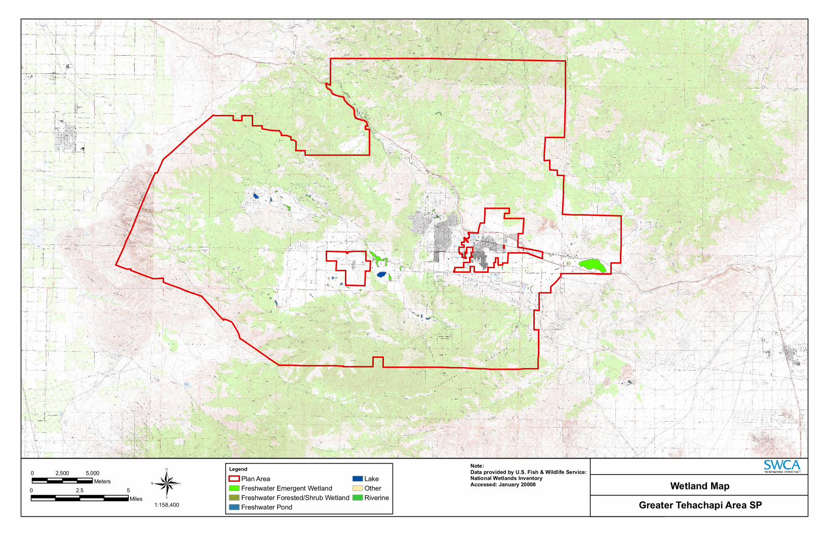
Greater Tehachapi Area SP 1:158,400
0 5,000 2,500
Meters
0 52.5
Miles
Wetland Map
Legend
Plan Area Freshwater Emergent Wetland Freshwater Forested/Shrub Wetland Freshwater Pond
Lake Other Riverine
Note: Data provided by U.S. Fish & Wildlife Service:National Wetlands Inventory Accessed: January 20008

Perognathus inornatus inornatus Ceratochrysis gracilis Neotamias speciosus speciosus
Vulpes macrotis mutica Corynorhinus townsendii
Taxidea taxus Athene cunicularia
Vulpes macrotis mutica Layia leucopappa
Opuntia basilaris var. treleasei Mimulus pictus
Monolopia congdonii Layia heterotricha Navarretia setiloba
Stabilized Interior Dunes Caulanthus californicus Opuntia basilaris var. treleasei
Batrachoseps stebbinsi Onychomys torridus tularensis
Opuntia basilaris var. treleasei Batrachoseps stebbinsi
Ensatina eschscholtzii croceator Batrachoseps stebbinsi
Monolopia congdonii Agelaius tricolor Opuntia basilaris var. treleasei Batrachoseps stebbinsi Southern Interior Cypress Forest Opuntia basilaris var. treleasei Andrena macswaini
Opuntia basilaris var. treleasei Cupressus arizonica ssp. nevadensis Perognathus inornatus inornatus
Onychomys torridus tularensis Buteo swainsoni Ensatina eschscholtzii croceator Buteo swainsoni
Vulpes macrotis muticaMimulus pictus
Atriplex cordulata
Astragalus hornii var. hornii Vulpes macrotis mutica Loeflingia squarrosa var. artemisiarum Streptanthus cordatus var. piutensis
Athene cunicularia Eschscholzia lemmonii ssp. kernensis Mimulus pictus Calochortus palmeri var. palmeri
Dipodomys nitratoides nitratoides Lytta moesta Athene cunicularia Allium shevockii
Eriogonum kennedyi var. pinicola Athene cunicularia Orthotrichum spjutii
Valley Saltbush Scrub Caulanthus californicus Layia heterotricha Streptanthus cordatus var. piutensis
Dipodomys nitratoides nitratoides Opuntia basilaris var. treleasei Batrachoseps stebbinsi Sauromalus ater Gopherus agassizii
Eremophila alpestris actia
Eriogonum kennedyi var. pinicola Eremophila alpestris actia
Dipodomys nitratoides nitratoides Layia leucopappa California macrophylla Layia heterotricha
Mimulus pictus Eschscholzia lemmonii ssp. kernensis Layia heterotricha Gopherus agassizii
Opuntia basilaris var. treleasei Vulpes macrotis mutica Mimulus pictus
Layia leucopappa Astragalus leucolobus Perognathus alticolus inexpectatus Spermophilus mohavensis Euphilotes battoides comstocki
Layia leucopappa Perognathus alticolus inexpectatus Perognathus alticolus inexpectatus
Taxidea taxus
Vulpes macrotis mutica Onychomys torridus tularensis
Valley Needlegrass Grassland Ensatina eschscholtzii croceator Perognathus inornatus inornatus Canbya candida
Vulpes macrotis mutica Valley Needlegrass Grassland Navarretia peninsularis Spermophilus mohavensis
Layia leucopappa
Mimulus pictus Viola aurea Eschscholzia lemmonii ssp. kernensis
Perognathus alticolus inexpectatus
Lasiurus cinereus Mimulus pictus Toxostoma lecontei Helminthoglypta concolor Athene cunicularia
Toxostoma lecontei
Helminthoglypta concolor Vulpes macrotis mutica Batrachoseps stebbinsi
Toxostoma lecontei
Vulpes macrotis mutica Toxostoma lecontei
Taxidea taxusGambelia sila
Toxostoma lecontei Gymnogyps californianus
Toxostoma lecontei
Githopsis tenella
Batrachoseps stebbinsi Batrachoseps stebbinsi
0 5,000 10,000 Legend Meters
0 5 10 Plan Area 10 Mile Buffer Special-Status Species Occurrences Miles
1:316,800 5 Mile Buffer Special-Status Species Occurrences Greater Tehachapi Area SP

California Condor
Southwestern Willow Flycatcher
Desert Tortoise
Desert Tortoise
California Condor
California Condor Desert Tortoise
0
0
1:506,880
5,000 10,000
Meters
10 5
Miles
Legend
Plan Area
5 Mile Buffer
10 Mile Buffer
Southwestern Willow Flycatcher
Desert Tortoise
California Condor Greater Tehachapi Area SP
Critical Habitat

GREATER TEHACHAPI AREA SPECIFIC PLAN BIOLOGICAL RESOURCES ASSESSMENT
APPENDIX A:Special-status Plants and Wildlife Within the Plan Area
SW CA Envi ronm enta l Cons u l tan ts
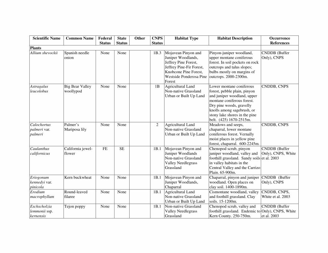
Scientific Name Common Name Federal Status
State Status
Other CNPS Status
Habitat Type Habitat Description Occurrence References
Plants Allium shevockii Spanish needle None None 1B.3 Mojavean Pinyon and Pinyon-juniper woodland, CNDDB (Buffer
onion Juniper Woodlands, Jeffrey Pine Forest,
upper montane coniferous forest. In soil pockets on rock
Only), CNPS
Jeffrey Pine-Fir Forest, outcrops and talus slopes; Knobcone Pine Forest, bulbs mostly on margins of Westside Ponderosa Pine outcrops. 2000-2300m. Forest
Astragalus leucolobus
Big Bear Valley woollypod
None None 1B Agricultural Land Non-native Grassland Urban or Built Up Land
Lower montane coniferous forest, pebble plain, pinyon and juniper woodland, upper montane coniferous forest.
CNDDB, CNPS
Dry pine woods, gravelly knolls among sagebrush, or stony lake shores in the pine belt. (425) 1670-2515m.
Calochortus palmeri var.
Palmer’s Mariposa lily
None None 2 Agricultural Land Non-native Grassland
Meadows and seeps, chaparral, lower montane
CNDDB, CNPS
palmeri Urban or Built Up Land coniferous forest. Vernally moist places in yellow pine forest, chaparral. 600-2245m.
Caulanthus California jewel- FE SE 1B.1 Mojavean Pinyon and Chenopod scrub, pinyon CNDDB (Buffer californicus flower Juniper Woodlands
Non-native Grassland juniper woodland, valley and foothill grassland. Sandy soils
Only), CNPS, White et al. 2003
Valley Needlegrass in valley habitats in the Grassland Central Valley and the Carrizo
Plain. 65-900m. Eriogonum Kern buckwheat None None 1B.1 Mojavean Pinyon and Chaparral, pinyon and juniper CNDDB (Buffer kennedyi var. Juniper Woodlands, woodland. Open places on Only), CNPS pinicola Chaparral clay soil. 1400-1890m. Erodium Round-leaved None None 1B.1 Agricultural Land Cismontane woodland, valley CNDDB, CNPS, macrophyllum filaree Non-native Grassland and foothill grassland. Clay White et al. 2003
Urban or Built Up Land soils. 15-1200m. Eschscholzia Tejon poppy None None 1B.1 Non-native Grassland Chenopod scrub, valley and CNDDB (Buffer lemmonii ssp. Valley Needlegrass foothill grassland. Endemic to Only), CNPS, White kernensis Grassland Kern County. 250-750m. et al. 2003

Scientific Name Common Name Federal Status
State Status
Other CNPS Status
Habitat Type Habitat Description Occurrence References
Eschscholzia Kernville poppy None None 3 Woodlands Cismontane woodland. Sandy CNPS procera floodplain. Also collected
from decomposed granite, limestone, and metamorphics. 810-1025m.
Fritillaria Greenhorn None None 1B.3 Black Oak Forest Lower montane coniferous CNPS brandegeei fritiliary Jeffrey Pine Forest
Westside Ponderosa Pine forest. Loamy, granitic soils, often in mixed conifer-
Forest blackoak community. 12001910m.
Fritillaria striata Striped adobe-lily None ST 1B.1 Non-native Grassland Valley and foothill grassland, cismontane woodland Heavy clay adobe soils in oak grassland. 135-1455m.
CNDDB (Buffer Only), CNPS, White et al. 2003
Lasthenia glabrata Coulter’s None None 1B.1 Agricultural Land Coastal salt marshes, playas, CNDDB, CNPS ssp. coulteri goldfields Non-native Grassland valley and foothill grasslands,
Urban or Built Up Land vernal pools. Usually found on alkaline soils in playas, sinks, and grasslands. 11400m.
Layia heterotricha Pale yellow layia None None 1B.1 Agricultural Land, Valley and foothill grasslands, CNDDB, CNPS, Mojavean Pinyon and cismontane woodland, White et al. 2003 Juniper Woodland, Non-native Grassland,
pinyon-juniper woodland. Open areas with alkaline or
Urban or Built Up Land clay soils. 270-1365 (2675)m. Layia leucopappa Comanche Point None None 1B.1 Non-native Grassland Valley and foothill grasslands, CNDDB, CNPS,
layia chenopod scrub. Dry hills in white-grey clay soils, often with weedy grasses. 100350m.
White et al. 2003
Loeflingia squarrosa var.
Sagebrush loeflingia
None None 2.2 Blue Oak Woodland, Foothill Pine Oak
Great Basin scrub, Sonoran desert scrub, desert dunes.
CNDDB, CNPS
artemisiarum Woodland Sandy flats and dunes; sandy areas around clay slicks w/ Sarcobatus, Atriplex, Tetradymia, etc. 700-1200m.

Scientific Name Common Name Federal Status
State Status
Other CNPS Status
Habitat Type Habitat Description Occurrence References
Mimulus pictus Calico None None 1B.2 Agricultural Land, Cismontane woodland, CNDDB, CNPS, monkeyflower Blue Oak Woodland,
Foothill Pine Oak broadleaved upland forest In bare ground around
White et al. 2003
Woodland, gooseberry bushes or granitic Mojavean Pinyon and outcrops. 100-1300m. Juniper Woodland, Non-native Grassland, Urban or Built Up Land
Monardella linoides ssp oblonga
Flax-like monardella
None None 1B.3 Agricultural Land Non-native Grassland Urban or Built Up Land
Lower and upper montane coniferous forest, pinyon-juniper woodland. On dry slopes of yellow pine forest; decomposed granitic soils; in roadside and disturbed areas.
CNDDB, CNPS, White et al. 2003
1695-2470m. Navarretia peninsularis
Baja navarretia None None 1B.2 Chamise Chaparral, Interior Live Oak Forest, Jeffrey Pine Fir Forest, Mojavean Pinyon and Juniper Woodland, Northern Mixed
Lower montane coniferous forest, chaparral. Wet areas in open forest. 1500-2425m.
CNDDB, CNPS
Chaparral, Scrub Oak Chaparral, Valley Oak Woodland, Westside Ponderosa Pine Forest
Navarretia setiloba Piute Mountains None None 1B.1 Woodlands, Mojavean Cismontane woodland, CNDDB (Buffer navarretia Pinyon and Juniper
Woodlands, Non-native pinyon-juniper woodland, valley and foothill grassland.
Only), CNPS, White et al. 2003
Grassland, Known only from Kern and Valley Needlegrass Tulare Counties. Red clay Grassland soils, other clay soils (?), or
on gravelly loam. 3001110m.
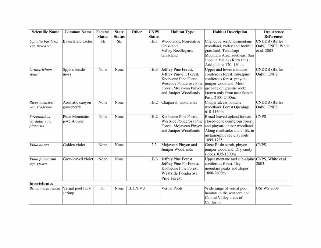
Scientific Name Common Name Federal Status
State Status
Other CNPS Status
Habitat Type Habitat Description Occurrence References
Opuntia basilaris var. treleasei
Bakersfield cactus FE SE 1B.1 Woodlands, Non-native Grassland, Valley Needlegrass Grassland
Chenopod scrub, cismontane woodland, valley and foothill grassland; Tehachapi Mountain Area, southeast San
CNDDB (Buffer Only), CNPS, White et al. 2003
Joaquin Valley (Kern Co.) Arid plains; 120–150 m.
Orthotrichum Spjut's bristle- None None 1B.3 Jeffrey Pine Forest, Upper and lower montane CNDDB (Buffer spjutii moss Jeffrey Pine-Fir Forest, coniferous forest, subalpine Only), CNPS
Knobcone Pine Forest, Westside Ponderosa Pine
coniferous forest, pinyon-juniper woodland. Moss
Forest, Mojavean Pinyon growing on granitic rock; and Juniper Woodlands known only from near Sonora
Pass. 2100-2400m. Ribes menziesii Aromatic canyon None None 1B.2 Chaparral, woodlands Chaparral, cismontane CNDDB (Buffer var. ixoderme gooseberry woodland. Forest Openings. Only), CNPS
610-1160m. Streptanthus cordatus var.
Piute Mountains jewel-flower
None None 1B.2 Knobcone Pine Forest, Westside Ponderosa Pine
Broad-leaved upland forests, closed-cone coniferous forest,
CNPS
piutensis Forest, Mojavean Pinyon and pinyon-juniper woodland. and Juniper Woodlands Along roadbanks and cliffs, in
metamorphic red clay soils. 1095-1735.
Viola aurea Golden violet None None 2.2 Mojavean Pinyon and Great Basin scrub, pinyon- CNPS Juniper Woodlands juniper woodland. Dry sandy
slopes. 835-1800m. Viola pinetorum ssp. grisea
Grey-leaved violet None None 1B.3 Jeffrey Pine Forest Jeffrey Pine-Fir Forest, Knobcone Pine Forest, Westside Ponderosa
Upper montane and sub-alpine coniferous forest. Dry mountain peaks and slopes. 1800-2600m.
CNPS, White et al. 2003
Pine Forest Invertebrates Brachinecta lynchi Vernal pool fairy FT None IUCN:VU Vernal Pools Wide range of vernal pool USFWS 2008
shrimp habitats in the southern and Central Valley areas of California

Scientific Name Common Name Federal Status
State Status
Other CNPS Status
Habitat Type Habitat Description Occurrence References
Andrena macswaini
An andrenid bee None None Unknown Oligolectic on morning-opening, yellow-flowered species of Camissonia. Nests in deep, sandy soil. This is the only species in the subgenus diandrena with aggregated nests associated with depressions.
CNDDB (Buffer Only)
Desmocerus californicus dimorphus
Valley elderberry longhorn beetle
FT None Grassland, Woodland Occurs only in the Central Valley of California, in association with blue elderberry (Sambucus mexicana). Prefers to lay eggs in elderberrries 2-8 inches in diameter; some preference shown for "stressed" elderberries.
CNDDB (Buffer Only), USFWS 2008, White et al. 2003
Euphilotes battoides comstocki
Comstock’s blue butterfly
None None Scrub Hostplant is Eriogonum sp. CNDDB
Helminthoglypta concolor
Whitefir shoulderband
None None Forest Moist habitats in middle Kern-Upper Tehachapi watershed and Antelope-Fremont Valleys
CNDDB (Buffer Only)
Lytta moesta Moestan blister beetle
None None Unknown Central California. CNDDB (Buffer Only)
Amphibians Batrachoseps stebbinsi
Tehachapi slender salamander
None ST IUCN:VU, FSS,
BLMS
Forest, Woodland, Riparian
Valley-foothill hardwood-conifer and valley-foothill riparian in the Piute and Tehachapi Mountains of Kern County. Prefers wet talus slopes or log-strewn hillsides with a steep, north-facing exposure.
CNDDB, White et al. 2003

Scientific Name Common Name Federal Status
State Status
Other CNPS Status
Habitat Type Habitat Description Occurrence References
Ensatina eschscholtzii croceator
Yellow-blotched salamander
None SC IUCN:LC, FSS,
BLMS
Woodland, Chaparral Forests and well-shaded canyons, as well as oak woodlands and old chaparral. Need surface objects, such as logs, boards, and rocks. Also need old rodent burrows or other underground retreats.
CNDDB, White et al. 2003
Rana aurora draytoni
California red-legged frog
FT SC IUCN:NT Riparian, Wetland, Ponds and Lakes.
Lowlands and foothills in or near permanent sources of deep water with dense, shrubby or emergent riparian vegetation.Requires 11-20 weeks of permanent water for larval development. Must have access to estivation habitat.
USFWS 2008
Rana boylii Foothill yellow-legged frog
None SC IUCN:NT, FSS,
BLMS
Riparian Partly shaded shallow streams with rocky substrates. Needs some cobble-sized substrate for egg-laying.
White et al. 2003
Spea hammondii Western spadefoot None SC IUCN:NT, BLMS
Grassland, Woodland (Valley-Oak Woodland & Foothill Pine-Oak Woodland)
Occurs primarily in grassland habitat, but can be found in valley-foothill hardwood woodlands. Vernal pools are essential for breeding and egg-laying.
White et al. 2003
Reptiles Emys marmorata Western pond
turtle None None IUCN:VU,
BLMS, FSS
Riparian, Wetland, Ponds and Lakes.
Inhabits permanent or nearly permanent bodies of water in many habitat types below 6000 ft. Require basking sites such as partially submerged logs, vegetation mats, or open mud banks.
White et al. 2003

Scientific Name Common Name Federal Status
State Status
Other CNPS Status
Habitat Type Habitat Description Occurrence References
Anniella pulchra Silvery legless None SC FSS Grasslands, Scrub, Sandy or loose loamy soils White et al. 2003 pulchra lizard Chaparral under sparse vegetation. Soil
moisture is essential. They prefer soils with a high moisture content.
Gambelia sila Blunt-nosed leopard lizard
FE SE, FP IUCNL:EN Scrub, Grasslands Resident of sparsely vegetated alkali and desert scrub habitats, in areas of low
CNDDB (Buffer Only)
topographic relief. Seeks cover in mammal burrows, under shrubs or structures such as fence posts; they do not excavate their own burrows.
Phrynosoma coronatum
Coast horned lizard
None SC FSS Scrub, Chaparral Inhabits coastal sage scrub and chaparral in arid and semi-arid climate conditions.
CNDDB
Prefers friable, rocky or shallow sandy soil.
Birds Accipter cooperii Cooper’s hawk None SC IUCN:LC Forest, Woodland, Woodland, chiefly of open, White et al. 2003,
(N) Riparian, Chaparral, interrupted or marginal type. TMBC 2007 Developed. Nest sites mainly in riparian
growths of deciduous trees, as in canyon bottoms, on river floodplains; also live in oaks.
Accipiter striatus Sharp-shinned None SC IUCN:LC Forest, Woodland, Found in Ponderosa pine, White et al. 2003, hawk Riparian, Developed. black oak, riparian deciduous, TMBC 2007
mixed conifer, and Jeffrey pine habitats but prefers riparian areas. Requires north facing slopes with plucking perches. Nests usually within 275 ft of water.

Scientific Name Common Name Federal Status
State Status
Other CNPS Status
Habitat Type Habitat Description Occurrence References
Agelaius tricolor Tricolored None SC ABC, Riparian, Wetland, Ponds Highly colonial species, most White et al. 2003, blackbird Aububon,
BLMS, and Lakes, Developed Agricultural Land and
numerous in the Central Valley and vicinity. Largely
TMBC 2007
IUCN:LC, Built-up Land). endemic to California. USBC, Requires open water, BCC protective nesting substrate
and foraging area with insect prey within a few km of the colony.
Aquila chrysaetos Golden eagle (N&W)
None SC, FP IUCN:LC, BCC,
CDFS,
Forest, Woodland, Chaparral, Scrub, Grasslands.
Rolling foothill or coast-range terrain, where open grassland turns to scattered oaks,
CNDDB (Buffer Only), White et al. 2003, TMBC 2007
BLMS sycamores, or large digger pines. Cliff-walled canyons provide nesting habitat in most parts of range; also large trees in open areas.
Asio otus Long-eared owl None SC Woodlands, Riparian Found in riparian bottomlands grown to tall willows and cottonwoods; also, belts of
CNDDB (Buffer Only), White et al. 2003
live oak paralleling stream courses. Require adjacent open land productive of mice and the presence of old nests of crows, hawks, or magpies for breeding.
Athene cunicularia Burrowing owl None SC IUCN:LC, BLMS, BCC
Grasslands, Scrub. Open, dry annual or perennial grasslands, deserts and scrublands characterized by low-growing vegetation. Subterranean nester,
CNDDB (Buffer Only), White et al. 2003
dependent upon burrowing mammals, especially California ground squirrel.
Baeolophus Oak titmouse None None ABC, Woodlands Occurs in chaparral, oak TMBC 2007 inornatus Audubon, woodlands and coniferous
IUCN:LC, forests. Nests in tree cavities USBC

Scientific Name Common Name Federal Status
State Status
Other CNPS Status
Habitat Type Habitat Description Occurrence References
Buteo regalis Ferruginous hawk (W)
None SC Audubon, BLMS,
IUCN:NT, BCC
Grasslands, Scrub, Agricultural Land, Woodland (Valley-Oak Woodland, Mojavean Pinyon and Juniper Woodladn),
Open grasslands, sagebrush flats, desert scrub, low foothills surrounding valleys and fringes or pinyon-juniper habitats. Mostly eats lagomorphs, ground squirrels, and mice. Population trends may follow lagomorph population cycles.
White et al. 2003, TMBC 2007
Buteo swainsoni Swainson’s hawk (N)
None ST ABC, Audubon,
USBC, FSS, BCC
Riparian, Valley-Oak Woodland, Scrub, Grasslands, Agricultural Land.
Breeds in stands with few trees in Juniper-Sage flats, riparian areas and in oak savannahs. Requires adjacent suitable foraging areas such as grasslands, or alfalfa or grain fields supporting rodent populations.
CNDDB (Buffer Only), White et al. 2003
Carduelis lawrencei
Lawrence’s goldfinch
None None Audubon Woodlands, scrub, riparian
Occurs in dry woodlands and scrub adjacent to riparian areas.Feeds on seeds of annuals
White et al. 2003, TMBC 2007
Charadrius montanus
Mountain plover (W)
None SC ABC, Audubon,
BLMS, IUCN:VU,
USBC, BCC
Grasslands, Agricultural Land.
Forage in short-grasslands, and agricultural fields. Short vegetation, bare ground, & flat topography. Prefers grazed areas with burrowing rodents.
White et al. 2003,
Circus cyaneus Northern harrier (N)
None SC IUCN:LC Riparian, Wetland, Lakes and Ponds, Grasslands.
Coastal salt marsh and freshwater marsh. Nest and forage in grasslands, from salt grass in desert sink to mountain cienagas. Nests on ground in shrubby vegetation, usually at marsh edge; nest built of a large mound of sticks in wet areas.
White et al. 2003, TMBC 2007

Scientific Name Common Name Federal Status
State Status
Other CNPS Status
Habitat Type Habitat Description Occurrence References
Cypseloides niger Black swift (N) None SC ABC, Audubon,
Forest, Woodland Central and southern Sierra Nevada; San Bernardino and
White et al. 2003
IUCN:LC, San Jacinto Mtns. Breeds in USBC, small colonies on cliffs behind BCC or adjacent to waterfalls in
deep canyons; forages widely. Dendroica petechia brewsteri
Yellow warbler (N)
None SC IUCN:LC Riparian, Forest Riparian plant associations. Prefers willows, cottonwoods, aspens, sycamores, and alders for nesting and foraging. Also nests in montane shrubs in
White et al. 2003
open conifer forests. Elanus leucurus White-tailed kite
(N) None FP Riparian, Woodland,
Grassland, Wetlands. (Nesting) rolling foothills/valley margins with scattered oaks and river
White et al. 2003, TMBC 2007
bottomlands or marshes next to deciduous woodland. Open grasslands, meadows, or marshes for foraging close to isolated, dense-topped trees for nesting and perching.
Empidonax traillii Southwestern FE SE Audubon, Riparian Riparian woodlands in USFWS 2008 extimus willow flycatcher USBC southern California. Eremophila alpestris actia
California horned lark
None SC IUCN Grasslands, meadows, agricultural lands
Coastal regions, chiefly from Sonoma Co. to San Diego Co. Also main part of San Joaquin Valley and east to foothills. Short-grass prairie, “bald hills,” mountain meadows,
White et al. 2003
open coastal plains, fallow grain fields, alkali flats.
Falco columbarius Merlin (W) None SC IUCN:LC Grassland, Scrub, Agricultural Land
Open country, coastal area, grasslands, and scrub. Tends to hunt over wetlands and
White et al. 2003, TMBC 2007
agricultural fields with large flocks of small birds.

Scientific Name Common Name Federal Status
State Status
Other CNPS Status
Habitat Type Habitat Description Occurrence References
Falco mexicanus Prairie falcon None SC IUCN:LC, BCC
Grassland, Scrub, Agricultural Land.
Inhabits dry, open terrain, either level or hilly. Breeding sites located on cliffs.
CNDDB (Buffer Only), White et al. 2003, TMBC 2007
Forages far afield, even to marshlands and ocean shores.
Gymnogyps California condor FE SE ABC, Grassland, Scrub, Requires vast expanses of USFWS 2008, californianus Audubon, Chaparral, Woodland, open savannah, grasslands, CNDDB (Buffer
CDFS, Forest. and foothill chaparral in Only), White et al. IUCN:CR,
USBC mountain ranges of moderate altitude. Deep canyons
2003
containing clefts in the rocky walls provide nesting sites. Forages up to 100 miles from roost/nest.
Icteria virens Yellow-breasted None SC IUCN:LC Riparian Summer resident, inhabits White et al. 2003 chat (N) riparian thickets of willow and
other brushy tangles near waterways. Nests in low, dense riparian, consisting of willow, blackberry, wild grape; forage and nest within 10 ft of the ground.
Ixobrychius exilis Least bittern (N) None SC IUCN Marshes, grasslands Marshes and grasslands, White et al. 2003 Dense vegetation.
Lanius ludovicianus
Loggerhead shrike None SC IUCN:LC, BCC
Woodland, Grasslands, Scrub, Agricultural Land, Riparian
Broken woodlands, savannah, pinyon-juniper, Joshua tree, and riparian woodlands, desert oases, scrub, and washes.
White et al. 2003, TMBC 2007
Prefers open country for hunting, with perches for scanning, and fairly dense shrubs and brush for nesting.
Melanerpes lewis Lewis’ woodpecker
None None ABC, Audubon, IUCN:LC,
Forest, Woodland Occurs in oak woodlands and coniferous forests
TMBC 2007
BCC

Scientific Name Common Name Federal Status
State Status
Other CNPS Status
Habitat Type Habitat Description Occurrence References
Nycticorax nycticorax
Black-crowned night-heron (N)
None None BLMS, IUCN:LC
Riparian, Wetlands, Lakes and Ponds.
Colonial nester in tall trees and in emergent marsh vegetation. Rookery sites are near foraging areas of marshes, lake and river
TMBC 2007
margins, wet meadows, and tide-flats.
Oreortyx pictus eremophilus
Mountain quail None None Audubon Forest, Woodland Most often found in mixed evergreen forest and chaparral cover types. Configurations of tall, dense shrubs which are in
TMBC 2007
close proximity to water and escape cover.
Picoides nuttallii Nuttall’s None None ABC, Woodland, Scrub, Generalist, occurs in most TMBC 2007 woodpecker Audubon,
IUCN:LC, Riparian woodland and scrublands.
Nests in cavities USBC
Progne subis Purple martin None SC IUCN:LC Forest, Woodland, Riparian.
Open areas across eastern North America, and also some locations on the west coast.
White et al. 2003
Open areas with an open water source nearby.
Strix occidentalis occidentalis
California spotted owl
None SC ABC, Audubon,
Forest, Woodland Nests in stands composed of mixtures of interior live oak,
White et al. 2003
FSS, BLMS,
IUCN:NT,
California sycamore, California buckeye, and blue oak
USBC, BCC
Toxostoma California None None Chaparral, Woodland, Chaparral, riparian, and White et al. 2003, redivivum thrasher Riparian juniper woodlands Prefers TMBC 2007
habitats with dense litter and cover.
Mammals

Scientific Name Common Name Federal Status
State Status
Other CNPS Status
Habitat Type Habitat Description Occurrence References
Lasiurus cinereus hoary bat None SC IUCN:LC, WBWG:M
Woodland, Chaparral, Scrub, Grassland, Riparian, Developed.
Prefers open habitats or habitat mosaics with access to trees for cover & open areas or habitat edges for feeding. Roosts in dense foliage of medium to large trees. Feeds primarily on moths. Requires water.
CNDDB (Buffer Only)
Onychomys torridus tularensis
Tulare grasshopper mouse
None SC IUCN:DD, BLMS
Grasslands, Scrub Hot arid valleys and scrub deserts in S San Joaquin Valley. Feeds almost exclusively on arthropods and needs abundant supply of insects.
CNDDB (Buffer Only), White et al. 2003
Perognathus alticolus inexpectatus
Tehachapi pocket mouse
None SC IUCN:NT, FSS
Grasslands, Scrub, Agricultural Land.
Arid annual grassland and desert shrub communities but also taken in fallow grain field and in Russian thistle. Burrows for cover and nesting. Aestivates and hibernates during extreme weather. Forages on open ground and under shrubs.
CNDDB, White et al. 2003
Perognathus inornatus inornatus
San Joaquin pocket mouse
None None BLMS, IUCN:LC
Grassland, Blue Oak Woodland.
Typically found in grasslands and blue oak savannahs. Needs friable soils.
CNDDB (Buffer Only), White et al. 2003
Taxidea taxus American badger None SC IUCN:LC Grassland, Scrub, Woodland.
Most abundant in drier open stages of shrub, forest, and herbaceous habitats, with friable soils. Need sufficient food, friable soils, and uncultivated ground. Prey on burrowing rodents. Digs burrows.
CNDDB (Buffer Only)

Scientific Name Common Name Federal Status
State Status
Other CNPS Status
Habitat Type Habitat Description Occurrence References
Vulpes macrotis San Joaquin kit FE ST IUCN:LC Grassland, Scrub Annual grasslands or grassy CNDDB, White et al. mutica fox open stages with scattered
shrubby vegetation. Need 2003
loose-textured sandy soils for burrowing, and suitable prey base.
Habitats Jeffrey Pine-Fir Forest
None None CDFG Jeffrey Pine-Fir Forest Understory is open, primarily of scattered Montane
GAP 2008
Chaparral and small trees. Similar to Jeffrey Pine Forest but moister. On well-drained slopes, usually avoiding the driest and moistest sites. Intergrades broadly with Jeffrey Pine Forest and upper Montane Fir Forest and Lodgepole Pine Forest in upper limits
Westside None None CDFG Westside Ponderosa Pine Open, park-like forest of GAP 2008 Ponderosa Pine Forest coniferous evergreens to 70m Forest tall, dominated by Pinus
ponderosa. Sparse understory of scattered chaparral shrubs and young trees. Thick needle litter and pine cones on the ground. Cones mature in early autumn. All plants are essentially dormant in winter.
Valley Oak Woodland
None None CDFG (CNDDB)
Valley Oak Woodland Canopies of these woodlands are dominated almost exclusively by valley oaks. Merge with Annual Grasslands
GAP 2008
or agricultural land. Intergrade with Blue Oak Woodlands or Blue Oak-Digger Pine habitats.

Scientific Name Common Name Federal Status
State Status
Other CNPS Status
Habitat Type Habitat Description Occurrence References
Big Sagebrush Scrub
None None CDFG Big Sagebrush Scrub Mostly soft-woody shrubs, 0.5m tall, usually with bare ground underneath and between shrubs. Artemisia
GAP 2008
tridentata is dominant. Dormant in winter. Occurs on a wide variety of soils and terrain, from rocky, well-drained slopes to fine-textured valley soils with high water table. Pinyon-Juniper Woodland is a frequent associate.
Valley Needlegrass Grassland
None None CDFG (CNDDB)
Valley Needlegrass Grassland
Mid-height grassland dominated by perennial, tussock-forming Stipa pulchra. Formerly extensive around the Sacramento, San Joaquin, and Salinas Valleys, and the Los Angeles Basin, but now much reduced. On
GAP 2008 (interspersed within Nonnative grasslands at too fine of a scale for GAP mapping capabilities)
fine-textured (often clay) soils, moist in the winter and very dry in the summer. Besides S. Pulchra, Occurs with other native and nonnative grassland species.

FT = Federal Threatened FE = Federal Endangered FPT = Federal Proposed Threatened FPE = Federal Proposed Endangered FPD = Federal Proposed Delisting FC = Federal Candidate FD = Federal Delisted
SE = California listed as Endangered ST = California listed as Threatened SR = California Rare Species SC = California State Species of Special Concern FP = California Fully Protected
FSS = Forest Service Sensitive BLMS = Bureau of Land Management Sensitive CDFS = California Dept. of Forestry Sensitive IUCN = International Union for Conservation of Nature and Natural Resources CR: Critically Endangered DD: Data Deficient EN: Endangered LC: Least Concern NT: Near Threatened VU: Vulnerable
WBWG = Western Bat Working Group H: High Priority MH: Medium-High Priority M: Medium Priority LM: Low-Medium Priority
USBC = The United States Bird Conservation Watch List ABC = The American Bird Conservancy Green List Audubon = WatchList BCC = U.S. Fish and Wildlife Service Birds of Conservation COncern
List 1B = Plants rare or endangered in California and elsewhere List 2 = Rare, threatened, or endangered in California, but more common elsewhere. List 3 = We need more information about this plant (Review List). 0.1 = Seriously endangered in California (over 80% of occurrences threatened / high degree and immediacy of threat) 0.2 = Fairly endangered in California (2080% occurrences threatened) 0.3 = Not very endangered in California (<20% of occurrences threatened) CA-Endemic = Plant’s native range is confined to California