Embed Size (px)
Citation preview

TS06H - Boundary Delineation Issues: From Parcel to Country Level, paper nº5107 Paula Santos, Ana Roque, and José Mucombo Revision of the Mozambique Frontiers: a cooperation project FIG Working Week 2011 Bridging the Gap between Cultures Marrakech, Morocco, 18-22 May 2011
1/11
Revision of the Mozambique Frontiers: a Cooperation Project
Paula SANTOS and Ana ROQUE, Portugal, José MUCOMBO, Mozambique
Key words: Frontiers, Mozambique, Cooperation SUMMARY As many African countries, Mozambique faces today the problem of rebuilding and readjusting its official borders. Due to natural causes or to political issues the demarcation of the border vanished in some areas. Old beacons are missing and negotiations must be done in order to rebuild the border line according to the previous treaties and agreements. Although this rebuilding process corresponds to an internal political requirement it is also a response to the African Union Border Declaration Program (Addis Ababa, 2007), in order to implement the Resolution on the Inalienability of Colonial Boundaries assumed in Cairo (1964) by the Organization of African Unit and ratified by the African Union Assembly in Durban (2002). In many cases, the official documents concerning this issue, reports, maps, sketches, field-notes, description and geographic coordinates of the beacons, results of topographic and geodetic works, photographs, are still kept outside the African countries, in the national Archives of the former colonial powers, thus being necessary an official collaboration with the different countries involved. In what concerns Mozambique most of this information is kept at the Tropical Research Institute (IICT), a Portuguese government agency, mainly working with the Community of Portuguese Speaking Countries (CPLP) to develop research for development in human and natural sciences, seeking to increase the scientific and technical capacity of developing countries and to ensure the preservation of and access to its documental collections. Considering the IICT mission and to respond to particular concerns of Mozambique government, a cooperation project is being prepared. It will involve an interdisciplinary team aiming at investigate appropriate and innovative methodologies and technologies to organize and obtain a Boundary Information System for Mozambique in order to provide reliable information and to support the management of the boundary. The system will be based on studies involving historical and geographical documentation existing at the IICT as well as in other archives, obtained during Mozambique Boundaries implementation starting in 1856. All the information will be processed in a geo-database to support the creation of a geographical information system for the management of the frontiers. This project also intends to be an operational tool to improve further investigation and to be used as a basis for a continuous dialogue among the six Mozambique neighboring countries while contributing to reinforce international cooperation networks concerning boundaries research.
TS06H - Boundary Delineation Issues: From Parcel to Country Level, paper nº5107 Paula Santos, Ana Roque, and José Mucombo Revision of the Mozambique Frontiers: a cooperation project FIG Working Week 2011 Bridging the Gap between Cultures Marrakech, Morocco, 18-22 May 2011
2/11
Revision of the Mozambique Frontiers: a Cooperation Project
Paula SANTOS and Ana ROQUE, Portugal, José MUCOMBO, Mozambique
1. PREVIOUS NOTE Africa is considered the most divided continent. Its 54 countries correspond to 109 international frontiers, being 26% defined by natural features (mountains, rivers, etc..), 50% corresponding to astronomical lines and 30% to mathematical lines. Moreover, more than 180 ethnic or cultural areas are split between more than two countries (Döpcke, 1999). Reflecting the European colonial interests and purposes, this scenario underlines the arbitrary and artificial definition of the colonial boundaries in Africa disrespecting both the traditional territory organization and any local ethnic, social or cultural entities (Bouquet, 2003). With the end of the colonial period, the new African states adopted the European model of nation state, integrating multicultural and multiethnic societies within the colonial boundaries and such is the case of Mozambique. Meanwhile, for most cases, the former political map of Africa prevailed with the acceptation of the inherited colonial boundaries, accordingly with the Cairo declaration of 1964. Nevertheless, forty-three years after the Cairo assembly, the 2007 Declaration of Ministers in Charge of Border Issues, within the context of the African Union Border Program (AUBP), estimate that “less than a quarter of African boundaries have been delimited or demarcated.” (Article 2a). According to the AUBP all the process of fixing African borders, where such an exercise has not yet been taken mainly because the new African countries do not have all the information about their frontiers, should be concluded by 2012 and, as far as it concerns Mozambique, the government is committed to accomplishing this highly demanding task. However, to achieve this goal, the governments of the different countries, namely the one of Mozambique, must proceed in due time to the necessary works and diplomatic contacts. Yet, in many cases, most of the official documents concerning this issue are still kept outside the African countries, in the several national Archives of the former colonial powers, thus being necessary an official collaboration with the different countries involved. Needless to say that the “remaking” of the history of a country is always a difficult task and in this specific case, when the borders were defined by a colonial power strange to the local interests, this task become even more difficult to attempt by the fact most of the documents supporting the decisions responsible for the actual country shape are kept outside the country. Regardless to the former Portuguese colonies, and specifically Mozambique, the historical information on the borders is dispersed within several archives and institutions, being the Ministry of the Foreign Affairs (MNE), the Geographic Society of Lisbon (SGL) and the National Library (BNP) some of the most well known ones. However, as most of the information concerning this subject was produced by the Portuguese Commission of Cartography (PCC) and the institutional successor of the PCC is the Tropical Research Institute (IICT), the IICT turned out to be one of the most important repositories of information on the African colonial borders.

TS06H - Boundary Delineation Issues: From Parcel to Country Level, paper nº5107 Paula Santos, Ana Roque, and José Mucombo Revision of the Mozambique Frontiers: a cooperation project FIG Working Week 2011 Bridging the Gap between Cultures Marrakech, Morocco, 18-22 May 2011
3/11
The lack of these documents has been presented, as a major restriction to the prosecution of the technical and scientific work needed to confirm the 2.685 km of its terrestrial borders, involving seven neighbouring countries (South Africa, Swaziland, Zimbabwe, Zambia, Malawi and Tanzania), and the 2.7000 km of maritime border to be discussed and defined with four other countries (South Africa, Madagascar, Comoros and Tanzania) (IMAF, 2009).
Fig. 1 - Mozambique Boundaries (IMAF, 2009) Additionally, local research and fieldwork developed by IMAF teams has revealed that, due to natural causes or to political issues, about one half of the country border demarcation has disappeared (IMAF, 2009). Old beacons were missing and there was no information on the primitive geographical coordinates. In this sense, any attempt to rebuild them required the previous knowledge of their geographical position and every possible reconstruction of the borderlines depended upon unknown descriptions, maps or topographic and geographic data. Briefly, it was impossible to continue the works based only on the little information already published. By this reason the Institute of the Sea and Frontiers (IMAF) of Mozambique (the local entity responsible for the Mozambique border reconstruction and management) and the IICT started working together with the purpose of identification, organization and study the existent documents on the Mozambique border process in order to make them available to Mozambique and consequently to support the difficult task of its border reconstruction. To overcome these difficulties, a cooperation project is being structured involving the IICT and the IMAF, and this paper is, somehow, an output of the works in progress involving Portuguese and Mozambican researches.
MOZAMBIQUE INTERNATIONAL BOUNDARIES CONTINENTAL Country Terrestrial
(Km) Fluvial (Km)
Lakes (Km)
Total (Km)
South Africa
472 24 0 496
Swaziland 106 0 0 106
Zimbabwe 839 295 0 1,134 Zambia 330 76 0 406 Malawi 888 190 322 1,400 Tanzania 50 620 0 670
TOTAL 2.685 1.205 322 4.212
MARITIME South Africa, Madagascar, Comoros and Tanzania 2700

TS06H - Boundary Delineation Issues: From Parcel to Country Level, paper nº5107 Paula Santos, Ana Roque, and José Mucombo Revision of the Mozambique Frontiers: a cooperation project FIG Working Week 2011 Bridging the Gap between Cultures Marrakech, Morocco, 18-22 May 2011
4/11
2. MOZAMBIQUE BOUNDARIES DOCUMENTATION AT IICT The Tropical Research Institute (IICT) is a state laboratory that promotes tropical knowledge by pursuing interdisciplinary research of relevance to countries in tropical regions. It has a special mandate towards the Community of Portuguese Speaking Countries (CPLP), in order to increase the scientific and technical capacity of developing countries and also to ensure the preservation of its documental collections. For historical reasons IICT concentrates an unique, vast and valuable collection of cartographic and documental information on historical precedents and boundaries demarcation concerning CPLP countries, namely on Mozambique The most relevant nucleus of this huge patrimony are the Archive of Frontiers, the Map Collection, namely the one produced by the Portuguese Commission of Cartography along with a rich nucleus of specific Publications on the border process. As regards Mozambique, The Archive of Frontiers is constituted by 36 boxes of documents dated from 1856 to 1942 t including official and diplomatic documents, correspondence, proceedings of the several meetings held by the commissions in charge of the delimitation of the boundaries and the definition of the border lines, reports, field notes, photographs, detailed accounts of the daily works, description and geographic coordinates of the beacons, results of the topographic and geodetic works, aerial photographs, sketches, maps, photographs, precise descriptions of the territories traversed as well as the scientific equipment used during the survey missions. This information was never studied nor prepared to achieve its potential to prevent conflicts and support the sustainable development of Mozambique
Fig. 2 - Archive of Frontiers IICT – GeoDes Archives.
The Map Collection includes 280 manuscript maps, sketches and some printed copies while the library keeps innumerous books and articles concerning Mozambique border process with particular relevance for the revision works made by the Geographical Mission of Mozambique on Mozambique boundaries with Nyassaland (actual Malawi), Rhodesia

TS06H - Boundary Delineation Issues: From Parcel to Country Level, paper nº5107 Paula Santos, Ana Roque, and José Mucombo Revision of the Mozambique Frontiers: a cooperation project FIG Working Week 2011 Bridging the Gap between Cultures Marrakech, Morocco, 18-22 May 2011
5/11
(Zimbabwe), South Africa and Swaziland.
Fig. 3 - Map collection of the Portuguese Commission of Cartography. IICT – Department of Human Sciences.
Fig. 4 - Examples of Publications With previous information on the documents existent in the IICT Archives and its possible relevance to highlight present day problems concerning border management between Mozambique and Malawi, official delegations from these two countries visited the IICT in January 2009 and June 2010. The main purpose of these visits was the access to the official documents related to the Mozambique border process in order to observe the resolutions of the AU Border Declaration Programme and bring to light accurate and reliable data on the precise location of the border lines and of the boundary marks. As previously mentioned the lack of these documents was then presented as a major restriction to the progress of the local fieldworks to rebuild the borders according to the former agreements and resolutions of the early 20th century. Both delegations underline these difficulties while presenting specific examples of the urgency in accessing this documents, explicitly in the cases of mined areas, like the border region of Cahora Bassa with Malawi or the tripoint common to Mozambique, South Africa and Zimbabwe defined on the confluence of the Limpopo and Pafuri rivers by cross lines

TS06H - Boundary Delineation Issues: From Parcel to Country Level, paper nº5107 Paula Santos, Ana Roque, and José Mucombo Revision of the Mozambique Frontiers: a cooperation project FIG Working Week 2011 Bridging the Gap between Cultures Marrakech, Morocco, 18-22 May 2011
6/11
between the beacons constructed on those respective river-sides that have now disappeared.
Fig. 5 - Confluence of Rivers Limpopo and Pafuri Mozambican delegation also visited the Army Geographical Institute of Portugal (IGeoE), the official entity responsible for the Portuguese boundaries management, where the IGeoE presented the boundary information system (BGIS) in use for the management of the Portugal-Spain boundary.
Fig. 6 - Portuguese BGIS implemented by IGeoE

TS06H - Boundary Delineation Issues: From Parcel to Country Level, paper nº5107 Paula Santos, Ana Roque, and José Mucombo Revision of the Mozambique Frontiers: a cooperation project FIG Working Week 2011 Bridging the Gap between Cultures Marrakech, Morocco, 18-22 May 2011
7/11
Recognising both the importance of the archival funds of the IICT and the commitment of the institution in making them available to the Community of the Portuguese Speaking Countries (CPLP), the Mozambican delegation suggested a cooperation Project of the Institute of the Sea and frontiers (IMAF) of Mozambique with IICT and the collaboration of the IGeoE in order to construct such a BGIS for Mozambique and to accomplish the required transfer of information. 3 IMPLEMENTATION OF A BOUNDARY INFORMATION SYSTEM FOR MOZAMBIQUE Boundary implementation is usually divided into 4 phases: historical precedent, delimitation, demarcation and characterization. The first phase takes into consideration cultural aspects and previous attempts to establish the boundary. Delimitation is a political process, when negotiators from both countries define and rectify treaties concerning the boundary line to be traced. Demarcation and characterization are performed by “Joint Commissions” constituted by technicians from both neighboring countries. While the demarcation is based on the interpreting on the terrain the intentions defined during the previous process and beacons are built to define the country boundary, characterization consists on building new “marks” to support the population living along the borders. Responding to particular concerns of Mozambique government, this cooperation project pretends to assure the appropriate methodologies and technologies to organize and obtain a Boundary Information System for Mozambique to provide authorities and general public with reliable information and to expedite the management of the boundary. The fact that a boundary is not only a treaty or a line on a map, a boundary is a complex functional structure on the earth´s surface will be addressed crossing relevant related information such as methodologies, natural resources, human context and historical evolution. The system will be mainly based on studies involving historical documentation associated with geographic data existing at the IICT. Thus, a comprehensive research of the variables involved will be supported by an interdisciplinary team, based on historians and geographical engineers in order to assure the connections between the historical and geographical data collected and its current applications to the Mozambique boundary demarcation presently in progress. Additionally, IGeoE will contribute with their experience as responsible for the maintenance of the Portuguese terrestrial boundary, while IMAF will guarantee the connection of the project objectives and results with Mozambique requirements and expectations. The main goal of this project is to produce, through a comprehensive analysis of the existing historical information, a structured compilation of documents to produce digital databases to support present and future management of Mozambique boundaries. The original data will be submitted to an analogue-digital conversion process in order to be integrated into a documental and a geographical database: both will provide the means to support the country stability, regarding international relations with Mozambique neighboring countries. Although the main source of information is located at IICT, a search at relevant national and international archives will complement the required perception of existing information produced during the long process of the demarcation of Mozambican boundaries.
TS06H - Boundary Delineation Issues: From Parcel to Country Level, paper nº5107 Paula Santos, Ana Roque, and José Mucombo Revision of the Mozambique Frontiers: a cooperation project FIG Working Week 2011 Bridging the Gap between Cultures Marrakech, Morocco, 18-22 May 2011
8/11
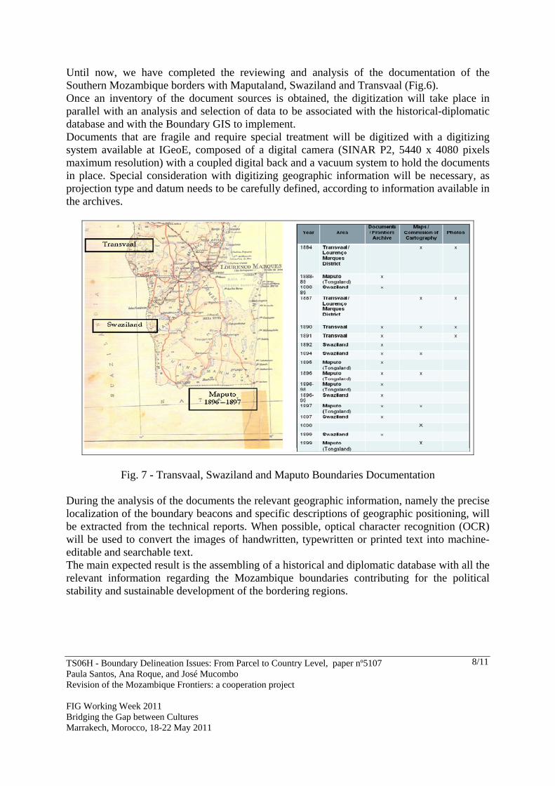
Until now, we have completed the reviewing and analysis of the documentation of the Southern Mozambique borders with Maputaland, Swaziland and Transvaal (Fig.6). Once an inventory of the document sources is obtained, the digitization will take place in parallel with an analysis and selection of data to be associated with the historical-diplomatic database and with the Boundary GIS to implement. Documents that are fragile and require special treatment will be digitized with a digitizing system available at IGeoE, composed of a digital camera (SINAR P2, 5440 x 4080 pixels maximum resolution) with a coupled digital back and a vacuum system to hold the documents in place. Special consideration with digitizing geographic information will be necessary, as projection type and datum needs to be carefully defined, according to information available in the archives.
Fig. 7 - Transvaal, Swaziland and Maputo Boundaries Documentation
During the analysis of the documents the relevant geographic information, namely the precise localization of the boundary beacons and specific descriptions of geographic positioning, will be extracted from the technical reports. When possible, optical character recognition (OCR) will be used to convert the images of handwritten, typewritten or printed text into machine-editable and searchable text. The main expected result is the assembling of a historical and diplomatic database with all the relevant information regarding the Mozambique boundaries contributing for the political stability and sustainable development of the bordering regions.

TS06H - Boundary Delineation Issues: From Parcel to Country Level, paper nº5107 Paula Santos, Ana Roque, and José Mucombo Revision of the Mozambique Frontiers: a cooperation project FIG Working Week 2011 Bridging the Gap between Cultures Marrakech, Morocco, 18-22 May 2011
9/11
Fig. 7 - Information on Maputo´s Border The next phase will be the elaboration of the historical and geographical databases. All the information once analyzed will be put together into a database. Keywords and geographical descriptors (when possible) will be associated to each document, to make searching and association to other documents easier and finally will be implemented the boundary GIS that integrates decision support instruments to develop viable future, long-term monitoring. The geo-database will be built to accommodate all the geo-referenced information regarding Mozambique boundaries, specially the location of boundary beacons, either current and from a historical perspective. Other available and digitized information will be associated, providing there is a common geographic link. It will have a user-friendly interface to visualize and query the database and incorporate eventual changes at the beacon level (e.g., for maintenance work). An add-on will be created, that will allow the visualization and edition of the database with a link to Google Earth, thus enhancing real-time operations on the ground, and the visualization and remote edition of boundaries beacons when necessary. The project pretends to be a pioneer instrument articulating historical and geographical information in an informatics platform developed for this specific purpose and country. In this way, the scientific continuity between the usefulness of that information in the past and the expected advantage from its recovery for spatial monitoring, conflict prevention and as an instrument for regional stability will be assured.

TS06H - Boundary Delineation Issues: From Parcel to Country Level, paper nº5107 Paula Santos, Ana Roque, and José Mucombo Revision of the Mozambique Frontiers: a cooperation project FIG Working Week 2011 Bridging the Gap between Cultures Marrakech, Morocco, 18-22 May 2011
10/11
4 FINAL NOTES Nowadays, about a half of the terrestrial boundaries are not precisely delimited and maritime boundaries even much less precise. As above mentioned this project responds to a specific demand of the Mozambique Government to access the basic information in order to redefine and rebuilt the limits of the national territory while observing the resolutions of the AU Border Programme. This demand compelled to a first approach to the specific archival documents related to this subject and later on to the definition of a cooperation programme mainly focused on the analyse of those documents and the possibility of making them available to Mozambique as, in fact, they include all the information requested for the physical reconstruction of the borderline. The project profits from the combination of a multidisciplinary research team from IICT, with the valuable practical knowledge and adequate tools of IGeoE and the local experience of Mozambican IMAF members. The final result will be the implementation of a BGIS that support the management and continuous characterization of Mozambique boundaries that contributes to support the stability and development of Mozambique, to prevent conflicts and in order to promote cooperation and peace as recognized by the AUBP and desired by all of us. According to Addler (Addler, 2001) there are three essential reasons for the demarcations of a boundary:
Peace, since the treaties celebrated by the neighboring countries are agreements that emphasis the permanent and pacific condition of a boundary
Reaffirmation of the Independence of a state Security decurrently of the nearly inviolable regulation of the frontier line.
By other words Good fences make good neighbors (Robert Frost).

TS06H - Boundary Delineation Issues: From Parcel to Country Level, paper nº5107 Paula Santos, Ana Roque, and José Mucombo Revision of the Mozambique Frontiers: a cooperation project FIG Working Week 2011 Bridging the Gap between Cultures Marrakech, Morocco, 18-22 May 2011
11/11
REFERENCES Adler, R. (2001), Geographical information in Delimitation, Demarcation and Management of International Land Boundaries. Boundary and territory briefing, vol3, nº 4. Ed. IBRU. Bouquet, C. (2003), Artificiality of the borders in Sub-Saharan Africa .Cahiers d'Outre-Mer, 56 (222), 181-198. Döpcke, W. (1999), A vida longa da linhas rectas: cinco mitos sobre as fronteiras na África Negra. Revista Brasileira de Política Internacional, Brasília, 42( 1), 77-109. IMAF (2009), Moçambique Internacional Borders. Data presented in January by the Director of the Instituto do Mar e Fronteiras at the IICT meeting. Lisbon, 20th January 2009. IMAF (2009), Report of the Mozambican delegation visit to IICT, Maputo, 2009 BIOGRAPHICAL NOTES Paula Santos is a researcher in geographical engineering at Tropical Research Institute. She works in the analysis of the geodetic (triangulation, leveling and gravimetric) networks established in the CPLP countries, global positioning and navigation satellite systems to reinforce and update those networks, geodetic monitorization of risk areas of natural disasters, CPLP countries frontiers, GIS and interdisciplinary projects in the scope of cartography, frontiers and geodetic missions history. Ana Cristina Roque is a researcher at the Tropical Research Institute in Lisbon. Has a PhD in History of Discoveries and Expansion and works mainly in projects related to the History of Mozambique. Presently she coordinates a project on the Portuguese scientific missions of the 18th-20thcenturies, in the former Portuguese colonies, with a special focus on the border’s process and the scientific knowledge used and produced during this process, namely in terms of cartographical representation. CONTACTS Dr. Paula Santos IICT - Tropical Research Institute Travessa Conde da Ribeira 9, 2º 1300-142 Lisboa PORTUGAL Tel. + (351) 21 361 63 40 ext 219 Email: [email protected] Web site: http://www2.iict.pt