Embed Size (px)
Citation preview
REVIEW OF KWINANA AIR-QUALITYBUFFER
Published by
Albert Facey House469 Wellington Street
Perth, Western Australia 6000
August 2002
ii
© State of Western Australia
Published by theWestern Australian Planning Commission
Albert Facey House469 Wellington Street
Perth, Western Australia 6000
Published August 2002
ISBN O 7309 9335 3
Internet: http://www.planning.wa.gov.auemail: [email protected]
Tel: (08) 9264 7777Fax: (08) 9264 7566TTY: (08) 9264 7535
Infoline:1800 626 477
Copies of this document are available in alternative formats on application to the Disability Services Coordinator
Disclaimer
This document has been prepared for the Western Australian Planning Commission in consultation with various Statedepartments, service providers and land developers. Any representation, statement, opinion or advice expressed or
implied in this publication is made in good faith and on the basis that the Government, its employees and agents are notliable for any damage or loss whatsoever which may occur as a result of action taken or not taken (as the case may be) in
respect of any representation, statement, opinion or advice referred to herein. Professional advice should be obtainedbefore applying the information contained in this document to particular circumstances.
iii
CONTENTSIntroduction . . . . . . . . . . . . . . . . . . . . . . . . . . . . . . . . . . . . . . . . . . . . . . . . . . . . . . .1
Background . . . . . . . . . . . . . . . . . . . . . . . . . . . . . . . . . . . . . . . . . . . . . . . . . . . . . . .1
Review of Environmental Protection Policy . . . . . . . . . . . . . . . . . . . . . . . . . . . . . . . .3
Changes in Air Quality Over Time . . . . . . . . . . . . . . . . . . . . . . . . . . . . . . . . . . . . . 4
State Air Environmental Protection Policy and National Environment Protection Measure . . . . . . . . . . . . . . . . . . . . . . . . . . . . .5
Fremantle-Rockingham Industrial Area Regional Strategy . . . . . . . . . . . . . . . . . . . 6
Hope Valley-Wattleup Redevelopment Act 2000 . . . . . . . . . . . . . . . . . . . . . . . . . . . 6
Principles and Process for Determining Residential Exclusion Area . . . . . . . . . . . . 7
Process for Definition of Residential Exclusion Area . . . . . . . . . . . . . . . . . . . . . . . . 8
Land Use Constraints . . . . . . . . . . . . . . . . . . . . . . . . . . . . . . . . . . . . . . . . . . . . . . 8
Proposed Changes to Kwinana Buffer Boundary . . . . . . . . . . . . . . . . . . . . . . . . . 10
Implementation . . . . . . . . . . . . . . . . . . . . . . . . . . . . . . . . . . . . . . . . . . . . . . . . . . .14
Conclusion . . . . . . . . . . . . . . . . . . . . . . . . . . . . . . . . . . . . . . . . . . . . . . . . . . . . . . .16
References . . . . . . . . . . . . . . . . . . . . . . . . . . . . . . . . . . . . . . . . . . . . . . . . . . . . . . .17
Map 1 Constraining Land Uses and Their Buffers . . . . . . . . . . . . . . . . . . . . . . . . .19
Map 2 Residential Exclusion Area and Areas of Change . . . . . . . . . . . . . . . . . . . .21
Map 3 Area 1 & 2 Expansions; Areas 7 & 8 Subject to Further Investigation . . . .23
Map 4 Area 3 Expansion; Area 9 Subject to Further Investigation . . . . . . . . . . . . .25
Map 5 Areas 4, 5 & 6 Contractions . . . . . . . . . . . . . . . . . . . . . . . . . . . . . . . . . . . .27
R e v i e w o f K w i n a n a A i r - Q u a l i t y B u f f e r
iv
Public Submissions on theReview of the Kwinana Air-Quality Buffer
This review has been released to seek public comment. Submissions received willfeed into the processes recommended for implementing the review, that is the masterplanning for the Hope Valley-Wattleup Redevelopment Area, a new Statement ofPlanning Policy for the Kwinana area and an Environmental Protection Policy for Air-Quality.
Every submission received will be acknowledged in writing and considered by thestudy team. All submissions will be treated in confidence.
When making a submission, it is very helpful to:
• Clearly state your opinion and the reasons for it;
• If possible, outline possible alternatives or solutions to your area of interest;
• Provide any additional information to support your comments.
Please include your name, contact details and area of interest with your submission.
You may use the study’s Freepost address, which is:
Review of the Kwinana Air-Quality BufferWestern Australian Planning CommissionReply Paid 68766PERTH WA 6000
or email to [email protected]
For more information or assistance with making a submission, please contact:
Dale BastinSenior Planning OfficerWestern Australian Planning CommissionTel: (08) 9264 7655email: [email protected]
WE LOOK FORWARD TO RECEIVING YOUR SUBMISSION.
THE CLOSING DATE FOR SUBMISSIONS IS FRIDAY 27 SEPTEMBER 2002.
Introduction
In line with a pre-election commitment, theMinisters for Planning and Infrastructure andEnvironment and Heritage requested a reviewof the boundaries of the air-quality bufferestablished under the EnvironmentalProtection (Kwinana) (Atmospheric Wastes)Policy (EPA, 1992) commonly referred to asthe Kwinana EPP. The redevelopment of theHope Valley-Wattleup area, and recognitionthat land use separation to prevent conflict ismore of a planning issue than simply one ofmanagement of air-quality, were instrumental inbringing about the review.
The review examines the genesis of theKwinana EPP and associated buffer and thechanges that have occurred in the Kwinanaarea over time, resulting in changedcircumstances between the requirements ofthe Kwinana EPP in terms of managing sulphurdioxide and particulates and the extent of thedefined Kwinana EPP buffer. The reviewrecommends that, based upon the range ofconstraints that can cause land use conflict, acomposite planning and environmentalprotection buffer should be put in place thatprovides a Residential Exclusion Area (REA) toprotect nearby residents and the KwinanaIndustrial Area (KIA) as the State’s premierheavy industry area.
Background
Development of the KIA commenced in themid 1950s. The KIA was established by aspecial Act of Parliament over an area ofapproximately 120 square kilometres along aneight-kilometre strip of coast adjacent toCockburn Sound. The area was set up toaccommodate the development of majorresource processing industries in the State.
The most significant air-quality issue to arise atKwinana has been the impact of sulphurdioxide caused by the combustion of sulphur-containing fossil fuels. In the late 1970s, totalemissions of sulphur dioxide reached 300tonnes per day. The most significantcontributions to these emissions came fromthe combustion of heavy fuel oil at the AlcoaAlumina Refinery and the Kwinana PowerStation, plus the processing of crude oil at theBP Oil Refinery without recovery of sulphur.
The Kwinana Air Modelling Study (KAMS),(1978-1982) was established by the thenDepartment of Conservation and Environment(DCE) in order to investigate and developprocedures to manage the sulphur dioxideproblem. The final report from this study (DCE,1982) summarised the results of sulphurdioxide monitoring in the Wattleup Townshipand revealed a significant pollution problem.
During the course of KAMS the MetropolitanRegion Planning Authority (MRPA) requestedthe DCE to provide interim advice on theimpact of degraded air-quality as an input to Aplanning strategy for the south-west corridor(MRPA 1980). The final results of KAMSshowed unacceptable air-quality in areas wellbeyond the buffer at that time.
KAMS final report confirmed the need for abuffer zone and recommended limits on furtherurban expansion within this zone. Thisrecommendation influenced a number ofplanning decisions to exclude urban
R e v i e w o f K w i n a n a A i r - Q u a l i t y B u f f e r
1
development in the area from that timeonwards and was accommodated within theKwinana Regional Strategy (SPC, 1988). A 1.5Km radius lobe centred on CockburnCement was added to the north of the buffer inthe late 1980’s, in response to dust emissionsfrom that company’s operations.
The arrival of North-West Shelf natural gas toKwinana in 1984 significantly improved air-quality around Kwinana. It was recognisedhowever, that the option for the use oftraditional fuels by Kwinana industriesremained, with a potential decline in air-quality.In response to this, the EnvironmentalProtection Authority (EPA) developed theKwinana EPP, which was approved by theMinister for the Environment and gazetted inJuly 1992. This was reviewed in 1999 and re-gazetted, unchanged, on 21 December 1999.
The Kwinana EPP, which currently remains inplace, has the following key functions:
• identifies the area covered by the policyand three zones (industrial, buffer zoneand rural/residential) within that area;
• establishes, through associatedregulations, the air-quality objectives forsulphur dioxide and particulates (withthe opportunity for other pollutants to beadded at later dates);
• allows the EPA to establish a procedurefor determining and applying limits onthe emissions from each industrialsource so that the cumulative impact ofall these emissions does not exceed theair-quality objectives; and
• requires the industries to monitorpollutant levels at various locations inthe environment (additional to the EPA’songoing monitoring program) and alsoto monitor emissions from the variousindustrial sources so that theachievement of policy objectives can beverified and enforced.
Licensing of, and compliance by, industryconsistent with the Kwinana EPP is managedby the Department of Environmental Protection(DEP) under Part V of the EnvironmentalProtection Act (1986).
The Kwinana EPP applies to the three localgovernments of Cockburn, Kwinana andRockingham. It also defines three areas - A, Band C, within which different air-qualitystandards are applied. Area B is essentiallythe original buffer area with a fewmodifications (such as around the Alcoaresidue storage areas). Importantly, theKwinana EPP was the first statutory documentin which the buffer was defined and, as aconsequence, the buffer has become knownas the “Kwinana EPP buffer”.
As outlined earlier, the determination of theextent of the buffer for the KIA dates back tothe early 1980s, with KAMS being a key input.The buffer line, which evolved into theKwinana EPP buffer, while based on a strongbody of scientific work, is not intended to be ascientifically precise line at which air-qualitywill be a particular level everywhere along theboundary. Rather, it is a planning constraintimposed two decades ago, whichsubsequently has been used by governmentto prevent encroachment of sensitive landuses and by the DEP to manage industrialemissions so as to protect air-quality beyondthe buffer (and retain a reasonable level of air-quality where people live within the buffer).Changes in the spatial distribution of industrialemissions within the KIA over the past twodecades have resulted in a currentconcentration “footprint” which lookssomewhat different to the buffer shape.
Licensed emission limits, based on computermodelling, ensure that the Kwinana EPPstandards may be approached but notexceeded in any of the three policy areas.However, the availability of low sulphur fuelsfor Kwinana industries throughout the 1990s
R e v i e w o f K w i n a n a A i r - Q u a l i t y B u f f e r
2
has resulted in ambient concentrations ofsulphur dioxide in the Kwinana area, which arewell below the standards.
The Kwinana EPP has also served as a de-facto planning tool in protecting Kwinanaindustry from the encroachment of newsensitive land uses such as residential andrural subdivision for reasons other than justsulphur dioxide and dust. While the KwinanaEPP applies only to sulphur dioxide andparticulates, the buffer has been used to assistin the management of other industrialemissions such as noise, odour and risk.
Review ofEnvironmentalProtection Policy
In line with statutory requirements, the EPAconducted a review of the Kwinana EPP in1999. At the time of that review, the EPArecognised that two key policy processes witha strong relationship to the Kwinana EPP wereunder way – namely the Fremantle-Rockingham Industrial Area Regional Strategy(FRIARS) (WAPC, 2000) and the developmentof a State Air EPP, to implement the NationalEnvironment Protection Measure (NEPM) forAmbient Air Quality (NEPC, 1998).Subsequently, the EPA recommended that theKwinana EPP be renewed, unchanged,pending the completion of these relatedprocesses. The Minister for the Environmentendorsed this approach.
In taking this approach, the EPA noted that theFRIARS process provided a critical opportunityto review the buffer in the context of potentialexpansion of industrial activities in Kwinanaand land use considerations within the areaaffected by the buffer. In renewing theKwinana EPP unchanged, the EPA flagged thepotential for changes to the buffer arising fromthe FRIARS process. Furthermore, the EPAconsidered that the Kwinana EPP might beincorporated into the State Air EPP framework,if appropriate.
R e v i e w o f K w i n a n a A i r - Q u a l i t y B u f f e r
3
Changes in Air-QualityOver Time
As previously indicated, air quality within thebuffer area has improved dramatically sincethe late 1970s. This has been attributed to theuse of low-sulphur fuels by industry along withtighter emission controls on industry. Industriesgenerally have been able to operate atemission levels well below their maximumlicence allocations due to the availability ofcompetitively priced low-sulphur fuels such asnatural gas and the processing of low-sulphurcrude at the BP refinery.
Monitoring of ambient air-quality at monitoringstations in and adjacent to the buffer showsthat current sulphur dioxide levels complycomfortably with the standards set under theKwinana EPP and also comply with the NEPMstandards. This has been the case since atleast 1994. If the NEPM was taken to apply atall places of human residence then, based oncurrent air-quality, there would be littlejustification for the buffer in terms of sulphurdioxide levels in residential areas alone.However care needs to be taken as thepotential remains for industry to increaseemissions significantly within current licenceallowances, or for new industries to beallocated emissions limits, which could lead toa reduction in air-quality within the buffer area.
More recent analysis of the likely pattern ofground-level concentrations of sulphur dioxideunder maximum emission scenarios forexisting industry configurations reveals that theshape of the buffer based on sulphur dioxidealone would be considerably different to thecurrent alignment, with a significant retractionin the eastern portion of the current buffer areato the north of Alcoa’s residue storage area(RSA). This is due largely to changes in thelocation of major emission sources within the
KIA, which have occurred over time andexisting “pinch points” on the existing bufferwhich constrain increases in emissionallocations.
The long-term trend for sulphur dioxideemissions from Kwinana industries is likely tosee current air quality maintained as a result ofreducing emission levels. The maximumscenario as outlined, while possible, appearsunlikely as key industries in Kwinana continueto reduce their emissions.
R e v i e w o f K w i n a n a A i r - Q u a l i t y B u f f e r
4
State Air EnvironmentalProtection Policy andNational EnvironmentProtection Measure
In 1998, the National Environment ProtectionCouncil adopted the NEPM that establisheduniform national standards for ambient levelsof six key air pollutants, including sulphurdioxide. The NEPM is aimed at providing anadequate level of protection of human healthwherever people live in Australia.
The State Government is committed to theimplementation of the NEPM, with thedevelopment of a State Air EPP identified asthe most appropriate legislative vehicle for theimplementation of the NEPM in WesternAustralia. In line with this, the EPA hascommenced the preparation of the State AirEPP. Work to date has focused onconsultation with the community and keystakeholders on the approach to be adoptedfor the EPP. It is anticipated that a draft StateAir EPP will be released for public comment inlate 2002.
In line with the NEPM approach, the air-qualityobjectives for the State Air EPP (based on theNEPM standards) will be applied to all areas ofthe State with the exception of residence-freebuffer areas or within the boundaries ofindustrial premises. Since the Kwinana EPPalso sets standards for sulphur dioxide, it willbe necessary to resolve the difference, whichwould arise by imposing the NEPM standardsfor sulphur dioxide within the Kwinana policyarea.
In developing an appropriate approach forKwinana, the following issues are relevant:
• The NEPM standard is formulated on adifferent basis to the Kwinana EPPstandards however, in terms of itsstringency, the NEPM standard lies
between the one hour Kwinana EPPstandards for Area B (buffer) and AreaC (rural/residential), i.e. the NEPM andKwinana EPP standards are quiteconsistent.
• The likelihood of the Kwinana bufferbecoming residence-free within themedium to long term is low (i.e. ruraldwellings will remain even if townshipsare removed).
• Sulphur dioxide concentrations in thebuffer area in recent years have beentypically less than one-third of the NEPMstandard. Noting that concentrations inGoldfields residential areas are beingbrought into compliance with the NEPMover the next few years, it would beinconsistent to allow concentrations inthe Kwinana buffer to grow out ofcompliance. Hence, it could bereasonably argued that the NEPMstandard be applied to places wherepeople live or congregate in the buffer.
• The Kwinana EPP contains amanagement mechanism forestablishing emission limits onindustries, based on modelling. This hasbeen well proven and successful andshould be retained. However, efficientallocation of emission limits requires astandard formulated as per the KwinanaEPP, not the NEPM.
R e v i e w o f K w i n a n a A i r - Q u a l i t y B u f f e r
5
Fremantle-RockinghamIndustrial AreaRegional Strategy
The Western Australian Planning Commission(WAPC) published the FRIARS Final Report inApril 2000. FRIARS recommended a PreferredLand Use Strategy that provides for about900ha of future industrial development in HopeValley, Wattleup, Henderson, and Munster. Italso recommended that the Governmentprepare legislation to manage and implementthe Strategy and identify an ImplementationAgency that would:
• prepare and seek environmental andplanning approval for a Master Plan forthe area to implement the PreferredLand Use Strategy;
• develop, in consultation with the EPA,environmental performance criteria to beincluded in the development policies forthe area; and
• prepare and implement a socialtransition strategy to manage theimpacts on the community.
FRIARS further recommended that theWAPC/Department for Planning andInfrastructure (DPI) prepare planning controlsto prevent further subdivision for residentialpurposes within the Rural zones of theKwinana buffer.
Hope Valley-WattleupRedevelopment Act2000
In response to FRIARS, the Hope Valley-Wattleup Redevelopment Act 2000 (the Act)was prepared and came into effect in January2001. The Act defines the Hope Valley-Wattleup Redevelopment Area(Redevelopment Area) (see Map 1) and givesthe Western Australian Land Authority(LandCorp) and the WAPC powers to fulfil theresponsibilities set out in the Act.
The Act designates LandCorp as theImplementation agency responsible for:
• undertaking, promoting and co-ordinating the development andredevelopment of land in theRedevelopment Area; and
• preparing and keeping under review aMaster Plan for the Redevelopment Areato fulfil the objectives of FRIARS.
A team of consultants engaged by LandCorpis preparing a Master Plan, which will becompleted within 12 months.
The Act also states that the WAPC’s mainresponsibilities are:
• making recommendations to the Ministerfor Planning and Infrastructure regardingapproval of the Master Plan; and
• controlling development in theRedevelopment Area (the Act revokesthe Metropolitan Region Scheme (MRS)and local town planning schemes).
R e v i e w o f K w i n a n a A i r - Q u a l i t y B u f f e r
6
Principles forDetermining ResidentialExclusion Area
Separation of incompatible land uses is animportant planning principle and in the contextof Kwinana has added significance.
The review has established the followingprinciples to guide the definition of a modifiedKwinana buffer, called for the purpose of thisreport the Residential Exclusion Area (REA):
• protect human health and amenity;
• protect and complement the economicinterests of the State's premier industrialarea, the KIA, and its ancillary landuses, which are of State significance;
• recognise existing Industrial zoned landand public utilities;
• recognise the off-site effects of industryand ancillary uses, including not onlyair-quality but also other impacts suchas risk, dust, odour and noise;
• promote containment of the off-siteimpacts of industry and its ancillaryuses to within the REA;
• ensure development is compatible withthe off-site impacts of industry and itsancillary land uses;
• reflect previous decisions ofgovernment; and
• achieve a balance between the abovefactors and community equity.
Consequently, the REA essentially willcomprise:
• land already zoned and/or used forindustrial, public utilities or ancillarypurposes or intended to be used forsuch uses (eg KIA, Henderson Industrial
Area, most of the Redevelopment Area,mineral extraction and refuse disposal);and
• land that is likely to be affected by off-site impacts of the above uses.
Land use within the REA will be managed toensure that changes in land use arecompatible with the range of planning andenvironmental constraints affecting the area.While there will continue to be a presumptionagainst an increase in residential populationwithin the REA, it is envisaged that owners ofland within the REA will continue to bepermitted to:
• occupy existing lawfully establisheddwellings within the REA; and
• construct new dwellings on existingvacant lots within the REA.
R e v i e w o f K w i n a n a A i r - Q u a l i t y B u f f e r
7
Process for Definitionof ResidentialExclusion Area
The process used for the definition of the REAwas to map all the constraints to residentialdevelopment that existed in the currentKwinana EPP buffer area. Each of the land useconstraints requires a buffer for the protectionof sensitive uses such as residentialdevelopment. These land uses and theassociated buffers together form a compositebuffer, which defines the REA.
The land uses identified as constraintscomprise:
• the full extent of the KIA shown asIndustrial in the MRS;
• Alcoa Residue Storage Areas asidentified by the Department of Mineraland Petroleum Resources;
• the Hope Valley WattleupRedevelopment Area as identified in theAct;
• Cockburn Cement as identified byreference to the Kwinana EPP;
• wastewater treatment plants asidentified in the MRS and discussionwith the Water Corporation;
• basic raw material extraction areas asidentified in FRIARS;
• gas pipelines and service corridors asidentified in FRIARS;
• the Kwinana Motorplex as set out in theKwinana International Motorplex PublicEnvironmental Review (ERM,1999); and
• landfill sites as identified by the DEP.
Further discussion of these land uses and thebuffers identified for each of them is containedin the following section.
Land Use Constraints
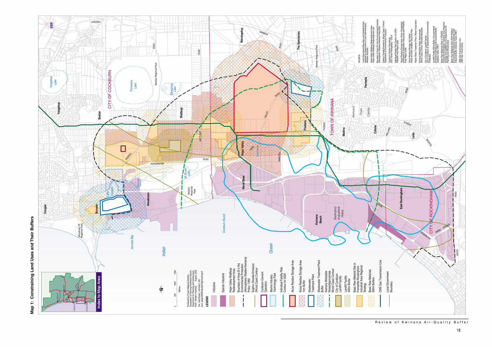
The range of land uses and their associatedemissions, including appropriate buffers,which pose a constraint to development withinand adjacent to the Kwinana EPP buffer areaare set out on Map 1 along with the existingKwinana EPP buffer boundary. These landuses are described below and depicted onMap 1:
• Kwinana Industrial Area – this area isthe primary industrial area for WesternAustralia, containing a variety ofindustries such as the BP Oil Refineryand the Kwinana Power Station. Theindustries produce a range of emissionsincluding particulates, sulphur dioxide,odour and noise.
A review of the area extent of maximumground-level concentrations of sulphurdioxide arising from emissions from KIAindustries and Cockburn Cement hasbeen undertaken. This review wasbased on a conservative review ofseveral sets of scenarios detailingmodel output for emissions. Thescenarios represent maximum emissionsat which the ground-level concentrationsare about to exceed the Kwinana EPPstandard. The result of this review, whichis shown in Map 1, indicates that thelikely extent of ground-levelconcentration “footprint” caused bymaximum sulphur dioxide emissionsfrom the KIA and Cockburn Cement isgenerally well within the boundaries ofthe current Kwinana EPP buffer,touching the boundary at three “pinchpoints”, while natural gas is thepreferred fuel.
The determination of the exact spatialextent of impacts from dust and odourfrom the KIA is difficult due to a lack ofdetailed monitoring of each of theseemissions. However, based on
R e v i e w o f K w i n a n a A i r - Q u a l i t y B u f f e r
8
complaints data, the impact of theseemissions appears to be confined to theareas immediately adjacent to the KIAand certainly within the boundaries ofthe Redevelopment Area. Recent dataon cumulative noise emissions from theKIA developed by the KwinanaIndustries Council indicates that thesouthern portion of the buffer is subjectto elevated noise levels from industry.
The manufacture and transport of arange of materials in the KIA also createa level of risk. The risk contour outlinesthe unacceptable risk area for a fullydeveloped KIA to the year 2020.
• Alcoa Residue Storage Area - theactive RSA occupies approximately 380hectares of land immediately north ofAnketell Road. The operation associatedwith the residue storage can lead to off-site emissions of dust and noise.Consequently, these operations requireseparation from sensitive uses such asresidential development. A one-kilometre indicative buffer has beenassigned in the draft Jandakot StructurePlan (WAPC, 2001) to protect sensitiveuses. As this extends well beyond theexisting Kwinana EPP buffer boundaryon the eastern and southern area of theRSA, a more detailed examination of theextent of off site impacts associated withthe RSA is needed in order to determinethe extent of any buffer required for thesite. In addition, consideration of longterm management and land usestrategies are needed.
• Cockburn Cement – this manufacturingfacility is located in the northern part ofthe Kwinana EPP buffer area and wasintegral to the definition of the KwinanaEPP buffer boundary owing to emissionsof sulphur dioxide and dust. The currentoperations of the plant contributeemissions of dust and noise thatgenerally require maintenance of the
existing buffer around the facility. Thereis however some limited scope forrationalisation of the boundaries of thebuffer in the vicinity of the facility toprovide better alignment with cadastralboundaries. Due to ongoing communityconcerns, an independent audit of themanagement and regulation ofemissions from the facility has recentlybeen completed. This audit has made anumber of recommendations aimed atimproving the regulation, monitoring andmanagement of emissions fromCockburn Cement’s operations. Animplementation plan for theserecommendations is currently beingdeveloped by DEP in response to thefindings of the audit.
• Basic Raw Material Areas – a numberof extraction and resource areas existwithin the Kwinana EPP buffer for sandand limestone. These areas requireprotection as they provide key rawmaterials for development of the region.A 500m generic buffer is recommendedfor quarries of this type in EPA DraftGuidance No.3 Industrial – ResidentialBuffer Areas (Separation Distances)(EPA, 1997), in order to minimise conflictbetween the quarry and sensitive landuses.
• Henderson Landfill – the City ofCockburn operates a landfill site in adisused quarry in the Hendersonlocality. Landfill sites are a potentialsource of noise, dust and odour. Inorder to minimise the potential for landuse conflict, a 500m generic buffer isrecommended for the facility.
• Gas Pipeline – CMS Energy’s high-pressure gas transmission pipeline islocated in the Kwinana EPP buffer. Thepipeline has a level of risk associatedwith it and requires a buffer fromsensitive uses. The level of risk variesdepending upon the characteristics of
R e v i e w o f K w i n a n a A i r - Q u a l i t y B u f f e r
9
the pipe, pressure, burial depth andlevel of activity within the pipelineeasement. Thus, the required buffer canvary from 30m-100m.
• Kwinana Motorplex – this facilitygenerates high levels of noise whenoperating, which extends some distancefrom the facility, depending upon themeteorological conditions at the time.The approximate worst-case noisecontour, which was modelled for thefacility, as it applies to the area withinthe boundaries of the Kwinana EPP, isshown on Map 1.
• Wastewater Treatment Plants – thereare two wastewater treatment plantsoperating in the area, Woodman Pointand Kwinana, with an additional plantproposed for Rockingham in comingyears. The plants can produceobjectionable odour. Given the size ofthe Woodman Point Treatment Plant, theWater Corporation has historicallyidentified a 750m buffer between theplant and sensitive land uses. As aresult of this, affected private land to thenorth-east of the plant has beenretained in an Urban Deferred zoningunder the Metropolitan Region Scheme.Following recent major upgrade worksat Woodman Point, the WaterCorporation is to undertake a detailedodour definition study to determine thelong-term buffer required for the facility.It is anticipated that this work will becompleted over the next 12 months. TheKwinana plant has a 500m-buffer owingto its smaller capacity.
Proposed Changes toKwinana BufferBoundary
The results of this review provide two clearoutcomes for the Kwinana buffer. Firstly, thereview highlights the multi-purpose nature ofthe buffer – the buffer is really a composite ofa number of planning and environmentalconstraints, rather than simply a sulphurdioxide buffer. While this has long beenrecognised, it is clear from this review that it isimportant that the buffer be established as anintegrated land use and environmental buffer,and supported via a combination of planningand environmental instruments, rather than viathe Kwinana EPP. The concept of a ResidentialExclusion Area (REA) to support the requiredbuffer is seen as an alternative approach inthis regard.
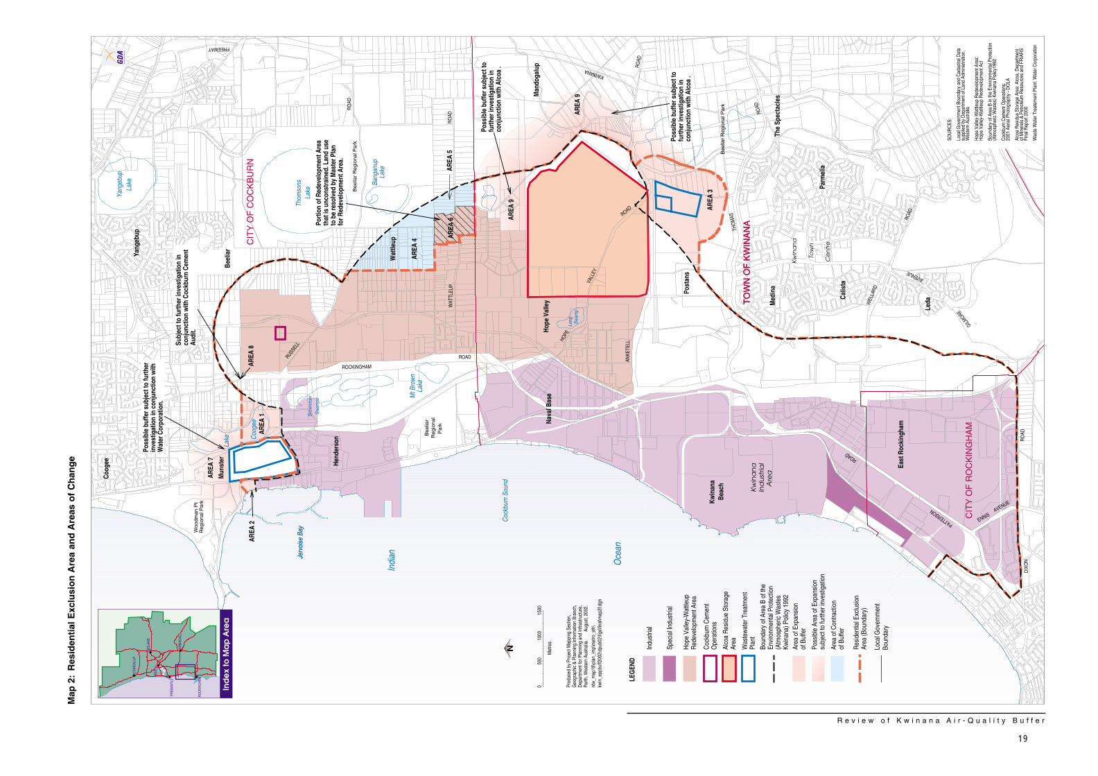
Secondly, this review has identified that thereare several areas in which the boundaries ofthe buffer alignment can be modified in orderto represent more properly the extent of thevarious environmental and planningconstraints. Six areas have been identifiedwhere changes to the Kwinana EPP buffer arerecommended, three areas where theboundary should expand and three areaswhere the boundary could contract (see Map 2).
In addition, there are three areas where thereview identifies environmental and planningconstraints that require more detailedinvestigation to determine the extent of thebuffer required to manage the constraints(Map 2). The final alignment of the REA in thevicinity of these areas will be determinedfollowing these investigations.
It is considered appropriate and equitable forthe REA (shown on Map 2) to be defined bythe composite of existing and proposedindustrial and commercial land uses and their
R e v i e w o f K w i n a n a A i r - Q u a l i t y B u f f e r
10
associated buffers. The REA will guideplanning decisions that will define theboundaries of zoning, lots and land useaccordingly.
Generally, the REA reflects the outer limit ofthe buffer for the significant land uses andimpacts in the area. While much of the area isaffected by more than one land use orenvironmental constraint, some of the REA isdefined by only one, albeit significant,constraint such as the KIA (sulphur dioxide,risk), the buffer from the Cockburn Cementoperation (dust, noise), or wastewatertreatment plants (odour). In their own rightthese justify a buffer but are complemented tovarying degrees by other less significant landuses such as extraction of basic raw materialsand the Kwinana Motorplex that, for variousreasons, are not considered to be of suchsignificance to define the REA by themselves.
Proposed Expansions
The three areas of proposed expansion of thebuffer are:
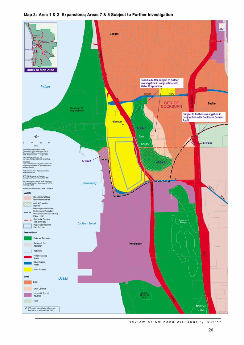
Area 1 Land in the vicinity of the MarineIndustry Technology Park (MITP) (seeMap 3).
Land to contain the Marine IndustryTechnology Park (MITP) is mostlywithin the existing Kwinana EPP bufferboundary. Nevertheless, MetropolitanRegion Scheme Amendment No.991/33 (South West Districts Omnibus(No. 3B) (WAPC, 2000) zoned theland Urban in the MRS, as this zoningwas considered more suitable thanthe Industrial zone for the proposedMITP. Land use associated with theMITP will be commercial/lightindustrial in nature and will becompatible with the REA. To reflect
the principles outlined for redefiningthe Kwinana buffer, all of the MITParea should be included in the REA.
Area 2 Lot 15 Cockburn Road, Munster (see Map 3)
Lot 15 at the northern extremity of theJervoise Bay shipbuilding area iszoned Industrial but not within theKwinana EPP buffer. This lot shouldbe included in the REA owing to itszoning.
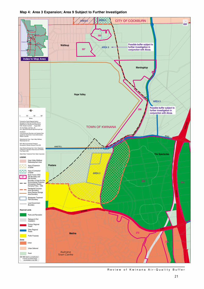
Area 3 Land within the 500m buffer for theKwinana wastewater treatment plant(see Map 4).
The wastewater treatment plantwarrants a 500m buffer asappropriate for this activity. As set outby the guiding principles of thereview, this buffer should also becontained in the REA. Lots affectedby the wastewater treatment plantbuffer are owned by Alcoa or inpublic ownership.
Proposed Contractions
The review proposes three areas of contractionof the buffer. Having regard to the principlesand criteria for the definition of the REA, it isconcluded that these areas of land do notneed to be included in the REA. Nevertheless,they will serve to provide a transition betweenthe industry and associated developmentwithin the REA and the surrounding land uses,which are sensitive to the industrial uses suchas the Beeliar Regional Park and futureresidential development to the east.
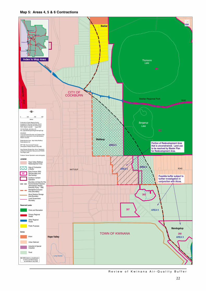
Area 4 Land bounded by Power Avenue,Dalison Avenue and the existingKwinana EPP buffer boundary (seeMap 5).
R e v i e w o f K w i n a n a A i r - Q u a l i t y B u f f e r
11
Comprising about 110ha, this areaaffects about 76 privately owned lotsand contains lots of about 1ha and2ha, which are not serviced by areticulated water supply service.Further intensification of subdivision inthis area would be contrary toproviding a transition area and furtherwould not be supported because:
• Lots of less than 2ha in area would need to be provided with a reticulated water service in accordance with WAPC policy.
• Lots of less than 1ha in area would need to be zoned Special Residential and would need substantial pre-planning and the full range of urban utilities and services (eg schools, sewerage) which would not be economically viable in this area.
Accordingly, while Area 4 can beremoved from the existing buffer area,further subdivision would not besupported. Nevertheless, it isenvisaged that Area 4 would remainzoned Rural in the MRS but zonedRural-Residential in the localgovernment town planning scheme toreflect and confirm the current densityand character of land use.
Rural zoned land to the north of Area4, which is currently outside of thebuffer, should continue to remainrural/rural-residential in nature in orderto ensure a suitable land useinterface between the RedevelopmentArea/REA and Regional Open Spaceto the east.
Area 5 Land in the vicinity of the intersectionof Wattleup and Mandogalup Roads(see Map 5).
This area comprises about 34ha andaffects about 13 privately owned lots
of about 2.8ha each. Area 5 iseffectively the current transitionbetween the Redevelopment Areaand future urban development to theeast (as defined by the westernextremity of the MRS Urban Deferredzoning adjacent). This area may be asuitable extension to the adjacentfuture urban cell advocated by theUrban Expansion Policy Statement forthe Perth Metropolitan Region (DPUD,1990), the draft Jandakot StructurePlan and the City of Cockburn'sSouthern Suburbs District StructurePlan. However, given Area 5 would bethe interface between futuredevelopment in the RedevelopmentArea and the urban cell to the east,precise definition of the land use forArea 5 should not occur until theMaster Plan for the RedevelopmentArea is finalised and further progressof the planning for the adjacent urbancell.
Area 6 Land within the Redevelopment Areawest of Mandogalup Road (see Map 5).
Area 6 is within the RedevelopmentArea but is not affected by any off-siteimpacts that constrain sensitivedevelopment. In accordance with theHope Valley-Wattleup RedevelopmentAct, the land will remain within theRedevelopment Area. AlthoughFRIARS identifies this land for futureindustrial development, the MasterPlan for the Redevelopment Areamay:
• identify that this area is not neededfor industrial purposes and would be better utilised for non-industrial uses;
• identify that the land should be developed for industrial or commercial purposes; or
R e v i e w o f K w i n a n a A i r - Q u a l i t y B u f f e r
12
• conclude that the use of this land cannot or would not need to be determined for a number of years, in order to have regard for progress of the Redevelopment Project and future data about demands for industrial land.
It is anticipated that the Master Planwill protect existing use rights. Theoutcomes of this review and use ofArea 6 will be considered via theMaster Plan and its approval by theMinister for Planning andInfrastructure, as required by theRedevelopment Act.
Areas Requiring FurtherInvestigation
The review has identified three areas in whichfurther changes to the buffer could beconsidered. More detailed investigations orstudies are however required prior todetermining the extent of changes required.These areas are as follows:
Area 7 Buffer for the Woodman Point WasteWater Treatment Plant (see Map 3).
The wastewater treatment plant is aservice utility that is ancillary tosurrounding industrial development(existing and future). As such, theWater Corporation has indicatedagreement to the Woodman PointPlant being included in the REA,consistent with the outlined principles.
The wastewater treatment plantcreates off-site impacts onsurrounding land and it would bedesirable to incorporate the buffer forthese impacts into the REA. As theimpacts affect privately owned land tothe north-east of the plant, the WaterCorporation has recently completedimprovements the operation of this
plant to reduce its impacts.Accordingly, the Water Corporationwill undertake a detailed odourdefinition study (commencing early in2003) to define the extent of theimpacts and the new buffer requiredfor the plant. The results of this studywill provide the most up to dateinformation for consideration ofincorporating a buffer for the plantinto the REA for the long term.
In the meantime, the REA will notinclude a buffer for this plant anddevelopment of land that may beaffected by the impacts of the plantcan be managed via the currentzoning of that land. Most of theaffected land is either zonedIndustrial and Urban Deferred orreserved Public Purposes or Parksand Recreation in the MRS. It isenvisaged the Urban Deferred zoningwould be retained until the odourstudy is completed.
Area 8 Land near the corner of RockinghamRoad and Frobisher Avenue (see Map 3).
This land is currently within the EPPbuffer and has been zoned as UrbanDeferred in the MRS on the basis ofits location within the buffer.Immediately adjacent land outside ofthe buffer has been zoned for urbandevelopment, while land to the southwithin the buffer has been zoned forthe Marine Industry Technology Park.This has created a small area of land,which remains constrained in terms ofland use. The potential exists for thealignment of the buffer to be slightlyadjusted in this area to align withcadastral boundaries in order toprovide for a more practical planningoutcome for this land. A final decisionon the alignment of the buffer as itrelates to this land should however be
R e v i e w o f K w i n a n a A i r - Q u a l i t y B u f f e r
13
deferred pending the implementationof the key recommendations of therecent independent audit of themanagement of emissions fromCockburn Cement.
Area 9 Buffer for the Alcoa Residue StorageArea (see Map 4).
The RSA is ancillary to the AlcoaKwinana Refinery and has off-siteimpacts from dust and noise.Although the WAPC’s draft JandakotStructure Plan (WAPC, 2001) depictsa 1 km buffer to protect sensitive landuses from off site impacts during theoperational life of the RSA, it isproposed that further detailedinvestigations are undertaken tobetter define the extent of the impactsfrom the operation of the facility. Thiswork should also examine the longterm management practices appliedto dust and noise emissions, andidentify mechanisms to ensureequitable outcomes for privatelandowners affected by anyexpansion of the buffer in this area.Until this work is completed thecurrent EPP buffer line will be retainedin proximity to the RSA.
Implementation
It is envisaged that the REA as depicted onMap 2 would be implemented through threecomplementary mechanisms – revisions to thecurrent Kwinana EPP, the Hope Valley-Wattleup Master Plan, and a proposedStatement of Planning Policy (SPP). Furtherdetail on each of these implementationmechanisms is as follows:
Environmental ProtectionPolicy
As outlined previously, the EPA flagged thepotential for changes to the Kwinana EPPboundary and framework for Kwinana inrenewing the Kwinana EPP in 1999. Theoutcomes of this current review, if adopted,could require changes to the boundary of AreaB (buffer) specified within the Kwinana EPP, asit currently exists. Given the current stage ofdevelopment of the State Air EPP, it isappropriate that any changes to the bufferboundary be incorporated into the processassociated with the State Air EPP.
Regardless of the framework adopted for theKwinana EPP, the need for industry to continueto adopt a continuous improvement approachto off-site emissions remains critical, in order toensure that impacts from industrial land usesare contained within the revised buffer area,and that the extent of impacts from industryare reduced over time.
Hope Valley-Wattleup MasterPlan
The Master Plan will provide a co-ordinatedand consistent approach to the managementof land use within a considerable portion of theproposed buffer area. It is critical that theMaster Plan ensures the delivery of land uses,
R e v i e w o f K w i n a n a A i r - Q u a l i t y B u f f e r
14
which are compatible with the range ofconstraints that apply within the area, as wellas maintaining off-site impacts from land usewithin the Master Plan area to within the REA.
Statement of Planning Policy
It would be appropriate for the REA andadjacent Rural zoned land to becomplemented by an SPP, to describe theland use planning responses to theenvironmental and planning constraints of thearea. An SPP is prepared by the WAPC andadopted pursuant to section 5AA of the TownPlanning and Development Act 1928. Localgovernments must have “due regard” to anSPP in the preparation and amendment oftown planning schemes.
It is envisaged that the SPP for this areawould:
• confirm the WAPC’s position on land useand subdivision within the area;
• reflect the recommended changes tothe Kwinana EPP buffer;
• ensure that the impacts of future landuse and development on land within theREA are contained within this area; and
• set out any specific detailed provisionsthat may be necessary to achieve theSPP objectives.
In respect of planning for the RedevelopmentArea, it is considered that this review does notwarrant a deviation from the recommendationsof FRIARS. Therefore, in order to enablepreparation of the Master Plan for theRedevelopment Area to continue withconfidence, it is recommended that the SPPspecify that the Master Plan for theRedevelopment Area should continue to beguided by the Act and FRIARS, having regardto the findings of this review.
The SPP would be able to ensure that theWAPC's consideration of planning proposals inand adjacent to the REA has particular regardto the range of land uses and impacts thatmay affect any given proposal. This measurecould also apply to local government’sconsideration of planning proposals in andadjacent to the REA, perhaps by way ofrequiring inclusion of specific provisions in therelevant town planning schemes.
R e v i e w o f K w i n a n a A i r - Q u a l i t y B u f f e r
15
Conclusion
The Review has identified the need toacknowledge that the Kwinana EPP buffer areais affected by not only sulphur dioxideemissions as identified by the DEP but alsovarious other land uses, constraints and theirbuffers (including waste water treatmentplants, basic raw materials areas, landfill sites,various infrastructure). This review thereforeestablishes principles and a process forredefining the buffer and recommends a newcomposite buffer to be called the ResidentialExclusion Area (REA). The REA is designed toprotect residents from emissions from theindustrial and ancillary land uses in the areaand also to protect industry from encroachingresidential development, which may threatentheir operations. In line with this, a key landuse objective within the REA is to restrictadditional residential use. Although existingresidential land uses would remain, they wouldbe treated as non-conforming uses, with apresumption against new residentialdevelopment.
The REA proposes to alter the existingKwinana buffer by:
• expanding it in three areas (the MarineIndustry Technology Park, KwinanaWaste Water Treatment Plant and Lot 15Cockburn Road, Henderson);
• contracting it in three areas (land to theeast of Power Ave and land in thevicinity of the intersection of Wattleupand Mandogalup Roads); and
• identifying three areas where furtherinvestigation is required beforeexpansions and contractions in thesethree areas are further contemplated(buffers for the Woodman Point WasteWater Treatment Plant and the AlcoaResidue Storage Area and land at thecorner of Rockingham Road andFrobisher Avenue).
The development of the State Air EPP willincorporate the outcomes of this review as itrelates to the management of air quality withinthe Kwinana airshed. The EPP is proposed tobe supplemented by a land use planningbuffer via a Statement of Planning Policy to beprepared by the Western Australian PlanningCommission. Also, the Master Plan for theHope Valley-Wattleup Redevelopment Areabeing prepared by LandCorp will play animportant role in responding to the review andthe range of constraints within a large portionof the REA.
Submissions on this review will be used in thedevelopment of the above mechanisms.
The need for periodic review of the boundariesand framework for the REA is also highlightedin order to take account of changingcircumstances associated with land use andenvironmental constraints affecting the areaover time.
R e v i e w o f K w i n a n a A i r - Q u a l i t y B u f f e r
16
References
Department of Conservation and Environment(1982). The Kwinana Air Modelling Study1978-1982.
City of Cockburn (1999). Southern SuburbsDistrict Structure Plan.
Department of Planning and UrbanDevelopment (1990). Urban Expansion PolicyStatement for the Perth Metropolitan Region.Perth, Western Australia.
Environmental Protection Authority (1997).Draft Industrial Buffer Distances Table.
ERM Mitchell McCotter (1999). KwinanaInternational Motorplex, Public EnvironmentalReview. Prepared for the Western AustralianSports Centre Trust.
Metropolitan Region Planning Authority (1980).A planning strategy for the south-westcorridor: based on 1974 report by T.S.Martinand Associates and further studies: publishedfor discussion.
National Environment Protection Council(1998). National Environment ProtectionMeasure for Ambient Air Quality.
State Planning Commission (1988). KwinanaRegional Strategy.
Western Australian Planning Commission(2000). Fremantle-Rockingham Industrial AreaRegional Strategy. Final Report.
Western Australian Planning Commission(2000). Metropolitan Region SchemeAmendment No. 991/33 (South West DistrictsOmnibus (No. 3B).
Western Australian Planning Commission(2001). Jandakot Structure Plan: For PublicComment October 2001.
R e v i e w o f K w i n a n a A i r - Q u a l i t y B u f f e r
17
Indi
an
Oce
an
Coc
kbur
n So
und
TO
WN
OF
KW
INA
NA
CIT
Y O
F R
OC
KIN
GH
AM
CIT
Y O
F C
OC
KB
UR
N
Nava
l Bas
eHo
pe V
alle
y
Wat
tleup
Kw
ina
na
Beel
iar
Med
inaPo
stan
s
Calis
ta
Man
doga
lup
Leda
East
Roc
king
ham
Coog
ee
RUSSEL
L
ANKE
TELL
THO
MAS
WEL
LARD
GILMOR
E
DIX
ON
ENNIS
KWINANA
FREEWAY
ROCKINGHAM
WAT
TLEU
P
Bee
liar
Ind
ust
rial
Are
a
Bee
liar
Reg
iona
l Par
k
Bee
liar
Reg
iona
l Par
k
Hend
erso
n
Reg
iona
l P
ark
RO
AD
RO
AD
AVENUE
Kwin
ana
Beac
h
The
Spec
tacl
es
RO
AD
Yang
ebup
La
ke
Lake
Coo
gee Br
ownm
anSw
amps
Mt B
row
nLa
ke
Long
Sw
amp
Bang
anup
Lake
Thom
sons
La
ke
Yang
ebup
Parm
elia
Kw
ina
na
Tow
n
Ce
ntr
e
ROAD
ROAD
PATTERSON
Woo
dman
Pt
Reg
iona
l Par
k
Jerv
oise
Bay
AVENUE
GEOC
ENTR
IC D
ATUM
OF
AUST
RALI
A
0
Met
res
LEG
END
N
1500
1000
500
JOO
ND
ALU
P
MID
LAN
D
PER
TH
FREM
ANTL
E
ARM
ADAL
E
RO
CKI
NG
HAM
�
�
�
�
�
�
Loca
l Gov
ernm
ent
Boun
dary
RO
AD
HOPE
ROAD
VALL
EY
ROAD
ROAD
Prod
uced
by
Proj
ect M
appi
ng S
ectio
n,G
eogr
aphi
c &
Plan
ning
Info
rmat
ion
Bran
ch,
Dep
artm
ent f
or P
lann
ing
and
Infra
stru
ctur
e,Pe
rth, W
este
rn A
ustra
lia.
Augu
st, 2
002.
ntw
_map
18\p
lan_
imp\
met
ro_s
th\
kwin
_epp
buff2
002\
dpub
02\fi
gs\fi
nal\m
ap1f
Was
tew
ater
Tr
eatm
ent P
lant
Coc
kbur
n C
emen
t O
pera
tion
Indi
vidu
al F
atal
ity R
isk
Con
tour
for 2
020
Kwin
ana
Mot
orpl
ex
Noi
se(A
ppro
xim
ate
Wor
st C
ase)
Con
tour
City
of C
ockb
urn
Land
fill F
acilit
y
Sulp
hur D
ioxi
de E
mis
sion
(Wor
st C
ase)
Con
tour
Indu
stria
l
Spec
ial I
ndus
trial
Land
fill F
acilit
y50
0m B
uffe
r
Was
tew
ater
Tre
atm
ent P
lant
Buffe
r
Alco
a R
esid
ue S
tora
ge A
rea
1km
Buf
fer
Alco
a R
esid
ue S
tora
ge A
rea
Mar
ine
Indu
stry
Tech
nolo
gy P
ark
Mun
ster
Ind
ex
to M
ap
Are
a
Basi
c R
aw M
ater
ial S
ite in
Frem
antle
-Roc
king
ham
Indu
stria
l Are
a R
egio
nal
Stra
tegy
Hop
e Va
lley-
Wat
tleup
Red
evel
opm
ent A
rea
CM
S G
as T
rans
mis
sion
Lin
e
Basi
c R
aw M
ater
ials
500m
Buf
fers
Boun
dary
of A
rea
B in
the
Envi
ronm
enta
l Pro
tect
ion
(Atm
osph
eric
Was
tes
Kwin
ana)
Polic
y -1
992
SOU
RC
E: Lo
cal G
over
nmen
t Bou
ndar
y an
d C
adas
tral D
ata
supp
lied
by D
epar
tmen
t of L
and
Adm
inis
tratio
n,
Wes
tern
Aus
tralia
Hop
e Va
lley-
Wat
tleup
Red
evel
opm
ent A
rea:
Hop
e Va
lley-
Wat
tleup
Red
evel
opm
ent A
ct Bo
unda
ry o
f Are
a B
in th
e En
viro
nmen
tal P
rote
ctio
n(A
tmos
pher
ic W
aste
s) K
win
ana
Polic
y199
2 Su
lphu
r Dio
xide
Em
issi
ons
(Wor
st C
ase)
Con
tour
:D
epar
tmen
t of E
nviro
nmen
tal P
rote
ctio
n C
ockb
urn
Cem
ent O
pera
tions
:20
01 A
eria
l Pho
togr
aphy
- D
OLA
Indi
vidu
al F
atal
ity R
isk
Con
tour
for 2
000:
FRIA
RS
Fina
l Rep
ort 2
000
Alco
a R
esid
ue S
tora
ge A
rea:
Alc
oa, D
epar
tmen
tof
Min
eral
s &
Petro
leum
Res
ourc
es a
nd F
RIA
RS
Fina
l Rep
ort 2
000
Alco
a R
esid
ue S
tora
ge 1
km B
uffe
r:Al
coa
and
draf
t Jan
dako
t Stru
ctur
e Pl
an W
aste
Wat
er T
reat
emen
t Pla
nt: W
ater
Cor
pora
tion
Kwin
ana
Mot
orpl
ex N
oise
(App
roxi
mat
eW
orst
Cas
e) C
onto
ur: K
win
ana
Mot
orpl
ex C
ity o
f Coc
kbur
n La
ndfil
l Fac
ility:
City
of C
ockb
urn
& D
epar
tmen
t of E
nviro
nmen
tal
Prot
ectio
n La
ndfil
l Fac
ility
500m
Buf
fer:
Envi
ronm
enta
lPr
otec
tion
Auth
ority
Dra
ft In
dust
rial B
uffe
rD
ista
nce
Tabl
e (1
997)
Basi
c R
aw M
ater
ials
Site
s in
FR
IAR
S:Fr
eman
tle-R
ocki
ngha
m In
dust
rial A
rea
Reg
iona
lSt
rate
gy a
nd u
pdat
ed b
y th
e D
epar
tmen
t for
Plan
ning
and
Infra
stru
ctur
e Ba
sic
Raw
Mat
eria
ls S
ites
500m
Buf
fers
:En
viro
nmen
tal P
rote
ctio
n Au
thor
ity D
raft
Indu
stria
l Buf
fer D
ista
nce
Tabl
e (1
997)
CM
S G
as T
rans
mis
sion
Lin
e:C
MS
Gas
Tra
nsm
issi
on
R e v i e w o f K w i n a n a A i r - Q u a l i t y B u f f e r
18
Map
1:
Co
nst
rain
ing
Lan
d U
ses
and
Th
eir
Bu
ffer
s
CIT
Y O
F R
OC
KIN
GH
AM
TO
WN
OF
KW
INA
NA
TO
WN
OF
KW
INA
NA
CIT
Y O
F C
OC
KB
UR
N
Oce
an
Nava
l Bas
eHo
pe V
alle
y
Wat
tleup
Kw
ina
na
Beel
iar
Med
ina
Post
ans
Calis
ta
Man
doga
lup
Leda
East
Roc
king
ham
Mun
ster
Coog
ee
RUSSEL
L
ANKE
TELL
THO
MAS
WEL
LARD
GILMORE
DIX
ON
ENNIS
KWINANA
FREEWAY
ROCKINGHAM
WAT
TLEU
P
Bee
liar
Ind
ust
rial
Are
a
Bee
liar
Reg
iona
l Par
k
Bee
liar
Reg
iona
l Par
k
Hend
erso
n Reg
iona
l P
ark
RO
AD
RO
AD
AVENUE
Kwin
ana
Beac
h
The
Spec
tacl
es
RO
AD
Yang
ebup
La
ke
Lake C
ooge
e
Brow
nman
Swam
ps
Mt B
row
nLa
ke
Bang
anup
Lake
Thom
sons
La
ke
Yang
ebup
Parm
elia
Kw
ina
na
Tow
n
Ce
ntr
e
ROAD
ROAD
PATTERSON
Woo
dman
Pt
Reg
iona
l Par
k
Jerv
oise
Bay
AVENUE
GEOC
ENTR
IC D
ATUM
OF
AUST
RALI
A
0
Met
res
N
1500
1000
500
Indu
stria
l
Spec
ial I
ndus
trial
AREA
7
AREA
4
AREA
9
AREA
9
AREA
3
Prod
uced
by
Proj
ect M
appi
ng S
ectio
n,G
eogr
aphi
c &
Plan
ning
Info
rmat
ion
Bran
ch,
Dep
artm
ent f
or P
lann
ing
and
Infra
stru
ctur
e,Pe
rth, W
este
rn A
ustra
lia.
A
ugus
t, 20
02.
Was
tew
ater
Tre
atm
ent
Plan
t
Coc
kbur
n C
emen
t O
pera
tions
Area
of E
xpan
sion
of
Buf
fer
Area
of C
ontra
ctio
n of
Buf
fer
Loca
l Gov
ernm
ent
Boun
dary
Jerv
oise
Bay
JOO
ND
ALU
P
MID
LAN
D
PER
TH
FREM
ANTL
E
ARM
ADAL
E
RO
CKI
NG
HAM
�
�
�
�
�
�
ROAD
Long
Sw
amp
Coc
kbur
n So
und
ROAD
ROAD
HOPE
VALL
EY
RO
AD
ntw
_map
18\p
lan_
imp\
met
ro_s
th\
kwin
_epp
buff2
002\
dpub
02\fi
gs\fi
nal\m
ap2f
.dgn
LEG
END
AREA
1
AREA
8
Porti
on o
f Red
evel
opm
ent A
rea
that
is u
ncon
stra
ined
. Lan
d us
eto
be
reso
lved
by
Mas
ter P
lan
for R
edev
elop
men
t Are
a.
AREA
5
AREA
2
AREA
6
Subj
ect t
o fu
rther
inve
stig
atio
n in
co
njun
ctio
n w
ith C
ockb
urn
Cem
ent
Audi
t.
Poss
ible
buf
fer s
ubje
ct to
furth
er in
vest
igat
ion
inco
njun
ctio
n w
ith A
lcoa
.
Poss
ible
buf
fer s
ubje
ct to
furth
er in
vest
igat
ion
inco
njun
ctio
n w
ith A
lcoa
.
Poss
ible
buf
fer s
ubje
ct to
furth
erin
vest
igat
ion
in c
onju
nctio
n w
ithW
ater
Cor
pora
tion.
Res
iden
tial E
xclu
sion
Ar
ea (B
ound
ary)
Alco
a R
esid
ue S
tora
ge
Area
Indi
an
Hop
e Va
lley-
Wat
tleup
Red
evel
opm
ent A
rea
Boun
dary
of A
rea
B of
the
Envi
ronm
enta
l Pro
tect
ion
(Atm
osph
eric
Was
tes
Kwin
ana)
Pol
icy
1992
Poss
ible
Are
a of
Exp
ansi
onsu
bjec
t to
furth
er in
vest
igat
ion
Ind
ex
to M
ap
Are
a
SOU
RC
ES:
Loca
l Gov
ernm
ent B
ound
ary
and
Cad
astra
l Dat
a su
pplie
d by
Dep
artm
ent o
f Lan
d Ad
min
istra
tion,
W
este
rn A
ustra
lia H
ope
Valle
y-W
attle
up R
edev
elop
men
t Are
a:H
ope
Valle
y-W
attle
up R
edev
elop
men
t Act
Boun
dary
of A
rea
B in
the
Envi
ronm
enta
l Pro
tect
ion
(Atm
osph
eric
Was
tes)
Kw
inan
a Po
licy1
992
Coc
kbur
n C
emen
t Ope
ratio
ns:
2001
Aer
ial P
hoto
grap
hy -
DO
LA Al
coa
Res
idue
Sto
rage
Are
a: A
lcoa
, Dep
artm
ent
of M
iner
als
& Pe
trole
um R
esou
rces
and
FR
IAR
SFi
nal R
epor
t 200
0 W
aste
Wat
er T
reat
emen
t Pla
nt: W
ater
Cor
pora
tion
R e v i e w o f K w i n a n a A i r - Q u a l i t y B u f f e r
19
Map
2:
Res
iden
tial
Exc
lusi
on
Are
a an
d A
reas
of
Ch
ang
e
R e v i e w o f K w i n a n a A i r - Q u a l i t y B u f f e r
20
CITY OFCOCKBURN
AREA 7
AREA 2
AREA 8
Subject to further investigation in conjunction with Cockburn CementAudit.
AREA 1
Possible buffer subject to furtherinvestigation in conjunction withWater Corporation.Indian
Ocean
Beeliar
Munster
Coogee
RUSSELL
RO
CKIN
GH
AM
Beeliar
Henderson
Regional Park
ROAD
Lake
Coogee
BrownmanSwamps
Mt BrownLake
RO
AD
Woodman PtRegional Park
Jervoise Bay
GEOCENTRIC DATUM OF AUSTRALIA
LEGEND
FREM
ANTLE
RO
CKIN
GH
AM
HIGHWAY
NB: MRS detail is a simplification of Zones and
Reserved Lands
Parks and Recreation
Waterways
Public Purposes
Zones
Urban Deferred
Urban
Rural
MAYOR ROAD
Cockburn Sound
0
Metres
N
200 400 600
Produced by Project Mapping Section,Geographic & Planning Information Branch,Department for Planning and Infrastructure,Perth, Western Australia. August 2002
JOONDALUP
MIDLAND
PERTH
FREMANTLE
ARMADALE
ROCKINGHAM
�
�
�
�
�
�
ntw-map18\plan_imp\metro_sth\kwin_eppbuff2002\dpub02\figs\final\map3f.dgn
Index to Map Area
SOURCES:Local Government Boundary and Cadastral Data supplied by Department of Land Administration, Western Australia Redevelopment Area: Hope Valley-WattleupRedevelopment Act EPP 1992: Environmental Protection(Atmospheric Wastes) Kwinana Policy1992 Alcoa Residue Storage Area: Alcoa, Departmentof Minerals & Petroleum Resources and FRIARSFinal Report 2000 Waste Water Treatement Plant: Water Corporation
Residential ExclusionArea (Boundary)Wastewater TreatmentPlant Boundary
Area of Expansionof Buffer
Railways & PortInstallation
Primary RegionalRoads
Other RegionalRoads
Industrial & SpecialIndustrial
Hope Valley-WattleupRedevelopment Area
Boundary of Area B in theEnvironmental Protection(Atmospheric Wastes Kwinana)Policy - 1992
Reservations as amended to July 2002
Map 3: Area 1 & 2 Expansions; Areas 7 & 8 Subject to Further Investigation
R e v i e w o f K w i n a n a A i r - Q u a l i t y B u f f e r
21
268
269 270
267
393
272
272Urban
Possible buffer subject tofurther investigation in conjunction with Alcoa.
Possible buffer subject tofurther investigation in conjunction with Alcoa.
TOWN OF KWINANA
Medina
Postans
THOMAS
The Spectacles
ROAD
KWIN
ANA
FREE
WAY
ANKETELL
Hope Valley
Wattleup
Mandogalup
ROAD
0
Metres
LEGEND
N
Reserved Lands
Parks and Recreation
Public Purposes
Zones
Urban Deferred
Rural
200 400 600
Produced by Project Mapping Section,Geographic & Planning Information Branch,Department for Planning and Infrastructure,Perth, Western Australia. August 2002
Area of Expansion of Buffer
Wastewater Treatment Plant Boundary
Railways & Port Installation
Primary Regional Roads
Other Regional Roads
NB: MRS detail is a simplification of Zones and Reservations
Local Government Boundary
AREA 3
GEOCENTRIC DATUM OF AUSTRALIA
JOONDALUP
MIDLAND
PERTH
FREMANTLE
ARMADALE
ROCKINGHAM
�
�
�
�
�
�
AREA 9
AREA 9
Area of Contraction of Buffer
ntw-map18\plan_imp\metro_sth\kwin_eppbuff2002\dpub02\figs\final\map4f.dgn
AREA 6 AREA 5
Residential ExclusionArea (Boundary)Alcoa Residue StorageArea Boundary
KwinanaTown Centre
as amended to July 2002
267Bush Forever 2000 Site Boundary andSite Number
Index to Map Area
CITY OF COCKBURN
SOURCES:Local Government Boundary and Cadastral Data supplied by Department of Land Administration, Western Australia Redevelopment Area: Hope Valley-WattleupRedevelopment Act EPP 1992: Environmental Protection(Atmospheric Wastes) Kwinana Policy1992 Alcoa Residue Storage Area: Alcoa, Departmentof Minerals & Petroleum Resources and FRIARSFinal Report 2000 Waste Water Treatement Plant: Water Corporation
Hope Valley-WattleupRedevelopment Area
Boundary of Area B of theEnvironmental ProtectionAtmospheric WastesKwinana) Policy - 1992
Map 4: Area 3 Expansion; Area 9 Subject to Further Investigation
R e v i e w o f K w i n a n a A i r - Q u a l i t y B u f f e r
22
391
393
267
268
392
TOWN OF KWINANA
JOONDALUP
MIDLAND
PERTH
FREMANTLE
ARMADALE
ROCKINGHAM
�
�
�
�
�
�
GEOCENTRIC DATUM OF AUSTRALIA
Hope Valley
Wattleup
Beeliar
Mandogalup
RUSSELL
RO
CKIN
GH
AM
WATTLEUP
Beeliar Regional ParkROAD
ROAD
Long Swamp
BanganupLake
Thomsons Lake
RO
AD
LEGEND
Reserved Lands
Parks and Recreation
Public Purposes
Zones
Urban Deferred
Rural
Area of Contraction of Buffer
Primary Regional Roads
Other Regional Roads
NB: MRS detail is a simplification of Zones and Reservations
Local Government Boundary
Urban
Industrial & Special Industrial
Cockburn CementOperation
AREA 6
AREA 9
AREA 9
Residential ExclusionArea (Boundary)
Alcoa Residue StorageArea Boundary
CITY OFCOCKBURN
Index to Map Area
Bush Forever 2000 Site Boundary andSite Number
267
AREA 4Portion of Redevelopment Areathat is unconstrained. Land useto be resolved by Master Planfor Redevelopment Area.
AREA 5
Possible buffer subject tofurther investigation inconjunction with Alcoa.
as amended to July 2002
0
Metres
N
200 400 600
Produced by Project Mapping Section,Geographic & Planning Information Branch,Department for Planning and Infrastructure,Perth, Western Australia. August 2002
ntw-map18\plan_imp\metro_sth\kwin_eppbuff2002\dpub02\figs\final\map5f.dgn
SOURCES:Local Government Boundary and Cadastral Data supplied by Department of Land Administration, Western Australia Redevelopment Area: Hope Valley-WattleupRedevelopment Act EPP 1992: Environmental Protection(Atmospheric Wastes) Kwinana Policy1992 Alcoa Residue Storage Area: Alcoa, Departmentof Minerals & Petroleum Resources and FRIARSFinal Report 2000 Cockburn Cement Operations: aerial photography
Hope Valley-WattleupRedevelopment Area
Boundary od Area B of theEnvironmental Protection(Atmospheric WastesKwinana} Policy - 1992
Map 5: Areas 4, 5 & 6 Contractions