Embed Size (px)
Citation preview
Restoration Plan Gaudin Creek A
July 13th, 2011
Page 1 of 11
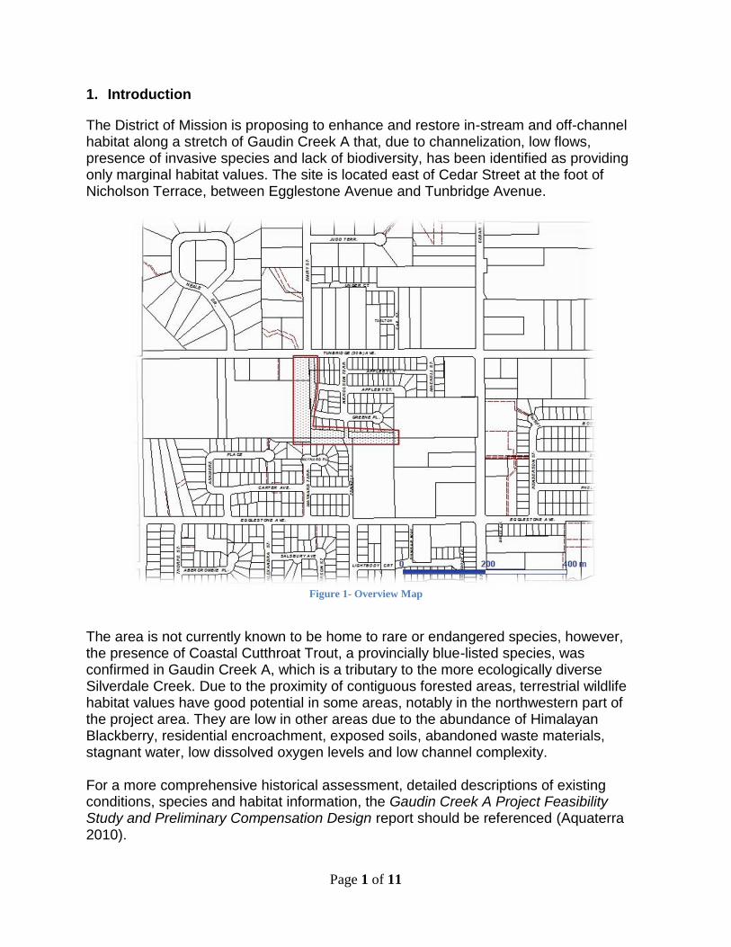
1. Introduction
The District of Mission is proposing to enhance and restore in-stream and off-channel habitat along a stretch of Gaudin Creek A that, due to channelization, low flows, presence of invasive species and lack of biodiversity, has been identified as providing only marginal habitat values. The site is located east of Cedar Street at the foot of Nicholson Terrace, between Egglestone Avenue and Tunbridge Avenue.
Figure 1- Overview Map
The area is not currently known to be home to rare or endangered species, however, the presence of Coastal Cutthroat Trout, a provincially blue-listed species, was confirmed in Gaudin Creek A, which is a tributary to the more ecologically diverse Silverdale Creek. Due to the proximity of contiguous forested areas, terrestrial wildlife habitat values have good potential in some areas, notably in the northwestern part of the project area. They are low in other areas due to the abundance of Himalayan Blackberry, residential encroachment, exposed soils, abandoned waste materials, stagnant water, low dissolved oxygen levels and low channel complexity. For a more comprehensive historical assessment, detailed descriptions of existing conditions, species and habitat information, the Gaudin Creek A Project Feasibility Study and Preliminary Compensation Design report should be referenced (Aquaterra 2010).
Page 2 of 11
2. Purpose
The proposed restoration project is intended to provide partial compensation for 12.6 hectares of habitat lost due to development, as required by the Cedar Valley Environmental Management Plan (CVEMP). The CVEMP serves as a memorandum of understanding between the District of Mission (DOM) and Fisheries and Oceans Canada (FOC) and was devised in 2005 for a 10-year term. The CVEMP identifies habitat that is to be removed as part of development and compensated for by paying the District $25/m2 of habitat removed. The money collected is then utilized to fund compensation projects. This is the first project that DOM and FOC have agreed to undertake. This project plan sets out the restoration plan components. Projected numbers and species of plants and trees, as well as amounts of topsoil and gravel may be subject to minor modifications, as may be necessitated by field conditions as the project proceeds. 3. Project Area
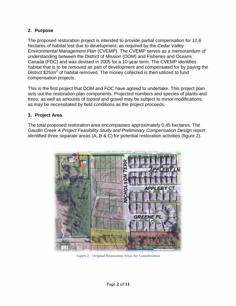
The total proposed restoration area encompasses approximately 0.45 hectares. The Gaudin Creek A Project Feasibility Study and Preliminary Compensation Design report identified three separate areas (A, B & C) for potential restoration activities (figure 2).
Figure 2 – Original Restoration Areas for Consideration
Page 3 of 11
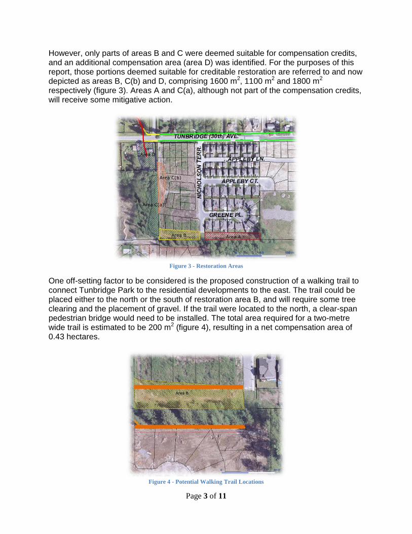
However, only parts of areas B and C were deemed suitable for compensation credits, and an additional compensation area (area D) was identified. For the purposes of this report, those portions deemed suitable for creditable restoration are referred to and now depicted as areas B, C(b) and D, comprising 1600 m2, 1100 m2 and 1800 m2 respectively (figure 3). Areas A and C(a), although not part of the compensation credits, will receive some mitigative action.
Figure 3 - Restoration Areas
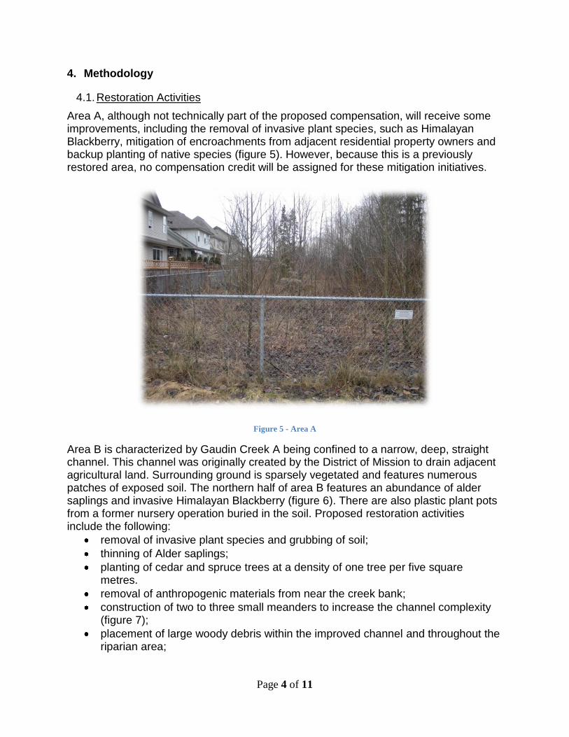
One off-setting factor to be considered is the proposed construction of a walking trail to connect Tunbridge Park to the residential developments to the east. The trail could be placed either to the north or the south of restoration area B, and will require some tree clearing and the placement of gravel. If the trail were located to the north, a clear-span pedestrian bridge would need to be installed. The total area required for a two-metre wide trail is estimated to be 200 m2 (figure 4), resulting in a net compensation area of 0.43 hectares.
Figure 4 - Potential Walking Trail Locations
Page 4 of 11
4. Methodology
4.1. Restoration Activities
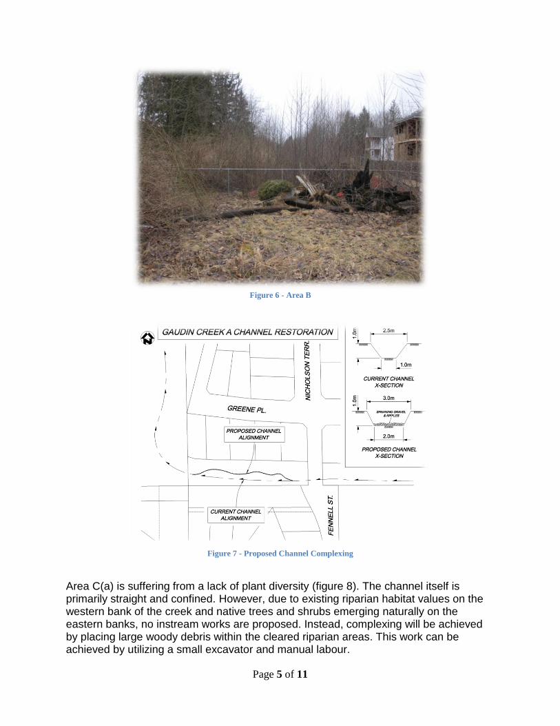
Area A, although not technically part of the proposed compensation, will receive some improvements, including the removal of invasive plant species, such as Himalayan Blackberry, mitigation of encroachments from adjacent residential property owners and backup planting of native species (figure 5). However, because this is a previously restored area, no compensation credit will be assigned for these mitigation initiatives.
Figure 5 - Area A
Area B is characterized by Gaudin Creek A being confined to a narrow, deep, straight channel. This channel was originally created by the District of Mission to drain adjacent agricultural land. Surrounding ground is sparsely vegetated and features numerous patches of exposed soil. The northern half of area B features an abundance of alder saplings and invasive Himalayan Blackberry (figure 6). There are also plastic plant pots from a former nursery operation buried in the soil. Proposed restoration activities include the following:
removal of invasive plant species and grubbing of soil;
thinning of Alder saplings;
planting of cedar and spruce trees at a density of one tree per five square metres.
removal of anthropogenic materials from near the creek bank;
construction of two to three small meanders to increase the channel complexity (figure 7);
placement of large woody debris within the improved channel and throughout the riparian area;
Page 5 of 11
Figure 6 - Area B
Figure 7 - Proposed Channel Complexing
Area C(a) is suffering from a lack of plant diversity (figure 8). The channel itself is primarily straight and confined. However, due to existing riparian habitat values on the western bank of the creek and native trees and shrubs emerging naturally on the eastern banks, no instream works are proposed. Instead, complexing will be achieved by placing large woody debris within the cleared riparian areas. This work can be achieved by utilizing a small excavator and manual labour.
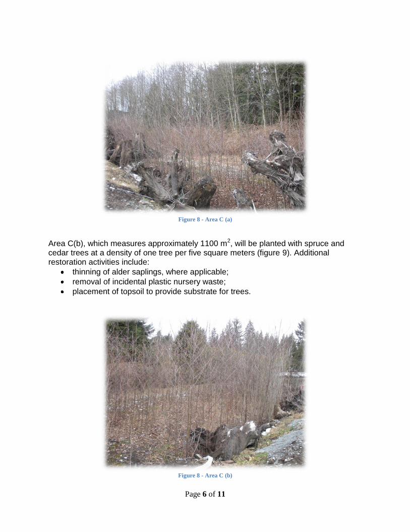
Page 6 of 11
Figure 8 - Area C (a)
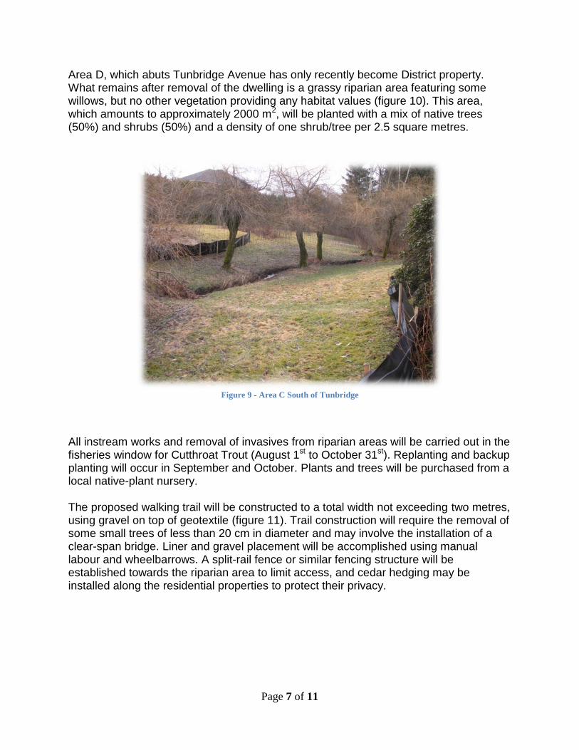
Area C(b), which measures approximately 1100 m2, will be planted with spruce and cedar trees at a density of one tree per five square meters (figure 9). Additional restoration activities include:
thinning of alder saplings, where applicable;
removal of incidental plastic nursery waste;
placement of topsoil to provide substrate for trees.
Figure 8 - Area C (b)
Page 7 of 11
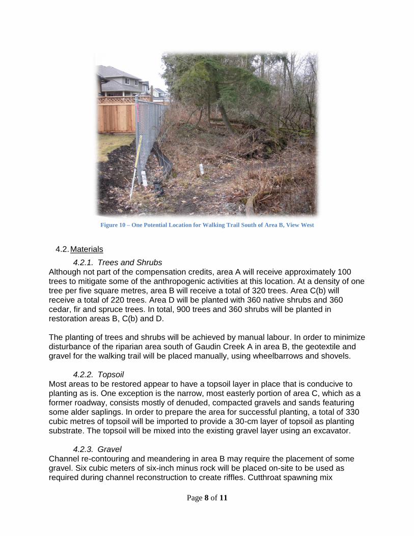
Area D, which abuts Tunbridge Avenue has only recently become District property. What remains after removal of the dwelling is a grassy riparian area featuring some willows, but no other vegetation providing any habitat values (figure 10). This area, which amounts to approximately 2000 m2, will be planted with a mix of native trees (50%) and shrubs (50%) and a density of one shrub/tree per 2.5 square metres.
Figure 9 - Area C South of Tunbridge
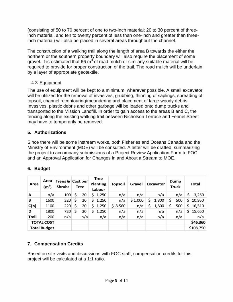
All instream works and removal of invasives from riparian areas will be carried out in the fisheries window for Cutthroat Trout (August 1st to October 31st). Replanting and backup planting will occur in September and October. Plants and trees will be purchased from a local native-plant nursery. The proposed walking trail will be constructed to a total width not exceeding two metres, using gravel on top of geotextile (figure 11). Trail construction will require the removal of some small trees of less than 20 cm in diameter and may involve the installation of a clear-span bridge. Liner and gravel placement will be accomplished using manual labour and wheelbarrows. A split-rail fence or similar fencing structure will be established towards the riparian area to limit access, and cedar hedging may be installed along the residential properties to protect their privacy.
Page 8 of 11
Figure 10 – One Potential Location for Walking Trail South of Area B, View West
4.2. Materials
4.2.1. Trees and Shrubs Although not part of the compensation credits, area A will receive approximately 100 trees to mitigate some of the anthropogenic activities at this location. At a density of one tree per five square metres, area B will receive a total of 320 trees. Area C(b) will receive a total of 220 trees. Area D will be planted with 360 native shrubs and 360 cedar, fir and spruce trees. In total, 900 trees and 360 shrubs will be planted in restoration areas B, C(b) and D. The planting of trees and shrubs will be achieved by manual labour. In order to minimize disturbance of the riparian area south of Gaudin Creek A in area B, the geotextile and gravel for the walking trail will be placed manually, using wheelbarrows and shovels.
4.2.2. Topsoil Most areas to be restored appear to have a topsoil layer in place that is conducive to planting as is. One exception is the narrow, most easterly portion of area C, which as a former roadway, consists mostly of denuded, compacted gravels and sands featuring some alder saplings. In order to prepare the area for successful planting, a total of 330 cubic metres of topsoil will be imported to provide a 30-cm layer of topsoil as planting substrate. The topsoil will be mixed into the existing gravel layer using an excavator.
4.2.3. Gravel Channel re-contouring and meandering in area B may require the placement of some gravel. Six cubic meters of six-inch minus rock will be placed on-site to be used as required during channel reconstruction to create riffles. Cutthroat spawning mix
Page 9 of 11
(consisting of 50 to 70 percent of one to two-inch material; 20 to 30 percent of three-inch material, and ten to twenty percent of less than one-inch and greater than three-inch material) will also be placed in several areas throughout the channel. The construction of a walking trail along the length of area B towards the either the northern or the southern property boundary will also require the placement of some gravel. It is estimated that 66 m3 of road mulch or similarly suitable material will be required to provide for proper construction of the trail. The road mulch will be underlain by a layer of appropriate geotextile.
4.3. Equipment
The use of equipment will be kept to a minimum, wherever possible. A small excavator will be utilized for the removal of invasives, grubbing, thinning of saplings, spreading of topsoil, channel recontouring/meandering and placement of large woody debris. Invasives, plastic debris and other garbage will be loaded onto dump trucks and transported to the Mission Landfill. In order to gain access to the areas B and C, the fencing along the existing walking trail between Nicholson Terrace and Fennel Street may have to temporarily be removed. 5. Authorizations
Since there will be some instream works, both Fisheries and Oceans Canada and the Ministry of Environment (MOE) will be consulted. A letter will be drafted, summarizing the project to accompany submissions of a Project Review Application Form to FOC and an Approval Application for Changes in and About a Stream to MOE.
6. Budget
Area Area
(m2)
Trees &
Shrubs
Cost per
Tree
Tree
Planting
Labour
Topsoil Gravel ExcavatorDump
TruckTotal
A n/a 100 20$ 1,250$ n/a n/a n/a n/a 3,250$
B 1600 320 20$ 1,250$ n/a 1,000$ 1,800$ 500$ 10,950$
C(b) 1100 220 20$ 1,250$ 8,560$ n/a 1,800$ 500$ 16,510$
D 1800 720 20$ 1,250$ n/a n/a n/a n/a 15,650$
Trail 200 n/a n/a n/a n/a n/a n/a n/a n/a
$46,360
$108,750
TOTAL COST
Total Budget
7. Compensation Credits
Based on site visits and discussions with FOC staff, compensation credits for this project will be calculated at a 1:1 ratio.
Page 10 of 11
8. Communication Plan
An outline of the proposed activities will be communicated to District staff who may receive questions from the public via e-mail. A copy of this restoration plan will be attached. In addition, letters will be sent to home owners in the area, particularly residents immediately adjacent to the restoration site, explaining the activities, before commencement of any work.
Residents who are located adjacent to one of the potential trail delineations will be sent a letter soliciting their feedback before commencement of tree clearing or construction. Council will be informed of the feedback received to guide its final decision on the trail location, and residents will be notified of the Council meeting date on which this matter will be discussed.
Residents who have extended their yards into area A will also be requested to remove any of their personal belongings and non-native plantings from the area and remove or secure any gates that were added to the existing chain link fence.
9. Environmental Management During Works
All works are scheduled to be carried out during dry conditions within the fisheries window for Cutthroat Trout, when the channel is completely dry. As such, no fish salvage will be required, however, erosion control measures will include the placement of straw and coco mats nonetheless. Since the site is a previously disturbed site, and no species at risk were identified by the Aquaterra study, these measures are considered to be adequate to prevent damage to habitat and wildlife.
All equipment will be maintained in leak-free condition, and fuel will be stored a minimum of 30 metres from any wetted areas. Spill kits will be kept on-site at all times while equipment is working at the site.
10. Personnel
District staff will supervise contractors and monitor all activities, including channel relocation, tree clearing and invasives removal, trail building and placement of large woody debris. Planting will be carried out by volunteers or District staff under the direction of District staff.
11. References
Gaudin Creek A Project Feasibility Study and Preliminary Compensation Design; Aquaterra Biological Consulting; Chris Lee, Byron Kirkham; Project No. 2010047; November 2010
Cedar Valley Environmental Management Plan; District of Mission, Department of Fisheries and Oceans; June 2005