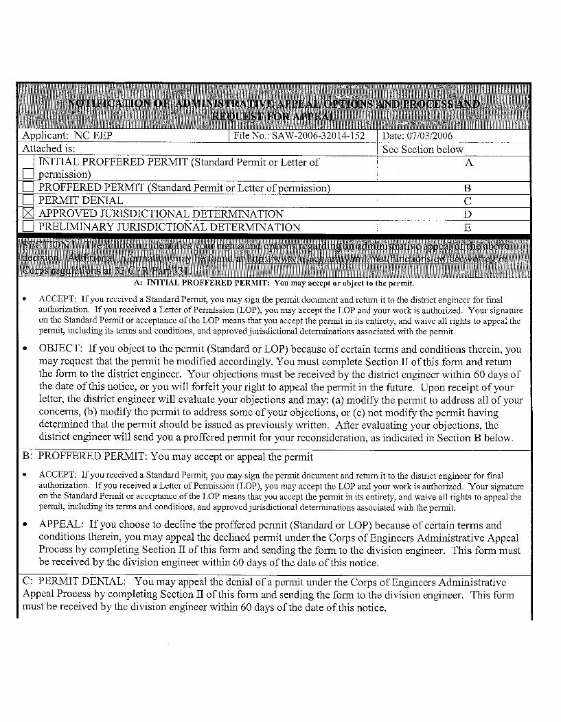
Embed Size (px)
Citation preview

BROCK STREAM RESTORATION
FINAL RESTORATION PLAN
Jones County, North Carolina SCO Project Number 050650601
Prepared for: North Carolina Ecosystem Enhancement Program
1652 Mail Service Center Raleigh, NC 27699-1652
Status of Plan: Final Submission Date: July 28, 2006

Prepared by:
Stantec Consulting Services Inc 801 Jones Franklin Road, Suite 300
Raleigh, NC 27606

Brock Stream Restoration Page i Jones County, North Carolina July 2006
EXECUTIVE SUMMARY
The Brock Restoration Site was discovered during the Lower and Middle Neuse Wetland and Stream Mitigation Site Search conducted by the North Carolina Department of Transportation (NCDOT) in 2001. The northern Jones County site is located approximately 12 miles southeast of Kinston, North Carolina. The Restoration Plan presented here includes the restoration of an unnamed tributary to Big Chinquapin Branch and its riparian buffer, as well as buffer restoration adjacent to Big Chinquapin Branch, and the preservation of a portion of the relic Coastal Plain Bottomland Hardwood Forest along an old oxbow of Big Chinquapin Branch.
Restoration of a degraded stream system to a stable condition leads to improvements in the aquatic and terrestrial communities that depend on it. Big Chinquapin Branch is a major tributary to the Trent River and both systems are nutrient sensitive waters (NCDWQ, 1998). The proposed plan will provide important benefits by improving the biological integrity of the stream system, reducing impacts from surrounding nutrient runoff, reducing downstream sedimentation, increasing dissolved oxygen, moderating pH levels, and moderating water temperatures of the stream through shading by the surrounding buffer.
The United States Army Corps of Engineers (USACE and NCDWQ, 2005) recently released a new draft mitigation guidance document related to stream restoration in the outer Coastal Plain of North Carolina. The new guidance, developed in cooperation with the North Carolina Division of Water Quality (NCDWQ), addresses mitigation credits for headwater streams. Many natural headwater streams and wetlands in the Coastal Plain were historically channelized for agricultural purposes. A number of these channels, including the channel on the Brock Restoration Site, are eroding and lack functionality and habitat. While many of these areas would benefit from restoration, traditional natural channel design with pattern and profile has been determined to be inappropriate for all coastal headwater streams. The driving factor behind the new guidance is that it is difficult to discern the original condition of these first order channels: whether they were historically intermittent streams or headwater wetlands. Emphasis is now being placed on restoring habitat and floodplain functionality to these types of channels. The Brock Restoration Site is one of the first Ecosystem Enhancement Program projects to fall under the new guidelines.
Using Rosgen classification (Rosgen, 1996), the existing channel is classified as a G5, which is narrow and deep. The stream system will be restored using Priority 3 restoration, which involves excavation of a new bankfull bench near the existing channel elevation. The bankfull bench will be constructed entirely on the east side of the channel to minimize construction costs and avoid disturbing a cemetery located onsite. The restored stream channel will classify as an E5 channel with a sinuosity less than 1.05. Wetlands are expected to form within portions of the newly created bankfull bench, especially in the more downstream section of the project where backwater from Big Chinquapin Branch will affect the stream.
The Brock Restoration Site is located in an area of intense agricultural land use. The proposed restoration plan will reforest riparian buffer along the restored floodplain. An upland riparian buffer will also be reforested along a portion of Big Chinquapin Branch. The buffer restoration will reconnect existing forested buffers along Big Chinquapin Branch and provide a wooded corridor for

Brock Stream Restoration Page ii Jones County, North Carolina July 2006
wildlife. By reforesting a mosaic of vegetative communities, local biological diversity will be increased. The buffer will also intercept overland flow from a swale draining the agricultural fields on the Brock property. Buffer reforestation at this site will reduce the input of nutrients from the fields to the waters downstream of the unnamed tributary to Big Chinquapin Branch, designated as nutrient sensitive waters by NCDWQ. The Brock Restoration Site offers the potential to:
• Restore 1,850 linear feet of stream
• Restore 6.88 acres of riparian buffer
• Preserve 0.52 acres of riparian buffer

Brock Stream Restoration Page iii Jones County, North Carolina July 2006
Table of Contents
Executive Summary .......................................................................................................................................i 1.0 Project Site Location .........................................................................................................................1
1.1 Directions To Project Site .........................................................................................................1 1.2 USGS HUC and NCDWQ River Basin Designations...............................................................1 1.3 Project Vicinity Map .................................................................................................................1
2.0 Watershed Characterization ..............................................................................................................2
2.1 Drainage Area............................................................................................................................2 2.2 Surface Water Classification / Water Quality ...........................................................................2 2.3 Physiography, Geology and Soils..............................................................................................2 2.4 Historical Land Use and Development Trends..........................................................................2 2.5 Protected Species.......................................................................................................................2
2.5.1 Red-cockaded woodpecker (Picoides borealis) ....................................................................3 2.5.2 American Alligator (Alligator mississippiensis) ...................................................................3 2.5.3 Federal Species of Concern...................................................................................................4
2.6 Cultural Resources ....................................................................................................................4 2.7 Potential Constraints..................................................................................................................4
2.7.1 Property Ownership and Boundary .......................................................................................4 2.7.2 Site Access ............................................................................................................................5 2.7.3 Utilities ..................................................................................................................................5 2.7.4 Cemetery ...............................................................................................................................5 2.7.5 Drain Tiles.............................................................................................................................5 2.7.6 FEMA / Hydrologic Trespass................................................................................................5
3.0 Project Site Streams...........................................................................................................................6
3.1 Channel Classification...............................................................................................................6 3.2 Discharge...................................................................................................................................7 3.3 Channel Morphology.................................................................................................................8 3.4 Channel Stability Assessment ...................................................................................................8 3.5 Vegetation .................................................................................................................................8
4.0 Reference Streams.............................................................................................................................9 5.0 Project Site Wetlands ........................................................................................................................9
5.1 Jurisdictional Wetlands .............................................................................................................9 5.2 Hydrological Characterization ..................................................................................................9 5.3 Soil Characterization .................................................................................................................9 5.4 Plant Community Characterization .........................................................................................10
6.0 Project Site Restoration Plan...........................................................................................................11
6.1 Restoration Project Goals and Objectives ...............................................................................11 6.1.1 Designed Channel Classification.........................................................................................12 6.1.2 Target Buffer Communities.................................................................................................13
6.2 Sediment Transport Analysis ..................................................................................................13 6.2.1 Methodology .......................................................................................................................13 6.2.2 Discussion ...........................................................................................................................13
6.3 HEC-RAS Analysis.................................................................................................................14 6.3.1 No-Rise, LOMR, CLOMR..................................................................................................14

Brock Stream Restoration Page iv Jones County, North Carolina July 2006
6.3.2 Hydrologic Trespass............................................................................................................15 6.4 Soil Restoration .......................................................................................................................15 6.5 Natural Plant Community Restoration ....................................................................................15
6.5.1 Narrative & Plant Community Restoration .........................................................................15 6.5.2 On-site Invasive Species Management................................................................................16
7.0 Performance Criteria .......................................................................................................................16
7.1 Streams ....................................................................................................................................16 7.2 Vegetation ...............................................................................................................................16 7.3 Schedule & Reporting .............................................................................................................17
8.0 References .......................................................................................................................................19 9.0 Tables ..............................................................................................................................................21 Table 9.1 Restoration Structure and Objectives Table 9.2 Bankfull Cross-Sectional Areas and Discharge Table 9.3 Land Use of Watershed Table 9.4 Morphological Table Table 9.5 Shear Stress and Stream Power Analysis Table 9.6 Designed Vegetative Communities by Zone 10.0 Figures.............................................................................................................................................27 Figure 10.1 Project Site Vicinity Map Figure 10.2 Project Site Watershed Map Figure 10.3 Project Site NRCS Soil Survey Map Figure 10.4 Project Site Hydrological Features Map Figure 10.5 Project Site Wetland Delineation Map 11.0 Design Sheets ..................................................................................................................................35 Sheet 11.1. Existing Conditions Sheet 11.2. Plan View
Sheet 11.3. Planting Plan Sheet 11.4. HEC-RAS Analysis Sheet 11.5. Typical Section
12.0 Appendices......................................................................................................................................41 Appendix 1. Project Site Photographs
Appendix 2. Project Site Notification of Jurisdictional Determination and USACE Routine Wetland Determination Data Forms
Appendix 3. Project Site NCDWQ Stream Classification Forms Appendix 4. Project Site Biological Reconnaissance Form Appendix 5. HEC-RAS Analysis Appendix 6. Correspondence

Brock Stream Restoration Page 1 Jones County, North Carolina July 2006
1.0 Project Site Location
1.1 DIRECTIONS TO PROJECT SITE
The Brock Restoration Site is located approximately 12 miles southeast of Kinston, North Carolina (Figure 10.1) and lies in northern Jones County. From US 70 East in Kinston turn right on NC 58 and travel approximately 12 miles. The site is located on the left approximately three miles past the beginning of the Pine Street loop (SR 1301).
1.2 USGS HUC AND NCDWQ RIVER BASIN DESIGNATIONS
The Brock Restoration Site is located within the Neuse River Basin (NCDWQ Subbasin 03-04-11) and the United States Geological Survey (USGS) 14-digit Hydrologic Unit Code 03020204010060. The unnamed tributary to Big Chinquapin Branch is a perennial stream. The restoration reach begins at a 54-inch corrugated metal pipe under a farm path crossing. The channel flows in a northerly direction along the east side of a small cemetery, terminating at its confluence with Big Chinquapin Branch (Figure 10.2).
1.3 PROJECT VICINITY MAP
Kinston
Cove City
Dover
US 70
NC
5 8
Trenton
Big Chinquapin Branch
Beaver Creek
Vine Swamp
Trent River
Little Chinquapin Branch
Chi
nqua
pin
Cha
pel R
dLeno
ir C
ount
y
Jone
s C
ount
y
Craven County
Jones County
Fla t Sw
amp
Rattlesnake Branch
Southwest Creek (Kellys Pond)
Core Creek
Trac
ey S
wam
p
N E U
SE RIVER
Brock Project Site
Midd le RdP ine St
Wyse Fork Rd
Sta
te H
ighw
ay 4
1
Cobb R
d
British R
d
Old N
ew Bern Rd
�0 1 20.5 Miles
Brock Vicinity Map(see also Figure 10.1)
Local Roads
Major Roads
Railroads
County Boundary
Streams
Municipality
Site Boundary
Brock Stream Restoration Page 2 Jones County, North Carolina July 2006
2.0 Watershed Characterization
2.1 DRAINAGE AREA
The Brock Site is located on an unnamed tributary to Big Chinquapin Branch with a watershed of approximately 315 acres in size (Figure 10.2). A field verification of the watershed area delineated from the USGS topographic map was conducted on March 6, 2002.
2.2 SURFACE WATER CLASSIFICATION / WATER QUALITY
The unnamed stream is a tributary of Big Chinquapin Branch, which is classified as C Sw NSW from its source to the Trent River. The “Use Support Rating” has not been determined for this section of Big Chinquapin Branch.
2.3 PHYSIOGRAPHY, GEOLOGY AND SOILS
The project watershed is located in the eastern portion of the Coastal Plain Physiographic Province of North Carolina. Broad, flat interstream areas are the dominant topographic features of this province. Slopes are generally less than four percent. Elevations on the Brock Site range from approximately 39 to 52 feet above mean sea level. The soil survey for Jones County (Barnhill, 1981) indicates that the area is underlain by Goldsboro loamy sand, Grifton fine sandy loam, Lynchburg fine sandy loam, Muckalee loam, and Norfolk loamy sand. The watershed geology contains Tertiary Period material including the Comfort Member and New Hanover Member of the Castle Hayne Formation. The Comfort Member is Bryozoan-echinoid skeletal limestone with common solution cavities. The New Hanover Member is a thin, micritic phosphate-pebble conglomerate.
2.4 HISTORICAL LAND USE AND DEVELOPMENT TRENDS
The watershed is a mixture of forested lands, agricultural row crops, two-lane roadways, farm roads, cemeteries, minor culverts, and a few single-family homes (Table 9.3). Agricultural drainage features, including ditches and drain tile, have been constructed and maintained on the Brock and neighboring properties. The Brock Site and adjacent properties are utilized primarily for agricultural purposes. No zoning exists in this part of Jones County and little development is expected in the future.
2.5 PROTECTED SPECIES
Some populations of flora and fauna are in decline due to natural forces or their inability to coexist with human activities. Federal law (under the provisions of the Endangered Species Act of 1973, as amended) requires that any action likely to adversely affect a species classified as federally protected be subject to review by the United States Fish and Wildlife Service (USFWS). Other species may receive additional protection under separate state laws.

Brock Stream Restoration Page 3 Jones County, North Carolina July 2006
Letters were sent to the USFWS and the North Carolina Natural Heritage Program (NCNHP) on November 18, 2005 requesting comments on the project study area. A response letter dated November 29, 2005 was received from the NCNHP stating “The Natural Heritage Program has no record of rare species, significant natural communities, or priority natural areas at the site or within a mile of the project area” (Appendix 6).
Plants and animals with federal classifications of ‘endangered,’ ‘threatened,’ ‘proposed endangered,’ and ‘proposed threatened’ are protected under the provisions of Section 7 and Section 9 of the Endangered Species Act of 1973, as amended. The USFWS lists two federally protected species for Jones County, the red-cockaded woodpecker (Picoides borealis) and the American alligator (Alligator mississippiensis).
2.5.1 Red-cockaded woodpecker (Picoides borealis)
The federal and state status for the red cockaded woodpecker is ‘endangered.’ An endangered species is one whose continued existence as a viable component of the State’s fauna is determined to be in jeopardy. Red-cockaded woodpeckers (RCW) are mostly black and white birds with barred backs and wings and a large white cheek patch. Its habitat preference is wet pine flatwoods and pine savannas. The project watershed does not have trees of suitable age and size to support RCW cavities. The upper half of the watershed is forested, although according to North Carolina Gap Analysis Project (NCGAP) data, this area is predominantly pocosin woodlands and shrublands. These areas are not suitable for nesting due to the small size of the pine trees and/or the presence of hardwood species in the canopy or understory. Foraging is unlikely as there is a lack of open pine stands for suitable nesting habitat within half a mile of the watershed. This adjacent area contains regenerating pine stands, pine plantations, and Coastal Plain nonriverine wet flat forests which are unsuitable due to the small size of pine trees and/or the presence of hardwood species. NCNHP does not indicate any occurrences of RCWs within the project watershed or its vicinity and no individuals were observed during field surveys. Therefore, the Brock restoration will have no effect on the red-cockaded woodpecker.
2.5.2 American Alligator (Alligator mississippiensis)
The American alligator has a federal status of T(S/A), which denotes a species that is threatened due to similarity of appearance with other rare species and is listed for its protection. These species are not biologically endangered or threatened and are not subject to Section 7 consultation. The American alligator is listed as “threatened due to similar appearance” to provide protection to the American crocodile, a species which it closely resembles. The state status for the American alligator is ‘threatened.’ A threatened species is one that is likely to become an endangered species within the foreseeable future throughout all or a significant portion of its range. The American alligator is 6 to 17 feet long with a broadly rounded snout, distinguishing it from the American crocodile (Crocodylus aeutus). The American crocodile is a tropical species and is not found this far north of Florida. The American alligator inhabits fresh water swamps, marshes, abandoned rice fields, ponds, lakes, and backwaters of large rivers. Although its range once extended north in the coastal plain to the Dismal Swamp, the American alligator is now absent in the area north of the Albemarle Sound and in much of the upper coastal plain. Big Chinquapin Branch does not provide suitable habitat for the American alligator because it is typically found in larger streams and waterbodies further south. None have been observed in Big Chinquapin Branch during field visits. Therefore, the Brock restoration will have no effect on the American alligator.

Brock Stream Restoration Page 4 Jones County, North Carolina July 2006
2.5.3 Federal Species of Concern
‘Federal species of concern’ are not afforded federal protection under the Endangered Species Act and are not subject to any of its provisions, including Section 7, until they are formally listed or proposed as ‘threatened’ or ‘endangered.’ However, the status of these species is subject to change, and therefore should be included for consideration. A ‘federal species of concern’ is defined as a species that is under consideration for listing, but for which there is insufficient information to support its listing. In addition, organisms that are listed ‘endangered,’ ‘threatened,’ or of ‘special concern’ by the NCNHP list of Rare Plant and Animal Species, are afforded state protection under the N.C. State Endangered Species Act and the N.C. Plant Protection and Conservation Act of 1979.
As of November 2005, there are thirteen ‘federal species of concern’ listed by the USFWS for Jones County. There are three vertebrates, the Southern hog-nosed snake (Heterodon simus), the Carolina gopher frog (Rana capito capito), and the “Neuse” madtom (Notorus furiosus), and one invertebrate, the Croatan crayfish (Procambarus plumimanus). The other nine species are vascular plants including quillwort (Isoetes microvela), Carolina bogmint (Macbridea caroliniana), Carolina goldenrod (Solidago pulchra), Carolina spleenwort (Asplenium heteroresiliens), Chapman’s sedge (Carex chapmanii), Godfrey’s sandwort (Minuartia godfreyi), Savanna cowbane (Oxypolis ternate), Spring-flowering goldenrod (Solidago verna), and Venus flytrap (Dionea muscipula). None of these species were observed during site visits.
The Brock Restoration Site has potential to provide future habitat for some ‘federal species of concern’ such as the Southern hog-nosed snake, Croatan crayfish, and Carolina bogmint.
2.6 CULTURAL RESOURCES
The Brock Site consists of agricultural fields with no apparent historical or cultural significance. There is small cemetery on the west side of the project stream and is overgrown with vegetation. A letter of inquiry has been sent to the State Historic Preservation Office (SHPO) regarding the site and specifically the cemetery. A response was received on January 4, 2006 requesting an investigation of the Brock site because of its proximity to the Civil War Battle of Kinston. SHPO also recommended that the cemetery be evaluated by a professional architectural historian (Appendix 6). Subsequent discussions between the Federal Highway Administration and the Office of State Archeology resulted in the decision that an archeological survey would not be necessary for this project (Appendix 6).
2.7 POTENTIAL CONSTRAINTS
The landowner and the tenant farmer at the Brock Site were consulted on land use, proposed channel alignments, proposed vegetated buffers and the ability to incorporate restored stream system within the current and future land use constraints. A discussion of the various constraints is provided below.
2.7.1 Property Ownership and Boundary
The State has acquired a conservation easement from Ms. Clare Brock on the sections of her property selected for restoration. The conservation easement places mutually agreed upon restrictions on the

Brock Stream Restoration Page 5 Jones County, North Carolina July 2006
property deeds that will guide the use and management of the stream and its buffer areas, including the preservation of a portion of the Coastal Plain Bottomland Hardwood Forest and the buffer reforestation areas. After signing the easement, the property owners retain ownership, but agree to manage the property according to the restrictions. The easement remains with the property if it is sold or transferred and the new owner(s) will be required to honor the provisions of the conservation easement. NCEEP has been working with the primary landowner, Ms. Clare Brock, and the tenant farmer such that they are aware of the type of work and extent of the project’s area.
2.7.2 Site Access
Currently, the site is easily accessible from NC 58 via a dirt road on the adjacent property to the west. An agreement with Jean and Robert Tillett must be reached to use this access point for construction. An undeveloped 15’ ingress and egress easement is also present on the southeast portion of Clare Brock’s property. However, road access for construction equipment will need to be greatly improved.
2.7.3 Utilities
No utilities are known to exist within the project area.
2.7.4 Cemetery
A small cemetery with at least five gravesites is located on the west side of the stream channel. The cemetery is identified on an antique property map as “negro” cemetery. A site investigation found the cemetery overgrown with vegetation. Five headstones, dated between 1920 and 1955, were found in the southern portion of the 50 by 200 foot area marked as a cemetery. Photos of the headstones, as well as a map of the cemetery location, can be found in Appendix 6. The proposed bankfull bench is to be excavated on the east side of the channel away from the cemetery, therefore negative impacts by this restoration project are not expected.
2.7.5 Drain Tiles
At least two drain tiles are known to exist along the unnamed tributary. These drains were found during the jurisdictional wetland delineation on December 1, 2005. One of the drains is located on the adjacent property to the south and the other is located within the project reach downstream from the cemetery (Figure 10.4). Both drains were discharging water at the time of inspection. Additional drain tiles are likely located throughout the site. As the floodplain is widened during construction, these drains will be exposed and will require installation of floodplain interceptors to prevent future erosion.
2.7.6 FEMA / Hydrologic Trespass
A HEC-RAS analysis indicated that the proposed channel geometry would not increase the 100-year flood elevations within the project area. In fact, the analysis predicts reductions in the water surface elevation by 2.89 feet at the downstream end (HEC-RAS Section 37) of the project (Appendix 5). The HEC-RAS analysis is discussed further in section 6.3.

Brock Stream Restoration Page 6 Jones County, North Carolina July 2006
3.0 Project Site Streams
A field survey of the existing channel was completed on October 9, 2001. A detailed topographic survey of the Site was completed on November 15, 2001. Field survey measurements were gathered using the US Forest Service Technical Report RM-245 (Harrelson et al., 1994). Elevation measurements taken for the longitudinal profile and two cross-sections (one riffle and one pool) include, but were not limited to: thalweg, water surface, bankfull, low bank, and terrace. Measurements were also taken to calculate the bank slope, width of flood prone area, belt width, valley length, straight length, pool-to-pool spacing, and channel materials. The survey and data collection provided detailed existing conditions and identified design constraints (such as cemetery location) (Sheet 11.1).
The fluvial processes occurring have been causing instability and eroding banks. These trends may continue if the stream is not restored to a stable condition. The channel is also a pathway for nutrients from the surrounding agricultural areas to the nutrient sensitive waters of the Trent River. Impacts resulting from sediment and nutrient depositions will decrease once the channel and buffer are restored. Photographs of the channel are located in Appendix 1.
3.1 CHANNEL CLASSIFICATION
The restoration reach is shown on both the USGS Phillips Crossroads topographic quadrangle and the Soil Survey of Jones County (Barnhill, 1981). The channel is a first order stream. Regular maintenance (vegetation removal, channel bed material removal, and grade alteration) has created the current dimension, pattern, and profile. See Appendix 1 for photos of existing conditions.
The North Carolina Division of Water Quality (NCDWQ) stream classification method for determining ephemeral, intermittent, and perennial channels was utilized to evaluate the unnamed tributary to Big Chinquapin Branch. The jurisdictional determination was conducted on October 10, 2001 during an extended dry period. A score of 12.5 was recorded for the upstream portion of the channel between NC 58 and the Brock property, indicating that portions of the stream near NC 58 are potentially ephemeral. The existing channel at a point just downstream from NC 58 received a numerical score of 22.5, indicating it was at least an intermittent stream (Appendix 3).
Dave Penrose (NCDWQ), Leilani Paugh (NCDOT), and Lia Myott (Stantec) conducted a further evaluation on February 21, 2002, to determine if the existing channel was perennial or intermittent. Based on the aquatic fauna identified and the drainage basin size, the reach from the southern boundary of the Brock property to Big Chinquapin Branch was determined to be perennial. See Appendix 1 for photos of existing conditions and Appendix 4 for the Biological Reconnaissance Form.
It should be noted that coastal streams score lower on the NCDWQ stream classification evaluation than their mountain and piedmont counterparts. The form depends heavily on geomorphologic features (e.g. riffle and pool sequence) that are not always exhibited as strongly in smaller perennial and intermittent coastal plain streams when compared to non-coastal plain streams. The project site stream scored in the intermittent range, although after analyzing the aquatic fauna it was determined to be perennial.

Brock Stream Restoration Page 7 Jones County, North Carolina July 2006
Stream channels are classified using five criteria: width-to-depth ratio, entrenchment ratio, slope, sinuosity, and channel materials (Rosgen, 1996). Width-to-depth ratio is the ratio of the bankfull surface width to the mean depth of the bankfull channel. The ratio is an indication of the channel’s ability to dissipate energy and transport sediment. Entrenchment ratio is the vertical containment of the stream and the degree to which the channel is incised in the valley floor. Entrenchment ratio indicates the stream’s ability to access its floodplain. Flood-prone width divided by bankfull width yields the entrenchment ratio. The slope is the change in water surface elevation per unit of stream length. Slope can be analyzed over the entire reach to determine if the slope is stable within the existing channel material, or over sections to determine the condition of pools and riffles. Sinuosity is the ratio of stream length to valley length. Channels with low sinuosity in eastern North Carolina typically indicate a straightened channel. Channel bed and bank materials indicate the channel’s resistance to hydraulic stress and ability to transport sediment. All five of the criteria were used to determine the current condition of the channel.
Using Rosgen classification, the restoration reach is classified as a G5. The ‘G’ classification indicates that the channel is entrenched, and has a low width-to-depth ratio and sinuosity. The existing channel is approximately 20 feet wide at the top, 8 feet deep and 4 feet across at the bottom. The ‘5’ classification designates it as a predominantly sand bed channel. Areas of firm marine clay are apparent from the downcutting process. The existing channel data is presented in Table 9.4.
Stream flow fluctuates dramatically, from fast flowing and relatively deep water to no flow with water pooled only in scattered locations during drought conditions. Aquatic fauna observed in the channel during the field investigation included various minnow species, dragonfly and damselfly nymphs, and crayfish. In-stream habitat quality is poor due to agricultural maintenance practices, the lack of woody streambank vegetation, algal growth, lack of riffle-pool sequence, and temperature fluctuations. Only the most pollutant-tolerant species were present, further indicating poor water quality and/or habitat.
Bank height ratios describe the difference between the bankfull elevation and the lowest stream bank. Commonly, stable channels exhibit bank height ratios between 1.0 and 1.3; however, these numbers may increase based on stream classification and overall entrenchment. The existing bank height ratio at the Brock Site is 3.5 indicating that the stream is deeply incised. Additional information including pattern data for the existing channels can be found in Table 9.4.
3.2 DISCHARGE
Bankfull discharge is defined as the dominant channel forming flow that moves the most sediment over time (Rosgen, 1994). This generally equates to a 1.2 to 1.5 year storm event in North Carolina. Bankfull discharge is estimated using various methods. Coastal Plain Regional Curves developed by the Stream Restoration Institute at North Carolina State University were reviewed (NCSRI, 2004). These curves provide a graphical representation of bankfull discharge to drainage area. USGS regional regression methods for determining peak discharge were also examined (Pope et al., 2001). This method employs long-term gage data to develop equations based on hydro-physiographic region. Coastal plain regression equations were used to calculate various peak discharges for 2, 5, 10, 50 and 100-year events. A log-log plot of these discharges can then be extrapolated to determine the bankfull discharge. A third method to estimate bankfull discharge is based on channel morphology. Once bankfull areas and bed roughness were determined from field surveys, Manning’s equation is applied to calculate the mean velocity in the channel. This velocity is then multiplied by the channel area to determine the discharge. The existing

Brock Stream Restoration Page 8 Jones County, North Carolina July 2006
bankfull velocity is approximately 2.1 ft/s equating to a bankfull discharge of 20.8 ft³/s (Table 9.2). The calculated discharge compares well to the NCSU regional curves and the USGS regression method.
3.3 CHANNEL MORPHOLOGY
Bankfull width of the existing stream channel at the Brock Site is approximately 6.9 feet and bankfull depth is approximately 1.4 feet. The stream has a sinuosity of 1.06; however, due to past channel straightening, there are no radii to measure for radius of curvature ratios or meander length ratios. The width-to-depth ratio of 5.0 is moderate and the entrenchment ratio of 1.9 is moderately entrenched as expected for a G5 type stream. The Brock restoration site’s streambed material is sand dominated. Photographs of the existing stream channel are presented in Appendix 1. A complete morphological table for the existing stream channel is presented in Table 9.4.
The composition of the streambed and banks is an important facet of stream character, influencing channel form and hydraulics, erosion rates and sediment supply. The streambeds on the Brock Site were characterized using the modified Wolman Pebble Count (Rosgen, 1994). Pebble counts were taken at representative locations along each reach. The locations included both riffle and pool cross sections. The average d50 (50% of the sampled population is equal to or finer than the representative particle diameter) is less than 2.0 mm for the stream, which falls into the sand size category.
3.4 CHANNEL STABILITY ASSESSMENT
The existing channel on the Brock Site was analyzed for overall stability. This analysis included the morphological assessment as mentioned above, and calculations of shear stress and stream power. The existing channels exhibited average shear stresses of approximately 0.25 lb/ft2, which equates to a stream power of 0.41 lb/ft²/s. In a relatively flat, sand bed system such as the Brock Site, the stream power is slightly excessive. Shield’s curve indicates shear of this magnitude can move particles 45 mm in diameter. The largest particles found at the Brock Site are 30 mm. Field observations indicated bank erosion and attempted lateral migration of the channel. These indicators include sloughing banks, especially in locations of drain tiles, center bar formation and lateral bar formation. The proposed channel is designed to reduce the shear and stream power to an acceptable level capable of moving the largest particles but without degrading the channel.
3.5 VEGETATION
Vegetative communities present on the Brock Site include agricultural row crops, Coastal Plain Bottomland Hardwood Forest, and a Mesic Hardwood Forest. The majority of the Brock and surrounding properties are used for agricultural crop production. On the Brock Site, this land use covers approximately 87 acres. Cotton was the dominant crop noted during Fall 2001 and 2005. The natural communities on the site were identified based on the classification system established by Schafale and Weakley (1990). Restoration of the stream channel and riparian buffer will provide additional wildlife habitat for terrestrial and aquatic species where very little habitat existed before.
The historic forested riparian buffer has been replaced with a narrow grassy border and row crops that provide only limited thermal and chemical moderating effects. The channel banks are sparsely vegetated

Brock Stream Restoration Page 9 Jones County, North Carolina July 2006
by a variety of herbaceous species, while black willow (Salix nigra), Juncus spp. and Carex spp. grow in the wetter areas.
4.0 Reference Streams
Priority 3 stream restoration will be carried out on the unnamed tributary on the Brock Site. This will involve excavating a new bankfull bench but will not include restoring pattern to the stream. Reference reaches are not required for this methodology. Additional information is provided in section 6.0 of this report.
5.0 Project Site Wetlands
5.1 JURISDICTIONAL WETLANDS
The methods outlined in the US Army Corps of Engineers (USACE) Wetlands Delineation Manual (Environmental Laboratory, 1987) were used to delineate the jurisdictional wetlands on the Brock property (Appendix 2). Approximately 0.11 acres of existing wetlands are located in the former channel of Big Chinquapin Branch (Figure 10.5). The property line runs down the center of the old channel splitting the wetland area.
5.2 HYDROLOGICAL CHARACTERIZATION
Hydrology for the existing wetland comes primarily from large overbank flows from Big Chinquapin Branch, which still enter the old channel. Some surface runoff also contributes to the hydrology.
5.3 SOIL CHARACTERIZATION
The soil survey for Jones County (Barnhill, 1981) indicates Goldsboro loamy sand, Grifton fine sandy loam, Lynchburg fine sandy loam, Muckalee loam, and Norfolk loamy sand underlie the Restoration Site (Figure 10.3). According to the soil survey, the unnamed tributary and buffer area are underlain by Goldsboro, Muckalee and Norfolk soils. The only hydric soils found within the project vicinity during the field visits were located in the small Coastal Plain Bottomland Hardwood Forest in the northwest portion of the project area.
Goldsboro loamy sand is a moderately well drained soil found near drainageways in uplands. The soils formed in moderately fine textured sediment. Infiltration is moderate and runoff is slow. Slopes range from 0 to 2 percent. The seasonal high water table is below 2 or 3 feet. Goldsboro soils typically contain inclusions of hydric Muckalee soils. Goldsboro soils are fine-loamy, siliceous, thermic Aquic Paleudults. Goldsboro soils are mapped on the southern end of the property, primarily in the agricultural fields.

Brock Stream Restoration Page 10 Jones County, North Carolina July 2006
The Grifton series consists of very deep, poorly drained, moderately permeable soils on uplands, stream terraces, and floodplains in the Coastal Plain. The soils formed in loamy marine sediments and are underlain by alluvial marly sands and clays. Slopes range from 0 to 2 percent. The water table is at a depth of 0.5 to 1 foot below the ground surface from December to May. Grifton soils are fine-loamy, siliceous, thermic Typic Ochraqualfs and are classified as a hydric soil by the Natural Resources Conservation Service (NRCS). Grifton fine sandy loam is mapped along Big Chinquapin Branch where the riparian buffer will be planted connecting the Coastal Plain Bottomland Hardwood Forest to the Mesic Hardwood Forest. Wetland restoration is not feasible in this area because the water table has been lowered as a result of the channelization of Big Chinquapin Branch.
Lynchburg fine sandy loam is a very deep, somewhat poorly drained soil that forms in loamy marine sediments. Lynchburg soils are on low Coastal Plain areas, generally in shallow depressions or on broad interstream divides. Runoff is slow and permeability is moderately slow to moderate. The water table is typically at a depth of 0.5 to 1.5 feet from November to April. Lynchburg soils typically contain inclusions of hydric Rains soils. Lynchburg soils are fine-loamy, siliceous, thermic Aeric Paleaquults. Lynchburg soils are mapped on the Brock property outside of the project area.
Muckalee loam is a poorly drained soil found in level areas or drainageways. Infiltration is moderate and surface runoff is very slow. These wide flat areas are frequently flooded for brief periods and ponded in winter. The water table is at a depth of 0.5 to 1.5 feet. The NRCS classifies Muckalee loam as a hydric soil. Muckalee soils are coarse-loamy, siliceous, nonacid, thermic Typic Fluvaquents. Muckalee loam is mapped in the area of the Coastal Plain Bottomland Hardwood Forest on the northwest corner of the property.
Norfolk loamy sand is a well-drained soil found near major drainageways. Infiltration is moderate and surface runoff is medium. The seasonal high water table remains below 4 feet. Norfolk soils are fine-loamy, siliceous, thermic Typic Paleudults. Norfolk loamy sand is mapped along most of the stream channel on the property. Norfolk soils typically contain inclusions of hydric Muckalee soils.
5.4 PLANT COMMUNITY CHARACTERIZATION
The entire Brock property encompasses approximately 99 acres located between NC 58 and Big Chinquapin Branch. Vegetative communities present on the property include agricultural row crops, Coastal Plain Bottomland Hardwood Forest, and a Mesic Hardwood Forest. The conservation easement primarily contains agricultural row crops.
The Coastal Plain Bottomland Hardwood Forest community lies at the confluence of the unnamed tributary with Big Chinquapin Branch. This vegetative community encompasses nearly two acres. Historically, Big Chinquapin Branch followed a meandering path through this area. When Big Chinquapin Branch was channelized, one of the stream’s meanders was cut-off from the straightened mainstem. This area still supports a Coastal Plain Bottomland Hardwood Forest, which rarely floods because of the channelization of Big Chinquapin Branch. The dominant canopy tree species include American sycamore (Platanus occidentalis), sweetgum (Liquidambar styraciflua), ironwood (Carpinus caroliniana), red maple (Acer rubrum), water oak (Quercus nigra), and green ash (Fraxinus pennsylvanica). The understory is dominated by canopy species such as red maple and sweetgum. The shrub layer is dominated by box elder (Acer negundo) and sassafras (Sassafras albidum). The herbaceous

Brock Stream Restoration Page 11 Jones County, North Carolina July 2006
layer is dominated by jewel-weed (Impatiens capensis), Indian strawberry (Duchesnea indica), false nettle (Boehmeria cylindrica), giant cane (Arundinaria gigantea), lizard’s tail (Saururus cernuus), and panic grass (Panicum spp.). Standing water was noted in the old meander channel, which discharges into the unnamed tributary during periods of overbank flows from Big Chinquapin Branch.
This Coastal Plain Bottomland Hardwood Forest community is underlain by Muckalee loam. Based on the hydric soils listing of Muckalee, presence of hydrophytic vegetation, and hydrology this portion of the old channel is a wetland (Appendix 2). However, the United States Army Corps of Engineers (USACE) has not verified it as a wetland at this time. The existing wetland area encompasses a total of 0.11 acres, while less than half of that area is within the conservation easement. Photographs of the Coastal Plain Bottomland Hardwood Forest are located in Appendix 1.
The Mesic Hardwood Forest is located in the northeast portion of the Brock property outside the conservation easement. The canopy contains primarily red maple with tulip poplar (Liriodendron tulipifera), hackberry (Celtis laevigataI), American sycamore, and white oak (Quercus alba) interspersed among the maples. The understory contains saplings of the canopy species as well as American holly (Ilex opaca) and flowering dogwood (Cornus florida). Shrubs and vines include horsesugar (Symplocos tinctoria), giant cane, greenbrier (Smilax spp.), trumpet creeper (Campsis radicans) and poison ivy (Toxicodendron radicans). The sparse herbaceous layer includes Christmas fern (Polystichum acrostichoides), partridgeberry (Mitchella repens), and Carex spp. This community encompasses approximately ten acres.
6.0 Project Site Restoration Plan
The United States Army Corps of Engineers (USACE and NCDWQ, 2005) recently released a new draft mitigation guidance document related to stream restoration in the outer Coastal Plain of North Carolina. The new guidance, developed in cooperation with the North Carolina Division of Water Quality (NCDWQ), addresses mitigation credits for headwater streams. Many natural headwater streams and wetlands in the Coastal Plain were historically channelized for agricultural purposes. A number of these channels, including the channel on the Brock Restoration Site, are eroding and lack functionality and habitat. While many of these areas would benefit from restoration, traditional natural channel design with pattern and profile has been determined to be inappropriate for all coastal headwater streams. The driving factor behind the new guidance is that it is difficult to discern the original condition of these first order channels: whether they were historically intermittent streams or headwater wetlands. Emphasis is now being placed on restoring habitat and floodplain functionality to these types of channels. The Brock Restoration Site is one of the first Ecosystem Enhancement Program projects to fall under the new guidelines.
6.1 RESTORATION PROJECT GOALS AND OBJECTIVES
The health of a watershed is dependent on the quality of the headwater system(s), individual tributaries, and major channels. High quality tributaries with vegetated buffers filter contaminants, maintain moderate water temperatures, provide high quality aquatic and terrestrial habitat and regulate flows downstream.

Brock Stream Restoration Page 12 Jones County, North Carolina July 2006
Big Chinquapin Branch is a major tributary to the Trent River, and both water bodies are nutrient sensitive (NCDWQ, 1998). Agricultural land use practices have narrowed or removed many natural, vegetated buffers along streams within the Trent River watershed as well as draining and converting nonriverine wet hardwood forests to cropland. This restoration will enhance functional elements of the unnamed tributary.
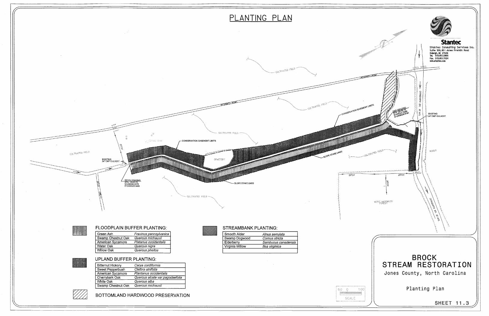
The Brock Restoration Plan calls for the restoration of the unnamed tributary to Big Chinquapin Branch, reforestation of the associated riparian buffer, reforestation of the buffer along Big Chinquapin Branch, and preservation of the existing wetlands and Coastal Plain Bottomland Hardwood Forest within the conservation easement. This involves the creation of a stable channel, riverine floodplain, and associated riparian buffer.
Priority 3 stream restoration will be carried out on the unnamed tributary on the Brock Site (Table 9.1). This will involve reconnecting the stream channel to its floodplain, which will allow overbank flooding. To reduce construction costs and avoid disturbing the cemetery, a bankfull bench will be cut entirely on the east side of the existing channel. Water quality functions will be improved due to the creation of more storage for floodwaters and increased filtering of pollutants. Wetlands are expected to form within portions of the newly created bankfull bench, especially in the downstream section of the project where backwater from Big Chinquapin Branch will affect the stream. Barring water quality issues outside of the Brock Site, the restoration should improve aquatic species diversity and abundance in the stream channels.
The restoration of riparian buffers along the restored stream channel will improve water quality. The re-establishment of the riparian buffers with hardwood species will also improve wildlife habitat on the property.
These measures will improve the physical, chemical, and biological components of the unnamed tributary and the Brock property, as well as Big Chinquapin Branch and other downstream waters. Specific project goals:
• Improve water quality by limiting the bank erosion
• Provide a stable stream channel (1850 linear feet of stream restoration)
• Restore 6.9 acres and preserve 0.52 acres of riparian buffers along the stream channel
• Improve aquatic and terrestrial habitat within the unnamed tributary to Big Chinquapin Branch
6.1.1 Designed Channel Classification
The proposed stream channel will be modified, by cutting a floodplain bench. Due to the constraint imposed by a culvert at the upstream end of the project, the stream will not be returned to the original floodplain; rather the stream has been designed as a Priority 3 restoration (re-establishing a floodplain at its existing elevation). The state of the existing channel reveals how it is able to handle the system’s flow and sediment supply. The existing shear stress and stream power are compared with the design in order to evaluate aggradation and degradation.

Brock Stream Restoration Page 13 Jones County, North Carolina July 2006
Design channel dimensions were calculated utilizing the regional curve and the few bankfull indicators that could be found in the existing channel. The stream design allows the stream to transfer less sediment through the restoration reach but will also allow for the sediment to deposit on the newly formed bankfull bench without aggrading or degrading. The channel pattern and profile will not be adjusted. The channel dimension will be adjusted by grading a bankfull bench on the east side of the channel. Flood analysis ensures that the stream restoration project will not increase flood stage following construction.
The proposed channel will have a total length of 1,850 feet. The bankfull bench is designed to handle larger flows. Flood flows will be able to access the newly excavated floodplain. In conjunction with the channel restoration, the proposed design will reforest 6.88 acres of riparian buffer along the restored stream channel. Design sheets are included in section 11.
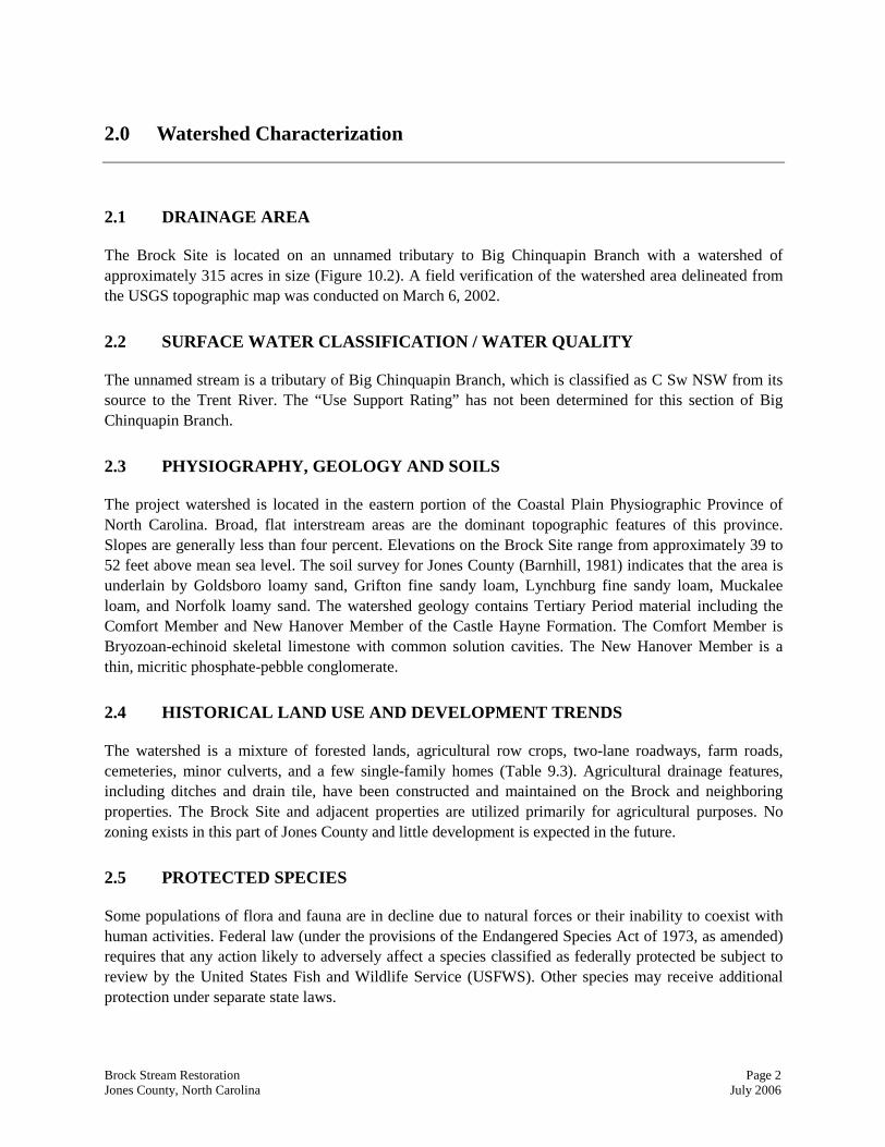
6.1.2 Target Buffer Communities
Buffer reforestation will establish a stable buffer along the restoration reach extending to the limits of the conservation easement (Table 9.6, Sheet 11.3). The planting plan is dependent on the hydrology of the site, the surrounding vegetative communities, and available supply of species. The plan is modeled after mature, unaltered systems as outlined in the Natural Communities of North Carolina (Schafale and Weakley, 1990). The newly excavated floodplain will be planted with a Coastal Plain Bottomland Hardwood Forest community. Remaining areas outside the floodplain, excluding the cemetery, will be planted as a Mesic Mixed Hardwood Forest Coastal Plain Subtype.
6.2 SEDIMENT TRANSPORT ANALYSIS
6.2.1 Methodology
A stable stream has the ability to transfer its sediment load without aggrading (depositing sediment) or degrading (scouring sediment) over long periods of time. The stream design is based on a comparison with the existing channel’s aggrading/degrading pattern and adjusting the proposed channel’s shear stress and stream power such that the channel has the ability to transfer its sediment load in a stable manner.
Shear stress (lbs/sqft): τ = R S
Stream power (lbs/sqft/s): ω = τ µ
= specific weight of water S = hydraulic slope
R = hydraulic radius µ = velocity The geometry and the profile of the proposed stream combine to provide a stream that will convey the bankfull discharge and transport the stream’s sediment supply. Grade control devices will be installed to further reduce the possibility of degradation within the restored channel.
6.2.2 Discussion
When working with a sandbed channel the standard practice is to evaluate the stream power of the channel. Stream power is the product of the shear stress and the bankfull flow velocity. The current

Brock Stream Restoration Page 14 Jones County, North Carolina July 2006
stream power is down-cutting the existing streambed; thus the proposed design reduces stream power. At bankfull flows the unit stream power and shear stress will remain un-changed (Table 9.5). During higher flood flows the shear stress and average velocity will both decrease on the proposed channel as compared to the design channel. In the existing stream system during high flows there is more power and a higher sediment transport capacity than in the proposed channel.
6.3 HEC-RAS ANALYSIS
6.3.1 No-Rise, LOMR, CLOMR
The methodology used to evaluate the hydrologic analysis required the evaluation of the existing stream’s bankfull elevation and corresponding bankfull area. Due to the severe alterations in the stream channels at the Brock Site, bankfull indicators were not easily observed in the field. For this reason, the Coastal Plain Regional Curves were used to verify the bankfull dimensions surveyed (NCSRI, 2004). Also, bankfull discharge was verified with the regional curves equation below.
Q = 16.56 (Awatershed)0.72 R2 = 0.95 (NCSRI, 2004)
The Hydrologic Engineering Center’s River Analysis System (HEC-RAS) was used to evaluate how the discharge flows within the proposed channel geometry (USACE, 1997). This evaluation verifies that the proposed plan, dimension, and profile would adequately carry the discharge at the bankfull stage, the point where water begins to overflow onto the floodplain.
Given that the project involves modifications to a stream channel, it is important to analyze the effect of these changes on flood elevations. Floodwater elevations were analyzed using the HEC-RAS Version 3.0.1.
HEC-RAS is a software package that is designed to perform one-dimensional, steady flow, hydraulic calculations for water surface profiles for a network of natural and constructed channels. The model is based on the energy equation, and the energy losses are evaluated by friction (Manning’s equation) and contraction/expansion (coefficient multiplied by the change in velocity head). The momentum equation is used in situations where the water surface profile rapidly varies, such as hydraulic jumps and stream junctions.
Discharge rates for the design have been evaluated with the regional curve. The bankfull discharge for the restoration reach is approximately 20.8 ft3/s. The existing channel’s V-shaped dimension, straight pattern, and uniform profile channels the bankfull discharge through a reduced area at a faster velocity than the proposed design. The proposed design will reduce this velocity. The existing and proposed geometries were evaluated at the bankfull discharge rates using HEC-RAS. The proposed bankfull bench dimensions, slow the velocity as the stream travels through the valley.
The analysis supports the field identification of the existing bankfull area with a close approximation and confirms the proposed channel will adequately carry the discharge at bankfull stage.

Brock Stream Restoration Page 15 Jones County, North Carolina July 2006
6.3.2 Hydrologic Trespass
The 100-year discharges were determined using the hydrological procedure and charts presented in the NCDOT guidelines for Drainage Studies and Hydraulic Design (NCDOT, 1999). According to Chart C200.1, the Hydrologic Contour is 4. With a drainage area of 315 acres and a hydrologic contour of 4, the 100-year discharge of 130 cfs can be determined from Chart C200.2.
The HEC-RAS analysis indicates that the proposed channel geometry will not increase the 100-year flood elevations within the project area, and that the water surface elevation will be reduced by greater than 2.0 feet at the upstream end of the project (Station 37 or Station 10+00) (Appendix 5). The HEC-RAS plan layout is shown in Sheet 11.4.
6.4 SOIL RESTORATION
The recommended construction sequence will include removing the existing topsoil within the areas to be restored. The excavated material will be stockpiled and spread across the new floodplain area to provide a more nutrient rich substrate for the establishment of planted vegetation. Compacted areas of the soil will be “deep ripped” prior to planting.
6.5 NATURAL PLANT COMMUNITY RESTORATION
6.5.1 Narrative & Plant Community Restoration
As previously discussed, the target streambank and floodplain riparian communities are Coastal Plain Bottomland Hardwood Forest. The remaining unforested areas within the easement are to be planted with Mesic Mixed Hardwood Forest Coastal Plain Subtype species. The planting plan was designed to include species that would be found in these communities as described by Schafale and Weakley’s Classification of the Natural Communities of North Carolina (1990). Proposed plantings for each zone are presented in Table 9.6.
Seeding, mulching, live staking, and vegetation planting will be used to stabilize the restored streambanks and floodplain. All disturbed areas will be seeded with a non-invasive grass species and either mulched or matted. Matting will provide immediate protection for the streambanks against shear stress while the plantings develop a root mass. The matting will be made from biodegradable material. In time, the plantings will replace the matting. The streambed and point bars of the stream channel will not be matted or planted so they may function as natural point bars.
Plantings will be used for streambank stabilization and riparian buffer establishment. Plantings will quickly develop a root mass and help protect streambanks and floodplains from erosive forces while absorbing nutrients. The plantings will eventually provide the stream with shade and wildlife habitat. The entire unforested areas of the easement will be planted.
The planting plan will use three different groupings of woody vegetation: streambank, floodplain, and upland riparian buffer (Table 9.6, Sheet 11.3). In addition, it can be expected that natural recruitment from onsite woody and herbaceous material will occur. Streambank planting will involve planting trees and shrubs on the channel banks for stability and reinforcement. Planting techniques may include live

Brock Stream Restoration Page 16 Jones County, North Carolina July 2006
staking, containerized, and bare root plantings. Species approved for streambank planting include swamp dogwood (Cornus stricta), smooth alder (Alnus serrulata), elderberry (Sambucus canadensis), and Virginia willow (Itea virginica).
Vegetative planting within the new floodplain will consist of Coastal Plain Bottomland Hardwood species native to the Coastal Plain physiographic region. Based on species availability at the time of construction, the following woody species are proposed: American sycamore, willow oak (Quercus phellos), green ash, water oak, and swamp chestnut oak (Quercus michauxii).
Vegetative planting within the upland riparian area of the restored channel and along the buffer adjacent to Big Chinquapin Branch will be modeled after species found in coastal plain mesic hardwood forests. Based on species availability, the proposed woody species include cherrybark oak (Quercus falcata var. pagodaefolia), white oak, bitternut hickory (Carya cordiformis), sweet pepperbush (Clethra alnifolia), American sycamore, and swamp chestnut oak.
6.5.2 On-site Invasive Species Management
It is not anticipated that invasive plant species will be a significant problem on the Brock Restoration Site. During the first year of monitoring, any invasive species problems will be noted and specific management options will be proposed.
7.0 Performance Criteria
7.1 STREAMS
The stability of the stream channel will be monitored annually for five years or until success criteria are met. One reach of the new channel will be monitored for dimension, pattern and profile. Permanent cross section pins will be installed in the monitoring reach. The longitudinal profile will be a minimum of 20 bankfull widths or 200 feet. As vegetation establishes and the channel stabilizes, the channel’s cross-section is expected to tighten slightly; however, the cross-section should not indicate downcutting or widening. Monitoring efforts will evaluate any changes by overlaying each year’s cross-section and longitudinal profile with the previous years’ for comparison. In addition, photo reference points will be located using a Global Positioning System and included on the “as-built” plan for the Brock Restoration Site.
7.2 VEGETATION
Vegetative sample plots will be quantitatively monitored during the growing season. According to NCEEP guidance, 1-2% of the planted area should be sampled. Based on the approximate buffer area, four 100m plots will be established. In each plot, species composition, density, and survival will be monitored. The four plot corners will be located using a Global Positioning System (GPS), permanently located with ROW stakes, and included in the “as-built” report for the Brock Site.

Brock Stream Restoration Page 17 Jones County, North Carolina July 2006
The vegetative success of the riparian buffer will be evaluated based on the species density and survival rates. Vegetation monitoring will be considered successful if at least 260 trees/acre are surviving at the end of five years.
7.3 SCHEDULE & REPORTING
1. Restoration Plan July 2006
2. Final Design August 2006
3. Bid Administration
• Execute Contract September 2006
4. Construction Management
• Begin Construction October/November 2006
• Complete Construction/Planting December 2006
5. Mitigation Plan December 2006
6. First Year Monitoring Report October 2007


Brock Stream Restoration Page 19 Jones County, North Carolina July 2006
8.0 References
Barnhill, W.L. 1981. Soil Survey of Jones County, North Carolina. USDA, Soil Conservation Service.
Environmental Laboratory. 1987. United States Army Corps of Engineers. Wetlands Delineation Manual, Technical Report Y-87-1. United States Army Engineer Waterways Experiment Station, Vicksburg, Mississippi.
Harrelson, C.C., C.L. Rawlins and J.P. Potyondy. 1994. Stream Channel Reference Sites: An Illustrated Guide to Field Technique. United States Department of Agriculture, Fort Collins, CO.
NCDOT. 1999. Guidelines for Drainage Studies and Hydraulic Design. North Carolina Department of Transportation. Raleigh, NC.
NCDWQ. 1998. Neuse River Basinwide Water Quality Plan. North Carolina Department of Environment and Natural Resources, Division of Water Quality. Raleigh, NC.
NCSRI. 2004. Coastal Regional Curve. NC Stream Restoration Institute. http://www.bae.ncsu.edu/programs/extension/wqg/sri/coastal.htm. Accessed September 2004.
Pope, B.F., Tasker, G.D., and J.C. Robbins. 2001. Estimating the Magnitude and Frequency of Floods in Rural Basins of North Carolina – Revised. US Geological Survey. Water-Resources Investigations Report 01-4207. Prepared in cooperation with the North Carolina Department of Transportation.
Rosgen, D. 1994. A Classification of Natural Rivers. Catena 22:169-199. Elsevier, Amsterdam.
Rosgen, D. 1996. Applied River Morphology. Wildland Hydrology, Pagosa Springs, CO.
Schafale, M.P. and A.S. Weakley. 1990. Classification of the Natural Communities of North Carolina Third Approximation. North Carolina Natural Heritage Program, Raleigh, NC.
USACE. 1997. HEC-RAS River Analysis System, Version 2.0. USACE, Hydrologic Engineering Center, Davis, CA.
USACE, NCDWQ. 2005. Information Regarding Stream Restoration in the Outer Coastal Plain of North Carolina. Wilmington, NC. November 28, 2005. Accessed April 2006. http://h2o.enr.state.nc.us/ncwetlands/documents/CoastalPlainSTreamMitigationFinalDraftPolicyNov28.doc.


Brock Stream Restoration Page 21 Jones County, North Carolina July 2006
9.0 Tables
Table 9.1 Restoration Structure and Objectives
Table 9.2 Bankfull Cross-Sectional Areas and Discharge
Table 9.3 Land Use of Watershed
Table 9.4 Morphological Table
Table 9.5 Shear Stress and Stream Power Analysis
Table 9.6 Designed Vegetative Communities by Zone


Brock Stream Restoration Page 23 Jones County, North Carolina July 2006
Table 9.1 Restoration Structure and Objectives Project Number 050650601 Brock Stream Restoration
Restoration Reach Restoration Type
Priority Approach
Existing Linear
Footage or Acreage
Designed Linear
Footage or Acreage
Stream Restoration Priority 3 1,850 feet 1,850 feet Restoration 6.88 acres Buffer Preservation 0.52 acres
Total Buffer Acres 7.4 acres
Table 9.2 Bankfull Cross-Sectional Areas and Discharge Project Number 050650601 (UT to Big Chinquapin Creek)
Parameter Existing Proposed Bkf Discharge (cfs) 20.8 20.8
Bkf Area Utilized (sqft) 9.9 9.9 Bkf Velocity (f/s) 2.1 2.1
Table 9.3 Land Use of Watershed Project Number 050650601 (UT to Big Chinquapin Creek)
Land Use Acreage Percentage
Forested 188.0 59.1%
Agriculture 117.8 37.0%
Rural Residential 10.2 3.2%
Road 2.2 0.7%

Brock Stream Restoration Page 24 Jones County, North Carolina July 2006
Table 9.4 Morphological Table Project Number 050650601 Brock Stream and Wetland Restoration
Variables Existing Channel Proposed Reach Brock Brock
1. Stream Type G5 E5 2. Drainage Area (sq. mi) 0.49 0.49 3. Bankfull Width (Wbkf) ft Mean: 7.0 Mean: 7.0 4. Bankfull Mean Depth (dbkf) ft Mean: 1.4 Mean: 1.4 5. Width/Depth Ratio (Wbkf/dbkf) Mean: 4.9 Mean: 4.9 6. Bankfull Cross-Sectional Area (Abkf) sq ft Mean: 9.9 Mean: 9.9 7. Bankfull Mean Velocity (Vbkf) fps Mean: 2.1 Mean: 2.1 8. Bankfull Discharge (Qbkf) cfs Mean: 20.8 Mean: 20.8 9. Maximum Bankfull Depth (dmax) ft Mean: 2.2 Mean: 2.2 10. Ratio of Low Bank Height to Mean: 3.3 Mean: 1.0 Maximum Bankfull Depth (lbh/dmax) 11. Width of Flood Prone Area (Wfpa) ft Mean: 13.0 Mean: 42.0 12. Entrenchment Ratio (Wfpa/Wbkf) Mean: 1.9 Mean: 6.0 13. Meander Length (Lm) ft Mean: N/A Mean: N/A 14. Ratio of Meander Length to Mean: N/A Mean: N/A Bankfull Width (Lm/Wbkf) 15. Radius of Curvature (Rc) ft Mean: N/A Mean: N/A 16. Ratio of Radius of Curvature to Mean: N/A Mean: N/A Bankfull Width (Rc/Wbkf) 17. Belt Width (Wblt) ft Mean: 20.0 Mean: 20.0 18. Meander Width Ratio (Wblt/Wbkf) Mean: 2.9 Mean: 2.9 20. Sinuosity (Stream length/valley distance) (K) Mean: 1.05 Mean: 1.05 21. Valley Slope (ft/ft) Mean: 0.0033 Mean: 0.0033 22. Average Water Surface Slope for Reach (Savg) Mean: 0.0031 Mean: 0.0031 23. Pool Slope (Spool) ft/ft Mean: 0.0001 Mean: 0.0001 24. Ratio of Pool Slope to Mean: 0.032 Mean: 0.032 Average Slope (Spool/Savg) 25. Maximum Pool Depth (dpool) ft Mean: 3.0 Mean: 3.0 26. Ratio of Maximum Pool Depth to Bankfull Mean Mean: 2.1 Mean: 2.1 Depth (dpool/dbkf) 27. Pool Width (Wpool) ft Mean: 8.5 Mean: 8.5 28. Ratio of Pool Width to Bankfull Mean: 1.2 Mean: 1.2 Width (Wpool/Wbkf) 29. Bankfull Cross-sectional Area at Pool (Apool) sq ft Mean: 15.2 Mean: 15.2 30. Ratio of Pool Area to Bankfull Area (Apool/Abkf) Mean: 1.5 Mean: 1.5 31. Pool to Pool Spacing (p-p) ft Mean: 20.0 Mean: 20.0 32. Ratio of Pool-to-Pool Spacing Mean: 2.9 Mean: 2.9 to Bankfull Width (p-p/Wbkf) 33. Pool Length (Lp) ft Mean: 20.0 Mean: 20.0 34. Ratio of Pool Length to Bankfull Width (Lp/Wbkf) Mean: 2.9 Mean: 2.9 35. Riffle Slope (Sriff) ft/ft Mean: 0.021 Mean: 0.021 36. Ratio of Riffle Slope to Average Slope (Sriff/Savg) Mean: 6.8 Mean: 6.8 37. Maximum Riffle Depth (driff) ft Mean: 2.2 Mean: 2.2 38. Ratio of Maximum Riffle Depth to Mean: 1.6 Mean: 1.6 Bankfull Mean Depth (driff/dbkf)

Brock Stream Restoration Page 25 Jones County, North Carolina July 2006
Table 9.5 Shear Stress and Stream Power Analysis
Project Number 050650601 Brock Stream Restoration PARAMETER EXISTING PROPOSED Velocity (f/s) 2.1 2.1 Shear Stress (lbs/sqft) 0.25 0.25 Stream Power (lbs/sqft/s) 0.413 0.413 D100 (mm) 30 30
Table 9.6 Designed Vegetative Communities by Zone Project Number 050650601 Brock Stream Restoration
Common Name Scientific Name Southeast Region Indicator
Streambank
Smooth Alder Alnus serrulata Facultative Wetland + Swamp Dogwood Cornus stricta Facultative Wetland - Virginia Willow Itea virginica Facultative Wetland + Elderberry Sambucus Canadensis Facultative Wetland -
Floodplain – Coastal Plain Bottomland Hardwood Forest
Green Ash Fraxinus pennsylvanica Facultative Wetland American Sycamore Platanus occidentalis Facultative Wetland - Swamp Chestnut Oak Quercus michauxii Facultative Wetland - Water Oak Quercus nigra Facultative Willow Oak Quercus phellos Facultative Wetland -
Upland Riparian Area – Mixed Mesic Hardwood Forest Coastal Plain Subtype
Bitternut Hickory Carya cordiformis Facultative Sweet Pepperbush Clethra alnifolia Facultative Wetland American Sycamore Plantanus occidentalis Facultative Wetland - Cherrybark Oak Quercus alcate var pagodaefolia Facultative + White Oak Quercus alba Facultative Upland Swamp Chestnut Oak Quercus michauxii Facultative Wetland -


Brock Stream Restoration Page 27 Jones County, North Carolina July 2006
10.0 Figures
Figure 10.1. Project Site Vicinity Map
Figure 10.2. Project Site Watershed Map
Figure 10.3. Project Site NRCS Soil Survey Map
Figure 10.4. Project Site Hydrological Features Map
Figure 10.5. Project Site Wetland Delineation Map


Page 29
Kinston
Dover
US 70
NC
5 8
Trenton
Big Chinquapin Branch
Beaver Creek
Vine Swamp
Trent River
Little Chinquapin Branch Chi
nqua
pin
Cha
pel R
d
Leno
ir C
ount
y
Jone
s C
ount
y
Craven County
Jones County
Flat S w
a mp
Rattlesnake Branch
hwest Creek (Kellys Pond)
Core Creek
Trac
ey S
wam
p
Brock Project Site
Middle Rd
P leasant Hill Rd
Pine St
United States Highway 70 W
yse Fork Rd
Sta
te H
ighw
ay 4
1
State Highway 58
Cobb R
d
Ph illip s Rd H
enderson Rd
Greent own Rd
British R
d
F ran cks Field Rd
Tayl
or R
d
Nob
les
Ln
Stroud R
d
Wyse F
ork Rd
�
0 1 2 30.5 Miles
Brock Stream Restoration Jones County, North Carolina
July 2006
Figure 10.1 Vicinity MapLegend
Local Roads
Major Roads
Railroads
County Boundary
Streams
Municipality
Site BoundaryJones County
�

Page 30
Big Chinquapin Branch
Legend
Streams
Watershed
Approximate Easement
0 1000 2000500 Feet
Brock Stream Restoration Jones County, North Carolina
July 2006
Figure 10.2 Project Site Watershed Map
�
Phillips Crossroads USGS 7.5' Quad

Page 31
Big Chinquapin Branch
State Highway 58
Pine S
t
Sutton Ln
Legend
Approximate Easement
Streams
Local Roads
Major Roads
Watershed
Soils
AuB - Autryville
GoA - Goldsboro
Gt - Grifton
Ly - Lynchburg
Me - Meggett
Mk - Muckalee
NoB - Norfolk
On - Onslow
Pn - Pantego
Ra - Rains
Brock Stream Restoration Jones County, North Carolina
July 2006
Figure 10.3 Project Site NRCS Soil Survey Map
�
0 1000 2000500 Feet

Page 32
G
G
Legend
Streams
Wetland
G Drain tiles
Approximate Easement0 500 1000250 Feet
Brock Stream Restoration Jones County, North Carolina
July 2006
Figure 10.4 Project Site Hydrological Features
�
Aerial Photos: September 2003Hurricane Isabel Damage Assessmentand Recovery Effort (USGS)
Big Chinquapin Branch

Page 33
G
GGG
wl-001wl-002
wl-003
wl-004
wl-005
wl-006
wl-007
wl-008
wl-009wl-010
wl-018
wl-017
wl-016
wl-015
wl-014
wl-013
wl-012wl-011
wl-021
wl-020
wl-019
0 50 100 15025 Feet
Brock Stream Restoration Jones County, North Carolina
July 2006
Figure 10.5 Project Site Wetland Delineation Map
�
wl-010 495252.170518 2459019.67127wl-011 495270.850967 2459021.227wl-009 495262.958213 2459002.11188wl-008 495284.424412 2458974.07158wl-007 495312.489934 2458967.19385wl-006 495340.550917 2458950.64434wl-005 495381.706564 2458914.28978wl-004 495411.273861 2458889.84023wl-003 495433.286775 2458849.9157wl-002 495458.969971 2458817.37638wl-001 495469.10842 2458816.41552wl-012 495282.359678 2458984.4434wl-013 495313.82772 2458975.1234wl-014 495347.493019 2458963.15459wl-015 495378.814594 2458932.3502wl-016 495408.628211 2458914.97596wl-017 495442.358838 2458893.41786wl-018 495465.52572 2458896.10438wl-019 495470.378064 2458886.94702wl-020 495441.726795 2458874.55621wl-021 495458.375208 2458849.69829
Flag Number Northing Easting
Aerial Photos: September 2003Hurricane Isabel Damage Assessmentand Recovery Effort (USGS)
Legend
Streams! Wetland Flags
Wetland
Approximate Easement
G Data Form Sampling Points
Big Chinquapin Branch


Brock Stream Restoration Page 35 Jones County, North Carolina July 2006
11.0 Design Sheets
Sheet 11.1. Existing Conditions
Sheet 11.2. Plan View
Sheet 11.3. Planting Plan
Sheet 11.4. HEC-RAS Analysis
Sheet 11.5. Typical Section


Brock Stream Restoration Page 41 Jones County, North Carolina July 2006
12.0 Appendices
Appendix 1. Project Site Photographs
Appendix 2. Project Site Notification of Jurisdictional Determination and USACE Routine Wetland
Determination Data Forms
Appendix 3. Project Site NCDWQ Stream Classification Forms
Appendix 4. Project Site Biological Reconnaissance Form
Appendix 5. HEC-RAS Analysis
Appendix 6. Correspondence


Appendix 1. Project Site Photographs


Photo 1. Coastal Plain Bottomland Hardwood Forest Adjacent to Big Chinquapin Branch
Photo 2. Former Channel of Big Chinquapin Branch Located in Coastal Plain Bottomland Hardwood Forest

Photo 3. Existing Channel; Southern Property Limits Facing North Looking Downstream Showing Entrenched Channel
Photo 4. Existing Channel; Middle Reach Facing North Looking Downstream Showing Mowed Buffer

Appendix 2. Project Site Notification of Jurisdictional Determination and USACE Routine Wetland Determination Data Forms


DATA FORM ROUTINE WETLAND DETERMINATION
(1987 COE Wetlands Delineation Manual)
Project/Site: Brock Restoration Site Date: 12/1/2005 Applicant / Owner: NC EEP County: Jones Investigator: P Colwell, M Ruiz, A Coleman State: NC Do Normal Circumstances exist on the site? YES NO Community ID: wetland Is the site significantly disturbed (Atypical Situation)? YES NO Transect ID: Is the area a potential Problem Area? (If needed, explain on reverse) YES NO Plot ID: wet
VEGETATION Dominant Plant Species Scientific Name Stratum Indicator 1 red maple Acer rubrum Tree FAC 2 sycamore Platanus occidentalis L. Tree FACW- 3 ironwood Carpinus caroliniana Tree FAC 4 giant cane Arundinaria gigantea Herb FACW 5 pickerel weed Pontederia cordata L. Herb OBL 6 7 8 9 10 Percent of Dominant Species that are OBL, FACW, or FAC (excluding FAC-): 100% Remarks:
HYDROLOGY [ ] Recorded Data (Describe in Remarks) [ ] Stream, Lake, or Tide Gauge [ ] Aerial Photographs [ ] Other [X] No Recorded Data Available
FIELD OBSERVATIONS
Depth of Surface Water 3 (in)
Depth of Free Water in Pit (in)
Depth to Saturated Soil (in)
WETLAND HYDROLOGY INDICATORS Primary Indicators: [X] Inundated [X] Saturated in Upper 12 Inches [X] Water Marks [X] Drift Lines [ ] Sediment Deposits [X] Drainage Patterns in Wetlands Secondary Indicators (2 or more Required) [X] Oxidized Root Channels in Upper 12 inches [X] Water-stained Leaves [ ] Local Soil Survey Data [ ] FAC-Neutral Test [ ] Other (Explain in Remarks)
Remarks:

SOILS Map Unit Name (Series and Phase): Drainage Class: Taxonomy (Subgroup): Field Observations Confirm Mapped Type? YES NO PROFILE DESCRIPTION Depth (inches)
Horizon Matrix Color (Munsell Moist)
Mottle Colors (Munsell Moist)
Mottle Abundance/Contrast
Texture, Concretions, Structure, etc.
0-12 A 10YR3/2 Loam 12-24 Bt 2.5Y4/2 Clay loam HYDRIC SOIL INDICATORS: [ ] Histosol [ ] Histic Epipedon [X] Sulfidic Odor [ ] Aquic Moisture Regime [X] Reducing Conditions [X] Gleyed or Low-Chroma Colors
[ ] Concretions [ ] High Organic Content in Surface Layer in Sandy Soils [ ] Organic Streaking in Sandy Soils [ ] Listed on Local Hydric Soils List [ ] Listed on National Hydric Soils List [ ] Other (Explain in Remarks)
Remarks:
WETLAND DETERMINATION Hydrophytic Vegetation Present? YES NO Wetland Hydrology Present? YES NO Hydric Soil Present? YES NO
Is this Sampling Point Within a Wetland? YES NO
Remarks: Old meander channel of Big Chinquapin Branch

DATA FORM ROUTINE WETLAND DETERMINATION
(1987 COE Wetlands Delineation Manual)
Project/Site: Brock Restoration Site Date: 11/2/2005 Applicant / Owner: NC EEP County: Jones Investigator: P Colwell, M Ruiz, A Coleman State: NC Do Normal Circumstances exist on the site? YES NO Community ID: upland Is the site significantly disturbed (Atypical Situation)? YES NO Transect ID: Is the area a potential Problem Area? (If needed, explain on reverse) YES NO Plot ID: up
VEGETATION Dominant Plant Species Scientific Name Stratum Indicator 1 sugar maple Acer saccharum Tree FACU- 2 tulip poplar Liriodendron tulipifera L. Tree FAC 3 sycamore Platanus occidentalis L. Tree FACW- 4 hackberry Celtis occidentalis L. Tree FACU 5 green ash Fraxinus pennsylvanica Tree FACW 6 Chinese privet Ligustrum sinense Shrub FAC 7 honeysuckle Lonicera japonica. Vine FAC- 8 saw greenbrier Smilax bona-nox Vine FAC 9 10 Percent of Dominant Species that are OBL, FACW, or FAC (excluding FAC-): 63% Remarks:
HYDROLOGY [ ] Recorded Data (Describe in Remarks) [ ] Stream, Lake, or Tide Gauge [ ] Aerial Photographs [ ] Other [X] No Recorded Data Available
FIELD OBSERVATIONS
Depth of Surface Water -- (in)
Depth of Free Water in Pit -- (in)
Depth to Saturated Soil -- (in)
WETLAND HYDROLOGY INDICATORS Primary Indicators: [ ] Inundated [ ] Saturated in Upper 12 Inches [ ] Water Marks [ ] Drift Lines [ ] Sediment Deposits [ ] Drainage Patterns in Wetlands Secondary Indicators (2 or more Required) [ ] Oxidized Root Channels in Upper 12 inches [ ] Water-stained Leaves [ ] Local Soil Survey Data [ ] FAC-Neutral Test [ ] Other (Explain in Remarks)
Remarks: no wetland hydrology

SOILS Map Unit Name (Series and Phase): Drainage Class: Taxonomy (Subgroup): Field Observations Confirm Mapped Type? YES NO PROFILE DESCRIPTION Depth (inches)
Horizon Matrix Color (Munsell Moist)
Mottle Colors (Munsell Moist)
Mottle Abundance/Contrast
Texture, Concretions, Structure, etc.
0-10 A 2.5Y3/2 Loam 10-15 Bt1 2.5Y4/3 Clay loam 15+ Bt2 2.5Y5/4 /
2.5Y3/2 Clay loam
HYDRIC SOIL INDICATORS: [ ] Histosol [ ] Histic Epipedon [ ] Sulfidic Odor [ ] Aquic Moisture Regime [ ] Reducing Conditions [ ] Gleyed or Low-Chroma Colors
[ ] Concretions [ ] High Organic Content in Surface Layer in Sandy Soils [ ] Organic Streaking in Sandy Soils [ ] Listed on Local Hydric Soils List [ ] Listed on National Hydric Soils List [ ] Other (Explain in Remarks)
Remarks: not a hydric soil
WETLAND DETERMINATION Hydrophytic Vegetation Present? YES NO Wetland Hydrology Present? YES NO Hydric Soil Present? YES NO
Is this Sampling Point Within a Wetland? YES NO
Remarks: This point is located in the forested area between the old channel and the current channel of Big Chinquapin Branch.

Appendix 3. Project Site NCDWQ Stream Classification Forms


NCDWQ Stream Classification Form Project Name: Brock River Basin: Neuse County: Jones Evaluator: MPE/KFC/LEM DWQ Project Number: N/A Nearest Named Stream: Big Chinquapin Branch Latitude: 35 05 52 Date: 10/9/01 USGS QUAD: Phillips Crossroads Longitude: 77 28 01 Location/Directions: Brock Property – North of NC58, approximately 6.5 miles west of Trenton (Existing channel between Brock/Tillett culvert crossing and Big Chinquapin Branch) *PLEASE NOTE: If evaluator and landowner agree that the feature is a man-made ditch, then use of this form is not necessary. Also, if in the best professional judgment of the evaluator, the feature is a man-made ditch and not a modified natural stream—this rating system should
not be used* Primary Field Indicators: (Circle One Number Per Line)
I. Geomorphology Absent Weak Moderate Strong 1) Is There A Riffle-Pool Sequence? 0 1 2 3 2) Is The USDA Texture In Streambed Different From Surrounding Terrain? 0 1 2 3 3) Are Natural Levees Present? 0 1 2 3 4) Is The Channel Sinuous? 0 1 2 3 5) Is There An Active (Or Relic) Floodplain Present? 0 1 2 3 6) Is The Channel Braided? 0 1 2 3 7) Are Recent Alluvial Deposits Present? 0 1 2 3 8) Is There A Bankfull Bench Present? 0 1 2 3 9) Is A Continuous Bed & Bank Present? 0 1 2 3 (*NOTE: If Bed & Bank Caused By Ditching And WITHOUT Sinuosity Then Score=0*) 10) Is A 2nd Order Or Greater Channel (As Indicated On Topo Map And/Or In Field) Present? Yes=3 No=0 PRIMARY GEOMORPHOLOGY INDICATOR POINTS: 5 II. Hydrology Absent Weak Moderate Strong 1) Is There A Groundwater Flow/Discharge Present? 0 1 2 3 PRIMARY HYDROLOGY INDICATOR POINTS: 2 III. Biology Absent Weak Moderate Strong 1) Are Fibrous Roots Present In Streambed? 3 2 1 0 2) Are Rooted Plants Present In Streambed? 3 2 1 0 3) Is Periphyton Present? 0 1 2 3 4) Are Bivalves Present? 0 1 2 3 PRIMARY BIOLOGY INDICATOR POINTS: 6 Secondary Field Indicators: (Circle One Number Per Line)
I. Geomorphology Absent Weak Moderate Strong 1) Is There A Head Cut Present In Channel? 0 .5 1 1.5 2) Is There A Grade Control Point In Channel? 0 .5 1 1.5 3) Does Topography Indicate A Natural Drainage Way? 0 .5 1 1.5 SECONDARY GEOMORPHOLOGY INDICATOR POINTS: 2.5

II. Hydrology Absent Weak Moderate Strong 1) Is This Year’s (Or Last’s) Leaf litter ___Present In Streambed? 1.5 1 .5 0 2) Is Sediment On Plants (Or Debris) Present? 0 .5 1 1.5 3) Are Wrack Lines Present? 0 .5 1 1.5 4) Is Water In Channel And >48 Hrs. Since 0 .5 1 1.5 Last Known Rain? (*NOTE: If Ditch Indicated In #9 Above Skip This Step And #5 Below*) 5) Is There Water In Channel During Dry 0 .5 1 1.5 Conditions Or In Growing Season)? 6) Are Hydric Soils Present In Sides Of Channel (Or In Headcut)? Yes=1.5 No=0 SECONDARY HYDROLOGY INDICATOR POINTS: 4.5 III. Biology Absent Weak Moderate Strong 1) Are Fish Present? 0 .5 1 1.5 2) Are Amphibians Present? 0 .5 1 1.5 3) Are Aquatic Turtles Present? 0 .5 1 1.5 4) Are Crayfish Present? 0 .5 1 1.5 5) Are Macrobenthos Present? 0 .5 1 1.5 6) Are Iron Oxidizing Bacteria/Fungus Present? 0 .5 1 1.5 7) Is Filamentous Algae Present? 0 .5 1 1.5 8) Are Wetland Plants In Streambed? N/A SAV Mostly OBL Mostly FACW Mostly FAC Mostly FACU Mostly UPL (* NOTE: If Total Absence Of All Plants In Streambed 2 1 .75 .5 0 0 As Noted Above Skip This Step UNLESS SAV Present*). SECONDARY BIOLOGY INDICATOR POINTS: 2.5 TOTAL POINTS (Primary + Secondary)= 22.5 (If Greater Than Or Equal To 19 Points The Stream Is At Least Intermittent)

NCDWQ Stream Classification Form Project Name: Brock River Basin: Neuse County: Jones Evaluator: MPE/KFC/LEM DWQ Project Number: N/A Nearest Named Stream: Big Chinquapin Branch Latitude: 35 05 42 Date: 10/09/01 USGS QUAD: Phillips Crossroads Longitude: 77 28 07 Location/Directions: Tillett Property – North of NC58, approximately 6.5 miles west of Trenton (Existing channel between NC58 and Brock/Tillett culvert). *PLEASE NOTE: If evaluator and landowner agree that the feature is a man-made ditch, then use of this form is not necessary. Also, if in the best professional judgment of the evaluator, the feature is a man-made ditch and not a modified natural stream—this rating system should
not be used* Primary Field Indicators: (Circle One Number Per Line)
I. Geomorphology Absent Weak Moderate Strong 1) Is There A Riffle-Pool Sequence? 0 1 2 3 2) Is The USDA Texture In Streambed Different From Surrounding Terrain? 0 1 2 3 3) Are Natural Levees Present? 0 1 2 3 4) Is The Channel Sinuous? 0 1 2 3 5) Is There An Active (Or Relic) Floodplain Present? 0 1 2 3 6) Is The Channel Braided? 0 1 2 3 7) Are Recent Alluvial Deposits Present? 0 1 2 3 8) Is There A Bankfull Bench Present? 0 1 2 3 9) Is A Continuous Bed & Bank Present? 0 1 2 3 (*NOTE: If Bed & Bank Caused By Ditching And WITHOUT Sinuosity Then Score=0*) 10) Is A 2nd Order Or Greater Channel (As Indicated On Topo Map And/Or In Field) Present? Yes=3 No=0 PRIMARY GEOMORPHOLOGY INDICATOR POINTS: 4 II. Hydrology Absent Weak Moderate Strong 1) Is There A Groundwater Flow/Discharge Present? 0 1 2 3 PRIMARY HYDROLOGY INDICATOR POINTS: 0 III. Biology Absent Weak Moderate Strong 1) Are Fibrous Roots Present In Streambed? 3 2 1 0 2) Are Rooted Plants Present In Streambed? 3 2 1 0 3) Is Periphyton Present? 0 1 2 3 4) Are Bivalves Present? 0 1 2 3 PRIMARY BIOLOGY INDICATOR POINTS: 2 Secondary Field Indicators: (Circle One Number Per Line)
I. Geomorphology Absent Weak Moderate Strong 1) Is There A Head Cut Present In Channel? 0 .5 1 1.5 2) Is There A Grade Control Point In Channel? 0 .5 1 1.5 3) Does Topography Indicate A Natural Drainage Way? 0 .5 1 1.5 SECONDARY GEOMORPHOLOGY INDICATOR POINTS: 2.5

II. Hydrology Absent Weak Moderate Strong 1) Is This Year’s (Or Last’s) Leaf litter ___Present In Streambed? 1.5 1 .5 0 2) Is Sediment On Plants (Or Debris) Present? 0 .5 1 1.5 3) Are Wrack Lines Present? 0 .5 1 1.5 4) Is Water In Channel And >48 Hrs. Since 0 .5 1 1.5 Last Known Rain? (*NOTE: If Ditch Indicated In #9 Above Skip This Step And #5 Below*) 5) Is There Water In Channel During Dry 0 .5 1 1.5 Conditions Or In Growing Season)? 6) Are Hydric Soils Present In Sides Of Channel (Or In Headcut)? Yes=1.5 No=0 SECONDARY HYDROLOGY INDICATOR POINTS: 3 III. Biology Absent Weak Moderate Strong 1) Are Fish Present? 0 .5 1 1.5 2) Are Amphibians Present? 0 .5 1 1.5 3) Are AquaticTurtles Present? 0 .5 1 1.5 4) Are Crayfish Present? 0 .5 1 1.5 5) Are Macrobenthos Present? 0 .5 1 1.5 6) Are Iron Oxidizing Bacteria/Fungus Present? 0 .5 1 1.5 7) Is Filamentous Algae Present? 0 .5 1 1.5 8) Are Wetland Plants In Streambed? N/A SAV Mostly OBL Mostly FACW Mostly FAC Mostly FACU Mostly UPL (* NOTE: If Total Absence Of All Plants In Streambed 2 1 .75 .5 0 0 As Noted Above Skip This Step UNLESS SAV Present*). SECONDARY BIOLOGY INDICATOR POINTS: 1 TOTAL POINTS (Primary + Secondary)= 12.5 (If Greater Than Or Equal To 19 Points The Stream Is At Least Intermittent)

Appendix 4. Project Site Biological Reconnaissance Form


BIOLOGICAL RECONNAISANCE FORM Perennial/Intermittent Point
Send to Dave Penrose 401/Wetlands Unit, Division of Water Quality
1650 Mail Services Center Raleigh, North Carolina 27699-1621
e-mail [email protected], FAX 919/715-5637
a) Location Brock Site, DOT
Stream Name: UT Chinquapin Branch Receiving Waterbody: Chinquapin Br, Trent River
Location/Road: nr NC 58 County: Jones Date: 21Feb02 Regional Office: Washington RO
Basin: Neuse Subbasin: 030411 Latitude/Longitude: See site description below
Ecoregion: Coastal Plain
Rosgen Class: ? Observers: Dave Penrose, LeiLani Paugh, Lia Myott
USGS Quad Sheet: Phillips Crossroads
Notes (attach photograph or drawing on the back of this form): Three sites were sampled on the mainstem of this tributary; Marker 23 (350536/772831) was above NC 58 within a dense canopy, Marker 24 was at the property line (350543/772811) and Marker 25 near the downstream confluence (350600/772820). Both downstream sites had no riparian canopy, agricultural runoff.
b) Habitat
Primary Adjacent Land Use: agriculture, cotton Riparian Zone Characteristics: eliminated downstream
Stream Width: up to one meter downstream
Flow Conditions: perennial. Stream Order: first
Stream Permanence Characteristics, Rating (if relevant): Interesting river rock layer about 18” below soil surface. Good bed and bank characteristics, degree of incision and catchment size (222 AC at the upstream property line and 285 at the confluence)
c) Biology
Benthic Macroinvertebrate Taxa: Amphipoda: X Isopoda: X Decapoda: X Chironomidae: X Oligochaeta: Mollusca: X (Sphaerium) Ephemeroptera: Plecoptera: Trichoptera: Coleoptera: Other Diptera: Fish and Salamander Taxa:
I/P Results: The most upstream location was dominated by Isopods suggesting intermittent conditions. We started to see perennial indicators at the Brock property line (Sphaerium, Crayfish) and made the I/P call at that point. The downstream location had many more perennial indicators. We did not collect any primary indictors (EPT’s) at any location, perhaps due to the level of perturbation in the catchment.


Appendix 5. HEC–RAS Analysis


HEC-RAS Plan: Plan 11 River: BROCK Reach: EXISTINGReach River Sta Profile Q Total W.S. Elev E.G. Slope Vel Total Shear Total Power Total
(cfs) (ft) (ft/ft) (ft/s) (lb/sq ft) (lb/ft s)EXISTING 37 2- YEAR 25.00 34.42 0.003196 2.37 0.21 0.49EXISTING 37 10-YEAR 150.00 36.91 0.002628 3.61 0.37 1.34EXISTING 37 100-YEAR 315.00 39.01 0.002980 3.17 0.33 1.04
EXISTING 36 2- YEAR 25.00 34.29 0.002673 2.25 0.19 0.43EXISTING 36 10-YEAR 150.00 36.76 0.002997 3.72 0.42 1.56EXISTING 36 100-YEAR 315.00 38.82 0.003449 3.38 0.37 1.26
EXISTING 35 2- YEAR 25.00 34.16 0.002355 2.21 0.17 0.38EXISTING 35 10-YEAR 150.00 36.59 0.003189 3.86 0.44 1.70EXISTING 35 100-YEAR 315.00 38.67 0.003259 3.24 0.35 1.12
EXISTING 34 2- YEAR 25.00 34.03 0.002274 2.16 0.17 0.36EXISTING 34 10-YEAR 150.00 36.41 0.003111 3.81 0.43 1.65EXISTING 34 100-YEAR 315.00 38.47 0.003394 3.23 0.33 1.08
EXISTING 33 2- YEAR 25.00 33.80 0.003315 2.49 0.23 0.56EXISTING 33 10-YEAR 150.00 36.11 0.004016 4.19 0.53 2.20EXISTING 33 100-YEAR 315.00 38.13 0.004105 3.86 0.46 1.77
EXISTING 32 2- YEAR 25.00 33.58 0.003576 2.45 0.23 0.56EXISTING 32 10-YEAR 150.00 35.92 0.003214 3.77 0.43 1.62EXISTING 32 100-YEAR 315.00 37.94 0.002703 3.83 0.43 1.63
EXISTING 31 2- YEAR 25.00 33.28 0.006429 3.07 0.36 1.11EXISTING 31 10-YEAR 150.00 35.68 0.003916 4.14 0.51 2.10EXISTING 31 100-YEAR 315.00 37.75 0.003003 4.22 0.50 2.13
EXISTING 30 2- YEAR 25.00 33.15 0.002493 2.19 0.18 0.39EXISTING 30 10-YEAR 150.00 35.56 0.002914 3.66 0.41 1.49EXISTING 30 100-YEAR 315.00 37.63 0.003122 3.77 0.43 1.62
EXISTING 29 2- YEAR 25.00 33.03 0.002201 2.08 0.16 0.33EXISTING 29 10-YEAR 150.00 35.44 0.002592 3.50 0.37 1.28EXISTING 29 100-YEAR 315.00 37.50 0.002641 3.69 0.40 1.48
EXISTING 28 2- YEAR 25.00 32.93 0.002057 2.05 0.15 0.31EXISTING 28 10-YEAR 150.00 35.30 0.002575 3.50 0.36 1.27EXISTING 28 100-YEAR 315.00 37.35 0.002704 3.74 0.40 1.50
EXISTING 27 2- YEAR 25.00 32.82 0.002334 2.11 0.17 0.35EXISTING 27 10-YEAR 150.00 35.15 0.002935 3.66 0.41 1.49EXISTING 27 100-YEAR 315.00 37.19 0.003048 3.95 0.46 1.82
EXISTING 26 2- YEAR 25.00 32.74 0.001661 1.85 0.12 0.23EXISTING 26 10-YEAR 150.00 35.06 0.002235 3.33 0.32 1.07EXISTING 26 100-YEAR 315.00 37.10 0.002556 3.51 0.37 1.30
EXISTING 25 2- YEAR 25.00 32.65 0.003419 2.39 0.22 0.54EXISTING 25 10-YEAR 150.00 34.94 0.003346 3.80 0.45 1.69EXISTING 25 100-YEAR 315.00 37.01 0.003041 3.59 0.39 1.41
EXISTING 24 2- YEAR 25.00 32.44 0.004247 2.59 0.27 0.69EXISTING 24 10-YEAR 150.00 34.72 0.003903 4.07 0.51 2.08

HEC-RAS Plan: Plan 11 River: BROCK Reach: EXISTING (Continued)Reach River Sta Profile Q Total W.S. Elev E.G. Slope Vel Total Shear Total Power Total
(cfs) (ft) (ft/ft) (ft/s) (lb/sq ft) (lb/ft s)EXISTING 24 100-YEAR 315.00 36.79 0.003868 3.88 0.47 1.81
EXISTING 23 2- YEAR 25.00 32.09 0.008322 3.22 0.43 1.40EXISTING 23 10-YEAR 150.00 34.50 0.004078 4.17 0.53 2.22EXISTING 23 100-YEAR 315.00 36.58 0.005359 3.76 0.49 1.86
EXISTING 22 2- YEAR 25.00 31.98 0.001862 2.02 0.14 0.29EXISTING 22 10-YEAR 150.00 34.37 0.002793 3.71 0.40 1.48EXISTING 22 100-YEAR 315.00 36.42 0.003328 3.05 0.32 0.97
EXISTING 21 2- YEAR 25.00 31.85 0.002592 2.29 0.19 0.42EXISTING 21 10-YEAR 150.00 34.16 0.003649 4.09 0.49 2.01EXISTING 21 100-YEAR 315.00 36.26 0.003622 2.86 0.30 0.85
EXISTING 20 2- YEAR 25.00 31.67 0.003792 2.64 0.25 0.67EXISTING 20 10-YEAR 150.00 33.88 0.004990 4.60 0.63 2.89EXISTING 20 100-YEAR 315.00 36.00 0.005231 3.35 0.41 1.38
EXISTING 19 2- YEAR 25.00 31.38 0.006048 3.07 0.36 1.09EXISTING 19 10-YEAR 150.00 33.57 0.005571 4.79 0.69 3.28EXISTING 19 100-YEAR 315.00 35.61 0.007068 3.90 0.55 2.16
EXISTING 18 2- YEAR 25.00 31.14 0.004398 2.69 0.28 0.76EXISTING 18 10-YEAR 150.00 33.35 0.004857 4.40 0.61 2.68EXISTING 18 100-YEAR 315.00 35.30 0.005956 3.68 0.49 1.79
EXISTING 17 2- YEAR 25.00 30.92 0.004645 2.80 0.30 0.83EXISTING 17 10-YEAR 150.00 33.06 0.005655 4.67 0.68 3.18EXISTING 17 100-YEAR 315.00 35.05 0.005665 3.47 0.44 1.54
EXISTING 16 2- YEAR 25.00 30.75 0.003069 2.41 0.21 0.50EXISTING 16 10-YEAR 150.00 32.81 0.004776 4.47 0.60 2.68EXISTING 16 100-YEAR 315.00 34.79 0.005319 3.28 0.40 1.30
EXISTING 15 2- YEAR 25.00 30.63 0.002347 2.08 0.16 0.34EXISTING 15 10-YEAR 150.00 32.64 0.003810 4.04 0.50 2.03EXISTING 15 100-YEAR 315.00 34.54 0.004466 3.25 0.38 1.22
EXISTING 14 2- YEAR 25.00 30.52 0.002162 2.01 0.15 0.29EXISTING 14 10-YEAR 150.00 32.47 0.003363 3.85 0.44 1.69EXISTING 14 100-YEAR 315.00 34.28 0.004132 3.47 0.38 1.31
EXISTING 13 2- YEAR 25.00 30.43 0.001843 1.81 0.12 0.22EXISTING 13 10-YEAR 150.00 32.36 0.002634 3.44 0.35 1.22EXISTING 13 100-YEAR 315.00 34.11 0.003350 3.26 0.32 1.04
EXISTING 12 2- YEAR 25.00 30.29 0.003128 2.18 0.18 0.40EXISTING 12 10-YEAR 150.00 32.20 0.003167 3.56 0.39 1.38EXISTING 12 100-YEAR 315.00 33.93 0.003306 2.98 0.23 0.68
EXISTING 11 2- YEAR 25.00 29.75 0.018037 4.10 0.73 2.99EXISTING 11 10-YEAR 150.00 31.87 0.005287 4.36 0.58 2.54EXISTING 11 100-YEAR 315.00 33.76 0.003942 2.80 0.22 0.62

HEC-RAS Plan: Plan 11 River: BROCK Reach: EXISTING (Continued)Reach River Sta Profile Q Total W.S. Elev E.G. Slope Vel Total Shear Total Power Total
(cfs) (ft) (ft/ft) (ft/s) (lb/sq ft) (lb/ft s)EXISTING 10 2- YEAR 25.00 29.53 0.003690 2.41 0.23 0.56EXISTING 10 10-YEAR 150.00 31.73 0.003385 3.74 0.44 1.63EXISTING 10 100-YEAR 315.00 33.61 0.003766 2.46 0.22 0.55
EXISTING 9 2- YEAR 25.00 29.24 0.006448 2.97 0.36 1.08EXISTING 9 10-YEAR 150.00 31.46 0.004690 4.27 0.58 2.46EXISTING 9 100-YEAR 315.00 33.03 0.006621 3.76 0.30 1.13
EXISTING 8 2- YEAR 25.00 29.13 0.002133 2.06 0.16 0.32EXISTING 8 10-YEAR 150.00 31.32 0.003340 3.86 0.45 1.75EXISTING 8 100-YEAR 315.00 32.96 0.002842 2.70 0.18 0.49
EXISTING 7 2- YEAR 25.00 28.98 0.003148 2.35 0.21 0.50EXISTING 7 10-YEAR 150.00 31.09 0.004219 4.16 0.54 2.24EXISTING 7 100-YEAR 315.00 32.92 0.002156 2.16 0.16 0.35
EXISTING 6 2- YEAR 25.00 28.76 0.004610 2.68 0.29 0.77EXISTING 6 10-YEAR 150.00 30.80 0.005281 4.50 0.64 2.90EXISTING 6 100-YEAR 315.00 32.81 0.002318 2.08 0.16 0.34
EXISTING 5 2- YEAR 25.00 28.49 0.005249 2.79 0.31 0.87EXISTING 5 10-YEAR 150.00 30.49 0.005606 4.60 0.67 3.09EXISTING 5 100-YEAR 315.00 32.07 0.011794 4.27 0.47 2.02
EXISTING 4 2- YEAR 25.00 28.11 0.009168 3.36 0.46 1.54EXISTING 4 10-YEAR 150.00 30.26 0.004907 4.41 0.59 2.62EXISTING 4 100-YEAR 315.00 31.85 0.004392 4.57 0.50 2.29
EXISTING 3 2- YEAR 25.00 27.86 0.004271 2.65 0.27 0.72EXISTING 3 10-YEAR 150.00 30.06 0.004496 4.21 0.56 2.34EXISTING 3 100-YEAR 315.00 31.67 0.003928 4.82 0.66 3.18
EXISTING 2 2- YEAR 25.00 27.54 0.007084 3.23 0.42 1.36EXISTING 2 10-YEAR 150.00 29.54 0.008611 5.50 0.98 5.40EXISTING 2 100-YEAR 315.00 31.18 0.007154 6.09 1.09 6.66
EXISTING 1 2- YEAR 25.00 27.44 0.005009 2.80 0.30 0.83EXISTING 1 10-YEAR 150.00 29.49 0.005001 4.59 0.62 2.84EXISTING 1 100-YEAR 315.00 31.17 0.005009 5.08 0.74 3.74

HEC-RAS Plan: Plan 11 River: BROCK Reach: PROPOSED WITH BEReach River Sta Profile Q Total W.S. Elev E.G. Slope Vel Total Shear Total Power Total
(cfs) (ft) (ft/ft) (ft/s) (lb/sq ft) (lb/ft s)PROPOSED WITH BE 37 2- YEAR 25.00 34.51 0.003454 1.64 0.07 0.12PROPOSED WITH BE 37 10-YEAR 150.00 35.41 0.003539 2.63 0.25 0.66PROPOSED WITH BE 37 100-YEAR 315.00 36.12 0.003501 3.40 0.38 1.29
PROPOSED WITH BE 36 2- YEAR 25.00 34.28 0.004551 1.87 0.08 0.16PROPOSED WITH BE 36 10-YEAR 150.00 35.24 0.003376 2.58 0.24 0.63PROPOSED WITH BE 36 100-YEAR 315.00 35.95 0.003387 3.35 0.37 1.24
PROPOSED WITH BE 35 2- YEAR 25.00 34.16 0.002193 1.46 0.05 0.07PROPOSED WITH BE 35 10-YEAR 150.00 35.09 0.002906 2.47 0.22 0.54PROPOSED WITH BE 35 100-YEAR 315.00 35.80 0.003125 3.27 0.35 1.13
PROPOSED WITH BE 34 2- YEAR 25.00 34.08 0.001530 1.15 0.05 0.05PROPOSED WITH BE 34 10-YEAR 150.00 34.95 0.002665 2.40 0.21 0.50PROPOSED WITH BE 34 100-YEAR 315.00 35.64 0.003040 3.25 0.34 1.12
PROPOSED WITH BE 33 2- YEAR 25.00 33.89 0.003526 1.59 0.08 0.12PROPOSED WITH BE 33 10-YEAR 150.00 34.72 0.004134 2.76 0.28 0.78PROPOSED WITH BE 33 100-YEAR 315.00 35.40 0.004117 3.59 0.43 1.53
PROPOSED WITH BE 32 2- YEAR 25.00 33.68 0.003660 1.43 0.09 0.13PROPOSED WITH BE 32 10-YEAR 150.00 34.51 0.003873 2.68 0.27 0.73PROPOSED WITH BE 32 100-YEAR 315.00 35.19 0.003894 3.52 0.41 1.45
PROPOSED WITH BE 31 2- YEAR 25.00 33.40 0.004677 2.05 0.08 0.16PROPOSED WITH BE 31 10-YEAR 150.00 34.27 0.004562 2.88 0.30 0.87PROPOSED WITH BE 31 100-YEAR 315.00 34.97 0.004263 3.64 0.44 1.60
PROPOSED WITH BE 30 2- YEAR 25.00 33.14 0.004940 2.00 0.08 0.17PROPOSED WITH BE 30 10-YEAR 150.00 34.08 0.003787 2.67 0.26 0.70PROPOSED WITH BE 30 100-YEAR 315.00 34.79 0.003656 3.43 0.39 1.34
PROPOSED WITH BE 29 2- YEAR 25.00 32.97 0.003232 1.75 0.06 0.11PROPOSED WITH BE 29 10-YEAR 150.00 33.90 0.003320 2.57 0.24 0.61PROPOSED WITH BE 29 100-YEAR 315.00 34.62 0.003314 3.32 0.36 1.20
PROPOSED WITH BE 28 2- YEAR 25.00 32.88 0.001774 1.29 0.05 0.06PROPOSED WITH BE 28 10-YEAR 150.00 33.75 0.002974 2.49 0.22 0.55PROPOSED WITH BE 28 100-YEAR 315.00 34.46 0.003141 3.27 0.35 1.14
PROPOSED WITH BE 27 2- YEAR 25.00 32.63 0.007774 2.09 0.13 0.27PROPOSED WITH BE 27 10-YEAR 150.00 33.57 0.003963 2.71 0.28 0.75PROPOSED WITH BE 27 100-YEAR 315.00 34.27 0.003807 3.49 0.41 1.41
PROPOSED WITH BE 26 2- YEAR 25.00 32.50 0.002449 1.49 0.06 0.08PROPOSED WITH BE 26 10-YEAR 150.00 33.40 0.003127 2.54 0.23 0.59PROPOSED WITH BE 26 100-YEAR 315.00 34.10 0.003316 3.35 0.37 1.22
PROPOSED WITH BE 25 2- YEAR 25.00 32.46 0.002366 1.26 0.06 0.08PROPOSED WITH BE 25 10-YEAR 150.00 33.28 0.003358 2.57 0.25 0.63PROPOSED WITH BE 25 100-YEAR 315.00 33.96 0.003569 3.42 0.39 1.33
PROPOSED WITH BE 24 2- YEAR 25.00 32.33 0.002909 1.29 0.08 0.10PROPOSED WITH BE 24 10-YEAR 150.00 33.07 0.004321 2.79 0.30 0.83PROPOSED WITH BE 24 100-YEAR 315.00 33.73 0.004287 3.64 0.44 1.62
PROPOSED WITH BE 23 2- YEAR 25.00 31.97 0.013833 2.17 0.22 0.48PROPOSED WITH BE 23 10-YEAR 150.00 32.82 0.005160 2.93 0.33 0.98PROPOSED WITH BE 23 100-YEAR 315.00 33.51 0.004505 3.68 0.46 1.68
PROPOSED WITH BE 22 2- YEAR 25.00 31.72 0.002860 1.65 0.06 0.10

HEC-RAS Plan: Plan 11 River: BROCK Reach: PROPOSED WITH BE (Continued)Reach River Sta Profile Q Total W.S. Elev E.G. Slope Vel Total Shear Total Power Total
(cfs) (ft) (ft/ft) (ft/s) (lb/sq ft) (lb/ft s)PROPOSED WITH BE 7 100-YEAR 315.00 31.33 0.001003 2.25 0.15 0.34
PROPOSED WITH BE 6 2- YEAR 25.00 28.79 0.003312 1.39 0.08 0.11PROPOSED WITH BE 6 10-YEAR 150.00 29.62 0.003785 2.66 0.27 0.71PROPOSED WITH BE 6 100-YEAR 315.00 31.29 0.000909 2.19 0.14 0.31
PROPOSED WITH BE 5 2- YEAR 25.00 28.62 0.002968 1.40 0.07 0.10PROPOSED WITH BE 5 10-YEAR 150.00 29.39 0.004348 2.79 0.30 0.83PROPOSED WITH BE 5 100-YEAR 315.00 31.25 0.000785 2.08 0.13 0.26
PROPOSED WITH BE 4 2- YEAR 25.00 28.32 0.009200 2.16 0.14 0.31PROPOSED WITH BE 4 10-YEAR 150.00 29.15 0.005203 2.92 0.33 0.96PROPOSED WITH BE 4 100-YEAR 315.00 31.22 0.000624 1.91 0.10 0.20
PROPOSED WITH BE 3 2- YEAR 25.00 27.85 0.004764 2.73 0.30 0.81PROPOSED WITH BE 3 10-YEAR 150.00 28.92 0.004345 2.76 0.29 0.80PROPOSED WITH BE 3 100-YEAR 315.00 31.20 0.000482 1.75 0.09 0.15
PROPOSED WITH BE 2 2- YEAR 25.00 27.46 0.008667 3.48 0.50 1.72PROPOSED WITH BE 2 10-YEAR 150.00 28.63 0.006093 3.10 0.37 1.15PROPOSED WITH BE 2 100-YEAR 315.00 31.18 0.000426 1.69 0.08 0.13
PROPOSED WITH BE 1 2- YEAR 25.00 26.95 0.024940 4.87 1.06 5.14PROPOSED WITH BE 1 10-YEAR 150.00 28.15 0.012686 4.01 0.59 2.38PROPOSED WITH BE 1 100-YEAR 315.00 31.17 0.000335 1.52 0.06 0.10

Appendix 6. Correspondence

Stantec Inc.
801 Jones Franklin Road Ste 300
Raleigh, NC 27606
Tel: (919) 851-6866 Fax: (919) 851-7024
November 14, 2005 Rene Gledhill-Early State Historic Preservation Office 4617 Mail Service Center Raleigh, NC 28516 RE: EEP Wetland and Stream mitigation projects in Jones County. Dear Ms. Gledhill-Early: The Ecosystem Enhancement Program (EEP) requests review and comment on any possible issues that might emerge with respect to archaeological or cultural resources associated with two potential wetland and stream restoration projects in Jones County (see attached site maps). The Stallings site and Brock site have been identified for the purpose of providing in-kind mitigation for unavoidable stream channel and wetland impacts. Several sections of channel have been identified as significantly degraded. The agriculture fields on the Stallings site are classified as prior converted wetlands. At the Stallings site, remnants of a brick foundation have been observed in an area adjacent to Webb Farm Rd during preliminary surveys of the site for restoration purposes. Stream and wetland restoration would not occur where the foundation is located (see site map). The majority of the site has historically been disturbed due to agricultural purposes such as tilling. Enclosed are current photos of the site and the foundation. We ask that you review this site based on the attached information to determine the presence of any historic properties. At the Brock site, according to survey conducted in 2003, a cemetery is located adjacent to the stream in an area covered with shrubs and vines measuring approximately 50 feet wide by 200 feet long. The area was recently investigated and five headstones were found in the southern section of the area marked as a cemetery. All of the located headstones were dated between 1920 and 1955. The dense vegetation covering the area could be concealing additional headstones. Enclosed are current photos of the cemetery area and the headstones. Stream restoration would occur adjacent to the cemetery avoiding any impact on headstones. The remainder of the site has historically been disturbed due to agricultural purposes such as tilling.

May 9, 2006 State Historic Preservation Office Page 2 of 2
Reference: EEP Wetland and Stream mitigation projects in Jones County
We thank you in advance for your timely response and cooperation. Please feel free to contact us at (919) 851-6866 ext. 259 with any questions that you may have concerning the extent of site disturbance associated with this project. Sincerely, Melissa Ruiz Scientist, Environmental Management cc: Julia Hunt, EEP Project Manager 1652 Mail Service Center Raleigh, NC 27699 Enclosed: Site photos, Project Vicinity and Project Site maps

Photos of headstones found at Brock Site in Jones County
Photo 5: Old graveyard is located in this area of shrubs and vines, agriculture fields surround the cemetery

Photo 6: Eliza Miller 1884-1954 Photo 7: Mordecai Jarmon 1877-1950
Photo 8: Sarah Jarmon ~1900 - ? Photo 9: Lizzie Flower died 1955
Photo 10: Toney Flowers died 1920

Big Chinquapin Branch
�Brock Restoration Site
Jones County, North Carolina
0 300 600150Feet
Legend
Cemetery
Approximate Easement
Grading_Area
Roads
Streams


Legend
Approximate Easement
Streams
Cemetery Area
Area of Potential Effect0 500 1000250 Feet
Brock Stream Restoration Jones County, North Carolina
March 2006
Approximate Area of Potential Effect
Aerial Photos: September 2003Hurricane Isabel Damage Assessmentand Recovery Effort (USGS)
Cemetery (not to be disturbed)

Memorandum
Date: May 10, 2006 Subject: ER 05-2736
From: Donnie Brew Environmental Protection Specialist
Federal Highway Administration 310 New Bern Avenue, Suite 410 Raleigh, NC 27601
To: Renee Gledhill-Early State Historic Preservation Office 4617 Mail Service Center Raleigh, NC 28516
RE: EEP Stream Restoration Project, Brock Site, Jones County, ER 05-2736 Lea Abbott of the Office of State Archeology and I met on April 19th to discuss the Brock Site stream restoration project. Upon review of additional information, Mr. Abbott concurred that an archeological survey for this project would not be necessary. Thank you for your assistance, Donnie cc: Julia Hunt EEP Project Manager 1652 Mail Service Center Raleigh, NC 27699 Lea Abbott Office of State Archeology 4619 Mail Service Center Raleigh, NC 27699-4619 Enclosed: Site photos, Project site map

Stantec Inc.
801 Jones Franklin Road Ste 300
Raleigh, NC 27606
Tel: (919) 851-6866 Fax: (919) 851-7024
November 14, 2005 Mr. Harry E. LeGrand NC Natural Heritage Program 1601 Mail Service Center Raleigh, NC 27569-1601 RE: EEP Wetland and Stream mitigation projects in Jones County. Dear Mr. LeGrand: The purpose of this letter is to request a review and comments on any possible issues that might emerge with respect to endangered species, and migratory birds from two potential wetland and stream restoration projects located in Jones County (see attached site maps). The Stallings site and Brock site have been identified for the purpose of providing in-kind mitigation for unavoidable stream channel and wetland impacts. Several sections of channel have been identified as significantly degraded. The agriculture fields at the Stallings site are classified as prior converted wetlands. We have reviewed the information on your website and provided a letter to the US Fish and Wildlife Service. Any comments and/or recommendations that you may have for the site would be greatly appreciated. If you have any questions concerning this project, or need additional information, please do not hesitate to call me at (919) 851-6866 ext. 259. We greatly appreciate your assistance in this matter. Sincerely, Melissa Ruiz Scientist, Environmental Management cc: Julia Hunt, EEP Project Manager 1652 Mail Service Center Raleigh, NC 27699 Enclosed: Project Vicinity and Project Site maps
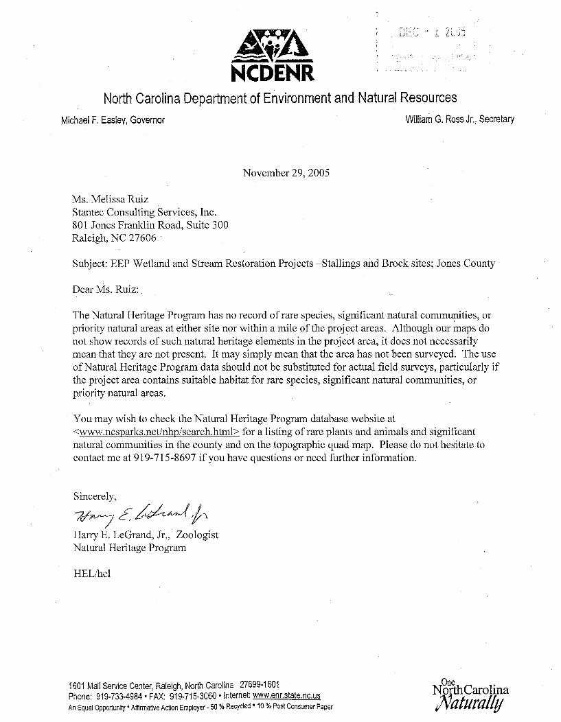
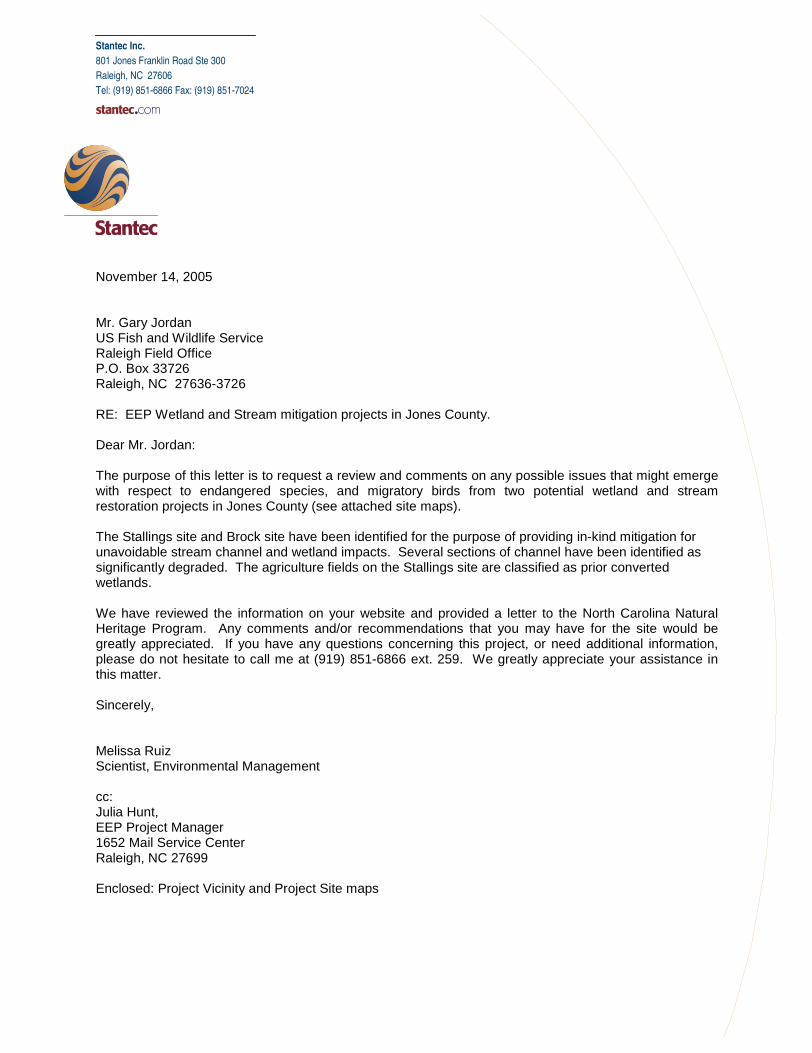
Stantec Inc.
801 Jones Franklin Road Ste 300
Raleigh, NC 27606
Tel: (919) 851-6866 Fax: (919) 851-7024
November 14, 2005 Mr. Gary Jordan US Fish and Wildlife Service Raleigh Field Office P.O. Box 33726 Raleigh, NC 27636-3726 RE: EEP Wetland and Stream mitigation projects in Jones County. Dear Mr. Jordan: The purpose of this letter is to request a review and comments on any possible issues that might emerge with respect to endangered species, and migratory birds from two potential wetland and stream restoration projects in Jones County (see attached site maps). The Stallings site and Brock site have been identified for the purpose of providing in-kind mitigation for unavoidable stream channel and wetland impacts. Several sections of channel have been identified as significantly degraded. The agriculture fields on the Stallings site are classified as prior converted wetlands. We have reviewed the information on your website and provided a letter to the North Carolina Natural Heritage Program. Any comments and/or recommendations that you may have for the site would be greatly appreciated. If you have any questions concerning this project, or need additional information, please do not hesitate to call me at (919) 851-6866 ext. 259. We greatly appreciate your assistance in this matter. Sincerely, Melissa Ruiz Scientist, Environmental Management cc: Julia Hunt, EEP Project Manager 1652 Mail Service Center Raleigh, NC 27699 Enclosed: Project Vicinity and Project Site maps