Embed Size (px)
Citation preview
A HISTORY of REST HAVEN BY HOWARD W. BURNETT June, 1997
THE HISTORY OF REST HAVEN Rest Haven is a part of Deale, so we’ll start there. Here is a quote from the 1997 Membership Directory of the Southern Anne Arundel Chamber of Commerce. DEALE “The earliest mention of the area in the Maryland Hall of Records was 1659, when Englishman Richard Gott marked off 600 acres and called it Rams Gott Swamp. Cecil H. Marshall notes in his handwritten history of Deale how in the 1850’s watermen traveled from the Eastern Shore to a huge, natural oyster bar called Bay Shore Bar. About 10 of those families settled in that era on Parker’s Island, which soon began washing away. With their land disappearing, some of these families moved a short distance to the Deale area. Deale’s first post office was opened in 1908, about 16 years after the original Cedar Grove Church was built with lumber hauled from Churchton by ox-cart.” The following about the history of the Deale area is from the Deale family history: “In Southern Anne Arundel County located between Herring Bay and West River is the community of Deale. It was given its name by Postmaster John Leatherbury who named it after his mother’s (Rachel A. F. Deale) family. “The origins of the Deales into Maryland is difficult to trace as the records of Calvert County were destroyed in a Courthouse fire of 1882. Also, some of the Anne Arundel County land records were destroyed in the State House fire of 1704. “The earliest records show that the Deales were associated and friends with some of the most prominent families in Anne Arundel County history. They owned and invested in land. The early ancestors apparently had substantial wealth although they do not appear as part of the upper society. They married into such families as the Hopkins, Wells, Gotts, Giles, and Franklins. Some of these were part of the West River and Herring Creek Hundreds of The Quaker Association. (Ed. note: The earliest Quaker Meetings in Maryland were at the Quaker Cemetery in Galesville.) “The Deales were apparently Episcopalian in the early generations as they were members of the St. James Parish. The later generations helped to establish and were active members in both the Oakland and Cedar Grove United Methodist Churches.

“Most of the later generations of Deales were farmers, fishermen, and craftsmen. James Franklin Deale was a prominent doctor in the Baltimore area. Also John Summerfield Deale became a minister in the Baltimore Conference Methodist Episcopal Church...... “......William Deale of Calvert County settled in Maryland before 1691.....He married Elizabeth Stallings...and had 9 children. “....Eventually, in 1737, a James Deale purchased parcels of Ram Gott Swamp located on Herring Bay.” (Note: Ram Gott Swamp appears to be the original reference name for the area now known as Deale, Rockhold Creek, and Tracey Creek drainages, at least the flat parts with poor drainage.) In 1951-1953, the State sponsored a program encouraging local elementary schools to delve into the history of their area. A book, Discovering Our School Community, resulted. This is a loose-leaf notebook, available at the Deale Library, which has a write-up about many local areas of Anne Arundel County. About Deale, it offers the following: “Historical background. Deale’s earliest settlers were farmers and watermen. We have no certainty for what reason they came other than to explore and to find better ways of making a living. “In 1659, Richard Gott, an Englishman, came in and staked off 600 acres of barren land. After obtaining a patent (an old English word comparable to the words grant and charter), he, for the time being, paid a rent of 12 shillings (approximately $3.00) per year, to Lord Baltimore. He named this great tract of land “Rams Gott Swamp”. However, on the first map made of the property it carries the “Rams Goat” inscription. On August 1, 1698, Richard Gott’s son, Richard Gott, Jr., who had inherited the property from his father, sold it to Anthony Holland. It seems that sometime during this period other disposition had been made of all the land but 240 acres which comprises what we now know as Deale. “Historians point out that many of our oldest records were lost in a fire which accounts for much of the information concerning various properties. However, in February 1702, this 240 acres was transferred from Anthony Holland to his son, Thomas Holland, and his half-brothers Jacob and Capell Holland; also two sisters, Elizabeth and Susannah. These last four persons sold their interest to their half-brother Thomas Holland, who, on November 25, 1716, sold it to John Giles. The records say that this John Giles had three daughters to whom he bequeathed 80 acres each, in 1727. “The next transfer takes place in 1736, when a George Chocke sold 80 acres of “Rams Gott Swamp” to James Deale and stated that this one portion of 80 acres was sold for 16 pounds, 5 shillings, and 7 pence. We assume that this was one part of the records that were destroyed, for there is nothing in the present record concerning the man, George Chocke. It is possible that this Chocke was the husband of one of the daughters of John Giles, for the record tells us that in 1757 Mr. James Deale acquired from William Wooten and wife, Elizabeth, daughter of John Giles, who in 1727 bequeathed to her, one third of Ramgoat Swamp 80 acres.’ For this portion he paid

40 pounds of sterling. In that same year, according to the records, Mr. Deale acquired the final 80 acres from George and Rebecca Allen, daughter of John Giles who in 1727 bequeathed to her one-third of Rams Goat Swamp. For this portion he paid 50 pounds, sterling. In 1773 we find that Mr. James Deale willed 80 acres of this property to his son, William Deale, but under the stipulations of this will, because William Deale had no heirs, all of the 240 acres and all the personal property (with the exception of one Negro man named Newalk who was given to William Deale) was bequeathed to another son, John Deale. “One of the boundaries noted on the first map of the property which was drawn up in 1775, lists the creek presently known as Rockhold Creek, as Gott’s Creek, after the man who settled it. Deeds drawn up long since that time still named “Gott’s Creek” as a boundary. It is not known when the name was changed. “The James Deale mentioned is presumably the ancestor of all the Deale families which have been in the community from his first mention down to the present day. “In 1882 Frederick Rogers bought 100 acres of land from Mr. Hall. Mason’s and Owing’s Beaches (as they are now called) were part of that tract. “About a mile from Deale in the Chesapeake Bay there was an island, called “Parkers Island,” upon which eight white families lived. It was large enough, they say, for eight large house lots with gardens. People used to row boats to reach the island. Finally, the families moved to the mainland (Deale), and little by little the island disappeared. Miss Pearl Rogers, a resident of the community, said she could remember when there was only one tree on a speck of land on the island, then it too, disappeared into the bay. “Religion. Pentecostal Church. The Pentecostal Church was established by the Reverend J. A. McCambridge of Washington, DC In the spring of 1928 the tabernacle was built on Rockhold Creek on the property that the Reverend Howard D. Parks donated for the tabernacle. “In 1928, when the weather began to get cold, half of the tabernacle was closed in and used as a church for eleven years. “In 1941, the Reverend Stakle built the parsonage on the same property with the church. The Reverend Parks preached here about two years. “When the church and parsonage were finished there was enough money to cover expenses on the parsonage, with a $65 debt remaining on the church. This has been paid. At this time the Reverend E. F. M. Staudt, the former District Superintendent of Assemblies of God Churches, and his wife, live in the parsonage and both preach. Mrs. Staudt was a missionary to India for fifteen years. (Ed. note: The Pentecostal Church apparently became the Assembly of God Church, but today has become a private residence on Rockhold Creek Road.)
“Methodist Church. Until the year 1892 there was no Methodist Church in Deale. Adherents of that faith attended Oakland - the five to eight miles, in those days, being within walking distance - while some of our nearby neighbors attended, via horse and buggy, either the Northern or Southern Methodist Church at Friendship. However, following a successful revival meeting held in the old barn which stood just back of what is now Wheeler’s Hardware Store, the 42 converts vigorously decided that Cedar Grove, as Deale was then known, should have its own church. At this same time Oakland was in the process of building a new church and it was decided that the old church building should be moved to Cedar Grove. Taken down and sawed up into movable sections, the old church was hauled to Deale by oxcart and reassembled as the first Methodist house of worship on the site of the present church. This was done under the direction of the Reverend J. R. Andrew, pastor at that time, and his assistant, J. W. Beall. Many of the older residents of Deale recall with pleasure, the homey every-dayness of the Reverend Andrew - a giant of a man they say, who thought nothing was impossible once you made up your mind to do it. Mr. James Rogers recalls that he remembers as a child, when the Reverend Andrew would drive his horse and buggy down on the end of Drum Point Road, load his team on an old scow there, go across the creek, unload at Town Point and proceed to preach at the church at Friendship. On his return trip, Mr. Rogers reminisces, he would invariably stop in at their home and partake of whatever his mother had in the way of food. Truly, our community was being formed and forged by real pioneers in those days when it was not easy to accomplish an aim. The old church records register forty members in the organization of that first church. By 1912 this old building served its purpose, and the congregation decided to tackle the job of building a new church. The Reverend W. H. Sanders was pastor at this time and according to the old record, ‘a successful revival service resulted in a good number of conversions, and has helped to make that appointment one of the leading appointments of the circuit.’ Of course, in those days, Oakland, Cedar Grove, Mt. Calvary, Wesley Chapel, Shiloh, Lower Marlboro, and Friendship comprised one circuit and were served by one minister. To get this new church built, the men of the community went into Mr. Thomas Ford’s woods and cut all the timber, donated by Mr. Ford, for the building. They arranged for the saw mill of Mr. Harry Price to go into the woods at the same time and saw these logs into the materials needed for the erection of the church. This lumber, too, was hauled to the present site of the church by oxcart and horses and wagon. Mrs. Ford recalls that so great was her enthusiasm that she, alone, cooked for and fed all the men who did this work. She tells that for the roof, windows, doors, etc., that couldn’t be coaxed out of those trees they dared go to the bank and borrow $50 to complete the job. Most of the actual work of building was volunteer, she says, and was under the direction of Mr. Will Leatherbury. She remembers, with loving fondness, that the first hymn sung in the present church in 1912 with Mrs. Janie Windsor Leatherbury as organist, was “The Ninety and Nine.” The present church was dedicated in 1922 when the Reverend Carl D. Maxwell was pastor. “It is interesting to note that eight of the original forty members who formed the church in 1892, are still residents of the community. (Ed. note: In 1951-1953.) To all of them, to those who followed the gleam envisioned by those first forty, to those who dared to do more than dream, and to the ministers who have worked with and for the cause of our community and God, we bow in humble tribute to their noble achievement.

“Episcopal Church. In 1876 an Episcopal Church was built, called St. Mark’s, so the people would not have so far to walk to St. James, several miles away. St. Mark’s is still being used as a place of worship and is kept in good repair. “Rise of Community. In 1907 bridges were built over Rockhold and Tracey’s Creeks. The opening of these bridges began the opening and building up of Deale and in 1910 the first state road was built, which also promoted the rise of the community. In about 1920 the waterfront property began to be settled and city people came here for the summer. Later they equipped their homes for winter and began to stay throughout the year. “The population has increased from a few families of 500 or 600 people in the early twentieth century to the present 900 to 1100 people. “How Deale Got Its Name. The Community was first called Cedar Grove, and the Methodist Church still bears that name. When the post office was placed here, Mr. John Leatherbury was given the privilege of naming it. He named it Deale, which was his mother’s maiden name.” (Ed. note: In The Postal History of Maryland, etc., by Smith and Kay, it is stated the Deale Post Office was established on July 5, 1899, with John J. Leatherbury as Postmaster.) (Tongue-in-cheek Ed note: “Deil” is the old scotch word for “Devil.” Could this be the origin of Deale?) Cecil H. Marshall, a life-long resident of Deale, developed a personal history of Deale, primarily from recollections by family members and others. Some information from Mr. Marshall’s personal history are presented here: In the 1850’s large oyster bars attracted watermen from the eastern shore to the Herring Bay area. One of these oyster bars, known as “Bay Shore Bar” extended from Herring Bay up to West River. Some settled on Parker’s Island, and family names there included William S. Marshall, John Catlin, Wes Evans, John W. S. Parks, Jake Linton, Conley Parks, Thomas Henry Rogers, and Bud Phipps. About at that time, others settled in the Deale area, including some descendants of William Rogers. Alexander Rogers, a son of William Rogers, built a house at the end of Drum Point Road, in 1863. Before the Deale Post Office was established, mail was hauled in once a week from the old “Sudley” Post Office. The original Deale Elementary School was built around 1899 at the east corner of Rte 256 and Drum Point Road. Lumber was brought by boat from Baltimore and landed at the “Sand Place,” opposite “Oysterman’s Inn” (Ed. note: now Skipper’s Pier.) on Drum Point Road. It was a two room school for eight grades. The first teacher was Miss Zeborah Deale, called by everyone “Miss Zipp.” She was the daughter of James Deale. Before the Deale School was built, kids had to walk to a little school-house on Franklin-Gibson Road, the old Nutwell School.
(A “new” Deale school was built in 1932, where the Elks Lodge is now located.) School heat was provided by big coal stoves in each room, with the older boys charged with bringing in the coal and taking out the ashes. Bathrooms were two shanties out in back. The water supply was a pitcher pump out in front of the school. Houses were big and sturdy, but cold and drafty in winter. No fancy gadgets, no electricity, no bathroom, no water, just wood and coal stove heat. The cooking was done on a woodstove in the kitchen, which was also used for most other family activities -- eating, sitting, reading, sewing, bathing in the morning, and the Saturday night wash-tub bath. The only other heat was a coal stove which was kept burning from about Thanksgiving until spring. Yards were large, and gardens supplied most of the families needs. Grass was mowed with push-type reel mowers, and yard and garden work were expected of the family boys. In the 1920s to 1940s there were two stores on Drum Point Road which sold just about everything needed for living in those days: meat, food supplies, gas, kerosene, cloth, sugar, flour, hats, shoes and boots. One store was operated by John S. W. Parks and one by Virgil Rogers. Earlier there had been a store operated by Columbus Rogers. Storekeepers got their supplies from Baltimore. They would go, once a week, by horse and wagon, to the old steamboat landing on Chalk Point Road to pick up supplies. A third store appears to have been located at the west corner of Rte. 256 and Drum Point Road, owned by Matt Windsor. (This location was later owned by Collinsons and Dick Leisner, and eventually was occupied by a brick drugstore building.) Electricity came to Deale around 1930. Many families could not afford to have their homes wired, and some were just plain suspicious of electricity and suspected it might draw lightning, so delayed home electrification for a number of years.. Deale roads were all County Roads, laid out as they now are. They were mostly dirt until the County started putting gravel on them. County crews came around about once a year to clean out the ditches and spread some gravel. Gradually the roads were improved, until during the 1950’s the packed crushed stone particles and oil and tar were put down. The first marine railway for boat hauling in Rockhold Creek was built by Frank Marshall in 1928. Before that the local watermen used to haul their boats up on shore, using pound net poles to slide the boat up on sideways. Most of the boats were small compared with now and could be pulled up by several men using ropes. The main recreation for the community was baseball. The local team was the “Cedar Grove” team. They played teams from Baltimore and Washington, as well as Grenock and Owings. After World War II, a league was formed consisting of Cedar Grove, Grenock, Huntingtown, and St. Leonard. In addition to baseball, there was always swimming, boating, and in the winter, ice skating. The winter of 1935-36 was especially cold, and skaters could skate to Fairhaven and even to North Beach.
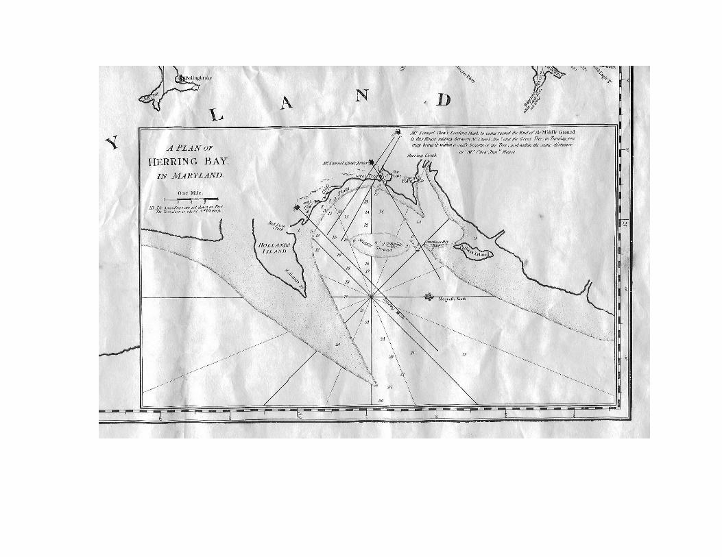
Before the 1930’s employment was limited, primarily to Oystering and Crabbing. In 1937, oysters brought 50 cents a bushel, and crabs were 25 cents a dozen, but there wasn’t much demand for them. In the mid-30s people from the cities started to bring their boats into Rockhold Creek, and sportfishing and party boats had their beginning. Rockfish were not especially popular until the 1940s. A summertime highlight in the 1930s were Herring Bay Regattas. Outboard hydroplanes, fishing boats, work boats, and sailboats competed around various racecourses. Boys had a rowboat race, with the winner getting a two dollar gold coin. Regattas usually were held Labor Day weekend. Another highlight was the Farmer’s Picnic. Near the end of summer there would be a jubilee picnic at Fairhaven. People came from all around, with most of the Deale people going by boat, to spend the day picnicking, playing games, and just visiting with relatives and friends. In the 1930’s, many oyster dredgers would bring their skipjacks into Rockhold Creek on nights and weekends, from where they worked the local oyster bars. There would be twenty or more, from Smith’s Island or Tangier Sound. They were all good natured, hard working watermen, just like the folks in Deale, so many made good friendships. Once, the Cedar Grove baseball team made a special trip to play their team on Smith’s Island. MAPS The 1776 map by Snyder and Bennett (“A New and Accurate Chart of the Bay of Chesapeake, with all the Shoals, Channels, Islands, Entrances.”) (See Appendix 1.) shows a clear “Plan of Herring Bay.” It clearly shows “Parker’s Island” off the mouth of a creek which must be what we currently know as Parker (or Parker’s) Creek. Of interest is the fact that Holland Point is shown as part of “Holland’s Island,” which indicates how little was known of this area in those days. The “Martenet’s Map of Ann Arundel County” of 1860, (See Appendix 2.) shows “Parker’s Id” to be a peninsula extending north to south across the mouth of the three pronged “Parker’s Cr.” (It is speculated that perhaps this creek was originally known as “Parker’s Island Creek” to keep it from being confused with the more well-known Parker’s Creek in Calvert County.) This map indicates a few early settlers in this area: a Linton approximately at the end of Marzoff Road; a T. Richardson along what is now Deale Beach Road (This is the old house on the old golf course); a James Deale perhaps near where Wheeler’s Hardware is now; a Dr. R. Franklin between Carr’s Creek and Deep Creek; and an unidentified house approximately where Resthaven is today. This map is very difficult to read, and many of the names on it are subject to interpretation.

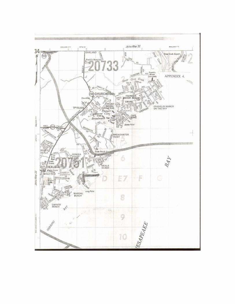
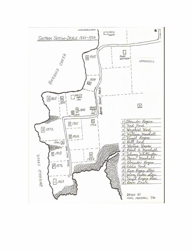
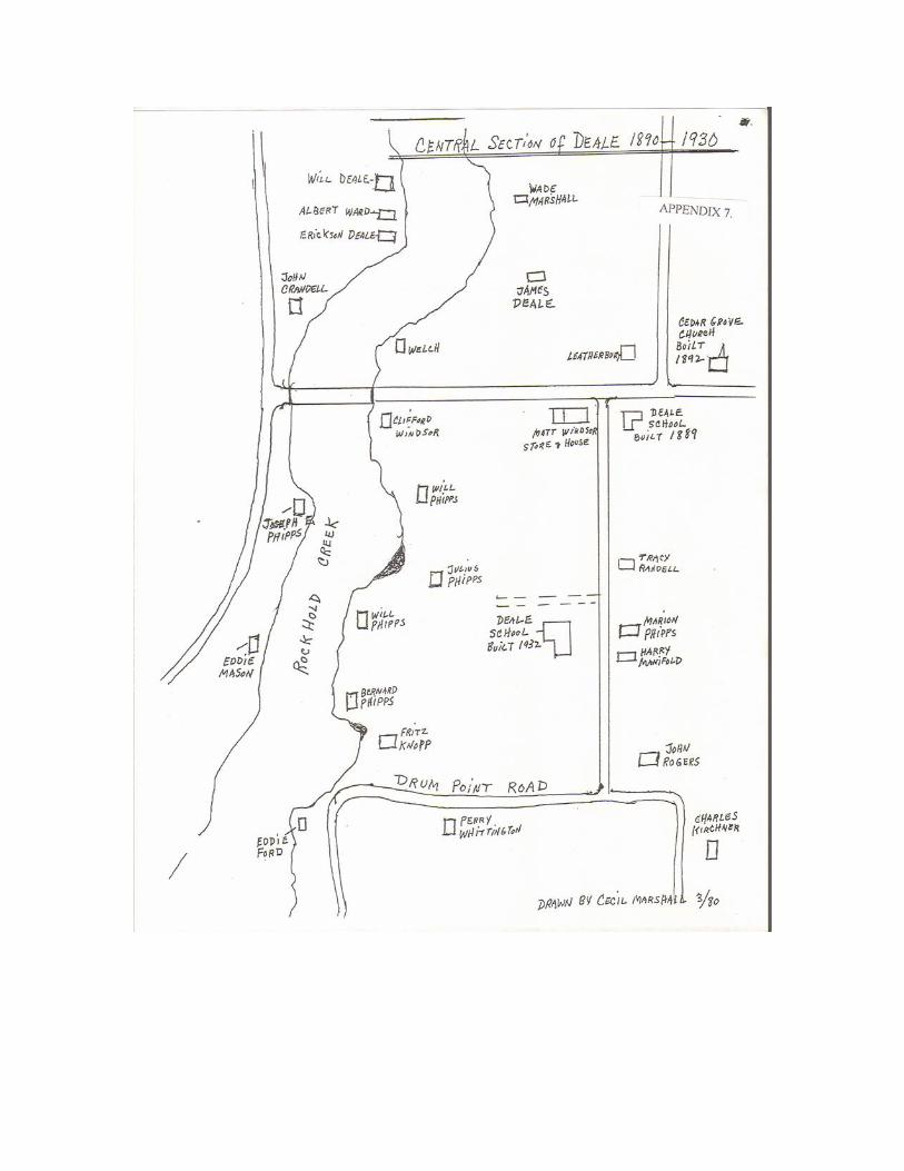
On this map, What is now Rockhold Creek is shown as Herring Creek, and the area now known as Deale is shown as part of Tracey’s Landing where several dwellings are shown. Actually, there is probably a map-makers error here. Since herring, for which Herring Bay must have been named, come to spawn in fresh water, the name Herring Creek should have been given to what is now Tracey’s Creek, which drains a fairly large watershed, while the present Rockhold Creek is strictly tidal and brackish, and thus of no interest to herring. The 1878 “Atlas of Anne Arundel County” by Hopkins (See Appendix 3.) is clearer and easier to read. It shows “Parkers Island” as a north-south peninsula across the mouth of what is now Parker’s Creek. There are three buildings shown on the island, one of which is labeled “Richardson.” The others may be houses or other buildings, though one is labeled simply “S.” (There is no list of abbreviations to explain this label. Perhaps it is to signify the name should be “S. Richardson.”) This map shows a road about where Deale Beach Road is now. A “P.Linton” house is shown about at the end of Marzoff Road, and an “S. Richardson” is shown where the old Golf Course home is now. An unnamed house is shown where Rest Haven is now. A “W. Hall” is shown across the Creek at what is now Mason’s Beach. On this map Rockhold Creek is called “Got Cr.” and what is now Tracey’s Creek is labeled “Herring Cr.” A “B.Davis” is shown about where Skipper’s Pier is today, and a “J. Deale” is shown as a dealer in horses about where Wheeler’s Hardware, or perhaps Mali’s, is today. The entire Deale area is labeled “Traceys Landing.” It is interesting to note that on this map larger landowners had their names printed in larger type, but no one in the immediate Deale area was awarded this distinction, the nearest being a Jacob Rice who apparently owned 243 acres on the Franklin Manor Road. A current map to consider is the ADC Company’s Anne Arundel Co., MD Street Map, page 34, (See Appendix 5.) which shows the Rest Haven community as it is today. Appendix maps 6, 7, and 8 are by Cecil H. Marshall, and show Deale in its earlier stages of development. EARLY REFERENCES Even earlier than these maps is a reference in the Anne Arundel County Land Records, as follows: “Grantor: Thomas Carr, AA Co. planter Grantee: John Wildly, AACo Planter Date of deed: 26 March 1703 Date Recorded: None Consideration: 45 pounds Signature: Thomas (X) Carr Witnesses: John Ward, John Cheshire, Richd Dallam Description: That peninsula or neck of land called Parkers Island, containing 100 acres, being near Herring Creek Swamp, bounded by the Chesapeake Bay on the south, and Herring Creek on the west. This parcel was formerly granted to Thomas Daborne, late of

AA Co., desc. who by his LWT devised the parcel to Thomas Carr.” (Note: “LWT” is Last Will and Testament; “desc.” means deceased.) There is also a notation in the records that “Thomas Dabourne for a valuable consideration grants to John Gray, AA Co., tailor, ‘the within written deed.’ Dated 10 February, 1670. Later, there is another entry: “Thomas Dabourne had a property called Dabourne’s Hope, which he assigned to John Gray, who later assigned it to Edward Thorley, who assigned it to Christopher Gardiner. Recorded 14 February, 1670.” It is not known if Parkers Island was part of “Dabourne’s Hope,” but it appears possible. As for the name Richardson which appears on the maps, the book Abstracts of Land Records, Anne Arundel County, MD 1699 - 1709 reports: “Samuell Richardson, Commander of the ship Faulkoner, publishes the rate of 15 pounds per ton for tobacco. 29 March, 1706.”; and again: “March 5th, 1707, Samll Richardson, commander of the ship Falconer riding at anchor in Severn River, publishes the rate of 16 pounds per ton for tobacco, consigning to John Falconer mercht in London.” Whether this Richardson left his name in the Parker’s Creek area is not known, but since Parker’s Creek is thought to have possibly been used to shelter ships from severe storms, it is possible. In Riley’s A History of Anne Arundel County, the following appears: Early grants in the Herring Creek Hundred include, in 1651, a grant to one William Parker, and in 1659 to Richard Gott. Other early grantees included William Ayers (the first grant, in 1651),Captain Edward Carter, Richard Bennett, Edward Selby, William Parrott, William Paget, Anthony Galloway (of Tulip Hill, and for which the town of Galloways was named, now known as Galesville), Richard Wells, Christopher Birckhead (of the two oldest dated tombstones in Maryland, at St. James Cemetery), George Pascall, and then in 1663, some 15 or 20 more persons. The description of the grant to William Parker has not been found, but it appears that this may be the origin of the “Parker’s Island” label. (A “Hundred” was an early Quaker designation for an area of land that could produce sustenance for enough families to furnish 100 militia soldiers, if needed. An alternate definition is for an area that could support 100 able bodied heads of household. The Herring Creek Hundred included the Deale area.) In 1683 three ports were established in Anne Arundel, one of which was “at Herring Creek on the Town Land.” This refers to Town Point. By 1686, the towns were of sufficient importance as to require town officers at the three towns, including: “Herring Creek Town, Mr. Thomas Knighton.” Dick Johnson, of Mimosa Cove, is an amateur archeologist of some repute, and has found traces of two marine skidways and other detritus indicating shipyards on Parker’s Creek. One was across from Heller’s house, on the Mason Beach side of the Creek, and one was on the old golf course property near where the new house was built in 1995. The original Parker’s Island Creek
(When its name dropped the “Island” is unknown) had a good channel exiting to the bay southwest of the present channel, about where the Gibb’s pond is today. A small island blocked the exit, forcing the tide into a rip which kept a deep channel open. It had a hard bottom; but when Parker’s Island and the channel mouth island eroded away, the channel was filled, and relocated to its present position. The Richardson’s (Golf Course property) at one time had a tannery, apparently somewhat behind where DeToto’s now live. There was a small pond where hides were put to soak, but it has been filled in. The black cemetery (from Franklin Church) on Deale Beach Road is sometimes referred to as the “Tan Yard,” which is a term usually used for an area where tannic acid rich tree bark and wood was concentrated for use in a leather tannery. There is a small cemetery on Ripley Road in Mimosa Cove where Richardsons, Weems, and Normans are interred. In 1988, a bulldozer was hired to flatten this area, and succeeded in breaking most of the stones before being halted. Only one stone in good condition remains. (The bulldozer operator was arrested, and cemetery lot development was permanently halted.) A QUESTION! So, where is Parker’s Island? Over the years it apparently kept eroding and finally became uninhabitable. Some old timers recall playing baseball on the island, and that the outfield was getting shorter due to erosion. Eventually one house remained, and it was salvaged by cutting it in half and moving it to firmer land. One half is part of the present McLean home at the end of Deale Beach Road. The other half was moved to what is now Deale Beach, on Carr’s Creek, by the Gager family, where it burned about 1950. Finally, the 1935 hurricane erased the last traces of Parker’s Island. (See related newspaper story at Appendix 9.) In A Cruising Guide to the Chesapeake by Blanchard and Stone, there is a note: “Larger boats sometimes anchor in Herring Bay, west of Parker Island bar...” So, apparently the name Parkers Island lives on with the mud bar across Herring Bay. (Ed note: Is it possible this is an author’s error, and “west” should be “east.”?) REST HAVEN At one time, apparently the Rest Haven peninsula was part of the holdings of the Franklin family. Captain Bernard Franklin, a steamship Captain, owned all of what is now Rest Haven, and most of the land pretty much as far as what is now Franklin Manor. Eventually, the Rest Haven area became the Phipps farm, which, by 1950 had become the John H. McKibbon farm. This was a subsistence farm, raising a variety of crops and products primarily for home consumption, and not for market as some other area farms did.
McKibbon started the subdivision about 1946. Starting at the farm’s east boundary adjoining the McLean property, five lots were laid off, of which, now, one is vacant, one is Aboud’s, one is the Kreb’s, and two are Fitzwater’s. (Ed note: A tree cut down in 1997 had about 50 tree rings, which confirms that the farm land converted back to brush about at the end of World War II.) The original farm entry lane off Deale Beach Road is now Cedar Drive, (most assuredly named for the cedar trees along it). McKibbon lived in the old Phipps farm house, which has now been enlarged and is the Heller home. He then sold off the lots along Cedar Drive, facing Parker’s Creek. These lots are now the Cook, Carr and Buckley houses, the Holt vacant lot, the Solier House, and the Czerwinski house (Formerly the Ben Jones house.) McKibbon then platted what he called Rest Haven, (See Appendix 5.) consisting of the lots along Bay View Drive, and the interior lots. The plat established Bay View Drive (named because of its location); Parker Drive (Named for the Creek); and Locust Street (probably named for black locust trees growing there.) A summer cottage was built on the water side of Bay View Drive in 1947; it is now part of the Leisner house. The Bayer house, (by Larry Herman), and the Paule house must have been built around that time. Anna Mae and Willie Collinson built the Winters house in 1950. The Pierson house was built in 1953. Landon Holt was the first to build on an interior lot, in the early 1950’s. Dick Leisner, in 1955, built the Tom Judge house (now the Bob Cross home.) An old chicken coop cement floor was located about where this house’s carport is now. The house was occupied in 1956. The Gill house was added about the same time. A builder named Schwartz, (of Schwartz Realty) built the Sanford (Villano), Dempsey, Bengtson, Burnett, Hensley, and William’s homes in 1956. Dick Leisner built the Bresnahan (Mattia) and Jim Judge homes in 1958. Herb Jones built the Armentrout home about 1960. In 1962, a builder named Nutwell built three houses on Bay Front Drive, now known as the Red House, the Jeanette Wedler house, and the Steve Heller house. These houses were built on speculation and sold later, the only houses in Rest Haven built on that plan. In 1988, the Paul Petro home was added, and the Solier house was built in 1995. Finally, in 1997, the Peppi house was added, which brings us to the present. Why the name Rest Haven? Apparently because it sounded good to Mr. McKibbon, and no other reason! ANOTHER QUESTION! While we’re at it, who is Parker, whose name graces a long gone island, a creek and a street? Here’s a quote from The Placenames of Maryland, by Hamill Kenny, 1984: “All mentions of Parker in Southern Maryland are traceable to William Parker, ....one of the Puritans who, in 1649 founded Anne Arundel County. In 1651 he was granted two tracts, one of them being Parkers Cliffs on Middle Cliffs at Parker Creek.” (He died in England in 1674.) “...descendants of

William Parker’s nephew, George (d.1681) still live in Calvert County......Parker Wharf’s name is attributed to Dr. John Clare Parker, who represented Calvert County in the State legislature, where he was President of the Senate. There is a settlement called Parkers, on the Patuxent River, near Broomes Island Village in Calvert County. Early Anne Arundel land records show that a “William Parker and wife” deeded “Cumberstone” to a Sara or Laura Lowndes(?). (The old script is exceedingly difficult to decipher, so this name may not be correct.) This would have been the original “Cumberstone” estate, on what is now Old Sudley Road; known now as “Sudley” and not the current estate on Cumberstone Road. It is unknown why this name migrated to a new neighborhood.

APPENDIX 1. 1778 Chart of the Bay of Chesapeake 2. 1860 Martenet’s Map of Ann Arundel County 3. 1878 Hopkin’s Atlas of Anne Arundel County 4. ADC Company’s current map of Anne Arundel County, Page 34 5. Plat of Rest Haven Sub-Division 6. Southern Section of Deale, 1860-1920 (by Cecil H. Marshall) 7. Central Section of Deale, 1890-1930 (by Cecil H. Marshall) 8. Western Section of Deale, 1890-1930 (by Cecil H. Marshall) 9. August 28, 1987, Newspaper article about Parker’s Island