Embed Size (px)
Citation preview

Response to Earthquake and Tsunamis
Apr 4, 2018
Emergency Response Coordinator

Earthquakes in the world
Japan Meteorological Agency
We are here
Red dots show the places where earthquakes occurred in the world
1

Annual distribution of all epicenters in 2015
Japan Meteorological Agency
We are here
Dots show the places where earthquakes occurred around Japan
2
A rock (500-600t)*Remnant of Tsunami in 1771
��������*The Ishigaki Is has experienced huge tsunamis 4 times in the past. Tsunami height was 20 to 30m.

Nikkei newspaper, Apr 11, 2011
Statistics of death toll in 2011 The Great East Japan Earthquake
AgesCauses of death
60s2,124 people70s
2,663 people
80 and over2,454 peopleDrowning
12,143 people
Death by fire148 people
Crashing death and others578 people
Caused by tsunami
3
The earthquake occurred at 2:46 pm, Mar 11, 2011

5 upper 6 lower
Low earthquake resistance
Difficult to walk Difficult to remain standing
Japan Meteorological Agency
Seismic intensity scale
4

6 upper 7
Low earthquake resistance
Low earthquake resistance
High earthquake resistance
Likely to lean or collapseLikely to lean
Impossible to move without crawling
5

• Protect your head and shelter under a table.
• Don’t rush outside.
• Don’t worry about turning off the gas in the
kitchen/labs when shaking in the earthquake.
After the tremor subsided, turn off the gas etc.
If you feel a tremor,
At home, or OIST campus
Response to Earthquake
*See the video “Earthquake Early Warning” presented at the last slide
6

• Don’t slow down suddenly.
• Turn on your hazard lights to alert other drivers.
• Then slow down smoothly, pull over to the left
and stop.
While driving
*See the video “Earthquake Early Warning” presented at the last slide
7
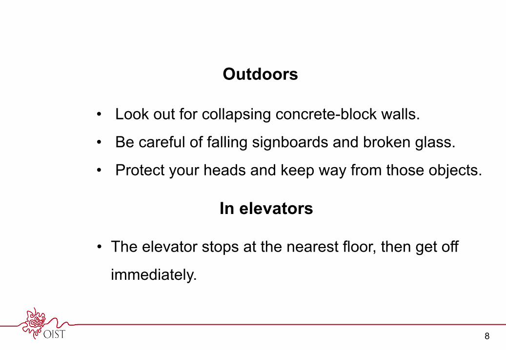
• Look out for collapsing concrete-block walls.
• Be careful of falling signboards and broken glass.
• Protect your heads and keep way from those objects.
Outdoors
• The elevator stops at the nearest floor, then get off
immediately.
In elevators
8

Earthquake Tsunami
An earthquake occurs at epicenter
Earthquake Early Warning issued when seismic intensity is 5 lower or more
People feel a tremor of the Earthquake
Tsunami warning issued
A few to ten and more seconds, depending on the distance you live from the epicenter.
As early as one minuteafter the earthquake
*Not all earthquakes trigger tsunamis.
Arrival of tsunamis on the coast
• As early as 4,5 minutes, or 50 minutes and more after the quake, depending on the distance you live from the epicenter.
• Tsunamis rush several times, not necessarily the first one is the highest tsunami and most devastating.
TV (NHK and all Japanese commercial broadcasting), radio (NHK etc.), cellphone (all Japan makes), website (NHK, Japan Meteorological Agency, etc.)
How to get the information
TV (NHK and all Japanese commercial broadcasting), radio (NHK etc.), cellphone (all Japan makes), website (NHK, Japan Meteorological Agency, etc.), PA by municipal governments, Fire Dep, and Japan Coast Guard etc.
Concept of tsunami warning after the earthquake
*See the video “Earthquake Early Warning” presented at the last slide
9

Major Tsunami Warning (Ou Tsunami Keihou), or Tsunami Warning (Tsunami Keihou)
• Immediately evacuate to a tsunami evacuation area/building.
• Be aware of 2nd wave, stay there until the warnings are lifted.
*Major Tsunami Waring with Huge Tsunami=the same scale of tsunamis we had in 2011 the Great East Japan Earthquake, in some places tsunami height exceeded 30 m.*Major Tsunami warning=tsunami height, 3m or more.*Tsunami warning=tsunami height, 1-3m.
Response to Tsunami
Japan Meteorological Agency
10

Onboard a ship (small craft)
In/near a port• Dock at the wharf/pier, immediately
evacuate to a higher ground/tsunami evacuation area.
Near coastal area• Escape offshore as far as possible.
Follow the direction by Japan Coast Guard if available.2011 the Great East Japan Earthquake
11

At beach
Tsunami Advisory(Tsunami Chuihou)
Immediately get out of the water,evacuate to a higher ground.
*Tsunami advisory=tsunami height, 0.2-1m.
Japan Meteorological Agency
12

13
Tsunami evacuation area in OIST
*OIST main campus is located more than 50 m above sea level. You stay here in case Major Tsunami Warning with Huge Tsunami was issued by the Japan Meteorological Agency.

Actions and Evacuation Route when Major Tsunami Warning (Ou Tsunami Keihou) issued
1. Protect yourself. Shelter under a table/desk if tremors occur.2. Do not rush outside.3. After tremors have subsided, turn off the gas, switch off the power, if used.4. Obtain information from TV, radio, internet about the tsunami.5. If a major tsunami warning with huge tsunami height is issued, evacuate to the building of the Onna Sub Base ASDF.
Do not use a car because the roads will be congested with traffic. Do not return until the warning is lifted.(If you have directions at the base by the Commander, follow it.)
OIST Seaside House
Onna Sub Base, Air Self-Defense Force
(Tsunami Evacuation Area)
Rou
te 5
8
Seaside Faculty Houses
We are here
23 m above sea level
More than 40 m above sea level
Gate
Major tsunami warning with huge tsunami height means tsunamis as large as those seen after the Great East Japan Earthquake of 2011 (over 30m in some places) may hit.
Bldg.
Seaside House
14
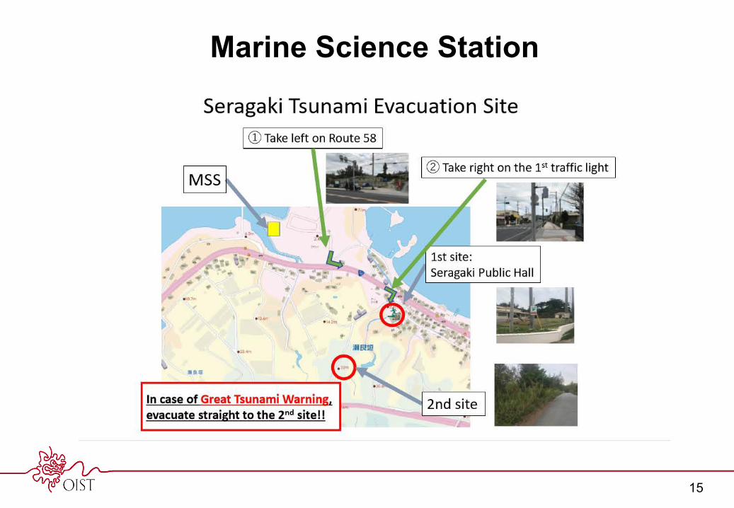
Marine Science Station
15

16
Tsunami evacuation area at your house

• You spend most of the year at your home.
• There is a high possibility of experiencing an
earthquake at your home.
• Most casualties were caused by Tsunamis that
occurred after the 2011 The Great East Japan
Earthquake.
• Highly recommended you know tsunami evacuation
areas near your house.
Prepare for Major Tsunami Warning with Huge Tsunamis
(Ou Tsunami Keihou, Kyodai Tsunami)
17

How to find proper tsunami evacuation areas
1. Know the meaning of sign boards.
2. Study the hazard map.
3. Know the sea level of evacuation area.
(more than 30m above sea level is preferable)
4. Walk to the tsunami evacuation area and know the
time needed to arrive there from your house.(JMA announces estimated time of tsunami arrival to your town)
18

Sign boards
19

Hazard map issued by city government
Hazard map issued by Ishikawa city government
20m sea level
20

Hazard map issued by city government
Sea level
Hazard map issued by Okinawa city government
Sea level
21

Okinawa Prefectural Government website
2Click Geographic Information System
3
1http://www.pref.okinawa.jp/site/chijiko/kohokoryu/foreign/index.html
Geographic Information System
4Click Sea Level Map
Hazard map posted by prefectural government
22

5 Select the area you live
23
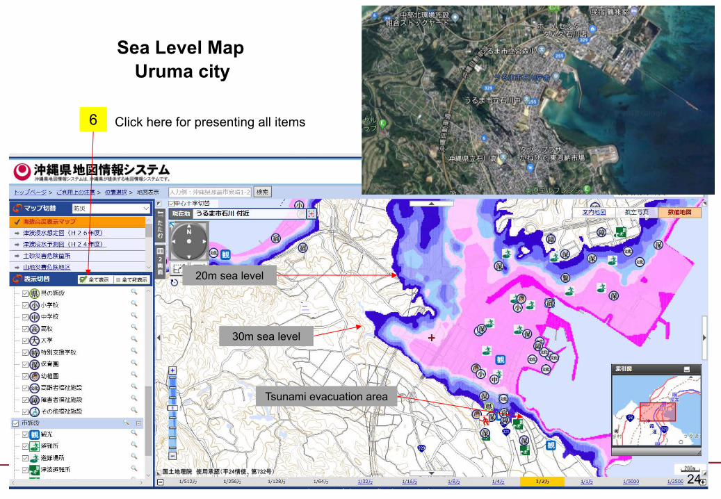
Uruma citySea Level Map
20m sea level
Tsunami evacuation area
30m sea level
6 Click here for presenting all items
24

Click here for more informationSea level Okinawa city AB
20m sea level
Sea Level Map
25

For You and your Family’s Safety,
Walk to a nearest tsunami evacuation area
from your house Once.
Send these messages to your colleagues
26

Earthquake Early Warning
Japan Meteorological Agency
The video introduces you how to react at the moment of earthquake in addition to actions to be taken if you receive the Earthquake Early Warning.
27