Embed Size (px)
DESCRIPTION
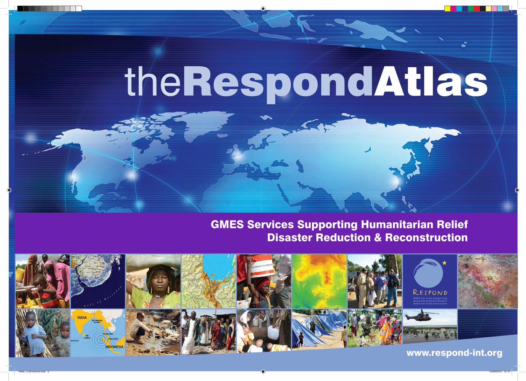
Space-based assistance is being providedthrough Global Monitoring for Environmentand Security initiative (GMES). This flagshipinitiative of ESA and the European Unionaims to combine Earth - and space-baseddata sources to develop an integratedenvironmental monitoring capability tobenefit European and world citizens.Respond was set up as fast track project aspart of the GMES Service in close conjunctionwith a large community of operational usersto address specific requirements of thehumanitarian aid community.Respond represents an alliance of Europeanand International organisations working withindustry and the humanitarian communityto improve access to maps, satellite imagesand geo-information. Founded in 2004 andextended in 2007, this project has mappedover three million square kilometres andhas been involved in over thirty worldwidehumanitarian crisis events.
Citation preview
theRespondAtlas
GMES Services Supporting Humanitarian ReliefDisaster Reduction & Reconstruction
www.respond-int.org
Atlas_1>35-amend.indd 3 13/08/2010 15:13
theRespondAtlas
Space-based assistance is being provided through Global Monitoring for Environment and Security initiative (GMES). This flagship initiative of ESA and the European Union aims to combine Earth - and space-based data sources to develop an integrated environmental monitoring capability to benefit European and world citizens.
Respond was set up as fast track project as part of the GMES Service in close conjunction with a large community of operational users to address specific requirements of the humanitarian aid community.
Respond represents an alliance of European and International organisations working with industry and the humanitarian community to improve access to maps, satellite images and geo-information. Founded in 2004 and extended in 2007, this project has mapped over three million square kilometres and has been involved in over thirty worldwide humanitarian crisis events.
Image: DLR
www.respond-int.org02
Atlas_1>35-amend.indd 4 13/08/2010 15:13
01
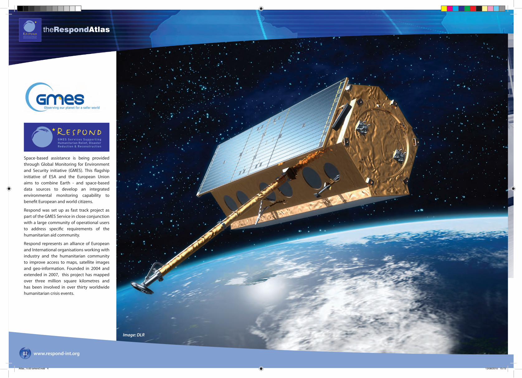
According to Oxfam, more than one billion people worldwide have been affected by natural or man-made crises since Respond began in 2004.
This Atlas illustrates just some of the mapping that has been provided since then by the Respond consortium – a partnership of private and public organisations, working together with a common vision to increase the effectiveness of the European and international humanitarian and development communities, through the appropriate and reliable application of geographic information.
Respond is, of course, part of the European Global Monitoring for Environment and Security (GMES) initiative. The first roots of Respond really emerged when key public and private actors, mainly in the Earth Observation (EO) service domain, put together a proposal to be one of the first of the European Space Agency (ESA)’s GMES Service Elements.
And throughout 2004-2009, that partnership has benefited from consistent and full ESA funding, without which, none of what you see in the next 90 pages would have been possible.
Bringing the Respond partners together has been a challenge: the users are a diverse group of charities, international organisations and government departments, all of whom have a real need for geographic information, but no interest whatsoever in satellites or European space policy. Furthermore, they have traditionally had a mistrust of commercial/industrial interests and their natural focus on profit. But we have learned and succeeded, to provide vital emergency mapping to crisis response teams across the globe.
We do not know how many people and organisations have directly used Respond mapping. Be it individual geographic layers being ingested into a humanitarian intervention planning tool in the UN in New York, or a paper map of Banda Aceh being used as an impromptu umbrella in the tropical rains of South East Asia – once the maps are out there, either through the World Wide Web, or through manual distribution in the field, they have a life of their own.
Respond mapping has been used to aid relief during all kinds of natural disasters, including the Asian Tsunami, many incidents of flooding across three different continents, and countless earthquakes and tropical storms. Importantly, it has also been used in the management of the humanitarian response to complex emergencies, such as the prolonged situation resulting in millions of internally displaced people in huge camps in Darfur. The EO-based geographic information produced by the Respond team has been shown to be relevant and helpful in all phases of the humanitarian intervention cycle: from mitigation and immediate response, to recovery and into preparedness for the next emergency.
theRespondAtlas
www.respond-int.org 03
From the beginning, Respond attempted to change the paradigm of EO-derived product provision, from fragmented deliveries of diverse products of unknown quality, to a consistent and coordinated service, providing validated mapping focussed entirely upon documented users’ needs.
I am very proud to be associated as Respond Project Leader, with all of the individuals from the 20 or so organisations throughout Europe, who have worked with such skill to create the huge volume of mapping, only a fraction of which is illustrated in this publication. They come from a dozen different countries and from organisations across the spectrum, from tiny SME’s with just a few employees, through multi-national companies, NGOs and the UN itself. But they have two things in common: a vision to see Earth observation being used to save lives and to improve the lives of disaster-affected communities; and a dedication to produce high-quality mapping whenever and wherever it is requested by our humanitarian response users, with whom we have developed such a close relationship over the last six years.
I hope that readers of this Atlas will find it informative and that it will expand their knowledge of GMES and what it has achieved so far. And that they will recognise both the formidable challenges and the great successes that have been achieved in bringing satellite-derived humanitarian mapping to aid so many emergency situations across our dangerous planet.
Dr Nicholas J Veck
Director, Space Business, Infoterra Ltd.
Project Leader, GMES-Respond
Foreword
Atlas_1>35-amend.indd 5 13/08/2010 15:13
theRespondAtlas
www.respond-int.org04
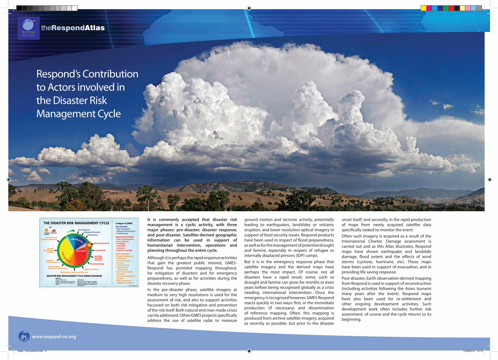
It is commonly accepted that disaster risk management is a cyclic activity, with three major phases: pre-disaster; disaster response; and post-disaster. Satellite-derived geographic information can be used in support of humanitarian intervention, operations and planning throughout the entire cycle.
Although it is perhaps the rapid response activities that gain the greatest public interest, GMES-Respond has provided mapping throughout, for mitigation of disasters and for emergency preparedness, as well as for activities during the disaster recovery phase. In the pre-disaster phase, satellite imagery at medium to very high resolutions is used for the assessment of risk, and also to support activities focussed on both risk mitigation and prevention of the risk itself. Both natural and man-made crises can be addressed. Other GMES projects specifically address the use of satellite radar to measure
Respond’s Contribution to Actors involved in the Disaster RiskManagement Cycle
ground motion and tectonic activity, potentially leading to earthquakes, landslides or volcanic eruption, and lower resolution optical imagery in support of food security issues. Respond products have been used in respect of flood preparedness, as well as for the management of potential drought and famine, especially in respect of refugee or internally displaced persons (IDP) camps.But it is in the emergency response phase that satellite imagery and the derived maps have perhaps the most impact. Of course, not all disasters have a rapid onset; some, such as drought and famine can grow for months or even years before being recognised globally as a crisis needing international intervention. Once the emergency is recognised however, GMES Respond reacts quickly in two ways: first, in the immediate production (if necessary) and dissemination of reference mapping. Often, this mapping is produced from archive satellite imagery, acquired as recently as possible, but prior to the disaster
onset itself; and secondly, in the rapid production of maps from newly acquired satellite data specifically tasked to monitor the event. Often such imagery is acquired as a result of the International Charter. Damage assessment is carried out and as this Atlas illustrates, Respond maps have shown earthquake and landslide damage, flood extent and the effects of wind storms (cyclone, hurricane, etc). These maps have been used in support of evacuation, and in providing life saving response.Post-disaster, Earth observation-derived mapping from Respond is used in support of reconstruction (including activities following the Asian tsunami many years after the event). Respond maps have also been used for re-settlement and other ongoing development activities. Such development work often includes further risk assessment, of course and the cycle returns to its beginning.
Atlas_1>35-amend.indd 6 13/08/2010 15:13

theRespondAtlas
www.respond-int.org 05
Link between Respond and the International Charter: “Space & Major Disasters”
The International Charter ‘Space and Major Disaster’ is an operational mechanism which delivers space imagery to disaster management centres and humanitarian aid actors during natural and man-made emergency situations.
People and the environment are increasingly suffering from the effects of natural disasters. Over the past 25 years, natural disasters have claimed more than 1.7 million lives, and affected more than 200 million people annually. One of the main drivers of increased vulnerability to hazards is global environmental change. Natural hazards, such as earthquakes, floods, droughts, storms, tropical cyclones and hurricanes, wildfires, tsunamis, volcanic eruptions and landslides threaten everyone but it is in impoverished regions where these have the most impact.
The International Charter on Space and Major Disasters (the Charter) is one initiative to promote improved responses to natural and technological disasters through the provision of space derived data.
The Charter aims at providing a unified system of space data acquisition and in the event of a natural or man-made disaster to make satellite Earth observation (and other space data) freely available to governments and agencies responding to major natural or man-made (technological) disasters and those affected by such events. Each member agency of the Charter has agreed to provide satellite information, under certain conditions, thereby helping to reduce the effects of disasters, particularly on human populations.
Since its foundation in 2000, the number of Charter activations has increased incrementally to reach approximately 40 activations per annum over the last few years.
Respond is a relevant framework for making use of the Charter for operational end-to-end crisis mapping solutions (Value-Added services) especially for situations outside of Europe.
The Charter is a key
mechanism to ensure
fast delivery of Respond
emergency response
products worldwide.
Atlas_1>35-amend.indd 7 13/08/2010 15:14
theRespondAtlas
www.respond-int.org06
Respond Mapping ThemesBasic Mapping Basic Mapping underpins almost all the mapping services provided in Respond. It provides the base layer information that users can utilise in order to determine key geographical attributes of a given area. The basic maps include as a minimum, information relating to the distribution of roads, rivers, and highly populated urban areas, including height information and administrative boundaries.
Crisis and Damage MappingA crisis or damage map is one produced within hours or days of a disaster occurring. The crisis and damage mapping service provides an assessment of the state or availability of infrastructure in areas during humanitarian crisis situations or after catastrophic events. This service operates on any scale (local to global) on a 24hrs/7 days a week basis.
Situation MappingSituation maps are important for both field, regional and headquarter staff to make informed decisions within a common reference frame. This type of bespoke mapping provides relevant and up-to-date user information in rapidly evolving operations, for example mapping the location of specific user related information, the state of transportation links, security zones etc.
IDP/Refugee MappingThese maps are designed to provide a snapshot of temporary human settlements caused by refugees crossing international borders or the internal displacement of people (IDP) within country. The Context maps provide a more complex situation assessment of the refugee or IDP camps and usually involve in-field data collection relevant to camp/IDP management that cannot be identified from EO data such as the location of man-made water resources and sensitive boundary information.
Thematic MappingA thematic map displays the spatial pattern of a theme or series of attributes about a geographic area. In contrast to basic maps which show many topographic features (forests, roads, political boundaries), thematic maps emphasise spatial variation of one or more specific subjects. Thematic maps can portray physical, social, political, economic, agricultural, or any other aspects of a city, state, region, nation, or continent.
Communication Mapping
Communication and report mapping is designed to improve the communication on the location and impact of humanitarian crises/events. They act as the visual tool to support user briefings to donors and the general public and thus are conceived to be simple context maps featuring basic user information to understand the ongoing situation.
India
Pakistan
Afghanistan
Iran
China
Quetta
Lahore
Karachi
Peshawar
Islamabad
-1-1
Mansehra
Kupwara (muzaffarabad)
PUNCHAbbottabad
ThoriAmbore
Chamra
Agro Tech
Chela Bandi
Saman Bandi
Panjkot (P1)
Mera Tenolian
Machiara (P5)
Panjgran (P2)
Narrul Stadium
Chilehana (P4)
Serli Sacha (P3)
Kalat
Sibi
Kachhi
Khuzdar
Larkana
Quetta
Nasirabad
Loralai
Jako
baba
d
Kohlu
PishinUrak
Sibi
Abad
Haji
Zidi
Jhal
Gazo
Bhag
Johan
Dirgi
Kalat
Lahri
Karkh
Gazan
Talli
Tebri
Dirao
Sachu
Kandi
Kaneti
Dadhar
Kurram
Sangan
Nuttal
Quetta
Kolpur
Harnai
Mandai
Shoran
Ziarat
Kambar
Margand
Khuzdar
Hatachi
Mastung
Khajjak
Larkana
Gandava
Khanpur
Mall Nau
Khairwah
Mamatawa
Bibi Nani
Manguuchar
Shahdadkot
Shori Data
Ghaibi Dero
Shikh Wasil
Mahmud Aulia
Quetta
Hatiari
Kot Magsi
Jhal Magsi
Jammu & Kashmir
Jammu And Kashmir
North West Frontier Province
Mansehra
SRINAGARKARGIL
BARAMULA
Kupwara (muzaffarabad)
PUNCH ANANTNAG
KohistanKupwara (gilgit Wazarat)
BADGAMAbbottabad
PULWAMA
Chilas
PULWAMA
Kel
ThoriAmbore
Chamra
Athmuqam
Agro Tech
Chela Bandi
Saman Bandi
Panjkot (P1)
Machiara (P5)
Panjgran (P2)
Chilehana (P4)
Serli Sacha (P3)
Kel
Suti
SeriLari
SopurKulan
Wampor
BadoabShudur
Koliap
NutnusWanagam
Kuligam
Tithwal
Gultari
BakwaliKalapani
Minimarg
BaramulaPalhalan
SonamargDragriyung
Harganyiwan
Saral Baihk Chechri KadalSardar Chauki
Fazildin-ki-basti
0 10 20 30 405Kilometres
0 10 20 30 405Kilometres
A.J.K
MERLIN Office
Flooded Areas 4th July 2007
Merlin OperationsAzad Jammu & Kashmir
Continuation of PHC services for IDP transitional camps in Muzaffarabad District
Continuation of PHC services in the earthquake affected areas,
including BHU operational supportand outreach activities
0 5 10 15 202.5Kilometres
MERLIN Operations - Muzzafferbad
Continuation of PHC services for IDP transitional camps in Muzaffarabad District
Merlin Operations - Muzzafferbad
Arabian Sea
MERLIN Operations - Pakistan
MERLIN Operations - Azad, Jammu & Kashmir
MERLIN Operations - Baluchistan
LegendAirport
Earthquake affected BHU
Flood response Base Camp
Office
Static clinic - IDP camp
City
Division Capital
Major City
National Capital
Provincial Capital
Road
Minor Road
Track, trail, or footpath
National Boundary
Provincial / Terratorial Boundary
District Boundary
Rivers
Lake
Flood Level 4th July 2007Disclaimer:
The user is advised that this map is not a definitive authority on political boundaries and that Infoterra and GMES Respond cannot be held responsible
for the accuracy of information content featured.
http://[email protected]
For more information visit:E-mail:
Merlin is the only specialist UK charity which responds worldwidewith vital health care and medical relief
for vulnerable peoplecaught up in natural disasters, conflict, disease and health system collapse
MERLIN OperationsPakistan 2007
Balochistan flood response: Mobile teams operating from Merlin's Base Camp in Jhal Magsi. Potential for BHU operational support, rehabilitation and handover to DOH
Strengthening the CHW system in Neelum District
Baluchistan Merlin Operations BaluchistanSind
Punjab
F.C.T.
F.A.T.
A.
Hyderabad
N.W.F.P
Faisalabad
Baluchistan
Sind
Data Sources
October 2007 Version 1.2
All Map Frames - Geographic & WGS84
MERLIN Operational Locations - Supplied by MERLIN 2007
Shaded Relief Derived from SRTM Elevation Data: GLCF
VMAP Level 1 Data supplied by GIST
Flood Analysis conducted by UNOSAT.MODIS Terra Data Aquired 4th July 2007.Supplied by UNOSAT
Map Produced by Infoterra Ltd.
Pakistan
India
Atlas_1>35-amend.indd 8 13/08/2010 15:14
theRespondAtlas
www.respond-int.org 07
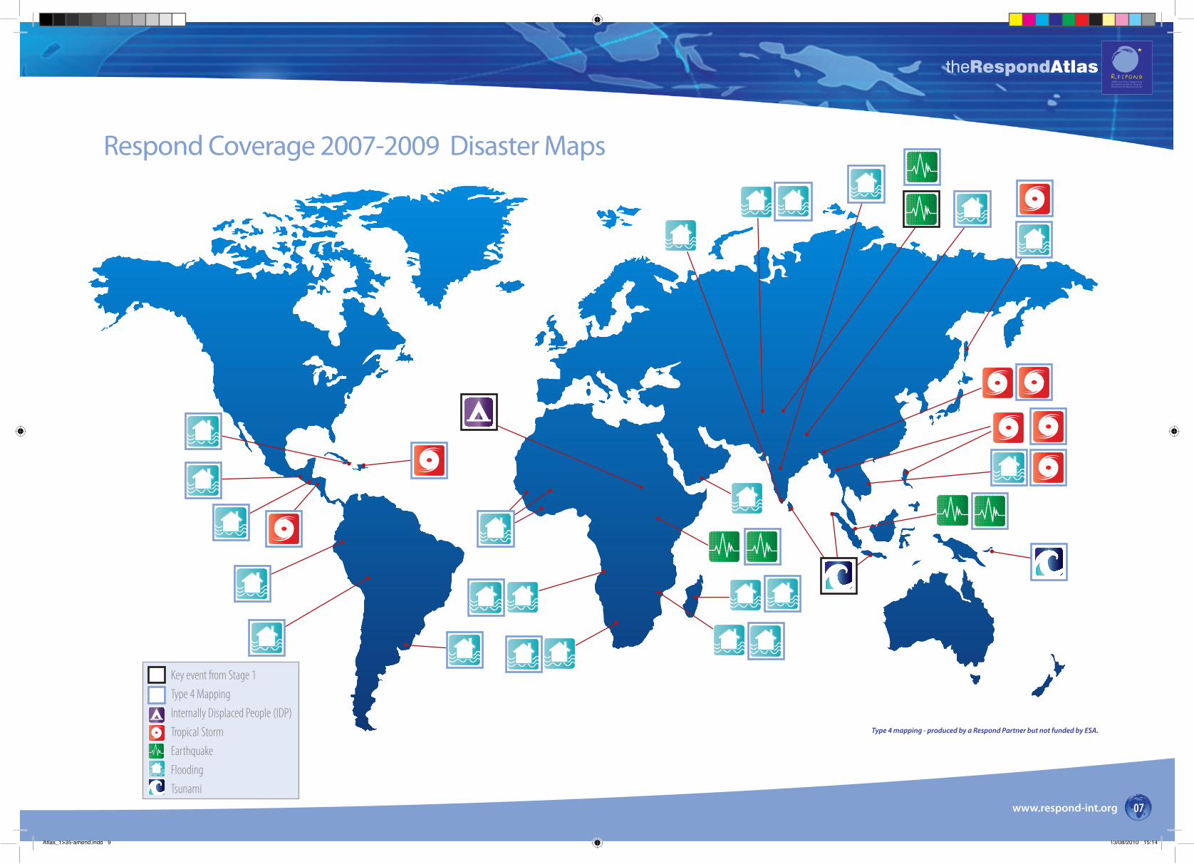
Respond Coverage 2007-2009 Disaster Maps
Key event from Stage 1Type 4 MappingInternally Displaced People (IDP)Tropical StormEarthquakeFloodingTsunami
Type 4 mapping - produced by a Respond Partner but not funded by ESA.
Atlas_1>35-amend.indd 9 13/08/2010 15:14

theRespondAtlas
www.respond-int.org08
Respond Coverage 2007-2009 Background Mapping Activities
Atlas_1>35-amend.indd 10 13/08/2010 15:14
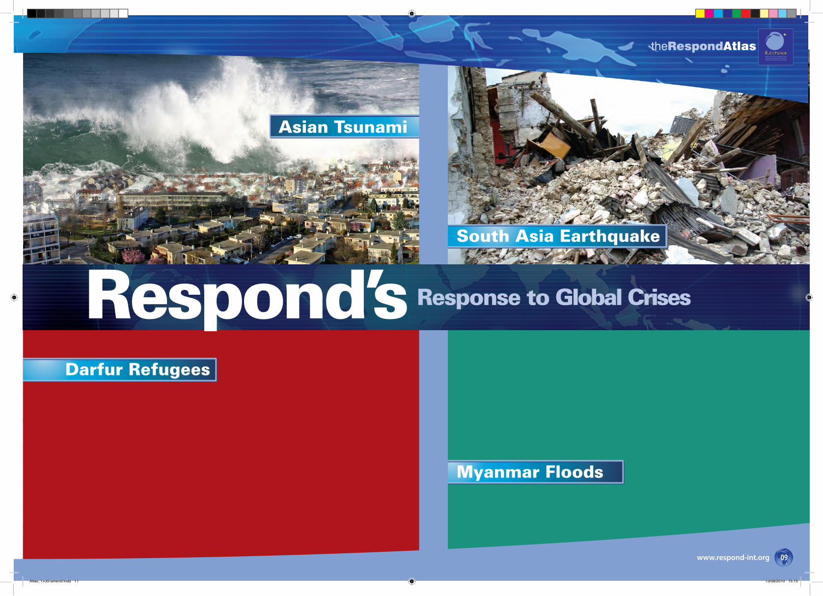
Myanmar Floods
Asian Tsunami
South Asia Earthquake
Respond’s Response to Global Crises
Darfur Refugees
theRespondAtlas
www.respond-int.org 09
Atlas_1>35-amend.indd 11 13/08/2010 15:15
theRespondAtlas
www.respond-int.org10
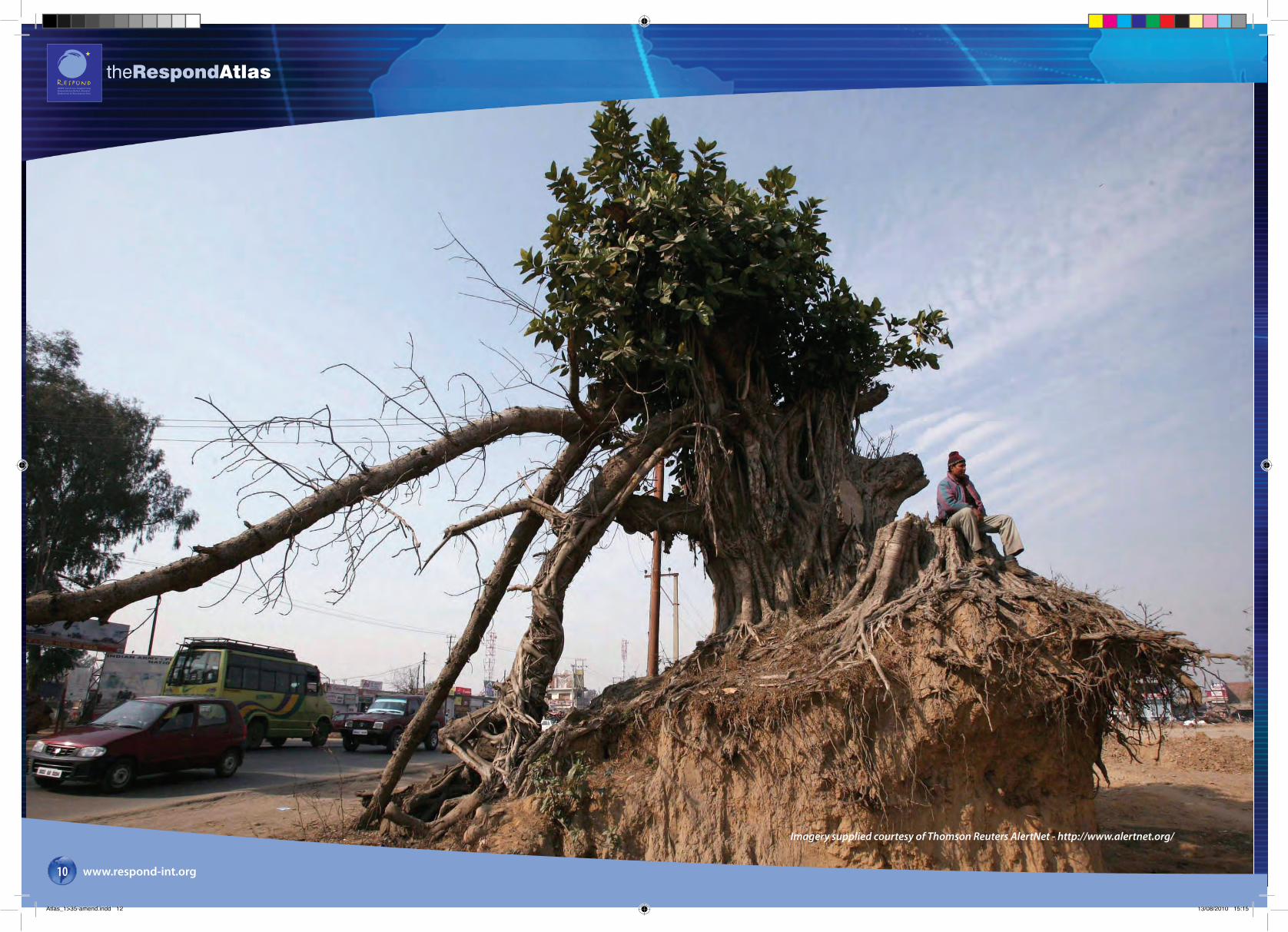
Imagery supplied courtesy of Thomson Reuters AlertNet - http://www.alertnet.org/
Atlas_1>35-amend.indd 12 13/08/2010 15:15
theRespondAtlas
www.respond-int.org 11
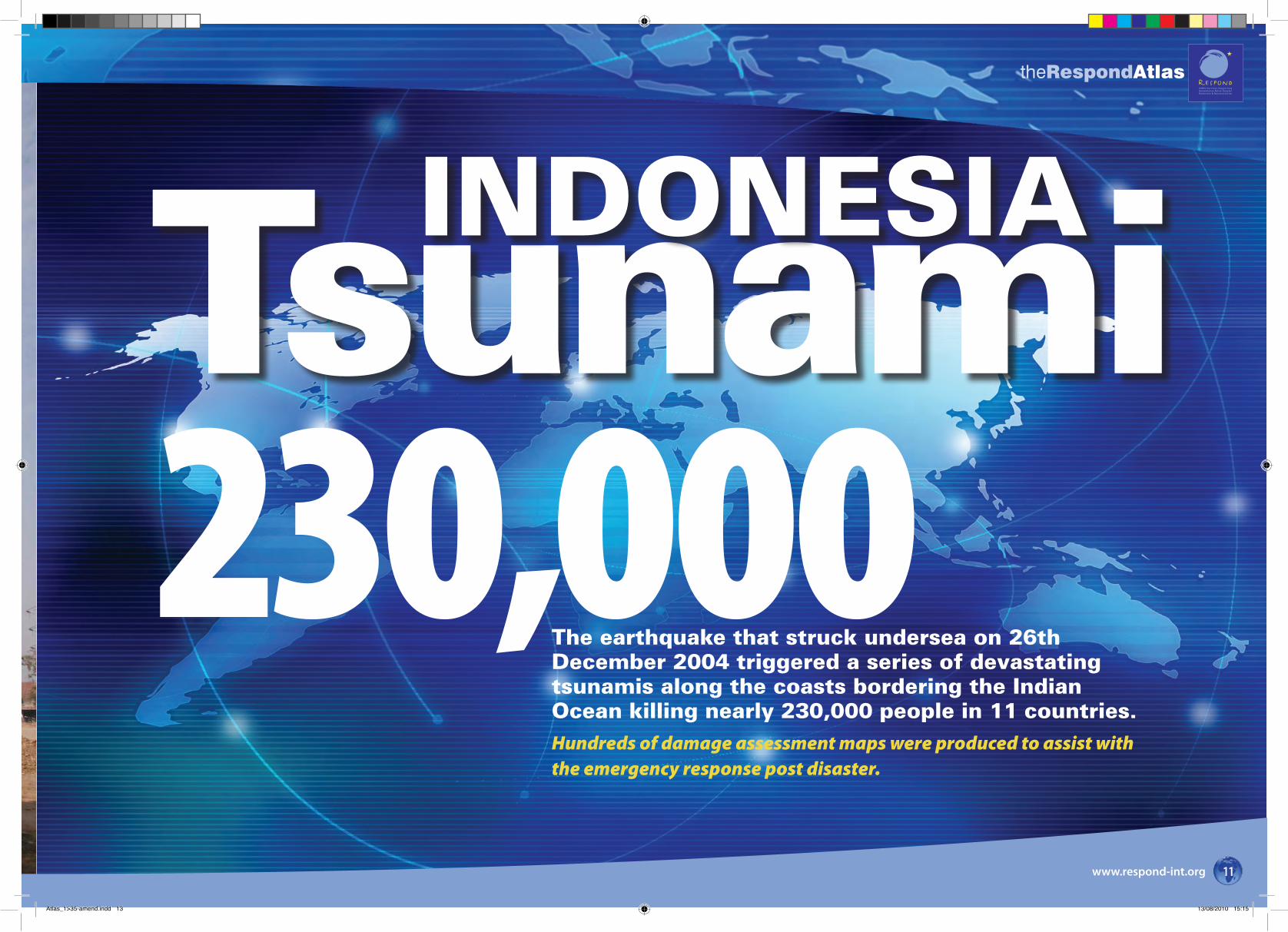
230,000TsunamiINDONESIA
The earthquake that struck undersea on 26th December 2004 triggered a series of devastating tsunamis along the coasts bordering the Indian Ocean killing nearly 230,000 people in 11 countries. Hundreds of damage assessment maps were produced to assist with the emergency response post disaster.
Atlas_1>35-amend.indd 13 13/08/2010 15:15
theRespondAtlas
www.respond-int.org12
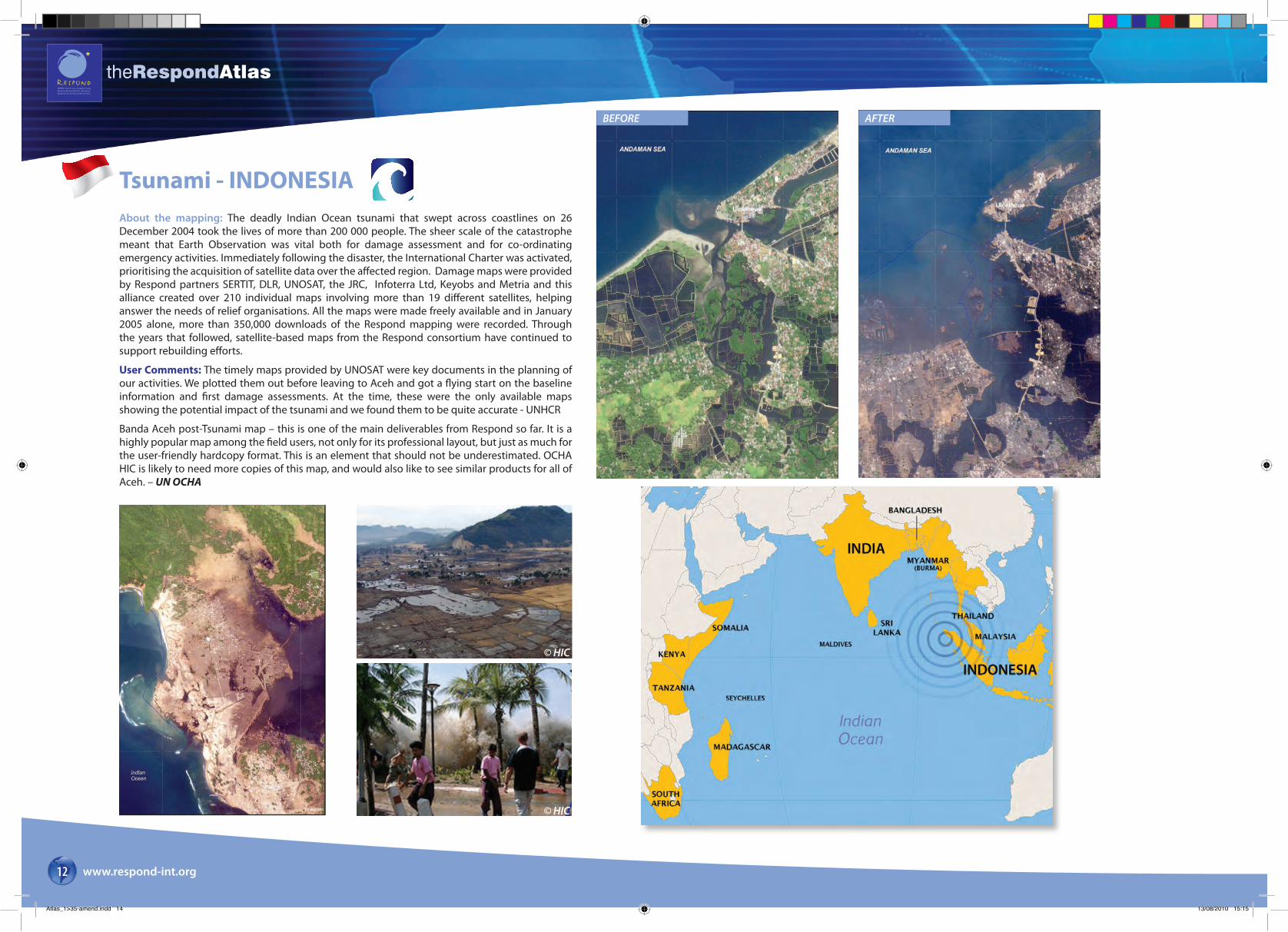
Tsunami - INDONESIA
BEFORE AFTER
© HIC
© HIC
About the mapping: The deadly Indian Ocean tsunami that swept across coastlines on 26 December 2004 took the lives of more than 200 000 people. The sheer scale of the catastrophe meant that Earth Observation was vital both for damage assessment and for co-ordinating emergency activities. Immediately following the disaster, the International Charter was activated, prioritising the acquisition of satellite data over the affected region. Damage maps were provided by Respond partners SERTIT, DLR, UNOSAT, the JRC, Infoterra Ltd, Keyobs and Metria and this alliance created over 210 individual maps involving more than 19 different satellites, helping answer the needs of relief organisations. All the maps were made freely available and in January 2005 alone, more than 350,000 downloads of the Respond mapping were recorded. Through the years that followed, satellite-based maps from the Respond consortium have continued to support rebuilding efforts.
User Comments: The timely maps provided by UNOSAT were key documents in the planning of our activities. We plotted them out before leaving to Aceh and got a flying start on the baseline information and first damage assessments. At the time, these were the only available maps showing the potential impact of the tsunami and we found them to be quite accurate - UNHCR
Banda Aceh post-Tsunami map – this is one of the main deliverables from Respond so far. It is a highly popular map among the field users, not only for its professional layout, but just as much for the user-friendly hardcopy format. This is an element that should not be underestimated. OCHA HIC is likely to need more copies of this map, and would also like to see similar products for all of Aceh. – UN OCHA
Atlas_1>35-amend.indd 14 13/08/2010 15:15
theRespondAtlas
www.respond-int.org 13
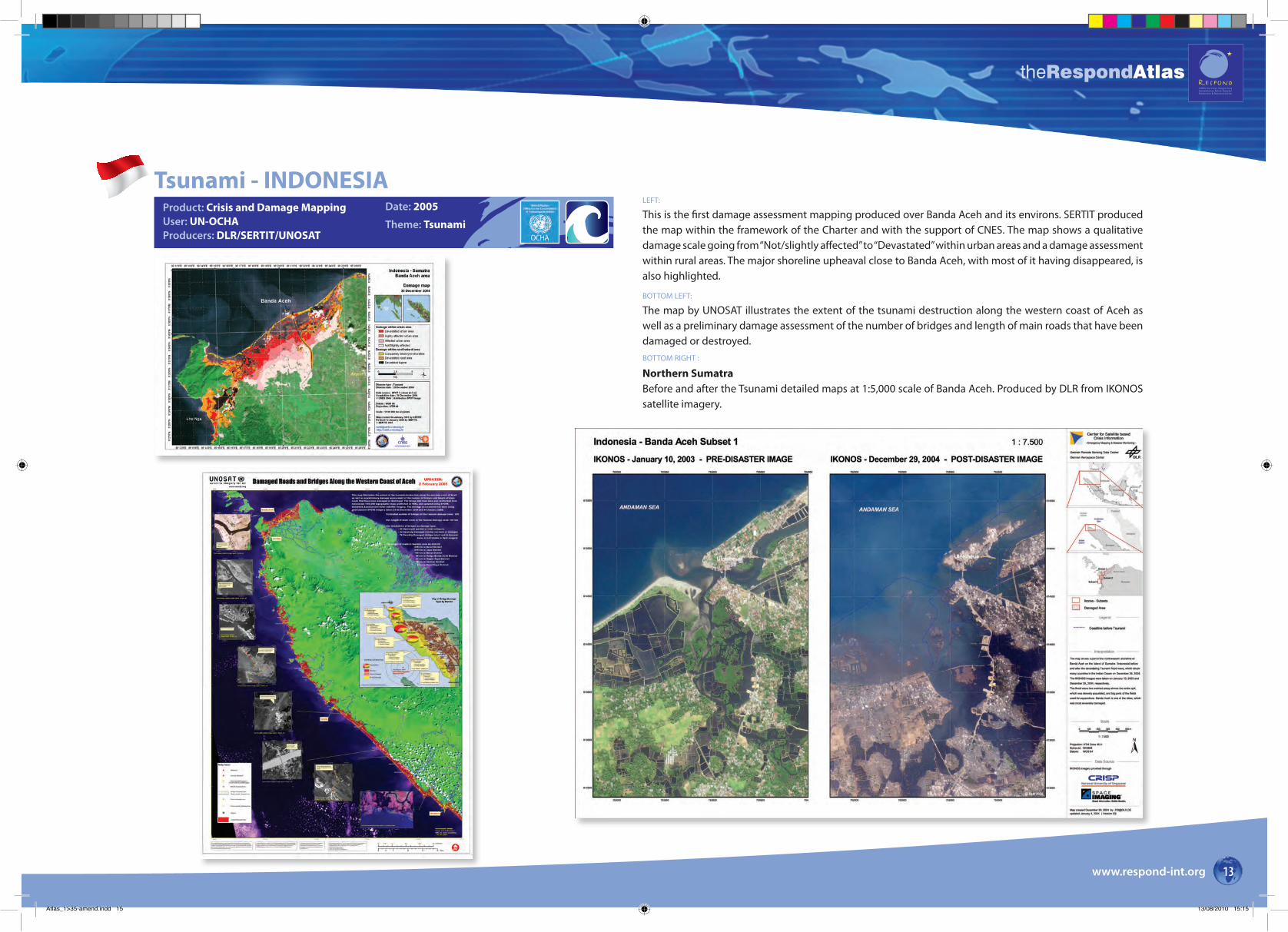
Tsunami - INDONESIALEFT:
This is the first damage assessment mapping produced over Banda Aceh and its environs. SERTIT produced the map within the framework of the Charter and with the support of CNES. The map shows a qualitative damage scale going from “Not/slightly affected” to “Devastated” within urban areas and a damage assessment within rural areas. The major shoreline upheaval close to Banda Aceh, with most of it having disappeared, is also highlighted.
BOTTOM LEFT:
The map by UNOSAT illustrates the extent of the tsunami destruction along the western coast of Aceh as well as a preliminary damage assessment of the number of bridges and length of main roads that have been damaged or destroyed. BOTTOM RIGHT :
Northern SumatraBefore and after the Tsunami detailed maps at 1:5,000 scale of Banda Aceh. Produced by DLR from IKONOS satellite imagery.
Product: Crisis and Damage MappingUser: UN-OCHAProducers: DLR/SERTIT/UNOSAT
Date: 2005
Theme: Tsunami
Atlas_1>35-amend.indd 15 13/08/2010 15:15
theRespondAtlas
www.respond-int.org14
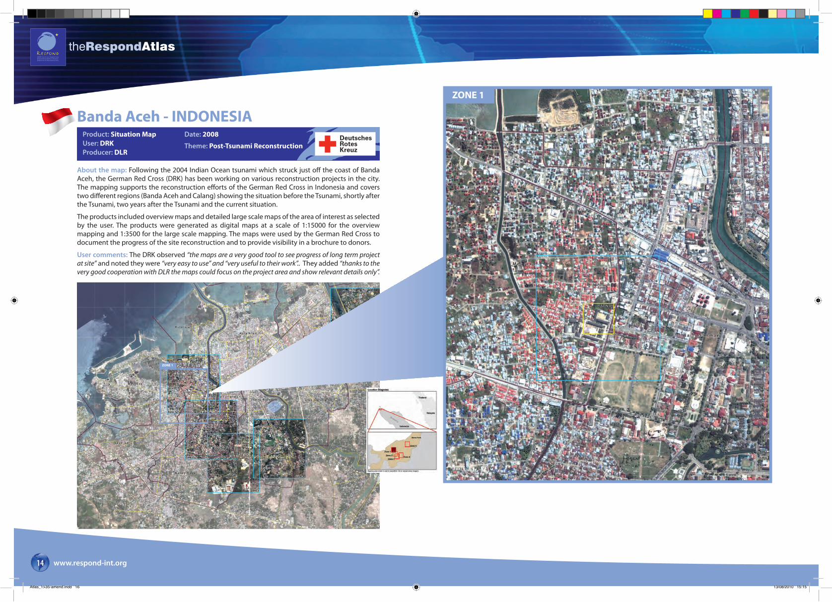
About the map: Following the 2004 Indian Ocean tsunami which struck just off the coast of Banda Aceh, the German Red Cross (DRK) has been working on various reconstruction projects in the city. The mapping supports the reconstruction efforts of the German Red Cross in Indonesia and covers two different regions (Banda Aceh and Calang) showing the situation before the Tsunami, shortly after the Tsunami, two years after the Tsunami and the current situation.
The products included overview maps and detailed large scale maps of the area of interest as selected by the user. The products were generated as digital maps at a scale of 1:15000 for the overview mapping and 1:3500 for the large scale mapping. The maps were used by the German Red Cross to document the progress of the site reconstruction and to provide visibility in a brochure to donors.
User comments: The DRK observed “the maps are a very good tool to see progress of long term project at site” and noted they were “very easy to use” and “very useful to their work”.. They added “thanks to the very good cooperation with DLR the maps could focus on the project area and show relevant details only”.
Banda Aceh - INDONESIADate: 2008
Theme: Post-Tsunami Reconstruction
ZONE 1
ZONE 1
Product: Situation MapUser: DRKProducer: DLR
DeutschesRotesKreuz
Atlas_1>35-amend.indd 16 13/08/2010 15:15
theRespondAtlas
www.respond-int.org 15
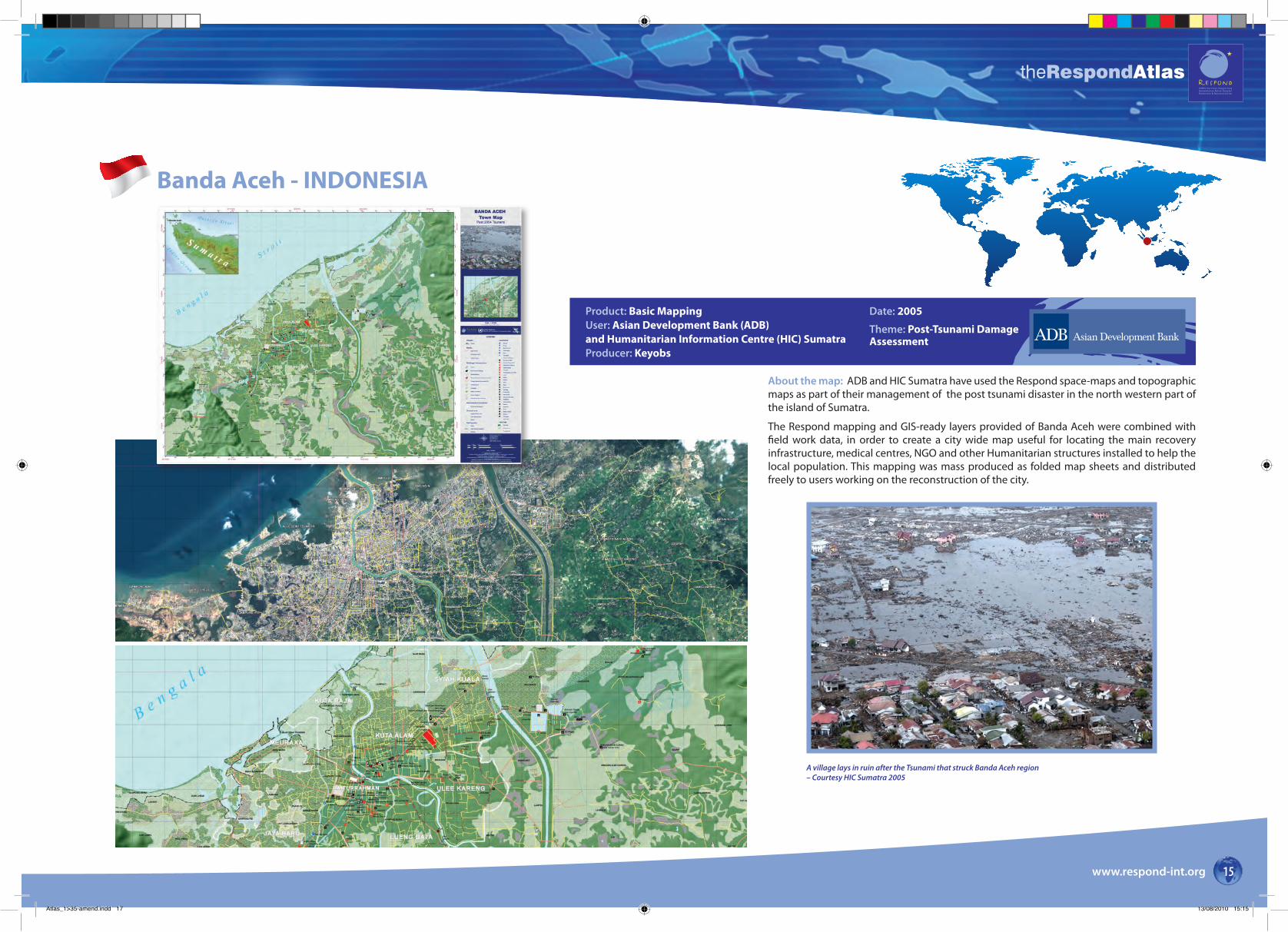
Banda Aceh - INDONESIA
About the map: ADB and HIC Sumatra have used the Respond space-maps and topographic maps as part of their management of the post tsunami disaster in the north western part of the island of Sumatra.
The Respond mapping and GIS-ready layers provided of Banda Aceh were combined with field work data, in order to create a city wide map useful for locating the main recovery infrastructure, medical centres, NGO and other Humanitarian structures installed to help the local population. This mapping was mass produced as folded map sheets and distributed freely to users working on the reconstruction of the city.
Product: Basic MappingUser: Asian Development Bank (ADB)and Humanitarian Information Centre (HIC) SumatraProducer: Keyobs
Date: 2005
Theme: Post-Tsunami Damage Assessment
A village lays in ruin after the Tsunami that struck Banda Aceh region – Courtesy HIC Sumatra 2005
Atlas_1>35-amend.indd 17 13/08/2010 15:15
theRespondAtlas
www.respond-int.org16
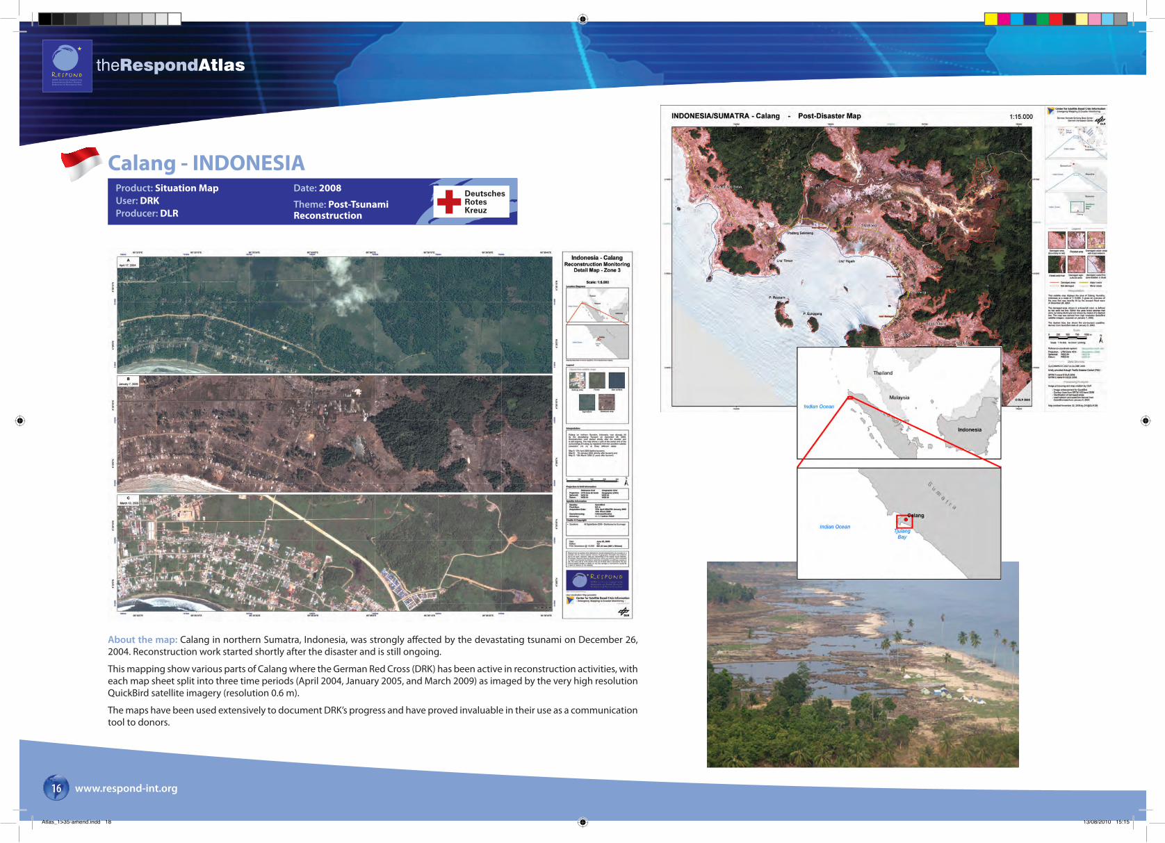
Calang - INDONESIAProduct: Situation MapUser: DRKProducer: DLR
Date: 2008
Theme: Post-Tsunami Reconstruction
About the map: Calang in northern Sumatra, Indonesia, was strongly affected by the devastating tsunami on December 26, 2004. Reconstruction work started shortly after the disaster and is still ongoing.
This mapping show various parts of Calang where the German Red Cross (DRK) has been active in reconstruction activities, with each map sheet split into three time periods (April 2004, January 2005, and March 2009) as imaged by the very high resolution QuickBird satellite imagery (resolution 0.6 m).
The maps have been used extensively to document DRK’s progress and have proved invaluable in their use as a communication tool to donors.
DeutschesRotesKreuz
Atlas_1>35-amend.indd 18 13/08/2010 15:15
theRespondAtlas
www.respond-int.org 17
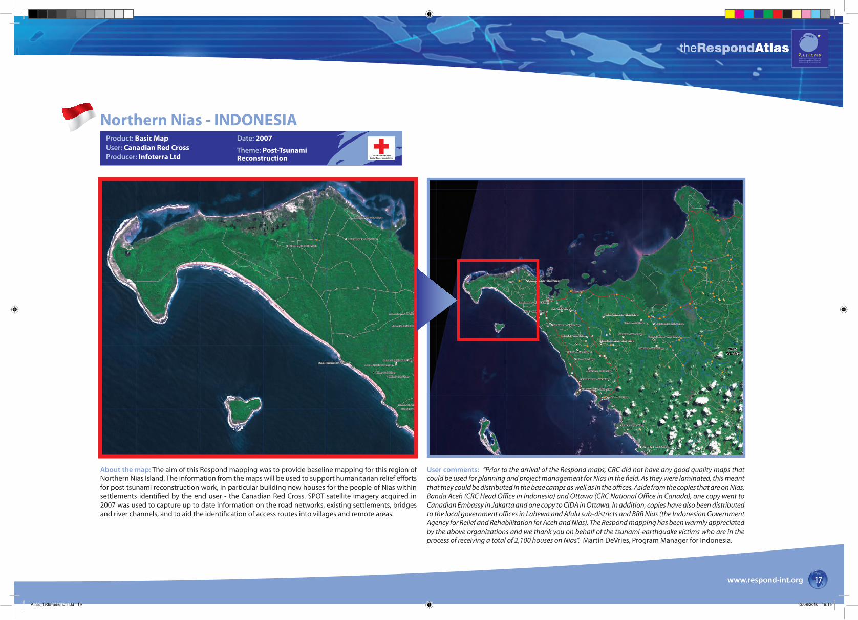
Northern Nias - INDONESIAProduct: Basic MapUser: Canadian Red CrossProducer: Infoterra Ltd
Date: 2007
Theme: Post-Tsunami Reconstruction Canadian Red Cross
Croix-Rouge canadienne
About the map: The aim of this Respond mapping was to provide baseline mapping for this region of Northern Nias Island. The information from the maps will be used to support humanitarian relief efforts for post tsunami reconstruction work, in particular building new houses for the people of Nias within settlements identified by the end user - the Canadian Red Cross. SPOT satellite imagery acquired in 2007 was used to capture up to date information on the road networks, existing settlements, bridges and river channels, and to aid the identification of access routes into villages and remote areas.
User comments: “Prior to the arrival of the Respond maps, CRC did not have any good quality maps that could be used for planning and project management for Nias in the field. As they were laminated, this meant that they could be distributed in the base camps as well as in the offices. Aside from the copies that are on Nias, Banda Aceh (CRC Head Office in Indonesia) and Ottawa (CRC National Office in Canada), one copy went to Canadian Embassy in Jakarta and one copy to CIDA in Ottawa. In addition, copies have also been distributed to the local government offices in Lahewa and Afulu sub-districts and BRR Nias (the Indonesian Government Agency for Relief and Rehabilitation for Aceh and Nias). The Respond mapping has been warmly appreciated by the above organizations and we thank you on behalf of the tsunami-earthquake victims who are in the process of receiving a total of 2,100 houses on Nias”. Martin DeVries, Program Manager for Indonesia.
Atlas_1>35-amend.indd 19 13/08/2010 15:15
theRespondAtlas
www.respond-int.org18
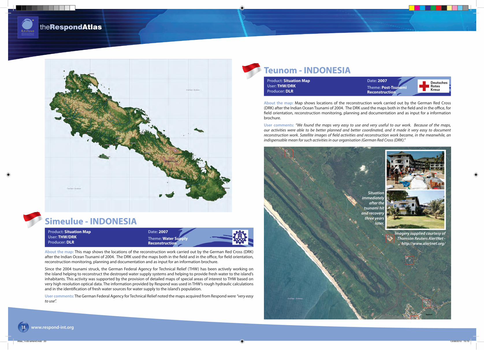
Simeulue - INDONESIAProduct: Situation MapUser: THW/DRKProducer: DLR
Date: 2007
Theme: Water Supply Reconstruction
About the map: This map shows the locations of the reconstruction work carried out by the German Red Cross (DRK) after the Indian Ocean Tsunami of 2004. The DRK used the maps both in the field and in the office, for field orientation, reconstruction monitoring, planning and documentation and as input for an information brochure.
Since the 2004 tsunami struck, the German Federal Agency for Technical Relief (THW) has been actively working on the island helping to reconstruct the destroyed water supply systems and helping to provide fresh water to the island’s inhabitants. This activity was supported by the provision of detailed maps of special areas of interest to THW based on very high resolution optical data. The information provided by Respond was used in THW’s rough hydraulic calculations and in the identification of fresh water sources for water supply to the island’s population.
User comments: The German Federal Agency for Technical Relief noted the maps acquired from Respond were “very easy to use”.
Teunom - INDONESIAProduct: Situation MapUser: THW/DRKProducer: DLR
Date: 2007
Theme: Post-Tsunami Reconstruction
DeutschesRotesKreuz
About the map: Map shows locations of the reconstruction work carried out by the German Red Cross (DRK) after the Indian Ocean Tsunami of 2004. The DRK used the maps both in the field and in the office, for field orientation, reconstruction monitoring, planning and documentation and as input for a information brochure.
User comments: “We found the maps very easy to use and very useful to our work. Because of the maps, our activities were able to be better planned and better coordinated, and it made it very easy to document reconstruction work. Satellite images of field activities and reconstruction work became, in the meanwhile, an indispensable mean for such activities in our organisation (German Red Cross (DRK).”
Situation immediately
after the tsunami hit
and recovery three years
later.
Imagery supplied courtesy of Thomson Reuters AlertNet -
http://www.alertnet.org/
Atlas_1>35-amend.indd 20 13/08/2010 15:15
theRespondAtlas
www.respond-int.org 19
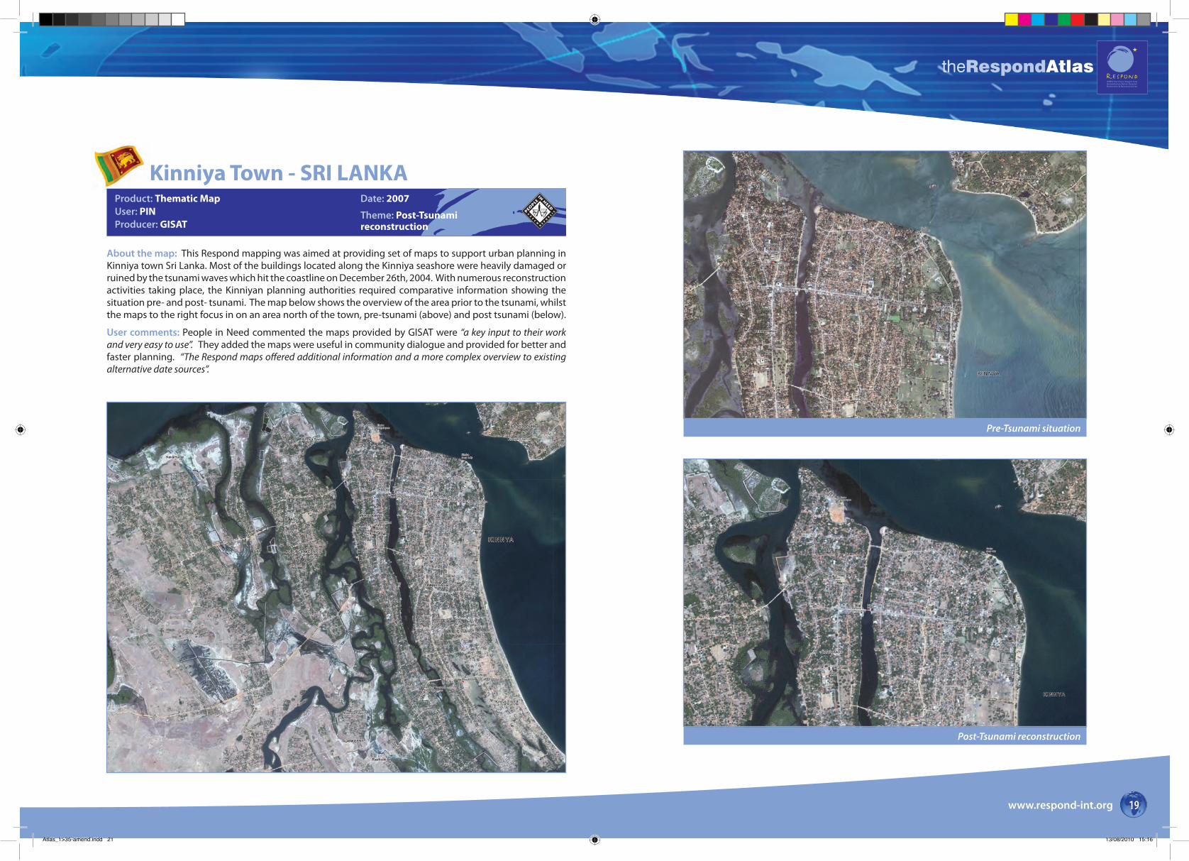
Kinniya Town - SRI LANKAProduct: Thematic MapUser: PINProducer: GISAT
Date: 2007
Theme: Post-Tsunamireconstruction
About the map: This Respond mapping was aimed at providing set of maps to support urban planning in Kinniya town Sri Lanka. Most of the buildings located along the Kinniya seashore were heavily damaged or ruined by the tsunami waves which hit the coastline on December 26th, 2004. With numerous reconstruction activities taking place, the Kinniyan planning authorities required comparative information showing the situation pre- and post- tsunami. The map below shows the overview of the area prior to the tsunami, whilst the maps to the right focus in on an area north of the town, pre-tsunami (above) and post tsunami (below).
User comments: People in Need commented the maps provided by GISAT were “a key input to their work and very easy to use”. They added the maps were useful in community dialogue and provided for better and faster planning. “The Respond maps offered additional information and a more complex overview to existing alternative date sources”.
Pre-Tsunami situation
Post-Tsunami reconstruction
Atlas_1>35-amend.indd 21 13/08/2010 15:16
theRespondAtlas
www.respond-int.org20
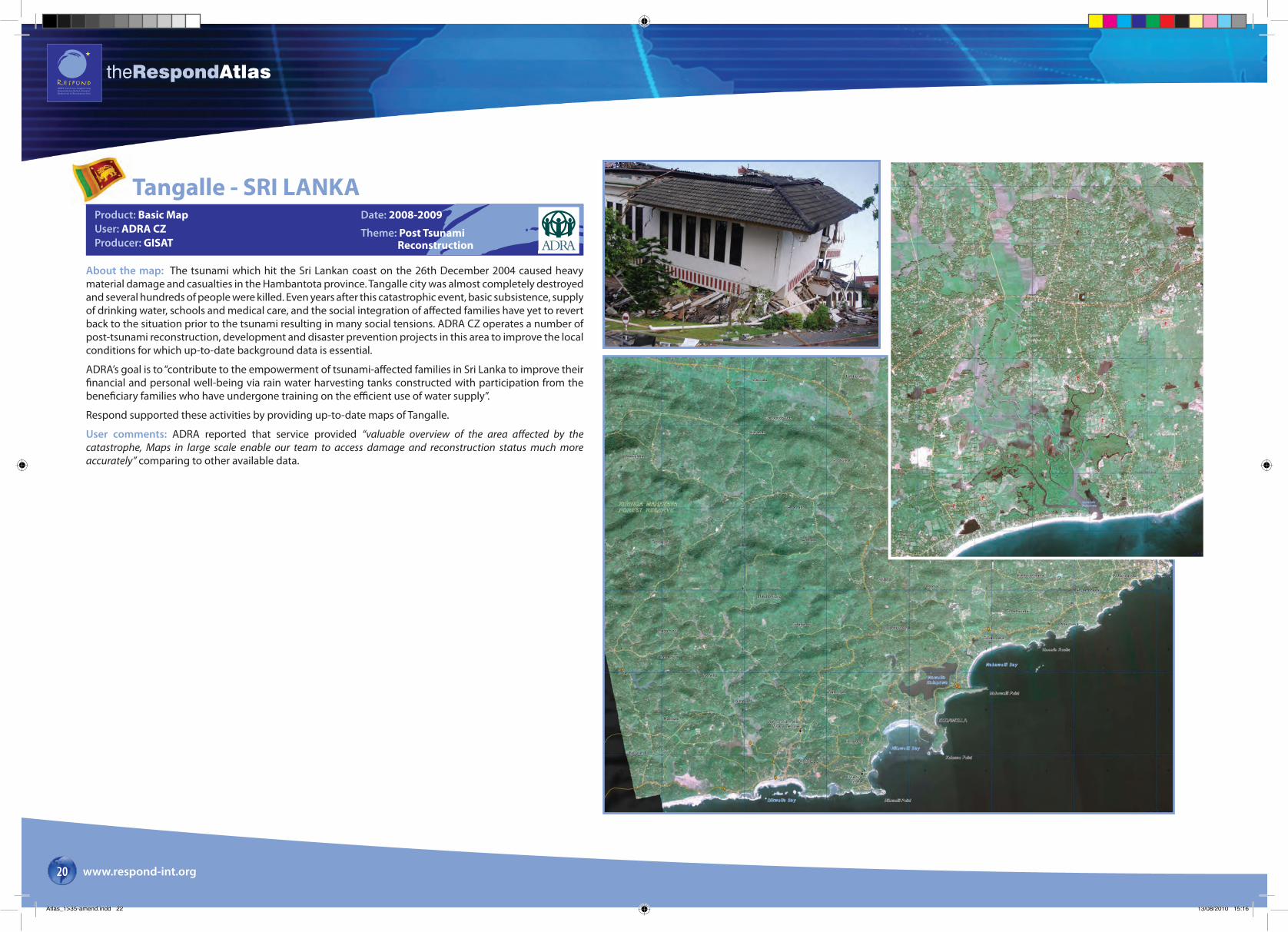
Tangalle - SRI LANKAProduct: Basic MapUser: ADRA CZProducer: GISAT
Date: 2008-2009
Theme: Post Tsunami Reconstruction
About the map: The tsunami which hit the Sri Lankan coast on the 26th December 2004 caused heavy material damage and casualties in the Hambantota province. Tangalle city was almost completely destroyed and several hundreds of people were killed. Even years after this catastrophic event, basic subsistence, supply of drinking water, schools and medical care, and the social integration of affected families have yet to revert back to the situation prior to the tsunami resulting in many social tensions. ADRA CZ operates a number of post-tsunami reconstruction, development and disaster prevention projects in this area to improve the local conditions for which up-to-date background data is essential.
ADRA’s goal is to “contribute to the empowerment of tsunami-affected families in Sri Lanka to improve their financial and personal well-being via rain water harvesting tanks constructed with participation from the beneficiary families who have undergone training on the efficient use of water supply”.
Respond supported these activities by providing up-to-date maps of Tangalle.
User comments: ADRA reported that service provided “valuable overview of the area affected by the catastrophe, Maps in large scale enable our team to access damage and reconstruction status much more accurately” comparing to other available data.
Atlas_1>35-amend.indd 22 13/08/2010 15:16
theRespondAtlas
www.respond-int.org 21
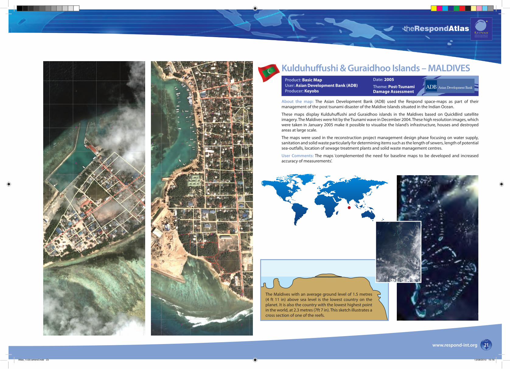
Product: Basic MapUser: Asian Development Bank (ADB)Producer: Keyobs
Date: 2005
Theme: Post-TsunamiDamage Assessment
About the map: The Asian Development Bank (ADB) used the Respond space-maps as part of their management of the post tsunami disaster of the Maldive Islands situated in the Indian Ocean.
These maps display Kulduhuffushi and Guraidhoo islands in the Maldives based on QuickBird satellite imagery. The Maldives were hit by the Tsunami wave in December 2004. These high resolution images, which were taken in January 2005 make it possible to visualise the Island’s infrastructure, houses and destroyed areas at large scale.
The maps were used in the reconstruction project management design phase focusing on water supply, sanitation and solid waste particularly for determining items such as the length of sewers, length of potential sea-outfalls, location of sewage treatment plants and solid waste management centres.
User Comments: The maps ‘complemented the need for baseline maps to be developed and increased accuracy of measurements’.
Page 16
The Maldives with an average ground level of 1.5 metres (4 ft 11 in) above sea level is the lowest country on the planet. It is also the country with the lowest highest point in the world, at 2.3 metres (7ft 7 in). This sketch illustrates a cross section of one of the reefs.
Kulduhuffushi & Guraidhoo Islands – MALDIVES
Atlas_1>35-amend.indd 23 13/08/2010 15:16
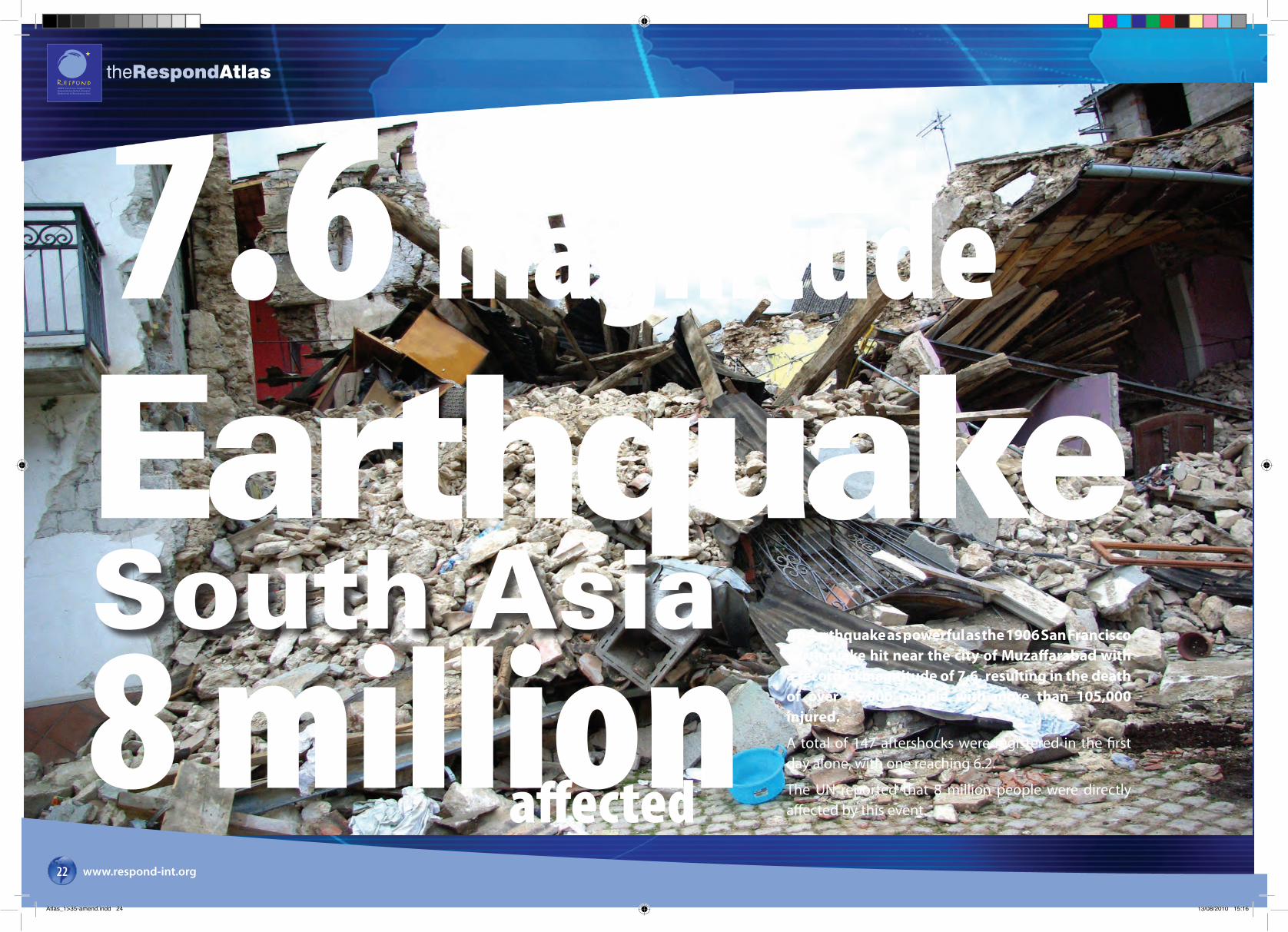
Earthquake8 millionSouth Asia
affected
7.6 magnitude
An earthquake as powerful as the 1906 San Francisco earthquake hit near the city of Muzaffarabad with a recorded magnitude of 7.6, resulting in the death of over 75,000 people with more than 105,000 injured.
A total of 147 aftershocks were registered in the first day alone, with one reaching 6.2.
The UN reported that 8 million people were directly affected by this event.
theRespondAtlas
www.respond-int.org22
Atlas_1>35-amend.indd 24 13/08/2010 15:16
theRespondAtlas
www.respond-int.org 23
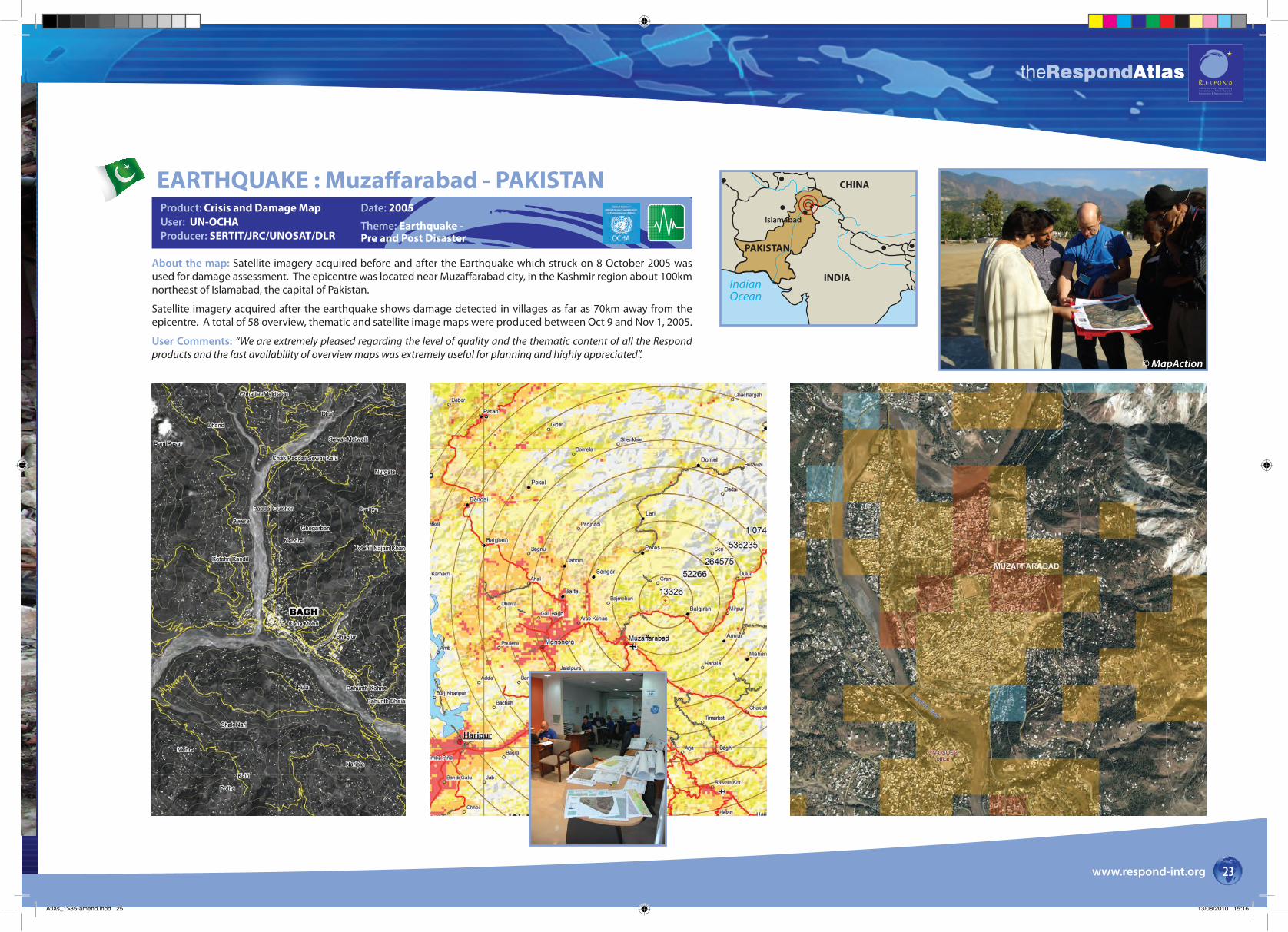
About the map: Satellite imagery acquired before and after the Earthquake which struck on 8 October 2005 was used for damage assessment. The epicentre was located near Muzaffarabad city, in the Kashmir region about 100km northeast of Islamabad, the capital of Pakistan.
Satellite imagery acquired after the earthquake shows damage detected in villages as far as 70km away from the epicentre. A total of 58 overview, thematic and satellite image maps were produced between Oct 9 and Nov 1, 2005.
User Comments: “We are extremely pleased regarding the level of quality and the thematic content of all the Respond products and the fast availability of overview maps was extremely useful for planning and highly appreciated”.
Islamabad
CHINA
INDIA
PAKISTAN
IndianOcean
EARTHQUAKE : Muzaffarabad - PAKISTANProduct: Crisis and Damage MapUser: UN-OCHAProducer: SERTIT/JRC/UNOSAT/DLR
Date: 2005
Theme: Earthquake - Pre and Post Disaster
© MapAction
Atlas_1>35-amend.indd 25 13/08/2010 15:16
LEFT:
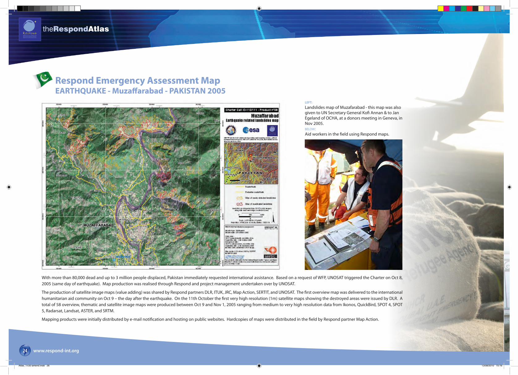
Landslides map of Muzafarabad - this map was also given to UN Secretary General Kofi Annan & to Jan Egeland of OCHA, at a donors meeting in Geneva, in Nov 2005.BELOW:Aid workers in the field using Respond maps.
With more than 80,000 dead and up to 3 million people displaced, Pakistan immediately requested international assistance. Based on a request of WFP, UNOSAT triggered the Charter on Oct 8, 2005 (same day of earthquake). Map production was realised through Respond and project management undertaken over by UNOSAT.
The production of satellite image maps (value adding) was shared by Respond partners DLR, ITUK, JRC, Map Action, SERTIT, and UNOSAT. The first overview map was delivered to the international humanitarian aid community on Oct 9 – the day after the earthquake. On the 11th October the first very high resolution (1m) satellite maps showing the destroyed areas were issued by DLR. A total of 58 overview, thematic and satellite image maps were produced between Oct 9 and Nov 1, 2005 ranging from medium to very high resolution data from Ikonos, QuickBird, SPOT 4, SPOT 5, Radarsat, Landsat, ASTER, and SRTM.
Mapping products were initially distributed by e-mail notification and hosting on public websites. Hardcopies of maps were distributed in the field by Respond partner Map Action.
theRespondAtlas
www.respond-int.org24
Respond Emergency Assessment Map EARTHQUAKE - Muzaffarabad - PAKISTAN 2005
Atlas_1>35-amend.indd 26 13/08/2010 15:16

THW (Technisches Hilfswerk) utilising Respond maps as they plan their activities during the aftermath of the South Asia Earthquake.
Devastation in a village near MuzaffarabadPost disaster satellite map of Muzaffarabad generated by DLR ZKI on 11 October using IKONOS Data of 9 October.
This was once a school.
Respond 1:4000 map of post-earthquake damage in the central city area of Balakot, based on a high-resolution IKONOS image. Areas of catastrophic damage are enclosed in red, extensive damage in orange and moderate damage in purple.
theRespondAtlas
www.respond-int.org 25
“For our users, the first need is to obtain an overview of the situation,” says Kader Fellah of SERTIT. “One vital point is to know the state of road access because in the mountainous terrain it is really quite difficult to travel by car: a team can drive for most of a day to a distant village and find themselves blocked by a landslide. Up-to-date mapping of roads and buildings, showing houses both within villages and dispersed in the countryside creates a very good product for carrying out rescue missions. Furthermore, damage maps derived from optical imagery have been very useful in charting landslide impacts. The French Civil Protection Agency has told SERTIT how useful these have been at headquarters level and in the field”.
“Respond maps have a multitude of different uses,” explains Stefan Voigt of DLR-ZKI. “These are areas the initial teams performing search and rescue may know nothing about in advance of going there, so there is a basic orientation function.”
“In addition, headquarters needs a way to work meaningfully with the people on the ground, and the maps are a way to do this. They may have seen pictures taken from the scene or even from a helicopter, but the maps give a bird’s eye view and a greater understanding of the context in-situ. Such an overview helps to plan response activities. In terms of logistics that means how we can get to a given place – seeing what the roads are like, perhaps whether a bridge is still there. The maps can also be used for detailed damage assessment, helping to put numbers to the destruction so donors can visualize its scale and set priorities.”
Atlas_1>35-amend.indd 27 13/08/2010 15:16
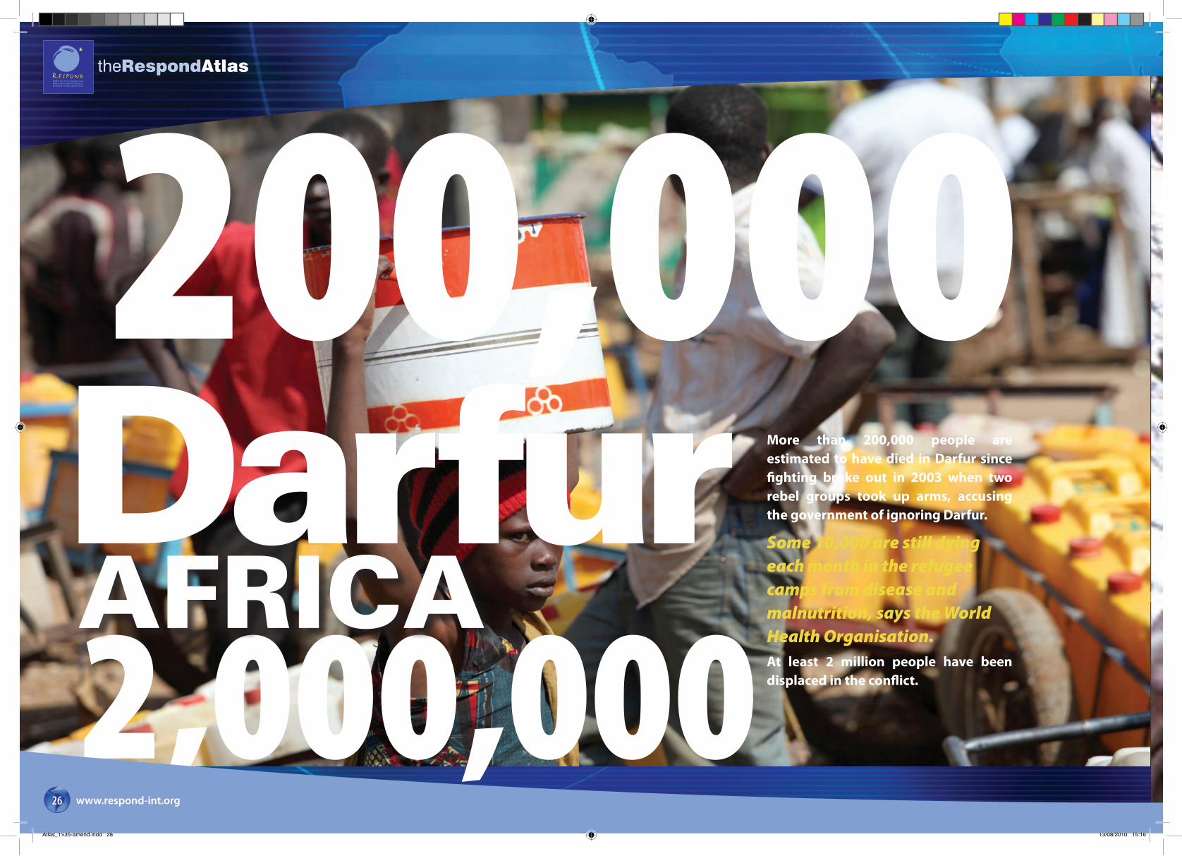
200,000Darfur2,000,000AFRICA
theRespondAtlas
www.respond-int.org26
More than 200,000 people are estimated to have died in Darfur since fighting broke out in 2003 when two rebel groups took up arms, accusing the government of ignoring Darfur.
Some 10,000 are still dying each month in the refugee camps from disease and malnutrition, says the World Health Organisation.At least 2 million people have been displaced in the conflict.
Atlas_1>35-amend.indd 28 13/08/2010 15:16

Darfur - SUDAN200,000theRespondAtlas
www.respond-int.org 27
About the map: UN humanitarian agencies are leading the effort aimed at assisting the 4.2 million conflict-affected people of the Darfur crisis. Of these, 2. million are internally displaced, and an additional 236,000 Sudanese refugees are in eastern Chad.
In support of these UN operations, Respond has been providing refugee/IDP camp maps which have proved vital to UNHCR’s operations as they can depict accurately and three-dimensionally, the location of a forcibly displaced population or the location, lay-out and infrastructure of a refugee camp. They can also show the environmental impact that camps have on surrounding areas.
User comments: The HIC Darfur products and services were well carried out and integrated into the HIC management. The service was very much appreciated. – UN-OCHA.
Camp maps: The maps provided are very good. They will be used for improving registration exercises, camp management, and protection of refugees. – UNHCR.
Date: 2004
Theme: Refugee / IDP Camp Mapping
Product: Refugee/IDP Camp MappingUser: UNHCR / UN- OCHAProducer: Keyobs/Metria
Atlas_1>35-amend.indd 29 13/08/2010 15:16
theRespondAtlas
www.respond-int.org28
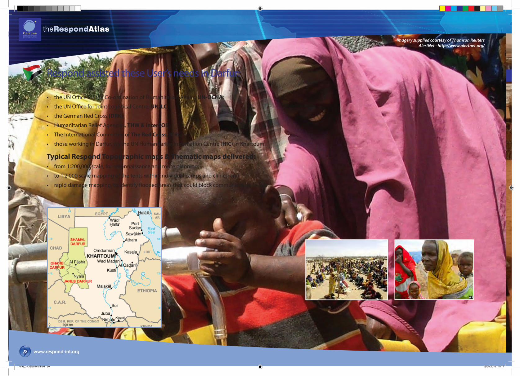
Respond assisted these User’s needs in Darfur:
• the UN Office for the Co-ordination of Humanitarian Affairs, UN-OCHA;
• the UN Office for Joint Logistical Centre, UNJLC;
• the German Red Cross (DRK);
• Humanitarian Relief Agencies, THW & InterSOS;
• The International Committee of The Red Cross, ICRC;
• those working in Darfur, via the UN Humanitarian Information Centre (HIC) in Khartoum.
Typical Respond Topographic maps & Thematic maps delivered:• from 1:200,000 scale, for reconnaissance and route planning;
• to 1:2,000 scale mapping of the tents within individual camps and clinics; and
• rapid damage mapping, to identify flooded areas that could block communication routes.
Imagery supplied courtesy of Thomson Reuters AlertNet - http://www.alertnet.org/
Atlas_1>35-amend.indd 30 13/08/2010 15:17
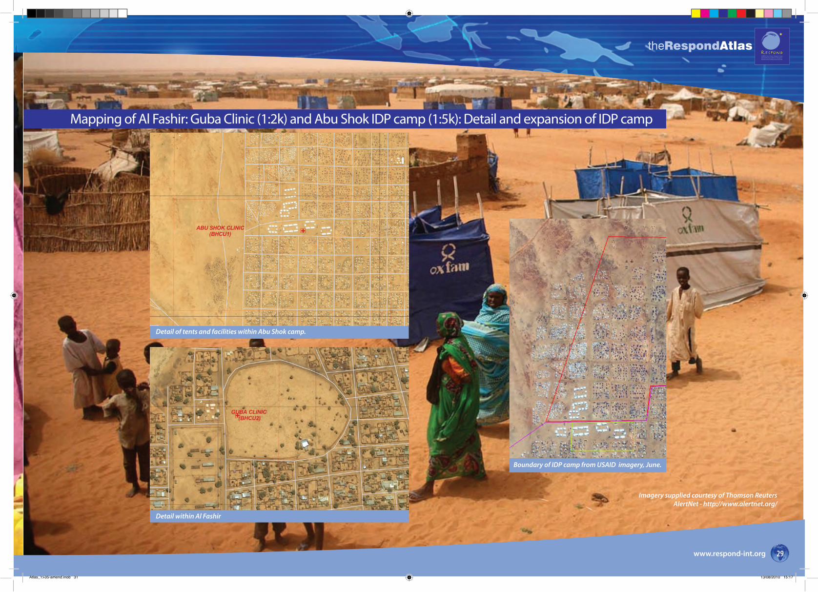
Boundary of IDP camp from USAID imagery, June.
Detail within Al Fashir
Detail of tents and facilities within Abu Shok camp.
theRespondAtlas
www.respond-int.org 29
Mapping of Al Fashir: Guba Clinic (1:2k) and Abu Shok IDP camp (1:5k): Detail and expansion of IDP camp
Imagery supplied courtesy of Thomson Reuters AlertNet - http://www.alertnet.org/
Atlas_1>35-amend.indd 31 13/08/2010 15:17
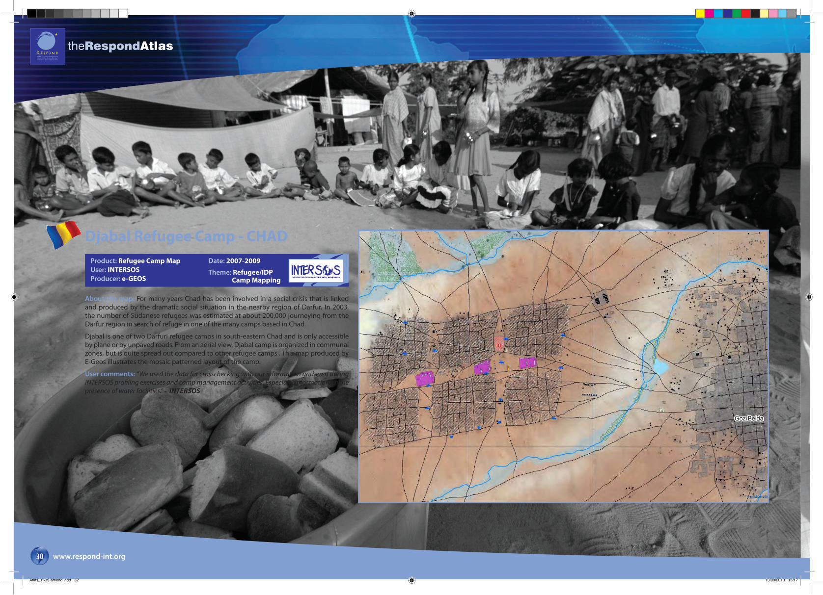
Djabal Refugee Camp - CHADProduct: Refugee Camp MapUser: INTERSOSProducer: e-GEOS
Date: 2007-2009
Theme: Refugee/IDP Camp Mapping
About the map: For many years Chad has been involved in a social crisis that is linked and produced by the dramatic social situation in the nearby region of Darfur. In 2003, the number of Sudanese refugees was estimated at about 200,000 journeying from the Darfur region in search of refuge in one of the many camps based in Chad.
Djabal is one of two Darfuri refugee camps in south-eastern Chad and is only accessible by plane or by unpaved roads. From an aerial view, Djabal camp is organized in communal zones, but is quite spread out compared to other refugee camps . This map produced by E-Geos illustrates the mosaic patterned layout of the camp.
User comments: “We used the data for crosschecking with our information gathered during INTERSOS profiling exercises and camp management activities. Especially information on the presence of water facilities.” - INTERSOS
theRespondAtlas
www.respond-int.org30
Atlas_1>35-amend.indd 32 13/08/2010 15:17

theRespondAtlas
www.respond-int.org 99
Respond’s user base has grown significantly in number and understanding since its start in 2004, providing to the following users and creating over 500 map sheets that have been distributed world-wide:
UN Users UNDAC - United Nations Disaster Assessment and CoordinationUNDP - United Nations Development ProgrammeUNDSS - United Nations Department of Safety and SecurityUNHCR - United Nations High Commissioner for RefugeesUNISDR - United Nations International Strategy for Disaster ReductionUNJLC - United Nations Joint Logistics CentreUN-OCHA - United Nations Office for the Coordination of Humanitarian AffairsWFP - World Food ProgrammeWHO - World Health OrganisationNon UN Users: ADB - Asian Development BankADRAAECI - Agencia Española de Cooperation InternationalCanadian Red Cross Caritas International CERMES - Centre de Recherche Mêdicale et SanitaireDFID - Department for International Development UKDRK - German Red CrossFrench Red Cross Governor of Bie State ICRC - International Committee Red Cross IFRC - International Federation of Red Cross and Red Crescent SocietiesInterSOS Merlin MIC - EC Monitoring and Information CentrePIN - People in NeedSDC - Swiss Department for Development and CooperationSpanish Red Cross World BankTHW - German Federal Agency for Technical Relief
Respond Partners:Project Lead: Infoterra Ltd
Independent Service Validation
Joint Research Council (JRC) – Marco BrogliaRoyal Military Academy (RMA) – Michal ShimoniInstitute Geomatica – Michele CrosettoTU Berlin – Stefan LangUniversity of Salzburg – Peter ZeilUniversity of Pavia – Paolo Gamba
Value Adding Organisations
System Engineers and Consultants
e-geosA N A S I / T E L E S P A Z I O C O M P A N Y
Atlas_76>99.indd 103 13/08/2010 15:07
theRespondAtlas
For further details on the Respond contract please contact the project’s Prime:
Infoterra Ltd Europa House The Crescent Southwood, Farnborough, Hampshire.
GU14 0NL UK T. +44 (0)1252 362000 F. +44 (0)1252 375016
www.infoterra.co.uk
www.respond-int.org
Respond is an ESA - led GMES Service Element Project:ESA - European Space AgencyESRINVia Galileo GalileiCasella Postale 641-00044 FrascatiItalywww.esa.int
Designed by: Rocket Creative Design Ltd.
T: +44 (0)1446 713 301
ROCKETCREATIVE.CO.UK
Atlas_1>35-amend.indd 2 13/08/2010 15:13