Embed Size (px)
Citation preview
RESOLUTION R-4848
A RESOLUTION OF THE CITY OF KIRKLAND RELATING TO ZONING, PLANNING,
AND LAND USE ASSOCIATED WITH THE AMENDMENTS TO THE SHORELINE
MASTER PROGRAM, FILE NO. ZON06-00017.
WHEREAS, the City Council has received a recommendation from the
Kirkland Pianning Commission to amend certain sections of the text of the
Kirkland Zoning Code, Ordinance 3719 as amended, all as set forth in that
certain report and recommendation of the Planning Commission dated October
14, 2010 and bearing Kirkland Department of Planning and Community
Development File No. ZON06-00017; and
WHEREAS, prior to making said recommendation, the Kirkland Planning
Commission, following notice thereof as required by RCW 35A.63.070, on
September 30, 2010, held a public hearing, on the amendment proposals and
considered the comments received at said hearing; and
WHEREAS, pursuant to the State Environmental Policy Act (SEPA), there
has accompanied the legislative proposal and recommendation through the
entire consideration process, a SEPA Determination of Non-Significance issued by
the responsible official pursuant to WAC 197-11-340; and
WHEREAS, in regular public meeting the City Council considered the
environmental documents received from the responsible official, together with
report and recommendation of the Planning Commission; and
WHEREAS, the City Council wishes to state its intent to adopt the
attached proposed Zoning Code text upon approval of the City's amendments to
its Shoreline Master Program by the State Department of Ecology; and
NOW, THEREFORE, BE IT RESOLVED by the City Council of the City of
Kirkland as follows:
Section 1. The City Council hereby approves the proposed Zoning text
amendments of Ordinance 3719 as amended, the Kirkland Zoning Ordinance as
set forth in Attachment A attached to this resolution and incorporated by
reference. The City Council intends to adopt the proposed Zoning text
amendments set forth in Attachment A upon the City's final adoption of the
amendments to its Shoreline Master Program.
PASSED by majority vote of the Kirkland City Council in open meeting
this 16th day of November , 20_LD
Signed in authentication thereof this _i6bfey of Mnvpmhpr , 2010.
Mayor
Attest:
Kirk
lan
d Z
on
ing
Co
de
1
AM
EN
DM
EN
TS
TO
OT
HE
R C
HA
PT
ER
S O
F T
HE
ZO
NIN
G C
OD
E
. CH
AP
TE
R 1
8 –
SIN
GL
E-F
AM
ILY
RE
SID
EN
TIA
L A
(RS
A) Z
ON
ES
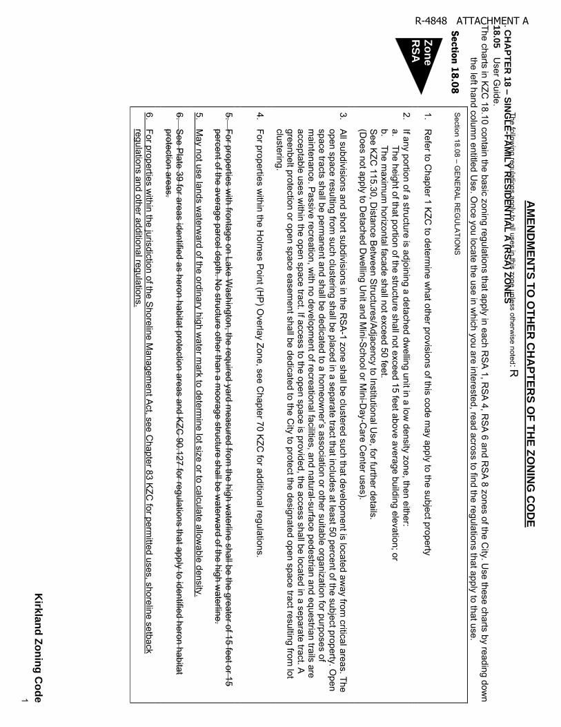
18
.05
User G
uide. The charts in KZC
18.10 contain the basic zoning regulations that apply in each RS
A 1, RS
A 4, RS
A 6 and RS
A 8 zones of the City. U
se these charts by reading down
the left hand column entitled U
se. Once you locate the use in w
hich you are interested, read across to find the regulations that apply to that use.
Se
ction
18
.08
Section 18.08 – G
EN
ER
AL R
EG
ULA
TION
S
The following regulations apply to all uses in this zone unless otherw
ise noted: R
1. R
efer to Chapter 1 KZC
to determine w
hat other provisions of this code may apply to the subject property
2. If any portion of a structure is adjoining a detached dw
elling unit in a low density zone, then either:
a. The height of that portion of the structure shall not exceed 15 feet above average building elevation; or
b. The m
aximum
horizontal facade shall not exceed 50 feet.
See K
ZC 115.30, D
istance Betw
een Structures/Adjacency to Institutional U
se, for further details.
(Does not apply to D
etached Dw
elling Unit and M
ini-School or M
ini-Day-C
are Center uses).
3.
All subdivisions and short subdivisions in the R
SA-1 zone shall be clustered such that developm
ent is located away from
critical areas. The open space resulting from
such clustering shall be placed in a separate tract that includes at least 50 percent of the subject property. Open
sp
ace
tracts
sh
all b
e p
erm
an
en
t and
sha
ll be
de
dic
ate
d to
a h
om
eo
wne
r’s a
ssocia
tion
or o
the
r su
itab
le o
rga
niz
atio
n fo
r pu
rpo
ses of
maintenance. Passive recreation, w
ith no development of recreational facilities, and natural-surface pedestrian and equestrian trails are
acceptable uses within the open space tract. If access to the open space is provided, the access shall be located in a separate tract. A
greenbelt protection or open space easement shall be dedicated to the C
ity to protect the designated open space tract resulting from lot
clustering.
4.
For properties within the H
olmes Point (H
P) O
verlay Zone, see Chapter 70 K
ZC for additional regulations.
5.
For properties with frontage on Lake W
ashington, the required yard measured from
the high waterline shall be the greater of 15 feet or 15
percent of the average parcel depth. No structure other than a m
oorage structure shall be waterw
ard of the high waterline.
5. M
ay not use lands waterw
ard of the ordinary high water m
ark to determine lot size or to calculate allow
able density.
6.
See P
late 39 for areas identified as heron habitat protection areas and KZC
90.127 for regulations that apply to identified heron habitat protection areas.
6.
For properties within the jurisdiction of the S
horeline Managem
ent Act, see C
hapter 83 KZC for perm
itted uses, shoreline setback regulations and other additional regulations.
Zo
ne
RS
A
R-4848 ATTACHMENT A
Section 18.10
US
E
REGULATIONS
DIR
EC
TIO
NS
: FIR
ST
, rea
d d
ow
n to
find
us
e...T
HE
N, a
cro
ss fo
r RE
GU
LA
TIO
NS
Re
qu
ired
Re
vie
w
Pro
ce
ss
MIN
IMU
MS
M
AX
IMU
MS
Landscape
Category
(See Ch. 95)
Sign Category
(See Ch. 100)
Re
qu
ired
Pa
rkin
g
Sp
ace
s
(Se
e C
h. 1
05
)
Sp
ec
ial R
eg
ula
tion
s
(Se
e a
lso
Ge
nera
l Re
gu
latio
ns)
Lo
t Siz
e
RE
QU
IRE
D Y
AR
DS
(Se
e C
h. 1
15
)
Lot Coverage
H
eig
ht o
f S
truc
ture
Fro
nt
Sid
e
Re
ar
Kirk
lan
d Z
on
ing
Co
de
2
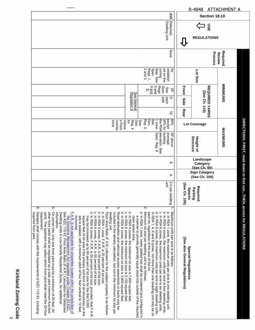
.01
0 D
etached D
welling U
nit N
one A
s established on the zoning M
ap. See
Spec
Regs. 1,
2 and 3.
20' S
ee S
pec. R
egs. 5 and 6 and
9.
5' each side
10
’50%
except 30%
for the R
SA
1 zone. S
ee G
en. R
eg. 3. S
ee G
en. R
eg. 4 for H
olme
s Point
overlay zone
30' above average building elevation. S
ee S
pec. Reg. 8
E
A
2.0 per dwelling
unit.
1. M
aximum
units per acre is as follows:
a. In RS
A 1 zone, the m
aximum
units per acre is one dwelling unit.
b. In RS
A 4 zones, the m
aximum
units per acre is four dwelling units.
c. In RS
A 6 zones, the m
aximum
units per acre is six dwelling units.
d. In RS
A 8 zones, the m
aximum
units per acre is eight dwelling units.
In R
SA
1, 4, 6 and 8 zones, not more than one dw
elling unit may be on
each lot, regardless of the size of the lot. 2.
Minim
um lot size per dw
elling unit is as follows:
a. In RS
A 1 zone, new
ly platted lots shall be clustered and configured in a m
anner to provide generally equal sized lots outside of the required open space area.
b. In RS
A 4 zones, the m
inimum
lot size is 7,600 square feet. c. In R
SA
6 zones, the minim
um lot size is 5,100 square feet.
d. In RS
A 8 zones, the m
inimum
lot size is 3,800 square feet. 3.
Road dedication and vehicular access easem
ents or tracts may be
included in the density calculation, but not in the minim
um lot size per
dwelling unit.
4. Floor A
rea Ratio (F.A
.R.) allow
ed for the subject property is as follows:
a. In RS
A 1 zone, F.A
.R. is 20 percent of lot size.
b. In RS
A 4 zones, F.A
.R. is 50 percent of lot size.
c. In RS
A 6 zones, F.A
.R. is 50 percent of lot size.
d. In RS
A 8 zones, F.A
.R. is 50 percent of lot size; provided, that F.A
.R.
may be increased up to 60 percent of lot size for the first 5,000
square feet of lot area if the primary roof form
of all structures on the site is peaked, w
ith a minim
um pitch of four feet vertical to 12 feet
horizontal. F.A
.R. is not applicable for properties located w
ithin the jurisdiction of the S
horeline Managem
ent Act regulated under C
hapter 83 KZC
.
See K
ZC 115.42, Floor A
rea Ratio (F.A
.R.) C
alculation for Detached
Dw
elling Units in Low
Density R
esidential Zones, for additional inform
ation. 5.
On corner lots, only one front yard m
ust be a minim
um of 20 feet. A
ll other front yards shall be regulated as a side yard (m
inimum
five-foot yard). The applicant m
ay select which front yard shall m
eet the 20-foot requirem
ent. 6.
Garages shall com
ply with the requirem
ents of KZC
115.43, including required front yard.
See G
eneral R
egulation 6
R-4848 ATTACHMENT A
Section 18.10
US
E
REGULATIONS
DIR
EC
TIO
NS
: FIR
ST
, rea
d d
ow
n to
find
us
e...T
HE
N, a
cro
ss fo
r RE
GU
LA
TIO
NS
Re
qu
ired
Re
vie
w
Pro
ce
ss
MIN
IMU
MS
M
AX
IMU
MS
Landscape
Category
(See Ch. 95)
Sign Category
(See Ch. 100)
Re
qu
ired
Pa
rkin
g
Sp
ace
s
(Se
e C
h. 1
05
)
Sp
ec
ial R
eg
ula
tion
s
(Se
e a
lso
Ge
nera
l Re
gu
latio
ns)
Lo
t Siz
e
RE
QU
IRE
D Y
AR
DS
(Se
e C
h. 1
15
)
Lot Coverage
H
eig
ht o
f S
truc
ture
Fro
nt
Sid
e
Re
ar
Kirk
lan
d Z
on
ing
Co
de
3
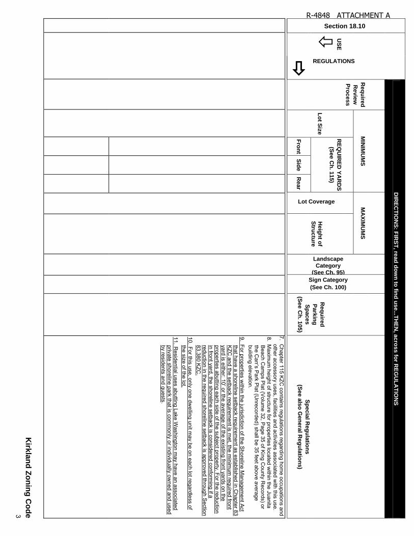
7.
Chapter 115 K
ZC contains regulations regarding hom
e occupations and other accessory uses, facilities and activities associated w
ith this use. 8. M
aximum
height of structure for properties located within the Juanita
Beach C
amps P
lat (Volum
e 32, Page 35 of K
ing County R
ecords) or th
e C
arr’s
Park
Pla
t (Unre
cord
ed) s
hall b
e 3
5 fe
et a
bove a
vera
ge
building elevation. 9. For properties w
ithin the jurisdiction of the Shoreline M
anagement A
ct that have a shoreline setback requirem
ent as established in Chapter 83
KZC
and the setback requirement is m
et, the minim
um required front
yard
is e
ither: 1
0’ o
r the a
vera
ge o
f the e
xis
ting fro
nt y
ard
s o
n th
e
properties abutting each side of the subject property. For the reduction in front yard, the shoreline setback is considered conform
ing if a reduction in the required shoreline setback is approved through S
ection 83.380 K
ZC.
10. For this use, only one dwelling unit m
ay be on each lot regardless of the size of the lot.
11. Residential uses abutting Lake W
ashington may have an associated
private shoreline park that is comm
only or individually owned and used
by residents and guests.
R-4848 ATTACHMENT A
Section 18.10
US
E
REGULATIONS
DIR
EC
TIO
NS
: FIR
ST
, rea
d d
ow
n to
find
us
e...T
HE
N, a
cro
ss fo
r RE
GU
LA
TIO
NS
Re
qu
ired
Re
vie
w
Pro
ce
ss
MIN
IMU
MS
M
AX
IMU
MS
Landscape
Category
(See Ch. 95)
Sign Category
(See Ch. 100)
Re
qu
ired
Pa
rkin
g
Sp
ace
s
(Se
e C
h. 1
05
)
Sp
ec
ial R
eg
ula
tion
s
(Se
e a
lso
Ge
nera
l Re
gu
latio
ns)
Lo
t Siz
e
RE
QU
IRE
D Y
AR
DS
(Se
e C
h. 1
15
)
Lot Coverage
H
eig
ht o
f S
truc
ture
Fro
nt
Sid
e
Re
ar
Kirk
lan
d Z
on
ing
Co
de
4
.01
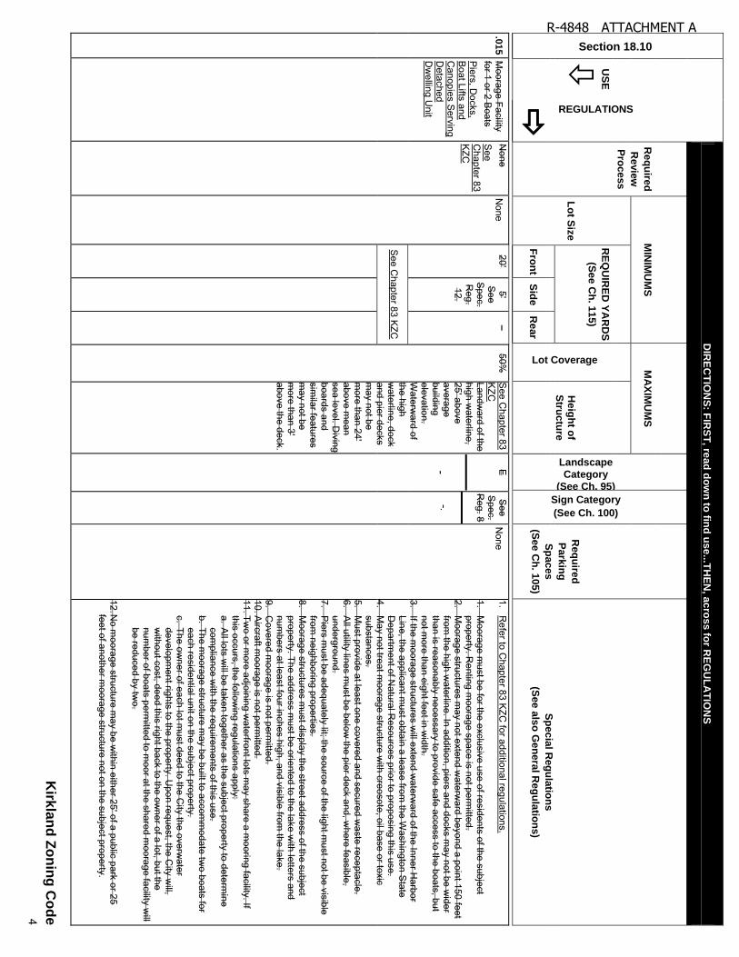
5 M
oorage Facility for 1 or 2 B
oats P
iers, Docks,
Boat Lifts and
Canopies S
erving D
etached D
welling U
nit
None
See
Chapter 83
KZC
None
20' 5'
See
Spec.
Reg.
12.
– 50%
S
ee Chapter 83
KZC
Landw
ard of the high w
aterline, 25' above average building elevation. W
aterward of
the high w
aterline, dock and pier decks m
ay not be m
ore than 24' above m
ean sea level. D
iving boards and sim
ilar features m
ay not be m
ore than 3' above the deck.
E
-
See
Spec.
Reg. 8
-.
None
1. R
efer to Chapter 83 K
ZC for additional regulations.
1. M
oorage must be for the exclusive use of residents of the subject
property. Renting m
oorage space is not permitted.
2. M
oorage structures may not extend w
aterward beyond a point 150 feet
from the high w
aterline. In addition, piers and docks may not be w
ider than is reasonably necessary to provide safe access to the boats, but not m
ore than eight feet in width.
3. If the m
oorage structures will extend w
aterward of the Inner H
arbor Line, the applicant m
ust obtain a lease from the W
ashington State
Departm
ent of Natural R
esources prior to proposing this use. 4.
May not treat m
oorage structure with creosote, oil base or toxic
substances. 5.
Must provide at least one covered and secured w
aste receptacle. 6.
All utility lines m
ust be below the pier deck and, w
here feasible, underground.
7. P
iers must be adequately lit; the source of the light m
ust not be visible from
neighboring properties. 8.
Moorage structures m
ust display the street address of the subject property. The address m
ust be oriented to the lake with letters and
numbers at least four inches high, and visible from
the lake. 9.
Covered m
oorage is not permitted.
10. Aircraft m
oorage is not permitted.
11. Two or m
ore adjoining waterfront lots m
ay share a mooring facility. If
this occurs, the following regulations apply:
a. All lots w
ill be taken together as the subject property to determine
compliance w
ith the requirements of this use.
b. The moorage structure m
ay be built to accomm
odate two boats for
each residential unit on the subject property. c. The ow
ner of each lot must deed to the C
ity the overwater
development rights to the property. U
pon request, the City w
ill, w
ithout cost, deed this right back to the owner of a lot, but the
number of boats perm
itted to moor at the shared m
oorage facility will
be reduced by two.
12. No m
oorage structure may be w
ithin either 25' of a public park or 25 feet of another m
oorage structure not on the subject property.
See C
hapter 83 KZC
R-4848 ATTACHMENT A

Section 18.10
US
E
REGULATIONS
DIR
EC
TIO
NS
: FIR
ST
, rea
d d
ow
n to
find
us
e...T
HE
N, a
cro
ss fo
r RE
GU
LA
TIO
NS
Re
qu
ired
Re
vie
w
Pro
ce
ss
MIN
IMU
MS
M
AX
IMU
MS
Landscape
Category
(See Ch. 95)
Sign Category
(See Ch. 100)
Re
qu
ired
Pa
rkin
g
Sp
ace
s
(Se
e C
h. 1
05
)
Sp
ec
ial R
eg
ula
tion
s
(Se
e a
lso
Ge
nera
l Re
gu
latio
ns)
Lo
t Siz
e
RE
QU
IRE
D Y
AR
DS
(Se
e C
h. 1
15
)
Lot Coverage
H
eig
ht o
f S
truc
ture
Fro
nt
Sid
e
Re
ar
Kirk
lan
d Z
on
ing
Co
de
5
R-4848 ATTACHMENT A

Section 18.10
US
E
REGULATIONS
DIR
EC
TIO
NS
: FIR
ST
, rea
d d
ow
n to
find
us
e...T
HE
N, a
cro
ss fo
r RE
GU
LA
TIO
NS
Re
qu
ired
Re
vie
w
Pro
ce
ss
MIN
IMU
MS
M
AX
IMU
MS
Landscape
Category
(See Ch. 95)
Sign Category
(See Ch. 100)
Re
qu
ired
Pa
rkin
g
Sp
ace
s
(Se
e C
h. 1
05
)
Sp
ec
ial R
eg
ula
tion
s
(Se
e a
lso
Ge
nera
l Re
gu
latio
ns)
Lo
t Siz
e
RE
QU
IRE
D Y
AR
DS
(Se
e C
h. 1
15
)
Lot Coverage
H
eig
ht o
f S
truc
ture
Fro
nt
Sid
e
Re
ar
Kirk
lan
d Z
on
ing
Co
de
6
.02
0
Church
See S
pec Regs 1
and 4.
See S
pec. R
eg. 1. 2. A
s established on the Zoning M
ap. See
Spec.
Reg. 2. 3
20' 20' on each side
20' 70%
, except 30%
for R
SA
1 zone. S
ee G
en. R
eg. 3. S
ee G
en. R
eg. 4 for H
olmes
Point
overlay zone.
30' above average building elevation.
C
B
1 for every 4 people based on m
aximum
occupancy load of w
orship. See
Spec. R
eg. 4. 5
1. This use not permitted on properties w
ithin the jurisdiction of the S
horeline Managem
ent Act. S
ee Chapter 83 K
ZC.
1. 2. The required review
process is as follows:
a. If the subject property, including all contiguous property owned by
the applicant and held by others for future use by the applicant, is less than five acres, the required review
process is Process IIA
, C
hapter 150 KZC
. b. If the subject property, including all contiguous property ow
ned by the applicant and held by others for future use by the applicant, is five or m
ore acres, a Master P
lan, approved through Process IIB
, C
hapter 152 KZC
, is required. The Master P
lan must show
building placem
ent, building dimensions, roadw
ays, utility location, land uses w
ithin the Master P
lan area, parking location, buffering, and landscaping.
2. 3. M
inimum
lot size is as follows:
a. In RS
A 1 zone, new
ly platted lots shall be clustered and configured in a m
anner to provide generally equal sized lots outside of the required open space area.
b. In RS
A 4 zones, the m
inimum
lot size is 7,600 square feet. c. In R
SA
6 zones, the minim
um lot size is 5,100 square feet.
d. In RS
A 8 zones, the m
inimum
lot size is 3,800 square feet. 3.4.
The property must be served by a collector or arterial street.
4.5. N
o parking is required for day-care or school ancillary to the use.
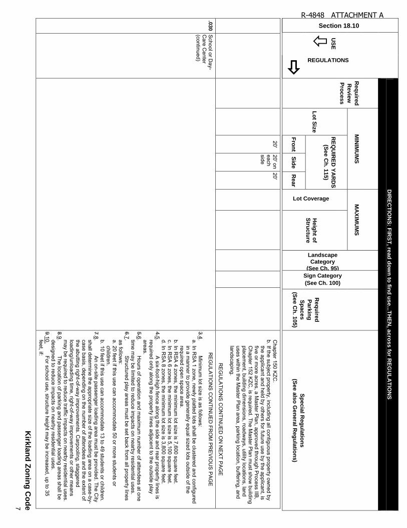
.03
0
School or D
ay-C
are Center
See S
pec. Regs.
1 and 2.
See S
pec. R
eg. 2. 3. A
s established on the Zoning M
ap. See
Spec.
Reg. 3. 4.
If this use can accom
modate 50 or
more students or
children, then:
30' above average building elevation. S
ee Spec.
Reg. 9. 10.
D
See
Gen.
Regs. 3
and 4.
B
See
Spec.
Reg.
12. 13.
See K
ZC
105.25. 1.
May locate on the subject property only if:
a. It will not be m
aterially detrimental to the character of the
neighborhood in which it is located; or
b. Site and building design m
inimizes adverse im
pacts on surrounding residential neighborhoods.
c. The property is served by a collector or arterial street. 2.
This use not permitted on properties w
ithin the jurisdiction of the S
horeline Managem
ent Act. S
ee Chapter 83 K
ZC.
2.3. The required review
process is as follows:
a. If the subject property, including all contiguous property owned by
the applicant and held by others for future use by the applicant, is less than five acres, the required review
process is Process IIA
,
50' 50' on each side
50'
If this use can accom
modate 13 to
49 students or children, then:
R-4848 ATTACHMENT A
Section 18.10
US
E
REGULATIONS
DIR
EC
TIO
NS
: FIR
ST
, rea
d d
ow
n to
find
us
e...T
HE
N, a
cro
ss fo
r RE
GU
LA
TIO
NS
Re
qu
ired
Re
vie
w
Pro
ce
ss
MIN
IMU
MS
M
AX
IMU
MS
Landscape
Category
(See Ch. 95)
Sign Category
(See Ch. 100)
Re
qu
ired
Pa
rkin
g
Sp
ace
s
(Se
e C
h. 1
05
)
Sp
ec
ial R
eg
ula
tion
s
(Se
e a
lso
Ge
nera
l Re
gu
latio
ns)
Lo
t Siz
e
RE
QU
IRE
D Y
AR
DS
(Se
e C
h. 1
15
)
Lot Coverage
H
eig
ht o
f S
truc
ture
Fro
nt
Sid
e
Re
ar
Kirk
lan
d Z
on
ing
Co
de
7
20' 20' on each side
20' C
hapter 150 KZC
. b. If the subject property, including all contiguous property ow
ned by the applicant and held by others for future use by the applicant, is five or m
ore acres, a Master P
lan, approved through Process IIB
, C
hapter 152 KZC
, is required. The Master P
lan must show
building placem
ent, building dimensions, roadw
ays, utility locations, land uses w
ithin the Master P
lan area, parking location, buffering, and landscaping.
RE
GU
LATIO
NS
CO
NTIN
UE
D O
N N
EX
T PA
GE
.03
0
School or D
ay-C
are Center
(continued)
R
EG
ULA
TION
S C
ON
TINU
ED
FRO
M P
RE
VIO
US
PA
GE
3.4. M
inimum
lot size is as follows:
a. In RS
A 1 zone, new
ly platted lots shall be clustered and configured in a m
anner to provide generally equal sized lots outside of the required open space area.
b. In RS
A 4 zones, the m
inimum
lot size is 7,600 square feet. c. In R
SA
6 zones, the minim
um lot size is 5,100 square feet.
d. In RS
A 8 zones, the m
inimum
lot size is 3,800 square feet. 4.5.
A six-foot-high fence along the side and rear property lines is
required only along the property lines adjacent to the outside play areas.
5.6. H
ours of operation and maxim
um num
ber of attendees at one tim
e may be lim
ited to reduce impacts on nearby residential uses.
6.7. S
tructured play areas must be set back from
all property lines as follow
s: a. 20 feet if this use can accom
modate 50 or m
ore students or children.
b. 10 feet if this use can accomm
odate 13 to 49 students or children. 7.8.
An on-site passenger loading area m
ust be provided. The City
shall determine the appropriate size of the loading area on a case-by-
case basis, depending on the number of attendees and the extent of
the abutting right-of-way im
provements. C
arpooling, staggered loading/unloading tim
e, right-of-way im
provements or other m
eans m
ay be required to reduce traffic impacts on nearby residential uses.
8.9. The location of parking and passenger loading areas shall be
designed to reduce impacts on nearby residential uses.
9.10. For school use, structure height m
ay be increased, up to 35 feet, if:
R-4848 ATTACHMENT A
Section 18.10
US
E
REGULATIONS
DIR
EC
TIO
NS
: FIR
ST
, rea
d d
ow
n to
find
us
e...T
HE
N, a
cro
ss fo
r RE
GU
LA
TIO
NS
Re
qu
ired
Re
vie
w
Pro
ce
ss
MIN
IMU
MS
M
AX
IMU
MS
Landscape
Category
(See Ch. 95)
Sign Category
(See Ch. 100)
Re
qu
ired
Pa
rkin
g
Sp
ace
s
(Se
e C
h. 1
05
)
Sp
ec
ial R
eg
ula
tion
s
(Se
e a
lso
Ge
nera
l Re
gu
latio
ns)
Lo
t Siz
e
RE
QU
IRE
D Y
AR
DS
(Se
e C
h. 1
15
)
Lot Coverage
H
eig
ht o
f S
truc
ture
Fro
nt
Sid
e
Re
ar
Kirk
lan
d Z
on
ing
Co
de
8
a. The school can accomm
odate 200 or more students; and
b. The required side and rear yards for the portions of the structure exceeding the basic m
aximum
structure height are increased by one foot for each additional one foot of structure height; and
c. The increased height is not specifically inconsistent with the
applicable neighborhood plan provisions of the Com
prehensive P
lan. d. The increased height w
ill not result in a structure that is incom
patible with surrounding uses or im
provements.
10.11. M
ay include accessory living facilities for staff persons. 11.12
These uses are subject to the requirements established by the
Departm
ent of Social and H
ealth Services (W
AC
Title 388). 12.13.
Electrical signs shall not be perm
itted.
R-4848 ATTACHMENT A
Section 18.10
US
E
REGULATIONS
DIR
EC
TIO
NS
: FIR
ST
, rea
d d
ow
n to
find
us
e...T
HE
N, a
cro
ss fo
r RE
GU
LA
TIO
NS
Re
qu
ired
Re
vie
w
Pro
ce
ss
MIN
IMU
MS
M
AX
IMU
MS
Landscape
Category
(See Ch. 95)
Sign Category
(See Ch. 100)
Re
qu
ired
Pa
rkin
g
Sp
ace
s
(Se
e C
h. 1
05
)
Sp
ec
ial R
eg
ula
tion
s
(Se
e a
lso
Ge
nera
l Re
gu
latio
ns)
Lo
t Siz
e
RE
QU
IRE
D Y
AR
DS
(Se
e C
h. 1
15
)
Lot Coverage
H
eig
ht o
f S
truc
ture
Fro
nt
Sid
e
Re
ar
Kirk
lan
d Z
on
ing
Co
de
9
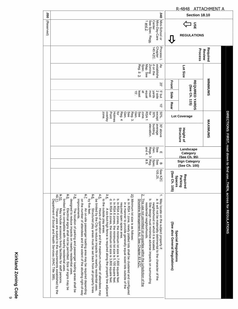
.04
0
Mini-S
chool or M
ini-Day-C
are C
enter S
ee Spec. R
egs. 1 and 2.
Process I,
Chapter
145 KZC
.
As
established on the Zoning M
ap. See
Spec.
Reg. 2. 3.
20' 5' but 2 side yards m
ust equal at least 15'.
10' 50%
, except 30%
for R
SA
1 zone. S
ee G
en. R
eg. 3. S
ee G
en. R
eg. 4 for H
olmes
Point
overlay zone.
30' above average building elevation.
E
See
Gen.
Regs. 3
and 4.
B
See
Spec.
Reg.
8.9.
See K
ZC
105.25. 1.
May locate on the subject property if:
a. It will not be m
aterially detrimental to the character of the
neighborhood in which it is located.
b. Site design m
ust minim
ize adverse impacts on surrounding
residential neighborhoods. 2. This use not perm
itted on properties within the jurisdiction of the
Shoreline M
anagement A
ct. See C
hapter 83 KZC
.
23. Minim
um lot size is as follow
s: a. In R
SA
1 zone, newly platted lots shall be clustered and configured
in a manner to provide generally equal sized lots outside of the
required open space area. b. In R
SA
4 zones, the minim
um lot size is 7,600 square feet.
c. In RS
A 6 zones, the m
inimum
lot size is 5,100 square feet. d. In R
SA
8 zones, the minim
um lot size is 3,800 square feet.
3.4. A
six-foot-high fence is required along the property line adjacent to the outside play areas.
4.5. H
ours of operation and the maxim
um num
ber of attendees may
be limited by the C
ity to reduce impacts on nearby residential uses.
5.6. S
tructured play areas must be set back from
all property lines by five feet.
6.7. A
n on-site passenger loading area may be required depending
on the number of attendees and the extent of the abutting right-of-w
ay im
provements.
7.8. The location of parking and passenger loading areas shall be
designed to reduce impacts on nearby residential uses.
8.9. E
lectrical signs shall not be permitted. S
ize of signs may be
limited to be com
patible with nearby residential uses.
9.10. M
ay include accessory living facilities for staff persons. 10.11.
These uses are subject to the requirements established by the
Departm
ent of Social and H
ealth Services (W
AC
Title 388).
.05
0
(Reserved)
R-4848 ATTACHMENT A
Section 18.10
US
E
REGULATIONS
DIR
EC
TIO
NS
: FIR
ST
, rea
d d
ow
n to
find
us
e...T
HE
N, a
cro
ss fo
r RE
GU
LA
TIO
NS
Re
qu
ired
Re
vie
w
Pro
ce
ss
MIN
IMU
MS
M
AX
IMU
MS
Landscape
Category
(See Ch. 95)
Sign Category
(See Ch. 100)
Re
qu
ired
Pa
rkin
g
Sp
ace
s
(Se
e C
h. 1
05
)
Sp
ec
ial R
eg
ula
tion
s
(Se
e a
lso
Ge
nera
l Re
gu
latio
ns)
Lo
t Siz
e
RE
QU
IRE
D Y
AR
DS
(Se
e C
h. 1
15
)
Lot Coverage
H
eig
ht o
f S
truc
ture
Fro
nt
Sid
e
Re
ar
Kirk
lan
d Z
on
ing
Co
de
10
.06
0
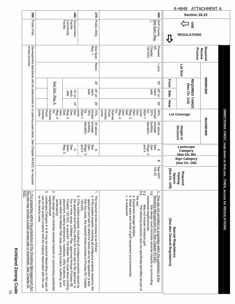
Golf C
ourse S
ee Spec. R
eg. 1.
Process
IIA,
Chapter
150 KZC
.
1 acre 50'
50' on each side
50' 50%
, except 30%
for R
SA
1 zone. S
ee G
en. R
eg. 3. S
ee G
en. R
eg. 4 for H
olmes
Point
overlay zone.
30' above average building elevation.
E
See
Gen.
Regs. 3
and 4.
B
See K
ZC
105.25. 1. This use not perm
itted on properties within the jurisdiction of the
Shoreline M
anagement A
ct. See C
hapter 83 KZC
. 1.2.
Site design m
ust minim
ize adverse impacts on surrounding
residential neighborhoods. 2.3.
May not include m
iniature golf. 3.4.
The following accessory uses are specifically perm
itted as part of this use. a. E
quipment storage facilities.
b. Retail sales and rental of golf equipm
ent and accessories. c. A
restaurant.
.07
0
Public U
tility S
ee Spec.
Reg. 1.
None
20' 20' on each side
20' 70%
, except 30%
for R
SA
1 zone. S
ee G
en. R
eg. 3. S
ee G
en. R
eg. 4 for H
olmes
Point
overlay zone.
30' above average building elevation.
A
See
Gen.
Regs. 3
and 4.
1. The required review
process is as follows:
a. If the subject property, including all contiguous property owned by the
applicant and held by others for future use by the applicant, is less than five acres, the required review
process is Process IIA, Chapter
150 KZC.
b. If the subject property, including all contiguous property owned by
the applicant and held by others for future use by the applicant, is five or m
ore acres, a Master P
lan, approved through Process IIB
, C
hapter 152 KZC
, is required. The Master P
lan must show
building placem
ent, building dimensions, roadw
ays, utility locations, land uses w
ithin the Master P
lan area, parking location, buffering, and landscaping.
2. S
ite design must m
inimize adverse im
pacts on surrounding residential neighborhoods.
3. Landscape C
ategory A or B
may be required depending on the type of
use on the subject property and the impacts associated w
ith the use on the nearby uses.
.08
0
Governm
ent Facility C
omm
unity Facility
10' on each side
10' C
S
ee S
pec. R
eg. 3.
See G
en. Reg. 6.
.09
0
Public P
ark D
evelopment standards w
ill be determined on a case-by-case basis. S
ee Chapter 49 K
ZC for required
review process.
1. For properties within the jurisdiction of the S
horeline Manaagem
ent Act,
this use may include a public access pier or boardw
alk. See C
hapter 83 K
ZC.
R-4848 ATTACHMENT A
Section 18.10
US
E
REGULATIONS
DIR
EC
TIO
NS
: FIR
ST
, rea
d d
ow
n to
find
us
e...T
HE
N, a
cro
ss fo
r RE
GU
LA
TIO
NS
Re
qu
ired
Re
vie
w
Pro
ce
ss
MIN
IMU
MS
M
AX
IMU
MS
Landscape
Category
(See Ch. 95)
Sign Category
(See Ch. 100)
Re
qu
ired
Pa
rkin
g
Sp
ace
s
(Se
e C
h. 1
05
)
Sp
ec
ial R
eg
ula
tion
s
(Se
e a
lso
Ge
nera
l Re
gu
latio
ns)
Lo
t Siz
e
RE
QU
IRE
D Y
AR
DS
(Se
e C
h. 1
15
)
Lot Coverage
H
eig
ht o
f S
truc
ture
Fro
nt
Sid
e
Re
ar
Kirk
lan
d Z
on
ing
Co
de
11
R-4848 ATTACHMENT A
CH
AP
TE
R 2
0 –
MU
LT
IFA
MIL
Y R
ES
IDE
NT
IAL
(RM
AN
D R
MA
) ZO
NE
S
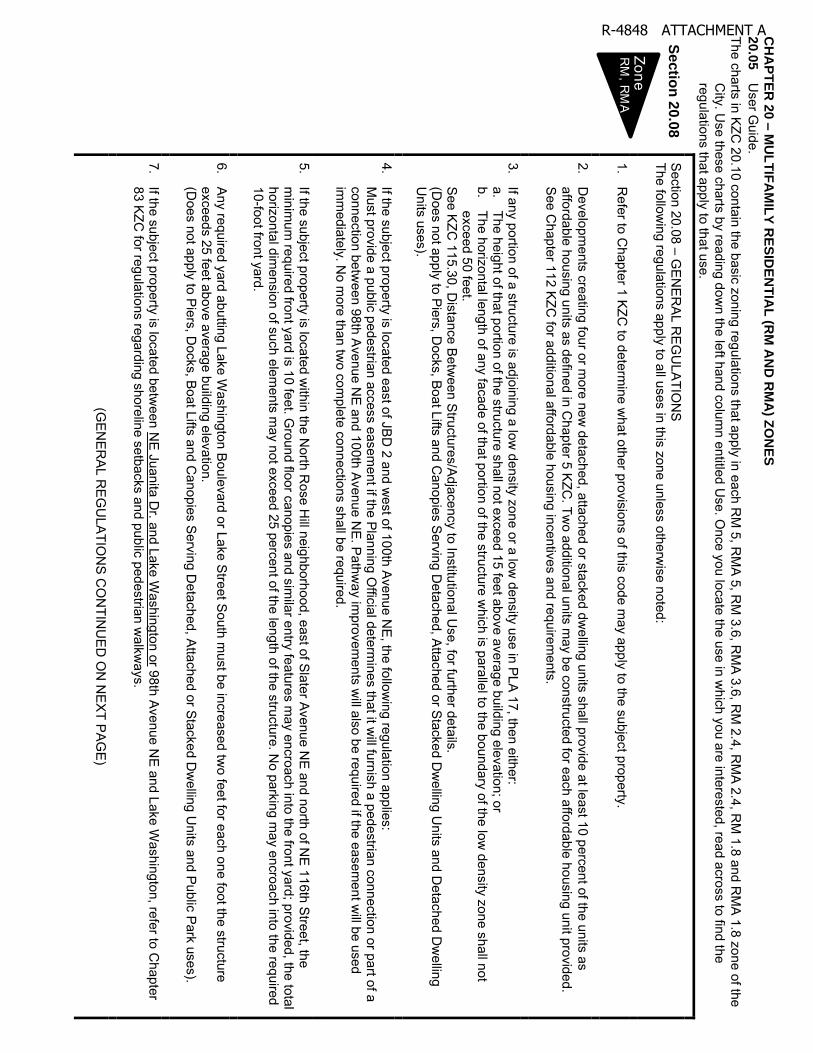
20
.05
User G
uide. The charts in KZC
20.10 contain the basic zoning regulations that apply in each RM
5, RM
A 5, R
M 3.6, R
MA
3.6, RM
2.4, RM
A 2.4, R
M 1.8 and R
MA
1.8 zone of the C
ity. Use these charts by reading dow
n the left hand column entitled U
se. Once you locate the use in w
hich you are interested, read across to find the regulations that apply to that use.
Sectio
n 2
0.0
8
Section 20.08 – G
EN
ER
AL R
EG
ULA
TION
S
The following regulations apply to all uses in this zone unless otherw
ise noted:
1. R
efer to Chapter 1 KZC
to determine w
hat other provisions of this code may apply to the subject property.
2. D
evelopments creating four or m
ore new detached, attached or stacked dw
elling units shall provide at least 10 percent of the units as affordable housing units as defined in C
hapter 5 KZC
. Two additional units m
ay be constructed for each affordable housing unit provided. S
ee Chapter 112 K
ZC for additional affordable housing incentives and requirem
ents.
3. If any portion of a structure is adjoining a low
density zone or a low density use in PLA
17, then either: a.
The height of that portion of the structure shall not exceed 15 feet above average building elevation; or b.
The horizontal length of any facade of that portion of the structure which is parallel to the boundary of the low
density zone shall not exceed 50 feet.
S
ee KZC
115.30, Distance B
etween Structures/A
djacency to Institutional Use, for further details.
(D
oes not apply to Piers, D
ocks, Boat Lifts and C
anopies Serving D
etached, Attached or Stacked Dw
elling Units and D
etached Dw
elling U
nits uses).
4. If the subject property is located east of JB
D 2 and w
est of 100th Avenue N
E, the follow
ing regulation applies:
Must provide a public pedestrian access easem
ent if the Planning O
fficial determines that it w
ill furnish a pedestrian connection or part of a connection betw
een 98th Avenue N
E and 100th Avenue N
E. P
athway im
provements w
ill also be required if the easement w
ill be used im
mediately. N
o more than tw
o complete connections shall be required.
5. If the subject property is located w
ithin the North R
ose Hill neighborhood, east of Slater Avenue N
E and north of N
E 116th S
treet, the m
inimum
required front yard is 10 feet. Ground floor canopies and sim
ilar entry features may encroach into the front yard; provided, the total
horizontal dimension of such elem
ents may not exceed 25 percent of the length of the structure. N
o parking may encroach into the required
10-foot front yard.
6. A
ny required yard abutting Lake Washington Boulevard or Lake S
treet South m
ust be increased two feet for each one foot the structure
exceeds 25 feet above average building elevation.
(Does not apply to P
iers, Docks, B
oat Lifts and Canopies S
erving Detached, A
ttached or Stacked Dw
elling Units and Public Park uses).
7.
If the subject property is located between N
E Juanita D
r. and Lake Washington or 98th Avenue N
E and Lake W
ashington, refer to Chapter
83 KZC for regulations regarding shoreline setbacks and public pedestrian w
alkways.
(G
EN
ERA
L RE
GU
LATIO
NS
CO
NTIN
UED
ON
NE
XT P
AGE
)
Zone��R
M, R
MA
R-4848 ATTACHMENT A
(G
EN
ERA
L RE
GU
LATIO
NS
CO
NTIN
UED
FRO
M P
RE
VIOU
S P
AGE
)
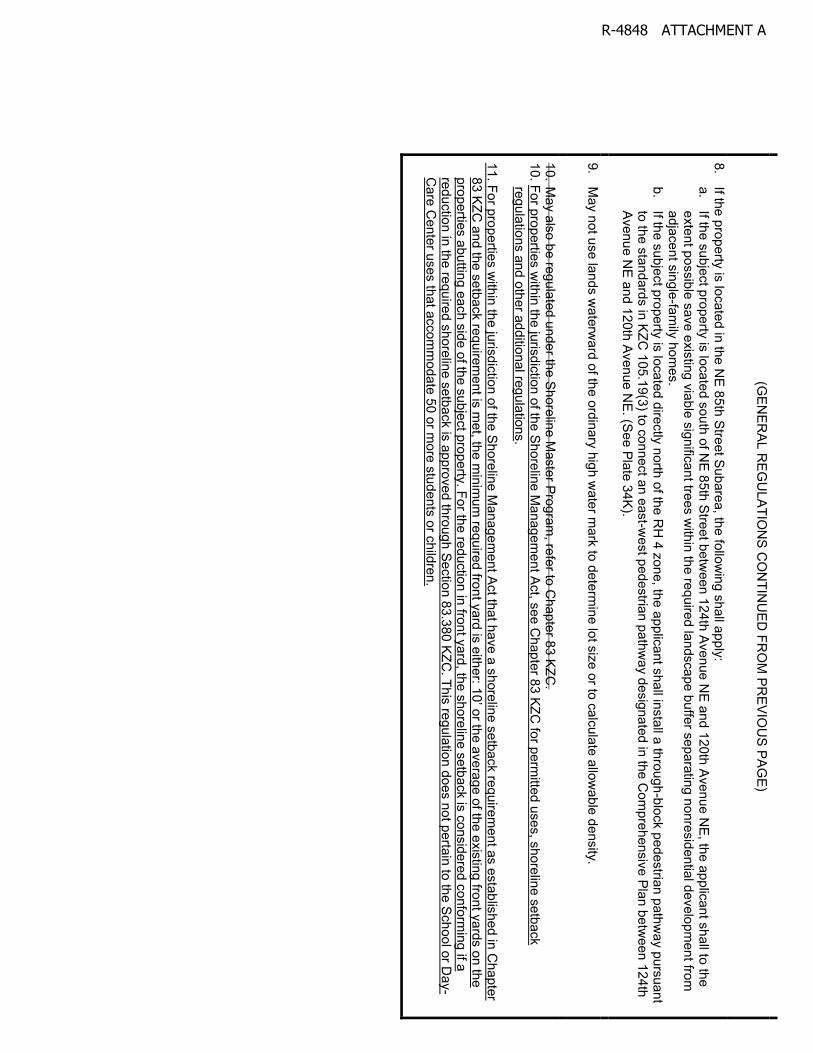
8.
If the property is located in the NE
85th Street Subarea, the follow
ing shall apply: a.
If the subject property is located south of NE
85th Street between 124th Avenue N
E and 120th A
venue NE
, the applicant shall to the extent possible save existing viable significant trees w
ithin the required landscape buffer separating nonresidential development from
adjacent single-fam
ily homes.
b. If the subject property is located directly north of the R
H 4 zone, the applicant shall install a through-block pedestrian pathw
ay pursuant to the standards in K
ZC 105.19(3) to connect an east-w
est pedestrian pathway designated in the C
omprehensive Plan betw
een 124th A
venue NE
and 120th Avenue NE
. (See Plate 34K
).
9.
May not use lands w
aterward of the ordinary high w
ater mark to determ
ine lot size or to calculate allowable density.
10. M
ay also be regulated under the Shoreline Master P
rogram, refer to C
hapter 83 KZC
. 10. For properties w
ithin the jurisdiction of the Shoreline Managem
ent Act, see C
hapter 83 KZC for perm
itted uses, shoreline setback regulations and other additional regulations.
11. For properties within the jurisdiction of the Shoreline M
anagement A
ct that have a shoreline setback requirement as established in C
hapter 8
3 K
ZC
and
the
se
tba
ck re
qu
irem
en
t is m
et, th
e m
inim
um
requ
ired
fron
t ya
rd is
eith
er: 1
0’ o
r the
ave
rage
of th
e existing front yards on the
properties abutting each side of the subject property. For the reduction in front yard, the shoreline setback is considered conforming if a
reduction in the required shoreline setback is approved through Section 83.380 KZC. This regulation does not pertain to the School or D
ay-C
are Center uses that accom
modate 50 or m
ore students or children.
R-4848 ATTACHMENT A
Section 20.10
US
E
REGULATIONS
DIR
EC
TIO
NS
: FIR
ST
, read
do
wn
to fin
d u
se...T
HE
N, a
cro
ss fo
r RE
GU
LA
TIO
NS
Req
uire
d
Re
vie
w
Pro
cess
MIN
IMU
MS
M
AX
IMU
MS
Landscape
Category
(See Ch. 95)
Sign Category
(See Ch. 100)
Req
uire
d
Park
ing
Sp
aces
(See C
h. 1
05)
Sp
ecia
l Reg
ula
tion
s
(Se
e a
lso
Ge
nera
l Reg
ula
tion
s)
Lo
t Siz
e
RE
QU
IRE
D Y
AR
DS
(See C
h. 1
15)
Lot Coverage
H
eig
ht o
f S
tructu
re
Fro
nt
Sid
e
Rea
r
.01
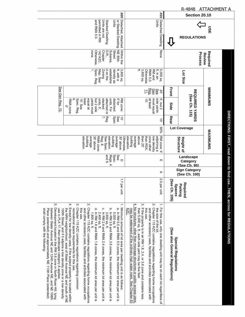
0 D
etached Dw
elling U
nits N
one 5,000 sq. ft. in an R
M and
RM
A 5.0.
Otherw
ise, 3,600 sq. ft.
20' S
ee G
en R
eg. 11.
5', but 2 side yards m
ust equal at least 15'
10' 60%
R
M zone: If
adjoining a low
density zone other than R
SX
, then 25' above average building elevation. O
therwise,
30' above average building elevation. S
ee Spec.
Reg. 8.
RM
A zone:
35' above average building elevation.
E
A
2.0 per unit. 1. For this use, only one dw
elling unit may be on each lot regardless of
the size of the lot. 2. C
hapter 115 KZC
contains regulations regarding home occupations
and other accessory uses, facilities and activities associated with
this use. 3. If the property is in an R
M 1.8, 2.4, or 3.6 zone and contains less
than 5,000 sq. ft., each side yard may be five feet.
4. No structures, other than m
oorage structures or public access piers, m
ay be waterw
ard of the ordinary high water m
ark. See C
hapter 83 K
ZC.
.02
0 D
etached, Attached
or Stacked D
welling
Units
Stacked D
welling
Units are not
permitted in R
M
and RM
A 5.0.
Within the
NE
85th S
treet S
ubarea, D
.R.,
Chapter
142 KZC
. O
therwise,
none.
3,600 sq. ft. w
ith a density as established on the Zoning M
ap. See
Spec. R
eg. 1.
RM
zone: 5' for detached units. For attached or stacked units, 5', but 2 side yards m
ust equal at least 15'S
ee S
pec. Reg.
6. R
MA
zone: 5'
10' S
ee S
pec. R
eg. 7.
D
See
Spec.
Regs. 4
and 9.
1.7 per unit. 1. M
inimum
amount of lot area per dw
elling unit is as follows:
a. In RM
5.0 and RM
A 5.0 zones, the m
inimum
lot area per unit is 5,000 sq. ft.
b. In RM
3.6 and RM
A 3.6 zones, the m
inimum
lot area per unit is 3,600 sq. ft.
c. In RM
2.4 and RM
A 2.4 zones, the m
inimum
lot area per unit is 2,400 sq. ft.
d. In RM
1.8 and RM
A 1.8 zones, the m
inimum
lot area per unit is 1,800 sq. ft.
2. Chapter 115 K
ZC contains regulations regarding hom
e occupations and other accessory uses, facilities and activities associated w
ith this use.
3. Chapter 115 K
ZC contains regulations regarding com
mon
recreational space requirements for this use.
4. Except for low
density uses, if the subject property is located within
the NR
H neighborhood, w
est of Slater A
venue NE
and south of NE
100th S
treet, and if it adjoins a low density zone or a low
density use in P
LA 17, then landscape category A
applies. 5. D
evelopment located in the R
M 3.6 zone in N
orth Rose H
ill, lying betw
een Slater A
venue NE
and 124th Avenue N
E, and N
E 108th
Place (extended) and approxim
ately NE
113th Place (extended)
shall comply w
ith the following:
See G
en Reg. 10.
R-4848 ATTACHMENT A
a. E
ach development shall incorporate at least tw
o acres; and b. S
ignificant vegetation that provides protection from I-405 shall be
retained to the maxim
um extent feasible.
RE
GU
LATIO
NS
CO
NTIN
UE
D O
N N
EX
T PA
GE
.02
0 D
etached, Attached
or Stacked D
welling
Units
(continued)
RE
GU
LATIO
NS
CO
NTIN
UE
D FR
OM
PR
EV
IOU
S P
AG
E
6. The side yard may be reduced to zero feet if the side of the dw
elling unit is attached to a dw
elling unit on an adjoining lot. If one side of a dw
elling unit is so attached and the opposite side is not, the side that is not attached m
ust provide a minim
um side yard of five feet.
7. The rear yard may be reduced to zero feet if the rear of the dw
elling unit is attached to a dw
elling unit on an adjoining lot. 8. W
here the 25-foot height limitation results solely from
an adjoining low
density zone occupied by a school that has been allowed to
increase its height to at least 30 feet, then a structure height of 30 feet above average building elevation is allow
ed. 9. W
hen a low density use adjoins a detached dw
elling unit in a low
density zone, Landscape Category E
applies. 10. R
esidential uses may have an associated private shoreline park
that is comm
only owned and used by residents and guests.
11. No structures, other than m
oorage structures or public access piers, m
ay be waterw
ard of the ordinary high water m
ark. See
Chapter 83 K
ZC.
.03
0 C
hurch W
ithin the N
E 85th
Street
Subarea,
D.R
., C
hapter 142 K
ZC.
Otherw
ise, P
rocess IIA
, Chapter
150 KZC
.
7,200 sq. ft.
20' S
ee G
en R
eg. 11
20' 20'
70%
RM
zone: If adjoining a low
density zone other than R
SX
, then 25' above average building elevation. O
therwise,
30' above average building elevation. R
MA
zone: 35' above average building elevation.
C
See
Spec.
Reg. 3.
B
1 for every 4 people based on m
aximum
occupancy load of w
orship. See
Spec. R
eg. 2.
1. The property must be served by a collector or arterial street.
2. No parking is required for day-care or school ancillary to the use.
3. If the subject property is located within the N
RH
neighborhood, west
of Slater A
venue NE
and south of NE
100th Street, and if it adjoins
a low density zone or a low
density use in PLA
17, then landscape category A
applies.
R-4848 ATTACHMENT A
Section 20.10 U
SE
REGULATIONS
DIR
EC
TIO
NS
: FIR
ST
, read
do
wn
to fin
d u
se...T
HE
N, a
cro
ss fo
r RE
GU
LA
TIO
NS
Req
uire
d
Re
vie
w
Pro
cess
MIN
IMU
MS
M
AX
IMU
MS
Landscape
Category
(See Ch. 95) Sign Category
(See Ch. 100)
Req
uire
d
Park
ing
Sp
aces
(See C
h.
105)
Sp
ecia
l Reg
ula
tion
s
(Se
e a
lso
Ge
nera
l Reg
ula
tion
s)
Lo
t
Siz
e
RE
QU
IRE
D Y
AR
DS
(See C
h. 1
15)
Lot Coverage
H
eig
ht o
f S
tructu
re
Fro
nt
Sid
e
Pro
perty
L
ine
Sh
ore
line
Setb
ack
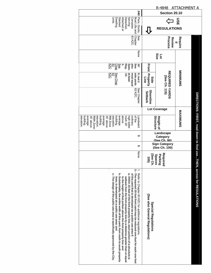
.04
0 P
iers, Docks,
Boat Lifts and
Canopies
Serving
Detached,
Attached or
Stacked
Dw
elling U
nits
See
Chapter
83 KZC
.
None
30' S
ee also S
pec. R
eg. 3. S
ee C
hap 83 K
ZC
5', but 2 side yards m
ust equal at least 15' S
ee Chap
83 K
ZC
See C
hapter 83 K
ZC.
Landw
ard of the ordinary high w
ater m
ark 30' above average building elevation. R
M Zone
30’ a
bove
average building elevation. R
MA
Zone: 35’ a
bove
average building elevation.
B
B
None
1. R
efer to Chapter 83 K
ZC for additional regulations.
3. The required 30-foot front yard m
ay be reduced one foot for each one foot of this yard that is developed as a public use area if: a. W
ithin 30 feet of the front property line, each portion of a structure is setback from
the front property line by a distance greater than or equal to the height of that portion above the front property line; and
b. Substantially, the entire w
idth of this yard, from north to south property
lines, is developed as a public use area; and c. The design of the public use area is specifically approved by the C
ity. .
R-4848 ATTACHMENT A
Section 20.10
US
E
REGULATIONS
DIR
EC
TIO
NS
: FIR
ST
, read
do
wn
to fin
d u
se...T
HE
N, a
cro
ss fo
r RE
GU
LA
TIO
NS
Req
uire
d
Re
vie
w
Pro
cess
MIN
IMU
MS
M
AX
IMU
MS
Landscape
Category
(See Ch. 95)
Sign Category
(See Ch. 100)
Req
uire
d
Park
ing
Sp
aces
(See C
h. 1
05)
Sp
ecia
l Reg
ula
tion
s
(Se
e a
lso
Ge
nera
l Reg
ula
tion
s)
Lo
t
Siz
e
RE
QU
IRE
D Y
AR
DS
(See C
h. 1
15)
Lot Coverage
H
eig
ht o
f S
tructu
re
Fro
nt
Sid
e
Rea
r
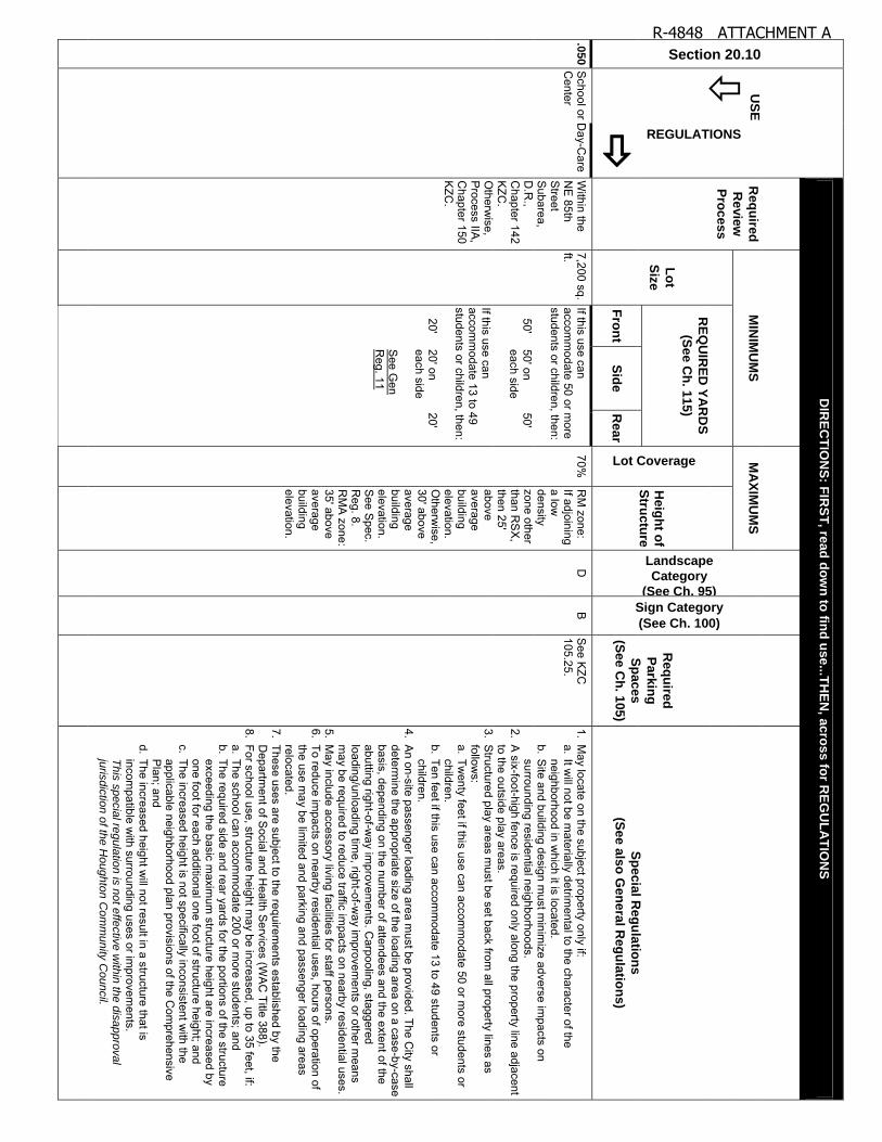
.05
0 S
chool or Day-C
are C
enter W
ithin the N
E 85th
Street
Subarea,
D.R
., C
hapter 142 K
ZC.
Otherw
ise, P
rocess IIA,
Chapter 150
KZC
.
7,200 sq. ft.
If this use can accom
modate 50 or m
ore students or children, then:
70%
RM
zone: If adjoining a low
density zone other than R
SX
, then 25' above average building elevation. O
therwise,
30' above average building elevation. S
ee Spec.
Reg. 8.
RM
A zone:
35' above average building elevation.
D
B
See K
ZC
105.25. 1. M
ay locate on the subject property only if: a. It w
ill not be materially detrim
ental to the character of the neighborhood in w
hich it is located. b. S
ite and building design must m
inimize adverse im
pacts on surrounding residential neighborhoods.
2. A six-foot-high fence is required only along the property line adjacent
to the outside play areas. 3. S
tructured play areas must be set back from
all property lines as follow
s: a. Tw
enty feet if this use can accomm
odate 50 or more students or
children. b. Ten feet if this use can accom
modate 13 to 49 students or
children. 4. A
n on-site passenger loading area must be provided. The C
ity shall determ
ine the appropriate size of the loading area on a case-by-case basis, depending on the num
ber of attendees and the extent of the abutting right-of-w
ay improvem
ents. Carpooling, staggered
loading/unloading time, right-of-w
ay improvem
ents or other means
may be required to reduce traffic im
pacts on nearby residential uses. 5. M
ay include accessory living facilities for staff persons. 6. To reduce im
pacts on nearby residential uses, hours of operation of the use m
ay be limited and parking and passenger loading areas
relocated. 7. These uses are subject to the requirem
ents established by the D
epartment of S
ocial and Health S
ervices (WA
C Title 388).
8. For school use, structure height may be increased, up to 35 feet, if:
a. The school can accomm
odate 200 or more students; and
b. The required side and rear yards for the portions of the structure exceeding the basic m
aximum
structure height are increased by one foot for each additional one foot of structure height; and
c. The increased height is not specifically inconsistent with the
applicable neighborhood plan provisions of the Com
prehensive P
lan; and d. The increased height w
ill not result in a structure that is incom
patible with surrounding uses or im
provements.
T
his
specia
l regula
tion is
not e
ffectiv
e w
ithin
the d
isappro
val
juris
dic
tion o
f the H
oughto
n C
om
munity
Council.
50' 50' on each side
50'
If this use can accom
modate 13 to 49
students or children, then:
20' 20' on each side S
ee Gen
Reg. 11
20'
R-4848 ATTACHMENT A
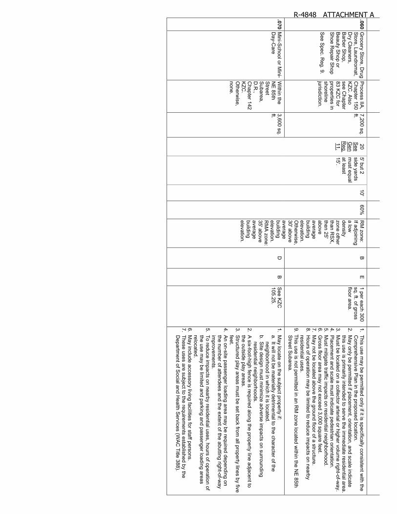
.06
0 G
rocery Store, D
rug S
tore, Laundromat,
Dry C
leaners, B
arber Shop,
Beauty S
hop or S
hoe Repair S
hop
See S
pec. Reg. 9.
Process IIA
, C
hapter 150 K
ZC. A
lso see C
hapter 83 K
ZC for
properties in shoreline jurisdiction.
7,200 sq. ft.
20 S
ee G
en R
eg. 11.
5' but 2 side yards m
ust equal at least 15'.
10' 60%
R
M zone:
If adjoining a low
density zone other than R
SX
, then 25' above average building elevation. O
therwise,
30' above average building elevation. R
MA
zone: 35' above average building elevation.
B
E
1 per each 300 sq. ft. of gross floor area.
1. This use may be perm
itted only if it is specifically consistent with the
Com
prehensive Plan in the proposed location.
2. May only be perm
itted if placement, orientation, and scale indicate
this use is primarily intended to serve the im
mediate residential area.
3. Must be located on a collector arterial or higher volum
e right-of-way.
4. Placem
ent and scale must indicate pedestrian orientation.
5. Must m
itigate traffic impacts on residential neighborhood.
6. Gross floor area m
ay not exceed 3,000 square feet. 7. M
ay not be located above the ground floor of a structure. 8. H
ours of operation may be lim
ited to reduce impacts on nearby
residential uses. 9. This use is not perm
itted in an RM
zone located within the N
E 85th
Street S
ubarea.
.07
0 M
ini-School or M
ini-D
ay-Care
Within the
NE
85th S
treet S
ubarea, D
.R.,
Chapter 142
KZC
. O
therwise,
none.
3,600 sq. ft.
D
B
See K
ZC
105.25. 1. M
ay locate on the subject property if: a. It w
ill not be materially detrim
ental to the character of the neighborhood in w
hich it is located. b. S
ite design must m
inimize adverse im
pacts on surrounding residential neighborhoods.
2. A six-foot-high fence is required along the property line adjacent to
the outside play areas. 3. S
tructured play areas must be set back from
all property lines by five feet.
4. An on-site passenger loading area m
ay be required depending on the num
ber of attendees and the extent of the abutting right-of-way
improvem
ents. 5. To reduce im
pacts on nearby residential uses, hours of operation of the use m
ay be limited and parking and passenger loading areas
relocated. 6. M
ay include accessory living facilities for staff persons. 7. These uses are subject to the requirem
ents established by the D
epartment of S
ocial and Health S
ervices (WA
C Title 388).
R-4848 ATTACHMENT A

.08
0 A
ssisted Living Facility (N
ot perm
itted in RM
5.0 or R
MA
5.0)
Within the
NE
85th S
treet S
ubarea, D
.R.,
Chapter 142
KZC
. O
therwise,
none.
3,600 sq. ft.
20' S
ee G
en. R
eg. 11.
RM
zone: 5' but 2 side yards m
ust equal at least 15'. R
MA
zone: 5'.
10' 60%
R
M zone:
If adjoining a low
density zone other than R
SX
, then 25' above average building elevation. O
therwise,
30' above average building elevation. R
MA
zone: 35' above average building elevation.
D
See
Spec.
Reg. 6.
A
1.7 per independent unit. 1 per assisted living unit.
1. A facility that provides both independent dw
elling units and assisted living units shall be processed as an assisted living facility.
2. If a nursing home use is com
bined with an assisted living facility use
in order to provide a continuum of care for residents, the required
review process shall be the least intensive process betw
een the two
uses. 3. For density purposes, tw
o assisted living units shall constitute one dw
elling unit. Total dwelling units m
ay not exceed the number of
stacked dwelling units allow
ed on the subject property. Through P
rocess IIB, C
hapter 152 KZC
, up to 1 1/2 times the num
ber of stacked dw
elling units allowed on the property m
ay be approved if the follow
ing criteria are met:
a. Project is of superior design; and
b. Project w
ill not create impacts that are substantially different than
would be created by a perm
itted multifam
ily development.
4. The assisted living facility shall provide usable recreation space of at least 100 square feet per unit, in the aggregate, for both assisted living units and independent dw
elling units, with a m
inimum
of 50 square feet of usable recreation space per unit located outside.
5. Chapter 115 K
ZC contains regulations regarding hom
e occupations and other accessory uses, facilities, and activities associated w
ith this use.
6. If the subject property is located within the N
RH
neighborhood, west
of Slater A
venue NE
and south of NE
100th Street, and if it adjoins a
low density zone or a low
density use in PLA
17, then landscape category A
applies.
.09
0 C
onvalescent C
enter or Nursing
Hom
e
Within the
NE
85th S
treet S
ubarea, D
.R.,
Chapter 142
KZC
. O
therwise,
Process IIA
, C
hapter 150 K
ZC.
7,200 sq. ft.
10' on each side
70%
C
See
Spec.
Reg. 2.
B
1 for each bed. 1. If a nursing hom
e use is combined w
ith an assisted living facility use in order to provide a continuum
of care for residents, the required review
process shall be the least intensive process between the tw
o uses.
2. If the subject property is located within the N
RH
neighborhood, west
of Slater A
venue NE
and south of NE
100th Street, and if it adjoins a
low density zone or a low
density use in PLA
17, then Landscape C
ategory A applies.
.10
0 P
ublic Utility
Within the
NE
85th S
treet S
ubarea, D
.R.,
None
20' S
ee G
en R
eg. 11
20' on each side
20' 70%
R
M zone:
If adjoining a low
density zone other
A
See
Spec.
Regs. 2
and 3.
B
See K
ZC
105.25. 1. S
ite design must m
inimize adverse im
pacts on surrounding residential neighborhoods.
2. Landscape Category A
or B m
ay be required depending on the type of use on the subject property and the im
pacts associated with the
use on the nearby uses.
R-4848 ATTACHMENT A
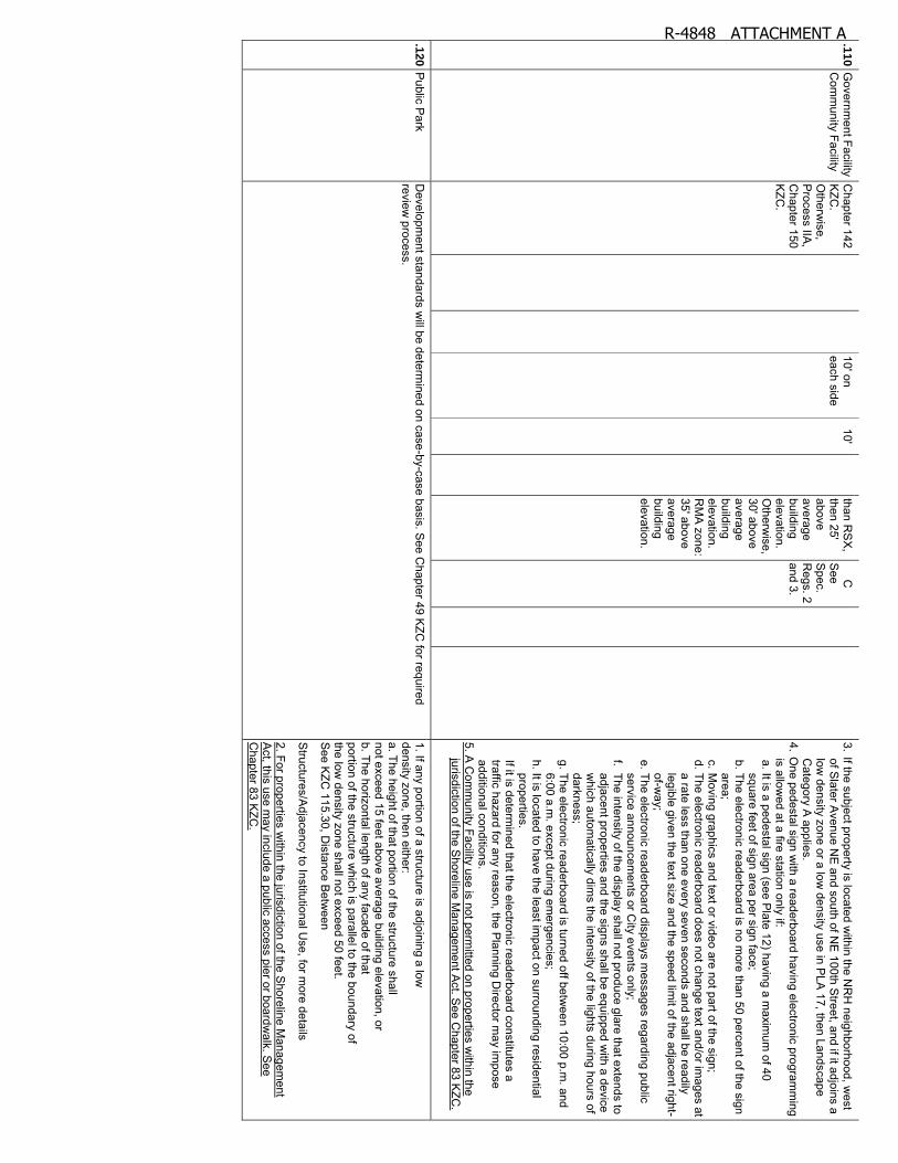
.11
0 G
overnment Facility
Com
munity Facility
Chapter 142
KZC
. O
therwise,
Process IIA
, C
hapter 150 K
ZC.
10' on each side
10' than R
SX
, then 25' above average building elevation. O
therwise,
30' above average building elevation. R
MA
zone: 35' above average building elevation.
C
See
Spec.
Regs. 2
and 3.
3. If the subject property is located within the N
RH
neighborhood, west
of Slater A
venue NE
and south of NE
100th Street, and if it adjoins a
low density zone or a low
density use in PLA
17, then Landscape C
ategory A applies.
4. One pedestal sign w
ith a readerboard having electronic programm
ing is allow
ed at a fire station only if: a. It is a pedestal sign (see P
late 12) having a maxim
um of 40
square feet of sign area per sign face; b. The electronic readerboard is no m
ore than 50 percent of the sign area;
c. Moving graphics and text or video are not part of the sign;
d. The electronic readerboard does not change text and/or images at
a rate less than one every seven seconds and shall be readily legible given the text size and the speed lim
it of the adjacent right-of-w
ay; e. The electronic readerboard displays m
essages regarding public service announcem
ents or City events only;
f. The intensity of the display shall not produce glare that extends to adjacent properties and the signs shall be equipped w
ith a device w
hich automatically dim
s the intensity of the lights during hours of darkness;
g. The electronic readerboard is turned off between 10:00 p.m
. and 6:00 a.m
. except during emergencies;
h. It is located to have the least impact on surrounding residential
properties.
If it is determined that the electronic readerboard constitutes a
traffic hazard for any reason, the Planning D
irector may im
pose additional conditions.
5. A C
omm
unity Facility use is not permitted on properties w
ithin the jurisdiction of the S
horeline Managem
ent Act. S
ee Chapter 83 K
ZC.
.12
0 P
ublic Park
Developm
ent standards will be determ
ined on case-by-case basis. See C
hapter 49 KZC
for required review
process. 1. If any portion of a structure is adjoining a low
density zone, then either: a. The height of that portion of the structure shall not exceed 15 feet above average building elevation, or b. The horizontal length of any facade of that portion of the structure w
hich is parallel to the boundary of the low
density zone shall not exceed 50 feet. S
ee KZC
115.30, Distance B
etween
Structures/A
djacency to Institutional Use, for m
ore details
2. For properties within the jurisdiction of the S
horeline Managem
ent A
ct, this use may include a public access pier or boardw
alk. See
Chapter 83 K
ZC.
R-4848 ATTACHMENT A
Kirk
lan
d Z
on
ing
Co
de
1
30
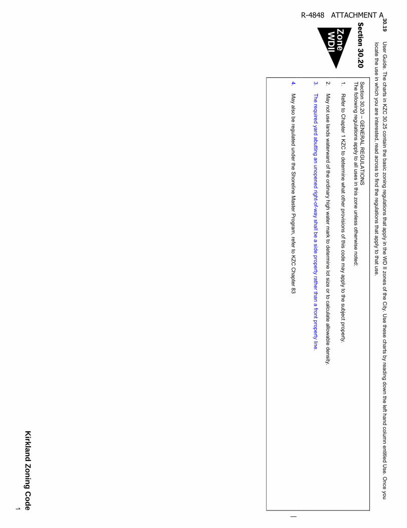
.19
User G
uide. The charts in KZC
30.25 contain the basic zoning regulations that apply in the WD
II zones of the City. U
se these charts by reading down the left hand colum
n entitled Use. O
nce you locate the use in w
hich you are interested, read across to find the regulations that apply to that use.
Se
ction
30
.20
Section 30.20 – G
EN
ER
AL R
EG
ULA
TION
S
The following regulations apply to all uses in this zone unless otherw
ise noted:
1. R
efer to Chapter 1 K
ZC to determ
ine what other provisions of this code m
ay apply to the subject property.
2. M
ay not use lands waterw
ard of the ordinary high water m
ark to determine lot size or to calculate allow
able density. 3. The required yard abutting an unopened right-of-w
ay shall be a side property rather than a front property line.
4.
May also be regulated under the S
horeline Master P
rogram, refer to K
ZC C
hapter 83
Zo
ne
WD
II
R-4848 ATTACHMENT A
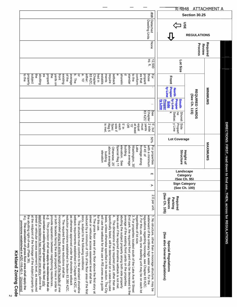
Section 30.25
US
E
REGULATIONS
DIR
EC
TIO
NS
: FIR
ST
, rea
d d
ow
n to
find
us
e...T
HE
N, a
cro
ss fo
r RE
GU
LA
TIO
NS
Re
qu
ired
Re
vie
w
Pro
ce
ss
MIN
IMU
MS
M
AX
IMU
MS
Landscape
Category
(See Ch. 95)
Sign Category
(See Ch. 100)
Re
qu
ired
Pa
rkin
g
Sp
ace
s
(Se
e C
h. 1
05
)
Sp
ec
ial R
eg
ula
tion
s
(Se
e a
lso
Ge
nera
l Re
gu
latio
ns)
Lo
t Siz
e
RE
QU
IRE
D Y
AR
DS
(Se
e C
h. 1
15
)
Lot Coverage
H
eig
ht o
f S
truc
ture
Fro
nt
No
rth
Pro
pe
rty
Lin
e S
ou
th
Pro
pe
r
ty L
ine
S
ide
P
rop
er
ty L
ine
Shoreli
ne S
etback
Side
Propert
y Line
Kirk
lan
d Z
on
ing
Co
de
2
.01
0 D
etached D
welling U
nits N
one 12,500 sq. ft.
For those properties that conform
to the standard shoreline setback requirem
ents established in C
hapter 83 K
ZC,
either: a. 1
0’
or b. The average of the existing front yards on the properties abutting the subject property to the
’’
See
Chapter
83 K
ZC
’
5’, b
ut
2 side yards m
ust equal at least 1
5’
OR
5’ in
each side if S
pec R
eg 5 is m
et.
50%
For properties w
ith a minim
um
of 4
5’ o
f
frontage along Lake W
ashin
gto
n, 3
0’
above average building elevation. S
ee S
pecial Reg 11
Otherw
ise, 25’
above average building
elevation
E
A
2.0 per unit. 1. N
o structure, other than a moorage structure, m
ay be w
aterward of the ordinary high w
ater mark. For the
regulations regarding moorage, see C
hapter 83 KZC
. 2. For this use, only one dw
elling unit may be on each lot
regardless of lot size. 3. For properties located south of the Lake A
ve W S
treet E
nd park, the required front yard may be decreased to the
average of the existing front yards on the properties abutting the subject property along both side property lines even if the required shoreline setback is not m
et. 4.
The dimensions of any required yard, other than as
specifically listed, will be determ
ined on a case-by-case basis, unless otherw
ise specified in this section. The City
will use the setback for this use in R
S zones as a guide
for this use. 5. The gross floor area of any floor above the first story at street or vehicular access easem
ent level shall be reduced by a m
inimum
of 15% of the floor area of the first
story, subject to the following conditions:
a. The structure must conform
to the standard shoreline setback requirem
ents established in Chapter 83 K
ZC, or
as otherwise approved under the shoreline setback
reduction provisions established in Section 83.380 K
ZC.
b. The required floor area reductions shall be incorporated along the entire length of the façade of one or both facades facing the side property lines in order to provide separation betw
een neighboring residences.. c.d. This provision shall not apply to residences that do not contain a ceiling height greater than 16 feet only applyif a residence has m
ore than one story above the street or vehicular access easem
ent level, as measured
at the midpoint of the frontage of the subject property on
the abutting right-of-way (P
late 36). d.c. The calculation of gross floor area shall apply the
provisions established in KZC
115.42.1. Uncovered
R-4848 ATTACHMENT A
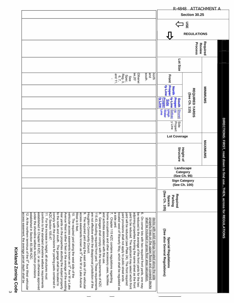
Section 30.25
US
E
REGULATIONS
DIR
EC
TIO
NS
: FIR
ST
, rea
d d
ow
n to
find
us
e...T
HE
N, a
cro
ss fo
r RE
GU
LA
TIO
NS
Re
qu
ired
Re
vie
w
Pro
ce
ss
MIN
IMU
MS
M
AX
IMU
MS
Landscape
Category
(See Ch. 95)
Sign Category
(See Ch. 100)
Re
qu
ired
Pa
rkin
g
Sp
ace
s
(Se
e C
h. 1
05
)
Sp
ec
ial R
eg
ula
tion
s
(Se
e a
lso
Ge
nera
l Re
gu
latio
ns)
Lo
t Siz
e
RE
QU
IRE
D Y
AR
DS
(Se
e C
h. 1
15
)
Lot Coverage
H
eig
ht o
f S
truc
ture
Fro
nt
No
rth
Pro
pe
rty
Lin
e
So
uth
P
rop
er
ty L
ine
S
ide
P
rop
er
ty L
ine
Shoreli
ne S
etbackH
igh W
ater Line
Side
Propert
y Line
Kirk
lan
d Z
on
ing
Co
de
3
north and south. O
therwi
se,2
0’
See
Spec.
Reg. 3, 6, 7,
and 11, .
decks with solid railings located along the side
property lines on the upper floors and covered decks shall be included in gross floor area calculation.
6. On corner lots w
ith two required front yards, one m
ay be reduced to the average of the front yards for the tw
o adjoining properties fronting the sam
e street as the front yard to be reduced. The applicant m
ay select which front
yard will be reduced (see P
late 24). The front required yard provisions shall not apply to public street ends located w
est of Waverly W
ay, which shall be regulated as
a side yard. 7.
Chapter 115 K
ZC contains regulations regarding
home occupations and other accessory uses, facilities
and activities associated with this use.
8. G
arages shall comply w
ith the requirements of K
ZC
115.43, including required front yard. These requirements
are not effective within the disapproval jurisdiction of the
Houghton C
omm
unity Council.
9. The required yard along the east side of the vehicular access easem
ents known as 5
th Ave W
or Lake Avenue
West is 0 feet.
10. The required yard along the west side of the
vehicular access easements know
n as 5th A
ve W or Lake
Avenue W
est is either 5 feet or the average of the existing rear yards on the properties abutting the subject property to the north and south. The garage shall be located to com
ply with the provisions for parking pads contained in
KZC
Section 105.47.
11. For the increase in height, all structures must
conform to the standard shoreline setback requirem
ents established in C
hapter 83 KZC
, or as otherwise approved
under the shoreline setback reduction provisions established in S
ection 83.380 KZC
. 12. A
t the northern terminus of the 5
th Ave W
est vehicular access easem
ent, the average parcel depth shall be
R-4848 ATTACHMENT A
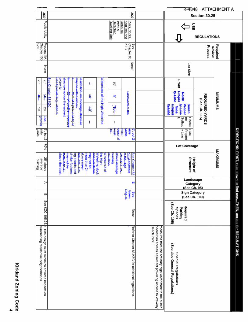
Section 30.25
US
E
REGULATIONS
DIR
EC
TIO
NS
: FIR
ST
, rea
d d
ow
n to
find
us
e...T
HE
N, a
cro
ss fo
r RE
GU
LA
TIO
NS
Re
qu
ired
Re
vie
w
Pro
ce
ss
MIN
IMU
MS
M
AX
IMU
MS
Landscape
Category
(See Ch. 95)
Sign Category
(See Ch. 100)
Re
qu
ired
Pa
rkin
g
Sp
ace
s
(Se
e C
h. 1
05
)
Sp
ec
ial R
eg
ula
tion
s
(Se
e a
lso
Ge
nera
l Re
gu
latio
ns)
Lo
t Siz
e
RE
QU
IRE
D Y
AR
DS
(Se
e C
h. 1
15
)
Lot Coverage
H
eig
ht o
f S
truc
ture
Fro
nt
No
rth
Pro
pe
rty
Lin
e S
ou
th
Pro
pe
r
ty L
ine
S
ide
P
rop
er
ty L
ine
Shoreli
ne S
etback
Side
Propert
y Line
Kirk
lan
d Z
on
ing
Co
de
4
measured from
the ordinary high water m
ark to the public pedestrian access easem
ent providing access to Waverly
Beach P
ark.
.02
0 P
iers, docks, boat lifts and canopies serving D
etached D
welling U
nit
See
Chapter 83
KZC
None
Landward of the
20
’ 5
’ ’
--
Waterw
ard of the High W
aterline
--’ 10
’ 10
’ --
In addition, no moorage structure
may be w
ithin either– a.
b. structure not on the subject property. S
ee Special R
egulation 1. S
ee Chapter 83 K
ZC
5’, b
ut 2
side yards m
ust equal at least 15’.
S
ee Chapter 83
KZC
Landward
of the High
above average building elevation. W
aterward of
the High
Waterline, dock
and pier decks m
ay not be m
ore than above m
ean sea level. D
iv-ing boards and sim
ilar features m
ay not be
above the deck.
E S
ee S
pec. R
eg. 8.
None
Refer to C
hapter 83 KZC for additional regulations.
.
.03
0 P
ublic Utility
Process IIA
, C
hapter 150 K
ZC.
None
20
’
20
’
20
’
10
’
The greater
5’, b
ut 2
side yards
70%
25’ a
bove
average building
A
B
See K
ZC 105.25. 1. S
ite design must m
inimize adverse im
pacts on surrounding residential neighborhoods.
R-4848 ATTACHMENT A
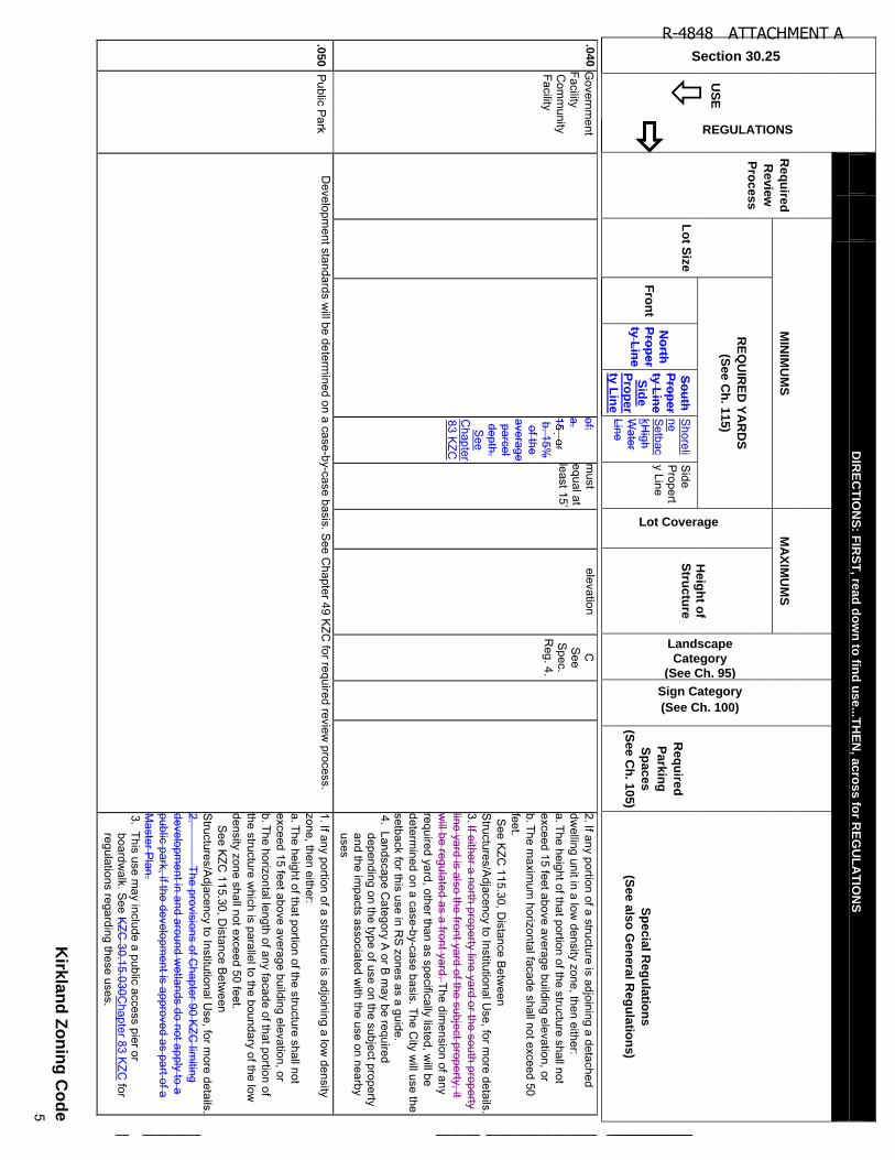
Section 30.25
US
E
REGULATIONS
DIR
EC
TIO
NS
: FIR
ST
, rea
d d
ow
n to
find
us
e...T
HE
N, a
cro
ss fo
r RE
GU
LA
TIO
NS
Re
qu
ired
Re
vie
w
Pro
ce
ss
MIN
IMU
MS
M
AX
IMU
MS
Landscape
Category
(See Ch. 95)
Sign Category
(See Ch. 100)
Re
qu
ired
Pa
rkin
g
Sp
ace
s
(Se
e C
h. 1
05
)
Sp
ec
ial R
eg
ula
tion
s
(Se
e a
lso
Ge
nera
l Re
gu
latio
ns)
Lo
t Siz
e
RE
QU
IRE
D Y
AR
DS
(Se
e C
h. 1
15
)
Lot Coverage
H
eig
ht o
f S
truc
ture
Fro
nt
No
rth
Pro
pe
rty
Lin
e
So
uth
P
rop
er
ty L
ine
S
ide
P
rop
er
ty L
ine
Shoreli
ne S
etbackH
igh W
ater Line
Side
Propert
y Line
Kirk
lan
d Z
on
ing
Co
de
5
.04
0 G
overnment
Facility C
omm
unity Facility
of: a.
b. 15%
of the
average parcel depth. S
ee C
hapter 83 K
ZC m
ust equal at le
ast 1
5’
elevation C
S
ee S
pec. R
eg. 4.
2. If any portion of a structure is adjoining a detached dw
elling unit in a low density zone, then either:
a. The height of that portion of the structure shall not exceed 15 feet above average building elevation, or b. The m
aximum
horizontal facade shall not exceed 50 feet. S
ee KZC
115.30, Distance B
etween
Structures/A
djacency to Institutional Use, for m
ore details. 3. If either a north property line yard or the south property line yard is also the front yard of the subject property, it w
ill be regulated as a front yard. The dimension of any
required yard, other than as specifically listed, will be
determined on a case-by-case basis. The C
ity will use the
setback for this use in RS
zones as a guide. 4. Landscape C
ategory A or B
may be required
depending on the type of use on the subject property and the im
pacts associated with the use on nearby
uses
.05
0 P
ublic Park
Developm
ent standards will be determ
ined on a case-by-case basis. See C
hapter 49 KZC
for required review process.
1. If any portion of a structure is adjoining a low density
zone, then either: a. The height of that portion of the structure shall not exceed 15 feet above average building elevation, or b. The horizontal length of any facade of that portion of the structure w
hich is parallel to the boundary of the low
density zone shall not exceed 50 feet.
See K
ZC 115.30, D
istance Betw
een S
tructures/Adjacency to Institutional U
se, for more details.
2. The provisions of C
hapter 90 KZC
limiting
development in and around w
etlands do not apply to a public park, if the developm
ent is approved as part of a M
aster Plan.
3. This use may include a public access pier or
boardwalk. S
ee KZC
30.15.030Chapter 83 K
ZC for
regulations regarding these uses.
R-4848 ATTACHMENT A
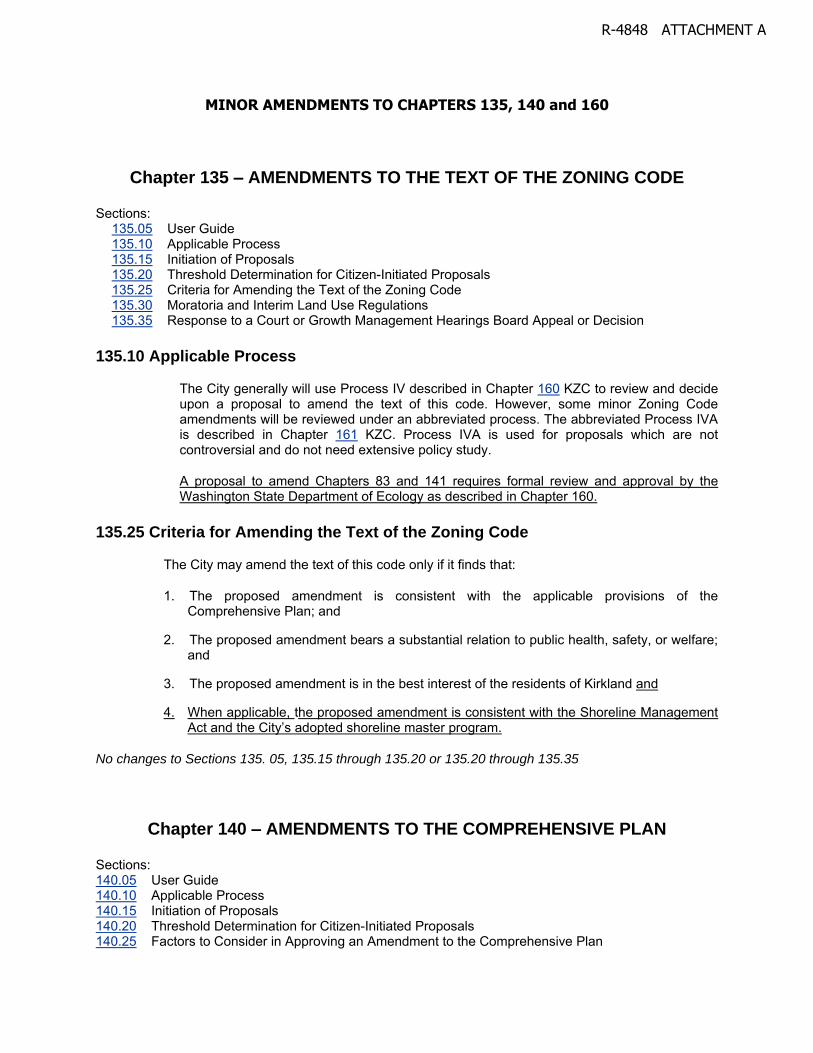
MINOR AMENDMENTS TO CHAPTERS 135, 140 and 160
Chapter 135 – AMENDMENTS TO THE TEXT OF THE ZONING CODE
Sections: 135.05 User Guide 135.10 Applicable Process 135.15 Initiation of Proposals 135.20 Threshold Determination for Citizen-Initiated Proposals 135.25 Criteria for Amending the Text of the Zoning Code 135.30 Moratoria and Interim Land Use Regulations 135.35 Response to a Court or Growth Management Hearings Board Appeal or Decision
135.10 Applicable Process
The City generally will use Process IV described in Chapter 160 KZC to review and decide upon a proposal to amend the text of this code. However, some minor Zoning Code amendments will be reviewed under an abbreviated process. The abbreviated Process IVA is described in Chapter 161 KZC. Process IVA is used for proposals which are not controversial and do not need extensive policy study.
A proposal to amend Chapters 83 and 141 requires formal review and approval by the Washington State Department of Ecology as described in Chapter 160.
135.25 Criteria for Amending the Text of the Zoning Code
The City may amend the text of this code only if it finds that:
1. The proposed amendment is consistent with the applicable provisions of the Comprehensive Plan; and
2. The proposed amendment bears a substantial relation to public health, safety, or welfare; and
3. The proposed amendment is in the best interest of the residents of Kirkland and
4. When applicable, the proposed amendment is consistent with the Shoreline Management Act and the City’s adopted shoreline master program.
No changes to Sections 135. 05, 135.15 through 135.20 or 135.20 through 135.35
Chapter 140 – AMENDMENTS TO THE COMPREHENSIVE PLAN
Sections: 140.05 User Guide 140.10 Applicable Process 140.15 Initiation of Proposals 140.20 Threshold Determination for Citizen-Initiated Proposals 140.25 Factors to Consider in Approving an Amendment to the Comprehensive Plan
R-4848 ATTACHMENT A
140.30 Criteria for Amending the Comprehensive Plan 140.35 Emergency Plan Amendment 140.40 Response to a Court or Growth Management Hearings Board Appeal or Decision 140.45 Responsibility To Review
140.10 Applicable Process
The City will use Process IV described in Chapter 160 KZC to review and decide upon a proposal to amend the Comprehensive Plan.
A proposal to amend the Shoreline Area Chapter of the Comprehensive Plan requires formal review and approval by the Washington State Department of Ecology as described in Chapter 160.
140.30 Criteria for Amending the Comprehensive Plan
The City may amend the Comprehensive Plan only if it finds that:
1. The amendment must be consistent with the Growth Management Act.
2. The amendment must be consistent with the countywide planning policies.
3. The amendment must not be in conflict with other goals, policies, and provisions of the Kirkland Comprehensive Plan.
4. The amendment will result in long-term benefits to the community as a whole, and is in the best interest of the community.
5. When applicable, the proposed amendment must be consistent with the Shoreline Management Act and the City’s adopted shoreline master program.
No changes to Sections 140.05, 140.15 through 140.25 and 140.35 through 140.45
Chapter 160 – PROCESS IV
Sections: 160.05 User Guide 160.15 Initiation of Proposals 160.20 Compliance with SEPA 160.25 Threshold Review 160.35 Official File 160.40 Notice 160.45 Staff Report 160.50 Community Council Proceeding 160.55 Public Hearing 160.60 Material To Be Considered 160.65 Electronic Sound Recordings 160.70 Public Comments and Participation at the Hearing 160.75 Continuation of the Hearing 160.80 Planning Commission Action 160.85 Planning Commission Report to City Council 160.90 Publication and Effect
R-4848 ATTACHMENT A
160.95 Jurisdiction of the Houghton Community Council 160.100 Jurisdiction of the Washington State Department of Ecology No change to 160.05 through 160.95
160.100 Jurisdiction of the Washington State Department of Ecology
The Washington State Department of Ecology is authorized under the authority of the Shoreline Management Act of RCW Chapter 90.58 and WAC Chapter 173-26 to approve, deny or propose modifications to the City’s shoreline master program (SMP). The City’s SMP includes the Shoreline Area chapter of the Comprehensive Plan and Chapters 83 and 141 KZC. For these components of the SMP, the City Council shall take action pursuant to KZC 165.85 and then direct the Planning Official to forward the amended SMP components to the Department of Ecology for formal review and final approval.
R-4848 ATTACHMENT A


![CNC Router Parts PROSeries4848 · 2017-02-07 · Title: PRO Series 4848 [CRP800-4848] Assembly Instructions Author: CNC Router Parts LLC Created Date: 2/7/2017 2:37:34 PM](https://img.pdfslide.us/doc/110x75/5ebc1cddacda035c743f2f2b/cnc-router-parts-2017-02-07-title-pro-series-4848-crp800-4848-assembly-instructions.jpg)