Embed Size (px)
Citation preview

Geological Society of America | LITHOSPHERE | Volume 11 | Number 2 | www.gsapubs.org 252
RESEARCH
Towards a clarification of the provenance of Cenozoic sediments in the northern Qaidam Basin
Haijian Lu1,*, Jiacan Ye1,2, Licheng Guo3,4, Jiawei Pan1, Shangfa Xiong3,4, and Haibing Li1
1KEY LABORATORY OF DEEP-EARTH DYNAMICS OF MINISTRY OF NATURAL RESOURCES, INSTITUTE OF GEOLOGY, CHINESE ACADEMY OF GEOLOGICAL SCIENCES, BEIJING 100037, CHINA2SCHOOL OF EARTH SCIENCE AND RESOURCES, CHINA UNIVERSITY OF GEOSCIENCES, BEIJING 100083, CHINA3KEY LABORATORY OF CENOZOIC GEOLOGY AND ENVIRONMENT, INSTITUTE OF GEOLOGY AND GEOPHYSICS, CHINESE ACADEMY OF SCIENCES, BEIJING 100029, CHINA4UNIVERSITY OF CHINESE ACADEMY OF SCIENCES, BEIJING 10049, CHINA
ABSTRACT
Determining the provenance of sedimentary basin fill in the northern Qaidam Basin is a key step toward understanding the sedimen-tary system dynamics and mountain-building processes of the surrounding orogenic belts in Tibet. The exceptionally thick (average of 6–8 km) Cenozoic fluvio-lacustrine deposits in the northern Qaidam Basin were once thought to have been eroded from the nearby north-ern Qaidam Basin margin and the southern Qilian Shan and to reflect the prolonged thrust-related exhumation of these orogenic belts. However, several recent studies, based mainly on paleocurrent and detrital zircon U-Pb age data, suggested that they were derived from the distant East Kunlun Shan to the south, or the Qimen Tagh to the southwest (at least 200 and 350 km from the northern Qaidam Basin, respectively). That model assumed that the East Kunlun Shan and Qimen Tagh formed significant topographic barriers during the earli-est sedimentation of Cenozoic strata (e.g., the Lulehe Formation) in the northern Qaidam Basin. Therefore, the tectonic significance of the provenance of the Lulehe Formation remains a fundamental problem in understanding the postcollisional uplift history of the northern Tibetan Plateau. To address this issue, we conducted sedimentological and paleocurrent analyses of the Lulehe Formation and detrital zircon U-Pb dating of Mesozoic strata in the northern Qaidam Basin. The results, in combination with existing paleocurrent and seismic reflection data, collectively indicate that although the source area cannot be specified by matching zircon U-Pb ages in sedimentary rocks with crystalline basement source rocks, other evidence points consistently to a unified proximal northerly source area (the northern Qaidam Basin margin and the southern Qilian Shan). Our results emphasize that noncrystalline basement rocks (e.g., Mesozoic sedimentary rocks) in fold-and-thrust belts should be taken into consideration when seeking potential source areas by correlating zircon U-Pb ages of silici-clastic detritus with related basement rocks. In addition, this study strongly supports the claim that variations in the proportions of age populations should be used with caution when determining source terrane by comparisons of age distributions.
LITHOSPHERE; v. 11; no. 2; p. 252–272; GSA Data Repository Item 2019032 | Published online 20 December 2018 https://doi.org/10.1130/L1037.1
INTRODUCTION
In Tibet, several ranges with upthrusted basement (Gangdese, Tanggula, Kunlun, Altyn Tagh, and Qilian Shan) are separated by numerous large and small Tertiary basins trending approximately E-W to NW-SE (Liu, 1988; Pan et al., 2004; Tapponnier et al., 2001; Wang et al., 2013; Yin and Har-rison, 2000; Yin, 2010). The sedimentary archives of these intermontane basins can be used to constrain the processes and mechanisms of the evo-lution of Tibet (Metivier et al., 1998; Yin et al., 2002). Various indicators in sedimentary basins in southern Tibet, such as the termination of marine facies sediments, the initial deposition of material derived from the Asian plate on the Indian margin, and the earliest strata to include mixed India- and Asia-sourced detritus, have been used to provide minimum constraints on the timing of the initial India-Asia collision (Garzanti et al., 1987, 1996; Najman, 2006). Sedimentologic, geochronologic, and structural analyses of Cretaceous–Tertiary basins in central Tibet have indicated multiple-phase contractional deformation since the India-Asia collision (Horton et al., 2002; Kapp et al., 2007; Li et al., 2017; Spurlin et al., 2005; Staisch et al., 2014). Further northwards, in the Qaidam Basin, there are exceptionally
thick (average of 6–8 km) sequences of Cenozoic siliciclastic sediments (Rieser et al., 2006a), which have been extensively used to reconstruct depositional systems (Bush et al., 2016; Jian et al., 2013; Meng and Fang, 2008; Rieser et al., 2005; Wang et al., 2006; Zhu et al., 2006; Zhuang et al., 2011), erosional unroofing patterns (X. Cheng et al., 2016; Rieser et al., 2006a, 2006b; Wang et al., 2017; Y. Wang et al., 2015), and kinematic histories of fold-and-thrust belts and strike-slip faults along the northern, western, and southern margins of the intermontane basin (F. Cheng et al., 2016b; Fu et al., 2015; Mao et al., 2016; Meng et al., 2001; Ritts et al., 2004, 2008; Wu et al., 2012; Yin et al., 2007a, 2008a, 2008b; Yue and Liou, 1999; Yue et al., 2001; Zhang et al., 2016, 2018).
Recent integrated analyses of seismic reflection profiles and thickness distributions of Cenozoic strata across the Qaidam Basin indicated that the basin structure is predominantly a broad Cenozoic synclinorium, and hence the main depocenter lies persistently along the northwest-trending central axis of the basin (Yin et al., 2008a; Zhu et al., 2006). The spatial distribution of Cenozoic strata in the Qaidam Basin indicates that the sediments are supplied by an endorheic drainage system with sources in several ranges: in the northern basin, mainly the southern Qilian Shan (Fig. 1A); in the western basin, mainly the Altyn Tagh Range; in the southwestern basin, mainly the Altyn Tagh Range and Qimen Tagh; and in
© 2018 The Authors. Gold Open Access: This paper is published under the terms of the CC-BY-NC license.
Downloaded from https://pubs.geoscienceworld.org/gsa/lithosphere/article-pdf/11/2/252/4659951/252.pdfby The Institute of Geology and Geophysics, Chinese Academy of Sciences useron 24 March 2019

Geological Society of America | LITHOSPHERE | Volume 11 | Number 2 | www.gsapubs.org 253
HAIJIAN LU ET AL. | Provenance of Cenozoic sediments in the northern Qaidam Basin RESEARCH
-
East kunlun Shan
Qilian Shan
Qaidam basin
Altyn Tagh Range
Qimen Tagh
N
0 100km
96oE94oE
39o N
37o N
98oE92oE
38o N
36o N
(Wang et al., 2017)
Commonly accepted paleocurrent(Jian et al., 2013;Song et al., 2013;Yin et al., 2008a; Zhuang et al., 2011)
(Bush et al., 2016)
~200 km
~350 km
Tibetan Plateau
India
TarimBasin
North Qaidam basin
Dahonggousection 80oE 110oE
40o N
20o N
E3g
E3g
E1-2l
N2y
γδ4ε
E3g
N2s
N1 E1-2l
C1
95°12′ E 95°18′ E 95°30′ E95°24′ E95°06′ E
37°4
2′ N
37°2
4′ N
37°3
6′ N
37°3
0′ N
C1
N1
K K
N1
O3
Z
N2s
Xiao Qaidam lake
Z
Thrust fault Paleocurrent data Sandstone samplesStrike-slip fault
Qigequan Fm. Shizigou Fm. Upper Youshashan Fm.Q N2yN2s N1
E3g E1-2l K
O3 γδ4e
Lower Youshashan Fm.Upper Ganchaigou Fm. Lower Ganchaigou
Fm.Lulehe Fm. Cretaceous Quanyagou
Fm.
Permian granitoidsUpper Ordovician strata
C1 D3C2C3T2
J1-2J3h
Z
53
50
55
75
39
45
20
84
60
70
24
46
72
70
70
70
65
50
65
E1-2l
N1
KJ3h
N2y
N2s
Z ZZ
E1-2l
E3gN1
J1-2
N2y
N2s
94°40′ E 94°45′ E 94°50′ E
38°1
0′ N
38°0
5′ N
38°0
0′ N
95°50′ E 95°55′ E 96°00′ E95°45′ E95°40′ E
37°3
2′ N
37°3
5′ N
37°3
8′ N
E1-2l
E3g
O3
C2
C3
K
K N2y
N2y
J3h
J3h
J1-2
J1-2
N2s
E3g
N1
Z
Z
4075
70 80
70 70
50
6064
7540
4515
44
C1
C1
C2
D3
C3
K
J3h
J3h
J2
Q
Q
97°37′ E 97°40′ E 97°43′ E
36°5
9′ N
36°5
6′ N
36°5
3′ N
18
70
44
50
42
5630 17
35
Fig. 1B
Fig. 1C
Fig. 1D
Fig. 1E
Upper Jurassic strata
Lower Jurassic strata
Triassic strata Upper Carboniferous strata
Middle Carboniferous strata
Lower Carboniferous strata
Upper Devonian strata
Sinian strata
Z
PC-5
PC-6 PC-7
PC-1
PC-2
PC-3PC-4
PC-8 PC-9
SD-1
SD-2
SD-4
SD-5
PC-1 SD-3
SD-3
Fig. 1A
(Wang et al., 2017; this study)
(Ji et al., 2017)
(Bush et al., 2016)
Lulehe
Yinmaxia
Yuqia
Beidatan
Nan Shan
Altyn Tagh fault
Kunlun fault
Saishenteng Shan
Aimunik Shan
Olongbluk Shan
Lvliang Shan
Xitie Shan
N2y25
(This study, Fig. 8H)Dahonggou
A
B
C
D
E
Figure 1. Location maps of the study area and sampling sites. (A) Digital elevation model (DEM) of the Qaidam Basin and adjacent orogenic belts, with schematic sediment dispersal pathways feeding the northern Qaidam Basin from three distinct perspectives. See inset map for location. The black broken line represents the approximate outline of the northern Qaidam Basin. (B–E) Geological maps of the localities of Dahonggou (B), Yuqia (C), Yinmaxia (D), and Beidatan (E), with the distributions of sampling sites.
Downloaded from https://pubs.geoscienceworld.org/gsa/lithosphere/article-pdf/11/2/252/4659951/252.pdfby The Institute of Geology and Geophysics, Chinese Academy of Sciences useron 24 March 2019

Geological Society of America | LITHOSPHERE | Volume 11 | Number 2 | www.gsapubs.org 254
HAIJIAN LU ET AL. | Provenance of Cenozoic sediments in the northern Qaidam Basin RESEARCH
the southern basin, mainly the East Kunlun Shan. This sediment dispersal model has been widely substantiated by paleocurrent analyses within the basin (Heermance et al., 2013; Ji et al., 2017; Jian et al., 2018; Meng and Fang, 2008; Song et al., 2013; Wu et al., 2012; Zhuang et al., 2011). How-ever, two recent provenance studies, together with detrital zircon U-Pb and apatite fission-track dating, have challenged the widely held view by suggesting that several major paleorivers flowed across the basin axis. Specifically, Bush et al. (2016) identified E-directed paleocurrent orienta-tions for the Lulehe Formation and the lower part of the lower Ganchaigou Formation from the Dahonggou section in the northern Qaidam Basin and suggested that the distant westernmost East Kunlun Shan (Qimen Tagh) was the principal sediment source feeding the E-directed fluvial system (Fig. 1A). Wang et al. (2017) measured NE-directed paleocurrent orientations for the Lulehe Formation and upper and lower Ganchaigou Formations from the same section and suggested that the East Kunlun Shan was the dominant provenance source (Fig. 1A), which was subse-quently replaced by the southern Qilian Shan. The controversy centers on a dispute over the provenance of the Lulehe Formation strata in the northern Qaidam Basin. It is noteworthy that these two long sediment dispersal pathways require linear distances of ~200 km and ~350 km, respectively, between source and sink (Fig. 1A). These values represent only lower limits, since Cenozoic shortening strain across the Qaidam Basin has not yet been considered; notably, the magnitude of Cenozoic shortening strain increases systematically westward from ~11% in the center to ~35% in the west (Yin et al., 2008b).
It is very important to validate these discrepant provenance models, because they indicate significant topographic relief and mountain build-ing for different orogenic belts. Most studies favoring roughly S-directed paleocurrents in the northern Qaidam Basin have linked the synorogenic coarse-grained Lulehe Formation with rapid uplift of the southern Qilian Shan at 65–50 Ma (Ji et al., 2017; Yin et al., 2008a; Zhuang et al., 2011). However, Bush et al. (2016) attributed the Lulehe Formation and the lower part of the lower Ganchaigou Formation to uplift-induced exhumation of the Qimen Tagh, whereas Wang et al. (2017) concluded that the East Kunlun Shan emerged as high relief after the deposition of the Lulehe Formation, supplying large amounts of detritus to the northern margin of the Qaidam Basin. The high-topography hypothesis for the East Kunlun Shan and Qimen Tagh during the sedimentation of the Lulehe Formation is, however, inconsistent with recent paleontological studies, which show that the Paleogene and early Neogene strata of the western Qaidam Basin contain many reefal deposits, representing lacustrine sedimentary facies (Zhong et al., 2004). The low-gradient depositional environment indicates no substantial surface uplift of the surrounding mountains.
Because the northern Qaidam Basin is a composite structure includ-ing diverse rock types produced in various ways by diverse geodynamic processes (Yang, 2002; Yin et al., 2007b), its orogenic detritus repre-sents a variety of signatures. Unraveling the provenance of clastic wedges accumulated in the northern Qaidam Basin therefore requires sophisti-cated and integrated investigations. Numerous methods have been used to investigate the potential source areas of Cenozoic sedimentary rocks in the northern Qaidam Basin, including counts of conglomerate clasts (Zhuang et al., 2011), sandstone modal analysis (Bush et al., 2016; Jian et al., 2013; Rieser et al., 2005), U-Pb detrital geochronology (Bush et al., 2016; Wang et al., 2017), paleocurrent analysis (Bush et al., 2016; Ji et al., 2017; Jian et al., 2018; Song et al., 2013; Wang et al., 2017; Zhuang et al., 2011), heavy mineral analysis (Bush et al., 2016; Jian et al., 2013), 40Ar/39Ar dating of detrital white mica (Rieser et al., 2006a), and detrital apatite fission-track dating (Wang et al., 2017). Most of these methods, however, only provide indirect inferences for provenance reconstruction. For instance, Cenozoic sandstone samples within the northern Qaidam
Basin exhibit a heavy mineral assemblage associated with magmatic and metamorphic basements (e.g., pyroxene, hornblende, epidote, and gar-net), potentially derived from both the Kunlun Shan and Qimen Tagh and the northern Qaidam Basin margin and the southern Qilian Shan (Bush et al., 2016; Jian et al., 2013). Thus, heavy mineral analysis is not an unequivocal indicator of provenance in the northern Qaidam Basin. In addition, neither the framework grain composition of sandstones nor the geochemical composition of mudstones exhibits significant variation within the Cenozoic formations of the northern Qaidam Basin (Bush et al., 2016; Jian et al., 2013; Rieser et al., 2005). Thus, they do not enable identification of a specific source terrane. These issues are partly attrib-uted to the orogenic recycling effect of older sedimentary units, which complicates potential provenance analyses. However, this effect has been ignored in recent studies (e.g., Wang et al., 2017).
Paleocurrent measurements can provide direct information about the orientation of the sedimentary systems and the flow directions of rivers. As a ubiquitous, chemically and physically resistant detrital mineral derived from multiple rock types, zircon is ideal for geochronological studies (Carter and Moss, 1999), and U-Pb zircon dating has been extensively used to discriminate potential sediment sources in the Tibetan Plateau (DeCelles et al., 2014; Gehrels et al., 2011; Wang et al., 2011; Wu et al., 2014; Zhuang et al., 2015). In this study, we obtained sedimentologi-cal and sedimentary petrological data from the Lulehe Formation in the Dahonggou locality, and we measured paleocurrent orientations for the Lulehe Formation at four localities; we also conducted detrital zircon U-Pb geochronologic analyses of Mesozoic sandstones from five localities in the northern Qaidam Basin. Combined with existing paleocurrent and seismic reflection data, our results strongly indicate that the provenance of the Lulehe Formation is the northern Qaidam Basin margin and the southern Qilian Shan and that the two distant sediment source models are not supported by geological observations.
GEOLOGICAL SETTING
Geography of the Qaidam Basin and Its Surroundings
Northern Tibet is characterized by several of the most prominent tec-tono-geomorphological features developed during the Cenozoic, including the Qilian Shan, the Altyn Tagh Range, the East Kunlun Shan, and the Qaidam Basin (Fig. 1A). These mountains have an average elevation of ~5000 m, with peaks exceeding 7000 m, whereas the intervening Qaidam Basin has an average elevation of ~2800 m, with little internal relief (Yin et al., 2007a). The transition zones between these mountains and the Qaidam Basin yield the most extensive topographic front (>500 km long) and the greatest relief (>2.5 km on average) within the plateau. The ~120,000 km2, rhombus-shaped Qaidam Basin is tectonically bounded by the Qilian Shan–Nan Shan and northern Qaidam thrust belts to the north, the sinistral Altyn Tagh fault to the west, the Eastern Kunlun thrust belt to the south, and the dextral Wenquan fault to the east. The trend of the northern Qaidam Basin is parallel to the northern Qaidam thrust belts and the regional trend of the southern Qilian Shan. Several secondary mountain ranges are located in the northern Qaidam Basin, including, from west to east, the Saishenteng Shan, Lvliang Shan, Xitie Shan, Aimunik Shan, and Olongbluk Shan.
Bedrock Geology and Bedrock Ages
Tectono-stratigraphically, the Qilian Shan–Nan Shan region consists of three belts, composed mainly of Proterozoic shallow-marine strata in the central part sandwiched between the North Qilian complex (mainly Lower Paleozoic mélange, turbidites, and arc-type volcanic rocks) and
Downloaded from https://pubs.geoscienceworld.org/gsa/lithosphere/article-pdf/11/2/252/4659951/252.pdfby The Institute of Geology and Geophysics, Chinese Academy of Sciences useron 24 March 2019

Geological Society of America | LITHOSPHERE | Volume 11 | Number 2 | www.gsapubs.org 255
HAIJIAN LU ET AL. | Provenance of Cenozoic sediments in the northern Qaidam Basin RESEARCH
the South Qilian metamorphic belt (Upper Proterozoic–Lower Paleozoic metamorphic rocks; Gehrels et al., 2003a, 2003b; Yin et al., 2007b). The crystallization ages of the late Proterozoic–Mesozoic plutons are confined to two groups in the Qilian Shan and Nan Shan (Fig. 2A; Cowgill et al., 2003; Gehrels et al., 2003a, 2003b): (1) 960–920 Ma small and isolated plutons, and (2) 520–400 Ma plutons from across the entire Qilian Shan and Nan Shan. Early Paleozoic arc magmatism was contemporaneous and spatially overlapped with ultrahigh-pressure (UHP) metamorphism in the northern Qaidam Basin (Yang, 2002). The bedrock of the Eastern Kunlun Range can be subdivided into three types (Yin et al., 2007a): (1) Precam-brian gneiss, Neoproterozoic metasediments, and Devonian–Carbonifer-ous marine strata; (2) widespread Paleozoic and early Mesozoic igneous rocks (Figs. 2A and 2B); and (3) Jurassic to Cenozoic terrigenous clastics. Two main phases of plutonism are constrained to the Ordovician–Silurian and Permian–Triassic (Liu, 1988; Wu et al., 2016). The Altyn Tagh Range exposes Paleoproterozoic migmatite, gneiss, and schist, and Mesoprotero-zoic carbonates intruded by Proterozoic–Mesozoic granitoids (Chen et al., 2012; Cheng et al., 2017; XBGMR, 1993). The bedrock of the Qaidam Basin is composed of Precambrian–Silurian metamorphic rocks (Huang et al., 1996); in addition, one phase of prominent arc magmatism related to the subduction of the Paleo-Tethys Ocean lasted from 290–280 Ma to 215 Ma across the Kunlun-Qaidam terrane (Fig. 2C; Chen et al., 2012; Wu et al., 2016). Although the Permian–Triassic magmatism is widely exposed along the Kunlun Range, it only occurs as isolated plutons in the northern Qaidam Basin (Fig. 2B; Chen et al., 2012; Cheng et al., 2017; Wu et al., 2016). U-Pb zircon dating of granitoid samples from drill cores also testifies to the existence of a Permian–Triassic Neo-Kunlun arc in the northern and southern Qaidam Basin (Fig. 2B; Cheng et al., 2017). The earliest phase (2.5–2.3 Ga) of magmatism was identified in the Quanji Massif, in the northern Qaidam Basin (C. Wang et al., 2015).
Mesozoic–Cenozoic Strata in the Northern Qaidam Basin
Besides the early Paleozoic UHP metamorphic gneiss in the Lvliang Shan, Xitie Shan, and Dulan areas along a 450-km-long belt in the northern Qaidam Basin (Yang, 2002; Yin et al., 2007b), Jurassic and Cretaceous sedimentary rocks crop out discontinuously along the margin of the north-ern Qaidam Basin from Lenghu to Dameigou (Figs. 1 and 2; Ritts and Biffi, 2001; Yu et al., 2017). The ages of Mesozoic strata have been deter-mined predominantly by paleontological studies and lithostratigraphic correlation (Ritts and Biffi, 2001, and references therein). Jurassic and Cretaceous strata are entirely nonmarine, nonvolcanogenic sedimentary rocks, and their lithology grades from boulder conglomerates to lami-nated shales (Ritts and Biffi, 2001). The depositional environments of these sedimentary rocks ranged from alluvial fans through coarse- and fine-grained fluvial systems, to deep, open lakes (Ritts and Biffi, 2001). Detrital zircon age data indicate that the Jurassic sedimentary rocks have two major age peaks of ca. 250 Ma and ca. 2400 Ma, and two minor peaks of ca. 450 Ma and ca. 850 Ma (Yu et al., 2017). This age distribution pat-tern is similar to that of the East Kunlun Range, which may complicate potential provenance analyses of Cenozoic strata in the northern Qaidam Basin. The inferred tectonic setting of Mesozoic rocks on the margin of northern Qaidam Basin remains disputed, with most researchers arguing for a predominantly extensional setting (Chen et al., 2003; Wu et al., 2011; Xia et al., 2001; Yu et al., 2017), and a few for a compressional setting (e.g., Ritts and Biffi, 2001). The provenance of these strata is also highly controversial, with one view arguing for the Qilian Shan (Ritts and Biffi, 2001) and the other for the East Kunlun Shan (Yu et al., 2017).
Cenozoic deposits with a maximum thickness of 12,000 m and an aver-age thickness of 6–8 km are widely distributed across the Qaidam Basin.
Seismic reflection data indicate that the Qaidam Basin is a broad Cenozoic synclinorium with its depocenter located persistently along the northwest-trending central axis of the basin (Meng and Fang, 2008; Yin et al., 2008a; Zhu et al., 2006). The depocenter has shifted progressively southeastward during the Cenozoic, from an initial position in the northwestern basin to its current depocenter at Dabuxun Lake near the basin center (Yin et al., 2008a; Zhu et al., 2006). A composite structural model was proposed to account for the spatio-temporal evolution of the sedimentary architecture in the Qaidam Basin, including south-directed thrusts carrying the low-elevation Qaidam Basin over the high-elevation Eastern Kunlun Range along the southern margin of the basin and crustal-scale triangular zones tapering from the northern margin toward the basin interior (Yin et al., 2007a, 2008a, 2008b). This model may also explain the observations that, whereas pre-Quaternary basin fills are widely exposed in the northern Qaidam Basin, they are rare in the southern Qaidam Basin. Traditional provenance analyses of sandstone petrography, heavy minerals, paleocur-rents, and conglomerate counts usually indicate that Cenozoic sediments adjacent to basin margins are directly linked to the adjacent mountain belts (Hanson, 1999; Jian et al., 2013; Wu et al., 2012; Zhuang et al., 2011).
Cenozoic outcrops are thickest in the Dahonggou and Lulehe locali-ties in the northern Qaidam Basin (QBGMR, 1984), and they show an initial upward-fining and then an upward-coarsening trend (Bush et al., 2016; Fang et al., 2007; Ji et al., 2017; Lu and Xiong, 2009; Wang et al., 2017). This exceptionally thick succession has been divided into seven formations, including, in ascending order, Qigequan, Shizigou, upper Youshashan, lower Youshashan, upper Ganchaigou, lower Ganchaigou, and Lulehe. The Lulehe Formation at the Dahonggou section consists of poorly sorted, clast-supported, granule-cobble conglomerates interbed-ded with medium- to coarse-grained, trough cross-stratified sandstones representing an alluvial-fan and braided fluvial system. The lower Gan-chaigou Formation is dominated by interbedded sandstone, or siltstone and mudrock deposits, and it represents a fine-grained fluvial system. The upper Ganchaigou Formation is predominantly composed of the interbeds of laminated or massive mudstones and ripple-laminated siltstones and likely also represents a fine-grained fluvial system. The lower Yousha-shan Formation consists of alternating brown laminated or bedded mud-stone and gray-green massive sandstone, or conglomerate, or siltstone, and it represents a coarse-grained fluvial system. The upper Youshashan Formation is mostly composed of interbedded conglomerate and sandy conglomerate, with brown or yellow massive sandstone intercalated with yellow massive siltstone, and it represents a sandy to gravelly braided fluvial system. The Shizigou Formation consists of coarse-grained con-glomerate and medium- to very coarse-grained sandstone, representing a sandy to gravelly braided fluvial or alluvial-fan system. The horizontal Qigequan Formation unconformably overlies the Shizigou Formation and consists of conglomerate, sandy conglomerate, sandstone, and siltstone deposits. Typically, the stratigraphic ages of the Qaidam Basin sediments are bracketed between the Paleocene–Eocene and Quaternary (Chang et al., 2015; Fang et al., 2007; Ji et al., 2017; Lu and Xiong, 2009; Sun et al., 2005). Recently, however, this long-held view was challenged by a new magnetostratigraphic study of the Dahonggou section, bolstered by newly discovered mammalian fossils (Wang et al., 2017). The latter sug-gested a far younger basal age of ca. 25 Ma for the Lulehe Formation.
SAMPLING AND ANALYTICAL METHODS
Paleocurrent Analyses
Paleocurrent directions were measured from fluvial and alluvial strata of the Lulehe Formation in the northern Qaidam Basin, using
Downloaded from https://pubs.geoscienceworld.org/gsa/lithosphere/article-pdf/11/2/252/4659951/252.pdfby The Institute of Geology and Geophysics, Chinese Academy of Sciences useron 24 March 2019

Geological Society of America | LITHOSPHERE | Volume 11 | Number 2 | www.gsapubs.org 256
HAIJIAN LU ET AL. | Provenance of Cenozoic sediments in the northern Qaidam Basin RESEARCH
36°N
37°N
FLK
120 km0 40 80
Altyn ShAltyn ShanS aht Shha
o
Qilian Shan
AAAAAAAAAA FFFFFFFFFTFTFTFTFTFTFTFTAAAAAAAAAAA
aan
Hoh Xil Basin
akaaannDuD ahakCC aaaHH dddd
nn -ShShhahahahanaaShSSQilian ilian Silian Qiliaaia SSn ShanhaShShNan ShNN hha
anananKEE nlunl
FFFFFFFFF
MMM
EEEL
XSFS
maghhh
TT
Lenghu
Anticlinorium
39°N
38°N
90°E 94°E 100° E96°E92°E 98°E
Kumkol Basin
Gonghe Basin
East Kunlun Shan
Qimen Tagh
Xorkol Basin
Altyn Tagh
Qaidam Basin
Altyn Tagh
Dahonggou
Nan Shan
Nan Shan
1003 721 407
438
417420
530412
396
433 424435
440 479 474 431 435447437
413477,514
485922
469406466
969
906-923422431446
411404,406,454
381485
446
439424
480483
343384550
353 410
448
428415
447389
506470,478482 425
444482
454465
444437
473 952928
448949
485
446 402 442446
440372
496
443403
408 375428
935953
951
462
423
493420397
432,434 382,391907 932
904
446436
382
438402
483
516 439441
578479479
441
470440
372
472
485453
955440
460402
916
437,443
437
423421
379
406
394408
403
410
933
421413
462429389435
450,451,467467467
439
429
412
36°N
37°N
FLK
120 km0 40 80
Altyn ShAltyn ShanS aht Shha
o
Qilian Shan
AAAAAAAAAA FFFFFFFFFTFTFTFTFTFTFTFTAAAAAAAAAAA
aan
Oligocene sedimentary rocks
Quaternary sedimentary rocks
Strike-slip fault
Hoh Xil Basin
akaaannDuD ahakCC aaaHH dddd
nn -ShShhahahahanaaShSSQilian ilian Silian Qiliaaia SSn ShanhaShShNan ShNN hha
anananKEE nlunl
FFFFFFFQFF
MMM
EEEL
XSFS
maghhh
TT
Lenghu
Anticlinorium
39°N
38°N
90°E 94°E 100° E96°E92°E 98°E
Jurassic sedimentary rocksPre-Jurassic sedimentary and metamorphic rocksJurassic granitic plutonsPermian-Triassic
Cambrian-Devonian granitic plutonsProterozoic granitic plutons
Kumkol Basin
Gonghe Basin
East Kunlun Shan
Qimen Tagh
Xorkol Basin
Altyn TaghPliocene sedimentary rocks
Miocene sedimentary rocks
Paleocene-Eocene
Cretaceous sedimentary rocks
Qaidam Basin
Altyn Tagh
Dahonggou
Thrust fault
Oligocene sedimentary rocks
Quaternary sedimentary rocks
Strike-slip fault
Jurassic sedimentary rocksPre-Jurassic sedimentary and metamorphic rocksJurassic granitic plutonsPermian-Triassic
Cambrian-Devonian granitic plutonsProterozoic granitic plutons
Pliocene sedimentary rocks
Miocene sedimentary rocks
Paleocene-Eocene
Cretaceous sedimentary rocksThrust fault
Nan Shan
sedimentary rocks
granitic plutons
sedimentary rocks
granitic plutons
264272 271
275
261262271
251284
224217
214-225 204 231
235219
215219-235
228237 214-225
218
237227
217
227
260260
270272 252,254,265
243260,271
270260
271
291271
260
216290
236
236253
257
198197230
204 195
251240 241 251
260
269 244
243
235222 231
242241 250
241253
251245-248
228
253
239
238246
215258
232229
252 241242
East Kunlun Shan Qaidam Basin Qilian Shan
Cenozoic Strata
J-K strata
Precambrian crystalline basement
Upper Paleozoic to Mesozoic Pluton (200-299 Ma) Lower Paleozoic-Upper Neoproterozoic Pluton (409-570 Ma)
KunlunFault
a
b
a b
B
C
A
Figure 2. Zircon U-Pb age data and subsurface structure of the Qaidam Basin and surrounding mountains, adapted from Cheng et al. (2017). Geological map of the Qaidam Basin and surrounding mountains is modified from Bush et al. (2016), with zircon ages for Proterozoic–early Paleozoic plutons (A) and for Permian–Triassic plutons (B). Note that several Permian–Triassic ages superimposed on Quaternary unconsolidated sediments (white) are based on drill-core data (Cheng et al., 2017). (C) Schematic cross section of a transect (a–b) extend-ing from the East Kunlun Shan northeastwards to the Qilian Shan. See part B for location. J-K—Jurassic–Cretaceous; KLF—Kunlun Fault.
Downloaded from https://pubs.geoscienceworld.org/gsa/lithosphere/article-pdf/11/2/252/4659951/252.pdfby The Institute of Geology and Geophysics, Chinese Academy of Sciences useron 24 March 2019

Geological Society of America | LITHOSPHERE | Volume 11 | Number 2 | www.gsapubs.org 257
HAIJIAN LU ET AL. | Provenance of Cenozoic sediments in the northern Qaidam Basin RESEARCH
cross-stratification (eight measurements at one station) and pebble-cob-ble imbrication (517 measurements at eight stations), in the localities of Lulehe, Yuqia, Dahonggou, and Yinmaxia (Fig. 3). The Dahonggou locality is ~5 km east of the previous section of Bush et al. (2016) and Wang et al. (2017). The dip direction and dip angle of planar paleocur-rent indicators (cross-strata, pebble-cobble imbrication) were measured in the field with a Brunton compass. We measured 62 and 42 pebble-cobble imbrications in two horizons at the Lulehe locality. Two layers with 93 and 59 pebble-cobble imbrications were recorded at the Yuqia locality, and two horizons with 50 and 50 pebble-cobble imbrications, plus one horizon with eight cross-strata data, were measured at the Dahonggou locality. Finally, we measured 56 and 105 pebble-cobble imbrications in two layers at the Yinmaxia locality. Detailed global positioning system (GPS) locations of all measuring points and attitudes (dip directions and dip angles) of all the pebble-cobble imbrications and cross-beddings are listed in the GSA Data Repository Table DR1.1 Structural restoration of the paleocurrent data was accomplished using a stereonet computer program.
Zircon U-Pb Dating
Five unweathered medium-grained Jurassic–Cretaceous sandstone samples were collected from five localities in the northern Qaidam Basin (Figs. 1C–1E). We attempted to minimize the effects of weathering by excavating and collecting the freshest samples possible. For each sample, an ~5 kg aliquot of medium-grained sandstone was collected and pro-cessed according to standard mineral separation techniques. Subsequently, ~250 zircon grains were randomly mounted in epoxy resin and then pol-ished to obtain a smooth flat internal surface. Reflected and transmitted light microscopy, as well as cathodoluminescence (CL) imagery, was used to identify ideal grains for U-Pb analysis. Approximately 100 zircon grains were randomly selected for analysis using laser ablation–multicollector–inductively coupled plasma–mass spectrometry (LA-MC-ICP-MS) at the Key Laboratory of Continental Tectonics and Dynamics, Institute of Geol-ogy, Chinese Academy of Geological Sciences, Beijing, China. Analyses were conducted using a laser spot size of 32 mm and a repetition rate of 5 Hz under 70% energy conditions, and with a 91500 zircon standard for calibration. Detailed methods have been described in Yuan et al. (2004).
RESULTS
Paleocurrent Directions
The results of paleocurrent analyses are reported in Table DR1, and a rose diagram is illustrated in Figure 4. Two horizons at the Lulehe locality display a consistent NE-directed flow for the Lulehe Formation deposits. Given the occurrence of coarse-grained boulders at the Lulehe section, the results most likely reflect a high-energy depositional system and proximal sediment source. Therefore, we attribute the two NE-directed paleoflow directions to thrust-related exhumation of the Saishenteng Shan, immedi-ately west of the Lulehe section. Two horizons at the Yuqia locality show a consistent SE-directed flow for the Lulehe Formation. The paleocur-rents indicated by the Lulehe Formation at the Dahonggou locality flow SW, and then SE, whereas those indicated by the Lulehe Formation at the Yinmaxia locality flow consistently SW.
1 GSA Data Repository Item 2019032, Table DR1: Paleocurrent measurements of the Lulehe Formation deposits in northern Qaidam Basin, and Table DR2: Detrital zircon U-Pb ages of Mesozoic sandstone samples from the northern Qaidam Basin margin, is available at http://www.geosociety.org/datarepository/2019, or on request from [email protected].
Detrital Zircon Ages
Representative CL images of detrital zircon grains from the five sand-stone samples are displayed in Figure 5, and the analytical data are listed in Table DR2. It is generally acknowledged that younger 206Pb/238U ages (younger than 1000 Ma) are often more precise, whereas older 206Pb/207Pb ages (older than 1000 Ma) are often more precise (Gehrels et al., 2011). Provenance determinations were based mainly on age clusters that included at least three analyses (Gehrels et al., 2011). Major age groups and their corresponding peak ages were evaluated by visual inspection of the detrital zircon U-Pb age probability plots for all five samples (Fig. 6A). In this study, the major peak refers to age populations having more than 30% of the total number of data, whereas minor peaks refer to those with less than 20%. A total of 500 detrital zircon grains produced data of suf-ficient precision for geochronological interpretation (Fig. 6A).
The zircon grains of Early Jurassic sample SD-1 exhibited both euhe-dral and abraded shapes, with sizes ranging from 50 to 200 µm (Fig. 5). The crystals displayed half distinct oscillatory and half faint zoning on CL images, suggesting both magmatic and metamorphic origins. The Th/U ratios varied from 0.01 to 3.23. Detrital zircon grains of sample SD-1 are 260–2830 Ma in age, with one major peak at 850 Ma and several minor peaks at 266, 463, 1820, and 2451 Ma. The zircon grains of Early Jurassic sample SD-2 showed both euhedral and abraded shapes, with sizes ranging from 50 to 300 µm (Fig. 5). Most of the crystals (~70%) displayed faint zoning on CL images, but the rest of the crystals showed distinct oscillatory zoning. The Th/U ratios ranged from 0.01 to 3.03. The age-distribution dia-gram of sample SD-2 shows one major peak at 446 Ma and two subordinate peaks at 240–292 and 952 Ma. The zircon grains of Cretaceous sample SD-3 showed both euhedral and abraded shapes, with sizes ranging from 50 to 300 µm (Fig. 5). Most of the crystals (~60%) displayed faint zoning on CL images, but the rest showed distinct oscillatory zoning. The Th/U ratios ranged from 0.01 to 3.69. The sample has a unimodal distribution, with one major peak at 460 Ma and rare Paleoproterozoic and Neopro-terozoic grains. The zircon grains of sample SD-4 showed both euhedral and abraded shapes, with sizes ranging from 60 to 280 µm (Fig. 5). Most of the crystals (~70%) displayed faint zoning on CL images, and the rest showed distinct oscillatory zoning. The Th/U ratios ranged from 0.04 to 3.81. The sample yielded a unimodal Paleoproterozoic peak of 2452 Ma, which is consistent with other age results for the same section (Qian et al., 2018; Yu et al., 2017). The zircon grains of sample SD-5 showed both euhedral and abraded shapes, with sizes ranging from 60 to 200 µm (Fig. 5). Most of the crystals (~60%) displayed faint zoning on CL images, but the rest showed distinct oscillatory zoning. The Th/U ratios ranged from 0.17 to 3.76. The sample exhibited diverse zircon age spectra, with one major peak at 449 Ma and two minor peaks at 983 and 2503 Ma.
CORRECTION OF THE STRATA
Calculation errors and differences in the boundaries assigned to each formation by different researchers may result in differences in the thick-ness of each formation at the same section. Several studies previously measured the thickness of the Lulehe Formation at the Dahonggou local-ity (Fig. 1B), and most of them obtained a relatively consistent thick-ness of 386–490 m (Zhuang et al., 2011; Ji et al., 2017; Wang et al., 2017). Our investigations in the field yield a thickness of ~546 m for the Lulehe Formation at the eastern Dahonggou section (Fig. 1B). This slight inconsistency is due to different boundary assignments for the Lulehe Formation. However, Bush et al. (2016) reported a thickness of 1100 m for the Lulehe Formation, which is more than twice that of other esti-mates. After careful examination, we discovered that Bush et al. (2016)
Downloaded from https://pubs.geoscienceworld.org/gsa/lithosphere/article-pdf/11/2/252/4659951/252.pdfby The Institute of Geology and Geophysics, Chinese Academy of Sciences useron 24 March 2019

Geological Society of America | LITHOSPHERE | Volume 11 | Number 2 | www.gsapubs.org 258
HAIJIAN LU ET AL. | Provenance of Cenozoic sediments in the northern Qaidam Basin RESEARCH
Fig. 3F
SE SE
current to SE
current to SE
Lulehe
Dahonggou
Yuqia
Yinmaxia
Dahonggou Dahonggou
SW NE
NWNE
A B
DC
E F
Figure 3. Primary sedimentary structures of the Lulehe Formation, including pebble imbrication (A–D) and ripple marks in wedge-shaped cross-strati-fication (E–F), used for paleocurrent measurement at the localities of Lulehe, Yuqia, Yinmaxia, and Dahonggou in the northern Qaidam Basin.
Downloaded from https://pubs.geoscienceworld.org/gsa/lithosphere/article-pdf/11/2/252/4659951/252.pdfby The Institute of Geology and Geophysics, Chinese Academy of Sciences useron 24 March 2019
Geological Society of America | LITHOSPHERE | Volum
e 11 | Num
ber 2 | ww
w.gsapubs.org
259
HAIJIAN LU ET AL. | Provenance of Cenozoic sedim
ents in the northern Qaidam Basin
RESEARCH
gr1
50 km
N2
Pz1Pz2-Trgn2
N2
gr1gr2
Pz1
Sugan Lake
gn2gn2
gn2
gr2
gr1
gr2
Pz1
gn2
Pz1
Pz2-Tr
N2Q1
Q1
N2
Q1
N2
Jr
N1
E
K
gn1
N1 E
N2
gr1
Altyn Tagh fault
ggnnn22
N1
P
E
Q2
Q2
N2
Q2
Q1
N1
E
KJ
Pz1gn2
gn1
gr2
Holocene strata
Pleistocene strata
PPPzzz11
Jgn2g
Pz2-Tr
E
gn2
38°00'
39°00'
37°00'
93°00' 94°00' 95°00' 96°00' 97°00'
N2
38°00'
37°00'
93°00' 94°00' 95°00'
Saishenteng Shan
N
S
n=93N
S
n=59
N
S
n=50
N
S
n=8
N
S
n=50
N
S
n=56
N
S
n=105
S
N
n=62
S
N
n=42
Danghe Nan Shan
Pliocene strata
Miocene strata
Paleogene strata
Cretaceous strata
Jurassic strata
Upper Paleozoic-Triassic strata
Lower Paleozoic strata
Permian granitoids
Felsic gneiss and orthogneiss
Eclogite gneiss
Cambrian-Devonian granitoids
south Qilian ShanLulehe
Yuqia
YinmaxiaN1
Dahonggou
PC-1 PC-2
PC-4
PC-3
PC-5 PC-6 PC-7
PC-8 PC-9
Figure 4. Regional geological map of the northern Qaidam Basin and the southern Qilian Shan with paleocurrent directions plotted on rose diagrams for the Lulehe Formation deposits, adapted from Yin et al. (2008a). Blue arrows represent mean paleocurrent vector within individual intervals; n—number of measurements.
Downloaded from https://pubs.geoscienceworld.org/gsa/lithosphere/article-pdf/11/2/252/4659951/252.pdfby The Institute of Geology and Geophysics, Chinese Academy of Sciences useron 24 March 2019

Geological Society of America | LITHOSPHERE | Volum
e 11 | Num
ber 2 | ww
w.gsapubs.org
260
HAIJIAN LU ET AL. | Provenance of Cenozoic sedim
ents in the northern Qaidam Basin
RESEARCH
200 µm
SD-1
SD-2
SD-3
SD-4
SD-5
887.7±19.3 268.8±7.4 830.8±26.7 2458.9±27.0 1624.4±22.4 1235.2±27.8 849.0±18.6 2491.1±22.4
243.9±7.3 296.5±7.5 944.2±23.8 287.0±6.7 2488.0±27.8 263.8±8.3 436.4±10.1 774.6±18.9 939.0±25.6
276.8±7.7 485.4±15.4 873.5±29.9 1146.3±37.0 460.7±18.2 467.7±16.2 451.7±14.9 746.4±21.7 2477.8±23.1
2471.9±18.5 2457.1±20.8 2453.7±37.8 2253.7±30.8 2439.8±51.7 2402.8±27.8
2476.2±20.1 459.0±13.7 686.2±14.7 968.6±18.3 1158.3±46.3988.9±37.0 2494.1±36.3 433.1±7.0
Figure 5. Representative cathodoluminescence (CL) images of detrital zircon grains from five sandstone samples. White circles indicate the locations of U-Pb analysis spots. Numbers are U-Pb ages in Ma with 1σ uncertainty.
Downloaded from https://pubs.geoscienceworld.org/gsa/lithosphere/article-pdf/11/2/252/4659951/252.pdfby The Institute of Geology and Geophysics, Chinese Academy of Sciences useron 24 March 2019

Geological Society of America | LITHOSPHERE | Volume 11 | Number 2 | www.gsapubs.org 261
HAIJIAN LU ET AL. | Provenance of Cenozoic sediments in the northern Qaidam Basin RESEARCH
0
20
40
200 600 1000 1400 1800 2200 2600 3000 3400
Num
ber
850 Ma
266 Ma463 Ma 1820 Ma 2451 Ma
0
20
40
0 500 1000 1500 2000 2500 3000 3500 4000 4500
Num
ber
446 Ma240 Ma292 Ma
952 Ma
0
20
40
200 600 1000 1400 1800 2200 2600 3000
Num
ber
460 Ma
0
20
40
1600 1800 2000 2200 2400 2600 2800
Num
ber
2452 Ma
0
20
35
200 600 1000 1400 1800 2200 2600 3000 3400
Num
ber
449 Ma
983 Ma 2503 Ma
SD-1n=100
SD-2n=100
SD-3n=100
SD-4n=100
SD-5n=100
0
300
600
0 500 1000 1500 2000 2500 3000 3500 4000 4500
Num
ber
442 Ma
256 Ma
Cenozoic Dahonggou strata n=1629
0
300
500
0 500 1000 1500 2000 2500 3000 3500 4000 4500
Num
ber
Mesozoic strata in northern Qaidam basin n=1761232 Ma
442 Ma
2442 Ma
0
80
160
0 500 1000 1500 2000 2500 3000 3500 4000 4500
Qilian Shan and Nan Shan n=363
0
200
400
0 500 1000 1500 2000 2500 3000 3500 4000 4500
Num
ber
East Kunlun Shan and Qimen Tagh n=864
Num
ber
406 Ma226 Ma
876 Ma
816 Ma
478 Ma
A
C
B
D
E
Figure 6. Probability distribution diagrams of zircon ages from dif-ferent geological units. (A) Five Mesozoic sandstone samples from the northern Qaidam Basin (this study). (B) Mesozoic strata from the northern Qaidam Basin (Yu et al., 2017; Bush et al., 2016; this study). (C) Cenozoic Dahonggou strata from the northern Qaidam Basin (Bush et al., 2016; Wang et al., 2017). (D) Qilian Shan and Nan Shan (Chen et al., 2012; Gehrels et al., 2003a, 2011; Menold et al., 2009). (E) East Kunlun Shan and Qimen Tagh (He et al., 2016; Li et al., 2013; Xia et al., 2015).
Downloaded from https://pubs.geoscienceworld.org/gsa/lithosphere/article-pdf/11/2/252/4659951/252.pdfby The Institute of Geology and Geophysics, Chinese Academy of Sciences useron 24 March 2019
Geological Society of America | LITHOSPHERE | Volume 11 | Number 2 | www.gsapubs.org 262
HAIJIAN LU ET AL. | Provenance of Cenozoic sediments in the northern Qaidam Basin RESEARCH
misidentified the underlying Cretaceous Quanyagou Formation as the lower part of the Lulehe Formation (Fig. 1B). There is an unconform-able contact between the Quanyagou and Lulehe Formation (QBGMR, 1984), but the poor exposure of the Quanyagou and Lulehe Formation at the western section, likely the result of intensive weathering and ero-sion caused by underground springs, may blur the boundary between the Quanyagou and Lulehe Formation. The near-indistinguishable boundary of the two formations may have led to this error.
Bush et al. (2016) collected samples for detrital zircon U-Pb geochro-nology and paleocurrent analysis at the Dahonggou section to determine provenance (Fig. 1B). Through strata correction, we are certain that four samples for zircon U-Pb dating and five horizons for paleocurrent analy-ses from the lower part of the Lulehe Formation were in fact collected from the Cretaceous Quanyagou Formation (QBGMR, 1984). Provenance analyses of the Cretaceous Quanyagou Formation indicated that large amounts of clastic materials from the western Kunlun Shan (Qimen Tagh) were transported to the Dahonggou section by an E-directed axial fluvial system (Bush et al., 2016). However, this view is inconsistent with pre-vious provenance analyses of Cretaceous strata in the northern Qaidam Basin margin, which suggested the derivation of siliciclastic detritus from the Qilian Shan (Ritts and Biffi, 2001). However, discussion of the prov-enance of Cretaceous strata is beyond the scope of the present study. To compare the provenance results of Cenozoic strata from different studies, we excluded the detrital zircon U-Pb geochronology and paleocurrent
data from the Cretaceous Quanyagou Formation (Bush et al., 2016) in the following discussion.
SEDIMENTOLOGY OF THE LULEHE FORMATION
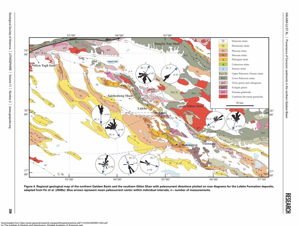
The Lulehe Formation is named for its type section at the Lulehe local-ity (QBGMR, 1980). It is widely exposed within the northern Qaidam Basin, where four localities were investigated in this study (Figs. 1 and 7). Typically, the Lulehe Formation unconformably overlies Mesozoic strata and conformably underlies the lower Ganchaigou Formation and is com-posed of terrigenous clastic red beds (Figs. 7 and 8) with a thickness of 400–500 m (Zhuang et al., 2011; Ji et al., 2017; Wang et al., 2017). The division between the Lulehe Formation and the lower Ganchaigou Forma-tion is easily determined by the presence and absence of sandy and con-glomeratic red beds, respectively. The Lulehe Formation deposits contain large amounts of cobble-boulder conglomerates (Fig. 7) and are usually interpreted as a synorogenic coarse-grained conglomerate deposited by high-gradient depositional systems (Zhuang et al., 2011; Ji et al., 2017; Yin et al., 2008a). The depositional environments of the Lulehe Formation can be reconstructed based on sedimentological observations of the 546-m-thick measured stratigraphic interval of the eastern Dahonggou section (Fig. 1B).
The Lulehe Formation at the Dahonggou section is divisible into two parts based on lithofacies assemblages and lithological characteristics. The lower part of the section (0–284 m) is characterized by a diverse
NE
Lulehe Yuqia
YinmaxiaDahonggou
NE SW
SE
28.5 cm
A B
DC
Figure 7. Abundant cobble-boulder conglomerates (mainly Gcm, Gmm, and Gcmi) in the lower part of the Lulehe Formation at the localities of Lulehe, Yuqia, Dahonggou, and Yinmaxia in the northern Qaidam Basin. See Table 1 for lithofacies codes.
Downloaded from https://pubs.geoscienceworld.org/gsa/lithosphere/article-pdf/11/2/252/4659951/252.pdfby The Institute of Geology and Geophysics, Chinese Academy of Sciences useron 24 March 2019

Geological Society of America | LITHOSPHERE | Volum
e 11 | Num
ber 2 | ww
w.gsapubs.org
263
HAIJIAN LU ET AL. | Provenance of Cenozoic sedim
ents in the northern Qaidam Basin
RESEARCH
500 µm
500 µm
500 µm
Ls
QmQm
F
Qm
Qm
QmF
F
F
Qm
Qm
Ls
Qm
Qm
QmF
F
Qm
Qm QmLs
F
F
Qm
Qm
Qm
NW
W
NW
Lulehe Fm.lower Ganchaigou Fm.
1 m
Gmm
GcmiGcmi
St
Gcmi
Sh
Gcmi
Sh
GmmGmmGmmGmm Fig. 8D
Gmm
Gmm
Gmm
GmmGmm
Gmm
GmmGmmGcmiSpGcmiSpGmmGmmFsm
FclGcmiShGcmiFsmGcmiFsmGcmi
Gcmi
Gcmi
FsmFsmFsm
SrFsm
FsmSmFsm
Fig. 3E, F
Fig. 3D
Fig. 7C
lower parttop
Fig. 8C
Fig. 8B
Fig. 8G
GcmiGcmiGcmi
Fig. 8F
Fig. 8E
sm ss cg
silts
tone
sand
ston
e
cong
lom
erat
e
mud
ston
e
sm ss cg
Grain size scale
LithologyThickness (m)
Lithofacies codes
Depositional environment
Representativephotos
Braided fluvial
Alluvial fan
Legend
Symbols
Covered interval
worker
Pebble-cobble imbrication
scoured base
soft-sediment deformation
Ripple marks orcross-lamination
Structures
A
B
D
C
E
F
G H
Figure 8. Measured stratigraphic section of the Lulehe Formation at the Dahonggou locality. (A) Excellent outcrop of the Lulehe Formation dominated by sandy and conglomeratic red beds. (B–D) Photomicrographs of feldspatholithic (B–C) and quartz-arenitic (D) petrofacies. The two feldspatholithic sandstones contain feldspar (F) and sedimentary lithic (Ls) grains, in addition to monocrystalline quartz (Qm); the quartzose example consists of 100% monocrystalline quartz (mainly Qm) grains. See part H for locations. (E–F) Interbeds of clast-supported pebble-cobble conglomerate and red siltstone, with a sharp, erosive contact, in the upper part of the Lulehe Formation. (G) Massive, matrix-supported and poorly sorted, pebble to boul-der conglomerates in the lower part of the Lulehe Formation. (H) Vertical succession of lithofacies and depositional system of the measured section. See Table 1 for lithofacies codes.
Downloaded from https://pubs.geoscienceworld.org/gsa/lithosphere/article-pdf/11/2/252/4659951/252.pdfby The Institute of Geology and Geophysics, Chinese Academy of Sciences useron 24 March 2019
Geological Society of America | LITHOSPHERE | Volume 11 | Number 2 | www.gsapubs.org 264
HAIJIAN LU ET AL. | Provenance of Cenozoic sediments in the northern Qaidam Basin RESEARCH
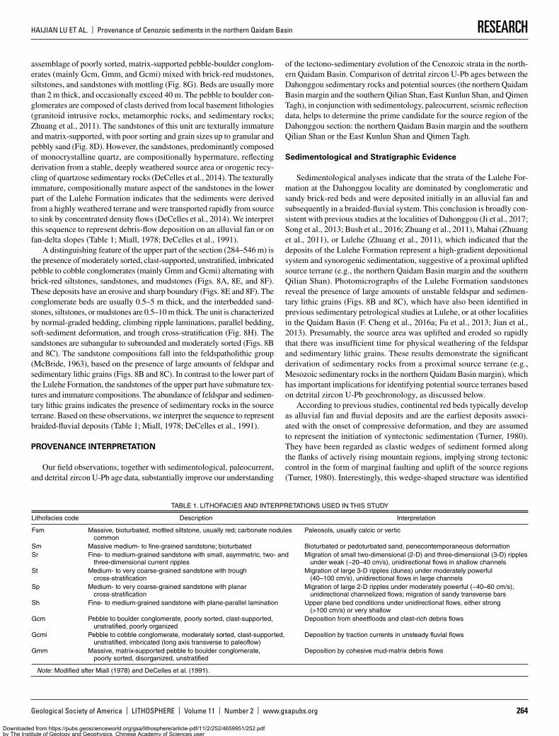
assemblage of poorly sorted, matrix-supported pebble-boulder conglom-erates (mainly Gcm, Gmm, and Gcmi) mixed with brick-red mudstones, siltstones, and sandstones with mottling (Fig. 8G). Beds are usually more than 2 m thick, and occasionally exceed 40 m. The pebble to boulder con-glomerates are composed of clasts derived from local basement lithologies (granitoid intrusive rocks, metamorphic rocks, and sedimentary rocks; Zhuang et al., 2011). The sandstones of this unit are texturally immature and matrix-supported, with poor sorting and grain sizes up to granular and pebbly sand (Fig. 8D). However, the sandstones, predominantly composed of monocrystalline quartz, are compositionally hypermature, reflecting derivation from a stable, deeply weathered source area or orogenic recy-cling of quartzose sedimentary rocks (DeCelles et al., 2014). The texturally immature, compositionally mature aspect of the sandstones in the lower part of the Lulehe Formation indicates that the sediments were derived from a highly weathered terrane and were transported rapidly from source to sink by concentrated density flows (DeCelles et al., 2014). We interpret this sequence to represent debris-flow deposition on an alluvial fan or on fan-delta slopes (Table 1; Miall, 1978; DeCelles et al., 1991).
A distinguishing feature of the upper part of the section (284–546 m) is the presence of moderately sorted, clast-supported, unstratified, imbricated pebble to cobble conglomerates (mainly Gmm and Gcmi) alternating with brick-red siltstones, sandstones, and mudstones (Figs. 8A, 8E, and 8F). These deposits have an erosive and sharp boundary (Figs. 8E and 8F). The conglomerate beds are usually 0.5–5 m thick, and the interbedded sand-stones, siltstones, or mudstones are 0.5–10 m thick. The unit is characterized by normal-graded bedding, climbing ripple laminations, parallel bedding, soft-sediment deformation, and trough cross-stratification (Fig. 8H). The sandstones are subangular to subrounded and moderately sorted (Figs. 8B and 8C). The sandstone compositions fall into the feldspatholithic group (McBride, 1963), based on the presence of large amounts of feldspar and sedimentary lithic grains (Figs. 8B and 8C). In contrast to the lower part of the Lulehe Formation, the sandstones of the upper part have submature tex-tures and immature compositions. The abundance of feldspar and sedimen-tary lithic grains indicates the presence of sedimentary rocks in the source terrane. Based on these observations, we interpret the sequence to represent braided-fluvial deposits (Table 1; Miall, 1978; DeCelles et al., 1991).
PROVENANCE INTERPRETATION
Our field observations, together with sedimentological, paleocurrent, and detrital zircon U-Pb age data, substantially improve our understanding
of the tectono-sedimentary evolution of the Cenozoic strata in the north-ern Qaidam Basin. Comparison of detrital zircon U-Pb ages between the Dahonggou sedimentary rocks and potential sources (the northern Qaidam Basin margin and the southern Qilian Shan, East Kunlun Shan, and Qimen Tagh), in conjunction with sedimentology, paleocurrent, seismic reflection data, helps to determine the prime candidate for the source region of the Dahonggou section: the northern Qaidam Basin margin and the southern Qilian Shan or the East Kunlun Shan and Qimen Tagh.
Sedimentological and Stratigraphic Evidence
Sedimentological analyses indicate that the strata of the Lulehe For-mation at the Dahonggou locality are dominated by conglomeratic and sandy brick-red beds and were deposited initially in an alluvial fan and subsequently in a braided-fluvial system. This conclusion is broadly con-sistent with previous studies at the localities of Dahonggou (Ji et al., 2017; Song et al., 2013; Bush et al., 2016; Zhuang et al., 2011), Mahai (Zhuang et al., 2011), or Lulehe (Zhuang et al., 2011), which indicated that the deposits of the Lulehe Formation represent a high-gradient depositional system and synorogenic sedimentation, suggestive of a proximal uplifted source terrane (e.g., the northern Qaidam Basin margin and the southern Qilian Shan). Photomicrographs of the Lulehe Formation sandstones reveal the presence of large amounts of unstable feldspar and sedimen-tary lithic grains (Figs. 8B and 8C), which have also been identified in previous sedimentary petrological studies at Lulehe, or at other localities in the Qaidam Basin (F. Cheng et al., 2016a; Fu et al., 2013; Jian et al., 2013). Presumably, the source area was uplifted and eroded so rapidly that there was insufficient time for physical weathering of the feldspar and sedimentary lithic grains. These results demonstrate the significant derivation of sedimentary rocks from a proximal source terrane (e.g., Mesozoic sedimentary rocks in the northern Qaidam Basin margin), which has important implications for identifying potential source terranes based on detrital zircon U-Pb geochronology, as discussed below.
According to previous studies, continental red beds typically develop as alluvial fan and fluvial deposits and are the earliest deposits associ-ated with the onset of compressive deformation, and they are assumed to represent the initiation of syntectonic sedimentation (Turner, 1980). They have been regarded as clastic wedges of sediment formed along the flanks of actively rising mountain regions, implying strong tectonic control in the form of marginal faulting and uplift of the source regions (Turner, 1980). Interestingly, this wedge-shaped structure was identified
TABLE 1. LITHOFACIES AND INTERPRETATIONS USED IN THIS STUDY
Lithofacies code Description Interpretation
Fsm Massive, bioturbated, mottled siltstone, usually red; carbonate nodules common
Paleosols, usually calcic or vertic
Sm Massive medium- to fine-grained sandstone; bioturbated Bioturbated or pedoturbated sand, penecontemporaneous deformationSr Fine- to medium-grained sandstone with small, asymmetric, two- and
three-dimensional current ripplesMigration of small two-dimensional (2-D) and three-dimensional (3-D) ripples
under weak (~20–40 cm/s), unidirectional flows in shallow channelsSt Medium- to very coarse-grained sandstone with trough
cross-stratificationMigration of large 3-D ripples (dunes) under moderately powerful
(40–100 cm/s), unidirectional flows in large channelsSp Medium- to very coarse-grained sandstone with planar
cross-stratificationMigration of large 2-D ripples under moderately powerful (~40–60 cm/s),
unidirectional channelized flows; migration of sandy transverse barsSh Fine- to medium-grained sandstone with plane-parallel lamination Upper plane bed conditions under unidirectional flows, either strong
(>100 cm/s) or very shallowGcm Pebble to boulder conglomerate, poorly sorted, clast-supported,
unstratified, poorly organizedDeposition from sheetfloods and clast-rich debris flows
Gcmi Pebble to cobble conglomerate, moderately sorted, clast-supported, unstratified, imbricated (long axis transverse to paleoflow)
Deposition by traction currents in unsteady fluvial flows
Gmm Massive, matrix-supported pebble to boulder conglomerate, poorly sorted, disorganized, unstratified
Deposition by cohesive mud-matrix debris flows
Note: Modified after Miall (1978) and DeCelles et al. (1991).
Downloaded from https://pubs.geoscienceworld.org/gsa/lithosphere/article-pdf/11/2/252/4659951/252.pdfby The Institute of Geology and Geophysics, Chinese Academy of Sciences useron 24 March 2019

Geological Society of America | LITHOSPHERE | Volume 11 | Number 2 | www.gsapubs.org 265
HAIJIAN LU ET AL. | Provenance of Cenozoic sediments in the northern Qaidam Basin RESEARCH
by seismic reflection profiling in the Qaidam Basin (Cheng et al., 2017; Wei et al., 2016; Yin et al., 2008b). The Lulehe Formation deposits in sections A–B and C–D of Figure 9 are thickest in the northern Qaidam Basin margin; they then thin to the southwest and then disappear before reaching the basin center (Yin et al., 2008b; Wei et al., 2016). A transverse section (E–F) along the central axis of the basin also supports the absence of the Lulehe Formation deposits at the center of Qaidam Basin, south of the Dahonggou section (Fig. 9D; Cheng et al., 2017). These findings are consistent with an isopach map of the Lulehe Formation deposits in the Qaidam Basin (Fig. 9A; Yin et al., 2008b). This distribution pattern of the Lulehe Formation deposits indicates that the Qaidam Basin was initiated as a common foreland basin during its earliest stage of sedimen-tation (Yin et al., 2002).
Sedimentology, facies analysis, and seismic reflection profiling pro-vide evidence that the Lulehe Formation strata in the northern Qaidam Basin were deposited in a proximal foreland basin system. Therefore, we conclude that the Lulehe Formation deposits in the locality of Dahong-gou originated from the proximal northern Qaidam Basin margin and the southern Qilian Shan.
Paleocurrent Evidence
The paleocurrent orientations of the deposits of the Lulehe Forma-tion at Dahonggou are disputed (Fig. 1A). Three previous paleocurrent measurements of the continuous Cenozoic sequence at Dahonggou have been conducted (Fig. 10): Bush et al. (2016) and Ji et al. (2017) inferred dominantly SW- and SE-directed flows, transverse to and away from the southern Qilian Shan, throughout the Cenozoic. Wang et al. (2017) also inferred four SW-directed paleocurrent orientations within the lower Youshashan, upper Youshashan, and Shizigou Formation; however, they inferred two NE-directed paleocurrent directions within the Lulehe For-mation and the lower part of the lower Ganchaigou Formation. Therefore, the sediment-dispersal pathways may have reversed during the interval between the lower Youshashan and lower Ganchaigou Formation.
To clarify the dispute over the provenance of the Lulehe Formation, we measured three paleocurrent orientations (PC-5, PC-6, PC-7) at three different horizons of the eastern Dahonggou section (Figs. 1B and 4). The results indicate SW- and SE-directed flows and a northerly source area. In addition, we obtained six paleocurrent estimates for the Lulehe Forma-tion from the localities at Lulehe, Yuqia, and Yinmaxia in the northern Qaidam Basin (Figs. 1C–1E and 4). Except for two NE-directed flows for Lulehe, the other localities showed SW- to SE-directed flows (Fig. 4). We conclude that the two NE-directed flows at the Lulehe locality reflect the tectonic uplift of the adjacent Saishenteng Shan (Fig. 4).
In summary, all our paleocurrent analyses spanning a wide range of the northern Qaidam Basin confirm that the widespread Lulehe Formation deposits in the northern Qaidam Basin were derived from the northern Qaidam Basin margin and the southern Qilian Shan. These paleocurrent results are supported by other paleocurrent studies in the northern Qaidam Basin (Zhuang et al., 2011; Meng and Fang, 2008).
Evidence from Zircon U-Pb Ages
Comparisons of age distributions based on the presence and absence of specific ages or age groups are the most reliable means for provenance identification (Gehrels et al., 2011). Since numerous geological factors may bias zircon age distributions, including recycling of zircons from older sedimentary units exposed in source terranes and/or incorporation of detrital zircons during transport, variations in the proportions of ages or age groups should be used with caution (Gehrels et al., 2011).
Two previous studies have examined the detrital age structure of the Dahonggou sedimentary rocks, both based on seven sandstone samples (Bush et al., 2016; Wang et al., 2017). Compared to the sampling strat-egy of Wang et al. (2017), the samples of Bush et al. (2016) had a more uniform distribution. Both studies revealed two major age populations, Permian–Triassic (200–300 Ma) and late Cambrian to Early Devonian (500–400 Ma), and two minor age populations, Neoproterozoic (1000–700 Ma) and Paleoproterozoic (2.5–1.6 Ga). The depth of 3200–4300 m is an exception, and here the Permian–Triassic peak is minor or absent (Fig. 11). This age structure is inconsistent with the concept of a simpli-fied two-stage evolution with a major 250 Ma peak being replaced by a major 440 Ma peak (Wang et al., 2017).
We combined large amounts of data to characterize several potential source terranes for the Cenozoic Dahonggou strata, including the East Kunlun Shan and Qimen Tagh (Fig. 6E; He et al., 2016; Li et al., 2013; Xia et al., 2015), Qilian Shan and Nan Shan (Fig. 6D; Chen et al., 2012; Gehrels et al., 2011, 2003a; Menold et al., 2009), and Mesozoic strata in the northern Qaidam Basin (Fig. 6B; Yu et al., 2017; Bush et al., 2016; this study). Compared to the age populations of the Cenozoic Dahonggou strata (Fig. 6C), those of the Qilian Shan and Nan Shan have fewer Perm-ian–Triassic (300–200 Ma) ages, and those of the East Kunlun Shan and Qimen Tagh have fewer Paleoproterozoic (2.5–1.6 Ga) ages. Although their proportions vary considerably, the four age populations of the Ceno-zoic Dahonggou strata are all indicative of three potential source terranes. Therefore, it is difficult to tie zircons of these ages to specific source ter-ranes, if we determine source terrane based on the presence or absence of specific age populations, rather than by variations in the proportions of the age populations.
Wang et al. (2017) suggested a two-stage provenance evolution model, with the earlier source area of the East Kunlun Shan being replaced by the Qilian Shan. This model is based mainly on the observation that granite bodies in the Qilian Shan are dominantly late Cambrian to early Devonian (500–400 Ma) in age, whereas those in the East Kunlun Shan are Perm-ian–Triassic (300–200 Ma) in age. However, this assumption overlooks the fact that large amounts of zircons with crystallization ages of 300–200 Ma are present in the northern Qaidam Basin. Besides the occurrence of iso-lated plutons immediately north of the Dahonggou section in the northern Qaidam Basin (Chen et al., 2012; Cheng et al., 2017; Menold et al., 2009), the Jurassic and Cretaceous sedimentary rocks have a major zircon age peak of ca. 250 Ma (Bush et al., 2016; Yu et al., 2017; Qian et al., 2018).
Geological mapping and analyses of seismic reflection profiles indi-cate that the northern Qaidam Basin margin and the southern Qilian Shan–Nan Shan thrust belt developed a SW-directed thrust-wedge duplex (triangle-zone structure), the southward propagation of which has accom-modated a significant amount of crustal shortening (20% to >60%; Yin et al., 2008a). The structural development of the orogenic wedge controls the geometry and shape of the northern Qaidam Basin and therefore has a strong influence on the prolonged exhumation of older strata within the fold-and-thrust belt and rapid sedimentation of younger strata within the basin interior. The Jurassic and Cretaceous sedimentary rocks crop out discontinuously within the fold-and-thrust belt of the northern Qaidam Basin margin with a greater altitude than the basin interior (Ritts and Biffi, 2001; Yu et al., 2017). It is believed that these Mesozoic rocks experienced multiphase exhumation and prolonged erosion since, or soon after, the beginning of the India-Eurasia collision (Yin et al., 2008a), and therefore they supplied large amounts of detritus to be redeposited within the basin interior. This interpretation was substantiated by recent detrital apatite fission-track analyses of Mesozoic strata in the northern Qaidam Basin margin, which suggested >6 km of exhumation of Mesozoic sedimentary rocks based on the observation that their apatite fission-track ages are
Downloaded from https://pubs.geoscienceworld.org/gsa/lithosphere/article-pdf/11/2/252/4659951/252.pdfby The Institute of Geology and Geophysics, Chinese Academy of Sciences useron 24 March 2019

Geological Society of America | LITHOSPHERE | Volum
e 11 | Num
ber 2 | ww
w.gsapubs.org
266
HAIJIAN LU ET AL. | Provenance of Cenozoic sedim
ents in the northern Qaidam Basin
RESEARCH
1000
600
1000
1000 10001000+
+
+ +
++
+
-
600
600
600600+ + +
-
--
-
+
-
- -
East kunlun Shan
Qilian Shan
Qaidam basin
Altyn Tagh
Qimen Tagh
Ela Shan
N
0 100km
96oE94oE
39o N
37o N
98oE92oE
38o N
36o N
Dahonggou
0481216
km048
1216
km
pre-Jr Lulehe
BA
C D
0 32km
0 20km
048
1216
km0481216
km
kmpre-Jr
A
B D
C
E
F
E F
Qigequan Shizigou Upper Youshashan Upper Youshashan Lower Youshashan Upper Ganchaigou Lower Ganchaigou Lulehe pre-JrMesozoic
Lulehe
048
1216
0481216
km
0 60km
Lulehe
A
B
C
D
Figure 9. Thickness of Cenozoic strata within the Qaidam Basin. (A) Digital elevation model (DEM) of the Qaidam Basin and its surroundings, with super-imposed isopach map of the Lulehe Forma tion (Yin et al., 2008b). (B–D) Cenozoic strata thicknesses based on seismic profile interpretations (Yin et al., 2008b; Wei et al., 2016; Cheng et al., 2017); Jr—Jurassic. See part A for locations.
Downloaded from https://pubs.geoscienceworld.org/gsa/lithosphere/article-pdf/11/2/252/4659951/252.pdfby The Institute of Geology and Geophysics, Chinese Academy of Sciences useron 24 March 2019

Geological Society of America | LITHOSPHERE | Volume 11 | Number 2 | www.gsapubs.org 267
HAIJIAN LU ET AL. | Provenance of Cenozoic sediments in the northern Qaidam Basin RESEARCH
Lule
he F
m.
low
er G
anch
aigo
u Fm
.up
per G
anch
aigo
u Fm
.Sh
izig
ou F
m.
uppe
r You
shas
han
Fm.
low
er Y
oush
asha
n Fm
.
N=21
N=20
N=20
N=19
N=18
N=24
(Wang et al., 2017) (Bush et al., 2016)
111010
32232518242122
211522
191311
1110
11
1110
11
101010
roughly consistent paleocurrent disparate paleocurrent N=24
N=3
N=38
N=34
N=6
N=25
N=9
N=25
N=4
(Ji et al., 2017)
Figure 10. Measured 5.27-km-thick lithostratigraphic section of the western Dahonggou locality (Fig. 1B), with red arrows indi-cating mean paleocurrent vector within individual intervals. We deleted the paleocurrent data for the Cretaceous Quanyagou For-mation from Bush et al. (2016). Studies have yielded roughly con-sistent paleocurrent data, except within the Lulehe and lower Gan-chaigou Formations, where Bush et al. (2016) and Ji et al. (2017) inferred SE- or SW-directed paleo-currents, but Wang et al. (2017) inferred NE-directed paleocurrents. The lithological legend is the same as in Figure 8H.
Downloaded from https://pubs.geoscienceworld.org/gsa/lithosphere/article-pdf/11/2/252/4659951/252.pdfby The Institute of Geology and Geophysics, Chinese Academy of Sciences useron 24 March 2019

Geological Society of America | LITHOSPHERE | Volume 11 | Number 2 | www.gsapubs.org 268
HAIJIAN LU ET AL. | Provenance of Cenozoic sediments in the northern Qaidam Basin RESEARCH
Lule
he F
m.
low
er G
anch
aigo
u Fm
.up
per G
anch
aigo
u Fm
.Sh
izig
ou F
m.
uppe
r You
shas
han
Fm.
low
er Y
oush
asha
n Fm
.
51015
5
15
204060
10
20
n=95
n=103
n=97
n=98
n=104
n=99102030
1020
(Wang et al., 2017) (Bush et al., 2016)LithologyDepth (m)
5
15
n=86
n=94
n=93
n=93
n=97
n=92
n=87
10
20
1020
0
10
2030
10
2030
0
510
510
0 250500800
1200
1600
2000
2400
2800
0 250500800
1200
1600
2000
2400
2800 0 250500
800
1200
1600
2000
2400
2800
5101520
n=97
0 250500
800
1200
1600
2000
2400
2800
Figure 11. Results of two previous provenance studies based on U-Pb ages of detrital zircons, both based on seven samples from the Dahonggou section (Bush et al., 2016; Wang et al., 2017). We deleted the detrital zircon U-Pb geochronologic data for the Cretaceous Quanyagou Formation from Bush et al. (2016). The lithological legend is the same as in Figure 8H.
Downloaded from https://pubs.geoscienceworld.org/gsa/lithosphere/article-pdf/11/2/252/4659951/252.pdfby The Institute of Geology and Geophysics, Chinese Academy of Sciences useron 24 March 2019

Geological Society of America | LITHOSPHERE | Volume 11 | Number 2 | www.gsapubs.org 269
HAIJIAN LU ET AL. | Provenance of Cenozoic sediments in the northern Qaidam Basin RESEARCH
younger than their depositional ages (Jian et al., 2018). This sedimen-tary recycling model is further supported by sandstone compositional data. Numerous Cenozoic sandstone samples from the northern Qaidam Basin represent recycled orogenic or, more specifically, fold-and-thrust belt materials according to classical Dickinson-Gazzi variation diagrams (Fig. 12; Lu et al., 2014; Bush et al., 2016; Jian et al., 2013). Therefore, the Jurassic and Cretaceous sedimentary rocks in the northern Qaidam Basin margin could be one of the major source regions for the Cenozoic Dahong-gou section, and recycling of these Mesozoic sedimentary units would yield Permian–Triassic–aged zircons, such as the 300–200 Ma popula-tion observed in the Cenozoic sandstones. Rieser et al. (2006b) reported a uniform 280–220 Ma age cluster for detrital white mica in Cenozoic sedimentary rocks from the Lulehe section in the northern Qaidam Basin (Fig. 1C). It was also concluded that these late Paleozoic–Early Triassic ages were either derived from recycled Triassic–Jurassic cover sequences, or from Permian intrusive bodies in the northern Qaidam Basin and the southern Qilian Shan–Nan Shan (Rieser et al., 2006b).
The widespread occurrence of 300–200 Ma detrital zircon ages in Mesozoic strata can be attributed to the fact that the bedrock of the Qaidam Basin contains granite bodies of 290–280 Ma to 215 Ma in age (Wu et al., 2016; Cheng et al., 2017; see Fig. 2C), which are overlain by Meso-zoic–Cenozoic sedimentary rocks (Cheng et al., 2017). The episodic reju-venation of fold-and-thrust belts (Ritts and Biffi, 2001), or normal faults (Yin et al., 2008a; Wu et al., 2011), in the northern Qaidam Basin since the Mesozoic may have exposed subsurface granites, which represent the principal and ultimate source for the 300–200 Ma detrital zircons in the Mesozoic and Cenozoic strata.
DISCUSSION
We obtained 500 detrital zircon ages from five Mesozoic sedimentary rocks, which were combined to supplement detrital zircon age data for Mesozoic strata in the northern Qaidam Basin. The integrated detrital zircon ages of Mesozoic strata show three major age populations: Permian–Trias-sic (300–200 Ma), late Cambrian to Early Devonian (500–400 Ma), and Paleoproterozoic (2.5–1.6 Ga), and one minor age population: Neoprotero-zoic (1000–700 Ma). Based on previous studies, the detrital zircon ages of the Cenozoic Dahonggou strata display two major age populations: Perm-ian–Triassic (300–200 Ma) and late Cambrian to Early Devonian (500–400 Ma), and two minor age populations: Neoproterozoic (1000–700 Ma) and Paleoproterozoic (2.5–1.6 Ga). However, the four age populations are all
reported in three potential source terranes, in varying proportions, includ-ing the East Kunlun Shan and Qimen Tagh, the Qilian Shan and Nan Shan, and Mesozoic strata in the northern Qaidam Basin. Therefore, it is difficult to tie zircons of these ages to specific source terranes using the presence or absence of specific age populations, rather than examining variations in the proportions of the age populations. Therefore, the use of a single detrital zircon dating method cannot provide unique source information.
Sedimentological analyses indicate that the Lulehe Formation strata at the Dahonggou locality are dominated by conglomeratic and sandy brick-red beds and were deposited first in an alluvial fan and then in a braided-fluvial system (Fig. 8). The Lulehe Formation deposits represent a high-gradient depositional system and synorogenic sedimentation, sug-gestive of a proximal uplifted source terrane (e.g., the northern Qaidam Basin margin and the southern Qilian Shan). Seismic reflection profiling also testifies that the Lulehe Formation strata in the northern Qaidam Basin were deposited in a proximal foreland basin system (Fig. 13). Therefore, sedimentological and stratigraphic evidence together indicate that the Lulehe Formation deposits at the Dahonggou locality originated from the proximal northern Qaidam Basin margin and the southern Qilian Shan (Fig. 13). This is further supported by our detailed paleocurrent studies spanning a large part of the northern Qaidam Basin (525 measurements at nine stations), which consistently indicate that the widespread Lulehe Formation deposits in the northern Qaidam Basin were derived from the northern Qaidam Basin margin and the southern Qilian Shan (Fig. 13).
Detrital fission-track dating can also be used to characterize variations in source terrane and has been regarded as a very important supplementary means of investigating changes in provenance for the Qaidam Basin (Du et al., 2018; Jian et al., 2018; Wang et al., 2017; Y. Wang et al., 2015). Detrital apatite fission-track data of the Cenozoic strata, especially the Lulehe Formation in the northern Qaidam Basin, show a prominent age population peak of 80–40 Ma (Du et al., 2018; Wang et al., 2017; Jian et al., 2018). This means that some of the Lulehe Formation sediments in the northern Qaidam Basin were most likely derived from Mesozoic strata in the northern Qaidam Basin margin, the detrital apatite fission-track ages of which range from 81 to 46 Ma (Fig. 13; Jian et al., 2018). Reworking of Mesozoic strata in response to uplift and cannibalization in the fold-and-thrust belt is supported by the presence of significant sedimentary lithic (Ls) grains and detrital modal analyses of Cenozoic sandstones in the northern Qaidam Basin, as was discussed above. It is thought that these Mesozoic strata experienced deep burial (>6 km) and strong annealing, resulting in younger detrital apatite fission-track ages than their depositional ages (Jian
Transitional ArcDissected Arc
BasementUplift
Craton
RecycledOrogenic
Interior
TransitionalContinental
Undissected Arc
Qt
F L
Arc Orogen Sources
SubductionComplexSources
Fold-thrust beltSources
Qp
Lv Ls
Qt: total quartz Qp: polycrystalline quartz F: feldspar L: lithic clasts Ls: lithic sedimentary and metasedimentary clasts Lv : lithic volcanic clasts
A BTransitional Arc
Dissected ArcBasementUplift
Craton
RecycledOrogenic
Interior
TransitionalContinental
Undissected Arc
Qt
F L0 80 1000
20
40
60
80
1000
20
40
60
80
10020 40 600 80 100
0
20
40
60
80
1000
20
40
60
80
10020 60400 80 100
0
20
40
60
80
1000
20
40
60
80
10020 6040
C D
Mixed O
rogenic Sources
Transitional ArcDissected Arc
BasementUplift
Craton
RecycledOrogenic
Interior
TransitionalContinental
Undissected Arc
Qt
F L0 80 1000
20
40
60
80
1000
20
40
60
80
10020 40 60
Figure 12. Quartz–feldspar–total lithic fragments (Qt-F-L) and polycrystalline quartz-lithic sedimentary clasts-lithic volcanic clasts (Qp-Lv-Ls) ternary diagrams of framework grain compositions of Cenozoic sandstones in the northern Qaidam Basin. (A–B) 150 sandstone samples from the northern Qaidam Basin spanning the Lulehe to Shizigou Formations, modified from Jian et al. (2013). (C) 129 sandstone samples collected from the upper Ganchaigou, lower Youshashan, and upper Youshashan Formations at the Dahonggou section (Lu et al., 2014). (D) 14 sandstone samples from the Dahonggou section, modified from Bush et al. (2016). Fields of various tectonic settings are from Dickinson (1985).
Downloaded from https://pubs.geoscienceworld.org/gsa/lithosphere/article-pdf/11/2/252/4659951/252.pdfby The Institute of Geology and Geophysics, Chinese Academy of Sciences useron 24 March 2019

Geological Society of America | LITHOSPHERE | Volume 11 | Number 2 | www.gsapubs.org 270
HAIJIAN LU ET AL. | Provenance of Cenozoic sediments in the northern Qaidam Basin RESEARCH
et al., 2018). Wang et al. (2017) suggested a drastic change of source area, with an early southerly source area (East Kunlun Shan) being replaced by a subsequent northerly source area (the southern Qilian Shan), based on the observations that an early sharp decrease in peak ages up section was succeeded by a slowly decreasing trend of peak ages. However, this conclu-sion is unconvincing, since it is based solely on sharp variations in detrital apatite fission-track ages. Jian et al. (2018) also observed similar variations in detrital thermochronological data, but they attributed the phenomenon to a single massive source area (the northern Qaidam Basin margin and the southern Qilian Shan) with distinct cooling ages. Low-temperature
thermochronological studies of crystalline basement rocks suggest that the northern Qaidam Basin margin (Lvliang Shan and Xitie Shan) and the southern Qilian Shan had a regionally heterogeneous cooling history, which indicates three phases of rapid exhumation since the Mesozoic (Early Cretaceous, Paleocene–Eocene and middle–late Miocene; X. Cheng et al., 2016; Jolivet et al., 2001; Wang et al., 2004; Zhuang et al., 2018).
This provenance model has important implications for the timing of the tectonic uplift of the northern Qaidam Basin margin and the south-ern Qilian Shan. The age of the basal Cenozoic sedimentary rocks in the Qaidam Basin (the basal age of the Lulehe Formation) is bracketed to 65–50 Ma (Ji et al., 2017; Yin et al., 2008a), or ca. 25 Ma (Wang et al., 2017). Since these massive terrigenous clastic sedimentary rocks in the northern Qaidam Basin are the product of surface uplift, tectonic exhuma-tion, and erosion of the northern Qaidam Basin margin and the southern Qilian Shan, the timing of the initiation of surface uplift of the northern Qaidam Basin margin and the southern Qilian Shan was likely no later than 65–50 Ma, or ca. 25 Ma. Irrespective of which age is correct, the substantial uplift of the southern Qilian Shan should be far older than 12 Ma, as suggested by Wang et al. (2017).
CONCLUSIONS
Our integrated study of the sedimentology, paleocurrent directions, detrital zircon U-Pb ages, detrital apatite fission-track ages, and seismic reflection profiles enables us to assemble a reliable reconstruction of the provenance of the Lulehe Formation in the northern Qaidam Basin.
(1) The detrital zircon age populations of the Cenozoic Dahonggou strata are all reported in three potential source terranes, in varying propor-tions, including the East Kunlun Shan and Qimen Tagh, the Qilian Shan and Nan Shan, and Mesozoic strata in the northern Qaidam Basin. Thus, the use of a single detrital zircon dating method cannot provide unique source information.
(2) The sedimentological and paleocurrent analyses, in combination with existing paleocurrent data, seismic reflection data, and detrital apatite fission-track dating, point consistently to a unified proximal northerly source area (the northern Qaidam Basin margin and the southern Qilian Shan).
(3) The orogenic recycling effect of Mesozoic strata in the fold-and-thrust belt of the northern Qaidam Basin, which was ignored in recent studies, played a significant role in producing the Permian–Triassic–aged zircons observed in the Cenozoic sandstones.
ACKNOWLEDGMENTSWe thank Longgang Fan, Guoli Wu, and Xuxuan Ma for help with data processing and inter-pretations; Aijun Sun for help in the field; and Min Lei and Xiangzhen Xu for providing labo-ratory support. Laurent Godin (Science Editor) and two anonymous reviewers are thanked for constructive and valuable suggestions. This research was supported by the National Natural Science Foundation of China (grant 41472187), the Strategic Priority Research Program of the Chinese Academy of Sciences (grant XDA19050104), and the China Geological Survey (grant DD20160022–03).
REFERENCES CITEDBush, M., Saylor, J., Horton, B., and Nie, J., 2016, Growth of the Qaidam Basin during Ceno-
zoic exhumation in the northern Tibetan Plateau: Inferences from depositional patterns and multiproxy detrital provenance signatures: Lithosphere, v. 8, p. 58–82, https:// doi .org /10 .1130 /L449 .1.
Carter, A., and Moss, S.J., 1999, Combined detrital-zircon fission-track and U-Pb dating: A new approach to understanding hinterland evolution: Geology, v. 27, no. 3, p. 235–238, https:// doi .org /10 .1130 /0091 -7613 (1999)027 <0235: CDZFTA>2 .3 .CO;2.
Chang, H., Li, L., Qiang, X., Garzione, C.N., Pullen, A., and An, Z., 2015, Magnetostratigraphy of Cenozoic deposits in the western Qaidam Basin and its implication for the surface uplift of the northeastern margin of the Tibetan Plateau: Earth and Planetary Science Letters, v. 430, p. 271–283, https:// doi .org /10 .1016 /j .epsl .2015 .08 .029.
Chen, X., Gehrels, G., Yin, A., Li, L., and Jiang, R., 2012, Paleozoic and Mesozoic basement magmatisms of eastern Qaidam Basin, northern Qinghai-Tibet Plateau: LA-ICP-MS zircon U-Pb geochronology and its geological significance: Acta Geologica Sinica [English Edi-tion], v. 86, no. 2, p. 350–369, https:// doi .org /10 .1111 /j .1755 -6724 .2012 .00665 .x.
NE
southern Qilian Shan
north Qaidam basin
Lulehe Formation
Pre-Mesozoic
Mesozoic
Cenozoic
strata
strata
strata
NE
southern Qilian Shan
north Qaidam basin
fold-thrust belt
Lulehe Formation
fold-thrust belt
A
B
Figure 13. Schematic block diagrams illustrating the source-sink relation-ships between the southern Qilian Shan and Mesozoic–Cenozoic strata in the northern Qaidam Basin, adapted from Plašienka (2012). (A) Tectono-sedimentary framework during the sedimentation of the Lulehe Formation. At this time, the bedrocks of the southern Qilian Shan and Mesozoic strata in the northern Qaidam Basin were the predominant sources of Cenozoic strata in the northern Qaidam Basin. This framework highlights the signifi-cance of the recycled orogen effect of Mesozoic strata in the fold-and-thrust belt of the northern Qaidam Basin. (B) Present tectono-sedimentary frame-work of the northern Qaidam Basin. In this diagram, the Cenozoic strata are a major source area of the Quaternary sediments.
Downloaded from https://pubs.geoscienceworld.org/gsa/lithosphere/article-pdf/11/2/252/4659951/252.pdfby The Institute of Geology and Geophysics, Chinese Academy of Sciences useron 24 March 2019

Geological Society of America | LITHOSPHERE | Volume 11 | Number 2 | www.gsapubs.org 271
HAIJIAN LU ET AL. | Provenance of Cenozoic sediments in the northern Qaidam Basin RESEARCH
Chen, X., Yin, A., Gehrels, G.E., Cowgill, E.S., Grove, M., Harrison, T.M., and Wang, X.F., 2003, Two phases of Mesozoic north-south extension in the eastern Altyn Tagh range, northern Tibetan Plateau: Tectonics, v. 22, no. 5, TC1053, https:// doi .org /10 .1029 /2001TC001336.
Cheng, F., Fu, S., Jolivet, M., Zhang, C., and Guo, Z., 2016a, Source to sink relation between the Eastern Kunlun Range and the Qaidam Basin, northern Tibetan Plateau, during the Cenozoic: Geological Society of America Bulletin, v. 128, no. 1, p. 258–283, https:// doi .org /10 .1130 /B31260 .1.
Cheng, F., Jolivet, M., Fu, S., Zhang, C., Zhang, Q., and Guo, Z., 2016b, Large-scale displace-ment along the Altyn Tagh fault (North Tibet) since its Eocene initiation: Insight from detrital zircon U-Pb geochronology and subsurface data: Tectonophysics, v. 677–678, p. 261–279, https:// doi .org /10 .1016 /j .tecto .2016 .04 .023.
Cheng, F., Jolivet, M., Hallot, E., Zhang, D., Zhang, C., and Guo, Z., 2017, Tectono-magmatic rejuvenation of the Qaidam craton, northern Tibet: Gondwana Research, v. 49, p. 248–263, https:// doi .org /10 .1016 /j .gr .2017 .06 .004.
Cheng, X., Lin, X., Wu, L., Chen, H., Xiao, A., Gong, J., Zhang, F., and Yang, S., 2016, The Exhumation history of North Qaidam thrust belt constrained by apatite fission track thermochronology: Implication for the rvolution of the Tibetan Plateau: Acta Geologica Sinica [English Edition], v. 90, no. 3, p. 870–883, https:// doi .org /10 .1111 /1755 -6724 .12730.
Cowgill, E., Yin, A., Harrison, T.M., and Wang, X., 2003, Reconstruction of the Altyn Tagh fault based on U‐Pb geochronology: Role of back thrusts, mantle sutures, and heterogeneous crustal strength in forming the Tibetan Plateau: Journal of Geophysical Research–Solid Earth, v. 108, no. B7, p. 457–470.
DeCelles, P.G., Gray, M.B., Ridgway, K.D., Cole, R.B., Pivnik, D.A., Pequera, N., and Srivastava, P., 1991, Controls on synorogenic alluvial-fan architecture, Beartooth Conglomerate (Pa-laeocene), Wyoming and Montana: Sedimentology, v. 38, no. 4, p. 567–590, https:// doi .org /10 .1111 /j .1365 -3091 .1991 .tb01009 .x.
DeCelles, P.G., Kapp, P., Gehrels, G.E., and Ding, L., 2014, Paleocene–Eocene foreland basin evo-lution in the Himalaya of southern Tibet and Nepal: Implications for the age of initial India-Asia collision: Tectonics, v. 33, no. 5, p. 824–849, https:// doi .org /10 .1002 /2014TC003522.
Dickinson, W. R., 1985, Interpreting provenance relations from detrital modes of sandstones, in Zuffa, G.G., ed., Provenance of Arenites: New York, D. Reidel Publishing, North Atlantic Treaty Organization (NATO) Advanced Study Institute (ASI) Series C: Mathematical and Physical Sciences Volume 148, p. 333–361.
Du, D., Zhang, C., Mughal, M. S., Wang, X., Blaise, D., Gao, J., Ma, Y., and Luo, X., 2018, De-trital apatite fission track constraints on Cenozoic tectonic evolution of the north east-ern Qinghai-Tibet Plateau, China: Evidence from Cenozoic strata in Lulehe section, the northern Qaidam Basin: Journal of Mountain Science, v. 15, no. 3, p. 532–547, https:// doi .org /10 .1007 /s11629 -017 -4692 -5.
Fang, X., Zhang, W., Meng, Q., Gao, J., Wang, X., King, J., Song, C., Dai, S., and Miao, Y., 2007, High-resolution magnetostratigraphy of the Neogene Huaitoutala section in the eastern Qaidam Basin on the NE Tibetan Plateau, Qinghai Province, China, and its implication on tectonic uplift of the NE Tibetan Plateau: Earth and Planetary Science Letters, v. 258, no. 1, p. 293–306, https:// doi .org /10 .1016 /j .epsl .2007 .03 .042.
Fu, L., Guan, P., Zhao, W., Wang, M., Zhang, Y., and Lu, J., 2013, Heavy mineral feature and provenance analysis of Paleogene Lulehe Formation in Qaidam Basin: Acta Petrologica Sinica, v. 29, no. 8, p. 2867–2875 [in Chinese with English abstract].
Fu, S., Ma, D., Guo, Z., and Cheng, F., 2015, Strike-slip superimposed Qaidam Basin and its control on oil and gas accumulation, NW China: Petroleum Exploration and Development, v. 42, no. 6, p. 778–789, https:// doi .org /10 .1016 /S1876 -3804 (15)30074 -4.
Garzanti, E., Baud, A., and Mascle, G., 1987, Sedimentary record of the northward flight of India and its collision with Eurasia (Ladakh Himalaya, India): Geodinamica Acta, v. 1, p. 297–312, https:// doi .org /10 .1080 /09853111 .1987 .11105147.
Garzanti, E., Critelli, S., and Ingersoll, R.V., 1996, Paleogeographic and paleotectonic evolution of the Himalayan Range as reflected by detrital modes of Tertiary sandstones and mod-ern sands (Indus transect, India and Pakistan): Geological Society of America Bulletin, v. 108, p. 631–642, https:// doi .org /10 .1130 /0016 -7606 (1996)108 <0631: PAPEOT>2 .3 .CO;2.
Gehrels, G.E., Yin, A., and Wang, X., 2003a, Detrital-zircon geochronology of the northeastern Tibetan Plateau: Geological Society of America Bulletin, v. 115, no. 7, p. 881–896, https:// doi .org /10 .1130 /0016 -7606 (2003)115 <0881: DGOTNT>2 .0 .CO;2.
Gehrels, G.E., Yin, A., and Wang, X., 2003b, Magmatic history of the northeastern Tibetan Plateau: Journal of Geophysical Research–Solid Earth, v. 108, no. B9, 2423, https:// doi .org /10 .1029 /2002JB001876.
Gehrels, G., Kapp, P., DeCelles, P., Pullen, A., Blakey, R., Weislogel, A., Ding, L., Guynn, J., Martin, A., McQuarrie, N., and Yin, A., 2011, Detrital zircon geochronology of pre-Tertiary strata in the Tibetan-Himalayan orogen: Tectonics, v. 30, no. 5, TC5016, https:// doi .org /10 .1029 /2011TC002868.
Hanson, A.D., 1999, Organic Geochemistry and Petroleum Geology, Tectonics and Basin Analysis of the Southern Tarim and Northern Qaidam Basins, Northwest China [Ph.D. dissertation]: Stanford, California, Stanford University, 388 p.
He, D., Dong, Y., Liu, X., Yang, Z., Sun, S., Cheng, B., and Li, W., 2016, Tectono-thermal events in East Kunlun, northern Tibetan Plateau: Evidence from zircon U-Pb geochronology: Gondwana Research, v. 30, p. 179–190, https:// doi .org /10 .1016 /j .gr .2015 .08 .002.
Heermance, R.V., Pullen, A., Kapp, P., Garzione, C.N., Bogue, S., Ding, L., and Song, P., 2013, Climatic and tectonic controls on sedimentation and erosion during the Pliocene–Quater-nary in the Qaidam Basin (China): Geological Society of America Bulletin, v. 125, no. 5–6, p. 833–856, https:// doi .org /10 .1130 /B30748 .1.
Horton, B.K., Yin, A., Spurlin, M.S., Zhou, J., and Wang, J., 2002, Paleocene–Eocene synco-ntractional sedimentation in narrow, lacustrine-dominated basins of east-central Tibet: Geological Society of America Bulletin, v. 114, p. 771–786, https:// doi .org /10 .1130 /0016 -7606 (2002)114 <0771: PESSIN>2 .0 .CO;2.
Huang, H., Huang, Q., and Ma, Y., 1996, Geology of Qaidam Basin and its Petroleum Predic-tion: Beijing, Geological Publishing House, 257 p.
Ji, J., Zhang, K., Clift, P., Zhuang, G., Song, B., Ke, X., and Xu, Y., 2017, High-resolution mag-netostratigraphic study of the Paleogene–Neogene strata in the northern Qaidam Basin: Implications for the growth of the northeastern Tibetan Plateau: Gondwana Research, v. 46, p. 141–155, https:// doi .org /10 .1016 /j .gr .2017 .02 .015.
Jian, X., Guan, P., Zhang, D., Zhang, W., Feng, F., Liu, R., and Lin, S., 2013, Provenance of Ter-tiary sandstone in the northern Qaidam Basin, northeastern Tibetan Plateau: Integration of framework petrography, heavy mineral analysis and mineral chemistry: Sedimentary Geology, v. 290, p. 109–125, https:// doi .org /10 .1016 /j .sedgeo .2013 .03 .010.
Jian, X., Guan, P., Zhang, W., Liang, H., Feng, F., and Fu, L., 2018, Late Cretaceous to early Eo-cene deformation in the northern Tibetan Plateau: Detrital apatite fission track evidence from the northern Qaidam Basin: Gondwana Research, v. 60, p. 94–104, https:// doi .org /10 .1016 /j .gr .2018 .04 .007.
Jolivet, M., Brunel, M., Seward, D., Xu, Z., Yang, J., Roger, F., Tapponnier, P., Malavieille, J., Arnaud, N., and Wu, C., 2001, Mesozoic and Cenozoic tectonics of the northern edge of the Tibetan Plateau: Fission-track constraints: Tectonophysics, v. 343, p. 111–134, https:// doi .org /10 .1016 /S0040 -1951 (01)00196 -2.
Kapp, P., Decelles, P.G., Gehrels, G.E., Heizler, M., and Ding, L., 2007, Geological records of the Cretaceous Lhasa-Qiangtang and Indo-Asian collisions in the Nima Basin area, central Tibet: Geological Society of America Bulletin, v. 119, p. 917–933, https:// doi .org /10.1130 /B26033 .1.
Li, L., Garzione, C.N., Pullen, A., Zhang, P., Li, Y., Li, L., Garzione, C.N., Pullen, A., Zhang, P., and Li, Y., 2017, Late Cretaceous–Cenozoic basin evolution and topographic growth of the Hoh Xil Basin, central Tibetan Plateau: Geological Society of America Bulletin, v. 130, no. 3, p. 499–521.
Li, W., Neubauer, F., Liu, Y., Genser, J., Ren, S., Han, G., and Liang, C., 2013, Paleozoic evolu-tion of the Qimantagh magmatic arcs, Eastern Kunlun Mountains: Constraints from zir-con dating of granitoids and modern river sands: Journal of Asian Earth Sciences, v. 77, p. 183–202, https:// doi .org /10 .1016 /j .jseaes .2013 .08 .030.
Liu, Z., 1988, Geologic Map of the Qinghai-Xizang Plateau and its Neighboring Regions: Beijing, Geologic Publishing House, and Chengdu Institute of Geology and Mineral Re-sources, scale 1:1,500,000.
Lu, H., and Xiong, S., 2009, Magnetostratigraphy of the Dahonggou section, the northern Qaidam Basin, and its bearing on Cenozoic tectonic evolution of the Qilian Shan and Altyn Tagh fault: Earth and Planetary Science Letters, v. 288, no. 3–4, p. 539–550, https:// doi .org /10 .1016 /j .epsl .2009 .10 .016.
Lu, H., Wang, E., and Meng, K., 2014, The mid-Miocene tectonic uplift of the southern Qilian-shan: Sedimentary evidence from Dahonggou section in Qaidam Basin: Chinese Journal of Geology, v. 45, no. 1, p. 95–103.
Mao, L., Xiao, A., Zhang, H., Wu, Z., Wang, L., Shen, Y., and Wu, L., 2016, Structural deforma-tion pattern within the NW Qaidam Basin in the Cenozoic era and its tectonic implications: Tectonophysics, v. 687, p. 78–93, https:// doi .org /10 .1016 /j .tecto .2016 .09 .008.
McBride, E.F., 1963, A classification of common sandstones: Journal of Sedimentary Re-search, v. 33, p. 664–669.
Meng, Q., and Fang, X., 2008, Cenozoic tectonic development of the Qaidam Basin in the northeastern Tibetan Plateau, in Burchfiel, B.C., and Wang, E., eds., Investigations into the Tectonics of the Tibetan Plateau: Geological Society of America Special Paper 444, p. 1–24, https:// doi .org /10 .1130 /2008 .2444 (01).
Meng, Q., Hu, J., and Yang, F., 2001, Timing and magnitude of displacement on the Altyn Tagh fault: Constraints from stratigraphic correlation of adjoining Tarim and Qaidam Basins, NW China: Terra Nova, v. 13, no. 2, p. 86–91, https:// doi .org /10 .1046 /j .1365 -3121 .2001 .00320 .x.
Menold, C.A., Manning, C.E., Yin, A., Tropper, P., Chen, X.H., and Wang, X.F., 2009, Metamor-phic evolution, mineral chemistry and thermobarometry of orthogneiss hosting ultrahigh-pressure eclogites in the North Qaidam metamorphic belt, western China: Journal of Asian Earth Sciences, v. 35, no. 3–4, p. 273–284, https:// doi .org /10 .1016 /j .jseaes .2008 .12 .008.
Metivier, F., Gaudemer, Y., Tapponnier, P., and Meyer, B., 1998, Northeastward growth of the Tibet plateau deduced from balanced reconstruction of two depositional areas: The Qa-idam and Hexi Corridor basins, China: Tectonics, v. 17, no. 6, p. 823–842, https:// doi .org /10 .1029 /98TC02764.
Miall, A.D., 1978, Lithofacies types and vertical profile models in braided river deposits: A summary, in Miall, A.D., ed., Fluvial Sedimentology: Canadian Society of Petroleum Geologists Memoir 5, p. 597–604.
Najman, Y., 2006, The detrital record of orogenesis: A review of approaches and techniques used in the Himalayan sedimentary basins: Earth-Science Reviews, v. 74, p. 1–72.
Pan, G., Ding, J., Yao, D., and Wang, L., 2004, Geological map of Qinghai-Xiang (Tibet) Pla-teau and Adjacent Areas: Chengdu, China, Chengdu Cartographic Publishing House, and Chengdu Institute of Geology and Mineral Resources, China Geological Survey, scale 1:1,500,000.
Plašienka, D., 2012, Jurassic syn-rift and Cretaceous syn-orogenic, coarse-grained deposits related to opening and closure of the Vahic (South Penninic) Ocean in the Western Carpath-ians–an overview: Geological Quarterly, v. 56, p. 601–628, https:// doi .org /10 .7306 /gq .1044.
Qinghai Bureau of Geology and Mineral Resources (QBGMR), 1980, Geologic Map of the Mahai Sheet: Beijing, Geological Publishing House, scale 1:200,000.
Qinghai Bureau of Geology and Mineral Resources (QBGMR), 1984, Geologic Map of the Daqaidam Sheet: Beijing, Geological Publishing House, scale 1:200,000.
Qian, T., Wang, Z., Liu, Y., Liu, S., Gao, W., Li, W., Hu, J., and Li, L., 2018, Provenance analysis of the Jurassic the northern Qaidam Basin: Stratigraphic succession and LA-ICP-MS geo-chronology: Scientia Sinica Terrae, v. 48, p. 224–242 [in Chinese with English abstract].
Rieser, A.B., Neubauer, F., Liu, Y., and Ge, X., 2005, Sandstone provenance of north-western sec-tors of the intracontinental Cenozoic Qaidam Basin, western China: Tectonic vs. climatic con-trol: Sedimentary Geology, v. 177, no. 1, p. 1–18, https:// doi .org /10 .1016 /j .sedgeo .2005 .01 .012.
Rieser, A.B., Liu, Y., Genser, J., Neubauer, F., Handler, R., Friedl, G., and Ge, X.H., 2006a, 40Ar/39Ar ages of detrital white mica constrain the Cenozoic development of the intracontinental Qaidam Basin, China: Geological Society of America Bulletin, v. 118, no. 11, p. 65–68.
Downloaded from https://pubs.geoscienceworld.org/gsa/lithosphere/article-pdf/11/2/252/4659951/252.pdfby The Institute of Geology and Geophysics, Chinese Academy of Sciences useron 24 March 2019

Geological Society of America | LITHOSPHERE | Volume 11 | Number 2 | www.gsapubs.org 272
HAIJIAN LU ET AL. | Provenance of Cenozoic sediments in the northern Qaidam Basin RESEARCH
Rieser, A.B., Liu, Y., Genser, J., Neubauer, F., Handler, R., and Ge, X.H., 2006b, Uniform Perm-ian 40Ar/39Ar detrital mica ages in the eastern Qaidam Basin (NW China): Where is the source?: Terra Nova, v. 18, no. 1, p. 79–87, https:// doi .org /10 .1111 /j .1365 -3121 .2005 .00666 .x.
Ritts, B.D., and Biffi, U., 2001, Mesozoic northeast Qaidam Basin: Response to contractional reactivation of the Qilian Shan, and implications for the extent of Mesozoic intraconti-nental deformation in Central Asia, in Hendrix, M.S., and Davis, G.A., eds., Paleozoic and Mesozoic Tectonic Evolution of Central and Eastern Asia: From Continental Assembly to Intracontinental Deformation: Geological Society of America Memoir 194, p. 293–316, https:// doi .org /10 .1130 /0 -8137 -1194 -0 .293.
Ritts, B.D., Yue, Y., and Graham, S.A., 2004, Oligocene–Miocene tectonics and sedimentation along the Altyn Tagh fault, northern Tibetan Plateau: Analysis of the Xorkol, Subei, and Ak-say Basins: The Journal of Geology, v. 112, no. 2, p. 207–229, https:// doi .org /10 .1086 /381658.
Ritts, B.D., Yue, Y., Graham, S.A., Sobel, E.R., Abbink, O.A., and Stockli, D., 2008, From sea level to high elevation in 15 million years: Uplift history of the northern Tibetan Plateau margin in the Altun Shan: American Journal of Science, v. 308, no. 5, p. 657–678, https:// doi .org /10 .2475 /05 .2008 .01.
Song, B., Zhang, K., Lu, J., Wang, C., and Xu, Y., 2013, The middle Eocene to early Miocene integrated sedimentary record in the Qaidam Basin and its implications for paleoclimate and early Tibetan Plateau uplift: Canadian Journal of Earth Sciences, v. 50, p. 183–196, https:// doi .org /10 .1139 /cjes -2012 -0048.
Spurlin, M.S., Yin, A., Horton, B.K., Zhou, J., and Wang, J., 2005, Structural evolution of the Yushu-Nangqian region and its relationship to syncollisional igneous activity, east-cen-tral Tibet: Geological Society of America Bulletin, v. 117, no. 9–10, p. 1293–1317, https:// doi .org /10 .1130 /B25572 .1.
Staisch, L.M., Niemi, N.A., Chang, H., Clark, M.K., Rowley, D.B., and Brian, C., 2014, A Creta-ceous–Eocene depositional age for the Fenghuoshan Group, Hoh Xil Basin: Implications for the tectonic evolution of the northern Tibet Plateau: Tectonics, v. 33, no. 3, p. 281–301, https:// doi .org /10 .1002 /2013TC003367.
Sun, Z., Yang, Z., Pei, J., Ge, X., Wang, X., Yang, T., Li, W., and Yuan, S., 2005, Magnetostratig-raphy of Paleogene sediments from the northern Qaidam Basin, China: Implications for tectonic uplift and block rotation in northern Tibetan Plateau: Earth and Planetary Science Letters, v. 237, no. 3, p. 635–646, https:// doi .org /10 .1016 /j .epsl .2005 .07 .007.
Tapponnier, P., Xu, Z., Françoise, R., Bertrand, M., Nicolas, A., Gérard, W., and Yang, J., 2001, Oblique stepwise rise and growth of the Tibet plateau: Science, v. 294, no. 5547, p. 1671–1677, https:// doi .org /10 .1126 /science .105978.
Turner, P., 1980, Continental Red Beds: New York, Elsevier Academic Press, Developments in Sedimentology 29, 562 p.
Wang, C., Li, R., Li, M., Meert, J.G., and Peng, Y., 2015, Palaeoproterozoic magmatic-meta-morphic history of the Quanji Massif, Northwest China: Implications for a single North China–Quanji–Tarim craton within the Columbia supercontinent?: International Geol-ogy Review, v. 57, no. 13, p. 1772–1790, https:// doi .org /10 .1080 /00206814 .2015 .1026849.
Wang, E., Xu, F.Y., Zhou, J.X., Wan, J., and Burchfiel, B.C., 2006, Eastward migration of the Qaidam Basin and its implications for Cenozoic evolution of the Altyn Tagh fault and as-sociated river systems: Geological Society of America Bulletin, v. 118, no. 3–4, p. 349–365, https:// doi .org /10 .1130 /B25778 .1.
Wang, F., Lo, C., Li, Q., Yeh, M., Wan, J., Zheng, D., and Wang, E., 2004, Onset timing of sig-nificant unroofing around Qaidam Basin, northern Tibet, China: Constraints from 40Ar/39Ar and FT thermochronology on granitoids: Journal of Asian Earth Sciences, v. 24, p. 59–69, https:// doi .org /10 .1016 /j .jseaes .2003 .07 .004.
Wang, J., Hu, X., Jansa, L., and Huang, Z., 2011, Provenance of the Upper Cretaceous–Eo-cene deep-water sandstones in Sangdanlin, southern Tibet: Constraints on the timing of initial India-Asia collision: The Journal of Geology, v. 119, no. 3, p. 293–309, https:// doi .org /10 .1086 /659145.
Wang, L.Q., Pan, G.T., Ding, J., and Yao, D.S., 2013, Geological Map of the Tibetan Plateau (scale at 1:1,500,000) with Explanations: Beijing, Geological Publishing House, 288 p.
Wang, W., Zheng, W., Zhang, P., Li, Q., Kirby, E., Yuan, D., Zheng, D., Liu, C., Wang, Z., Zhang, H., and Pang, J., 2017, Expansion of the Tibetan Plateau during the Neogene: Nature Com-munications, v. 8, p. 15887, https:// doi .org /10 .1038 /ncomms15887.
Wang, Y., Zheng, J., Zheng, Y., Liu, X., and Sun, G., 2015, Paleocene–early Eocene uplift of the Altyn Tagh Mountain: Evidence from detrital zircon fission track analysis and seismic sec-tions in the northwestern Qaidam Basin: Journal of Geophysical Research–Solid Earth, v. 120, no. 12, p. 8534–8550, https:// doi .org /10 .1002 /2015JB011922.
Wei, Y., Xiao, A., Wu, L., Mao, L., Zhao, H., Shen, Y., and Wang, L., 2016, Temporal and spatial patterns of Cenozoic deformation across the Qaidam Basin, northern Tibetan Plateau: Terra Nova, v. 28, no. 6, p. 409–418, https:// doi .org /10 .1111 /ter .12234.
Wu, C., Yin, A., Zuza, A.V., Zhang, J., Liu, W., and Ding, L., 2016, Pre-Cenozoic geologic his-tory of the central and northern Tibetan Plateau and the role of Wilson cycles in con-structing the Tethyan orogenic system: Lithosphere, v. 8, no. 3, p. 254–292, https:// doi .org /10 .1130 /L494 .1.
Wu, F., Ji, W., Wang, J., Liu, C., Chung, S., and Clift, P.D., 2014, Zircon U-Pb and Hf isotopic constraints on the onset time of India-Asia collision: American Journal of Science, v. 314, no. 2, p. 548–579, https:// doi .org /10 .2475 /02 .2014 .04.
Wu, L., Xiao, A., Wang, L., Shen, Z., Zhou, S., Chen, Y., Wang, L., Liu, D., and Guan, J., 2011, Late Jurassic–Early Cretaceous northern Qaidam Basin, NW China: Implications for the earliest Cretaceous intracontinental tectonism: Cretaceous Research, v. 32, no. 4, p. 552–564, https:// doi .org /10 .1016 /j .cretres .2011 .04 .002.
Wu, L., Xiao, A., Yang, S., Wang, L., Mao, L., Wang, L., Dong, Y., and Xu, B., 2012, Two‐stage evolution of the Altyn Tagh fault during the Cenozoic: New insight from provenance analysis of a geological section in NW Qaidam Basin, NW China: Terra Nova, v. 24, no. 5, p. 387–395, https:// doi .org /10 .1111 /j .1365 -3121 .2012 .01077 .x.
Xinjiang Bureau of Geology and Mineral Resources (XBGMR), 1993, Regional Geology of Xin-jiang Uygur Autonomous Region: Geological Memoir 1, Number 32 (scale 1:1,500,000): Beijing, Geological Publishing House, 843 p.
Xia, R., Wang, C., Qing, M., Deng, J., Carranza, E.J.M., Li, W., Guo, X., Ge, L., and Yu, W., 2015, Molybdenite Re-Os, zircon U-Pb dating and Hf isotopic analysis of the Shuangqing Fe-Pb-Zn-Cu skarn deposit, East Kunlun Mountains, Qinghai Province, China: Ore Geology Reviews, v. 66, p. 114–131, https:// doi .org /10 .1016 /j .oregeorev .2014 .10 .024.
Xia, W., Zhang, N., Yuan, X., Fan, L., and Zhang, B., 2001, Cenozoic Qaidam Basin, China: A stronger tectonic inversed, extensional rifted basin: American Association of Petroleum Geologists Bulletin, v. 85, no. 4, p. 715–736.
Yang, J.S., 2002, Early Paleozoic North Qaidam UHP metamorphic belt on the northeastern Tibetan Plateau and a paired subduction model: Terra Nova, v. 14, p. 397–404, https:// doi .org /10 .1046 /j .1365 -3121 .2002 .00438 .x.
Yin, A., 2010, Cenozoic tectonic evolution of Asia: A preliminary synthesis: Tectonophysics, v. 488, p. 293–325, https:// doi .org /10 .1016 /j .tecto .2009 .06 .002.
Yin, A., and Harrison, T.M., 2000, Geologic evolution of the Himalayan-Tibetan orogen: An-nual Review of Earth and Planetary Sciences, v. 28, p. 211–280, https:// doi .org /10 .1146 /annurev .earth .28 .1 .211.
Yin, A., Rumelhart, P.E., Butler, R., Cowgill, E., Harrison, T., Foster, D., and Ingersoll, R., 2002, Tectonic history of the Altyn Tagh fault system in northern Tibet inferred from Cenozoic sedimentation: Geological Society of America Bulletin, v. 114, no. 10, p. 1257–1295, https:// doi .org /10 .1130 /0016 -7606 (2002)114 <1257: THOTAT>2 .0 .CO;2.
Yin, A., Dang, Y.Q., Zhang, M., McRivette, M.W., Burgess, W.P., and Chen, X.H., 2007a, Cenozoic tectonic evolution of Qaidam Basin and its surrounding regions (Part 2): Wedge tectonics in southern Qaidam Basin and the Eastern Kunlun Range, in Sears, J.W., Harms, T.A., and Evenchick, C.A., eds., Whence the Mountains? Inquiries into the Evolution of Orogenic Systems: A Volume in Honor of Raymond A. Price: Geological Society of America Special Paper 433, p. 369–390, https:// doi .org /10 .1130 /2007 .2433 (18).
Yin, A., Manning, C.E., Lovera, O., Menold, C.A., Chen, X., and Gehrels, G.E., 2007b, Early Paleozoic tectonic and thermomechanical evolution of ultrahigh-pressure (UHP) meta-morphic rocks in the northern Tibetan Plateau, northwest China: International Geology Review, v. 49, p. 681–716, https:// doi .org /10 .2747 /0020 -6814 .49 .8 .681.
Yin, A., Dang, Y., Wang, L., Jiang, W., Zhou, S., Chen, X., Gehrels, G., and McRivette, M., 2008a, Cenozoic tectonic evolution of Qaidam Basin and its surrounding regions (Part 1): The southern Qilian Shan–Nan Shan thrust belt and the northern Qaidam Basin: Geological Society of America Bulletin, v. 120, no. 7–8, p. 813–846, https:// doi .org /10 .1130 /B26180 .1.
Yin, A., Dang, Y., Zhang, M., Chen, X., and McRivette, M., 2008b, Cenozoic tectonic evolution of the Qaidam Basin and its surrounding regions (Part 3): Structural geology, sedimenta-tion, and regional tectonic reconstruction: Geological Society of America Bulletin, v. 120, p. 847–876, https:// doi .org /10 .1130 /B26232 .1.
Yu, L., Xiao, A., Wu, L., Tian, Y., Rittner, M., Lou, Q., and Pan, X., 2017, Provenance evolution of the Jurassic northern Qaidam Basin (West China) and its geological implications: Evi-dence from detrital zircon geochronology: International Journal of Earth Sciences, v. 106, p. 2713–2726, https:// doi .org /10 .1007 /s00531 -017 -1455 -z.
Yuan, H.L., Gao, S., Liu, X.M., Li, H.M., Gunther, D., and Wu, F.Y., 2004, Precise U-Pb age and trace element determinations of zircon by laser ablation–inductively coupled plasma mass spectrometry: Geostandards and Geoanalytical Research, v. 28, p. 353–370, https:// doi .org /10 .1111 /j .1751 -908X .2004 .tb00755 .x.
Yue, Y., and Liou, J.G., 1999, Two-stage evolution model for the Altyn Tagh fault, China: Geol-ogy, v. 27, no. 3, p. 227–230, https:// doi .org /10 .1130 /0091 -7613 (1999)027 <0227: TSEMFT>2 .3 .CO;2.
Yue, Y., Ritts, B., and Graham, S., 2001, Initiation and long-term slip history of the Altyn Tagh fault: International Geology Review, v. 43, no. 12, p. 1087–1093, https:// doi .org /10 .1080 /00206810109465062.
Zhang, T., Han, W., Fang, X., Zhang, W., Song, C., and Yan, M., 2016, Intensified tectonic de-formation and uplift of the Altyn Tagh range recorded by rock magnetism and growth strata studies of the western Qaidam Basin, NE Tibetan Plateau: Global and Planetary Change, v. 137, p. 54–68, https:// doi .org /10 .1016 /j .gloplacha .2015 .12 .017.
Zhang, T., Fang, X., Wang, Y., Song, C., Zhang, W., Yan, M., Han, W., and Zhang, D., 2018, Late Cenozoic tectonic activity of the Altyn Tagh range: Constraints from sedimentary records from the western Qaidam Basin, NE Tibetan Plateau: Tectonophysics, v. 737, p. 40–56, https:// doi .org /10 .1016 /j .tecto .2018 .04 .021.
Zhong, J.H., Wen, Z.F., Guo, Z.Q., Wang, H.Q., and Gao, J.B., 2004, Paleogene and early Neogene lacustrine reefs in the western Qaidam Basin, China: Acta Geologica Sinica, v. 78, p. 736–743.
Zhu, L., Wang, C., Zheng, H., Xiang, F., Yi, H., and Liu, D., 2006, Tectonic and sedimentary evolution of basins in the northeast of Qinghai-Tibet Plateau and their implication for the northward growth of the plateau: Palaeogeography, Palaeoclimatology, Palaeoecology, v. 241, no. 1, p. 49–60, https:// doi .org /10 .1016 /j .palaeo .2006 .06 .019.
Zhuang, G., Hourigan, J., Ritts, B., and Kent-Corson, M., 2011, Cenozoic multiple-phase tec-tonic evolution of the northern Tibetan Plateau: Constraints from sedimentary records from Qaidam Basin, Hexi Corridor, and Subei Basin, northwest China: American Journal of Science, v. 311, p. 116–152, https:// doi .org /10 .2475 /02 .2011 .02.
Zhuang, G., Najman, Y., Guillot, S., Roddaz, M., Antoine, P.O., Métais, G., Carter, A., Marivaux, L., and Solangi, S.H., 2015, Constraints on the collision and the pre-collision tectonic con-figuration between India and Asia from detrital geochronology, thermochronology, and geochemistry studies in the lower Indus Basin, Pakistan: Earth and Planetary Science Letters, v. 432, no. 6, p. 363–373, https:// doi .org /10 .1016 /j .epsl .2015 .10 .026.
Zhuang, G., Johnstone, S.A., Hourigan, J., Ritts, B., Robinson, A., and Sobel, E.R., 2018, Un-derstanding the geologic evolution of northern Tibetan Plateau with multiple thermochro-nometers: Gondwana Research, v. 58, p. 195–210, https:// doi .org /10 .1016 /j .gr .2018 .02 .014.
MANUSCRIPT RECEIVED 3 AUGUST 2018 REVISED MANUSCRIPT RECEIVED 19 OCTOBER 2018 MANUSCRIPT ACCEPTED 4 DECEMBER 2018
Downloaded from https://pubs.geoscienceworld.org/gsa/lithosphere/article-pdf/11/2/252/4659951/252.pdfby The Institute of Geology and Geophysics, Chinese Academy of Sciences useron 24 March 2019