Embed Size (px)
Citation preview

October 2 020
Strategic Environmental Assessment for the Saham Toney Neighbourhood Plan Environmental Report to accompany the Submission version of the Neighbourhood Plan
Saham Toney Neighbourhood Plan Steering Group

Strategic Environmental Assessment for the Environmental Report to accompany the Saham Toney Neighbourhood Plan Submission version of the Neighbourhood Plan
Quality information
Prepared by
Ryan Putt
Environmental Consultant
Checked by
Nick Chisholm-Batten Associate Director
Verified by
Alastair Peattie Associate Director
Approved by
Alastair Peattie Associate Director
Michael Aquilina Environmental Consultant
Revision History
Revision Revision date
V2.0 3rd October 2020
Details
Submission version
Authorized
3rd October 2020
Name
Nick Chisholm-Batten
Position
Associate Director
Prepared for:
Saham Toney Neighbourhood Plan Steering Group
Prepared by:
AECOM Limited Aldgate Tower 2 Leman Street London E1 8FA United Kingdom aecom.com
© 2020 AECOM Limited. All Rights Reserved.
This document has been prepared by AECOM Limited (“AECOM”) for use of Locality (the “Client”) in
accordance with generally accepted consultancy principles, the budget for fees and the terms of reference agreed between AECOM and the Client. Any information provided by third parties and referred to herein has not been checked or verified by AECOM, unless otherwise expressly stated in
the document. No third party may rely upon this document without the prior and express written agreement of AECOM.
Prepared for: Saham Toney Neighbourhood Plan Steering Group AECOM

Strategic Environmental Assessment for the Environmental Report to accompany the Saham Toney Neighbourhood Plan Submission version of the Neighbourhood Plan
Table of Contents
Non-Technical Summary ...............................................................................................................
1. Introduction..............................................................................................1
Background ............................................................................................................................................. 1
SEA explained ......................................................................................................................................... 2
Structure of this SEA Environmental Report ........................................................................................... 3
2. Local Plan context and vision for the Neighbourhood Plan.....................4
Local Plan context for the Neighbourhood Plan ..................................................................................... 4
Vision and objectives for the Neighbourhood Plan ................................................................................. 5
3. What is the scope of the SEA?................................................................7
SEA Scoping Report ............................................................................................................................... 7
Key Sustainability Issues ...................................................................................................................... 11
SEA Framework .................................................................................................................................... 14
4. What has plan making / SEA involved up to this point? ........................17
Introduction............................................................................................................................................ 17
Overview of plan making / SEA work undertaken since 2016 .............................................................. 17
Housing numbers to deliver through the Neighbourhood Plan ............................................................. 17
Assessment of alternative development strategies for the Neighbourhood Plan ................................. 19
Current approach in the Neighbourhood Plan and the development of Neighbourhood Plan policies .................................................................................................................................................. 29
Choice of sites taken forward for the purposes of the Neighbourhood Plan ........................................ 29
Neighbourhood Plan policies ................................................................................................................ 32
5. What are the appraisal findings at this current stage? ..........................34
Introduction............................................................................................................................................ 34
Approach to this appraisal..................................................................................................................... 34
Biodiversity and Geodiversity................................................................................................................ 34
Climate Change .................................................................................................................................... 36
Landscape............................................................................................................................................. 37
Historic Environment ............................................................................................................................. 38
Land, Soil and Water Resources .......................................................................................................... 42
Population and Community ................................................................................................................... 42
Health and Wellbeing ............................................................................................................................ 43
Transportation ....................................................................................................................................... 44
Conclusions at this current stage .......................................................................................................... 44
6. What are the next steps? ......................................................................46
Appendix A Context Review and Baseline ......................................................47
Prepared for: Saham Toney Neighbourhood Plan Steering Group AECOM

Strategic Environmental Assessment for the Environmental Report to accompany the Saham Toney Neighbourhood Plan Submission version of the Neighbourhood Plan
This page is intentionally blank
Prepared for: Saham Toney Neighbourhood Plan Steering Group AECOM

Strategic Environmental Assessment for the Environmental Report to accompany the Saham Toney Neighbourhood Plan Submission version of the Neighbourhood Plan
Non-Technical Summary
What is Strategic Environmental Assessment (SEA)? A strategic environmental assessment (SEA) has been undertaken to inform the Saham Toney Neighbourhood Plan. This process is required by the SEA Regulations.
Neighbourhood Plan groups use SEA to assess Neighbourhood Plans against a set of sustainability objectives developed in consultation with interested parties. The purpose of the assessment is to avoid adverse environmental and socio-economic effects through the Neighbourhood Plan, and identify opportunities to improve the environmental quality of the area covered by the Neighbourhood
Plan and the quality of life of residents.
What is the Saham Toney Neighbourhood Plan? The Saham Toney Neighbourhood Plan is currently being prepared as a Neighbourhood Development Plan under the Localism Act 2011 and the Neighbourhood Planning (General) Regulations 2012. The
Neighbourhood Plan is being prepared in the context of the Breckland Local Plan 2019 and covers the time period up until the year 2036. It is anticipated that the Neighbourhood Plan will be submitted
to Breckland Council later in 2020 for subsequent independent examination.
Purpose of this Environmental Report This Environmental Report, which accompanies the Submission version of the Neighbourhood Plan,
is the latest document to be produced as part of the SEA process. The first document was the SEA Scoping Report (2019), which includes information about the Neighbourhood Plan area’s environment
and community. The second document was an earlier version of this Environmental Report, which
accompanied Regulation 14 consultation on the Neighbourhood Plan in June 2020.
The purpose of this Environmental Report is to:
• Identify, describe and evaluate the likely significant effects of the Saham Toney Neighbourhood Plan and alternatives; and
• Provide an opportunity for consultees to offer views on any aspect of the SEA process which
has been carried out to date.
The Environmental Report contains:
• An outline of the contents and main objectives of the Saham Toney Neighbourhood Plan and
its relationship with other relevant policies, plans and programmes;
• Relevant aspects of the current and future state of the environment and key sustainability issues;
• The SEA Framework of objectives against which the Saham Toney Neighbourhood Plan has been assessed;
• The appraisal of alternative approaches for the Saham Toney Neighbourhood Plan;
• The likely significant environmental effects of the Saham Toney Neighbourhood Plan;
• The measures envisaged to prevent, reduce and as fully as possible offset any significant adverse effects as a result of the Saham Toney Neighbourhood Plan; and
• The next steps for the Saham Toney Neighbourhood Plan and accompanying SEA process.
Prepared for: Saham Toney Neighbourhood Plan Steering Group AECOM

Strategic Environmental Assessment for the Environmental Report to accompany the Saham Toney Neighbourhood Plan Submission version of the Neighbourhood Plan
Assessment of reasonable alternatives for the Saham Toney Neighbourhood Plan Housing numbers to deliver through the Neighbourhood Plan
As discussed in Chapter 2 above, the Saham Toney Neighbourhood Plan is being prepared in the
context of the adopted Breckland Local Plan (2019).
In the Local Plan, Saham Toney has been designated as one of seventeen ‘Villages with Boundaries’,
meaning that the village has a designated settlement boundary. Policy HOU 04 (Villages with
Boundaries) indicates that appropriate development will be allowed immediately adjacent to the settlement boundary, subject to being supported by other policies within the development plan (along
with the criteria listed in Policy HOU 04).
Appendix 5 of the Breckland Local Plan also indicates that the minimum number of dwellings to be
built over the plan period to 2036 in Saham Toney is 33 (representing 5% growth of the number of
dwellings in the settlement from the date of adoption of the Local Plan).
Whilst the minimum number of homes to deliver through the Neighbourhood Plan is 33 dwellings, the
Neighbourhood Plan Steering Group recognise that there is a need to deliver homes of a type and tenure in the parish which meets the needs of the community. In response to this, a Housing Needs Assessment was undertaken for Saham Toney Parish between January and March 2019.
Additionally the minimum number of new dwellings required by the Local Plan was reviewed in the
light of (a) updated household projections for Breckland published in September 2018, but not
addressed in the Local Plan, and (b) an affordability factor as set out in Planning Practice Guidance,
but also not addressed in the Local Plan. The results concluded that a more appropriate minimum housing target for the Neighbourhood Area is 48 new dwellings over the period to 2036.
In recognition of both these findings, it was considered that the minimum delivery of 33 homes through the Neighbourhood Plan would potentially not deliver the number and type/tenure of homes required in the parish, including affordable homes, market and social housing, smaller homes, and homes for younger and older people. As such, it was recognised that the possibility of delivering an additional level of housing through allocations should be explored through the Neighbourhood Plan’s development process.
Site assessment undertaken for the Neighbourhood Plan
In late 2018, as part of its site allocation process, the Neighbourhood Plan Steering Group
commissioned independent site assessment of potential residential development sites.1 The purpose
of the site assessment was to deliver an independent and objective assessment of the sites that had been identified as potentially available for allocation through the Neighbourhood Plan. The site
assessment was undertaken through an assessment of whether the sites were suitable, available and achievable.
The site assessment considered 18 sites, including 16 identified through a ‘call for sites’ process undertaken between August and October 2018 and consideration of two other sites that were the
subject of undecided planning applications at the time of the assessment.
Following consideration of the site assessment and other evidence base studies, it was determined that the eleven of the sites would be appropriate for further consideration for the purposes of the Neighbourhood Plan. These sites were as follows:
1 AECOM (June 2019) Saham Toney Neighbourhood Development Plan Site Assessment
Prepared for: Saham Toney Neighbourhood Plan Steering Group AECOM

Strategic Environmental Assessment for the Environmental Report to accompany the Saham Toney Neighbourhood Plan Submission version of the Neighbourhood Plan
Table NTS1: Sites identified for further consideration through the Neighbourhood Plan
Site number Site address
STNP1 Pages Lane, The Grange, Pig Farm
STNP2 Croft Pig Unit (disused), 69 Hills Road
STNP4 West side of Pound Hill near its junction with Pages Lane
STNP5 Pound Hill east
STNP6 Pages Lane
STNP7 Page’s Farm (disused), Page’s Lane.
STNP9 Ovington Road, close to Brick Kiln Farm
STNP13 Hill Farm
STNP14 Croft Field, Hills Road
STNP15 8 Richmond Road
STNP16 Land adjacent to Richmond Hall, Richmond Road
Assessment of development strategy options
To inform the development of a spatial strategy to deliver housing of an appropriate type and tenure
through the Neighbourhood Plan, the SEA process has considered five development strategy options.
The options, which comprise different combinations of the eleven sites identified above, are as given
in Table NTS2 below. Figure 4.1 within the main body of the environmental report visually represents these options. The assessment has explored the relative merits of different spatial strategies for the Neighbourhood Plan in relation to the eight SEA themes. Tables 4.3 to 4.10 within the main body of the report presents the assessment findings.
Table NTS2: Development strategy options assessed as reasonable alternatives
Development Sites included in option (and number of dwellings to be Total number strategy option delivered on each site) of dwellings
Option A STNP1 (10); STNP2 (4); STNP4 (18); STNP5 (22); 107 STNP6 (10); STNP7 (12); STNP9 (3); STNP13 (5); STNP14 (5); STNP15 (6); and STNP16 (12)
Option B STNP1 (10); STNP2 (4); STNP4 (17); STNP7 (8); STNP9 (3); 70 STNP13 (5); STNP14 (5); STNP15 (6) and STNP16 (12)
Option C STNP1 (10); STNP2 (4); STNP7 (8) and STNP16 (12) 34
Option D STNP1 (10); STNP2 (4), STNP4 (13); STNP7 (8); STNP15 (6) 53 and STNP16 (12)
Option E STNP1 (10); STNP2 (4); STNP4 (13); STNP5 (12); STNP6 (5); 83 STNP7 (8); STNP9 (3); STNP13 (5); STNP14 (5); STNP15 (6)
and STNP16 (12)
The findings of the appraisal were then considered by the Neighbourhood Group. In light of this process, Options A, C and E were then not taken forward by the Neighbourhood Group for further
consideration. Alongside, Options B and D were examined further with regard to the key sustainability
Prepared for: Saham Toney Neighbourhood Plan Steering Group AECOM

Strategic Environmental Assessment for the Environmental Report to accompany the Saham Toney Neighbourhood Plan Submission version of the Neighbourhood Plan
issues identified by the SEA process and the other evidence base studies undertaken for the Neighbourhood Plan. Following this review, Option B was selected as the most appropriate option to take forward through the Neighbourhood Plan.
An overview of this review is presented in Table 4.11 within the main body of this Environmental Report.
Assessment of the current submission version of the Saham Toney Neighbourhood Plan The assessment has concluded that the submission version of the Saham Toney Neighbourhood Plan is likely to lead to significant long-term positive effects in relation to the ‘Population and Community’ and ‘Health and Wellbeing’ SEA themes. These benefits largely relate to the Neighbourhood Plan’s focus on providing new housing to meet local needs, the provision of new open spaces and
enhancement of green infrastructure networks in the area, support for new community provision, and
the protection and enhancement of the quality of the public realm and neighbourhood distinctiveness.
The Neighbourhood Plan also has a close focus on conserving and enhancing landscape and villagescape character in the parish, and on protecting and enhancing the setting and fabric of the
historic environment. It also seeks to support the Neighbourhood Plan area’s rural context and the
distinctiveness of the settlements in the parish. This will help limit the potential impact of new
development on landscape character, and facilitate enhancements to local distinctiveness. Whilst a
number of the site allocations have the potential to have impacts on the setting of key heritage assets in the village, the policies of the Neighbourhood Plan set out a range of provisions which will help
ensure potential impacts are avoided and mitigated. The Neighbourhood Plan’s focus on supporting the development of high quality and distinctive villagescapes will also reinforce local character.
The plan policies are likely to result in long-term positive benefits in relation to the ‘Biodiversity’ SEA theme. This is linked to the Neighbourhood Plan’s requirement to deliver biodiversity net-gain and its support for high-quality and multifunctional green infrastructure across the parish. In terms of the
‘Land, Soil and Water Resources’ SEA theme, a number of the Neighbourhood Plan’s allocations will lead to the inevitable loss of productive agricultural land. However, the Neighbourhood Plan also encourages the use of previously developed land where available.
In light of the area’s surface water flood risk and recent flooding events, the Neighbourhood Plan provides a close focus on policies which aim to reduce that risk as far as possible. This includes through an emphasis on the inclusion of climate change allowances within flood risk assessments,
drainage scheme proposals and through seeking to ensure that new development effectively considers its impacts on surface water flood risk. This will help ensure that no significant adverse
effects on surface water flood risk will take place as a result of the allocations taken forward through
the Neighbourhood Plan, and increased resilience to flood risk is secured.
The Neighbourhood Plan will also initiate a number of beneficial approaches regarding the ‘Transportation’ SEA through supporting provisions which will encourage and facilitate walking and cycling as alternatives to the private car. These are not though considered to be significant in the context of the SEA process given the scope of the Neighbourhood Plan and the scale of proposals.
Next steps This Environmental Report accompanies the Neighbourhood Plan for submission to the Local Planning Authority, Breckland Council, for subsequent Independent Examination.
At Independent Examination, the Neighbourhood Plan will be considered in terms of whether it meets the Basic Conditions for Neighbourhood Plans and is in general conformity with local planning policy.
If the Independent Examination is favourable, the Saham Toney Neighbourhood Plan will be subject to a referendum, organised by Breckland Council. If more than 50% of those who vote agree with the
Neighbourhood Plan, then it will be ‘made’. Once made, the Saham Toney Neighbourhood Plan will become part of the Development Plan for the parish. In the period between examination and
referendum the Neighbourhood Plan will carry significant weight in planning decisions.
Prepared for: Saham Toney Neighbourhood Plan Steering Group AECOM

Strategic Environmental Assessment for the Environmental Report to accompany the Saham Toney Neighbourhood Plan Submission version of the Neighbourhood Plan
This page is intentionally blank
Prepared for: Saham Toney Neighbourhood Plan Steering Group AECOM
Strategic Environmental Assessment for the Saham Toney NeighbourhoodPlan
Environmental Report to accompany the Regulation 14 version of theNeighbourhood Plan
Prepared for: Saham Toney Neighbourhood Plan Steering Group AECOM10

Strategic Environmental Assessment for the Environmental Report to accompany the Saham Toney Neighbourhood Plan Submission version of the Neighbourhood Plan
1. Introduction
Background AECOM has been commissioned to undertake an independent Strategic Environmental Assessment in support of Saham Toney’s emerging Neighbourhood Plan.
The Saham Toney Neighbourhood Plan is currently being prepared as a Neighbourhood Development Plan under the Localism Act 2011 and the Neighbourhood Planning (General) Regulations 2012. The Neighbourhood Plan is being prepared in the context of the Breckland Local Plan.
The Neighbourhood Plan will be submitted to Breckland Council for subsequent independent
examination during October 2020.
Key information relating to the Saham Toney Neighbourhood Plan is presented in Table 1.1.
Table 1.1: Key facts relating to the Saham Toney Neighbourhood Plan
Name of Qualifying Body Saham Toney Parish Council
Title of Plan Saham Toney Neighbourhood Plan
Subject Neighbourhood planning
Purpose The Saham Toney Neighbourhood Plan is being prepared as a Neighbourhood Development Plan under the Localism Act 2011 and Neighbourhood Planning (General) Regulations 2012. The plan will be in general conformity with the Breckland Local Plan 2019.
The Saham Toney Neighbourhood Plan will be used to guide and shape development within the Neighbourhood Plan area.
Timescale To 2036
Area covered by the plan The Saham Toney Neighbourhood Plan area covers the
parish of Saham Toney in Breckland (Figure 1.1).
Summary of content The Saham Toney Neighbourhood Plan will set out a vision,
strategy and range of policies for the Neighbourhood Plan area.
Plan contact point Chris Blow, Neighbourhood Plan Work Group Leader
Prepared for: Saham Toney Neighbourhood Plan Steering Group AECOM 1

Strategic Environmental Assessment for the Environmental Report to accompany the Saham Toney Neighbourhood Plan Submission version of the Neighbourhood Plan
SEA explained Strategic Environmental Assessment (SEA) is a mechanism for considering and communicating
the impacts of an emerging plan, and potential alternatives in terms of key sustainability issues.
The aim of SEA is to inform and influence the plan-making process with a view to avoiding and
mitigating negative impacts. Through this approach, the SEA for the Saham Toney Neighbourhood Plan seeks to maximise the developing plan’s contribution to sustainable
development.
SEA is undertaken to address the procedures prescribed by the Environmental Assessment of
Plans and Programmes Regulations 2004 (the SEA Regulations) which transpose into national law the EU Strategic Environmental Assessment (SEA) Directive2 . It also widens the scope of
the assessment from focussing on environmental issues to further consider social and
economic issues.
The Saham Toney Neighbourhood Plan has been screened in by Breckland Council as requiring an SEA. To meet this requirement, the Neighbourhood Plan is undergoing an SEA process which incorporates the requirements of the SEA Directive.
The SEA will be undertaken to meet specific requirements prescribed by the Environmental Assessment of Plans and Programmes Regulations 2004 (the SEA Regulations).
Two key procedural requirements of the SEA Regulations are that:
1. When deciding on ‘the scope and level of detail of the information’ which must be included in the Environmental Report there is a consultation with nationally designated authorities concerned with environmental issues; and
2. A report (the ‘Environmental Report’) is published for alongside the Draft Plan that presents outcomes from the environmental assessment (i.e. discusses ‘likely significant effects’ that would result from plan implementation) and reasonable alternatives.
2 Directive 2001/42/EC
Prepared for: Saham Toney Neighbourhood Plan Steering Group AECOM 2

Strategic Environmental Assessment for the Environmental Report to accompany the Saham Toney Neighbourhood Plan Submission version of the Neighbourhood Plan
Structure of this SEA Environmental Report This document is the SEA Environmental Report for the Saham Toney Neighbourhood Plan and
hence needs to answer all four of the questions listed below with a view to providing the information required by the SEA Regulations. Each of the four questions is answered in turn
within this report, as follows:
Table 1.2: Questions that must be answered by the SEA Environmental Report in order to meet
the regulatory3 requirements
Environmental Report question In line with the SEA Regulations, the report must include…4
What is the plan seeking to achieve?
• An outline of the contents, main objectives of the plan and relationship with other relevant plans and programmes.
What is the sustainability ‘context’?
What’s the scope of the SEA?
What is the sustainability ‘baseline’?
• The relevant environmental protection objectives, established at international or national level.
• Any existing environmental problems which are relevant to the plan including those relating to any areas of a particular environmental importance.
• The relevant aspects of the current state of the environment and the likely evolution thereof without implementation of the plan.
• The environmental characteristics of areas likely to be significantly affected.
• Any existing environmental problems which are relevant to the plan including those relating to any areas of a particular environmental importance.
What are the key • Key problems/issues and objectives that should be
issues & a focus of (i.e. provide a ‘framework’ for) assessment.
objectives?
What has plan-making/SEA involved up to this point?
• Outline reasons for selecting the alternatives dealt with (and thus an explanation of the ‘reasonableness’ of the approach).
• The likely significant effects associated with alternatives.
• Outline reasons for selecting the preferred approach in-light of alternatives appraisal/a description of how environmental objectives and considerations are reflected in the current version of the plan.
• The likely significant effects associated with the Submission Version of the plan.
What are the assessment findings • The measures envisaged to prevent, reduce and as at this stage? fully as possible offset any significant adverse effects
of implementing the Submission Version of the plan.
What happens next? • The next steps for plan making / SEA process.
3 Environmental Assessment of Plans and Programmes Regulations 2004 4 NB this column does not quote directly from Schedule II of the Regulations. Rather, it reflects a degree of interpretation.
Prepared for: Saham Toney Neighbourhood Plan Steering Group AECOM 3

Strategic Environmental Assessment for the Environmental Report to accompany the Saham Toney Neighbourhood Plan Submission version of the Neighbourhood Plan
2. Local Plan context and vision for the Saham Toney Neighbourhood Plan
Local Plan context for the Neighbourhood Plan The Saham Toney Neighbourhood Plan is being prepared in the context of the adopted
Breckland Local Plan (2019)5 . Neighbourhood plans will form part of the development plan for
the district, alongside, but not as a replacement for the Local Plan. The Local Plan seeks to give communities a solid framework within which appropriate community-led planning policy documents, including neighbourhood plans, can be brought forward. Neighbourhood plans are
required to be in general conformity with the strategic policies of the Local Plan and can develop policies and proposals to address local place-based issues. In this way it is intended for the Local Plan to provide a clear overall strategic direction for development in Saham Toney,
whilst enabling finer detail to be determined through the neighbourhood planning process where appropriate.
The Breckland Local Plan aims to set a spatial vision and strategy for the district, with clear economic, social and environmental objectives and to meet the needs of aspirations of Breckland’s residents.
In the Breckland Local Plan, Saham Toney has been designated as one of seventeen ‘Villages with Boundaries’ meaning that the village has a designated settlement boundary. Policy HOU
04 (Villages with Boundaries) indicates that appropriate development will be allowed immediately adjacent to the settlement boundary, subject to being supported by other policies within the development plan and where all of the following criteria are satisfied:
• The development is of an appropriate scale and design to the settlement;
• It would not lead to the number of dwellings in the settlement increasing by significantly more than 5% from the date of adoption of the Plan. The settlement refers to the number of buildings inside the defined settlement boundary;
• The design contributes to preserving, and where possible enhancing, the historic nature and connectivity of communities; and
• The development avoids coalescence of settlements.
• In addition, windfall development is allowed inside the settlement boundary.
Appendix 5 of the Breckland Local Plan indicates that the minimum number of dwellings to be
built over the plan period to 2036 in Saham Toney is 33 (representing 5% growth of the number
of dwellings in the settlement from the date of adoption of the Local Plan).
A Neighbourhood Plan requires SEA where it is likely to have significant environmental effects.
In this respect, the Saham Toney Neighbourhood Plan has been screened in by Breckland
Council as requiring a SEA. The Neighbourhood Plan will allocate new development in the parish. This may have impact on potentially environmentally sensitive locations, such as:
• Locations within SSSI impact risk zones for the Breckland Farm SSSI;
• Locations within the Breckland Special Protection Area primary and secondary buffer zones;
• Locations within the Breckland Special Protection Area additional 1km habitat cells
• Locations with sensitivity for the historic environment;
• Locations at risk of flooding; and
• Locations with sensitivity for landscape character.
5 Breckland Council (2019) Breckland Local Plan. [online] available at https://www.breckland.gov.uk/adoption [accessed 14/01/2020]
Prepared for: Saham Toney Neighbourhood Plan Steering Group AECOM 4

Strategic Environmental Assessment for the Environmental Report to accompany the Saham Toney Neighbourhood Plan Submission version of the Neighbourhood Plan
In light of this screening outcome, a SEA process is being undertaken to meet the specific requirements prescribed by the Environmental Assessment of Plans and Programmes Regulations 2004 (the SEA Regulations).
Vision and objectives for the Neighbourhood Plan
Vision statement The vision statement for the Saham Toney Neighbourhood Plan is as follows:
To preserve and enhance Saham Toney’s distinct and tranquil rural character whilst ensuring village life is peaceful and fulfilling for all residents. To promote gradually implemented, sustainable development, of a scale consistent with the Neighbourhood Area's development constraints; and to balance that with preservation of the area's richness of landscape, heritage, wildlife and community.
Vision statement for the Saham Toney Neighbourhood Plan
To support the vision statement, the Neighbourhood Plan defines sustainable development in
the parish as follows:
a) Achieving an appropriate balance between social, economic and environmental elements so that both current and future residents can enjoy a good quality of life
b) Providing new homes via developments that individually and cumulatively comply with the allocation and scale defined in in this Neighbourhood Plan, while at the same time taking full account of the Neighbourhood Area's development constraints
c) Encouraging the appropriate growth of local businesses
d) Ensuring local infrastructure has the capacity to accommodate the level of growth
e) Supporting the enhancement of community facilities to meet the needs of a growing local population.
f) Tackling climate change issues on a level proportionate to the extent, scale and type of development anticipated.
Objectives
With a view to implementing the vision and definition of sustainable development for the
Neighbourhood Plan, the key objectives of the Neighbourhood Plan are as follows:
Housing objectives
H1: To support Breckland Council's policies relating to a Village with Boundary, per Saham Toney's classification in the Local Plan.
H2: To support developments of a scale having regard to the Neighbourhood Area's development constraints, in suitable and sustainable locations within or immediately adjacent to the settlement boundary.
H3: To promote a gradual and sustainable pace of development over the entire plan period
Prepared for: Saham Toney Neighbourhood Plan Steering Group AECOM 5

Strategic Environmental Assessment for the Environmental Report to accompany the Saham Toney Neighbourhood Plan Submission version of the Neighbourhood Plan
Environmental objectives
E1: To protect and enhance the local environment, green infrastructure and open spaces,
ancient woodland, veteran trees, hedgerows and trees, and wildlife.
E2: To maintain the physical separation of Saham Toney from Watton.
E3: To preserve and enhance the village's landscape, character and historical assets.
E4: To protect agricultural land from non-sustainable development.
E5: To ensure developments do not cause flood or sewage out-spill problems, either to the
development sites or to surrounding properties and infrastructure.
Community objectives
C1: To maintain and enhance the village's community facilities and improve access to them.
Economic objectives
EC1: To support and encourage appropriate levels of development of rural businesses.
Prepared for: Saham Toney Neighbourhood Plan Steering Group AECOM 6

Strategic Environmental Assessment for the Environmental Report to accompany the Saham Toney Neighbourhood Plan Submission version of the Neighbourhood Plan
3. What is the scope of the SEA?
SEA Scoping Report The SEA Regulations require that: “When deciding on the scope and level of detail of the information that must be included in the report, the responsible authority shall consult the
consultation bodies”. In England, the consultation bodies are Natural England, the Environment Agency and Historic England.6 These authorities were consulted on the scope of
the Saham Toney Neighbourhood Plan SEA for a period of five weeks, between February 2020 and March 2020. In addition, as the body which carried out SEA screening on behalf of Breckland Council, Norfolk County Council was also consulted over the same period.
The purpose of scoping was to outline the ‘scope’ of the SEA through setting out:
• A context review of the key environmental and sustainability objectives of national, regional and local plans and strategies relevant to the Neighbourhood Plan;
• Baseline data against which the Neighbourhood Plan can be assessed;
• The key sustainability issues for the Neighbourhood Plan; and
• An ‘SEA Framework’ of objectives against which the Neighbourhood Plan can be assessed.
Responses received on the Scoping Report, and how they were addressed, have been summarised below.
Table 3.1: Responses received on the SEA Scoping Report
Consultation response How the response was considered and addressed
Historic England Edward James, Historic Places Adviser (email response received on 5th March 2020)
We would refer you to the guidance in Comment noted. The recommended guidance Historic England Advice Note 8: Sustainability and advice have provided an essential Appraisal and Strategic Environmental reference point during the SEA process. Assessment, which can be found here: <https://historicengland.org.uk/images-books/publications/sustainability-appraisal-and-strategic-environmental-assessment-advice-note-8/>
This advice sets out the historic environment factors which need to be considered during the Strategic Environmental Assessment or Sustainability Appraisal process, and our recommendations for information you should include.
6 In-line with Article 6(3).of the SEA Directive, these consultation bodies were selected because ‘by reason of their specific environmental responsibilities,[they] are likely to be concerned by the environmental effects of implementing plans and programme’.’
Prepared for: Saham Toney Neighbourhood Plan Steering Group AECOM 7

Strategic Environmental Assessment for the Environmental Report to accompany the Saham Toney Neighbourhood Plan Submission version of the Neighbourhood Plan
Consultation response How the response was considered and addressed
Historic England strongly advises that the Comment noted. The Norfolk Historic conservation and archaeological staff of the Environment Record has provided an essential relevant local planning authorities are closely reference point during the consideration of involved throughout the preparation of the reasonable alternatives and site allocations plan and its assessment. They are best (Chapter 4 of the Environmental Report). placed to advise on; local historic environment issues and priorities, including access to data held in the Historic Environment Record (HER), which should be consulted as part of the SEA process. In addition, they will be able to advise how any site allocation, policy or proposal can be tailored to minimise potential adverse impacts
Potential impacts resulting from the site allocations have been further discussed during the Plan appraisal (Chapter 5 of the Environmental Report), alongside policy commitments aiming to protect and enhance the heritage assets and features within the parish.
on the historic environment; the nature and design of any required mitigation measures; and opportunities for securing wider benefits for the future conservation and management of heritage assets.
Please note that the Heritage Gateway is not Comment noted. an appropriate source of Historic Environment Record data for the purposes of this assessment, owing to the fact that it is not as regularly updated as the Historic Environment Record for the area you will be assessing. The Norfolk HER should be consulted directly.
To avoid any doubt, this does not reflect our Comment noted. obligation to provide further advice on later stages of the SA/SEA process and, potentially, object to specific proposals which may subsequently arise (either as a result of this consultation or in later versions of the plan/guidance) where we consider that, despite the SA/SEA, these would have an adverse effect upon the environment.
Environment Agency No response received
Natural England No response received
Norfolk County Council Dominic Allen, Sustainability Manager and Caroline Jeffrey, Principal Planner, Minerals and Waste Policy (response received 11th March 2020)
Prepared for: Saham Toney Neighbourhood Plan Steering Group AECOM 8

Strategic Environmental Assessment for the Environmental Report to accompany the Saham Toney Neighbourhood Plan Submission version of the Neighbourhood Plan
Consultation response How the response was considered and addressed
The Lead Local Flood Authority (LLFA) welcome that the Neighbourhood Plan is subject to an SEA due to potential environmental effects and welcome that the impacts of flooding, including specific references to surface water, has been included as a criteria.
The LLFA also welcomes the following:
• the references made to NPPF throughout the document, specifically that of directing development away from areas of high-risk flooding.
• references made to The Flood and Water Management Act (2010) and the encouragement of utilising alternative engineering to flood risk management, namely in implementation of SuDS.
• the inclusion of the RoFSW Environment Agency Map (Figure 4.3).
• the inclusion of a map highlighting local reports of surface water flooding in Saham Toney taken from the ‘Flood Investigation Report into flooding in Watton and the surrounding area on 23 June 2016’ (Figure 4.4.).
• references made to the number of properties at risk of surface water flooding in Saham Toney, relevant to the date provided in the text (Section 4.16).
• references made to sustainably manage surface water run-off within the plan area.
• references made to main watercourses flowing through the Neighbourhood Plan Area.
Comments noted.
References to water quality measures are very few. In terms of sustainable drainage, water quality is a fundamental component of the SuDS philosophy and acts as one of four key pillars in their use and application.
The LLFA would recommend, in terms of an SEA screening for the Neighbourhood Plan, that further references to water quality measures are included in the report to ensure water quality measures are adopted when designing sustainable drainage strategies for the area of Saham Toney.
The Environmental Report (including assessment of reasonable alternatives and assessment of draft plan) has considered elements related to water quality. A key part of the SEA Framework is an appraisal question which considers the option or proposal’s likely impact on water quality.
Prepared for: Saham Toney Neighbourhood Plan Steering Group AECOM 9
Strategic Environmental Assessment for the Environmental Report to accompany the Saham Toney Neighbourhood Plan Submission version of the Neighbourhood Plan
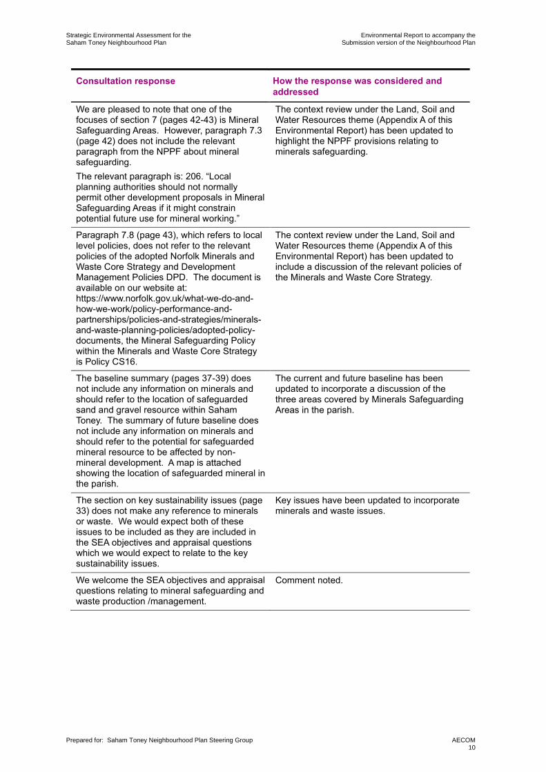
Consultation response How the response was considered and addressed
We are pleased to note that one of the focuses of section 7 (pages 42-43) is Mineral Safeguarding Areas. However, paragraph 7.3 (page 42) does not include the relevant paragraph from the NPPF about mineral safeguarding.
The relevant paragraph is: 206. “Local planning authorities should not normally permit other development proposals in Mineral Safeguarding Areas if it might constrain potential future use for mineral working.”
The context review under the Land, Soil and Water Resources theme (Appendix A of this Environmental Report) has been updated to highlight the NPPF provisions relating to minerals safeguarding.
Paragraph 7.8 (page 43), which refers to local level policies, does not refer to the relevant policies of the adopted Norfolk Minerals and Waste Core Strategy and Development Management Policies DPD. The document is available on our website at: https://www.norfolk.gov.uk/what-we-do-and-how-we-work/policy-performance-and-partnerships/policies-and-strategies/minerals-and-waste-planning-policies/adopted-policy-documents, the Mineral Safeguarding Policy within the Minerals and Waste Core Strategy is Policy CS16.
The context review under the Land, Soil and Water Resources theme (Appendix A of this Environmental Report) has been updated to include a discussion of the relevant policies of the Minerals and Waste Core Strategy.
The baseline summary (pages 37-39) does not include any information on minerals and should refer to the location of safeguarded sand and gravel resource within Saham Toney. The summary of future baseline does not include any information on minerals and should refer to the potential for safeguarded mineral resource to be affected by non-mineral development. A map is attached showing the location of safeguarded mineral in the parish.
The current and future baseline has been updated to incorporate a discussion of the three areas covered by Minerals Safeguarding Areas in the parish.
The section on key sustainability issues (page Key issues have been updated to incorporate 33) does not make any reference to minerals minerals and waste issues. or waste. We would expect both of these issues to be included as they are included in the SEA objectives and appraisal questions which we would expect to relate to the key sustainability issues.
We welcome the SEA objectives and appraisal Comment noted. questions relating to mineral safeguarding and waste production /management.
Prepared for: Saham Toney Neighbourhood Plan Steering Group AECOM 10
Strategic Environmental Assessment for the Environmental Report to accompany the Saham Toney Neighbourhood Plan Submission version of the Neighbourhood Plan
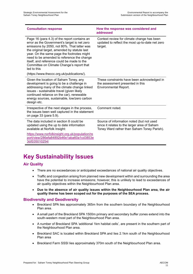
Consultation response How the response was considered and addressed
Page 16 (para 4.3) of the report contains an error as the Government’s target is net zero emissions by 2050, not 80%. That latter was the original target, amended by statute last year. On the same page the footnotes might need to be amended to reference the change itself, and reference could be made to the Committee on Climate Change’s report that led to this
(https://www.theccc.org.uk/publications/).
Context review for climate change has been updated to reflect the most up-to-date net zero target.
Given the location of Saham Toney, any These constraints have been acknowledged in development is going to be a challenge in the assessment presented in this addressing many of the climate change linked Environmental Report. issues - sustainable travel (given likely continued reliance on the car), renewable energy sources, sustainable, low/zero carbon design etc.
Irrespective of the next stages in the process, Comment noted. the issues been well captured in the statement on page 33 (para 5.9).
The data included in section 8 could be Source of information noted (but not used updated using the up to date information since it relates to the larger area of Saham available at Norfolk Insight: Toney Ward rather than Saham Toney Parish).
https://www.norfolkinsight.org.uk/population/re port/view/286efa84892b46e1aba60a1cd3853e 3d/E05010254/
Key Sustainability Issues Air Quality
• There are no exceedances or anticipated exceedances of national air quality objectives.
• Traffic and congestion arising from planned new development within and surrounding the area have the potential to increase emissions; however, this is unlikely to lead to exceedances of air quality objectives within the Neighbourhood Plan area.
• Due to the absence of air quality issues within the Neighbourhood Plan area, the air quality theme has been scoped out for the purposes of the SEA process.
Biodiversity and Geodiversity • Breckland SPA lies approximately 365m from the southern boundary of the Neighbourhood
Plan area.
• A small part of the Breckland SPA 1500m primary and secondary buffer zones extend into the south-western most part of the Neighbourhood Plan area.
• A number of Breckland SPA ‘additional 1km habitat cells’, are present in the southern part of the Neighbourhood Plan area.
• Breckland SAC is located within Breckland SPA and lies 2.1km south of the Neighbourhood Plan area
• Breckland Farm SSSI lies approximately 370m south of the Neighbourhood Plan area.
Prepared for: Saham Toney Neighbourhood Plan Steering Group AECOM 11

Strategic Environmental Assessment for the Environmental Report to accompany the Saham Toney Neighbourhood Plan Submission version of the Neighbourhood Plan
• There are nine County Wildlife Sites within the Neighbourhood Plan area; along with BAP priority habitats, namely; good quality semi-improved grassland (non-priority) and deciduous woodland.
Climate Change • Any increases in the built footprint of the Neighbourhood Plan area (including associated with
the delivery of new housing and employment land) has the potential to increase overall greenhouse gas emissions in the parish.
• Breckland has lower per capita emissions in comparison to Norfolk and England as a whole since 2005.
• Breckland has seen a 33.7% reduction in the percentage of total emissions per capita between 2005 and 2016, lower than the reductions for Norfolk (34.1%) and England (37.6%)
• The areas at highest risk of fluvial flooding (Flood Zone 3) in the Neighbourhood Plan area are those adjacent to Watton Brook.
• Within Saham Toney, there are various areas of land at medium and high risk of surface water flooding (including surrounding Watton Brook).
• Norfolk County Council’s 2017 Flood Investigation Report into flooding in Watton and the surrounding area identifies 100 residential and 4 non-residential properties at risk of surface water flooding in Saham Toney.
Landscape • The Neighbourhood Plan area lies within the ‘Mid Norfolk’ NCA which has unique landscape
characteristics.
• The Saham Toney Parish Landscape Character Assessment 7 splits the parish into five rural character areas and six village character areas and identifies a number of areas as having high landscape and/or visual sensitivity.
• The potential effects of development proposed through the Saham Toney Neighbourhood Plan may have implications for the overall character and appearance of landscape and townscape character Saham Toney in the future.
Historic Environment • The Neighbourhood Plan area contains one Grade I and ten Grade II nationally designated
listed buildings which are protected through the Listed Buildings and Conservation Areas Act 1990.
• There are two scheduled monuments located within the Neighbourhood Plan area.
• The Norfolk Historic Environment Record identifies Roman roads, Roman stones, Roman forts, Neolithic flint implements, Neolithic flint axes and Medieval objects within Saham Toney.
Land, Soil and Water Resources • There is a lack of evidence to ascertain agricultural land quality within the Neighbourhood
Plan area. However national provisional quality datasets indicate that the majority of land within the Neighbourhood Plan area is Grade 3; as part of a precautionary principle it is noted that there is the potential for loss of high quality (Grade 3a ‘best and most versatile’) agricultural land.
• The Neighbourhood Plan area lies within the Ely Ouse and Cut-off channel Nitrate Vulnerable Zone.
• Watton Brook has an overall water quality classification of ‘moderate’.
• Three areas of the parish are covered by Minerals Safeguarding Areas related to sand and gravel.
• Development in the parish has the potential to increase the Neighbourhood Plan’s waste management requirements.
7 Lucy Batchelor-Wylam, CMLI, January 2019
Prepared for: Saham Toney Neighbourhood Plan Steering Group AECOM 12

Strategic Environmental Assessment for the Environmental Report to accompany the Saham Toney Neighbourhood Plan Submission version of the Neighbourhood Plan
Population and Community • The population of Saham Toney decreased by 3.7% between 2001 and 2011, whereas
Breckland, the East of England and England all increased in population. The Office for National Statistics population estimate for the Parish in 2018 was 1,561.
• Generally, there is a higher proportion of residents within the 60+ age category within the Neighbourhood Plan area (40.0%) in comparison to the total for Breckland (29.1%), the East of England (23.9%) and England (22.3%).
• The proportion of residents with the 60+ age category is likely to continue to increase
• The two Lower Layer Super Output Areas (LSOA) which cover the Neighbourhood Plan area are within the 50% least and 50% most deprived neighbourhoods in England respectively.
• 77.4% of residents either own their home outright or with a mortgage, higher than the totals for Breckland (68.6%), the East of England (67.6%) and England (63.3%).
• The Neighbourhood Plan area has access to a range of local community facilities. A wide range of shops and services are available in Watton, which serve the needs of the local community.
Health and Wellbeing • The public health profile for Breckland outlines that life expectancy is lower for both men and
women in Breckland than the England average.
• 79.0% of residents in the Neighbourhood Plan area consider themselves as having ‘very good health’ or ‘good health’, similar to the totals for Breckland (79.5%), but a little lower than the East of England (82.5%) and England (81.4%).
• A higher proportion of residents within the Neighbourhood Plan area report that their activities are limited in some way compared to regional and national averages.
Transportation • There are no railway stations located within the Neighbourhood Plan area. The nearest
railway stations are Harling Road (south of the Neighbourhood Plan area) and Attleborough (east of the Neighbourhood Plan area), both approximately 14km from the Neighbourhood Plan area.
• The Neighbourhood Plan area is linked to the surrounding road network, with access to the A1075 and the B1108.
• Residents have access to a limited network of pedestrian footways and local cycle routes within the Neighbourhood Plan area.
Prepared for: Saham Toney Neighbourhood Plan Steering Group AECOM 13

Strategic Environmental Assessment for the Environmental Report to accompany the Saham Toney Neighbourhood Plan Submission version of the Neighbourhood Plan
SEA Framework
Baseline information (including the context review and baseline data) is presented in Appendix
A. The key sustainability issues and SEA Framework are presented below.
Table 3.2: SEA Framework for the Saham Toney Neighbourhood Plan
SEA Objective Assessment questions
Biodiversity and Geodiversity
Protect and enhance
all biodiversity and
geodiversity
Climate change
Reduce the contribution to climate
change made by activities within the
Neighbourhood Plan area
Support the resilience
of the Neighbourhood
Plan area to the potential effects of climate change,
including flooding
Will the option/proposal help to:
• Support the status of the internationally, nationally and locally designated sites within and within proximity to the Neighbourhood
Plan area including the Breckland SPA, the Breckland SAC and the
Breckland Farm SSSI?
• Achieve a net gain in biodiversity?
• Support enhancements to multifunctional green infrastructure
networks?
• Support access to, interpretation and understanding of biodiversity and geodiversity?
• Increase the resilience of ecological networks to the likely effects of climate change?
Will the option/proposal help to:
• Reduce the number of journeys made?
• Reduce the need to travel?
• Promote the use of sustainable modes of transport, including walking, cycling and public transport?
• Increase the number of new developments meeting or exceeding sustainable design criteria?
• Generate energy from low or zero carbon sources?
• Reduce energy consumption from non-renewable resources?
Will the option/proposal help to:
• Ensure that inappropriate development does not take place in areas at higher risk of flooding, taking into account the likely future effects of climate change?
• Improve and extend green infrastructure networks in the plan area to
support adaptation to the potential effects of climate change?
• Sustainably manage water run-off, reducing surface water runoff
(either within the plan area or downstream)?
• Ensure the potential risks associated with climate change are
considered through new development in the Neighbourhood Plan area?
• Increase the resilience of biodiversity in the area to the effects of climate change, including through enhancements to ecological networks?
Prepared for: Saham Toney Neighbourhood Plan Steering Group AECOM 14

Strategic Environmental Assessment for the Environmental Report to accompany the Saham Toney Neighbourhood Plan Submission version of the Neighbourhood Plan
Landscape
Protect and enhance
the character and
quality of landscapes and villagescapes.
Will the option/proposal help to:
• Conserve and enhance locally important landscape and villagescape
features within the Neighbourhood Plan area?
• Conserve and enhance local diversity and character?
• Ensure development is undertaken in conjunction with the planning guidelines outlined in the Saham Toney Parish Landscape Character
Assessment for the relevant landscape character areas?
Historic Environment
Protect, conserve and
enhance heritage assets within the Neighbourhood Plan area
Will the option/proposal help to:
• Conserve and enhance the significance of buildings and structures of architectural or historic interest, both designated and non-
designated, and their setting?
• Conserve and enhance the special interest, character and
appearance of locally important features and their settings?
• Support the integrity of the historic setting of key buildings of cultural heritage interest as listed on the Norfolk HER?
• Support access to, interpretation and understanding of the historic evolution and character of the environment?
• Conserve and enhance archaeological remains, including historic landscapes?
• Support the undertaking of archaeological investigations and, where
appropriate, recommend mitigation strategies?
Land, Soil and Water Resources
Ensure the efficient
and effective use of
land.
Will the option/proposal help to:
• Promote the use of previously developed land?
• Avoid the development of the best and most versatile agricultural land, which in the parish may comprise 3a agricultural land?
• Protect the integrity of mineral safeguarding areas?
Promote sustainable
waste management
solutions that
encourage the reduction, re-use and
recycling of waste.
Will the option/proposal help to:
• Reduce the amount of waste produced?
• Support the minimisation, reuse and recycling of waste?
• Maximise opportunities for local management of waste in order to
minimise export of waste to areas outside?
• Encourage recycling of materials and minimise consumption of
resources during construction?
Use and manage Will the option/proposal help to: water resources in a sustainable manner. • Support improvements to water quality?
• Minimise water consumption?
• Protect surface water resources?
Prepared for: Saham Toney Neighbourhood Plan Steering Group AECOM 15

Strategic Environmental Assessment for the Environmental Report to accompany the Saham Toney Neighbourhood Plan Submission version of the Neighbourhood Plan
Population and Community
Cater for existing and future residents’ needs as well as the needs of
different groups in the
community, and improve access to local, high-quality community services and facilities.
Will the option/proposal help to:
• Encourage and promote social cohesion and encourage active
involvement of local people in community activities?
• Minimise fuel poverty?
• Maintain or enhance the quality of life of existing local residents?
• Improve the availability and accessibility of key local facilities,
including specialist services for disabled and older people?
• Provide additional community infrastructure to meet existing and
future deficits? Reduce deprivation and promote a more inclusive and self-contained community.
Provide everyone with
the opportunity to live
in good quality, affordable housing, and ensure an appropriate mix of dwelling sizes, types and tenures.
Will the option/proposal help to:
• Support the provision of a range of house types and sizes?
• Support enhancements to the current housing stock?
• Meet the needs of all sectors of the community?
• Provide quality and flexible homes that meet people’s needs?
• Promote the use of sustainable building techniques, including use of sustainable building materials in construction?
• Provide housing in sustainable locations that allow easy access to a
range of local services and facilities?
Health and Wellbeing
Improve the health and Will the option/proposal help to: wellbeing residents within the Neighbourhood Plan
• Promote accessibility to a range of leisure, health and community facilities, for all age groups?
area. • Provide and enhance the provision of community access to green infrastructure, in accordance with Accessible Natural Greenspace Standards?
• Promote the use of healthier modes of travel?
• Improve access to the countryside for recreational use?
• Avoiding any negative impacts to the quality and extent of existing recreational assets, such as formal or informal footpaths?
Transportation
Promote sustainable
transport use and
reduce the need to travel.
Will the option/proposal help to:
• Encourage a shift to more sustainable forms of travel?
• Facilitate working from home and remote working?
• Improve road safety?
• Reduce the impact on residents from the road network?
Prepared for: Saham Toney Neighbourhood Plan Steering Group AECOM 16

Strategic Environmental Assessment for the Environmental Report to accompany the Saham Toney Neighbourhood Plan Submission version of the Neighbourhood Plan
4. What has plan making / SEA involved up to this point?
Introduction In accordance with the SEA Regulations the Environmental Report must include:
• An outline of the reasons for selecting the alternatives dealt with; and
• The likely significant effects on the environment associated with alternatives / an outline of
the reasons for selecting the preferred approach in light of alternatives appraised.
The ‘narrative’ of plan-making / SEA up to this point is told within this part of the Environmental Report. The following sections therefore describe how the SEA process to date has informed the preferred development strategy for the Neighbourhood Plan area and potential locations for
development. Specifically, this chapter explains how the Saham Toney Neighbourhood Plan’s development strategy has been shaped through considering alternative approaches for the location of housing in the Neighbourhood Plan area.
Overview of plan making / SEA work undertaken since 2016
Saham Toney Neighbourhood Plan’s preparation began in 2016, initiated by Saham Toney Parish Council. It has been led by the Neighbourhood Plan Work Group, which includes volunteers from the local community, supported by representatives of the Parish Council.
Significant public consultation has been carried out to date to support the Neighbourhood Plan.
This has gathered local views and opinions, with a view to engaging local people throughout
the Neighbourhood Plan’s preparation process. This has included events, engagement
workshops, community questionnaires, exhibitions and publicity exercises. An initial Regulation 14 consultation on a draft plan was undertaken in March/April 2018, and after significant update of the Plan, a further Regulation 14 pre-submission consultation was undertaken between August and October 2019. After further updates of the Plan, which included a reduction in the number of dwellings allocated, a third Regulation 14 pre-submission consultation was undertaken between June and August 2020. A parallel pre-submission consultation on this Environmental Report was undertaken over the same period
The Consultation Statement which will accompany the Neighbourhood Plan at submission will describe in detail how the community has been involved during the development of the
Neighbourhood Plan. That statement will also describe the results of consultation on this Environmental Report.
Housing numbers to deliver through the Neighbourhood Plan
As discussed in Chapter 2 above, the Saham Toney Neighbourhood Plan is being prepared in
the context of the adopted Breckland Local Plan (2019)8 .
In the Local Plan, Saham Toney has been designated as one of seventeen ‘Villages with Boundaries’, meaning that the village has a designated settlement boundary. Policy HOU 04 (Villages with Boundaries) indicates that appropriate development will be allowed immediately adjacent to the settlement boundary, subject to being supported by other policies within the development plan and where all of the following criteria are satisfied:
8 Breckland Council (2019) Breckland Local Plan. [online] available at https://www.breckland.gov.uk/adoption [accessed 14/01/2020]
Prepared for: Saham Toney Neighbourhood Plan Steering Group AECOM 17

Strategic Environmental Assessment for the Environmental Report to accompany the Saham Toney Neighbourhood Plan Submission version of the Neighbourhood Plan
• The development is of an appropriate scale and design to the settlement;
• It would not lead to the number of dwellings in the settlement increasing by significantly more than 5% from the date of adoption of the Plan. The settlement refers to the number of buildings inside the defined settlement boundary;
• The design contributes to preserving, and where possible enhancing, the historic nature and connectivity of communities; and
• The development avoids coalescence of settlements.
• In addition, windfall development is allowed inside the settlement boundary.
Appendix 5 of the Breckland Local Plan also indicates that the minimum number of dwellings to
be built over the plan period to 2036 in Saham Toney is 33 (representing 5% growth of the number of dwellings in the settlement from the date of adoption of the Local Plan).
Whilst the minimum number of homes to deliver through the Neighbourhood Plan is 33 dwellings, the Neighbourhood Plan Steering Group recognise that there is a need to deliver
homes of a type and tenure in the parish which meets the needs of the community. In response
to this, a Housing Needs Assessment was undertaken for Saham Toney Parish between
January and March 2019.9 This sought to establish what type and tenure of housing is required in the parish over the plan period, based on unconstrained demand and need as opposed to development constraints.
The key conclusions of the Housing Needs Assessment were as follows:
• Housing needs in Saham Toney Parish differ from those for Breckland as a whole.
• Greater focus on the needs of younger adults and older people is required; housing development over recent years have not sufficiently addressed those needs.
• There tends to be an over-supply of four or more-bedroom properties and a corresponding undersupply of one and two bedroom properties, and to a certain extent also of three-bedroom properties.
• The ratio of house prices to local wages mean it is very difficult for many young people locally to enter the property market.
• There is an insufficient amount of social housing available to meet demand (as evidenced by the Breckland housing register data).
• To satisfactorily address parish housing needs, residential development in Saham Toney over the coming years should focus on the supply of one, two and three-bedroom properties, that for both market and social housing are more genuinely affordable to those seeking such homes.
Additionally the minimum number of new dwellings required by the Local Plan was reviewed in
the light of (a) updated household projections for Breckland published in September 2018, but
not addressed in the Local Plan, and (b) an affordability factor as set out in Planning Practice
Guidance, but also not addressed in the Local Plan. The results of that review are given in the
Justification of a Minimum Housing Target for the Saham Toney Neighbourhood Plan, April 2020. The review concluded that a more appropriate minimum housing target for the
Neighbourhood Area is 48 new dwellings over the period to 2036.
In recognition of both these findings, it was considered that the minimum delivery of 33 homes through the Neighbourhood Plan would potentially not deliver the number and type/tenure of homes required in the parish, including affordable homes, market and social housing, smaller
homes, and homes for younger and older people. In addition, there was a recognition that
there is a need to “future-proof” the Neighbourhood Plan area against any increase in national or district housing requirements that may arise during the time period of the plan due to changing circumstances. As such, it was recognised that the possibility of delivering an
9 Saham Toney Parish Council (May 2019) Saham Toney Parish Housing Needs Assessment
Prepared for: Saham Toney Neighbourhood Plan Steering Group AECOM 18

Strategic Environmental Assessment for the Environmental Report to accompany the Saham Toney Neighbourhood Plan Submission version of the Neighbourhood Plan
additional level of housing through allocations should be explored through the Neighbourhood Plan’s development process.
For these reasons, and to provide the community and others with greater certainty about the type, extent and location of future residential development, the Neighbourhood Plan Steering Group decided to allocate sites in the Neighbourhood Plan, with the aim of delivering a range of
housing through the Neighbourhood Plan, including over and above the minimum 33 dwelling
housing delivery target set out in the Local Plan.
Assessment of alternative development strategies for the Neighbourhood Plan
Site assessment undertaken for the Neighbourhood Plan In late 2018, as part of its site allocation process, the Neighbourhood Plan Steering Group
commissioned independent site assessment of potential residential development sites.10 The purpose of the site assessment was to deliver an independent and objective assessment of the sites that had been identified as potentially available for allocation through the Neighbourhood Plan. The site assessment was undertaken through an assessment of whether the sites were
suitable, available and achievable.
The site assessment considered 18 sites, including 16 identified through a ‘call for sites’ process undertaken between August and October 2018 and consideration of two other sites that were the subject of undecided planning applications at the time of the assessment.
Following consideration of the site assessment and other evidence base studies, it was determined that the eleven of the sites would be appropriate for further consideration for the purposes of the Neighbourhood Plan.
These sites were as follows:
Table 4.1: Sites identified for further consideration through the Neighbourhood Plan
Site number Site address
STNP1 Pages Lane, The Grange, Pig Farm
STNP2 Croft Pig Unit (disused), 69 Hills Road
STNP4 West side of Pound Hill near its junction with Pages Lane
STNP5 Pound Hill east
STNP6 Pages Lane
STNP7 Page’s Farm (disused), Page’s Lane.
STNP9 Ovington Road, close to Brick Kiln Farm
STNP13 Hill Farm
STNP14 Croft Field, Hills Road
STNP15 8 Richmond Road
STNP16 Land adjacent to Richmond Hall, Richmond Road
10 AECOM (June 2019) Saham Toney Neighbourhood Development Plan Site Assessment
Prepared for: Saham Toney Neighbourhood Plan Steering Group AECOM 19

Strategic Environmental Assessment for the Environmental Report to accompany the Saham Toney Neighbourhood Plan Submission version of the Neighbourhood Plan
Assessment of development strategy options To inform the development of a spatial strategy to deliver housing of an appropriate type and
tenure through the Neighbourhood Plan, the SEA process has considered five development
strategy options. The options, which comprise different combinations of the eleven sites identified above, are as given in Table 4.2. Figure 4.1 (overleaf) visually represents these
options. The reasons for selection of each option were as follows:
• Option A: In response to a consultation representation by the landowners of sites STNP4 – 7, which proposed an increased allocation of dwellings on those four sites;
• Option B: An adjustment to the ‘base case’ arising from the conclusions of masterplanning studies11 for sites STNP1, 4, 5, 6 and 7, which highlighted unacceptable landscape character impact from STNP 5 and 6;
• Option C: The highest ranked sites as identified by the Site Selection Report, required to satisfy the minimum housing target (33) specified in the Local Plan; and
• Option D: The highest ranked sites as identified by the Site Selection Report, required to satisfy the minimum housing target (48) for the Neighbourhood Plan.
• Option E: The ‘base case’ as established by the Saham Toney Neighbourhood Plan Site Selection Report, first edition, July 2019;
Table 4.2: Development strategy options assessed as reasonable alternatives
Development Sites included in option (and number of dwellings to be Total number strategy delivered on each site) of dwellings option
Option A STNP1 (10); STNP2 (4); STNP4 (18); STNP5 (22);
STNP6 (10); STNP7 (12); STNP9 (3); STNP13 (5); STNP14 (5); STNP15 (6); and STNP16 (12)
107
Option B STNP1 (10); STNP2 (4); STNP4 (17); STNP7 (8); STNP9 (3);
STNP13 (5); STNP14 (5); STNP15 (6) and STNP16 (12) 70
Option C STNP1 (10); STNP2 (4); STNP7 (8) and STNP16 (12) 34
Option D STNP1 (10); STNP2 (4), STNP4 (13); STNP7 (8); STNP15 (6)
and STNP16 (12) 53
Option E STNP1 (10); STNP2 (4); STNP4 (13); STNP5 (12); STNP6 (5);
STNP7 (8); STNP9 (3); STNP13 (5); STNP14 (5); STNP15 (6)
and STNP16 (12)
83
Tables 4.3 to 4.10 below present the findings of the assessment of these five development
strategy options. The assessment has explored the relative merits of different spatial strategies for the Neighbourhood Plan in relation to the eight SEA themes.
To support the assessment findings, the options have been ranked in terms of their sustainability performance against each of the key sustainability issues described in Chapter 3.
It is intended that this will provide a basic indication of the relative sustainability merits of the options in relation to each key issue considered. An appreciation of those relative merits was a
useful tool to aid the plan-making group in its selection of a final option to carry forward through
the Neighbourhood Plan.
11 Saham Toney Masterplanning Report, AECOM, February 2020
Prepared for: Saham Toney Neighbourhood Plan Steering Group AECOM 20

Strategic Environmental Assessment for the Saham Toney NeighbourhoodPlan
Environmental Report to accompany theRegulation 14 version of the Neighbourhood Plan
Prepared for: Saham Toney Neighbourhood Plan Steering Group AECOM21

Strategic Environmental Assessment for the Environmental Report to accompany the Saham Toney Neighbourhood Plan Submission version of the Neighbourhood Plan
Table 4.3: Assessment of development strategy options: Biodiversity and Geodiversity
Option A: Sites STNP1, STNP2, STNP4, STNP5, STNP6, STNP7, STNP9, STNP13, STNP14, STNP15 and STNP16 (total 107 dwellings)
Option B: Sites STNP1, STNP2, STNP4, STNP7, STNP9, STNP13, STNP14, STNP15 and STNP16 (total 70 dwellings)
Option C: Sites STNP1, STNP2, STNP7 and STNP16 (total 34 dwellings)
Option D: Sites STNP1, STNP2, STNP4, STNP7, STNP15 and STNP16 (total 53 dwellings)
Option E: Sites STNP1, STNP2, STNP4, STNP5, STNP6, STNP7, STNP9, STNP13, STNP14, STNP15 and STNP16 (total 83 dwellings)
Discussion of potential effects and relative merits of options: Biodiversity and Geodiversity The proposed development areas put forward through all five options are within an SSSI Impact Risk Zone for “All planning applications (except householder12) outside or extending outside existing settlements/urban areas affecting greenspace, farmland, semi natural habitats or landscape features such as trees, hedges, streams, rural buildings/structures.”13 This relates to the Breckland Farmland SSSI (much of which is also internationally designated as the Breckland SAC/SPA), and south of the parish boundary, Wayland Wood, Watton SSSI. As such, all options have the potential to have impacts on SSSI IRZs without careful management of new development and the integration of appropriate mitigation and avoidance measures. However, the options delivering the highest level of housing (Options A and E) have increased potential to lead to effects on these nationally designated sites given the increased potential for impacts on features of biodiversity value from development. Whilst none of the sites proposed as allocations through the options have Biodiversity Action Plan Priority Habitats present on or adjacent to the site, all of the sites have some potential ecological value. In particular, development at site STNP16, which would be taken forward through all options has the potential to lead to impacts on biodiversity. This is because it is located adjacent to a County Wildlife Site and is close to areas covered by the Breckland SPA Primary Buffer Zone. Whilst development on the site would not lead to the direct loss of land within these areas, the site has some biodiversity value, including associated with on-site habitats where protected species may be present. Development at the site may therefore impact on habitats which form important components of local ecological networks linking these areas. None of the other sites considered through the options are located on or adjacent to a County Wildlife Site or the SPA Buffer Zone. However, sites STNP1, 4, 5, 6, 7, 9, 15 and 16 are within 1km cells where RSPB data was insufficient to provide for full analysis, which have been identified as potentially also supporting functionally linked habitat to the SPA. Overall, the delivery of a higher level of development in Saham Toney has the potential to result in an increased negative effect on biodiversity in and around the village. This includes through loss of habitats, ecological connections and key landscape features of biodiversity value. As such, Options A and E have increased potential to lead to negative impacts on biodiversity when compared to the remaining options. It should be noted though that a larger scale of housing delivery may increase opportunities for biodiversity enhancements in the Neighbourhood Plan area through developer led contributions. Whilst all allocations have the potential to lead to adverse impacts on biodiversity allocations, they also have the potential to promote net gains in biodiversity value if appropriate measures are included in relevant policies of the Neighbourhood Plan. Therefore, potential effects on biodiversity will vary depending on the specific site plans, Neighbourhood Plan policies and developer-led contributions. The introduction of the Environment Bill, which seeks to implement a new duty for developers to deliver ten per cent net biodiversity gain in new schemes, is also a consideration in the longer term. However, whilst bearing this inherent uncertainty in mind, it is considered that an increased level of housing delivery in the Neighbourhood Plan area has additional potential to result in negative impacts on the parish’s biodiversity resource in the short and medium term through impacting on established habitats and ecological networks.
Rank of relative sustainability performance
Option A Option B Option C Option D Option E
5 3 1 2 4
12 Proposals to alter or enlarge a single existing dwelling 13 Impact Risk Zones (IRZs) are a GIS tool developed by Natural England to make rapid initial assessment of the potential risks posed by development proposals to: Sites of Special Scientific Interest (SSSIs), Special Areas of Conservation (SACs), Special
Prepared for: Saham Toney Neighbourhood Plan Steering Group AECOM 22

Strategic Environmental Assessment for the Environmental Report to accompany the Saham Toney Neighbourhood Plan Submission version of the Neighbourhood Plan
Table 4.4: Assessment of development strategy options: Climate Change
Option A: Sites STNP1, STNP2, STNP4, STNP5, STNP6, STNP7, STNP9, STNP13, STNP14, STNP15 and STNP16 (total 107 dwellings)
Option B: Sites STNP1, STNP2, STNP4, STNP7, STNP9, STNP13, STNP14, STNP15 and STNP16 (total 70 dwellings)
Option C: Sites STNP1, STNP2, STNP7 and STNP16 (total 34 dwellings)
Option D: Sites STNP1, STNP2, STNP4, STNP7, STNP15 and STNP16 (total 53 dwellings)
Option E: Sites STNP1, STNP2, STNP4, STNP5, STNP6, STNP7, STNP9, STNP13, STNP14, STNP15 and STNP16 (total 83 dwellings)
Discussion of potential effects and relative merits of options: Climate Change In terms of climate change mitigation, the options which facilitate an additional level of development (Option A and Option E) will potentially lead to an increased level of greenhouse gas emissions due to an enlarged built footprint of the parish unless appropriate climate change adaptation and mitigation measures are introduced. All of the options will promote development which is accessible by foot to the limited range of facilities in Saham Toney. However, most journeys for key services and amenities will be made to locations outside of the parish, notably Watton. Options A and E, through focusing a greater proportion of the overall development on sites located adjacent to each other, may do more than the other options (which promote a greater proportion of the overall allocations on sites dispersed around the parish) to enable enhancements to infrastructure provision to be delivered. This includes through the potential delivery of on-site community and social infrastructure and enhanced walking and cycling networks. This may help limit the need to travel by the private car. Overall however, Option A and E are most likely of the options to lead to the largest increases in emissions through facilitating additional growth in the parish. In relation to adapting to the effects of climate change, all of the sites proposed through the options are within a Flood Zone 1 for fluvial flooding. This denotes that the area has less than a 1 in 1,000 annual probability of river flooding (taking into account the effect of any flood defences in the area). A number of the sites however have areas of surface water flood risk which may affect development, (as identified through the Government’s Flood Map for Planning). These are: site STNP1 (taken forward through all five options); site STNP4 (taken forward through Options A, B, D and E); site STNP5 (taken forward through A and E); site STNP6 (taken forward through A and E); site STNP7 (taken forward through all options); site STNP9 (taken forward through A, B and E); and site STNP15 (taken forward through A, B, D and E). Much of the parish also has a high groundwater level which can contribute to flooding as it hinders rainfall infiltration. This has the potential to affect all of the site allocations taken forward through the options. In light of these issues, the Lead Local Flood Authority (LLFA), Norfolk County Council, considered the flood risk issues which have the potential to affect allocations at each of the sites brought forward through the Neighbourhood Plan’s call for sites. Of the sites taken forward by the five options, none of these were highlighted by the LLFA as having flood risk constraints that would prevent development. However, the LLFA highlighted that site STNP7 (taken forward through all options) would only be suitable subject to a reduction in site size (as a result, the original proposal for 35 houses on a site of 1.86 ha was reduced to 8 houses on a site of 0.54 ha, and it is the latter that is taken forward through all options). Given that areas of flood risk are limited within site boundaries, and can be readily avoided through careful location of new development areas, flood risk is unlikely to comprise a significant constraint to development through all options if avoidance and mitigation measures are implemented. Likewise, it is also considered that the provisions of the NPPF and national policy (including relating to the sequential / exception test) will help guide development away from potential flood risk areas and ensure that appropriate mitigation measures are implemented. There would continue to be a need for potential surface and groundwater flood risk issues to be addressed through development however.
Rank of relative sustainability performance
Option A Option B Option C Option D Option E
5 3 1 2 4
Protection Areas (SPAs) and Ramsar sites. They define zones around each SSSI which reflect the particular sensitivities of the features for which it is notified and indicate the types of development proposal which could potentially have adverse impacts. IRZs are used to consider whether there will be a need to consult Natural England to seek advice on the nature of any potential impacts and how they might be avoided or mitigated.
Prepared for: Saham Toney Neighbourhood Plan Steering Group AECOM 23

Strategic Environmental Assessment for the Environmental Report to accompany the Saham Toney Neighbourhood Plan Submission version of the Neighbourhood Plan
Table 4.5: Assessment of development strategy options: Landscape
Option A: Sites STNP1, STNP2, STNP4, STNP5, STNP6, STNP7, STNP9, STNP13, STNP14, STNP15 and STNP16 (total 107 dwellings)
Option B: Sites STNP1, STNP2, STNP4, STNP7, STNP9, STNP13, STNP14, STNP15 and STNP16 (total 70 dwellings)
Option C: Sites STNP1, STNP2, STNP7 and STNP16 (total 34 dwellings)
Option D: Sites STNP1, STNP2, STNP4, STNP7, STNP15 and STNP16 (total 53 dwellings)
Option E: Sites STNP1, STNP2, STNP4, STNP5, STNP6, STNP7, STNP9, STNP13, STNP14, STNP15 and STNP16 (total 83 dwellings)
Discussion of potential effects and relative merits of options: Landscape Through increasing the scale of development to be taken forward in Saham Toney for the purposes of the Neighbourhood Plan, Option A, and to a lesser extent, Option E, have greater potential to lead to significant impacts on landscape character in the area. Potential impacts include through loss of landscape features, visual impacts and impacts on noise quality linked to increased traffic flows. In this context Options C and D, through promoting a more limited scale of development, are less likely to lead to significant effects on landscape and villagescape character in Saham Toney. In terms of the findings of the Saham Toney Parish Landscape Character Assessment, five of the sites proposed through the options are within an area of ‘moderate-high’ combined landscape sensitivity, that has high visual sensitivity. These are: site STNP1 (taken forward through all five options); site STNP2 (taken forward through all options); site STNP4 (taken forward through Options A, B, D and E); Site STNP5 (taken forward through A and E); site STNP6 (taken forward through Options A and E); and site STNP7 (taken forward through all options). All the other sites have been evaluated as being within areas of ‘medium’ combined landscape sensitivity. However, site STNP16 (taken forward through all options), whilst not in an area of higher landscape sensitivity, is located in an area which is not within the curtilage of the village’s existing settlement pattern. This increases the potential for development at this location to lead to additional impacts on landscape character. In the context of these sensitivities, a number of the options, through focusing development in certain vicinities of the village, have increased potential to lead to landscape and villagescape character impact at particular locations. In this respect Options A and E have the potential to have additional impacts on landscape and villagescape character in the vicinity of Pages Lane and Pound Hill through delivering an additional level of infill in this part of the village. These options will lead to cumulative and synergistic effects on landscape character in the area, including through affecting the open perspective between existing clusters of buildings. This has the potential to be significant given the open aspect of this part of the village. Similarly, the options, through taking forward site STNP16, has additional potential to lead to impacts on landscape and villagescape character to the west of Richmond Road, including through promoting development which is outside of the existing settlement pattern of the village. Impacts however depend on the specific layout of development, design measures and the integration of appropriate green infrastructure provision within new development areas. In this respect there is the potential for all of the options to limit potential effects through appropriate location, high quality design and the provision of new planting and open space provision.
Rank of relative sustainability performance
Option A Option B Option C Option D Option E
5 3 1 2 4
Prepared for: Saham Toney Neighbourhood Plan Steering Group AECOM 24

Strategic Environmental Assessment for the Environmental Report to accompany the Saham Toney Neighbourhood Plan Submission version of the Neighbourhood Plan
Table 4.6: Assessment of development strategy options: Historic Environment
Option A: Sites STNP1, STNP2, STNP4, STNP5, STNP6, STNP7, STNP9, STNP13, STNP14, STNP15 and STNP16 (total 107 dwellings)
Option B: Sites STNP1, STNP2, STNP4, STNP7, STNP9, STNP13, STNP14, STNP15 and STNP16 (total 70 dwellings)
Option C: Sites STNP1, STNP2, STNP7 and STNP16 (total 34 dwellings)
Option D: Sites STNP1, STNP2, STNP4, STNP7, STNP15 and STNP16 (total 53 dwellings)
Option E: Sites STNP1, STNP2, STNP4, STNP5, STNP6, STNP7, STNP9, STNP13, STNP14, STNP15 and STNP16 (total 83 dwellings)
Discussion of potential effects and relative merits of options: Historic Environment In relation to historic environment constraints, a key feature with the potential to be affected by development taken forward by the options is the Grade II listed Page’s Place, which dates from the late 16th / early 17th century and is located on Page’s Lane. In this context development of sites STNP6 and STNP7 may have particular potential to lead to impacts on the setting of this feature through impacts on views to and from the site, depending on screening measures and the design and layout of development. In this respect Options A and E, which take forward both sites, have most potential of the options to lead to significant in-combination impacts on the setting of this key feature of historic environment interest, with Options B and D having the potential to have less significant effects. Option C, which only takes forward site STNP7, has the least potential of the options to have significant effects.
Figure.4.2: location of Page’s Place Figure 4.3: Church of St George and The Old Rectory STNP15 is a further site which has the potential to impact on the setting of key historic environment assets in the parish. The site is located directly opposite the Grade II listed The Old Rectory and the Grade I listed Church of St George. Whilst the site is in a number of respects screened from these two key features of historic environment interest, inappropriate design and layout has the potential to have effects. This includes through the development of a previously undeveloped private garden and the demolishing of a residential dwelling. As such, Options A, B, D and E, through taking forward STNP15, all have the potential to impact on the setting of these assets without sensitive design and layout. In terms of other features recorded on the Norfolk Historic Environment Record, none of the sites proposed through the options have the potential to lead to development on or adjacent to these recorded archaeological sites and finds.
Rank of relative sustainability performance
Option A Option B Option C Option D Option E
5 2 1 3 4
Prepared for: Saham Toney Neighbourhood Plan Steering Group AECOM 25

Strategic Environmental Assessment for the Environmental Report to accompany the Saham Toney Neighbourhood Plan Submission version of the Neighbourhood Plan
Table 4.7: Assessment of development strategy options: Land, Soil and Water Resources
Option A: Sites STNP1, STNP2, STNP4, STNP5, STNP6, STNP7, STNP9, STNP13, STNP14, STNP15 and STNP16 (total 107 dwellings)
Option B: Sites STNP1, STNP2, STNP4, STNP7, STNP9, STNP13, STNP14, STNP15 and STNP16 (total 70 dwellings)
Option C: Sites STNP1, STNP2, STNP7 and STNP16 (total 34 dwellings)
Option D: Sites STNP1, STNP2, STNP4, STNP7, STNP15 and STNP16 (total 53 dwellings)
Option E: Sites STNP1, STNP2, STNP4, STNP5, STNP6, STNP7, STNP9, STNP13, STNP14, STNP15 and STNP16 (total 83 dwellings)
Discussion of potential effects and relative merits of options: Land, Soil and Water Resources Regarding the location of the best and most versatile land for agricultural purposes, a detailed agricultural land classification assessment has not been undertaken within the Neighbourhood Plan area. The provisional agricultural land classification dataset from Natural England suggests that most of the sites are underlain by Grade 3 (good to moderate) agricultural land. Given recent detailed classification has not been undertaken, it is uncertain whether this land comprises Grade 3a land (comprising land classified as the ‘best and most versatile’ (BMV), or Grade 3b land (which is not classified as such). However, the predictive BMV assessment undertaken in 2017 on behalf of Natural England14 suggests that most of the sites taken forward by the options are within a ‘moderate’ likelihood (20-60%) of taking place within an area of BMV land. The sites in the north of the area - STNP2, STNP13 and STNP14 - are in a location with ‘high’ likelihood (>60%) of being in a location underlain by BMV land. Therefore, Option A, B and E have most potential to lead to development which will result in the loss of BMV land. It should be noted though that all five options have the potential to result in the loss of BMV land and areas of greenfield land within the parish, and the additional loss of land which will take place through A and E have the most potential to lead to the loss of productive agricultural land. In terms of water resources, Anglian Water have stated that for all sites, infrastructure and/or treatment upgrades would be required to serve proposed growth in terms of water recycling capacity/sewerage. With regard to water supply, there is currently capacity available within the water supply network for the sites identified. Overall however, the options which deliver an increased level of growth would be most likely to require additional water resource infrastructure. In terms of water quality, it is difficult to come to a conclusion regarding the potential for development at any given location to result in negative effects without an understanding of the design measures that will be put in place. For example, sustainable drainage systems – SuDS – are an effective means of minimising surface water runoff and hence pollution. However, it should be noted that there is likely to be more scope for the implementation of measures such as SuDS within the larger scale of development promoted by Options A and E. There are no mineral safeguarding areas within the parish and as such, development will not compromise the integrity of mineral resources.
Rank of relative sustainability performance
Option A Option B Option C Option D Option E
5 3 1 2 4
14 Natural England (2017): ‘Likelihood of Best and Most Versatile (BMV) Agriculturaland – Strategic scale map Eastern Region’, [online] available to access via: < http://publications.naturalengland.org.uk/publication/6205542189498368?category=5208993007403008> last accessed [22/04/20]
Prepared for: Saham Toney Neighbourhood Plan Steering Group AECOM 26

Strategic Environmental Assessment for the Environmental Report to accompany the Saham Toney Neighbourhood Plan Submission version of the Neighbourhood Plan
Table 4.8: Assessment of development strategy options: Population and Community
Option A: Sites STNP1, STNP2, STNP4, STNP5, STNP6, STNP7, STNP9, STNP13, STNP14, STNP15 and STNP16 (total 107 dwellings)
Option B: Sites STNP1, STNP2, STNP4, STNP7, STNP9, STNP13, STNP14, STNP15 and STNP16 (total 70 dwellings)
Option C: Sites STNP1, STNP2, STNP7 and STNP16 (total 34 dwellings)
Option D: Sites STNP1, STNP2, STNP4, STNP7, STNP15 and STNP16 (total 53 dwellings)
Option E: Sites STNP1, STNP2, STNP4, STNP5, STNP6, STNP7, STNP9, STNP13, STNP14, STNP15 and STNP16 (total 83 dwellings)
Discussion of potential effects and relative merits of options: Population and Community Options A, E and B, through delivering an additional level of housing growth in Saham Toney, has increased potential to deliver a broader range of types and tenures of housing, including those identified through the Housing Needs Assessment as being required to meet the needs of the parish. In this respect, affordable housing provision may be easier to deliver through the allocations delivered through these options. In terms of community infrastructure provision, the options which focus allocations on sites adjacent to each other (including A and E) may have more potential to deliver such provision on site. This also offers additional potential for community infrastructure provision to be targeted to the specific needs of the parish, and to limit specific impacts on the community from new development areas. Whilst Breckland Council does not currently have a Community Infrastructure charging schedule, concentrating the delivery of housing at larger sites may help enable the securing of additional contributions to site-specific mitigation through Section 106 planning agreements and other mechanisms (it should be noted however that such contributions are typically required to make a development proposal acceptable in planning terms that would not otherwise be acceptable).
In terms of accessibility to local services and facilities, all of the options will promote development which is accessible by foot to the very limited range of facilities present in Saham Toney. Most journeys to access key services and amenities will however be made to locations outside of the parish, notably Watton. That notwithstanding, potential enhancements to the vitality of the village provided by the increased level of population growth promoted through Options E, A and B may support the availability and viability of amenities within Saham Toney.
Rank of relative sustainability performance
Option A Option B Option C Option D Option E
1 3 5 4 2
Prepared for: Saham Toney Neighbourhood Plan Steering Group AECOM 27

Strategic Environmental Assessment for the Environmental Report to accompany the Saham Toney Neighbourhood Plan Submission version of the Neighbourhood Plan
Table 4.9: Assessment of development strategy options: Health and Wellbeing
Option A: Sites STNP1, STNP2, STNP4, STNP5, STNP6, STNP7, STNP9, STNP13, STNP14, STNP15 and STNP16 (total 107 dwellings)
Option B: Sites STNP1, STNP2, STNP4, STNP7, STNP9, STNP13, STNP14, STNP15 and STNP16 (total 70 dwellings)
Option C: Sites STNP1, STNP2, STNP7 and STNP16 (total 34 dwellings)
Option D: Sites STNP1, STNP2, STNP4, STNP7, STNP15 and STNP16 (total 53 dwellings)
Option E: Sites STNP1, STNP2, STNP4, STNP5, STNP6, STNP7, STNP9, STNP13, STNP14, STNP15 and STNP16 (total 83 dwellings)
Discussion of potential effects and relative merits of options: Health and Wellbeing The benefits to wellbeing and mental health resulting from close contact with the natural environment are well-documented. In this respect, all of the sites taken forward through the options are accessible to the parish’s open space network. Similarly, the sites are all accessible to key leisure and recreational opportunities available locally, including the Village Hall, play park and sports facilities.
The delivery of an additional level of housing through Option A, E and B may however offer additional potential to deliver community infrastructure which supports the health and wellbeing of residents, such as open space and green infrastructure provision.
Rank of relative sustainability performance
Option A Option B Option C Option D Option E
1 3 5 4 2
Table 4.10: Assessment of development strategy options: Transportation
Option A: Sites STNP1, STNP2, STNP4, STNP5, STNP6, STNP7, STNP9, STNP13, STNP14, STNP15 and STNP16 (total 107 dwellings)
Option B: Sites STNP1, STNP2, STNP4, STNP7, STNP9, STNP13, STNP14, STNP15 and STNP16 (total 70 dwellings)
Option C: Sites STNP1, STNP2, STNP7 and STNP16 (total 34 dwellings)
Option D: Sites STNP1, STNP2, STNP4, STNP7, STNP15 and STNP16 (total 53 dwellings)
Option E: Sites STNP1, STNP2, STNP4, STNP5, STNP6, STNP7, STNP9, STNP13, STNP14, STNP15 and STNP16 (total 83 dwellings)
Discussion of potential effects and relative merits of options: Transportation All of the sites are relatively accessible (i.e. within walking distance) to the bus services available in Saham Toney and are accessible to the parish’s Public Rights of Way Network. The delivery of an additional level of housing through Option A, E and B may offer additional potential to deliver new and enhanced walking and cycling links in the village.
Rank of relative sustainability performance
Option A Option B Option C Option D Option E
1 3 5 4 2
Prepared for: Saham Toney Neighbourhood Plan Steering Group AECOM 28

Strategic Environmental Assessment for the Environmental Report to accompany the Saham Toney Neighbourhood Plan Submission version of the Neighbourhood Plan
Current approach in the Neighbourhood Plan and the development of Neighbourhood Plan policies
Choice of sites taken forward for the purposes of the Neighbourhood Plan
Option B was consulted on during the third Regulation 14 pre-submission consultation, and has been selected to be taken forward into the Regulation 15 submission version of the
Neighbourhood Plan. The principal reasons for selecting Option B are summarised below:
a) The first two Regulation 14 consultations on the Neighbourhood Plan identified villager
concerns regarding the potential landscape impact of certain sites. To address this,
masterplanning studies15 were carried out for the cluster of five sites in the Page’s Lane / Pound Hill / Chequers Lane area (STNP1, STNP4, STNP5, STNP6 and STNP7). Those
studies included options reflecting the housing capacities for those sites as given in Options A and E of this report. A professional landscape consultant then reviewed the masterplanning options and that review concluded that development of sites STNP5 and 6
would result in unacceptable landscape impact. Options A and E include sites STNP5 and 6,
and therefore, notwithstanding other sustainability issues identified in this report, were
excluded from further consideration. b) The landscape impact review of the masterplanning study also noted some scope to
increase the capacity of site STNP4 (which was 13 houses for the purposes of the
masterplanning study), without undue additional landscape impact. That finding, together
with a Regulation 14 consultation response by the Local Highways Authority that
recommended limiting the total number of sites allocated on sites STNP4, 5, 6 and 7 to no more than 25, guided a decision to allocate 4 more houses on site STNP4 for Option B than
was the case for Option E. c) The evidence base document ‘Justification of a Minimum Housing Target for the
Neighbourhood Plan’ showed that in order to address identified local housing needs,
respond to more up to date household projections for Breckland than those inherent in the Local Plan, take account of Planning Practice Guidance with regard to the application of an affordability factor when setting housing targets and ‘future-proof’ the Neighbourhood Plan
against potential changing circumstances, the minimum housing target for the Neighbourhood Plan should be set at 48 dwellings, rather than 33 as specified by the Local Plan. Since Option C would not achieve that minimum target, it was excluded from further
consideration.
Following the exclusion of Options A, C and E for the reasons noted above, Options B and D
were considered further with regard to the key sustainability issues identified by this report.
Conclusions of a review of those issues undertaken by the Saham Toney Neighbourhood Plan Work Group are summarised in Table 4.11.
15 Saham Toney Masterplanning Report, AECOM, February 2020
Prepared for: Saham Toney Neighbourhood Plan Steering Group AECOM 29

Strategic Environmental Assessment for the Environmental Report to accompany the Saham Toney Neighbourhood Plan Submission version of the Neighbourhood Plan
Table 4.11 comparison of Options B and D (undertaken by the STNP Work Group)
Key Sustainability Comparison of Options B and D Issue
Biodiversity Both options have the same potential to impact designated sites and in this respect are covered by the same protections and mitigation measures in the
Neighbourhood Plan By virtue of including more sites, Option B offers slightly more potential to
achieve a net gain in biodiversity under the Plan’s policies By virtue of including more sites, Option B offers greater potential to enhance
green infrastructure under the Plan’s policies Both options equally support access Both options equally help achieve SEA biodiversity objectives in other respects Consideration of the Plan’s draft policies, which do much to protect, preserve
and enhance biodiversity, overcomes the inherent uncertainty noted in Table
4.3 THERFORE OPTION B IS MARGINALLY FAVOURED
Climate change Option B includes more sites at a distance from services and facilities than
Option D, hence the latter will likely result in relatively fewer journeys and a
reduced need to travel by comparison Option D does not include sites STNP13 and 14, which are not served by paved footways or public transport, and therefore slightly better promotes the use of sustainable modes of transport Both options equally help achieve SEA climate change reduction objectives in
other respects OPTION D IS FAVOURED WITH REGARD TO CONTRIBUTION TO CLIMATE CHANGE REDUCTION By delivering more sites than Option D, Option B offers greater opportunity to extend and improve green infrastructure and enhance ecological networks in
accordance with Plan policies Both options equally help achieve SEA climate change resilience objectives in
other respects OPTION B IS FAVOURED WITH REGARD TO CONTRIBUTION TO CLIMATE CHANGE RESILIENCE
Landscape In the context of the Plan’s draft policies, which do much to preserve and
enhance the landscape character of the Neighbourhood Area, both options equally help achieve SEA landscape protection and enhancement objectives BOTH OPTIONS ARE EQUALLY FAVOURED WITH REGARD TO LANDSCAPE
Historic environment
Both options equally help achieve SEA historic environment protection and
enhancement objectives BOTH OPTIONS ARE EQUALLY FAVOURED WITH REGARD TO THE HISTORIC ENVIRONMENT
Land, soil and water resources
Site STNP14 is located on arable farmland and is included in Option B, but not
in Option D. However, the site area is only 0.3 hectares, so the relative
additional use of agricultural land is small. OPTION D IS SLIGHTLY FAVOURED WITH REGARD TO THE EFFICIENT AND EFFECTIVE USE OF LAND Both options equally help achieve SEA historic waste management objectives BOTH OPTIONS ARE EQUALLY FAVOURED WITH REGARD TO WASTE MANAGEMENT By allocating 13 more houses than Option D, Option B will likely lead to slightly higher water consumption. In other respects, both options equally achieve SEA water resource use and
management objectives BOTH OPTIONS ARE EQUALLY FAVOURED WITH REGARD TO WATER
RESOURCE USE AND MANAGEMENT
Prepared for: Saham Toney Neighbourhood Plan Steering Group AECOM 30

Strategic Environmental Assessment for the Environmental Report to accompany the Saham Toney Neighbourhood Plan Submission version of the Neighbourhood Plan
Key Sustainability Comparison of Options B and D Issue
Population and community
Health and wellbeing
By allocating more houses than Option D, Option B will likely better promote the provision of facilities, services and community infrastructure through developer contributions In other respects, both options equally achieve SEA residents’ needs objectives OPTION B IS SLIGHTLY FAVOURED WITH REGARD TO MEETING RESIDENTS’ NEEDS By allocating more houses than Option D, Option B will likely better meet all SEA objectives relating to housing provision. Furthermore, Option B will better ‘future-proof’ the Neighbourhood Plan with
respect to changes in housing need circumstances, and will provide some
‘reserve’ capacity in the event that some allocated sites are subsequently not
delivered OPTION B IS FAVOURED WITH REGARD TO MEETING HOUSING NEED IN
THE NEIGHBOURHOOD AREA
By allocating more houses than Option D, Option B has the potential to slightly better promote access to a range of facilities through increased developer contributions In other respects, both options equally achieve SEA health and wellbeing
objectives OPTION B IS SLIGHTLY FAVOURED WITH REGARD TO HEALTH AND
WELLBEING
Transportation Option D will likely slightly better encourage a shift to more sustainable forms of travel, since it includes sites STNP 13 and 14, which are further from local services and facilities than other sites and not directly served by public transport By allocating less sites than Option B, Option D will likely have slightly less impact on residents from the road network. However in this respect, it is noted that the Saham Toney Transport Study, AECOM, April 2020, which studied
Option A (more sites and more houses than either Option B or D) concluded that the impact of development of 83 houses on 11 allocated sites would have
negligible impact on the local road network. The provision of more houses through Option B may offer additional potential to deliver new and enhanced walking and cycling links BOTH OPTIONS ARE EQUALLY FAVOURED WITH REGARD TO TRANSPORTATION
CONCLUSIONS: The analysis above shows that Option B is favoured with regard to SEA objectives for biodiversity, population and community and health and wellbeing, while Option D is favoured for SEA land, soil and water use objectives. Both options are equally favoured against other SEA objectives. It should be noted that in general that differences between the two options are small, that being a consequence of their difference in housing allocations amount to three small sites delivering a total of 13 dwellings. That notwithstanding, the core principle of the Neighbourhood Plan is to provide for sustainable
growth and to preserve and enhance the local environment, in equal measure. Option B is favoured
against SEA objectives dealing with bot biodiversity and housing need and therefore is favoured overall. OPTION B WAS SELECTED TO BE TAKEN FORWARD INTO THE THIRD REGULATION 14 PRE-
SUBMISSION VERSION OF THE PLAN, THAT WAS CONSULTED ON BETWEEN JUNE AND
AUGUST 2020. FOLLOWING THAT CONSULTATION OPTION B IS RETAINED IN THE CURRENT SUBMISSION VERSION OF THE NEIGHBOURHOOD PLAN.
Prepared for: Saham Toney Neighbourhood Plan Steering Group AECOM 31

Strategic Environmental Assessment for the Environmental Report to accompany the Saham Toney Neighbourhood Plan Submission version of the Neighbourhood Plan
Neighbourhood Plan policies To support the implementation of the vision and objectives for the Neighbourhood Plan
discussed in Section 2.7 to 2.9, the current submission version of the Saham Toney Neighbourhood Plan puts forward 41 policies to guide development in the Neighbourhood Plan
area. These were developed following extensive community consultation and evidence
gathering, and refined following a third Regulation 14 consultation between June and August
2020.
The policies presented in the current submission version of the Neighbourhood Plan are as follows:
Table 4.12: Saham Toney Neighbourhood Plan policies
Policies
Policy 1: Services, Facilities & Infrastructure
Policy 2a: Residential Housing Allocation
Policy 2b: Residential Development Within the Settlement Boundary
Policy 2c: Residential Development Outside the Settlement Boundary
Policy 2d: Affordable Housing
Policy 2e: Housing Mix
Policy 2f: Common Criteria for All Residential Sites
Policy 2g: Masterplanning
Policy 2h: Site Allocation STNP1: Grange Farm, Chequers Lane
Policy 2i: Site Allocation STNP2: Disused Piggery, Off Hills Road
Policy 2j: Site Allocation STNP4: Land At The Junction Of Pound Hill And Page's Lane
Policy 2k: Site Allocation STNP7: Page's Farm
Policy 2l: Site Allocation STNP9: Ovington Road
Policy 2m: Site Allocation STNP13: Hill Farm
Policy 2n: Site Allocation STNP14: Croft Field
Policy 2o: Site Allocation STNP15: 8 Richmond Road
Policy 2p: Site Allocation STNP16: Richmond Hall
Policy 2q: Amenity Land at Richmond Hall
Policy 3a: Design
Policy 3b: Density of Residential Developments
Policy 3c: Site Access and On-Site Streets Layout
Policy 3d: Parking
Policy 3e: Dark Skies Preservation
Policy 3f: Climate Change Adaptation & Mitigation
Policy 4: Non-Residential Development
Prepared for: Saham Toney Neighbourhood Plan Steering Group AECOM 32

Strategic Environmental Assessment for the Environmental Report to accompany the Saham Toney Neighbourhood Plan Submission version of the Neighbourhood Plan
Policies
Policy 5: Saham Toney Rural Gap
Policy 6: Heritage Assets
Policy 7a: Landscape Character Preservation and Enhancement
Policy 7b: Key Views
Policy 7c: Local Green Spaces
Policy 7d: Biodiversity and Habitats
Policy 7e: Green Infrastructure
Policy 7f: Trees and Hedges
Policy 8a: Surface Water Management General Provisions
Policy 8b: Surface Water Runoff (Discharge) Rate & Volume
Policy 8c: Infiltration Testing
Policy 8d: Surface Water Flood Risk & Climate Change
Policy 8e: Surface Water Drainage & Water Quality
Policy 8f: Management & Maintenance of Sustainable Drainage Systems
Policy 8g: Resistance & Resilience of Sustainable Drainage Systems
Policy 8h: Design of Sustainable Drainage Systems
Policy 9: Sewerage Provision
The next chapter presents the findings of the assessment of these policies.
Prepared for: Saham Toney Neighbourhood Plan Steering Group AECOM 33

Strategic Environmental Assessment for the Environmental Report to accompany the Saham Toney Neighbourhood Plan Submission version of the Neighbourhood Plan
5. What are the appraisal findings at this current stage?
Introduction The aim of this chapter is to present appraisal findings and recommendations in relation to the current submission version of the Saham Toney Neighbourhood Plan. This chapter presents:
• An appraisal of the submission version of the Neighbourhood Plan under the eight SEA theme headings; and
• The overall conclusions at this current stage.
The Environmental Report accompanying Regulation 14 consultation on the Neighbourhood Plan in June 2020 presented an assessment of the earlier version of the Neighbourhood Plan.
Approach to this appraisal The appraisal is structured under the eight SEA themes taken forward for the purposes of the
SEA.
For each theme, ‘significant effects’ of the current version of the plan on the baseline are
predicted and evaluated. Account is taken of the criteria presented within Schedule 2 of the
Regulations. So, for example, account is taken of the probability, duration, frequency and
reversibility of effects as far as possible. These effect ‘characteristics’ are described within the assessment as appropriate.
Every effort is made to identify / evaluate effects accurately; however, this is inherently challenging given the high-level nature of the plan. The ability to predict effects accurately is also limited by understanding of the baseline and the nature of future planning applications.
Because of the uncertainties involved, there is a need to exercise caution when identifying and
evaluating significant effects and ensure all assumptions are explained. In many instances it is not possible to predict significant effects, but it is possible to comment on merits (or otherwise)
in more general terms.
Biodiversity and Geodiversity Although no statutory biodiversity designations are located within the parish, the southern part
of the Neighbourhood Plan area is constrained by buffer zones and cells which could also
support functionally linked habitat relating to the internationally designated Breckland SPA. In
terms of nationally designated sites, the parish lies within SSSI Impact Risk Zones for the Breckland Farm SSSI and the Wayland Wood Watton SSSI. There are also nine County Wildlife Sites within the Neighbourhood Plan area and areas of BAP priority habitats, including deciduous woodland and good quality semi-improved grassland.
To accompany the development of the Neighbourhood Plan, a Habitats Regulations Assessment (HRA) has been undertaken to evaluate the likely significant effects of the
Neighbourhood Plan on internationally designated biodiversity sites. Given potential impact
pathways, the Appropriate Assessment part of the HRA process focused on potential impacts on the Brecklands SAC/SPA, the Norfolk Valley Fens SAC, the Rex Graham Reserve SAC and
the Wash and Norfolk Coast SAC/SPA/Ramsar. This was in relation to potential issues relating
to air quality, water quality, hydrological changes/water abstraction, habitat fragmentation,
recreational pressure and urbanisation. Following the incorporation of measures to address the
findings of the HRA, the Appropriate Assessment concluded that no adverse effect would occur
on the integrity of European Sites within the catchment of Saham Toney Parish as a result of
Prepared for: Saham Toney Neighbourhood Plan Steering Group AECOM 34
Strategic Environmental Assessment for the Environmental Report to accompany the Saham Toney Neighbourhood Plan Submission version of the Neighbourhood Plan
Neighbourhood Plan policies. Further details are provided in the HRA report accompanying the Neighbourhood Plan.16
Given its presence within SSSI Impact Risk Zones17 for “Any residential developments with a total net gain in residential units”, site allocation STNP16 has the potential to have impacts on SSSIs without careful management of new development and the integration of appropriate mitigation and avoidance measures. The extent of the SSSI Impact Risk Zones are shown in Figure A2.1 in Appendix A. Site STNP16 is also located adjacent to a County Wildlife Site and adjoins areas covered by the Breckland SPA Primary Buffer Zone. Whilst development on the site would not lead to the direct loss of land within these areas, the site has some biodiversity value, including that associated with on-site habitats where protected species may be present.
Whilst none of the sites allocated by the Neighbourhood Plan have Biodiversity Action Plan Priority Habitats present on or adjacent to the site, all of the allocated sites have some potential ecological value. These potential impacts are recognised by the Neighbourhood Plan’s site-
specific policies. For example, Policy 2F ‘Common Criteria for Allocated Sites’ notes that all developments will require a full ecological assessment detailing any mitigation measures to preserve biodiversity. Policies 2H, 2J, 2K, 2L, 2O and 2P also all highlight that any planning applications within these allocated sites consider stone curlew populations and apply mitigation measures where appropriate.
These detailed policies are likely to serve to protect habitats and species in the Neighbourhood
Plan area and help mitigate the impact of site allocations on ecological connectivity within the area. In addition, in relation to SSSIs present locally, with the exception of STNP16, (discussed above) all of the site allocations (both individually and cumulatively) are significantly below the 100 unit threshold for which Natural England should be consulted on potential impacts to the
SSSIs in these areas (as shown in Figure A2.1 in Appendix A). As such, significant effects on
SSSIs in the vicinity of the parish are unlikely.
Published in February 2019, paragraph 170 (d) within the revised NPPF18 states that planning policies and decisions should contribute to and enhance the natural and local environment by ‘minimising impacts on and providing net gains for biodiversity, including by establishing coherent ecological networks’, with paragraph 32 outlining that spatial development strategies should demonstrate how opportunities for net gains have been addressed, and paragraphs 174 and 175 promote that aim. An environmental net gain principle for development is also
embedded within the goals and policies of the UK Government’s 25-Year Environment Plan19
which was published in January 2018.
In this regard, ecological networks within the Neighbourhood Plan area will be supported through Policy 7D, which states that developments should “where practical to do so, provide a net gain in biodiversity…”. Policy 7D also clearly states that developments that result in a net
loss will not normally be permitted. It also sets out clear criteria for developments to meet that
would otherwise adversely impact protected species, primary habitats and ecological connectivity.
Policies 7E and 7F provide further detail on biodiversity issues that new developments should
consider. Policy 7E notes the important ecosystem services that green infrastructure provides,
including improved biodiversity. The policy states that developments are expected to conserve
and enhance green infrastructure and where practical provide net gain. It also highlights the need to consider water bodies, therefore supporting water-based habitats in the Neighbourhood Plan area. Policy 7F lays out a protective stance on the area’s trees and hedges, noting that a
buffer zone should be incorporated around any ancient woodland and veteran trees. This is
16 AECOM (February 2020) Habitats Regulations Assessment: Saham Toney Neighbourhood Plan https://www.stnp2036.org/uploads/1/1/2/2/112245343/saham_toney_np_hra_reissue_for_consultation.pdf 17 SSSI Impact Risk Zones (IRZ) are a GIS tool/dataset which maps zones around each SSSI according to the sensitivities of the features for which it is notified. They specify the types of development that have the potential to have adverse impacts at a given location, including residential, rural-residential and rural non-residential. They can be viewed using the online interactive mapping service MAGIC, available to access here: https://magic.defra.gov.uk/ 18 MHCLG (2019): ‘Revised National Planning Policy Framework’, [online] available from: <https://www.gov.uk/government/collections/revised-national-planning-policy-framework> last accessed [05/11/19] 19 DEFRA (2018): ‘A Green Future: Our 25 Year Plan to Improve the Environment’, [online] available from: <https://www.gov.uk/government/publications/25-year-environment-plan> last accessed [05/11/19]
Prepared for: Saham Toney Neighbourhood Plan Steering Group AECOM 35

Strategic Environmental Assessment for the Environmental Report to accompany the Saham Toney Neighbourhood Plan Submission version of the Neighbourhood Plan
important as these types of mature habitats can be rich in biodiversity, therefore reducing the possible negative impacts development could have on the area’s biodiversity.
Climate Change The Saham Toney Neighbourhood Plan acknowledges that Breckland Council resolved to
declare a ‘climate emergency’20 in September 2019. Additionally, the Neighbourhood Plan acknowledges that climate change is the greatest challenge facing society. As such, several policies in the Neighbourhood Plan emphasise the importance of mitigating and adapting to the climate crisis.
A significant issue identified within the Neighbourhood Plan area is surface water flooding. In
this respect the Norfolk County Council Preliminary Flood Risk Assessment (2011) notes that
100 residential properties in Saham Toney are at risk of surface water flooding (14% of the total properties). The Neighbourhood Plan also provides photographic evidence of the June 2016
flood events that impacted the village. Given these issues, the Neighbourhood Plan has a close
focus on the effective management of surface water flood risk. In this respect policies 8A-8H
set out a range of detailed provisions for addressing surface water flood risk in the
Neighbourhood Plan area. This includes through setting out the expectations for development
proposals to effectively manage risk and mechanisms for facilitating enhancements, including through sustainable drainage techniques. Key provisions include an expectation that all new residential development proposals for 10 or more dwellings, or where the site exceeds 0.5ha in area, and all new non-residential proposals with floor space exceeding 1000m2 or having a site
area greater than 1 ha, include a site-specific Surface Water Drainage Strategy and that site-
specific Flood Risk Assessments are carried out for all development sites which contain a low,
medium or high risk of surface water flooding. A key element of these policies is also the
effective engagement of the relevant agencies with an interest in flood risk management,
including the Lead Local Flood Authority (Norfolk County Council) and the local statutory water provider (Anglian Water).
The surface water flooding policies 8A, 8B and 8D all emphasise the requirement to include
climate change allowances within flood risk assessments, drainage scheme proposals and the impacts of it upon water storage and main waterbodies. For example, Policy 8D notes “For
sustainable drainage systems both 20% and 40% climate change scenarios shall be tested for
developments with a lifespan over 50 years”. Whilst risk from surface water flooding can never
be eliminated, these policies will help ensure that new development safeguards against the risks of flooding and ensures that satisfactory surface water drainage, including sustainable
drainage schemes is implemented. Furthermore, with reference to the latest flood risk guidance from the Environment Agency through Policy 8D, the plan acknowledges that risk and
approaches to flood risk assessment may change over the plan period, thus ensuring practices undertaken in the Neighbourhood Plan area are considering the most up to date policy requirements and guidance. This will be an important tool in ensuring flood risk is minimised through future development.
Much of the parish also has a high groundwater level which can contribute to flooding as it hinders rainfall infiltration. This is considered through Policy 8C, which requires all proposals to include an infiltration test.
All of the allocated sites are located in a Flood Zone 1 for fluvial flooding. A number of the sites however have areas of surface water flood risk which may affect development including:
STNP1, STNP4, STNP7, STNP9 and STNP15. This is acknowledged in the site specific policies, which set out a requirement for “Flood Risk Assessment shall be submitted, describing the means of surface water drainage; including details of how surface and storm water will be managed on-site”. In light of these issues, the LLFA considered the flood risk issues which
have the potential to affect the sites. Given that areas of flood risk are limited within site
boundaries, and can be readily avoided through new development areas, flood risk is unlikely
20 Eastern Daily Press (2019) ‘We are living through an apocalypse’ - Second Norfolk council declares climate emergency [online] available from: https://www.edp24.co.uk/news/politics/breckland-council-declares-climate-emergency-1-6280687
Prepared for: Saham Toney Neighbourhood Plan Steering Group AECOM 36

Strategic Environmental Assessment for the Environmental Report to accompany the Saham Toney Neighbourhood Plan Submission version of the Neighbourhood Plan
to comprise a significant issue for development across all sites, if the policy provisions of the Neighbourhood Plan are appropriately implemented.
A key Neighbourhood Plan policy which seeks to support measures to limit greenhouse gas emissions and facilitate the effective adaptation to the effects of climate change is Policy 3F
(Climate Change Adaptation & Mitigation). In terms of climate change mitigation, the policy encourages and supports development proposals which “adopt innovative approaches to the
construction of low carbon homes which demonstrate sustainable use of resources and high
energy efficiency levels (for example construction to the passive house standard, or achieving net zero carbon emissions)” and zero emission development. It also seeks to support the
carbon intensity of materials and building techniques, and support, subject to the use
appropriate design, the retrofitting of existing properties.
Policy 3F also seeks to ensure that development proposals are accompanied by information in a Design and Access or Planning Statement which sets out the principles which should be applied to the development with regard to climate change mitigation and adaptation..
Neighbourhood Plans have a further opportunity to reduce carbon emissions through the
promotion of sustainable and active modes of transport. Whilst all of the sites promote
development which is accessible by foot to the limited range of facilities, and (as discussed under the ‘Transportation’ SEA theme below), active modes of transport are supported by the
Neighbourhood Plan policies, the connection with carbon emissions is not highlighted and a
reduction target in car journeys is not considered. Given the relatively rural context of the
Neighbourhood Plan area, there will continue to be an inevitable reliance on car-based journeys. In this respect Policy 1 includes a criterion supporting the provision / enhancement of
electric vehicle infrastructure that mitigates this concern.
Landscape In the context of the Breckland Local Plan, the Saham Toney Neighbourhood Plan area is considered a ‘Village with a boundary’. The area is prominently a rural landscape of gentle undulations, tributary streams and arable and pasture farmland, with small areas of woodland.
The Saham Toney Parish Landscape Character Assessment stresses the important function of
the landscape in creating the distinct rural setting of Saham Toney and the necessity of maintaining the rural gap between Watton to preserve that setting.
Potential impacts on landscape caused by development include a loss of landscape features,
i.e. woodland habitat, visual impacts (such as on the preservation of the rural gaps between
settlement clusters) and noise quality linked to increased traffic flows. The Landscape
Assessment found that three of the allocated sites: STNP1, STNP4 and STNP7 are within
areas of moderate-high combined landscape sensitivity, which considers visual and landscape
feature impacts. In recognition of these sensitivities, the site-specific policies related to these sites require Landscape and Visual Appraisals to demonstrate that the development “is sympathetic to the landscape character and visual amenity of the area” and therefore does not result in a significant landscape impact.
Policy 2B provides general guidance on residential development within the settlement
boundary, and much of the policy detail focuses on sensitive development that is “consistent
with the Neighbourhood Area's place within the Breckland settlement hierarchy”. Policy 7A is the key landscape policy within the Neighbourhood Plan. It sets an objective that all developments should seek to preserve or enhance the local landscape. Furthermore, it lays out the three plan character areas in the parish: Village, Settlement Fringe and Rural, highlighting,
for each the principles that development should adhere to within these areas. As such Policy 7A takes a proactive approach to clearly identifying measures to significantly reduce the risk of landscape impacts from new developments, and to preserve villagescape.
The protection of significant local views across the plan area is an important consideration in
the planning process, as the scale, height and mass of a development can ultimately impact on important views if they are not appropriate considered. Changes, such as development and landscape change, can see these views degraded over time. As a response, Policy 7B ‘Key
Prepared for: Saham Toney Neighbourhood Plan Steering Group AECOM 37

Strategic Environmental Assessment for the Environmental Report to accompany the Saham Toney Neighbourhood Plan Submission version of the Neighbourhood Plan
Views’ clearly defines ten key views across the Neighbourhood Plan area and notes that
development proposals shall seek to preserve and where possible enhance them and their landscape setting. The inclusion of “landscape setting” is an important detail that ultimately provides support or protection to the surrounding landscapes, which will play an important role
in preserving the rural context.
Furthermore, the Neighbourhood Plan highlights that a key concern for residents is that
development will lead to coalescence with the nearby larger settlement of Watton. As such
Policy 5 seeks to preserve the rural gap between Saham Toney and Watton, by listing restrictive criteria for development on the specified gap. Importantly it notes that development
will only be permitted if it “recognises the intrinsic and specific landscape value and sensitivity of the countryside in the rural gap, and would enhance the landscape”. This will help preserve
the distinctiveness of the two settlements.
Saham Toney enjoys a relatively limited level of light pollution compared with surrounding
areas, in particular Watton. In this respect Policy 3E( Dark Skies Preservation) seeks to maintain the low level of light pollution originating from the Neighbourhood Plan area through setting out a range of provisions for limiting impacts from street lighting and other types of lighting.
Overall therefore, the Neighbourhood Plan policies take a proactive and positive approach to
protecting and enhancing the character and visual amenity of the Neighbourhood Plan area.
Historic Environment The Neighbourhood Plan area has a distinctive historic environment, recognised through the
diversity of features within the area that are nationally and locally valued for their cultural heritage interest. Saham Toney is an ancient village with evidence of habitation dating back to pre-Roman times. Norfolk County Council’s Historic Environment Record currently lists 152
assets of significance in the Neighbourhood Plan area which are spread throughout the parish.
Furthermore, according to Archaeology UK’s ARCHI database, there are twenty sites of registered archaeological interest within the parish. These range from the site of a Roman
Camp at Woodcock Hall, an Iron-Age settlement site, an Anglo-Saxon cemetery and sites, and the site of a monastery at Saham Hills. Further to this the parish has eleven listed buildings,
two scheduled monuments and nine non-designated heritage assets. In this context, the
parish’s heritage resource is reflected by Neighbourhood Plan policies which have a strong
focus on conserving and enhancing the significance of buildings and structures of architectural or historic interest, both designated and non-designated, and their settings.
With regards to the impact of allocated sites on the parish’s heritage assets, a key feature with
the potential to be affected by development is the Grade II listed Page’s Place, which dates from the late 16th / early 17th century and is located on Page’s Lane. In this respect allocation STNP7 may have particular potential to lead to impacts on this feature through affecting views to and from this feature. As STNP7 contains some areas of brownfield land, redevelopment at these locations also present an opportunity to enhance the setting of this heritage feature through sensitive design.
Prepared for: Saham Toney Neighbourhood Plan Steering Group AECOM 38

Strategic Environmental Assessment for the Environmental Report to accompany the Saham Toney Neighbourhood Plan Submission version of the Neighbourhood Plan
Table 5.1: Potential impacts on Page’s Place from Neighbourhood Plan allocations
Heritage asset
affected What contribution do the sites make to the significance of the heritage asset?
Potential impact of development
on significance and mitigation measures proposed
Page’s Place: Site allocation STNP7: Page’s Farm lies Development on either site would The Grade II approximately 40m at its nearest point from the not impact upon the fabric of Page’s listed building feature and is within the setting of the listed Place. comprises a building. Due to a lack of screening, there are Development which takes place on house that was direct views from the house into the site. site allocation STNP7 would be built in the late Site allocation STNP4: Page’s Farm is located visible from the listed building and 16th / early 17th approximately 95m to the south of the site, has the potential to impact on the century. across Page’s Lane. The site is largely historic setting of it. Some minimal The building has screened from the listed building by trees and impacts on views to and from recently vegetation. STNP4 may also take place. undergone Avoidance and mitigation
significant measures: The site allocation policy renovation.
Figure 5.1: Renovation works at Page’s Place (January 2020)
for Page’s Farm (Policy 2K) incorporates the inclusion of a green, landscaped space with natural screening between the new
dwellings and the listed building. In addition, proposals for the site include the removal of a number of
neglected and unattractive farm buildings that currently impact on the listed building’s setting. With regards to Site STNP4, the allocation for the site (Policy 2J) highlights that existing trees and hedges on the site boundaries shall be retained, and site layout and landscaping shall be such as to have no detrimental impact on the setting of Page’s Place. A Heritage Statement shall be submitted for both development
sites. The Neighbourhood Plan policies which will support the conservation and enhancement of the historic environment are discussed below.
Furthermore, the development of site STNP15 has the potential to affect the setting of the Grade II listed The Old Rectory and the Grade I listed Church of St George. Whilst the site is screened in many respects from these two key features of historic environment importance,
inappropriate design and layout at the site would have the potential to have negative effects.
Prepared for: Saham Toney Neighbourhood Plan Steering Group AECOM 39

Strategic Environmental Assessment for the Environmental Report to accompany the Saham Toney Neighbourhood Plan Submission version of the Neighbourhood Plan
Table 5.2: Potential impacts on the Church of St George and the Old Rectory from
Neighbourhood Plan allocations
Heritage assets affected
What contribution does the site make to the significance of the heritage assets?
Potential impact of development
on significance and mitigation measures proposed
Church of St
George: Grade I listed, this parish church dates from the 13th and 14th
century with a 15th century west tower. The church is faced with flint with limestone dressings.
The Old
Rectory: The Grade II listed building comprises a red brick former
rectory house that dates from the late 18th
century, with features from later periods.
Site allocation STNP15 is located to the south of the Grade II listed The Old Rectory and the Grade I listed Church of St George. These are located on the opposite site of Richmond Road approximately 50m from the northern site boundary. The site is in a number of respects screened from these two key features of historic environment interest by walling and trees, and the fact that site STNP15 comprises land that
slopes downwards away from the two listed buildings.
The site however forms part of the wider setting of this historic part of the village.
Figure 5.2: Screening on Richmond Road (view north eastwards from Richmond Road
on the northern side of site STNP15 (Google Street View)
Development of the site would not
impact upon the fabric of these two listed buildings. Whilst the site is in a number of
respects screened from these two key features of historic environment
interest, the development of a previously undeveloped private garden and the demolishing of a residential dwelling for six dwellings has the potential to have some limited impacts on their settings. Development of the site however
has more potential to impact on the wider character of this historic part
of the village. Avoidance and mitigation
measures:
The site allocation policy for the site (Policy 2O) states that development
proposals shall demonstrate satisfactory measures to address any impact on the heritage setting of St. George’s Church and
the Old Rectory, and nearby non-
designated heritage assets. It also states that design will be required to pay particular attention to the historic character of the immediately surrounding area and fully respect
its sensitive nature; in this context a Heritage Statement will be required
to be submitted alongside new development at this location. The location of the proposed new
dwellings will not feature in any public views of the Church. The Neighbourhood Plan policies which will support the conservation and enhancement of the historic environment are discussed below.
Prepared for: Saham Toney Neighbourhood Plan Steering Group AECOM 40

Strategic Environmental Assessment for the Environmental Report to accompany the Saham Toney Neighbourhood Plan Submission version of the Neighbourhood Plan
Table 5.3: Potential impacts on Brick Kiln Farmhouse from Neighbourhood Plan
allocations
Heritage asset
affected What contribution do the sites make to the significance of the heritage asset?
Potential impact of development
on significance and mitigation measures proposed
Brick Kiln
Farmhouse: The Grade II
listed building comprises an
early 19th
century farmhouse of
gault brick and hipped roof of
black glazed pantiles. .
Site allocation STNP9: Ovington Road lies approximately 100m at its nearest point from the
farmhouse. The site is partly screened from the listed building by trees, field boundaries and the garden areas of existing properties on Ovington Road.
Figure 5.3: Screening on the NE corner of Site STNP9 looking towards Brick Kiln Farmhouse from the site
Development on site STNP9 would not impact upon the fabric of Brick Kiln Farmhouse. Development which takes place on site allocation STNP7 would have some visibility from the listed building; however this would be limited due to existing screening. Avoidance and mitigation
measures: The site allocation policy for the site (Policy 2L) states that site layout
and landscaping shall be such as to have no detrimental impact on the setting of Brick Kiln Farmhouse. A Heritage Statement will be required to be submitted alongside new development at this location to demonstrate this. The policy also facilitates the inclusion of large gardens between the new dwellings and the listed building, and new dwellings will also be of a scale to match adjacent properties on Ovington Road. The Neighbourhood Plan policies which will support the conservation and enhancement of the historic environment are discussed below.
Recognising potential effects on these heritage assets, the Neighbourhood Plan’s site-specific policies identify the requirement to submit a Heritage Statement to demonstrate that the “Site layout and landscaping shall be such as to have no detrimental impact on the setting…” of the
asset in question. Alongside, Policy 6 aims to conserve the Neighbourhood Plan area’s historic assets and encourage developments to “take into account their significance and contribution to
local distinctiveness, character and sense of place.”. The policy further notes that any decision that could affect the significance of designated heritage sites should take into consideration the most up to date guidance from Historic England and the relevant policies from the NPPF.
Importantly, the policy stipulates the need for proposals to understand to significance of both designated and non-designated assets, noting that managing sympathetic change will be
supported.
Recognising the area’s archaeological significance, Policy 6 also provides guidance on the steps that should be taken if new archaeological assets are uncovered. Through setting out a structured and clear process of the guidance to consider, with an emphasis on understanding
the significance of assets, the policy clearly recognises there is a careful balancing act for facilitating development whilst protecting and conserving archaeological assets,
Prepared for: Saham Toney Neighbourhood Plan Steering Group AECOM 41

Strategic Environmental Assessment for the Environmental Report to accompany the Saham Toney Neighbourhood Plan Submission version of the Neighbourhood Plan
Land, Soil and Water Resources The provisional agricultural land classification dataset from Natural England suggests that most
of the sites are underlain by Grade 3 (good to moderate) agricultural land. The predictive BMV assessment undertaken in 2017 on behalf of Natural England suggests that sites allocated in
the north of the area, including STNP2, STNP13 and STNP14 are in a location with ‘high’ likelihood (>60%) of being in a location underlain by BMV land. Therefore, development on these sites has increased potential to lead to a loss of higher quality agricultural land (though it
is noted that in the case of STNP2, the site is an area of brownfield land).
Outside of the allocations proposed, the Neighbourhood Plan seeks to limit potential further
losses of agricultural land in the parish. For example, Policy 2C sets out the requirements for
residential development outside of the settlement boundary. In this context a preference for
brownfield sites over greenfield options is stated, and development will only be supported for
affordable housing or rural exception sites in these locations. Policy 3A also emphasises the
importance of protecting undeveloped land through conserving the rural space between settlements (notably between Saham Toney and Watton) to avoid their coalescence. This will help limit the loss of productive agricultural land in this part of the parish.
In terms of water treatment provisions and water quality, Policy 9, which focuses on sewage
provision, requires development proposals to connect to the public sewerage network in
accordance with Anglian Water guidance. It also seeks to ensure that evidence is available to
demonstrate that there is capacity within the current system, including treatment works, to serve the development. Sustainable drainage systems (SuDS), which are supported by Policy 8A, 8E and 8H can also benefit the regulation of water quality. Additionally, Policy 8E sets out
an objective that “All proposals shall consider risk to water quality that may arise.”
In terms of water supply, there is currently capacity available within the water supply network for the sites allocated. In addition, the level of growth proposed across the allocated sites should not result in the need for significant additional water supply infrastructure.
Population and Community The Saham Toney Neighbourhood Plan sets out a range of provisions which will support the quality of life of the parish’s residents.
In terms of housing numbers, the Neighbourhood Plan seeks to deliver in the region of 70 homes through the allocation of nine sites. Given this reflects the findings of the Housing
Needs Assessment (HNA) undertaken to support the evidence base for the Neighbourhood
Plan (including relating to the type and tenure of housing required in the parish), it is considered
that this number will meet local needs if appropriate types and tenure of housing are delivered.
In this respect Policy 2E ‘Housing Mix’ recognises a shortfall of one, two and three bedrooms in
the Neighbourhood Plan area, particularly for lower income households. In response to this the
policy requires reference to the HNA in order to understand the proportion of these types of housing each proposal should consider. The policy also acknowledges that the proportion of
residents aged 60+ in the parish is likely to grow during the plan period through recognising the need to address housing need designed for older adults and suitable for independent living. In
addition, Policy 2D focuses on the delivery of affordable housing, if the threshold is triggered
through the relevant Local Plan policy. Policy 3A also provides details on encouraging social cohesion through design measures which do not distinguish between social housing and private dwellings. These policy provisions will therefore help support the delivery of high-quality housing of a range of types and tenures appropriate for the local community.
The quality of housing provision will also be supported by Policy 3A, which sets out the
sustainable construction principles that proposals will be encouraged to deliver. This includes utilising locally sourced materials of low environmental impact, maximising energy conservation
measures and the implementation of the energy hierarchy. This will be further supported by Policy 3F (Climate Adaptation & Mitigation) which sets out a range of provisions for low carbon homes which demonstrate sustainable use of resources and high energy efficiency standards.
Prepared for: Saham Toney Neighbourhood Plan Steering Group AECOM 42

Strategic Environmental Assessment for the Environmental Report to accompany the Saham Toney Neighbourhood Plan Submission version of the Neighbourhood Plan
This will help support the delivery of high quality and energy efficient housing, helping to
alleviate issues associated with poor quality housing such as fuel poverty.
In terms of community infrastructure provision, the number of homes being delivered will support the delivery of community infrastructure, including through Section 106 agreements and other mechanisms (it should be noted though that Breckland Council does not currently have a Community Infrastructure Levy charging schedule). Furthermore, Policy 4 encourages proposals which provide community or sports facilities; this will support a range of benefits linked to the quality of life of residents, including the promotion of community activities and support for community cohesion.
Community provision will also be supported by Policy 1, which seeks to ensure development
proposals demonstrate sufficient social infrastructure capacity, and that necessary infrastructure is in place to support the timing of new development by adequately servicing the needs arising from such development. The policy also makes consideration for access to such community and social infrastructure, requiring such provision to be accessible via sustainable
modes of transport. This will support residents’ accessibility to these new and enhanced services and facilities.
In terms of recreational space, Policy 7C seeks to protect open spaces in the parish through
identifying six Local Green Spaces where development will not be permitted unless under exceptional circumstances, including essential utility services. Green infrastructure provision’s influence on the health and wellbeing of residents has been discussed in the next section.
Health and Wellbeing The link between health and wellbeing and planning policy has become more prominent in
recent times. There are multiple ways in which planning policy, especially at a neighbourhood plan level, can improve the health and wellbeing of residents. Firstly, access and availability of
community infrastructure, particularly health services is critical. Whilst this has been discussed in the above section, it is worth highlighting that ready access to community infrastructure will be more important as the proportion of the populations within the older age group grows. This will be supported by Policy 2E, which encourages ease of access to such provision, and Policy 2G ‘Masterplanning’ which seeks to ensure that access issues are considered whilst developing site layout. A number of the site-specific policies also require the provision of new and improved pedestrian footpaths where necessary.
A key impact of the Neighbourhood Plan’s policies on health and wellbeing will be through
protecting and enhancing the Neighbourhood Plan area’s high-quality environment, public realm and green infrastructure provision. Green infrastructure provides space – including natural green space – for recreation and relaxation, and access to nature has been evidenced
to improve people’s health and wellbeing, through encouraging healthy outdoor recreation and
relaxation21 . This will support good physical and mental health and wellbeing within the community.
The key policies in this regard are 7C and 7E. Policy 7C seeks to protect six key open spaces as Local Green Space in the parish. These have been selected due to their proximity to the community, their recreational value, tranquillity value and richness of wildlife. These
characteristics will all contribute to improved mental and physical wellbeing of residents. Additionally, Policy 7E focuses on green infrastructure more broadly, recognising the important
ecosystem services and multifunctionality that green infrastructure can provide, of which health
and wellbeing elements are central. Appropriate landscaping and community greening has been found to contribute to mental health improvements, such as reductions in stress22. In this respect, Policy 7E seeks to deliver soft landscaping within new development areas.
Furthermore, the policy sets out the key principles for all allocated sites to deliver, one being:
21 Public Health England (2017) 22 WHO (2016) Urban green spaces and health [online] available at: http://www.euro.who.int/__data/assets/pdf_file/0005/321971/Urban-green-spaces-and-health-review-evidence.pdf?ua=1
Prepared for: Saham Toney Neighbourhood Plan Steering Group AECOM 43

Strategic Environmental Assessment for the Environmental Report to accompany the Saham Toney Neighbourhood Plan Submission version of the Neighbourhood Plan
“Development shall include positive measures commensurate with the site size to enhance
green infrastructure”.
The Neighbourhood Plan policies, including Policy 1 and 3A have a focus on encouraging sustainable transport modes, including walking and cycling. This will bring clear health benefits for residents associated with more active forms of transport. This has been discussed further under the ‘Transportation’ theme below.
As discussed above under the ‘Population and Community’ theme, the Neighbourhood Plan seeks to support the delivery of high quality and energy efficient housing of a range of types and tenures. The policies also seek to ensure that new development is safe, attractive,
inclusive and accessible and does not cause unnecessary noise and light pollution. In this respect the Neighbourhood Plan will help facilitate the delivery of high quality and inclusive
homes and neighbourhoods with the potential to promote the physical and mental health and wellbeing of residents.
Transportation Due to the relatively rural context of the Neighbourhood Plan area, public transport services are
limited to an hourly bus service during the week, with more infrequent bus services at the
weekend. Given the strategic nature and high level of investment required to deliver public transport improvements, it is beyond a Neighbourhood Plan to implement any significant public transport enhancements. Within these constraints however, the Neighbourhood Plan
recognises the role in which it can influence the use of sustainable modes of transport.
For example, Policy 1 sets out three broad objectives for services, facilities and infrastructure in
the parish, one of which is “a preference given to sustainable modes of transport (i.e. walking,
cycling and public transport) over non-sustainable driving routes.”. This is reinforced by a number of the site-specific policies, which promote an enhancement of pedestrian footpaths to
serve new development, for example Policy 2K for STNP7. The site-specific policies also seek to deliver safe access to and from sites and where appropriate road widening measures that
satisfy the local highway authority. This will contribute to improved road safety and reduce any significant traffic safety impact resulting from proposed development areas.
These elements will be further supported by Policy 3A, which seeks to “Incorporate safe and
attractive pedestrian routes” and “Where practical, along the rural lanes where there is no
existing footway in place, provide solutions sensitive to the rural setting and to pedestrian safety”. Policy 7E, through focusing on green infrastructure provision, will also support active modes of transport such as walking and cycling through encouraging the further development
of the parish’s multifunctional green infrastructure networks.
Conclusions at this current stage The assessment has concluded that the current version of the Saham Toney Neighbourhood
Plan is likely to lead to significant long-term positive effects in relation to the ‘Population and Community’ and ‘Health and Wellbeing’ SEA themes. These benefits largely relate to the Neighbourhood Plan’s focus on providing new housing to meet local needs, the provision of new open spaces and enhancement of green infrastructure networks in the area, support for
new community provision, and the protection and enhancement of the quality of the public realm and neighbourhood distinctiveness.
The Neighbourhood Plan also has a close focus on conserving and enhancing landscape and villagescape character in the parish, and on protecting and enhancing the setting and fabric of
the historic environment. It also seeks to support the Neighbourhood Plan area’s rural context
and the distinctiveness of the settlements in the parish. This will help limit the potential impact
of new development on landscape character, and facilitate enhancements to local distinctiveness. Whilst a number of the site allocations have the potential to have impacts on the setting of key heritage assets in the village, the policies of the Neighbourhood Plan set out
a range of provisions which will help ensure potential impacts are avoided and mitigated. The
Prepared for: Saham Toney Neighbourhood Plan Steering Group AECOM 44

Strategic Environmental Assessment for the Environmental Report to accompany the Saham Toney Neighbourhood Plan Submission version of the Neighbourhood Plan
Neighbourhood Plan’s focus on supporting the development of high quality and distinctive
villagescapes will also reinforce local character.
The plan policies are likely to result in long-term positive benefits in relation to the ‘Biodiversity’ SEA theme. This is linked to the Neighbourhood Plan’s requirement to deliver biodiversity net-gain and its support for high-quality and multifunctional green infrastructure across the parish. In terms of the ‘Land, Soil and Water Resources’ SEA theme, a number of the Neighbourhood Plan’s allocations will lead to the inevitable loss of productive agricultural land. However, the Neighbourhood Plan also encourages the use of previously developed land where available.
In light of the area’s surface water flood risk and recent flooding events, the Neighbourhood Plan provides a close focus on policies which aim to reduce that risk as far as possible. This includes through an emphasis on the inclusion of climate change allowances within flood risk assessments, drainage scheme proposals and through seeking to ensure that new development effectively considers its impacts on surface water flood risk. This will help ensure that no significant adverse effects on surface water flood risk will take place as a result of the allocations taken forward through the Neighbourhood Plan, and increased resilience to flood risk is secured.
The Neighbourhood Plan will also initiate a number of beneficial approaches regarding the ‘Transportation’ SEA through supporting provisions which will encourage and facilitate walking and cycling as alternatives to the private car. These are not though considered to be significant in the context of the SEA process given the scope of the Neighbourhood Plan and the scale of proposals.
Prepared for: Saham Toney Neighbourhood Plan Steering Group AECOM 45

Strategic Environmental Assessment for the Environmental Report to accompany the Saham Toney Neighbourhood Plan Submission version of the Neighbourhood Plan
6. What are the next steps? This Environmental Report accompanies the Neighbourhood Plan for submission to the Local Planning Authority, Breckland Council, for subsequent Independent Examination.
At Independent Examination, the Neighbourhood Plan will be considered in terms of whether it
meets the Basic Conditions for Neighbourhood Plans and is in general conformity with local planning policy.
If the Independent Examination is favourable, the Saham Toney Neighbourhood Plan will be subject to a referendum, organised by Breckland Council. If more than 50% of those who vote
agree with the Neighbourhood Plan, then it will be ‘made’. Once made, the Saham Toney Neighbourhood Plan will become part of the Development Plan for the parish. In the period
between examination and referendum the Neighbourhood Plan will carry significant weight in
planning decisions.
Prepared for: Saham Toney Neighbourhood Plan Steering Group AECOM 46

Strategic Environmental Assessment for the Environmental Report to accompany the Saham Toney Neighbourhood Plan Submission version of the Neighbourhood Plan
Appendix A Context Review and Baseline A1 – Air Quality Context Review
Key messages from the National Planning Policy Framework (NPPF) include:
• ‘Planning policies and decisions should sustain and contribute towards compliance with relevant limit values or national objectives for pollutants, taking into account the presence of Air Quality Management Areas and Clean Air Zones, and the cumulative impacts from individual sites in local areas. Opportunities to improve air quality or mitigate impacts should
be identified, such as through traffic and travel management, and green infrastructure
provision and enhancement. So far as possible these opportunities should be considered at
the plan-making stage, to ensure a strategic approach and limit the need for issues to be reconsidered when determining individual applications. Planning decisions should ensure
that any new development in Air Quality Management Areas and Clean Air Zones is consistent with the local air quality action plan.’
• ‘Significant development should be focused on locations which are or can be made
sustainable, through limiting the need to travel and offering a genuine choice of transport
modes. This can help to reduce congestion and emissions, and improve air quality and public health.’
• ‘New and existing developments should be prevented from contributing to, being put at
unacceptable risk from, or being adversely affected by unacceptable levels of air pollution’.
Published in January 2018 by the UK Government, ‘A Green Future: Our 25 Year Plan to Improve the
Environment’23 sets out a number of goals and policies in order to help the natural world regain and retain good health. In this context, Goal 1 ‘Clean Air’ and the policies contained within ‘Chapter 4:
Increasing resource efficiency and reducing pollution and waste’ within the 25 year plan directly relate to the air quality SEA theme.
In terms of the local context, Breckland Council is required under Section 82 of the Environment Act
(1995) to monitor air quality across the District, report regularly to DEFRA, and take action where
nationally set levels are likely to be exceeded. Monitoring is undertaken to assess levels of nitrogen dioxide (NO2), sulphur dioxide (SO2), ozone (O3), benzene (C6H6) and particulates (PM10). Where
exceedances exist, areas are declared as Air Quality Management Areas (AQMAs) and local authorities are required to produce an Air Quality Action Plan (AQAP) to improve air quality in the
area.
Policy COM 01 (Design), Policy COM 02 (Healthy Lifestyles) and Policy TR 01 (Sustainable Transport
Network) from the Breckland Local Plan relate to the Air Quality SEA theme.
Summary of Current Baseline
As of June 2019, there are no Air Quality Management Areas (AQMAs) within the Neighbourhood Plan area as highlighted in the 2019 Air Quality Annual Status Report.24 The nearest AQMA is in
Swaffham along A1065 Station Street. The AQMA was declared in 2017 for Nitrogen dioxide (NO2)25
and is approximately 10km north west of the Neighbourhood Plan area.
23 HM GOV (2018) A Green Future: Our 25 Year Plan to Improve the Environment [online] available at: https://assets.publishing.service.gov.uk/government/uploads/system/uploads/attachment_data/file/693158/25-year-environment-plan.pdf [accessed 13/01/2020] 24 Breckland Council (2019) Air Quality Annual Status Report 2019 [online] available at: https://www.breckland.gov.uk/media/13190/2019-Air-Quality-Annual-Status-Report-ASR-/pdf/ASR_Breckland_2019_Final.pdf?m=637116531681900000 [accessed 13/01/2020] 25 DEFRA (2019) UK AIR – Air Information Resources Interactive Map, [online] available at: https://uk-air.defra.gov.uk/aqma/maps/ [accessed 23/01/2020]
Prepared for: Saham Toney Neighbourhood Plan Steering Group AECOM 47

Strategic Environmental Assessment for the Environmental Report to accompany the Saham Toney Neighbourhood Plan Submission version of the Neighbourhood Plan
There are no recent or anticipated exceedances of national air quality objectives in the Neighbourhood Plan area.
Summary of Future Baseline
New housing and employment provision within the parish and the wider area, including through the Breckland Local Plan, has the potential for adverse effects on air quality through increasing traffic flows and associated levels of pollutants such as NO2. However, this is unlikely to lead to
exceedances of air quality objectives in the Neighbourhood Plan area given the low air pollutant
baseline which currently exists along with the scale of development proposed in the area through Local Plan.
A2 – Biodiversity and Geodiversity Context Review
At the European level, the EU Biodiversity Strategy26 was adopted in May 2011 in order to deliver an
established new Europe-wide target to ‘halt the loss of biodiversity and the degradation of ecosystem services in the EU by 2020’.
Key messages from the National Planning Policy Framework (NPPF) include:
• One of the three overarching objectives of the NPPF is an environmental objective to ‘contribute to protecting and enhancing our natural, built and historic environment’ including by ‘helping to improve biodiversity.’
• ‘Plans should: distinguish between the hierarchy of international, national and locally designated sites; allocate land with the least environmental or amenity value […], take a strategic approach to maintaining and enhancing networks of habitats and green
infrastructure; and plan for the enhancement of natural capital at a catchment or landscape
scape across local authority boundaries.’
• ‘Planning policies and decisions should contribute to and enhance the natural and local environment by: protecting and enhancing valued landscapes, sites of biodiversity or
geological value and soils (in a manner commensurate with the statutory status or identified quality in the development plan); and minimising impacts on and providing net gains for biodiversity, including establishing coherent ecological networks that are more resilient to
current and future pressures.’
• ‘To protect and enhance biodiversity and geodiversity, plans should:
a) Identify, map and safeguard components of local wildlife-rich habitats and wider ecological networks, including the hierarchy of international, national and locally designated sites of importance for biodiversity; wildlife corridors and stepping stones that
connect them; and areas identified by national and local partnerships for habitat management, enhancement, restoration or creation; and
b) Promote the conservation, restoration and enhancement of priority habitats, ecological networks and the protection and recovery of priority species; and identify and pursue opportunities for securing measurable net gains for biodiversity’.
The Natural Environment White Paper (NEWP)27 sets out the importance of a healthy, functioning natural environment to sustained economic growth, prospering communities and personal well-being.
It was in part a response to the UK’s failure to halt and reverse the decline in biodiversity by 2010 and
it signalled a move away from the traditional approach of protecting biodiversity in nature reserves to adopting a landscape approach to protecting and enhancing biodiversity. The NEWP also aims to
create a green economy in which economic growth and the health of our natural resources sustain each other and markets, business and Government better reflect the value of nature. It includes commitments to:
26 European Commission (2011) Our life insurance, our natural capital: an EU biodiversity strategy to 2020 [online] available at:
http://ec.europa.eu/environment/nature/biodiversity/comm2006/pdf/EP_resolution_april2012.pdf [accessed 13/01/2020] 27 Defra (2012) The Natural Choice: securing the value of nature (Natural Environment White Paper) [online] available at: http://www.official-documents.gov.uk/document/cm80/8082/8082.pdf [accessed 13/01/2020]
Prepared for: Saham Toney Neighbourhood Plan Steering Group AECOM 48

Strategic Environmental Assessment for the Environmental Report to accompany the Saham Toney Neighbourhood Plan Submission version of the Neighbourhood Plan
• Halt biodiversity loss, support functioning ecosystems and establish coherent ecological networks by 2020;
• Establish a new voluntary approach to biodiversity offsetting to be tested in pilot areas;
• Enable partnerships of local authorities, local communities and landowners, the private sector
and conservation organisations to establish new Nature Improvement Areas; and
• Address barriers to using green infrastructure to promote sustainable growth.
Reflecting the commitments within the Natural Environment White Paper and the EU Biodiversity Strategy, ‘Biodiversity 2020: A strategy for England’s wildlife and ecosystem services’ aims to ‘halt
overall biodiversity loss, support healthy well-functioning ecosystems and establish coherent ecological networks, with more and better places for nature for the benefit of wildlife and people’28 .
The recently published 25 Year Environment Plan29 sets out the Government’s environmental plan of action over the next quarter century, in the context of Brexit. The Plan aims to tackle the growing problems of waste and soil degradation, improving social justice through tackling pollution and
promoting the mental and physical health benefits of the natural world. It also sets out how the Government will address the effects of climate change. These aims are supported by a range of policies which are focused on the following six key areas:
• Using and managing land sustainably;
• Recovering nature and enhancing the beauty of landscapes;
• Connecting people with the environment to improve health and wellbeing;
• Increasing resource efficiency, and reducing pollution and waste;
• Securing clean, productive and biologically diverse seas and oceans; and
• Protecting and improving the global environment.
In this context, Goal 3 ‘Thriving plants and wildlife’ and the policies contained within Chapter 2 ‘Recovering nature and enhancing the beauty of landscapes’ and Chapter 5 ‘Securing clean,
productive and biologically diverse seas and oceans’ directly relate to the Biodiversity and
Geodiversity SEA theme.
At the local level, Policy ENV 02 (Biodiversity Protection and Enhancement), Policy ENV 03 (The
Brecks Protected Habitats & Species), Policy ENV 06 (Trees, Hedgerows and Development) from the Breckland Local Plan relate to the Biodiversity and Geodiversity SEA theme.
Summary of Current Baseline
European and Nationally designated sites
Breckland SPA
There are no European designated sites within the Neighbourhood Plan area. However, a Special Protection Area (SPA) and Special Area of Conservation (SAC) is located in close proximity to the
south of the Neighbourhood Plan area.
Breckland SPA is located approximately 365m from the southern boundary of the Neighbourhood Plan area and was classified as a SPA in September 200630. Breckland SPA is described as:
‘Breckland SPA lies on largely sandy soils of glacial origin. In the nineteenth century the area was termed a sandy waste, with small patches of arable cultivation that were soon abandoned. The continental climate, with low rainfall and free draining soils, has led to the development of dry heath
28 DEFRA (2011): ‘Biodiversity 2020: A strategy for England’s wildlife and ecosystem services’, [online] Available to download from: https://www.gov.uk/government/publications/biodiversity-2020-a-strategy-for-england-s-wildlife-and-ecosystem-services [accessed 13/01/2020] 29 HM GOV (2018) A Green Future: Our 25 Year Plan to Improve the Environment [online] available at: https://assets.publishing.service.gov.uk/government/uploads/system/uploads/attachment_data/file/693158/25-year-environment-plan.pdf [accessed 13/01/2020] 30 Natural England (2019) ‘European Site Conservation Objectives for Breckland SPA’, [online] available at: http://publications.naturalengland.org.uk/publication/4572292419944448 [accessed 15/01/2020]
Prepared for: Saham Toney Neighbourhood Plan Steering Group AECOM 49

Strategic Environmental Assessment for the Environmental Report to accompany the Saham Toney Neighbourhood Plan Submission version of the Neighbourhood Plan
and grassland communities. Much of Breckland has been planted with conifers throughout the twentieth century, and in part of the site, arable farming is the predominant land use. The remnants of dry heath and grassland which have survived these recent changes support heathland breeding birds,
where grazing by rabbits and sheep is sufficiently intensive to create short turf and open ground.
These breeding birds have also adapted to live in forestry and arable habitats. Woodlark Lullula
arborea and nightjar Caprimulgus europaeus breed in clear-fell and open heath areas, whilst stone
curlews Burhinus oedicnemus establish nests on open ground provided by arable cultivation in the
spring, as well as on Breckland grass-heath’.
A small part of the Breckland SPA 1500m primary and secondary buffer zones extend into the south-
western most part of the Neighbourhood Plan area, as shown below.
Breckland SAC
Breckland SAC is located within Breckland SPA approximately 2.1km south of the Neighbourhood Plan area and is around 7,544 ha in size. Breckland SAC comprises of:
• Inland water bodies (Standing water, Running water) (0.5%);
• Bogs, Marshes, Water fringed vegetation, Fens (1%);
• Heath, Scrub, Maquis and Garrigue, Phygrana (20%);
• Dry grassland, Steppes (59.4%);
• Improved grassland (0.2%);
• Other arable land (0.1%);
• Broad-leaved deciduous woodland (9%);
• Coniferous woodland (5%);
• Mixed woodland (4%);
• Inland rocks, Screes, Sands, Permanent Snow and ice (0.5%); and
• Other land (including Towns, Villages, Roads, Waste places, Mines, Industrial sites) (0.3%).
• Breckland SAC contains habitats including;
• Inland dunes with open Corynephorus and Agrostis grasslands,
• Natural eutrophic lakes with Magnopotamion or Hydrocharition - type vegetation,
• European dry heaths and
Prepared for: Saham Toney Neighbourhood Plan Steering Group AECOM 50

Strategic Environmental Assessment for the Environmental Report to accompany the Saham Toney Neighbourhood Plan Submission version of the Neighbourhood Plan
• Semi-natural dry grasslands and scrubland facies on calcareous substrates (Festuco-
Brometalia) (* important orchid sites)
Breckland SAC is also home to Great crested newts31 .
Norfolk Valley Fens SAC
The Norfolk Valley Fens SAC is around 616 ha in size and is located approximately 2.3km from the
western boundary of the Neighbourhood Plan area. Norfolk Valley Fens SAC comprises of:
• Inland water bodies (Standing water, Running water) (5%);
• Bogs, Marshes, Water fringed vegetation, Fens (25%);
• Heath, Scrub, Maquis and Garrigue, Phygrana (30%);
• Dry grassland, Steppes (5%);
• Humid grassland, Mesophile grassland (5%); and
• Broad-leaved deciduous woodland (30%).
• The Norfolk Valley Fens SAC contains alkaline fens habitat32 .
Breckland Farm SSSI
Breckland Farm is located approximately 370m south of the Neighbourhood Plan area. Notified in
November 2000, Breckland Farm SSSI is approximately 13,394 ha in size.
This site is notified for its internationally important population of stone curlew (Burhinus oedicnemus).
The citation statement for the SSSI states33:
‘Breckland is characterised by its climate and soils. Breckland's climate is semi-continental, being the driest region of the British Isles and subject to great extremes of temperature. The soils are complex,
but typically are very sandy free draining mixes of chalk, sand, silt, clay and flints. The predominant
land use within the SSSI is arable. This is characterised by field scale vegetables and root crops,
generally in rotation with cereals and outdoor pig units. Management for gamebirds is also a
characteristic feature. Stone curlews nest from March each year in cultivated land which has plenty of bare ground and very short vegetation. Late sown spring crops such as sugar beet and vegetables are favoured. They also occupy set-aside where this has been rotovated. Stone curlews are very sensitive to recreational disturbance and benefit from lack of recreational access on agricultural land; they are not usually affected by mechanised agricultural operations. Other habitats such as grassland
are used for foraging. A restored mineral working also supports breeding stone curlews. Breckland Farmland SSSI is adjoined by a number of heathland SSSIs which also provide breeding and foraging
habitat for stone curlew’.
The most recent conditions assessments for the SSSI indicate that 100% of the SSSI is considered to
be in ‘favourable’ condition.
SSSI Impact Risk Zones
SSSI Impact Risk Zones (IRZ) are a GIS tool/dataset which maps zones around each SSSI according to the sensitivities of the features for which it is notified. They specify the types of development that
have the potential to have adverse impacts at a given location, including residential, rural-residential and rural non-residential. Natural England is a statutory consultee on development proposals that
might impact on SSSIs.
The south western part of the Neighbourhood Plan area that surrounds Breckland Farm SSSI is within
an SSSI IRZ for ‘Large non-residential developments outside existing settlements/urban areas where
footprint exceeds 1ha’, ‘any residential development with a total net gain in residential units’ and ‘any
31 Joint Nature Conservation Committee (2019) ‘Breckland’, [online] available at: https://sac.jncc.gov.uk/site/UK0019865 [accessed 16/01/2020] 32 Joint Nature Conservation Committee (2019) ‘Norfolk Valley Fens’, [online] available at: https://sac.jncc.gov.uk/site/UK0012892 [accessed 16/01/2020] 33 Natural England (2019) Breckland Farm SSSI – Citation, [online] available at: https://designatedsites.naturalengland.org.uk/PDFsForWeb/Citation/2000442.pdf [accessed 23/01/2020]
Prepared for: Saham Toney Neighbourhood Plan Steering Group AECOM 51

Strategic Environmental Assessment for the Environmental Report to accompany the Saham Toney Neighbourhood Plan Submission version of the Neighbourhood Plan
residential developments outside existing settlements/urban areas with a total net gain in residential units’. This includes the southern part of the built up area of Saham Toney. The centre of Saham Toney is in an SSSI IRZ for ‘residential development of 100 units or more’ and ‘any residential development of 100 or more houses outside existing settlements/ urban areas.’
Locally important sites
County Wildlife Sites
There are nine County Wildlife Sites within the Neighbourhood Plan area and others which are
adjacent or in close proximity, shown below.
Ancient woodland
There are two areas of ancient woodland present in the parish, located north of Hill Road in the north
eastern part of the Neighbourhood Plan area, and one site of ancient replanted woodland (Saham Wood,) also located in the north of the Neighbourhood Plan area.
Prepared for: Saham Toney Neighbourhood Plan Steering Group AECOM 52

Strategic Environmental Assessment for the Environmental Report to accompany the Saham Toney Neighbourhood Plan Submission version of the Neighbourhood Plan
There are also 15 private veteran trees, 13 public veteran trees, two private ancient trees and two
public notable trees located within the Neighbourhood Plan area.34
Priority Habitats
There are a variety of BAP Priority Habitats located within and/or adjacent to the Neighbourhood Plan area, predominantly areas of good quality semi-improved grassland (Non-Priority) and deciduous
woodland.
Figure A2.1 shows the designated wildlife sites and BAP priority habitats located within and adjacent
to the Neighbourhood Plan area.
Summary of Future Baseline
Habitats and species are likely to continue to be offered protection through the higher-level planning framework, however; they will potentially face increasing pressures from future development within
the Neighbourhood Plan area with the potential for negative effects on the wider ecological network.
These pressures have the potential to be exacerbated by the effects of climate change.
The Neighbourhood Plan presents an opportunity to maximise benefits for biodiversity by including consideration of important habitats, species, undesignated sites, and connections between
designated sites and undesignated sites at a localised scale, and at an early stage of planning for
future growth. This is particularly relevant in the siting of new small-scale housing development.
34 Woodland Trust (2020) ‘Ancient Tree Inventory’, [online] available at: https://ati.woodlandtrust.org.uk/tree-search/?v=1650535&ml=map&z=14&nwLat=52.60152501959945&nwLng=0.7188936451810024&seLat=52.553487276272946 &seLng=0.9286638478177211 [accessed 03/02/2020]
Prepared for: Saham Toney Neighbourhood Plan Steering Group AECOM 53

Strategic Environmental Assessment for theSaham Toney Neighbourhood Plan
Environmental Report to accompany theSubmission version of the Neighbourhood Plan
Prepared for: Saham Toney Neighbourhood Plan Steering Group AECOM54

Strategic Environmental Assessment for the Environmental Report to accompany the Saham Toney Neighbourhood Plan Submission version of the Neighbourhood Plan
A3 – Climate Change Context Review
The UK Climate Change Risk Assessment is published on a five-yearly cycle in accordance with the requirements of the Climate Change Act 2008. It requires the Government to compile an assessment of the risks for the UK arising from climate change, and then to develop an adaptation programme to
address those risks and deliver resilience to climate change on the ground. For both the 2012 and the 2017 UK Climate Change Risk Assessment, the Adaptation Sub-Committee commissioned an evidence report aiming to understand the current and future climate risks and opportunities. The
evidence report contains six priority risk areas requiring additional action in the next five years, see below35 :
• Flooding and coastal change risks to communities, businesses and infrastructure;
• Risks to health, well-being and productivity from high temperatures;
• Risk of shortages in the public water supply, and for agriculture, energy generation and
industry;
• Risks to natural capital, including terrestrial, coastal, marine and freshwater ecosystems, soils and biodiversity;
• Risks to domestic and international food production and trade; and
• New and emerging pests and diseases, and invasive non-native species, affecting people,
plants and animals.
The UK Climate Change Act36 was passed in 2008 and established a framework to develop an economically credible emissions reduction path. It also highlighted the role it would take in
contributing to collective action to tackle climate change under the Kyoto Protocol, and more recently as part of the UN-led Paris Agreement. The Climate Change Act 2008 (2050 Target Amendment)
Order 2019 means that there is now in place a legally binding target of net zero by 2050. The Climate
Change Act includes the following:
• Commits the UK government by law to reducing greenhouse gas emissions by at least 100%
of 1990 levels (net zero) by 2050. This includes reducing emissions from the devolved administrations (Scotland, Wales and Northern Ireland), which currently account for about
20% of the UK’s emissions. The 100% target was based on advice from the CCC’s 2019 report, ‘Net Zero – The UK’s contribution to stopping global warming’ and introduced into law through the Climate Change Act 2008 (2050 Target Amendment) Order 2019.
• The Act requires the Government to set legally binding ‘carbon budgets’. A carbon budget is a
cap on the amount of greenhouse gases emitted in the UK over a five-year period. The
carbon budgets are designed to reflect the cost-effective path to achieving the UK’s long-term
objectives. The first five carbon budgets have been put into legislation and run up to 2032.
• The Committee on Climate Change was set up to advise the Government on emissions targets, and report to Parliament on progress made in reducing greenhouse gas emissions.
• The Act requires the Government to assess the risks and opportunities from climate change for the UK, and to prepare for them. The Committee on Climate Change’s Adaptation Sub-
Committee advises on these climate change risks and assesses progress towards tackling
them. The associated National Adaptation Programme requires the Government to assess the
risks to the UK from climate change, prepare a strategy to address them, and encourage key organisations to do the same.
Key messages from the National Planning Policy Framework (NPPF) include:
• One of the three overarching objectives of the NPPF is an environmental objective to ‘contribute to protecting and enhancing our natural, built and historic environment’ including
35 GOV UK: ‘UK Climate Change Risk Assessment Report January 2017’, [online] available at: https://www.gov.uk/government/publications/uk-climate-change-risk-assessment-2017 [accessed 13/01/2020] 36 GOV.UK (2008): ‘Climate Change Act 2008’, [online] accessible via <http://www.legislation.gov.uk/ukpga/2008/27/contents> last accessed [22/05/20]
Prepared for: Saham Toney Neighbourhood Plan Steering Group AECOM 55

Strategic Environmental Assessment for the Environmental Report to accompany the Saham Toney Neighbourhood Plan Submission version of the Neighbourhood Plan
by ‘mitigating and adapting to climate change’ and ‘moving to a low carbon economy.’ ‘The planning system should support the transition to a low carbon future in a changing climate,
taking full account of flood risk and coastal change. It should help to: shape places in ways that contribute to radical reductions in greenhouse gas emissions, minimise vulnerability and
improve resilience; encourage the reuse of existing resources, including the conversion of existing buildings; and support renewable and low carbon energy and associated infrastructure.’
• ‘Plans should take a proactive approach to mitigating and adapting to climate change, taking into account the long-term implications for flood risk, coastal change, water supply,
biodiversity and landscapes, and the risk of overheating from rising temperatures. Policies should support appropriate measures to ensure the future resilience of communities and
infrastructure to climate change impacts, such as providing space for physical protection
measures, or making provision for the possible future relocation of vulnerable development
and infrastructure.’
• ‘Local planning authorities should support community-led initiatives for renewable and low
carbon energy, including developments outside areas identified in local plans or other strategic policies that are being taken forward through neighbourhood planning.’
• Direct development away from areas at highest risk of flooding (whether existing or future).
‘Where development is necessary, it should be made safe for its lifetime without increasing flood risk elsewhere.’
The Flood and Water Management Act37 highlights that alternatives to traditional engineering approaches to flood risk management include:
• Incorporating greater resilience measures into the design of new buildings, and retro-fitting
properties at risk (including historic buildings);
• Utilising the environment in order to reduce flooding, for example through the management of
land to reduce runoff and through harnessing the ability of wetlands to store water;
• Identifying areas suitable for inundation and water storage to reduce the risk of flooding elsewhere;
• Planning to roll back development in coastal areas to avoid damage from flooding or coastal erosion; and
• Creating sustainable drainage systems (SuDS).38
At the local level, Policy GEN 01 (Sustainable Development in Breckland), Policy HOU 06 (Principle
of New Housing), Policy HOU 10 (Technical Design Standards for New Homes), Policy TR 01 (Sustainable Transport Network), Policy ENV 09 (Flood Risk & Surface Water Drainage), Policy ENV 10 (Renewable Energy Development) and Policy COM 02 (Healthy Lifestyles) from the Breckland
Local Plan relate to the Climate Change SEA theme.
Summary of Current Baseline
Contribution to climate change
In relation to greenhouse gas emissions, source data from the Department of Energy and Climate
Change suggests that Breckland has lower per capita emissions in comparison to Norfolk and
England as a whole since 2005. Breckland has also seen a 33.7% reduction in the percentage of total emissions per capita between 2005 and 2016, lower than the reductions for Norfolk (34.1%) and
England (37.6%)39 .
37 Flood and Water Management Act (2010) [online] available at: http://www.legislation.gov.uk/ukpga/2010/29/contents [accessed 13/01/2020] 38 N.B. The provision of Schedule 3 to the Flood and Water Management Act 2010 came into force on the 1st of October 2012 and makes it mandatory for any development in England or Wales to incorporate SuDs. 39 Department of Energy and Climate Change (2018) 2005 to 2016 UK local and regional CO2 emissions – data tables [online] available at:: https://www.gov.uk/government/statistics/uk-local-authority-and-regional-carbon-dioxide-emissions-national-statistics-2005-2016 [accessed 13/01/2020]
Prepared for: Saham Toney Neighbourhood Plan Steering Group AECOM 56

Strategic Environmental Assessment for the Environmental Report to accompany the Saham Toney Neighbourhood Plan Submission version of the Neighbourhood Plan
Potential effects of climate change
Following the success of the UK Climate Projections released in 2009 (UKCP09), the Met Office recently released the UK Climate Projections for 2018 (UKCP18).40 UKCP18 provides the most up to
date climate observations and projections out to 2100, using cutting-edge climate science. Projections are broken down to a regional level across the UK and are shown in probabilistic form, which illustrate the potential range of changes and the level of confidence in each prediction.
As highlighted by the research, the median estimate for effects of climate change on the East by 2040-2059 are as follows41:
• Increases in mean summer temperature of 1.5-2.5oC, and mean winter temperature increases of 1-2oC; and
• Decreases in mean summer precipitation of up to 30% and increases in mean winter
precipitation of up to 30%.
• Resulting from these changes, a range of risks may exist for the Neighbourhood Plan area,
including:
• Increased incidence of heat related illnesses and deaths during the summer;
• Increased incidence of illnesses and deaths related to exposure to sunlight (e.g. skin cancer, cataracts);
• Increased incidence of pathogen related diseases (e.g. legionella and salmonella);
• Increase in health problems related to rise in local ozone levels during summer;
• Increased risk of injuries and deaths due to increased number of storm events;
• Effects on water resources from climate change;
• Reduction in availability of groundwater for extraction;
• Adverse effect on water quality from low stream levels and turbulent stream flow after heavy rain;
• Increased risk of flooding, including increased vulnerability to 1:100 year floods;
• A need to increase the capacity of wastewater treatment plants and sewers;
• A need to upgrade flood defences;
• Soil erosion due to flash flooding;
• Loss of species that are at the edge of their southerly distribution;
• Spread of species at the northern edge of their distribution;
• Deterioration in working conditions due to increased temperatures;
• Changes to global supply chain;
• Increased difficulty of food preparation, handling and storage due to higher temperatures;
• An increased move by the insurance industry towards a more risk-based approach to
insurance underwriting, leading to higher cost premiums for business;
• Increased demand for air-conditioning;
• Increased drought and flood related problems such as soil shrinkages and subsidence;
• Risk of road surfaces melting more frequently due to increased temperature; and
• Flooding of roads.
40 Data released 26th November 2018 [online] available at: https://www.metoffice.gov.uk/research/collaboration/ukcp [accessed 13/01/2020] 41 Met Office (2019) Land Projection Maps: Probabilistic Projections [online] available at: https://www.metoffice.gov.uk/research/approach/collaboration/ukcp/land-projection-maps [accessed 13/01/2020]
Prepared for: Saham Toney Neighbourhood Plan Steering Group AECOM 57

Strategic Environmental Assessment for the Environmental Report to accompany the Saham Toney Neighbourhood Plan Submission version of the Neighbourhood Plan
Flood Risk
Figure A4.1: Fluvial flood risk within the Neighbourhood Plan area42
As shown in Figure A4.1, the majority of the Neighbourhood Plan is located in Flood Zone 1, showing that there is a <0.1% chance (1 in 1000) of river flooding in any given year. There are two small local watercourses including the Black Water and Watton Brook; both tributaries of the River Wissey located in the west of the Neighbourhood Plan. The River Wissey is within the Cam and Ely Ouse
catchment. There are areas of land surrounding the Watton Brook in the southern part of the Neighbourhood Plan area which are located in Flood Zone 3, and have a >1% of being flooded each
year.
Surface water drainage and sewer flooding is a risk for some parts of the Neighbourhood Plan area,
with sections of medium-high risk predominantly located in the south and centre of the
Neighbourhood Plan area, as depicted in Figure A4.2.
There have also been some local reports of surface water flooding in the centre of the built up area of
Saham Toney. See Figure A4.3 (overleaf), which is taken from the Norfolk County Council report
‘Flood Investigation Report into flooding in Watton and the surrounding area on 23 June 2016’. This report also identifies that 100 residential and 4 non-residential properties are at risk of surface water
flooding in Saham Toney.
Completed in 2018, the Breckland Council Level 1 Strategic Flood Risk Assessment (2017)43 states:
‘The floodplain directly south of Saham Toney in Watton, is undeveloped and therefore during a flood event water can be stored here rather than impacting the village (...) Surface water naturally drains away from the town of Watton and there are no records of groundwater flooding in the area’.
42 GOV UK (2019): ‘Flood Map for Planning’, [online] available at: https://flood-map-for-planning.service.gov.uk/ [accessed 15/01/2020] 43 Breckland Council (2017) ‘Level 1 Strategic Flood Risk Assessment’, [online] available at: https://www.breckland.gov.uk/media/2874/Strategic-Flood-Risk-Assessment-SFRA-Level-1/pdf/Appendix_A_BDC_Level_1_SFRA_reduced_.pdf [accessed 15/01/2020]
Prepared for: Saham Toney Neighbourhood Plan Steering Group AECOM 58

Strategic Environmental Assessment for the Environmental Report to accompany the Saham Toney Neighbourhood Plan Submission version of the Neighbourhood Plan
Figure A4.2: Surface water flood risk within the Neighbourhood Plan area44
44 GOV UK (2017): ‘Long term flood risk assessment for locations in England’, [online] available to access from: https://flood-warning-information.service.gov.uk/long-term-flood-risk/ [accessed 15/01/2020]
Prepared for: Saham Toney Neighbourhood Plan Steering Group AECOM 59

Strategic Environmental Assessment for the Environmental Report to accompany the Saham Toney Neighbourhood Plan Submission version of the Neighbourhood Plan
Figure A4.3: Surface water flood risk within the Neighbourhood Plan area45
Summary of Future Baseline
Climate change has the potential to increase the occurrence of extreme weather events in the Neighbourhood Plan area, with increases in mean summer and winter temperatures, increases in
mean precipitation in winter and decreases in mean precipitation in summer. This is likely to increase the risks associated with climate change, with an increased need for resilience and adaptation.
In terms of climate change contribution, per capita greenhouse gas emissions generated in the
Neighbourhood Plan area may continue to decrease with wider adoption of energy efficiency measures, renewable energy production and new technologies, including electric cars and buses.
However, increases in the built footprint of the Neighbourhood Plan area would contribute to
increases in the absolute levels of greenhouse gas emissions.
45 GOV UK (2017): ‘Long term flood risk assessment for locations in England’, [online] available to access from: https://flood-warning-information.service.gov.uk/long-term-flood-risk/ [accessed 15/01/2020]
Prepared for: Saham Toney Neighbourhood Plan Steering Group AECOM 60

Strategic Environmental Assessment for the Environmental Report to accompany the Saham Toney Neighbourhood Plan Submission version of the Neighbourhood Plan
A4 – Historic Environment Context Review
Key messages from the National Planning Policy Framework (NPPF) include:
• Heritage assets should be recognised as an ‘irreplaceable resource’ that should be conserved in a ‘manner appropriate to their significance’, taking account of ‘the wider social, cultural,
economic and environmental benefits’ of conservation, whilst also recognising the positive
contribution new development can make to local character and distinctiveness.
• Plans should set out a ‘positive strategy’ for the ‘conservation and enjoyment of the historic environment’, including those heritage assets that are most at risk.
• ‘When considering the impact of a proposed development on the significance of a designated heritage asset, great weight should be given to the asset’s conservation (and the more
important the asset, the greater the weight should be). This is irrespective of whether any potential harm amounts to substantial harm, total loss or less than substantial harm to its significance.’
The policies contained within Chapter 2 ‘Recovering nature and enhancing the beauty of landscapes’ and Goal 6 ‘Enhanced beauty, heritage and engagement with the natural environment’ of the Government’s ‘‘A Green Future: Our 25 Year Plan to Improve the Environment’ directly relates to the Landscape and Historic Environment SEA theme.
The Government’s Statement on the Historic Environment for England46 sets out its vision for the
historic environment. It calls for those who have the power to shape the historic environment to
recognise its value and to manage it in an intelligent manner in light of the contribution that it can
make to social, economic and cultural life.
Historic England is the statutory body that helps people care for, enjoy and celebrate England’s spectacular historic environment. Guidance and advice notes provide essential information for local planning authorities, neighbourhood groups, developers, consultants, landowners and other
interested parties on historic environment considerations, and are regularly reviewed and updated in
light of legislative changes. The following guidance and advice notes are particularly relevant and
should be read in conjunction with the others.
Conservation Area Designation, Appraisal and Management: Historic England Advice Note 1
(February 2016)47 outlines ways to manage change that conserves and enhances historic areas in
order to positively contribute to sustainable development. Principally, the advice note emphasises the
importance of:
• Understanding the different types of special architectural and historic interest which underpin
the designations; and
• Recognising the value of implementing controls through the appraisal and/or management
plan which positively contribute to the significance and value of conservation areas.
Sustainability Appraisal (SA) and Strategic Environment Assessment (SEA): Historic England Advice Note 8 (December 2016)48 provides support to all stakeholders involved in assessing the effects of certain plans and programmes on the historic environment. It offers advice on heritage considerations during each stage of the SA/SEA process and helps to establish the basis for robust and comprehensive assessments.
46 HM Government (2010) The Government’s Statement on the Historic Environment for England [online] available at: http://webarchive.nationalarchives.gov.uk/+/http://www.culture.gov.uk/reference_library/publications/6763.aspx [accessed 15/01/2020] 47 Historic England (2016): ‘Conservation Area Designation, Appraisal and Management: Advice Note 1’, [online] available at: https://historicengland.org.uk/images-books/publications/conservation-area-designation-appraisal-management-advice-note-1/ [accessed 15/01/2020] 48 Historic England (2016): ‘SA and SEA: Advice Note 8’ [online] available at: https://historicengland.org.uk/images-books/publications/sustainability-appraisal-and-strategic-environmental-assessment-advice-note-8/ [accessed 15/01/2020]
Prepared for: Saham Toney Neighbourhood Plan Steering Group AECOM 61

Strategic Environmental Assessment for the Environmental Report to accompany the Saham Toney Neighbourhood Plan Submission version of the Neighbourhood Plan
Historic England Good Practice Advice in Planning Note 3: The Setting of Heritage Assets (2nd
Edition) (December 2017)49 provides general advice on understanding setting, and how it may contribute to the significance of heritage assets and allow that significance to be appreciated, as well as advice on how views can contribute to setting. Specifically, Part 2 of the advice note outlines a five stepped approach to conducting a broad assessment of setting:
• Step 1: Identify which heritage assets and their settings are affected;
• Step 2: Asses the degree to which these settings make a contribution to the significance of
the heritage asset(s) or allow significance to be appreciated;
• Step 3: Assess the effects of the proposed development, whether beneficial or harmful, on that significance or on the ability to appreciate it;
• Step 4: Explore ways to maximise enhancement and avoid or minimise harm; and
• Step 5: Make and document the decision and monitor outcomes.
Neighbourhood Planning and the Historic Environment: Historic England Advice Note 11 (October
2018)50 outlines the importance of considering the historic environment whilst preparing the plan (section 1), which culminates in a checklist of relevant of issues to consider, followed by an overview
of what this means in terms of evidence gathering (section 2). Sections 3 to 5 of the advice note focus on how to translate evidence into policy, understand the SEA process and Historic England’s role in
neighbourhood planning.
At the local level, Policy HOU 06 (Principle of New Housing), Policy ENV 07 (Designated Heritage
Assets), Policy ENV 08 (Non-Designated Heritage Assets) and Policy COM 03 (Protection of Amenity) from the Breckland Local Plan relate to the Historic Environment SEA theme.
Summary of Current Baseline
Historic England is the statutory consultee for certain categories of listed building consent and all applications for scheduled monument consent. The historic environment is protected through the
planning system, via conditions imposed on developers and other mechanisms.
Listed Buildings
The Neighbourhood Plan area contains one Grade I and ten Grade II listed buildings. There are no Grade II* listed buildings in the Neighbourhood Plan Area.
The Grade I listed building is Church of St George located towards the centre of the Neighbourhood Plan area. The Grade II listed buildings in the Neighbourhood Plan area are as follows:
• Saham Hall Farmhouse;
• Gardeners Cottage;
• Barn 30 Metres West of White Hall;
• White Hall;
• The Old Rectory;
• Brick Kiln Farmhouse;
• Meadow Farmhouse;
• The Lodge;
• Page's Place; and
• Park Farmhouse.
49 Historic England (2017): ‘Setting of Heritage Assets: 2nd Edition’, [online] available to download via: https://historicengland.org.uk/images-books/publications/gpa3-setting-of-heritage-assets/ [accessed 15/01/2020] 50 Historic England (2018): ‘Neighbourhood Planning and the Historic Environment’, [online] available at: https://historicengland.org.uk/images-books/publications/neighbourhood-planning-and-the-historic-environment/ [accessed 15/01/2020]
Prepared for: Saham Toney Neighbourhood Plan Steering Group AECOM 62

Strategic Environmental Assessment for the Environmental Report to accompany the Saham Toney Neighbourhood Plan Submission version of the Neighbourhood Plan
None of the listed buildings within the Neighbourhood Plan area are identified as ‘at risk’ on Historic England’s Heritage at Risk Register51, but Page’s Place is presently undergoing a major programme of restoration.
Scheduled Monuments
The Neighbourhood Plan area contains two scheduled monuments: ‘Roman settlement at Woodcock Hall (located to the south west of the Neighbourhood Plan area) and High Banks’ (located on the east
boundary of the Neighbourhood Plan area).52
Conservation Areas
Conservation areas are designated because of their special architectural and historic interest53 .
Conservation area appraisals are a tool to demonstrate the area’s special interest, explaining the
reasons for designation and providing a greater understanding and articulation of its character -
mentioned within the ‘Conservation Area Designation, Appraisal and Management’ advice note by Historic England. Ideally, appraisals should be regularly reviewed as part of the management of the
conservation area and can be developed into a management plan.
There are no conservation area’s located within Saham Toney. The nearest conservation area is located in Watton.
Locally Important Heritage Features
It should be noted that not all the area’s historic environment features are subject to statutory designations, and non-designated features comprise a large part of what people have contact with as part of daily life – whether at home, work or leisure. Although not designated, many buildings and areas are of historic interest and are important by local communities. For example, open spaces and key distinctive buildings in the area are likely to be of value for local people. The Neighbourhood Plan process is developing a list of locally important assets.
The Historic Environment Record (HER) is the principal record of the historic environment in Norfolk,
going beyond the national heritage list to record many non- designated heritage assets. This is identified in both the NPPF and NPPG as an important information source for the historic environment that should be used in planning decisions.
Following a high-level review of the Historic Environmental Record (HER) for Norfolk (accessed via
the Heritage Gateway)54, there are 153 records within Saham Toney Parish including a variety of structures and archaeological finds such as: Roman roads, Roman stones, Roman forts, Neolithic flint
implements, Neolithic flint axes and Medieval objects55 .
Summary of Future Baseline
New development in the Neighbourhood Plan area has the potential to impact on the fabric and setting of heritage assets; for example, through inappropriate design and layout. It should be noted,
however, that existing historic environment designations offer a degree of protection to heritage
assets and their settings.
New development need not be harmful to the significance of a heritage asset, and in the context of the Neighbourhood Plan area there may be opportunity for new development to enhance the historic setting of the village and better reveal assets’ heritage significance.
51 Historic England (2019) Heritage at Risk Register [online] available at: https://www.historicengland.org.uk/advice/heritage-at-risk/search-register/ [accessed 15/01/2020] 52 Historic England (2019): ‘Saham Toney’, [online] available at: https://historicengland.org.uk/listing/the-list/list-entry/1004038 [accessed 15/01/2020] 53 Historic England (2019): ‘Conservation Areas’, [online] available at: https://historicengland.org.uk/listing/what-is-designation/local/conservation-areas/ [accessed 20/09/19] 54 Heritage Gateway (2019): Historic Environmental Record for Norfolk, [online] available at: https://www.heritagegateway.org.uk/Gateway/Results.aspx [accessed 16/01/2020] 55 Heritage Gateway (2019): Historic Environmental Record for Norfolk, [online] available at: https://www.heritagegateway.org.uk/Gateway/Results.aspx [accessed 16/01/2020]
Prepared for: Saham Toney Neighbourhood Plan Steering Group AECOM 63
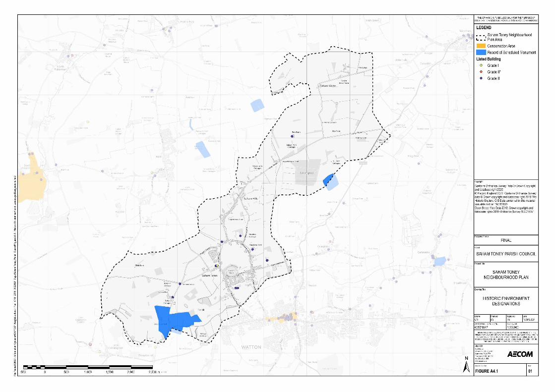
Strategic Environmental Assessment for theSaham Toney Neighbourhood Plan
Environmental Report to accompany theSubmission version of the Neighbourhood Plan
Prepared for: Saham Toney Neighbourhood Plan Steering Group AECOM64

Strategic Environmental Assessment for the Environmental Report to accompany the Saham Toney Neighbourhood Plan Submission version of the Neighbourhood Plan
A5 – Landscape Context Review
Key messages from the National Planning Policy Framework (NPPF) include:
• ‘Great weight should be given to conserving and enhancing landscape and scenic beauty in
National Parks, the Broads and Areas of Outstanding Natural Beauty […]. The conservation and enhancement of wildlife and cultural heritage are also important considerations in these
areas and should be given great weight in National Parks and the Broads. The scale and extent of development within these designated areas should be limited.’
• Strategic policies should set out an overall strategy making provision for ‘conservation and
enhancement of the natural, built and historic environment, including landscapes and green infrastructure.’
• Planning policies and decisions should ensure that developments ‘are sympathetic to local character and history, including the surrounding built environment and landscape setting,
while not preventing or discouraging appropriate innovation of change (such as increased densities).’
• ‘Planning policies and decisions should contribute to and enhance the natural and local environment by:
i. protecting and enhancing valued landscapes, sites of biodiversity or geological value
and soils
ii. recognising the intrinsic character and beauty of the countryside, and the wider benefits from natural capital and ecosystem services – including the economic and
other benefits of the best and most versatile agricultural land, and of trees and
woodland; and
iii. remediating and mitigating despoiled, degraded, derelict, contaminated and unstable
land, where appropriate.’
At the local level, Policy HOU 12 (Conversion of Buildings in the Countryside), ENV 04 (Open Space,
Sport & Recreation) and ENV 05 (Protection and Enhancement of the Landscape) from the Breckland
Local Plan relate to the Landscape SEA theme.
Summary of Current Baseline
National Character Areas
National Character Areas (NCAs) are landscape areas which share similar characteristics, following
natural lines in the landscape rather than administrative boundaries. Developed by Natural England,
NCA profiles describe the natural and cultural features that shape each of these landscapes,
providing a broad context to their character. The Neighbourhood Plan area is located within the ‘Mid Norfolk’ NCA56 .
The Mid Norfolk NCA is a broadly flat, rural landscape which occupies the northern section of the East
Anglian Plain. This is ancient countryside with a long-settled agricultural character, where arable land
is enclosed by winding lanes and hedgerows, interspersed with woodland and heath and dissected by lush pastoral river valleys. Key characteristics of this NCA include:
• Broadly flat, glacial till plateau dissected by river valleys which create a more intricate landscape to the west of Norwich.
• Chalk bedrock overlain by gravels, sands and glacial till left behind by the retreating ice of Anglian glaciations, and the resulting complexity of soils, determine natural vegetation patterns.
56 Natural England (2014): ‘NCA Profile 84: Mid Norfolk (NE523)’, [online] available at: http://publications.naturalengland.org.uk/publication/4560839075954688 [accessed 15/01/2020]
Prepared for: Saham Toney Neighbourhood Plan Steering Group AECOM 65

Strategic Environmental Assessment for the Environmental Report to accompany the Saham Toney Neighbourhood Plan Submission version of the Neighbourhood Plan
• Underlying chalk aquifer; small, fast-flowing chalk streams and biodiversity-rich, wide, lush
river valleys with wooded valley slopes, including the internationally important chalk-fed River
Wensum.
• Tranquil agricultural landscape with extensive areas of arable land, dominated by cereals with
break-cropping of sugar beet and oilseed rape, and some pastures along valley floors.
• Ancient countryside, much of it enclosed in the 14th century, with a sporadically rationalised patchwork field system, sinuous lanes and mixed hedges with hedgerow oaks.
• Large number of 18th-century estates with their associated parkland, and a great density and
stylistic variety of churches which are prominent features in the landscape.
• A mix of villages and many isolated farmsteads within a complex minor road network, with a
traditional pattern of market towns connected by main roads, and the city of Norwich providing a centre for cultural and economic activity.
Local Landscape Character
A Saham Toney Parish Landscape Character Assessment57 was carried out in (2019) to update the
Breckland Council Landscape Character Assessment (2007)58 and provide greater detail relating to Saham Toney. It identifies a number of areas as having high landscape and/or visual sensitivity. This assessment splits the parish into five rural character areas and six village character areas and are
summarised in Table A5.1 and Table A5.2 below. The rural character areas and village character
areas can be viewed in Figure A5.1 and Figure A5.2.
Table A5.1: Rural character areas identified by the Saham Toney Landscape Character
Assessment
Rural character areas
Area Key characteristics Opportunities and Management aims
RCA-1 • Low lying, gently rolling valley bottom below the 40m contour along the Watton Brook.
• Soils are seasonally wet, sands loams and peats with high water table.
• Land use dominated by meadows, used for hay and grazing.
• Forms of enclosure are gappy and scrubby hedges, and trees along ditches.
• Visual experience is varied. Open within the valley bottom, trees edge the skyline on the upper valley sides to the north. More intimate where small field systems endure to the east side of the village.
• Little settlement, which is instead is found on higher land, the exception being Ovington Road
• Lack of public access
• Condition is fair but poor in places. Settlement creeping into the floodplain at Watton infringes on the natural character.
• Belts of dark green conifers planted to screen and enclose the water treatment plant close to the bridge appear out of place and and have strong visual impact. These would be better replaced with species more suited to a river corridor.
• Hedges in the valley bottom are sometimes in poor condition and would benefit from gapping up and managing more regularly, especially those with a high proportion of elm.
• Retain quiet and tranquil character along Threxton Road. Retain backroads feel -development here is likely to be intrusive and inappropriate.
57 Lucy Batchelor-Wylam CMLI (2019) ‘Saham Toney Parish Landscape Character Assessment’, [online] available at: https://www.stnp2036.org/uploads/1/1/2/2/112245343/saham_toney_landscape_assessment_part_one_lca_final_january_2019 .pdf [accessed 15/01/2020] 58 Breckland Council (2007) Breckland Council Landscape Character Assessment’ pg 43, [online] available at: https://www.breckland.gov.uk/media/2069/Landscape-Character-Assessment/pdf/Landscape_Character_Assessment_-_May_2007_Final2.pdf [accessed 15/01/2020]
Prepared for: Saham Toney Neighbourhood Plan Steering Group AECOM 66

Strategic Environmental Assessment for the Environmental Report to accompany the Saham Toney Neighbourhood Plan Submission version of the Neighbourhood Plan
•
Avoid utility or highways interventions that detract from the rural character.
Generally development is unlikely to be appropriate in this landscape owing to its sensitivity and value as traditionally managed riverside meadows, and because of its function as undeveloped gap with Watton.
RCA-2 •
•
•
•
•
•
•
Gently sloping farmlands between 40 and 60m AOD with sandy, easily worked soils.
Arable estate farmlands, with a strongly rural and unified feel. Parkland provides setting for Saham Hall.
Wooded feel from frequent belts, plantations and small woodlands. No ancient woodlands. Oaks stud the field boundaries and parkland trees have skyline presence.
Straight sided large arable fields with network of narrow straight lanes.
No settlement other than the Hall and its associated cottages
Unified estate style with flint facing, brick quoins and ornate chimneys. Flint features in walls.
Sense of scenic well managed countryside. Quiet and tranquil feel. long views possible.
•
•
•
•
•
•
Landscape is in good condition. Hedges here are in better condition than other landscapes where the influence of estate farming is not present.
Strongly wooded character is robust and this characteristic provides some capacity for development or land uses to be absorbed within it. However, the character of the area is very consistent so anything that departs from the settlement pattern or architectural forms would be noticeable.
Protect areas of parkland, and their individual features, for their important contribution to character.
Apart from the woodland, semi-natural habitats are otherwise absent as this fertile farmland is valuable and productive.
Plan for enhancements to biodiversity, perhaps opportunities that might emerge through agrienvironmental scheme.
Seek opportunities to create public access where it is consistent with other land management aims.
RCA-3 • •
•
•
•
•
Flat or very gently sloping.
Land use is entirely arable farmland (cereals).
Simple, open farmland dominates. No woodlands. Hedges sometimes present. Roadsides often un-hedged, or hedges present behind narrow verges. Ash trees in hedgerows.
Large open fields with straightened boundaries.
No settlement but views across open farmland to village edges of Ashill and Saham Toney are part of the visual experience.
Expansive views across large fields, under big skies.
•
•
•
•
Landscape is in moderate condition. Loss of hedgerows causes associated loss of historic character; absence of features showing timedepth.
As the tree stock is limited and has a high percentage of ash -monitor for impact of Chalara dieback. Consider encouraging alternative species.
Semi-natural habitats are absent as this fertile farmland is valuable and productive.
Plan for enhancements to biodiversity, perhaps opportunities that might emerge through agrienvironmental
Prepared for: Saham Toney Neighbourhood Plan Steering Group AECOM 67

Strategic Environmental Assessment for the Environmental Report to accompany the Saham Toney Neighbourhood Plan Submission version of the Neighbourhood Plan
• No particular landmarks but poplar trees have skyline impact.
•
schemes. Plan to increase the stock of trees and woodland in the landscape. Replace lost hedges.
Seek opportunities to create public access where it is consistent with other land management aims.
RCA-4 •
•
•
•
•
•
•
Gently sloping valley side on the east side of the parish.
Land use is often pasture in the lower parts and arable farmland on the more elevated areas
Where there is a network of hedges and trees that creates an intimate feel. Opens out to long views when absent.
Finer grain to the landscape, smaller field sizes than seen elsewhere. Strong sense of time depth.
Settlement scattered along the west side of the area, often integrated within well vegetated settings but some stark edges.
Disused railway embankment is a strong linear feature in the east
Vernacular materials are red brick and render houses, large decorative chimneys. Pantile roofs, some black-coloured.
•
•
•
•
Landscape is in moderate condition. Some loss of hedgerows and associated loss of historic character. Plan for improvement to hedge network.
Semi-natural habitats are absent as this fertile farmland is valuable and productive.
Plan for enhancements to biodiversity, perhaps opportunities that might emerge through agri-environmental schemes. Plan to maintain the stock of trees and woodland in the landscape.
Seek opportunities to create public access along the disused railway line for recreation/tourism use, and radiating from the village edge through the farmlands.
RCA-5 •
•
•
•
•
•
Elevated plateau farmland in the far northeast of the parish
Land use is arable farmland with a well-managed feel.
Large woodland at Saham Wood (Ancient woodland) as well as regular plantations and coniferous shelter belts.
Regularised landscape with geometric feel to the grid of lanes, fields have straight boundaries
Settlement found in the form of scattered farms, some on the site of ancient manors and the location of medieval deer park
Vernacular materials are red brick and render houses with pantile roofs, some black glazed.
• •
•
•
Landscape is in good condition.
Semi-natural habitats are absent as this fertile farmland is valuable and productive. Plan for enhancements to biodiversity, perhaps opportunities that might emerge through agri-environmental schemes.
Plan to maintain and increase the stock of trees and woodland in the landscape. Continue to replace lost hedges.
Careful treatment of vernacular barns under residential conversion, as they contribute to the agricultural character.
Table A5.2: Village character areas identified by the Saham Toney Landscape Character
Assessment
Village character areas
Area Key characteristics
VCA-1 • Linear development along Richmond Road, generally one plot deep. Plot depths vary.
• Main road is busy and carries traffic from Watton to Ashill and other outlying villages
• Historical dwellings are scattered, in small clusters along the Richmond Road. Now much infilled with substantial 20th additions, all generally following the ribbon pattern
Prepared for: Saham Toney Neighbourhood Plan Steering Group AECOM 68

Strategic Environmental Assessment for the Environmental Report to accompany the Saham Toney Neighbourhood Plan Submission version of the Neighbourhood Plan
• No open space or public realm but opens out at junction with Bell Lane, and important
node where adjoins space in front of St. George’s. Important for orientation.
• Trees west of the mere provide a strong green edge
• Settlement edges are hard to experience from the highway but appear backed by well vegetated edges.
• Glimpses of church tower heading north along Richmond Road provide a series of key views to this landmark
VCA-2 • Modern, compact, estate-type development dating from the 1980/90s.
• Served by two estate roads - Amy’s Close and Bellmere Way/Mere Close - each
displaying a unified built form type.
• Dwellings on Amy’s Close have a particularly uniform appearance with little variation in house type or materials.
• Curved estate roads - no through roads with no connectivity
• Strong green edges of the Mere provide a well-defined edge, and provide containment,
preventing views to the north.
• No public open space within the estates but large area of open space adjacent at the
village hall.
• Mature trees play a role on the skylines along boundaries to the north and south, but
trees within the estates are smaller scale and more suburban in character.
VCA-3 • Slightly elevated and gently rolling landscape north of the Mere along Pound Hill between St. George’s church and Page’s Lane.
• Shallow soils over chalk, adjoining land use is both arable and unenclosed pastures.
• Comprises some older properties along Pound Hill, including the schoolhouse, but larger area is covered by unified 1970s bungalow estate development.
• The tracts of open arable land provide extensive views and are key to sense of place.
• Land bounding to the north provides separation between different clusters of settlement.
• Notable views to tower of St George’s church along southerly route on Pound Hill.
VCA-4 • Flat and gently rolling landscape associated with a small stream
• Shallow soils over chalk, adjoining land use is both arable and unenclosed pastures.
• Features an ancient manor at Pages Place indicating the long-settled nature of this area,
as well as a number of attractive cottages displaying traditional vernacular finishes.
• Low density dwellings along the southern end of Hills Road and along the north side of
Chequers Lane.
• Farmsteads are found at intervals along the southern side of Chequers Lane with large
scale buildings and a sometimes commercial purpose and character, with associated visual intrusion.
• The tract of open arable land to the west of Hills Road provides extensive views.
• Rural feel maintained owing to little modern development and maturity of vegetated
curtilages and edges which contribute positively to rural character.
VCA-5 • Elevated fringes of the plateau, indented with small streams. Heavier land - clayey and
loamy soils over chalky boulder clay. Poorly drained meadows along tributary stream.
• Settlement pattern is strongly linear, gaps between historic scattered farmsteads and
cottages since in filled with 20th century bungalows and houses. Important open space
around Ploughboy Lane.
• Built form type mixed - older cottages and occasional farmsteads within 20th century additions
• No public open spaces, but footpath offers access to countryside from Coburg Lane.
Undeveloped meadows adjacent to Ploughboy Lane contribute to character.
• No landmarks as such, but Chapel is notable in the streetscape.
• Contained visual experience often, longer views along streetscape where Hills Road
straightens out and over countryside at either end of the cluster.
Prepared for: Saham Toney Neighbourhood Plan Steering Group AECOM 69

Strategic Environmental Assessment for the Environmental Report to accompany the Saham Toney Neighbourhood Plan Submission version of the Neighbourhood Plan
• Ornamental garden frontages and boundary treatments create a suburban feel at points in the streetscape.
VCA-6 • Well vegetated, small scale pastoral valley bottom landscape provides setting. Tree belts line small fields.
• Low-lying village edge separated from Watton only by a narrow belt of undeveloped land.
Golf course occupies much of the valley bottom.
• Linear settlement pattern where older cottages and 1970/80s housing sit side by side. A recent small estate has been added at Labybird Lane. Farms and holdings west of Cley Lane.
• Settlement edges well integrated with well vegetated landscape. Enclosure from hedges and tree belts creates sense of intimacy. Long views are not obtained.
• A number of vernacular buildings are seen, small scale brick and flint cottages and a
works building. Narrow plot frontages for older properties.
• Mill tower is local landmark, but not easily seen in the landscape owing to well wooded
nature. View from the west from Ovington Road.
Figure A5.1: Rural character areas in Saham Toney
Prepared for: Saham Toney Neighbourhood Plan Steering Group AECOM 70

Strategic Environmental Assessment for the Environmental Report to accompany the Saham Toney Neighbourhood Plan Submission version of the Neighbourhood Plan
Figure A5.2: Village character areas in Saham Toney
Tree Preservation Orders
Implemented by local planning authorities, Tree Preservation Orders (TPOs) are designated to protect
specific trees, groups of trees or woodlands in the interests of their amenity value. When considering ‘amenity’; the local planning authority will likely take into consideration the following criteria59:
Visibility: the extent to which the trees or woodlands can be seen by the public; and
Individual, collective and wider impact: considering the importance of the trees or woodlands in relation to their cultural or historic value, contribution to and relationship with the landscape and/or
their contribution to the character or appearance of a conservation area.
In this context, Breckland Council have allocated multiple TPOs within the Neighbourhood Plan area.
59 GOV.UK (2014): ‘Tree Preservation Orders – General’, [online] available a:t https://www.gov.uk/guidance/tree-preservation-orders-and-trees-in-conservation-areas last accessed [15/01/2020]
Prepared for: Saham Toney Neighbourhood Plan Steering Group AECOM 71

Strategic Environmental Assessment for the Environmental Report to accompany the Saham Toney Neighbourhood Plan Submission version of the Neighbourhood Plan
Summary of Future Baseline
New development has the potential to lead to incremental changes in landscape and townscape character and quality in and around the Neighbourhood Plan area. This includes from the loss of
landscape features and areas with an important visual amenity value. Inappropriate levels of development within the open countryside or in settlement fringe areas could negatively impact upon the landscape features which contribute to the distinctive character of Saham Toney.
A6 – Land, Soil and Water Resources Context Review
The EU’s Soil Thematic Strategy60 presents a strategy for protecting soil resources in Europe. The main aim of the strategy is to minimise soil degradation and limit associated detrimental effects linked
to water quality and quantity, human health, climate change, biodiversity, and food safety.
Adopted in October 2000, the purpose of the EU Water Framework Directive (WFD) is to establish a
framework for the protection of inland surface waters, transitional waters, coastal waters and
groundwater, driving a catchment-based approach to water management. In England and Wales there
are 100 water catchments and it is Defra’s intention to establish a ‘framework for integrated catchment
management’ across England. The Environment Agency is establishing ‘Significant Water Management Issues’ and recently presented second River Basin Management Plans to ministers. The plans seek to deliver the objectives of the WFD namely:
• Enhance the status and prevent the further deterioration of aquatic ecosystems and
associated wetlands which depend on aquatic ecosystems;
• Promote the sustainable use of water;
• Reduce the pollution of water, especially by ‘priority’ and ‘priority hazardous’ substances;
• Ensure the progressive reduction of groundwater pollution; and
• Contribute to achieving ‘good’ water quality status for as many waterbodies as possible by 2027.
Key messages from the NPPF include:
• ‘Planning policies and decisions should contribute to and enhance the natural and local environment by:
1. protecting and enhancing valued landscapes, sites of biodiversity or geological value and
soils; and
2. recognising the intrinsic character and beauty of the countryside, and the wider benefits from natural capital and ecosystem services – including the economic and other benefits of the best and most versatile agricultural land, and of trees and woodland.’
• Prevent new or existing development from being ‘adversely affected’ by the presence of ‘unacceptable levels’ of soil pollution or land instability and be willing to remediate and
mitigate ‘despoiled, degraded, derelict, contaminated and unstable land, where appropriate’.
• ‘Planning policies and decisions should promote an effective use of land in meeting the need for homes and other uses, while safeguarding and improving the environment and ensuring
safe and healthy living conditions. Strategic policies should set out a clear strategy for accommodating objectively assessed needs, in a way that makes as much use as possible of
previously-developed or ‘brownfield’ land.’
• ‘Encourage multiple benefits from both urban and rural land, including through mixed use
schemes and taking opportunities to achieve net environmental gains.’
60 European Commission (2006) Soil Thematic Policy [online] available at: http://ec.europa.eu/environment/soil/index_en.html
[accessed 16/01/2020]
Prepared for: Saham Toney Neighbourhood Plan Steering Group AECOM 72

Strategic Environmental Assessment for the Environmental Report to accompany the Saham Toney Neighbourhood Plan Submission version of the Neighbourhood Plan
• Planning policies and decisions should ‘give substantial weight to the value of using suitable
brownfield land within settlements for homes and other identified needs’, and ‘promote and support the development of under-utilised land and buildings.’
• Taking a proactive approach to mitigating and adapting to climate change, taking into account the long-term implications for water supply.
• Prevent new and existing development from contributing to, being put at unacceptable risk from, or being adversely affected by unacceptable levels of water pollution.
• The government has produced a separate plan that specifically deals with planning policy in
relation to waste management; this should be read in conjunction with the NPPF.
• Local planning authorities should not normally permit other development proposals in Mineral Safeguarding Areas if it might constrain potential future use for mineral working.
Along with the policies contained within Chapter 1 ‘Using and managing land sustainably’ and Chapter
4 ‘Increasing resource efficiency, and reducing pollution and waste’, Goal 2 ‘Clean and plentiful water’, Goal 5 ‘Using resources from nature more sustainably and efficiently’ and Goal 8 ‘Minimising
waste’ of the Government’s ‘A Green Future: Our 25 Year Plan to Improve the Environment’ directly relates to the Land, Soil and Water Resources SEA theme.
Other key documents at the national level include Safeguarding our Soils: A Strategy for England61 ,
which sets out a vision for soil use in England, and the Water White Paper62, which sets out the Government’s vision for a more resilient water sector. It states the measures that will be taken to tackle issues such as poorly performing ecosystems, and the combined impacts of climate change
and population growth on stressed water resources. In terms of waste management, the Government
Review of Waste Policy in England63 recognises that environmental benefits and economic growth
can be the result of a more sustainable approach to the use of materials.
In terms of waste management, the Government Review of Waste Policy in England64 recognises that environmental benefits and economic growth can be the result of a more sustainable approach to the
use of materials.
The National Waste Management Plan65 provides an analysis of the current waste management situation in England and evaluates how it will support the implementation of the objectives and provisions of the revised Waste Framework Directive66 . This includes an assessment of the need for
new collection schemes, additional waste infrastructure and investment channels, as well as providing general or strategic waste management policies.
At the local level, the Norfolk Minerals and Waste Development Framework Core Strategy and Minerals and Waste Development Management Policies Development Plan Document67 sets out the approach to Minerals and Waste in the period to 2026. The key minerals safeguarding policy is Policy CS16 (Safeguarding mineral and waste sites and mineral resources), which sets out how Norfolk County Council will safeguard existing, permitted and allocated mineral extraction and associated
development and waste management facilities. The policy states that Norfolk County Council should
be consulted on all development proposals within Mineral Consultation Areas, and for other
development types within Mineral Consultation Areas (i.e. non-minor development outside settlement
boundaries), it will expect to see appropriate investigations carried out to assess whether any mineral
61 Defra (2009) Safeguarding our Soils: A strategy for England [online] available at: https://www.gov.uk/government/publications/safeguarding-our-soils-a-strategy-for-england [accessed 16/01/2020] 62 Defra (2011) Water for life (The Water White Paper) [online] available at http://www.official-documents.gov.uk/document/cm82/8230/8230.pdf [accessed 16/01/2020] 63 Defra (2011) Government Review of Waste Policy in England [online] available at: http://www.defra.gov.uk/publications/files/pb13540-waste-policy-review110614.pdf [accessed 16/01/2020] 64 DEFRA (2011) Government Review of Waste Policy in England [online] available at: https://assets.publishing.service.gov.uk/government/uploads/system/uploads/attachment_data/file/69401/pb13540-waste-policy-review110614.pdf [accessed 16/01/2020] 65 DEFRA (2013) Waste Management Plan for England [online] available at: https://assets.publishing.service.gov.uk/government/uploads/system/uploads/attachment_data/file/265810/pb14100-waste-management-plan-20131213.pdf [accessed 16/01/2020] 66 Directive 2008/98/EC 67 Norfolk County Council (September 2011) Norfolk Minerals and Waste Development Framework: Core Strategy and Minerals and Waste Development Management Policies Development Plan Document 2010-2026 file:///C:/Users/nick.chisholm-batten/Downloads/Core%20Strategy%20and%20Minerals%20and%20Waste%20Development%20Management%20Policies% 20Development%2020102026.pdf
Prepared for: Saham Toney Neighbourhood Plan Steering Group AECOM 73

Strategic Environmental Assessment for the Environmental Report to accompany the Saham Toney Neighbourhood Plan Submission version of the Neighbourhood Plan
resource there is of economic value, and if so, whether the material could be economically extracted
prior to the development taking place.
Policy ENV 02 (Biodiversity Protection and Enhancement), Policy ENV 06 (Trees, Hedgerows and Development), Policy ENV 09 (Flood Risk & Surface Water Drainage) from the Breckland Local Plan relate to the Land, Soil and Water Resources SEA theme.
Summary of Current Baseline
Soil resources
The Agricultural Land Classification (ALC) classifies land into size grades (plus ‘non-agricultural land’ and ‘urban’), where Grades 1 to 3a are recognised as being the ‘best and most versatile’ land and
Grades 3b to 5 of poorer quality. Sub-grade 3a is described in the agricultural land classification thus:
"Good quality agricultural land capable of consistently producing moderate to high yields of a narrow
range of arable crops, especially cereals, or moderate yields of a wide range of crops including cereals, grass, oilseed rape, potatoes, sugar beet and the less demanding horticultural crops." Sub-
grade 3b is described as "moderate quality agricultural land capable of producing moderate yields of a
narrow range of crops, principally cereals and grass or lower yields of a wider range of crops or high yields of grass which can be grazed or harvested over most of the year." In this context, there is a
need to avoid loss of higher quality ‘best and most versatile’ agricultural land.
At the local level a detailed classification has not been undertaken for the Neighbourhood Plan area.
There is therefore a need to rely on the national ‘Provisional Agricultural Land Quality’ dataset,
supplemented by interpretation of the sub-grade definitions given in the agricultural land classification.
The Provisional Agricultural Land Quality dataset68 shows that the Neighbourhood Plan area is predominantly covered by Grade 3 agricultural land with a section of Grade 4 agricultural land along the western boundary. Without the subset grading (3a or 3b) it is not possible to tell at this stage
whether the agricultural land is considered to be ‘best and most versatile’. It is also important to note
that the national dataset is of very low resolution, and may not necessarily provide an accurate
reflection of the agricultural land quality within the Neighbourhood Plan area.
Saham Toney Landscape Assessment Part One69 classifies the soilscape of the Neighbourhood Plan area identifying that the Parish is a collection of:
• Soilscape 3: Shallow lime-rich soils over chalk or limestone;
• Soilscape 8: Slightly acid loamy and clayey soils with impeded drainage;
• Soilscape 10: Freely draining slightly acid sandy soils;
• Soilscape 18: Slowly permeable seasonally wet slightly acid but base-rich loamy and clayey soils; and
• Soilscape 23: Loamy and sandy soils with naturally high groundwater and a peaty surface.
Minerals resources
Minerals Safeguarding Areas (MSAs) are known areas of mineral resources that are of sufficient
economic value to warrant protection for generations to come. There is no presumption that any areas within a MSA will ultimately be environmentally acceptable for mineral extraction. The purpose of
MSAs is not to automatically preclude other forms of development, but to make sure that mineral reserves are considered in land-use planning decisions.
There are three areas within the Neighbourhood Plan area covered by sand and gravel MSAs. Two
are located in the south of the parish, with a very small area located in the far north east of the parish.
The location of these areas is highlighted in the map below.
68 Natural England (2018) Agricultural Land Classification map London and the South East (ALC007) [online] available at http://publications.naturalengland.org.uk/publication/141047?category=5954148537204736 [accessed 16/01/2020] 69 Saham Toney Parish Council (2019) ‘Landscape Assessment Part One’, [online] available at: https://www.stnp2036.org/uploads/1/1/2/2/112245343/saham_toney_landscape_assessment_part_one_lca_final_january_2019 .pdf [accessed 16/01/2020]
Prepared for: Saham Toney Neighbourhood Plan Steering Group AECOM 74

Strategic Environmental Assessment for the Environmental Report to accompany the Saham Toney Neighbourhood Plan Submission version of the Neighbourhood Plan
Figure A6.1 Minerals Safeguarding Areas (sand and gravel), Saham Toney (source Norfolk
County Council
Water resources
The main watercourse flowing through the Neighbourhood Plan area is the Watton Brook. Watton Brook is a tributary of the River Wissey. It flows west through Saham Toney and joins the complex river network of the tributaries of the Little Ouse.
The Nitrates Directive (91/676/EEC) requires Member States to identify areas where groundwater have nitrate concentrations of more than 50 mg/l nitrate or are thought to be at risk of nitrate contamination. Areas associated with such groundwater are designated as Nitrate Vulnerable Zones (NVZs) within which, Member States are required to establish Action Programmes to reduce and
prevent further nitrate contamination. In this regard the Neighbourhood Plan area is situated within the
‘Ely Ouse and Cut-off channel’ NVZ.
Groundwater Source Protection Zones (SPZs) have been defined by the Environment Agency in
England and Wales to protect groundwater sources such as wells, boreholes and springs that are
used for public drinking water supply. The south eastern part of the Neighbourhood Plan area is within
SPZ2 (Outer Protection) with a small section in the south in SPZ3 (Total Catchment).
Water Quality
Saham Toney is located within the Anglian River Basin District, within the ‘Cam and Ely Ouse’ Management Catchment and the ‘River Wissey’ Operational Catchment. There are six water bodies within the Operational Catchment which include the ‘Watton Brook’ which flows through the south of the Neighbourhood Plan boundary.
Prepared for: Saham Toney Neighbourhood Plan Steering Group AECOM 75

Strategic Environmental Assessment for the Environmental Report to accompany the Saham Toney Neighbourhood Plan Submission version of the Neighbourhood Plan
Based on the most recently completed water quality assessments undertaken in 2016, the Environment Agency’s Catchment Data Explorer70 classifies Watton Brook71 as having a ‘good’ chemical status and ‘moderate’ ecological status. The overall classification for the waterbody in 2016
was ‘moderate’. The reasons for not achieving good (RNAG) are primarily attributed to sewage discharge and poor nutrient management.
Summary of Future Baseline
Future development has the potential to affect water quality through diffuse pollution, wastewater
discharges, water run-off, and modification. However, water companies are likely to maintain
adequate water supply and wastewater management over the plan period, and the requirements of
the Water Framework Directive are likely to lead to continued improvements to water quality within the Neighbourhood Plan area and wider area.
In the absence of a detailed Agricultural Land Classification assessment for the majority of the Parish,
it remains uncertain whether new development on greenfield land in the Neighbourhood Plan area will lead to losses of higher quality (best and most versatile) agricultural land.
Safeguarded mineral resources in Saham Toney have the potential to be affected by non-mineral development.
A7 – Population and Community Context Review
Key messages from the NPPF include:
• One of the three overarching objectives of the NPPF is a social objective to; ‘support strong,
vibrant and healthy communities, by ensuring that a sufficient number and range of homes can be provided to meet the needs of present and future generations; and by fostering a well-
designed and safe built environment, with accessible services and open spaces that reflect
current and future needs and support communities’ health, social and cultural wellbeing.’
• To support the Government’s objective of significantly boosting the supply of housing, strategic policies ‘should be informed by a local housing need assessment, conducted using
the standard method in national planning guidance. In addition to the local housing need figure, any needs that cannot be met within neighbouring areas should also be taken into account in establishing the amount of housing to be planned for.’
• The size, type and tenure of housing needed for different groups in the community should be
assessed and reflected in planning policies. Where a need for affordable housing is identified, planning policies should specify the type of affordable housing required, and expect
it to be met on-site where possible.
• Recognise the important contribution of small and medium sized development sites in
meeting housing needs. Local Plans should identify land to accommodate at least 10% of their housing requirement on sites no larger than one hectare, and neighbourhood planning groups should also consider the opportunities for allocating small and medium-sized sites.
• In rural areas, planning policies and decisions should be responsive to local circumstances and plan housing development to reflect local needs, particularly for affordable housing, including through rural exception sites where appropriate. Authorities should consider whether allowing some market housing would facilitate the provision of affordable housing to
meet local needs.
• Promote the retention and development of local services and community facilities such as local shops, meeting places, sports venues, open space, cultural buildings, public houses and places of worship.
70 Environment Agency (2019): ‘Catchment Data Explorer’, [online] available to access via: https://environment.data.gov.uk/catchment-planning/ [accessed 16/01/2020] 71 Environment Agency (2019): ‘Catchment Data Explorer – Watton Brook, [online] available at: https://environment.data.gov.uk/catchment-planning/WaterBody/GB105033047870 [accessed 16/01/2020]
Prepared for: Saham Toney Neighbourhood Plan Steering Group AECOM 76

Strategic Environmental Assessment for the Environmental Report to accompany the Saham Toney Neighbourhood Plan Submission version of the Neighbourhood Plan
• Ensure that developments create safe and accessible environments where crime and
disorder, and the fear of crime, do not undermine quality of life or community cohesion.
Places should contain clear and legible pedestrian routes, and high-quality public spaces,
which encourage the active and continual use of public areas.
• Ensuring that there is a ‘sufficient choice of school places’ and taking a ‘proactive, positive
and collaborative approach’ to bringing forward ‘development that will widen choice in education’.
The ‘Ready for Ageing?’ report, published by the Select Committee on Public Service and Demographic Change72 warns that society is underprepared for an ageing population. The report
states that ‘longer lives can be a great benefit, but there has been a collective failure to address the
implications and without urgent action this great boon could turn into a series of miserable crises’.
The report recognises that the supply of specialist housing for the older generation is insufficient for the demand. There is a need for central and local Government, housing associations, and house
builders to ensure that these housing needs are better addressed, giving as much priority to
promoting an adequate market of social housing for the older generation as is given to the younger generation.
At the local level, Policies from the Housing chapter, the Economy and Employment chapter and the
Communities chapter from the Breckland Local Plan relate to the Population and Community SEA theme.
Summary of Current Baseline
Population
The population of Saham Toney decreased by 3.7% between 2001 and 2011, whereas Breckland, the East of England and England all increased in population73 .
Age Structure
There is a significantly higher proportion of residents within the 60+ age category within the Neighbourhood Plan area (40.0%) in comparison to the total for Breckland (29.1%), the East of
England (23.9%) and England (22.3%)74 .
A lower proportion of residents are within the working age categories (25-44 and 45-59) in the
Neighbourhood Plan area (39.0%) in comparison to the totals for Breckland (43.2%), the East of
England (46.3%) and England (46.9%).
Additionally, 21.0% of residents within the Neighbourhood Plan area are within the younger age categories (0-15 and 16-24), lower than the proportions for Breckland (27.7%), the East of England (29.9%) and England (30.8%).
Household Deprivation
Census statistics measure deprivation across four ‘dimensions’ of deprivation, summarized below:
• Employment: Any person in the household (not a full-time student) that is either unemployed
or long-term sick.
• Education: No person in the household has at least a level 2 qualification and no person aged 16-18 is a full-time student.
• Health and Disability: Any person in the household that has generally ‘bad’ or ‘very bad’ health or has a long term health problem.
• Housing: The household accommodation is either overcrowded (with an occupancy rating of
-1 or less), in a shared dwelling or has no central heating.
72 Select Committee on Public Service and Demographic Change (2013) Ready for Ageing? [online] available at: http://www.parliament.uk/business/committees/committees-a-z/lords-select/public-services-committee/report-ready-for-ageing/ [accessed 16/01/2020] 73 ONS (no date): Census 2011: Population Density 2011 (Table QS102EW); Population Density 2001 (Table UV02) 74 ONS (no date): Census 2011: Age Structure 2011 (Table KS102EW)
Prepared for: Saham Toney Neighbourhood Plan Steering Group AECOM 77

Strategic Environmental Assessment for the Environmental Report to accompany the Saham Toney Neighbourhood Plan Submission version of the Neighbourhood Plan
A similar percentage of households are deprived in one or more dimensions within the Neighbourhood Plan area (58.9%) in comparison to the totals for Breckland (59.9%) and England (57.4%). However,
this is greater than the East of England (55.2%). Out of the 58.9% of households which are deprived
in the Neighbourhood Plan area, the majority are deprived in one or two dimensions, which is similar
to the regional and national trends75 .
Index of Multiple Deprivation
The Index of Multiple Deprivation 2019 (IMD) is an overall relative measure of deprivation constructed
by combining seven domains of deprivation according to their respective weights, as described below.
The seven deprivation domains are as follows:
• Income: The proportion of the population experiencing deprivation relating to low income,
including those individuals that are out-of-work and those that are in work but who have low
earnings (satisfying the respective means tests).
• Employment: The proportion of the working-age population in an area involuntarily excluded from the labour market, including those individuals who would like to work but are unable to
do so due to unemployment, sickness or disability, or caring responsibilities.
• Education, Skills and Training: The lack of attainment and skills in the local population.
• Health Deprivation and Disability: The risk of premature death and the impairment of
quality of life through poor physical or mental health. Morbidity, disability and premature mortality are also considered, excluding the aspects of behaviour or environment that may be predictive of future health deprivation.
• Crime: The risk of personal and material victimisation at local level.
• Barriers to Housing and Services: The physical and financial accessibility of housing and
local services, with indicators categorised in two sub-domains.
a. ‘Geographical Barriers’: relating to the physical proximity of local services b. ‘Wider Barriers’: relating to access to housing, such as affordability.
• Living Environment: The quality of the local environment, with indicators falling categorised in two sub-domains.
c. ‘Indoors Living Environment’ measures the quality of housing. d. ‘Outdoors Living Environment’ measures air quality and road traffic accidents.
• Two supplementary indices (subsets of the Income deprivation domains), are also included:
1. Income Deprivation Affecting Children Index: The proportion of all children aged 0 to 15
living in income deprived families. 2. Income Deprivation Affecting Older People Index: The proportion of all those aged 60 or
over who experience income deprivation.
Lower Super Output Areas (LSOAs) 76 are a geographic hierarchy designed to improve the reporting of small area statistics in England and Wales. They are standardized geographies designed to be as consistent in population as possible, with each LSOA containing approximately 1,000 to 1,500 people.
In relation to the IMD 2015, LSOAs are ranked out of the 32,844 in England and Wales, with 1 being
the most deprived. Ranks are normalized into deciles, with a value of 1 reflecting the top 10% most
deprived LSOAs in England and Wales.
The Neighbourhood Plan area lies within two LSOAs: Breckland 008A and Breckland 008B.
Breckland 008A LSOA is within the 50% least deprived neighbourhoods within England and Breckland 008B is within the 50% most deprived neighbourhoods within England.
75 ONS (no date): Census 2011: ‘Households by Deprivation Dimensions 2011 (Table QS119EW) 76 DCLG (2015): Indices of Deprivation Explorer’, [online] available at: http://dclgapps.communities.gov.uk/imd/idmap.html [accessed 16/01/2020]
Prepared for: Saham Toney Neighbourhood Plan Steering Group AECOM 78

Strategic Environmental Assessment for the Environmental Report to accompany the Saham Toney Neighbourhood Plan Submission version of the Neighbourhood Plan
Housing Tenure
Within the Neighbourhood Plan area, 77.4% of residents either own their home outright or with a
mortgage, higher than the totals for Breckland (68.6%), the East of England (67.6%) and England (63.3%).
A lower proportion of residents live within privately rented housing in the Neighbourhood Plan area in
comparison to the regional and national figures77 .
A lower percentage of residents in the Neighbourhood Plan area live in rent-free accommodation or
shared ownership accommodation in comparison to the regional and national trends.
Education
Based on the 2011 census data, 30.7% of residents in the Neighbourhood Plan area have no qualifications, higher than the totals for Breckland (28%), the East of England (22.5%) and England
(20.7%). Comparatively, 17.5% of residents within the Neighbourhood Plan area have a Level 4
qualification or above, which broadly aligns to the total for Breckland (18.7%) but is lower than the totals for the East of England (25.7%) and England (27.4%).
Employment
Regarding employment within the Neighbourhood Plan area, the following three occupation categories support the most residents78:
• Skilled trade occupations (18.4%); and
• Elementary occupations (12.9%); and
• Managers, directors, senior officials (12.6%).
Overall, 43.9% of residents within the Neighbourhood Plan area are employed in one of the above
three occupation categories, greater than the total for Breckland (39.1%), the East of England (34.0%) and England (33.3%).
Community Assets
The Neighbourhood Plan area has a number of local community facilities which serve the needs of the local community and play a vital role in supporting the parish’s sense of identity. Such facilities include: one pub, one tearoom, Broom Hall Country Hotel, Parkers C of E Primary School, St
Georges Parish Church, Threxton All Saints Church, Saham Toney Cricket Club and Watton Football Club. A wide range of services and facilities are in Watton.
Summary of Future Baseline
As the population of the Neighbourhood Plan area continues to age, this could potentially negatively impact upon the future vitality of the local community of the Neighbourhood Plan area, whilst also placing additional pressures on existing services and facilities, including in Watton. The suitability (e.g.
size and design) and affordability of housing for local requirements depends on the implementation of
appropriate housing policies through the Breckland Local Plan and Neighbourhood Plan. Unplanned
development may have wider implications in terms of transport and access to infrastructure, or the
natural environment.
A8 – Health and Wellbeing Context Review
Key messages from the NPPF include:
• One of the three overarching objectives of the NPPF is a social objective to; ‘support strong,
vibrant and healthy communities, by ensuring that a sufficient number and range of homes can be provided to meet the needs of present and future generations; and by fostering a well-
77 ONS (no date): Census 2011: Tenure-Households 2011 (Table QS405EW) 78 ONS (no date): Census 2011: ‘Occupation 2011’ (Table KS608EW)
Prepared for: Saham Toney Neighbourhood Plan Steering Group AECOM 79

Strategic Environmental Assessment for the Environmental Report to accompany the Saham Toney Neighbourhood Plan Submission version of the Neighbourhood Plan
designed and safe built environment, with accessible services and open spaces that reflect
current and future needs and support communities’ health, social and cultural wellbeing. ‘
• ‘Planning policies and decisions should aim to achieve healthy, inclusive and safe places which enable and support healthy lifestyles, especially where this would address identified local health and wellbeing needs – for example through the provision of safe and accessible
green infrastructure, sports facilities, local shops, access to healthier food, allotments and layouts that encourage walking and cycling.’
• Policies and decisions should take into account and support the delivery of local strategies to improve health, social and cultural well-being for all sections of the community.
• Access to a network of high-quality open spaces and opportunities for sport and physical activity is important for the health and wellbeing of communities. Development should avoid
building on existing open space, sports and recreational buildings and land, including playing
fields.
• Promote the retention and development of local services and community facilities such as local shops, meeting places, sports venues, cultural buildings, public houses and places of
worship.
In relation to other key national messages in relation to health, Fair Society, Healthy Lives79 (‘The Marmot Review’) investigated health inequalities in England and the actions needed in order to tackle
them. Subsequently, a supplementary report was prepared providing additional evidence relating to
spatial planning and health on the basis that that there is: “overwhelming evidence that health and
environmental inequalities are inexorably linked and that poor environments contribute significantly to
poor health and health inequalities”.
The increasing role that local level authorities are expected to play in providing health outcomes is demonstrated by recent government legislation. The Health and Social Care Act 2012 transferred responsibility for public health from the NHS to local government, giving local authorities a duty to improve the health of the people who live in their areas. This will require a more holistic approach to
health across all local government functions.
At the local level, Policy TR 01 (Sustainable Transport Network), Policy TR 02 (Transport
Requirements), Policy COM 02 (Healthy Lifestyles) and Policy COM 04 (Community Facilities) from
the Breckland Local Plan relate to the Health and Wellbeing SEA theme.
Summary of Current Baseline
Public Health Profile for Breckland
Published in November 2019 by Public Health England, the public health profile for Breckland outlines the following two key trends80:
• Life expectancy is lower for both men and women in Breckland than the England average; and
• In Year 6, 17.4% of children are classified as obese, better than the average for England.
Health Indicators and Deprivation
Deprivation is a significant contributor to poor health and can have adverse effects on wellbeing, with
elements related to poor housing quality, living environment, income and employment previously discussed in detail in the ‘Population and Community’ theme. 79.0% of residents in the Neighbourhood Plan area consider themselves as having ‘very good health’ or ‘good health’, similar to
79 The Marmot Review (2011) The Marmot Review: Implications for Spatial Planning [online] available at: https://www.nice.org.uk/media/default/About/what-we-do/NICE-guidance/NICE-guidelines/Public-health-guidelines/Additional-publications/Spatial-planning/the-marmot-review-implications-for-spatial-planning.pdf [accessed 16/01/2020] 80 Public Health England (2019) Local Authority Health Profile – Breckland, [online] available at: https://fingertips.phe.org.uk/static-reports/health-profiles/2019/e07000143.html?area-name=breckland [accessed 23-01-2020]
Prepared for: Saham Toney Neighbourhood Plan Steering Group AECOM 80

Strategic Environmental Assessment for the Environmental Report to accompany the Saham Toney Neighbourhood Plan Submission version of the Neighbourhood Plan
the total for Breckland (79.5%), but a lower than the totals for the East of England (82.5%) and England (81.4%)81 .
Additionally, 6.9% of residents in the Neighbourhood Plan area consider themselves to have ‘bad
health’ or ‘very bad health’, higher than the totals for Breckland (5.5%), the East of England (4.7%) and England (5.4%).
The total percentage of residents within the Neighbourhood Plan area who report that their activities are limited ‘a lot’ is greater than the totals for Breckland, the East of England and England82 . 78.2% of
residents in the Neighbourhood Plan area confirm that their activities are ‘not limited’. This is lower
than the totals for Breckland (80.3%), the East of England (83.3%) and England (82.4%).
Summary of Future Baseline
As the population continues to age, this has the potential to place pressures on existing services and
facilities within the timeframe of the Neighbourhood Plan. This could negatively impact on the future
vitality of the local community and economy.
Obesity is also seen as an increasing issue by health professionals, and one that will contribute to
significant health impacts on individuals, including increasing the risk of a range of diseases, including
heart disease, diabetes and some forms of cancer.
A9 – Transportation Context Review
European and UK transport policies and plans place emphasis on the modernisation and sustainability of the transport network. Specific objectives include reducing pollution and road
congestion through improvements to public transport, walking and cycling networks and reducing the need to travel. National policy also focuses on the need for the transport network to support
sustainable economic growth.
Key messages from the NPPF include:
• ‘Transport issues should be considered from the earliest stages of plan-making and
development proposals, so that:
i. The potential impacts of development on transport networks can be addressed
ii. Opportunities from existing or proposed transport infrastructure, and changing transport
technology and usage, are realised
iii. Opportunities to promote walking, cycling and public transport use are identified and pursued
iv. The environmental impacts of traffic and transport infrastructure can be identified, assessed and taken into account
v. Patterns of movement, streets, parking and other transport considerations are integral to the design of schemes, and contribute to making high quality places.’
• ‘Significant development should be focused on locations which are or can be made
sustainable, through limiting the need to travel and offering a genuine choice of transport
modes. This can help to reduce congestion and emissions, and improve air quality and public health. However, opportunities to maximise sustainable transport solutions will vary between urban and rural areas, and this should be taken into account in both plan-making and
decision-making.’
At the local level, each Local Transport Authority in England and Wales has a statutory duty to
produce and adopt a Local Transport Plan through the Local Transport Act 2000, as amended by the
81 ONS (no date): Census 2011: ‘General Health 2011’ (Table QS302EW) 82 ONS (no date): Census 2011: ‘Long-term Health Problem or Disability 2011’ (Table QS303EW)
Prepared for: Saham Toney Neighbourhood Plan Steering Group AECOM 81

Strategic Environmental Assessment for the Environmental Report to accompany the Saham Toney Neighbourhood Plan Submission version of the Neighbourhood Plan
Local Transport Act 2008.83 Norfolk’s Transport Plan for 202684 highlights Norfolk’s transport vision as ‘A transport system that allows residents and visitors a range of low carbon options to meet their transport needs and attracts and retains business investment in the county’. This will be achieved by:
• Making the best use of what we have to facilitate reliable journeys;
• Reducing the need to travel;
• Influencing others and ensuring transport is integrated into development plans;
• Working with communities and our partners to seek new solutions and new ways of
delivering; and
• Lobbying for and pursuing improvements to Norfolk’s strategic transport network.
At a local level Breckland Council published a Local Plan Examination document for the Transport
policies TR 01 and TR 02 85 to compliment the Breckland Local Plan. This document considers how Breckland will be consistent with national policy in regard to a sustainable transport network. The document acknowledges that given that the District contains rural areas, including the Neighbourhood plan, travel by car will remain an essential option; however:
‘Sustainable transport policy TR 01 seeks to widen the choice of travel opportunities using public transport, walking and cycling in order to achieve the mutually beneficial aims of reducing reliance on
the private car and promoting active lifestyles’.
At the local level, Policy HOU 02 (Level and Location of Growth), TR 01 (Sustainable Transport
Network) and TR 02 (Transport Requirements) relate to the Transport SEA theme.
Summary of Current Baseline
Rail network
There is no railway station located within the Neighbourhood Plan area. The nearest mainline railway station is Harling Road or Attleborough. Harling Road Rail station is approximately 14km south of the Neighbourhood Plan and Attleborough is approximately 14km east of the Neighbourhood Plan.
Harling Road and Attleborough stations are both on the line which runs between Cambridge and
Norwich. Saham Toney is also equal distance to Norwich station and Kings Lynn station which are
both approximately 30km away. Journey times from both Kings Lynn station and Norwich station into London Kings Cross is approximately 110 minutes.
Bus network
Regarding the bus network, there is one daytime bus service which operates through Saham Toney. The 11 Konectbus route between Swaffham and Dereham runs through the western part of Saham Toney every hour on weekdays and every two hours on Saturdays, with no services running on
Sundays. Additionally, the 6 Konnectbus provides a 7-day service from nearby Watton to Norwich.
The route from Saham Toney into Dereham takes approximately 50 minutes and to Swaffham about
30 minutes.
Road network and congestion
The Neighbourhood Plan area is relatively well connected to the road network. The A1075 runs to the
north east of the Neighbourhood Plan and can be accessed at Watton providing a route north to
Dereham and south to Thetford. The B1108 also runs through Watton, providing a route east to Norwich and west to the A1065 which provides a route to Cambridge. Additionally, a network of country roads are also present in the Neighbourhood Plan area, providing local access routes to Watton.
83 Local Transport Act 2008 [online] available at: http://www.legislation.gov.uk/ukpga/2008/26/contents [accessed 16/01/2020] 84 Norfolk County Council (2011) Connecting Norfolk: Norfolk’s Transport Plan for 2026 [online] available at: https://www.norfolk.gov.uk/what-we-do-and-how-we-work/policy-performance-and-partnerships/policies-and-strategies/roads-and-travel-policies/local-transport-plan [accessed 16/01/2020] 85 Breckland Council (2018) ‘Breckland Local Plan Examination, Matter 17: Transport (Policies TR 01 and TR 02)’ [online] available at: https://www.breckland.gov.uk/media/8657/CS-17/pdf/CS.17.pdf?m=636577579134370000 [accessed 17/01/2020]
Prepared for: Saham Toney Neighbourhood Plan Steering Group AECOM 82

Strategic Environmental Assessment for the Environmental Report to accompany the Saham Toney Neighbourhood Plan Submission version of the Neighbourhood Plan
Cycle and footpath network
There is one National Cycle Network which runs through the Neighbourhood Plan area (Route 13 . The route runs from the south to the north-east of the parish, via Cley Lane, Chequers Lane,
Ploughboy Lane, Hills Road and Long Road, providing a cycle route north to Dereham and south to Thetford.
There are no public rights of way network within the Neighbourhood Plan area, and a limited number
of footpaths connecting to the village centre, particularly from the north of the Neighbourhood Plan
area.
Availability of cars and vans
Based on the 2011 census data, 90.0% of households in the Neighbourhood Plan area have access to at least one car or van, which is higher than the totals for Breckland (84.5%), the East of England
(81.5%) and England (74.2%)86 .
Travel to work
The most popular method of travelling to work in the Neighbourhood Plan area is via driving a car or van (45.5%) which is similar to the totals for Breckland (44.8%) and the East of England (41.4%), but
higher than the total for England (37.0%).
4.2% of residents in the Neighbourhood Plan area either catch a train, bus, minibus, coach or walk to
work. This is lower than the percentage for Breckland (9.3%), the East of England (14.1%) and England (15.0%)87 .
Summary of Future Baseline
New development has the potential to increase traffic within the Neighbourhood Plan area.
Public transport use is likely to remain low compared with private car use. This is due to the rural nature of the parish and the relatively poor connectivity of the Neighbourhood Plan area via public transport.
There will be a continuing need for development to be situated in accessible locations which limit the need to travel by private car.
86 ONS (no date): ‘Car or Van Availability 2011’, (Table QS416EW) 87 ONS (no date): Census 2011: ‘Method of Travel to Work 2011’ (Table QS701EW)
Prepared for: Saham Toney Neighbourhood Plan Steering Group AECOM 83

Strategic Environmental Assessment for theSaham Toney Neighbourhood Plan
Environmental Report to accompany theSubmission version of the Neighbourhood Plan
Prepared for: Saham Toney Neighbourhood Plan Steering Group AECOM84
aecom.com


![Amanah Saham Nasional Berhad (ASNB) - MASTER ......ASB 3 Didik : Amanah Saham Bumiputera 3 – Didik [formerly kown as Amanah Saham Didik] ASN : Amanah Saham Nasional ASN Imbang 1](https://img.pdfslide.us/doc/110x75/611a65731f6af02a78680513/amanah-saham-nasional-berhad-asnb-master-asb-3-didik-amanah-saham.jpg)