Embed Size (px)
Citation preview
Healthy oceans: cared for, understood and used wisely for the benefit of all, now and in the future. Healthy oceans: cared for, understood and used wisely for the
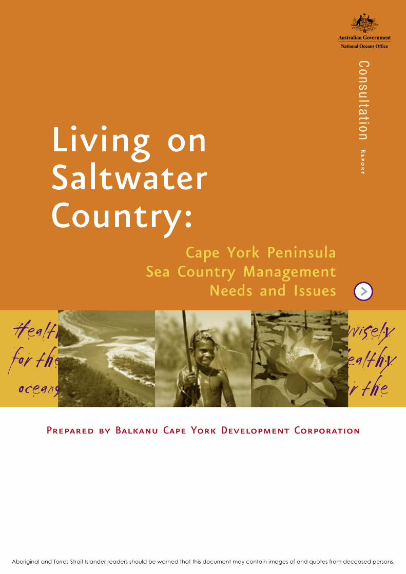
Living on Saltwater Country:
Prepared by Balkanu Cape York Development Corporation
Cape York Peninsula Sea Country Management
Needs and Issues
Aboriginal and Torres Strait Islander readers should be warned that this document may contain images of and quotes from deceased persons.
Consultation
Report
COPYRIGHT © National Oceans Office, 2004
DISCLAIMER This paper is not intended to be used or relied upon for any purpose other than the management of marine resources. The Traditional Owners and native title holders of the regions discussed in this report have not had the opportunity for comment on this document and it is not intended to have any bearing on their individual or group rights, but merely to provide an overview of the use and management of marine resources in the Northern Marine Planning Area for the Northern marine planning process. As such any views expressed in relation to land and sea ownership and/or Aborigi-nal rights and interests are not officially endorsed legal views and should not be regarded as such.
The information and views presented in this report reflect the best efforts of the Balkanu Cape York Land Council given the constraints. The Document has not been thoroughly examined by Traditional Owners concerned nor the Cape York Land Council. As such the views expressed in relation to land and sea ownership and/or Aboriginal rights and interests are not officially endorsed ligal views and should not be regarded as such. Where this Document is used or quoted this ownership should be acknowledged
This report was prepared by the Balkanu Cape York Aboriginal Corporation as an input to the scoping phase of the Northern regional marine planning process. The views expressed in this report are not necessarily those of the Australian Government. The Australian Government does not accept responsi-bility for the contents of this report.
SOURCING Copies of this report are available from: The National Oceans Office Level 1, 80 Elizabeth St, Hobart GPO Box 2139 Hobart TAS 7001 Tel: +61 3 6221 5000 Fax: +61 3 6221 5050 www.oceans.gov.au
REPRODUCTION: Information in this report may be reproduced in whole or in part for study or training purposes, subject to the inclusion of acknowledgement of the source and provided no commercial usage or sale of the material occurs. Reproduction for purposes other than those given above requires written permission from the National Oceans Office. Requests for permission should be addressed to the Public Affairs Officer, National Oceans Office, GPO Box 2139, Hobart TAS 7001.
CREDITS: Design: [email protected] Printing: PML Photos: Kerry Trapnell Published by the National Oceans Office
ISBN: 1-877043-51-6
TITLE:
LIVING ON SALTWATER COUNTRY: CAPE YORK PENINSULA SEA COUNTRY MANAGEMENT, NEEDS AND ISSUES
Sea Country Co
nsu
ltation Repo
rt — Cape Yo
rk Penin
sula
i
List of contentsACKNOWLEDGEMENTS . . . . . . . . . . . . . . . . . . . . . . . . . . . . . . . . . . . . . . . . . . . . . . . . ii
EXECUTIVE SUMMARY . . . . . . . . . . . . . . . . . . . . . . . . . . . . . . . . . . . . . . . . . . . . . . iii
ISSUES SUMMARY . . . . . . . . . . . . . . . . . . . . . . . . . . . . . . . . . . . . . . . . . . . . . . . . . . . . . iv
Introduction . . . . . . . . . . . . . . . . . . . . . . . . . . . . . . . . . . . . . . . . . . . . . . . . . . . . . . . . . . . . . . iv
Regional Recommendations . . . . . . . . . . . . . . . . . . iv
Chapter 1: Introduction . . . . . . . . . . . . . . . . . . . . . . . . . 1
Aims . . . . . . . . . . . . . . . . . . . . . . . . . . . . . . . . . . . . . . . . . . . . . . . . . . . . . . . . . . . . . . . . . . . . . . . . . 1
Rationale and Process . . . . . . . . . . . . . . . . . . . . . . . . . . . . . . . . . . . . . . . . . . . . . . . . 1
Limitations of Project . . . . . . . . . . . . . . . . . . . . . . . . . . . . . . . . . . . . . . . . . . . . . . . . 1
Introducing the region: the study area . . . . . . . . . . . . . . . . . . . . 2
Frameworks of Understanding . . . . . . . . . . . . . . . . . . . . . . . . . . . . . . . . . . . 2
Knowledge Base . . . . . . . . . . . . . . . . . . . . . . . . . . . . . . . . . . . . . . . . . . . . . . . . . . . . . . . . 5
Where is the sea? . . . . . . . . . . . . . . . . . . . . . . . . . . . . . . . . . . . . . . . . . . . . . . . . . . . . 5
Native Title and Sea Country . . . . . . . . . . . . . . . . . . . . . . . . . . . . . . . . . . . 6
The challenge . . . . . . . . . . . . . . . . . . . . . . . . . . . . . . . . . . . . . . . . . . . . . . . . . . . . . . . . . . . 6
Aboriginal Cape York - Regional Directions . . . . . . . . . . . . . 7
Institutional Arrangements
and Policy Frameworks . . . . . . . . . . . . . . . . . . . . . . . . . . . . . . . . . . . . . . . . . . . . . . 9
Process Issues . . . . . . . . . . . . . . . . . . . . . . . . . . . . . . . . . . . . . . . . . . . . . . . . . . . . . . . . . . . 9
Economy . . . . . . . . . . . . . . . . . . . . . . . . . . . . . . . . . . . . . . . . . . . . . . . . . . . . . . . . . . . . . . . . . . . . 11
Commercial Industries . . . . . . . . . . . . . . . . . . . . . . . . . . . . . . . . . . . . . . . . . . . . . . 11
Tourism . . . . . . . . . . . . . . . . . . . . . . . . . . . . . . . . . . . . . . . . . . . . . . . . . . . . . . . . . . . . . . . . . . . 12
Commercial Fishing . . . . . . . . . . . . . . . . . . . . . . . . . . . . . . . . . . . . . . . . . . . . . . . . . . 12
Aquaculture . . . . . . . . . . . . . . . . . . . . . . . . . . . . . . . . . . . . . . . . . . . . . . . . . . . . . . . . . . . . . 12
Subsistence economy . . . . . . . . . . . . . . . . . . . . . . . . . . . . . . . . . . . . . . . . . . . . . . . 13
Community . . . . . . . . . . . . . . . . . . . . . . . . . . . . . . . . . . . . . . . . . . . . . . . . . . . . . . . . . . . . . . . . 13
Introduction . . . . . . . . . . . . . . . . . . . . . . . . . . . . . . . . . . . . . . . . . . . . . . . . . . . . . . . . . . . . 13
Comparative basic social indicators for Australia . . . . . . 14
Regional Issues . . . . . . . . . . . . . . . . . . . . . . . . . . . . . . . . . . . . . . . . . . . . . . . . . . . . . . . . . 16
Introduction . . . . . . . . . . . . . . . . . . . . . . . . . . . . . . . . . . . . . . . . . . . . . . . . . . . . . . . . . . . . 16
Reflections on the National Oceans Office Planning process . . . . . . . . . . . . . . . . . . . . . . . . . . . . . . . . . . . . . . . . . . . . . . . . . . . . . . 16
Fishing strategies . . . . . . . . . . . . . . . . . . . . . . . . . . . . . . . . . . . . . . . . . . . . . . . . . . . . 16
Regional issues from a Balkanu/CYLC perspective . . . . . 17
Transport and Communications . . . . . . . . . . . . . . . . . . . . . . . . . . . . . . . . 19
Conservation . . . . . . . . . . . . . . . . . . . . . . . . . . . . . . . . . . . . . . . . . . . . . . . . . . . . . . . . . . . . . . 19
Introduction . . . . . . . . . . . . . . . . . . . . . . . . . . . . . . . . . . . . . . . . . . . . . . . . . . . . . . . . . . . . 19
Bycatch . . . . . . . . . . . . . . . . . . . . . . . . . . . . . . . . . . . . . . . . . . . . . . . . . . . . . . . . . . . . . . . . . . . 19
Ecosystem-based Management . . . . . . . . . . . . . . . . . . . . . . . . . . . . . . . . . . . 19
Marine Parks . . . . . . . . . . . . . . . . . . . . . . . . . . . . . . . . . . . . . . . . . . . . . . . . . . . . . . . . . . . 19
Fisheries Habitat Reserves . . . . . . . . . . . . . . . . . . . . . . . . . . . . . . . . . . . . . . . . 19
Inshore and offshore extent of management boundaries . . . . . . . . . . . . . . . . . . . . . . . . . . . . . . . . . . . . . . . . . . . . . . . . . . . . . . . . . . . . . . . 21
Research . . . . . . . . . . . . . . . . . . . . . . . . . . . . . . . . . . . . . . . . . . . . . . . . . . . . . . . . . . . . . . . . . . . .22
Subregional Issues . . . . . . . . . . . . . . . . . . . . . . . . . . . . . . . . . . . . . . . . . . . . . . . . . . . .22
Kaurareg . . . . . . . . . . . . . . . . . . . . . . . . . . . . . . . . . . . . . . . . . . . . . . . . . . . . . . . . . . . . . . . . . . 22
Injinoo . . . . . . . . . . . . . . . . . . . . . . . . . . . . . . . . . . . . . . . . . . . . . . . . . . . . . . . . . . . . . . . . . . . . 22
Old Mapoon . . . . . . . . . . . . . . . . . . . . . . . . . . . . . . . . . . . . . . . . . . . . . . . . . . . . . . . . . . . . 23
Napranum . . . . . . . . . . . . . . . . . . . . . . . . . . . . . . . . . . . . . . . . . . . . . . . . . . . . . . . . . . . . . . . 23
Aurukun . . . . . . . . . . . . . . . . . . . . . . . . . . . . . . . . . . . . . . . . . . . . . . . . . . . . . . . . . . . . . . . . . . 23
Pormpuraaw . . . . . . . . . . . . . . . . . . . . . . . . . . . . . . . . . . . . . . . . . . . . . . . . . . . . . . . . . . . . . 23
Kowanyama . . . . . . . . . . . . . . . . . . . . . . . . . . . . . . . . . . . . . . . . . . . . . . . . . . . . . . . . . . . . . 24
Values And Areas . . . . . . . . . . . . . . . . . . . . . . . . . . . . . . . . . . . . . . . . . . . . . . . . . . . . 24
Marine resource values of the sea and of saltwater country in western Cape York Peninsula. . . . . . . . . . . . . . . . . . 24
Regional Distribution of saltwater country and of areas of conservation significance . . . . . . . . . . . . . . . . . . . . . . . . . . . . 37
Gulf of Carpentaria Marine Bioregion . . . . . . . . . . . . . . . . . . . . 38
Southern Gulf Lowlands region . . . . . . . . . . . . . . . . . . . . . . . . . . . . . . . . 38Mitchell River area . . . . . . . . . . . . . . . . . . . . . . . . . . . . . . . . . . . . . . . . . . . . . . 38 Coleman River area . . . . . . . . . . . . . . . . . . . . . . . . . . . . . . . . . . . . . . . . . . . . . 40
Northern Gulf Lowlands region . . . . . . . . . . . . . . . . . . . . . . . . . . . . . . . . 41Holroyd River area . . . . . . . . . . . . . . . . . . . . . . . . . . . . . . . . . . . . . . . . . . . . . . . 41 Archer River area . . . . . . . . . . . . . . . . . . . . . . . . . . . . . . . . . . . . . . . . . . . . . . . . . 42
Arafura Sea Marine Bioregion . . . . . . . . . . . . . . . . . . . . . . . . . . . . . . . . . 43Watson River area . . . . . . . . . . . . . . . . . . . . . . . . . . . . . . . . . . . . . . . . . . . . . . . 43
Weipa and Napranum region . . . . . . . . . . . . . . . . . . . . . . . . . . . . . . . . . . 44Embley River area . . . . . . . . . . . . . . . . . . . . . . . . . . . . . . . . . . . . . . . . . . . . . . 44 Wenlock River area . . . . . . . . . . . . . . . . . . . . . . . . . . . . . . . . . . . . . . . . . . . . . . 45
Northern Peninsula region . . . . . . . . . . . . . . . . . . . . . . . . . . . . . . . . . . . . . . 46Ducie River area . . . . . . . . . . . . . . . . . . . . . . . . . . . . . . . . . . . . . . . . . . . . . . . . . 46 Jardine River area . . . . . . . . . . . . . . . . . . . . . . . . . . . . . . . . . . . . . . . . . . . . . . . . 47
Chapter 2: Management Considerations . . . . . . . . . . . . . . 49
Introduction . . . . . . . . . . . . . . . . . . . . . . . . . . . . . . . . . . . . . . . . . . . . . . . . . . . . . . . . . . . 49
The Building Blocks . . . . . . . . . . . . . . . . . . . . . . . . . . . . . . . . . . . . . . . . . . . . . . . . 50
Native Title . . . . . . . . . . . . . . . . . . . . . . . . . . . . . . . . . . . . . . . . . . . . . . . . . . . . . . . . . . . 50
Management Units - A Suggestion . . . . . . . . . . . . . . . . . . . . . . . . . 50
Boundaries . . . . . . . . . . . . . . . . . . . . . . . . . . . . . . . . . . . . . . . . . . . . . . . . . . . . . . . . . . . . . . . 51
Compliance . . . . . . . . . . . . . . . . . . . . . . . . . . . . . . . . . . . . . . . . . . . . . . . . . . . . . . . . . . . . . . 51
Resourcing Issues . . . . . . . . . . . . . . . . . . . . . . . . . . . . . . . . . . . . . . . . . . . . . . . . . . . . . 52
Access - areas for exclusive use of Traditional Owners . . . . . . . . . . . . . . . . . . . . . . . . . . . . . . . . . . . . . . . . . . . . . . . . . . 52
Bringing It All Together . . . . . . . . . . . . . . . . . . . . . . . . . . . . . . . . . . . . . . . . . .52
Discussion . . . . . . . . . . . . . . . . . . . . . . . . . . . . . . . . . . . . . . . . . . . . . . . . . . . . . . . . . . . . . . . 52
Structural Frameworks for Management - Some Options . . . . . . . . . . . . . . . . . . . . . . . . . . . . . . . . . . . . . . . . . . . . . . . . . . . . . . . . . . 53
The subregional approach . . . . . . . . . . . . . . . . . . . . . . . . . . . . . . . . . . . . . . . . 53
Concept . . . . . . . . . . . . . . . . . . . . . . . . . . . . . . . . . . . . . . . . . . . . . . . . . . . . . . . . . . . . . . . . . . . 95
Conclusions . . . . . . . . . . . . . . . . . . . . . . . . . . . . . . . . . . . . . . . . . . . . . . . . . . . . . . . . . . . . . . 55
Regional and Subregional Aspirations (saltwater plans) . . . . . . . . . . . . . . . . . . . . . . . . . . . . . . . . . . . . . . . . . . . . . . . . . . . . . . 55
Please note that the Living on Saltwater Country Literature Review is a companion document to this report. This report should be read in conjunction with the Literature Review with particular reference to Part B.
ii
Chapter 3: Other Recommendations . . . . . . . . . . . . . . . . . . . . . . . .57
Current position . . . . . . . . . . . . . . . . . . . . . . . . . . . . . . . . . . . . . . . . . . . . . . . . . . . . . . 57
Moving ahead . . . . . . . . . . . . . . . . . . . . . . . . . . . . . . . . . . . . . . . . . . . . . . . . . . . . . . . . . 57
Considerations for the next phases of planning. . . . . . . 57
Process . . . . . . . . . . . . . . . . . . . . . . . . . . . . . . . . . . . . . . . . . . . . . . . . . . . . . . . . . . . . . . . . . . . . 57
On ground actions . . . . . . . . . . . . . . . . . . . . . . . . . . . . . . . . . . . . . . . . . . . . . . . . . . 58
Aboriginal conservation priorities . . . . . . . . . . . . . . . . . . . . . . . . . . . . . 58
Traditional knowledge . . . . . . . . . . . . . . . . . . . . . . . . . . . . . . . . . . . . . . . . . . . . . . 58
Subsistence economy . . . . . . . . . . . . . . . . . . . . . . . . . . . . . . . . . . . . . . . . . . . . . . . 58
Cultural mapping . . . . . . . . . . . . . . . . . . . . . . . . . . . . . . . . . . . . . . . . . . . . . . . . . . . . . 58
Tourism . . . . . . . . . . . . . . . . . . . . . . . . . . . . . . . . . . . . . . . . . . . . . . . . . . . . . . . . . . . . . . . . . . . 58
Economy . . . . . . . . . . . . . . . . . . . . . . . . . . . . . . . . . . . . . . . . . . . . . . . . . . . . . . . . . . . . . . . . . 59
Torres Strait issues . . . . . . . . . . . . . . . . . . . . . . . . . . . . . . . . . . . . . . . . . . . . . . . . . . 59
Legal issues . . . . . . . . . . . . . . . . . . . . . . . . . . . . . . . . . . . . . . . . . . . . . . . . . . . . . . . . . . . . . 59
Research . . . . . . . . . . . . . . . . . . . . . . . . . . . . . . . . . . . . . . . . . . . . . . . . . . . . . . . . . . . . . . . . . . 59
Basis for management . . . . . . . . . . . . . . . . . . . . . . . . . . . . . . . . . . . . . . . . . . . . . 59
Monitoring . . . . . . . . . . . . . . . . . . . . . . . . . . . . . . . . . . . . . . . . . . . . . . . . . . . . . . . . . . . . . . 59
Land use . . . . . . . . . . . . . . . . . . . . . . . . . . . . . . . . . . . . . . . . . . . . . . . . . . . . . . . . . . . . . . . . . 59
Fisheries . . . . . . . . . . . . . . . . . . . . . . . . . . . . . . . . . . . . . . . . . . . . . . . . . . . . . . . . . . . . . . . . . . 59
REFERENCES . . . . . . . . . . . . . . . . . . . . . . . . . . . . . . . . . . . . . . . . . . . . . . . . . . . . . . . . . . . . . 60
APPENDIX ONE . . . . . . . . . . . . . . . . . . . . . . . . . . . . . . . . . . . . . . . . . . . . . . . . . . . . . . . . 62
APPENDIX TWO . . . . . . . . . . . . . . . . . . . . . . . . . . . . . . . . . . . . . . . . . . . . . . . . . . . . . . . . 66
Acknowledgements
We acknowledge the Traditional Owners of Cape York
and the Muralug Archipelago (islands and seas of the
Kaurareg Aboriginal nation in the southern part of the
area known as Torres Strait) and thank them for their
patience.
Balkanu would also like to thank staff of various
agencies and the National Oceans Office particularly
for their assistance as well as a number of individuals.
Special thanks to Jim Monaghan who bought some
“management unit” ideas into a regionalisation
perspective for this report
GlossaryCDEP Community Development and
Employment Program
CSIRO Commonwealth Science and Industry
Research Organisation
CYLC Cape York Land Council
CYNHT Cape York Natural Heritage Trust
CYP Cape York Partnerships
CYPDA Cape York Peninsula Development
Association
CYPLUS Cape York Peninsula Land Use Study
DEH Department of Environment and Heritage
(Queensland)
DPI NFC Department of Primary Industries
Northern Fisheries Centre
EBM Ecosystem-based management
EPA Environmental Protection Agency
GBRMP Great Barrier Reef Marine Park
GBRMPA Great Barrier Reef Marine Park Authority
GulfMAC Gulf of Carpentaria Management Advisory
Committee
MUSP Multiple Use Strategic Plan
NHT Natural Heritage Trust
NLC Northern Land Council
NMP Northern Marine Plan
NMPR Northern Marine Planning Region
NMPA Northern Marine Planning Area
NPA Northern Peninsula Area
NTA Native Title Act 1993 (Cth)
NPF Northern Prawn Fishery
NRS National Reserve System
QFS Queensland Fisheries Service
SEMP South East Marine Plan
TEK Traditional Ecological Knowledge
TSRA Torres Strait Regional Authority
Sea Country Co
nsu
ltation Repo
rt — Cape Yo
rk Penin
sula
iii
Executive Summary
The Northern Regional Marine Planning (NRMP) process
is one of many requests for engagement by Traditional
Owners in various planning and consultation processes
and needs to be cognisant of capacity of communities
and regional organisations to deal with these matters
amidst other demands on their time. This study
overlaps with a number of property planning projects,
native title negotiations, transfers under the Aboriginal
Land Act, return to homeland projects and health and
social justice programs.
This report is a summary of the key aspirations of
Indigenous peoples within the Northern Marine Planning
Area (NMPA). It reflects some central points of note for
consideration within the planning process, and makes
recommendations for future planning.
This report is divided up into sections as follows: -
• Context and background of information on NMPA
• Issues
• Values
• Management arrangements
• Recommendations
In particular we make the following recommendations:
• A management structure be developed that reflects
integration between the natural, cultural, policy and
subregional geographic boundaries;
• That a program is established to implement the
development of cultural criteria to complement
conventional CAR (comprehensiveness, adequate and
representative) natural asset protection;
• That adequate resourcing of regional and subregional
organisations be provided to enable the facilitation
of the National Oceans Office process in the
northern region;
• That the NRMP be developed in such a way that
it incorporates Traditional Owner aspirations and
involves Traditional Owners at all levels in decisions
over sea country.
Our other recommendations are detailed in the main
body of the text.
During and prior to our consultations three points have
been made consistently by Traditional Owners:
1. Why do users of country generally not respect
Traditional Owners?
2. What benefits do Traditional Owners get from
activities in their country?
3. How can Traditional Owners gain more control over
those activities?
From an organisational and procedural viewpoint, we are
interested in the regionalisation of these matters and
integrating uses and aspirations that support sustainable
cultures. Our consultation methods and this report
reflect our understanding. The desire to be recognised
at least as stakeholders and more appropriately as
owners and therefore managers, is a crucial part of the
reconciliation process and provides a route for resolution
of use conflicts and a planning process that supports
protection and sustainability.
We believe it is crucial that research into Traditional
Ecological Knowledge (TEK) and other knowledge be
conducted by Traditional Owner-endorsed process.
Benefits of incorporation of Indigenous interests and
knowledge into the NRMP include:
• It provides the information for cultural sustainability,
passing on information to younger generations;
• It is simply useful natural resource management
information which has not yet contributed fully to
the total knowledge base required for equitable and
proper management of Australian resources;
• It provides an Indigenous scientific component to a
management plan;
• It provides a practical bridge between the social and
environmental components of ESD management.
iv
The Oceans Policy as a whole has no specific legal basis
yet and relies on legislation that applies to marine and
land use issues in existing law at the three levels of
government (see also Literature Review). Indeed the
State of Queensland has not committed to engagement
with the Commonwealth beyond the scoping phase
as far as we are aware. This is not easy to sell to
our Aboriginal constituency who expect bipartisan and
lasting political commitment and who have been waiting
for something practical like a patrol boat or vehicles for
decades. We would strongly encourage all agencies to
deliver some tangible outcomes immediately. These are
good indications of intent and goodwill for Aboriginal
groups that are in many cases bored and frustrated
merely talking about their issues.
Outcomes in this context will be even more complicated
than stitching together sectoral data, identifying
pressure points and resolving conflicts so that natural
systems can function and be productive. Resolution of
social/cultural issues across the planning region (from
Darwin to Torres Strait) is going to be the dominant
management criterion on which a marine plan will
stand or fall.
Issues Summary
Introduction
Given the above, a number of issues were raised by
Traditional Owners. These included:
(a) Desire for the National Oceans Office NRMP to
acknowledge that Indigenous issues and opinions
relating to marine management are an intrinsic part
of mainstream land and sea management;
(b) Indigenous peoples are frustrated by and saturated
with consultation processes. There is a widespread
incredulity that ‘anything will get done’. Some
tangible benefits accruing from the NRMP need to
be identified;
(c) Control of knowledge and other processes need
to be formulated by Traditional Owners, their
representatives and governments.
Regional Recommendations
1. That a meeting is called by Balkanu/CYLC with
senior Traditional Owners of each subregion* for
a debriefing and to discuss negotiation tables and
other possibilities as a way forward.
2. That an Indigenous project person is appointed
(possibly jointly funded) and housed in Balkanu.
3. That Memoranda Of Understanding (MOUs) are
developed between each subregion and Balkanu/Cape
York Land Council (CYLC) and clarity established over
any further contracts that might be let. These will
include words such as holding information “in trust”
as opposed to ownership. We would expect the
National Oceans Office to adopt a parallel position
with Balkanu/CYLC
4. That the range of assessment phase research projects
be examined to see where communities can be
involved.
5. That opinion about operationally funded marine
protected areas be considered as an ongoing process
for the Gulf of Carpentaria and coastal and riverine
areas of west Cape York based on cultural units and
majority Traditional Owner boards. These protected
areas should conform with areas that Traditional
Owners themselves want protected and allowance
made for Traditional Owner-managed tourism and
other sustainable uses to occur within these areas.
Issues relating to section 211 of the Native Title
Act (the right to hunt and fish for traditional
use) should be negotiated and/or compensated as
Traditional Owners see fit. Input into this process
should be confined to those whose interests are
directly affected by management and kept at the
local scale.
6. That those communities currently lacking capacity
be supported by Balkanu/CYLC with funding from
government and other sources to develop more
effective land and sea management functions within
the already agreed subregional framework but not
limiting Traditional Owner’s independence. Current
western Cape York subregions are:
• Kaurareg
• Injinoo Land Trust
• Old Mapoon
• Napranum
• Aurukun
• Pormpuraaw
• Kowanyama
* See appendix 2 for proposed subregions
Sea Country Co
nsu
ltation Repo
rt — Cape Yo
rk Penin
sula
v
7. That funds be provided to Balkanu/CYLC to
investigate mechanisms for marine management
and protection in relation to Aboriginal rights and
interests and that recommendations be made relating
to which tools (State or Commonwealth, preferably
both) might be mutually acceptable.
Options may include
• Indigenous Land Use Agreements (ILUAs)
• Indigenous Protected Areas (IPAs)
• Commonwealth Conservation Agreements
• Co-management under the Fisheries Act
(Queensland (Qld))
• Coordinated conservation agreements (Nature
Conservation Act, Qld)
• Community By-laws
• Resourcing Traditional Owners
• Resourcing Traditional Owners and agencies
• Aboriginal Management Areas
(Qld Marine Parks Act)
• Partnerships with industry
• Local government legislation
8. The importance of recording traditional knowledge
and ideas for management solutions cannot be
understated and we would recommend a large
investment in saltwater ethno-ecological research and
research partnerships as this information will provide
the substance for real management that Traditional
Owners can identify with.
vi
Sea Country Co
nsu
ltation Repo
rt — Cape Yo
rk Penin
sula
1
Chapter 1:
Introduction
Aims
The aims of this report are:
1. To provide some context for the planning process in
relation to the Aboriginal world view and emphasise
the primacy of Aboriginal people and interests on
Cape York as part of the NMPA;
2. To catalyse and progress processes that support and
maintain that reality, culturally, socially, economically
and environmentally and identify roles for subregions,
Cape York Land Council and Balkanu in the following
phases of the NRMP process, including engagement
with Northern Australian Indigenous Land & Sea
Management Alliance (NAILSMA);
3. To provide information to the National Oceans Office
about:
a. what Aboriginal people want for their
saltwater country;
b. what the range of Aboriginal aspirations
and interests is;
c. where Aboriginal people have got to in
pursuing those desires;
d. what Aboriginal people need to fulfil
those wishes;
4. To indicate how the above integrate with regional
initiatives;
5. To contribute to the understanding and delivery of
equitable management of resources;
6. To move on from what is known to practical action
on-the-ground.
Rationale and Process
Good translation and representation of issues rely
more often than not on long-term familiarity with
communities, a good understanding of community
dynamics and a great degree of trust. In short
‘consultants’ cannot easily be found for this type of
work. To overcome some of these challenges we have
chosen to try and devolve remunerated work to the
subregional level and also to have Traditional Owners
at the front of the process.
The various subregions of western Cape York have
different capacities to address issues such as are
required in this plan.
We adopted a two pronged approach. The first is
provision of funds to each sub-region to progress the
consultation process in a locally appropriate manner and
the second is to participate in the former and produce
this regional overview.
Balkanu had a draft contract drawn up and sent to
each subregion along with the preliminary advice. Some
subregions accepted the contracts as they were, some
required changes and others rejected them. There were
some important lessons learned during this process and
in some instances this led to disruptions and delays in
some of the subregions.
Whilst we encouraged subregions to ‘do their own
thing’ we also provided a preliminary advice listing a
number of headings and also provided suggestions to
the subregions on what each heading might contain
without colouring their view of what might be
important to them. This was an effort to create some
themes that might flow together later at the whole
planning region scale and accommodate a desire by the
National Oceans Office and QLD Environment Protection
Agency (EPA) to work towards a themed approach.
Limitations of Project
While we have attempted to find a balance between
the local and the regional scale, we have received
criticism that the themed approach was too inflexible
and does not allow for the freedom sought. On the
other hand we have received criticism that not enough
guidance was provided by the headings suggested.
Where necessary or requested, we provided further
suggestions to subregions.
We also found constraints in operating within an
intense political framework; often with competing
interests and had to work with the difficulties of both
language and time constraints.
We have left it to subregional Traditional Owners as
far as possible to determine the details that they are
prepared to put on the record for this study but are
mindful that subregions might be unaware of potential
pitfalls. We have had to be particularly wary of legal
matters pertaining to the changing demands brought
by recent native title cases. Explaining these at the
community level is time consuming and difficult.
We have not had that time, and in some cases,
information has had to be withheld from publication
as a precaution. Because of the different capacities and
styles at the subregional level the subregional scoping
documents vary accordingly. Some subregions have fully

2
developed GIS facilities and enough human resources
while others have very little capacity. Some have
excellent cultural data bases, others do not.
The fact that the English language is required for
discussions may itself be a major obstacle to proper
communication. In some cases the senior knowledge
holders and decision-makers want a younger person
who speaks English or an intermediary to translate
for them. This has consequences when providing for
sufficient engagement, namely having to transport and
accommodate two people rather than one to meetings
off country. We know that cost is a major concern for
government but in some cases there are no alternatives
and realistic allocations must be made in budgets for
proper involvement.
Introducing the region: the study area
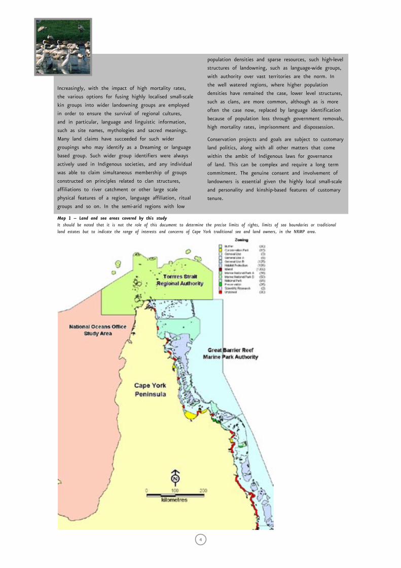
This scoping study area covers the region from the
Staaten River in the south to Hawkesbury Reef in the
north (see map 2) and aims to provide comment on
issues penetrating into the Gulf of Carpentaria. Cape
York is the size of Victoria and Tasmania combined and
has a coastline measured in thousands of kilometres.
The sea country of the Kaurareg falls within the
southern Torres Strait and within the jurisdiction of the
Torres Strait Regional Authority (TSRA). The Kaurareg
are Aboriginal people but have island homes and assert
customary marine tenure over their seas. This will
complicate the National Oceans Office desire to separate
the Torres Strait from the Northern Planning region as
it relates to process. The National Oceans Office should
be aware that there are currently fora for discussing
Kaurareg business in the context of the TSRA and there
are matters of contention pre-dating the NRMP. These
should be investigated by the National Oceans Office
and discussed with the Kaurareg and Cape York Land
Council, their legal representatives.
Frameworks of Understanding
While Indigenous issues have been part of the political
spectrum for some time now, it is worth re-stating
the particular frameworks of understanding within
which Indigenous peoples in our region are operating.
In particular, dissemination of knowledge and notions
of country, sea and native title differ, in some cases
radically, from existing ‘western’ understandings of
land and sea. This section outlines some of these
understandings. It must be understood they crucially
underpin everything else that follows in this report.
Country
It is important to recognise the holistic view that
Indigenous people have of their ‘countries’. The word
country refers to both physical and non-physical
expressions of Aboriginal inheritance.
This document focuses on the Northern regional marine
planning process in relation to what Indigenous people
call ‘country’. The relevance of this concept is important
in representation on advisory committees at various
levels of government, in land and sea management
and in western versus Aboriginal views of ownership
and rights. It is appropriate that from the outset
we acknowledge the intricacy, richness and centrality
of this concept to the Aboriginal world view and
consequently its relevance to proposed management
regimes, particularly the current NRMP in what is
undisputed Aboriginal domain. We also make the point
that it is the Traditional Owners who maintain the
monopoly on what the concept of country means.
Any vision for co-management or management
partnerships will need to accommodate this Indigenous
reality and this view of the relationship between people
and their resources must contribute at least ‘half’ to
a real management partnership with government. In
an effort to clarify what the term ‘country’ means, we
have chosen to quote from Langton et al (1999: 28-30)
in full.
Chapter 1: introduction
Sea Country Co
nsu
ltation Repo
rt — Cape Yo
rk Penin
sula
3
Land and Sea Country. (Langton, M et al (1999:28-30))
Indigenous people are born with an inchoate, inherited
and transmissible right in a “country” which may be
comprised of land and waters, “sea country” etc. Such
rights to, and responsibilities for, land- and-water scapes,
and natural resources therein, are governed by customary
systems of land tenure and other jural realms. These
rights are held in common with other members of the
particular “clan” or local kin-based group.
Indigenous rights in land are inherited, usually according
to descent principles, and often in conjunction with
secondary rights obtained through ritual knowledge, long
periods of residence, and adoption. Unless only one
person of one of these descent-based groups survives,
Indigenous land is owned by descent-based groups,
sometimes referred to in the literature as customary
landholding corporations.
Should the demise of such a customary land-holding
group be suspected because of the death, or imminent
death of sole childless heirs, neighbouring groups with
strong ritual and kinship ties to the landowning group
may begin negotiations for customary succession to the
estate. Such succession processes may continue for many
years, and may not, in the end occur, if a member
of the group in jeopardy should bear appropriate heirs
to the estate. The politics of succession to Indigenous
estates are as byzantine as the history of dynasties
elsewhere in the world similarly dependant on lineage,
correct birth, family standing, wealth and power and
prescribed marriage laws.
Extant Indigenous cultures in Australia regard land not
just as a physical resource, but as a social resource.
These customary estates, or “country”, are landscapes,
imbued with spiritual power. They are perceived by
their owners to be inhabited by ancestral presences,
and shaped by these a priori spiritual forces. Country
may include landscapes, seascapes and riverscapes, and
may have one or more focal sacred sites. These sites
may be terrestrial, marine or riparian. They are regarded
as sacred because of the presence of powerful ancestral
beings of a spiritual nature whose adventures in a
marvellous, mythological past explain the biogeographical
and physical phenomena of the landscape. These beings
are said to be the ancestors of the landowners and are
also said to [be] the ancestors of particular non-human
endemic species of a particular estate or territory. The
relationships between landowners and biogeographical
and physical features of land, sea or waterscape
are symbolised by the mythological stories and thus
landowners and environments and biota are believed
to be inter-related by virtue of the powerful metaphors
of kinship and other human institutions that organise
relationships, rules for behaviour, and responsibilities of
the members.
The sacred knowledge pertaining to the mythological
stories, their meanings and their associated sites,
sacred objects and designs, rituals, songs and dances,
is controlled by particular members of groups, often in
conjunction with kinsmen or kinswomen from closely
related groups conjoined in religious affairs. Such
knowledge is subject to restrictions and severe penalties
apply for the misuse or desecration of such knowledge.
Customary estates, whether comprised of land, sea,
or fresh water, are determined by tradition. While
the estates are bordered and relatively discrete, their
features are also subject to intense negotiations from
time to time, especially in circumstances where
the extent of a border may determine whether a
group benefits from an economic development. Such
negotiations are not arbitrary, however, and are based
on the allegiance of the members of the landowning
groups with their close kin and allies in neighbouring
groups. Just as a customary estate may be subject to
succession, so too estates are sometimes the subject
of fission and fusion. An ambitious senior member of
a group with responsibility for a significant sacred site
may secede from his group of birth, and if he has
sufficient progeny and other grounds for establishing a
new lineage of which he would be the apical head, he
could define his site focused estate and name it after
the site for which [he] is responsible. Similarly, two
groups may fuse, especially when there are sufficient
intermarriages, but insufficient progeny to assert
influence, and an absence of ambitious, competing
leaders. Such fusion may be beneficial when groups are
under environmental or other stresses. They would also
be conjoined by religious interests, again site-based.
Such sites may be joined by so-called “Dreaming” tracks,
or mythological pathways of particular creative ancestors
who played a part in establishing the biogeography of
the territory.
Even in those areas of Australia where the frontier and
post frontier impacts have been severe, whether in terms
of dispossession and depopulation, or repression of
cultural practices and languages, elements of the classical
system of Aboriginal land tenure are to be found. Highly
adaptive strategies for sustaining the key institutions
and positions of authority of Indigenous societies have
been employed throughout Indigenous Australia, an
historical phenomenon not yet adequately understood, for
instance, even in informed legal circles, and even less in
government agencies with responsibilities for Indigenous
land, heritage and related matters.
4
Increasingly, with the impact of high mortality rates,
the various options for fusing highly localised small-scale
kin groups into wider landowning groups are employed
in order to ensure the survival of regional cultures,
and in particular, language and linguistic information,
such as site names, mythologies and sacred meanings.
Many land claims have succeeded for such wider
groupings who may identify as a Dreaming or language
based group. Such wider group identifiers were always
actively used in Indigenous societies, and any individual
was able to claim simultaneous membership of groups
constructed on principles related to clan structures,
affiliations to river catchment or other large scale
physical features of a region, language affiliation, ritual
groups and so on. In the semi-arid regions with low
population densities and sparse resources, such high-level
structures of landowning, such as language-wide groups,
with authority over vast territories are the norm. In
the well watered regions, where higher population
densities have remained the case, lower level structures,
such as clans, are more common, although as is more
often the case now, replaced by language identification
because of population loss through government removals,
high mortality rates, imprisonment and dispossession.
Conservation projects and goals are subject to customary
land politics, along with all other matters that come
within the ambit of Indigenous laws for governance
of land. This can be complex and require a long term
commitment. The genuine consent and involvement of
landowners is essential given the highly local small-scale
and personality and kinship-based features of customary
tenure.
Map 1 – Land and sea areas covered by this study It should be noted that it is not the role of this document to determine the precise limits of rights, limits of sea boundaries or traditional land estates but to indicate the range of interests and concerns of Cape York traditional sea and land owners, in the NRMP area.
Chapter 1: introduction
Sea Country Co
nsu
ltation Repo
rt — Cape Yo
rk Penin
sula
5
Knowledge Base
“All this white-man law. like tangle up barb-wire” Gordon Pablo, Wuthathi Elder, Shelburne Bay, Cape York
Australia is up to 150 years behind some other
countries in recognising native title. (Langton et al
1999: 34). Recognition of Aboriginal people has
generally been contingent on legally recognised rights.
This distinction is important in recognising what
actually happens during consultation as opposed to
the resultant government policy and legislation.
Officers may be sympathetic while the law might
be quite different and ministers can only respond
to the law, not the ethical issues. Accepted Australian
law is complex: the general public, some sectors of
government and many Traditional Owners are unclear
about what the legislation means in real terms. Having
to rely on other peoples’ understanding of Australian
law and the lack of recognition of Aboriginal law
has left Aboriginal people in a very poor negotiating
position over management and management rights. The
fact that Queensland land and sea laws differ adds
further to the problem of understanding the roles and
responsibilities of departments and how they might
interact in one particular sea country or geographic
area and its resources owned by a particular Aboriginal
group. There has been little moral argument forthcoming
from senior levels of government as opposed to officer-
level interaction.
Importantly this study has not sought or proffered
traditional knowledge because we are persuaded by
Traditional Owners that the processes and structures
to keep it safe from exploitation do not yet exist.
The management process must devolve all the way
down to Traditional Owner level before it would be
appropriate to expose such knowledge. Similarly, cultural
site mapping is a sensitive issue. Aboriginal people are
generally not in favour of their sites being mapped by
authorities and archived in government data bases nor
having them advertised in public documents. We have
made suggestions on ways these problems might be
overcome in relation to planning.
In this context, it is important to re-emphasise that
practical outcomes are going to have to be based on
respect rather than the letter of the law.
It is essential to remember that, for Indigenous peoples,
native title exists whether it is recognised by the
common law or not. The common law recognition does
not alter the form of that title, it only alters the
enforceability in Australian courts. Indeed, it is as a
result of the continued observance of our laws and
customs, independently of the acceptance of common
law recognition by Australian courts, that native title
continues today. It is those laws and customs of
Indigenous peoples that have continued to exist, and
their meaning to us, that should be recognised by
the common law not a remodelling of that meaning
by lawyers so that it can be neatly compared with
interests they are familiar with or be understood in
accordance with their own world views. Astoundingly, it
appears to be assumed too eagerly by some that native
title is allowed to exist “only because it is recognised
in the common law”. This misconception is then used
to legitimise the manipulation of Aboriginal concepts of
land ownership to conform to western concepts
(Michael Dodson 1995)
Where is the sea?
In the world of Robinson Crusoe property rights
play no role. Property rights are an instrument
of society and derive their significance from the
fact that they help a man form those expectations
which he can reasonably hold in his dealings with
others. These expectations find expression in the
laws, customs, and mores of a society. An owner
of property possesses consent of fellow men to
allow him to act in particular ways. An owner
expects the community to prevent others from
interfering with his actions, provided that these
actions are not prohibited in the specification of
his rights. (Rigbsy quoting Demsetz: 1967:346)
While mainstream Australia generally accepts that
Aboriginal people have connections to land, the public
perception of that extension to water is less clear
and aggravated by a European belief that the sea and
its contents belong to everyone. Coastal and indeed
inland Aboriginal peoples have very strong associations
with rivers, estuaries and the sea and in the case of
the west coast of Cape York associations with the sea
appear to move further offshore as one moves further
north, where at the top of Torres Strait and east
Arnhem Land Indigenous interests merge with those of
Papua New Guinea and West Papua (or Irian Jaya).
6
In relation to saltwater interests on Cape York, Cordell
welcomes “the appearance of ‘sea,’ alongside land” in
the terms of reference of the Cape York Peninsula Land
Use Study as it pertains to Indigenous management.
Saltwater is very important to coastal Aboriginal
people and is highly underrated in terms of funding
priorities at all political levels. It has been afforded
some attention since the Croker Island decision. The
issues are immense, ranging from the Great Barrier Reef
Marine Park Authority (GBRMPA) on the east coast,
TSRA boundary issues in the north, Gulf issues in the
west with multiple layers of jurisdiction in all areas.
Issues in the Sea - Negotiating over Sea Country
• Shipping traffic
• Potential marine accidents
• Mining
• Several types of aquaculture
• Recreational fishing
• Charter fishing
• Subsistence fishing
• Commercial fishing (several different types)
• Indigenous commercial opportunities
• Indigenous fishing and hunting
• Bycatch issues
• Land based tourism
• Coastal management
• Dune protection
• Access
• Cultural site management
• Weeds and feral animals
• Wetlands
• Catchment effects of fire
• Cattle grazing
• Tree clearing
• Cropping
• Erosion
• Water quality
• Enforcement
Native Title and Sea Country
It should be noted that the sea has featured as a very
poor second in relation to Native Title claims progressed
and management arrangements resolved. Saltwater food
sources are extremely important to Aboriginal peoples
on both coasts of Cape York and particularly in the
Torres Strait (Johannes and MacFarlane 1991). Indigenous
peoples witnessed the first native title case in 1992 – a
case dealing with land rather than the sea even though
the claim centred on an island. (Mabo and others v.
Queensland [no 2] 1992 175 CLR 1). We have seen the
establishment of land councils as opposed to land and
sea councils. The Indigenous Land Corporation (ILC)
was set up with the objective of buying land back and
supporting the management of purchased lands. Clearly
the need to address land issues has resulted in the
employment of specialist land expertise, land lawyers
and so on.
As has been identified by Petersen and Rigsby (1998),
property rights in the sea represent a significant “blind
spot” in the consideration of Indigenous rights generally
and that the consideration of customary marine tenure
has only recently become a subject of interest as late
as the 1980s.
Petersen and Rigsby note also what they describe as a
“highly significant reference to ownership of seas in the
Torres Strait, although it is consigned to a footnote.
Anthony Wilkins noted:
I think there is what may be termed a spatial
projection of the idea of proprietorship. As foreshore
rights of landed property extend not only over adjacent
reef but to the water over it [emphasis added by
Petersen and Rigsby] – as in the case of fish caught
within the area- so the inhabitants of certain areas
appear to have a pre-emptial right to certain distant
fishing stations which lie off their part of the coast
(1908: 167 fn1).
This appears to be widely true of Aboriginal marine
tenure systems.”
The challenge
In this context, we do not want to use our
involvement in this NRMP process to necessarily
expound the virtues of western science and
management, nor to persuade or guide Traditional
Owners into a western construct or government-preferred
management solution.
We believe that there are solutions but they must
be negotiated not imposed. Whilst many mainstream
science initiatives do have merit, our role is to assist
in maintaining the aspects of ‘country’ as described
earlier and to create entry points in the dominant
structures (the existing governmental structures) and
process drivers (eg bioregional modelling, ecosystem-
based research) for very long established Indigenous
values and understandings, at scales relevant to
Traditional Owners
Chapter 1: introduction
1 This document sought to provide a vehicle for the following groups of Aboriginal people to express their views in the best way possible and this list may not be agreeable to all.
Sea Country Co
nsu
ltation Repo
rt — Cape Yo
rk Penin
sula
7
It is worth remembering that Indigenous people
were granted citizenship of Australia as recently
as 1967, Old Mapoon on Cape York was razed and
its residents removed to New Mapoon in 1963,
The Native Title Act was passed in 1993 and the
Croker Island Case (finding limited non-exclusive sea
rights and no commercial rights) was finalised only
in 2002. The Native Title Act has been the main
inducement for Australia to attend to its legal
obligations in relation to land and sea. There are
structures geared for land claims. The same cannot
be said for the sea.
Aboriginal Cape York - Regional Directions
Cape York has a sophisticated and integrated vision
emerging for Indigenous peoples and generated by
Indigenous people. This plan conforms with the ATSIC
regional plan, and establishes roles for Cape York Land
Council, Apunipima Cape York Health Council, Cape York
Partnerships, Cape York Institute and Balkanu with the
potential of bringing other expertise and capacity to
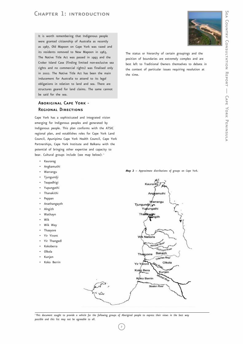
bear. Cultural groups include (see map below): 1
• Kaurareg
• Angkamuthi
• Warrangu
• Tjungundji
• Teapadhigi
• Yupungathi
• Thanakithi
• Peppan
• Anathangayth
• Alngith
• Wathayn
• Wik
• Wik Way
• Thaayore
• Yir Yiront
• Yir Thangedl
• Kokoberra
• Olkola
• Kunjen
• Koko Berrin
The status or hierarchy of certain groupings and the
position of boundaries are extremely complex and are
best left to Traditional Owners themselves to debate in
the context of particular issues requiring resolution at
the time.
Map 2 – Approximate distributions of groups on Cape York.
8
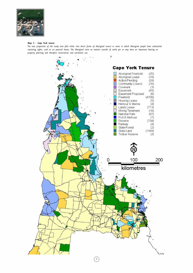
Map 3 - Cape York tenure The vast proportion of the study area falls either into direct forms of Aboriginal tenure or areas in which Aboriginal people have substantial coexisting rights, such as on pastoral leases. The Aboriginal voice on matters outside of cattle per se may have an important bearing on property planning and therefore conservation and catchment use.
Chapter 1: aboriginal cape york - where are we?
Sea Country Co
nsu
ltation Repo
rt — Cape Yo
rk Penin
sula
9
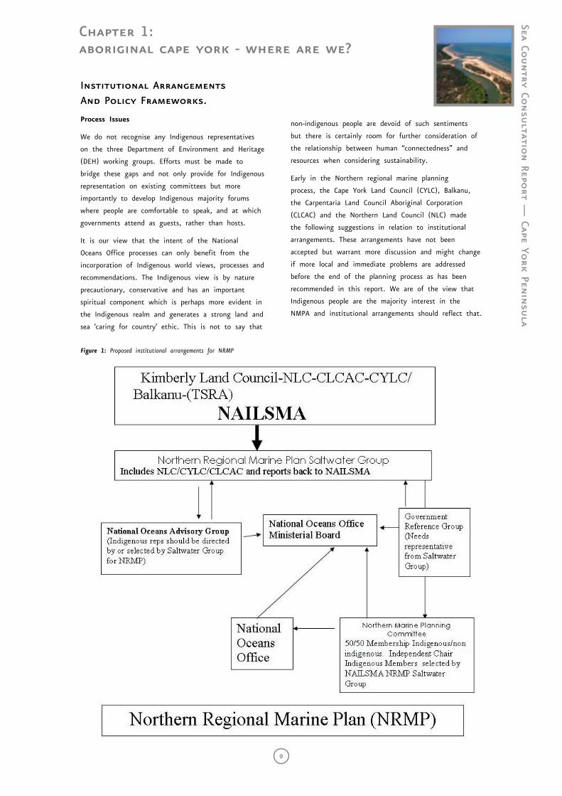
Figure 1: Proposed institutional arrangements for NRMP
Institutional Arrangements And Policy Frameworks.
Process Issues
We do not recognise any Indigenous representatives
on the three Department of Environment and Heritage
(DEH) working groups. Efforts must be made to
bridge these gaps and not only provide for Indigenous
representation on existing committees but more
importantly to develop Indigenous majority forums
where people are comfortable to speak, and at which
governments attend as guests, rather than hosts.
It is our view that the intent of the National
Oceans Office processes can only benefit from the
incorporation of Indigenous world views, processes and
recommendations. The Indigenous view is by nature
precautionary, conservative and has an important
spiritual component which is perhaps more evident in
the Indigenous realm and generates a strong land and
sea ‘caring for country’ ethic. This is not to say that
non-indigenous people are devoid of such sentiments
but there is certainly room for further consideration of
the relationship between human “connectedness” and
resources when considering sustainability.
Early in the Northern regional marine planning
process, the Cape York Land Council (CYLC), Balkanu,
the Carpentaria Land Council Aboriginal Corporation
(CLCAC) and the Northern Land Council (NLC) made
the following suggestions in relation to institutional
arrangements. These arrangements have not been
accepted but warrant more discussion and might change
if more local and immediate problems are addressed
before the end of the planning process as has been
recommended in this report. We are of the view that
Indigenous people are the majority interest in the
NMPA and institutional arrangements should reflect that.
10
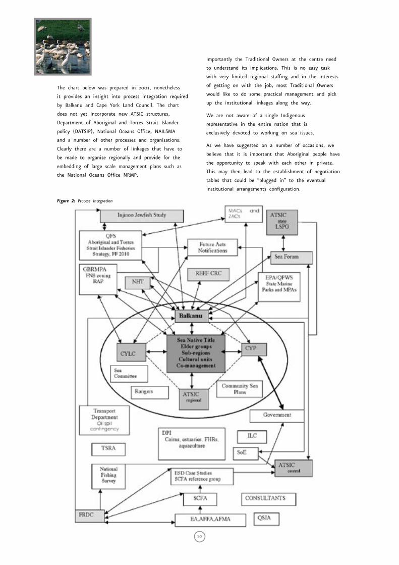
The chart below was prepared in 2001, nonetheless
it provides an insight into process integration required
by Balkanu and Cape York Land Council. The chart
does not yet incorporate new ATSIC structures,
Department of Aboriginal and Torres Strait Islander
policy (DATSIP), National Oceans Office, NAILSMA
and a number of other processes and organisations.
Clearly there are a number of linkages that have to
be made to organise regionally and provide for the
embedding of large scale management plans such as
the National Oceans Office NRMP.
Importantly the Traditional Owners at the centre need
to understand its implications. This is no easy task
with very limited regional staffing and in the interests
of getting on with the job, most Traditional Owners
would like to do some practical management and pick
up the institutional linkages along the way.
We are not aware of a single Indigenous
representative in the entire nation that is
exclusively devoted to working on sea issues.
As we have suggested on a number of occasions, we
believe that it is important that Aboriginal people have
the opportunity to speak with each other in private.
This may then lead to the establishment of negotiation
tables that could be “plugged in” to the eventual
institutional arrangements configuration.
Figure 2: Process integration
Chapter 1: institutional arrangements and policy frameworks
Sea Country Co
nsu
ltation Repo
rt — Cape Yo
rk Penin
sula
11
Economy
There is a broad spectrum of economic aspirations both
in type and intensity on the west coast of Cape York.
It is clear that Aboriginal people are well and truly
over hosting the exploitation of their land and sea, and
surrounding land and sea which may affect their own
country, by impacting on brood stocks, food chains
etc. Off-shore gillnet, fish trawl and prawning industries
are of particular relevance. There are potential impacts
from shipping incidents particularly during periods of
northerly and westerly weather; in fact any kind of
spills in the Gulf are likely to impact on one or more
of the three coasts in the planning region because of
the gyre currents. In the event of petroleum exploration
and industry development there may well be risks
attached in these partially enclosed waters.
In general Aboriginal peoples have gained little or
nothing from the commercial use of the Gulf and there
is little reason for them to support developments which
pose threats whether real or perceived (here alluding
to the apparent improvement in Barramundi stocks in
the Gulf signalled by Queensland Fisheries Service (QFS),
where those unacquainted with recent trends might
suspect otherwise, namely that Barramundi stocks are
not improving). There is in some industries a sorry
history of exploitation of Aboriginal labour in the
region, the Beche de Mer industry, for example.
Cape York Aboriginal people have, through circumstances
beyond their control, been economically marginalised.
This has contributed to serious secondary effects
including health and social challenges which form core
targets for our indigenous partner organisations.
Responses to these challenges and signalling a
significant shift in consciousness relating to Aboriginal
participation in the ‘real economy’ were precipitated
by Cape York Aboriginal leaders, in particular by the
thoughts of Noel Pearson in his book “Our Right to
Take Responsibility” (Pearson, 2000). The central aim
is to shift from a welfare economy to a real economy
supported by skills development and associated social
initiatives such as alcohol management programs. The
concept proved central in the development of Cape
York Partnerships, a partnership with the Queensland
Government. (see www.capeyorkpartnerships.com.au).
The ensuing Cape York Justice Study in turn made
recommendations on substance abuse and other matters.
The challenge is providing for sustainable real economies
within cultural and environmental land-and-sea scapes
that are valued locally and by broader Australia.
Commercial Industries
Many commercial aspirations in the planning region
are similar in each Land Council area, as might be
expected, with foci on practicality, low (or appropriate)
technology solutions and labour intensive type
developments which in some cases are not geared
specifically or purely to achieve a high economic
return. There are balances to be reached with other
non-economic aspirations. There is further need to
integrate potential economic alternatives in a way that
protects culture and the environment. In a coastal area
rich in cultural sites but also desperate to generate
income, this poses challenges. It is important that
good information is available to Traditional Owners
and that development is well considered. Many of
the communities have ideas but are wary of revealing
them for fear of having them seized by opportunists
who may have the wherewithal to capitalise on them
before Traditional Owners can. During our research we
sought and were provided with project lists which are
being progressed by Cape York Partnerships, Balkanu
Business Hubs and others. There was concern that some
were commercial-in-confidence and therefore details are
not provided here. This means that these potentials
need to be discussed at the local level in order to
resolve planning issues and possible conflicts between
prospective development areas and areas of non-
extractive or conservation use.
12
Tourism
Tourism, without doubt, shows a very good potential
for most communities and a Cape York Tourism Heads
of Agreement has been developed and is still evolving.
Tourism has been a subject of debate at the regional,
state and national scales with the Cape York Peninsula
Development Association (CYPDA) active in that arena.
Traditional Owners do however want to be sure about
who owns the strategy applying to their country.
It is likely that all west coast communities could be
‘fully booked’ as far as hosting recreational fishing
is concerned. What is required is site assessment by
Traditional Owners, booking systems and control of
areas which are currently overrun by visitors who are
unaware of protocols, sensitive areas or management
aspirations for saltwater country in each subregion.
Areas like Kowanyama have a long history of providing
fishing camps for recreational fishers and are usually
booked out each holiday season when the roads are
open, (May-November). However, where tourism is new
or Traditional Owners wish to sell new products, an
Indigenous tourism network might prove useful.
Commercial Fishing
Most west coast communities also have an interest in
commercial fishing. The challenge is fitting these desires
into the existing permitting structures, negotiating
fair allocations, skills development and accommodating
cultural views of saltwater country and how those
interface with regional Indigenous fishery concepts such
as the Cape York Fishing Company developed under the
auspices of the Cape York Partnerships program and
Balkanu Business Hubs. There is still negotiation to
occur on this potential but the intent is clearly there
with funds available for licence purchasing. The existing
industry should be aware of it and the government
should be clear about its motivations. The Cape
York Fishing Company is focused on reducing welfare
dependence whilst recognising pressures on fisheries
brought about by the cumulative take of all sectors
operating in the region.
We believe that establishment of equity is going to
have to involve a buy-out of existing non-indigenous
fishing effort and its replacement with Indigenous
fishing effort. The government must be prepared for
this and the potential for ATSIC or its successor to
contribute investigated. The social consequences are
potentially significant as economic benefits accrue to
local Aboriginal people.
Importantly, we would strongly suggest that
governments do not take it upon themselves solely
to develop the strategy to establish balance. It is
absolutely essential to bring the people involved on the
ground along with the process. Before any such matters
are negotiated with parties, Indigenous leaders need to
talk and they in turn need to talk with Traditional
Owner groups. There is a very real possibility of
inappropriate processes simply alienating parties such as
commercial and recreational users rather than engaging
them. People need to be ready to discuss these issues,
not forced to talk for the sake of a planning deadline.
Aquaculture
Whilst there appear to be opportunities relating to
aquaculture we believe that some caution is warranted.
Aquaculture has not got off the ground in a big way
on Cape York at this stage although moves are afoot
at Commonwealth and regional scales. The National
Indigenous Aquaculture strategy was developed by Dr.
Chan Lee (2001) and staff have been put in place
in Canberra with a view to generating interest in
aquaculture in Indigenous areas across Australia. An
interim Indigenous Aquaculture working group has been
established and is facilitated by the aquaculture unit
at Department of Primary Industries (DPI) Northern
Fisheries in Cairns.
We are strongly of the view that aquaculture species
need to be well chosen and that there needs to
be consideration of generating negative competition
between communities. Where the main source of
product is Cape York, or if Cape York could develop an
iconic aquaculture species, that might be a different
matter.
The ability to compete with existing producers who are
closer to the market is an issue in some cases. We
have expressed some of our views on aquaculture in a
paper presented to a workshop in Cairns in April 2002
(Aken and Roberts 2002).
Stephanie Golden (1995) provides an overview of
potential of aquaculture and mariculture developments.
This includes a map of areas suitable for pond
aquaculture as calculated against soil type, flood events
and pH. Opportunities for pond culture need to be
assessed in relation to benefits sought and it should be
understood that some of these benefits may be solely
for local food production, training and involvement in
an occupation of some sort.
There are numerous opportunities for cage cultures in
a number of estuaries, but a broad view of risks and
benefits should be taken, incorporating more than just
economic indicators. Why grow barramundi, for example,
Chapter 1: economy
Sea Country Co
nsu
ltation Repo
rt — Cape Yo
rk Penin
sula
13
if a well managed river is full of barramundi and there
are other barramundi farms much closer to cities and
towns which could easily price communities out of the
market? If barramundi are for community food, it might
be better investing in the maintenance of local stocks.
The public image of Cape York as natural wilderness
might however provide some market advantage.
DPI Cairns is currently undertaking an aquaculture
scoping study due for completion in 2004 which should
further inform these matters.
Traditional Owners have seen significant problems
occurring in waters and lands from being encouraged to
‘try some development’. Weeds and feral animals, aerial
seeding of exotic grasses into wet lands for cattle and
similar influences have caused problems. In general our
recommendation would be to grow poducts that are
endemic and to start on a small scale. The latter would
conflict with some types of aquaculture that require a
critical mass to be economical and that in turn brings
possible problems for areas rich in cultural sites. There
will, however, be viable options.
Subsistence economy
The importance of the subsistence economy cannot be
underestimated. There is a clear need to realistically
consider exclusive use areas around outstations and
recognised community-use areas. This potential has been
caught up in the Native Title debate where only non-
exclusive and non-commercial indigenous use has been
recognised. However, opportunities exist for agreements
to be made between users.
We have referred to government and societal responses
to Aboriginal aspirations, rights and interests as being
contingent on case law. This path is not likely to
produce the results sought by Aboriginal people in the
short to medium term. Aboriginal people want the
ability to get food in a non-competitive setting in
an area where they are the undisputed majority and
really need food. Their competition is there either for
recreation or profit. This, in our view, is totally unjust
and agreements must be entered into in the true spirit
of reconciliation.
Note. It is worth considering the utility of the
Indigenous Subsistence Survey Kit or parts of it,
in obtaining information on the use of marine
resources. (This kit has been provided to the
National Oceans Office). However we should bear
in mind Traditional Owners’ likely scepticism of
unfamiliar people fossicking for such information,
namely where the best fishing areas are, how
much is caught at each and when. The success
of the survey kit methodology is contingent
on support and training in its use and also
that information emanating from it is held and
negotiated by the community concerned. It is
intended to be a subregional and Indigenous
regional organisational tool, not a government tool.
Community
Introduction
Aboriginal people are by most measures a disadvantaged
group in Australia. The mortality rates at comparatively
young ages are particularly telling. Refer to Part B of
the Living on Saltwater Literature Review for community
histories. Relationships between people at the local scale
are extremely complex and Traditional Owners themselves
are best placed to advise on who should speak on
issues and areas.
With the exclusion of Weipa, the vast majority of
the population on the west coast is made up of
Indigenous people and we provide more detailed
information on demographics and social interactions in
the accompanying document entitled Living on Saltwater
Country: A Review of Indigenous use, management,
needs and issues available from the National Oceans
Office along with some tenure history. The subregions
have also provided their own accounts of their
communities in the subregional reports which may also
be available from the National Oceans Office, depending
on permissions. These documents should be consulted in
conjunction with this report.
A summary of subregional issues as they pertain to the
NMPR can be found later in the document.
14
Comparative basic social indicators for Australia
Table 1(a): Social indicators for western and northern Cape York Peninsula (ABS 2001)
National median age = 35
National indigenous median age = 20
National median weekly individual income = $300 - $399
National weekly indigenous individual income = $200 - $299
National mean household size = 2.6 persons
National mean indigenous household size = 3.4 persons
National median weekly household income = $700 - $799
National indigenous median weekly household income = $600 - $699
National Year 12% = 38%
National indigenous year 12% = 17%
National CDEP % = n/a
Chapter 1: community
Sea Country Co
nsu
ltation Repo
rt — Cape Yo
rk Penin
sula
15
Table 1(b): Social indicators for southern Gulf Lowlands (ABS 2001)
COMMUNITY Totalpopulation
Indigenouspopulation
Indigenousmedian age
Indigenous median weekly individual income
Indigenous mean household size
Indigenous median weekly household income
Year 12 (%)
CDEP (%)
Kowanyama 890 820 26 $160 - $199 5.4 $600 - $699 13% 71%
Pormpuraaw 649 575 28 $200 - $299 4.6 $800 - $999 3% 88%
Table 1(c): Social indicators for northern Gulf Lowlands (ABS 2001)
COMMUNITY Totalpopulation
Indigenouspopulation
Indigenousmedian age
Indigenous median weekly individual income
Indigenous mean household size
Indigenous median weekly household income
Year 12 (%)
CDEP (%)
Aurukun 1047 945 24 $120 - $159 6.0 $600 - $699 6% 91%
Table 1(d): Social indicators for Weipa/ Napranum region (ABS 2001)
COMMUNITY Totalpopulation
Indigenouspopulation
Indigenousmedian age
Indigenous median weekly individual income
Indigenous mean household size
Indigenous median weekly household income
Year 12 (%)
CDEP (%)
Weipa 2487 299 31 $700 - $799 2.8 $1200 - $1499 24% n/a
Napranum 727 676 23 $160 - $199 4.1 $400 - $499 8% 82%
Table 1(e): Social indicators for Thursday Island and the Northern Peninsula Area (ABS 2001)
COMMUNITY Totalpopulation
Indigenouspopulation
Indigenousmedian age
Indigenous median weekly individual income
Indigenous mean household size
Indigenous median weekly household income
Year 12 (%)
CDEP (%)
Mapoon 215 189 26 $160 - $199 6.1 $500 - $599 12% n/a
New Mapoon 327 305 16 $160 - $199 5.1 $500 - $599 21% 73%
Injinoo 385 376 18 $160 - $199 5.0 $600 - $699 18% 48%
Umagico 254 237 20 $160 - $199 4.2 $500 - $599 21% 87%
Bamaga 774 638 19 $200 - $299 4.2 $800 - $999 33% 37%
Thursday Island 1049 809 18 $400 - $499 4.9 $800 - $999 25% 0
Table 1(f): Basic social indicators for western Cape York Peninsula (ABS 2001)
COMMUNITY Totalpopulation
Indigenouspopulation
Indigenousmedian age
Indigenous median weekly individual income
Indigenous mean household size
Indigenous median weekly household income
Year 12 (%)
CDEP (%)
Kowanyama 890 820 26 $160 - $199 5.4 $600 - $699 13% 71%
Pormpuraaw 649 575 28 $200 - $299 4.6 $800 - $999 3% 88%
Aurukun 1047 945 24 $120 - $159 6.0 $600 - $699 6% 91%
Weipa 2487 299 31 $700 - $799 2.8 $1200 - $1499 24% n/a
Napranum 727 676 23 $160 - $199 4.1 $400 - $499 8% 82%
Mapoon 215 189 26 $160 - $199 6.1 $500 - $599 12% n/a
New Mapoon 327 305 16 $160 - $199 5.1 $500 - $599 21% 73%
Injinoo 385 376 18 $160 - $199 5.0 $600 - $699 18% 48%
Umagico 254 237 20 $160 - $199 4.2 $500 - $599 21% 87%
Bamaga 774 638 19 $200 - $299 4.2 $800 - $999 33% 37%
Thursday Island 1049 809 18 $400 - $499 4.9 $800 - $999 25% 0
n/a = not available * it is likely that the figures for Weipa include indigenous and non-indigenous individual income
Clearly being able to do anything much beyond
surviving under current circumstances is difficult and
it is for this reason that communities are keen to
offer fee for service to agencies that have management
responsibilities in these remote regions. However skills
transfer is required in some cases where the ability
to apply Australian Law correctly is necessary. This
necessity is disputed by many Traditional Owners
There are, however, opportunities to enlist Aboriginal
observation and reporting powers before this point of
full official endorsement is reached.
16
Regional Issues
Introduction
This chapter provides an outline of the scope of
different issues that we have been informed by
Traditional Owners in the region comprise their main
concerns about the National Oceans Office process -
and on the community in terms of Land and Sea
Country management.
It is divided into three sections - broad reflections on
National Oceans Office which are summarised below and
further detailed in Appendix One which is our analysis
of the presentation by the National Oceans Office in
2002 to the three Land Councils in Cairns.
Secondly we present the scope of issues from a whole
of Cape York regional perspective. This includes a broad
discussion on issues such as conservation, ecosystem
based management and transport.
The chapter concludes with the presentation of issues
on a case by case basis of the communities in the
NMP area.
Reflections on the National Oceans Office
planning process
Drawing on a literature review of National Oceans
Office documents which includes their website, the
Ocean Policy and the presentation to the three Land
Councils in 2002 on the concept of the Northern
Marine Plan; we would like to make some comments.
Our comments are centred on the mechanisms,
philosophies and policies relating to getting the
Aboriginal message across within the frameworks
developed to achieve such aims and goals. How many
Aboriginal people are in the scientific, advisory and
political machinery of these processes? What are the
hierarchies? Which Aboriginal people should be involved?
How are they appointed?
There is a need for properly resourced Indigenous
representative structures dealing with saltwater issues
at several levels. This again became very clear at the
Waibene (Thursday Island) Maritime Summit 2001. It
is unreasonable to expect the totality of representation
of Aboriginal interests to be by way of a single
representative, greatly outnumbered by non-indigenous
interests, in a foreign meeting environment. Authorities
seem baffled by the reluctance of Traditional Owners to
sit on some committees. Such reluctance evaporates at
Aboriginal meetings. Any sincere effort to get Aboriginal
participation will require contemplation of Aboriginal
only meetings, something that has never been a
government priority and consequently not budgeted for.
The intentions of the National Oceans Office are
good insofar as the data will be used to develop
a management plan but it is terribly fraught for
Aboriginal people who may not yet have:
1. Enough information and/or information services
themselves to compete on an equitable basis with
other parties;
2. Solid local processes as they relate to regional
matters. Traditional Owners can deal very well with
their own local issues;
3. Clear governance structures as they relate to
representation on government committees;
4. The facilities and personnel to interpret and create
secure data sets that the current planning processes
might find useful;
5. A full understanding of the legal context in which
consultations are occurring;
6. An understanding of the intent of the planning
process from a government perspective; and
7. An understanding of the implications of providing
certain information at this particular time.
(Information that might prove to be Native Title
evidence in the future or information that might
provide advantages for commercial operators.)
Fishing strategies
In the northern parts of Cape York there is an increase
in the number and size of local community boats which
allows access to marine resources further offshore in
more safety and in less time. The increase in fishing
effort is ‘profitable’ in one sense insofar as access to
relatively rich resources is concerned but a further
complication relates to the diversion of income to pay
for these boats. If money is short to repay loans for
boats then the natural tendency will be to use one’s
new found ability to catch food to do so rather than
going to the local store to buy food where it is much
more expensive. Some of the boats cost in excess of
$20,000 so it is in the interests of boat owners to
try and make them ‘pay’. Moving in this direction
throws a different light on resource management and
some caution is required so that it is not the resource
or environment that is actually paying to maintain
infrastructure that might not actually be necessary if
people did not have to go far to get it. Hence the
possibility of protecting Aboriginal food resources by
exclusion of competition and therefore negating the
need for bigger and better boats is raised.
Chapter 1: regional issues
Sea Country Co
nsu
ltation Repo
rt — Cape Yo
rk Penin
sula
17
There is a need for people to prepare themselves for
the end result of such a scenario (the use of natural
capital to support the boats to catch it) unless ways
can be found to manage the situation, including
possible food subsidies. Simply providing subsidies
however is not straight forward because of the social
and cultural aspects of food getting. For example, it
may be physically and politically possible to offset the
take of marine products with a load of beef but that
might not be acceptable to saltwater people who have
a taste for, and culture based around, certain marine
species. Apart from that some species are believed to
be nutritionally necessary. Catching fish in a breeding
or pre-breeding state (when they are fat) is a common
desire. Sometimes certain fish are reserved for certain
people and fish size can influence the ease with
which old people can eat them. Small fish are often
considered sweeter and of better nutritional value.
Aboriginal people are seeking the opportunity and
mechanisms to get their collective position clear and
agreed to by Traditional Owners at various scales
(individual, family, clan, group, subregion and region)
before being pushed into multi-stakeholder meetings
with totally different terms of reference, motivations
and world views to Indigenous peoples.
There is some concern in Kaurareg and Injinoo country
about the condition of bait fish stocks that used to
swarm around the wharves at Horn Island and Seisia.
There has also been an Indigenous fishing survey in
Injinoo which indicates a very high participation rate
and dependence on fishing for food.
It would be remiss of us not to mention some
disappointments having been involved in the Aboriginal
and Torres Strait Islander Fisheries Strategy. It required
a good deal of persuasion by Cape York Land Council
to eventually get at least the Queensland part of
this strategy on the Queensland Fisheries Management
Authority (QFMA) table in Jan 1999 (Smyth 1999).
It remains unimplemented. We have heard two
reasons for this. The first is that the current State
fisheries organisation, the Queensland Fisheries Service
(QFS), is not bound by initiatives promoted by its
predecessor the QFMA, and the second is that any
outstanding Fishing Strategy issues have been captured
in arrangements relating to the development of a Cape
York Fishing Company.
The Aboriginal and Torres Strait Islander Fishing
Strategy has a chequered history starting with the
establishment of the National Indigenous Coastal
Reference Group (a 1993 National Coastal Zone Inquiry
recommendation) unilaterally disbanded by the Liberal/
National government in 1998. We believe that this was
a significant backward step since the Reference Group
would have been useful to government precisely under
these current circumstances, namely the development
and implementation of Oceans Policy and Regional Marine
Plans. A major meeting of Indigenous fishers argued
for the need for National Indigenous representation at
the Maritime Summit on Thursday Island (March 2001).
There remains a significant consultation and negotiation
gap at this level.
Balkanu was involved in the work up of the
Commonwealth 2000 State of Environment report as
a member of the expert panel. Unfortunately much
of the Indigenous contribution and intent was edited
out in the final report. That was a national document
and as such there might have been excuse to take a
lowest common denominator or pro rata approach (as
a proportion of the total Australian population) to
Indigenous issues. This would not hold for the current
study where Indigenous people constitute the majority
of “the public” in the NRMP (see Living on Saltwater
Country Literature Review Part B).
In spite of the first national attempt at an Aboriginal
and Torres Strait Islander Fisheries Strategy there is an
indication that another attempt will be made. (DAFF,
2003). We are unsure about how this might differ
from the first iteration and what the local connections
for the process are intended to be. The Lingiari report
on water rights also seems to have been shelved.
Cape York was developing a fishing strategy under
the auspices of Cape York Peninsula (CYP) 2010. This
has been redirected into a working group process for
political reasons. In summary there have been numerous
attempts to develop fishing strategies but nothing much
to show at this time.
Regional issues from a Balkanu/CYLC perspective
A serious attempt should be made to see that
arrangements made between State and Commonwealth
and each of them with Indigenous people conform
across the lands and saltwater countries of Cape York
from east to west and north to south. For this reason
it is important to be mindful of a ‘whole of Cape York’
dimension as well as a purely ‘west coast’ dimension
to negotiations at State and Commonwealth levels.
The National Oceans Office and Queensland also have
substantial interests on the east coast of Cape York.
There should also be conformity between the marine
jurisdictions (particularly non-Commonwealth jurisdictions)
across the Gulf and into the Torres Strait as far as
18
fisheries are concerned. Strategies relating to marine
protected areas on one side of the Cape should inform
negotiations on the other side of the Cape - that
is, the interaction between the GBRMPA (a statutory
Commonwealth authority) and the EPA/Queensland
Parks and Wildlife Service developing State marine
parks will have parallels with interactions between the
Commonwealth jurisdictions and State aspirations for
marine parks on the west coast in the context of this
National Oceans Office planning process. There is a need
to coordinate arrangements between Commonwealth,
States and Territory between themselves as well as with
Indigenous organisations. The latter is a stated goal
of the National Oceans Office. It is the role of whole
of Cape York regional organisations to take on these
challenges and integrate policy and management and,
further, to contribute to strategic policy across northern
Australia from Western Australia to Torres Strait. The
resources required to do this are significant.
In particular we make the following observations:
• While there is a sound Cape York regional strategy
in place, there is a shortage of resources for
implementation. The capacity to think about and
develop strategic approaches exists but either more
staff are required or with current staffing more time
is required;
• More opportunities are required to discuss matters at
the whole of planning region scale (the three Land
Councils) in private;
• There are important matters relating to Traditional
Owner oversighting and understanding of documents
provided to government on their behalf. This process
can be very time consuming and demanding on
human resources;
• It is important that Traditional Owners understand
the drivers of the process. Some of these are
difficult to justify especially in the absence
of centralised Oceans legislation and it is also
difficult to explain “western” planning jargon and
rationale (eg. bioregional planning, ecosystem
based management, etc.) There is some difficulty
translating the aims of the planning exercise and the
legislative framework into which it fits;
• There are no guarantees that the planning process
will not be stopped by either the State or the
Commonwealth changing political direction. This
again makes some Traditional Owners reluctant to sit
down and talk yet again with perhaps no benefits
forthcoming;
• The fundamental principle that Aboriginal people
do not differentiate land from sea is not fully
understood by all parties or government legislative
processes;
• There is a basic rejection in some quarters that
traditional or any other Aboriginal rights extend to
water;
• Regional coordination of subregions is required not
just on the west coast but across the whole Cape
because legal relationships between Commonwealth,
State and Aboriginal people remain the same;
• The NTRB needs to be supported in developing
consultation and negotiation structures for the whole
of Cape York;
• There are many tenure resolution issues involved in
the management of an area that covers catchments,
coasts and seas as well as negotiation of Aboriginal
rights and interests in those areas. Management is
not entirely separable from Native Title;
• These processes require significant resourcing.
The area is very large and Traditional Owner
groups widely spread;
• More attention must be paid by government to
existing Aboriginal strategies and internal strategic
development rather than governments developing
strategy for Aboriginal people;
• Management information from other sectors needs
to get to Traditional Owners to allow for internal
planning once their local structures are in place;
• Existing Aboriginal structures must be supported.
There are sophisticated integrated visions and
structures not only for land and sea management
per se but the compulsory of cultural and social
factors related to them. Governments should
make the effort to find out about them and
the Aboriginal organisations that work on them
at the Cape York scale; and
• Further participation in planning processes
should entertain the delivery of some practical
demonstration of government intent and goodwill.
This might be in the form of a practical piece
of equipment (perhaps a four wheel drive vehicle,
quad motor bike), a guaranteed number of seats
on consultation groups or some other outcome that
Traditional Owners can see as a material benefit to
their management efforts. A large document is not a
satisfactory outcome for Traditional Owners.
Chapter 1: transport and communicationSea Co
untry Co
nsu
ltation Repo
rt — Cape Yo
rk Penin
sula
19
Transport and communication
Cape York is characterised by heavy summer rainfall
which isolates many communities. These communities
are spread across the region and contact overland is
difficult or impossible during the wet season with no
sealed roads connecting communities. It is therefore
important communities are self sufficient and able to
manage saltwater country which is accessible to other
users by boat.
Communities rely on marine and air transport in the
wet season and marine, air and road transport in the
dry season. By way of an example of how the Cape
is isolated, the extent of wet season inundation in
the Kowanyama region is presented in the Values and
Areas section of this document. Airstrips are important
for outstations and community hubs. The west coast is
serviced by barges but some facilities are primitive and/
or in disrepair. Air transport is very expensive and to
some extent the development of subregional Land and
Sea centres reduces reliance on Cairns-based operations.
However there is still a significant need at this point
in time for regular Cape York “circuits” to coordinate
and support subregional initiatives. Road trips are very
hard on vehicles which travel great distances on very
bad roads. Broken windscreens, tyres, suspensions and
other problems are common.
In an effort to boost communication between
communities, Cairns and other centres, Balkanu initiated
the development of a digital network which aims to
introduce Traditional Owners to new technology and
encourage its use. This forms part of a larger Outback
Digital Network (ODN), (See www.cydn.com.au). Good
communication systems are necessary for several reasons
including coordination of emergency services during
annual cyclone seasons. Some communities use radio
communications locally for contacting rangers and out
stations.
Transport and access to markets for the products of
economic developments (timber, cattle, aquaculture
product, fish etc.), is a major issue for Cape York
Traditional Owners.
Conservation
Introduction
Conservation stirs mixed emotions in Aboriginal
communities. There have been various manifestations of
the so called Green-Black alliance depending on issues
and political circumstances at the time.
Whilst Aboriginal people are often seen as environmental
defenders and stewards of the land and water, there
are nonetheless pressing needs to develop sustainable
economies. Many potential industries are new to
Aboriginal people and some caution is required
particularly in regard to extractive and landscape
modifying economic prospects. There is little reason
for Aboriginal people to have any great confidence in
land and sea management based on the past record of
agencies, industry and government policy which appears
to focus on historical industries operating in broader
Australia which have established markets and do not all
fit comfortably into the ‘caring for country’ ethic. We
need only consider the state of some resources and the
need to back pedal on latent fishing effort and tourism
permitting for example.
In the context of the National Oceans Office process,
it seems clear that Queensland is taking advantage
of the opportunity to work towards their wish to
see boundary-to-boundary State marine parks put in
place. We must point out that considerable negotiation
is likely to be necessary for Traditional Owners to
entertain the idea and a public declaration of such
an intent should be well considered by the Ministers
concerned.
This is for a number of reasons:
1. Traditional Owners have been left in weak
management positions in the past and will be on
guard;
2. The rationale for these parks needs to be explained
to people so that negotiable middle ground is
created; and
3. The rights retained after gazettal will need to be
spelled out sooner rather than later.
On a more positive note for government, Traditional
Owners certainly have conservation interests and that
should be clearly recognised. The essential elements
for success will be negotiating the geographic areas of
common conservation interest.
A successful management regime will be contingent on
consideration of both cultural and natural criteria and
we are left to the conclusion that Aboriginal people are
not ‘safe’ enough to contribute all they know without
considerable risk. For this reason we would recommend
that management be negotiated in a way that does
not require Traditional Owners to divulge information
to third parties. This should be achievable at the local
scale with Traditional Owners in confidence.
20
Bycatch
Aboriginal people use just about everything that they
catch and are by extension very concerned about what
is going on both within the inshore region, in rivers
and lagoons and over the horizon in the sea. The
GulfMAC has produced a bycatch paper to which the
CYLC contributed. Although dealt with very briefly here,
this is a very major concern of Aboriginal people and is
mentioned by the majority of people spoken with.
Ecosystem-based Management
In recent years there has been a great deal of
discussion of management at the ecosystem scale. This
is an honourable ambition but we do not yet have the
‘institutional arrangements’ to deal with those things
at the community level. That is, much of the research
relating to ecosystems-based management is in-house
at academic institutions and in agencies without the
benefit of Indigenous knowledge of interacting species
and Indigenous use of those species. Obtaining the
latter would be a major undertaking. There is also
perhaps more of a focus currently on the connectivity
of food chains and life cycles within the sea itself,
rather than the land and the sea.
The Indigenous view of the world considers ecosystems
as well as adding a spiritual dimension to the whole.
It should also be noted that Indigenous material culture
impinges on ecosystem models, for example using
the feathers of certain birds in dance and ceremony.
Further, some species are used for medicine not
consumption and discussions with Traditional Owners
suggest that certain species eat what might be seen as
unusual things for their own well being. For example
dogs and cats eat grass on occasion; some seed eating
birds eat shells for calcium. The point being that some
species of plants and animals and types of physical
habitat might be crucial even if those elements are
rare. The ‘ecosystem model’ for a particular ‘saltwater
country’ as an Indigenous concept might be very
complicated indeed.
For Aboriginal people the physical connection to
and interaction of people with country is very real
and discounting them as an ‘ecosystem factor’ in a
management scenario is fatal especially where they
live off the land and sea. On Cape York the orthodox
ecosystem is occupied by people that live within them.
Marine Parks
At present there are no State or Commonwealth marine
parks on the west coast. However, there are State and
Commonwealth fisheries jurisdictions and we have seen
that Commonwealth powers under the Environment
Protection & Biodiversity Conservation (EPBC) Act are
substantial and can be brought to bear on States.
On the east coast of Cape York the GBRMPA Act has
primacy over State legislation as it relates to State and
Commonwealth waters.
It is highly likely that both State and Commonwealth
will be seeking marine protected areas within the
Northern regional marine planning area. The State has
had aspirations in that direction for many years and
we have seen the installation of a cross shelf marine
protected area in the South-east Regional Marine Plan.
Balkanu is seeking support to develop thinking about
saltwater protection and believe if done properly,
mutually beneficial outcomes are possible. Again we
request time to provide information to Traditional
Owners, time for them to assess the pros and cons
and encourage government not to be tempted to take
the lead on these matters.
Fisheries Habitat Reserves
Fisheries Habitat Reserves are one of the very few
tools employed in conservation on the west coast. In
the early stages of Cape York Natural Heritage Trust
(CYNHT), the Department of Primary Industries (DPI)
that has responsibility for Fisheries Habitat Reserves
(FHR), successfully applied for significant funds to
negotiate what they thought were the best three
FHRs identified during the Cape York Peninsula Land
Use Study (CYPLUS) process. One of these was in the
Aurukun region. The justification for FHR’s in remote
areas under Aboriginal control is questionable. One of
the questions being “what is the threat?”, another “why
cede legislative control to the State in areas that are
owned by Aboriginal people?”
The lesson to be learned here is that agencies are
sometimes uncoordinated and too focussed on the
implementation of measures under their own particular
legislation and do not yet understand the strategic
thinking required for broad outcomes at ground level.
Even within the DPI there is a tension between
promoting aquaculture, for example, and fish habitat
protection. The reason is that fish habitat areas can
prevent certain types of structures that might be
required for developing economies and for Traditional
Owners there is a danger that options for use
might be removed before they are even known. Fish
Habitat Reserves do not protect fish per se because
Chapter 1: conservation
Sea Country Co
nsu
ltation Repo
rt — Cape Yo
rk Penin
sula
21
commercial and recreational fishing are allowed and
many Traditional Owners want outside fishing pressure
removed rather than just habitat being preserved.
Completely different arrangements are required to deal
with what Traditional Owners really want and they are
to do with allocations, access to fish and protected
areas that include protection of fish from other users.
The Indigenous Subsistence Survey Kit was developed
in 1998 via a Coastcare grant. It was a three way
partnership with the DPI Northern Fisheries Centre
(housing an Indigenous project officer at Balkanu’s
suggestion), the Commonwealth Department of
Environment and Heritage and Balkanu. The intention
was to create a survey methodology that Indigenous
communities could use.
With the assistance of a facilitator this survey
methodology appears to work well and might be
suited to those communities that have land and sea
coordinators in place and who are able to fit the
surveys in amongst other priorities.
Inshore and offshore extent of management
boundaries
There are reasons to consider how far inland a
Northern Regional Marine Plan should extend.
We are of the opinion that these planning area
boundaries have four components
• Cultural. There are cultural boundaries, sites, totems
and story lines to be accounted for. They might
cross catchment boundaries. Cultural rules may
preclude some activities and access.
• Environmental. Catchment scale considerations, food
chains and the extent of ecosystem, Indigenous food
species ranges
• Social. Some Traditional owners are not resident on
country for various reasons. Their contributions are,
however, required and acknowledged.
• Economic. Trading and social linkages need
consideration as do commercial operations outside
traditional country (eg Indigenous people with normal
commercial permits or authorities).
The above are difficult to separate.
We believe that for a full consideration of the forces
at play in the NMPR that we need to deal at least
with the areas that are covered with water during a
major wet season and the areas of land that drain into
that area, which takes the study area to the Great
Dividing Range. Where cultural groupings go over the
Divide they need to be included also because they
will be part of the Traditional Owner group involved
in discussions relating to land use and waters flowing
west into the Gulf of Carpentaria. We would anticipate
some resistance to this suggestion from government
agencies that generally have separate land and water
functions and that these functions also vary across
Federal and State and Territory levels. It is easy to see
the attractiveness of management using cultural units or
countries or to draw an analogy, a single department
(the Traditional Owners of a particular country) dealing
with a cultural or geographic space.
These concerns relate to the cultural landscape as much
as they do to the physical landscape. Some coastal
estates are narrow and parallel with the coast while
others might reach far up rivers with little coastal
frontage and no doubt evolved as a result of resource
requirements and kinship relationships. Adaptation has
occurred that needs to be accommodated in modern
management arrangements and also a need for some
pliable management options. As one old Aboriginal man
eloquently put it, “We must walk forward but put our
culture in our suitcase.”
We believe that it is counter productive to dwell
exclusively on the past (being pedantic about rights
and boundaries) to formulate sustainable futures
for Cape York. However, Australian Native Title
law does present barriers to advancing management
that is not the fault of Aboriginal people. We have
seen the development of the Cape York sub-regional
framework which is a contemporary manifestation of
common interest. While these reflect strong Aboriginal
commonalities there are other factors at play also.
It is important that Aboriginal economies develop
and to that extent Aboriginal people are having to
make some important decisions about what type of
developments are appropriate and what effect those
developments might have on their countries and culture.
There are knock-on effects relating to developments in
catchments (e.g. erosion and water quality) and if these
developments conform with cultural rules.
The suggested approach to be taken is to consider all
initiatives or issues occurring in one cultural space rather
than one initiative occurring over many cultural spaces. The
latter has been the intent of the Cape York Partnerships
process. This is where we believe the subregional negotiation
table model might be useful.
22
Research
To date, research has tended to focus on mainstream
issues and priorities within the Aboriginal domain.
Aboriginal people and knowledge have also been the
subjects of research. Significant shifts in that tendency
have been precipitated by CINCRM, the Key Centre
For Wildlife, Balkanu’s role in the Tropical Savannas
Cooperative Research Centre (CRC) and the Reef CRC.
As Aboriginal people shake off shackles, new rights have
been recognised and Aboriginal values acknowledged.
A far-sighted and rigorous debate is being led by
Indigenous intellectuals resulting in new research
partnerships and directions. (See Langton 1998).
The habits of data harvesting and storage in western
academic institutions are changing as regional and local
data handling facilities improve. Indigenous people and
their organisations are developing partnerships with
existing and new research organisations and cooperatives
as well as developing their own research centres. This
is not only appropriate but provides a negotiating
position where previously information was simply taken
away. Information also loses value if it is removed
from its context. If information is held and analysed by
people who belong to it, processes are likely to seen as
more meaningful and results as more durable.
As already mentioned in this document, the importance
of recording traditional knowledge and ideas for
management solutions cannot be understated and we
would recommend a large investment in saltwater ethno-
ecological research and research partnerships.
Subregional Issues
This next section presents the profile of issues for each
community/sub region. As will be clear while there
are differences across subregions, there are key issues
in common such as the need to resource on-ground
management, and involve Indigenous peoples in such
management programs.
Kaurareg
• TSRA boundary issues
• Fisheries jurisdictions (complicated)
• Fishing licenses
• Aquaculture prospects
• Others fishing in Kaurareg area
• Advance existing plans
• Resourcing of management function
(land and sea centre)
• Tourism opportunities
• Tourism options taken up by others
• Revisit strategies already developed
• Commercial fishing (desires to participate
and issues with existing fishers)
• Information about CSIRO resource
assessments should be provided
• Role in Fisheries Task Force
• No benefits to Traditional Owners
for use of their country
Injinoo
• Netting (drag netting)
• Clarity on jurisdiction of Thursday Island Fisheries
and Boating patrol required
• Commercial netting in Seven Rivers needs attention,
(participation in and existing conflict issues)
• Access (by boat or vehicle) to country cannot be
controlled
• Commercial fishing should happen well offshore
• Crab fishery issues, includes participation and issues
relating to existing crabbers camp/s
• Tourists cannot be controlled
• No benefits to Traditional Owners for use of their
country
• Rubbish on beach and camping areas
• Charter fishing boats using area without permission
• Fear of enforcement officers (seem to be more
preoccupied with safety gear and registration than
fisheries enforcement)
• Skardon Kaolin mine (environmental effects and mine
staff use of country)
• Concerns about non-Traditional Owner take
• Crab Island turtle egg resource requires better
management
• Fishing methods used. Which methods are seen as
threats?
• Feeding of gropers, sharks and crocodiles by tour
operators creates safety problems and in some
cases negates catch and release arguments put by
recreational and charter sectors.
• Want control of their affairs
• Traditional hunting and fishing in protected and
other areas still unresolved
• Unendorsed camping on Injinoo lands
• Want some areas closed to fishing
• Need ranger bases/outstations for large areas under
Aboriginal tenure
• Signage required in some places
• Capacity to lodge complaints and have them acted
on is limited
• Fishing structures and permits. Local vs regional.
Possible clashes.
Chapter 1: subregional issues
2 Will need to be checked with Napranum. Subregional report not provided. We offer the following that we will attempt to confirm and move into the next phase of the project pending National Oceans Office approval
Sea Country Co
nsu
ltation Repo
rt — Cape Yo
rk Penin
sula
23
• Cultural sites need protection
• Areas to which remains have been repatriated
especially along coastal fringe
• Growth of resorts and accommodation using
traditional lands to entertain guests
• Control structures/strategies required
• Planning generally required starting at Traditional
Owner level
• Very bad roads
Old Mapoon
• Boat launching access
• Commercial fishing aspirations exist
• Ability to control access
• Ranger capacity
• Magpie geese. Management wanted by community
• Tourism issues many of which are a consequence of
being close to Weipa
• Requires support for land and sea centre
• Want to develop community based tourism
• Traditional Owners wish to contemplate an
Indigenous Protected Area
Napranum 2
• Traditional lands used for recreational camps of
Weipa population
• Heavy recreational use of Aboriginal lands
• Heavy charter boat use of Weipa area
• Aboriginal use compromised by mining leases
in some instances
• Dugong hunting issues. Traditional Owners
are concerned
• Marine debris
Aurukun
• More integrated consultation is required. [Too many
‘silo’ departments in State and Commonwealth]
• Outsiders should consult with Traditional Owners
about land and sea access
• Mining companies should consult directly with
Traditional Owners
• Rubbish and marine debris
• New roads as a consequence of mining activities.
Difficult to control outside access
• Problems with some commercial fishermen
• Not happy with nets in rivers and fishing overnight.
By-catch and waste thought to stem from the latter
• No policing of illegal fishing practices
• Current commercial fishing believed to be
unsustainable
• Commercial fishing should occur well offshore
• Only line fishing should be allowed in rivers
• Support needed for teaching culture
• Want to investigate sustainable commercial fishing
• Want young people to move to outstations and to
develop small business
• Feral pigs are a problem
• Feral pigs could be processed for market
• More patrols of land and sea are necessary
• Cane toads are a problem
• Outsiders are also netting in lagoons and rivers in
inside or “timber country”
• Freezer loads are being removed
• Want to stop all netting in these areas
• Rubbish left by campers. Number of nights should
be set
• Campers need education about fires.
• Crocodile culling suggested. Too many. Products could
be sold
• Training required in various skills. [mine revegetation,
erosion control, water quality]
• Weeds issues
• Dugong and turtles
• Land and sea management centre needs more support
• Saltwater plan still in developmental phase
• Tourism aspirations, controlled fishing, camping
Pormpuraaw
• Emergency services
• Transport
• Crocodile farm, tourism, bycatch use,
ranching potential
• There should always be enough for
effortless subsistence
• Changes in fishing technology
• Lessons learned and price paid by community
by boom and bust prawn fishery
• Commercial fishing. There are clashes with
gill net fishers who fish near outstations
• Pormpuraaw have acquired fishing licenses
and have aspirations
• Training is required
• Various tourist aspirations exist
24
• There is competition for resources and space in spite
of Aboriginal ownership
• There is too much waste. Bycatch particularly
is an issue
• Traditional Owners do not benefit from
use of their country by others
• Desecration of coastal sites by recreational
and commercial fishing camps
• Illegal camping
• Lack of control of fishing especially in areas
traditionally associated with Aboriginal use
• Theft of outstation equipment
• Aboriginal people recognise marine areas
have more than subsistence value
• Marine debris
• Commercial fishing kills rays and sharks
which are food
• Potential for charter boat operations
• Feral pigs are recognised as a problem
in some contexts
• Interruption of subsistence fishing by continuous
recreational and commercial use
Kowanyama
• Have an existing process of consultation and
planning
• Planning is at an advanced stage with full GIS
capabilities
• Homelands are a prime interest
• High landscape values
• High cultural values
• Have an integrated planning vision currently
addressing
o Cattle
o Clean water
o Feral animals
o Fire
o Roads and mining
o Fisheries
o Weeds
• Provides model for subregional Aboriginal
management especially in fisheries
• Some nets found on Kowanyama land
(they should not be there)
• Aerial monitoring is undertaken using camping
fee monies
• Well organised tourism regulation
• Want more fisheries information
• Want to be involved in collection of that
information
• Interest in commercial crocodile egg harvesting
• Would like visitors to provide fishing data
• Interest in aquaculture
• Tilapia (noxious fish near or in upper reaches of
catchment) are a concern
• Questions that Kowanyama want answered through
the National Oceans Office process.
o What is the effect of the commercial and
recreational fishery in the Gulf on Kowanyama’s
subsistence fishery?
o Which homeland enterprises are feasible
(financially and socially) and sustainable (won’t
harm sea or saltwater life)? These enterprises
might include cattle, tourism and recreational
fishing, aquaculture and maybe conservation.
o How can homelands help NRMP in the future?
o Are we getting an idea of the impact of
roads, pigs, cattle and weeds on the ecological,
biological and cultural values of coastal wetlands
and other fish habitat (rivers, mangroves)?
o Which areas need to be conserved? How can any
conservation management plans be implemented
locally?
o Do mining exploration leases over the sand ridge
country still exist?
o How can the extensive degradation of coastal and
saltwater country by rubber vine be controlled?
o Will more effective control of rubber vine control
enhance the conservation and marine resource
value of this country for Traditional Owners?
o Maintenance for children of the future
Values And Areas
Marine resource values of the sea and of saltwater
country in western Cape York Peninsula.
This section comprises a summary of the biogeographical
and nature conservation values, and fishery areas of
the west coast of Cape York Peninsula; all of which
are referenced to the Marine Resource Use Regions and
their constituent Surface Water Management Areas. This
summary is largely based on those properties and values
that have been recorded for the west coast as part
of the Cape York Peninsula Land Use Study (CYPLUS)
program. As compared to the rest of Queensland little
other scientific work has been done in western Cape
York Peninsula.
There remains a major place for cultural values which,
in most cases, are well known for the subregions but
not detailed in this study for reasons of confidentiality.
Chapter 1: values and areas
Sea Country Co
nsu
ltation Repo
rt — Cape Yo
rk Penin
sula
25
The planning process must devolve down to the
subregional scale and discussions with Traditional
Owners to address these matters. The challenge will
be matching mainstream values with Indigenous
environmental and cultural values to arrive at a
protective and sustainable management outcomes where
economic progress is possible.
It is relevant that the National Oceans Office notes
additional cultural interaction information (how people
move between communities and how they might
be located some distance from their countries),
demographics and tenure issues alluded to in the
companion literature review for this project.
It should be borne in mind that Aboriginal people are
pursuing opportunities for jobs and training to be able
to contribute to the protection of values identified
here. We would also refer the National Oceans Office to
the subregional reports which highlight values, use and
aspirations at the local scale.
Biogeographical and nature conservation properties of saltwater country
The following studies have been found to be
particularly relevant to this review
• ‘Lands of the Mitchell – Normanby Area’
(Galloway et al 1970).
• ‘National Parks for Cape York Peninsula’
(Stanton 1976)
• ‘Cape York Peninsula Resource Analysis’
(Connell Wagner 1989).
• ‘Coastal Environment Geoscience of Cape
York Peninsula’ (Burne and Graham 1995).
• ‘Marine Vegetation of Cape York Peninsula’
(Danaher 1995).
• ‘An assessment of the conservation and natural
heritage significance of Cape York Peninsula’
(Abrahams et al 1995).
• ‘Areas containing significant species or habitats
outside the existing national parks and reserves
network on Cape York Peninsula’ (Whisson and
Young 1995).
• ‘Indigenous management of land and sea and
traditional activities in Cape York Peninsula’.
(Cordell 1995).
• ‘Vegetation Survey and Mapping of Cape York
Peninsula’. (Neldner and Clarkson 1995)
• ‘Terrestrial Vertebrate Fauna of Cape York
Peninsula’. (Winter and Lethbridge 1995)
More current information on the marine resource
use values of the western Peninsula have also been
obtained in e-mail correspondence with officers in
the relevant Queensland government agencies.
Galloway et al (1970) provide a comprehensive overview
of the landforms, soils and vegetation of southern Cape
York Peninsula and the Upper Gulf country. Connell
Wagner (1989) also gives a general summary of the
biogeography of the whole Peninsula, and Abrahams et
al (1995) describes the natural conservation properties
of 36 different areas of the Peninsula. Danaher (1995)
and Burne and Graham (1995) give summaries of the
biological and geomorphological characteristics of the
marine environment, respectively. Nevertheless, there
is no information on the extent of saltwater country
in the western Peninsula other than in the southern
Gulf Lowlands where wet season inundation mapping
has been undertaken from satellite imagery as part of
community land use and landscape accessibility studies
in Kowanyama and Pormpuraaw (Monaghan 2002,
Monaghan 2003a). Maps 4 and 5 show the wet and
dry season extents of surface water that have been
recorded in the Kowanyama Deed of Grant in Trust
(DOGIT) area (Monaghan 2002).
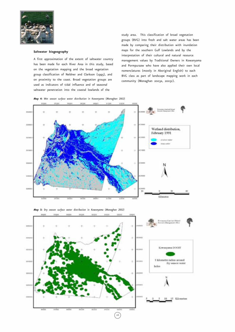
26
Saltwater biogeography
A first approximation of the extent of saltwater country
has been made for each River Area in this study, based
on the vegetation mapping and the broad vegetation
group classification of Neldner and Clarkson (1995), and
on proximity to the coast. Broad vegetation groups are
used as indicators of tidal influence and of seasonal
saltwater penetration into the coastal lowlands of the
study area. This classification of broad vegetation
groups (BVG) into fresh and salt water areas has been
made by comparing their distribution with inundation
maps for the southern Gulf Lowlands and by the
interpretation of their cultural and natural resource
management values by Traditional Owners in Kowanyama
and Pormpuraaw who have also applied their own local
nomenclatures (mostly in Aboriginal English) to each
BVG class as part of landscape mapping work in each
community (Monaghan 2003a, 2003c).
Map 4: Wet season surface water distribution in Kowanyama (Monaghan 2002)
Map 5: Dry season surface water distribution in Kowanyama (Monaghan 2002)
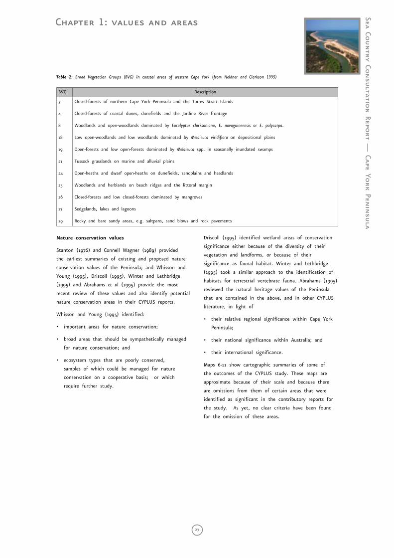
Chapter 1: values and areas
Sea Country Co
nsu
ltation Repo
rt — Cape Yo
rk Penin
sula
27
BVG Description
3
4
8
18
19
21
24
25
26
27
29
Closed-forests of northern Cape York Peninsula and the Torres Strait Islands
Closed-forests of coastal dunes, dunefields and the Jardine River frontage
Woodlands and open-woodlands dominated by Eucalyptus clarksoniana, E. novoguineensis or E. polycarpa.
Low open-woodlands and low woodlands dominated by Melaleuca viridiflora on depositional plains
Open-forests and low open-forests dominated by Melaleuca spp. in seasonally inundated swamps
Tussock grasslands on marine and alluvial plains
Open-heaths and dwarf open-heaths on dunefields, sandplains and headlands
Woodlands and herblands on beach ridges and the littoral margin
Closed-forests and low closed-forests dominated by mangroves
Sedgelands, lakes and lagoons
Rocky and bare sandy areas, e.g. saltpans, sand blows and rock pavements
Table 2: Broad Vegetation Groups (BVG) in coastal areas of western Cape York (from Neldner and Clarkson 1995)
Nature conservation values
Stanton (1976) and Connell Wagner (1989) provided
the earliest summaries of existing and proposed nature
conservation values of the Peninsula; and Whisson and
Young (1995), Driscoll (1995), Winter and Lethbridge
(1995) and Abrahams et al (1995) provide the most
recent review of these values and also identify potential
nature conservation areas in their CYPLUS reports.
Whisson and Young (1995) identified:
• important areas for nature conservation;
• broad areas that should be sympathetically managed
for nature conservation; and
• ecosystem types that are poorly conserved,
samples of which could be managed for nature
conservation on a cooperative basis; or which
require further study.
Driscoll (1995) identified wetland areas of conservation
significance either because of the diversity of their
vegetation and landforms, or because of their
significance as faunal habitat. Winter and Lethbridge
(1995) took a similar approach to the identification of
habitats for terrestrial vertebrate fauna. Abrahams (1995)
reviewed the natural heritage values of the Peninsula
that are contained in the above, and in other CYPLUS
literature, in light of
• their relative regional significance within Cape York
Peninsula;
• their national significance within Australia; and
• their international significance.
Maps 6-11 show cartographic summaries of some of
the outcomes of the CYPLUS study. These maps are
approximate because of their scale and because there
are omissions from them of certain areas that were
identified as significant in the contributory reports for
the study. As yet, no clear criteria have been found
for the omission of these areas.
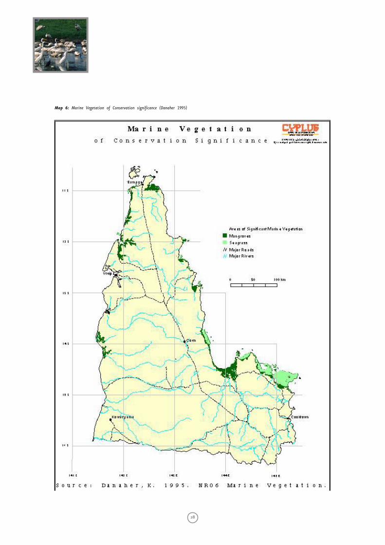
28
Map 6: Marine Vegetation of Conservation significance (Danaher 1995)
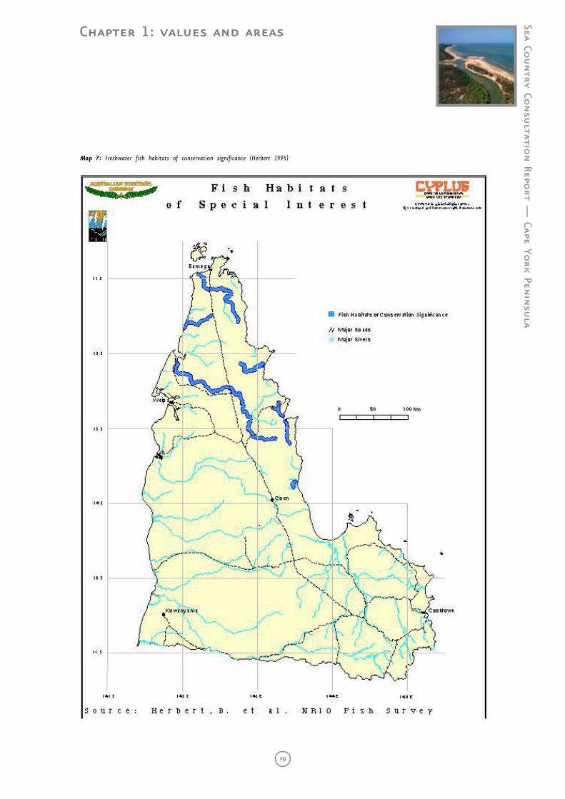
Chapter 1: values and areas
Sea Country Co
nsu
ltation Repo
rt — Cape Yo
rk Penin
sula
29
Map 7: Freshwater fish habitats of conservation significance (Herbert 1995)
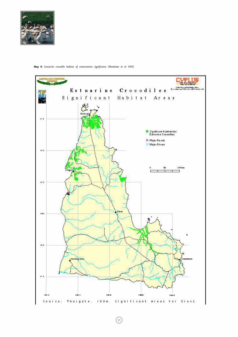
30
Map 8: Estuarine crocodile habitat of conservation significance (Abrahams et al 1995)
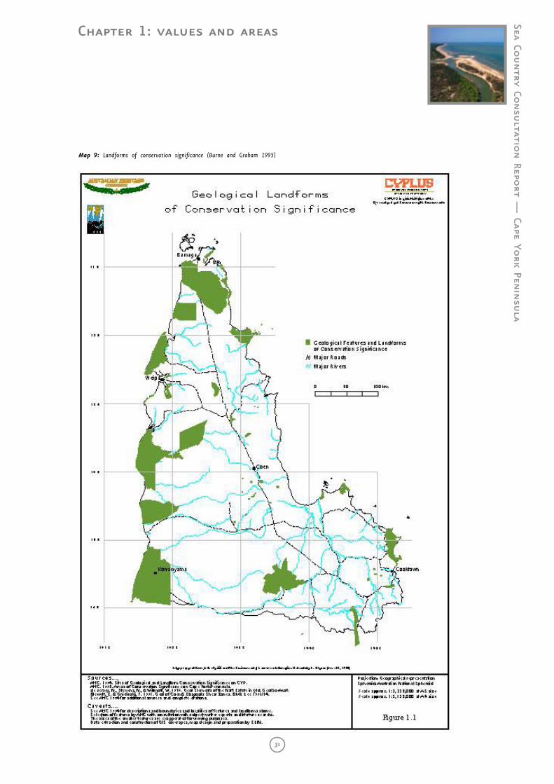
Chapter 1: values and areas
Sea Country Co
nsu
ltation Repo
rt — Cape Yo
rk Penin
sula
31
Map 9: Landforms of conservation significance (Burne and Graham 1995)
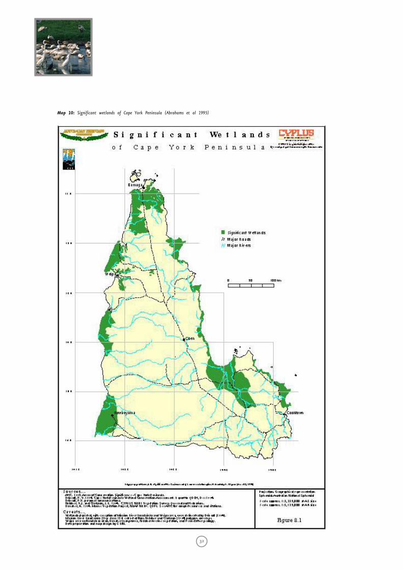
32
Map 10: Significant wetlands of Cape York Peninsula (Abrahams et al 1995)

Chapter 1: values and areas
Sea Country Co
nsu
ltation Repo
rt — Cape Yo
rk Penin
sula
33
Map 11: Significant turtle breeding sites (Abrahams et al 1995)
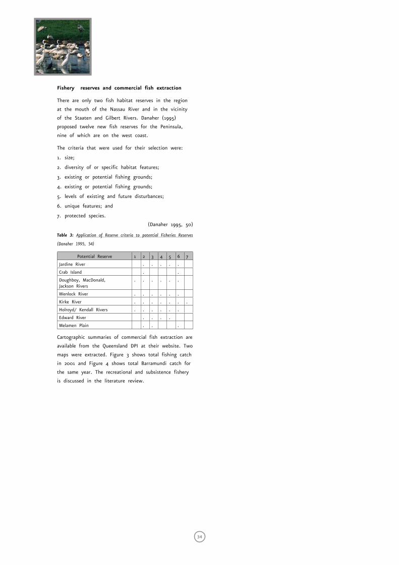
34
Fishery reserves and commercial fish extraction
There are only two fish habitat reserves in the region
at the mouth of the Nassau River and in the vicinity
of the Staaten and Gilbert Rivers. Danaher (1995)
proposed twelve new fish reserves for the Peninsula,
nine of which are on the west coast.
The criteria that were used for their selection were:
1. size;
2. diversity of or specific habitat features;
3. existing or potential fishing grounds;
4. existing or potential fishing grounds;
5. levels of existing and future disturbances;
6. unique features; and
7. protected species.
(Danaher 1995, 50)
Table 3: Application of Reserve criteria to potential Fisheries Reserves
(Danaher 1995, 54)
Potential Reserve 1 2 3 4 5 6 7
Jardine River . . . . .
Crab Island . .
Doughboy, MacDonald, Jackson Rivers
. . . . . .
Wenlock River . . . . . .
Kirke River . . . . . . .
Holroyd/ Kendall Rivers . . . . . .
Edward River . . . .
Melamen Plain . . .
Cartographic summaries of commercial fish extraction are
available from the Queensland DPI at their website. Two
maps were extracted. Figure 3 shows total fishing catch
in 2001 and Figure 4 shows total Barramundi catch for
the same year. The recreational and subsistence fishery
is discussed in the literature review.
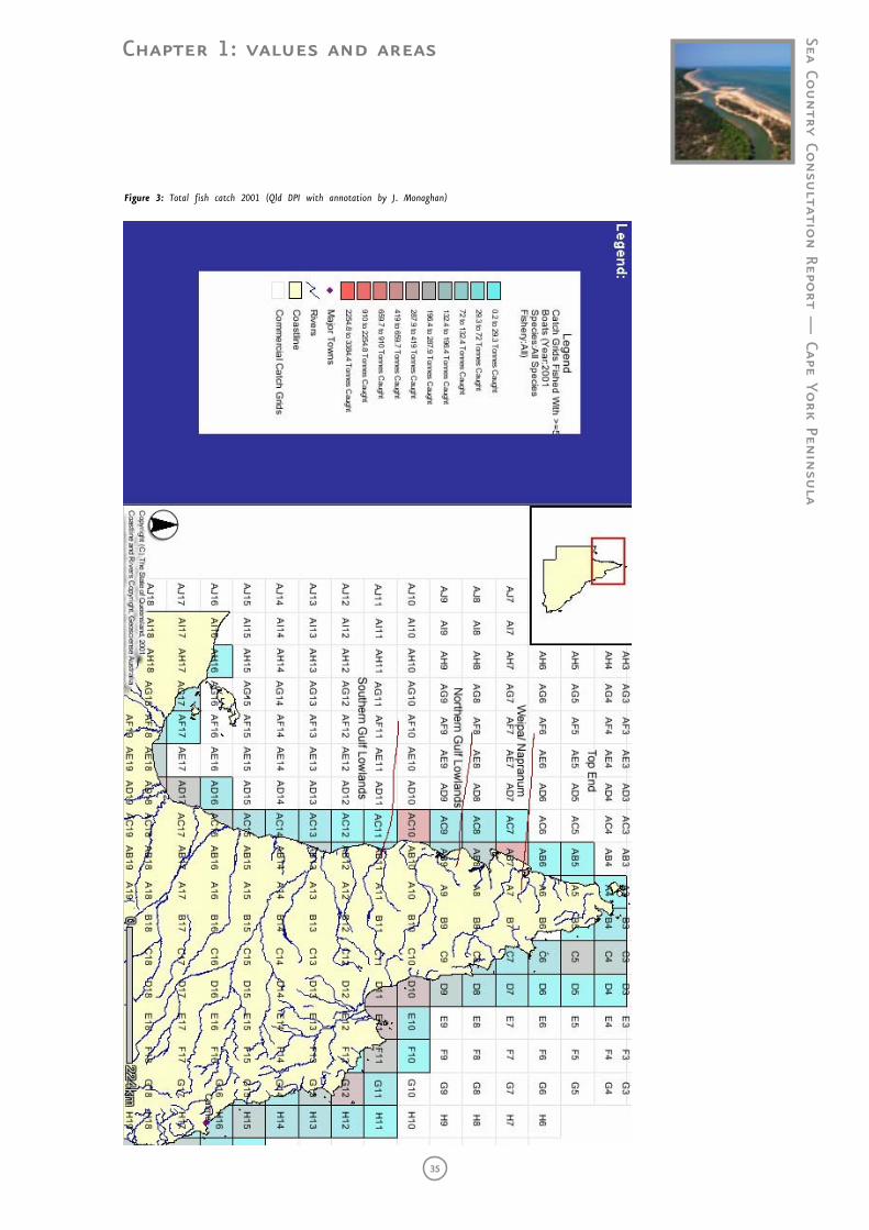
Chapter 1: values and areas
Sea Country Co
nsu
ltation Repo
rt — Cape Yo
rk Penin
sula
35
Figure 3: Total fish catch 2001 (Qld DPI with annotation by J. Monaghan)
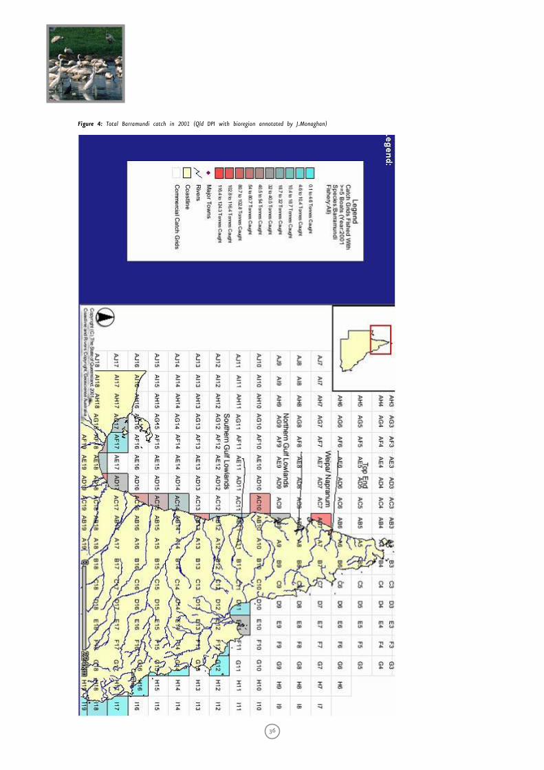
36
Figure 4: Total Barramundi catch in 2001 (Qld DPI with bioregion annotated by J.Monaghan)
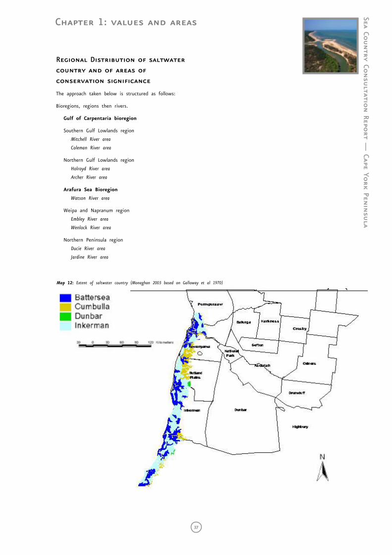
Chapter 1: values and areas
Sea Country Co
nsu
ltation Repo
rt — Cape Yo
rk Penin
sula
37
Regional Distribution of saltwater country and of areas of conservation significance
The approach taken below is structured as follows:
Bioregions, regions then rivers.
Gulf of Carpentaria bioregion
Southern Gulf Lowlands region
Mitchell River area
Coleman River area
Northern Gulf Lowlands region
Holroyd River area
Archer River area
Arafura Sea Bioregion
Watson River area
Weipa and Napranum region
Embley River area
Wenlock River area
Northern Peninsula region
Ducie River area
Jardine River area
Map 12: Extent of saltwater country (Monaghan 2003 based on Galloway et al 1970)
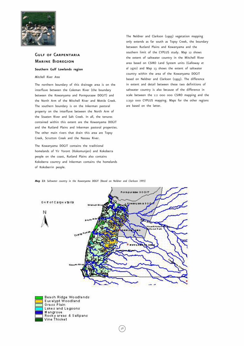
38
Map 13: Saltwater country in the Kowanyama DOGIT (Based on Neldner and Clarkson 1995)
Gulf of Carpentaria Marine Bioregion
Southern Gulf Lowlands region
Mitchell River Area
The northern boundary of this drainage area is on the
interfluve between the Coleman River (the boundary
between the Kowanyama and Pormpuraaw DOGIT) and
the North Arm of the Mitchell River and Mottle Creek.
The southern boundary is on the Inkerman pastoral
property on the interfluve between the North Arm of
the Staaten River and Salt Creek. In all, the tenures
contained within this extent are the Kowanyama DOGIT
and the Rutland Plains and Inkerman pastoral properties.
The other main rivers that drain this area are Topsy
Creek, Scrutton Creek and the Nassau River.
The Kowanyama DOGIT contains the traditional
homelands of Yir Yoront (Kokomunjen) and Kokoberra
people on the coast, Rutland Plains also contains
Kokoberra country and Inkerman contains the homelands
of Kokoberrin people.
The Neldner and Clarkson (1995) vegetation mapping
only extends as far south as Topsy Creek, the boundary
between Rutland Plains and Kowanyama and the
southern limit of the CYPLUS study. Map 12 shows
the extent of saltwater country in the Mitchell River
area based on CSIRO Land System units (Galloway et
al 1970) and Map 13 shows the extent of saltwater
country within the area of the Kowanyama DOGIT
based on Neldner and Clarkson (1995). The difference
in extent and detail between these two definitions of
saltwater country is also because of the difference in
scale between the 1:2 000 000 CSIRO mapping and the
1:250 000 CYPLUS mapping. Maps for the other regions
are based on the latter.
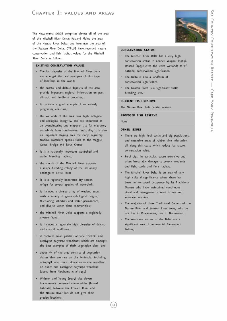
Chapter 1: values and areas
Sea Country Co
nsu
ltation Repo
rt — Cape Yo
rk Penin
sula
39
The Kowanyama DOGIT comprises almost all of the area
of the Mitchell River Delta; Rutland Plains the area
of the Nassau River Delta; and Inkerman the area of
the Staaten River Delta. CYPLUS have recorded nature
conservation and fish habitat values for the Mitchell
River Delta as follows:
EXISTING CONSERVATION VALUES
• The fan deposits of the Mitchell River delta
are amongst the best examples of this type
of landform in the world;
• the coastal and deltaic deposits of the area
provide important regional information on past
climatic and landform processes;
• it contains a good example of an actively
prograding coastline;
• the wetlands of the area have high biological
and ecological integrity, and are important as
an overwintering and stopover site for migratory
waterbirds from south-eastern Australia; it is also
an important staging area for many migratory
tropical waterbird species such as the Magpie
Goose, Brolga and Sarus Crane;
• it is a nationally important watershed and
wader breeding habitat;
• the mouth of the Mitchell River supports
a major breeding colony of the nationally
endangered Little Tern;
• it is a regionally important dry season
refuge for several species of waterbird;
• it includes a diverse array of wetland types
with a variety of geomorphological origins,
fluctuating salinities and water permanence,
and diverse water plant communities;
• the Mitchell River Delta supports a regionally
diverse fauna;
• it includes a regionally high diversity of deltaic
and coastal landforms;
• it contains small patches of vine thickets and
Eucalyptus polycarpa woodlands which are amongst
the best examples of their vegetation class; and
• about 5% of the area consists of vegetation
classes that are rare on the Peninsula, including
notophyll vine forest, Acacia crassicarpa woodland
on dunes and Eucalyptus polycarpa woodland.
(above from Abrahams et al 1995)
• Whissen and Young (1995) cite eleven
inadequately preserved communities (faunal
habitats) between the Edward River and
the Nassau River but do not give their
precise locations.
CONSERVATION STATUS
• The Mitchell River Delta has a very high
conservation status in Connell Wagner (1989).
Driscoll (1995) cites the Delta wetlands as of
national conservation significance.
• The Delta is also a landform of
conservation significance.
• The Nassau River is a significant turtle
breeding site.
CURRENT FISH RESERVE
The Nassau River fish habitat reserve
PROPOSED FISH RESERVE
None
OTHER ISSUES
• There are high feral cattle and pig populations,
and extensive areas of rubber vine infestation
all along this coast which reduce its nature
conservation value.
• Feral pigs, in particular, cause extensive and
often irreparable damage to coastal wetlands
and fish, turtle and flora habitat.
• The Mitchell River Delta is an area of very
high cultural significance where there has
been uninterrupted occupancy by its Traditional
Owners who have maintained continuous
ritual and management control of sea and
saltwater country.
• The majority of those Traditional Owners of the
Nassau River and Staaten River areas, who do
not live in Kowanyama, live in Normanton.
• The nearshore waters of the Delta are a
significant area of commercial Barramundi
fishing.
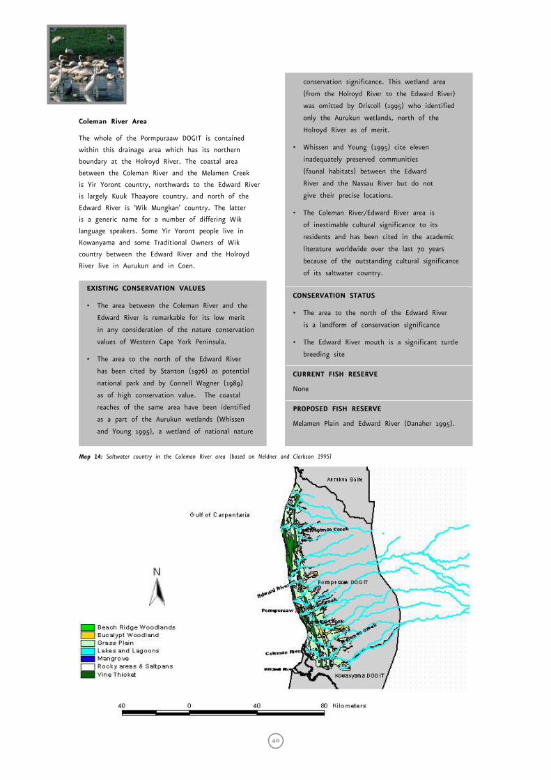
40
Coleman River Area
The whole of the Pormpuraaw DOGIT is contained
within this drainage area which has its northern
boundary at the Holroyd River. The coastal area
between the Coleman River and the Melamen Creek
is Yir Yoront country, northwards to the Edward River
is largely Kuuk Thaayore country, and north of the
Edward River is ‘Wik Mungkan’ country. The latter
is a generic name for a number of differing Wik
language speakers. Some Yir Yoront people live in
Kowanyama and some Traditional Owners of Wik
country between the Edward River and the Holroyd
River live in Aurukun and in Coen.
EXISTING CONSERVATION VALUES
• The area between the Coleman River and the
Edward River is remarkable for its low merit
in any consideration of the nature conservation
values of Western Cape York Peninsula.
• The area to the north of the Edward River
has been cited by Stanton (1976) as potential
national park and by Connell Wagner (1989)
as of high conservation value. The coastal
reaches of the same area have been identified
as a part of the Aurukun wetlands (Whissen
and Young 1995), a wetland of national nature
conservation significance. This wetland area
(from the Holroyd River to the Edward River)
was omitted by Driscoll (1995) who identified
only the Aurukun wetlands, north of the
Holroyd River as of merit.
• Whissen and Young (1995) cite eleven
inadequately preserved communities
(faunal habitats) between the Edward
River and the Nassau River but do not
give their precise locations.
• The Coleman River/Edward River area is
of inestimable cultural significance to its
residents and has been cited in the academic
literature worldwide over the last 70 years
because of the outstanding cultural significance
of its saltwater country.
CONSERVATION STATUS
• The area to the north of the Edward River
is a landform of conservation significance
• The Edward River mouth is a significant turtle
breeding site
CURRENT FISH RESERVE
None
PROPOSED FISH RESERVE
Melamen Plain and Edward River (Danaher 1995).
Map 14: Saltwater country in the Coleman River area (based on Neldner and Clarkson 1995)
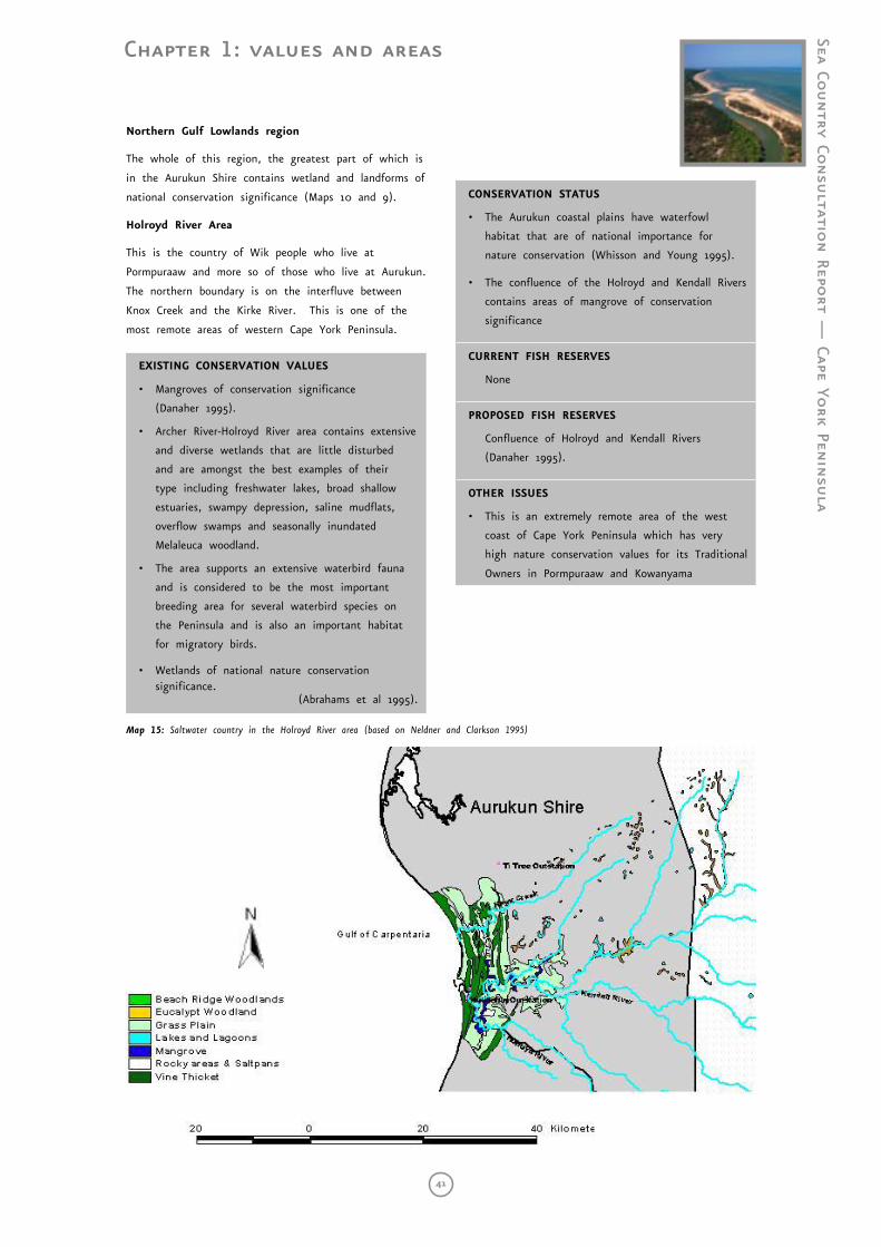
Chapter 1: values and areas
Sea Country Co
nsu
ltation Repo
rt — Cape Yo
rk Penin
sula
41
Northern Gulf Lowlands region
The whole of this region, the greatest part of which is
in the Aurukun Shire contains wetland and landforms of
national conservation significance (Maps 10 and 9).
Holroyd River Area
This is the country of Wik people who live at
Pormpuraaw and more so of those who live at Aurukun.
The northern boundary is on the interfluve between
Knox Creek and the Kirke River. This is one of the
most remote areas of western Cape York Peninsula.
EXISTING CONSERVATION VALUES
• Mangroves of conservation significance
(Danaher 1995).
• Archer River-Holroyd River area contains extensive
and diverse wetlands that are little disturbed
and are amongst the best examples of their
type including freshwater lakes, broad shallow
estuaries, swampy depression, saline mudflats,
overflow swamps and seasonally inundated
Melaleuca woodland.
• The area supports an extensive waterbird fauna
and is considered to be the most important
breeding area for several waterbird species on
the Peninsula and is also an important habitat
for migratory birds.
• Wetlands of national nature conservation significance.
(Abrahams et al 1995).
CONSERVATION STATUS
• The Aurukun coastal plains have waterfowl
habitat that are of national importance for
nature conservation (Whisson and Young 1995).
• The confluence of the Holroyd and Kendall Rivers
contains areas of mangrove of conservation
significance
CURRENT FISH RESERVES
None
PROPOSED FISH RESERVES
Confluence of Holroyd and Kendall Rivers
(Danaher 1995).
OTHER ISSUES
• This is an extremely remote area of the west
coast of Cape York Peninsula which has very
high nature conservation values for its Traditional
Owners in Pormpuraaw and Kowanyama
Map 15: Saltwater country in the Holroyd River area (based on Neldner and Clarkson 1995)
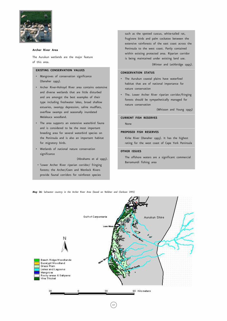
42
Archer River Area
The Aurukun wetlands are the major feature
of this area.
EXISTING CONSERVATION VALUES
• Mangroves of conservation significance
(Danaher 1995).
• Archer River-Holroyd River area contains extensive
and diverse wetlands that are little disturbed
and are amongst the best examples of their
type including freshwater lakes, broad shallow
estuaries, swampy depression, saline mudflats,
overflow swamps and seasonally inundated
Melaleuca woodland.
• The area supports an extensive waterbird fauna
and is considered to be the most important
breeding area for several waterbird species on
the Peninsula and is also an important habitat
for migratory birds.
• Wetlands of national nature conservation
significance
(Abrahams et al 1995).
• ‘Lower Archer River riparian corridor/ fringing
forests; the Archer/Coen and Wenlock Rivers
provide faunal corridors for rainforest species
such as the spotted cuscus, white-tailed rat,
frugivore birds and palm cockatoo between the
extensive rainforests of the east coast across the
Peninsula to the west coast. Partly contained
within existing protected area. Riparian corridor
is being maintained under existing land use.
(Winter and Lethbridge 1995).
CONSERVATION STATUS
• The Aurukun coastal plains have waterfowl
habitat that are of national importance for
nature conservation
• The. Lower Archer River riparian corridor/fringing
forests should be sympathetically managed for
nature conservation
(Whisson and Young 1995)
CURRENT FISH RESERVES
None
PROPOSED FISH RESERVES
Kirke River (Danaher 1995). It has the highest
rating for the west coast of Cape York Peninsula
OTHER ISSUES
The offshore waters are a significant commercial
Barramundi fishing area
Map 16: Saltwater country in the Archer River Area (based on Neldner and Clarkson 1995)
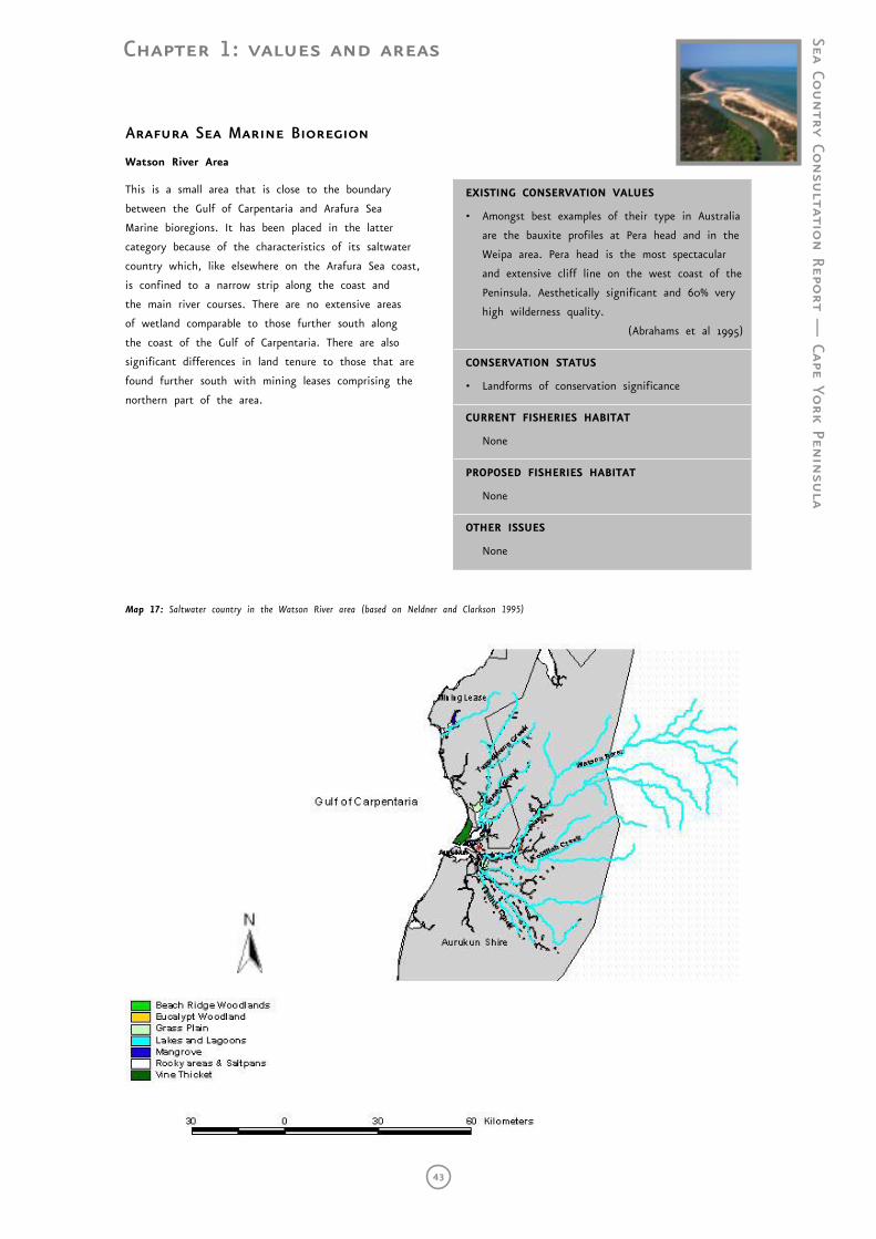
Chapter 1: values and areas
Sea Country Co
nsu
ltation Repo
rt — Cape Yo
rk Penin
sula
43
Map 16: Saltwater country in the Archer River Area (based on Neldner and Clarkson 1995)
Arafura Sea Marine Bioregion
Watson River Area
This is a small area that is close to the boundary
between the Gulf of Carpentaria and Arafura Sea
Marine bioregions. It has been placed in the latter
category because of the characteristics of its saltwater
country which, like elsewhere on the Arafura Sea coast,
is confined to a narrow strip along the coast and
the main river courses. There are no extensive areas
of wetland comparable to those further south along
the coast of the Gulf of Carpentaria. There are also
significant differences in land tenure to those that are
found further south with mining leases comprising the
northern part of the area.
EXISTING CONSERVATION VALUES
• Amongst best examples of their type in Australia
are the bauxite profiles at Pera head and in the
Weipa area. Pera head is the most spectacular
and extensive cliff line on the west coast of the
Peninsula. Aesthetically significant and 60% very
high wilderness quality.
(Abrahams et al 1995)
CONSERVATION STATUS
• Landforms of conservation significance
CURRENT FISHERIES HABITAT
None
PROPOSED FISHERIES HABITAT
None
OTHER ISSUES
None
Map 17: Saltwater country in the Watson River area (based on Neldner and Clarkson 1995)
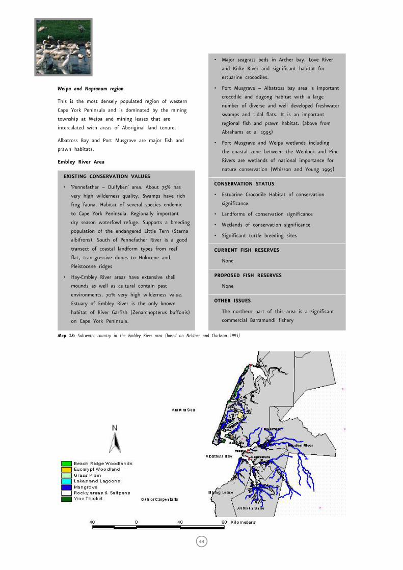
44
Weipa and Napranum region
This is the most densely populated region of western
Cape York Peninsula and is dominated by the mining
township at Weipa and mining leases that are
intercalated with areas of Aboriginal land tenure.
Albatross Bay and Port Musgrave are major fish and
prawn habitats.
Embley River Area
EXISTING CONSERVATION VALUES
• ‘Pennefather – Duifyken’ area. About 75% has
very high wilderness quality. Swamps have rich
frog fauna. Habitat of several species endemic
to Cape York Peninsula. Regionally important
dry season waterfowl refuge. Supports a breeding
population of the endangered Little Tern (Sterna
albifrons). South of Pennefather River is a good
transect of coastal landform types from reef
flat, transgressive dunes to Holocene and
Pleistocene ridges
• Hay-Embley River areas have extensive shell
mounds as well as cultural contain past
environments. 70% very high wilderness value.
Estuary of Embley River is the only known
habitat of River Garfish (Zenarchopterus buffonis)
on Cape York Peninsula.
• Major seagrass beds in Archer bay, Love River
and Kirke River and significant habitat for
estuarine crocodiles.
• Port Musgrave – Albatross bay area is important
crocodile and dugong habitat with a large
number of diverse and well developed freshwater
swamps and tidal flats. It is an important
regional fish and prawn habitat. (above from
Abrahams et al 1995)
• Port Musgrave and Weipa wetlands including
the coastal zone between the Wenlock and Pine
Rivers are wetlands of national importance for
nature conservation (Whisson and Young 1995)
CONSERVATION STATUS
• Estuarine Crocodile Habitat of conservation
significance
• Landforms of conservation significance
• Wetlands of conservation significance
• Significant turtle breeding sites
CURRENT FISH RESERVES
None
PROPOSED FISH RESERVES
None
OTHER ISSUES
The northern part of this area is a significant
commercial Barramundi fishery
Map 18: Saltwater country in the Embley River area (based on Neldner and Clarkson 1995)
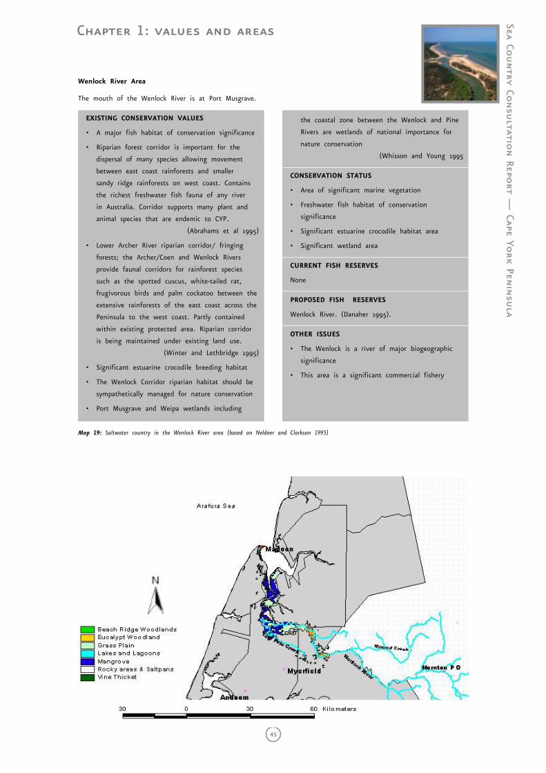
Chapter 1: values and areas
Sea Country Co
nsu
ltation Repo
rt — Cape Yo
rk Penin
sula
45
Wenlock River Area
The mouth of the Wenlock River is at Port Musgrave.
EXISTING CONSERVATION VALUES
• A major fish habitat of conservation significance
• Riparian forest corridor is important for the
dispersal of many species allowing movement
between east coast rainforests and smaller
sandy ridge rainforests on west coast. Contains
the richest freshwater fish fauna of any river
in Australia. Corridor supports many plant and
animal species that are endemic to CYP.
(Abrahams et al 1995)
• Lower Archer River riparian corridor/ fringing
forests; the Archer/Coen and Wenlock Rivers
provide faunal corridors for rainforest species
such as the spotted cuscus, white-tailed rat,
frugivorous birds and palm cockatoo between the
extensive rainforests of the east coast across the
Peninsula to the west coast. Partly contained
within existing protected area. Riparian corridor
is being maintained under existing land use.
(Winter and Lethbridge 1995)
• Significant estuarine crocodile breeding habitat
• The Wenlock Corridor riparian habitat should be
sympathetically managed for nature conservation
• Port Musgrave and Weipa wetlands including
the coastal zone between the Wenlock and Pine
Rivers are wetlands of national importance for
nature conservation
(Whisson and Young 1995
CONSERVATION STATUS
• Area of significant marine vegetation
• Freshwater fish habitat of conservation
significance
• Significant estuarine crocodile habitat area
• Significant wetland area
CURRENT FISH RESERVES
None
PROPOSED FISH RESERVES
Wenlock River. (Danaher 1995).
OTHER ISSUES
• The Wenlock is a river of major biogeographic
significance
• This area is a significant commercial fishery
Map 19: Saltwater country in the Wenlock River area (based on Neldner and Clarkson 1995)
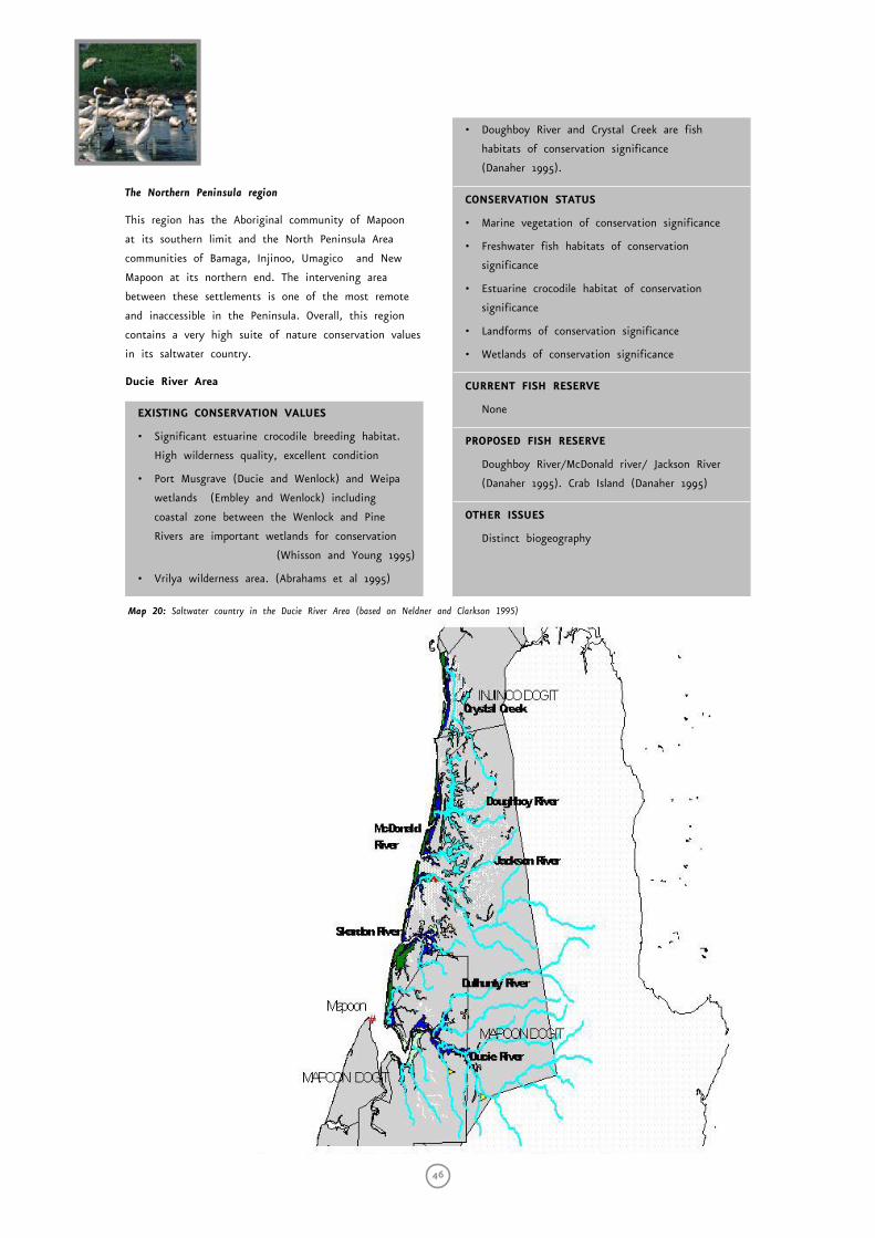
46
The Northern Peninsula region
This region has the Aboriginal community of Mapoon
at its southern limit and the North Peninsula Area
communities of Bamaga, Injinoo, Umagico and New
Mapoon at its northern end. The intervening area
between these settlements is one of the most remote
and inaccessible in the Peninsula. Overall, this region
contains a very high suite of nature conservation values
in its saltwater country.
Ducie River Area
EXISTING CONSERVATION VALUES
• Significant estuarine crocodile breeding habitat.
High wilderness quality, excellent condition
• Port Musgrave (Ducie and Wenlock) and Weipa
wetlands (Embley and Wenlock) including
coastal zone between the Wenlock and Pine
Rivers are important wetlands for conservation
(Whisson and Young 1995)
• Vrilya wilderness area. (Abrahams et al 1995)
• Doughboy River and Crystal Creek are fish
habitats of conservation significance
(Danaher 1995).
CONSERVATION STATUS
• Marine vegetation of conservation significance
• Freshwater fish habitats of conservation
significance
• Estuarine crocodile habitat of conservation
significance
• Landforms of conservation significance
• Wetlands of conservation significance
CURRENT FISH RESERVE
None
PROPOSED FISH RESERVE
Doughboy River/McDonald river/ Jackson River
(Danaher 1995). Crab Island (Danaher 1995)
OTHER ISSUES
Distinct biogeography
Map 20: Saltwater country in the Ducie River Area (based on Neldner and Clarkson 1995)
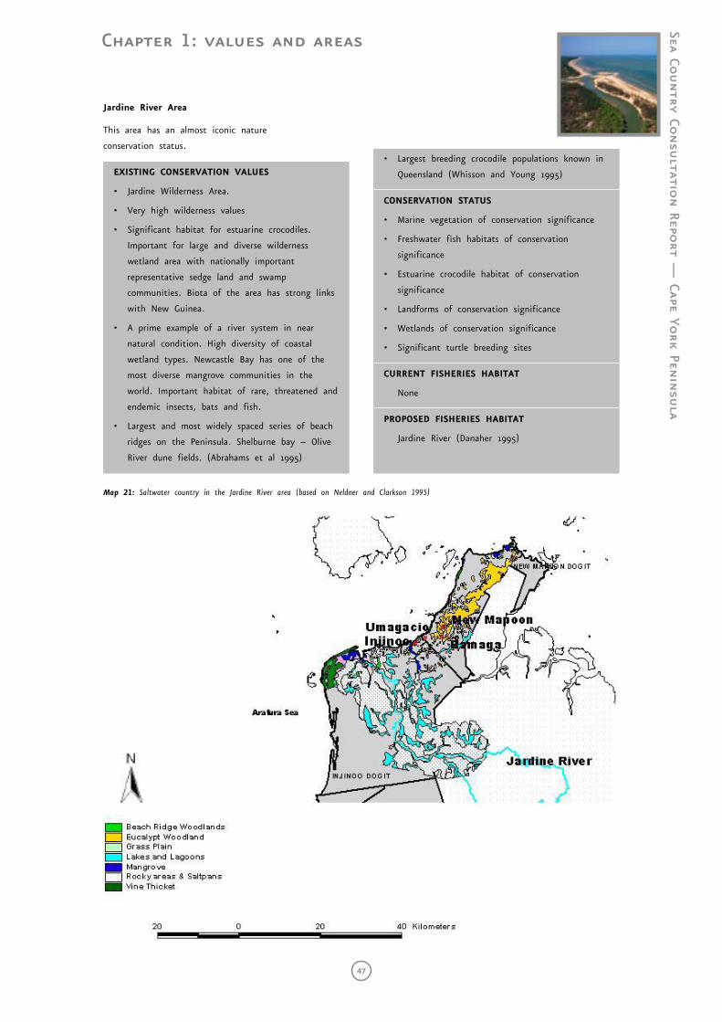
Chapter 1: values and areas
Sea Country Co
nsu
ltation Repo
rt — Cape Yo
rk Penin
sula
47
Jardine River Area
This area has an almost iconic nature
conservation status.
EXISTING CONSERVATION VALUES
• Jardine Wilderness Area.
• Very high wilderness values
• Significant habitat for estuarine crocodiles.
Important for large and diverse wilderness
wetland area with nationally important
representative sedge land and swamp
communities. Biota of the area has strong links
with New Guinea.
• A prime example of a river system in near
natural condition. High diversity of coastal
wetland types. Newcastle Bay has one of the
most diverse mangrove communities in the
world. Important habitat of rare, threatened and
endemic insects, bats and fish.
• Largest and most widely spaced series of beach
ridges on the Peninsula. Shelburne bay – Olive
River dune fields. (Abrahams et al 1995)
• Largest breeding crocodile populations known in
Queensland (Whisson and Young 1995)
CONSERVATION STATUS
• Marine vegetation of conservation significance
• Freshwater fish habitats of conservation
significance
• Estuarine crocodile habitat of conservation
significance
• Landforms of conservation significance
• Wetlands of conservation significance
• Significant turtle breeding sites
CURRENT FISHERIES HABITAT
None
PROPOSED FISHERIES HABITAT
Jardine River (Danaher 1995)
Map 21: Saltwater country in the Jardine River area (based on Neldner and Clarkson 1995)

48
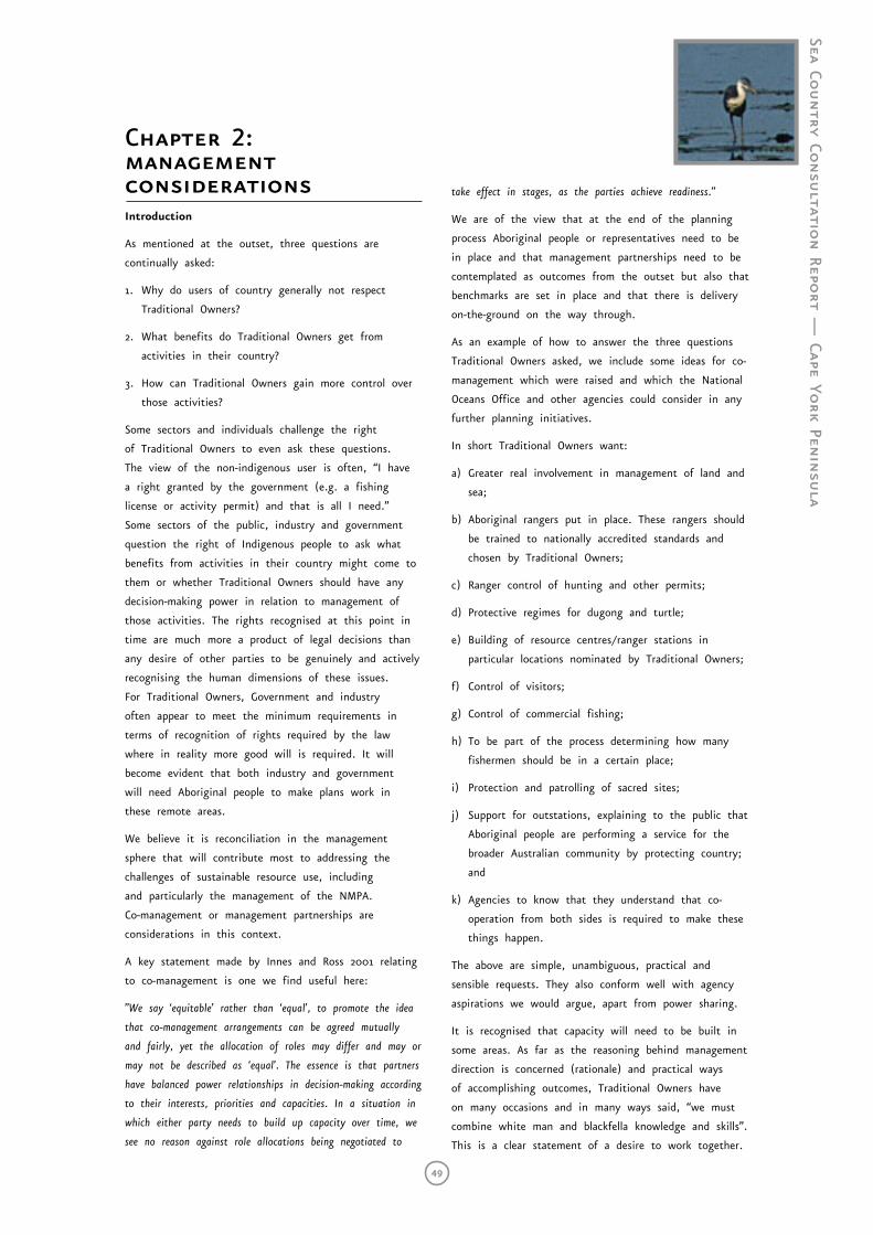
Sea Country Co
nsu
ltation Repo
rt — Cape Yo
rk Penin
sula
49
Chapter 2: management considerationsIntroduction
As mentioned at the outset, three questions are
continually asked:
1. Why do users of country generally not respect
Traditional Owners?
2. What benefits do Traditional Owners get from
activities in their country?
3. How can Traditional Owners gain more control over
those activities?
Some sectors and individuals challenge the right
of Traditional Owners to even ask these questions.
The view of the non-indigenous user is often, “I have
a right granted by the government (e.g. a fishing
license or activity permit) and that is all I need.”
Some sectors of the public, industry and government
question the right of Indigenous people to ask what
benefits from activities in their country might come to
them or whether Traditional Owners should have any
decision-making power in relation to management of
those activities. The rights recognised at this point in
time are much more a product of legal decisions than
any desire of other parties to be genuinely and actively
recognising the human dimensions of these issues.
For Traditional Owners, Government and industry
often appear to meet the minimum requirements in
terms of recognition of rights required by the law
where in reality more good will is required. It will
become evident that both industry and government
will need Aboriginal people to make plans work in
these remote areas.
We believe it is reconciliation in the management
sphere that will contribute most to addressing the
challenges of sustainable resource use, including
and particularly the management of the NMPA.
Co-management or management partnerships are
considerations in this context.
A key statement made by Innes and Ross 2001 relating
to co-management is one we find useful here:
”We say ‘equitable’ rather than ‘equal’, to promote the idea
that co-management arrangements can be agreed mutually
and fairly, yet the allocation of roles may differ and may or
may not be described as ‘equal’. The essence is that partners
have balanced power relationships in decision-making according
to their interests, priorities and capacities. In a situation in
which either party needs to build up capacity over time, we
see no reason against role allocations being negotiated to
take effect in stages, as the parties achieve readiness.”
We are of the view that at the end of the planning
process Aboriginal people or representatives need to be
in place and that management partnerships need to be
contemplated as outcomes from the outset but also that
benchmarks are set in place and that there is delivery
on-the-ground on the way through.
As an example of how to answer the three questions
Traditional Owners asked, we include some ideas for co-
management which were raised and which the National
Oceans Office and other agencies could consider in any
further planning initiatives.
In short Traditional Owners want:
a) Greater real involvement in management of land and
sea;
b) Aboriginal rangers put in place. These rangers should
be trained to nationally accredited standards and
chosen by Traditional Owners;
c) Ranger control of hunting and other permits;
d) Protective regimes for dugong and turtle;
e) Building of resource centres/ranger stations in
particular locations nominated by Traditional Owners;
f) Control of visitors;
g) Control of commercial fishing;
h) To be part of the process determining how many
fishermen should be in a certain place;
i) Protection and patrolling of sacred sites;
j) Support for outstations, explaining to the public that
Aboriginal people are performing a service for the
broader Australian community by protecting country;
and
k) Agencies to know that they understand that co-
operation from both sides is required to make these
things happen.
The above are simple, unambiguous, practical and
sensible requests. They also conform well with agency
aspirations we would argue, apart from power sharing.
It is recognised that capacity will need to be built in
some areas. As far as the reasoning behind management
direction is concerned (rationale) and practical ways
of accomplishing outcomes, Traditional Owners have
on many occasions and in many ways said, “we must
combine white man and blackfella knowledge and skills”.
This is a clear statement of a desire to work together.
50
Aboriginal people do contemplate joint advisory,
scientific and management boards to manage country.
The issue is that governments have not committed to
establishing equity and handing over responsibility.
The Building Blocks
In considering how best to develop effective
management structures for incorporation into the NRMP
we argue that a number of ‘building blocks’ need to
be in place and factored into the planning process.
This section outlines a number of these including -
Native Title, Management Units, Boundaries, Compliance,
Resourcing and Access considerations.
Native Title
Native Title and management are not separable in
a practical sense. At one interview we were asked
if rivers and creeks were included in native title.
The answer was that they were included in the claim
but exclusive native title was subject to extinguishing
acts, such as fishing licenses and tourism fishing
permits. A charter boat can essentially do what they
like under the law as long as they stay in boats. This
of course makes no sense at all to Traditional Owners
because as far as they are concerned that is their
water and there is an arrangement to be made and a
discussion to be had between them and the user. This
applies equally to commercial fishing where practices are
legally allowed but which do not make any sense from
a traditional standpoint.
Aboriginal management information can often form
native title evidence. This has created some difficulties
in this project and will continue to do so in the
future. While the National Oceans Office has been keen
to establish what traditional practices are and keen
to know where cultural sites are in order to include
them in considerations, until Native Title processes
have run their course or until Traditional Owners have
weighed up other options for control and ownership
of their lands and seas, this information remains with
them. Insistence by funding providers on retaining
copyright and intellectual property in this instance
severely constrains ability to provide detail to the
National Oceans Office. Native title is comparatively
new legislation and public and bureaucratic perceptions
have been slow to shift. Native title itself is generally
not well understood by non-lawyers and communities
and in some senses it is more practical to accept that
Aboriginal people have inherited rights and significant
legal rights. We therefore have to be prepared to bring
processes to the Traditional Owner level and provide for
secure information exchange.
Management Units - A Suggestion
Management according to traditional group, language
group or perhaps clan group can deliver a management
framework and is a process that could be mutually
agreeable.
Indeed the EPA has progressed this concept and we
attach a quote from their strategy in relation to MPA’s
to highlight some of these ideas.
Indigenous partnerships -
(Environmental Protection Agency, 2000: s.7 p.5).
Indigenous peoples of Aboriginal and Torres Strait Islander
heritage have had cultural and subsistence relationships with
the Australian marine environment for thousands of years.
Indigenous peoples in many parts of Australia continue to
have strong links with the sea, and regard coastal waters as
part of their “country” or clan estates.
Acknowledgement of traditional interests is part of Queensland
marine park zoning plans for the Cairns and Moreton Bay
Marine Parks.
Under the Cairns Marine Park zoning plan, an ‘Aboriginal
Management Area’ has been declared over Mission Bay.
The objective of this management area is to progress the
involvement of the traditional inhabitants in planning and
management, including conserving the area’s natural resources
and protecting its cultural values.
Similarly in the Moreton Bay Marine Park, one purpose of
the South Passage area is to recognise Aboriginal interests
in the planning and management of Moreton Bay, including
conservation of the natural resource area.
In bioregions such as those in the Gulf of Carpentaria and
Torres Strait where Traditional Owners remain predominant
users of marine ecosystems, any measure for protecting the
marine environment must be culturally relevant and respect
traditional custodianship.
Indigenous peoples have suggested that approaching the
planning of marine protected areas in some parts of
Queensland from the perspective of traditional clan estates
might be more appropriate than a bioregion basis. These
suggestions have some validity.
For example, in the Torres Strait, traditional use of
marine environments remains strong and moves are
being made towards autonomy. In addition, special
treaty arrangements between Australia and New Guinea
are in place. These oblige both countries to protect the
flora, fauna and marine environment of the Torres Strait
Protected zone. Planning for marine protected areas in Torres
Strait should go ahead in a context of relevant local custom,
and bioregional boundaries might take second place to
planning units that are culturally relevant.
Chapter 2: management considerations
3 The EPA (2000) shows two near-shore bioregions for the west coast of Cape York, the west Cape York bioregion (WCY) and the Karumba-Nassau (KAN) bioregion. Clearly using cultural management units may assist in higher resolution of protected areas because there are currently more cultural units than bioregions.
Sea Country Co
nsu
ltation Repo
rt — Cape Yo
rk Penin
sula
51
Native title claims exist over many marine areas in
Queensland. Resolution of these will be relevant to any
measures that that might ultimately be adopted for
protecting and managing the marine environment.
Native title issues and traditional knowledge of indigenous
peoples need to be recognised and incorporated into
any strategy for marine protected areas. In many cases,
Traditional Owners will have a role in caring for the marine
environment and its resources in continuity with their
heritage and traditions.
These statements provide a very positive basis for
engagement with the State, particularly bioregions3
being acknowledged as secondary to cultural units in
the Cape York context of the NRMP.
The concept of a cultural unit basis for management,
coupled with genuine and equitable management
partnerships theoretically should deliver the outcomes
required. We believe that these provide the makings
of a real and necessary paradigm shift in management
and that all parties need to navigate in that direction.
There may well be significant flow-on effects such as
regionalisation and subregionalisation of fisheries where
all users have to focus on looking after their area,
rather than being free to move when one area is
fished out.
Boundaries
Boundaries can be particularly complicated and in
many cases Aboriginal people have chosen to follow
descriptions of their country that have practical
relevance to what they are trying to achieve at the
time. The Kimberley Land Council is contemplating
Native Title management units in their “Saltwater
Country”, (See also Roberts and Wallace 2002 regarding
suggestions relating to artificial management boundaries
or area management and discussion on subregional
scale management). The idea has been prompted by
the fact that in some instances Traditional Owners
adopt boundaries that serve the purposes of the process
currently underway. For example, in some cases native
title claims follow pastoral lease or other boundaries
rather than a traditional boundary, because it may
lead to a practical outcome sooner. It is clear that
prior to European settlement and current community
centralisation it may have been necessary for people to
move according to seasonal food and water availability
and there were times when groups mixed to make use
of plentiful resources or for cultural meetings. It is also
clear that over longer times scales (tens of thousands
of years) that landscapes and seascapes have changed
phenomenally and of course Aboriginal society would
have had to adapt to such changes and changes are
occurring now. It is worth contemplating that only
8,000 years ago the sea level was approximately 100
meters lower than it is today.
It is perhaps useful to think of individuals occupying
physical and non-physical cultural space which might
expand or contract depending on the relationships
and interactions of that person over their lifetimes.
There are inherited rights and rights that are gained
or lost through marriage and cultural practice and
that an individual’s rights are in some cases just that,
individual. These are complex matters upon which
we are not qualified to comment and it will be for
Traditional Owners to recommend how engagement
might take place and at what scales. We do however
believe that Traditional Owners will want to focus on
local results for themselves and their groups and less
on higher level outcomes whilst they do need to be
integrated regionally to accommodate administrative
processes and agency jurisdictions.
Compliance
A clear problem acknowledged by all sectors is that
there is limited capacity by anyone to enforce the
law as it stands despite the recent surveillance
upgrades precipitated by the refugee crisis and people
smuggling. The west coast of Cape York is not well
provided for at all while the east coast is receiving
some, if limited, attention because of the GBRMPA’s
priorities and political and social prominence in broader
Australia. While there is some capacity for compliance
organisations to synergise, there is still a large shortfall
in the presence of people on the water along coasts
and in rivers attending to saltwater management. It is
in the field of operational management that Indigenous
people can be of major relevance to the success of a
management plan in this region. This is not a new
concept; Aboriginal people have been making this point
for decades.
Both State and Commonwealth have been reluctant
to devolve management authority until the situation
is in environmental or political crisis. The NRMP
has the potential to determine a more stable policy
environment than has been the case to date. Aboriginal
people are well past consulting on many issues and are
becoming desensitised to many government approaches
no matter how willing and genuine they might be.
Our recommendation is to get resources on the ground
immediately and build capacity in situ rather than
52
relying on the ephemeral nature of agency policy. Such
developments need to be tied to income generation so
that communities are not continually at the mercy of
government change and reliance on government funding.
The aspirations of Aboriginal peoples have been
variously appropriated by departments when it is
clear that mutually beneficial outcomes could be
forthcoming if these departments actually funded
operatives in Indigenous organisations as well as
maintaining departmental functions in remote areas.
There has been more of a focus on the latter to date.
Resourcing Issues
Current management is being funded through part
time Community Development Employment Projects
(CDEP) and the NHT. It is neither sufficient nor
appropriate that such funds are solely relied on to
manage the vast areas that need to be patrolled
and managed in the long term. It is therefore
necessary to contemplate multi-source funding, using
the wherewithal of all parties to contribute to outcomes
and to identify the scales at which they can be applied
to produce outcomes that are meaningful for Traditional
Owners. We believe local and higher level negotiating
tables based on the Cape York Partnerships model may
provide a solution.
If funds are to be spent by agencies as a consequence
of their obligations in any event, negotiation tables
provide a method of strategic application of what is
available. It is the resourcing of the negotiating tables
themselves that is an immediate issue.
Although not well engaged in management, there
seems to be an expectation that the sector of
Australian society least able to do so should be
fighting against considerable political odds to secure
funds to look after country not only for themselves
but for Australia as a whole. We would put it to the
State and Commonwealth that in order to maintain
the health of country, serious consideration needs
to be given to raising funds for its management.
It appears that the responsible agencies themselves
are under severe pressure and there is little opportunity
to devolve responsibilities further.
There are however some opportunities. Visitors can be
charged for entry and use in some instances where
ownership is acknowledged, Traditional Owners can
apply for grants, as can agencies in partnership with
Traditional Owners. In the latter case agencies can
bring their political influence to bear based on agreed
strategies developed at the negotiation tables which,
in turn, are based on subregional Traditional Owner
priorities. There are employment programs and training
funds that can contribute but it would appear that
training and infrastructure and human resources have
to reach a certain threshold if the initiatives are
not to slide backwards again and start with another
consultation process and/or new staff. Funds must be
found to create the critical mass at the subregional
scale and hold it there until they become self-sufficient.
This means community people seeing their own
communities as a place where they can work, live and
be employed. The stop/start nature of political support
and associated funding initiatives has not allowed that
to happen.
Indigenous documents such as this one invariably point
out that too much is expected from Aboriginal people
for too little while government continues to seek
department-centred outcomes.
Access - areas for exclusive use of
Traditional Owners
There are no areas put aside for the exclusive use of
Traditional Owners and many are relieved when the wet
season sets in and makes roads to the south and into
west coast communities impassable.
Australian Law does not yet allow for exclusive
possession of water or the resources in it. However
it is obvious that agreements can be made and if
other users observed some form of voluntary exclusivity
for the benefit of Aboriginal people, that would do
wonders for sectoral relationships and relationships with
government.
Bringing It All Together
Discussion
Cape York is an important land, sea and cultural scape
in both Australian and global terms. The physical and
non-physical dimensions of the area are vast. Cape
York, the Gulf of Carpentaria and the Far Northern
Section of the Great Barrier Reef Marine Park have
been the subject of intense political, developmental and
conservation debate. There are a number of studies that
have been undertaken on the Cape. Many parties have
‘plans’ for the Cape ranging from broad acre farming
to declaration of wilderness zones. Although clearly
a region of undisputed Aboriginal primacy, Aboriginal
peoples of the Cape have not, until relatively recently
(post-Mabo), been included or even considered in
management planning, resource access arrangements
(allocations) or management implementation. These
processes are still in their infancy.
As far as the National Oceans Offices’ Northern
regional marine planning process is concerned we are
anticipating that a management plan will be developed.
Chapter 2: bringing it all together
Sea Country Co
nsu
ltation Repo
rt — Cape Yo
rk Penin
sula
53
We are anticipating a strong State position and
that Queensland will want outcomes for their marine
parks program as well as the State economy. We are
anticipating government focus on conventional CAR
(comprehensive, adequate and representative) biodiversity
protection as part of the management solution.
Structural Frameworks for Management - Some Options
Given the ‘building blocks’ are established, there are
a number of ways to approach the regionalisation of
management. We provide the following as potential
criteria for inclusion into the NRMP.
1. Population nodes (general population nodes)
2. Aboriginal population nodes
3. Aboriginal ‘countries’
4. Cape York subregions (see management chapter)
5. Catchments
6. Bioregions
7. Shire boundaries
8. Native Title claim boundaries.
9. ATSIC boundaries
Each of these has advantages and disadvantages
and can be greatly influenced by political pressures.
In view of the Aboriginal focus on ‘country’ as a
primary unit we suggest that incorporation of this
local aspect of management is absolutely essential
to any regionalisation and subsequent program delivery.
To date many of these have not been developed in
a marine/coastal context.
In thinking further about this and as a result of our
consultations we now present a conceptual model of
how the NRMP could be developed. This concept is
one which integrates Western and cultural concepts
of country, obviates the need to ‘re-invent the wheel’
by using existing policy and cultural domains and is
geographically placed to reflect the key values of the
subregions.
The subregional approach
The subregional strategy of Cape York is a compromise
of a number of determinants, namely native title
claims, transfers and claims under the Aboriginal Land
Act, prescribed bodies corporate, language groups,
catchments, people catchments (and their involvement
in subregional issues) and some political pressures.
Bioregions are notably absent because they are
secondary, we believe, to the actual ownership and
delivery of management on the Cape. This has been
recognised by the EPA in their planning framework
for marine protected areas. Bioregions can however be
catered for because the scale or grain of resolution
achieved by using ‘countries’ as a management unit
appears in most cases to be smaller than bioregions
currently identified. This means that there is likely
to be more than one ‘country’ per bioregion which
in turn augers well for representation of bioregional
types within a “county” based management structure.
The boundaries of these subregions are still evolving
but centre on common interests in a geographic region
including non-indigenous interests. The subregion is
therefore the target for integrated solutions from our
perspective. However there is also a need for whole of
Cape York integration in dealings with the State and
Commonwealth especially in relation to the roll out of
NHT2 and its required whole of Cape Natural Resource
Management plan and investment strategy. (Refer to
Appendix Two).
Concept
Countries are clustered into subregions and subregions
are clustered into four geographic regions containing
catchments (with social and cultural components)
forming two marine bioregions.
This provides for management at four levels and
opportunities to allocate human and funding resources
strategically in an environment where funds might be
in short supply.
The regionalisation presented here is organised around a
biogeographical and contextual framework which explores
and arranges the many issues to do with marine
resource use in western Cape York Peninsula. This
framework integrates spatial trends in:
• Aboriginal and European tenures, and related notions
of ownership or rights of use of the marine
resource;
• the wide range of wet and dry season variation in
the availability of the resource;
• the numerous Aboriginal language, tribe and clan
affiliations and related cultural values in land and
seascapes of the region; and
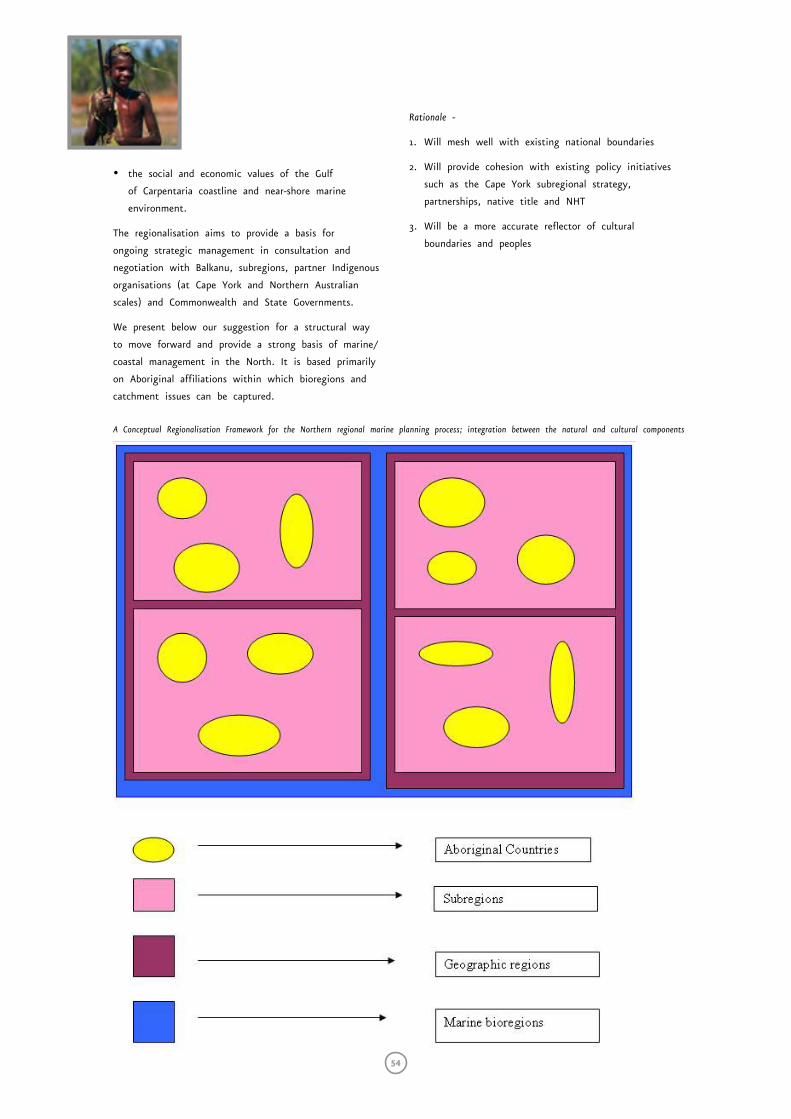
54
• the social and economic values of the Gulf
of Carpentaria coastline and near-shore marine
environment.
The regionalisation aims to provide a basis for
ongoing strategic management in consultation and
negotiation with Balkanu, subregions, partner Indigenous
organisations (at Cape York and Northern Australian
scales) and Commonwealth and State Governments.
We present below our suggestion for a structural way
to move forward and provide a strong basis of marine/
coastal management in the North. It is based primarily
on Aboriginal affiliations within which bioregions and
catchment issues can be captured.
Rationale -
1. Will mesh well with existing national boundaries
2. Will provide cohesion with existing policy initiatives
such as the Cape York subregional strategy,
partnerships, native title and NHT
3. Will be a more accurate reflector of cultural
boundaries and peoples
A Conceptual Regionalisation Framework for the Northern regional marine planning process; integration between the natural and cultural components
Chapter 2: conclusions
Sea Country Co
nsu
ltation Repo
rt — Cape Yo
rk Penin
sula
55
ConclusionsThe National Oceans Office process has not been
smooth sailing but the result is positive. Effective
Indigenous engagement requires more time than this
process has provided. There is a dearth of individuals
capable of straddling the issues and concepts across
cultures to deal with these matters.
Cape York, and indeed Northern Territory and
Carpentaria Traditional Owners, have many common
issues whilst at the same time being responsible for
particular countries. There will be major challenges
involved in representation of those local issues.
We encourage the continuing use of Native Title
Representative Bodies as a centralising structure for
gathering information, holding it in trust for Traditional
Owners and providing legal filters for Traditional Owners
in a volatile Native Title environment.
Regional and Subregional Aspirations
(saltwater plans)
We have elaborated many of our organisational
aspirations already especially in the sections relating to
institutional arrangements, values and areas section and
management considerations.
They revolve around:
• Having time to explain initiatives to Traditional
Owners whose understanding of management is
totally different from Natural Reserve System and
or bioregional processes;
• Having the funds to travel the vastness of
Cape York;
• Having the human resources to do the job amongst
many others;
• Having coordination capacity at different levels
but within Indigenous structures not government
structures;
• Having representation at the right places;
• Having Indigenous-only fora for free expression; and
• Having self determination.
Unity of purpose is required. Government needs
to support mandated bodies and not vacillate. We
would suggest that in order to establish a basis for
management the following are required:
• Documentation of resources that are currently used
by various sectors.
• Assessment of which resources can be used that are
currently wasted or not used at all in a commercial
context.
• Assessment of the status of resources used. Is
increased use sustainable? Is re-allocation required?
• Are these subsistence resources, commercial resources
or both?
• Is outside commercial and recreational activity
threatening subsistence? If so, prioritise food
resources and limit other uses.
• Test feasibility of current economic aspirations.
Rule out those that are not feasible, develop other
options and make provisions for future demand on
resources if possible.
• Map all subsistence and commercial activities at the
subregional scale.
• Superimpose commercial activities or potential
commercial activities on cultural constraints if any.
• Map potential conservation areas at the subregional
scale.
• Apply Indigenous and non-indigenous criteria for
identifying and then selecting saltwater country
protected areas.
• Negotiate uses in protected areas. These are in many
cases not going to be ‘no-take’ areas except where
Traditional Owners require or agree to total closure.
There is a general view held by Traditional Owners that
everyone but Traditional Owners is benefiting from their
resources. This is undeniable and it is high time this
injustice was addressed rather than pretending it doesn’t
exist. As mentioned on numerous occasions, there is a
distinction between non-indigenous parties recognising
the letter of the law and working on partnerships of
mutual respect regardless of legal precedent. The fact
that native title has not been found in a particular
area of land or sea does not mean that those wishing
to use that land or sea, albeit legal, should ignore
Traditional Owners.
56
The essential elements for success will be negotiating
the areas of common conservation and use interest.
It is important for Traditional Owners to have the
opportunity to propose solutions first rather to have
to react.
This challenge asks us to consider how negotiation
is occurring now and to change the convention to
deliver results at the local or sea country or subregional
scale. These are likely to vary in size and should be
worked out by Traditional Owners and their Indigenous
organisations.
The transient population in the west coast communities
are generally highly skilled and well paid. There is
a real need to support people who will stay for the
long term, to acquire the skills required and help to
prevent the major discontinuities that occur when the
transient people leave. In short, capacity building and
job security for local people is necessary.
People are seeking the opportunity and mechanisms
to get their position clear and agreed to by Traditional
Owners at various scales (individual, family, clan,
group, subregion and region) before being pushed
into multi-stakeholder meetings with totally different
terms of reference, motivations and world views to
Indigenous peoples.
We believe that it is essential to provide for long-
term continuity at the subregional scale. This problem
is best solved by mentoring programs, training geared
to ‘learning by doing’ and the engagement of local
Indigenous people (preferably) in key positions pending
Traditional Owner approval.
We would suggest that the next phases of the National
Oceans Office planning process seek to provide for
the development of such partnerships and that the
‘negotiations tables’ model be implemented with the
Cape York Land Council and Balkanu as lead agencies
and with a view to management partnerships at the
subregional scale.
Sea Country Co
nsu
ltation Repo
rt — Cape Yo
rk Penin
sula
57
Chapter 3: other recommendations Current position
We have completed a scoping study. This has identified
a number of issues. We have provided the necessary
latitude (such as not enforcing contractual obligations
and time lines on subregions) to limit disenfranchising
people from the process.
This has caused Balkanu and the National Oceans Office
some discomfort but that is the reality. Consultations
are occurring in a highly charged political atmosphere
involving a number of parties including the State and
Commonwealth who themselves have points of tension.
Because of the lateness of the reports it has not been
possible to provide a detailed synthesis of issues as
originally intended but that can still be done and most
of the broader issues are quite clear and unequivocal.
More detailed matters will need to be dealt with in
situ at the subregional scale through the proposed
negotiation tables if we can find the resources to
conduct them.
The regional report provides a general overview
and importantly contemplates the mechanisms by
which management might be achieved. The report
acknowledges current processes, agency rationales
and obligations and attempts to bring them into a
Tradtional Owners frame.
It is very clear that management information generally
and Indigenous management information, in particular,
is sparse in the published literature with some notable
exceptions. Indigenous information has restricted access
negotiated between anthropologists/consultants and
Traditional Owners or as a consequence of unsettled
tenure negotiations.
We have addressed a number of issues as a
consequence of recognition of Balkanu as the peak
Indigenous land and sea management organisation on
Cape York and engagement in regional, State and
Commonwealth processes.
Moving ahead
Having done the scoping study, there is now a need
for some time to be set aside to discuss issues
between Land Councils and revisit communities to
explain where we have got to and explain management
options that we have suggested on their behalf. This is
complex and will need time.
As we suggested early in the scoping phase process,
we immediately signal that more time be provided and
that progress of the planning process turn on mutual
understanding rather than timelines for the sake of
timelines.
We suggest subregional negotiation tables as the way
forward. These will need funding.
Considerations for the next phases of planning.
Note: Where ever possible the subregions should be enlisted
to do this work. Balkanu/CYLC is offering to coordinate
such tasks with a view to aligning them with whole of
Cape York responsibilities and arrangements with State and
Commonwealth Governments
All studies and actions suggested below should be presented
in plain English and be accessible to Traditional Owners.
Process
1. A possible assessment of the National Oceans Office
process itself as it relates to Indigenous issues and
engagement. This might inform the next regional
marine planning process.
2. The wording of all contracts will need to change to
accommodate Traditional Owners wishes. Both sets of
contracts ( the contact between the National Oceans
Office and Balkanu and the contracts between
Balkanu and subregions) triggered serious problems
in practice. The subregional contracts had to reflect
the desire of the National Oceans Office to own
copyright and intellectual property. This became a
major sticking point.
3. Workshops relating to institutional arrangements
should be undertaken starting with discussions
between Land Councils in private and funded by the
National Oceans Office. Development of institutional
arrangements appear a long way from settled and is
a critical issue that we must try and resolve.
4. Develop a process agreement so that everyone is
clear on what is happening and what their roles and
responsibilities are.
5. Strategy, roles and responsibilities. We are
continually reacting. Why? What is required for
Indigenous people to be on the front foot? National
Oceans Office must provide time and resources for
Traditional Owners to digest issues and for Balkanu
and CYLC to seek counsel from constituents.
58
On ground actions
6. An evaluation of on ground projects that can
be undertaken immediately should be done. This
suggestion is in order to show good will to
Traditional Owners that something is actually
happening on the ground besides more discussion.
The human resources provided to attract funds to do
them needs addressing, namely application writers/
negotiators. Balkanu and partner organisations offer
a seat for that person in their office. This might
be coordinated with CDEP programs and training.
Some of this is being done already through Cape
York Partnerships and Balkanu Business Hubs.
NHT 2 is waiting in the wings and in our
scoping report we have provided a regionalisation
that might be applied pending endorsement by
Traditional Owners. The development of negotiation
tables at subregional scale, we suggest, is the way
to develop strategy which may be attractive to the
NHT 2 strategic regional plans. This should be a
private Indigenous affair to begin with, with other
parties by invitation.
Aboriginal conservation priorities
7. As mentioned in the regional report there is a
plethora of Eurocentric ‘conservation significance’
documents for Cape York. There is a need for
parallel Indigenous documents to determine where
common areas of Indigenous and mainstream
significance might exist. It would also be for
Indigenous people to determine what the criteria
for valuation might be. We can say from experience
that the ranking and weighting of cultural heritage
and Indigenous natural values as often undertaken
in computer-based Decision Support Systems are
not likely to provide the outcomes required in
this region in the short term. Decisions will come
from senior traditional people based on their own
assessments of the situation. It is important that
those people have information.
Traditional knowledge
8. The importance of recording traditional knowledge
and Indigenous ideas for management solutions
cannot be understated and we would recommend a
large investment in marine ethno-ecological research
and research partnerships immediately. However this
should be negotiated by Indigenous organisations,
not taken and run with by tertiary institutions,
mainstream researchers or agencies. Balkanu can
recommend a pathway for engagement pending
discussions with Indigenous groups.
From an organisational point of view we believe it
is crucial that research into Traditional Ecological
Knowledge and other knowledge be conducted by
Traditional Owner-endorsed process. Benefits derived from
this include:
• It provides the information for cultural sustainability,
passing on information to younger generations
• It is simply useful natural resource management
information
• It provides an Indigenous scientific component to a
management plan
• It provides a practical bridge between the social and
environmental components of ESD management.
Subsistence economy
9. The value of subsistence use has not yet been
quantified except in one study (see literature
review). It appears to be substantial based on the
outcomes of the Injinoo Subsistence Fishing Survey,
general observation and personal communications.
Attempts might be made to do this but if the
former is accepted as fact obtaining the figures
might be academic. However, history has shown
that numbers are important in arguing allocations
for example and will be important in calculating
total catch. Balkanu, DPI and Qld Department of
Environment and Heritage have produced a survey
kit which might be of use in this regard.
Cultural mapping
10. We would recommend a study of cultural mapping
that has occurred along the west coast of Cape
York. This must remain strictly confidential and held
in trust by the CYLC for Traditional Owners and
each local group provided with their information
where they have secure data storage systems. No
other parties (including the National Oceans Office)
have any rights to such information but it does
need to inform planning. A subcontract to do
this was precluded by the scoping study contractual
conditions.
Tourism
11. We would recommend an overview of tourism studies
and if necessary a study of the number of tour
operations and tourists using saltwater country,
including the benefits to Traditional Owners derived
from those activities and the ownership of those
operations. The focus should be on subregional
outcomes for Traditional Owners.
Chapter 3: other recommendations
Sea Country Co
nsu
ltation Repo
rt — Cape Yo
rk Penin
sula
59
Economy
12. A confidential review of economic aspirations
should be undertaken by Balkanu Business Hubs
and seconded business partners.
Torres Strait issues
13. Discussion of mechanisms relating to the interaction
of TSRA and Kaurareg with Cape York Land Council,
Torres Strait Treaty etc.
Legal issues
14. A study of the legislative interactions and roles
and obligations of State and Commonwealth and
workshops to explain those to parties and Traditional
Owners. This should include an analysis of tools
available for co-management and protected areas
negotiation. This should be done by the CYLC.
Research
15. A study and review of Indigenous research priorities
should be undertaken by Indigenous organisations
16. Biological research needs from an Indigenous
perspective should be identified (Balkanu Caring
for Country Unit and subregions)
17. Social research needs should be identified. (Cape
York Partnerships, Balkanu and subregions)
18. Economic research needs should be assessed (Balkanu
Business Hubs and Balkanu Caring for Country Unit
and subregions)
Basis for management
19. Development of MOU with the State on the
promotion of the marine protected areas framework
referring to management along cultural management
unit lines.
Monitoring
20. The status of Aboriginal participation in monitoring
on the west coast should be assessed. This should
include environmental monitoring and compliance
monitoring. What are the opportunities and what
training is required? Some of this work has already
been done by Cape York Partnerships and Business
Hubs.
Land use
21. Model wet and dry inundation for where it hasn’t
been done using vegetation types and landsat. An
example of Jim Monaghan’s work in Kowanyama is
provided in the regional report.
22. A significant catchment based study needs to be
done. This should include current and future use
of catchments.
Fisheries
23. Traditional Owners would like to know the number,
type and extent of commercial fisheries in the area
of operation, what species are caught, the condition
of those fisheries as well as market information.
There should also be an analysis of the flow of
benefits in these fisheries. DPI fisheries information
provides a basis for analysing fisheries harvests on
an area basis and could be followed up during the
next phase of this planning process.
24. All species used by Aboriginal people should be listed
for each subregion and research conducted on stock
status and impacts from other use. Literature on
each species should be reviewed (in each subregion
if possible) and provided to Traditional Owners for
their consideration. (Not a whole lot of language
names collected and taken to a university or
departmental computer)
25. Endorsement from the Injinoo Land Trust to publicise
Injinoo fishing survey with a view to showing other
communities the results.
26. Review of recreational fisheries, camping etc on
western Cape York
27. A review of charter operations is required showing
value and flow of benefits
28. Review and update aquaculture strategies, potentials,
inform Traditional Owners of hazards and benefits.
Some areas are simply unsuitable for certain species.
29. Keep abreast of development of the aquaculture
scoping paper through DPI Northern Fisheries Centre.
30. Review fishing strategies in view of the
Commonwealth Department of Agriculture, Fisheries
and Forestry proposal to create another national
Indigenous fishing strategy.
60
ReferencesAbrahams H.,Mulvaney M., Glasco D. and Bugg A.
(1995). Areas of Conservation Significance
on Cape York Peninsula. CYPLUS report.
Aken, R and Roberts, C (2002) Aquaculture on
Cape York-Building Relationships. Paper
presented to the Aquaculture Workshop
for Indigenous Communities. April 9&10,
2002, Cairns Colonial Club. In Aquaculture
information published by ATSIC, AFFA and
Queensland DPI.
Balkanu, (2002). Submission to GBRMPA Water
Quality process. Unpublished report.
Cordell,J (1995) Indigenous Management of Land
and Sea and Traditional Activities in
Cape York Peninsula. CYPLUS report.
DAFF, (2003) Looking to the Future. A
Commonwealth review of Fisheries Policy.
Commonwealth Department of Agriculture,
Fisheries and Forestry-Australia, ISBN 0-
9750223-0-X.
EPA, (2000) Marine Protected Areas in
Queensland – a draft planning
framework. State of Queensland,
Environmental Protection Agency.
ISSN 1037-4698.
Golden, S (1995) General suitability of
Aquaculture and Mariculture
developments. Part C of Cape
York Peninsula Land Use Strategy,
Other primary industries (non-pastoral,
non-forestry) of Cape York.
Johannes, R.E. and W. MacFarlane (1991). Traditional
Fishing in the Torres Strait Islands.
CSIRO Division of Fisheries. Hobart.
Langton, M. (1998) Burning Questions: emerging
environmental issues for indigenous
peoples in Northern Australia. Published
by the Centre for Indigenous Natural and
Cultural Resource Management, Northern
Territory University.
Langton, M, Epworth, D, and Sinnamon, V (1999).
Indigenous social, economic and cultural
issues in land, water and biodiversity
conservation. A scoping study for WWF
Australia, Volume 1. Internal document.
Lee, C and Nel,S (2001) A National
Aquaculture Development Strategy
for Indigenous Communities in
Australia. AFFA.
Mackey, B.G., Nix,H and Hitchcock,P. (2001).
The Natural Heritage Significance
of Cape York Peninsula. ISBN 0-7315-
3337-2. CD. Published by ANUTECH Pty
Ltd. Commissioned by the Queensland
Environmental Protection Agency.
Nettheim, G., Meyers, G. and Craig, D. (2002)
Indigenous Peoples and Governance
structures: A Comparative Analysis of
Land and Resource Management Rights.
Aboriginal Studies Press.
Pearson, N. (2000) Our right to take
responsibility. Published by Noel Pearson
and Associates, Cairns Queensland. ISBN
0646395289.
Petersen, N and Rigsby, B (1998) Customary
Marine Tenure In Australia. Oceania
Monograph 48, University of Sydney.
ISBN 1 86451 358 6
Roberts, C and Wallis, A. (2002). Aboriginal Cultural
Sub-regions as Surrogates for Biodiversity Mosaics
in Cape York, Australia- towards reconciliation
of management values and on ground realities.
Aquatic Protected Areas - What works best and
how do we know?, Proceedings of the World
Congress on Aquatic Protected Areas
- Cairns, Australia; August, 2002.” Editors..
JP Beumer, DC Smith and A Grant. In press
Roberts, C and Aken, R (2001) Sea Country:
Maritime Estates, Traditional priorities
for traditional country (PDF)
http://www.balkanu.com.au/media/papers/
index.htm Paper presented to the Waibene
(Thursday Island Cultural Maritime Summit
March 2001.
Sea Country Co
nsu
ltation Repo
rt — Cape Yo
rk Penin
sula
61
Ross, H and Innes, J. (2001) Co-managed
research as a strategy for informing
the development of Indigenous and
government management partnerships
over the Great Barrier Reef. Paper
presented at International Association for
the Study of Common Property, Inaugural
Pacific Regional Meeting, Brisbane, QLD, 2-4
September 2001.
Smyth, D. (2000) Fishing for recognition: The
search for an Indigenous Fisheries Policy
in Australia. Indigenous Law Bulletin, Vol
4 issue 29. Special Issue Water Rights. Pg
8-10.
Southon, M and Kaurareg Elders, (1998), in Petersen,
N and Rigsby, B (1998) Customary Marine
Tenure In Australia. Oceania Monograph
48, University of Sydney. ISBN 1 86451 358
6 pp 221
Wilkins, A. (1908) Property and inheritance. In Reports
of the Cambridge expedition to the Torres Strait:
sociology, magic and religion of the eastern
islanders, Vol 6 (ed) A. Haddon, Cambridge:
Cambridge University Press. Pp 163-167.
QDPI. (2002) Queensland Fisheries Resources.
Current condition and trends 1988-2000.
Information series Q102012. Edited by L.
Williams.
62
Appendix oneThis section comprises our thoughts and comments on
the power point presented by National Oceans Office
with the National Oceans Office part in italics.
• Launched in 1998. We are aware of ATSIC
participation and submissions in the development of
the Oceans policy although recommendations were
not all taken up by the Commonwealth. Balkanu
contributed to those ATSIC submissions. We identify
the Oceans Policy Issues Paper #6 as a good
statement of aspirations. Indigenous people however
want some action on these matters.
• Ecologically sustainable development basis. We believe
that this is an honourable stance but are seriously
concerned that Aboriginal people are way behind
in having their interests represented, although they
have made every effort to do so. (See Smyth,
2000 who provides a chronology of attempts to
contribute and participate). Ecologically sustainable
development usually addresses three pillars, namely
social, economic and environmental. Aboriginal people
frequently have cultural considerations that may
affect all three of those parameters.
Firstly, the number of Aboriginal people fluent in
the language and rationale of the prevailing western
management and scientific paradigms is limited
although the concept of ESD is fundamental to
Aboriginal lifestyles. Aboriginal know-how is regarded
more often than not as being somehow less relevant
to contemporary mainstream management. This must
change through Aboriginal-led collaborative investigation.
Balkanu is engaged in a number of collaborative projects
and would like to progress these in the following
phases. NAILSMA should also be consulted on policy
relating to research partnerships.
Secondly, management must value alternative rationale
and science equally and make way for its expression.
This does however require its own process, structures
and skills (we refer the reader to the excellent multi-
media work being done by Victor Steffensen at Balkanu
on recording traditional knowledge).
Thirdly, Aboriginal people have not or have not been
able to elevate their values enough in the discussion
to be considered in the ESD equation. A good example
is what Richard Aken of the Kaurareg nation calls
“spiritually sustainable development” (pers comm.) which
is central to Aboriginal concepts of country and its
management. For Aboriginal people there is little point
in managing country unless this dimension is included.
Fourthly, existing commercial operators have a massive
advantage in maintaining their position of superiority
in the ESD debate. There is an absolute need for
other sectors to concede that they have had that
upper hand from the start. There is a need for other
parties to recognise that they need to make concessions
and for the Indigenous share to increase. Aboriginal
people require management agencies to recognise and
support that reality. Negotiations are necessary and
compensation packages (to both existing industry
operators and Aboriginal people) will be required to
instate some semblance of fair access and participation
in industry.
• Ecosystem-based management. This is a contemporary
scientific phrase that is becoming well used, perhaps
even worn. It appears to make intuitive sense,
alluding to connectivity of natural systems, the
need to consider food chains, relationships between
species, migrations and movement according to
stages in the lifecycle, seasons et cetera. This kind of
thinking is of course central to the Aboriginal world
view and extends even further to include themselves
and their religion, sky, clouds and other components
of country. A focus on ecosystem management also
provides confirmation and support for considering
the substantial and varied cultural and landscapes of
rivers and deltas in the NMP area, particularly on
the west coast of Cape York
The “social landscape” and endorsement of principles
arising from it is crucial in making what might on
paper be a good natural ecosystem perspective work
in practice. Without effective compliance a good plan
means little and it is for this reason that all efforts
must be made to have the people who are expected
to comply understand the objectives and the reasoning
behind a strategy or plan.
• Adaptive management. This is presumed to mean
reviewing and monitoring progress and changing
management strategies as more options are
identified. Aboriginal people have had to rely on
their ability to cope with change and are quite
familiar with changes in seasons of the year (and
variations each year) requiring different survival and
management strategies. We are aware of calendar
trees indicating that certain species of fish are
‘fat’ for example (here fat relates to texture, taste,
nutritional quality and so on). Longer or shorter
wet seasons, severe dry seasons affect when flowers
appear or shoots grow which in turn may indicate
when resources are available. Such knowledge is
clearly of management value and prescribed dates
for management activities could be replaced by
the recognition of and adaptation to environmental
triggers and signals. An example is fish spawning
closures. It is extremely relevant to collect such
Sea Country Co
nsu
ltation Repo
rt — Cape Yo
rk Penin
sula
63
information. The Aboriginal role in monitoring is
potentially very significant because it is they who
are there on country. It would seem that with some
collaborative planning of monitoring arrangements
there could be some good outcomes socially,
environmentally and culturally.
• Improved coordination between Commonwealth, States
and Territory. These are complex issues that
are confusing for Traditional Owners and their
organisations. What Aboriginal people do understand
is that policy is subject to political change and that
there is competition between local, State, Territory
and Federal interests. The complexity of jurisdictional
arrangements frustrates Aboriginal people and the
discontinuities in legislation fly in the face of
attempts at ecosystem-based management. Traditional
Owners have remarked on numerous occasions that
fish do not recognise legislative or jurisdictional
boundaries.
Aboriginal and Torres Strait Islander Communities.
In the context of developing integrated oceans planning and
management processes, the government will seek to ensure that:
• Traditional conservation and use practices are valued. If
these practices are to be valued they must also be
known. Some of this might be undertaken in the
assessment phase. There are significant issues relating
to intellectual property and complexities of privileged
or secret information. There are real dangers of
information falling into inappropriate hands. It is
therefore necessary that mechanisms are in place
that allow incorporation of information without its
public exposure. An example is for Traditional Owners
to lay out the route for a road without having to
identify the sites around which the road might
be navigating. Similarly, Traditional Owners, armed
with their own knowledge and protocols can produce
a list of appropriate activities in particular areas
without having to declare the reasons for those
decisions. Similarly we would encourage the National
Oceans Office to support development of a process
that allows Traditional Owners to develop plans
with minimal interference, and provide them the
opportunity to table a plan themselves.
• That the reliance by many coastal indigenous communities
on marine resources is treated as an important ocean
use. In the assessment phase it would be worth
quantifying just how important reliance on these
resources is. It is a key issue. In Kowanyama for
example a rough estimate is that local people obtain
three meals per week from the saltwater environment
(Jim Monaghan pers.comm). Our own observations
confirm this to be true along the length of the
west coast and elsewhere where Aboriginal people
live near the water (salt and fresh). The Kaurareg
Nation falls into a geographic region regarded as
having the highest per-capita consumption of seafood
in the world4.
• That indigenous communities have opportunities to take
up commercial activities related to oceans. We need
to consider what is required for this to happen,
for example in cases where fishery resources are
already being fished to capacity. What range of
opportunities might Aboriginal people want to take
up and how will they manifest themselves on
the land and sea? How are balances to be struck
between Aboriginal subsistence, Aboriginal commercial
fishing, non-indigenous commercial fishing, charter
fishing, hosted recreational fishing and so on? How
will allocations be adjusted after long histories of
one-sided commercial opportunities?
Regional Marine Planning
• Each regional marine plan and its planning process will
vary depending on the characteristics of the region. This
is agreed and we have made the case for Aboriginal
primacy in this region, particularly in the near shore
and onshore saltwater areas.
• Provides a framework for future decision making. To
this end we will be working towards an endorsed
structure and agreed set of principles with other
Aboriginal groups at various scales.
• Promotes ecologically sustainable marine based industries.
Consideration must also be given to culturally
sustainable parameters in this planning region.
• Integrated management of sectoral activities. There are
two issues here; integration of user interests (what
is the cumulative effect of uses on the resources
themselves and social relationships between sectors
within a particular country) and integration of
processes used to identify and negotiate them (what
are the authorised negotiating fora that are to
address integration?) We would suggest that the CYP
Negotiation Tables model is a good working model
already endorsed by the State.
• Work towards consistency in management across
jurisdictional boundaries.
4 It is worth considering the utility of the Indigenous Subsistence Survey Kit or parts of it, in obtaining such information. However we should bear in mind Traditional Owners’ likely scepticism of unfamiliar people fossicking for such information. The use of the survey kit is contingent on support and training in its use and also that information emanating from it is held and negotiated by the community concerned. It is intended to be a subregional tool, not a government tool.
64
It is appropriate in this particular circumstance to
consider at least near shore management arrangements
based on cultural criteria . Aboriginal people have
always displayed consistency in demanding the right
to control what happens in their traditional domain.
Aboriginal freehold is inalienable and cannot be sold.
Balkanu has promoted this central conceptualisation of
Indigenous space (country) in a number of discussion
papers (www.balkanu.com.au) and through advocacy
generally. The coasts of Cape York and the Torres
Strait (in fact right across Northern Australia from
Western Australia to Cape York) provide a clear
opportunity to consider management by ‘country’
or cultural unit so to speak.
• Engender long term responsible use of oceans resources-
stewardship. Aboriginal people are familiar with so-
called intergenerational equity, (or simply, “leaving
something for their children”) and the need to
manage and protect for the future. This is a primary
motivation for objecting to what they perceive as
over-use of their homelands by others. Industry has
become very widespread and efficient and its impacts
need to be controlled. Industry also needs to develop
more of a stewardship ethic (notwithstanding
compliance with belated legislation such as the
EPBC Act and increasingly demanding environmental
guidelines, nor the potential market advantages of
registration under the Marine Stewardship Council
and development of codes of conduct and EMS).
• First plan developed in the South-east of Australia,
the second in the Northern Planning Area. Clearly
different parameters apply in the Northern
Planning Area and the National Oceans Office
recognises those. We would hope this translates
to appropriate considerations in the next phases
and within the institutional arrangements that
will pertain to the NRMP.
What does regional marine planning involve?
• Identification of environmental, social, economic and
cultural objectives by involving all interests in identifying
their concerns. Importantly Indigenous peoples do
not confine their interest to cultural objectives
alone. The other objectives need to find a position
in culture. It is important for Traditional Owners
to have the opportunity to propose solutions first
rather to have to react. While the NRM process is
attempting to provide for this, successful outcomes
rely on the possession and understanding of the
agendas and aspirations of other parties, the ability
to debate internally at various scales and to have
advocates that understand the language and issues.
• Facilitating a shared understanding of the region and
of perspectives of each interest group. We intend to
provide such an understanding from this study for
the early rounds of stakeholder meetings. However
representation and preparation for such meetings
is complex in view of the “inverse” nature of
Aboriginal voice and responsibility for country
compared with the western system of representation.
Senior elders speak for their country but may have
no desire to participate in hierarchies requiring them
to speak for others or at regional fora.
• Providing appropriate structures to enable all interest
groups to participate and provide input through
the various planning phases. This is an issue for
Indigenous peoples because the legislation authorising
prescribed bodies corporate, NTRBs and other
governance structures in Australian Law is relatively
recent in relation to traditional protocol.
• Provide sound information to aid development of shared
perspectives and guide decision making. This is easily
said but in reality requires a major investment of
time and resources especially across such a vast area
where many do not like to fly in small aircraft and
vehicles are not readily available. The alternative is
an intense engagement community by community,
which is costly. The cross-cultural communication
issues described above also bear on the exchange
of sound and useful information between parties.
Outcomes are necessary at the ‘country’ scale and
there is no alternative to that type of engagement.
It is how this information moves into regional and
larger arenas that is problematic at this stage. A
regional organisation with a native title mandate is
required to broker this.
In more detail: in each marine region the Regional Marine
Plan will broadly:
• Identify ocean resources and economic and other
opportunities. This raises some questions for
Traditional Owners who have good ideas but no way
of capitalising on them. We already know of some
commercial-in-confidence studies underway which
cannot be incorporated into the planning process
until they are commercially safe and investors are
secured. In this respect the planning process is a
little ahead of its time.
Traditional Owners do not want economic options to
be limited (e.g. by the gazettal of protected areas)
before they are known. It must be clear (while keeping
in mind the precautionary principle) that the order of
priority needs to be:
Sea Country Co
nsu
ltation Repo
rt — Cape Yo
rk Penin
sula
65
1. Assessment of resources
2. Documenting aspirations
3. Determining feasibility of aspirations
4. Assessing the cumulative impact, should all
aspirations be feasible
5. Prioritising opportunities
6. Declaration of protected areas
A number of these have been progressed to various
degrees at the various scales.
• Identify current and emerging threats to ecosystem health.
There is a considerable list of these and many are
common across the west coast of Cape York. Again
Traditional Owners have identified major roles for
themselves in looking after country and assistance is
sought to act on these.
• Determine planning and management responses to threats.
Traditional Owners have excellent local knowledge
and are clearly invaluable in planning and executing
responses to threats. Some State Emergency Service
reports have been prepared (eg for Pormpuraaw) and
oil spill contingency planning has been undertaken
on the east coast of Cape York.
• Identify ecosystem characteristics and broad objectives
for ecosystem management. Again we refer to the
relevance of the spiritual and customary ritual
dimensions of country which need to be accounted
for in management in order to be meaningful to
the prospective co-managers or management partners,
namely Indigenous people and others.
• Identify conservation priorities and measures to meet
them, including areas that should be assessed as
possible marine protected areas. There are a number
of studies elaborating non-Indigenous or mainstream
conservation targets on Cape York but we are yet to
see an Aboriginal conservation plan for Cape York.
Even though there is a strong focus on generating
economies, conservation priorities are important to
Aboriginal people and need to be acted upon.
Aboriginal people need boats on the water and patrol
vehicles within the term of the NRMP process. We are
of the opinion that the National Oceans Office has
underplayed the protected areas aspect of the planning
exercise, perhaps because of a fear of resistance to an
expression of conservation interest by users. This is not
necessarily the case but a very important caveat applies.
Aboriginal people want to look after country their way.
Aboriginal people do want to get on with the business
of looking after country and agencies would do well to
establish their credibility by doing practical things with
Traditional Owners on country.
Regional Marine Planning
1. Specific Issues & Management Responses
2. A Planning and Management Framework for the Future:
• shared understanding of values. It is important
that stakeholders understand Aboriginal values,
particularly in this Aboriginal-dominated planning
region. Not only should they understand these
values, but they should be recognised as primary
values, tied to cultural survival of Australia’s first
nations.
• reduced conflict between sectors over resource
allocation. This will be partially resolved by a clear
expression of expectations. Reduction of conflict
should not be expected to be accomplished by an
Aboriginal acceptance of current inequities despite
being the major presence on the Cape. Other
parties should also be mindful that Aboriginal
people are disadvantaged in discussions, because
of factors such as the ability to travel and basic
social indicators such as living wages. It must be
made clear that non-indigenous interests have the
lion’s share from the Gulf of Carpentaria.
• increased certainty and long-term security for
resource users and marine based industries. Increased
‘certainty’ was the catch cry of parties wanting
to limit the effects of the Native Title Act
during the Wik case in 1998. The idea of
certainty was embraced by the general public to
the detriment of Indigenous peoples. From the
Wik case came the 1998 amendments to the
NTA, which acted against native title interests.
It is Aboriginal peoples, more than pastoralists or
fishers, who require certainty particularly through
multi-lateral political commitment.
• indicators of sustainability-monitoring, evaluation
& reporting (a basis for adaptive management).
Aboriginal people have potential in this area
given suitable training and the potential to report
on criteria that are not yet accepted currently
in mainstream management. The structures and
formats for reporting must be reconsidered in the
context of Aboriginal life. Ways must be found
to tap into rich traditional knowledge without
having to teach people English or be the subjects
of researchers. Aboriginal people are practical
and show great initiative and ingenuity. These
aptitudes must find expression in management
and new directions in dealing with these
issues. We would recommend that indicators of
Indigenous participation and benefit be developed
for the NRMP.
66
Appendix twoEstablishing Community Sub-Regions
A brief for 1999 Land Summits
Produced by Balkanu Cape York Development Corporation
Community Sub-regions
What is the purpose of this paper?
To talk about establishing Aboriginal Land and Natural
Resource Management Office’s (ALNRMOs) in each of the
twelve proposed sub-regions of Cape York.
Governance Structures
What does that mean?
Governance structures are the organisations and
departments that decide how things are done and
who is in control of the decision making process.
What are the problems with existing structures?
They are not coherent (they don’t follow on from
each other)
Many of these structures are imposed by government
and don’t allow us to be represented and make
decisions.
Many of them were established when land rights
and self-determination were not imagined
They do not address the need for a holistic approach
(looking at the big picture)
They do not get away from the welfare approach (they
keep us dependant)
What about the Structures in the Cape?
The hundreds of Aboriginal organisations in Cape York
have evolved wali wali (in an ad hoc manner). This has
created competition and even conflict over access to
resources and representation.
Why should it change?
We need to recover from the effects of colonial history
and institutionalisation. To do this we need to create
governance structures that will empower us.
What is the Challenge?
To develop structures for Indigenous control through
which we
Make our decisions
And act on our decisions
What are the three levels of Aboriginal Governance?
Regional
The ‘whole of Cape York’ - the level at which Peninsula
Regional Council, Apunipima, Balkanu and CYLC operate.
They are owned and controlled by their members (Cape
York people)
Sub-Regional
Communities - the community level. This is the level
where most organisations and resources are located
including Community Councils. This is the level at
which management needs to be organised and at
which ALNRMOs would operate. It is simply impossible
for each Traditional Owner group to have their own
management agency.
Local
The level of local Traditional Owner groups. The people
who ultimately “have a say” over different areas of
land. It is important that Traditional Owner groups
work together to lead the sub-regional land and natural
resource management agency.
Sea Country Co
nsu
ltation Repo
rt — Cape Yo
rk Penin
sula
67
What is the best level to operate ALNRMOs at?
Operating at this sub-regional level is the most effective
way for land and resource management to take place.
Why do we need to plan?
So we use resources efficiently and so that Government
can provide more effective support.
So we do it in an holistic way - we need to stop the
business of every program in Cape York operating in
isolation from every other program in Cape York
So that things are not done in the Welfare mode - the
people on the ground need to be empowered to carry
out the work.
Where do Regional Organisations fit in?
Balkanu and CYLC can provide support by:
Helping people plan and establish management
organisations and systems
Helping agencies to get funding and other resources
Helping agencies deal with government departments and
outside management agencies
Organising access to training
Providing support and exchanging information
Helping agencies network with other groups/people who
are working in the same field
What is the relationship between
Local Groups and ALNRMOs
Community Councils are relevant because:
They have resources to contribute to land and resource
management such as CDEP
They currently employ Community Rangers
They have by-law making powers which are relevant to
land and resource management.
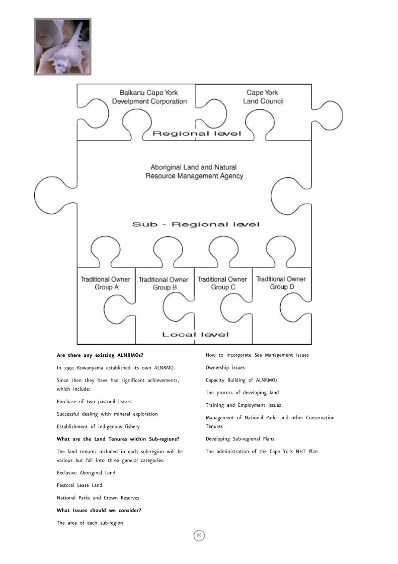
68
Are there any existing ALNRMOs?
In 1991 Kowanyama established its own ALNRMO.
Since then they have had significant achievements,
which include:
Purchase of two pastoral leases
Successful dealing with mineral exploration
Establishment of indigenous fishery
What are the Land Tenures within Sub-regions?
The land tenures included in each sub-region will be
various but fall into three general categories.
Exclusive Aboriginal Land
Pastoral Lease Land
National Parks and Crown Reserves
What Issues should we consider?
The area of each sub-region
How to incorporate Sea Management Issues
Ownership issues
Capacity Building of ALNRMOs
The process of developing land
Training and Employment Issues
Management of National Parks and other Conservation
Tenures
Developing Sub-regional Plans
The administration of the Cape York NHT Plan

Sea Country Co
nsu
ltation Repo
rt — Cape Yo
rk Penin
sula
69
Proposed Sub-regions
The sub-regions proposed are only a draft for discussion
Kowanyama sub-region
This sub-region would be centred on Kowanyama
Community and include the Alice-Mitchell River
National Park and adjacent pastoral leases with which
the Traditional Owner groups of Kowanyama are
predominantly affiliated.
Pormpuraaw sub-region
This sub-region would be centred on the Pormpuraaw
Community and include the adjacent pastoral leases with
which the Traditional Owner groups of Pormpuraaw are
predominantly affiliated.
Aurukun sub-region
This sub-region would be centred on the Aurukun
Community and include western parts of the Mungkan-
Kaanju National Park and adjacent mining and pastoral
leases with which the Wik people are predominantly
affiliated
Napranum sub-region
This sub-region would be centred on the Napranum
Community and include the adjacent mining leases and
pastoral leases with which the Traditional Owner groups
of Napranum are predominantly affiliated.
Old Mapoon sub-region
This sub-region would be centred on the Old Mapoon
Community and include the adjacent mining leases and
pastoral leases with which the Traditional Owner groups
at Old Mapoon are predominantly affiliated.
Northern Peninsula sub-region
This sub-region would include the Aboriginal
Communities of the Northern Peninsula, the Jardine
River National Park and other Aboriginal Reserves and
Crown lands with which the Traditional Owner groups
of the Northern Peninsula are predominantly affiliated.
Lockhart sub-region
This sub-region would be centred on the Lockhart
Community and include the Iron Range National
Park and adjacent Crown lands and pastoral leases
with which the Traditional Owner groups of Lockhart
Community are predominantly affiliated.
Coen sub-region:
This sub-region would be centred on the Coen
Community and include the Silver Plains and Rokeby
National Parks and adjacent pastoral leases and Crown
lands with which the Traditional Owner groups of Coen
are predominantly affiliated.
Laura sub-region
This sub-region would be centred on the Laura
Community and include part of the Lakefield National
Park with which the Kuku Taipan people are affiliated
and the adjacent pastoral leases with which the
Traditional Owner groups of Laura are predominantly
affiliated.
Lakefield/Kalpowar/Starcke sub-region
This sub-region would include most of the Lakefield
National Park, Cape Melville, Kalpowar and Starcke
areas.
Hope Vale sub-region
This sub-region would be centred on the Hope Vale
Community and include National Parks, pastoral leases
and other Crown lands with which the Traditional
Owner groups of Hope Vale are predominantly affiliated.
Yalanji sub-region
This sub-region would be centred on the Wujal Wujal
and Mossman Gorge Communities and include all of the
eastern Yalanji traditional lands
Kaurareg sub-region
This sub-region would be centred on the Horn Island
Community and including all of the Kaurareg traditional
islands.
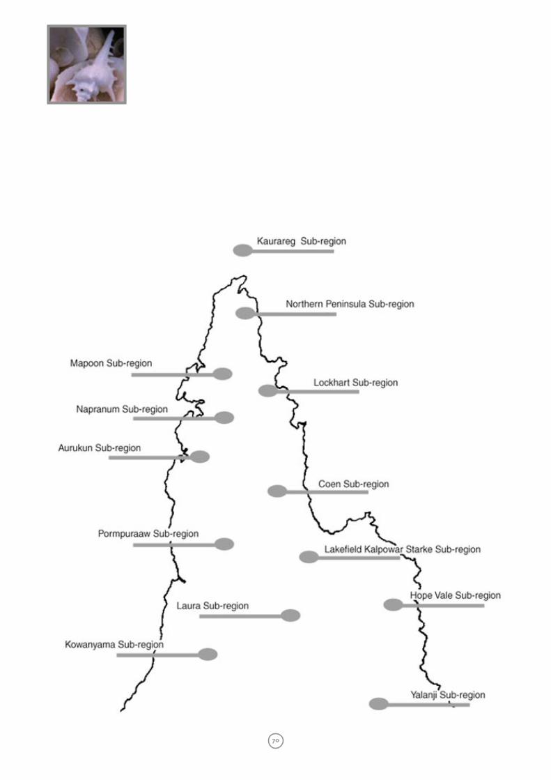
70