Embed Size (px)
Citation preview
REPORT PREPARED FOR
1179785 ONTARIO LIMITED
ON
MECHCANICAL TRENCHING
CLAIM 1166848, ZARN LAKE AREA,
KENORA MINING DIVISION
a a
August 26, 2003
JOHN WAKEFORD, P. GEOL
RECEIVEDAUG 2 9 2003-
GEOSCIENCE ASSESSMENT ______OFFICE
PROVINCIAL/RECORDINGor K i r: t - SUDBURY
R E C E: \ V E D
A.M.7i*l
P.M.li?H|5|6l
E
C
CDrv
ui
CDCO
52J04SE2003 2.26181 ZARN LAKE 010
Summary
A trenching program was completed on daim number 1166848, Zarn Lake Area,Kenora Mining Division Map Sheet G-2277, during the period August 14, 2003 through August 26, 2003. Additional sampling is in progress and wiil be reported at a later tfme. Trenching exposed a series of sulphide bearing quartz veJns near the former Alcona Gold Mine. Trenching was completed to expose the veins to accurately determine orientation, size and mineralization present.
Property Location and Access
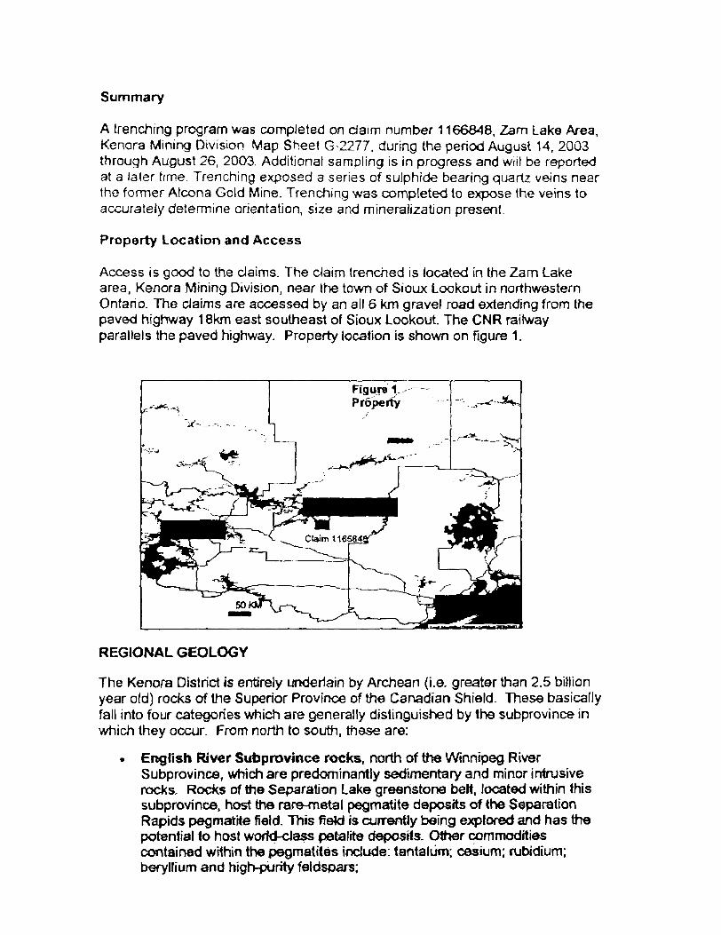
Access is good to the claims. The claim trenched is located in the Zarn Lake area, Kenora Mining Division, near the town of Sioux Lookout in northwestern Ontario. The claims are accessed by an all 6 km gravel road extending from the paved highway f 8km east southeast of Sioux Lookout. The CNR railway parallels the paved highway. Property location is shown on figure 1.
REGIONAL GEOLOGY
The Kenora District is entirely underlain by Archean (i.e. greater than 2.5 billion year old) rocks of the Superior Province of the Canadian Shield. These basically fall into four categories which are generally distinguished by the subprovince in which they occur. From north to south, these are:
. English River Subprovince rocks, north of the Winnipeg RiverSubprovince, which are predominantly sedimentary and minor intrusive rocks. Rocks of trie Separation Lake greenstone belt, located within this subprovince, host the rare-metal pegmatite deposits of the Separation Rapids pegmatite field. This fieW is currently being explored and has the potential to host worfd-dass petalite deposits. Other commodities contained wHhin the pegmatites include: tantalum; cesium; rubidium; beryllium and high-purity feldspars;
* Winnipeg River Subprovince rocks, north of Ihe WabigoonSubprovince, which are generally highly metamorphosed gneissic rocks- The Lount Lake batholith, located within this Subprovince, is host to three producing granite quarries This batholith, which covers approximately 1600 so,, km., has the potential to host additional granite deposits;
. Wabigoon Subprovince rocks, underlying most of the District, which are narrow, generally east or north-northeast trending belts of mixed volcanic, intrusive and sedimentary rocks-the so-called "greenstone" bells- separated by large intrusions of generally granitic rock. The majority of historical gold producers are hosted within the Wabigoon subprovince Several advanced gold projects such as Nuinsco's Cameron Lake Deposit, Teck Exploration and Corona Gold Corp.'s joint venture Thunder Lake Deposit, and Falconbridge's Kenbridge Ni-Cu deposit are hosted within the western Wabigoon's supracrustal rocks. Phases of the large granitic batholiths which separate the greenstone baits are host to producing and past-producing granite quarries. Other commodities produced within this subprovince include: soapstone, railway ballast, quartz and peat; and
* Quetico Subprovince rocks, south of the Wabigoon Subprovince, which are predominantly sedimentary and minor intrusive rocks similar to those occurring in the English River Subprovince.
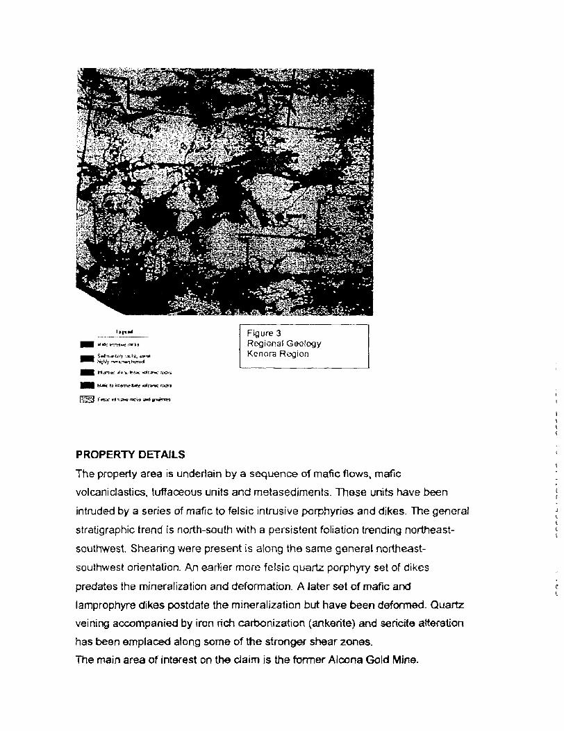
The New Millennium properties all fall within the Wabigoon Subprovince rock units. Figure 3, taken from the Ontario Resident Geologist website illustrates the regional geology of the Kenora District.
j rails,
Figure 3Regional Geology Kenora Region
TiftJ. J*Sfc fcfcw: ndt
t to rfianT*"la*e wXr
PROPERTY DETAILS
The property area is underlain by a sequence of mafic flows, mafic
volcan!elastics, tuffaceous units and metasediments. These units have been
intruded by a series of mafic to felsic intrusive porphyries and dikes. The general
stratigraphic trend is north-south with a persistent foliation trending northeast-
southwest. Shearing were present is along the same genera! northeast-
southwest orientation. An earlier more felsic quartz porphyry set of dikes
predates the mineralization and deformation. A later set of mafic and
lamprophyre dikes postdate the mineralization but have been deformed. Quartz
veining accompanied by iron rich carbonization (ankerite) and sericite alteration
has been emplaced along some of the stronger shear zones.
The main area of interest on the claim is the former Alcona Gold Mine.
Alcona Gold Mine
An underground shaft to a depth of 325' evaluated the Alcona deposit with levels
cut on the 180 and 305-foot level The mine was active from 1936 and 1937 at
wnich point operations were suspended lo " conserve the companies funds
during the market depression'. Veins occur in fractures and along shear zones
dose to the contact with a massive andesite and distinctive porphyritic basalt.
The porphyritic basalt can be seen proximal to the veining, alteration and
shearing as far to the north as 700 meters away. Veins vary in strike (0920 to
130") and dip (22"to 880 south. Quartz is grayish white in colour and contains
variable amounts of pyrite, chalcopyrite, sphalerite, galena and bornite. Veins
and associated shearing lend to be narrow with the largest noted in current
trenching of 1.1m. Sulphides can occur as disseminated grains and narrow :
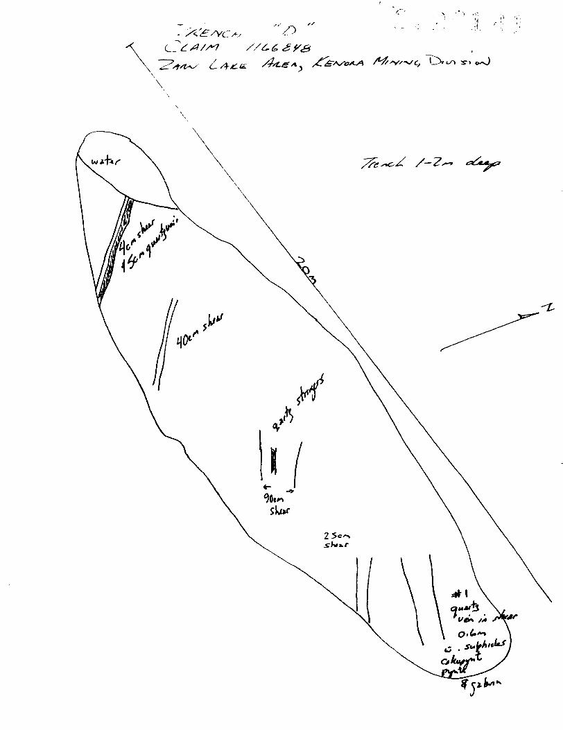
massive stringers. Historical records on the Number 1 vein record a width ofi
22"(0.6m) grading 0.5 oz Au/ton (17 gm Au/tonne). The Number 2 vein averages '
0.28 oz Au/ton over 18.5" (9.6 gm Au/tonne over 0.5m). The Number 2 vein is \
occurs 50' south of the Number 1 vein. Only the Number 1 vein is currently
exposed. Additional veins vary in width to 80" (2.0m) and carry variable amounts -
of gold mineralization. Two main trench areas have exposed what is likely the i
extension of the Number 1 and/or the Number 2 veins a further 600 meters to the i
north. Generally these trench areas are grown in and rt is difficult to accurately c
measure and sample veins. In 1991 Cream Silver Mines and Valerie Gold l
Resources were involved m a joint venture on a portion of the current property. '
The partners completed a program of geological mapping and drilled 6 shallow [r
and widely spaced diamond drill holes over a larger claim group. The holes were \c
all drilled immediately northeast of the underground workings. Cumulative [
footage for the program was 1075 feet (327m).
All holes encountered significant gold values but over narrow width, the best
being 0.43 oz Au/ton over 2.3' (14.8 gm Au/tonne over 0.7m). The partners ;.c
concluded that they had "identified several features which are indicative of a
promising geologic environment for economic mineralization. The ... property
shows good potential and further work is recommended.* The operators went on
to recommend a two-phase exploration program totaling S230,000 consisting
largely of drilling.
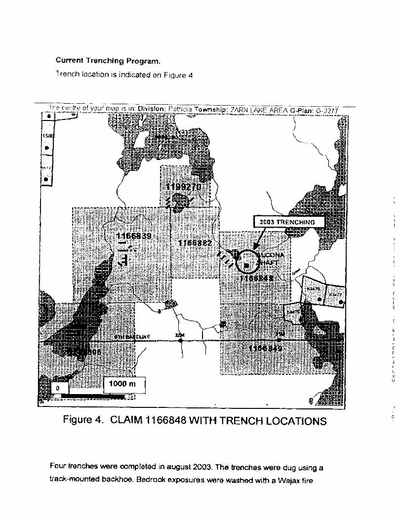
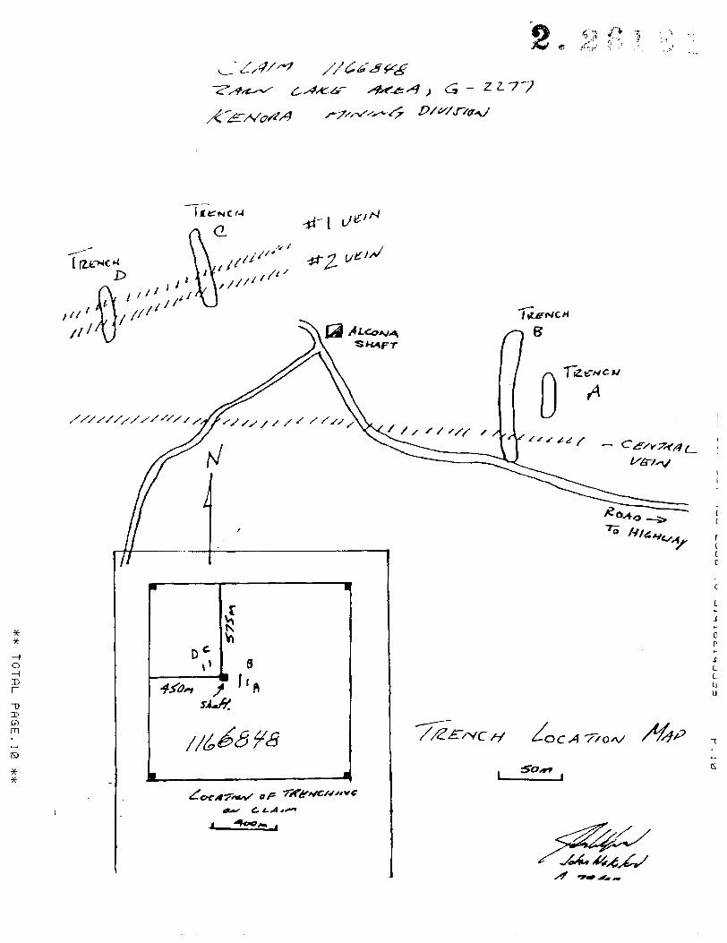
Current Trenching Program.
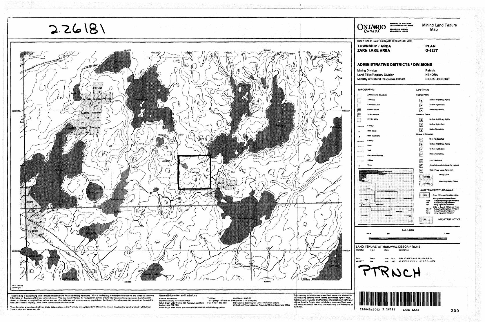
Trench location is indicated on Figure 4
^S^^L^^ilS^l^L^^^^^^'^ G-Plan: G--2277
feS
Figure 4. CLAIM 1166848 WITH TRENCH LOCATIONS
Four trenches were completed in august 2003. The trenches were dug using a
track-mounted backhoe. Bedrock exposures were washed with a Wajax fire
pump. Some additional clearing by hand was required to complete the trenches.
Sketch maps were prepared to evaluate sample requirements. Trenching
exposed a complex series of sheared mafic volcanic rocks quartz porphyry and
numerous sulphide bearing quartz veins Sulphides noted include chalcopyrite,
pyrite and galena. Sulphides occur in quartz veins and to a lesser extent within
sheared wallrocks. Sheared wallrocks tended to be deeper weathered and not as
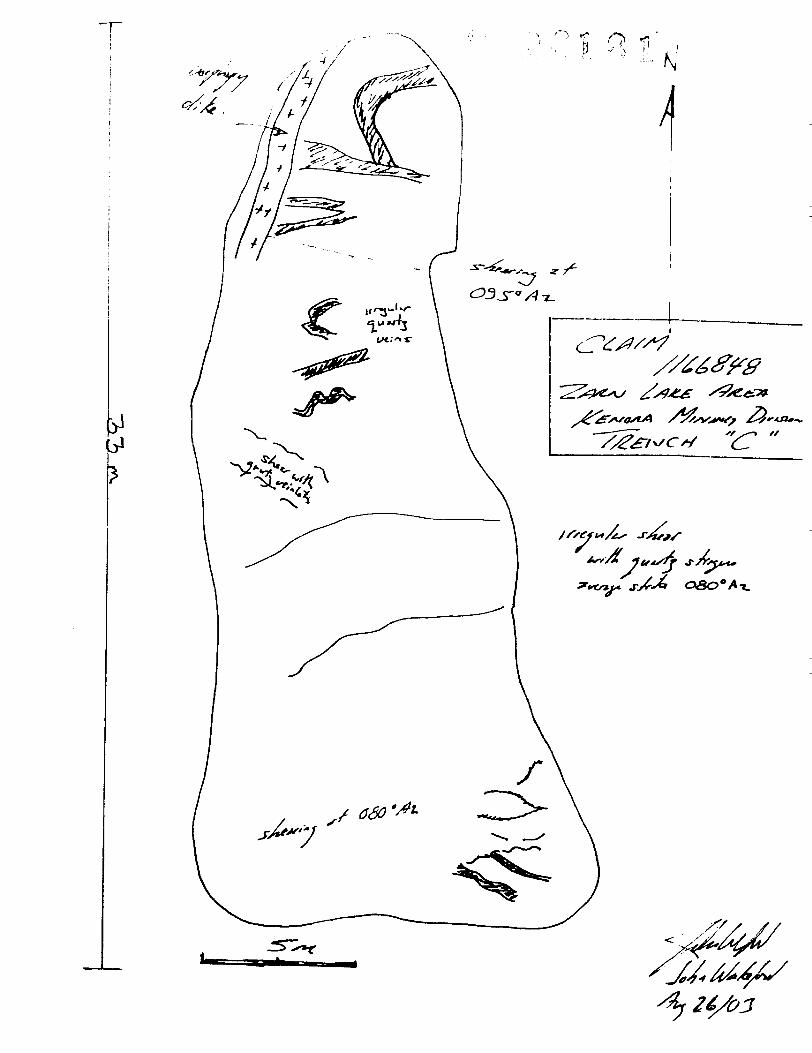
svell exposed as veining. The depression, in trench "B' may be deeply weathered
sheared wallrock. Two trenches were dug on the central vein immediately
southeast of the shaft and two trenches v/ere put in on the Number 1 and
Number 2 veins immediately northwest of the shaft. All trenches encountered
mineralized veining and sheared mineralized wallrock. Five maps are included
with this report, a trench location map, and map of each trench. Trench lengths
and depths are outlined below.
TRENCH
A
B
C
D
Totals
TARGET
Central vein
Central Vein
Number 1 8, 2 Veins
Number 1& 2 Veins
LENGTH A DEPTH
16m, 1-2 m deep
60m, 1-5+m deep
22m, 1-2 m deep
20m, 1-2 m deep
118 meters
Personnel working on the project induded:
Joe Riives, Prospector Dryden, 1 day
Sherridon Johnson, Prospector, Dryden, 6 days
Kevin Proudy, Prospector, Dryden, 5 days
Supervision and program design completed by John Wakeford, P. Geo.
Stripping was completed by Mike Aitken Trucking of Dryden , ~T~ ' kr -a "1 *-

RECOMMENDATIONS
Based on presence of mineralization and veining a program of sampling should
be completed. Sampling should evaluate the veining and mineralized sheared
mafic volcanics separately to determine if wallrocks contain appreciable gold.
Estimated cost of the program is as follows:
ITEM
Mapping
Sampling S
Assays
Report
Total
UNITS
3 days
75samples
1 day
UNIT COST
wooS25
S400
TOTAL
S 1200
12000
S400
S3600
iUuUu
c (I
~ 2 2.7*7
o—lD
CDm
off. l.A**~
T
G
I
C C, - Z. Z
A/
A
o.
4
2. 2618s
/ xx
Oir(
*? ?u^*"*.-U
N
1+J-c oso- \3- A. ie^ '
*~* - *^ ^
^ 070- l
" TT^oxx. r .
"J * -*
^/-
/o
o -i ID
"D
D OmG)
Certificate of Qualifications
John Wakeford, P Geo.
i John Wakeford residing at 724B Kingston Road, Toronto, Ontario,
acknowledge that:
- l am a professional geoscienlist as designated by the Association of
Professional Geoscientist of Ontario
- l have obtained a B.Sc. from the University of Waterloo, Ontario in 1979
- l have been continually practicing as a geologist for the past 24 years
ONTMUO MINISTRY OF NORTHERN DEVELOPMENT AND MINES
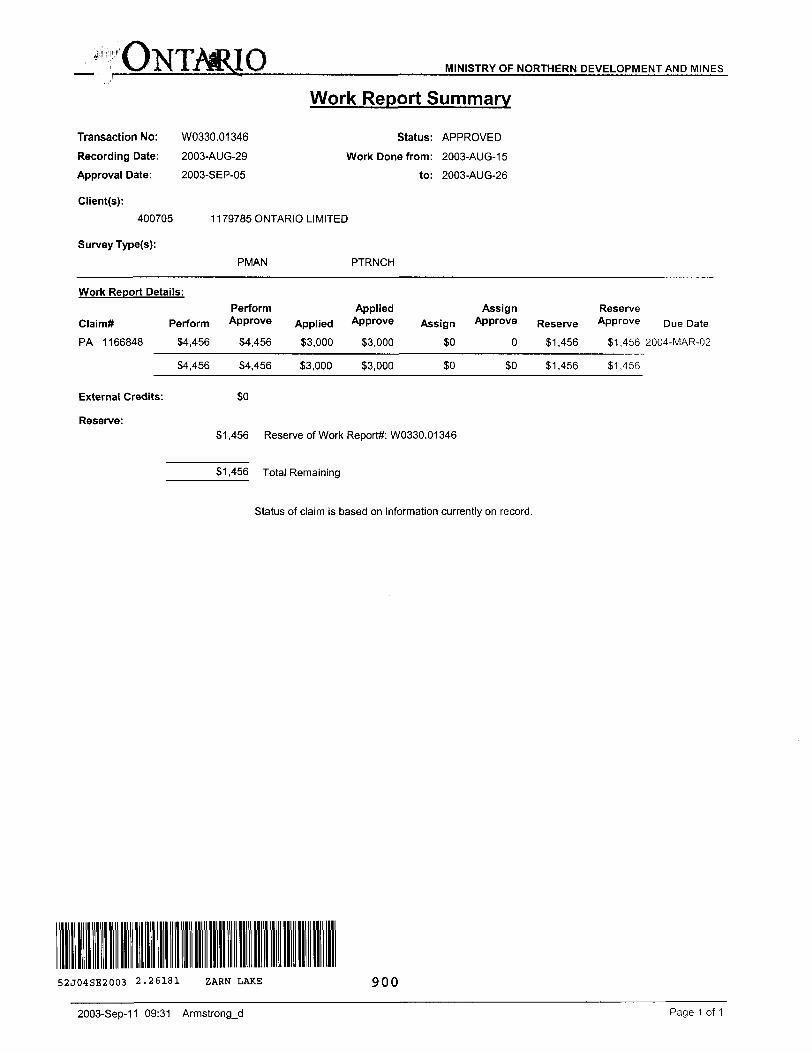
Transaction No: W0330.01346Recording Date: 2003-AUG-29
Approval Date: 2003-SEP-05
Work Report Summary
Status: APPROVED
Work Done from: 2003-AUG-15
to: 2003-AUG-26
Client(s):400705
Survey Type(s):
1179785 ONTARIO LIMITED
PMAN PTRNCH
Work Report Details:
Claim*
Perform Applied Assign ReserveClaim* Perform Approve Applied Approve Assign Approve Reserve Approve Due Date
PA 1166848 34,456 34,456 33,000 33,000 30 O 31,456 31,456 2004-MAR-02
34,456 34,456 33,000 33,000 30 SO 31,456
External Credits:
Reserve:31,456 Reserve of Work Report*: W0330.01346
31,456
31,456 Total Remaining
Status of claim is based on information currently on record.
52J04SE2003 2.26181 ZARN LAKE 900
2003-Sep-11 09:31 Armstrong_d Page 1 of 1

Ministry ofNorthern Developmentand Mines
Date: 2003-SEP-08
Ministere du Developpement du Nord et des Mines Ontario
GEOSCIENCE ASSESSMENT OFFICE 933 RAMSEY LAKE ROAD, 6th FLOOR SUDBURY, ONTARIO P3E 6B5
1179785 ONTARIO LIMITED SUITE 404, 347 BAY STREET TORONTO, ONTARIO M5H 2R7 CANADA
Tel: (888) 415-9845 Fax:(877)670-1555
Dear Sir or Madam
Submission Number: 2.26181 Transaction Number(s): W0330.01346
Subject: Approval of Assessment Work
We have approved your Assessment Work Submission with the above noted Transaction Number(s). The attached Work Report Summary indicates the results of the approval.
At the discretion of the Ministry, the assessment work performed on the mining lands noted in this work report may be subject to inspection and/or investigation at any time.
If you have any question regarding this correspondence, please contact PIERRE DESCOTEAUX by email at [email protected] or by phone at (705) 670-5858.
Yours Sincerely,
Roy DenommeActing Senior Manager, Mining Lands Section
Gc: Resident Geologist
1179785 Ontario Limited (Claim Holder)
Assessment File Library
1179785 Ontario Limited (Assessment Office)
Visit our website at http://www.gov.on.ca/MNDM/LANDS/mlsmnpge.htm Page: 1 Correspondence 10:18631
ONTARIOCANADA
WHtSTRY OF NORTHERN
raoviNcuu. WNIHOMOOHDHra OFFICE
Mining Land Tenure Map
595000E
SSSOOOON 5550000N
5MSOOON
Thoea *l*lng to data mining claims should consul! with the Provincial Mining Recorders' Office of the Ministry of Northern Development and Minos for additional General Information and Limitations This map may not dhow unraglttared land tenure tind Intsrerts InInformation on the status of the lands shown hereon. Thin map l* not Intended for navlflational, survey, or land title determination purposes as the Information contact Information: * Toll Frea Map Datum: NAD 63 land Including certain patents, teases, easernente, ficht of ways,shown oft tNs map K compiled from various sources. Completeness and accuracy are not guaranteed. Additional Information may aHo be obtained through the Provincial Mining Recorders' Office Tel: 1 (888) 415-9848 ert 57iti|ortlon: UTM (6 dojroe) doedng rights, license*, of other form* of disposition of rishts andlocal Lend Titles or RejIXry Office, or the Ministry of Natural Resources. Willet oreefl Miller Centre 633 Ramsey Lake Road Fax: 1 (877) 670-1444 Tofrogmphlo Dete Source: Land Information Ontario Interest from Ihe Crown. Also certain land tenure and (and uses
Sudbury ON P3E 8BS Mlnln j Land Tenure Source: Provincial Mining Recorders' Office thf "J8trtcl OT Prohibit fres entry to atake mining dalrm may not beThe information shown Is derived from digital date available In the Provincial Mining Recorders' Office at the time of downloading from the Ministry of Northern Hortl. Pa ^K nww.mndm.gov.ori.MA^NDMrtHINeS/LANBS/mlsmnpge.hlm Illustrated.^a-jnli* mont amt MinA* wi^i *1M
Date; Time of Issue: Fn Sep 05 09:56:32 EOT 2003 TOWNSHIP l AREA PLAN ZARN LAKE AREA 6.2277
ADMINISTRATIVE DISTRICTS l DIVISIONS
Mining DivisionLand Titles/Registry DivisionMinistry of Natural Resources District
Patricia KENORA SIOUX LOOKOUT
TOPOGRAPHIC
i l Administrative BamdarlBt[ v """j ToWTiShip
f ""1 Concession, to*
Utnd Tenure
fi
i.
Indian R
Cliff, Pit i Pile
Contour
MneShaflt
Mine Hnadlrarw
Railway
Road
,........ Natural Se. Pipsllna
....., utliiles
^. Tower
r*I"j Surface And MMngRtghls
{'•Si SuiAics Rights OnlyIfjn MlnWBRistllsOnly
BurMcs Ant Mining HlghHi
r'^'l M.nlno Rflnts Only
Ucenotof Occupalion
m m
lift! Not SptcM
Surface And Mmmj Rlgrilt
Surface Right. Only
Mining Rigltts Only
draa In Council (Not open fer tttUngl
Watffi Powsr leass Aoeifisnt •---, MWiuCWW
Wed Onty Mnmj Claims
UNO TENURE WITHDRAWALS
Mining Acts wnndrewei Turn Won Sarhcs Aw Mining RliMBWitniln
Onto, in Council Withdrawal Typesw;sm
W'm Mining WflhUOnl!
IMPORTANT NOTICE
Hals 1:4IMa
LAND TENURE WITHDRAWAL DESCRIPTIONSIdentifier Type Dete Description
940 W.8S/77
Wwi Ws
Jan 1, 2001 PUBUIdANDS ACT 2S/11/M S.R.O. Jan 1,1880 SB.43/70W.85/77 2^11ffT.8.R.O. 418B9
52J04SE2003 2.26181 ZARN LAKE 200