Embed Size (px)
Citation preview
REPORT ON THE COLUMBUS KIRKLAND PROPERTY
TECK TOWNSHIPDISTRICT OF TIMISKAMING
ONTARIO
for
ZENDA CAPITAL CORP.
Milton, Ontario June 24, 2004
John M. Siriunas, P.Eng.
42A01NE2061 2.27954 TECK 010

SUMMARY
Zenda Capital Corp. holds under option the mineral rights to a 64 ha unpatented mining property in the Kirkland Lake area of northeastern Ontario (the "Columbus Kirkland" property). The property is located in Teck Township approximately 6 km northwest of the downtown part of the Town of Kirkland Lake. This region is believed to have the potential to host economic deposits of gold. This investigation focussed on the western portion of the property where prospecting and sampling were carried out.
The Columbus Kirkland property is underlain by Archean-age volcanic rocks of the Kinojevis Group.
Sulphide (pyrite) mineralization was observed in two historical trenches in close proximity to the Columbus Kirkland shaft. Explosives were used to obtain samples of fresh material for analysis.
The Columbus Kirkland claim is regarded as comprising a property that merits continued exploration. The importance of examining and sampling the existing trenches and pits on the property is underscored by the current program.

TABLE OF CONTENTS
SUMMARY ii
1 PREAMBLE l1.1 TERMS OF REFERENCE l1.2 SOURCES OF INFORMATION l1.3 UNITS AND CURRENCY l
2 PROPERTY LOCATION AND DESCRIPTION 42.1 LOCATION 42.2 PROPERTY DESCRIPTION 4
3 ACCESSIBILITY, CLIMATE AND LOCAL RESOURCES 73.1 ACCESSIBILITY 73.2 CLIMATE 73.3 LOCAL RESOURCES 73.4 INFRASTRUCTURE 8
4 PREVIOUS WORK 94.1 GOVERNMENT WORK 94.2 EXPLORATION WORK 94.3 CURRENT WORK 10
5 GEOLOGY 115.1 REGIONAL GEOLOGY 115.2 PROPERTY GEOLOGY 115.3 ECONOMIC GEOLOGY 11
6 WORK PROGRAM 12
7 CONCLUSIONS AND RECOMMENDATIONS 16
8 REFERENCES 17
CERTIFICATE OF QUALIFICATIONS
APPENDIX I SAMPLE DESCRIPTIONS APPENDIX II CERTIFICATE OF ANALYSIS APPENDIX III STATEMENT OF COSTS

LIST OF FIGURES
FIGURE l General location map, Columbus Kirkland... 3
FIGURE 2 Location map, Columbus Kirkland 5
FIGURE 3 Claim map and property location, Columbus Kirkland 6
FIGURE 4 General property map, Columbus Kirkland 13
FIGURE 5 Work and sample locations, Columbus Kirkland 14
l PREAMBLE
1.1 TERMS OF REFERENCE
The author has been commissioned by Zenda Capital Corp. ("Zenda") to carry out prospecting and sampling of a mineral property in the Kirkland Lake area of northeastern Ontario (the "Columbus Kirkland" property). The property has also been referred to as the Shamrock or Kirkland Shamrock by previous workers. The purpose of this report is for Ontario government assessment filing and as such is not a full National Instrument 43-101-compliant technical report.
1.2 SOURCES OF INFORMATION
The information contained in this report was derived from a variety of sources, which are more specifically listed under "References" (Section 8). The author believes that all of the information and technical documents are accurate and complete in all material aspects. Any analyses performed or resources estimated by others and quoted herein have not been audited by the author.
The status and title to the mining claims mentioned herein are as reported in the Ontario Ministry of Northern Development and Mines (MNDM), Mines and Minerals Division, Mining Claims Database. Claim maps herein are derived from the MNDM CLAIMaps Internet Application. The author is aware of underlying agreements that pertain to the property.
The results and opinions outlined in this report are dependent on the aforementioned information being current, accurate and complete as of the date of this report or as of dates indicated within this report, and that no information has been withheld which could impact the conclusions or recommendations herein. The author reserves the right, but will not be obliged, to revise this report and conclusions if additional information becomes known to him subsequent to the date of this report.
1.3 UNITS AND CURRENCY
The data presented herein are predominantly in metric units; however, the results of previous work and commodity prices may be quoted in imperial units.
The following conversion factors can be used to convert between imperial and metric measures that appear in this report:
l foot (ft) = 0.305 m ^ 30.48 cm l mile (mi) = 1.609 km l acre — 0.405 ha l (short) ton - 0.907 tonnes (t) l (avdp) ounce (oz) - 28.35 g l (troy) ounce (oz) = 31.103 g l (troy) oz/ton = 34.286 g/t l pound (lb) = 0.454 kg
Currency amounts are expressed in Canadian dollars unless otherwise specified (e.g., $US - United States dollars).
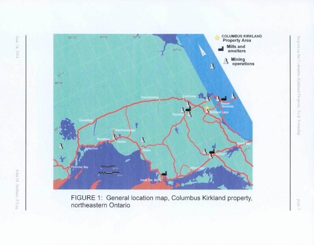
COLUMBUS KIRKLAND Property Area
Mills and smelters
Mining operations
FIGURE 1: General location map, Columbus Kirkland property, northeastern Ontario
2 PROPERTY LOCATION AND DESCRIPTION
2.1 LOCATION
The Teck Township area is located in northeastern Ontario, District of Timiskaming. The property area lies within NTS 42 A/1. The claim, referred to in Section 2.2 below, is approximately centred on UTM coordinates (NAD 27, Zone 17) 568700 E and 5334200 N or 480 09' 33" N latitude and 800 04' 34" W longitude. The current magnetic declination in the region is li0 West. The general location of the property area with respect to some cities, towns and communities in northeastern Ontario and northwestern Quebec is presented in the map of Figure 1. The property location with respect to the Kirkland Lake gold camp is presented in Figure 2.
2.2 PROPERTY DESCRIPTION
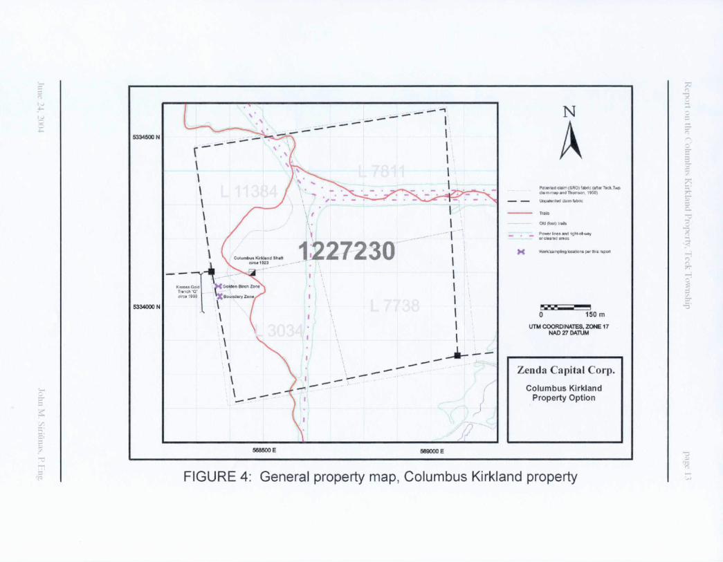
The property comprises one (1), four-unit unpatented mining claim numbered 1227230 and covers approximately 64 ha. This claim is located in central Teck Township in Larder Lake Mining Division; a copy of a portion of the claim map for this area is presented in Figure 3.
The claim is recorded in the name of Diamond Lake Resources Inc. Zenda Capital Corp. holds the claim under option through agreements with Messrs. P. Culhane and B. McCombe and Diamond Lake Resources Inc. Registered surface rights holders are Foxpoint Resources, Ltd. (now Kirkland Lake Gold Inc.) for claims L 3034, L 7811 and L 11384 (Parcel 9264 CST) and Alfred Percy Wood for claim L 7738 (Parcel 9931 CST).

Sylvanite Mine B Toburn Mine52tAu M 18IAU
1927-1961 M 1917-1968
ZENDA CAPITAL CORP.'S COLUMBUS KIRKLAND CLAIM
Wright Hargreaves Mine 150lAu
1921-1965
Shore Mine 268 t AuKirkland Lake Mine
36 t Au 1916- 1960
(11 (J CDLJJ LU
Teck Hughes Mine1151 Au
1917-1968Macassa Mine
115 l Au 1933- current
O 1.5kmUTM COORDINATES ZONE 17
A-f."S
FIGURE 2: Location map, Columbus Kirkland property, Kirkland Lake mining camp 3
l

3 ACCESSIBILITY, CLIMATE AND LOCAL RESOURCES
3.1 ACCESSIBILITY
The claim is accessible by road: an access road toward the property generally follows and parallels a powerline leading west from Goodfish (Airport) Road just north of Trans-Canada Highway #66 (Government Road) in Kirkland Lake. Beyond a river between Kirkland Lake and Lower Kirkland Lake access is restricted to four-wheel drive vehicle or ATV due to the necessity of fording that river. Alternatively, the property may be reached by following the Goldthorpe Road north and west from the Trans-Canada Highway #66 at Chaput Hughes to where it intersects a north south power line. The right-of-way can then be followed north to the property. The trails across the property are used as recreational snowmobile routes in the winter.
3.2 CLIMATE
The Teck Township area lies near the northern boundary of the Lake Timiskaming Lowland ecoregion of the Boreal Shield. The following descriptions are derived largely from the work of the Ecological Stratification Working Group (1998).
The region is classified as having a humid mid-boreal ecoclimate. The area is located 10 km to the southwest of Kirkland Lake Airport, for which extensive climatic records are available from Environment Canada. The average mean annual temperature is 1.70 C. The average daily temperature range in summer is from 10.20 C to 22.60C while in winter the average range is from -21.10C to - 8.60C. Average yearly precipitation for the area is 884 mm and the extreme month-end snow cover was reported in March 1996 at 95 cm.
3.3 LOCAL RESOURCES
The dominant land cover is mixed wood forest of white spruce, balsam fir and eastern white pine along with some red pine, yellow birch and trembling aspen. Wetter sites support black spruce, tamarack and eastern white cedar. The area is strongly glaciated and is characterized by ridged to hummocky rock outcrops covered with discontinuous acidic morainal tills. Bedrock outcroppings are
common. Humo-Ferric Podzols are the dominant with significant Gleysohc soils. Wildlife includes white-tailed deer, wolf, lynx, moose, black bear, snowshoe hare and beaver. Forestry, mining and tourism are important land uses in the region.
3.4 INFRASTRUCTURE
The proximity to the Kirkland Lake mining camp and the history of past mineral prodxiction in and in the vicinity of Teck Township provides all manner of infrastructure necessary for the timely exploration and development of mineral properties in the area. The null complex of Kirkland Lake Gold Inc. lies 2 km to the south of the property area; the null is permitted to process 2,000 t of gold ore per day and is currently underutilized. Kirkland Lake Airport is located only 10 km to the northeast of the property. Power lines pass through the property.

4 PREVIOUS WORK
4.1 GOVERNMENT SURVEYS
Geology of the region has been mapped over the years by the agencies of the Ontario Government. This work includes the mapping of Teck Township and the Kenogami Lake area by Thomson (1950), Lebel Township by MacLean (1956), Bernhardt and Morrisette Townships by Rupert and Lovell (1970). Additional government studies have focused on the economic geology of the region (Burrows and Hopkins, 1925; Todd, 1928; Thomson et al, 1950; Charlewood, 1964; Savage, 1964).
4.2 EXPLORATION WORK
The Kirkland Lake area has seen great exploration activity since the discovery of gold in 1911. The mines of the camp have produced in excess of 754 t of gold since that time (Meyer et al., 2002).
The Columbus Kirkland property appears on maps produced in the 1920s (e.g. Todd, 1928). A two or three compartment shaft was reportedly sunk by the Columbus Kirkland Gold Mining Company to a depth of 50 ft. some time between 1922 and 1927. Further work was undertaken by Lac-Teck Gold Mines Ltd. during the 1930s. Numerous pits and trenches are evidenced throughout the property.
Recorded exploration work on the property appears to be limited to work undertaken by and on the behalf of Trinity Explorations in the late 1980s and early 1990s. This work included airborne geophysics (Ahern, 1989), ground geophysics (Hansen, 1989) and geological mapping (Mullan, 1993). Diamond drilling was also carried out as part of a combined exploration program but two (2) holes that were put down (by Tundra Gold Mines Ltd.) were collared to the north of the current property boundary.
Kinross Gold Corporation has carried out geological mapping (Grant et al., 1998), geophysical surveying and trenching immediately to the west of the Columbus Kirkland property.
4.3 CURRENT WORK
The current mapping, prospecting and sampling was carried out by the author during the period between the dates of June 13, 2004 and June 18, 2004. The author was assisted by Mr. Thomas O'Connor, Technician, of Kirkland Lake, ON. Spatial reference was maintained by the use of a handheld Garmin eTREX Vista GPS with WAAS enabled; though the unit can report accuracies of from 3 m to 5 m in the Kirkland Lake area, the forest canopy at the work site greatly degraded horizontal displacement of position especially when mapping-in the trail that crosses the claim. Maximum error of location is estimated to be +I- 30 m in this case.

5 GEOLOGY
5.1 REGIONAL GEOLOGY
The Kirkland Lake area lies within the south-central part of the Abitibi Subprovince of the Archean-age Superior Province of the Canadian Shield. Jensen and Langford (1985) recognize the presence of two distinct volcanic cycles characterized by a lower komatiitic sequence, progressing stratigraphically upwards through tholeiitic and calc-alkaline volcanosedimentary rocks and culminating in alkalic volcanics with associated sediments and intrusives. The property area is underlain by lithologies of the Kinojevis Group, the tholeiitic member of the upper of the two volcanic cycles.
5.2 PROPERTY GEOLOGY
Thomson (1950) indicated the property to be underlain by pillowed volcanic rocks of mafic (basic) to intermediate composition. Stratigraphic tops are to the north. Mullan (1993) noted the presence of gabbro (coarse grained flows?) and some agglomerate (pillow breccia?).
5.3 ECONOMIC GEOLOGY
The gold ores of the main Kirkland Lake camp are hosted by rocks of the Timiskaming Group, the youngest member of the upper volcanic cycle. Major structures, e.g. the Kirkland Lake "Main Break" or fault, were important controlling factors in the genesis of the ore zones.
Within the Kenojevis Group volcanics, gold mineralization is known to be present in the Goodfish Lake area to the east of the property (Burrows and Hopkins, 1925). The gold mineralization here is closely related to a quartz- feldspar porphyry intrusive. A structure in that vicinity known as the Kirana Break is also reported to host gold where it is mineralized with sulphides.
Significant gold mineralization has recently been recognized to also be present in structures that crosscut the main trend of mineralization in the Kirkland Lake gold camp (e.g., the "'D' Zone" at the Macassa Mine).
6 WORK PROGRAM
The current work program consisted of prospecting in the vicinity of the original Columbus Kirkland shaft. Field observations indicated that there has been little recent effort to examine and sample trenches in the vicinity of the shaft.
A base map for the property (Figure 4) was prepared by digitizing the 1:2,000- scale OEM municipal series maps obtained from the Physical Services Department of the Corporation of the Town of Kirkland Lake. Those maps are based on the NAD 27 datum and this datum has been retained for the current map. The patented claim fabric appears on those maps but was corrected to match the claim boundaries as they appear on the geology map of Thomson (1950) and current claim maps (NAD 83).
The main trail through the claim was surveyed with a GPS. The location of trail as it appears on the original OEM map deviates significantly from what was actually surveyed; the original orientation appears as "old (foot) trail" on Figure 4.
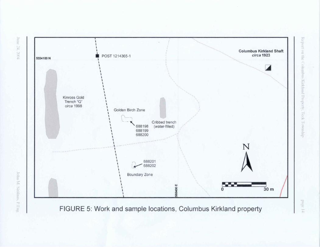
Prospecting located two trenches of primary interest for sampling (see Figure 5). The Columbus Kirkland shaft itself was not considered to be a viable target at this juncture as heavy equipment would be needed to facilitate excavation of the surrounding rock dump. Explosives were used at both primary locations to obtain samples from fresh exposures of bedrock. A total of five (5) grab samples of rock were collected for analysis. No areas suitable for proper channel sampling with a diamond saw, that was rented for that very purpose, presented themselves during this investigation. Sample descriptions are presented in Appendix I while the Certificate of Analysis is presented in Appendix II.
The first location was dubbed the "Golden Birch Zone". The existing trench at this location, mainly water-filled, is about 7 m long and 2.5 m wide; a jog at the west end of the trench makes it about 4 m wide at that point. Some water was pumped from the trench in an attempt to gain better rock exposure and an better working environment.
Rocks were observed to be highly schistose, or sheared, mafic to intermediate volcanics. Similar sheared volcanics, albeit with low gold values, were observed in trenching just to the west of this area (Grant et al., 1998).
The Golden Birch Zone contains a quartz vein that is estimated to be at least 30 cm wide. It was sampled in this program. Judging by its location and the shape of the trench it is believed that this is the same vein that appears on the map of
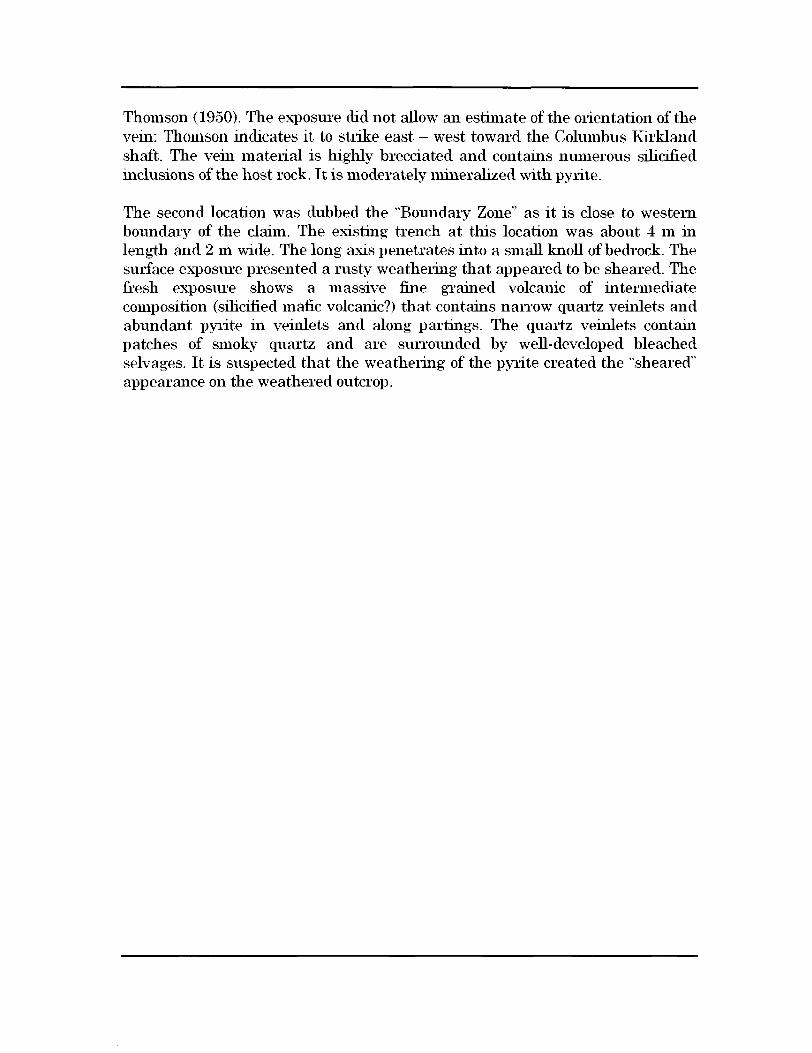
Thomson (1950). The exposure did not allow an estimate of the orientation of the vein; Thomson indicates it to strike east west toward the Columbus Kirkland shaft. The vein material is highly brecciated and contains numerous silicified inclusions of the host rock. It is moderately mineralized with pyrite.
The second location was dubbed the "Boundary Zone" as it is close to western boundary of the claim. The existing trench at this location was about 4 m in length and 2 m wide. The long axis penetrates into a small knoll of bedrock. The surface exposure presented a rusty weathering that appeared to be sheared. The fresh exposure shows a massive fine grained volcanic of intermediate composition (silicified mafic volcanic?) that contains narrow quartz veinlets and abxmdant pyrite in veinlets and along partings. The quartz veinlets contain patches of smoky quartz and are surrounded by well-developed bleached selvages. It is suspected that the weathering of the pyrite created the "sheared" appearance on the weathered outcrop.
5334500 N
5334000N
1227230
N
APai BIB a culm (GAO) tone (til* ihdt TwpO*mnue*rfT*omuaP 19W)
BcaBcni at tin
O 150m
UTM COORDINATES, ZONE 17 NAD 27 DATUM
Zenda Capital Corp.
Columbus Kirkland Property Option
568600 E 569000 E
FIGURE 4: General property map, Columbus Kirkland property
l J
t J
5334100 N
Kinross Gold Trench "Q"
circa 1998
POST 1214365-1
ll l l
Columbus Kirkland Shaft c*rca1923
Golden Birch Zone
Cribbed trench688198 (water-filled)688199688200 ,--;
688201688202
Boundary Zone
N
Aw
30 m
FIGURE 5: Work and sample locations, Columbus Kirkland property

7 CONCLUSIONS AND RECOMMENDATIONS
The following conclusions and recommendations, based on the material presented within this report, are made regarding Zenda Capital Corp.'s Columbus Kirkland option in Teck Township:
1) The property area is underlain by Archean-age rocks of the Superior Structural Province of the Canadian Shield. Lithologies of the Kenojevis Group comprising mafic (pillowed) volcanic rocks are present;
2) Quartz veining has been observed on the property in the vicinity of the Columbus Kirkland shaft;
3) Evidence of shearing in the form of highly schistose volcanic rocks has been recognized in the field in the study area;
4) Structurally controlled lode old deposits associated with Kenojevis Group volcanic rocks are the main target for mineralization on the property;
5) The possibility that north south structures that have been shown to carry gold mineralization within the Timiskaming Group could persist through and into the Kinojevis Group remains to be studied; and
6) There remain numerous areas of the property that require to be prospected and re-examined in detail. The results of this small program demonstrates the value in closely examining areas that have been previously trenched.
Respectfully sxibmitted,
John M. Siriunas, P.Eng. June 24, 2004

8 REFERENCES
Ahern, L.L., 1989, Report on the combined airborne geophysical survey on the Kirkland Shamrock prospect of Trinity Explorations in Teck Township, Ontario: Unpublished assessment report by H. Ferderber Geophysics Ltd., File 2.12243, January, 1989, 12p.
Burrows, A.G. and Hopkins, P.E., 1925, Kirkland Lake gold area (revised edition): Ont. Dept. Mines, Ann. Report v.32, pt.4, 52p.
Charlewood, G.H., 1964, Geology of deep developments on the main ore zone at Kirkland Lake: Ont. Dept. Mines, GC 11, 49p.
Ecological Stratification Working Group, 1998, A national ecological framework for Canada: Agriculture and Agri-Food Canada, Research Branch, Centre for Land and Biological Resources Research and Environment Canada, State of the Environment Directorate, Ecozone Analysis Branch, Ottawa/Hull.
Grant, J., Beauchamp, S. and Russell, I., 1998, Geology of the Kinross Gold Limited north Teck Township claims, Kirkland Lake, Ontario: Unpublished assessment report, File 2.19324, November, 1998, 23p.
Hansen, J.E., 1989, Geophysical survey report on five properties in the Kirkland Lake area for Tundra Gold Mines Ltd. and Trinity Explorations: Unpublished assessment report, File 2.12900, November, 1989, 17p.
Jensen, L.S. and Langford, F.F., 1985, Geology and petrogenesis of the Archean Abitibi belt in the Kirkland Lake are, Ontario: Ont. Geol. Surv., MP 123, 130p.
MacLean, A., 1956, Lebel Township: Ont. Dept. Mines, Bull. 150, 63p. Accompanied by Map 53a, scale 1:12,000.
Meyer, G., Cosec, M., Grabowski, G.P.B., Guindon, D.L., Chaloux, E.G. and Stewart, J.M., 2002, Report of activities 2001, Resident Geologist program, Kirkland Lake Regional Resident Geologist report: Kirkland Lake-Sudbury Districts: Ont. Geol. Surv., OFR 6083, 94p.
Mullan, G.J., 1993, Shamrock prospect, Teck Township (N.T.S. 42 A/1), Ontario, Larder Lake Mining Division, final report Ontario Prospector's

Assistance Program, geological mapping program, O.P.A.P. project registration #OP92-407: Unpublished assessment report. File 2.14923, January 15th , 1993, 13p.
Rupert, R.J. and Lovell, H.L., 1970, Bernhardt and Morrisette Townships: Ont. Dept. Mines, GR 84, 27p. Accompanied by Map 2193, scale 1:31,680.
Savage, W.S., 1964, Mineral resources and mining properties in the Kirkland Lake - Larder Lake area: Ont. Dept. Mines, MRC 3, 108p.
Thomson, Jas. E., 1950, Geology of Teck Township and the Kenogami Lake area: Ont. Dept. Mines, Ann. Report v.57, pt.5, 53p. Accompanied by Map 1945- 1, scale 1:12,000.
Thomson, Jas. E., Charlewood, G.H., Griffin, K., Hawley, J.E., Hopkins, H., Macintosh, C.G., Ogrizlo, S.P., Perry, O.S. and Ward, Wm., 1950, Geology of the main ore zone at Kirkland Lake: Ont. Dept. Mines, Ann. Report v.57, pt.5.
Todd, E.W., 1928, Kirkland Lake gold area (a detailed study of the central zone and vicinity): Ont. Dept. Mines, Ann. Report v.37, pt.2, 176p.

CERTIFICATE OF QUALIFICATIONS
I, John M. Siriunas, of 25 3rd Side Road, Milton, Ontario, Canada do hereby certify that:
1) I hold a Bachelor of Applied Science degree in Geological Engineering (1976) and a Master of Applied Science Degree in Applied Geology (1979) from the University of Toronto in Toronto, Ontario, Canada.
2) I am registered as a Professional Engineer in the Province of Ontario and possess a Certificate of Authorization for the practice of professional engineering.
3) I have practised my profession as an engineer and consultant continuously since graduation.
4) I have based my comments contained in this report on my knowledge of geology, geochemistry and mineral deposits and on the various referenced reports. Mapping, prospecting and sampling carried out on the property in June of 2004 was done under my direct supervision.
5) I am an Officer and Director of Zenda Capital Corp.
June 24. 2004 John M. Siiiunas, M.ASc., P.Eng.
APPENDIX I
SAMPLE DESCRIPTIONS

688198
688199
688200
688201
688202
Golden Birch Zone
Golden Birch Zone
Golden Birch Zone
Boundary Zone
Boundary Zone
brecciated quartz vein and silicified volcanic fragments, minor pyrite
brecciated quartz vein and silicified volcanic fragments, minor pyrite
brecciated quartz vein and silicified volcanic fragments, minor pyrite
fine grained volcanic, intermediate composition (silicified?), quartz veinlets, pyrite stringers fine grained volcanic, intermediate composition (silicified?), quartz veinlets, pyrite stringers

APPENDIX II
CERTIFICATE OF ANALYSIS
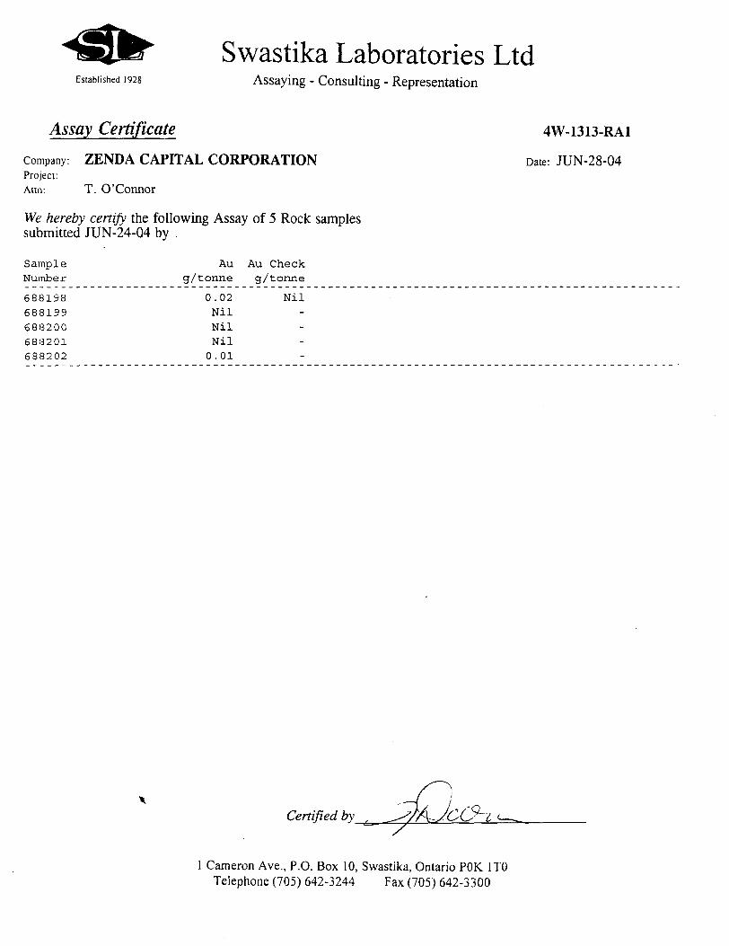
Swastika Laboratories LtdEstablished 1928 Assaying - Consulting - Representation
Assay Certificate 4W-1313-RA1
Company: ZENDA CAPITAL CORPORATION Date: JUN-28-04Project:Attn: T. O'Connor
We hereby certify the following Assay of 5 Rock samples submitted JUN-24-04 by .
Sample Au Au Check Number g/tonne g/tonne
688198 0.02 Nil688199 Nil688200 Nil688201 Nil688202 0.01
Certified by
l Cameron Ave., P.O. Box 10, Swastika, Ontario POK l TO Telephone (705) 642-3244 Fax (705) 642-3300
APPENDIX III
STATEMENT OF COSTS
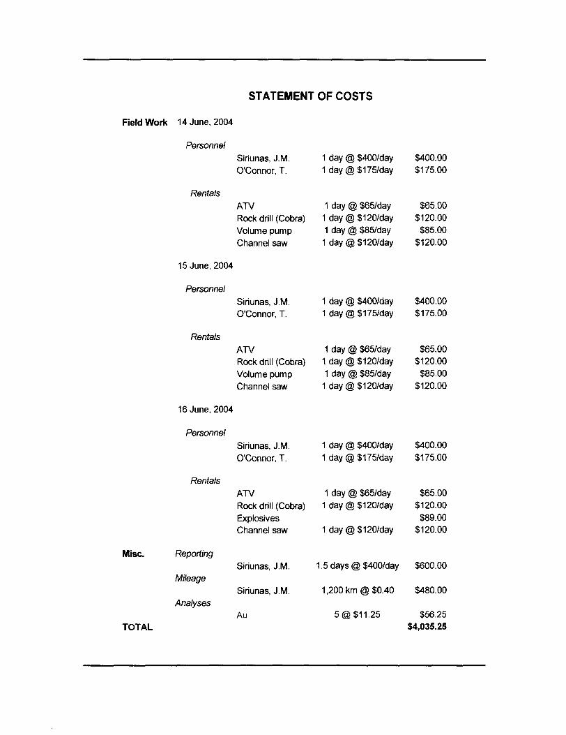
STATEMENT OF COSTS
Field Work 14 June, 2004
Personnel
Rentals
Misc.
Siriunas, J.M. O'connor, T.
ATVRock drill (Cobra) Volume pump Channel saw
15 June, 2004
Personnel
Rentals
Siriunas, J.M. O'connor, T.
ATVRock drill (Cobra) Volume pump Channel saw
16 June, 2004
Personnel
Rentals
Siriunas, J.M. O'connor, T.
Reporting
Mileage
Analyses
ATVRock drill (Cobra)ExplosivesChannel saw
Siriunas, J.M.
Siriunas, J.M.
Au
1 day @ 5400/day 1 day@51757day
1 day @ 565/day 1 day@51207day 1 day @ 585/day
1 day@51207day
1 day @ 5400/day 1 day @51757day
1 day @ 565/day 1 day @ 3120/day
1 day @ 385/day 1 day@31207day
1 day @ S657day 1 day@S1207day
1 day @ S1207day
3400.003175.00
365.005120.00585.00
5120.00
5400.005175.00
565.005120.00
585.005120.00
1 day @ 5400/day 3400.00 1 day @ 5175/day 3175.00
365.005120.00
589.005120.00
TOTAL
1.5 days @ 3400/day 5600.00
1,200 km @ 50.40 5480.00
5 @ 311.25 556.25 34,035.25
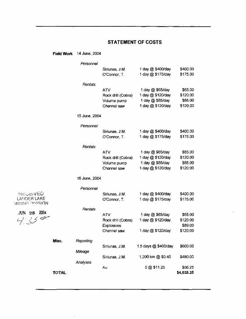
STATEMENT OF COSTS
Field Work 14 June, 2004
Personnel
JUN
Siriunas, J. M.O'connor, T.
RentalsATVRock drill (Cobra)Volume pumpChannel saw
15 June, 2004
PersonnelSiriunas, J. M.O'connor, T.
RentalsATVRock drill (Cobra)Volume pumpChannel saw
16 June, 2004
PersonnelciVbD Siriunas, J. M.iER LAKE O'connor, T.ni VISION
Rentals28 2004 ATV
26 ^^ Rock drill (Cobra)ExplosivesChannel saw
Misc. ReportingSiriunas, J. M.
MileageSiriunas, J. M.
AnalysesAu
TOTAL
1 day @ 5400/day1 day@5175Way
1 day @ 565/day1 day @ 3120/day
1 day @ 585/day1 day @ 5120/day
1 day @ 5400/day1 day@5175Aiay
1 day @ 565/day1 day @ 5120/day
1 day @ 585/day1 day @ 5120/day
1 day @ 5400/day1 day@5175^ay
1 day @ 565/day1 day @ 5120/day
1 day @ 5120/day
1.5 days @ 5400/day
1,200 km @ 50.40
5 @ 511.25
5400.005175.00
565.005120.00
585.005120.00
5400.005175.00
565.005120.00
585.005120.00
5400.005175.00
565.003120.00589.00
5120.00
5600.00
5480.00
556.2554,035.25
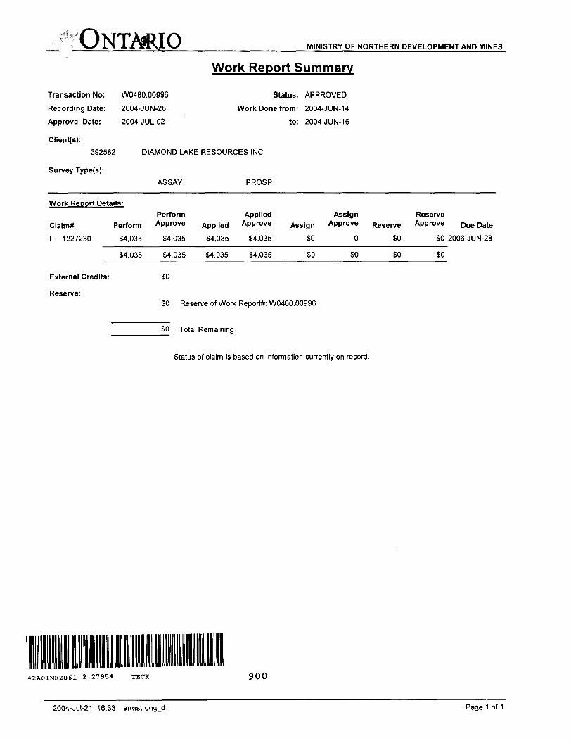
ONTARIO MINISTRY OF NORTHERN DEVELOPMENT AND MINES
Transaction No: W0480.00996
Recording Date: 2004-JUN-28
Approval Date: 2004-JUL-02
Work Report Summary
Status: APPROVED
Work Done from: 2004-JUN-14
to: 2004-JUN-16
Client(s):
392582
Survey Type(s):
DIAMOND LAKE RESOURCES INC.
ASSAY PROS P
Work Report Details:Perform Applied Assign Reserve
Perform Approve Applied Approve Assign Approve Reserve Approve
L 1227230 S4.035 S4.035 S4.035 S4.035 SO O SO SO
Claim*
54,035 S4.035 S4.035 S4,035
S4.035 S4.035 S4.035 S4.035
External Credits:
Reserve:
SO
SO
o
so
so
so
Due Date
SO 2006-J UN-28
SO
SO
SO Reserve of Work Report*: W0480.00996
SO Total Remaining
Status of claim is based on information currently on record.
42A01NE2061 2.27954 TECK 900
2004-Jul-21 16:33 armstrongjd Page 1 of 1

Ministry ofNorthern Developmentand Mines
Date: 2004-JUL-02
Ministere du Developpement du Nord et des Mines Ontario
GEOSCIENCE ASSESSMENT OFFICE 933 RAMSEY LAKE ROAD, 6th FLOOR SUDBURY, ONTARIO P3E 6B5
DIAMOND LAKE RESOURCES INC. BOX 385, 53-8TH AVE., LARDER LAKE, ONTARIO POK1LO CANADA
Tel: (888) 415-9845 Fax:(877)670-1555
Dear Sir or Madam
Submission Number: 2.27954 Transaction Number(s): W0480.00996
Subject: Approval of Assessment Work
We have approved your Assessment Work Submission with the above noted Transaction Number(s). The attached Work Report Summary indicates the results of the approval.
At the discretion of the Ministry, the assessment work performed on the mining lands noted in this work report may be subject to inspection and/or investigation at any time.
If you have any question regarding this correspondence, please contact BRUCE GATES by email at [email protected] or by phone at (705) 670-5856.
Yours Sincerely,
R. Schienbein
Senior Manager(A), Mining Lands Section
Cc: Resident Geologist
Thomas A. O'connor (Agent)
Assessment File Library
Diamond Lake Resources Inc. (Claim Holder)
Diamond Lake Resources Inc. (Assessment Office)
Visit our website at http://www.gov.on.ca/MNDM/LANDS/mlsmnpge.htm Page: 1 Correspondence 10:19574
ONWRIOCANADAWNWTAY OF MORTHeRM
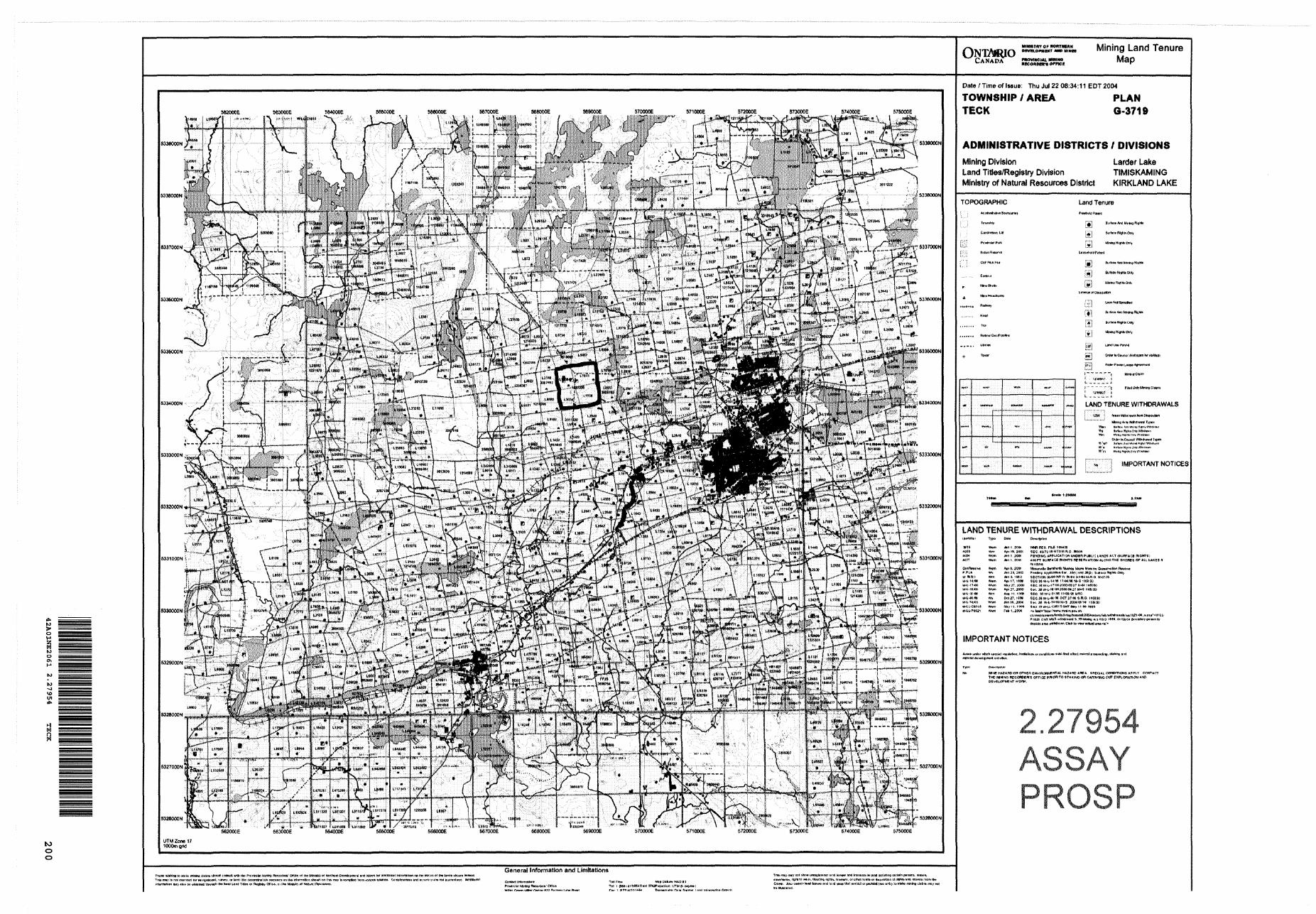
fconom-s ornce
Mining Land Tenure Map
to o o
! '
S^^TP^ ^"5p-jfijS&i^lv ""P"*i S•* •B/rff-i' ,...;. U .-'l'. ' ;-ft*—f^
ll^il'lEM
S , t^-""'' -
n l X ' '* :iWl iaww) -
a clitiro itlotiW coraull *flh the PioirUvt*) M**U RocoKMn' OHICB ist ttw WnBtl'o* rwvlgatioiwl. imvsy, ornrrt HttoewwnrtnrtiionwHiioeiwiwilioirto'Bwiionilwwnon
tinatl innuih llwr kwal iairf Tithra ut Rcgfertiy Olltto, vi Ilw MMuky at Natural
General Information and Limitations
Date ; Time of Issue: Thu Jul 22 08:34:11 EOT 2004
TOWNSHIP I AREA PLAN TECK G-3719
ADMINISTRATIVE DISTRICTS 7 DIVISIONS
Mining Division Larder LakeLand Titles/Registry Division TIMISKAMINGMinistry of Natural Resources District KIRKLAND LAKE
TOPOGRAPHIC Land Tenure
[f! SI li)m s s
W Amsl Mh*to ffi
en KigtiU Only
(Mn h ftn'fWl *9t optn K
l*"1 "" '" """•""•^ nitni&ttMntooGtaltM * 'tfWOttf il. ™ ™. ™ ,,^ t
LAND TENURE WITHDRAWALS
i Iir94 j *j**-t Wdtnitwn (row
W'n: W'BHj Wflitf, O'V *V"*Jwi
IMPORTANT NOTICES
LAND TENURE WITHDRAWAL DESCRIPTIONSM'WHlfMir Ty(H" DAM Dmf.rtjKkm
W5S *Vum An f, EWH MNP RE O. FH.E tai*(S4WS *Vm Apt tt. SiXn BCC, 4*7011/^78M.RO, BBdll*40M Mm JOn f, 3001 f6N0ll*l*PPUC*TlONW)OBR; PUBLIC t*NDS ACT (9URPACi RlCNTS)4057 WMT1 Jtn l, EIKM 4TOFT tUW*CB RUBHTS W St m1 AT l ON *tONiHTME 4MORB5 OP AU LAKES *
O*nfSMMiv* ft*wn AVI 4, SIM Mitomil* OwnNrtl Munksi M*l*" Mvwiw Oanwrnlkwi Rw*iwjP .P L* Wi Jin3i,2(Kif Pan4inf Api^fj-HWn tw WMijiiW JSjit Sufliov FHjfW* Onjj1 .W M-IKl Win *in 3 1tnO OICTION 3KJEIONRW JWWO X-flilM.n O (ftO?^
ICC.3S UV'-H* 1 '* 04TB7'flS S,R O, IWBISO
,*rt,vt*l**VMfc.'vw183l -W.,*.*!!.1 * W-Lt
IMPORTANT NOTICES
M(MBHAZ*JWOnomBnCNVtnoHWSW*LHJU*RO*llE*. Sf-ECa*L
THE MUNS wccBpewa cf ncc pwon TO srAKtwa -on CAWMNGDCvCiCTMEMT WORK,
2.27954ASSAYPROSP
Tnw rmp twv lei li*?* unrooiitenwi Mnt tanuwt nrd hue resin IN MM ituiWiw) ceitnln pstwna, tanton,
Ovr*).. Alrc MtrUin ***f tonura nrsj Urd WMH thil rostral crwOuM tiw artr, lofftth. nirtry tlakm m