Embed Size (px)
Citation preview
Report on the 1st TRANSMIT Summer School “Underlying causes of ionospheric effects on radio wave
propagation”
Marko Vučković
19. January 2012.

Contents
1. Introduction............................................................................................................. 3
2. About the TRANSMIT project................................................................................ 4
3. Short overview of lectures and presentations.......................................................... 5
4. Conclusion............................................................................................................... 10
5. References............................................................................................................... 11
2

1 Introduction
In the period from 19th to 23rd of September a TRANSMIT Summer School was held in Konstancin-Jeziorna near Warsaw, Poland. This was the first summer school in scope of the TRANSMIT project. TRANSMIT (Training Research and Applications Network to Support the Mitigation of Ionospheric Threats) is an initiative funded by the European Commission through a Marie Curie Initial Training Network (ITN) for Early Stage Researchers and Experienced Researchers. The research focuses on countering the serious problems posed by the Earth's ionosphere, mainly to Global Navigation Satellite Systems (GNSS). More details about TRANSMIT project can be found in [1].
The project aims are to describe and model ionospheric scintillation effects on different GNSS systems, with a focus on the new Galileo and modernized GPS signals. Novel approaches for the mitigation of these effects will be based on the design and validation of novel receiver tracking models.What is more, this project helped me understanding basics of physics of the upper atmosphere and understanding principles of new signals structure and their demodulation.
3

2 About the TRANSMIT project
As mentioned above, TRANSMIT is a sizable project which includes a lot of manpower and numerous participating institutes. The people who are involved in this project are:
− Marcio Aquino and Alan Dodson, Institute of Engineering Surveying and Space Geodesy (IESSG), University of Nottingham, UK
− Yannik Beniguel, Informatique, Electromagnetisme, Electronique, Analyse Numerique (IEEA), France
− Giorgina De Franceschi, Instituto Nazionale di Geofisica e Vulcanologia (INGV), Rome, Italy
− Fabio Dovis and Riccardo Notarpietro, Politecnico di Torino, Italy− Biagio Forte, University of Nova Gorica (UNG), Slovenia− Roman Galas, University of Berlin (UoB), Germany− Norbert Jakowsky, German Aerospace Center (DLR), Germany− Tomislav Kos, University of Zagreb, Croatia− Cathryn Mitchell, University of Bath, UK− Andrzej Wernik, Space Research Center (SRC), Poland
The aims of the TRANSMIT project are [1]: 1) Providing young researcher a coordinated program of training, focused on harmful effects of ionospheric phenomena that can significantly impair a wide range of systems and applications that are at the core of several activities embedded in our daily life.
2) Providing Europe with the next generation of researchers in this field. The idea is to educate and prepare every young researcher with skills through a comprehensive and coordinated training program.
3) Developing real time integrated state of the art tools to mitigate ionosphere threats to GNSS and several related applications, such as civil aviation, marine navigation and land transportation.
4
3 Short overview of lectures and presentations
The aim of the first TRANSMIT school was to introduce early stage researchers with some basic principles of GNSS signals, their transmission, fully developed systems, GNSS receivers, ionosphere scintillations, space weather and many other relevant to this project.
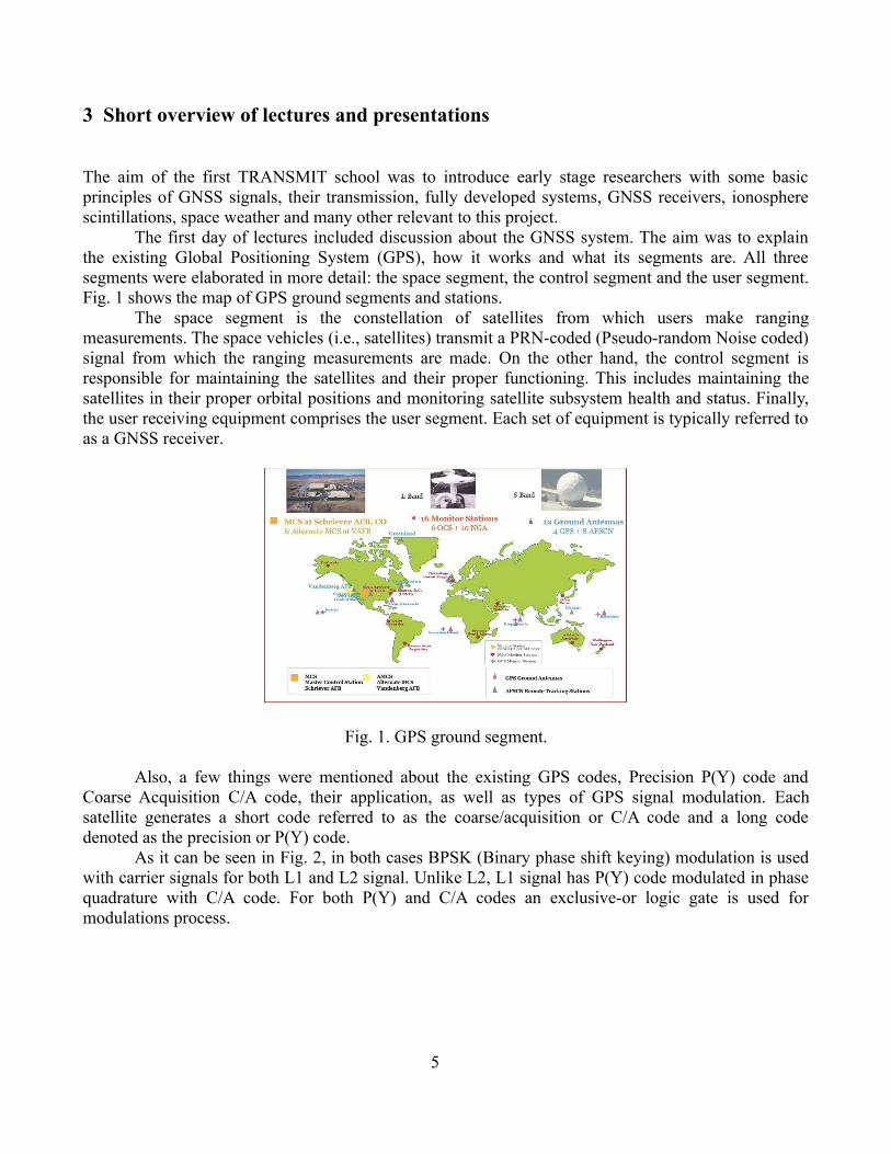
The first day of lectures included discussion about the GNSS system. The aim was to explain the existing Global Positioning System (GPS), how it works and what its segments are. All three segments were elaborated in more detail: the space segment, the control segment and the user segment. Fig. 1 shows the map of GPS ground segments and stations.
The space segment is the constellation of satellites from which users make ranging measurements. The space vehicles (i.e., satellites) transmit a PRN-coded (Pseudo-random Noise coded) signal from which the ranging measurements are made. On the other hand, the control segment is responsible for maintaining the satellites and their proper functioning. This includes maintaining the satellites in their proper orbital positions and monitoring satellite subsystem health and status. Finally, the user receiving equipment comprises the user segment. Each set of equipment is typically referred to as a GNSS receiver.
Fig. 1. GPS ground segment.
Also, a few things were mentioned about the existing GPS codes, Precision P(Y) code and Coarse Acquisition C/A code, their application, as well as types of GPS signal modulation. Each satellite generates a short code referred to as the coarse/acquisition or C/A code and a long code denoted as the precision or P(Y) code.
As it can be seen in Fig. 2, in both cases BPSK (Binary phase shift keying) modulation is used with carrier signals for both L1 and L2 signal. Unlike L2, L1 signal has P(Y) code modulated in phase quadrature with C/A code. For both P(Y) and C/A codes an exclusive-or logic gate is used for modulations process.
5

Fig. 2. GPS L1 and L2 signals description.
Finally, the discussion was focused on GPS Navigation Message, its format, underlying parts and the meaning of every subframe. The navigation message essentially contains information about the satellite orbit, the satellite health status, various correction data, status messages, and other data messages. As one can notice from Fig. 3, there are five 300 bit subframes (basic explanation for each subframe is also given). Without going into more details, it is just worth to mention that the navigation message provides all necessary information for GNSS communication.
Fig. 3. GPS message.
The second lecture was about the new GNSS signals and systems; Galileo system with its technical advantages and other GNSS systems like GLONASS and Compass. One of the main questions was why a new satellite positioning system is necessary. A few reasons for that were given, like for instance [3]:
• there are some places where GPS simply doesn't work due to the lack of available satellites,• GPS is a military operated and controlled system,• there is a need for a reliable, secure safety-of-life system and commercial applications, etc.
6

Also, there were a few words about the new GPS signal modulations and carrier rate schemes, as well as the new powerful E5 signal.
Fig. 4. New GNSS signals.
Note in Fig. 4 that all the Galileo satellites will share the same nominal frequency, making use of CDMA spread-spectrum compatibility with the GPS, using three signals E5a, E5b and L1 [2]. Six signals, including three data-less channels, so-called pilot tones (ranging codes not modulated by data), are accessible to all Galileo Users on the E5a, E5b and L1 carrier frequencies for Open Services (OS) and Safety-of-life Services (SoL).
The third lecture gave a more detailed description of a GNSS Receiver, GNSS antenna, RF front end, Baseband Processor and Navigation Engine.
Fig. 5. The fundamental GNSS receiver.
The GNSS antenna must be able to collect very weak signals, to work in single or multiple frequencies simultaneously and provide few more detailed characteristics. Received signals must be gained, filtered and converted with an A/D converter. Then, the converted signal is sent to a baseband processor which represents the ‘heart’ of a GNSS receiver. The processed signal with all necessary information is sent to the user interface. More details about every part of GNSS receiver can be found in [3].
7
The following day, our attention was focused on the methods, techniques and models of the ionosphere. The influence of atmospheric effects on GNSS signals was discussed in more detail, as well as how those effects can be described and thus modeled. Details of a group delay, depolarization, ray bending and carrier phase advance were then explained. All these effects are correlated with the ionospheric Total Electron Content (TEC).
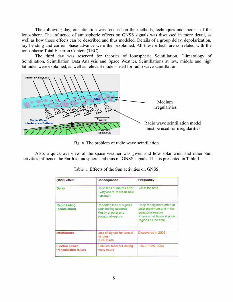
The third day was reserved for theories of Ionospheric Scintillation, Climatology of Scintillation, Scintillation Data Analysis and Space Weather. Scintillations at low, middle and high latitudes were explained, as well as relevant models used for radio wave scintillation.
Fig. 6. The problem of radio wave scintillation.
Also, a quick overview of the space weather was given and how solar wind and other Sun activities influence the Earth’s ionosphere and thus on GNSS signals. This is presented in Table 1.
Table 1. Effects of the Sun activities on GNSS.
8
Medium irregularities
Radio wave scintillation model must be used for irregularities

GNSS Positioning Techniques, Augmentation Systems, Scintillation Receivers and Monitoring Networks were discussed on the fourth day. An overview of all the lectures was made, with some additional useful information and pointing out the most important things to keep in mind.
The last day of summer school was planned for the TRANSMIT partners, companies and institutions where early stage researchers could show their potential for upgrading the existing systems, developing some new techniques or GNSS models, or even establishing a new system prototype, as well as of course do their practice training and research. The companies (industry) should in fact help the researchers with gaining further knowledge and experience by providing necessary means and equipment for this research, so that they could use it for commercial applications and human progress in general. All these new ideas and solutions are expected to be achieved through the TRANSMIT project.
9
4 Conclusion
The TRANSMIT school was our first step to understanding basic principles of GNSS signals, development of new techniques for detecting and monitoring ionospheric threats and establishing a real-time system prototype for monitoring the ionosphere, as well as how to incorporate achieved solutions into this system that responds to all end-user needs and requirements. Besides, the researchers will be encouraged to acquire some training in other institutes for research in this field as well.
Furthermore, this was a very good introduction to my further studies and research. In scope of this project, I have already had a week training in Kiruna, Sweden, working on EISCAT radar measurements. This will help me modeling of scintillation effects on new signals by using available ground measurements at low and high latitudes and integration of additional data sources in the modeling (e.g., radars and radio occultation, beacon signals).
10

5 References
[1] http://www.nottingham.ac.uk/transmit/about/projectoverview.aspx, accessed on 19.1.2012.
[2] http://www.ifen.unibw-muenchen.de/research/signal.htm, accessed on 19.1.2012.
[3] Elliott D. Kaplan and Christopher J. Hegarty “Understanding GPS Principles and Applications”, vol 2, pp. 104-110, 2006.
11