Embed Size (px)
Citation preview

Report onPhase 1 Contamination Assessment
Proposed Residential SubdivisionWilton Junction
Prepared forElton Consulting Pty Ltd
Project 73467.00June 2013


Phase 1 Contamination Assessment Project 73467.00Wilton Junction, Hume Highway and Picton Road, Wilton June 2013
Executive Summary
This report presents the results of a Phase 1 contamination assessment of a 2 128 hectare site, which forms part of the land parcel known as Wilton Junction, situated about the existing intersection of Picton Road and the Hume Highway in the suburb of Wilton. The work was commissioned by Mr Brian Elton of Elton Consulting Pty Ltd, client representatives, on 3 May 2013, on behalf of Wilton Junction Landowners Group. The purpose of this assessment is to provide a preliminary evaluation of the contamination status of the Site and its suitability, from a contamination standpoint, for the proposed rezoning, which includes residential areas and some open space and commercial areas. The site lies within the Local Government Area of Wollondilly Shire Council (Council), and is understood primarily to be formed of several (approximately nine) relatively large land holdings on either side of the Hume Highway north of Picton Road, with a number of smaller land holdings fronting Picton Road, both east and west of the Hume Highway. Most of the site currently appears to be used for a mixture of rural/residential, agricultural and commercial purposes, although higher density residential development and an existing small commercial precinct are present within the existing Wilton village. Wilton Junction comprises an irregular shaped area of approximately 2 584 ha. The site location and boundaries are shown on Drawing 1 Appendix B. The Wilton Junction land precinct is a collaborative development approach essentially progressed by a consortium of four land developers, including Lend Lease, Bradcorp, Governors Hill and Walker Corporation and known as the Wilton Junction Landowners’ Group (WJLG). Together, the WJLG own 1 966 hectares or 76% of the Wilton Junction site, with the remaining 618 hectares or 24% owned by other small landholders. The land ownership can be seen on Drawing 2, Appendix B. The 456 hectares currently controlled by Lend Lease has already progressed to construction (commenced in late 2006), with several development stages either complete or nearing completion. Accordingly, this part of Wilton Junction does not require consideration under the current assessment. Wilton village has also been excluded from this assessment, as rezoning of this area is not required. In addition, the 618 hectares owned by smaller landholders is to be considered from a desktop perspective only and thus 1 510 hectares remains accessible for field inspection and investigation. Of this 1 510 hectares, 849 hectares is currently considered as developable land, with the remaining 661 hectares comprising riparian areas or open space that will be excluded from urban development. A review of historical aerial photographs, EPA public registers, section 149 certificates (provided by the client’s representative) and groundwater bore searches were undertaken. The site history searches indicated that the majority of the site has remained vacant, with the only likely usage being agricultural, commercial (including airfield) and some rural residential and residential uses. The Section 149 certificate for Lot 2 Deposited Plan 702024 (Bradcorp Land) indicated that the subject land is in an area which is affected by unexploded ordinance (UXO), with the subject land generally being in an area of a World War 2 bombing range. A search on the Department of Defence website also identified a portion of the site that is affected by UXO. The Department of Defence characterised the site as having a slight potential for UXO. The Department of Defence indicates that sites with a ‘Slight’ UXO potential are “areas with a confirmed history of military activities that have resulted in residual UXO but Defence considers it inappropriate to assess as substantial.”

Phase 1 Contamination Assessment Project 73467.00Wilton Junction, Hume Highway and Picton Road, Wilton June 2013
The advice provided by the Department of Defence for sites with a ‘Slight’ UXO potential is as follows: “All land usage and development, within these areas, should continue without further UXO investigation or remediation.” Based on this information, no further investigation of the UXO area within the site is considered warranted from a contamination stand point. DP agree with the JET 1999 report, which recommended that subdivision approval should be conditional upon any contractors or workmen being alerted to the possible presence of unexploded ordinance and advised not to move any suspicious items but to call in qualified military personnel for identification and handling. The review and site inspection identified 53 Areas of Environmental Concern (AEC) within the Bradcorp, Walker Corporation and Governors Hill Lands. The locations of these AEC are shown on Drawing 13 in Appendix B. For the areas of the site that are owned by smaller landholders, a desktop study was conducted and no site inspection was undertaken. As a result of the desktop study, the identified potential areas of environmental concern (PAEC) within these areas were not investigated and remain PAEC. A total of 42 PAEC have been identified within the small landholders’ areas of the site and are shown on Drawing 13, Appendix B. Based on the obtained information, it is considered that the potential for significant contamination at the Site is low, however, further investigation is warranted for the AEC as shown in Section 7. In addition, low density sampling of the remaining residential area (excluding AEC), is recommended to confirm the contamination status of the Site, as no surface or subsurface sampling was conducted by DP to confirm the contamination status of the Site. The additional detailed investigation should be undertaken in advance of any development applications for the subdivision or bulk earthworks. Additionally, DP recommends that subdivision approval within the UXO area should be conditional upon any contractors or workmen being alerted to the possible presence of UXO and advised not to move any suspicious items but to call in qualified military personnel for identification and handling. Notwithstanding, a military researcher and munitions expert should review our recommendation in advance of any development applications for subdivision or bulk earthworks. Based on the findings of this preliminary contamination assessment, potential groundwater contamination is not considered to be significant unless soil contamination is found within the AEC or within the background area. If significant contamination is identified, then a groundwater investigation may be required. It is considered that the site can be rezoned for the proposed residential subdivision from a contamination perspective. Further investigation as described above and remediation, as required, should be undertaken prior to subdivision.

Phase 1 Contamination Assessment Project 73467.00Wilton Junction, Hume Highway and Picton Road, Wilton June 2013
Table of Contents
Page
1. Introduction ...................................................................................................................... 1
2. Scope of Works ............................................................................................................... 1
3. Site Definition .................................................................................................................. 2
3.1 Regional Geology and Soils .................................................................................. 3
4. Previous Investigations ................................................................................................... 5
5. Review of Site History Information .................................................................................. 5
5.1 Search of NSW EPA Registers ............................................................................. 5
5.2 Historical Aerial Photography ................................................................................ 5
5.3 Review of Section 149 (2 and 5) Certificates ........................................................ 7
5.4 Groundwater Bore Database ................................................................................ 7
5.5 Search on the Department of Defence Website for Sites affected by Unexploded Ordinance ......................................................................................... 8
6. Site Inspection ................................................................................................................. 9
6.1 Observations made from Geotechnical and Salinity Investigation ...................... 11
7. Potential for Contamination ........................................................................................... 11
8. Conclusions and Recommendations ............................................................................. 18
9. Limitations ..................................................................................................................... 18
Appendix A: About this Report
Appendix B: Drawings
Appendix C: Photo Plate
Appendix D: PAEC Logs
Appendix E: Provided Section 149 Certificate
Appendix F: Test Pit Logs

Page 1 of 19
Phase 1 Contamination Assessment Project 73467.00Wilton Junction, Hume Highway and Picton Road, Wilton June 2013
Report on
Phase 1 Contamination Assessment
Proposed Residential Subdivision
Wilton Junction
1. Introduction
This report presents the results of a Phase 1 contamination assessment of a 2 128 hectare site, which forms part of the land parcel known as Wilton Junction, situated about the existing intersection of Picton Road and the Hume Highway in the suburb of Wilton. The work was commissioned by Mr Brian Elton of Elton Consulting Pty Ltd, the client’s representative, on 3 May 2013, on behalf of the client, the Wilton Junction Landowners’ Group. The site lies within the Local Government Area of Wollondilly Shire Council (Wollondilly), and is understood, primarily, to be formed of several (approximately nine) relatively large land holdings on either side of the Hume Highway north of Picton Road. There are also a number of smaller land holdings fronting Picton Road both east and west of the Hume Highway (refer Drawing 1, Appendix B). Most of the site currently appears to be used for a mixture of rural/residential, agricultural and commercial purposes, although higher density residential development and an existing small commercial precinct are present within the existing Wilton village. The purpose of this assessment is to provide a preliminary evaluation of the contamination status of the Site and its suitability, from a contamination standpoint, for the proposed residential rezoning which includes some open space and commercial areas. This investigation included a review of readily available site history information and a site walkover, in general accordance with current NSW Environmental Protection Authority (NSW EPA) endorsed guidelines. This assessment was also undertaken concurrently with salinity and preliminary geotechnical investigations which are reported separately (Project 73467.00). 2. Scope of Works
The scope of works comprised:
A review of the previous preliminary contamination assessment undertaken for the Condell Park portion of Wilton Junction by Johnstone Environmental Technology Pty Ltd (JET) Report on Preliminary Contamination Assessment, Condell Park, Wilton, NSW, dated 3 November 1999, Project JET1127-001/DJ, [JET 1999];
Site Inspection by an environmental engineer.
Page 2 of 19
Phase 1 Contamination Assessment Project 73467.00Wilton Junction, Hume Highway and Picton Road, Wilton June 2013
A search through the NSW EPA Land Information records to confirm that there are no current statutory notices on any parts of the release area issued under the Contaminated Land Management Act (1997).
A review of historical aerial photography for the area obtained through the Land Information Section of the Department of Planning.
A review of the Section 149 certificates for information relating to site contamination provided by the client’s representative.
Interviews with local residents and land owners (where possible) to obtain anecdotal information regarding the potential nature and extent of site filling or other relevant information.
A review of the test pit logs undertaken for the geotechnical and salinity investigations for contamination purposes.
Based on the findings of the above site history searches a list of Potential Areas of Environmental Concern (PAEC) were developed.
Each PAEC was assessed individually and, depending on the risk or presence of contamination, certain PAEC were declared Areas of Environmental Concern (AEC) which will be the subject of subsequent Phase 2 Investigations.
Preparation of a report detailing the methodology and results of the assessment and assessing the suitability of the site for the proposed rezoning.
3. Site Definition
The site is defined as the Wilton Junction land precinct and is situated about the existing intersection of Picton Road and the Hume Highway in the suburb of Wilton. The site comprises an irregular shaped area of approximately 2 584 ha. The site location and boundaries are shown on Drawing 1, Appendix B. The Wilton Junction land precinct is a collaborative development progressed by a consortium of four land developers, including Lend Lease, Bradcorp, Governors Hill and Walker Corporation collectively known as the Wilton Junction Landowners’ Group (WJLG). Together, the WJLG own 1 966 hectares or 76% of the Wilton Junction site, with the remaining 618 hectares or 24% owned by other small landholders. The land ownership is shown on Drawing 2 Appendix B. The 456 hectares currently controlled by Lend Lease has already progressed to construction (commenced in late 2006) with several development stages either complete or nearing completion. Accordingly, this part of Wilton Junction has not been considered under the current assessment. In addition, the 618 hectares owned by smaller landholders has only been considered from a desktop perspective and, thus, 1 510 hectares remains accessible for field inspection and investigation. Of this 1 510 hectares, 849 hectares is currently considered as developable land with the remaining 661 hectares comprising riparian areas or open space that will be excluded from urban development. Wilton village has also been excluded from this assessment as rezoning of this area is not required.

Page 3 of 19
Phase 1 Contamination Assessment Project 73467.00Wilton Junction, Hume Highway and Picton Road, Wilton June 2013
The site is bound to the north by the Nepean River, to the west by the Nepean River and Cordeaux River, to the south by Cordeaux River and catchment lands and to the east by Allens Creek and further agricultural and rural residential lands. The site traverses undulating terrain with an overall difference in level of about 170 m from the highest part of the site to the lowest. The site currently appears to be used for a mixture of rural/residential, agricultural and commercial purposes, although higher density residential development and an existing small commercial precinct are present within the existing Wilton village.
3.1 Regional Geology and Soils
Reference to the 1:100 000 Wollongong-Port Hacking Geological Series Sheet indicates that the central portions of the Site are underlain by Ashfield Shale (mapping unit Rwa) of the Wianamatta Group of Triassic age. This formation typically comprises laminite and dark grey siltstone. The 1:100 000 Wollongong-Port Hacking Geological Series Sheet also indicates that the riparian zones within the Site are underlain by Hawkesbury Sandstone (mapping unit Rh) of Triassic age. This formation typically comprises medium to coarse-grained quartz sandstone, very minor shale and laminite lenses. The 1:100 000 Wollongong-Port Hacking Geological Series Sheet also indicates that some minor areas are underlain by Bringelly Shale (mapping unit Rwb) of Triassic age. This formation typically comprises shale, carbonaceous claystone, laminite, and coal in parts.
Figure 1: Geology Sheet
Light green = Ashfield Shale
Dark green = Hawkesbury Sandstone
Grey = Bringelly Shale
Page 4 of 19
Phase 1 Contamination Assessment Project 73467.00Wilton Junction, Hume Highway and Picton Road, Wilton June 2013
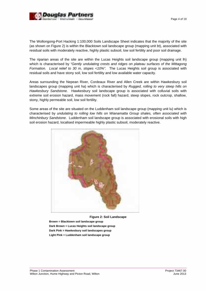
The Wollongong-Port Hacking 1:100,000 Soils Landscape Sheet indicates that the majority of the site (as shown on Figure 2) is within the Blacktown soil landscape group (mapping unit bt), associated with residual soils with moderately reactive, highly plastic subsoil, low soil fertility and poor soil drainage. The riparian areas of the site are within the Lucas Heights soil landscape group (mapping unit lh) which is characterised by “Gently undulating crests and ridges on plateau surfaces of the Mittagong Formation. Local relief to 30 m, slopes <10%”. The Lucas Heights soil group is associated with residual soils and have stony soil, low soil fertility and low available water capacity. Areas surrounding the Nepean River, Cordeaux River and Allen Creek are within Hawkesbury soil landscapes group (mapping unit ha) which is characterised by Rugged, rolling to very steep hills on Hawkesbury Sandstone. Hawkesbury soil landscape group is associated with colluvial soils with extreme soil erosion hazard, mass movement (rock fall) hazard, steep slopes, rock outcrop, shallow, stony, highly permeable soil, low soil fertility. Some areas of the site are situated on the Luddenham soil landscape group (mapping unit lu) which is characterised by undulating to rolling low hills on Wianamatta Group shales, often associated with Minchinbury Sandstone. Luddenham soil landscape group is associated with erosional soils with high soil erosion hazard, localised impermeable highly plastic subsoil, moderately reactive.
Figure 2: Soil Landscape
Brown = Blacktown soil landscape group
Dark Brown = Lucas Heights soil landscape group
Dark Pink = Hawkesbury soil landscapes group
Light Pink = Luddenham soil landscape group
Page 5 of 19
Phase 1 Contamination Assessment Project 73467.00Wilton Junction, Hume Highway and Picton Road, Wilton June 2013
4. Previous Investigations
A previous investigation for a portion of the Wilton Junction land precinct was undertake by Johnston Environmental Technology Pty Ltd (JET) in Report on Preliminary Contamination Assessment, Rural Land Subdivision, Condell Park, Wilton, NSW, 3 November 1999, JET1127-001/DJ. [JET 1999]. JET (1999) was undertaken on the Bradcorp and Lend Lease portions of Wilton Junction (Lots 1, 2 and 4 of Deposited Plan 702024) and included:
An on-site inspection of the property and an examination of the surface features and surrounds.
Inquires with Council and residents regarding land uses and activities; and
Examination of historical aerial photographs at the NSW Department of Land and Water Conservation to assist in determining previous land uses (particularly to assess any previous cultivation or intensive uses).
The JET report concluded that the site was suitable for the proposed land use being a subdivision into 40 ha rural blocks with homestead construction, however, it was recommended that “subdivision approval should be conditional upon any contractors or workman being alerted to the possible presence of Unexploded ordinance and advised not to move any suspicious items but to call in qualified military personnel for identification and handling”. 5. Review of Site History Information
The site history investigation is undertaken to identify potential areas of environmental concern and contaminants of concern which may arise from previous uses (storage of dangerous goods, storage and disposal of raw and waste products etc.), the presence of demolished or partly demolished buildings, soil stockpiles, land filling, waste disposal and other potentially contaminating activities. The following sections detail the methodology of the investigations undertaken with results discussed in Section 7.
5.1 Search of NSW EPA Registers
A search on 11 June 2013 for current Statutory Notices issued under the Contaminated Land Management Act 1997 and Protection of the Environment Operations Act 1997 (POEO) available on the NSW EPA website showed that there are no notices or licences that have been issued for the site.
5.2 Historical Aerial Photography
Aerial photographs were examined to identify any changes to the landscape which may include potentially contaminating land activities or significant environmental features. Seven aerial photographs were examined from the years 1955, 1961, 1975, 1984, 1990, 2005 and 2010. Copies are included in Appendix B.

Page 6 of 19
Phase 1 Contamination Assessment Project 73467.00Wilton Junction, Hume Highway and Picton Road, Wilton June 2013
The aerial photographs were reviewed for Potential Areas of Environmental Concern (PAEC) for all areas of the site excluding the Lend Lease and existing Wilton village areas. The Lend Lease and Wilton township areas were excluded from the aerial review for potential areas of contamination as these areas have already or are in the process of being developed. A summary of the aerial photograph review is given below. 1955: The majority of the site appears to have been cleared with one cluster of buildings observed within the Wilton Township Area. Individual homestead were observed along Wilton Park Road. Wilton Park Road alignment could be seen running in a west to east direction. The site was densely vegetated around the edges within the gully areas. Some dams and gravel tracks were present across the site indicating a potential for some agricultural usage. Recently cleared or logged areas were observed within the northern and eastern portions of the site. 1961: The site appears to have remained relatively unchanged with the exception of more extensive land clearing within the northern and eastern portions of the site. Some ground disturbances were noted in various locations within the site. 1975: The site appears to have remained relatively unchanged since the previous photograph with the exception of more clearly defined lots (some with residential dwellings) along Wilton Park Road in the western portion of the site. Residential dwellings appear to have been constructed on some of these lots. Since the previous photograph Wilton Township appears to be expanding with the addition of more residential housing. Some ground disturbances were noted within the site which included a dirt track (possibly a runway) which was observed running in a north south direction in the vicinity of the current airfield. Land clearing was observed to the north of the cluster of residential buildings observed in Wilton and to the south of Wilton Park Road in the western portion of the site. 1984: The majority of the site appears to have remained relatively unchanged since the previous photograph. The Hume Highway has been constructed since the previous photograph. Picton Road has also been constructed from the north of the site to Wilton. Further development of Wilton Township has appeared to have been undertaken since the previous photograph with additional residential buildings being constructed. The alignment of Wilton Park Road has been altered due to the construction of the Hume Highway and Picton Road. There appears to have been a new access road to the airfield and an additional runway constructed since the previous photograph. A dirt/gravel access road was observed running past the airfield and up to the north within the rail corridor. The access road can be seen leading to a large ground disturbance where the construction of the rail bridge appears to have commenced. Some ground disturbances were observed adjacent to the access road. 1990: The site appears to have remained relatively unchanged since the previous photograph. The southern portion of Picton road has been constructed. An additional runway has been constructed roughly perpendicular to the existing runway (in a rough north west to south east direction). Some additional land clearing was observed on the central eastern portion of the site (to the north of the Wilton Township). The original runway appears to have been unused and becoming less noticeable. Some minor ground disturbances were noted within the site 2005: The site appears to have remained relatively unchanged since the previous photograph. There was a ground disturbance to the south of Picton road and south of the Wilton Township which appears to have been some kind of oval track.

Page 7 of 19
Phase 1 Contamination Assessment Project 73467.00Wilton Junction, Hume Highway and Picton Road, Wilton June 2013
2010: The site appears to have remained relatively unchanged since the previous photograph. In the vicinity of the airfield the original runway can no longer be seen. The construction of the Bingara Gorge residential development has commenced since the previous photograph with roads and houses being constructed. Overall comments from the aerial photographs include:
The majority of the site has remained vacant with the only likely usage being agricultural, commercial (including the airfield and some areas within the current Wilton Village) and some residential use;
The Hume Highway and Picton Road were constructed between the years 1975 and 1990;
Some ground disturbances were noted in the vicinity of the rail corridor and during the construction of the Rail bridge;
Numerous ground disturbances and dams were noted within the site; and
Recent land clearing was observed within the site.
5.3 Review of Section 149 (2 and 5) Certificates
A review of the provided Section 149 Planning Certificates for the Bradcorp and Lend Lease portions of the site (Lots 1, 2 and 4 of Deposited Plan 702024), dated 18 February 1999, (Appendix E) indicated that there are no matters listed under the Section 59(2) of the Contaminated Land Management Act 1997 which should be specified on the certificate. We note that the date on the Section 149 certificates provided by the client is 1999. Due to their age it is possible that some amendments may have been made to the certificates over the ensuing years. However a review of the NSW EPA Registers showed no notices or licences that have been issued for the site. Future contamination assessments should review the current certificates. The Section 149 certificate for Lot 2 Deposited Plan 702024 (Bradcorp Land) indicated that the subject land is in an area which is affected by unexploded ordinance with the subject land generally being in an area of a World War 2 bombing range. This is discussed further in Section 5.5. No certificates were provided for the remaining portions of the site.
5.4 Groundwater Bore Database
A search of the groundwater bore database administered by the NSW Office of Water indicated that there are eight bores located within the site. Work summaries from the bore search indicated that the authorised and intended purposes of the groundwater bores were for domestic stock, irrigation and test purposes. Groundwater was noted in one of these bore to the east at a depth of 76 m below ground level. Groundwater was noted in the remaining wells at depths of 12 m and 24 m below ground level.

Page 8 of 19
Phase 1 Contamination Assessment Project 73467.00Wilton Junction, Hume Highway and Picton Road, Wilton June 2013
5.5 Search on the Department of Defence Website for Sites Affected by Unexploded Ordinance
A search on 25 June 2013 for sites affected by Unexploded Ordinance (UXO) on the Department of Defence website indicated that the site was partially within the Douglas Park World War 2 Bombing Range (refer figure 3). The Department of Defence characterised the site as having a slight UXO potential.
Figure 3: Area affected by Unexploded Ordinance
The Department of Defence indicates that sites with a ‘Slight’ UXO potential are “areas with a confirmed history of military activities that have resulted in residual UXO but Defence considers it inappropriate to assess as substantial.” The advice provided by the department of defence for sites with a ‘Slight’ UXO potential is as follows: “All land usage and development, within these areas, should continue without further UXO investigation or remediation.” The Department of Defence provide the following warning and advice for a site with a Slight UXO potential as: “Defence issues the following UXO warning and advice for areas assessed as having a slight UXO potential: Allied Defence Forces used many sites throughout Australia, during and after World War II, for encampments, field training, live firing of weapons and other military activities. This property is on such a site. A possibility exists that Dangerous items of Unexploded Ordnance (UXO) may still be found on this site. If you should find a suspicious item, that may be a UXO, do not touch or disturb it. It has been there for many years, it will not hurt you if you do not disturb it. There are no known instances, in Australia where UXO have caused injuries except when they were deliberately and intentionally disturbed. Contact police they will arrange for military experts to attend and dispose of it. Defence recommends that all land usage and development, within these areas, may continue without any further UXO investigation or remediation.”

Page 9 of 19
Phase 1 Contamination Assessment Project 73467.00Wilton Junction, Hume Highway and Picton Road, Wilton June 2013
Based on this information, no further investigation of the UXO area within the site is considered warranted from a contamination stand point. DP agree with the JET 1999 report which recommended that subdivision approval should be conditional upon any contractors or workman being alerted to the possible presence of Unexploded ordinance and advised not to move any suspicious items but to call in qualified military personnel for identification and handling. 6. Site Inspection
A site walkover of the Bradcorp, Walker Corporation and Governors Hill land was undertaken by an environmental engineer from DP on the 3 - 5 June 2013. Photographs were taken during the site inspection and are presented in Appendix C and site features can be seen on Drawing 10, 11 and 12 Appendix B. PAEC were assessed and descriptive logs were completed which are presented in Appendix D. During the inspection the following were noted: Walker Corporation Land (Refer Drawing 10):
Two residential buildings are located within the Walker site, consisting of brick construction and tiled roofing. The buildings are generally in a good condition.
A shed with fenced-off horse area is located centrally within the northern lot. Gravels were imported and placed within the floor of the fenced-off area. A small stockpile of asphalt gravel was located within this area.
Some filling was observed within drainage lines located within the Walker Corporation. Anthropogenic materials were observed within one drainage line refer Drawing 10.
A small shed/building/structure adjacent to the southern residential building appeared to have corrugated asbestos roofing and walls.
A water pipeline was observed running along the western boundary of the site with irrigation signs noted. The surface of this area appears to have been ploughed or reworked with broken PVC pipes being observed on the surface.
The rail corridor appeared to be fenced-off and grass covered to the north of the site.
Governors Hills Land (refer Drawing 11):
A derelict structure was observed within the site and adjacent to the western boundary, which was constructed from corrugated metal sheeting and timber. There was corrugated sheeting on the ground surface in the vicinity of the structure.
Some minor fill (possibly only surface filling) was observed leading to a road underpass. The underpass links the western portion and eastern portion of the Governors Hill land with Picton Road running through the centre.
Some concrete was observed within a creek line in the northern portion of the site.
Minor filling was observed within a creek line and drainage line.

Page 10 of 19
Phase 1 Contamination Assessment Project 73467.00Wilton Junction, Hume Highway and Picton Road, Wilton June 2013
A minor stockpile of anthropogenic materials were observed with some possible shallow filling within the vicinity of the stockpile.
The airfield consists of multiple portable buildings and more than 20 caravans. The portable buildings were constructed with cladding and corrugated roofing.
Two runways were observed in approximately perpendicular directions. It appears that some filling would have been required to achieve the current runway level.
A 30 000 L above-ground storage tank (AST) of Jet Fuel was located adjacent to the runway within the airfield area. The Jet Fuel bowser is located approximately 20 m from the AST and a fuel odour was noted. Some minor staining was observed around the bowser.
A 1000L diesel AST and generator were observed within the airfield area. Ground staining was observed around the AST.
Two shipping containers (used for storage) were observed to the south of the Jet Fuel tank. Two 44 gallon drums of unleaded petrol were observed within one of the shipping containers. A ride on lawn mower was observed in the second.
A toilet block and septic tanks were also observed within the airfield.
An asphalt stockpile was noted to the south of the airfield.
A landfill was observed on the northern side of the runway. Anthropogenic materials were observed within the landfill which included metal, plastic, concrete, tyres, wood and fibrous cement fragments (possibly asbestos-containing material).
Two storage sheds, stockpiles and surface litter was observed in the vicinity of the landfill. The materials within the stockpile and surface litter consisted of building demolition, airplane parts and other anthropogenic materials.
Four caravans in two locations were observed within the tree lines in the northern portion of the Governors Hills land. In one of the locations timber, plastic and scrap metal were spread on the surface.
Some areas potentially had filling of a minor nature.
Anthropogenic materials were observed within a dam with possible filling observed within drainage lines to the north-west and south-east of the dam.
Bradcorp Land (Refer Drawing 12):
The site consists mainly of fenced paddocks with a cattle yard located within the centre of the site and a timber and metal corrugated shed on the south eastern boundary adjacent to the Hume Highway and bridge.
A rail corridor runs through the Bradcorp Land with an access road running to the north where there is a partially constructed bridge. The bridge has been constructed on a large soil mound. Along the access road there are areas that have been excavated and it appears that the material excavated could have potentially been used to construct the earth mound for the bridge.
A large stockpile of shale gravel was noted to the east of the rail corridor.
A possible access track (ground disturbance) was observed within the south eastern corner of the Bradcorp Land. Observations suggest that cut and fill may have been undertaken.

Page 11 of 19
Phase 1 Contamination Assessment Project 73467.00Wilton Junction, Hume Highway and Picton Road, Wilton June 2013
Four BHP Billiton exploration/monitoring locations were observed within the site.
Some minor mounds of soil (<0.5 m high) were observed in the north of the site.
Overhead power lines run in an east-west direction in the northern portion of the Bradcorp land.
There were no signs of unexploded ordinances or indications that the site was used as a World War 2 Bombing Range.
6.1 Observations made from Geotechnical and Salinity Investigation
A geotechnical and salinity investigation was undertaken and, as part of the intrusive investigation, there were a total of 44 test pits excavated across the site (TP1 to TP44) to varying depths. Although environmental samples were not collected, observations were made during excavation to confirm the presence or absence of potential filling across the Site. The locations of the test pits are shown on Drawing 2 in Appendix B. The test pit logs are provided in Appendix F, together with notes defining classification methods and descriptive terms. The pits encountered relatively uniform conditions underlying the site, with the succession of strata broadly summarised as follows:
TOPSOIL – silty clayey topsoil, clayey silty topsoil, sandy silty clayey topsoil and silty topsoil encountered to depths of 0.1 – 0.5 m in all TP, with the exception of TP35;
FILLING – clayey silt filling with some grass and igneous gravel was encountered to a depth of 0.3 m in TP35;
CLAY/SILT – silty clays, sandy clays, shaly clays, clays, clayey silts and sandy silts were encountered to depths of 0.3 – 2.3 m in all pits with the exception of TP31 and TP42;
BEDROCK – sandstone or shale was encountered in all pits to the depth of termination. No free groundwater was observed in the test pits excavated. It is noted that the test pits were immediately backfilled on completion which precluded long term monitoring of groundwater levels. 7. Potential for Contamination
In the course of the site history investigations and site inspection 85 areas were identified as Potential Areas of Environmental Concern (PAEC). Each PAEC was described on a PAEC Identification & Inspection Log. Based on the investigation, each PAEC was reclassified as either an AEC (if evidence warranted) or not an AEC (areas which require no further investigation). These logs are included for reference in Appendix D. The logs contain detailed information regarding the investigations. Table 3 below lists the identified PAEC.

Page 12 of 19
Phase 1 Contamination Assessment Project 73467.00Wilton Junction, Hume Highway and Picton Road, Wilton June 2013
Potential areas of environmental concern were only identified from the parcels of land that were within the Bradcorp, Walker Corp, Governors Hill and the smaller landholders portions of the site. The parcels of land that were not examined for potential areas of environmental concern are the lend lease development area and the current Wilton township. Table 3: Summary of Identified Potential Areas of Environmental Concern
PAEC # Identified from Brief Description Inspection Type Outcome
1 Historic Aerial - 1984 Construction of Railway Bridge Site Inspection AEC
2 Historic Aerial - 2005 Ground Disturbance Outside Accessible Land -
3 Historic Aerial - 1961 Ground Disturbance Outside Accessible Land -
4 Historic Aerial - 1961 Possible disturbance Outside Accessible Land -
5 Historic Aerial - 1975 Ground Disturbance Outside Accessible Land -
6 Historic Aerial - 1975 Ground Disturbance Outside Accessible Land -
7 Historic Aerial - 1984 Ground Disturbance in relation to
construction of Picton Road Outside Accessible Land -
8 Historic Aerial - 2005 Ground Disturbance Outside Accessible Land -
9 Historic Aerial - 1961 Ground Disturbance Site Inspection AEC
10 Historic Aerial - 1961 Ground Disturbance Outside Accessible Land -
11 Historic Aerial - 1975 Small Shed/demolished Site Inspection AEC
12 Historic Aerial - 1975 Ground Disturbance Site Inspection AEC
13 Historic Aerial - 1975 Dirt Track Site Inspection AEC
14 Historic Aerial - 1984 Ground Disturbance Airport Site Inspection AEC
15 Historic Aerial - 1984 previous road demolished Site Inspection AEC
16 Historic Aerial - 1984 ground disturbance Site Inspection AEC
17 Historic Aerial - 1984 ground disturbance Site Inspection AEC
18 Historic Aerial - 1984 possible dam or disturbance Site Inspection Not AEC - Excavation
19 Historic Aerial - 1984 ground disturbances or stockpiles Site Inspection Not AEC - Excavation
20 Historic Aerial - 1984 stockpiles / storage of materials
along access road Site Inspection Not AEC - Excavation
21 Historic Aerial - 1990 ground disturbance noted in vicinity
of airport Site Inspection AEC
22 Historic Aerial - 1984 ground disturbance Site Inspection Not AEC - Dam
23 Historic Aerial - 2005 ground disturbance Site Inspection Not AEC - Excavation
24 Historic Aerial - 2005 ground disturbance along access
road Outside Accessible Land -
25 Historic Aerial - 1955 small ground disturbance Site Inspection AEC
26 Historic Aerial - 1961 land clearing / logging Outside Accessible Land -
27 Historic Aerial - 1984 Ground disturbance Site Inspection Not AEC – Gas Pipeline
28 Historic Aerial - 1961 ground disturbance Site Inspection AEC
29 Historic Aerial - 1984 ground disturbance Outside Accessible Land -
30 Historic Aerial - 1984 ground disturbance Outside Accessible Land -
31 Historic Aerial - 1984 ground disturbance adjacent to
Hume highway Outside Accessible Land -
32 Historic Aerial - 1984 ground disturbance adjacent to
Hume highway Outside Accessible Land -
33 Historic Aerial - 1961 Ground disturbance possibly from
services Outside Accessible Land -

Page 13 of 19
Phase 1 Contamination Assessment Project 73467.00Wilton Junction, Hume Highway and Picton Road, Wilton June 2013
PAEC # Identified from Brief Description Inspection Type Outcome
34 Historic Aerial - 1961 ground disturbance Site inspection AEC
35 Historic Aerial - 2005 Oval racing track ground
disturbance Site Inspection AEC
36 Historic Aerial - 1961 land clearing / logging Outside Accessible Land -
37 Historic Aerial - 1975 ground disturbance Site Inspection AEC
38 Historic Aerial - 1975 ground disturbance Site Inspection AEC
39 Historic Aerial - 1975 house / structure demolition Outside Accessible Land -
40 Historic Aerial - 1990 possible market gardens Outside Accessible Land -
41 Historic Aerial - 1990 ground disturbance possibly from
construction of Picton Road Site Inspection AEC
42 Historic Aerial - 1955 cleared land Outside Accessible Land -
43 Historic Aerial - 1955 land clearing / logging Site Inspection AEC
44 Historic Aerial - 1961 land clearing / logging Site Inspection Not AEC – No obvious
signs of contamination from land clearing
45 Historic Aerial - 1961 land clearing / logging Site Inspection Not AEC - No obvious
signs of contamination from land clearing
46 Historic Aerial - 1961 land clearing / logging Site Inspection Not AEC - No obvious
signs of contamination from land clearing
47 Historic Aerial - 1961 land clearing / logging Site Inspection Not AEC - No obvious
signs of contamination from land clearing
48 Site Inspection Possible filled gully and derelict
bridge - AEC
49 Site Inspection Possible area of fill, brick noted half
buried with placed boulders on surface adjacent
- AEC
50 Site Inspection Homestead - brick and tile
construction - Not AEC
51 Site Inspection Metal portable horse stable with mounds of imported gravel being
spread over site - AEC
52 Site Inspection Machine Shed, with shipping
containers, truck parked outside and small asphalt gravel stockpile
- AEC
53 Site Inspection Possibly lightly filled gully - AEC
54 Site Inspection Ground disturbance possibly filled
small dam - AEC
55 Site Inspection Possible filled gully (logs observed
on surface) - AEC
56 Site Inspection Derelict structure - AEC
57 Site Inspection Potential fill of unknown origin - AEC
58 Site Inspection concrete observed within eroded
gully/creek - AEC
59 Site Inspection dam with what appears to be extra
fill required for the dam wall/mounds
- AEC
60 Site Inspection filled gully / landfill with car bodies, white goods, engines, bricks and
scrap metal observed - AEC
61 Site Inspection reworked ground with broken PVC
pipes in area of mine water irrigation
- AEC
62 Site Inspection cut to fill mounds for surface water
detention - Not AEC
63 Site Inspection Small scrap metal stockpile - AEC

Page 14 of 19
Phase 1 Contamination Assessment Project 73467.00Wilton Junction, Hume Highway and Picton Road, Wilton June 2013
PAEC # Identified from Brief Description Inspection Type Outcome
64 Site Inspection Fibro building with asbestos roofing - AEC
65 Site Inspection fill mounds with anthropogenic
materials observed - AEC
66 Site Inspection anthropogenic filling - AEC
67 Site Inspection anthropogenic stockpile (timber
tyres and scrap metal) - AEC
68 Site Inspection stockpile of soil - AEC
69 Site Inspection stockpile of soil - AEC
70 Site Inspection
Airfield Area - including Jet Fuel tank, Bowser, Shipping Containers
with Fuel Storage within, Diesel AST with generator and staining on
ground
- AEC
71 Site Inspection Crushed Asphalt stockpile - AEC
72 Site Inspection possible area of minor fill (slightly
raised area) 50 m x 30 m - AEC
73 Site Inspection Minor filled creek with boulders observed and fencing material
stockpiled adjacent. - AEC
74 Site Inspection possible filled creek with cobbles
and boulders observed on surface - AEC
75 Site Inspection an "L" shaped soil mound (0.5 m
high) within the PAEC 51 - AEC
76 Site Inspection another soil mound within PAEC51 - AEC
77 Site Inspection Dirt Ramp / mound observed - AEC
78 Site Inspection small stockpile of soil - AEC
79 Site Inspection stockpile of scrap metal - AEC
80 Site Inspection access road within Governors hill (north of runway) had some fill in
areas - AEC
81 Site Inspection small fill mound with tyres observed
on surface noted 20 m x 4 m - AEC
82 Site Inspection
anthropogenic material noted in and around dam with possible fill to
the north and south of the dam within drainage line
- AEC
83 Site Inspection
Anthropogenic material were observed on the ground surface in the vicinity of three caravans and
consisted of timber, brick, tyres and some plastics
- AEC
84 Site Inspection possible fill area 10 m x 10 m - AEC
85 Site Inspection Area of landfill, shipping containers
and anthropogenic materials observed in stockpiles
- AEC
For the areas of the site that are owned by smaller landholders a desktop study was conducted and, as such, no site investigation was undertaken. As a result of the desktop study the identified PAEC within these areas were not inspected and remain PAEC. The PAEC that have been identified within the small landholder areas of the site are summarised in Table 4 and the location of each of the PAEC is shown on Drawing 13, Appendix B.

Page 15 of 19
Phase 1 Contamination Assessment Project 73467.00Wilton Junction, Hume Highway and Picton Road, Wilton June 2013
Table 4: Summary of Identified Potential Areas of Environmental Concern that Requires Site Inspection (Small Landholders)
PAEC # Identified from Brief Description Inspection Type
2 Historic Aerial - 2005 Ground Disturbance Outside Accessible Land
3 Historic Aerial - 1961 Ground Disturbance Outside Accessible Land
4 Historic Aerial - 1961 Possible disturbance Outside Accessible Land
5 Historic Aerial - 1975 Ground Disturbance Outside Accessible Land
6 Historic Aerial - 1975 Ground Disturbance Outside Accessible Land
7 Historic Aerial - 1984 Ground Disturbance in relation to construction of
Picton Road Outside Accessible Land
8 Historic Aerial - 2005 Ground Disturbance Outside Accessible Land
10 Historic Aerial - 1961 Ground Distrubance Outside Accessible Land
24 Historic Aerial - 2005 ground disturbance along access road Outside Accessible Land
26 Historic Aerial - 1961 land clearing / logging Outside Accessible Land
29 Historic Aerial - 1984 ground disturbance Outside Accessible Land
30 Historic Aerial - 1984 ground disturbance Outside Accessible Land
31 Historic Aerial - 1984 ground disturbance adjacent to Hume Highway Outside Accessible Land
32 Historic Aerial - 1984 ground disturbance adjacent to Hume Highway Outside Accessible Land
33 Historic Aerial - 1961 ground disturbance possibly from services Outside Accessible Land
36 Historic Aerial - 1961 land clearing / logging Outside Accessible Land
39 Historic Aerial - 1975 house / structure demolition Outside Accessible Land
40 Historic Aerial - 1990 possible market gardens Outside Accessible Land
42 Historic Aerial - 1955 cleared land Outside Accessible Land
The site history and inspection of the Bradcorp, Walker Corp and Governors Hill sites indicated that the sites had been primarily vacant and used for agricultural and rural residential purposes with the exception of the airfield and rail corridor. Following the investigation of each PAEC and inspection of the Bradcorp, Walker Corp and Governors Hills sites, the identified AEC within the Bradcorp, Walker Corp and Governors Hill sites are summarised in Table 5 together with an assessment of the potential contamination associated with each AEC. The location of each of the AEC is shown on Drawing 13, Appendix B. Table 5: Summary of Identified Areas of Environmental Concern AEC
# PAEC# Brief Description Contaminants of Concern
1 1 Construction of Railway Bridge Heavy metals, TRH, BTEX, PCB,
PAH and asbestos
2 9 Ground Disturbance Heavy metals, TRH, BTEX, OCP,
OPP, PCB, PAH and asbestos
3 11 Small Shed/demolished Heavy metals, TRH, BTEX, PCB,
PAH and asbestos
4 12 Ground Disturbance / Runway Heavy metals, TRH, BTEX, PCB,
PAH and asbestos
5 13 Dirt Track Heavy metals, TRH, BTEX, PCB,
PAH and asbestos
6 14 Runway Heavy metals, TRH, BTEX, PCB,
PAH and asbestos

Page 16 of 19
Phase 1 Contamination Assessment Project 73467.00Wilton Junction, Hume Highway and Picton Road, Wilton June 2013
AEC #
PAEC# Brief Description Contaminants of Concern
7 15 previous road demolished Heavy metals, TRH, BTEX, PCB,
PAH and asbestos
8 16 ground disturbance Heavy metals, TRH, BTEX, PCB,
PAH and asbestos
9 17 Stockpile Heavy metals, TRH, BTEX, PCB,
PAH and asbestos
10 21 Runway Heavy metals, TRH, BTEX, PCB,
PAH and asbestos
11 25 small ground disturbance Heavy metals, TRH, BTEX, OCP,
OPP, PCB, PAH and asbestos
12 28 ground disturbance Heavy metals, TRH, BTEX, OCP,
OPP, PCB, PAH and asbestos
13 34 ground disturbance Heavy metals, TRH, BTEX, OCP,
OPP, PCB, PAH and asbestos
14 35 Oval racing track ground disturbance Heavy metals, TRH, BTEX, PCB,
PAH and asbestos
15 37 ground disturbance Heavy metals, TRH, BTEX, PCB,
PAH and asbestos
16 38 ground disturbance Heavy metals, TRH, BTEX, PCB,
PAH and asbestos
17 41 ground disturbance possibly from construction of Picton Road Heavy metals, TRH, BTEX, PCB,
PAH and asbestos
18 48 Possible filled gully and derelict bridge Heavy metals, TRH, BTEX, PCB,
PAH and asbestos
19 49 Possible area of fill, brick noted half buried with placed boulders on
surface adjacent Heavy metals, TRH, BTEX, PCB,
PAH and asbestos
20 51 Metal portable fencing with mounds of imported gravel being
spread over site Heavy metals, TRH, BTEX, OCP,
OPP, PCB, PAH and asbestos
21 52 Machine Shed, with shipping containers, truck parked outside and
small asphalt gravel stockpile Heavy metals, TRH, BTEX, OCP,
OPP, PCB, PAH and asbestos
22 53 Possibly lightly filled gully Heavy metals, TRH, BTEX, OCP,
OPP, PCB, PAH and asbestos
23 54 Ground disturbance possibly filled small dam Heavy metals, TRH, BTEX, OCP,
OPP, PCB, PAH and asbestos
24 55 Possible filled gully (logs observed on surface) Heavy metals, TRH, BTEX, OCP,
OPP, PCB, PAH and asbestos
25 56 Derelict structure Heavy metals, TRH, BTEX, PCB,
PAH and asbestos
26 57 Potential fill of unknown origin Heavy metals, TRH, BTEX, OCP,
OPP, PCB, PAH and asbestos
27 58 concrete observed within eroded gully/creek Heavy metals, TRH, BTEX, PCB,
PAH and asbestos
28 59 dam with what appears to be extra fill within the dam wall/mounds Heavy metals, TRH, BTEX, OCP,
OPP, PCB, PAH and asbestos
29 60 filled gully / landfill with car bodies, white goods, engines, bricks
and scrap metal observed Heavy metals, TRH, BTEX, PCB,
PAH and asbestos
30 61 Mine Water Irrigation Area - reworked ground with broken PVC
pipes observed Heavy metals, TRH, BTEX, PCB,
PAH and asbestos
31 63 Small scrap metal stockpile Heavy metals, TRH, BTEX, PCB,
PAH and asbestos
32 64 Fibro building with asbestos roofing Lead, asbestos
33 65 fill mounds with anthropogenic materials observed Heavy metals, TRH, BTEX, OCP,
OPP, PCB, PAH and asbestos

Page 17 of 19
Phase 1 Contamination Assessment Project 73467.00Wilton Junction, Hume Highway and Picton Road, Wilton June 2013
AEC #
PAEC# Brief Description Contaminants of Concern
34 66 anthropogenic filling Heavy metals, TRH, BTEX, OCP,
OPP, PCB, PAH and asbestos
35 67 anthropogenic stockpile (timber tyres and scrap metal) Heavy metals, TRH, BTEX, PCB,
PAH and asbestos
36 68 stockpile of soil Heavy metals, TRH, BTEX, OCP,
OPP, PCB, PAH and asbestos
37 69 stockpile of soil Heavy metals, TRH, BTEX, OCP,
OPP, PCB, PAH and asbestos
38 70 Airfield Area - including Jet Fuel tank, Jet Fuel Bowser, Shipping
Containers with Fuel Storage, Diesel AST with generator and staining on ground
Heavy metals, TRH, BTEX, PCB, PAH and asbestos
39 71 Crushed Asphalt stockpile Heavy metals, TRH, BTEX, PCB,
PAH and asbestos
40 72 possible area of minor fill (slightly raised area) 50 m x 30 m Heavy metals, TRH, BTEX, OCP,
OPP, PCB, PAH and asbestos
41 73 Minor filled creek with boulders observed and fencing material
stockpiled adjacent. Heavy metals, TRH, BTEX, OCP,
OPP, PCB, PAH and asbestos
42 74 possible filled creek with cobbles and boulders observed on surface Heavy metals, TRH, BTEX, OCP,
OPP, PCB, PAH and asbestos
43 75 an "L" shaped soil mound (0.5 m high) within the PAEC 51 Heavy metals, TRH, BTEX, OCP,
OPP, PCB, PAH and asbestos
44 76 another soil mound within PAEC51 Heavy metals, TRH, BTEX, OCP,
OPP, PCB, PAH and asbestos
45 77 Dirt Ramp / mound observed Heavy metals, TRH, BTEX, OCP,
OPP, PCB, PAH and asbestos
46 78 small stockpile of soil Heavy metals, TRH, BTEX, PCB,
PAH and asbestos
47 79 stockpile of scrap metal Heavy metals, TRH, BTEX, PCB,
PAH and asbestos
48 80 access road within Governors Hill (north of runway) had some fill in
areas Heavy metals, TRH, BTEX, PCB,
PAH and asbestos
49 81 small fill mound with tyres observed on surface noted 20 m x 4 m Heavy metals, TRH, BTEX, PCB,
PAH and asbestos
50 82 anthropogenic material noted in and around dam with possible fill to
the north and south of the dam within drainage line Heavy metals, TRH, BTEX, OCP,
OPP, PCB, PAH and asbestos
51 83 Anthropogenic material were observed on the ground surface in the vicinity of three caravans and consisted of timber, brick, tyres and
some plastics
Heavy metals, TRH, BTEX PCB, PAH and asbestos
52 84 possible fill area 10 m x 10 m Heavy metals, TRH, BTEX, OCP,
OPP, PCB, PAH and asbestos
53 85 Area of landfill, shipping containers and anthropogenic materials
observed in stockpiles Heavy metals, TRH, BTEX, PCB,
PAH and asbestos
Notes:
Where: Heavy Metals = priority heavy metals viz: arsenic (As), cadmium (Cd), chromium (Cr), copper (Cu), lead (Pb), mercury (Hg), nickel (Ni) and zinc (Zn).
TPH = Total Petroleum Hydrocarbons.
BTEX = Benzene, Toluene, Ethylbenzene and Xylenes.
PAH = Polycyclic Aromatic Hydrocarbons.
OCP = Organochlorine pesticides
OPP = Organophosphorous pesticides.
Asb = Asbestos.

Page 18 of 19
Phase 1 Contamination Assessment Project 73467.00Wilton Junction, Hume Highway and Picton Road, Wilton June 2013
8. Conclusions and Recommendations
The aim of this assessment was to provide a preliminary evaluation of the contamination status of the Site and its suitability, from a contamination standpoint, for the proposed residential rezoning which includes some open space and commercial areas. Based on the obtained information, it is considered that the potential for significant contamination at the Site is low; however, further investigation is warranted for the AEC as shown in Section 7. In addition, low density sampling of the remaining residential area (excluding AEC), is recommended to confirm the contamination status of the Site as no surface or subsurface sampling was conducted by DP to confirm the soil conditions. The additional detailed investigation should be undertaken in advance of any development applications for the subdivision or bulk earthworks. Additionally, DP recommends that subdivision approval within the UXO area should be conditional upon any contractors or workmen being alerted to the possible presence of UXO and advised not to move any suspicious items but to call in qualified military personnel for identification and handling. Notwithstanding, a military researcher and munitions expert should review our recommendation in advance of any development applications for subdivision or bulk earthworks. Based on the findings of this preliminary contamination assessment, potential groundwater contamination is not considered to be significant unless soil contamination is found within the AEC or within the background area. If significant contamination is identified then a groundwater investigation may be required. It is considered that the site can be rezoned for the proposed residential subdivision from a contamination perspective. Further investigation as described above and remediation, as required, should be undertaken prior to subdivision. 9. Limitations
Douglas Partners Pty Ltd (DP) has prepared this report for a project at Wilton Junction, Wilton, NSW in accordance with DP's proposal SYD130344 and acceptance received from Mr Brian Elton of Elton Consulting Pty Ltd, client’s representative, on 3 May 2013, on behalf of Wilton Junction Landowners Group. The report is provided for the exclusive use of Elton Consulting Pty Ltd for this project only and for the purpose(s) described in the report. It should not be used for other projects or by a third party. In preparing this report DP has necessarily relied upon information provided by the client and/or their agents. The results provided in the report are indicative of the sub-surface conditions only at the specific sampling or testing locations, and then only to the depths investigated and at the time the work was carried out. Sub-surface conditions can change abruptly due to variable geological processes and also as a result of anthropogenic influences. Such changes may occur after DP's field testing has been completed. DP's advice is based upon the conditions encountered during this investigation. The accuracy of the advice provided by DP in this report may be limited by undetected variations in ground conditions between sampling locations. The advice may also be limited by budget constraints imposed by others or by site accessibility.

Page 19 of 19
Phase 1 Contamination Assessment Project 73467.00Wilton Junction, Hume Highway and Picton Road, Wilton June 2013
This report must be read in conjunction with all of the attached notes and should be kept in its entirety without separation of individual pages or sections. DP cannot be held responsible for interpretations or conclusions made by others unless they are supported by an expressed statement, interpretation, outcome or conclusion given in this report.
Douglas Partners Pty Ltd

Appendix A
About this Report
July 2010
Introduction These notes have been provided to amplify DP's report in regard to classification methods, field procedures and the comments section. Not all are necessarily relevant to all reports. DP's reports are based on information gained from limited subsurface excavations and sampling, supplemented by knowledge of local geology and experience. For this reason, they must be regarded as interpretive rather than factual documents, limited to some extent by the scope of information on which they rely. Copyright This report is the property of Douglas Partners Pty Ltd. The report may only be used for the purpose for which it was commissioned and in accordance with the Conditions of Engagement for the commission supplied at the time of proposal. Unauthorised use of this report in any form whatsoever is prohibited. Borehole and Test Pit Logs The borehole and test pit logs presented in this report are an engineering and/or geological interpretation of the subsurface conditions, and their reliability will depend to some extent on frequency of sampling and the method of drilling or excavation. Ideally, continuous undisturbed sampling or core drilling will provide the most reliable assessment, but this is not always practicable or possible to justify on economic grounds. In any case the boreholes and test pits represent only a very small sample of the total subsurface profile. Interpretation of the information and its application to design and construction should therefore take into account the spacing of boreholes or pits, the frequency of sampling, and the possibility of other than 'straight line' variations between the test locations.
Groundwater Where groundwater levels are measured in boreholes there are several potential problems, namely: • In low permeability soils groundwater may
enter the hole very slowly or perhaps not at all during the time the hole is left open;
• A localised, perched water table may lead to an erroneous indication of the true water table;
• Water table levels will vary from time to time with seasons or recent weather changes. They may not be the same at the time of construction as are indicated in the report; and
• The use of water or mud as a drilling fluid will mask any groundwater inflow. Water has to be blown out of the hole and drilling mud must first be washed out of the hole if water measurements are to be made.
More reliable measurements can be made by installing standpipes which are read at intervals over several days, or perhaps weeks for low permeability soils. Piezometers, sealed in a particular stratum, may be advisable in low permeability soils or where there may be interference from a perched water table.
Reports The report has been prepared by qualified personnel, is based on the information obtained from field and laboratory testing, and has been undertaken to current engineering standards of interpretation and analysis. Where the report has been prepared for a specific design proposal, the information and interpretation may not be relevant if the design proposal is changed. If this happens, DP will be pleased to review the report and the sufficiency of the investigation work. Every care is taken with the report as it relates to interpretation of subsurface conditions, discussion of geotechnical and environmental aspects, and recommendations or suggestions for design and construction. However, DP cannot always anticipate or assume responsibility for: • Unexpected variations in ground conditions.
The potential for this will depend partly on borehole or pit spacing and sampling frequency;
• Changes in policy or interpretations of policy by statutory authorities; or
• The actions of contractors responding to commercial pressures.
If these occur, DP will be pleased to assist with investigations or advice to resolve the matter.

July 2010
Site Anomalies In the event that conditions encountered on site during construction appear to vary from those which were expected from the information contained in the report, DP requests that it be immediately notified. Most problems are much more readily resolved when conditions are exposed rather than at some later stage, well after the event.
Information for Contractual Purposes Where information obtained from this report is provided for tendering purposes, it is recommended that all information, including the written report and discussion, be made available. In circumstances where the discussion or comments section is not relevant to the contractual situation, it may be appropriate to prepare a specially edited document. DP would be pleased to assist in this regard and/or to make additional report copies available for contract purposes at a nominal charge. Site Inspection The company will always be pleased to provide engineering inspection services for geotechnical and environmental aspects of work to which this report is related. This could range from a site visit to confirm that conditions exposed are as expected, to full time engineering presence on site.

July 2010
Sampling Sampling is carried out during drilling or test pitting to allow engineering examination (and laboratory testing where required) of the soil or rock. Disturbed samples taken during drilling provide information on colour, type, inclusions and, depending upon the degree of disturbance, some information on strength and structure. Undisturbed samples are taken by pushing a thin-walled sample tube into the soil and withdrawing it to obtain a sample of the soil in a relatively undisturbed state. Such samples yield information on structure and strength, and are necessary for laboratory determination of shear strength and compressibility. Undisturbed sampling is generally effective only in cohesive soils. Test Pits Test pits are usually excavated with a backhoe or an excavator, allowing close examination of the in-situ soil if it is safe to enter into the pit. The depth of excavation is limited to about 3 m for a backhoe and up to 6 m for a large excavator. A potential disadvantage of this investigation method is the larger area of disturbance to the site.
Large Diameter Augers Boreholes can be drilled using a rotating plate or short spiral auger, generally 300 mm or larger in diameter commonly mounted on a standard piling rig. The cuttings are returned to the surface at intervals (generally not more than 0.5 m) and are disturbed but usually unchanged in moisture content. Identification of soil strata is generally much more reliable than with continuous spiral flight augers, and is usually supplemented by occasional undisturbed tube samples. Continuous Spiral Flight Augers The borehole is advanced using 90-115 mm diameter continuous spiral flight augers which are withdrawn at intervals to allow sampling or in-situ testing. This is a relatively economical means of drilling in clays and sands above the water table. Samples are returned to the surface, or may be collected after withdrawal of the auger flights, but they are disturbed and may be mixed with soils from the sides of the hole. Information from the drilling (as distinct from specific sampling by SPTs or undisturbed samples) is of relatively low
reliability, due to the remoulding, possible mixing or softening of samples by groundwater. Non-core Rotary Drilling The borehole is advanced using a rotary bit, with water or drilling mud being pumped down the drill rods and returned up the annulus, carrying the drill cuttings. Only major changes in stratification can be determined from the cuttings, together with some information from the rate of penetration. Where drilling mud is used this can mask the cuttings and reliable identification is only possible from separate sampling such as SPTs.
Continuous Core Drilling A continuous core sample can be obtained using a diamond tipped core barrel, usually with a 50 mm internal diameter. Provided full core recovery is achieved (which is not always possible in weak rocks and granular soils), this technique provides a very reliable method of investigation. Standard Penetration Tests Standard penetration tests (SPT) are used as a means of estimating the density or strength of soils and also of obtaining a relatively undisturbed sample. The test procedure is described in Australian Standard 1289, Methods of Testing Soils for Engineering Purposes - Test 6.3.1. The test is carried out in a borehole by driving a 50 mm diameter split sample tube under the impact of a 63 kg hammer with a free fall of 760 mm. It is normal for the tube to be driven in three successive 150 mm increments and the 'N' value is taken as the number of blows for the last 300 mm. In dense sands, very hard clays or weak rock, the full 450 mm penetration may not be practicable and the test is discontinued. The test results are reported in the following form.
• In the case where full penetration is obtained with successive blow counts for each 150 mm of, say, 4, 6 and 7 as:
4,6,7 N=13
• In the case where the test is discontinued before the full penetration depth, say after 15 blows for the first 150 mm and 30 blows for the next 40 mm as:
15, 30/40 mm

July 2010
The results of the SPT tests can be related empirically to the engineering properties of the soils.
Dynamic Cone Penetrometer Tests / Perth Sand Penetrometer Tests Dynamic penetrometer tests (DCP or PSP) are carried out by driving a steel rod into the ground using a standard weight of hammer falling a specified distance. As the rod penetrates the soil the number of blows required to penetrate each successive 150 mm depth are recorded. Normally there is a depth limitation of 1.2 m, but this may be extended in certain conditions by the use of extension rods. Two types of penetrometer are commonly used.
• Perth sand penetrometer - a 16 mm diameter flat ended rod is driven using a 9 kg hammer dropping 600 mm (AS 1289, Test 6.3.3). This test was developed for testing the density of sands and is mainly used in granular soils and filling.
• Cone penetrometer - a 16 mm diameter rod with a 20 mm diameter cone end is driven using a 9 kg hammer dropping 510 mm (AS 1289, Test 6.3.2). This test was developed initially for pavement subgrade investigations, and correlations of the test results with California Bearing Ratio have been published by various road authorities.

July 2010
Introduction These notes summarise abbreviations commonly used on borehole logs and test pit reports. Drilling or Excavation Methods C Core Drilling R Rotary drilling SFA Spiral flight augers NMLC Diamond core - 52 mm dia NQ Diamond core - 47 mm dia HQ Diamond core - 63 mm dia PQ Diamond core - 81 mm dia
Water Water seep Water level
Sampling and Testing A Auger sample B Bulk sample D Disturbed sample E Environmental sample U50 Undisturbed tube sample (50mm) W Water sample pp pocket penetrometer (kPa) PID Photo ionisation detector PL Point load strength Is(50) MPa S Standard Penetration Test V Shear vane (kPa)
Description of Defects in Rock The abbreviated descriptions of the defects should be in the following order: Depth, Type, Orientation, Coating, Shape, Roughness and Other. Drilling and handling breaks are not usually included on the logs. Defect Type B Bedding plane Cs Clay seam Cv Cleavage Cz Crushed zone Ds Decomposed seam F Fault J Joint Lam lamination Pt Parting Sz Sheared Zone V Vein
Orientation The inclination of defects is always measured from the perpendicular to the core axis. h horizontal v vertical sh sub-horizontal sv sub-vertical Coating or Infilling Term cln clean co coating he healed inf infilled stn stained ti tight vn veneer Coating Descriptor ca calcite cbs carbonaceous cly clay fe iron oxide mn manganese slt silty Shape cu curved ir irregular pl planar st stepped un undulating Roughness po polished ro rough sl slickensided sm smooth vr very rough Other fg fragmented bnd band qtz quartz

July 2010
Graphic Symbols for Soil and Rock General
Soils
Sedimentary Rocks
Metamorphic Rocks
Igneous Rocks
Road base
Filling
Concrete
Asphalt
Topsoil
Peat
Clay
Conglomeratic sandstone
Conglomerate
Boulder conglomerate
Sandstone
Slate, phyllite, schist
Siltstone
Mudstone, claystone, shale
Coal
Limestone
Porphyry
Cobbles, boulders
Sandy gravel
Laminite
Silty sand
Clayey sand
Silty clay
Sandy clay
Gravelly clay
Shaly clay
Silt
Clayey silt
Sandy silt
Sand
Gravel
Talus
Gneiss
Quartzite
Dolerite, basalt, andesite
Granite
Tuff, breccia
Dacite, epidote
July 2010
Description and Classification Methods The methods of description and classification of soils and rocks used in this report are based on Australian Standard AS 1726, Geotechnical Site Investigations Code. In general, the descriptions include strength or density, colour, structure, soil or rock type and inclusions. Soil Types Soil types are described according to the predominant particle size, qualified by the grading of other particles present:
Type Particle size (mm)
Boulder >200
Cobble 63 - 200
Gravel 2.36 - 63
Sand 0.075 - 2.36
Silt 0.002 - 0.075
Clay <0.002 The sand and gravel sizes can be further subdivided as follows:
Type Particle size (mm)
Coarse gravel 20 - 63
Medium gravel 6 - 20
Fine gravel 2.36 - 6
Coarse sand 0.6 - 2.36
Medium sand 0.2 - 0.6
Fine sand 0.075 - 0.2
The proportions of secondary constituents of soils are described as:
Term Proportion Example
And Specify Clay (60%) and Sand (40%)
Adjective 20 - 35% Sandy Clay
Slightly 12 - 20% Slightly Sandy Clay
With some 5 - 12% Clay with some sand
With a trace of 0 - 5% Clay with a trace of sand
Definitions of grading terms used are:
• Well graded - a good representation of all particle sizes
• Poorly graded - an excess or deficiency of particular sizes within the specified range
• Uniformly graded - an excess of a particular particle size
• Gap graded - a deficiency of a particular particle size with the range
Cohesive Soils Cohesive soils, such as clays, are classified on the basis of undrained shear strength. The strength may be measured by laboratory testing, or estimated by field tests or engineering examination. The strength terms are defined as follows:
Description Abbreviation Undrained shear strength
(kPa)
Very soft vs <12
Soft s 12 - 25
Firm f 25 - 50
Stiff st 50 - 100
Very stiff vst 100 - 200
Hard h >200
Cohesionless Soils Cohesionless soils, such as clean sands, are classified on the basis of relative density, generally from the results of standard penetration tests (SPT), cone penetration tests (CPT) or dynamic penetrometers (PSP). The relative density terms are given below:
Relative Density
Abbreviation SPT N value
CPT qc value (MPa)
Very loose vl <4 <2
Loose l 4 - 10 2 -5
Medium dense
md 10 - 30 5 - 15
Dense d 30 - 50 15 - 25
Very dense
vd >50 >25
July 2010
Soil Origin It is often difficult to accurately determine the origin of a soil. Soils can generally be classified as:
• Residual soil - derived from in-situ weathering of the underlying rock;
• Transported soils - formed somewhere else and transported by nature to the site; or
• Filling - moved by man. Transported soils may be further subdivided into:
• Alluvium - river deposits
• Lacustrine - lake deposits
• Aeolian - wind deposits
• Littoral - beach deposits
• Estuarine - tidal river deposits
• Talus - scree or coarse colluvium
• Slopewash or Colluvium - transported downslope by gravity assisted by water. Often includes angular rock fragments and boulders.

July 2010
Rock Strength Rock strength is defined by the Point Load Strength Index (Is(50)) and refers to the strength of the rock substance and not the strength of the overall rock mass, which may be considerably weaker due to defects. The test procedure is described by Australian Standard 4133.4.1 - 1993. The terms used to describe rock strength are as follows:
Term Abbreviation Point Load Index Is(50) MPa
Approx Unconfined Compressive Strength MPa*
Extremely low EL <0.03 <0.6
Very low VL 0.03 - 0.1 0.6 - 2
Low L 0.1 - 0.3 2 - 6
Medium M 0.3 - 1.0 6 - 20
High H 1 - 3 20 - 60
Very high VH 3 - 10 60 - 200
Extremely high EH >10 >200
* Assumes a ratio of 20:1 for UCS to Is(50) Degree of Weathering The degree of weathering of rock is classified as follows:
Term Abbreviation Description
Extremely weathered EW Rock substance has soil properties, i.e. it can be remoulded and classified as a soil but the texture of the original rock is still evident.
Highly weathered HW Limonite staining or bleaching affects whole of rock substance and other signs of decomposition are evident. Porosity and strength may be altered as a result of iron leaching or deposition. Colour and strength of original fresh rock is not recognisable
Moderately weathered
MW Staining and discolouration of rock substance has taken place
Slightly weathered SW Rock substance is slightly discoloured but shows little or no change of strength from fresh rock
Fresh stained Fs Rock substance unaffected by weathering but staining visible along defects
Fresh Fr No signs of decomposition or staining
Degree of Fracturing The following classification applies to the spacing of natural fractures in diamond drill cores. It includes bedding plane partings, joints and other defects, but excludes drilling breaks.
Term Description
Fragmented Fragments of <20 mm
Highly Fractured Core lengths of 20-40 mm with some fragments
Fractured Core lengths of 40-200 mm with some shorter and longer sections
Slightly Fractured Core lengths of 200-1000 mm with some shorter and loner sections
Unbroken Core lengths mostly > 1000 mm

July 2010
Rock Quality Designation The quality of the cored rock can be measured using the Rock Quality Designation (RQD) index, defined as:
RQD % = cumulative length of 'sound' core sections ≥ 100 mm long total drilled length of section being assessed
where 'sound' rock is assessed to be rock of low strength or better. The RQD applies only to natural fractures. If the core is broken by drilling or handling (i.e. drilling breaks) then the broken pieces are fitted back together and are not included in the calculation of RQD. Stratification Spacing For sedimentary rocks the following terms may be used to describe the spacing of bedding partings:
Term Separation of Stratification Planes
Thinly laminated < 6 mm
Laminated 6 mm to 20 mm
Very thinly bedded 20 mm to 60 mm
Thinly bedded 60 mm to 0.2 m
Medium bedded 0.2 m to 0.6 m
Thickly bedded 0.6 m to 2 m
Very thickly bedded > 2 m

Appendix B
Drawings

TITLE:
OFFICE:
DATE:SCALE:
DRAWN BY:
CLIENT:
REVISION:
PROJECT No:
DRAWING No: 1
Site Boundary and Site LocalityWilton Land Owners Group
As Shown
BAHCampbelltown
18.06.2013 A
73467.00
Phase 1 Contamination Assessment
Wilton Junction, Hume Highway and Picton Road, WILTONMGA94 Z56
N
Legend
Wilton Junction Site Boundary


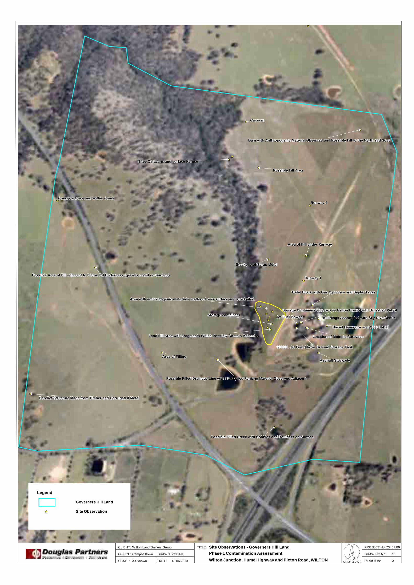
TITLE:
OFFICE:
DATE:SCALE:
DRAWN BY:
CLIENT:
REVISION:
PROJECT No:
DRAWING No: 11
Site Observations - Governers Hill LandWilton Land Owners Group
As Shown
BAHCampbelltown
18.06.2013 A
73467.00
Phase 1 Contamination Assessment
Wilton Junction, Hume Highway and Picton Road, WILTONMGA94 Z56
N
Legend
Governers Hill Land
Site Observation

0 1,000
meters
TITLE:
OFFICE:
DATE:SCALE:
DRAWN BY:
CLIENT:
REVISION:
PROJECT No:
DRAWING No: 12
Site Observations - Bradcorp LandWilton Land Owners Group
As Shown
BAHCampbelltown
19.06.2013 A
73467.00
Phase 1 Contamination Assessment
Wilton Junction, Hume Highway and Picton Road, WILTONMGA94 Z56
N
Legend
Governers Hill Land
Site Observation

2,000
meters
0
TITLE:
OFFICE:
DATE:SCALE:
DRAWN BY:
CLIENT:
REVISION:
PROJECT No:
DRAWING No: 13
Areas of Environmental ConcernWilton Land Owners Group
As Shown
BAHCampbelltown
19.06.2013 A
73467.00
Phase 1 Contamination Assessment
Wilton Junction, Hume Highway and Picton Road, WILTONMGA94 Z56
N

Appendix C
Photographs

Site Photographs PROJECT: 76467.00
Phase 1 Contamination Assessment PLATE No: 1
Wilton Junction, Wilton REV: A
CLIENT: Elton Consulting Pty Ltd DATE: 24-Jun-13
Photo 1 - AEC 20
Photo 2 - AEC 21

Site Photographs PROJECT: 76467.00
Phase 1 Contamination Assessment PLATE No: 1
Wilton Junction, Wilton REV: A
CLIENT: Elton Consulting Pty Ltd DATE: 24-Jun-13
Photo 4 - AEC 31 and AEC 32
Photo 3 - AEC 29

Site Photographs PROJECT: 76467.00
Phase 1 Contamination Assessment PLATE No: 1
Wilton Junction, Wilton REV: A
CLIENT: Elton Consulting Pty Ltd DATE: 24-Jun-13
Photo 5 - AEC 33
Photo 6 - Excavation observed within railcorridor in Bradcorp Land (PAEC 18 - 20)

Site Photographs PROJECT: 76467.00
Phase 1 Contamination Assessment PLATE No: 1
Wilton Junction, Wilton REV: A
CLIENT: Elton Consulting Pty Ltd DATE: 24-Jun-13
Photo 7 - Hay Shed in Bradcorp Land
Photo 8 - AEC9

Site Photographs PROJECT: 76467.00
Phase 1 Contamination Assessment PLATE No: 1
Wilton Junction, Wilton REV: A
CLIENT: Elton Consulting Pty Ltd DATE: 24-Jun-13
Photo 9 - Deisel AST within AEC38
Photo 10 - Buildings associated with the Airfeild operations (Within AEC38)

Site Photographs PROJECT: 76467.00
Phase 1 Contamination Assessment PLATE No: 1
Wilton Junction, Wilton REV: A
CLIENT: Elton Consulting Pty Ltd DATE: 24-Jun-13
Photo 11 - 30000 L Jet Fuel AST (Within AEC38)
Photo 12 - Jet Fuel Bowser

Site Photographs PROJECT: 76467.00
Phase 1 Contamination Assessment PLATE No: 1
Wilton Junction, Wilton REV: A
CLIENT: Elton Consulting Pty Ltd DATE: 24-Jun-13
Photo 13 - 44 Gallon Drums of Unleaded Petrol with storage container adjacent to Jet Fuel Tank.
Photo 14 - Runway

Site Photographs PROJECT: 76467.00
Phase 1 Contamination Assessment PLATE No: 1
Wilton Junction, Wilton REV: A
CLIENT: Elton Consulting Pty Ltd DATE: 24-Jun-13
Photo 15 - Surface anthropogenic refuse (AEC53)
Photo 16 - AEC53

Site Photographs PROJECT: 76467.00
Phase 1 Contamination Assessment PLATE No: 1
Wilton Junction, Wilton REV: A
CLIENT: Elton Consulting Pty Ltd DATE: 24-Jun-13
Photo 17 - Land Fill within AEC53
Photo 18 - Land Fill within AEC53

Appendix D
PAEC Logs

Potential AEC Identification and Inspection
PAEC Identification & Inspection Log Client: Elton Consulting Project Number: 73467.00 Project: Phase 1 Contamination Assessment Date: 30/05/13 Location: Wilton Junction Logged: BAH
Location:
Property: Picton Road, Wilton Junction GPS Coordinates
Grid Ref: Easting: 284837.8
PAEC #: 1 Northing: 6212874
Identified from:
Site Inspection Conductivity Data Other (list below): Title Deed info. Interviews Council Records Geotechnical Aerial Photography √ Historical Society Year: 1984
Details:
Construction of Railway Bridge within railway corridor.
Follow up:
Site Inspection
Inspection Details:
Inspected by: BAH Photographed: Yes Date Inspected: 04/06/13 Inspection Method: Site walkover
Observations:
Semi constructed bridge with large soil mound/embankment.
Reasoning: Classified as an AEC ?
Imported filling within mound. Yes √ No

Potential AEC Identification and Inspection
PAEC Identification & Inspection Log Client: Elton Consulting Project Number: 73467.00 Project: Phase 1 Contamination Assessment Date: 30/05/13 Location: Wilton Junction Logged: BAH
Location:
Property: Picton Road, Wilton Junction GPS Coordinates
Grid Ref: Easting: 284330.31
PAEC #: 2 Northing: 6212396.51
Identified from:
Site Inspection Conductivity Data Other (list below): Title Deed info. Interviews Council Records Geotechnical Aerial Photography √ Historical Society Year: 2005
Details:
Ground disturbance.
Follow up:
Site inspection
Inspection Details:
Inspected by: Photographed: Date Inspected: Inspection Method: Outside accessible
land
Observations:
Reasoning: Classified as an AEC ?
Yes No

Potential AEC Identification and Inspection
PAEC Identification & Inspection Log Client: Elton Consulting Project Number: 73467.00 Project: Phase 1 Contamination Assessment Date: 30/05/13 Location: Wilton Junction Logged: BAH
Location:
Property: Picton Road, Wilton Junction GPS Coordinates
Grid Ref: Easting: 283625.89
PAEC #: 3 Northing: 6211899.68
Identified from:
Site Inspection Conductivity Data Other (list below): Title Deed info. Interviews Council Records Geotechnical Aerial Photography √ Historical Society Year: 1961
Details:
Ground Disturbance
Follow up:
Site inspection
Inspection Details:
Inspected by: Photographed: Date Inspected: Inspection Method: Outside Accessible
Land
Observations:
Reasoning: Classified as an AEC ?
No

Potential AEC Identification and Inspection
PAEC Identification & Inspection Log Client: Elton Consulting Project Number: 73467.00 Project: Phase 1 Contamination Assessment Date: 30/05/13 Location: Wilton Junction Logged: BAH
Location:
Property: Picton Road, Wilton Junction GPS Coordinates
Grid Ref: Easting: 283541.2
PAEC #: 4 Northing: 6210598.35
Identified from:
Site Inspection Conductivity Data Other (list below): Title Deed info. Interviews Council Records Geotechnical Aerial Photography √ Historical Society Year: 1961
Details:
Possible Disturbance
Follow up:
Site Inspection.
Inspection Details:
Inspected by: Photographed: Date Inspected: Inspection Method: Outside Accessible
Land
Observations:
Reasoning: Classified as an AEC ?
Yes No

Potential AEC Identification and Inspection
PAEC Identification & Inspection Log Client: Elton Consulting Project Number: 73467.00 Project: Phase 1 Contamination Assessment Date: 30/05/13 Location: Wilton Junction Logged: BAH
Location:
Property: Picton Road, Wilton Junction GPS Coordinates
Grid Ref: Easting: 283693.5
PAEC #: 5 Northing: 6210229.77
Identified from:
Site Inspection Conductivity Data Other (list below): Title Deed info. Interviews Council Records Geotechnical Aerial Photography √ Historical Society Year: 1975
Details:
Ground Disturbance
Follow up:
Site inspection
Inspection Details:
Inspected by: Photographed: Date Inspected: Inspection Method: Outside Accessible
land
Observations:
Reasoning: Classified as an AEC ?
Yes No

Potential AEC Identification and Inspection
PAEC Identification & Inspection Log Client: Elton Consulting Project Number: 73467.00 Project: Phase 1 Contamination Assessment Date: 30/05/13 Location: Wilton Junction Logged: BAH
Location:
Property: Picton Road, Wilton Junction GPS Coordinates
Grid Ref: Easting: 283860.75
PAEC #: 6 Northing: 6210174.96
Identified from:
Site Inspection Conductivity Data Other (list below): Title Deed info. Interviews Council Records Geotechnical Aerial Photography √ Historical Society Year: 1975
Details:
Ground Disturbance
Follow up:
Site inspection
Inspection Details:
Inspected by: Photographed: Date Inspected: Inspection Method: Outside Accessible
Land
Observations:
Reasoning: Classified as an AEC ?
Yes No

Potential AEC Identification and Inspection
PAEC Identification & Inspection Log Client: Elton Consulting Project Number: 73467.00 Project: Phase 1 Contamination Assessment Date: 30/05/13 Location: Wilton Junction Logged: BAH
Location:
Property: Picton Road, Wilton Junction GPS Coordinates
Grid Ref: Easting: 283943.29
PAEC #: 7 Northing: 6211905.77
Identified from:
Site Inspection Conductivity Data Other (list below): Title Deed info. Interviews Council Records Geotechnical Aerial Photography √ Historical Society Year: 1984
Details:
Ground Disturbance in relation to construction of Picton Rd
Follow up:
Site inspection
Inspection Details:
Inspected by: Photographed: Date Inspected: Inspection Method: Outside Accessible
land
Observations:
Reasoning: Classified as an AEC ?
Yes No

Potential AEC Identification and Inspection
PAEC Identification & Inspection Log Client: Elton Consulting Project Number: 73467.00 Project: Phase 1 Contamination Assessment Date: 30/05/13 Location: Wilton Junction Logged: BAH
Location:
Property: Picton Road, Wilton Junction GPS Coordinates
Grid Ref: Easting: 283902.47
PAEC #: 8 Northing: 6211093.66
Identified from:
Site Inspection Conductivity Data Other (list below): Title Deed info. Interviews Council Records Geotechnical Aerial Photography √ Historical Society Year: 2005
Details:
Ground Disturbance.
Follow up:
Site inspection
Inspection Details:
Inspected by: Photographed: Date Inspected: Inspection Method: Outside Accessible
Land
Observations:
Reasoning: Classified as an AEC ?
Yes No

Potential AEC Identification and Inspection
PAEC Identification & Inspection Log Client: Elton Consulting Project Number: 73467.00 Project: Phase 1 Contamination Assessment Date: 30/05/13 Location: Wilton Junction Logged: BAH
Location:
Property: Picton Road, Wilton Junction GPS Coordinates
Grid Ref: Easting: 285900.17
PAEC #: 9 Northing: 6211272.18
Identified from:
Site Inspection Conductivity Data Other (list below): Title Deed info. Interviews Council Records Geotechnical Aerial Photography √ Historical Society Year: 1961
Details:
Ground Disturbance.
Follow up:
Site inspection
Inspection Details:
Inspected by: BAH Photographed: Yes Date Inspected: 04/06/13 Inspection Method: Site walkover.
Observations:
Possible cut and fill was observed to create access trail.
Reasoning: Classified as an AEC ?
Need to confirm cut & fill and that no Yes √ anthropogenic material is in fill. No

Potential AEC Identification and Inspection
PAEC Identification & Inspection Log Client: Elton Consulting Project Number: 73467.00 Project: Phase 1 Contamination Assessment Date: 30/05/13 Location: Wilton Junction Logged: BAH
Location:
Property: Picton Road, Wilton Junction GPS Coordinates
Grid Ref: Easting: 284200.09
PAEC #: 10 Northing: 6210704.35
Identified from:
Site Inspection Conductivity Data Other (list below): Title Deed info. Interviews Council Records Geotechnical Aerial Photography √ Historical Society Year: 1961
Details:
Ground Disturbance.
Follow up:
Site inspection
Inspection Details:
Inspected by: Photographed: Date Inspected: Inspection Method: Outside Accessible
Land
Observations:
Reasoning: Classified as an AEC ?
Yes No

Potential AEC Identification and Inspection
PAEC Identification & Inspection Log Client: Elton Consulting Project Number: 73467.00 Project: Phase 1 Contamination Assessment Date: 30/05/13 Location: Wilton Junction Logged: BAH
Location:
Property: Picton Road, Wilton Junction GPS Coordinates
Grid Ref: Easting: 284313.1
PAEC #: 11 Northing: 6210854.23
Identified from:
Site Inspection Conductivity Data Other (list below): Title Deed info. Interviews Council Records Geotechnical Aerial Photography √ Historical Society Year: 1975
Details:
Small shed/demolished
Follow up:
Site inspection
Inspection Details:
Inspected by: BAH Photographed: Yes Date Inspected: 04/06/13 Inspection Method: Site walkover
Observations:
Area of flat grass with possible cut to level area. (Possibly location of former shed)
Reasoning: Classified as an AEC ?
Possible demolished shed. Yes √ No

Potential AEC Identification and Inspection
PAEC Identification & Inspection Log Client: Elton Consulting Project Number: 73467.00 Project: Phase 1 Contamination Assessment Date: 30/05/13 Location: Wilton Junction Logged: BAH
Location:
Property: Picton Road, Wilton Junction GPS Coordinates
Grid Ref: Easting: 285503.54
PAEC #: 12 Northing: 6210678.78
Identified from:
Site Inspection Conductivity Data Other (list below): Title Deed info. Interviews Council Records Geotechnical Aerial Photography √ Historical Society Year: 1975
Details:
Ground Disturbance.
Follow up:
Site inspection
Inspection Details:
Inspected by: BAH Photographed: Yes Date Inspected: 04-05/06/13 Inspection Method: Site walkover
Observations:
Area of manicured lawn. Is located within “drop zone” area for sky divers.
No signs of previous runway/ground disturbance.
Reasoning: Classified as an AEC ?
Possible former runway present. (Possible filling) Yes √ No

Potential AEC Identification and Inspection
PAEC Identification & Inspection Log Client: Elton Consulting Project Number: 73467.00 Project: Phase 1 Contamination Assessment Date: 30/05/13 Location: Wilton Junction Logged: BAH
Location:
Property: Picton Road, Wilton Junction GPS Coordinates
Grid Ref: Easting: 285388.09
PAEC #: 13 Northing: 6211303.85
Identified from:
Site Inspection Conductivity Data Other (list below): Title Deed info. Interviews Council Records Geotechnical Aerial Photography √ Historical Society Year: 1975
Details:
Dirt Track
Follow up:
Site inspection
Inspection Details:
Inspected by: BAH Photographed: Yes Date Inspected: 05/06/13 Inspection Method: Site walkover
Observations:
No sign of previous dirt track.
Reasoning: Classified as an AEC ?
Previous dirt track use. Yes √ May have possible surface contamination. No

Potential AEC Identification and Inspection
PAEC Identification & Inspection Log Client: Elton Consulting Project Number: 73467.00 Project: Phase 1 Contamination Assessment Date: 30/05/13 Location: Wilton Junction Logged: BAH
Location:
Property: Picton Road, Wilton Junction GPS Coordinates
Grid Ref: Easting: 285389.3
PAEC #: 14 Northing: 6210873.12
Identified from:
Site Inspection Conductivity Data Other (list below): Title Deed info. Interviews Council Records Geotechnical Aerial Photography √ Historical Society Year: 1984
Details:
Ground Disturbance Airport / runway
Follow up:
Site inspection
Inspection Details:
Inspected by: BAH Photographed: Yes Date Inspected: 05/06/13 Inspection Method: Site walkover
Observations:
Portions of the runway were covered with roadbase gravel. Fill was observed in
areas of the runway.
Reasoning: Classified as an AEC ?
Fill & runway use. Yes √ Possible surface contamination within filling. No

Potential AEC Identification and Inspection
PAEC Identification & Inspection Log Client: Elton Consulting Project Number: 73467.00 Project: Phase 1 Contamination Assessment Date: 30/05/13 Location: Wilton Junction Logged: BAH
Location:
Property: Picton Road, Wilton Junction GPS Coordinates
Grid Ref: Easting: 285094.44
PAEC #: 15 Northing: 6210070.15
Identified from:
Site Inspection Conductivity Data Other (list below): Title Deed info. Interviews Council Records Geotechnical Aerial Photography √ Historical Society Year: 1984
Details:
Previous Road demolished
Follow up:
Site inspection
Inspection Details:
Inspected by: BAH Photographed: Yes Date Inspected: 05/06/13 Inspection Method: Site walkover
Observations:
No obvious signs of previous land use.
Reasoning: Classified as an AEC ?
Previous road area. Yes √ No

Potential AEC Identification and Inspection
PAEC Identification & Inspection Log Client: Elton Consulting Project Number: 73467.00 Project: Phase 1 Contamination Assessment Date: 30/05/13 Location: Wilton Junction Logged: BAH
Location:
Property: Picton Road, Wilton Junction GPS Coordinates
Grid Ref: Easting: 284267.09
PAEC #: 16 Northing: 6211514.64
Identified from:
Site Inspection Conductivity Data Other (list below): Title Deed info. Interviews Council Records Geotechnical Aerial Photography √ Historical Society Year: 1984
Details:
Ground Disturbance
Follow up:
Site inspection
Inspection Details:
Inspected by: BAH Photographed: Yes Date Inspected: 30/05/13 Inspection Method: Site walkover
Observations:
Signs of former ground disturbance. Some very minor surface litter observed.
Reasoning: Classified as an AEC ?
Ground disturbance from construction of Picton Yes √ Road. No

Potential AEC Identification and Inspection
PAEC Identification & Inspection Log Client: Elton Consulting Project Number: 73467.00 Project: Phase 1 Contamination Assessment Date: 30/05/13 Location: Wilton Junction Logged: BAH
Location:
Property: Picton Road, Wilton Junction GPS Coordinates
Grid Ref: Easting: 285693.31
PAEC #: 17 Northing: 6211383.04
Identified from:
Site Inspection Conductivity Data Other (list below): Title Deed info. Interviews Council Records Geotechnical Aerial Photography √ Historical Society Year: 1984
Details:
Ground Disturbance
Follow up:
Site inspection
Inspection Details:
Inspected by: BAH Photographed: Yes Date Inspected: 04/06/13 Inspection Method: Site walkover
Observations:
Stockpile of crushed shale.
Reasoning: Classified as an AEC ?
Stockpile of crushed shale. Yes √ No

Potential AEC Identification and Inspection
PAEC Identification & Inspection Log Client: Elton Consulting Project Number: 73467.00 Project: Phase 1 Contamination Assessment Date: 30/05/13 Location: Wilton Junction Logged: BAH
Location:
Property: Picton Road, Wilton Junction GPS Coordinates
Grid Ref: Easting: 285746.01
PAEC #: 18 Northing: 6211048.58
Identified from:
Site Inspection Conductivity Data Other (list below): Title Deed info. Interviews Council Records Geotechnical Aerial Photography √ Historical Society Year: 1984
Details:
Possible Dam or Disturbance
Follow up:
Site inspection
Inspection Details:
Inspected by: BAH Photographed: Yes Date Inspected: 04/06/13 Inspection Method: Site walkover
Observations:
Large excavation/trench observed (refer photograph)
Reasoning: Classified as an AEC ?
Large excavation. Yes No √

Potential AEC Identification and Inspection
PAEC Identification & Inspection Log Client: Elton Consulting Project Number: 73467.00 Project: Phase 1 Contamination Assessment Date: 30/05/13 Location: Wilton Junction Logged: BAH
Location:
Property: Picton Road, Wilton Junction GPS Coordinates
Grid Ref: Easting: 285788.66
PAEC #: 19 Northing: 6210935.86
Identified from:
Site Inspection Conductivity Data Other (list below): Title Deed info. Interviews Council Records Geotechnical Aerial Photography √ Historical Society Year: 1984
Details:
Ground Disturbances or stockpiles
Follow up:
Site inspection
Inspection Details:
Inspected by: BAH Photographed: Yes Date Inspected: 04/06/13 Inspection Method: Site walkover
Observations:
Large excavation into natural soil.
Reasoning: Classified as an AEC ?
Large excavation into natural soil. Yes No √

Potential AEC Identification and Inspection
PAEC Identification & Inspection Log Client: Elton Consulting Project Number: 73467.00 Project: Phase 1 Contamination Assessment Date: 30/05/13 Location: Wilton Junction Logged: BAH
Location:
Property: Picton Road, Wilton Junction GPS Coordinates
Grid Ref: Easting: 285461.2
PAEC #: 20 Northing: 6211738.84
Identified from:
Site Inspection Conductivity Data Other (list below): Title Deed info. Interviews Council Records Geotechnical Aerial Photography √ Historical Society Year: 1984
Details:
Stockpiles / Storage of materials along access road
Follow up:
Site inspection
Inspection Details:
Inspected by: BAH Photographed: Yes Date Inspected: 04/06/13 Inspection Method: Site walkover
Observations:
Large excavation into natural material (Refer photograph)
Reasoning: Classified as an AEC ?
Excavation into natural material. Yes No √

Potential AEC Identification and Inspection
PAEC Identification & Inspection Log Client: Elton Consulting Project Number: 73467.00 Project: Phase 1 Contamination Assessment Date: 30/05/13 Location: Wilton Junction Logged: BAH
Location:
Property: Picton Road, Wilton Junction GPS Coordinates
Grid Ref: Easting: 285355.49
PAEC #: 21 Northing: 6211145.44
Identified from:
Site Inspection Conductivity Data Other (list below): Title Deed info. Interviews Council Records Geotechnical Aerial Photography √ Historical Society Year: 1990
Details:
Ground disturbance in vicinity of airport
Follow up:
Site inspection
Inspection Details:
Inspected by: BAH Photographed: Yes Date Inspected: 05/06/13 Inspection Method: Site walkover
Observations:
Second runway.
Reasoning: Classified as an AEC ?
Possible surface contaminants and possible filling in areas.
Yes √ No

Potential AEC Identification and Inspection
PAEC Identification & Inspection Log Client: Elton Consulting Project Number: 73467.00 Project: Phase 1 Contamination Assessment Date: 30/05/13 Location: Picton Road, Wilton Junction Logged: BAH
Location:
Property: Picton Road, Wilton Junction GPS Coordinates
Grid Ref: Easting: 284581.31
PAEC #: 22 Northing: 6210882.25
Identified from:
Site Inspection Conductivity Data Other (list below): Title Deed info. Interviews Council Records Geotechnical Aerial Photography √ Historical Society Year: 1984
Details:
Ground disturbance.
Follow up:
Site inspection.
Inspection Details:
Inspected by: BAH Photographed: Yes Date Inspected: 05/06/12 Inspection Method: Site walkover
Observations:
Underpass and dam observed in area
Reasoning: Classified as an AEC ?
Dam not ground disturbance. Yes No √

Potential AEC Identification and Inspection
PAEC Identification & Inspection Log Client: Elton Consulting Project Number: 73467.00 Project: Phase 1 Contamination Assessment Date: 30/05/13 Location: Picton Road, Wilton Junction Logged: BAH
Location:
Property: Picton Road, Wilton Junction GPS Coordinates
Grid Ref: Easting: 284660.21
PAEC #: 23 Northing: 6211858.25
Identified from:
Site Inspection Conductivity Data Other (list below): Title Deed info. Interviews Council Records Geotechnical Aerial Photography √ Historical Society Year: 2005
Details:
Ground Disturbance
Follow up:
Site inspection
Inspection Details:
Inspected by: BAH Photographed: Yes Date Inspected: 04/06/13 Inspection Method: Site walkover
Observations:
In the area of the BHP Billiton monitoring well.
Reasoning: Classified as an AEC ?
Ground disturbance from construction of monitoring well.
Yes
No √

Potential AEC Identification and Inspection
PAEC Identification & Inspection Log Client: Elton Consulting Project Number: 73467.00 Project: Phase 1 Contamination Assessment Date: 30/05/13 Location: Picton Road, Wilton Junction Logged: BAH
Location:
Property: Picton Road, Wilton Junction GPS Coordinates
Grid Ref: Easting: 285740.99
PAEC #: 24 Northing: 6211110.11
Identified from:
Site Inspection Conductivity Data Other (list below): Title Deed info. Interviews Council Records Geotechnical Aerial Photography √ Historical Society Year: 2005
Details:
Ground Disturbance along access road
Follow up:
Site inspection
Inspection Details:
Inspected by: BAH Photographed: Yes Date Inspected: 04/06/13 Inspection Method: Site walkover.
Observations:
Large excavation / Trench observed.
Reasoning: Classified as an AEC ?
Excavation. Yes No √

Potential AEC Identification and Inspection
PAEC Identification & Inspection Log Client: Elton Consulting Project Number: 73467.00 Project: Phase 1 Contamination Assessment Date: 30/05/13 Location: Picton Road, Wilton Junction Logged: BAH
Location:
Property: Picton Road, Wilton Junction GPS Coordinates
Grid Ref: Easting: 286356.32
PAEC #: 25 Northing: 6211712.03
Identified from:
Site Inspection Conductivity Data Other (list below): Title Deed info. Interviews Council Records Geotechnical Aerial Photography √ Historical Society Year: 1955
Details:
Small Ground Disturbance
Follow up:
Site inspection
Inspection Details:
Inspected by: BAH Photographed: Yes Date Inspected: 04/06/13 Inspection Method: Site walkover
Observations:
Creek observed with potential fill in southern end.
Reasoning: Classified as an AEC ?
Possible fill in south of creek. Yes √ No

Potential AEC Identification and Inspection
PAEC Identification & Inspection Log Client: Elton Consulting Project Number: 73467.00 Project: Phase 1 Contamination Assessment Date: 30/05/13 Location: Picton Road, Wilton Junction Logged: BAH
Location:
Property: Picton Road, Wilton Junction GPS Coordinates
Grid Ref: Easting: 286648.75
PAEC #: 26 Northing: 6211888.71
Identified from:
Site Inspection Conductivity Data Other (list below): Title Deed info. Interviews Council Records Geotechnical Aerial Photography √ Historical Society Year: 1961
Details:
Land clearing/logging
Follow up:
Site inspection
Inspection Details:
Inspected by: BAH Photographed: Yes Date Inspected: 05/06/13 Inspection Method: Site walkover
Observations:
No sign of contamination observed.
Reasoning: Classified as an AEC ?
No sign of contamination observed. Yes No √

Potential AEC Identification and Inspection
PAEC Identification & Inspection Log Client: Elton Consulting Project Number: 73467.00 Project: Phase 1 Contamination Assessment Date: 30/05/13 Location: Picton Road, Wilton Junction Logged: BAH
Location:
Property: Picton Road, Wilton Junction GPS Coordinates
Grid Ref: Easting: 286301.32
PAEC #: 27 Northing: 6209693.03
Identified from:
Site Inspection Conductivity Data Other (list below): Title Deed info. Interviews Council Records Geotechnical Aerial Photography √ Historical Society Year: 1984
Details:
Ground Disturbance
Follow up:
Site inspection
Inspection Details:
Inspected by: BAH Photographed: Yes Date Inspected: 03/06/13 Inspection Method: Site walkover
Observations:
Gas easement.
Reasoning: Classified as an AEC ?
Not AEC – Gas easement. Yes No ×

Potential AEC Identification and Inspection
PAEC Identification & Inspection Log Client: Elton Consulting Project Number: 73467.00 Project: Phase 1 Contamination Assessment Date: 30/05/13 Location: Picton Road, Wilton Junction Logged: BAH
Location:
Property: Picton Road, Wilton Junction GPS Coordinates
Grid Ref: Easting: 285893.75
PAEC #: 28 Northing: 6209091.1
Identified from:
Site Inspection Conductivity Data Other (list below): Title Deed info. Interviews Council Records Geotechnical Aerial Photography √ Historical Society Year: 1961
Details:
Ground disturbance.
Follow up:
Site inspection.
Inspection Details:
Inspected by: BAH Photographed: Yes Date Inspected: 30/05/13 Inspection Method: Site walkover
Observations:
No sign of ground disturbance.
Reasoning: Classified as an AEC ?
Ground disturbance observed in aerial photograph.
Yes √ No

Potential AEC Identification and Inspection
PAEC Identification & Inspection Log Client: Elton Consulting Project Number: 73467.00 Project: Phase 1 Contamination Assessment Date: 30/05/13 Location: Picton Road, Wilton Junction Logged: BAH
Location:
Property: Picton Road, Wilton Junction GPS Coordinates
Grid Ref: Easting: 284425.49
PAEC #: 29 Northing: 6209968.4
Identified from:
Site Inspection Conductivity Data Other (list below): Title Deed info. Interviews Council Records Geotechnical Aerial Photography √ Historical Society Year: 1984
Details:
Ground Disturbance
Follow up:
Site Inspection
Inspection Details:
Inspected by: Photographed: Date Inspected: Inspection Method: Outside Accessible
Land
Observations:
Reasoning: Classified as an AEC ?
Yes No

Potential AEC Identification and Inspection
PAEC Identification & Inspection Log Client: Elton Consulting Project Number: 73467.00 Project: Phase 1 Contamination Assessment Date: 19/02/13 Location: Picton Road, Wilton Junction Logged: BAH
Location:
Property: Picton Road, Wilton Junction GPS Coordinates
Grid Ref: Easting: 284251.85
PAEC #: 30 Northing: 6209537.37
Identified from:
Site Inspection Conductivity Data Other (list below): Title Deed info. Interviews Council Records Geotechnical Aerial Photography Historical Society Year: 1984
Details:
ground disturbance
Follow up:
Inspection Details:
Inspected by: Photographed: Date Inspected: Inspection Method: Outside Accessible
Land
Observations:
Reasoning: Classified as an AEC ?
Yes No

Potential AEC Identification and Inspection
PAEC Identification & Inspection Log Client: Elton Consulting Project Number: 73467.00 Project: Phase 1 Contamination Assessment Date: 30/05/13 Location: Picton Road, Wilton Junction Logged: BAH
Location:
Property: Picton Road, Wilton Junction GPS Coordinates
Grid Ref: Easting: 284902.22
PAEC #: 31 Northing: 6209281.48
Identified from:
Site Inspection Conductivity Data Other (list below): Title Deed info. Interviews Council Records Geotechnical Aerial Photography √ Historical Society Year: 1965
Details:
Ground disturbance adjacent to Hume highway.
Follow up:
Site inspection
Inspection Details:
Inspected by: Photographed: Date Inspected: Inspection Method: Outside Accessible
Land
Observations:
Reasoning: Classified as an AEC ?
Yes No

Potential AEC Identification and Inspection
PAEC Identification & Inspection Log Client: Elton Consulting Project Number: 73467.00 Project: Phase 1 Contamination Assessment Date: 30/05/13 Location: Picton Road, Wilton Junction Logged: BAH
Location:
Property: Picton Road, Wilton Junction GPS Coordinates
Grid Ref: Easting: 285117.74
PAEC #: 32 Northing: 6209722.42
Identified from:
Site Inspection Conductivity Data Other (list below): Title Deed info. Interviews Council Records Geotechnical Aerial Photography √ Historical Society Year: 1984
Details:
Ground disturbance adjacent to Hume highway.
Follow up:
Site inspection
Inspection Details:
Inspected by: Photographed: Date Inspected: Inspection Method: Outside Accessible
land
Observations:
Reasoning: Classified as an AEC ?
Yes No
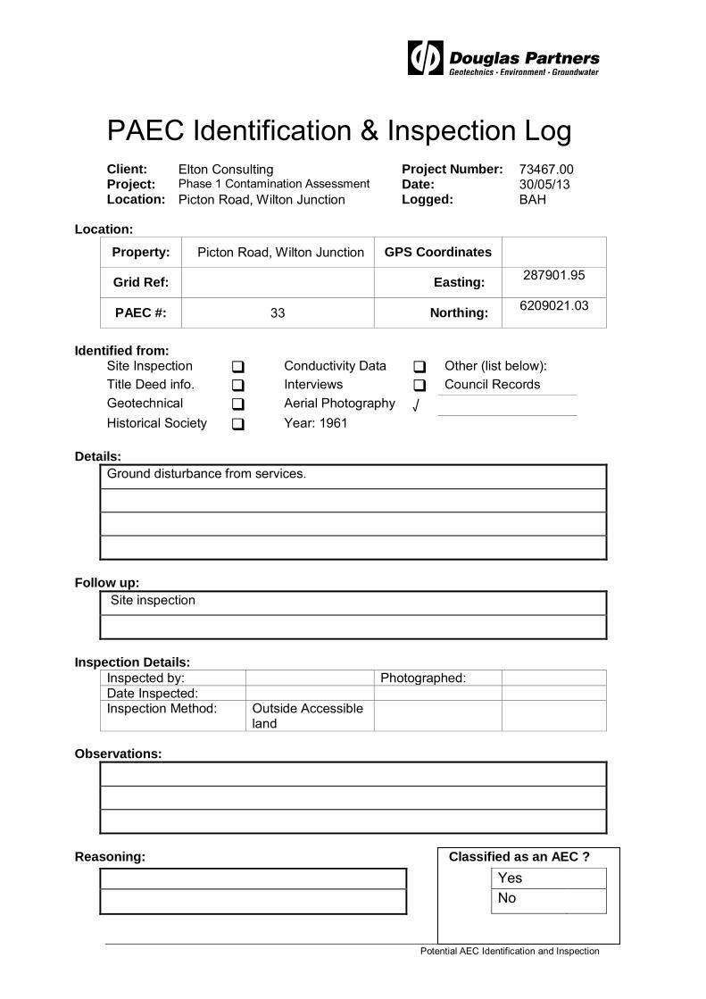
Potential AEC Identification and Inspection
PAEC Identification & Inspection Log Client: Elton Consulting Project Number: 73467.00 Project: Phase 1 Contamination Assessment Date: 30/05/13 Location: Picton Road, Wilton Junction Logged: BAH
Location:
Property: Picton Road, Wilton Junction GPS Coordinates
Grid Ref: Easting: 287901.95
PAEC #: 33 Northing: 6209021.03
Identified from:
Site Inspection Conductivity Data Other (list below): Title Deed info. Interviews Council Records Geotechnical Aerial Photography √ Historical Society Year: 1961
Details:
Ground disturbance from services.
Follow up:
Site inspection
Inspection Details:
Inspected by: Photographed: Date Inspected: Inspection Method: Outside Accessible
land
Observations:
Reasoning: Classified as an AEC ?
Yes No

Potential AEC Identification and Inspection
PAEC Identification & Inspection Log Client: Elton Consulting Project Number: 73467.00 Project: Phase 1 Contamination Assessment Date: 30/05/13 Location: Picton Road, Wilton Junction Logged: BAH
Location:
Property: Picton Road, Wilton Junction GPS Coordinates
Grid Ref: Easting: 287338.41
PAEC #: 34 Northing: 6208670.72
Identified from:
Site Inspection Conductivity Data Other (list below): Title Deed info. Interviews Council Records Geotechnical Aerial Photography √ Historical Society Year: 1961
Details:
Ground disturbance
Follow up:
Site inspection
Inspection Details:
Inspected by: BAH Photographed: Yes Date Inspected: 30/05/13 Inspection Method: Site walkover
Observations:
Ground disturbances – Bare earth observed.
Reasoning: Classified as an AEC ?
Bare earth observed. Yes √ No

Potential AEC Identification and Inspection
PAEC Identification & Inspection Log Client: Elton Consulting Project Number: 73467.00 Project: Phase 1 Contamination Assessment Date: 30/05/13 Location: Picton Road, Wilton Junction Logged: BAH
Location:
Property: Picton Road, Wilton Junction GPS Coordinates
Grid Ref: Easting: 287234.83
PAEC #: 35 Northing: 6208667.68
Identified from:
Site Inspection Conductivity Data Other (list below): Title Deed info. Interviews Council Records Geotechnical Aerial Photography √ Historical Society Year: 2005
Details:
Oval track - ground disturbance
Follow up:
Site inspection
Inspection Details:
Inspected by: BAH Photographed: Yes Date Inspected: 05/06/13 Inspection Method: Site walkover
Observations:
Oval track observed with five small structures adjacent to track.
Road base was observed on surface. Filling was also observed in parts of track.
Reasoning: Classified as an AEC ?
Oval track & small structures observed with road base gravels on surface.
Yes √
No

Potential AEC Identification and Inspection
PAEC Identification & Inspection Log Client: Elton Consulting Project Number: 73467.00 Project: Phase 1 Contamination Assessment Date: 30/05/13 Location: Picton Road, Wilton Junction Logged: BAH
Location:
Property: Picton Road, Wilton Junction GPS Coordinates
Grid Ref: Easting: 288532.51
PAEC #: 36 Northing: 6209307.37
Identified from:
Site Inspection Conductivity Data Other (list below): Title Deed info. Interviews Council Records Geotechnical Aerial Photography √ Historical Society Year: 1961
Details:
land clearing / logging
Follow up:
Site inspection
Inspection Details:
Inspected by: Photographed: Date Inspected: Inspection Method: Outside Accessible
land
Observations:
Reasoning: Classified as an AEC ?
Yes No

Potential AEC Identification and Inspection
PAEC Identification & Inspection Log Client: Elton Consulting Project Number: 73467.00 Project: Phase 1 Contamination Assessment Date: 30/05/13 Location: Picton Road, Wilton Junction Logged: BAH
Location:
Property: Picton Road, Wilton Junction GPS Coordinates
Grid Ref: Easting: 287981.15
PAEC #: 37 Northing: 6206712.02
Identified from:
Site Inspection Conductivity Data Other (list below): Title Deed info. Interviews Council Records Geotechnical Aerial Photography √ Historical Society Year: 1975
Details:
Ground Disturbance
Follow up:
Site inspection
Inspection Details:
Inspected by: BAH Photographed: Yes Date Inspected: 04/06/13 Inspection Method: Site Walk Over
Observations:
Some gravel noted on surface.
Reasoning: Classified as an AEC ?
Further investigation is required. Yes √ No

Potential AEC Identification and Inspection
PAEC Identification & Inspection Log Client: Elton Consulting Project Number: 73467.00 Project: Phase 1 Contamination Assessment Date: 30/05/13 Location: Picton Road, Wilton Junction Logged: BAH
Location:
Property: Picton Road, Wilton Junction GPS Coordinates
Grid Ref: Easting: 288133.46
PAEC #: 38 Northing: 6206803.41
Identified from:
Site Inspection Conductivity Data Other (list below): Title Deed info. Interviews Council Records Geotechnical Aerial Photography √ Historical Society Year: 1975
Details:
ground disturbance
Follow up:
Site inspection
Inspection Details:
Inspected by: BAH Photographed: Yes Date Inspected: 04/06/13 Inspection Method: Site Walk Over
Observations:
Reworked / ploughed ground. Some erosion noted to the west.
Reasoning: Classified as an AEC ?
Further investigation required. Yes √ No

Potential AEC Identification and Inspection
PAEC Identification & Inspection Log Client: Elton Consulting Project Number: 73467.00 Project: Phase 1 Contamination Assessment Date: 30/05/13 Location: Picton Road, Wilton Junction Logged: BAH
Location:
Property: Picton Road, Wilton Junction GPS Coordinates
Grid Ref: Easting: 287323.18
PAEC #: 39 Northing: 6207954.87
Identified from:
Site Inspection Conductivity Data Other (list below): Title Deed info. Interviews Council Records Geotechnical Aerial Photography √ Historical Society Year: 1975
Details:
house / structure demolition
Follow up:
Site inspection
Inspection Details:
Inspected by: Photographed: Date Inspected: Inspection Method: Outside Accessible
land
Observations:
Reasoning: Classified as an AEC ?
Yes No

Potential AEC Identification and Inspection
PAEC Identification & Inspection Log Client: Elton Consulting Project Number: 73467.00 Project: Phase 1 Contamination Assessment Date: 30/05/13 Location: Picton Road, Wilton Junction Logged: BAH
Location:
Property: Picton Road, Wilton Junction GPS Coordinates
Grid Ref: Easting: 289443.32
PAEC #: 40 Northing: 6206085.28
Identified from:
Site Inspection Conductivity Data Other (list below): Title Deed info. Interviews Council Records Geotechnical Aerial Photography √ Historical Society Year: 1990
Details:
possible market gardens
Follow up:
Site inspection
Inspection Details:
Inspected by: Photographed: Date Inspected: Inspection Method: Outside Accessible
land
Observations:
Reasoning: Classified as an AEC ?
Yes No

Potential AEC Identification and Inspection
PAEC Identification & Inspection Log Client: Elton Consulting Project Number: 73467.00 Project: Phase 1 Contamination Assessment Date: 30/05/13 Location: Picton Road, Wilton Junction Logged: BAH
Location:
Property: Picton Road, Wilton Junction GPS Coordinates
Grid Ref: Easting: 288525.66
PAEC #: 41 Northing: 6207561.92
Identified from:
Site Inspection Conductivity Data Other (list below): Title Deed info. Interviews Council Records Geotechnical Aerial Photography √ Historical Society Year: 1990
Details:
ground disturbance possibly from construction of Picton road
Follow up:
Site inspection
Inspection Details:
Inspected by: Photographed: Date Inspected: Inspection Method: Outside Accessible
land
Observations:
Reasoning: Classified as an AEC ?
Yes No

Potential AEC Identification and Inspection
PAEC Identification & Inspection Log Client: Elton Consulting Project Number: 73467.00 Project: Phase 1 Contamination Assessment Date: 30/05/13 Location: Picton Road, Wilton Junction Logged: BAH
Location:
Property: Picton Road, Wilton Junction GPS Coordinates
Grid Ref: Easting: 288378.37
PAEC #: 42 Northing: 6205927.63
Identified from:
Site Inspection Conductivity Data Other (list below): Title Deed info. Interviews Council Records Geotechnical Aerial Photography √ Historical Society Year: 1955
Details:
Land clearing / logging.
Follow up:
Site inspection
Inspection Details:
Inspected by: Photographed: Date Inspected: Inspection Method: Outside Accessible
land
Observations:
Reasoning: Classified as an AEC ?
Yes No

Potential AEC Identification and Inspection
PAEC Identification & Inspection Log Client: Elton Consulting Project Number: 73467.00 Project: Phase 1 Contamination Assessment Date: 30/05/13 Location: Picton Road, Wilton Junction Logged: BAH
Location:
Property: Picton Road, Wilton Junction GPS Coordinates
Grid Ref: Easting: 285307.44
PAEC #: 43 Northing: 6214230.01
Identified from:
Site Inspection Conductivity Data Other (list below): Title Deed info. Interviews Council Records Geotechnical Aerial Photography √ Historical Society Year: 1955
Details:
land clearing / logging
Follow up:
Site inspection
Inspection Details:
Inspected by: BAH Photographed: Yes Date Inspected: 05/06/13 Inspection Method: Site Walk Over
Observations:
No obvious signs of contamination observed.
Reasoning: Classified as an AEC ?
No obvious signs of contamination. Yes No √

Potential AEC Identification and Inspection
PAEC Identification & Inspection Log Client: Elton Consulting Project Number: 73467.00 Project: Phase 1 Contamination Assessment Date: 19/02/13 Location: Picton Road, Wilton Junction Logged: BAH
Location:
Property: Picton Road, Wilton Junction GPS Coordinates
Grid Ref: Easting: 286714.96
PAEC #: 44 Northing: 6213980.22
Identified from:
Site Inspection Conductivity Data Other (list below): Title Deed info. Interviews Council Records Geotechnical Aerial Photography √ Historical Society Year: 1961
Details:
land clearing / logging
Follow up:
Site inspection
Inspection Details:
Inspected by: BAH Photographed: Yes Date Inspected: 05/06/13 Inspection Method: Site walkover
Observations:
No obvious signs of contamination observed.
Reasoning: Classified as an AEC ?
No obvious signs of contamination Yes Time since land clearing. No √

Potential AEC Identification and Inspection
PAEC Identification & Inspection Log Client: Elton Consulting Project Number: 73467.00 Project: Phase 1 Contamination Assessment Date: 30/05/13 Location: Picton Rd, Wilton Junction Logged: BAH
Location:
Property: Picton Rd, Wilton Junction GPS Coordinates
Grid Ref: Easting: 284957.06
PAEC #: 45 Northing: 6212317.01
Identified from:
Site Inspection Conductivity Data Other (list below): Title Deed info. Interviews Council Records Geotechnical Aerial Photography √ Historical Society Year: 1961
Details:
land clearing / logging
Follow up:
Site inspection
Inspection Details:
Inspected by: BAH Photographed: Yes Date Inspected: 04/06/13 Inspection Method: Site walkover
Observations:
No obvious signs of contamination observed.
Reasoning: Classified as an AEC ?
No obvious sign of contamination and time since land clearing.
Yes
No √

Potential AEC Identification and Inspection
PAEC Identification & Inspection Log Client: Elton Consulting Project Number: 73467.00 Project: Phase 1 Contamination Assessment Date: 30/05/13 Location: Emerald Hill Estate Logged: BAH
Location:
Property: 1100 – 1500 Camden Valley
Way, Leppington GPS Coordinates
Grid Ref: Easting: 285605.89
PAEC #: 46 Northing: 6213017.63
Identified from:
Site Inspection Conductivity Data Other (list below): Title Deed info. Interviews Council Records Geotechnical Aerial Photography √ Historical Society Year: 1961
Details:
land clearing / logging
Follow up:
Site inspection
Inspection Details:
Inspected by: BAH Photographed: Yes Date Inspected: 04/06/13 Inspection Method: Site walkover
Observations:
No obvious signs of contamination.
Reasoning: Classified as an AEC ?
No obvious signs of contamination and time since Yes Land clearing. No √

Potential AEC Identification and Inspection
PAEC Identification & Inspection Log Client: Elton Consulting Project Number: 73467.00 Project: Phase 1 Contamination Assessment Date: 30/05/13 Location: Emerald Hill Estate Logged: BAH
Location:
Property: 1100 – 1500 Camden Valley
Way, Leppington GPS Coordinates
Grid Ref: Easting: 287019.32
PAEC #: 47 Northing: 6212725.2
Identified from:
Site Inspection Conductivity Data Other (list below): Title Deed info. Interviews Council Records Geotechnical Aerial Photography √ Historical Society Year: 1961
Details:
land clearing / logging
Follow up:
Site inspection
Inspection Details:
Inspected by: BAH Photographed: Yes Date Inspected: 04/06/13 Inspection Method: Site walkover
Observations:
No obvious signs of contamination.
Reasoning: Classified as an AEC ?
No obvious signs of contamination observed and Yes Time since land clearing. No √

Potential AEC Identification and Inspection
PAEC Identification & Inspection Log Client: Elton Consulting Project Number: 73467.00 Project: Phase 1 Contamination Assessment Date: 30/05/13 Location: Emerald Hill Estate Logged: BAH
Location:
Property: 1100 – 1500 Camden Valley
Way, Leppington GPS Coordinates
Grid Ref: Easting: 285465.38
PAEC #: 48 Northing: 6209324.57
Identified from:
Site Inspection Conductivity Data Other (list below): Title Deed info. Interviews Council Records Geotechnical Aerial Photography √ Historical Society Year: 1965
Details:
Possible filled gully and derelict bridge
Follow up:
Site inspection
Inspection Details:
Inspected by: BAH Photographed: Yes Date Inspected: 04/06/13 Inspection Method: Site walkover
Observations:
Possible filled gully with derelict bridge observed and filling at either end of bridge.
Reasoning: Classified as an AEC ?
Fill observed. Yes √ No

Potential AEC Identification and Inspection
PAEC Identification & Inspection Log Client: Elton Consulting Project Number: 73467.00 Project: Phase 1 Contamination Assessment Date: 30/05/13 Location: Picton Rd, Wilton Junction Logged: BAH
Location:
Property: Picton Rd, Wilton Junction GPS Coordinates
Grid Ref: Easting: 285566.22
PAEC #: 49 Northing: 6209245.51
Identified from:
Site Inspection √ Conductivity Data Other (list below): Title Deed info. Interviews Council Records Geotechnical Aerial Photography Historical Society Year:
Details:
Follow up:
Site inspection
Inspection Details:
Inspected by: BAH Photographed: Yes Date Inspected: 04/06/13 Inspection Method: Site walkover
Observations:
Possible area of fill, brick noted half buried with placed boulders on surface adjacent
Reasoning: Classified as an AEC ?
Area affected by possible filling. Yes √ No

Potential AEC Identification and Inspection
PAEC Identification & Inspection Log Client: Elton Consulting Project Number: 73467.00 Project: Phase 1 Contamination Assessment Date: 30/05/13 Location: Picton Rd, Wilton Junction Logged: BAH
Location:
Property: Picton Rd, Wilton Junction GPS Coordinates
Grid Ref: Easting: 285757.96
PAEC #: 50 Northing: 285757.96
Identified from:
Site Inspection √ Conductivity Data Other (list below): Title Deed info. Interviews Council Records Geotechnical Aerial Photography Historical Society Year: 1961
Details:
Follow up:
Site inspection
Inspection Details:
Inspected by: BAH Photographed: Yes Date Inspected: 05/06/13 Inspection Method: Site walkover
Observations:
Homestead/ Brick and tile construction.
Reasoning: Classified as an AEC ?
Residential buildings of brick / tile construction. Yes No √

Potential AEC Identification and Inspection
PAEC Identification & Inspection Log Client: Elton Consulting Project Number: 73467.00 Project: Phase 1 Contamination Assessment Date: 30/05/13 Location: Picton Rd, Wilton Junction Logged: BAH
Location:
Property: Picton Rd, Wilton Junction GPS Coordinates
Grid Ref: Easting: 285757.96
PAEC #: 51 Northing: 285757.96
Identified from:
Site Inspection √ Conductivity Data Other (list below): Title Deed info. Interviews Council Records Geotechnical Aerial Photography Historical Society Year:
Details:
Metal portable horse stable with mounds of imported gravel being spread over site
Follow up:
Inspection Details:
Inspected by: BAH Photographed: Yes Date Inspected: 03/06/13 Inspection Method: Site walkover
Observations:
Metal portable fencing for use with horses with mounds of imported gravel being
Spread within fenced area.
Reasoning: Classified as an AEC ?
Imported fill. Yes √ No

Potential AEC Identification and Inspection
PAEC Identification & Inspection Log Client: Elton Consulting Project Number: 73467.00 Project: Phase 1 Contamination Assessment Date: 30/05/13 Location: Picton Rd, Wilton Junction Logged: BAH
Location:
Property: Picton Rd, Wilton Junction GPS Coordinates
Grid Ref: Easting: 285718.38
PAEC #: 52 Northing: 285718.38
Identified from:
Site Inspection √ Conductivity Data Other (list below): Title Deed info. Interviews Council Records Geotechnical Aerial Photography Historical Society Year:
Details:
Machine Shed, with shipping containers, truck parked outside and small asphalt gravel stockpile
Follow up:
Site inspection
Inspection Details:
Inspected by: BAH Photographed: Yes Date Inspected: 03/06/13 Inspection Method: Site walkover
Observations:
A Machine Shed, with shipping containers, truck parked outside and small asphalt gravel
stockpile was noted during the inspection.
Reasoning: Classified as an AEC ?
Possible area of contamination further investigation required.
Yes √ No

Potential AEC Identification and Inspection
PAEC Identification & Inspection Log Client: Elton Consulting Project Number: 73467.00 Project: Phase 1 Contamination Assessment Date: 30/05/13 Location: Picton Rd, Wilton Junction Logged: BAH
Location:
Property: Picton Rd, Wilton Junction GPS Coordinates
Grid Ref: Easting: 285461.17
PAEC #: 53 Northing: 285461.17
Identified from:
Site Inspection √ Conductivity Data Other (list below): Title Deed info. Interviews Council Records Geotechnical Aerial Photography Historical Society Year:
Details:
Possibly lightly filled gully
Follow up:
Inspection Details:
Inspected by: BAH Photographed: Yes Date Inspected: 03/06/13 Inspection Method: Site walkover
Observations:
Possibly lightly filled gully
Reasoning: Classified as an AEC ?
Further investigation required. Yes √ No

Potential AEC Identification and Inspection
PAEC Identification & Inspection Log Client: Elton Consulting Project Number: 73467.00 Project: Phase 1 Contamination Assessment Date: 30/05/13 Location: Picton Rd, Wilton Junction Logged: BAH
Location:
Property: Picton Rd, Wilton Junction GPS Coordinates
Grid Ref: Easting: 285945.65
PAEC #: 54 Northing: 285945.65
Identified from:
Site Inspection √ Conductivity Data Other (list below): Title Deed info. Interviews Council Records Geotechnical Aerial Photography Historical Society Year:
Details:
Ground disturbance possibly filled small dam
Follow up:
Site inspection
Inspection Details:
Inspected by: BAH Photographed: Yes Date Inspected: 03/06/13 Inspection Method: Site walkover
Observations:
Ground disturbance possibly filled small dam
Reasoning: Classified as an AEC ?
Further investigation required. Yes √ No

Potential AEC Identification and Inspection
PAEC Identification & Inspection Log Client: Elton Consulting Project Number: 73467.00 Project: Phase 1 Contamination Assessment Date: 30/05/13 Location: Picton Rd, Wilton Junction Logged: BAH
Location:
Property: Picton Rd, Wilton Junction GPS Coordinates
Grid Ref: Easting: 286326.49
PAEC #: 55 Northing: 286326.49
Identified from:
Site Inspection √ Conductivity Data Other (list below): Title Deed info. Interviews Council Records Geotechnical Aerial Photography Historical Society Year:
Details:
Possible filled drainage line (logs observed on surface).
Follow up:
Site inspection
Inspection Details:
Inspected by: BAH Photographed: Yes Date Inspected: 03/06/13 Inspection Method: Site walkover
Observations:
Reasoning: Classified as an AEC ?
Further investigation required. Yes √ No

Potential AEC Identification and Inspection
PAEC Identification & Inspection Log Client: Elton Consulting Project Number: 73467.00 Project: Phase 1 Contamination Assessment Date: 30/05/13 Location: Picton Rd, Wilton Junction Logged: BAH
Location:
Property: Picton Rd, Wilton Junction GPS Coordinates
Grid Ref: Easting: 284255.66
PAEC #: 56 Northing: 284255.66
Identified from:
Site Inspection √ Conductivity Data Other (list below): Title Deed info. Interviews Council Records Geotechnical Aerial Photography Historical Society Year:
Details:
Derelict structure
Follow up:
Site inspection
Inspection Details:
Inspected by: BAH Photographed: Yes Date Inspected: 03/06/13 Inspection Method: Site walkover
Observations:
Derelict structure observed. Consists of corrugated metal sheeting and timber.
Corrugated metal sheeting observed on ground near structure
Reasoning: Classified as an AEC ?
Further investigation required. Yes √ No

Potential AEC Identification and Inspection
PAEC Identification & Inspection Log Client: Elton Consulting Project Number: 73467.00 Project: Phase 1 Contamination Assessment Date: 30/05/13 Location: Picton Rd, Wilton Junction Logged: BAH
Location:
Property: Picton Rd, Wilton Junction GPS Coordinates
Grid Ref: Easting: 284513.42
PAEC #: 57 Northing: 284513.42
Identified from:
Site Inspection √ Conductivity Data Other (list below): Title Deed info. Interviews Council Records Geotechnical Aerial Photography Historical Society Year:
Details:
Area of fill.
Follow up:
Inspection Details:
Inspected by: BAH Photographed: Yes Date Inspected: 30/05/13 Inspection Method: Site walkover
Observations:
An area with some filling observed and gravels on surface. Adjacent to underpass of
Picton road.
Reasoning: Classified as an AEC ?
Further investigation required. Yes √ No
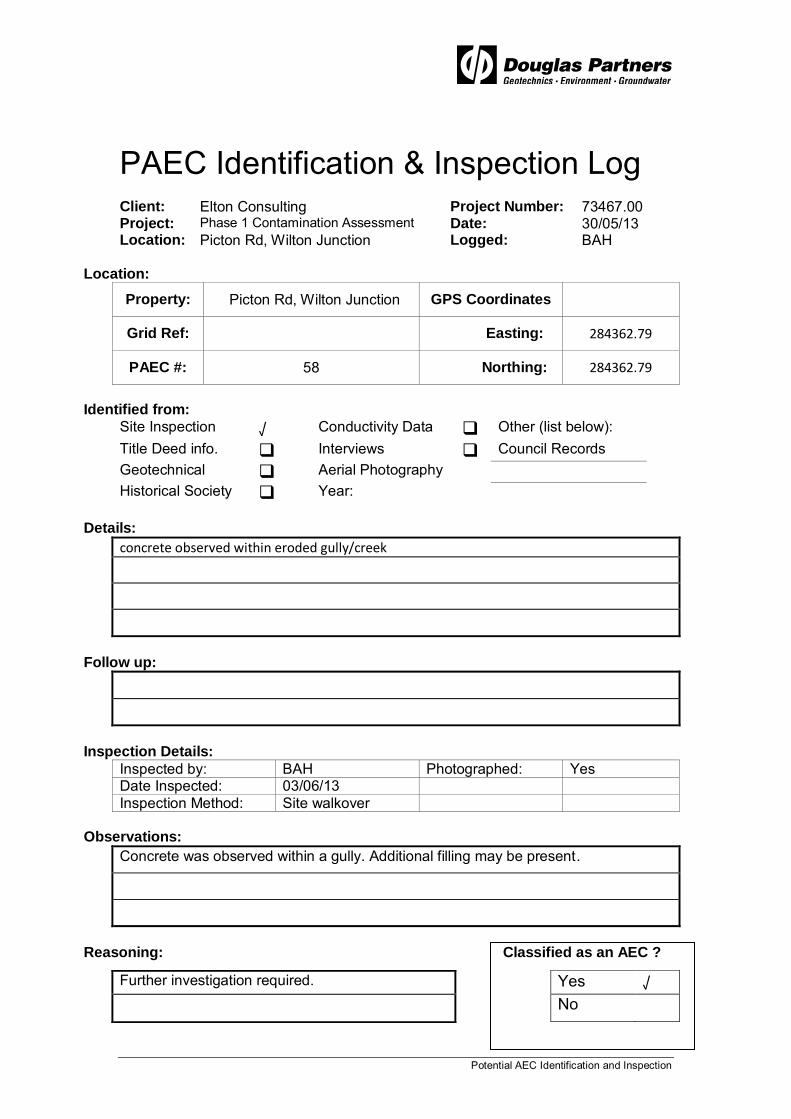
Potential AEC Identification and Inspection
PAEC Identification & Inspection Log Client: Elton Consulting Project Number: 73467.00 Project: Phase 1 Contamination Assessment Date: 30/05/13 Location: Picton Rd, Wilton Junction Logged: BAH
Location:
Property: Picton Rd, Wilton Junction GPS Coordinates
Grid Ref: Easting: 284362.79
PAEC #: 58 Northing: 284362.79
Identified from:
Site Inspection √ Conductivity Data Other (list below): Title Deed info. Interviews Council Records Geotechnical Aerial Photography Historical Society Year:
Details:
concrete observed within eroded gully/creek
Follow up:
Inspection Details:
Inspected by: BAH Photographed: Yes Date Inspected: 03/06/13 Inspection Method: Site walkover
Observations:
Concrete was observed within a gully. Additional filling may be present.
Reasoning: Classified as an AEC ?
Further investigation required. Yes √ No

Potential AEC Identification and Inspection
PAEC Identification & Inspection Log Client: Elton Consulting Project Number: 73467.00 Project: Phase 1 Contamination Assessment Date: 30/05/13 Location: Picton Rd, Wilton Junction Logged: BAH
Location:
Property: Picton Rd, Wilton Junction GPS Coordinates
Grid Ref: Easting: 287503.88
PAEC #: 59 Northing: 287503.88
Identified from:
Site Inspection √ Conductivity Data Other (list below): Title Deed info. Interviews Council Records Geotechnical Aerial Photography Historical Society Year:
Details:
dam with what appears to be extra fill within dam wall/mound
Follow up:
Inspection Details:
Inspected by: BAH Photographed: Yes Date Inspected: 04/06/13 Inspection Method: Site walkover
Observations:
dam with what appears to be extra fill within dam wall/mound
Reasoning: Classified as an AEC ?
Further investigation into the dam wall is required. Yes √ No

Potential AEC Identification and Inspection
PAEC Identification & Inspection Log Client: Elton Consulting Project Number: 73467.00 Project: Phase 1 Contamination Assessment Date: 30/05/13 Location: Picton Rd, Wilton Junction Logged: BAH
Location:
Property: Picton Rd, Wilton Junction GPS Coordinates
Grid Ref: Easting: 287446.41
PAEC #: 60 Northing: 287446.41
Identified from:
Site Inspection √ Conductivity Data Other (list below): Title Deed info. Interviews Council Records Geotechnical Aerial Photography Historical Society Year:
Details:
filled gully / landfill with car bodies, white goods, engines, bricks and scrap metal observed
Follow up:
Inspection Details:
Inspected by: BAH Photographed: Yes Date Inspected: 04/06/13 Inspection Method: Site walkover
Observations:
filled gully / landfill with car bodies, white goods, engines, bricks and scrap metal observed
Reasoning: Classified as an AEC ?
Further investigation required. Yes √ No

Potential AEC Identification and Inspection
PAEC Identification & Inspection Log Client: Elton Consulting Project Number: 73467.00 Project: Phase 1 Contamination Assessment Date: 30/05/13 Location: Picton Rd, Wilton Junction Logged: BAH
Location:
Property: Picton Rd, Wilton Junction GPS Coordinates
Grid Ref: Easting: 287976.99
PAEC #: 61 Northing: 287976.99
Identified from:
Site Inspection √ Conductivity Data Other (list below): Title Deed info. Interviews Council Records Geotechnical Aerial Photography Historical Society Year:
Details:
reworked ground with broken PVC pipes in area of mine water irrigation
Follow up:
Site inspection
Inspection Details:
Inspected by: BAH Photographed: Yes Date Inspected: 04/06/13 Inspection Method: Site walkover
Observations:
reworked ground with broken PVC pipes in area of mine water irrigation
Reasoning:
Further investigation required. Yes √ No

Potential AEC Identification and Inspection
PAEC Identification & Inspection Log Client: Elton Consulting Project Number: 73467.00 Project: Phase 1 Contamination Assessment Date: 30/05/13 Location: Picton Rd, Wilton Junction Logged: BAH
Location:
Property: Picton Rd, Wilton Junction GPS Coordinates
Grid Ref: Easting: 287830.73
PAEC #: 62 Northing: 287830.73
Identified from:
Site Inspection √ Conductivity Data Other (list below): Title Deed info. Interviews Council Records Geotechnical Aerial Photography Historical Society Year:
Details:
cut to fill mounds for surface water detention
Follow up:
Site inspection
Inspection Details:
Inspected by: BAH Photographed: Yes Date Inspected: 30/05/13 Inspection Method: Site walkover
Observations:
Very minor cut to fill mounds for surface water detention.
Reasoning:
No further investigation required. Yes No √
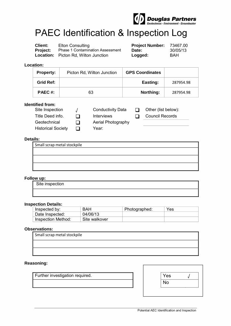
Potential AEC Identification and Inspection
PAEC Identification & Inspection Log Client: Elton Consulting Project Number: 73467.00 Project: Phase 1 Contamination Assessment Date: 30/05/13 Location: Picton Rd, Wilton Junction Logged: BAH
Location:
Property: Picton Rd, Wilton Junction GPS Coordinates
Grid Ref: Easting: 287954.98
PAEC #: 63 Northing: 287954.98
Identified from:
Site Inspection √ Conductivity Data Other (list below): Title Deed info. Interviews Council Records Geotechnical Aerial Photography Historical Society Year:
Details:
Small scrap metal stockpile
Follow up:
Site inspection
Inspection Details:
Inspected by: BAH Photographed: Yes Date Inspected: 04/06/13 Inspection Method: Site walkover
Observations:
Small scrap metal stockpile
Reasoning:
Further investigation required. Yes √ No

Potential AEC Identification and Inspection
PAEC Identification & Inspection Log Client: Elton Consulting Project Number: 73467.00 Project: Phase 1 Contamination Assessment Date: 30/05/13 Location: Picton Rd, Wilton Junction Logged: BAH
Location:
Property: Picton Rd, Wilton Junction GPS Coordinates
Grid Ref: Easting: 287906.34
PAEC #: 64 Northing: 287906.34
Identified from:
Site Inspection √ Conductivity Data Other (list below): Title Deed info. Interviews Council Records Geotechnical Aerial Photography Historical Society Year:
Details:
Fibro building with asbestos roofing
Follow up:
Site inspection
Inspection Details:
Inspected by: BAH Photographed: Yes Date Inspected: 04/06/13 Inspection Method: Site walkover
Observations:
Fibro building with asbestos roofing
Reasoning:
Further investigation required. Yes √ No
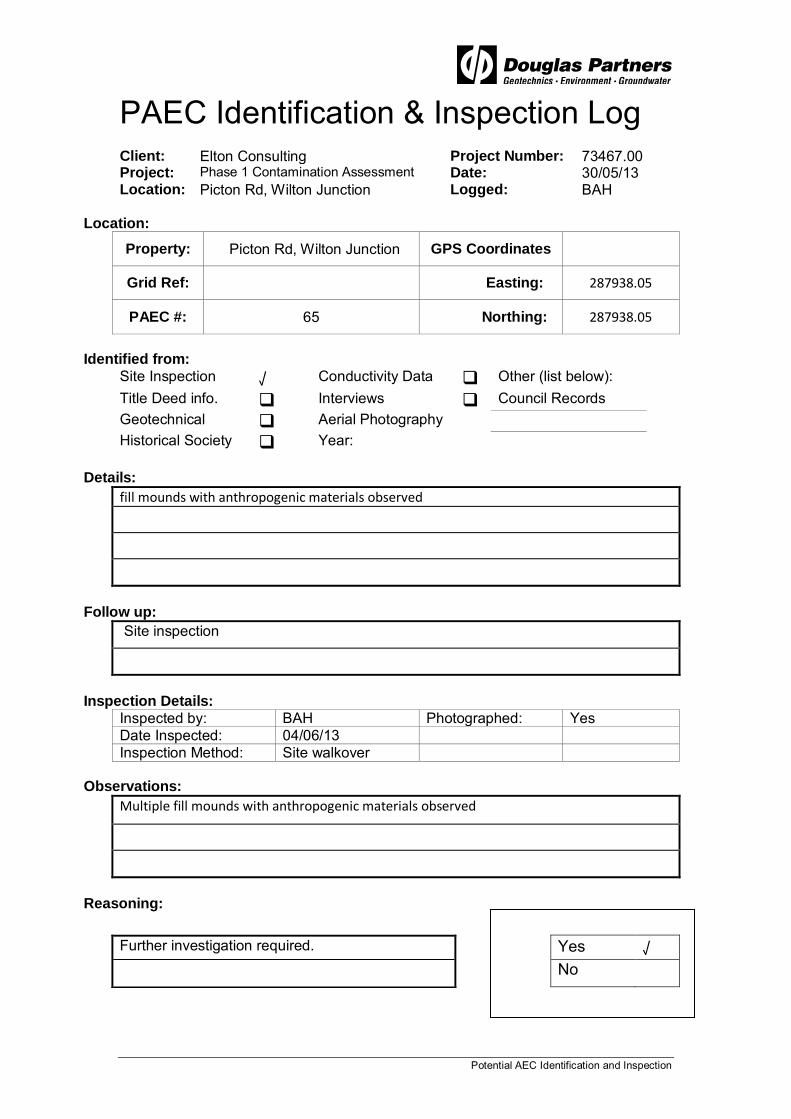
Potential AEC Identification and Inspection
PAEC Identification & Inspection Log Client: Elton Consulting Project Number: 73467.00 Project: Phase 1 Contamination Assessment Date: 30/05/13 Location: Picton Rd, Wilton Junction Logged: BAH
Location:
Property: Picton Rd, Wilton Junction GPS Coordinates
Grid Ref: Easting: 287938.05
PAEC #: 65 Northing: 287938.05
Identified from:
Site Inspection √ Conductivity Data Other (list below): Title Deed info. Interviews Council Records Geotechnical Aerial Photography Historical Society Year:
Details:
fill mounds with anthropogenic materials observed
Follow up:
Site inspection
Inspection Details:
Inspected by: BAH Photographed: Yes Date Inspected: 04/06/13 Inspection Method: Site walkover
Observations:
Multiple fill mounds with anthropogenic materials observed
Reasoning:
Further investigation required. Yes √ No

Potential AEC Identification and Inspection
PAEC Identification & Inspection Log Client: Elton Consulting Project Number: 73467.00 Project: Phase 1 Contamination Assessment Date: 30/05/13 Location: Picton Rd, Wilton Junction Logged: BAH
Location:
Property: Picton Rd, Wilton Junction GPS Coordinates
Grid Ref: Easting: 286686.55
PAEC #: 66 Northing: 286686.55
Identified from:
Site Inspection √ Conductivity Data Other (list below): Title Deed info. Interviews Council Records Geotechnical Aerial Photography Historical Society Year:
Details:
anthropogenic filling
Follow up:
Site inspection
Inspection Details:
Inspected by: BAH Photographed: Yes Date Inspected: 04/06/13 Inspection Method: Site walkover
Observations:
Anthropogenic filling was observed.
Reasoning:
Further investigation required. Yes √ No

Potential AEC Identification and Inspection
PAEC Identification & Inspection Log Client: Elton Consulting Project Number: 73467.00 Project: Phase 1 Contamination Assessment Date: 30/05/13 Location: Picton Rd, Wilton Junction Logged: BAH
Location:
Property: Picton Rd, Wilton Junction GPS Coordinates
Grid Ref: Easting: 286651
PAEC #: 67 Northing: 286651
Identified from:
Site Inspection √ Conductivity Data Other (list below): Title Deed info. Interviews Council Records Geotechnical Aerial Photography Historical Society Year:
Details:
anthropogenic stockpile (timber, tyres and scrap metal)
Follow up:
Site inspection
Inspection Details:
Inspected by: BAH Photographed: Yes Date Inspected: 04/06/13 Inspection Method: Site walkover
Observations:
anthropogenic stockpile (timber, tyres and scrap metal)
Reasoning:
Possible surface contamination. Yes √ Further investigation is required. No

Potential AEC Identification and Inspection
PAEC Identification & Inspection Log Client: Elton Consulting Project Number: 73467.00 Project: Phase 1 Contamination Assessment Date: 30/05/13 Location: Picton Rd, Wilton Junction Logged: BAH
Location:
Property: Picton Rd, Wilton Junction GPS Coordinates
Grid Ref: Easting: 285355.7
PAEC #: 68 Northing: 285355.7
Identified from:
Site Inspection √ Conductivity Data Other (list below): Title Deed info. Interviews Council Records Geotechnical Aerial Photography Historical Society Year:
Details:
stockpile of soil
Follow up:
Inspection Details:
Inspected by: BAH Photographed: Yes Date Inspected: 04/06/13 Inspection Method: Site walkover
Observations:
Soil stockpile observed (Refer photography)
Reasoning:
Further investigation required. Yes √ No

Potential AEC Identification and Inspection
PAEC Identification & Inspection Log Client: Elton Consulting Project Number: 73467.00 Project: Phase 1 Contamination Assessment Date: 30/05/13 Location: Picton Rd, Wilton Junction Logged: BAH
Location:
Property: Picton Rd, Wilton Junction GPS Coordinates
Grid Ref: Easting: 284351.87
PAEC #: 69 Northing: 284351.87
Identified from:
Site Inspection √ Conductivity Data Other (list below): Title Deed info. Interviews Council Records Geotechnical Aerial Photography Historical Society Year:
Details:
Wooden and timber derelict structure for hay storage.
Follow up:
Site inspection
Inspection Details:
Inspected by: BAH Photographed: Yes Date Inspected: 04/05/13 Inspection Method: Site walkover
Observations:
Wooden and timber derelict structure for hay storage.
Reasoning:
Further investigation required. Yes √ No

Potential AEC Identification and Inspection
PAEC Identification & Inspection Log Client: Elton Consulting Project Number: 73467.00 Project: Phase 1 Contamination Assessment Date: 30/05/13 Location: Picton Rd, Wilton Junction Logged: BAH
Location:
Property: Picton Rd, Wilton Junction GPS Coordinates
Grid Ref: Easting: 285430.6
PAEC #: 70 Northing: 285430.6
Identified from:
Site Inspection √ Conductivity Data Other (list below): Title Deed info. Interviews Council Records Geotechnical Aerial Photography Historical Society Year:
Details:
Airfield area consists of 30 000 L jet fuel tank, 10 000 L diesel tank, two 44 gallon drums of
unleaded petrol, storage containers and other associated buildings.
Follow up:
Site inspection
Inspection Details:
Inspected by: BAH Photographed: Yes Date Inspected: 04-05/06/13 Inspection Method: Site walkover
Observations:
Airfield area consists of 30000 L jet fuel tank, 10 000 L diesel tank, two 44 gallon drums of
unleaded petrol, storage containers and other associated buildings.
Reasoning:
Further investigation required. Yes √ No

Potential AEC Identification and Inspection
PAEC Identification & Inspection Log Client: Elton Consulting Project Number: 73467.00 Project: Phase 1 Contamination Assessment Date: 30/05/13 Location: Picton Rd, Wilton Junction Logged: BAH
Location:
Property: Picton Rd, Wilton Junction GPS Coordinates
Grid Ref: Easting: 285397.06
PAEC #: 71 Northing: 285397.06
Identified from:
Site Inspection √ Conductivity Data Other (list below): Title Deed info. Interviews Council Records Geotechnical Aerial Photography Historical Society Year:
Details:
Crushed Asphalt stockpile
Follow up:
Inspection Details:
Inspected by: BAH Photographed: Yes Date Inspected: 30/05/13 Inspection Method: Site walkover
Observations:
Large crushed asphalt stockpile.
Reasoning:
Yes √ No

Potential AEC Identification and Inspection
PAEC Identification & Inspection Log Client: Elton Consulting Project Number: 73467.00 Project: Phase 1 Contamination Assessment Date: 30/05/13 Location: Picton Rd, Wilton Junction Logged: BAH
Location:
Property: Picton Rd, Wilton Junction GPS Coordinates
Grid Ref: Easting: 284777.27
PAEC #: 72 Northing: 284777.27
Identified from:
Site Inspection √ Conductivity Data Other (list below): Title Deed info. Interviews Council Records Geotechnical Aerial Photography Historical Society Year:
Details:
possible area of minor fill (slightly raised area) 50 m x 30 m
Follow up:
Site inspection
Inspection Details:
Inspected by: BAH Photographed: Yes Date Inspected: 05/06/13 Inspection Method: Site walkover
Observations:
possible area of minor fill (slightly raised area) 50 m x 30 m
Reasoning:
Further investigation required. Yes √ No

Potential AEC Identification and Inspection
PAEC Identification & Inspection Log Client: Elton Consulting Project Number: 73467.00 Project: Phase 1 Contamination Assessment Date: 30/05/13 Location: Picton Rd, Wilton Junction Logged: BAH
Location:
Property: Picton Rd, Wilton Junction GPS Coordinates
Grid Ref: Easting: 284993
PAEC #: 73 Northing: 6210492
Identified from:
Site Inspection √ Conductivity Data Other (list below): Title Deed info. Interviews Council Records Geotechnical Aerial Photography Historical Society Year:
Details:
Minor filled drainage line with boulders observed and fencing material stockpiled adjacent.
Follow up:
Site inspection
Inspection Details:
Inspected by: BAH Photographed: Yes Date Inspected: 05/06/13 Inspection Method: Site walkover
Observations:
Minor filled drainage line with boulders observed and fencing material stockpiled adjacent.
Reasoning:
Further investigation required. Yes √ No

Potential AEC Identification and Inspection
PAEC Identification & Inspection Log Client: Elton Consulting Project Number: 73467.00 Project: Phase 1 Contamination Assessment Date: 30/05/13 Location: Picton Rd, Wilton Junction Logged: BAH
Location:
Property: Picton Rd, Wilton Junction GPS Coordinates
Grid Ref: Easting: 285222.86
PAEC #: 74 Northing: 285222.86
Identified from:
Site Inspection √ Conductivity Data Other (list below): Title Deed info. Interviews Council Records Geotechnical Aerial Photography Historical Society Year:
Details:
Possible filled creek with cobbles and boulders observed on surface
Follow up:
Inspection Details:
Inspected by: BAH Photographed: Yes Date Inspected: 05/06/13 Inspection Method: Site walkover
Observations:
Possible filled creek with cobbles and boulders observed on surface
Reasoning:
Further investigation required. Yes √ No

Potential AEC Identification and Inspection
PAEC Identification & Inspection Log Client: Elton Consulting Project Number: 73467.00 Project: Phase 1 Contamination Assessment Date: 30/05/13 Location: Picton Rd, Wilton Junction Logged: BAH
Location:
Property: Picton Rd, Wilton Junction GPS Coordinates
Grid Ref: Easting: 285966.55
PAEC #: 75 Northing: 285966.55
Identified from:
Site Inspection √ Conductivity Data Other (list below): Title Deed info. Interviews Council Records Geotechnical Aerial Photography Historical Society Year:
Details:
An "L" shaped soil mound (0.5 m high)
Follow up:
Site inspection
Inspection Details:
Inspected by: BAH Photographed: Yes Date Inspected: 05/6/13 Inspection Method: Site walkover
Observations:
An "L" shaped soil mound (0.5 m high)
Reasoning:
Further investigation required. Yes √ No

Potential AEC Identification and Inspection
PAEC Identification & Inspection Log Client: Elton Consulting Project Number: 73467.00 Project: Phase 1 Contamination Assessment Date: 30/05/13 Location: Picton Rd, Wilton Junction Logged: BAH
Location:
Property: Picton Rd, Wilton Junction GPS Coordinates
Grid Ref: Easting:
PAEC #: 76 Northing:
Identified from:
Site Inspection √ Conductivity Data Other (list below): Title Deed info. Interviews Council Records Geotechnical Aerial Photography Historical Society Year:
Details:
Small soil mound
Follow up:
Site inspection
Inspection Details:
Inspected by: BAH Photographed: Yes Date Inspected: 05/06/13 Inspection Method: Site walkover
Observations:
Small soil mound
Reasoning:
Further investigation required. Yes √ No

Potential AEC Identification and Inspection
PAEC Identification & Inspection Log Client: Elton Consulting Project Number: 73467.00 Project: Phase 1 Contamination Assessment Date: 30/05/13 Location: Picton Rd, Wilton Junction Logged: BAH
Location:
Property: Picton Rd, Wilton Junction GPS Coordinates
Grid Ref: Easting: 286544.62
PAEC #: 77 Northing: 286544.62
Identified from:
Site Inspection √ Conductivity Data Other (list below): Title Deed info. Interviews Council Records Geotechnical Aerial Photography Historical Society Year:
Details:
Dirt Ramp / mound observed.
Follow up:
Inspection Details:
Inspected by: BAH Photographed: Yes Date Inspected: 05/06/13 Inspection Method: Site walkover
Observations:
Dirt Ramp / mound observed.
Reasoning:
Further investigation required. Yes √ No

Potential AEC Identification and Inspection
PAEC Identification & Inspection Log Client: Elton Consulting Project Number: 73467.00 Project: Phase 1 Contamination Assessment Date: 30/05/13 Location: Picton Rd, Wilton Junction Logged: BAH
Location:
Property: Picton Rd, Wilton Junction GPS Coordinates
Grid Ref: Easting: 285745.38
PAEC #: 78 Northing: 285745.38
Identified from:
Site Inspection √ Conductivity Data Other (list below): Title Deed info. Interviews Council Records Geotechnical Aerial Photography Historical Society Year:
Details:
Small stockpile of soil
Follow up:
Inspection Details:
Inspected by: BAH Photographed: Yes Date Inspected: 05/06/13 Inspection Method: Site walkover
Observations:
Small stockpile of soil
Reasoning:
Further investigation required. Yes √ No
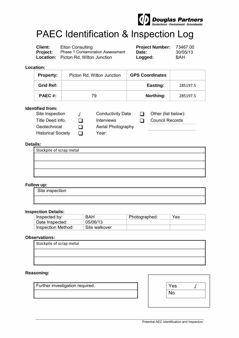
Potential AEC Identification and Inspection
PAEC Identification & Inspection Log Client: Elton Consulting Project Number: 73467.00 Project: Phase 1 Contamination Assessment Date: 30/05/13 Location: Picton Rd, Wilton Junction Logged: BAH
Location:
Property: Picton Rd, Wilton Junction GPS Coordinates
Grid Ref: Easting: 285197.5
PAEC #: 79 Northing: 285197.5
Identified from:
Site Inspection √ Conductivity Data Other (list below): Title Deed info. Interviews Council Records Geotechnical Aerial Photography Historical Society Year:
Details:
Stockpile of scrap metal
Follow up:
Site inspection
Inspection Details:
Inspected by: BAH Photographed: Yes Date Inspected: 05/06/13 Inspection Method: Site walkover
Observations:
Stockpile of scrap metal
Reasoning:
Further investigation required. Yes √ No

Potential AEC Identification and Inspection
PAEC Identification & Inspection Log Client: Elton Consulting Project Number: 73467.00 Project: Phase 1 Contamination Assessment Date: 30/05/13 Location: Picton Rd, Wilton Junction Logged: BAH
Location:
Property: Picton Rd, Wilton Junction GPS Coordinates
Grid Ref: Easting:
PAEC #: 80 Northing:
Identified from:
Site Inspection √ Conductivity Data Other (list below): Title Deed info. Interviews Council Records Geotechnical Aerial Photography Historical Society Year:
Details:
Access road within Governors hill (north of runway) has some fill in areas.
Follow up:
Site inspection
Inspection Details:
Inspected by: BAH Photographed: Yes Date Inspected: 05/06/13 Inspection Method: Site walkover
Observations:
Access road within Governors hill (north of runway) has some fill in areas.
Reasoning:
Further investigation required. Yes √ No

Potential AEC Identification and Inspection
PAEC Identification & Inspection Log Client: Elton Consulting Project Number: 73467.00 Project: Phase 1 Contamination Assessment Date: 30/05/13 Location: Picton Rd, Wilton Junction Logged: BAH
Location:
Property: Picton Rd, Wilton Junction GPS Coordinates
Grid Ref: Easting: 285470
PAEC #: 81 Northing: 285470
Identified from:
Site Inspection √ Conductivity Data Other (list below): Title Deed info. Interviews Council Records Geotechnical Aerial Photography Historical Society Year:
Details:
Small fill mound with tyres observed on surface noted 20 m x 4 m.
Follow up:
Site inspection
Inspection Details:
Inspected by: BAH Photographed: Yes Date Inspected: 05/06/13 Inspection Method: Site walkover
Observations:
Small fill mound with tyres observed on surface noted 20 m x 4 m.
Reasoning:
Further investigation required. Yes √ No

Potential AEC Identification and Inspection
PAEC Identification & Inspection Log Client: Elton Consulting Project Number: 73467.00 Project: Phase 1 Contamination Assessment Date: 30/05/13 Location: Picton Rd, Wilton Junction Logged: BAH
Location:
Property: Picton Rd, Wilton Junction GPS Coordinates
Grid Ref: Easting: 285110.1
PAEC #: 82 Northing: 285110.1
Identified from:
Site Inspection √ Conductivity Data Other (list below): Title Deed info. Interviews Council Records Geotechnical Aerial Photography Historical Society Year:
Details:
Anthropogenic material noted in and around dam with possible fill to the north and south of the dam within drainage line
Follow up:
Inspection Details:
Inspected by: BAH Photographed: Yes Date Inspected: 05/06/13 Inspection Method: Site walkover
Observations:
Anthropogenic material noted in and around dam with possible fill to the north and south of
the dam within drainage line
Reasoning:
Further investigation required. Yes √ No

Potential AEC Identification and Inspection
PAEC Identification & Inspection Log Client: Elton Consulting Project Number: 73467.00 Project: Phase 1 Contamination Assessment Date: 30/05/13 Location: Picton Rd, Wilton Junction Logged: BAH
Location:
Property: Picton Rd, Wilton Junction GPS Coordinates
Grid Ref: Easting: 285041.73
PAEC #: 83 Northing: 285041.73
Identified from:
Site Inspection √ Conductivity Data Other (list below): Title Deed info. Interviews Council Records Geotechnical Aerial Photography Historical Society Year:
Details:
Anthropogenic material were observed on the ground surface in the vicinity of three caravans and consisted of timber, brick, tyres and some plastics.
Follow up:
Inspection Details:
Inspected by: BAH Photographed: Yes Date Inspected: 05/06/13 Inspection Method: Site walkover
Observations:
Anthropogenic material were observed on the ground surface in the vicinity of three
caravans and consisted of timber, brick, tyres and some plastics.
Reasoning:
Further investigation required. Yes √ No

Potential AEC Identification and Inspection
PAEC Identification & Inspection Log Client: Elton Consulting Project Number: 73467.00 Project: Phase 1 Contamination Assessment Date: 30/05/13 Location: Picton Rd, Wilton Junction Logged: BAH
Location:
Property: Picton Rd, Wilton Junction GPS Coordinates
Grid Ref: Easting: 285159.97
PAEC #: 84 Northing: 285159.97
Identified from:
Site Inspection √ Conductivity Data Other (list below): Title Deed info. Interviews Council Records Geotechnical Aerial Photography Historical Society Year:
Details:
Possible fill area 10 m x 10 m.
Follow up:
Inspection Details:
Inspected by: BAH Photographed: Yes Date Inspected: 05/06/13 Inspection Method: Site walkover
Observations:
Possible fill area 10 m x 10 m.
Reasoning:
Further investigation required. Yes √ No

Potential AEC Identification and Inspection
PAEC Identification & Inspection Log Client: Elton Consulting Project Number: 73467.00 Project: Phase 1 Contamination Assessment Date: 30/05/13 Location: Picton Rd, Wilton Junction Logged: BAH
Location:
Property: Picton Rd, Wilton Junction GPS Coordinates
Grid Ref: Easting:
PAEC #: 85 Northing:
Identified from:
Site Inspection √ Conductivity Data Other (list below): Title Deed info. Interviews Council Records Geotechnical Aerial Photography Historical Society Year:
Details:
Area of landfill, storage containers and anthropogenic materials observed in stockpiles and
Scattered on ground surface. Possible asbestos fragments were observed on surface of land fill.
Follow up:
Site inspection
Inspection Details:
Inspected by: BAH Photographed: Yes Date Inspected: 05/06/13 Inspection Method: Site walkover
Observations:
Area of landfill, storage containers and anthropogenic materials observed in stockpiles and
Scattered on ground surface. Possible asbestos fragments were observed on surface of landfill.
Reasoning:
Further Investigation Required Yes √ No

Appendix E
Provided Section 149 Certificates


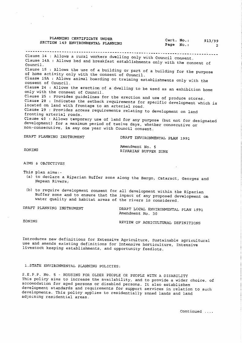


Appendix F
Test Pit Logs

0.2
0.8
1.2
1.4
TOPSOIL - light brown silty clayey topsoil with a trace ofgrass rootlets and ironstone gravel
SANDY CLAY - very stiff light brown and orange brownsilty clay with some sand
SANDY CLAY - very stiff to hard grey red brown/orangesandy clay (extremely weathered sandstone)
SANDSTONE - low to medium strength light brownsandstone
Pit discontinued at 1.4m
SAMPLING & IN SITU TESTING LEGEND
1
2
3
4
RL
133
132
131
130
129
TEST PIT LOG
Depth(m)
Hume Highway & Picton Road, Wilton
A Auger sample G Gas sample PID Photo ionisation detector (ppm)B Bulk sample P Piston sample PL(A) Point load axial test Is(50) (MPa)BLK Block sample Ux Tube sample (x mm dia.) PL(D) Point load diametral test Is(50) (MPa)C Core drilling W Water sample pp Pocket penetrometer (kPa)D Disturbed sample Water seep S Standard penetration testE Environmental sample Water level V Shear vane (kPa)
Wilton Junction Landowners GroupWilton Junction
Results &Comments
LOGGED: SURVEY DATUM: MGA94
CLIENT:PROJECT:LOCATION:
PIT No: 1PROJECT No: 73467DATE: 21/5/2013SHEET 1 OF 1
Sampling & In Situ Testing
1
2
3
4
Wat
er
Dep
th
Sam
ple
Description
of
Strata Gra
phic
Log
Typ
e
REMARKS:
RIG: 8T Backhoe
WATER OBSERVATIONS:
SURFACE LEVEL: 133 AHDEASTING: 6214688NORTHING: 286119
Dynamic Penetrometer Test(blows per 150mm)
5 10 15 20
Cone Penetrometer AS1289.6.3.2 Sand Penetrometer AS1289.6.3.3
D
D
D
D
D
0.1
0.3
0.5
1.0
1.3

0.2
0.6
1.1
2.2
2.4
TOPSOIL - light brown sandy silty topsoil with someironstone gravel and a trace of grass rootlets
SILTY CLAY - very stiff red brown mottled light brown siltyclay
SANDY CLAY - very stiff to hard grey and light brownsandy clay with a trace of rootlets
SANDSTONE - very low strength, extremely weatheredgrey/light brown sandstone
SANDSTONE - low to medium strength grey and orangebrown sandstone
Pit discontinued at 2.4m - backhoe refusal
SAMPLING & IN SITU TESTING LEGEND
1
2
3
4
RL
131
130
129
128
127
TEST PIT LOG
Depth(m)
Hume Highway & Picton Road, Wilton
A Auger sample G Gas sample PID Photo ionisation detector (ppm)B Bulk sample P Piston sample PL(A) Point load axial test Is(50) (MPa)BLK Block sample Ux Tube sample (x mm dia.) PL(D) Point load diametral test Is(50) (MPa)C Core drilling W Water sample pp Pocket penetrometer (kPa)D Disturbed sample Water seep S Standard penetration testE Environmental sample Water level V Shear vane (kPa)
Wilton Junction Landowners GroupWilton Junction
Results &Comments
LOGGED: SURVEY DATUM: MGA94
CLIENT:PROJECT:LOCATION:
PIT No: 2PROJECT No: 73467DATE: 21/5/2013SHEET 1 OF 1
Sampling & In Situ Testing
1
2
3
4
Wat
er
Dep
th
Sam
ple
Description
of
Strata Gra
phic
Log
Typ
e
REMARKS:
RIG: 8T Backhoe
WATER OBSERVATIONS:
SURFACE LEVEL: 131 AHDEASTING: 6214424NORTHING: 285438
Dynamic Penetrometer Test(blows per mm)
5 10 15 20
Cone Penetrometer AS1289.6.3.2 Sand Penetrometer AS1289.6.3.3
D
D
D
D
D
0.5
1.0
1.5
2.0
2.3
0.4
1.7
2.1
2.5
TOPSOIL - brown silty topsoil with some clay, grassrootlets and sandstone cobbles
SILTY CLAY - very stiff to hard red brown mottled lightbrown silty clay with a trace of fine ironstone gravel
- from 0.8m: becoming red/brown mottled grey
SANDSTONE - grey and light brown extremely weatheredsandstone with some bands of very low to low strength
SANDSTONE - low to medium strength grey/brownsandstone
Pit discontinued at 2.5m - backhoe refusal
SAMPLING & IN SITU TESTING LEGEND
1
2
3
4
RL
142
141
140
139
138
TEST PIT LOG
Depth(m)
Hume Highway & Picton Road, Wilton
A Auger sample G Gas sample PID Photo ionisation detector (ppm)B Bulk sample P Piston sample PL(A) Point load axial test Is(50) (MPa)BLK Block sample Ux Tube sample (x mm dia.) PL(D) Point load diametral test Is(50) (MPa)C Core drilling W Water sample pp Pocket penetrometer (kPa)D Disturbed sample Water seep S Standard penetration testE Environmental sample Water level V Shear vane (kPa)
Wilton Junction Landowners GroupWilton Junction
Results &Comments
LOGGED: SURVEY DATUM: MGA94
CLIENT:PROJECT:LOCATION:
PIT No: 3PROJECT No: 73467DATE: 21/5/2013SHEET 1 OF 1
Sampling & In Situ Testing
1
2
3
4
Wat
er
Dep
th
Sam
ple
Description
of
Strata Gra
phic
Log
Typ
e
REMARKS:
RIG: 8T Backhoe
WATER OBSERVATIONS:
SURFACE LEVEL: 142 AHDEASTING: 6214233NORTHING: 286041
Dynamic Penetrometer Test(blows per mm)
5 10 15 20
Cone Penetrometer AS1289.6.3.2 Sand Penetrometer AS1289.6.3.3
DB
D
D
D
D
0.4
0.5
0.7
1.0
1.5
2.0
2.4

0.25
0.6
0.8
0.9
TOPSOIL - sandy silty topsoil with some clay and grassrootlets
SANDY CLAY - very stiff orange brown/ red brown sandyclay with a trace of rootlets
SANDSTONE - extremely weathered grey brownsandstone
SANDSTONE - medium strength grey brown sandstone
Pit discontinued at 0.9m - backhoe refusal
SAMPLING & IN SITU TESTING LEGEND
1
2
3
4
RL
134
133
132
131
130
TEST PIT LOG
Depth(m)
Hume Highway & Picton Road, Wilton
A Auger sample G Gas sample PID Photo ionisation detector (ppm)B Bulk sample P Piston sample PL(A) Point load axial test Is(50) (MPa)BLK Block sample Ux Tube sample (x mm dia.) PL(D) Point load diametral test Is(50) (MPa)C Core drilling W Water sample pp Pocket penetrometer (kPa)D Disturbed sample Water seep S Standard penetration testE Environmental sample Water level V Shear vane (kPa)
Wilton Junction Landowners GroupWilton Junction
Results &Comments
LOGGED: SURVEY DATUM: MGA94
CLIENT:PROJECT:LOCATION:
PIT No: 4PROJECT No: 73467DATE: 21/5/2013SHEET 1 OF 1
Sampling & In Situ Testing
1
2
3
4
Wat
er
Dep
th
Sam
ple
Description
of
Strata Gra
phic
Log
Typ
e
REMARKS:
RIG: 8T Backhoe
WATER OBSERVATIONS:
SURFACE LEVEL: 134 AHDEASTING: 6214271NORTHING: 286750
Dynamic Penetrometer Test(blows per mm)
5 10 15 20
Cone Penetrometer AS1289.6.3.2 Sand Penetrometer AS1289.6.3.3
D
D
D
0.1
0.5
0.85

0.1
0.3
0.7
1.2
1.4
TOPSOIL - brown clayey silty topsoil with some sand andgrass rootlets
SANDY SILT - light brown and orange brown sandy siltwith some ironstone gravel
SILTY CLAY - stiff to very stiff red brown mottled lightbrown silty clay with a trace of rootlets
SANDY CLAY - stiff to very stiff grey/red brown/orangebrown sandy clay (extremely weathered sandstone)
SANDSTONE - low to medium strength brown and greysandstone
Pit discontinued at 1.4m - backhoe refusal
SAMPLING & IN SITU TESTING LEGEND
1
2
3
4
RL
140
139
138
137
136
TEST PIT LOG
Depth(m)
Hume Highway & Picton Road, Wilton
A Auger sample G Gas sample PID Photo ionisation detector (ppm)B Bulk sample P Piston sample PL(A) Point load axial test Is(50) (MPa)BLK Block sample Ux Tube sample (x mm dia.) PL(D) Point load diametral test Is(50) (MPa)C Core drilling W Water sample pp Pocket penetrometer (kPa)D Disturbed sample Water seep S Standard penetration testE Environmental sample Water level V Shear vane (kPa)
Wilton Junction Landowners GroupWilton Junction
Results &Comments
LOGGED: SURVEY DATUM: MGA94
CLIENT:PROJECT:LOCATION:
PIT No: 5PROJECT No: 73467DATE: 21/5/2013SHEET 1 OF 1
Sampling & In Situ Testing
1
2
3
4
Wat
er
Dep
th
Sam
ple
Description
of
Strata Gra
phic
Log
Typ
e
REMARKS:
RIG: 8T Backhoe
WATER OBSERVATIONS:
SURFACE LEVEL: 140 AHDEASTING: 6213867NORTHING: 285653
Dynamic Penetrometer Test(blows per mm)
5 10 15 20
Cone Penetrometer AS1289.6.3.2 Sand Penetrometer AS1289.6.3.3
D
D
D
0.5
1.0
1.3

0.15
0.7
1.3
TOPSOIL - brown clayey silty topsoil with someironstone gravel and grass rootlets
SILTY CLAY - hard red brown mottled light brown siltyclay
SHALE - low strength grey shale
- from 1.0m: medium strength
Pit discontinued at 1.3m - backhoe refusal
SAMPLING & IN SITU TESTING LEGEND
1
2
3
4
RL
148
147
146
145
144
TEST PIT LOG
Depth(m)
Hume Highway & Picton Road, Wilton
A Auger sample G Gas sample PID Photo ionisation detector (ppm)B Bulk sample P Piston sample PL(A) Point load axial test Is(50) (MPa)BLK Block sample Ux Tube sample (x mm dia.) PL(D) Point load diametral test Is(50) (MPa)C Core drilling W Water sample pp Pocket penetrometer (kPa)D Disturbed sample Water seep S Standard penetration testE Environmental sample Water level V Shear vane (kPa)
Wilton Junction Landowners GroupWilton Junction
Results &Comments
LOGGED: SURVEY DATUM: MGA94
CLIENT:PROJECT:LOCATION:
PIT No: 6PROJECT No: 73467DATE: 20/5/2013SHEET 1 OF 1
Sampling & In Situ Testing
1
2
3
4
Wat
er
Dep
th
Sam
ple
Description
of
Strata Gra
phic
Log
Typ
e
REMARKS:
RIG: 8T Backhoe
WATER OBSERVATIONS:
SURFACE LEVEL: 148 AHDEASTING: 6213829NORTHING: 286315
Dynamic Penetrometer Test(blows per 150mm)
5 10 15 20
Cone Penetrometer AS1289.6.3.2 Sand Penetrometer AS1289.6.3.3
D
U50
D
D
0.1
0.2
0.5
1.2

0.25
0.6
0.7
TOPSOIL - brown silty topsoil with some clay and a traceof ironstone gravel and grass rootlets
SANDY CLAY - very stiff orange brown light brown/redbrown sandy clay
SANDSTONE - medium strength grey brown sandstone
Pit discontinued at 0.7m - backhoe refusal
SAMPLING & IN SITU TESTING LEGEND
1
2
3
4
RL
138
137
136
135
134
TEST PIT LOG
Depth(m)
Hume Highway & Picton Road, Wilton
A Auger sample G Gas sample PID Photo ionisation detector (ppm)B Bulk sample P Piston sample PL(A) Point load axial test Is(50) (MPa)BLK Block sample Ux Tube sample (x mm dia.) PL(D) Point load diametral test Is(50) (MPa)C Core drilling W Water sample pp Pocket penetrometer (kPa)D Disturbed sample Water seep S Standard penetration testE Environmental sample Water level V Shear vane (kPa)
Wilton Junction Landowners GroupWilton Junction
Results &Comments
LOGGED: SURVEY DATUM: MGA94
CLIENT:PROJECT:LOCATION:
PIT No: 7PROJECT No: 73467DATE: 21/5/2013SHEET 1 OF 1
Sampling & In Situ Testing
1
2
3
4
Wat
er
Dep
th
Sam
ple
Description
of
Strata Gra
phic
Log
Typ
e
REMARKS:
RIG: 8T Backhoe
WATER OBSERVATIONS:
SURFACE LEVEL: 138 AHDEASTING: 6213830NORTHING: 287139
Dynamic Penetrometer Test(blows per mm)
5 10 15 20
Cone Penetrometer AS1289.6.3.2 Sand Penetrometer AS1289.6.3.3
D
D
D
0.15
0.5
0.65

0.25
0.6
0.7
1.0
TOPSOIL - light brown silty topsoil with some ironstonegravel and clay and a trace of grass rootlets
SILTY CLAY - hard red brown mottled light brown siltyclay
SHALY CLAY -hard grey brown mottled orange brownshaly clay
SHALE - very low to low strength brown shale with somemedium strength bands
Pit discontinued at 1.0m
SAMPLING & IN SITU TESTING LEGEND
1
2
3
4
RL
142
141
140
139
138
TEST PIT LOG
Depth(m)
Hume Highway & Picton Road, Wilton
A Auger sample G Gas sample PID Photo ionisation detector (ppm)B Bulk sample P Piston sample PL(A) Point load axial test Is(50) (MPa)BLK Block sample Ux Tube sample (x mm dia.) PL(D) Point load diametral test Is(50) (MPa)C Core drilling W Water sample pp Pocket penetrometer (kPa)D Disturbed sample Water seep S Standard penetration testE Environmental sample Water level V Shear vane (kPa)
Wilton Junction Landowners GroupWilton Junction
Results &Comments
LOGGED: SURVEY DATUM: MGA94
CLIENT:PROJECT:LOCATION:
PIT No: 8PROJECT No: 73467DATE: 21/5/2013SHEET 1 OF 1
Sampling & In Situ Testing
1
2
3
4
Wat
er
Dep
th
Sam
ple
Description
of
Strata Gra
phic
Log
Typ
e
REMARKS:
RIG: 8T Backhoe
WATER OBSERVATIONS:
SURFACE LEVEL: 142 AHDEASTING: 6213622NORTHING: 286698
Dynamic Penetrometer Test(blows per 150mm)
5 10 15 20
Cone Penetrometer AS1289.6.3.2 Sand Penetrometer AS1289.6.3.3
D
D
D
0.1
0.4
0.9

0.2
0.6
0.95
TOPSOIL - light brown silty topsoil with some fine grainedsand a trace of grass rootlets
SANDY CLAY -stiff to very stiff orange brown and greysandy clay
SANDSTONE - low to medium strength grey and greybrown sandstone
Pit discontinued at 0.95m - backhoe refusal
SAMPLING & IN SITU TESTING LEGEND
1
2
3
4
RL
145
144
143
142
141
TEST PIT LOG
Depth(m)
Hume Highway & Picton Road, Wilton
A Auger sample G Gas sample PID Photo ionisation detector (ppm)B Bulk sample P Piston sample PL(A) Point load axial test Is(50) (MPa)BLK Block sample Ux Tube sample (x mm dia.) PL(D) Point load diametral test Is(50) (MPa)C Core drilling W Water sample pp Pocket penetrometer (kPa)D Disturbed sample Water seep S Standard penetration testE Environmental sample Water level V Shear vane (kPa)
Wilton Junction Landowners GroupWilton Junction
Results &Comments
LOGGED: SURVEY DATUM: MGA94
CLIENT:PROJECT:LOCATION:
PIT No: 9PROJECT No: 73467DATE: 20/5/2013SHEET 1 OF 1
Sampling & In Situ Testing
1
2
3
4
Wat
er
Dep
th
Sam
ple
Description
of
Strata Gra
phic
Log
Typ
e
REMARKS:
RIG: 8T Backhoe
WATER OBSERVATIONS:
SURFACE LEVEL: 145 AHDEASTING: 6213409NORTHING: 285752
Dynamic Penetrometer Test(blows per mm)
5 10 15 20
Cone Penetrometer AS1289.6.3.2 Sand Penetrometer AS1289.6.3.3
D
D
D
0.1
0.5
0.9

0.15
0.7
1.1
1.4
TOPSOIL - light brown silty topsoil with some clay anda trace of grass rootlets
SILTY CLAY - very stiff red brown mottled light brown siltyclay
SANDY CLAY - stiff grey/red brown sandy clay (extremelyweathered sandstone)
SANDSTONE - low strength brown and grey brown fine tomedium grained sandstone
Pit discontinued at 1.4m - backhoe refusal
SAMPLING & IN SITU TESTING LEGEND
1
2
3
4
RL
148
147
146
145
144
TEST PIT LOG
Depth(m)
Hume Highway & Picton Road, Wilton
A Auger sample G Gas sample PID Photo ionisation detector (ppm)B Bulk sample P Piston sample PL(A) Point load axial test Is(50) (MPa)BLK Block sample Ux Tube sample (x mm dia.) PL(D) Point load diametral test Is(50) (MPa)C Core drilling W Water sample pp Pocket penetrometer (kPa)D Disturbed sample Water seep S Standard penetration testE Environmental sample Water level V Shear vane (kPa)
Wilton Junction Landowners GroupWilton Junction
Results &Comments
LOGGED: SURVEY DATUM: MGA94
CLIENT:PROJECT:LOCATION:
PIT No: 10PROJECT No: 73467DATE: 20/5/2013SHEET 1 OF 1
Sampling & In Situ Testing
1
2
3
4
Wat
er
Dep
th
Sam
ple
Description
of
Strata Gra
phic
Log
Typ
e
REMARKS:
RIG: 8T Backhoe
WATER OBSERVATIONS:
SURFACE LEVEL: 148 AHDEASTING: 6212897NORTHING: 285471
Dynamic Penetrometer Test(blows per 150mm)
5 10 15 20
Cone Penetrometer AS1289.6.3.2 Sand Penetrometer AS1289.6.3.3
D
D
D
D
0.1
0.5
1.0
1.3

0.1
1.0
1.4
TOPSOIL - brown clayey silty topsoil with a trace of grassrootless
SHALY CLAY - very stiff to hard red brown shaly clay
- from 0.4m: low strength shale bands
SHALE - low to medium strength grey shale
Pit discontinued at 1.4m
SAMPLING & IN SITU TESTING LEGEND
1
2
3
4
RL
166
165
164
163
162
TEST PIT LOG
Depth(m)
Hume Highway & Picton Road, Wilton
A Auger sample G Gas sample PID Photo ionisation detector (ppm)B Bulk sample P Piston sample PL(A) Point load axial test Is(50) (MPa)BLK Block sample Ux Tube sample (x mm dia.) PL(D) Point load diametral test Is(50) (MPa)C Core drilling W Water sample pp Pocket penetrometer (kPa)D Disturbed sample Water seep S Standard penetration testE Environmental sample Water level V Shear vane (kPa)
Wilton Junction Landowners GroupWilton Junction
Results &Comments
LOGGED: SURVEY DATUM: MGA94
CLIENT:PROJECT:LOCATION:
PIT No: 11PROJECT No: 73467DATE: 20/5/2013SHEET 1 OF 1
Sampling & In Situ Testing
1
2
3
4
Wat
er
Dep
th
Sam
ple
Description
of
Strata Gra
phic
Log
Typ
e
REMARKS:
RIG: 8T Backhoe
WATER OBSERVATIONS:
SURFACE LEVEL: 166 AHDEASTING: 62128277NORTHING: 286354
Dynamic Penetrometer Test(blows per mm)
5 10 15 20
Cone Penetrometer AS1289.6.3.2 Sand Penetrometer AS1289.6.3.3
D
D
D
0.05
0.5
1.3

0.25
1.1
1.4
TOPSOIL - light brown silty topsoil with some fine grainedsand and clay and a trace of grass rootlets
SILTY CLAY - very stiff to hard red brown mottledorange/red brown silty clay
- from 0.8m: becoming grey
SANDSTONE - low to medium strength brown sandstone
Pit discontinued at 1.4m - backhoe refusal
SAMPLING & IN SITU TESTING LEGEND
1
2
3
4
RL
TEST PIT LOG
Depth(m)
Hume Highway & Picton Road, Wilton
A Auger sample G Gas sample PID Photo ionisation detector (ppm)B Bulk sample P Piston sample PL(A) Point load axial test Is(50) (MPa)BLK Block sample Ux Tube sample (x mm dia.) PL(D) Point load diametral test Is(50) (MPa)C Core drilling W Water sample pp Pocket penetrometer (kPa)D Disturbed sample Water seep S Standard penetration testE Environmental sample Water level V Shear vane (kPa)
Wilton Junction Landowners GroupWilton Junction
Results &Comments
LOGGED: SURVEY DATUM: MGA94
CLIENT:PROJECT:LOCATION:
PIT No: 12PROJECT No: 73467DATE: 15/5/2013SHEET 1 OF 1
Sampling & In Situ Testing
1
2
3
4
Wat
er
Dep
th
Sam
ple
Description
of
Strata Gra
phic
Log
Typ
e
REMARKS:
RIG: 8T Backhoe
WATER OBSERVATIONS:
SURFACE LEVEL: --EASTING:NORTHING:
Dynamic Penetrometer Test(blows per mm)
5 10 15 20
Cone Penetrometer AS1289.6.3.2 Sand Penetrometer AS1289.6.3.3
D
D
D
0.5
1.0
1.3

0.25
0.5
1.5
1.8
TOPSOIL - light brown sandy silty topsoil with some fineto medium ironstone gravel and a trace of grass rootlets
SILTY CLAY - very stiff red brown mottled light brown siltyclay
SANDY CLAY - very stiff grey/red brown/orange brownsandy clay (extremely weathered sandstone)
- from 1.0m: some ironstone and low strength sandstonebands
SANDSTONE - low strength grey and orange brown fineto medium grained sandstone
Pit discontinued at 1.8m - backhoe refusal
SAMPLING & IN SITU TESTING LEGEND
1
2
3
4
RL
150
149
148
147
146
TEST PIT LOG
Depth(m)
Hume Highway & Picton Road, Wilton
A Auger sample G Gas sample PID Photo ionisation detector (ppm)B Bulk sample P Piston sample PL(A) Point load axial test Is(50) (MPa)BLK Block sample Ux Tube sample (x mm dia.) PL(D) Point load diametral test Is(50) (MPa)C Core drilling W Water sample pp Pocket penetrometer (kPa)D Disturbed sample Water seep S Standard penetration testE Environmental sample Water level V Shear vane (kPa)
Wilton Junction Landowners GroupWilton Junction
Results &Comments
LOGGED: SURVEY DATUM: MGA94
CLIENT:PROJECT:LOCATION:
PIT No: 13PROJECT No: 73467DATE: 15/5/2013SHEET 1 OF 1
Sampling & In Situ Testing
1
2
3
4
Wat
er
Dep
th
Sam
ple
Description
of
Strata Gra
phic
Log
Typ
e
REMARKS:
RIG: 8T Backhoe
WATER OBSERVATIONS:
SURFACE LEVEL: 150 AHDEASTING: 6212551NORTHING: 284871
Dynamic Penetrometer Test(blows per mm)
5 10 15 20
Cone Penetrometer AS1289.6.3.2 Sand Penetrometer AS1289.6.3.3
D
D
D
0.5
1.0
1.6

0.3
1.4
1.9
2.1
TOPSOIL - light brown silty topsoil with some clay andgrass rootlets
SILTY CLAY - very stiff light brown mottled red brown siltyclay with a trace of fine rootlets
- from 0.9m: grey mottled red brown
SANDY CLAY - hard grey and red brown sandy clay(extremely weathered sandstone)
SANDSTONE - low to medium strength brown and greyfine to medium grained sandstone
Pit discontinued at 2.1m
SAMPLING & IN SITU TESTING LEGEND
1
2
3
4
RL
151
150
149
148
147
TEST PIT LOG
Depth(m)
Hume Highway & Picton Road, Wilton
A Auger sample G Gas sample PID Photo ionisation detector (ppm)B Bulk sample P Piston sample PL(A) Point load axial test Is(50) (MPa)BLK Block sample Ux Tube sample (x mm dia.) PL(D) Point load diametral test Is(50) (MPa)C Core drilling W Water sample pp Pocket penetrometer (kPa)D Disturbed sample Water seep S Standard penetration testE Environmental sample Water level V Shear vane (kPa)
Wilton Junction Landowners GroupWilton Junction
Results &Comments
LOGGED: SURVEY DATUM: MGA94
CLIENT:PROJECT:LOCATION:
PIT No: 14PROJECT No: 73467DATE: 20/5/2013SHEET 1 OF 1
Sampling & In Situ Testing
1
2
3
4
Wat
er
Dep
th
Sam
ple
Description
of
Strata Gra
phic
Log
Typ
e
REMARKS:
RIG: 8T Backhoe
WATER OBSERVATIONS:
SURFACE LEVEL: 151 AHDEASTING: 6212395NORTHING: 284415
Dynamic Penetrometer Test(blows per mm)
5 10 15 20
Cone Penetrometer AS1289.6.3.2 Sand Penetrometer AS1289.6.3.3
D
D
D
D
0.5
1.0
1.5
2.0

0.15
0.4
0.8
1.0
TOPSOIL - light brown silty topsoil with some fine grainedsand and grass rootlets
SILTY CLAY - stiff orange brown mottled red brown siltyclay with some sand
SANDY CLAY - stiff to very stiff grey/red brown/orangebrown sandy clay with some ironstone bands (extremelyweathered sandstone)
SANDSTONE - low strength grey and orange brownsandstone
Pit discontinued at 1.0m - backhoe refusal
SAMPLING & IN SITU TESTING LEGEND
1
2
3
4
RL
158
157
156
155
154
TEST PIT LOG
Depth(m)
Hume Highway & Picton Road, Wilton
A Auger sample G Gas sample PID Photo ionisation detector (ppm)B Bulk sample P Piston sample PL(A) Point load axial test Is(50) (MPa)BLK Block sample Ux Tube sample (x mm dia.) PL(D) Point load diametral test Is(50) (MPa)C Core drilling W Water sample pp Pocket penetrometer (kPa)D Disturbed sample Water seep S Standard penetration testE Environmental sample Water level V Shear vane (kPa)
Wilton Junction Landowners GroupWilton Junction
Results &Comments
LOGGED: SURVEY DATUM: MGA94
CLIENT:PROJECT:LOCATION:
PIT No: 15PROJECT No: 73467DATE: 20/5/2013SHEET 1 OF 1
Sampling & In Situ Testing
1
2
3
4
Wat
er
Dep
th
Sam
ple
Description
of
Strata Gra
phic
Log
Typ
e
REMARKS:
RIG: 8T Backhoe
WATER OBSERVATIONS:
SURFACE LEVEL: 158 AHDEASTING: 6212196NORTHING: 285499
Dynamic Penetrometer Test(blows per mm)
5 10 15 20
Cone Penetrometer AS1289.6.3.2 Sand Penetrometer AS1289.6.3.3
D
D
D
0.1
0.5
0.9
1.0

0.15
0.7
1.4
TOPSOIL - brown clayey silty topsoil with a trace ofgrass rootlets
SILTY CLAY - very stiff to hard red brown silty clay
- from 0.5m: very low to low strength bands
SHALE - low to medium strength grey shale
Pit discontinued at 1.4m
SAMPLING & IN SITU TESTING LEGEND
1
2
3
4
RL
174
173
172
171
170
TEST PIT LOG
Depth(m)
Hume Highway & Picton Road, Wilton
A Auger sample G Gas sample PID Photo ionisation detector (ppm)B Bulk sample P Piston sample PL(A) Point load axial test Is(50) (MPa)BLK Block sample Ux Tube sample (x mm dia.) PL(D) Point load diametral test Is(50) (MPa)C Core drilling W Water sample pp Pocket penetrometer (kPa)D Disturbed sample Water seep S Standard penetration testE Environmental sample Water level V Shear vane (kPa)
Wilton Junction Landowners GroupWilton Junction
Results &Comments
LOGGED: SURVEY DATUM: MGA94
CLIENT:PROJECT:LOCATION:
PIT No: 16PROJECT No: 73467DATE: 20/5/2013SHEET 1 OF 1
Sampling & In Situ Testing
1
2
3
4
Wat
er
Dep
th
Sam
ple
Description
of
Strata Gra
phic
Log
Typ
e
REMARKS:
RIG: 8T Backhoe
WATER OBSERVATIONS:
SURFACE LEVEL: 174 AHDEASTING: 6212232NORTHING: 286193
Dynamic Penetrometer Test(blows per 150mm)
5 10 15 20
Cone Penetrometer AS1289.6.3.2 Sand Penetrometer AS1289.6.3.3
D
D
D
0.1
0.5
1.3

0.2
1.4
1.9
2.2
TOPSOIL - light brown clayey silty topsoil with somegrass rootlets
SANDY CLAY - very stiff red brown and orange brownslightly sandy clay
SANDSTONE - very low strength, extremely weatheredgrey/red brown sandstone
SANDSTONE - low to medium strength grey brownsandstone
Pit discontinued at 2.2m
SAMPLING & IN SITU TESTING LEGEND
1
2
3
4
RL
165
164
163
162
161
TEST PIT LOG
Depth(m)
Hume Highway & Picton Road, Wilton
A Auger sample G Gas sample PID Photo ionisation detector (ppm)B Bulk sample P Piston sample PL(A) Point load axial test Is(50) (MPa)BLK Block sample Ux Tube sample (x mm dia.) PL(D) Point load diametral test Is(50) (MPa)C Core drilling W Water sample pp Pocket penetrometer (kPa)D Disturbed sample Water seep S Standard penetration testE Environmental sample Water level V Shear vane (kPa)
Wilton Junction Landowners GroupWilton Junction
Results &Comments
LOGGED: SURVEY DATUM: MGA94
CLIENT:PROJECT:LOCATION:
PIT No: 17PROJECT No: 73467DATE: 21/5/2013SHEET 1 OF 1
Sampling & In Situ Testing
1
2
3
4
Wat
er
Dep
th
Sam
ple
Description
of
Strata Gra
phic
Log
Typ
e
REMARKS:
RIG: 8T Backhoe
WATER OBSERVATIONS:
SURFACE LEVEL: 165 AHDEASTING: 6212611NORTHING: 286702
Dynamic Penetrometer Test(blows per mm)
5 10 15 20
Cone Penetrometer AS1289.6.3.2 Sand Penetrometer AS1289.6.3.3
D
U50
D
D
D
0.4
0.5
0.78
1.0
1.5
2.0

0.15
1.1
1.6
1.9
TOPSOIL - light brown clayey silty topsoil with a trace ofgrass rootlets
SILTY CLAY - hard red brown silty clay
- from 0.6m: red brown mottled light brown silty clay
SANDSTONE - very low strength, extremely weatheredsandstone with some ironstone bands
SANDSTONE- low strength grey and grey brown finegrained sandstone with some medium strength sandstoneand ironstone bands
Pit discontinued at 1.9m
SAMPLING & IN SITU TESTING LEGEND
1
2
3
4
RL
169
168
167
166
165
TEST PIT LOG
Depth(m)
Hume Highway & Picton Road, Wilton
A Auger sample G Gas sample PID Photo ionisation detector (ppm)B Bulk sample P Piston sample PL(A) Point load axial test Is(50) (MPa)BLK Block sample Ux Tube sample (x mm dia.) PL(D) Point load diametral test Is(50) (MPa)C Core drilling W Water sample pp Pocket penetrometer (kPa)D Disturbed sample Water seep S Standard penetration testE Environmental sample Water level V Shear vane (kPa)
Wilton Junction Landowners GroupWilton Junction
Results &Comments
LOGGED: SURVEY DATUM: MGA94
CLIENT:PROJECT:LOCATION:
PIT No: 18PROJECT No: 73467DATE: 20/5/2013SHEET 1 OF 1
Sampling & In Situ Testing
1
2
3
4
Wat
er
Dep
th
Sam
ple
Description
of
Strata Gra
phic
Log
Typ
e
REMARKS:
RIG: 8T Backhoe
WATER OBSERVATIONS:
SURFACE LEVEL: 169 AHDEASTING: 6212026NORTHING: 284799
Dynamic Penetrometer Test(blows per 150mm)
5 10 15 20
Cone Penetrometer AS1289.6.3.2 Sand Penetrometer AS1289.6.3.3
D
D
D
D
0.1
0.5
1.0
1.5

0.15
0.7
1.2
1.7
1.9
TOPSOIL - brown clayey silty topsoil with some grassrootlets
SILTY CLAY - very stiff red brown silty clay with a trace ofgrass rootlets
SHALE - low to medium strength grey and brown highlyfractured shale
SHALE - extremely low strength, grey and orange brownshale
SHALE - low to medium strength grey shale
Pit discontinued at 1.9m
SAMPLING & IN SITU TESTING LEGEND
1
2
3
4
RL
176
175
174
173
172
TEST PIT LOG
Depth(m)
Hume Highway & Picton Road, Wilton
A Auger sample G Gas sample PID Photo ionisation detector (ppm)B Bulk sample P Piston sample PL(A) Point load axial test Is(50) (MPa)BLK Block sample Ux Tube sample (x mm dia.) PL(D) Point load diametral test Is(50) (MPa)C Core drilling W Water sample pp Pocket penetrometer (kPa)D Disturbed sample Water seep S Standard penetration testE Environmental sample Water level V Shear vane (kPa)
Wilton Junction Landowners GroupWilton Junction
Results &Comments
LOGGED: SURVEY DATUM: MGA94
CLIENT:PROJECT:LOCATION:
PIT No: 19PROJECT No: 73467DATE: 20/5/2013SHEET 1 OF 1
Sampling & In Situ Testing
1
2
3
4
Wat
er
Dep
th
Sam
ple
Description
of
Strata Gra
phic
Log
Typ
e
REMARKS:
RIG: 8T Backhoe
WATER OBSERVATIONS:
SURFACE LEVEL: 176 AHDEASTING: 6211828NORTHING: 285145
Dynamic Penetrometer Test(blows per mm)
5 10 15 20
Cone Penetrometer AS1289.6.3.2 Sand Penetrometer AS1289.6.3.3
D
D
D
D
D
0.1
0.5
1.0
1.5
1.8

0.15
0.45
1.1
TOPSOIL - light brown silty topsoil with a trace ofironstone gravel, clay and grass rootlets
SILTY CLAY - hard grey mottled red brown silty clay
SHALE - very low strength grey and brown shale withsome bands of low to medium strength shale
- from 0.9m: low to medium strength
Pit discontinued at 1.1m
SAMPLING & IN SITU TESTING LEGEND
1
2
3
4
RL
204
203
202
201
200
TEST PIT LOG
Depth(m)
Hume Highway & Picton Road, Wilton
A Auger sample G Gas sample PID Photo ionisation detector (ppm)B Bulk sample P Piston sample PL(A) Point load axial test Is(50) (MPa)BLK Block sample Ux Tube sample (x mm dia.) PL(D) Point load diametral test Is(50) (MPa)C Core drilling W Water sample pp Pocket penetrometer (kPa)D Disturbed sample Water seep S Standard penetration testE Environmental sample Water level V Shear vane (kPa)
Wilton Junction Landowners GroupWilton Junction
Results &Comments
LOGGED: SURVEY DATUM: MGA94
CLIENT:PROJECT:LOCATION:
PIT No: 20PROJECT No: 73467DATE: 21/5/2013SHEET 1 OF 1
Sampling & In Situ Testing
1
2
3
4
Wat
er
Dep
th
Sam
ple
Description
of
Strata Gra
phic
Log
Typ
e
REMARKS:
RIG: 8T Backhoe
WATER OBSERVATIONS:
SURFACE LEVEL: 204 AHDEASTING: 6211570NORTHING: 286062
Dynamic Penetrometer Test(blows per 300mm)
5 10 15 20
Cone Penetrometer AS1289.6.3.2 Sand Penetrometer AS1289.6.3.3
D
D
D
0.1
0.4
0.9

0.25
1.2
1.5
1.7
TOPSOIL - brown silty clayey topsoil with some sand andgrass rootlets
SANDY CLAY - very stiff red brown mottled grey brownsilty clay with a trace of rootlets
SANDY CLAY - stiff grey and orange brown sandy clay(Extremely weathered sandstone)
SANDSTONE - low to medium strength grey and greybrown sandstone
Pit discontinued at 1.7m
SAMPLING & IN SITU TESTING LEGEND
1
2
3
4
RL
176
175
174
173
172
TEST PIT LOG
Depth(m)
Hume Highway & Picton Road, Wilton
A Auger sample G Gas sample PID Photo ionisation detector (ppm)B Bulk sample P Piston sample PL(A) Point load axial test Is(50) (MPa)BLK Block sample Ux Tube sample (x mm dia.) PL(D) Point load diametral test Is(50) (MPa)C Core drilling W Water sample pp Pocket penetrometer (kPa)D Disturbed sample Water seep S Standard penetration testE Environmental sample Water level V Shear vane (kPa)
Wilton Junction Landowners GroupWilton Junction
Results &Comments
LOGGED: SURVEY DATUM: MGA94
CLIENT:PROJECT:LOCATION:
PIT No: 21PROJECT No: 73467DATE: 20/5/2013SHEET 1 OF 1
Sampling & In Situ Testing
1
2
3
4
Wat
er
Dep
th
Sam
ple
Description
of
Strata Gra
phic
Log
Typ
e
REMARKS:
RIG: 8T Backhoe
WATER OBSERVATIONS:
SURFACE LEVEL: 176 AHDEASTING: 6211359NORTHING: 285401
Dynamic Penetrometer Test(blows per mm)
5 10 15 20
Cone Penetrometer AS1289.6.3.2 Sand Penetrometer AS1289.6.3.3
D
D
D
D
0.5
1.0
1.3
1.6

0.2
0.8
1.2
1.7
TOPSOIL - brown clayey silty topsoil with some grassrootlets
SILTY CLAY - very stiff red brown mottled orange brownsilty clay
SHALY CLAY - very stiff to hard grey and orange brownshaly clay
SHALE - very low strength grey shale with bands of low tomedium strength shale
Pit discontinued at 1.7m
SAMPLING & IN SITU TESTING LEGEND
1
2
3
4
RL
207
206
205
204
203
TEST PIT LOG
Depth(m)
Hume Highway & Picton Road, Wilton
A Auger sample G Gas sample PID Photo ionisation detector (ppm)B Bulk sample P Piston sample PL(A) Point load axial test Is(50) (MPa)BLK Block sample Ux Tube sample (x mm dia.) PL(D) Point load diametral test Is(50) (MPa)C Core drilling W Water sample pp Pocket penetrometer (kPa)D Disturbed sample Water seep S Standard penetration testE Environmental sample Water level V Shear vane (kPa)
Wilton Junction Landowners GroupWilton Junction
Results &Comments
LOGGED: SURVEY DATUM: MGA94
CLIENT:PROJECT:LOCATION:
PIT No: 22PROJECT No: 73467DATE: 21/5/2013SHEET 1 OF 1
Sampling & In Situ Testing
1
2
3
4
Wat
er
Dep
th
Sam
ple
Description
of
Strata Gra
phic
Log
Typ
e
REMARKS:
RIG: 8T Backhoe
WATER OBSERVATIONS:
SURFACE LEVEL: 207 AHDEASTING: 6211247NORTHING: 286024
Dynamic Penetrometer Test(blows per mm)
5 10 15 20
Cone Penetrometer AS1289.6.3.2 Sand Penetrometer AS1289.6.3.3
D
U50U50
D
D
0.35
0.450.5
0.75
0.9
1.0
1.6

0.15
0.9
1.4
1.7
TOPSOIL - brown clayey silty topsoil with some coarsesand and grass rootlets
SILTY CLAY - very stiff red brown mottled light brown siltyclay with a trace of rootlets
SHALY CLAY - very stiff grey mottled red brown shaly clay
SHALE - very low strength grey shale with some bands oflow to medium strength brown shale
Pit discontinued at 1.7m
SAMPLING & IN SITU TESTING LEGEND
1
2
3
4
RL
181
180
179
178
177
TEST PIT LOG
Depth(m)
Hume Highway & Picton Road, Wilton
A Auger sample G Gas sample PID Photo ionisation detector (ppm)B Bulk sample P Piston sample PL(A) Point load axial test Is(50) (MPa)BLK Block sample Ux Tube sample (x mm dia.) PL(D) Point load diametral test Is(50) (MPa)C Core drilling W Water sample pp Pocket penetrometer (kPa)D Disturbed sample Water seep S Standard penetration testE Environmental sample Water level V Shear vane (kPa)
Wilton Junction Landowners GroupWilton Junction
Results &Comments
LOGGED: SURVEY DATUM: MGA94
CLIENT:PROJECT:LOCATION:
PIT No: 23PROJECT No: 73467DATE: 20/5/2013SHEET 1 OF 1
Sampling & In Situ Testing
1
2
3
4
Wat
er
Dep
th
Sam
ple
Description
of
Strata Gra
phic
Log
Typ
e
REMARKS:
RIG: 8T Backhoe
WATER OBSERVATIONS:
SURFACE LEVEL: 181 AHDEASTING: 6211139NORTHING: 284599
Dynamic Penetrometer Test(blows per mm)
5 10 15 20
Cone Penetrometer AS1289.6.3.2 Sand Penetrometer AS1289.6.3.3
D
D
D
0.5
1.0
1.6

0.2
0.9
1.5
1.8
TOPOIL - brown clayey silty topsoil with some grassrootlets
SANDY CLAY - very stiff red brown mottled orange brownsilty clay
SANDY CLAY - stiff to very stiff grey/orange brown/redbrown sandy clay (extremely weathered sandstone)
SANDSTONE - low to medium strength brown and orangebrown fine to medium grained sandstone
Pit discontinued at 1.8m - backhoe refusal
SAMPLING & IN SITU TESTING LEGEND
1
2
3
4
RL
185
184
183
182
181
TEST PIT LOG
Depth(m)
Hume Highway & Picton Road, Wilton
A Auger sample G Gas sample PID Photo ionisation detector (ppm)B Bulk sample P Piston sample PL(A) Point load axial test Is(50) (MPa)BLK Block sample Ux Tube sample (x mm dia.) PL(D) Point load diametral test Is(50) (MPa)C Core drilling W Water sample pp Pocket penetrometer (kPa)D Disturbed sample Water seep S Standard penetration testE Environmental sample Water level V Shear vane (kPa)
Wilton Junction Landowners GroupWilton Junction
Results &Comments
LOGGED: SURVEY DATUM: MGA94
CLIENT:PROJECT:LOCATION:
PIT No: 24PROJECT No: 73467DATE: 20/5/2013SHEET 1 OF 1
Sampling & In Situ Testing
1
2
3
4
Wat
er
Dep
th
Sam
ple
Description
of
Strata Gra
phic
Log
Typ
e
REMARKS:
RIG: 8T Backhoe
WATER OBSERVATIONS:
SURFACE LEVEL: 185 AHDEASTING: 6210875NORTHING: 284939
Dynamic Penetrometer Test(blows per 150mm)
5 10 15 20
Cone Penetrometer AS1289.6.3.2 Sand Penetrometer AS1289.6.3.3
D
D
D
D
D
0.1
0.5
1.0
1.4
1.7

0.2
1.0
1.4
1.7
TOPSOIL - brown clayey silty topsoil with some fineironstone gravel and a trace of gravel rootlets
SILTY CLAY - very stiff red brown mottled light brown siltyclay
from 0.6m: becoming grey mottled orange brown
SHALY CLAY -very stiff grey mottled orange brown shalyclay with some bands of low to medium strength greyshale
SHALE - low to medium strength grey shale
Pit discontinued at 1.7m
SAMPLING & IN SITU TESTING LEGEND
1
2
3
4
RL
195
194
193
192
191
TEST PIT LOG
Depth(m)
Hume Highway & Picton Road, Wilton
A Auger sample G Gas sample PID Photo ionisation detector (ppm)B Bulk sample P Piston sample PL(A) Point load axial test Is(50) (MPa)BLK Block sample Ux Tube sample (x mm dia.) PL(D) Point load diametral test Is(50) (MPa)C Core drilling W Water sample pp Pocket penetrometer (kPa)D Disturbed sample Water seep S Standard penetration testE Environmental sample Water level V Shear vane (kPa)
Wilton Junction Landowners GroupWilton Junction
Results &Comments
LOGGED: SURVEY DATUM: MGA94
CLIENT:PROJECT:LOCATION:
PIT No: 25PROJECT No: 73467DATE: 21/5/2013SHEET 1 OF 1
Sampling & In Situ Testing
1
2
3
4
Wat
er
Dep
th
Sam
ple
Description
of
Strata Gra
phic
Log
Typ
e
REMARKS:
RIG: 8T Backhoe
WATER OBSERVATIONS:
SURFACE LEVEL: 195 AHDEASTING: 6210834NORTHING: 285702
Dynamic Penetrometer Test(blows per mm)
5 10 15 20
Cone Penetrometer AS1289.6.3.2 Sand Penetrometer AS1289.6.3.3
D
D
D
D
0.5
0.8
1.2
1.6

0.1
0.9
1.3
TOPSOIL - brown clayey silty topsoil with some rootletsand a trace of sand
SILTY CLAY - very stiff red brown silty clay
from 0.6m: becoming grey brown mottled red brown
SHALE - very low to low strength brown shale
Pit discontinued at 1.3m
SAMPLING & IN SITU TESTING LEGEND
1
2
3
4
RL
206
205
204
203
202
TEST PIT LOG
Depth(m)
Hume Highway & Picton Road, Wilton
A Auger sample G Gas sample PID Photo ionisation detector (ppm)B Bulk sample P Piston sample PL(A) Point load axial test Is(50) (MPa)BLK Block sample Ux Tube sample (x mm dia.) PL(D) Point load diametral test Is(50) (MPa)C Core drilling W Water sample pp Pocket penetrometer (kPa)D Disturbed sample Water seep S Standard penetration testE Environmental sample Water level V Shear vane (kPa)
Wilton Junction Landowners GroupWilton Junction
Results &Comments
LOGGED: SURVEY DATUM: MGA94
CLIENT:PROJECT:LOCATION:
PIT No: 26PROJECT No: 73467DATE: 21/5/2013SHEET 1 OF 1
Sampling & In Situ Testing
1
2
3
4
Wat
er
Dep
th
Sam
ple
Description
of
Strata Gra
phic
Log
Typ
e
REMARKS:
RIG: 8T Backhoe
WATER OBSERVATIONS:
SURFACE LEVEL: 206 AHDEASTING: 6210736NORTHING: 284393
Dynamic Penetrometer Test(blows per mm)
5 10 15 20
Cone Penetrometer AS1289.6.3.2 Sand Penetrometer AS1289.6.3.3
D
D
D
0.3
0.5
1.0

0.15
1.3
1.9
2.1
TOPSOIL - brown clayey silty topsoil with a trace of grassrootlets and loose sand
SILTY CLAY - very stiff then hard red brown mottled lightbrown silty clay with a trace of rootlets
-from 0.7m: becoming grey mottled orange brown
CLAY - stiff grey clay with a trace of fine ironstone gravel
-from 1.7m: becoming shaly clay
SHALE - low to medium strength grey shale
Pit discontinued at 2.1m
SAMPLING & IN SITU TESTING LEGEND
1
2
3
4
RL
206
205
204
203
202
TEST PIT LOG
Depth(m)
Hume Highway & Picton Road, Wilton
A Auger sample G Gas sample PID Photo ionisation detector (ppm)B Bulk sample P Piston sample PL(A) Point load axial test Is(50) (MPa)BLK Block sample Ux Tube sample (x mm dia.) PL(D) Point load diametral test Is(50) (MPa)C Core drilling W Water sample pp Pocket penetrometer (kPa)D Disturbed sample Water seep S Standard penetration testE Environmental sample Water level V Shear vane (kPa)
Wilton Junction Landowners GroupWilton Junction
Results &Comments
LOGGED: SURVEY DATUM: MGA94
CLIENT:PROJECT:LOCATION:
PIT No: 27PROJECT No: 73467DATE: 20/5/2013SHEET 1 OF 1
Sampling & In Situ Testing
1
2
3
4
Wat
er
Dep
th
Sam
ple
Description
of
Strata Gra
phic
Log
Typ
e
REMARKS:
RIG: 8T Backhoe
WATER OBSERVATIONS:
SURFACE LEVEL: 206 AHDEASTING: 6210363NORTHING: 284419
Dynamic Penetrometer Test(blows per 150mm)
5 10 15 20
Cone Penetrometer AS1289.6.3.2 Sand Penetrometer AS1289.6.3.3
D
D
U50
D
D
D
0.1
0.5
0.6
0.951.0
1.5
2.0

0.1
0.7
1.1
1.3
TOPSOIL - brown clayey silty topsoil with some grassrootlets
SILTY CLAY - very stiff red brown silty clay with a trace offine ironstone gravel
SANDY CLAY - stiff grey /red brown /orange brown sandyclay (extremely weathered sandstone)
SANDSTONE - low to medium strength fine to mediumgrained red brown and grey sandstone
Pit discontinued at 1.3m
SAMPLING & IN SITU TESTING LEGEND
1
2
3
4
RL
193
192
191
190
189
TEST PIT LOG
Depth(m)
Hume Highway & Picton Road, Wilton
A Auger sample G Gas sample PID Photo ionisation detector (ppm)B Bulk sample P Piston sample PL(A) Point load axial test Is(50) (MPa)BLK Block sample Ux Tube sample (x mm dia.) PL(D) Point load diametral test Is(50) (MPa)C Core drilling W Water sample pp Pocket penetrometer (kPa)D Disturbed sample Water seep S Standard penetration testE Environmental sample Water level V Shear vane (kPa)
Wilton Junction Landowners GroupWilton Junction
Results &Comments
LOGGED: SURVEY DATUM: MGA94
CLIENT:PROJECT:LOCATION:
PIT No: 28PROJECT No: 73467DATE: 20/5/2013SHEET 1 OF 1
Sampling & In Situ Testing
1
2
3
4
Wat
er
Dep
th
Sam
ple
Description
of
Strata Gra
phic
Log
Typ
e
REMARKS:
RIG: 8T Backhoe
WATER OBSERVATIONS:
SURFACE LEVEL: 193 AHDEASTING: 6210286NORTHING: 285079
Dynamic Penetrometer Test(blows per mm)
5 10 15 20
Cone Penetrometer AS1289.6.3.2 Sand Penetrometer AS1289.6.3.3
D
D
D
0.5
1.0
1.2

0.2
0.8
1.9
2.1
2.4
TOPSOIL - brown silty topsoil with some clay and grassrootlets
SILTY CLAY - hard red brown silty clay with someironstone gravel and a trace of grass rootlets
CLAY - stiff to very stiff grey mottled red brown slightlysilty clay
SANDSTONE - very low strength , extremely weatheredgrey mottled orange brown sandstone
SANDSTONE - low to medium strength grey sandstone
Pit discontinued at 2.4m
SAMPLING & IN SITU TESTING LEGEND
1
2
3
4
RL
192
191
190
189
188
TEST PIT LOG
Depth(m)
Hume Highway & Picton Road, Wilton
A Auger sample G Gas sample PID Photo ionisation detector (ppm)B Bulk sample P Piston sample PL(A) Point load axial test Is(50) (MPa)BLK Block sample Ux Tube sample (x mm dia.) PL(D) Point load diametral test Is(50) (MPa)C Core drilling W Water sample pp Pocket penetrometer (kPa)D Disturbed sample Water seep S Standard penetration testE Environmental sample Water level V Shear vane (kPa)
Wilton Junction Landowners GroupWilton Junction
Results &Comments
LOGGED: SURVEY DATUM: MGA94
CLIENT:PROJECT:LOCATION:
PIT No: 29PROJECT No: 73467DATE: 21/5/2013SHEET 1 OF 1
Sampling & In Situ Testing
1
2
3
4
Wat
er
Dep
th
Sam
ple
Description
of
Strata Gra
phic
Log
Typ
e
REMARKS:
RIG: 8T Backhoe
WATER OBSERVATIONS:
SURFACE LEVEL: 192 AHDEASTING: 6210578NORTHING: 284936
Dynamic Penetrometer Test(blows per mm)
5 10 15 20
Cone Penetrometer AS1289.6.3.2 Sand Penetrometer AS1289.6.3.3
B
D
D
D
0.4
0.7
1.0
1.5
2.0

0.1
0.3
0.9
1.4
2.0
TOPSOIL - brown silty topsoil with some clay and grassrootlets
CLAYEY SILT - brown and grey brown clayey silt with atrace of fine ironstone gravel and grass rootlets
SILTY CLAY - stiff light brown and red brown silty claywith a trace of fine ironstone gravel
SHALY CLAY - grey shaly clay with some ironstonegravel-from 1.2m: becoming low strength brown shale
SHALE - grey extremely low to very low strength shalewith some low strength bands
- from 1.8m: becoming low strength brown shale
Pit discontinued at 2.0m
SAMPLING & IN SITU TESTING LEGEND
1
2
3
4
RL
217
216
215
214
213
TEST PIT LOG
Depth(m)
Hume Highway & Picton Road, Wilton
A Auger sample G Gas sample PID Photo ionisation detector (ppm)B Bulk sample P Piston sample PL(A) Point load axial test Is(50) (MPa)BLK Block sample Ux Tube sample (x mm dia.) PL(D) Point load diametral test Is(50) (MPa)C Core drilling W Water sample pp Pocket penetrometer (kPa)D Disturbed sample Water seep S Standard penetration testE Environmental sample Water level V Shear vane (kPa)
Wilton Junction Landowners GroupWilton Junction
Results &Comments
LOGGED: SURVEY DATUM: MGA94
CLIENT:PROJECT:LOCATION:
PIT No: 30PROJECT No: 73467DATE: 17/5/2013SHEET 1 OF 1
Sampling & In Situ Testing
1
2
3
4
Wat
er
Dep
th
Sam
ple
Description
of
Strata Gra
phic
Log
Typ
e
REMARKS:
RIG: 8T Backhoe
WATER OBSERVATIONS:
SURFACE LEVEL: 217 AHDEASTING: 620300NORTHING: 285604
Dynamic Penetrometer Test(blows per mm)
5 10 15 20
Cone Penetrometer AS1289.6.3.2 Sand Penetrometer AS1289.6.3.3
D
D
D
D
0.5
1.0
1.5
1.9
2.0

0.4
0.6
TOPSOIL - silty clayey topsoil with some grass rootletsand ironstone gravel
SHALE - brown then grey low then medium strength shale
Pit discontinued at 0.6m
SAMPLING & IN SITU TESTING LEGEND
1
2
3
4
RL
224
223
222
221
220
TEST PIT LOG
Depth(m)
Hume Highway & Picton Road, Wilton
A Auger sample G Gas sample PID Photo ionisation detector (ppm)B Bulk sample P Piston sample PL(A) Point load axial test Is(50) (MPa)BLK Block sample Ux Tube sample (x mm dia.) PL(D) Point load diametral test Is(50) (MPa)C Core drilling W Water sample pp Pocket penetrometer (kPa)D Disturbed sample Water seep S Standard penetration testE Environmental sample Water level V Shear vane (kPa)
Wilton Junction Landowners GroupWilton Junction
Results &Comments
LOGGED: SURVEY DATUM: MGA94
CLIENT:PROJECT:LOCATION:
PIT No: 31PROJECT No: 73467DATE: 17/5/2013SHEET 1 OF 1
Sampling & In Situ Testing
1
2
3
4
Wat
er
Dep
th
Sam
ple
Description
of
Strata Gra
phic
Log
Typ
e
REMARKS:
RIG: 8T Backhoe
WATER OBSERVATIONS:
SURFACE LEVEL: 224 AHDEASTING: 6209150NORTHING: 282876
Dynamic Penetrometer Test(blows per 150mm)
5 10 15 20
Cone Penetrometer AS1289.6.3.2 Sand Penetrometer AS1289.6.3.3

0.2
1.4
1.7
2.0
TOPSOIL - clayey silty topsoil with some grass rootlets
SILTY C LAY -stiff to very stiff red brown with some lightbrown silty clay-from 0.7m: becoming grey mottled red brown with a traceof ironstone gravel
SHALY CLAY - stiff grey shaly clay with some ironstonegravel
SHALE - extremely low to very low strength with some lowstrength band-from 1.9m: becoming low to medium strength
Pit discontinued at 2.0m
SAMPLING & IN SITU TESTING LEGEND
1
2
3
4
RL
229
228
227
226
225
TEST PIT LOG
Depth(m)
Hume Highway & Picton Road, Wilton
A Auger sample G Gas sample PID Photo ionisation detector (ppm)B Bulk sample P Piston sample PL(A) Point load axial test Is(50) (MPa)BLK Block sample Ux Tube sample (x mm dia.) PL(D) Point load diametral test Is(50) (MPa)C Core drilling W Water sample pp Pocket penetrometer (kPa)D Disturbed sample Water seep S Standard penetration testE Environmental sample Water level V Shear vane (kPa)
Wilton Junction Landowners GroupWilton Junction
Results &Comments
LOGGED: SURVEY DATUM: MGA94
CLIENT:PROJECT:LOCATION:
PIT No: 32PROJECT No: 73467DATE: 17/5/2013SHEET 1 OF 1
Sampling & In Situ Testing
1
2
3
4
Wat
er
Dep
th
Sam
ple
Description
of
Strata Gra
phic
Log
Typ
e
REMARKS:
RIG: 8T Backhoe
WATER OBSERVATIONS:
SURFACE LEVEL: 229 AHDEASTING: 6208827NORTHING: 285513
Dynamic Penetrometer Test(blows per mm)
5 10 15 20
Cone Penetrometer AS1289.6.3.2 Sand Penetrometer AS1289.6.3.3
D
D
D
D
0.5
1.0
1.5
1.9
2.0

0.15
0.8
1.2
1.8
TOPSOIL - clayey silty topsoil with some grass rootletsand a trace of ironstone gravel
SILTY CLAY - stiff light brown mottled red brown silty claywith a trace of grass rootlets
SHALY CLAY - stiff grey and orange brown shaly clay withsome ironstone gravel
SHALE - very low to low strength grey and brown shale
Pit discontinued at 1.8m
SAMPLING & IN SITU TESTING LEGEND
1
2
3
4
RL
215
214
213
212
211
TEST PIT LOG
Depth(m)
Hume Highway & Picton Road, Wilton
A Auger sample G Gas sample PID Photo ionisation detector (ppm)B Bulk sample P Piston sample PL(A) Point load axial test Is(50) (MPa)BLK Block sample Ux Tube sample (x mm dia.) PL(D) Point load diametral test Is(50) (MPa)C Core drilling W Water sample pp Pocket penetrometer (kPa)D Disturbed sample Water seep S Standard penetration testE Environmental sample Water level V Shear vane (kPa)
Wilton Junction Landowners GroupWilton Junction
Results &Comments
LOGGED: SURVEY DATUM: MGA94
CLIENT:PROJECT:LOCATION:
PIT No: 33PROJECT No: 73467DATE: 17/5/2013SHEET 1 OF 1
Sampling & In Situ Testing
1
2
3
4
Wat
er
Dep
th
Sam
ple
Description
of
Strata Gra
phic
Log
Typ
e
REMARKS:
RIG: 8T Backhoe
WATER OBSERVATIONS:
SURFACE LEVEL: 215 AHDEASTING: 6209244NORTHING: 286220
Dynamic Penetrometer Test(blows per mm)
5 10 15 20
Cone Penetrometer AS1289.6.3.2 Sand Penetrometer AS1289.6.3.3
D
D
D
0.5
1.0
1.5

0.15
0.6
0.9
1.4
TOPSOIL - brown sandy silty clay topsoil with some grassrootlets
SILTY CLAY - stiff red brown silty clay with a trace of fineironstone gravel and grass rootlets
SHALY CLAY - stiff to very stiff grey mottled brown shalyclay with some ironstone gravel
SHALE - very low to low strength brown shale
Pit discontinued at 1.4m
SAMPLING & IN SITU TESTING LEGEND
1
2
3
4
RL
244
243
242
241
240
TEST PIT LOG
Depth(m)
Hume Highway & Picton Road, Wilton
A Auger sample G Gas sample PID Photo ionisation detector (ppm)B Bulk sample P Piston sample PL(A) Point load axial test Is(50) (MPa)BLK Block sample Ux Tube sample (x mm dia.) PL(D) Point load diametral test Is(50) (MPa)C Core drilling W Water sample pp Pocket penetrometer (kPa)D Disturbed sample Water seep S Standard penetration testE Environmental sample Water level V Shear vane (kPa)
Wilton Junction Landowners GroupWilton Junction
Results &Comments
LOGGED: SURVEY DATUM: MGA94
CLIENT:PROJECT:LOCATION:
PIT No: 34PROJECT No: 73467DATE: 17/5/2013SHEET 1 OF 1
Sampling & In Situ Testing
1
2
3
4
Wat
er
Dep
th
Sam
ple
Description
of
Strata Gra
phic
Log
Typ
e
REMARKS:
RIG: 8T Backhoe
WATER OBSERVATIONS:
SURFACE LEVEL: 244 AHDEASTING: 6208872NORTHING: 286115
Dynamic Penetrometer Test(blows per mm)
5 10 15 20
Cone Penetrometer AS1289.6.3.2 Sand Penetrometer AS1289.6.3.3
D
D
D
0.5
0.7
0.8
1.3
1.4

0.3
0.8
1.3
1.7
1.9
FILLING - brown clayey silty filling with some grassrootlets and igneous cobbles
SILTY CLAY - stiff to very stiff grey and red brown siltyclay with a trace of fine ironstone gravel
SHALY CLAY - stiff grey shaly clay with some ironstonegravel
SHALE - extremely low strength grey shale with somebands of ironstone and very low to low strength shale
SHALE - low strength grey shale
Pit discontinued at 1.8m
SAMPLING & IN SITU TESTING LEGEND
1
2
3
4
RL
226
225
224
223
222
TEST PIT LOG
Depth(m)
Hume Highway & Picton Road, Wilton
A Auger sample G Gas sample PID Photo ionisation detector (ppm)B Bulk sample P Piston sample PL(A) Point load axial test Is(50) (MPa)BLK Block sample Ux Tube sample (x mm dia.) PL(D) Point load diametral test Is(50) (MPa)C Core drilling W Water sample pp Pocket penetrometer (kPa)D Disturbed sample Water seep S Standard penetration testE Environmental sample Water level V Shear vane (kPa)
Wilton Junction Landowners GroupWilton Junction
Results &Comments
LOGGED: SURVEY DATUM: MGA94
CLIENT:PROJECT:LOCATION:
PIT No: 35PROJECT No: 73467DATE: 17/5/2013SHEET 1 OF 1
Sampling & In Situ Testing
1
2
3
4
Wat
er
Dep
th
Sam
ple
Description
of
Strata Gra
phic
Log
Typ
e
REMARKS:
RIG: 8T Backhoe
WATER OBSERVATIONS:
SURFACE LEVEL: 226 AHDEASTING: 6209133NORTHING: 286590
Dynamic Penetrometer Test(blows per mm)
5 10 15 20
Cone Penetrometer AS1289.6.3.2 Sand Penetrometer AS1289.6.3.3
D
D
D
0.5
1.0
1.5

0.2
0.8
1.2
1.7
TOPSOIL - brown silty topsoil with some clay and grassrootlets
SILTY CLAY - very stiff red brown silty clay with a trace ofgrass rootlets
SHALY CLAY - very stiff grey orange brown shaly claywith some ironstone gravel-from 0.95m: some bands of very low to low strengthbrown shale
SHALE - low strength brown and grey brown shale
Pit discontinued at 1.7m
SAMPLING & IN SITU TESTING LEGEND
1
2
3
4
RL
247
246
245
244
243
TEST PIT LOG
Depth(m)
Hume Highway & Picton Road, Wilton
A Auger sample G Gas sample PID Photo ionisation detector (ppm)B Bulk sample P Piston sample PL(A) Point load axial test Is(50) (MPa)BLK Block sample Ux Tube sample (x mm dia.) PL(D) Point load diametral test Is(50) (MPa)C Core drilling W Water sample pp Pocket penetrometer (kPa)D Disturbed sample Water seep S Standard penetration testE Environmental sample Water level V Shear vane (kPa)
Wilton Junction Landowners GroupWilton Junction
Results &Comments
LOGGED: SURVEY DATUM: MGA94
CLIENT:PROJECT:LOCATION:
PIT No: 36PROJECT No: 73467DATE: 17/5/2013SHEET 1 OF 1
Sampling & In Situ Testing
1
2
3
4
Wat
er
Dep
th
Sam
ple
Description
of
Strata Gra
phic
Log
Typ
e
REMARKS:
RIG: 8T Backhoe
WATER OBSERVATIONS:
SURFACE LEVEL: 247 AHDEASTING: 6208856NORTHING: 286603
Dynamic Penetrometer Test(blows per 150mm)
5 10 15 20
Cone Penetrometer AS1289.6.3.2 Sand Penetrometer AS1289.6.3.3
D
DU50
D
D
0.1
0.4
0.5
0.7
1.0
1.5

0.5
0.9
1.2
TOPSOIL - clayey silty topsoil with a trace of grass rootlets
SILTY CLAY - very stiff red brown silty clay with a trace offine ironstone gravel0.6m: becoming grey mottled red brown
SHALE - grey extremely low to very low strength shale- from 1.2m: becoming low to medium strength
Pit discontinued at 1.4m
SAMPLING & IN SITU TESTING LEGEND
1
2
3
4
RL
232
231
230
229
228
TEST PIT LOG
Depth(m)
Hume Highway & Picton Road, Wilton
A Auger sample G Gas sample PID Photo ionisation detector (ppm)B Bulk sample P Piston sample PL(A) Point load axial test Is(50) (MPa)BLK Block sample Ux Tube sample (x mm dia.) PL(D) Point load diametral test Is(50) (MPa)C Core drilling W Water sample pp Pocket penetrometer (kPa)D Disturbed sample Water seep S Standard penetration testE Environmental sample Water level V Shear vane (kPa)
Wilton Junction Landowners GroupWilton Junction
Results &Comments
LOGGED: SURVEY DATUM: MGA94
CLIENT:PROJECT:LOCATION:
PIT No: 37PROJECT No: 73467DATE: 21/5/2013SHEET 1 OF 1
Sampling & In Situ Testing
1
2
3
4
Wat
er
Dep
th
Sam
ple
Description
of
Strata Gra
phic
Log
Typ
e
REMARKS:
RIG: 8T Backhoe
WATER OBSERVATIONS:
SURFACE LEVEL: 232 AHDEASTING: 6208682NORTHING: 287358
Dynamic Penetrometer Test(blows per mm)
5 10 15 20
Cone Penetrometer AS1289.6.3.2 Sand Penetrometer AS1289.6.3.3
D
DB
D
D
0.1
0.4
0.5
0.7
1.0
1.3

0.25
0.8
1.2
TOPSOIL - brown/red brown clayey silty topsoil with atrace of grass rootlets
SILTY CLAY - very stiff grey mottled red brown clay with atrace of fine ironstone gravel
SHALE - low to medium strength grey/brown and brownshale
Pit discontinued at 1.2m
SAMPLING & IN SITU TESTING LEGEND
1
2
3
4
RL
248
247
246
245
244
TEST PIT LOG
Depth(m)
Hume Highway & Picton Road, Wilton
A Auger sample G Gas sample PID Photo ionisation detector (ppm)B Bulk sample P Piston sample PL(A) Point load axial test Is(50) (MPa)BLK Block sample Ux Tube sample (x mm dia.) PL(D) Point load diametral test Is(50) (MPa)C Core drilling W Water sample pp Pocket penetrometer (kPa)D Disturbed sample Water seep S Standard penetration testE Environmental sample Water level V Shear vane (kPa)
Wilton Junction Landowners GroupWilton Junction
Results &Comments
LOGGED: SURVEY DATUM: MGA94
CLIENT:PROJECT:LOCATION:
PIT No: 38PROJECT No: 73467DATE: 21/5/2013SHEET 1 OF 1
Sampling & In Situ Testing
1
2
3
4
Wat
er
Dep
th
Sam
ple
Description
of
Strata Gra
phic
Log
Typ
e
REMARKS:
RIG: 8T Backhoe
WATER OBSERVATIONS:
SURFACE LEVEL: 248 AHDEASTING: 6208346NORTHING: 287526
Dynamic Penetrometer Test(blows per mm)
5 10 15 20
Cone Penetrometer AS1289.6.3.2 Sand Penetrometer AS1289.6.3.3
D
D
D
0.1
0.5
1.0

0.35
1.3
2.1
2.5
TOPSOIL - brown clayey silty topsoil with some grassrootlets
SILTY CLAY - very stiff red brown and grey silty clay witha trace of fine ironstone gravel
SHALY CLAY - stiff grey and orange brown shaly clay withsome ironstone gravel
SHALE - extremely low strength grey shale with someironstone bands and very low strength bands
Pit discontinued at 2.5m
SAMPLING & IN SITU TESTING LEGEND
1
2
3
4
RL
262
261
260
259
258
TEST PIT LOG
Depth(m)
Hume Highway & Picton Road, Wilton
A Auger sample G Gas sample PID Photo ionisation detector (ppm)B Bulk sample P Piston sample PL(A) Point load axial test Is(50) (MPa)BLK Block sample Ux Tube sample (x mm dia.) PL(D) Point load diametral test Is(50) (MPa)C Core drilling W Water sample pp Pocket penetrometer (kPa)D Disturbed sample Water seep S Standard penetration testE Environmental sample Water level V Shear vane (kPa)
Wilton Junction Landowners GroupWilton Junction
Results &Comments
LOGGED: SURVEY DATUM: MGA94
CLIENT:PROJECT:LOCATION:
PIT No: 39PROJECT No: 73467DATE: 17/5/2013SHEET 1 OF 1
Sampling & In Situ Testing
1
2
3
4
Wat
er
Dep
th
Sam
ple
Description
of
Strata Gra
phic
Log
Typ
e
REMARKS:
RIG: 8T Backhoe
WATER OBSERVATIONS:
SURFACE LEVEL: 262 AHDEASTING: 6207950NORTHING: 287578
Dynamic Penetrometer Test(blows per 150mm)
5 10 15 20
Cone Penetrometer AS1289.6.3.2 Sand Penetrometer AS1289.6.3.3
D
U50
D
D
D
0.1
0.5
0.87
1.0
1.5
2.2

0.15
0.9
1.1
1.4
TOPSOIL - brown clayey silt topsoil with some grassrootlets
SILTY CLAY - stiff to very stiff brown mottled light brownsilty clay with a trace of grass rootlets- from 0.4m: becoming light brown and red brown
SHALY CLAY - stiff grey shaly clay with some ironstonegravel/ bands
SHALE - very low strength grey shale with some lowstrength bands
Pit discontinued at 1.4m
SAMPLING & IN SITU TESTING LEGEND
1
2
3
4
RL
244
243
242
241
240
TEST PIT LOG
Depth(m)
Hume Highway & Picton Road, Wilton
A Auger sample G Gas sample PID Photo ionisation detector (ppm)B Bulk sample P Piston sample PL(A) Point load axial test Is(50) (MPa)BLK Block sample Ux Tube sample (x mm dia.) PL(D) Point load diametral test Is(50) (MPa)C Core drilling W Water sample pp Pocket penetrometer (kPa)D Disturbed sample Water seep S Standard penetration testE Environmental sample Water level V Shear vane (kPa)
Wilton Junction Landowners GroupWilton Junction
Results &Comments
LOGGED: SURVEY DATUM: MGA94
CLIENT:PROJECT:LOCATION:
PIT No: 40PROJECT No: 73467DATE: 17/5/2013SHEET 1 OF 1
Sampling & In Situ Testing
1
2
3
4
Wat
er
Dep
th
Sam
ple
Description
of
Strata Gra
phic
Log
Typ
e
REMARKS:
RIG: 8T Backhoe
WATER OBSERVATIONS:
SURFACE LEVEL: 244 AHDEASTING: 6207544NORTHING: 287782
Dynamic Penetrometer Test(blows per mm)
5 10 15 20
Cone Penetrometer AS1289.6.3.2 Sand Penetrometer AS1289.6.3.3
D
D
D
0.5
1.0
1.3
1.4

0.4
0.8
1.0
TOPSOIL - brown clayey silty topsoil with some fineironstone gravel and grass rootlets
SILTY CLAY - very stiff red brown and light brown siltyclay
SHALE - low to medium strength grey shale
Pit discontinued at 1.0m
SAMPLING & IN SITU TESTING LEGEND
1
2
3
4
RL
255
254
253
252
251
TEST PIT LOG
Depth(m)
Hume Highway & Picton Road, Wilton
A Auger sample G Gas sample PID Photo ionisation detector (ppm)B Bulk sample P Piston sample PL(A) Point load axial test Is(50) (MPa)BLK Block sample Ux Tube sample (x mm dia.) PL(D) Point load diametral test Is(50) (MPa)C Core drilling W Water sample pp Pocket penetrometer (kPa)D Disturbed sample Water seep S Standard penetration testE Environmental sample Water level V Shear vane (kPa)
Wilton Junction Landowners GroupWilton Junction
Results &Comments
LOGGED: SURVEY DATUM: MGA94
CLIENT:PROJECT:LOCATION:
PIT No: 41PROJECT No: 73467DATE: 17/5/2013SHEET 1 OF 1
Sampling & In Situ Testing
1
2
3
4
Wat
er
Dep
th
Sam
ple
Description
of
Strata Gra
phic
Log
Typ
e
REMARKS:
RIG: 8T Backhoe
WATER OBSERVATIONS:
SURFACE LEVEL: 255 AHDEASTING: 6207522NORTHING: 288439
Dynamic Penetrometer Test(blows per mm)
5 10 15 20
Cone Penetrometer AS1289.6.3.2 Sand Penetrometer AS1289.6.3.3
D
D
0.2
0.5

0.3
0.9
TOPSOIL - brown clayey silty topsoil with some grassrootlets
SHALE - low strength brown then grey shale-from 0.6m: becoming low to medium strength
Pit discontinued at 0.8m
SAMPLING & IN SITU TESTING LEGEND
1
2
3
4
RL
256
255
254
253
252
TEST PIT LOG
Depth(m)
Hume Highway & Picton Road, Wilton
A Auger sample G Gas sample PID Photo ionisation detector (ppm)B Bulk sample P Piston sample PL(A) Point load axial test Is(50) (MPa)BLK Block sample Ux Tube sample (x mm dia.) PL(D) Point load diametral test Is(50) (MPa)C Core drilling W Water sample pp Pocket penetrometer (kPa)D Disturbed sample Water seep S Standard penetration testE Environmental sample Water level V Shear vane (kPa)
Wilton Junction Landowners GroupWilton Junction
Results &Comments
LOGGED: SURVEY DATUM: MGA94
CLIENT:PROJECT:LOCATION:
PIT No: 42PROJECT No: 73467DATE: 17/5/2013SHEET 1 OF 1
Sampling & In Situ Testing
1
2
3
4
Wat
er
Dep
th
Sam
ple
Description
of
Strata Gra
phic
Log
Typ
e
REMARKS:
RIG: 8T Backhoe
WATER OBSERVATIONS:
SURFACE LEVEL: 256 AHDEASTING: 6207178NORTHING: 288176
Dynamic Penetrometer Test(blows per mm)
5 10 15 20
Cone Penetrometer AS1289.6.3.2 Sand Penetrometer AS1289.6.3.3
D
D
0.2
0.6

0.15
0.9
1.1
1.3
TOPSOIL - silty topsoil with some clay and grass rootlets
SILTY CLAY - stiff to very stiff brown mottled grey andorange brown silty clay-from 0.5m: becoming red brown
CLAY - stiff to very stiff grey clay with some silt and a traceof fine rootlets
SHALE - grey and dark grey very low to low strength shale
Pit discontinued at 1.3m
SAMPLING & IN SITU TESTING LEGEND
1
2
3
4
RL
267
266
265
264
263
TEST PIT LOG
Depth(m)
Hume Highway & Picton Road, Wilton
A Auger sample G Gas sample PID Photo ionisation detector (ppm)B Bulk sample P Piston sample PL(A) Point load axial test Is(50) (MPa)BLK Block sample Ux Tube sample (x mm dia.) PL(D) Point load diametral test Is(50) (MPa)C Core drilling W Water sample pp Pocket penetrometer (kPa)D Disturbed sample Water seep S Standard penetration testE Environmental sample Water level V Shear vane (kPa)
Wilton Junction Landowners GroupWilton Junction
Results &Comments
LOGGED: SURVEY DATUM: MGA94
CLIENT:PROJECT:LOCATION:
PIT No: 43PROJECT No: 73467DATE: 17/5/2013SHEET 1 OF 1
Sampling & In Situ Testing
1
2
3
4
Wat
er
Dep
th
Sam
ple
Description
of
Strata Gra
phic
Log
Typ
e
REMARKS:
RIG: 8T Backhoe
WATER OBSERVATIONS:
SURFACE LEVEL: 267 AHDEASTING: 6206898NORTHING: 288025
Dynamic Penetrometer Test(blows per mm)
5 10 15 20
Cone Penetrometer AS1289.6.3.2 Sand Penetrometer AS1289.6.3.3
D
D
D
0.5
1.0
1.1
1.2

0.25
0.9
2.0
2.2
2.4
TOPSOIL - brown silty topsoil with some clay and grassrootlets, tree rootlets and a trace of large sandstone gravel
SILTY CLAY - very stiff then hard grey mottled red brownclay with a trace of fine rootlets-from 0.7m: becoming grey mottled orange brown
SANDY CLAY - very stiff to hard grey mottled orangebrown slightly sandy clay with a trace of white gravelinclusions
SANDSTONE - extremely low strength grey fine grainedsandstone
SANDSTONE - very low to low strength grey fine grainedsandstone with some ironstone bands
Pit discontinued at 2.4m
SAMPLING & IN SITU TESTING LEGEND
1
2
3
4
RL
267
266
265
264
263
TEST PIT LOG
Depth(m)
Hume Highway & Picton Road, Wilton
A Auger sample G Gas sample PID Photo ionisation detector (ppm)B Bulk sample P Piston sample PL(A) Point load axial test Is(50) (MPa)BLK Block sample Ux Tube sample (x mm dia.) PL(D) Point load diametral test Is(50) (MPa)C Core drilling W Water sample pp Pocket penetrometer (kPa)D Disturbed sample Water seep S Standard penetration testE Environmental sample Water level V Shear vane (kPa)
Wilton Junction Landowners GroupWilton Junction
Results &Comments
LOGGED: SURVEY DATUM: MGA94
CLIENT:PROJECT:LOCATION:
PIT No: 44PROJECT No: 73467DATE: 17/5/2013SHEET 1 OF 1
Sampling & In Situ Testing
1
2
3
4
Wat
er
Dep
th
Sam
ple
Description
of
Strata Gra
phic
Log
Typ
e
REMARKS:
RIG: 8T Backhoe
WATER OBSERVATIONS:
SURFACE LEVEL: 267 AHDEASTING: 6206589NORTHING: 288146
Dynamic Penetrometer Test(blows per 150mm)
5 10 15 20
Cone Penetrometer AS1289.6.3.2 Sand Penetrometer AS1289.6.3.3
D
D
D
D
D
0.15
0.5
1.0
1.5
2.3

0.3
1.3
2.3
2.7
TOPSOIL - brown silty topsoil with some clay, grassrootlets and medium to coarse ironstone gravel
SILTY CLAY - stiff to very stiff red brown silty clay with atrace of fine ironstone gravel and rootlets-from 0.7m: becoming light brown mottled red brown
SANDY CLAY - stiff grey slightly sandy clay with someironstone gravel
SHALE/FINE SANDSTONE` - extremely low strength greyfine grained sandstone with some very low strengthsandstone and high strength ironstone bands
Pit discontinued at 2.7m
SAMPLING & IN SITU TESTING LEGEND
1
2
3
4
RL
281
280
279
278
277
TEST PIT LOG
Depth(m)
Hume Highway & Picton Road, Wilton
A Auger sample G Gas sample PID Photo ionisation detector (ppm)B Bulk sample P Piston sample PL(A) Point load axial test Is(50) (MPa)BLK Block sample Ux Tube sample (x mm dia.) PL(D) Point load diametral test Is(50) (MPa)C Core drilling W Water sample pp Pocket penetrometer (kPa)D Disturbed sample Water seep S Standard penetration testE Environmental sample Water level V Shear vane (kPa)
Wilton Junction Landowners GroupWilton Junction
Results &Comments
LOGGED: SURVEY DATUM: MGA94
CLIENT:PROJECT:LOCATION:
PIT No: 45PROJECT No: 73467DATE: 17/5/2013SHEET 1 OF 1
Sampling & In Situ Testing
1
2
3
4
Wat
er
Dep
th
Sam
ple
Description
of
Strata Gra
phic
Log
Typ
e
REMARKS:
RIG: 8T Backhoe
WATER OBSERVATIONS:
SURFACE LEVEL: 281 AHDEASTING: 6206172NORTHING: 288134
Dynamic Penetrometer Test(blows per mm)
5 10 15 20
Cone Penetrometer AS1289.6.3.2 Sand Penetrometer AS1289.6.3.3
B&D0.7-0.8
D
D
D
D
0.5
1.0
1.5
2.0
2.6

Douglas Partners Pty Ltd ABN 75 053 980 117
www.douglaspartners.com.au 18 Waler Crescent
Smeaton Grange NSW 2567 Phone (02) 4647 0075
Fax (02) 4646 1886
Brisbane • Cairns • Canberra • Central Coast • Coffs Harbour • Darwin • Geelong • Gold Coast • Macarthur Melbourne • Newcastle • Perth • Port Macquarie • Sunshine Coast • Sydney • Townsville • Wollongong
Walker Corporation Pty Limited Project 73467.02 Level 21, Govenor Macquarie Tower 16 February 2017 Govenor Macquarie Tower, 1 Farrer Place R.01.Rev3 SYDNEY NSW 2000 CLN Attention: Mr Gerry Beasley Email: [email protected] Dear Sirs Addendum to Phase 1 Contamination Assessment Wilton Junction Rezoning Hume Highway and Picton Road, Wilton NSW 1. Introduction
Douglas Partners Pty Ltd (DP) was commissioned by Walker Corporation Pty Limited (Walker) to prepare an addendum to the DP report titled Phase 1 Contamination Assessment, Wilton Junction, Hume Highway and Picton Road, Wilton, report 73467.00.Rev 6 dated 18 June 2014 (DP, 2014; ‘the PCA’). The PCA was prepared by DP for a land parcel known as Wilton Junction, situated at the current intersection of Picton Road and Hume Highway, Wilton. The extent of the Walker site in the context of the wider Wilton Junction is presented in Figure 1, on the following page. It is understood by DP that the Wilton Junction land parcel is subject to a proposed rezoning, with four key stakeholders involved in the site’s development including Lend Lease, Bradcorp, Governors Hill and Walker. The DP (2014) report provided a preliminary evaluation of the contamination status of the Wilton Junction site and its suitability, from a contamination standpoint, for the proposed rezoning. This addendum to the PCA has been prepared in response to comments provided by the NSW Environment Protection Authority (EPA) on the PCA for the Walker Corporation portion of the site only (‘Walker site’).

Page 2 of 11
Proposed Wilton Junction Rezoning Project 73467.02.R.01.Rev3 Hume Highway and Picton Road, Wilton, NSW February 2017
Figure 1: Wilton Junction Land Ownership

Page 3 of 11
Proposed Wilton Junction Rezoning Project 73467.02.R.01.Rev3 Hume Highway and Picton Road, Wilton, NSW February 2017
2. Land Ownership
Land ownership for the Walker site is as defined in Table 1 below.
Table 1: Land Parcel Details
Address Lot DP Area (Ha) Owner 5 Janderra Lane, Wilton 51 626650 35.14 Walker Corporation P/L 15 Janderra Lane, Wilton 75 837310 43.66 Walker Corporation P/L 990 Picton Road, Wilton 16 253158 22.88 Walker Corporation P/L
1080 Picton Road, Wilton
29 814280 0.18 Walker Group Holdings P/L 30 814280 14.83 Walker Group Holdings P/L 34 814280 0.08 Walker Group Holdings P/L 38 814280 0.0303 Walker Group Holdings P/L
1114 Picton Road, Wilton 1 1076362 17.01 Walker Group Holdings P/L 1140 Picton Road, Wilton 1 587498 10.12 Walker Corporation P/L Picton Road, Wilton 2 1076362 194.12 Walker Corporation P/L Picton Road, Wilton 2 108340 61.00 Walker Corporation P/L 72 Almond Street, Wilton 1 1018965 3.54 Walker Corporation P/L
1090 Argyle Street, Wilton
32 814280
4.36 Walker Corporation P/L 33 814280 36 814280 2 759094 37 814280
3. Response to EPA Comments
Table 1 below presents comments received by Walker for the Wilton Junction site, and DP’s response specific to the Walker site. Section 3 onwards addresses the comments in greater detail as requested by the EPA and as defined in Table 2 below.
Table 2: DP Response to EPA Comments
EPA Comment (Section 4) DP Response
1
The Phase 1 Contamination Assessment (the report) presents a preliminary evaluation of the contamination status of the site identifying Areas of Environmental Concern (AECs). The Phase 1 Contamination Assessment does not consider or address contaminated sites issues in fine detail.
Noted and agreed, the level of assessment completed is considered suitable for a rezoning application.
2
The report does not include a Conceptual Site Model (CSM) which should be an integral part of a Phase 1 assessment. As described in the NEPM guidance (Schedule B (2) – guideline on site Characterisation), development of a CSM is an essential part of all site assessments and provides the framework for identifying how the site became contaminated and how potential receptors may be exposed to contamination either in the present or in the future. In accordance with the NEPM guidance, a CSM should be developed so to establish the assessment objectives to inform further assessment.
DP considers that a CSM would typically be more appropriate at the next phase of the assessment (i.e. the detailed assessment of the individual AEC). DP Action: A high level CSM will be presented in this PCA Addendum.

Page 4 of 11
Proposed Wilton Junction Rezoning Project 73467.02.R.01.Rev3 Hume Highway and Picton Road, Wilton, NSW February 2017
EPA Comment (Section 4) DP Response
3
The “Executive Summary” indicates “Based on the findings of this preliminary contamination assessment, potential groundwater contamination is not considered to be significant unless soil contamination is found within the AEC within the background area. If significant contamination is identified, then a groundwater investigation may be required.” Given that AECs have been identified in the report, further intrusive investigations of contamination by way of both soil and groundwater assessment within the AECs is warranted.
DP intends to assess the need for a groundwater assessment on a case by case basis for each AEC. Based on the findings of the PCA, no known significant issues exist within the Walker area that would trigger the need for a groundwater assessment.
4
The “Section 7.4 Groundwater Bore Database” indicated the presence of eight (8) bores on site for domestic stock, irrigation and test purposes with depths between 12 to 76 metres depth. The site hydrogeology description is not included and therefore, the depth of the groundwater on site remains unknown. An assessment of site hydrogeology is warranted to inform a conceptual site model of the site and understanding of potential impacts of site contamination to human health and the environment.
Available bore logs and site history information can be further assessed to provide additional information on the hydrogeological regime of the general region. DP Action: The additional information will be provided in this PCA Addendum.
5
The “Section 7.5, Search of the Department of Defence Website for Sites Affected by Unexploded Ordnance (UXO)” indicates “no further investigation of the UXO area within the site is considered necessary from a contamination stand point.” It is recommended an adequate assessment of UXO to be undertaken in the site. A site containing UXO represents a safety hazard and must be assessed by a qualified expert. The expert will be able to determine if the site is safe or has an appropriate level of site investigation in relation to UXO by identifying the presence of UXO or the likelihood of finding it in the site. It is also recommended that the area suspected to be used as a World War 2 bombing range (Lot 2 DP702024 – owned by Bradcorp) to be assessed to identify potential environmental impacts from the military past activity.
This comment is not relevant to the Walker area. DP Action: None proposed.
6
The “Section 8, Site Inspection”, page 15 of the report: Bullet 7, indicates that minor staining was observed around the bowser in the airfield Bullet 8, indicates that staining around above ground storage tank (AST) was observed around the bowser in the airfield. Consideration should be given to contaminated site assessment of airfield AST and associated infrastructure as well as soil and groundwater investigations in the airfield area. Irrigation/domestic bores may be present in vicinity of the site, so it will be critical to assess the potential impacts into water resources. Monitoring must be undertaken with reference to the NSW EPA approved guidelines including the 2013 Amendment of the Assessment of Site Contamination NEPM 1999.
This comment is not relevant to the Walker area. DP Action: None proposed.
7
The Section “8. Site Inspection” page 15, bullet 12, indicates a landfill (which appears to be illegal) was observed on the northern side of the runway. It is considered that further assessment is required, including groundwater assessment, in order to identify soil and groundwater impacts from the landfill activities.
This comment is not relevant to the Walker area. DP Action: None proposed.
8
The Section “8. Site Inspection” page 15, Bradcorp Land, bullet 1, indicates a cattle yard is located in the centre of the site. For agricultural areas, consideration should be given to the selection of laboratory analytical suite for identification of impacts from this activity, including arsenic.
This comment is not relevant to the Walker area. DP Action: None proposed.

Page 5 of 11
Proposed Wilton Junction Rezoning Project 73467.02.R.01.Rev3 Hume Highway and Picton Road, Wilton, NSW February 2017
EPA Comment (Section 4) DP Response
9
The Section “8. Site Inspection” page 16, bullet 3, indicates that BHP Billiton exploration / monitoring locations were observed. Further information about BHP Billiton activities in the area should be obtained and assessed in order to identify potential contamination sources if any, from their activity.
The presence of BHP Billiton exploration / monitoring locations observed on the ‘Governers Hill’ Land is likely associated with nearby coal mining (Bulli Seam Operations at West Cliff Colliery / Appin Area 9). The bores were not observed on the Walker area. DP Action: Further information regarding BHP Billiton mining / monitoring activities in the region will be provided in the PCA Addendum. The PCA Addendum will also provide comment on any potential contamination sources (if any) associated with such activities.
10
The Section “9, Potential for Contamination” identifies in “Table 3” asbestos are identified as a contaminant of concern for a number of areas of environmental concern. It is recommended that future investigations engage a suitably qualified person for implementing asbestos management, if required.
DP confirms suitably qualified and trained environmental staff are engaged to conduct asbestos specific investigations and remediation works. Training includes DP in-house asbestos competency training. DP is also able to provide licensed asbestos assessors for work associated with friable asbestos.
11
Considering that important contamination issues have been identified in the report, engagement of a site auditor accredited under the Contaminated Land Management Act 1997 is recommended to confirm that the site is suitable for the proposed use.
In rezoning applications that DP has previously worked on a CLM site auditor has not been a requirement. In DP’s experience the auditor is typically involved in the project at the development application stage.
4. Response to Comments
DP has addressed the EPA’s comments regarding hydrogeology, BHP Billiton activities and the CSM in Sections 3.1 – 3.3 below.
4.1 Hydrogeology The Walker site is at the geological boundary of the Wianamatta shales and the Hawkesbury sandstone. As such the hydrogeology will vary depending on the location within the site. The following paragraphs give a description of the expected conditions in both the shales and the sandstone. McNally, G. 2005, Investigation of Urban Salinity – Case Studies from Western Sydney, 2005 describes some general features of the hydrogeology of Western Sydney which are relevant to the Walker site. The shale terrain of much of Western Sydney is known for saline groundwater, resulting either from the release of connate salt in shales of marine origin or from the accumulation of windblown sea salt. Seasonal groundwater level changes of 1 m – 2 m can occur in a shallow regolith aquifer or a deeper shale aquifer due to natural influences.

Page 6 of 11
Proposed Wilton Junction Rezoning Project 73467.02.R.01.Rev3 Hume Highway and Picton Road, Wilton, NSW February 2017
Groundwater investigations undertaken by DP in the South West of Sydney and previous studies of areas underlain by the Wianamatta Group indicate that:
• The shales have a very low intrinsic permeability, hence groundwater flow is likely to be dominated by fracture flow with resultant low yields (typically < 1 L/s) in bores; and
• The groundwater in the Wianamatta Group is typically brackish to saline with total dissolved solids (TDS) in the range 4000 – 5000 mg/L (but with cases of TDS up t o 31 750 mg/L being reported). T he dominant ions are typically sodium and c hloride and the water is generally unsuitable for livestock or irrigation.
The areas underlain by Hawkesbury sandstone are typically associated with higher groundwater quality (i.e. low salinities) and higher yields. Based on available groundwater bore logs2 and available information on regional geology (as discussed in the PCA), shale and sandstone is present at shallow depths (< 10 m) below the Wilton area; the older Hawkesbury sandstone is typically exposed in low lying areas, e.g. built up areas and watercourses. Owing to the higher yield potential and general low salinities associated with the Hawkesbury sandstone, groundwater from the Hawkesbury sandstone can be considered generally suitable for irrigation purposes. As the Hawkesbury sandstone beneath the Wilton area is unconfined and likely to be in direct hydraulic continuity with the soil landscape, it is not considered to be suitable for potable water purposes.
4.2 BHP Billiton Activities Further information regarding the BHP Billiton activities was obtained via phone and email correspondence with a community officer from South 32, a resource company that was previously part of BHP Billiton (BHP)3 who operate coal mining in the Bulli and Appin areas. BHP own and operate a number of underground coal mines located in the Bulli and Appin areas and the nearest current underground mine at the site is located approximately 6 km north of the Walker site, near Douglas Park. As discussed in the PCA, BHP exploration / monitoring bores are located on the portion of the Wilton Junction site known as ‘Governors Hill’ (see Figure 1) which is located approximately 3 km north of the Walker site. The BHP bores were installed by BHP in 2005 for the purposes of monitoring groundwater levels only as part of their mine dewatering program. The groundwater levels are frequently monitored using in-bore data loggers. The bores were installed using a truck mounted drill rig; groundwater bores were subsequently installed and appropriately sealed above the bore slots. All spoil and water was taken off site by BHP and disposed of appropriately. As discussed in the PCA, DP understands mine water irrigation has previously occurred in the southern half of the Walker site using excess mine water from dewatering activities at Appin. Based on discussions with South 32, irrigation using mine water at the Walker site has not occurred since 2008, i.e. since the sale of the site to Walker. At the time of reporting, DP has placed a request with South 32 to receive data on the quality of the mine water at the time of irrigation. DP recommends that data received is considered as part of future investigation works (see Section 4). The location where mine water irrigation occurred is referred to as Area of Environmental Concern (AEC) 30 as documented in the PCA and is presented in Drawing 1, attached.
2 From the Bureau of Meteorology (BOM) Groundwater Explorer http://www.bom.gov.au/water/groundwater/explorer/map.shtml. Last accessed 12 January 2016. 3 Prior to 25 May 2015. https://en.wikipedia.org/wiki/South32. Last accessed 12 January 2016.

Page 7 of 11
Proposed Wilton Junction Rezoning Project 73467.02.R.01.Rev3 Hume Highway and Picton Road, Wilton, NSW February 2017
As part of the scope of the PCA, three test pits were completed within the extent of AEC 30 (TP41 – TP43) for logging purposes. No visual or olfactory indicators of potential contamination were observed during logging. Owing to the preliminary stage of the investigation works, the scope of the PCA did not include soil sampling and analysis for contamination assessment purposes.
4.3 Conceptual Site Model A conceptual site model (CSM) is a representation of site-related information regarding contamination sources, receptors and ex posure pathways between those sources and r eceptors (linkages). A preliminary CSM provides a f ramework to identify potential contamination sources and how potential receptors may be exposed to contamination either in the present or the future (i.e. it enables an assessment of the potential source – pathway – receptor linkages). The preliminary CSM is used to inform future contamination investigations (if required).
4.3.1 Potential Sources Based on the review of site history information and the site inspection, the identified sources, description of sources and contaminants of potential concern (COPC) at the site have been summarised in Table 3, below. The locations of AEC for the Walker site are shown on Drawing 1, attached. Table 3: Potential Contamination Sources and COPC
Potential Source AEC# Description of Potential Source COPC
Fill Material (S1)
18, 22, 24,
29
During the site inspection, filling was
observed within drainage lines at various locations across the Walker site.
Anthropogenic materials were observed within one drainage line.
Metals, TRH, BTEX, PCB, PAH, ASB,
OCP*, OPP*
19, 34
A possible area of filling was noted within the
western portion of the site, and anthropogenic filling was observed west of
the race track
28
A dam was observed south east of the race track. The dam wall is likely to contain fill.

Page 8 of 11
Proposed Wilton Junction Rezoning Project 73467.02.R.01.Rev3 Hume Highway and Picton Road, Wilton, NSW February 2017
Potential Source AEC# Description of Potential Source COPC
Existing fibreboard structures (S2) 32
During the site inspection, a small shed/ structure, south east of the race track
and adjacent to the residential building appeared to be partly constructed from ACM
(corrugated asbestos roofing and walls was noted)
Review of current aerial photographs indicates that there are also similar shed like structures near the northern boundary, within
the western half of the site, which may be partly constructed from ACM
Lead, asbestos
Building Demolition (S3) -
Review of aerial photography shows that possible building demolition material may be present east of the fibro structures (located
south east of the race track). Building demolition material is often an indicator of
the presence of ACM
Asbestos
Mounds /Stockpiles (S4) 20, 21, 33, 35,
Review of current aerial photographs indicates that there is a region within the
central portion of the west side, adjacent the sheds / fenced-off horse area that appears
to be used for stockpiling of materials. A small stockpile of asphalt gravel was noted
during the site inspection.
An anthropogenic stockpile consisting of timber tyres and scrap metal was noted
towards the north of the site, and fill mounds with anthropogenic material was observed adjacent the fibro structure, located north
east of the race track
Metals, TRH, BTEX, PCB,
PAH, ASB, OCP* OPP*
Ground Disturbance (S5) 12, 13, 14, 15, 16, 17,
23,
Several ground disturbances have been observed across the site
Metals, TRH, BTEX, PCB, PAH, ASB,
OCP*, OPP*
Mine water irrigation (S6)
30
A mine water irrigation area within the southern portion of the site was noted during the site inspection. The surface of the area
appeared to have been ploughed or reworked with broken PVC pipes being
observed on the surface.
Metals, TRH, BTEX, PCB,
PAH
Notes: Metals: comprising arsenic (As), cadmium (Cd, chromium (Cr), copper (Cu), lead (Pb), mercury (Hg), nickel (Ni) and zinc (Zn); TRH - Total recoverable hydrocarbons; BTEX - Benzene, toluene, ethylbenzene and xylene; PAH - Polycyclic aromatic hydrocarbons; OCP and OPP - Organochlorine and organophosphorous pesticides; PCB - Polychlorinated biphenyls; ACM - Asbestos Containing Material * Relevant to AEC12, 21 - 24, 28, 33, 34

Page 9 of 11
Proposed Wilton Junction Rezoning Project 73467.02.R.01.Rev3 Hume Highway and Picton Road, Wilton, NSW February 2017
4.3.2 Potential Receptors The following potential human receptors (R) have been identified for the site: R1 – Construction and maintenance workers (during site redevelopment); R2 – Future site users following development of the site; and R3 – Land users in adjacent areas (rural residential) including irrigation from Hawkesbury sandstone aquifer. The following potential ecological receptors (R) have been identified for the site: R4 – Local groundwater, and receiving water bodies; R5 – Surface water bodies (creeks, dams); and R6 – Local ecology. DP notes that potential ecological receptors are usually associated with the upper 2 m (root zone and habitation zone for many species) of the soil profile.
4.3.3 Potential Pathways Potential pathways for contamination include the following: P1 – Ingestion and dermal contact of soil and irrigation water; P2 – Inhalation of airborne fibres, dust and / or vapours; P3 – Leaching of contaminants and vertical migration into groundwater; P4 – Surface water run – off; P5 – Lateral migration of groundwater providing base flow to watercourses; and P6 – Plant uptake.
4.3.4 Summary of Potential Complete Pathways A ‘source – pathway – receptor’ approach has been used to assess the potential risks of harm being caused to human or ecological receptors from contamination sources on or in the vicinity of the site, via exposure pathways. The possible exposure pathways between the above sources (S1 – S6) and receptors (R1 to R6) are provided in Table 4 below. Assessment of the preliminary CSM was used to determine data gaps and the requirement for sampling and analysis to assess the suitability of the site for the proposed residential use.

Page 10 of 11
Proposed Wilton Junction Rezoning Project 73467.02.R.01.Rev3 Hume Highway and Picton Road, Wilton, NSW February 2017
Table 4: Preliminary Conceptual Site Model
Source Exposure Pathway Receptor Requirement for
Additional Data and / or Management
S1: Fill Material
S2: Existing fibro structures
S3: Building Demolition
S4: Mounds / Stockpiles
S5: Ground Disturbance
S6: Mine water irrigation
P1 – Ingestion and dermal contact.
P2 – Inhalation of fibres, dust and/or vapours
R1 - Construction and maintenance workers.
R2 – Future site users
R3 – Land users in adjacent areas.
An intrusive investigation is required to quantify and assess possible
contamination including chemical testing of soil
(and groundwater if deemed necessary).
P3 – Leaching of contaminants and vertical migration into groundwater.
P4 – Surface water run-off.
P5 – Lateral migration of groundwater providing baseflow to watercourses.
R4 – Local groundwater and receiving water bodies.
R5 – Surface water bodies.
P6 – Plant uptake. R6 – Local ecology.
5. Conclusions
The purpose of the PCA is to provide a preliminary evaluation of the contamination status of the site and its suitability, from a contamination standpoint for the proposed residential rezoning, which includes some open space and commercial areas. The purpose of this addendum to the PCA is to respond to comments provided by the NSW EPA specific for the Walker site only. B ased on t he findings of the PCA and this addendum, it is considered that the potential for significant contamination at the site is low, however, further investigation is recommended for the AECs defined in this report, including review of any data received from South 32 on the quality of mine water historically used on the Walker site. In addition, low density sampling of the remaining balance of the Walker site is recommended to confirm the contamination status of the site. The additional investigation works should be undertaken prior to any development applications for subdivision and commencement of bulk earthworks. Based on the findings of the PCA and this addendum to the PCA, the potential for groundwater contamination is not considered to be significant unless soil contamination is identified during further investigation works. If significant contamination is identified, then a groundwater investigation may be required. It is considered that the site is suitable for rezoning for the proposed Wilton Junction development from a contamination perspective. Further investigation, as described above and remediation, as required, should be undertaken prior to subdivision.

DATE:
SCALE:
DRAWN BY:
OFFICE:TITLE:
REVISION:DRAWING No:PROJECT No:CLIENT:
Macarthur
CLN
9.01.2017
As shownA173467.02Walker Corporation Pty Ltd
MGA
1.079
kilometres
0
Legend
AEC
AEC
DP, 2014
Site boundary
Douglas Partners Pty Ltd ABN 75 053 980 117
www.douglaspartners.com.au 18 Waler Crescent
Smeaton Grange NSW 2567 Phone (02) 4647 0075
Fax (02) 4646 1886
Brisbane • Cairns • Canberra • Central Coast • Coffs Harbour • Darwin • Geelong • Gold Coast • Macarthur Melbourne • Newcastle • Perth • Port Macquarie • Sunshine Coast • Sydney • Townsville • Wollongong
Walker Corporation Pty Ltd Project 73467.03 Level 21, Governor Macquarie Tower 3 March 2017 1 Farrer Place R001.Rev0 SYDNEY NSW 2000 EMG Attention: Mr Gerry Beasley Email: [email protected] Dear Sirs Supplementary Phase 1 Contamination Assessment Wilton Junction Rezoning - Walker Land 1000 and 1010 Picton Road, Wilton, NSW 1. Introduction Douglas Partner Pty Ltd (DP) has been engaged by Walker Corporation (Walker) to prepare a Supplementary Phase 1 Contamination Assessment (Supplementary PCA) for a portion of land to be developed by Walker (the Walker site) located in Wilton Junction, NSW. DP has previously prepared a report titled Report on Phase 1 Contamination Assessment, Land Capability Assessment, Wilton Junction, Hume Highway and Picton Road, Wilton, Project 73467.00 Rev 6, June 2014 (DP, 2014; the PCA) for the proposed rezoning of Wilton Junction (including the Walker site). DP subsequently prepared a report titled Addendum to the Phase 1 Contamination Assessment, Wilton Junction, Hume Highway and Picton Road, Wilton, NSW, Project 73467.03, dated 17 January 2017 (‘PCA Addendum’). The PCA Addendum was prepared in response to comments provided by the NSW Environment Protection Authority (EPA) on the PCA for the Walker site. Since the completion of the PCA in 2014, Walker Corporation has acquired an additional two lots located at 1000 and 1010 Picton Road (Lots 25 and 26 on Deposited Plan 253157 respectively1). Walker intends to include 1000 and 1010 Picton Road (collectively referred to as ‘the site’) as part of the proposed Wilton Junction development. Walker Corporation therefore requires a Supplementary PCA be completed for the site. The Supplementary PCA is required by Walker for their application to Wollondilly Shire Council (‘Council’) for the proposed rezoning for residential land use of the balance of the Walker site. The location of the site and the wider Walker site is shown on Drawing 1, attached. This report presents the findings of the Supplementary PCA specific to the site and is intended to provide information of relevance to the site only that is not provided for in the PCA (DP, 2014). This PCA Addendum should therefore be read in conjunction with the PCA.
1 A separate lot associated with a water main (Lot 1 on Deposited Plan 744834) traverses the lots and continues towards the north east and south west of the site.

Page 2 of 7
Wilton Junction Rezoning - Walker Land Project 73467.03.R001.Rev0 1000 and 1010 Picton Road, Wilton, NSW March 2017
1.1 Purpose The purpose of the Supplementary PCA is to provide a preliminary evaluation of the contamination status of the site and its suitability, from a contamination standpoint, for the proposed residential rezoning, which may include some open space and commercial areas. 1.2 Scope of Work The following scope of work was completed to inform the Supplementary PCA:
• A site walkover was completed on 27 January 2016;
• A site history review including historical aerial photographs was completed for the site; and
• Preparation of this letter report. 2. Site Description The site covers an area of approximately 27 hectares and is located in Wollondilly Shire local government area. The site is bound by Picton Road to the north, and rural residential / pastoral land to the east, west and south. The site level slopes toward the north, from between 214 m in the north and 260 m above Australian Height Datum (AHD) in the south. A topographic ridge runs parallel with the southern boundary, beyond which is designated Special Area (restricted entry) for the purpose of drinking water protection. 1000 Picton Road is currently not occupied and only used for cattle and horse agistment. 1010 Picton Road is currently occupied and used for mixed rural residential, horse stables and mixed livestock grazing. Regional geology and soils as discussed in the PCA remains applicable to the site. 2.1 Land Ownership Land ownership for the site is as defined in Table 1 below.
Table 1: Land Parcel Details
Address Lot DP Area (Ha) Owner
1000 Picton Road, Wilton 25 253157 14.1 Walker Corporation P/L
1010 Picton Road, Wilton 26 253157 11.61 Walker Corporation P/L
3. Site History Review A review of site history information was completed for the site and the findings are presented in Sections 5.1 to 5.4 below.

Page 3 of 7
Wilton Junction Rezoning - Walker Land Project 73467.03.R001.Rev0 1000 and 1010 Picton Road, Wilton, NSW March 2017
3.1 Statutory Notices and Licenses A search on the NSW EPA Land Information records2 confirmed that there are no current statutory notices under the Contaminated Land Management Act (1997) for the site. A search of the NSW EPA current list of activities licensed by the EPA under Schedule 1 of the Protection of the Environment Operations (POEO) Act 1997 confirmed that there are no current licenses for the site. 3.2 Section 149(2) and (5) Planning Certificate Copies of current Section 149(2) and (5) planning certificates for the site have been assessed for any contamination specific conditions. None were identified. Copies of planning certificates are attached. 3.3 Previous Investigations DP were not provided with any previous investigations of relevance to this site. 3.4 Historical Aerial Photography Historical aerial photographs for the site are presented in Drawings 2 to 7 attached (in order). Key findings of the review of historical aerials are presented below. 1955
• The resolution of the 1955 historical aerial is of poor quality. The site appears to be largely cleared (likely agricultural / pastoral land use) with sparse tree cover;
• A large dam is visible in the north east part of the site; and
• Picton Road is located north of the site (and is not visible on the aerial photograph provided in Drawing 2).
1961
• A small structure is visible in the north eastern part of the site on 1010 Picton Road (circled on Drawing 3). Several dams and a connecting creek run south to north through the eastern part of the site; and
• A small dam is visible in the western part 1000 Picton Road. 1975
• A linear feature, likely a vehicle track is visible running east to west in the northern part of 1000 Picton Road (circled on Drawing 4).
2 Completed on 2 February 2017.

Page 4 of 7
Wilton Junction Rezoning - Walker Land Project 73467.03.R001.Rev0 1000 and 1010 Picton Road, Wilton, NSW March 2017
1984
• The linear feature observed in the 1975 aerial photograph is no longer present. Several structures, paddocks and a house are present in the northern part of 1010 Picton Road. An additional dam has been placed near to the centre of the site, on the boundary between both properties; and
• Picton road is now located in its current alignment, next to the northern site boundary. 1994
• Tree cover surrounding the house in the northern part of 1010 Picton Road appears to have become more developed.
2015
• Land scarring and a small structure are visible in the centre of 1000 Picton Road (circled on Drawing 7).
3.5 Groundwater Bore Database A search of the NSW Groundwater Database indicates that there are no current registered groundwater bores on the site. One current registered groundwater bore utilised for water supply purposes is located within 1 km radius of the site. The groundwater bore is 148 m deep. 4. Site Walkover A site walkover was undertaken by an environmental engineer from DP on the 27 January 2017 and additional information requested from the current tenants, where relevant. Photographs were taken during the site walkover and are attached, with relevant site features shown on Drawing 1, attached. PAEC were assessed and descriptive logs were completed and are attached. Key findings of the walkover are presented below:
• At the time of the inspection, the balance of the site was used for mixed horse, sheep and alpaca grazing. The house (Photograph 1) appeared to be constructed from brick and concrete or terracotta tile. A fragment of fibre-cement sheeting (laboratory analysis – see attached laboratory report) was observed on the garden surface to the south west of the house. Laboratory analysis did not report any asbestos in the fragment (see attached). A septic tank is located adjacent to the house;
• A large corrugated steel shed and corroded steel water tank was observed to the west of the house that did not appear to have been used for some time. A drum and gas cylinder was observed on the southern side of the shed with charred residue indicating a previous fire had occurred here (Photograph 2). The contents of the drum could not be inspected at the time of the walkover because the drum was closed and sealed at the time of the inspection. To the south west of the shed is a stockpile of refuse containing corrugated steel, an old lawnmower, several empty containers and a car battery; and

Page 5 of 7
Wilton Junction Rezoning - Walker Land Project 73467.03.R001.Rev0 1000 and 1010 Picton Road, Wilton, NSW March 2017
• Relic brick foundations and two stone structures were observed to the south of the house (Photograph 3), one resembling a chimney or kiln. The structures are suspected to have been present for some time and possibly remnants from a former homestead which is located where a former structure was observed on the 1961 aerial photograph.
• Empty containers of ‘Stellite Coatings’ with listed ingredients including boron, cobalt, chromium, iron, manganese, molybdenum, nickel, silicon and tungsten (Photograph 4) were scattered in several areas across 1010 Picton Road, including:
o The stockpile located south west of the large corrugated steel shed;
o In several locations in the drainage line and associated dams running south to north; and
o On the ground surface in the field located to the south of the house.
Based on discussions with the current tenants, the containers have been located on the lot prior to the start of their tenancy and their original purpose was not known.
• Suspected filling containing suspected construction and demolition material partially covered with bramble was observed to the south of the house (Photograph 5);
• Several dam walls were observed across the site, the walls of which appear to comprise filling. However the surface of the walls resembled the surrounding natural soil conditions and no anthropogenic material was observed;
• A large metal shed on a concrete platform was observed in the centre of 1000 Picton Road. The metal shed appeared to have been recently used for domestic purposes and a septic tank was observed nearby. Three dismantled vehicles are also located close to the shed. Several stockpiles and materials were located near to the shed, including:
o white unsealed container labelled ‘Poison hazardous pesticide’ (Photograph 6) but has been introduced to the site by the current tenant to transfer water only and has not contained pesticides while it has been on the property (confirmed by the current tenant);
o panels of plasterboard;
o kitchen appliances;
o timber and felled vegetation;
o mulch;
o wooden pallets;
o bags of builders sand; and
o construction related material including fencing and demarcation.
• Suspected localised filling and stockpiling of metal furniture, timber, PVC buckets and one empty drum was observed to the north east of the large metal shed (Photograph 7); and
• Several fragments of fibre cement sheeting were observed on the ground surface of a dirt track running parallel to the fence on the eastern side of 1000 Picton Road. Laboratory analysis did not report any asbestos in the fragments (see attached).

Page 6 of 7
Wilton Junction Rezoning - Walker Land Project 73467.03.R001.Rev0 1000 and 1010 Picton Road, Wilton, NSW March 2017
5. Potential for Contamination The Supplementary PCA has identified a total of ten Potential Areas of Environmental Concern (PAEC). Each PAEC was described on a PAEC Identification and Inspection Log. Based on the findings of the investigation, each PAEC was reclassified as either an AEC (if evidence so required) or not an AEC (areas which require no further investigation). The PAEC logs are attached and findings are summarised in Table 2 below and presented in Drawing 8, attached. Table 2: Summary of Identified PAEC and AEC
PAEC #
Identified From
Brief Description Walkover Findings Outcome
1 Historical
aerial – 1955 House or building visible in
aerial photograph
Footprint inspected and natural soil conditions
only observed Not AEC
2 Historical
aerial – 1961 Structure visible in aerial
photograph Remnant stone structures
observed Not AEC
3 Historical aerial – various
Several dams currently and historically located at the time
may contain filling
No suspected anthropogenic material
observed in exposed dam walls
Not AEC
4 Site walkover Fragment of hardiflex in south
garden, next to house
Laboratory testing confirmed no asbestos
present in fragment tested Not AEC
5 Site walkover Possible oil / fuel spillage
Possible localised shallow soil impact – confirmatory soil analysis can confirm if
impacted
AEC
6 Site walkover
Numerous discarded empty small blue containers labelled “Stellite Coating” containing
several metals
Origin and use is not known by the current
tenants AEC
7 Site walkover Stockpile containing
construction and demolition materials
-- AEC
8 Site walkover Possible filling near steel shed -- AEC
9 Site walkover Fragments of hardiflex on
ground surface
Laboratory testing confirmed no asbestos
present in fragment tested Not AEC


73467.03
A
2DRAWING No:
PROJECT No:
REVISION:
2-Feb-17CLIENT: DATE:Walker Corporation

73467.03
A
3DRAWING No:
PROJECT No:
REVISION:
2-Feb-17CLIENT: DATE:Walker Corporation

73467.03
A
4DRAWING No:
PROJECT No:
REVISION:
2-Feb-17CLIENT: DATE:Walker Corporation

73467.03
A
5DRAWING No:
PROJECT No:
REVISION:
2-Feb-17CLIENT: DATE:Walker Corporation

73467.03
A
6DRAWING No:
PROJECT No:
REVISION:
2-Feb-17CLIENT: DATE:Walker Corporation

73467.03
A
7DRAWING No:
PROJECT No:
REVISION:
2-Feb-17CLIENT: DATE:Walker Corporation

73467.03
A
8DRAWING No:
PROJECT No:
REVISION:
2-Feb-17CLIENT: DATE:Walker Corporation
Legend
AEC
PAEC
Site boundary

CERTIFICATE OF ANALYSIS 161082Client:
Douglas Partners Pty Ltd Smeaton Grange
18 Waler Crescent
Smeaton Grange
NSW 2567
Attention: Emily McGInty
Sample log in details:
Your Reference: 73467.03, Wilton
No. of samples: 2 material
Date samples received: 31/01/17
Date completed instructions received: 31/01/17
Analysis Details:
Please refer to the following pages for results and methodology summary.
Samples were analysed as received from the client. Results relate specifically to the samples as received.
Note, even after disintegration it can be difficult to detect the presence of asbestos in some asbestos containing
bulk materials using PLM and dispersion staining. This is due to the low grade or small length or diameter of the
asbestos fibres present in the material, or to the fact that very fine fibres have been distributed intimately throughout the
materials. Vinyl/asbestos floor tiles, some asbestos containing epoxy resins and some ore samples are examples
of these types of material, which are difficult to analyse.
Report Details:
Date results requested by: 2/02/17
Date of Preliminary Report: Not Issued
Issue Date: 1/02/17
NATA accreditation number 2901. This document shall not be reproduced except in full.
Accredited for compliance with ISO/IEC 17025 - Testing Tests not covered by NATA are denoted with *.
Results Approved By:
Asbestos was analysed by Approved Identifier: Lucy Zhu
Asbestos was authorised by Approved Signatory: Paul Ching
Page 1 of 3Envirolab Reference: 161082
Revision No: R 00

Client Reference: 73467.03, Wilton
Envirolab
Ref:
Sample ID: Date
analysed
Mass / Dimension of
Sample
Sample Description Asbestos ID in
materials
-- -- - - - -
161082-1 A1 1/02/2017 60x28x4mm Beige layered fibre cement
material
No asbestos
detected
Organic fibres
detected
161082-2 A2 1/02/2017 130x115x5mm Beige layered fibre cement
material
No asbestos
detected
Organic fibres
detected
Page 2 of 3Envirolab Reference: 161082
Revision No: R 00

Client Reference: 73467.03, Wilton
Method ID Methodology Summary
ASB-001 Asbestos ID - Qualitative identification of asbestos in bulk samples using Polarised Light Microscopy and
Dispersion Staining Techniques including Synthetic Mineral Fibre and Organic Fibre as per Australian Standard
4964-2004.
Page 3 of 3Envirolab Reference: 161082
Revision No: R 00


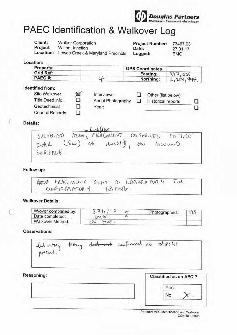


Photograph 1 – House and garden area
Photograph 2 – Drum and gas cylinder next to corrugated steel shed with charred residue.
Site Photographs PROJECT: 73467.03
Supplementary PCA PLATE No: 1
Wilton Junction Walker Land REV: A
CLIENT: Walker Corporation DATE: February
2017

Photograph 3 – Structures possibly from a former homestead
Photograph 4 – Empty containers of ‘Stellite Coatings’ visible in several areas
Site Photographs PROJECT: 73467.03
Supplementary PCA PLATE No: 2
Wilton Junction Walker Land REV: A
CLIENT: Walker Corporation DATE: February
2017

Photograph 5 – Possible fill containing construction and demolition material
Photograph 6 – Open container with liquid, and labelled as containing pesticides
Site Photographs PROJECT: 73467.03
Supplementary PCA PLATE No: 3
Wilton Junction Walker Land REV: A
CLIENT: Walker Corporation DATE: February
2017

Photograph 7 – Metal furniture and timber visible next to dam near centre of 1000 Picton Road
Site Photographs PROJECT: 73467.03
Supplementary PCA PLATE No: 4
Wilton Junction Walker Land REV: A
CLIENT: Walker Corporation DATE: February
2017

Douglas Partners Pty Ltd ABN 75 053 980 117
www.douglaspartners.com.au 18 Waler Crescent
Smeaton Grange NSW 2567 Phone (02) 4647 0075
Fax (02) 4646 1886
Brisbane • Cairns • Canberra • Central Coast • Coffs Harbour • Darwin • Geelong • Gold Coast • Macarthur Melbourne • Newcastle • Perth • Port Macquarie • Sunshine Coast • Sydney • Townsville • Wollongong
Bradcorp Holdings Project 85989.00 Locked Bag 5015 28 June 2017 GLADESVILLE NSW 1675 R.001.Rev0 CLN Attention: Grahame Kelly Email: [email protected] Dear Sirs Addendum to Phase 1 Contamination Assessment
Proposed Wilton Junction Rezoning
Hume Highway and Picton Road, Wilton, NSW
1. Introduction
Douglas Partners Pty Ltd (DP) was commissioned by Bradcorp Holdings Pty Ltd (Bradcorp) to prepare an addendum to the DP report titled Phase 1 Contamination Assessment, Wilton Junction, Hume Highway and Picton Road, Wilton, report 73467.00.Rev 6 dated 18 June 2014 (DP, 2014; ‘the PCA’). The PCA was prepared by DP for a land parcel known as Wilton Junction, situated at the intersection of Picton Road and Hume Highway, Wilton. It is understood by DP that the Wilton Junction land parcel is subject to a proposed rezoning, with four key stakeholders involved in the site’s development including Lend Lease Building Pty Ltd, Bradcorp, Governors Hill and Walker Corporation Pty Ltd. The extent of the Bradcorp site is shaded in green on Figure 1, on the following page. The DP (2014) report provided a preliminary evaluation of the contamination status of the Wilton Junction site and its suitability, from a contamination standpoint, for the proposed rezoning. This addendum to the PCA has been prepared in response to comments provided by the NSW Environment Protection Authority (EPA) on the PCA for the Bradcorp portion of the site only (‘Bradcorp site’), see Section 2.

Page 2 of 13
Proposed Wilton Junction Rezoning 85989.00.R.001.Rev0 Hume Highway and Picton Road, Wilton, NSW June 2017
Figure 1: Wilton Junction Land Ownership

Page 3 of 13
Proposed Wilton Junction Rezoning 85989.00.R.001.Rev0 Hume Highway and Picton Road, Wilton, NSW June 2017
2. Response to EPA Comments
Table 1 below presents comments that were provided to Bradcorp, from the EPA with DP’s response specific to the Bradcorp site. Section 3 addresses the response to comments in greater detail. Table 1: DP response to EPA Comments
EPA Comment (Section 4) DP Response
The Phase 1 Contamination Assessment (the report) presents a preliminary evaluation of the contamination status of the site identifying Areas of Environmental Concern (AECs). The Phase 1 Contamination Assessment does not consider or address contaminated sites issues in fine detail.
Noted and agreed, the level of assessment completed was considered suitable for the rezoning application and is commensurate with the information available at the Phase 1 (PSI) stage.
DP Action: none proposed.
The report does not include a Conceptual Site Model (CSM) which should be an integral part of a Phase 1 assessment. As described in the NEPM guidance (Schedule B (2) – guideline on site Characterisation), development of a CSM is an essential part of all site assessments and provides the framework for identifying how the site became contaminated and how potential receptors may be exposed to contamination either in the present or in the future. In accordance with the NEPM guidance, a CSM should be developed so to establish the assessment objectives to inform further assessment.
DP Action: A high level CSM is presented in this PCA Addendum.
The “Executive Summary” indicates “Based on the findings of this preliminary contamination assessment, potential groundwater contamination is not considered to be significant unless soil contamination is found within the AEC within the background area. If significant contamination is identified, then a groundwater investigation may be required.” Given that AECs have been identified in the report, further intrusive investigations of contamination by way of both soil and groundwater assessment within the AECs is warranted.
DP intends to assess the need for a groundwater assessment on a case by case basis for each AEC. Based on the findings of the PCA, no known significant issues exist within the Bradcorp area that would trigger the need for a groundwater assessment, unless significant contamination is identified at the Phase 2 or DSI stage.
DP Action: None proposed.

Page 4 of 13
Proposed Wilton Junction Rezoning 85989.00.R.001.Rev0 Hume Highway and Picton Road, Wilton, NSW June 2017
EPA Comment (Section 4) DP Response
The “Section 7.4 Groundwater Bore Database” indicated the presence of eight (8) bores on site for domestic stock, irrigation and test purposes with depths between 12 to 76 metres depth. The site hydrogeology description is not included and therefore, the depth of the groundwater on site remains unknown. An assessment of site hydrogeology is warranted to inform a conceptual site model of the site and understanding of potential impacts of site contamination to human health and the environment.
Available bore logs and site history information can be further assessed to provide additional information on the hydrogeological regime of the general region.
DP Action: The additional information is provided in this PCA Addendum.
The “Section 7.5, Search of the Department of Defence Website for Sites Affected by Unexploded Ordnance (UXO)” indicates “no further investigation of the UXO area within the site is considered necessary from a contamination stand point.” It is recommended an adequate assessment of UXO to be undertaken in the site. A site containing UXO represents a safety hazard and must be assessed by a qualified expert. The expert will be able to determine if the site is safe or has an appropriate level of site investigation in relation to UXO by identifying the presence of UXO or the likelihood of finding it in the site. It is also recommended that the area suspected to be used as a World War 2 bombing range (Lot 2 DP702024 – owned by Bradcorp) to be assessed to identify potential environmental impacts from the military past activity.
OPEC Systems has been engaged by Bradcorp to conduct a UXO Assessment of the Douglas Park Bombing Range (which encompasses the site). The OPEC Systems report has been reviewed by DP as part of this PCA Addendum.
The “Section 8, Site Inspection”, page 15 of the report: Bullet 7, indicates that minor staining was observed around the bowser in the airfield Bullet 8, indicates that staining around above ground storage tank (AST) was observed around the bowser in the airfield.
Consideration should be given to contaminated site assessment of airfield AST and associated infrastructure as well as soil and groundwater investigations in the airfield area. Irrigation/domestic bores may be present in vicinity of the site, so it will be critical to assess the potential impacts into water resources. Monitoring must be undertaken with reference to the NSW EPA approved guidelines including the 2013 Amendment of the Assessment of Site Contamination NEPM 1999.
This comment is not relevant to the Bradcorp area as the ASTs were located outside the boundary of this area.
DP Action: None proposed; a review of available groundwater information is however included in this report.

Page 5 of 13
Proposed Wilton Junction Rezoning 85989.00.R.001.Rev0 Hume Highway and Picton Road, Wilton, NSW June 2017
EPA Comment (Section 4) DP Response
The Section “8. Site Inspection” page 15, bullet 12, indicates a landfill (which appears to be illegal) was observed on the northern side of the runway. It is considered that further assessment is required, including groundwater assessment, in order to identify soil and groundwater impacts from the landfill activities.
This comment is not relevant to the Bradcorp area as the landfill is outside the boundary of this area.
DP Action: None proposed ; a review of available groundwater information is however included in this report.
The Section “8. Site Inspection” page 15, Bradcorp Land, bullet 1, indicates a cattle yard is located in the centre of the site. For agricultural areas, consideration should be given to the selection of laboratory analytical suite for identification of impacts from this activity, including arsenic.
Based on the findings of the Phase 1 Assessment, the cattle yard was not considered to be an Area of Environmental Concern.
To resolve this comment, DP proposes conducted a walkover of the cattle yard area, as well as targeted sampling and analysis for chemicals of potential concern associated with former agricultural land use in this portion of the site. The findings of these works are included in this PCA Addendum.
The Section “8. Site Inspection” page 16, bullet 3, indicates that BHP Billiton exploration / monitoring locations were observed. Further information about BHP Billiton activities in the area should be obtained and assessed in order to identify potential contamination sources if any, from their activity.
The presence of BHP Billiton exploration / monitoring locations observed on the ‘Governers Hill’ Land is likely associated with nearby coal mining (Bulli Seam Operations at West Cliff Colliery / Appin Area 9). South32 (demerged from BHP Billiton) is contractually required to reinstate the site to baseline conditions, if and where required. This requirement will be triggered once rezoning approval is granted.
DP Action: Further information regarding BHP Billiton mining / monitoring activities in the region is provided in this PCA Addendum which also provides comment on any potential contamination sources (if any) associated with such activities.
The Section “9, Potential for Contamination” identifies in “Table 3” asbestos are identified as a contaminant of concern for a number of areas of environmental concern. It is recommended that future investigations engage a suitably qualified person for implementing asbestos management, if required.
DP confirms that suitably qualified and trained environmental staff are engaged to conduct asbestos specific investigations and remediation works. Training includes DP in-house asbestos competency training. DP is also able to provide licensed asbestos assessors for work associated with friable asbestos.
DP Action: None proposed.

Page 6 of 13
Proposed Wilton Junction Rezoning 85989.00.R.001.Rev0 Hume Highway and Picton Road, Wilton, NSW June 2017
EPA Comment (Section 4) DP Response
Considering that important contamination issues have been identified in the report, engagement of a site auditor accredited under the Contaminated Land Management Act 1997 is recommended to confirm that the site is suitable for the proposed use.
DP understands that Melissa Porter of Senversa has been engaged by Bradcorp to conduct an audit under the CLM Act 1997.
3. Response to Comments
DP has addressed the EPA’s comments regarding the CSM, hydrogeology, UXO, cattle yard and BHP Billiton activities in Sections 3.1 – 3.5 below.
3.1 Conceptual Site Model
A CSM is a representation of site-related information regarding contamination sources, receptors and exposure pathways between those sources and receptors (linkages). A preliminary CSM provides a framework to identify potential contamination sources and how potential receptors may be exposed to contamination either in the present or the future (i.e. it enables an assessment of the potential source – pathway – receptor linkages). The preliminary CSM is used to inform future contamination investigations (if required).
3.1.1 Potential Sources
Based on the review of site history information and the site inspection conducted as part of the PCA, the identified sources, description of sources and contaminants of potential concern (COPC) at the site have been summarised in Table 2, below. The locations of AEC for the Bradcorp site (only) are shown on Drawing 1, attached. Table 2: Potential Contamination Sources and COPC Bradcorp Site
Potential Source AEC# Description of Potential Source COPC
Mounds / Stockpile (S1) 36, 37, 43, 44, 45
During the site inspection, two soil mounds (of unknown origin) were observed within the northern portion of the site (AEC 43 and 44). Soil stockpiles (of unknown origin) were also observed within the southern region (AEC 36
and 37), and a earthen ramp / mound was noted within the south eastern portion of the
site (AEC 45)
Metals, PAH, TRH, BTEX,
OCP, OPP, PCB, asbestos
Fill (S2) 24
A possible filled gully was observed during the site inspection in the south eastern
region of the site. Timber logs were observed on the surface.
Metals, PAH, TRH, BTEX,
OCP, OPP, PCB, asbestos

Page 7 of 13
Proposed Wilton Junction Rezoning 85989.00.R.001.Rev0 Hume Highway and Picton Road, Wilton, NSW June 2017
Potential Source AEC# Description of Potential Source COPC
Construction of Railway Bridge (S3) 1
Review of the 1984 historic aerial photograph indicates that a railway bridge was being constructed within the western
portion of the site. Construction and demolition waste is likely to have been generated as a result of these works.
Metals, TRH, BTEX, PCB,
PAH and asbestos
Ground Disturbance (S4) 2, 8, 11
Based on review of historical aerial photographs, the following ground
disturbances were noted: 1955 aerial - AEC 11 1961 aerial - AEC 2 1984 aerial - AEC 8
Metals, PAH, TRH, BTEX,
OCP, OPP, PCB, asbestos
Notes: Metals: comprising arsenic (As), cadmium (Cd, chromium (Cr), copper (Cu), lead (Pb), mercury (Hg), nickel (Ni) and zinc (Zn); TRH - Total recoverable hydrocarbons; BTEX - Benzene, toluene, ethylbenzene and xylene; PAH - Polycyclic aromatic hydrocarbons; OCP and OPP - Organochlorine and organophosphorous pesticides; PCB - Polychlorinated biphenyls; ACM - Asbestos Containing Material
3.1.2 Potential Receptors
The following potential human receptors (R) have been identified for the site: R1 – Construction and maintenance workers (during site redevelopment); R2 – Future site users following development of the site; and R3 – Land users in adjacent areas (rural residential) including irrigation from Hawkesbury sandstone aquifer. The following potential ecological receptors (R) have been identified for the site: R4 – Local groundwater, and receiving water bodies; R5 – Surface water bodies (creeks, dams); and R6 – Local ecology. DP notes that potential ecological receptors are usually associated with the upper 2 m (root zone and habitation zone for many species) of the soil profile.
3.1.3 Potential Pathways
Potential pathways for contamination include the following: P1 – Ingestion and dermal contact of soil and irrigation water;

Page 8 of 13
Proposed Wilton Junction Rezoning 85989.00.R.001.Rev0 Hume Highway and Picton Road, Wilton, NSW June 2017
P2 – Inhalation of airborne fibres, dust and / or vapours; P3 – Leaching of contaminants and vertical migration into groundwater; P4 – Surface water run – off; P5 – Lateral migration of groundwater providing base flow to watercourses; and P6 – Plant uptake.
3.1.4 Summary of Potential Complete Pathways
A ‘source – pathway – receptor’ approach has been used to assess the potential risks of harm being caused to human or ecological receptors from contamination sources on or in the vicinity of the site, via exposure pathways. The possible exposure pathways between the above sources (S1 – S6) and receptors (R1 to R6) are provided in Table 3 below. Assessment of the preliminary CSM was used to determine data gaps and the requirement for sampling and analysis to assess the suitability of the site for the proposed residential use. Table 3: Preliminary Conceptual Site Model
Source Exposure Pathway Receptor
Requirement for
Additional Data and /
or Management
S1: Mounds / Stockpiles
S2: Fill
S3: Construction and Demolition waste
S4: Ground Disturbance
S5: Agricultural Activities
S6: BHP Billiton Activities
P1 – Ingestion and dermal contact.
P2 – Inhalation of fibres, dust and/or vapours
R1 - Construction and maintenance workers.
R2 – Future site users
R3 – Land users in adjacent areas.
An intrusive investigation is required to quantify and assess possible
contamination including chemical testing of soil
(surface water and groundwater if deemed
necessary).
P3 – Leaching of contaminants and vertical migration into groundwater.
P4 – Surface water run-off.
P5 – Lateral migration of groundwater providing baseflow to watercourses.
R4 – Local groundwater and receiving water bodies.
R5 – Surface water bodies.
P6 – Plant uptake. R6 – Local ecology.

Page 9 of 13
Proposed Wilton Junction Rezoning 85989.00.R.001.Rev0 Hume Highway and Picton Road, Wilton, NSW June 2017
3.2 Hydrogeology
The Bradcorp site is underlain by both Ashfield Shale of the Wianamatta Group and Hawkesbury Sandstone. As such, the hydrogeology will vary depending on the location within the site. The following paragraphs provide a description of the expected conditions in both the shales and the sandstone. McNally, G. 2005, Investigation of Urban Salinity – Case Studies from Western Sydney, 2005 describes some general features of the hydrogeology of Western Sydney which are relevant to the Bradcorp site. The shale terrain of much of Western Sydney is known for saline groundwater, resulting either from the release of connate salt in shales of marine origin or from the accumulation of windblown sea salt. Seasonal groundwater level changes of 1 m – 2 m can occur in a shallow regolith aquifer or a deeper shale aquifer due to natural influences. Groundwater investigations undertaken by DP in the South West of Sydney and previous studies of areas underlain by the Wianamatta Group, including Wilton indicate that:
The shales have a very low intrinsic permeability, hence groundwater flow is likely to be dominated by fracture flow with resultant low yields (typically < 1 L/s and as low as 0.03 L/s in Wilton) in bores. Groundwater depth in the Wilton area is typically in the range of at least 50 m below the ground surface;
The groundwater in the Wianamatta Group is typically brackish to saline with total dissolved solids (TDS) in the range 4000 – 5000 mg/L (but with cases of TDS up to 31 750 mg/L being reported1). The dominant ions are typically sodium and chloride and the water is generally unsuitable for livestock or irrigation; and
The Hawkesbury Sandstone is generally associated with low salinity levels, however the typically low to very low yield of groundwater from the sandstone means extraction of groundwater for irrigation purposes is typically impractical.
The areas underlain by Hawkesbury Sandstone are typically associated with higher groundwater quality (i.e. low salinities) and higher yields. Based on available groundwater bore logs and previous investigations in the Wilton area, sandstone and shale in places is present at shallow depths (< 10 m) below the Wilton area; the older Hawkesbury sandstone is more commonly exposed in low lying areas, i.e. toward the north east and north west (toward the Nepean River). The Hawkesbury sandstone beneath the Wilton area is generally unconfined and likely to be in direct hydraulic continuity with the soil landscape, therefore it is not considered to be suitable for potable water purposes.
1 Old, A.N. 1942. The Wianamatta Shale Waters of the Sydney District. NSW Agricultural Gazette, May 1942, p215 – 221.

Page 10 of 13
Proposed Wilton Junction Rezoning 85989.00.R.001.Rev0 Hume Highway and Picton Road, Wilton, NSW June 2017
3.3 OPEC Systems UXO Assessment
OPEC Systems Pty Ltd (OPEC) was engaged by Bradcorp to conduct an Unexploded Ordnance Assessment for the site as reported in their report titled Douglas Park Bombing Range, Unexploded Ordnance Assessment, Reference 17339DHN, dated 20 June 2017 (OPEC, 2017). OPEC reported that the Douglas Park Bombing Range operated by the Australian Military Forces was located at the site, including three aircraft Emergency Landing Grounds (ELG). The bombing range was reported by OPEC to be located at the site between February 1943 and at least January 1944. OPEC reported a search of the area for unexploded ammunition was ordered as part of the range closure; records indicated that no munitions, high explosive or practice were air delivered onto the range. OPEC concludes “it is considered that there is no potential for remnant air delivered munitions to be found in the Wilton Junction and Wilton North West development area”. A copy of the OPEC report is attached.
3.4 Cattle Yard
3.4.1 Site Walkover
A site walkover was undertaken on 13 June 2017 by a DP environmental scientist. Five surface samples (S1 to S5) were collected from the cattle yard area to provide general site coverage. One of the samples (S5) targeted an observed ground disturbance, based on review of aerial photographs. The surface sample locations are shown on Drawing 2, attached. Photographs taken during the walkover are presented in Photographic Plates 1 to 3, attached. During the walkover, the following observations were made:
The cattle yard consisted of a fenced area (Photograph 1) surrounded by vacant agricultural land (Photograph 2);
There was an Intermediate Bulk Container (IBC) immediately south of the site (Photograph 1). No evidence of spillages were observed on or around the IBC;
Two plastic basins filled with liquid (no odour was observed; assumed to be water) were found within the cattle yard (Photograph 3);
Metal stakes and sheeting were found scattered within the northern portion of the cattle yard (Photograph 4); and
Immediately north of the cattle yard, there was an area stripped of vegetation, with exposed soil (Photograph 5 – observed ground disturbance in historical aerial).
3.4.2 Field Sampling Procedure
Sampling data were recorded to comply with routine chain – of – custody requirements and DP’s standard operating procedures. The general sampling, handling, transport and tracking procedures are detailed below:
Sample locations were pre-determined using GIS prior to field work and were located in the field using a handheld Garmin GPS;

Page 11 of 13
Proposed Wilton Junction Rezoning 85989.00.R.001.Rev0 Hume Highway and Picton Road, Wilton, NSW June 2017
Samples were collected from the ground surface using disposable nitrile gloves and hand tools. Samples were collected from soils that did not come into contact with the hand tools. Gloves were replaced prior to the collection of each sample. Samples were placed into laboratory prepared glass jars. In addition, 50 g bag samples were collected for asbestos testing;
Sample containers were labelled with individual and unique identification including project number, sample ID, depth and date of sampling; and
One QA/QC sample was collected.
3.4.3 Analytical Rationale
Laboratory analysis of primary and intra-laboratory samples was conducted by Envirolab Services Pty Ltd (Envirolab). Envirolab is accredited by the National Association of Testing Authorities (NATA) and are required to conduct in – house QA / QC procedures. These are normally incorporated into every analytical run and include assessment of reagent blanks, spike recovery, surrogate recovery and laboratory duplicates. The analytical methods used are summarised in the laboratory certificates of analysis, attached.
3.4.4 Site Assessment Criteria
The site assessment criteria (SAC) applied have been informed by the CSM - which identified potential linkage of human and environmental receptors to potential contamination on the site (refer to Section 3.1). Analytical results were assessed (as a Tier 1 assessment) against the investigation and screening levels as per Schedule B1 of NEPC (2013). Taking into account the proposed land use of the site, the investigation and screening levels adopted are consistent with a residential land use scenario.
3.4.5 Analytical Results
The analytical results for the soil samples collected during the investigation are summarised in the attached Summary Table of Laboratory Results, together with the adopted SAC. Laboratory certificate of analysis has also been attached. A summary of the results is provided below:
Concentrations of PAH, Phenols, BTEX, OCP, OPP and PCB were below the laboratory limit of reporting (LOR);
Concentrations of metals and TRH were below the LOR and or SAC; and
Asbestos was not detected in any of the soil samples submitted for analysis.

Page 12 of 13
Proposed Wilton Junction Rezoning 85989.00.R.001.Rev0 Hume Highway and Picton Road, Wilton, NSW June 2017
3.5 BHP Billiton Activities
Further information regarding the BHP Billiton activities was obtained via phone and email correspondence with a community officer from South 32, a resource company that was previously part of BHP Billiton (BHP), who operate coal mining in the Bulli and Appin areas. The nearest current underground mine (Longwall type) at the site is located approximately 1 km north of the Bradcorp site, near Douglas Park. As discussed in the PCA, four BHP exploration / monitoring bores are located within the Bradcorp site (as shown on Drawing 1, attached) Four BHP bores were installed by BHP at the site in 2005 for the purposes of monitoring groundwater levels (only) as part of their mine dewatering program. The groundwater levels are frequently monitored using in-bore data loggers. The bores were installed using a truck mounted drill rig; groundwater bores were subsequently installed and appropriately sealed above the bore slots. All spoil and water was taken off site by BHP and disposed of appropriately (as reported by South 32/BHP). Based on correspondence received from South 32, mine water irrigation has historically occurred in the general Wilton area, however DP understands this has not occurred on the site, nor has any irrigation occurred in the general Wilton area for a number of years. 4. Conclusions
The PCA prepared by DP provided a preliminary evaluation of the contamination status of the site and its suitability, from a contamination standpoint for the proposed residential rezoning. The purpose of this addendum to the PCA is to respond to comments provided by the EPA, specific to the Bradcorp site only. Based on the findings of the PCA and this addendum, it is considered that the potential for significant contamination at the site is low, however, further investigation is recommended for the AECs defined in Table 2 of this report. In addition, low density (grid based) sampling of the remainder of the Bradcorp property is recommended to confirm the contamination status of the site. The additional investigation works should be undertaken prior to any development applications for subdivision and/or commencement of bulk earthworks. Based on the findings of the PCA and this addendum, the potential for groundwater contamination is not considered to be significant unless soil contamination is identified during further investigation works as part of the Phase 2 or DSI. If significant contamination is identified, then a groundwater investigation will be required. It is considered that the site is suitable for rezoning for the proposed Wilton Junction development from a contamination perspective. Further investigation, as described above, and remediation, as required, should be undertaken prior to subdivision.


DATE:
SCALE:
DRAWN BY:
OFFICE:TITLE:
REVISION:DRAWING No:PROJECT No:CLIENT:
Macarthur
CLN
22.06.2017
As shownA185989.00Bradcorp Holdings Pty Ltd
MGA
1,000
metres
0
Legend
AEC
Bradcorp Site Boundary

DATE:
SCALE:
DRAWN BY:
OFFICE:TITLE:
REVISION:DRAWING No:PROJECT No:CLIENT:
Macarthur
CLN
20.06.2017
As shownA285989.00Bradcorp Holdings Pty Ltd
MGA
13.00
metres
0Legend
Sampling Location
Approximate Cattle Yard Boundary

PROJ: 85989.00
PLATE: 1
REV: A
DATE: 13.6.2017CLIENT: Bradcorp Holdings Pty Ltd
Photo 2 - Surrounding agricultural land
Photo 1 - Cattle Yard
Site Photographs
Addendum to PCA
Wilton Junction, Hume Highway and Picton Road, Wilton, NSW

PROJ: 85989.00
PLATE: 2
REV: A
DATE: 13.6.2017
Addendum to PCA
Site Photographs
Photo 4 - Metals stakes and sheeting within northern portion of cattle yard
Photo 3 - Area within cattle yard
Wilton Junction, Hume Highway and Picton Road, Wilton, NSWCLIENT: Bradcorp Holdings Pty Ltd

PROJ: 85989.00
PLATE: 3
REV: A
DATE: 13.6.2017CLIENT: Bradcorp Holdings Pty Ltd
Photo 5 - Area of exposed soil, north of cattle yard
Site Photographs
Addendum to PCA
Wilton Junction, Hume Highway and Picton Road, Wilton, NSW