Embed Size (px)
Citation preview
1
Report on disaster proneness of Pulingome and Thirumeni Villages
(Reference: Submission to the Principal Secretary, Revenue and Disaster Management by
Kottathalachy Hill Eco-Protection Council and direction by Principal Secretary to Head, HVRA Cell
for urgent enquiry and report dated 3 May 2012)
Prepared by Reviewed by Approved by
sd/-
sd/-
sd/-
Dr. Sekhar L. Kuriakose
Head (Scientist)
HVRA Cell
Shri. G. Sankar
Principal Investigator
HVRA Cell
Prof. Dr. Keshav Mohan
Director
ILDM
Hazard, Vulnerability and Risk Assessment Cell
Department of Revenue and Disaster Management, Govt. of Kerala
2nd
Floor, Institute of Land and Disaster Management
PTP Nagar, Thiruvananthapuram 695038
Tel/Fax: 0471-2364424
Email: [email protected]

2
Prelude
Kottathalachy hill, located in survey no. 119/1 of Pulingome village, Taliparamba taluk, Kannur
district was declared as an Ecologically Fragile Land (Kerala Gazette dated 19 Sep 2006 No. 3 EFL 1-
134/2006) in the year 2006. Figure 1 shows the location map of Kottathalachy hill. In May 2012,
Kottathalachy Hill Eco-Protection Council placed a request before the Principal Secretary, Dept. of
Revenue and Disaster Management, Govt. of Kerala to declare the villages of Pulingome and
Thirumeni within which Kottathalachy hill is located, as Disaster Affected.
Immediate reason for the request by the Kottathalachy Hill Eco-Protection Council
The council in its appeal to the Principal Secretary states the following:
“Before three years a group of people from afar bought the land under the pretext that it may be
used for tourism and related purpose. They also mislead the people saying that these acres of land are
for large scale agriculture and cultivation. The innocent agricultural people sold the fertile land when
they were offered and incredible price for it. At present this businessmen have accumulated around 65
acres of agricultural land. Actually they bought the land, the central part of the Kottathalachy hill for
the purpose of quarrying, mining and stone crusher”.
Further they have requested:
“Since our villages are affected by piping and it is located in the environmentally sensitive area
please declare that these villages (Thirumeni and Pulingome) are disaster prone and only ecofriendly
projects should be allowed. An integral and all encompassed study on the environmental impact should
be executed by the concerned experts before issuing the licenses required.”
This request was also based on an investigation report submitted by Mr. G. Sankar, Scientist F,
CESS, Thiruvananthapuram regarding the wide spread presence of ‘soil pipes’ in these villages and the
conclusion in the report regarding possibility of land subsidence due to soil piping
Based on the request submitted by the Kottathalachy Hill Eco-Protection Council, the Principal
Secretary, Revenue and Disaster Management ordered Head, HVRA Cell on 3 May 2012 to investigate
the matter and report to the government.
The investigation
A team was constituted to investigate the situation in the Thirumeni and Pulingome villages. The
team members were Shri. G. Sankar, Principal Investigator, HVRA Cell (Scientist F, CESS), Dr.
Sekhar L. Kuriakose, Associate Professor, DMC & Head (Scientist), HVRA Cell, Mr. Eldhose
Kuriakose, Technical Assistant, CESS and Mr. Binoy P. Johny, Field Assistant, HVRA Cell. The team
conducted a detailed investigation of the said villages between 21st and 26
th May 2012. Findings of the
team are given below.

3
Figure 1: Location map of Kottathalachi hill

4
1. Introduction
Kottathalachy hill is situated in the border of Kerala and Karnataka in the villages of Pulingome and
Thirumeni, Thaliparamba taluk,
Kannur district (cf. Figure 1). The
hill is 809 m above MSL. The hill top
and immediate surrounding areas are
ecologically fragile and was declared
as an Ecologically Fragile Land
(Kerala Gazette dated 19 Sep 2006
No. 3 EFL 1-134/2006) in the year
2006. The approach road to the hill
top is via Cherupuzha town. The hill
top is also a pilgrim center of the
Christian community. Figure 2 shows a panoramic view of the Kottathalachy hill. The affected locality
is situated in the highland region with elevations reaching up to 801m in the Kottanthalachi mala.
Average slope of the hill is roughly 30º with many parts of the hill being near vertical. Soil thickness is
about 7 m on an average with rocky exposures present in the most areas. The Kottathachi mala is
characterized by radial drainage indicating its shape. Many lower order streams originate from this hill.
‘Thirumeni chal’ a third order stream and its tributaries drain through the locality. Charnockite rocks
dominates Precambrian crystalline basement of the area. The overburden material above the basement
is clay rich loamy soil.
1.1 Available literature
Two study reports are available regarding the environmental sensitivity of Kottathalachy hill, they
being the study report on ‘Investigation of the land subsidence in Chattivayal locality of Cherupuzha
grama panchayath, Taliparamba taluk, Kannu district’ from CESS in the year 2005 and an
‘Environmental Impact Assessment of Kottathalachy hill area’ by CARITAS India in the year 2011.
1.1.1 Extracts from the report of CESS
Land disturbances in the form of subsidence occurred in the Chattivayal ward of the Cherupuzha
Panchayat at about 12 noon, on September 9, 2005. The incident happened in the land belonging to
Mr. Chamakkala C.T Joseph. The subsided area is located very close to the house of Ms. Lisi Francis.
As the extent of the subsidence was not clear, fearing danger, the family of Ms. Lisi Francis was shifted
from this locality. In order to get an expert opinion on the matter, District Collector, Kannur requested
Figure 2: Panoramic view of the valley of Kottathalachy
hill
5
CESS, Thiruvananthapuram to study the phenomenon in order to assess the vulnerability of the house
under reference. Mr. G. Sankar, Scientist along with Mr. Sachit Mohan, Project Scientist investigated
the site. The field investigation was assisted by Mr. K.R. Jagadish, Asst. Geologist, Mining and
Geology, Kannur and Mr. M.K Rajan, Village Officer, Thirumeni.
1.1.1.1 Major conclusions of the investigation
• The study conducted by CESS indicates that the deep hollow formed in the land of Mr.
Chamakkala C.T. Joseph in Puligome Desom, Thirumeni village in Taliparamba taluk is due to a
geological phenomenon called ‘piping’, a process of subsurface soil erosion along preferred
channel.
• Once initiated they become cumulative with time, the conduits expand due to subsurface erosion
leading to roof collapse and subsidence features on surface.
• The house belonging to Ms. Lisi Francis is located in a vulnerable area. It is found that the
caving is taking place very near to the basement of the house. So it is found to be dangerous to
dwell there.
• There are underground channel-ways in the form of pipes formed in this locality. These pipes
have affected the ground water level in the area. As piping progresses subsidence may occur in
future also.
• This survey infers that there may be couple of such underground cavities or pipes existing in the
area. People may be advised to report if they hear sound of flowing water underground or see
muddy water from the springs located down slope side.
• Further studies may be conducted to establish/confirm the path of the pipes so that people can
avoid developmental activities there.
1.2 Extracts from the report of CARITAS India
The EIA conducted by CARITAS states that the hills are prone to rockfall and landslides. The hill
slope was affected by landslides in the year 2004, 2006 and 2010. The report also mentions that if
quarrying is allowed and top soil is removed, it would affect the ground water table of the region.
2. Hazard susceptibility of Thirumeni and Pulingome villages
It was evident from the field work conducted by the team that the slopes of Kottathalchi hill has
been affected by land degradation processes such as rock fall and debris flows since time immemorial.
The presence of numerous cobbles and boulders entrapped in the B and C horizons of the soil, and the
numerous loose boulders along the slopes of the hill are evidences of such events in the historic past.

6
Figure 3 shows a typical soil profile of the region. It is evident that these land degradation processes are
active event today, given the occurrence of landslides in the years 2004, 2006 and 2010. The slope,
rainfall conditions and anthropogenic activities prevalent in the area favors landslides and rock falls.
Numerous loose boulders and large rock fragments were seen to be located precariously on the slopes
of Kottathalachi hill. Such rocks and boulders which were found to be detached from the parent bed
rock are susceptible to toppling if subjected to severe vibrations such as that resultant of quarry related
blasting.
In addition to the above stated geo-hazards, the
presence of soil pipes (tunnels due to natural
subsurface erosion) makes the land further fragile. A
total of 20 pipes and pipe outlets were marked and
cataloged. Three pipes were investigated physically. It
was evident from the investigation that many of these
pipes are decades old in terms of their origin and
existence. Investigations inside the pipes revealed that
the baseline of the pipes is often bed rock. Figure 4
shows the locations of the investigated pipes overlaid
on the digital elevation model; Figure 5 shows the
locations of the pipes overlaid on the drainage map.
Water flow channels were observed inside the pipe.
Evidences inside indicates that most pipes experiences
pipe-full discharge during the peak seasons.
Indications of fluvial erosion such as water flow striations were evident on the side walls as well as the
roof. As bed rock arrests down cutting, the investigated pipes were seen to be experiencing lateral
erosion along the side walls. Presence of peat or peat like organic strata was found almost near the
baseline on the side walls of the investigated pipes and this stratum was found to be bedding parallel to
the slope. Some parts of the pipes were found to be stable. The walls and roofs of the stable segments
were found to be made of saprolite. Major part of the investigated pipes was still experiencing lateral
erosion. The relatively active parts of the pipes were found to be lined by thick soil strata that were
being eroded. Loose soil blocks that got detached from the roof were found on the floor of the pipes.
Figure 3: Entrapped boulders and
cobbles in the B & C horizons

7
Figure 4: Locations of soil pipes cataloged, overlaid over the Digital Elevation Model

8
Figure 5: Locations of soil pipes cataloged, overlaid over the drainage network

9
The near original state of
these soil blocks and the fact that
the soil has not been washed off
by running water indicates that
they were recent in origin. This
indicates that the processes
which triggered piping are still
active in the region and
numerous undetected pipes may
be present in the soil strata of the
region. Table 1 shows the slope
and elevation of the various pipe
inlets and outlets cataloged
during the site visit. From the
table it is evident that pipes are
located on steep slopes on
altitudes above 150 m (cf. Figure
4). Figure 6 shows the sketch of
an investigated soil pipe.
The pipe inlets and outlets were in close proximity to the 1st order drainage channels in the region
(cf. Figure 5) which is an indicator of the hydrological influence of these entities. The ground water
level of the region also seems to be influenced by the presence of these pipes. It may be noted that such
large soil pipes would collapse and result in significant loss of agricultural land if sever ground
disturbances such as blasting, piling etc. and resultant ground vibrations propagate through them. The
roofs and sidewalls of such pipes are unstable and the soil strata in the region do not seems to be
processing sufficient cohesion to withstand such vibrations. Figure 7 shows some photographs of the
investigated soil pipes.
Further, based on the rainfall records in the current year (2012) it has been noted that Thirumeni and
Pulingome are Moderately Drought (26-50% deficit of rainfall) affected (Meteorological Drought
Situation Assessment of Kerala, June-July 2012. Prepared by HVRA Cell, Dept. of Disaster
Management, Govt. of Kerala). Kottathalichi hill being the origin of ‘Thirumeni chal’ is a major source
of fresh water for these villages.
Figure 6: A sketch of an investigated soil pipe

10
A
B
C D
Figure 7: A – Inlet of a pipe; B – 20 m inside a soil pipe; C – 45 m inside a soil; D – Inlet to another soil pipe

11
Any disturbance to its sedimentary strata and bed rock will result in the reduction of soil water and
ground water storage respectively whereby the thriving agricultural richness of these villages will be
negatively affected.
The ecological fragility of Taliparamba Taluk (cf. Figure 8) has been noted in the ‘Report of the
Western Ghats Ecology Expert Panel – Part 1, 2011’ appointed by the Ministry of Environment and
Forests, Govt. of India. The report, known as ‘the Madhav Gadgil Committee Report’ identified
Taliparamba taluk as ‘Region of high sensitivity’ and has classified it as Ecological Sensitive Zone 2
(Appendix 3, Page 95, WGEEP Report 2011). The WGEEP Report 2011 further states ‘Change in land
use is not permitted in ESZ 2 from forest to non-forest uses or agricultural to non-agricultural, except
agriculture to forest (or tree crops) except when extension of existing village settlement areas to
accommodate increase in population of local residents’ (Table 6, Page 41, WGEEP Report 2011).
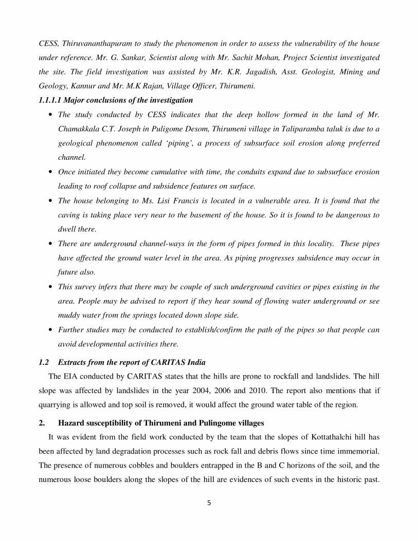
Further, in a report prepared by Centre for Earth Science Studies (CESS) in the year 2010,
Thirumeni and Pulingome villages have been classified as highly landslide prone and lightning prone.
Figure 9 shows the hazard susceptibility of Kannur district in which the villages Thirumeni and
Pulingome are highlighted.
3. Conclusions and recommendations
Based on the above stated facts, the following conclusions and recommendation are made by this
expert team which visited these villages:
Conclusions
1. The villages, Thirumeni and Pulingome of Taliparamba taluk are prone to natural hazards such
as landslides, land subsidence due to soil piping, drought and lightning.
2. These villages are ecologically highly sensitive as evident from the WGEEP report.
3. Based on the field investigation and available literature it is evident that these villages are hazard
prone.
4. The investigation team could not find immediate reasons for declaring these villages as ‘Disaster
Affected’ under the available provisions of the Disaster Management Act 2005.
5. However, if major anthropogenic interventions such as quarrying, mining (including river sand
mining), blasting, deep piling, ground water extraction for purposes other than local agriculture
etc. are allowed, it would lead to a situation whereby the hazard probability in the area would
substantially increase.

12
Figure 8: ESZs in Kannur (Blue circle in the map indicates the relative location of Kottathalachi hill)
(Reference: Understanding WGEEP, Kerala State Biodiversity Board 2012)

13
4. Recommendations
1. Anthropogenic interventions such as quarrying, mining, blasting, deep piling and ground water
extraction for purposes other than local agriculture should not be allowed in these two villages
considering the possibility of rock fall, possibility of land subsidence due to soil pipe collapses
and the possibility of hydrological and agricultural drought given any reduction in soil water
storage and ground water storage.
2. Quarrying, mining and explosive licenses issued in these two villages must be revoked and no
further mining and explosive licenses should be issued in these villages.
3. As recommended in the WGEEP report, agricultural land in these two villages should not be
converted to non-agricultural land, except from agriculture to forest (or tree crops).
4. Public must be alerted that they should not construct houses without undertaking a thorough
investigation to know if any sub-surface soil pipes exist at the sites proposed for construction.
14
Figure 9: Hazard zonation map prepared by CESS for Kannur district. In the blue box are Pulingome
and Thirumeni villages