Embed Size (px)
Citation preview

Report of the Working Group on Urban Strategic Planning 12th Five-year plan
Steering committee on Urban Development &
Management
October 4, 2011
Ministry of Housing and Urban Poverty Alleviation
Government of India
Working Group on Urban Strategic Planning
2
Contents Abbreviations ........................................................................................................................................ 3
1 Summary and Recommendations ............................................................................................. 6
Recommendations to Regional and Local Bodies ..................................................................... 19
2 Background ................................................................................................................................. 23
2.1 Steering Committee ........................................................................................................... 23
2.2 Working Group on Urban Strategic Planning .................................................................. 24
2.2.1 Brief outline of the issues involved ............................................................................. 25
2.2.2 Suggested Terms of Reference ................................................................................. 26
2.2.3 Composition of the Working Group .......................................................................... 27
3 Issues Identified by the Working Group .................................................................................... 27
4 Approach to Urban Strategic Planning ................................................................................... 30
5 Expected Outcomes .................................................................................................................. 31
6 Urban Strategic Planning: Principles ......................................................................................... 32
7 Existing actors/catalysts and recommendations .................................................................... 33
7.1 Recommendations to Government of India ................................................................... 35
7.2 Recommendations to States ............................................................................................. 39
7.3 Recommendations to Regional and Local Bodies ......................................................... 56
8 Case Studies ................................................................................................................................ 68

Working Group on Urban Strategic Planning
3
Abbreviations
ARC Administrative Reforms Commission
BRTS Bus Rapid Transit System
CAA Constitutional Amendment Act
CEPT Centre for Environmental Planning and Technology
CTP Chief Town Planner
DA Development Authority
DCR Development Control Regulations
DMES Data Management ---System
DMIC Delhi Mumbai Industrial Corridor
DPC District Planning Committee
DPG District Planning Guidelines
EDB Economic Development Board
EWS Economically Weaker Section
FYP Five Year Plan
GEM Generators of Economic Growth Momentum
GIS Geographical Information System
GoI Government of India
IDDP Integrated District Development Plan
ITPI Institute of Town Planners India
JNNURM Jawaharlal Nehru National Urban Renewal Mission

Working Group on Urban Strategic Planning
4
LB Local Body
LDP Local Development Plan
LU Land Use
LUC Land Use Conversion
MA Metropolitan Area
MMRDA Mumbai Metropolitan Regional Development Authority
MoHUPA Ministry of Housing and Urban Poverty Alleviation
MoUD Ministry of Urban Development
MPC Metropolitan Planning Committee
NHAI National Highway Authority of India
NOIDA New Okhla Industrial Development Authority
PPP Public Private Partnership
PWD Public Works Department
RAY Rajiv Awas Yojana
SC Sectoral Committee
SDC Spatial Development Centre
SDP Spatial Development Plan
SEC State Election Commission
SEZ Special Economic Zone
SPA School of Planning and Architecture/Special Planning Area
SPB State Planning Board
SPC State Planning Commission
SRTC State Road Transport Corporation

Working Group on Urban Strategic Planning
5
TCPD Town and Country Planning Department
TCPO Town and Country Planning Organisation
TDR Transfer Development Right
TIF Tax Increment Financing
ULB Urban Local Body
UMTA Unified Metropolitan Transport Authority
URA Urban Redevelopment Authority
WC Ward Committee
ZP Zilla Panchayat
Working Group on Urban Strategic Planning
6
1 Summary and Recommendations
Urbanisation has emerged as a key policy and governance challenge in India in
recent years. Cities and towns contribute to more than 60 percent of GDP.
Urbanisation is concomitant to economic growth. The strong correlation between
urbanization and economic development is well-known. While urbanization can be
an engine of economic development and inclusion, unless managed properly, it
can create serious socio-economic consequences and disastrous outcomes which
would be difficult or impossible to fix. With the rapid growth of urban population,
expected to occur as the structural transformation of the Indian economy matures,
and as India moves to double-digit growth, the backlog, current and growth needs
of urbanization need to be addressed comprehensively. We have to not only arrest
the deteriorating conditions in cities, but also take advance action for
accommodating urbanisation in a planned manner as India moves from a level of
31 percent to more than 50 percent urbanisation in the next few decades.
Projections suggest that India will have more than 700 million urban population by
the 2040s. There is an urgent need to address the lack of consistent and coherent
urban development policy, faulty and improper urban planning, coupled with poor
implementation and regulation overload in India’s cities. These factors have
transformed many of our cities into chaotic entities that are unlikely to be able to
meet the demands of Indian’s vision of development in the 21st century.
The urban planning system currently in vogue needs to be restructured to make it
inclusive with a strategic vision, to ensure the integration of physical and socio-
economic planning, transportation and land use planning, and to promote
participation by the people in the planning and development processes in the light
of the 74th Constitution Amendment Act, 1992 envisioning democratic
decentralization and power to the people. This should be a key vehicle for
achieving the objectives of the 12th Plan – faster and more inclusive economic
growth.
The urban planning process must combine spatial planning with socio-economic
and financial planning, and transportation planning with land use and

Working Group on Urban Strategic Planning
7
environmental planning to be more responsive to the changing needs and
demands of the citizens. Urban planning in India is a state subject and under the 12th
Schedule of the Constitution 74th Amendment Act, the subject of urban planning,
including town planning has been mandated for the third tier – Municipal
Corporations and Municipalities. The subject of regional planning, however, falls in
the domain of the State Governments. While the Constitution 74th Amendment Act
envisages that the District and Metropolitan Planning Committees consolidate plans
for the component urban and rural bodies, they send the “draft” District and
Metropolitan Plans to the State Government. The implication is that these plans are
to be integrated with the State Plans. As per the Constitutional mandate, the District
and Metropolitan Development Plans have to ensure coordinated spatial planning,
sharing of natural and other resources, integrated provision of infrastructure and
environmental conservation. These are areas which require guidelines so as to
synchronise bottom-up and top-down approaches, Moreover, considering that
cities are the engines of economic growth and socio-economic transformation,
there is a need for the Government of India to lay down broad policies and
guidelines with regard to spatio-economic planning and urban development in the
country, especially regional planning. All the constituent States and Union Territories
should restructure and update their Town and Country Planning/Urban
Development/Municipal Acts and spatio-economic policies in accordance with
these policy guidelines. These laws are the enabling instruments for undertaking
regional and urban planning activities at various levels to meet the challenges of
urbanisation.
Critical Issues
The Working Group has identified the following as the key problem areas in the
present urban planning system.
1. Lack of Comprehensive Planning Approach: The present master planning
approach generally focused on only the core area of the city, without proper
urban growth vision and strategy to connect/integrate the peri-urban and
rural areas within a regional framework. Lack of regional planning approach
has led to haphazard growth and proliferation of slums around industrial
locations and peri-urban areas, and randomly located new developments
such as SEZs and townships.

Working Group on Urban Strategic Planning
8
2. Rigid Planning Process: The planning process carried out through master plans
in India’s cities is rigid and deterministic. It lacks the integration of spatial
planning (including transportation and land use planning) with sectoral
planning. Master plans have aimed to be too detailed and therefore, even
after years of plan preparation exercise, zonal plans have not been
completed. Resultingly, the growth of cities has overtaken the planners by
surprise and the livability of cities has degraded with unplanned urbanization,
congestion and environmental degradation.
3. Lack of Plan-Finance Linkage: Master Plans in the past have been utopian,
without linkage to any financing and operating strategy. Planned urban
development leads to increases in tax bases, especially those related to land.
Master plans did not address the financing issues in a meaningful manner as a
result of which plan implementation has lagged behind plan targets
significantly.
4. Inadequate Institutional Clarity: The existing institutional framework for urban
planning and governance doesn’t specify clearly the roles and responsibilities
of the State Government, parastatals like Water Supply and Sewerage
Boards, Improvement Trusts, Urban Development Authorities, District Planning
Committee (DPC)/Metropolitan Planning Committee (MPC) and urban and
rural local governments in plan preparation, implementation, enforcement
and monitoring.
5. Lack of Capacity and Enabling Tools: A major impediment to effective
regional and urban planning system in India is the lack of human resources,
and enabling tools such as GIS and GIS-enabled Management Information
Systems (MIS). The plan process is often not participatory. The lack of
accountability and participation of the people and elected local
government representatives in the planning process also hindered the
effectiveness of the plan-making and implementation processes.
Approach to Urban Strategic Planning
The Working Group adopted the following as the key differentiators between the
existing approach to planning and the recommended strategic approach to
planning:

Working Group on Urban Strategic Planning
9
1. Vision-led: The approach should generate a qualitative vision of the city in
the framework of city region’s future based on a sound participatory process
to articulate the aspirations and needs of people from all spheres, including
the common man. The formulation of strategies evolved from such a vision
will mean a more flexible, responsive and most importantly, an inclusive
planning paradigm. This is a step away from the existing plan-making process
which relies exhaustingly on analysing the past trends, technicalities and
mechanical formulations.
2. Comprehensive and integrated: The existing systems of development
planning and spatial planning operate on a distinctly disjoint and parallel
fashion with little or no interaction. The planning approach should address all
sectors of development and spatial planning together in a holistic and
integrated framework – ensuring integration of sectoral and spatial planning.
3. Urban – rural integration in a regional framework: A strategic approach to
urban planning will start with a macro perspective at the national/state level
and then at regional level to guide urbanization and rural development in an
integrated and holistic manner. This comprehensive approach should then
eventually pave way for ‘sustainable settlement planning’ emphasising on
human living environment rather than overtly concentrating on built
environment and the accompanying administrative structures. It will integrate
top-down and bottom-up approaches.
District and Metropolitan Development Plans are envisaged to ensure
integrated rural and urban planning. They need to ensure spatial planning in
a coordinated manner, sharing of natural and other resources, integrated
provision of infrastructure and conservation of the environment. Detailed
planning needs to be left to the urban and rural local bodies.
Principles of Urban Strategic Planning
The Working Group has also articulated principle of urban strategic planning one
would like to see at the end of the 12th FYP period, with respect to urban strategic
planning:
1. Smart Growth: Planning should be based on smart growth principle that
concentrates growth in select city centres to avoid haphazard urban sprawl

Working Group on Urban Strategic Planning
10
and costly extension of urban infrastructure facilities to far-off areas. This
advocates compact, transit-oriented, walk-to-work, bicycle-friendly land use
to the extent possible, including neighbourhood schools, streets and
amenities that cater to everyone; mixed-use development with a range of
housing choices; and focus on public transport;
2. Existing Cities - Strategic densification: Cities in India have precariously low
Floor Space Index. Subject to development of supporting infrastructure, there
is need for selective densification of city centres, creating agglomeration
economies and generating resources for financing infrastructure;
3. Setting Priorities: Make the best use of available infrastructure networks or
extend the same to create sustainable settlement patterns:
a. Special or strategic focus on National Priority, State Priority cities and
cities that are Generators of Economic Growth Momentum (GEM).
Resources are scarce and they should be directed towards cities that
are capable generating agglomeration economies and inclusive
economic growth faster.
4. Development of (i) New cities along the National Transport/Industrial Growth
Corridors (Golden Quadrilateral and other Corridors) forming the national
spatial grid structure, (ii) Ring towns connected with major growing cities by
limited access high speed radial and orbital transport networks such as MTRS
and BRTS and (ii) Twin-cities - High speed commuter rail connectivity between
large primate city and growing secondary cities (e.g., between Bengaluru
and Mysore) located within the distance of 100-200 km.
5. Regional and urban planning as an instrument for guiding inclusive growth –
spatial and development planning should cover metropolitan regions,
planning areas of cities (may be 5-8 kilometers around existing large cities, say
those with more than 3 lakh population – transportation networks to be
central pieces of planning to “lead” development.
6. Integrated Land use and transport planning to optimise the functional and
spatial linkages between housing, workplaces and commercial areas; enable
cities to harness the benefits and agglomeration and minimise congestion;
adopt trip reduction zoning and densification of transit nodes and corridors in
addition to conservation of natural and heritage resources as part of the
planning paradigm.

Working Group on Urban Strategic Planning
11
7. Planning in consonance with the income distribution structure of the city
region with the urban poor located near public transport nodes/links and
providing space for the urban poor in master plans for living, selling and
working - at city, zone and local levels.
8. Effective land management in which growth is enabled to generate
resources for planned urban development.
9. Strengthening the Institutional framework for regional and urban planning
adopting the regime of 74th CAA
10. Creating capacity at city/town, state, central and institutional level for spatial
and socio-economic development planning.
Key Recommendations on Urban Strategic Planning
Based on the extensive analysis, discussions and meetings, the Working Group has
set out below major recommendations on urban strategic planning which sets out a
framework for urban planning in cities and towns of India adopting a regional
planning framework. The following is a summary of recommendations of the Working
Group.
Recommendations to Government of India
Strategic Plan Preparation
1. Prepare a National Spatial Strategy covering National Transportation Grids
and National Priority Cities, proposed new cities along emerging industrial
and high-tech Growth Corridors/Transportation Grids connected to central
cities with a high speed rail network and likely to generate agglomeration
forces. The strategy should define the broad morphology of the future
urbanization needs - with existing cities, their peripheral extensions and new
cities to be developed along the growth/transport corridors. The new cities on
growth corridors need to be located near existing large/metropolitan
cities/growth centres connected with high-speed transit networks so that they
can take advantages of the agglomeration forces. Development of new
cities will require a range of fiscal incentives, industrial location policy and
Working Group on Urban Strategic Planning
12
development transit networks – high speed rail network along the proposed
highway development corridors.
2. Provide a major thrust to Regional and Urban Planning and preparation of
District, Metropolitan and City Spatial and Development Plans through
strategic guidelines and financial support. The regional plans may be in the
form of structure plans.
3. Strategic Densification of Cities. The density regulations in Indian cities are
archaic and don’t address the needs of the present day demands of the
urban society. In fact, Indian cities have the lowest Floor Space Index (FSI) in
the world. Strategic densification as a planning strategy need to be pursued
to accommodate future urbanisation. Government of India may introduce
incentives that encourage states and cities to pursue this strategy for future
urban development. However, this strategy needs to go hand in hand with
infrastructure development within the city facilitated by flexible zoning.
4. Urban Renewal and Regeneration: Policy should provide broad framework to
facilitate the process of urban regeneration/ renewal within the generic
principle that the growth would pay for itself. This would require a flexible
planning approach and seed capital support.
Financing of Plan Preparation & Implementation
5. Assist National Priority Cities to create regional and urban planning capacity
under New Improved JNNURM and prepare strategic plans with 100 per cent
funding from the Centre.
6. Assist State Priority and GEM cities to create regional and urban planning
capacity under New Improved JNNURM and prepare strategic plans with 50
per cent funding from the Centre and 50 percent from State.
The cities have to be selected based on objective criteria through expert
committees involving the Central and State Governments. The plans must
have a clear financing and operating plan – clubbing own resources, state
share, central share and institutional finance/PPP.

Working Group on Urban Strategic Planning
13
Technical and Capacity Building Support
7. Government of India need to invest in a program for developing a set of
vendors of planning services who can conform to the requisite standards
anywhere in the country. A large number of planning firms already exist in the
country as a result of the market created by JNNURM during the last 5-6 years.
Their capacities can be built up and enhanced through NIJNNURM.
8. A major program on capacity building and networking need to be launched
by the Government of India to strengthen technical capacity of existing
planning institutions of states, and create on-line and off-line platforms to
share knowledge network on spatial planning. The Working Group endorsed
the recommendations of the High Powered Expert Committee for estimating
the investment requirement for urban infrastructure.
a. Setting up of five Indian Institutes of Urban Management, which could
be standalone institutions of excellence.
b. Create a Reform and Performance Management Cell (RPMC) in the
Government of India (and at state level and in large cities) with a
multidisciplinary team undertaking activities like:
c. Promote think tank initiatives in urban policy through Centres of
Excellence/ Innovation in existing institutions
d. Declare leading institutions as Centers of Excellence
e. Create a Scheme for funding Strategic (Spatial) Planning Research
through Centers of Excellence
f. Create an annual forum for sharing of research outcomes
g. Establish new schools of planning and enhance capacity of existing
ones
h. Producing new breed of professionals and training the resources who
are already carrying out these functions.
i. Funding for training & certification of in-service personnel as well as for
producing more planning professionals
j. Funding for creation of state level data infrastructure for planning
should be provided under NIJNNURM

Working Group on Urban Strategic Planning
14
10% of New JNNURM central allocation may be earmarked for capacity building
and preparation of Metropolitan Development and City Strategic Plans. To start with,
strategic plans should be prepared for all National and State Priority Cities and GEM
cities (in a phased manner). An expert committee jointly coordinated by the
Ministries of Urban Development and Housing and Urban Poverty Alleviation
supported by a full-fledged technical cell may guide the capacity building and plan
preparation processes.
Recommendations to State Governments
Legal Framework
9. Revise the nomenclature of Master Plan” to “Spatial and Development Plan”:
currently most common term used for the plan of cities is ‘master plan’ which
is both limited in outcome and over-bearing in perception and prescription.
The State Government needs to revise the nomenclature of Master Plan to
“Spatial and Development Plan” so as to capture both the spatial and socio-
economic development aspects of the planning. The nomenclature is
important to provide focus on what the plan is to deliver rather than
communicating a command and control concept.
10. States to revise “Town and Country Planning”, “Urban Development” and
“Municipal Acts” to respond to the challenges of urbanization and to policy
thinking appropriate to the times based on principles of urban strategic
planning: many states have enacted Town and Country Planning and Urban
Development Acts, Many of these acts are legacy of colonial influence
guided in part by two Model Acts – the Model Town and Country Planning
Law of 1960 and the model Regional and Town Planning and Development
Law of 1966 and its update of 1985. These Acts need to reviewed and revised
to respond to the challenges of the present days of urbanisation. The
recommended revision/establishment of Town and Country Planning
Acts/Municipal Acts should provides a broad framework, within the purview
of the 74th CAA, to address the present day challenges of urbanisation – with
entrenching planning functions and objectives into municipal system. The
Urban Development Acts and Urban Development Plan Formulation
Working Group on Urban Strategic Planning
15
Guidelines need to be changed to suit the needs of faster and more inclusive
growth.
The Government of India may assist the State Governments in model law
formulation.
Plan Preparation
11. Constitute/revamp State Planning Board (SPB) At the level of the state, a
strategic development vision should provide guidance for the district and
metropolitan spatial plans, ensuring a seamless integration of state
development priorities into district/metropolitan development plans. All states
must revive and strengthen where constituted, or constitute where not
constituted - State Planning Boards that are mandated with the preparation
of statewide strategic State Spatial and Development Plans or State Spatial
Plans. These plans must reflect the state and central governments' economic,
infrastructure and social development priorities and resource allocations,
which will be an input document for the plans of the lower levels of
government. The recommended State Planning Boards should work closely
with State Planning Commission and provide guidance to metropolitan and
district development plans to ensure seamless integration of these plans with
the state level spatial and development plan.
The State Planning Board (SPB) should oversee that the spatial development
plans for the state are prepared in a timely manner as prescribed; approve
plans of DPCs and MPCs; prepare or get prepared plans by default when
there is no acting Planning Authority; and act as arbitrator for conflicting land
uses between plans.
Technical assistance to SPB may be provided by the State Town Country
Planning Department (TCPD). The recommendations of the State Planning
Board must drive the investment priorities of the State Planning Commission
(SPC). The Chairperson of the SPB should be part of the SPC so that there is
informed decision making on the investment priorities based on the spatial
development plan of the SPB.

Working Group on Urban Strategic Planning
16
12. Constitute MPC/DPC to prepare Metropolitan/District Spatial Development
Plan. Under the Constitution, the DPC/MPCs are supposed to ‘consolidate’
the draft development plan of the district/metropolitan area. The constitution
is unclear on whether this plan is to be accepted by the government, and if
so, by when. It is open today, for a State to reject or ignore the
District/Metropolitan Plan, whether spatial or otherwise, completely. This is to
be clarified and designed properly, in the Planning Act.
The State Government should also notify Districts/Metropolitan Areas,
municipalities, and panchayats as "Planning Areas" and notify their respective
authorities as sole Planning Authorities. While, as an interim measure, it is
recommended that the existing Metropolitan and Urban Development
Authorities may prepare all the 3-tier plans within the district, the
establishment of long-term structures need to be put in place.
The ‘Draft Development Plan (DP)’ to be produced by the MPC/DPC requires
that due attention be paid to (1) integrate rural and urban through
coordinated spatial planning; (2) covers all matters of common interest to
municipalities and the panchayats; (3) take into consideration all investments
likely from various sources and sharing of resources; (4) facilitate integrated
development of infrastructure, and (5) ensure environmental conservation.
The plan at this level is a strategic plan serving the long-term interest of the
district/metro area as a whole over a 20 year period horizon. It may be in the
form of a structural plan.
In order for the MPC/DPC to deliver on this mandate it must be empowered
with adequate sovereign authority. Currently no such provisions are made in
the existing statutes and in fact a number of statutes that have been written
pre -74th Amendment to Constitution are in contradiction and need to be
reviewed and revised to be in line with the 74th Amendment Act.
13. Transfer planning function to local bodies: At present, in many states planning
function is entrusted with urban development authorities or some other state
level entities. Many states have not transferred the planning function to the
urban local bodies, as mandated by the 12th Schedule of the 74th Constitution
Amendment Act, 1992. It is recommended that all the state should transfer

Working Group on Urban Strategic Planning
17
the planning function to the urban local bodies to enable them to prepare
development plan in a participative manner.
14. Restructure the Role of the Development Authorities. Development Authorities
(DA) are currently responsible for developing plans for the metropolitan
region and of the metropolitan cities. To this end, the Development
Authorities’ technical capabilities as a metropolitan level planner and
regulator must be strengthened.
Metropolitan Development Authority role need to be restructured and it
should act as technical arm of the MPC. Metropolitan Development Authority
may be vested with the responsibility of enforcing and regulating the
Development Plan, and be the appellate authority for conflict resolutions on
the Spatial Plans for all Local Planning Authorities in the metro region. This is in
keeping with the letter and spirit of the Constitutional Amendment Act where
the DA's role is as the facilitator to the planning process. For all cities above 3
lakhs population, planning for a city development area may include city
proper and peripheral area, say 5-8 kilometres for which the Urban
Development Authority can service the Area Planning Committee (similar to
Metropolitan Planning Committee),
Given the changed mandate of Development Authority, it is critical that it is
relieved from the functions and responsibilities related to project
implementation and land development so as to avoid any conflict of interest
between the roles of planner/regulator, and that of project implementer or
developer. This includes its role as an infrastructure developer for region, and
as a land bank owner in the region.
All land parcels owned by the Development Authorities must be transferred to
the respective local governments.
15. Streamline the Procurement Process. State Governments should create state-
wide list for “Empanelled Urban Practice Professional Institutions” who can be
accessed by ULBs without having to go through tedious and repetitive
procurement procedure. In addition, the State Governments need to
Working Group on Urban Strategic Planning
18
prepare standardised procurement documents for key urban
infrastructure/services development activities including potential PPP
structures.
16. Establish institutional ownership for GIS data in State Urban Information
Systems In order to create credible, useful, successful spatial development
plans, and collect and analyze data in a systematized, standardized and
transparent manner.
Plan Implementation
17. Establish a system of Guaranteed Land Title Act. One of the major
impediments to planning process in India is unclear land records and title
system. To address the issue of land title state governments may establish a
system of Guaranteed Land Title Act as per the MoUD’s Framework Law, 2011
that provides security of tenure to immovable property. The recommended
system of Guaranteed Land Title Act may enable a system of rights to land
and property. This would enable local bodies to move towards better land
management and registration.
Plan Monitoring
18. Establish Office of Ombudsman. State Government should establish an Office
of a Metropolitan/District Ombudsman that would look into complaints of
corruption and maladministration against functionaries of local bodies, both
elected members and officials. The Ombudsman would mediate any
conflicts between citizens and specific authorities.
Plan Financing
19. Provide adequate resources for plan preparation to produce highly complex
technical outputs like plans/budgets/projects. Preparation this kind of plans
need not only financial support but also supporting systems that include
financial and trained technical resources

Working Group on Urban Strategic Planning
19
Technical and Capacity Building Support
20. State government need to develop revised legislation, and detailed standard
operating procedures for all the processes mandated by law, to ensure
consistency in planning processes. State governments also need to provide
guidance on strategic spatial plan development, policies for revenue land
(conversion, acquisition), environment, heritage, transport, affordable
housing, etc
21. Establish Indian Institutes of Urban Management to support regional and
urban planning and management activities in cities and towns. These
institutes should be established with the help of the Government of India.
Recommendations to Regional and Local Bodies
Plan Preparation
22. Prepare detailed SDPs reflecting Vision, Land Use (LU) and Development
Control Regulations (DCRs)
Spatial Development Plans contain two key aspects: Land Use (emerging out
of a vision); and Development Control Regulations (DCR). The SDP of the
District and Metropolitan Planning area must reflect the strategic vision of
development and sustainability for the entire region. Each municipality and
panchayat must also produce the third tier of plans at the level of the ward
and these plans are detailed as per the DCRs and LU of the tier-2 SDP of the
Municipality/Panchayat plan. Building bylaws which are under the functional
domain of, the Corporation/Council/Panchayat, are to be the mandate of
the municipality but through a separate division, not as part of the SDP.
23. MPC/DPC’s spatial development plans to be prepared with sectoral
participation. It is recommended that the MPC/DPC need to have Sector
Consolidation Committees to consolidate the sectoral plans that emerge
from the participatory process generated by lower tiers of local government
in the metropolitan area. The amalgamation of these sectoral plan will form
the basis for the preparation of MDP/DDP.

Working Group on Urban Strategic Planning
20
24. Establish a Unified Metropolitan Transit Authority for Metropolitan Areas.
Establish a UMTA as a technical agency that can help all planning bodies in
the MA, and work with the LBs to prepare integrated transport plans for the
regional and local governments. The UMTA plans would provide the input for
preparing transit oriented land use zoning and development.
25. Establish a Unified Metropolitan Water Authority in Metropolitan Areas. Given
that water is a key resource for human survival in growing urban areas and for
the agricultural economy in rural areas, the fair and equitable access to
surface water resources, its distribution across jurisdictions, as well as
appropriate regulatory measures for sourcing, pricing, ground water
extraction and replenishment, will require inter-jurisdiction planning across
local governments, at the regional level. This would require a specialised
authority like Unified Metropolitan Water Authority to deal with these issues.
26. Specialised Cells in Metropolitan Areas: Establish Unified Metropolitan
Environment Cell, Unified Metropolitan Heritage Cell and Directorate of
Metropolitan Economics and Statistics in Metropolitan Areas to provide
specialised services such as environmental safeguards, obtaining required
clearances on plan notification from state and central agencies, regulating
and enforcing environment and heritage related statutes, and creating
database for plan preparation.
27. Create Comprehensive Database on Urban Services and E-Governance
Systems, to aid the SDP preparation process. The MPC/DPC assisted by the
State Government should develop a standard and comprehensive urban e-
governance package. This can be prepared by examining best practices of
e-governance systems already being undertaken in the municipalities in the
MA and integrating GoI's initiatives on e-governance. GoI may develop
models that can be applied across cities.

Working Group on Urban Strategic Planning
21
Plan Implementation
28. Empower Ward Committees in municipalities through “Area Sabha” structures.
Wards must be empowered to contribute to the planning process through
local plans that reflect, correspond and guide the Spatial Plan. The Model
Activity Mapping document that has been provided by the Ministry of Urban
Development can serve as the template for the distribution of functions
across the tiers of ULB, Ward Committee and Area Sabha, for each of the
functions being devolved to the ULB.
29. Establish participatory structures of Area Sabhas All urban local bodies must
establish decentralised structures for participation in the plan preparation and
enforcement. These structures will ensure that the measures of accountability
flow outward to the citizens rather than upwards to the higher levels of
government.
30. Develop Participatory Planning Processes in ULBs. Active citizen participation
in urban areas must be through the structures of Area Sabhas in the
neighbourhood, and Ward Committees at the ward level. The process and
structure should ensure that ULBs prepare Ward Plan Budget in line with the
template prepared by the Ministry of Urban Development.
31. Decentralise enforcement of the SDPs. Empowering local bodies to plan must
extend to plan enforcement otherwise they will be unable to carry out their
plan. The enforcement should follow a decentralized bottom-up approach
with MPC/DPC acting as the third level of enforcement
32. Establish Citizen Charters the recommended Citizen Charters should contain
comprehensive information on service levels for all urban services, including
specification of time limits for approvals relating to regulatory services such as
licenses and permits. The Charter should also specify the relief available to the
citizens in case of non-adherence.
33. Enable Local Bodies to independently hire and recruit planning/technical
resources Local bodies to be empowered to hire for any position
independently in a transparent manner and lateral hiring must be allowed

Working Group on Urban Strategic Planning
22
34. Create a Single Window System at local body level, for plan sanction and
building approvals. Each municipality should have its own "Single-Window
Service Centres", and all plan sanctions and approvals from centre, state,
and local governments should be facilitated through this one-window system.
Multiple sets of plans can be submitted for the multiple approvals at this single
window of the municipality and its plan area. In case of a rejected plan, the
owner has recourse with the Ombudsman. In the case of development
projects in the panchayats, a common district / metropolitan single-window
service centre can be thought of, and local governments should be brought
under one umbrella by establishing ‘one stop service centres’.
The State Government should set up an "Urban Services Streamlining Task
Force" to examine and suggest simplification of Development Control
Regulations, procedures and transparency in all ULB plan sanctioning
activities
Plan Monitoring
35. Land Use Conversion (LUC) procedure needs to be amended to allow
conversion only as per spatial plan zoning prescribed. Any LUC approval at
the level of the district or metropolitan city must follow the
Metropolitan/District SDP and spatial plans of local governments. If a change
to the plan is proposed, it must be routed through the Panchayat /
Municipality concerned, and approved through consensus.
36. Pass Disclosure Law and Publish Performance Standards Every
municipal authority in the Metropolitan Area/district must comply with the
requirements of the Disclosure law, and publish quarterly statements of
performance, including financial statements and annual audited financial
statements, as well as Service Level Benchmarks (SLBs) as defined by MOUD,
GOI. All planning entities - DPCs, MPCs, Municipal Authorities must make
quarterly disclosure of all planning-related sanctions and procedures.

Working Group on Urban Strategic Planning
23
2 Background
2.1 Steering Committee
Urbanisation has emerged as a key policy and governance challenge in India in
recent years. Cities and towns contribute to more than 60 percent of GDP.
Urbanisation is concomitant to economic growth. The strong correlation between
urbanization and economic development is well-known. While urbanization can be
an engine of economic development and inclusion, unless managed properly, it
can create serious socio-economic consequences and disastrous outcomes which
would be difficult or impossible to fix. With the rapid growth of urban population,
expected to occur as the structural transformation of the Indian economy matures,
and as India moves to double-digit growth, the backlog, current and growth needs
of urbanization need to be addressed comprehensively. We have to not only arrest
the deteriorating conditions in cities, but also take advance action for
accommodating urbanisation in a planned manner as India moves from a level of
31 percent to more than 50 percent urbanisation in the next few decades.
Projections suggest that India will have more than 700 million urban population by
the 2040s. There is an urgent need to address the lack of consistent and coherent
urban development policy, faulty and improper urban planning, coupled with poor
implementation and regulation overload in India’s cities. These factors have
transformed many of our cities into chaotic entities that are unlikely to be able to
meet the demands of Indian’s vision of development in the 21st century.
Since faster, sustainable and more inclusive growth is the major objective of 12th
plan, a well planned urban development can be a key vehicle for achieving this
objective in a more inclusive manner. With a view to guide the planned urbanisation
in India during the 12th Plan a Steering Committee on Urban Development
Management has been constituted under the chairmanship of Shri Arun Maira,
Member, Planning Commission. The Terms of Reference of the Steering Committee
include the following:

Working Group on Urban Strategic Planning
24
i. To critically evaluate the challenges of urbanization in India and evolve a
vision and approach for managing the same during the 12th plan period.
ii. To draw a framework and road map for ensuring that different layers of
Governments, i.e. Central, State and City, function systematically in close
coordination of each other by drawing long term urban strategic planning
which along with specific context of municipal limits encompasses the overall
regional planning perspective including the rural areas falling within the zone
of influence of urban agglomerations.
iii. To recommend strategies for improving urban governance which ensures
managerial efficiency, accountability and responsibilities and is appropriate
for addressing the future need of Indian cities
iv. To suggest measures for building adequate capacity, especially at State and
ULB level to meet the challenges of urbanization.
v. To recommend measures for ensuring efficient and affordable public urban
transport to incentivize shift from private to public transport.
vi. To recommend strategies for accelerating the creation of job opportunities in
urban areas for meeting the twin objectives of faster as well as inclusive
economic growth.
vii. To suggest and recommend measures for improvement in delivery of urban
basic services to the citizens, particularly the poor with specific reference to
the provision of affordable housing.
viii. To suggest strategies for ensuring environmental sustainability of urban areas
while maintaining a high rate of growth.
ix. To suggest measures for mobilizing adequate financial resources for guided
urbanization.
x. To review the performance and undertake impact assessment of central
schemes/ programmes especially Jawaharlal Nehru National Urban Renewal
Mission (JNNURM) and suggest suitable form and guidelines of new scheme
which may be launched under 12th Plan.
2.2 Working Group on Urban Strategic Planning
In the context of formulation of the Twelfth Five Year Plan (2012-2017), it was
decided to constitute a Working Group on Urban Strategic Planning under the

Working Group on Urban Strategic Planning
25
chairpersonship of Secretary, MoHUPA. The working Group would be serviced by
MoHUPA.
2.2.1 Brief outline of the issues involved
Urban policy framework in India is out of sign with the economic and demographic
imperatives. A huge urban land shortage artificially created by out modelled
planning models and consequent housing shortages and growth of slums, chaotic
transport, unequal municipal finances and governance, untidy informal irregular
growth, huge infrastructure shortages, water logging and open defecation disease
are some visible problems of urban planning in India.
The urban planning system currently in vogue needs to be restructured to make it
inclusive with a strategic vision, to ensure the integration of physical and socio-
economic planning, transportation and land use planning, and to promote
participation by the people in the planning and development processes in the light
of the 74th Constitution Amendment Act, 1992 envisioning democratic
decentralization and power to the people. This should be a key vehicle for
achieving the objectives of the 12th Plan – faster and more inclusive economic
growth.
The urban planning process must combine spatial planning with socio-economic
and financial planning, and transportation planning with land use and
environmental planning to be more responsive to the changing needs and
demands of the citizens. Urban planning in India is a state subject and under the 12th
Schedule of the Constitution 74th Amendment Act, the subject of urban planning,
including town planning has been mandated for the third tier – Municipal
Corporations and Municipalities. The subject of regional planning, however, falls in
the domain of the State Governments. While the Constitution 74th Amendment Act
envisages that the District and Metropolitan Planning Committees consolidate plans
for the component urban and rural bodies, they send the “draft” District and
Metropolitan Plans to the State Government. The implication is that these plans are
to be integrated with the State Plans. As per the Constitutional mandate, the District
and Metropolitan Development Plans have to ensure coordinated spatial planning,
sharing of natural and other resources, integrated provision of infrastructure and
environmental conservation. These are areas which require guidelines so as to

Working Group on Urban Strategic Planning
26
synchronise bottom-up and top-down approaches, Moreover, considering that
cities are the engines of economic growth and socio-economic transformation,
there is a need for the Government of India to lay down broad policies and
guidelines with regard to spatio-economic planning and urban development in the
country, especially regional planning. All the constituent States and Union Territories
should restructure and update their Town and Country Planning/Urban
Development/Municipal Acts and spatio-economic policies in accordance with
these policy guidelines. These laws are the enabling instruments for undertaking
regional and urban planning activities at various levels to meet the challenges of
urbanisation.
2.2.2 Suggested Terms of Reference
The following points were noted as issues to be addressed by the working group on
urban strategic planning:
1) The urban land and land use policy is outmoded. The planning process in urban
areas is weak and has stymied the growth of cities.
2) Urban Planning must combine robust spatial planning with development goals
and version infrastructure planning (including urban transport), socio-economic
and environmental planning and risk mitigation against hazards. It must given
the spatial planning to the development plan.
3) Urban planning also needs to be made more responsive to changing needs and
changing population share by income distribution with special focus to the
needs to the urban poor.
4) The existing focus on expansion of towns in isolation of their hinterlands needs to
be reoriented to that of the region.
5) Within the region, aim should be to identify towns or growing villages with
locational or natural resource advantages in order to focus future socio
economic and spatial growth in such nodes by guided investment of funds for
infrastructure and industrial growth.
6) Spatial planning should also include operationalising the provisions of the Town &
Country Planning Act, for the rural hinterland of the towns, by laying down clear
and simple guidelines for the country or the Panchayat areas, with specific
reference to the peri-urban areas.

Working Group on Urban Strategic Planning
27
7) Regional Planning must be so redesigned as to prevent the shift of function of
regulation of urban planning within a regional master plan to the 3rd tier as per
the Constitutional provisions.
2.2.3 Composition of the Working Group
Chairperson: Smt Kiran Dhingra
Shri Arun Kumar Misra, Secretary, MoHUPA
Members:
Shri G.S. Sandhu, Principal Secretary, Department of UD &
Housing, Govt of Rajasthan, Jaipur
Member
Ms. Swati Ramanathan, India Urban Space, Bangalore Member
Prof. A.K. Sharma, Director, School of Planning and Architecture,
New Delhi
Member
Ms. Nisha Singh, Joint Secretary (UD), MoUD, GoI Member
Prof. EFN Ribeiro, Chairman, Board of Governors, SPA Bhopal Member
Ms. Uma Adusumili, Chief, Planning Division, MMRDA, Mumbai Member
Prof. Shivanand Swami, Associate Director, CEPT University,
Ahmedabad
Member
Shri I.P. Gautam, Municipal Commissioner, Ahmedabad Member
Shri. J.B. Kshirsagar, Chief Planner, TCPO, New Delhi Member
Shri Sanjeev Sanyal, Sustainable Planet Institute, Gurgaon Member
Shri Brijesh Kumar, formerly Chairman, GNOIDA, Greater NOIDA Member
Dr. A.N. Sachithanandan, President, ITPI, Chennai Member
Dr.P.K.Mohanty, Additional Secretary and Mission Director
(JNNURM) , Ministry of Housing and Urban Poverty Alleviation
Member –
Convener
3 Issues Identified by the Working Group
The Working Group on Urban strategic Planning has identified the following key
problem areas of the urban planning. These are:
Working Group on Urban Strategic Planning
28
1. Lack of integration between spatial and sectoral planning: Spatial planning in
many states in India is carried out by town planning departments or
development authorities. These plans lay out, for the entire urban areas, the
road network, land use zoning and development control regulations. As a
parallel process, the state governments undertake planning for many sectors
of development (social and economic) at the state, district and city level.
Most of the sectoral (socio-economic) planning efforts are focused on
program and project formulation and have very weak spatial planning
components. The most recent additions in the context of urban development
are the plans required under JNNURM and other GOI programs (City
Development Plan, Comprehensive Mobility Plan, City Sanitation Plan, etc).
Most of the sectoral (socio-economic) planning efforts are focused on
program and project formulation and have very weak spatial planning
components, if any.
2. Lack of regional approach: the present planning approach focuses on only
the core area of the city, without proper vision and strategy to integrate the
peri-urban and rural areas within a regional framework. Consequently most
cities and their regions are facing serious issues of haphazard development in
the urban periphery, environmental degradation and depletion of natural
resources.
3. Rigid and deterministic plans: The planning process carried out through
master plans in India’s cities is rigid and deterministic. It lacks the integration of
spatial planning (including transportation and land use planning) with
sectoral planning. Master plans have aimed to be too detailed and therefore,
even after years of plan preparation exercise, zonal plans have not been
completed. Resultantly, the growth of cities has overtaken the planners by
surprise and the livability of cities has degraded with unplanned urbanization,
congestion and environmental degradation.
4. Congestion and long commutes: Inefficient public transport systems and
deficient road networks have resulted in poor accessibility, long trip durations
and congestion on the street, not only in within cities, but also in their
extended peri-urban areas.
5. Slums and squatter settlements around industrial estates: Industrial
developments are planned with little or no provision for the EWS housing
Working Group on Urban Strategic Planning
29
needs resulting from direct and indirect demand generated by such
development.
6. Randomly located new developments such as SEZs and Townships: The lack
of a regional perspective results in major new developments coming up in
random locations often with unforeseen consequences with respect to
infrastructure adequacy, overcrowding of existing urban centres,
environment and other considerations.
7. Lack of Plan-Finance Linkage: Master Plans in the past have been utopian,
without linkage to any financing and operating strategy. Planned urban
development leads to increases in tax bases, especially those related to land.
Master plans did not address the financing issues in a meaningful manner as a
result of which plan implementation has lagged behind plan targets
significantly.
8. Lack of institutional clarity: The existing institutional framework for urban
planning and governance doesn’t specify clearly the roles and responsibilities
of the State Government, parastatals like Water Supply and Sewerage
Boards, Improvement Trusts, Urban Development Authorities, District Planning
Committee (DPC)/Metropolitan Planning Committee (MPC) and urban and
rural local governments in plan preparation, implementation, enforcement
and monitoring.
9. Lack of Capacity building and the enabling tools: A major impediment to
effective regional and urban planning system in India is the lack of human
resources, and enabling tools such as GIS and GIS-enabled Management
Information Systems (MIS). The plan process is often not participatory. The lack
of accountability and participation of the people and elected local
government representatives in the planning process also hindered the
effectiveness of the plan-making and implementation processes.
10. Social exclusion: Current approaches to planning have resulted in a sharp
divide between income groups in terms of access to housing and basic
services. Legal, mortgageable ownership housing has become unaffordable
and rental markets are underdeveloped, resulting in large sections of the
urban poor having to live in unserviced, unsafe and unmortgageable
housing.

Working Group on Urban Strategic Planning
30
4 Approach to Urban Strategic Planning
The Working Group adopted the following as the key differentiators between the
existing approach to planning and the recommended strategic approach to
planning:
1. Vision-led: The approach should generate a qualitative vision of the city in
the framework of city region’s future based on a sound participatory process
to articulate the aspirations and needs of people from all spheres, including
the common man. The formulation of strategies evolved from such a vision
will mean a more flexible, responsive and most importantly, an inclusive
planning paradigm. This is a step away from the existing plan-making process
which relies exhaustingly on analysing the past trends, technicalities and
mechanical formulations.
2. Comprehensive and integrated: The existing systems of development
planning and spatial planning operate on a distinctly disjoint and parallel
fashion with little or no interaction. The planning approach should address all
sectors of development and spatial planning together in a holistic and
integrated framework – ensuring integration of sectoral and spatial planning.
3. Urban – rural integration in a regional framework: A strategic approach to
urban planning will start with a macro perspective at the national/state level
and then at regional level to guide urbanization and rural development in an
integrated and holistic manner. This comprehensive approach should then
eventually pave way for ‘sustainable settlement planning’ emphasising on
human living environment rather than overtly concentrating on built
environment and the accompanying administrative structures. It will integrate
top-down and bottom-up approaches.
District and Metropolitan Development Plans are envisaged to ensure
integrated rural and urban planning. They need to ensure spatial planning in
a coordinated manner, sharing of natural and other resources, integrated
provision of infrastructure and conservation of the environment. Detailed
planning needs to be left to the urban and rural local bodies.

Working Group on Urban Strategic Planning
31
5 Expected Outcomes
The general outcomes that are desired from the recommended approach of urban
strategic planning are represented below:
The group also articulated a vision of what one would like to see at the end of the
12th FYP period, with respect to urban strategic planning:
All states in India to have:
an effective strategic planning system that promotes plans that are
strategic in nature, vision-led and cater to the future of human
settlements and regions with sustainable inclusive high growth
a comprehensive planning legislation mandating such a planning
system
A planning system incorporates urban land management practices
that are effective in the supply of planned and serviced land in
tandem with demand for urbanization and leads to growth
management in the peripheries of cities
A planning system that mandates holistic regional planning to ensure
balanced development in urban and rural areas, effectively
managing natural resources
To have institutional capacity to undertake such planning processes
The 73rd and 74th Constitutional Amendment Acts put the responsibility for planning
on the shoulders of the respective local bodies. The CAAs also mandate a hierarchy
of governance institutions for rural, urban and metropolitan contexts. The working

Working Group on Urban Strategic Planning
32
group concurred that any recommendations for revamping the legal framework
and institutional structure for planning have to respect the provisions of the 73rd and
74th CAAs.
Clearly, one cannot expect that in five years all of India will get planned thoroughly.
Therefore, the key outcome is to put in place a framework for effective planning in
all the states, with some level of consistency in principles and processes across the
country.
6 Urban Strategic Planning: Principles
The Working Group has also articulated some broad principles of urban strategic
planning one would like to see within the overall framework of urban development:
1. Smart Growth: Planning should be based on smart growth principle that
concentrates growth in select city centres to avoid haphazard urban sprawl
and costly extension of urban infrastructure facilities to far-off areas. This
advocates compact, transit-oriented, walk-to-work, bicycle-friendly land use
to the extent possible, including neighbourhood schools, streets and
amenities that cater to everyone; mixed-use development with a range of
housing choices; and focus on public transport;
2. Existing Cities - Strategic densification: Cities in India have precariously low
Floor Space Index. Subject to development of supporting infrastructure, there
is need for selective densification of city centres, creating agglomeration
economies and generating resources for financing infrastructure;
3. Setting Priorities: Make the best use of available infrastructure networks or
extend the same to create sustainable settlement patterns:
a. Special or strategic focus on National Priority, State Priority cities and
cities that are Generators of Economic Growth Momentum. Resources
are scarce and they should be directed towards cities that are
capable generating agglomeration economies and inclusive
economic growth faster.
4. Development of (i) New cities along the National Transport/Industrial Growth
Corridors (Golden Quadrilateral and other Corridors) forming the national
spatial grid structure, (ii) Ring towns connected with major growing cities by

Working Group on Urban Strategic Planning
33
limited access high speed radial and orbital transport networks such as MTRS
and BRTS and (ii) Twin-cities - High speed commuter rail connectivity between
large primate city and growing secondary cities (e.g., between Bengaluru
and Mysore) located within the distance of 100-200 km.
5. Regional and urban planning as an instrument for guiding inclusive growth –
spatial and development planning should cover metropolitan regions,
planning areas of cities (may be 5-8 kilometers around existing large cities, say
those with more than 3 lakh population – transportation networks to be
central pieces of planning to “lead” development.
6. Integrated Land use and transport planning to optimise the functional and
spatial linkages between housing, workplaces and commercial areas; enable
cities to harness the benefits and agglomeration and minimise congestion;
adopt trip reduction zoning and densification of transit nodes and corridors in
addition to conservation of natural and heritage resources as part of the
planning paradigm.
7. Planning in consonance with the income distribution structure of the city
region with the urban poor located near public transport nodes/links and
providing space for the urban poor in master plans for living, selling and
working - at city, zone and local levels.
8. Effective land management in which growth is enabled to generate
resources for planned urban development.
9. Strengthening the Institutional framework for regional and urban planning
adopting the regime of 74th CAA
10. Creating capacity at city/town, state, central and institutional level for spatial
and socio-economic development planning.
7 Existing actors/catalysts and recommendations
After delineating an approach with essential underlying principles that should form
the crux for an integrated urban planning framework and strong policy, the Working
Group has looked at the efforts that have already been made in this direction. It is
always contended that efforts so far in India have been fractional and disaggregate
in approach. Any sound strategy making and policy guiding framework enlists the

Working Group on Urban Strategic Planning
34
prior efforts and the success of their intended benefits, inventories the gaps and
disconnection between them and paves way for a process that strongly perceives
the existing merits before embarking on recommendations.
Some of the efforts that have had a strong influence in structuring urban planning
and development are:
At national level:
i. National highways
ii. Railway connectivity
iii. Freight corridors
iv. Golden Quadrilateral – DMIC
At state level:
i. State highways
ii. Town and Country Planning Organisation
iii. State Planning Board
At regional level:
i. Metropolitan/District Planning Committees
ii. Development Authorities
iii. Unified Metropolitan Transport Authority
iv. Master Plans for 20 -25 years
At Municipal level
i. Ward committees and Area Sabhas
ii. City Development Plans
iii. Master plans
iv. Cit y Sanitation Plans
All the above listed initiatives in the form of either institutions or tangible actions plans
play a key role in the field of urban development. They are all key players in the area
of urban planning by either initiating the processes, providing supporting
mechanisms or by giving necessary thrust to the process of urbanisation.
In addition to the above, a number of other initiatives have been taken to
compliment them. At the national level, the Delhi Mumbai Industrial Corridor is a spin
off project of the Golden Quadrilateral initiative. An initiative of this scale weighing

Working Group on Urban Strategic Planning
35
the advantages brought forth by the project and the plan to provide further impetus
to urban growth banking on the connectivity between the two most important
urban as well as economic centres in India is a sound spatial planning decision. To
ensure an overall cohesive policy for urbanisation and urban planning in India, it is
necessary to have a National Spatial Strategy indentifying potential growth centres
and areas with need for developing new urban centres.
7.1 Recommendations to Government of India
Strategic Plan Preparation
1. Prepare a National Spatial Strategy covering National Transportation Grids
and National Priority Cities, proposed new cities along emerging industrial
and high-tech Growth Corridors/Transportation Grids connected to central
cities with a high speed rail network and likely to generate agglomeration
forces. The strategy should define the broad morphology of the future
urbanization needs - with existing cities, their peripheral extensions and new
cities to be developed along the growth/transport corridors. The new cities on
growth corridors need to be located near existing large/metropolitan
cities/growth centres connected with high-speed transit networks so that they
can take advantages of the agglomeration forces. Development of new
cities will require a range of fiscal incentives, industrial location policy and
development transit networks – high speed rail network along the proposed
highway development corridors.
Given that about 150 million of the urban population is in the 50 million plus
cities of India, national strategy for urbanisation should include a regional
view to planning, especially in districts with metropolitan cities where the
pressure of the city is felt keenly on the surrounding region. A major metro
attracts the bulk of migration and highway corridor development all around
it. If the region is planned and developed proactively, satellite towns around
such magnet cities can become catchment areas for further urbanisation.
Such a strategy distributes the pressure, and increases the ability to provide
for a better quality of life overall.

Working Group on Urban Strategic Planning
36
These Satellite cities may be located on the basis of the parameters such as
Potential for economic sustainability, existing road / rail networks, existing and
anticipated infrastructure, especially water and power, Strategic location for
rural access, Existing social infrastructure and Low environmental impact.
2. Provide a major thrust to Regional and Urban Planning and preparation of
District, Metropolitan and City Spatial and Development Plans through
strategic guidelines and financial support. The regional plans may be in the
form of structure plans.
3. Strategic Densification of Cities. The density regulations in Indian cities are
archaic and don’t address the needs of the present day demands of the
urban society. In fact, Indian cities have the lowest Floor Space Index (FSI) in
the world. Strategic densification as a planning strategy need to be pursued
to accommodate future urbanisation. Government of India may introduce
incentives that encourage states and cities to pursue this strategy for future
urban development. However, this strategy needs to go hand in hand with
infrastructure development within the city facilitated by flexible zoning.
4. Urban Renewal and Regeneration: Policy should provide broad framework to
facilitate the process of urban regeneration/ renewal within the generic
principle that the growth would pay for itself. This would require a flexible
planning approach and seed capital support.
Key Points: Planning Commission should support the preparation of the National Spatial
Strategy with a dedicated Spatial Planning Division. Similar divisions should be established in

Working Group on Urban Strategic Planning
37
Ministry of Urban Development and Ministry of Housing and Urban Poverty Alleviation to
provide support to the states.
Financing of Plan Preparation & Implementation
5. Assist National Priority Cities to create regional and urban planning capacity
under New Improved JNNURM and prepare strategic plans with 100 per cent
funding from the Centre.
6. Assist State Priority Cities GEM cities to create regional and urban planning
capacity under New Improved JNNURM and prepare strategic plans with 50
per cent funding from the Centre and 50 percent from State.
The cities have to be selected based on objective criteria through expert
committees involving the Central and State Governments. The plans must have a
clear financing and operating plan – clubbing own resources, state share,
central share and institutional finance/PPP.
Technical and Capacity Building Support
7. Government of India need to invest in a program for developing a set of
vendors of planning services who can conform to the requisite standards
anywhere in the country. A large number of planning firms already exist in the
country as a result of the market created by JNNURM during the last 5-6 years.
Their capacities can be built up and enhanced through NIJNNURM.
8. A major program on capacity building and networking need to be launched
by the Government of India to strengthen technical capacity of existing
planning institutions of states, and create on-line and off-line platforms to
share knowledge network on spatial planning. The Working Group endorsed
the recommendations of the High Powered Expert Committee for estimating
the investment requirement.
k. Setting up of five Indian Institutes of Urban Management, which could
be standalone institutions of excellence.
l. Create a Reform and Performance Management Cell (RPMC) in the
Government of India (and at state level and in large cities) with a
multidisciplinary team undertaking activities like:

Working Group on Urban Strategic Planning
38
m. Promote think tank initiatives in urban policy through Centres of
Excellence/ Innovation in existing institutions
n. Declare leading institutions as Centres of Excellence
o. Create a Scheme for funding Strategic (Spatial) Planning Research
through Centres of Excellence
p. Create an annual forum for sharing of research outcomes
q. Establish new schools of planning and enhance capacity of existing
ones
r. Producing new breed of professionals and training the resources who
are already carrying out these functions.
s. Funding for training & certification of in-service personnel as well as for
producing more planning professionals
t. Funding for creation of state level data infrastructure for planning
should be provided under NIJNNURM
10% of New JNNURM central allocation may be earmarked for capacity building
and preparation of Metropolitan Development and City Strategic Plans. To start with,
strategic plans should be prepared for all National and State Priority Cities and GEM
cities (in a phased manner). An expert committee jointly coordinated by the
Ministries of Urban Development and Housing and Urban Poverty Alleviation
supported by a full-fledged technical cell may guide the capacity building and plan
preparation processes.
It is essentially national level initiatives that paved way for the initial development of
urban settlements in different states in the country with infrastructure provision. It was
later in 1970s that a majority of states set up Town & Country Planning organisations
realising the need for a coordinating and plan making authority at State level. State
Planning boards which were functional in many states by that time continue to
progress with their initial objectives of supporting development programmes and
preparing sectoral plan documents linking the Planning Commission functions at
Centre to state level even today. As it has already been suggested that spatial
planning division may be introduced in the Planning Commission in the earlier
recommendation, it necessary that the same linkage be established at State level.

Working Group on Urban Strategic Planning
39
The existing TCPOs would be able to render the necessary technical expertise
required for the State Planning Boards to devise State level Spatial Development
Plans.
Further, important initiatives are required to be taken at this level to serve two
objectives. One being, bringing forth of necessary changes for smooth transfer of
planning functions to the local bodies and second being the transfer process itself.
The following set of recommendations are in response to both the objectives:
7.2 Recommendations to States
Legal Framework
9. Revise the nomenclature of “Master Plan” to “Spatial Development Plan”
(SDP) The current most common term used for the plan for cities is “master
plan” which is both limited in outcome and over-bearing in perception and
prescription. The more appropriate term would be “spatial development
plan” which captures both the development aspect as well as the spatial
aspect of the power of the plan. This nomenclature is important to provide
focus on what the plan is to deliver. It captures the “socio-economic”
development planning prevailing in rural plans, along with the “spatial” land
use zoning that has been the predominant focus of urban plans.
10. States to revise “Town and Country Planning”, “Urban Development” and
“Municipal Acts” to respond to the challenges of urbanization and to policy
thinking appropriate to the times based on principles of urban strategic
planning
Town and Country Planning Acts
While all states, with the exception of Rajasthan state and the Union Territory
(UT) of Lakshadweep have enacted planning legislation in the form of Town
and Country Planning Acts, different states adopted planning legislation at
different points in time. Most state Planning Acts are legacy legislature
adopted from colonial influence, guided in part by two Model Acts brought
out by the Ministry of Urban Development GoI: the Model Town and Country
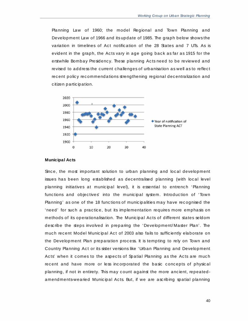
Working Group on Urban Strategic Planning
40
Planning Law of 1960; the model Regional and Town Planning and
Development Law of 1966 and its update of 1985. The graph below shows the
variation in timelines of Act notification of the 28 States and 7 UTs. As is
evident in the graph, the Acts vary in age going back as far as 1915 for the
erstwhile Bombay Presidency. These planning Acts need to be reviewed and
revised to address the current challenges of urbanisation as well as to reflect
recent policy recommendations strengthening regional decentralization and
citizen participation.
Municipal Acts
Since, the most important solution to urban planning and local development
issues has been long established as decentralised planning (with local level
planning initiatives at municipal level), it is essential to entrench ‘Planning
functions and objectives’ into the municipal system. Introduction of ‘Town
Planning’ as one of the 18 functions of municipalities may have recognised the
‘need’ for such a practice, but its implementation requires more emphasis on
methods of its operationalisation. The Municipal Acts of different states seldom
describe the steps involved in preparing the ‘Development/Master Plan’. The
much recent Model Municipal Act of 2003 also fails to sufficiently elaborate on
the Development Plan preparation process. It is tempting to rely on Town and
Country Planning Act or its sister versions like ‘Urban Planning and Development
Acts’ when it comes to the aspects of Spatial Planning as the Acts are much
recent and have more or less incorporated the basic concepts of physical
planning, if not in entirety. This may count against the more ancient, repeated-
amendments-wearied Municipal Acts. But, if we are ascribing spatial planning

Working Group on Urban Strategic Planning
41
functions to Municipalities and local elected bodies, it goes as a
commonsensical solution to include them in their guiding acts.
To attribute regional planning approach to the spatial planning efforts of
Municipalities and not restrict the regional plan boundaries to that of the
municipality, reinforcement of the concept of ‘urban development regions1’
around the municipal boundaries may be introduced. This will enable
Municipalities to plan for immediate hinterlands and peri-urban spaces outside
their jurisdiction and help exercise a certain control over the development and
landuse patterns of the emerging and future urban spaces. These ‘development
regions’ may have the same provisions ascribed to the municipalities as the
‘development/planning areas’ in the Town and Country Planning Act.
Another key aspect proposed in the 1993 West Bengal Municipal Act, which
stands deleted as of now after amendments, calls for creation of Urban
Development Committees for the jurisdiction of the ‘urban development region’
encompassing the constituent municipalities as well as gram sabhas. This
committee plays a key role in the finalisation of master plans or any other
activities involved in the process. The earlier version of the Act also goes on to say
that these committees may also be constituted in gram panchayat areas
(Census town conurbations and nearby villages) by the State government and it
falls on the assigned gram panchayats to fulfil the mandate of the urban
development committees and that sufficient support may be rendered by the
State government when requested.
Plan Preparation
11. Constitution of State Planning Board (SPB) for development of the Strategic
Plan at the state level. At the level of the state, a strategic development vision
provides guidance for the district and metropolitan spatial plans, ensuring a
seamless integration of state development priorities into district plans. All
states must revive and strengthen where constituted, or constitute where not
constituted - State Planning Boards that are mandated with the preparation
of statewide strategic Spatial Development Plans (SDP). These plans must
reflect the state and central governments' economic, infrastructure and
1 Deleted section 297 of the West Bengal Municipal Act, 1993 (with amendments, 2006)
Working Group on Urban Strategic Planning
42
social development priorities and budgetary allocations, which will be an
input document for the plans of the lower levels of government.
The main duties of the Board towards facilitating the lower levels of plans
include inter alia:
• Overseeing that spatial development plans for the state are prepared
in a timely manner as prescribed;
• Approving plans of DPCs and MPCs; preparing plans by default when
there is no acting Planning Authority; and
• Acting as arbitrator for conflicting land uses between plans.
The State Town Country Planning Department (TCPD) may provide technical
Assistance to the State Planning Board to deliver its duties and also assign
technical resources to the secretariat of the DPC/MPC. The role of the
secretariat to the DPCs may be assigned to the Zilla Panchayat. The
constitution of the Board can be structured to ensure appropriate political
representation, with the State Minister for Planning as the Chairperson, and
the Principle Secretary, Planning as Secretary to the SPB.
The strategic plan of the Board must be notified in a time-bound period so as
to provide direction to the planning of the lower tiers of districts and local
bodies – urban and rural. The recommendations of the State Planning Board
must drive the investment priorities of the State Planning Commission (SPC).
The Chairperson of the SPB should be part of the SPC so that there is informed
decision making on the investment priorities based on the spatial
development plan of the SPB.
Technical assistance to the SPB
A Technical Committee (TC) may be set up to assist the SPB in preparing the
State SDP. The PS of the State Planning Ministry would be the Chairman of the
TC and plays the role of the Secretary to the SPB. The Chief Town Planner
(CTP) is the member secretary of the TC and provides the required support on
planning to the TC.

Working Group on Urban Strategic Planning
43
Points to Note:
• The PS Planning is not a member secretary in the SPB and has no voting rights. The PS Planning is
also the Chairperson of the TC.
• The CTP reports to the Chairperson of the TC, and the Chairperson of the TC reports to the SPB
• The role of the CTP and TCPD as the technical support to the state must be strengthened with
adequate resources and a formal role for input into development of Urban and Regional
Planning Institutions, with a Special Committee set up to address the urgent need for such
establishing such Institutions.
12. Recognize a 3-tier footprint to the Spatial Development Plans: Region; Local;
Sub-local, where the regional plan integrates urban and rural development.
The city can no longer be viewed in isolation when preparing plans. The inter-
linkages between the core and the peripheries need to be part of the plan
preparation. Greenfield airports that service travel needs of the core and
periphery areas, regional transport linkages between cities and villages, agro
production in the region that provide grain and vegetables, water sources
that are shared between settlements, land fill sites that hold the waste of
urban consumption, rural land for the expanding population and expanding
economics– all these require a planning footprint that goes beyond the city.
The definition of this “region” for planning cannot be left open-ended, and
may be categorically defined by the district / metropolitan area boundary, so
that it is in consonance with the provision in the 74th Amendment of the
Constitution of India. The district provides political and administrative logic,
and planning for the region must therefore be for the area of the district.

Working Group on Urban Strategic Planning
44
Based upon the overall development controls for the larger region, the local
governments including both rural (village panchayats) and urban
(municipalities), may prepare their second tier of SDPs. The third tier plans are
prepared for the footprint of the zones of municipalities and panchayats.
Zonal Development Plan
Metropolitan/District SDP must be recognized as the highest tier of the 3-tier plans.
This recommendation is in keeping with the Planning Commission’s Decentralised
Planning Guidelines. The district plan integrates and consolidates all the plans of
local bodies – rural and urban – and at the same time guides their plans at a macro
level. The second tier plans are of the municipalities and panchayats. The third is the
electoral ward (or cluster of wards) within municipalities and panchayats. All three
levels plans must be processed keeping in mind the higher level of plans and their
and annual budgetary priorities, including the plans of the State Planning Board.
Specific points:
• In case “economic zone” or “environmental zone” is earmarked for development or protection
by either the union government or the state government, such an area will be designated as
“Special Area Plans (SPA)” planned on a case-by-case basis as authorised by the union or
state. However, the planning process shall be carried out in consultation with the MPC/DPC
within which the SPA is located.

Working Group on Urban Strategic Planning
45
• As per The Special Economic Zones (SEZ) Act, 2005 brought out be the Ministry of Commerce
and Industry, Section 11(1) and Section 12(1) to (6), every proposal for setting up of Special
Economic Zone shall be submitted to the concerned Development Commissioner who shall be
forward it to the SEZ Board with his inspection report, and State Government’s
recommendations. The SEZ Act adds that before recommending any proposal for setting up of
a Special Economic Zone, the State Government shall endeavour that:
o Exemption from State and local taxes, levies and duties including stamp duty, and
taxes levied on goods - Section 26 (1) (a), (1) (e), 26 (2)
o Water supply, electricity and other services in the State to the proposed Special
Economic Zone Units and Developer.
• The SEZ provisions in effect encroaches upon the constitutional authority as prescribed by the
74th Amendment, of the regional and local governments in establishing a separate planning
and governance authority exclusively for the SEZ, requiring no consultation on land acquisition
or planning, while at the same time committing the support of these governments in allocating
infrastructure and resources to the SEZ without consultation2.
• Two key mandatory requirements are recommended before granting approvals to SEZs:
discussion and consensus with the relevant Planning Authority/s on the impact and conformity
of the SEZ to the existing plans; incorporation of the SEZ’s requirements of affordable housing
into the SEZ plans.
13. Constitute and empower MPC/DPC to prepare Metropolitan/District Spatial
Development Plan.
Regional Planning approach requires clearly defined political and institutional
roles and responsibilities. The need for a regional approach and the co-
related legislation that empowers such an approach could not be more
pressing, especially around rapidly urbanising settlements, and where natural
resources of land, agriculture, water, minerals, stone, forests, etc. are under
threat.
These regions must be covered by a systematic hierarchy of Planning
Authorities, at two levels - first, for the region as a whole, and second, for
individual local bodies. However, as an interim measure, it is recommended
that the existing metropolitan and urban Development Authorities may
2 SEZs and private townships planned and approved by States and also the Union government, subverts the authority of regional and local bodies. For example, NCR region plan include 22 districts has a separate planning and sanctioning authority, which has no input from the district governments.

Working Group on Urban Strategic Planning
46
prepare all the 3-tier plans within the district, the establishment of long-term
structures need to be put in place. These are as follows:
• For the region as a whole, the MPC/DPC shall be the Planning Authority
vested with the preparation and notification of the
Metropolitan/district SDP
• For the second level of Spatial Development Plans, each LB (municipal
corporation, council, nagar panchayat, panchayat) shall be the
notified Planning Authority in its jurisdiction, and the practice of SPA
created by the State as it exists currently - without any consultation
and consensus by local planning authorities - shall be discontinued.
• The State Government shall not have the authority to notify any
authority/organisation as an SPA for any territory in the MA, without
due consultation with the existing planning authority, thereby
respecting the constitutional authority of regional and local
governments
• All current Special Planning Area territory shall revert to appropriate
Planning Authority, based on the respective jurisdictions.
Under the Constitution, the MPC/DPC is supposed to ‘consolidate’ the draft
development plan of the district/Metropolitan area. The constitution is
unclear on whether this plan is to be accepted by the government, and if so,
by when. It is open today, for a State to reject or ignore the District Plan,
whether spatial or otherwise, completely. This is to be clarified and designed
properly, in the draft planning Act.
The ‘draft development plan (DP)’ so produced by the MPC/DPC: (1)
Requires that due attention be paid to all urban local body development; (2)
Covers all matters of common interest to municipalities and the panchayats
including coordinated spatial planning; (3) Should take into consideration
investment into the metropolitan region; (4) Facilitate integrated
development of infrastructure (5) environmental conservation, and resource
sharing. The plan at this level is a strategic plan serving the long-term interest
of the district as a whole over a 20 year period horizon.

Working Group on Urban Strategic Planning
47
In order for the MPC/DPC to deliver on this mandate it must be empowered
with adequate sovereign authority. Currently no such provisions are made in
the existing statutes and in fact a number of statutes that have been written
pre -74th Amendment to Constitution are in contradiction and need to be
reviewed and revised to be in line with the 74th Amendment.
Specific points • The MPC/DPC must consolidate the plans of the municipalities and panchayats and
prepare its own development plan called the “Metropolitan Spatial Development
Plan” for the MA, submit to the State Government for approval and final notification,
and share the authority for regulating the plans with the local governments in the
MA/District.
• The MPC/DPC must be fully empowered to have a review function of the spatial Plans
of all the Planning Area /Special Planning Area bodies in its jurisdiction, so as to ensure
that these plans are consistent with the SDP of the region prepared by the MPC/DPC.
• The setting up of the MPC will have implications on other existing regional structures like
DPC In the cases where a metropolitan area straddles multiple districts. Therefore,
these districts must either be notified as a single metropolitan planning area with MPC
constituted with representation from all districts straddled by the metropolitan city and
region or the metropolitan region may be carved out of the respective districts and be
declared a distinct Planning Area with the MPC constituted with appropriate
representation from the districts involved. In this second option, the area carved out of
the districts into the MPC planning area, must include complete "block panchayats".
• A point to be noted is that the second option is less desirable than the first since it
creates a planning area that is not synchronous with the existing political boundaries.
The decision may be left to the states based on the political preference by individual
states. The planning authority for the metropolitan territory must not be fragmented,
and must be in keeping with the principles in the 74th Amendment to the Constitution
of India. This recommendation is consistent with the recommendations of the 2nd
Administrative Reforms Committee Report on Local Governance (section 3.7.6.2.4
page 75).
• The MPC/DPC must have a representative composition. The MPC/DPC is to be
mandated with a complex task of preparing the SDP, which involves engagement with
multiple stakeholders both within and outside government, and multiple technical
issues to be addressed. All of these tasks need to be done in a time-bound manner, for
a credible, enforceable plan. Once a plan has been notified through due process, the
MPC/DPC will also need to ensure proper compliance with the plan, and also that
revision to the plan happens on an ongoing basis. These tasks cannot be fulfilled

Working Group on Urban Strategic Planning
48
without a clear, empowered mandate, and an equitable representation in the
decision-making structure.
Constituting the MPC/DPC with elected representatives
The State Election Commission (SEC) will constitute electoral wards that are
represented by municipalities/panchayats. This is consistent with the policies of
the Ministry of Panchayati Raj (MoPR), which is the nodal ministry for the DPCs.
The SEC shall be vested with the authority to conduct the process of constituting
the MPC / DPC.
The 73rd and 74th Amendments to the Constitution of India mandates that a
minimum of 2/3rds of the MPC shall be constituted of elected representatives
from the MA region, provided that not less than two-thirds of the members of
such Committee shall be elected by, and from amongst, the elected members
of the Municipalities and Chairpersons of the Panchayats in the Metropolitan
area in proportion to the ratio between the population of the Municipalities and
of the Panchayats in that area.
Similarly, a minimum of 4/5ths of the DPC shall be elected by, and from amongst,
the elected members of the District Panchayat and of the Municipalities in the
district in proportion to the ratio between the population of the rural areas and of
the urban areas in the district. The remaining 1/3rd and 1/5th of the MPC and
DPC is kept open for nomination. That way, experts, who are not elected
representatives, can become members of the MPC/DPC. Also, those elected
representatives that are ineligible for being selected in the 2/3rd and 4/5ths
quota (such as MLAs, MPs, and in the case of the DPC, the elected
representatives from the Intermediate and Village panchayats), can be
nominated within this non-elected category. Currently, DPCs are dysfunctional in
most States and the nominees are usually the MLAs, who do not attend.
14. Transfer planning function to local bodies. Each of the existing as well as
proposed municipality in a district or Metropolitan area must have a Planning
Cell that provides technical support, which even if not fully staffed, must have
minimum resources that can provide for the day-to-day planning and design
requirements of the municipality, and that can also establish and oversee

Working Group on Urban Strategic Planning
49
contractual arrangements with external planning service providers (from
within or outside government) as needed.
Each municipality must mandatorily fulfil their obligation to produce a spatial
plan within a time-bound period of time.
The Spatial Development Plans thus prepared by the municipality be
submitted to the MPC/DPC. Any directions given by the MPC/DPC from the
point of view of ensuring the fulfilment of requirements and imperatives of the
notified Metropolitan/District SDP shall be complied with by the municipality
concerned. The spatial Plan which fully complies with such directions (if any)
shall be approved by the municipal corporation/council concerned. This
ensures compliance with the requirements of regional planning and also
safeguards the power of the individual ULBs to approve the SDPs prepared by
them without such plans being required (as is the legal requirement today) to
be submitted to the State Government for final approval.
In the case of rural local plans, the local Panchayat jurisdiction is composed
of "ward" footprints (the 600000 villages of India are under 25000 panchayats)
with an elected "pancha" per ward. A ward may have multiple villages and in
some cases may even cut villages. This grouping of "hamlets" into a pancha
ward is done by the State Election Commission (SEC) who is the final authority
on what constitutes an electoral ward. The Collector, or Director Municipality
may help in processing the delineation of the ward based on population
guidelines of the SEC.
The concept of the "village" representation has therefore given way to the
concept of the "ward" representation. The financial schemes and devolution
too go to the ward and not to the village. Hence the tier-2 SDPs in the rural
areas may be made at the Block footprint by the Panchayat, which
comprises of wards with elected Panchas that can prepare their plans at the
third tier of the recommended 3-tier plan making. The Ward Plans thus
prepared, must be with participation of the people through the grama
sabhas of the natural community unit of village/s contained in each "ward".

Working Group on Urban Strategic Planning
50
15. Restructure the role of the Development Authorities of metropolitan cities to
become technical and administrative support for MPC Development
Authorities (DA) are currently responsible for creating “structure plans” for the
metropolitan region and of the metropolitan cities. To this end, the
Development Authorities’ technical capabilities as a metropolitan level
planner and regulator must be strengthened.
Metropolitan Development Authority role need to be restructured and it
should act as technical arm of the MPC. Metropolitan Development Authority
may be vested with the responsibility of enforcing and regulating the
Development Plan, and be the appellate authority for conflict resolutions on
the Spatial Plans for all Local Planning Authorities in the metro region. This is in
keeping with the letter and spirit of the Constitutional Amendment Act where
the DA's role is as the facilitator to the planning process. For all cities above 3
lakh population, planning for a city development area may include city
proper and peripheral area, say 5-8 kilometres for which the Urban
Development Authority can service the Area Planning Committee (similar to
Metropolitan Planning Committee),
Given the changed mandate of Development Authority, it is critical that it is
relieved from the functions and responsibilities related to project
implementation and land development so as to avoid any conflict of interest
between the roles of planner/regulator, and that of project implementer or
developer. This includes its role as an infrastructure developer for region, and
as a land bank owner in the region.
All land parcels owned by the Development Authorities must be transferred to
the respective local governments.
The ZPs in different states vary widely in the range of powers and
responsibilities devolved upon them. In some states like Karnataka, the Chief
Planning Officer of the District is under the Administrative control of the ZP. In
other States, like Rajasthan, the CPO answers to the DC and is not under the
administrative control of the ZP. Therefore, it is recommended that the Chief

Working Group on Urban Strategic Planning
51
Planning Officer and his establishment in the district ought to become part of
the technical support system of the DPC3.
16. Streamline the Procurement Process. State Government should create a
state-wide list for “Empanelled Urban Practice Professional Institutions” whose
services can be accessed contractually by ULBs without having to go through
tedious and repetitive procurement procedure. In addition, the State
Government would prepare standardised procurement documents for key
urban infrastructure/services development activities, e.g. waste management
systems, water supply, sewerage, GIS, roads, etc, including potential PPP
structures. These should be developed in conjunction with industry forums and
other departments that have had experience in large scale procurement
processes. Ideally the state government would create a list of "qualified urban
infrastructure vendors" by sector that can be pre-qualified to bid for
appropriate ULB works. This list can be periodically updated.
The MPC/DPC (or the State Government) should also establish an e-
Procurement process. Placing the process online will enable the process to
become transparent and will not require waiting until a Disclosure Report is
published for the public to see how the money is being spent. Equally
important is the expectation that if the procurement process is brought online
more vendors will have a chance to participate, opening up the service and
infrastructure market and thereby lowering the costs to the municipalities and
citizens because the process will become more competitive.
17. Establish institutional ownership for GIS data through State Urban Information
Systems Spatial plans are analytical documents that are based on scientific
methodology and data collection. In order to create credible, useful,
successful spatial development plans, the MA needs a Metropolitan Spatial
Date Cell to collect and analyze data in a systematized, standardized and
transparent manner.
3 The technical support to DPCs, Panchayats and smaller cities and towns that will not have a separate Development Authority as in the case of metropolitan cities, is a matter that needs to be addressed. It is recommended that the State Town and Country Planning Department be strengthened to provide technical services, and planning assistance as and when needed.

Working Group on Urban Strategic Planning
52
Creating an Urban Spatial Data Centre (SDC) at the State level provides
reliable and current spatial data, which is a key requirement in the process of
decision-making, both for preparing spatial plans, for data sharing between
departments, and for urban management. The value of GIS spans across land
records, land management, municipal tax charges, monitoring services such
as water supply, roads, waste management, etc. The Metropolitan Area
planning especially need to have good quality maps to enable spatial
planning and urban management. The Metropolitan Spatial Data Cell can be
linked to the State SDC such that the base maps rest with the SDC, but the
MSDC can overlay data layers and modify these as required.
A key point to note on maps is the strong reluctance by various departments
at both central and state governments, to share their maps. In the times,
where Google and Microsoft have made maps available in public domain
across the globe, In India, procuring maps out of government is like procuring
top-secret national security documents. Establishing a map-sharing protocol
must be put on the front burner by union and state governments.
Plan Implementation
18. Establish a Guaranteed Land Title Act as per the MoUD’s Framework Law, 2011
Urbanising India urgently requires a robust system to establish and protect
land rights. Infrastructure development requires acquisition of land, and
without clarity on rights and boundaries, projects become expensive and
delayed.
There are two important aspects to land title: the first the formal recognition
by the state of property rights through a system of titles; and second the
facilitation by the state, of efficient trade in rights, through a process of
registration. Both of these elements exist in India, but in incomplete form.
a. While Indian law requires compulsory registration of sale of land, the
Indian Registration Act of 1908 doesn’t ask the registration authority to
verify history of the land or ownership from the seller, weakening the
protection to the buyer. Hence land registration is not registration of
Working Group on Urban Strategic Planning
53
title, but of deed of transaction. It is a fiscal instrument for the state,
allowing it to collect a “fee”, not providing the statutory support of
certainty to title. Neither does the Transfer of Property Act, 1882 require
verification of ownership.
b. In addition, Section 18 of the Registration Act does not demand
compulsory registration of all land related transactions. State legislation
on land acquisition, court decrees, land orders, heir-ship partitions,
mortgages, agreements to sell, etc, do not require mandatory
registration. The provision related to land in the Indian Contract Act of
1872, does not require contracts to be registered.
All of these forces combine to weaken land records and security of tenure.
What we have in India today is a presumed ownership to land that is
questionable and can be challenged on multiple fronts.
Implementing a system of Property title certification is one of the mandatory
reforms under the Jawaharlal Nehru National Urban Renewal Mission
(JNNURM). States are expected to implement the reform within the Mission
period. The Ministry of Urban Development has undertaken a comprehensive
exercise under Project PLATINUM (Partnership for Land Title in Urban
Management) for implementation of Guaranteed Land Title. The
recommendations of the Working Group are applicable immediately over
Union Territories and are underway to be tabled in Parliament for approval
and notification at the earliest. States may use the Law (Annexure 1 of
PLATINUM Report) as a Framework Law to enable a system of security of rights
to land and property. These recommendations on moving land management
and registration closer to local governments are consistent with the
recommendations of the 2nd Administrative Reforms Committee.
Plan Monitoring
19. Establish Office of Ombudsman. State Government should establish an Office
of a Metropolitan/District Ombudsman that would look into complaints of
corruption and maladministration against functionaries of local bodies, both
elected members and officials. The Ombudsman would mediate conflicts
between citizens and specific authorities. They would also assist in mediation

Working Group on Urban Strategic Planning
54
or arbitration conducted by the MPC/DPC or Development Authority to
reconcile interagency conflicts or irregularities in plan enforcement.
For the Ombudsman, the term ‘Public Servant’ should be defined
appropriately in the respective State legislations. The Ombudsman should
have the authority to investigate cases and submit report to competent
authorities for taking action. Such competent authorities should normally take
action as recommended. In case of disagreement, reasons must be recorded
in writing and be placed in the public domain.
This would require amendments in the respective State Panchayat Act and
the Municipalities Act to include provisions pertaining to the local body
Ombudsman. If the State Government feels that there are circumstances that
make it necessary to suspend or rescind any resolution passed by the
municipal corporation or council/panchayat or to dissolve or supersede
them, it should not do so unless the matter has been referred to the
Metropolitan Ombudsman and the Ombudsman recommends such action.
If, on any occasion, the State Government is in possession of records or has
adequate reasons to initiate action against the Urban Local Bodies or its
elected representatives, it should place the records before the
Metropolitan/District Ombudsman concerned for investigation. (See 2nd ARC
Report on Local Governance, section 5.8.4, page 309).
The office of the Ombudsman will have to be established in such a manner as
to ensure that there will be no conflict with the existing set-up under the
Lokayukta Act or Prevention of Corruption Act.
Plan Financing
20. Provide adequate resources for plan preparation. Producing highly complex
technical outputs like plans/budgets/projects will simply not take place
without the required supporting systems that include financial and trained
technical resources. Similarly, enforcement and regulation of plans will also
require appropriate and efficient authority. Absence of these renders
Working Group on Urban Strategic Planning
55
Planning Authorities and its outputs as toothless institutions and processes.
Providing central incentives for regional and local governments will enable
them to begin building of their institutional capacities to effectively deliver
their planning mandate.
Technical and Capacity Building Support
21. State government need to develop revised legislation, and detailed standard
operating procedures for all the processes mandated by law, to ensure
consistency in planning processes. State governments also need to provide
guidance on strategic spatial plan development, policies for revenue land
(conversion, acquisition), environment, heritage, transport, affordable
housing, etc
22. State governments should establish Indian Institutes of Urban Management to
support regional and urban planning and management activities in cities and
towns. These institutes should be established with the help of the Government
of India.
The initiatives at local level taken up so far inherently reflect the disjoint sectoral and
spatial dimensions of planning in a much amplified scale at the delivery level. The
eternal interstices between policy and programme approaches at the higher levels
of governance translate into veritable proof of failed programme implementation at
local level. Though ‘decentralisation’ is well accepted as the key word to enable
successful local planning and participatory approach to development, it remains
largely independent of the responsibilities attributed to the implementing machinery
in terms of programme based or mission mode programmes like City Development
Plans, City Sanitation Plans etc.
Some concerns of this accord have been addressed in the recommendations
proposed at the State level. Though this sets up the necessary working mechanism
for the foundation laid at the National level, a set of initiatives are to be taken at the
regional and local levels to align the myriad dimensions of spatial planning and
service delivery functions of municipalities/local bodies and the much practiced
programme/project based intermittent functions.

Working Group on Urban Strategic Planning
56
7.3 Recommendations to Regional and Local Bodies
Plan Preparation
23. Prepare SDPs for all municipalities and Panchayats within the
district/metropolitan Area in synchronisation with the timeline of the
Metropolitan/District SDP A credible Metropolitan/District SDP can only be
drafted if it fulfils two critical criteria: one, that it is well integrated with the next
levels of plans (Municipal/Panchayat SDP, and Zonal SDP); and two, that it
has been generated in a truly participatory manner. The details of how the
three levels of plans are to be produced will require adherence to a well-
defined CALENDAR of PLANNING. It is critical that the MPC/DPC institutional
and organizational structure be well defined, in order that it can fulfil its
central mandate of preparing the district /metropolitan SDP.
Each PA shall prepare the 2nd-tier plans (and periodic revisions for such
SDPs)) for its jurisdiction, in a participatory manner especially in preparation of
the 3rd-tier plans – the Zonal Plans, and in conjunction with the Metropolitan
Area/District SDP (see sections below on plan preparation).
The Town and Country Planning Departments of states (TCPD) and
Development Authorities of MAs may provide technical support to local
governments for the preparation of the spatial plans of all local bodies in the
district to synchronise timing so that there is aggregation of sector and spatial
plans of all local governments within the metropolitan district.
24. MPC/DPC’s spatial development plans to be prepared with sectoral
participation. The Planning Commission's report of 2008 titled "Manual for
Integrated District Planning Guidelines (DPG)" recommends an institutional
structure for the MPC/DPC. This structure envisages that the MPC/DPC would
have the following Sector Consolidation Committees: Primary Sector,
Education, Health, Poverty Alleviation, Infrastructure, Economic Development,
Planning and Regulatory Services.

Working Group on Urban Strategic Planning
57
The purpose of these sectoral committees is to consolidate the sectoral plans
that emerge from the participatory process generated by lower tiers of local
government in the metropolitan area. The consolidation at the level of the
Metropolitan Area will take into account common needs, conflicts and
dependencies. In order to do that a comprehensive, integrated, multi-tiered
set of plans for the district or MA be created, all of the institutional
organization recommendations need to be put in place, since these
institutional arrangements are central to the development of the plans
themselves.
The final output of the Metropolitan Development Plan shall consist of the
following sub plans that may be created by the respective Sectoral
Committees (SC):
i. Land and Housing plan by the SC on Planning and Poverty
Alleviation
ii. Economic and Livelihood plan by SC on Economic Development4
iii. Transport and Connectivity plan by the SC on Transport, which is
UMTA
iv. Physical infrastructure plan by the SC on Infrastructure
v. Social infra plan by the SCs on Educations and Health
vi. Environment and Heritage plan by the SC on Regulations
This committee structure is to be applied for the plan preparation of
MPC/DPC, and settlement authorities to all three levels of plans.
In addition to these Sector Consolidation Committees, the Decentralised
Planning Guidelines recommends an Integration Committee that will consider
all the recommendations submitted by the sector consolidation committees
on inter-sectoral dependencies and decide upon these recommendations,
making appropriate modifications. The Integration Committee will also
prepare the Draft Spatial Development Plan for the district or MA, which will 4 An important point to note that the Sectoral Consolidation Committee on Economic Development will include special planning delineations based on economic activity, in conjunction with state or central governments as applicable. The SC on Regulations will include special planning delineations based on environment/ecological/heritage protection, that have a footprint within the district or MA.

Working Group on Urban Strategic Planning
58
be sent to the State Government for comments and suggestions, and the
final plan will then be placed before the MPC/DPC for approval and
notification by the State Urban & Regional Development Planning Board (see
recommendation 2). The Integration Committee shall essentially function as
the Executive Committee of the MPC. Each of these committees will have a
Chairperson, who will be chosen from among the Elected Representatives of
the participating local governments in the district or MA, and not from the
nominated members from either the Legislative Assembly or Parliament5. This
structure for the functioning of the MPC/DPC will require a substantive
administrative support.
25. Establish a Unified Metropolitan Transit Authority for Metropolitan Areas.
Establish a UMTA as a technical agency that can help all planning bodies in
the MA, and work with the LBs to prepare integrated transport plans for the
regional and local governments. The UMTA plans would provide the input for
preparing transit oriented land use zoning.
Given the depth and breadth of responsibilities given to municipalities,
municipalities must create their own institutional infrastructure and capacity
to manage these responsibilities. The introduction of BRTS; the proposal for
Metro; the SRTC buses serving the region; private bus operators; road
transport and logistics hubs; the Railways projects, such as stations, goods
yards, double tracking, gauge increase, ROBs, RUBs; the Airport; road projects
of PWD, NHAI, and ULBs; cycle-rickshaws, non-motorised and pedestrian
facilities, all require regulation and coordination by the UMTA for the entire
district as applicable.
Connectivity in the region between rural and urban is a primary criterion for
rural residents to be able to access urban services, without giving up
residence in villages. Rural residents who prefer to stay close to their land and
ancestral roots, require connectivity to the urban economy and social
services such as specialist hospitals, access to urban markets, higher
5 This is in keeping with the spirit of decentralisation that the overall process envisages and is in fact a dilution of the recommendations of the 2nd Administrative Reforms Commission in its report on Local Governance (see section 3.1.3.4 of ARC report). Each Committee will also draft relevant state government departments/organisations/other key stakeholders into it as it deems fit.

Working Group on Urban Strategic Planning
59
education and job opportunities for their children, even cultural
entertainment.
Having good bus and local rail connectivity that links villages to satellite towns
and big cities, is key to providing a real choice to rural residents, of staying in
their homes.
26. Establish a Unified Metropolitan Water Authority in Metropolitan Areas. Given
that water is a key resource for human survival in growing urban areas and for
the agricultural economy in rural areas, the fair and equitable access to
surface water resources, its distribution across jurisdictions, as well as
appropriate regulatory measures for sourcing, pricing, ground water
extraction and replenishment, will require inter-jurisdiction planning across
local governments, at the regional level. This would require a specialised
authority like Unified Metropolitan Water Authority to deal with these issues.
27. Establish Unified Metropolitan Environment Authority Cell in Metropolitan Areas
Establish a Unified Metropolitan Environment Cell (UMEC) to obtain data on
geological, disaster risk evaluation, to ensure statutory compliance on
environmental safeguards, obtain required clearances on plan notification
from state and central agencies, regulate and enforce environment and
heritage related statutes.
Disaster mitigation and management is a critical area to protect human life
from natural disasters, and the environment from human excesses. The
existing structures need to be decentralized and strengthened. Regional
plans must factor in the assessment on disasters.
The creation of a Zoning Atlas initiative by the Central Pollution Control Board
provides a district-level evaluation for the setting up of Industries with
consideration to the sensitivity of environment with the pollution potential of
industries so as to identify sites with minimal environmental impacts/risks. Such
evaluations may become pre-conditions of Environmental Impact
Assessment, for approvals of industrial activity.

Working Group on Urban Strategic Planning
60
28. Establish Unified Metropolitan Heritage Authority Cell in Metropolitan Areas.
While several agencies have been involved in heritage preservation, and
undertaken individual projects, in the future there must be a single specialized
body responsible for all heritage efforts in cities. Without a single repository
heritage assets will be mismanaged and compete against each other for
resources. This cell will work in coordination with all of the relevant ULBs and
lend out expertise as necessary.
Therefore Metropolitan Areas must establish a Unified Metropolitan Heritage
Cell (UMHC). A point to note - the regulatory and functional requirements of
heritage related planning, may be combined with the Environmental Cell
referenced in recommendation 11, if felt to be more suitable.
29. Establish Directorate Of Metropolitan Economics And Statistics. Municipalities
need to be enabled with good quality data in order to make good quality
decisions.
This function requires manpower, expertise and resources. The most efficient
and effective method would be to create a dedicated agency for collect
the data. This agency would enable all municipalities and panchayats in the
region to have standardized methods, units and scopes so that data can be
compared, correlated and coordinated.
It is recommended to establish a Directorate of Metropolitan Economics and
Statistics (DMES), under the Department of Economics and Statistics of the
State Government, with dotted-line reporting to each MPC/DPC in the state.
30. Prepare detailed SDPs reflecting Vision, Land Use (LU) and Development
Control Regulations (DCRs)
Spatial Development Plans should contain two key aspects - Land Use
(emerging out of a vision); and Development Control Regulations (DCR). The
SDP of the district and MA must reflect the strategic vision for sustainable
development of the entire region. At the level of settlements in the jurisdiction
Working Group on Urban Strategic Planning
61
of local governments too, the SDP reflects the vision. Based on this vision, the
SDP indicates LU and DCRs.
Every municipality and panchayat must also produce the third tier of plans.
These plans are detailed as per the DCRs and LU of the tier-2 SDP of the
Municipality/Panchayat plan. Building bylaws which are under the functional
domain of, the Corporation/Council/Panchayat are to be the mandate of
the municipality but through a separate division, not as part of the SDP.
The 3rd tier of the SDP at the zonal level should be most participatory in
nature and flexible to revision, in order to respond to the changing economic,
infrastructure and social needs of the local community and geographic area.
These plans may be reviewed every year and zoning changes drafted and
notified as per the appropriate rules and regulations.
This third tier of planning is where urban renewal and economic revitalisation
plans can be envisioned, planned and executed, in partnership with the local
communities. So also the issue of increased density may be decided along
strategic central areas and transport corridors. However, decisions on
densification must always be accompanied by evaluation of carrying
capacity of existing infrastructure.
Plan Implementation
31. Empower Ward Committees in municipalities through “Area Sabha” structures.
The ward provides the most effective unit for garnering citizen participation
and engagement. Wards must be empowered to contribute to the planning
process.
A decentralized system of urban management within each ULB needs to be
practiced, especially in municipal corporations and large municipal councils.
At the heart of such a decentralised system is the functioning of appropriately
empowered Ward Committees. The constitution of "area sabhas" provides an
institutional platform for such a decentralised system.

Working Group on Urban Strategic Planning
62
The Model Activity Mapping document that has been provided by the
Ministry of Urban Development, as an annexure to the Nagara Raj Bill, can
serve as the template for the distribution of functions across the tiers of ULB,
Ward Committee and Area Sabha, for each of the functions being devolved
to the ULB. This ensures that Executive power is located at the ULB and Ward
Committee levels, while participatory and accountability mechanisms are
created with the Area Sabha, and the link between the Area Sabha and the
Ward Committees through the Area Sabha Representatives who are the
members of the Ward Committee.
32. Establish participatory structures of Area Sabhas While decentralization follows
the impeccable logic of subsidiary, care must be taken to ensure that it does
not result in decentralization of corruption. The check to this is that the
measures of accountability must flow outward to the citizens rather than
upwards to the higher levels of government.
Spatial planning and plans are a most powerful tool for accountability and
transparency, since plans indicate all development priorities and can be
visible to the public on spatial maps.
As part of the JNNURM reforms, all states have signed up for the required
reform of establishing participatory, decentralised structures. Eight states have
already passed the required amendments to their municipal laws. Hyderabad
Municipal Corporation has already initiated the implementation of these
structures of participation through Area Sabhas. All urban local bodies must
establish decentralised structures for participation in the plan preparation and
enforcement. The recommendations for the structure are:
a. Each Area Sabha comprising all citizens in one or two (or more) polling
station areas, should elect, once in five years, a small Committee of
Representatives. The Committee of Representatives would elect one
person who would chair the meetings of the Area Sabha and would
represent the Area Sabha in the relevant Ward Committee. The State

Working Group on Urban Strategic Planning
63
may, by law, prescribe the procedure and other details for such
election.
b. Ward Committees should be set up in every electoral ward of
Municipalities and Panchayats. The Committee is constituted with
representation of all Area Sabhas - one per area.
c. Ward Committees need to be given legitimate functions - 18 Municipal
Functions+29 Panchayat Function as per 74th CA Act - which can be
handled at that level. These functions could include street lighting,
sanitation, water supply, drainage, road maintenance, maintenance
of school buildings, maintenance of local hospitals/dispensaries, local
markets, parks, playgrounds, etc.
d. Funds allocated for the functions entrusted to the Ward Committee
should be transferred en-bloc to the Ward Committee. The budget
proposed by the Ward Committee in respect to the functions allotted
to it should be taken into account in formulating the overall municipal
budget.
e. Meetings of the Ward Committee should be widely publicised to
ensure maximum citizens’ participation.
33. Develop Participatory Planning Processes in ULBs. All 3-tiers of the SDPs - MA/
district, municipal/panchayat, and ward - should be prepared along the lines
discussed previously and consistent with the Manual for Integrated District
Planning released by the Planning Commission. This envisages active citizen
participation in urban areas through the structures of Area Sabhas in the
neighbourhood, and Ward Committees at the ward level.
This process can only be practiced after the structures are put in place. Once
that occurs, it will result in true participatory planning. Every ULB must have a
Ward Plan Budget, which must be prepared in a systematic process
beginning with Area Sabha consultations, and ending with recommendations
of the Ward Committee. The "budget calendar" described in Schedule 1 of
the Nagara Raj Bill circulated by Ministry of Urban Development, GOI, as part
of JNNURM reforms, can be used as a template for this participatory
budgeting exercise.

Working Group on Urban Strategic Planning
64
34. Enable Local Bodies to independently hire and recruit planning/technical
resources Local bodies, when empowered to hire any position, must use
transparent processes that fill the positions on basis of merit and reservations.
Any potential hire must be vetted to ensure there is no conflict of interest. All
positions must be widely advertised to ensure that the position is accessible.
35. Create Comprehensive Database on Urban Services and E-Governance
Systems, to aid the SDP preparation process. The MPC/DPC assisted by the
State Government should develop a standard and comprehensive urban e-
governance package (requirement specification, applications, hardware,
software, SLAs, AMC, etc) that contains at a minimum, the following six
components - Accounting, Payroll, Procurement and Tendering, Works
Management, Property Tax, Birth and Death. This can be prepared by
examining best practices of e-governance systems already being undertaken
in the municipalities in the MA and integrating GoI's initiatives on e-
governance.
Each municipality will send to DMES key primary data being generated by it –
building licences, births and deaths etc. This will be compiled and
aggregated by the DMES, pulling in data from various other sources within
and outside government. Each municipality will receive a comprehensive set
of data from DMES on a monthly/quarterly basis, to assist it in planning and
budgeting activities, for which it will pay the DMES a fee. This data will then be
published for public viewing as part of their E-governance system.
36. Establish Citizen Charters The role envisaged as per the 74th Amendment to
the Constitution and the recommendations herein, places a lot of
responsibility on the shoulders of the municipalities without much guidance.
As a result the MPC should require that every municipality in the MA produce
Citizens’ charters within six months. These Citizen Charters should contain
comprehensive information on service levels for all urban services, including
specification of time limits for approvals relating to regulatory services such as
licenses and permits. The charter should also specify the relief available to the

Working Group on Urban Strategic Planning
65
citizens in case of non-adherence. (See 2nd ARC Report on Local
Governance, section 5.4.2.10. page 243)
37. Create a Single Window System at local body level, for plan sanction and
building approvals.
Each municipality should have its own "Single-Window Service Centres", and
all plan sanctions and approvals from centre, state, and local governments
should be facilitated through this one-window system. Multiple sets of plans
can be submitted for the multiple approvals at this single window of the
municipality and its plan area. In case of a rejected plan, the owner has
recourse with the ombudsman. In the case of development projects in the
panchayats, a common district / metropolitan single-window service centre
can be thought of, and local governments should be brought under one
umbrella by establishing ‘one stop service centres’.
The plan sanctioning and building approvals process is obscure, elaborate
and held hostage to repeated instances of politics and rents seeking. A single
window system will go a long way in addressing these issues. Call centres,
electronic kiosks, web based services and other tools of modern technology
should be used by all municipalities to bring speed, transparency and
accountability into delivery of approvals and services to the citizens.
For oversight, the State Government should set up an "Urban Services
Streamlining Task Force" made of members both from within and outside
government, to examine and suggest simplification of Development Control
Regulations, procedures and transparency in all ULB plan sanctioning
activities.
38. Decentralise enforcement of the SDPs. Empowering local bodies to plan must
extend to plan enforcement otherwise they will be unable to carry out their
plan. The enforcement should follow a decentralized bottom-up approach
consisting of:
Working Group on Urban Strategic Planning
66
a. Ward Committee / Panch as the first level of enforcement, closest to
the actual location of violations. The WC must be authorised to hold
hearings, serve notice, and recommend appropriate punitive action
against violators of notified plans, and steps for reversal of the violation
to the municipal corporation / council, or panchayat
b. The Municipal Corporation or council / panchayat is the second level
of enforcement, acting upon recommendations from the WC / Panch,
and as the first appellate authority to address disputes arising out of
WC decisions
c. The MPC/DPC shall act as the third level of enforcement, acting on
municipality/panchayat recommendations, and as the appellate
authority to address disputes on municipality/panchayat decisions.
Any disputes that cannot be settled by MPC/DPC can move to the
judiciary.
Plan Monitoring
39. Land Use Conversion (LUC) needs to be amended to allow conversion only as
per spatial plan zoning prescribed. Any LUC approval at the level of the
district or metropolitan city must follow the Metropolitan/District SDP and
spatial plans of local governments. If a change to the plan is proposed, it
must be routed through the Panchayat / Municipality concerned, and
approved through consensus. This will ensure that approvals pass a high bar
of reason-giving and consensus and an official objections/suggestion
process. This is especially so for development controls over land, and
extensions to cities that requires public financing of infrastructure
development.
The ability to unlock the potential of land for urban infrastructure has a very
large dependency on the spatial development Planning Authorities in three
ways: land acquisition for public projects, development charges, and
planning instruments such as Floor Space Index (FSI) and Transfer of
Development Rights (TDRs). Policies on these fronts must be articulated
without delay.

Working Group on Urban Strategic Planning
67
40. Pass Disclosure Law and Publish Performance Standards Every municipal
authority in the MA/district must comply with the requirements of the
Disclosure law, and publish quarterly statements of performance, including
financial statements and annual audited financial statements, as well as
Service Level Benchmarks (SLBs) as defined by MOUD, GOI. Spatial
Development Plans too may be connected to outcome measurements, with
SLBs in key planning themes – transport, water etc. Priorities for infrastructure,
as outlined in the plan, may be linked to expected outcomes and these
outcomes be used as SLBs for the SDP. This information must be placed on the
website of the ULB. Collectively all of the reports must be placed on the
MPC/DPC’s website.
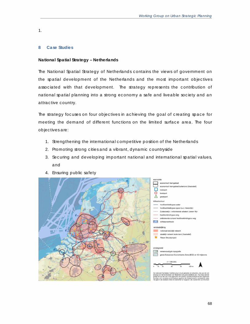
Working Group on Urban Strategic Planning
68
1.
8 Case Studies
National Spatial Strategy – Netherlands
The National Spatial Strategy of Netherlands contains the views of government on
the spatial development of the Netherlands and the most important objectives
associated with that development. The strategy represents the contribution of
national spatial planning into a strong economy a safe and liveable society and an
attractive country.
The strategy focuses on four objectives in achieving the goal of creating space for
meeting the demand of different functions on the limited surface area. The four
objectives are:
1. Strengthening the international competitive position of the Netherlands
2. Promoting strong cities and a vibrant, dynamic countryside
3. Securing and developing important national and international spatial values,
and
4. Ensuring public safety

Working Group on Urban Strategic Planning
69
The Strategy distinguishes between different forms of governance and contains the
process architecture for the local and regional governments. It indicates the extent
to which the national government wishes to become involved and the way in which
such involvement might occur. The national government is responsible for the results
where the basic quality standards are concerned and provide guidance in situation
where national interests are at stake. The National Spatial Strategy also defines the
spatial framework for all spatial investments to be undertaken by national, regional
and local governments as such investments could become relevant in sector-based
policy documents.
The National Spatial Strategy makes it clear which minimum basic values are
guaranteed everywhere – the basic quality standards – and which spatial structures
entail greater responsibility for the national government: the National Spatial
Structure. All policy statements made by the national government in the National
Spatial Strategy can be linked to one of these two concepts.
The national governments focussed on concentrating urbanisation and
infrastructure into national urban networks, economic core areas and major
transport axes as much as possible. The derived objectives of this policy strategy of
concentrating urbanisation and infrastructure and organisation in urban networks
are:
1. Developing national urban networks and urban centres
2. Strengthening the economic core areas
3. Improving accessibility
4. Improving the liveability and socio-economic position of cities
5. Maintaining accessible recreational facilities in and around the cities
6. Preserving and strengthening the variation between city and countryside
7. Harmonising urbanisation and the economy with water management, and
8. Safeguarding environmental quality and safety.
The national government has identified 6 national urban networks (and 13
economic core areas – which are located within these 6 urban networks) to
develop the coherence between urban cities and urban areas. The development of
these networks is a high priority. The objectives of the National Spatial Strategy for
each of the regions are being incorporated into a coherent development

Working Group on Urban Strategic Planning
70
perspective, in which the government outlines the main plans for development up
until 2030.
The national government, on the basis of the spatial policy, primarily focuses its
efforts on major transport axes between the two main ports and their region, and
the most important major urban centres. These transport axes are the backbone of
the spatial structure of the country. A rapid public transport link from Schiphol and
Amsterdam to Almere and Groningen improves not only the accessibility of the
north of the country and of the northern wing of the Randstad urban agglomeration
but also promotes the economic development of the north of the country. This
would also put Almere on a more equal footing with the other cities in the Randstad.
Source: National Spatial Strategy of the Netherlands: Creating Space for
Development
http://english.verkeerenwaterstaat.nl/english/Images/engelsesamenvattingnotaruim
te_tcm249-301728.pdf

Working Group on Urban Strategic Planning
71
High Speed Inter-City Transport System
Transport system in any country is an expression of spatial structures and has a form
and distribution. Economic activities are distributed over space create transactions
supported by these distribution systems. This is central to the concept of spatial
interaction. The demand for transaction grows with the growth in the economy,
which in turn requires more distribution networks.
The arrival of the high-speed train in Japan in 1964, which was opened in heavily
populated Tokyo–Osaka (“Tokaido”) corridor, is a transport revolution – the fourth
Kondratieff technology. The line was extended through the Sanyo (“Mountain
Sunshine”) area to Hakata/Fukuoka on the island of Kyushu by 1975. The Tokaido
and Sanyo Shinkansen lines serve two-thirds of the Japanese population. Three-
quarters of the Japanese economy is concentrated in these two areas. Shinkansen
lines from Tokyo into the eastern parts of the country began operation in the early
1980s, with a view to decentralise the regional development efforts in Japan. This
has been adopted in Europe in 1970s and 1980s.
The experience of the countries and cities suggest that high-speed train network can
compete with air transportation in the range up to 500 kilometres and effectively
supplant it for much shorter-distance traffic between major urban centres,
particularly in case of urban centres located in corridor fashion - for instance on the
Tokaido corridor in Japan between Tokyo and Osaka, or between Paris, Lyon and
Marseille, or between Hamburg, Hannover, Frankfurt, Stuttgart and Munich, or
between London, Paris and Brussels.
Not only these trains compete effectively, but also there are likely to alter the
geographical balance within/between the metropolitan areas. They essentially
connect traditional central business district and help powerfully to correct any
tendency on the part of business to migrate from CBD to suburban areas
.
Working Group on Urban Strategic Planning
72
Strategic Planning in Singapore
Singapore was founded as a trading post by the British early in the nineteenth
century. After the Independence, the good world communication based upon
trade provided a useful base for this city state to set about pursuing a survival
strategy. The state created new institutional structures to facilitate the economic
development – Economic Development Board (EDB) being one of the most
important bodies. An Economic Committee, realising the limits on the size of the
work force and the restricted land area, concluded that Singapore should focus on
developing as a service centre and seek to attract companies for offshore-based
activities, tourism and banking. The land requirements for this service sector
orientation had already been prepared in the early 70s and a new banking and
corporate district known as the ‘Golden Shoe’ was planned incorporating the
historical commercial area. The state’s economic strategy is closely linked to land
use and development planning.
The EDB is a key influence on the strategic land use plans that are prepared by the
Urban Redevelopment Authority (URA). The private sector is also involved in the
planning process to give their opinion in the committees that are set up to advice
these government boards. Thus, URA responds to the views of various advisory
committees and the boards and ministers of government in preparing its plans.
The URA translates all these discussions into land use and developmental terms
through preparation of a strategic plan for the whole island, called the Concept
Plan. The latest Concept Plan was reviewed and completed in 20016. The Concept
Plan is reviewed every 10 years, to ensure there is sufficient land to meet long-term
population and economic growth while providing a good quality environment. The
mission statement of the URA is to ‘plan and facilitate the physical development of
Singapore towards a thriving world class city in the 21st century”. The Concept Plan
lists out the seven key proposals represent the key thrusts of Concept Plan 2001 for
housing, recreation, business, infrastructure and identity. They are:
• New homes in familiar places
6 The draft Concept Plan of 2011 will be exhibited in the second half of the 2011 after getting feedback from public

Working Group on Urban Strategic Planning
73
• High-rise city living - a room with a view
• More choices for recreation
• Greater flexibility for businesses
• A global business centre
• An extensive rail network
• Focus on identity
The Concept plan seeks to ensure the continued economic growth through
‘restructuring the city’ to ensure that the facilities needed by future business are
planned now, this includes transport and telecommunication infrastructure, land,
and environmental quality. The concept plan continues to provide a variety of
housing from low to medium to high-density housing. A mixed zoning approach is
adopted to include housing and entertainment. It also aims at providing the double
the existing green spaces.
A New thrust area of the Concept Plan of 2011 is identity. As Singapore develops,
the cities want to retain a sense of identity to its physical landscape and encourage
a sense of rootedness to the country. The strategy includes preservation of buildings,
natural elements and landmarks, developing town centres at unique locations and
building regional identity to familiar places.
In essence, the concept plan is a broader conception of what contributes to
economic success. This encompasses high quality residential provision, a good
environment, leisure facilities and exciting city life. Thus there is more provision for low
density housing often in waterfront communities linked to beaches and recreational
facilities and well preserved culture to conserve the identity of the culture.

Working Group on Urban Strategic Planning
74
Curitiba's Strategic Approach to Urban Planning
The first development plan to direct urban growth in Curitiba was developed by a
French planner, Alfred Agache, in 1943. Though this plan was not implemented, it
succeeded in introducing the concept of urban planning to Curitiba’s citizens and
government. This awareness edged closer to action in 1964 when the city
administration commissioned a Preliminary Urban Plan. The city held a competition
for the best plan among local and national professionals. As a result Curitiba Master
Plan was born. The city created the Curitiba Research and Urban Planning Institute
to implement the plan and continue the planning process in 1965.even though the
city gave low priority to master plans, it provided the Institute with resources to detail
procedures for implementing plan.
Today, Curitiba’s practical planning process is firmly established. When ideas are
proposed, they are tested conceptually and then in application. These tests
generate feedback that leads to further improvements and applications. The
ongoing process allows Curitiba to fashion solutions that fit real problems. Rather
than being stymied by feedback, it refreshes and redirects the process along a
progressive path. After two decades of successes, the Urban Planning Institute is
now well established as the local incubator for an urban planning tradition that
emphasizes interplay between planning, analysis, participatory planning and
implementation.
The Master Plan of Curitiba strategically addressed the issues of transportation, land
use controls and a hierarchical structure of the road network. The plan directs the
growth out of the central city to five structural growth corridors. The displacement of
the growth was evenly distributed the density in city centre and in the growth
corridors.
The plan combines these tools to direct growth out of the central city and into
arterial growth corridors. Arterial and feeder roadways as well as land use controls
on settlement densities defined these corridors. The more even density distribution
ensured the high levels of public transportation that can be self-financing. The public
transport systems and more balanced densities also encouraged economic

Working Group on Urban Strategic Planning
75
development and reduced indirect costs of other infrastructure improvements such
as water, sewage, electricity, and communication.
The gradual development of Curitiba's integrated transportation system is the most
visible result of the city's planning processes. The planning process of Curitiba focuses
more on the relationship between space and movement. This emphasises the
dynamic nature of urban activities.
The city used transportation to heighten the socio-economic payoff from its planning
activities. One of the examples is housing for low income groups. The city had
acquired land near some of the planned structural corridors before developing
them. The city subsidised the low income housing, as the transportation routes were
put in place. The city also located other small scale, low income housing
developments throughout the city.
The densities and land use vary in relation to available transportation. Along most
structural routes, buildings can have a total floor area of up to six times the plot size.
On lower capacity roads that are well served by public transportation, the city
permits floor space up to four times plot size. The permitted ratio of floor space to
plot size decreases with the distance a land site is from public transportation.
The land use density controls encourage a shift of development activity from the
central city to and around the structural axes. This locates high density residential
and commercial in the same areas and matches density to the availability of public
transport. This eases traffic and human congestion in the central city. Planners
converted wide central avenues in the central city into open air pedestrian malls
and walkways. These malls and walkways reinforce the city centre as a pleasant
locale that preserves historic elements and where pedestrians have priority.

Working Group on Urban Strategic Planning
76
Kollam Model of Development Plan Preparation
District Planning Committee Kollam District of Kollam District decided to prepare a
integrated District Plan for the District as whole (IDDP) and a Local Development
Plan (LDP) for each Local Self Government Institution in the district in the Spatial
Planning approach. The matter was taken up to the State Planning Board and
subsequently a Government Order was issued to prepare these plans as a pilot
project in Kollam under the aegis of Kollam DPC with Town and Country Planning
Department as the nodal agency.
The process of preparation of IDDP and LDP started in Kollam District in August, 2003.
Training programmes to various stakeholders of the project and primary data
collection at the Gram Panchayat and Municipality level were conducted for one
and half years. About 12000 stakeholders ranging from DPC members to NGO’s at
the Grama Panchayat level were given training and thus created awareness about
the project among stakeholders which is inevitable for the success of the project.
Some Unique Features of the Project:
• The project was based on participatory spatial planning approach. All the
development partners like Technocrats, Politicians, NGO’s, Government
Departments, common men and other decision makers are involved in the
process of preparation of LDP and IDDP.
• The sectoral policies of various development agencies of the planning area
are translated to spatial plans. Hence, there was synergy between the
sectoral approach and spatial planning approach as the project ensures the
integration of various development sectors over the space (An LSGI in the
case of LDPs and District as a whole in the case of IDDP). The integration of
various sectors is performed by taking into account the specialties in social,
physical and economic aspects of the space, over which the sectors are
integrated. This ensures the best and optimum utilization of land, the most
valuable resource in the planning area.
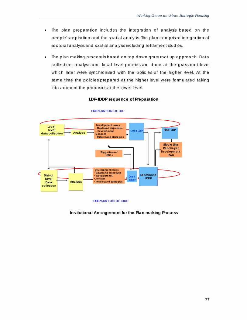
Working Group on Urban Strategic Planning
77
• The plan preparation includes the integration of analysis based on the
people’s aspiration and the spatial analysis. The plan comprised integration of
sectoral analysis and spatial analysis including settlement studies.
• The plan making process is based on top down grass root up approach. Data
collection, analysis and local level policies are done at the grass root level
which later were synchronised with the policies of the higher level. At the
same time the policies prepared at the higher level were formulated taking
into account the proposals at the lower level.
LDP-IDDP sequence of Preparation
PREPARATION OF LDP
District LevelData
collection
Local Level
data collection
Analysis
Analysis Draft LDP
SanctionedIDDP
Final LDP
DraftIDDP
Block/Jilla Panchayat
Development Plan
Development issues•Goals and objectives• Development Concept•Policies and Strategies
Suggestions ofLSGI’s
PREPARATION OF IDDP
Development issues•Goals and objectives• Development Concept•Policies and Strategies
Institutional Arrangement for the Plan making Process

Working Group on Urban Strategic Planning
78
District Planning Committee
LDP PROCESSING COMMITTEE
Chairman-Dist Collector
Convener -Dist. Town Planner
Members-DPO, ADC(General) DD Pyt, RJD,Pyt /Mlty Secretaries
WORKING GROUPS,SPATIAL
INTEGRATION COMMITTEE
PANCHAYAT/ MUNICIPALITY
IDDP INTEGRATION GROUPChairman-DPC ChairmanVice Chairman –Dist CollectorCo vice chairman-Chairman SPSG of SplTAGConvener- -Dist. Town PlannerMembers - 3 members of DPC, 3 Non official members of Special TAG,DPO,DD-Dept of economics & statistics
SPL :TAG FOR IDDPChairman- District Collector
Convener- District Town PlannerMembers- All other members of TAG
SPATIAL PLANNING SUB GROUP(SPSG)
OTHER SUB-GROUPS OD
SPL TAG
DISTRICT TOWN & COUNTRY PLANNING
OFFICE
-- PREPARATION OF IDDP-- PREPARATION OF LDP
COORDINATION COMMITTEE-LDP & IDDP
Chairman-DPC Chairman
Co-chairman-Mayor Corp.
Vice Chairman –Dist Collector
Convener -Dist. Town Planner
Members-Pyt/Mly Chairpersons
Compact cities – case of Ahmedabad
The world over there is a growing realization that compact cities are more efficient
and sustainable than cities that are sprawled over large areas. Cities can remain
compact only if the mechanisms for supply of planned and serviced land are
efficient and keep pace with demand. Moreover, the density of development has
to be high and vary across space in relation to the carrying capacity and economic
potential for development. Urban planning in India has historically favoured uniform
low densities across the urban area. This has led to extensive urban sprawl,
consuming agricultural land and threatening ecologically sensitive areas. Urban
sprawl also significantly increases the cost of providing infrastructure.
What should be the average population density of a city or how compact a city
should be is a question that defies an easy answer and certainly not one that can
have the same answer for different cities. The desirable average density of a city
may be anywhere on a scale from a “sparse” 50 persons per hectare to a
“crowded” 300 persons per hectare. The desirable density is contextual – cultural,
social, economic, climatic and ecological. However, in a structured planning
process, the stakeholders in a city can make an informed choice based on
analytical studies. To illustrate, the image below shows the results of a study done for
Ahmedabad by the CEPT University. The study compares the cost of providing
infrastructure for different levels of density/ spatial extent.

Working Group on Urban Strategic Planning
79

Working Group on Urban Strategic Planning
80
Efficient land supply for urban growth – case of Town Planning Scheme, Ahmedabad
As the city grows, more land in the periphery gets transformed from rural uses to
urban uses. In the absence of an effective mechanism this transformation is
haphazard and results in congestion and low levels of infrastructure provision. To
ensure planned and serviced new growth, most cities rely on large scale land
acquisition and development of planned layouts. However this is becoming
increasingly difficult with the increase in land values as well as the active resistance
to displacement by displaced land owners. Therefore it has become imperative to
introduce more fair, equitable and inclusive methods of land consolidation that
cause minimal displacement if at all. A good example of such a mechanism, which
has recently attracted a lot of attention, is the Town Planning Scheme. In use for
nearly a century in Gujarat and a few other places like Maharashtra, and now
Andhra Pradesh this mechanism consolidates all land holdings in the Scheme
jurisdiction and rearranges them in a manner suitable for urban uses. A similar
proportion of land is deducted from all the plots and used for providing roads and
land for physical and social infrastructure. A portion of the land is also used as a land
bank to recover the cost of implementation of the entire scheme. In Ahmedabad
this has become the principal means of implementing the Development Plan for the
city as a whole. The two images below illustrate how this two-tier planning system
works.

Working Group on Urban Strategic Planning
81
Considerable improvements are required in this system to make it more replicable
on a countrywide basis. The notable point is that such a system can ensure that the
contiguous growth of a city can be managed with seamless integration of road
network as well as other infrastructure networks. Also that the agriculture land owner
is left with a part of his previous holding but financially not worse off by the increase

Working Group on Urban Strategic Planning
82
in the cost of his urban holding : a thin win, no opposition, no delays and no costs
upfront to the city.