Embed Size (px)
Citation preview
1
REPORT OF THE FINNISH NATIONAL COMMITTEEOF GEODESY AND GEOPHYSICS 2002
Compiled by H. Nevanlinna
This report can be obtained in pdf-form at http://www.geo.fmi.fi/iugg_fin.html
Content
Annual reports Page
International Association of Geodesy (IAG) 2International Association of Geomagnetism and Aeronomy (IAGA)
7International Association of Hydrological Sciences (IAHS) 13International Association of Meteorology and Atmospheric Sciences (IAMAS) 17International Association for the Physical Sciences of the Ocean (IAPSO) 19International Association of Seismology and Physics of the Earth's Interior
(IASPEI) 22International Association of Volcanology and Chemistry of the Earth's Interior
(IAVCEI) 23
Table: The number of peer-reviewed articles 25
2
INTERNATIONAL ASSOCIATION OF GEODESY (IAG)Work done in the Finnish Geodetic Institute(Compiled by Markku Poutanen and Matti Ollikainen)
1. The Finnish permanent GPS network FinnRef®
The Finnish permanent GPS network FinnRef® consists of 12 stations. Station no. 13at Degerby tide gauge in the Aland Islands was installed. All stations have two-frequency receivers, choke ring antennas, and meteorological sensors. Both the GPSand the meteorological data are collected into receiver memory, and downloaded tothe Finnish Geodetic Institute (FGI) once every 24 hours. Metsähovi is a station of theInternational GPS Service (IGS) network. Joensuu, Metsähovi, Sodankylä, and Vaasabelong to the EUREF Permanent Network (EPN). Metsähovi, Vaasa and Degerby areTIGA stations. All FinnRef® stations are used in the computation of the joint NordicGPS network. FinnRef® forms the backbone for Finnish GPS point densifications andenables the study of the crustal motions of the Earth. Determination of land uplift, andstudies on periodic effects on data, as well as deformation studies due to loading ef-fects have been made using the permanent network.
2. EUREF-FIN, a national realisation of the ETRF89 reference frame
FGI has participated in national committees and working groups in order to advancethe usage and help in practical questions of the new reference frame, EUREF-FIN, inFinland. Observations in the FinnRef® network are the basis of the EUREF-FIN. Up-keeping and maintaining of the reference frame is the responsibility of the FGI.
3. Works as a National Standards Laboratory
The FGI is a National Standards Laboratory (NSL) of length and acceleration of freefall, as prescribed in the law (581/2000). The NSLs in Finland and the quality systemsin them have recently been represented by the CMA in the EUROMET QS-Forum. Inconnection with this, and due to entering the global Mutual Recognition Arrangement(MRA) between the NMIs, the NSLs in the FGI have implemented a new qualitysystem according to the ISO17025 standard, which now guides the metrological ac-tivities.
Scale transfer and calibration services for EDM instruments have been maintainedat our Nummela baselines. The traceability of measurements with the Väisälä Interfer-ence Comparator has been greatly improved, since the absolute calibrations of quartzgauges can now be performed (in addition to some NMIs abroad) in the CMA in Fin-land.
The vertical laser rod comparator as a part of the calibration facilities has beenworking well and it has been used to calibrate all rods of the FGI used in the ThirdLevelling. In addition, the invar rods used in Baltic countries and other domestic usershave been calibrated. The system calibration comparator to calibrate the digital levelshas been designed and is now ready.
3
4. Precise levelling
The Third Precise Levelling continued in Lapland. About 400 km/year of double-runlevelling was performed in 2002 by three field teams using the Zeiss DiNi12 digitalleveling instruments, which were taken into use in 2001. The levelling lines in Lap-land were completed, except for one connection to the Russian border. In 2002 theFinnish and Russian precise levelling networks were connected at two places in Lap-land. The levelling connection was carried out by a Finnish and a Russian levellingteam.
A test field built at Metsähovi was used in levelling studies and determination ofthe precision of the precise levelling instruments. Unexpected temperature-relatedmovements of some bedrock benchmarks were discovered, and the research of thephenomena will continue.
5. Gravity observations5.1 Absolute gravity observations
Absolute measurements were made in Metsähovi and on three points in Lithuaniawith the JILAg-5 absolute gravimeter. A new generation absolute gravimeter, FG5was ordered. Sites for absolute measurements in Ghana were reconnoitred.
5.2 Relative gravity observations
The Finnish part of the land uplift gravity line 63ºN was measured in 2002 with fourLCR-gravimeters. The work was done in a co-operation with the Estonian LandBoard, from where two gravimeters and an observer participated the campaign.
The national gravity survey of Finland by the FGI covers the whole country with adensity of 1 point/25 km2 or better. The Geological Survey of Finland and the FGI,primarily in some geologically inter_ested areas, are densified this network to thelevel of 2 6 points/1 km2 in a co-operation. The gravity survey was continued in 2002near the city of Tampere. Testing of RTK-GPS was done in connection to the densifi-cation to study the applicability of the method in this kind of work.
5.3 Superconducting gravimetry
The superconducting gravimeter GWR T020 at Metsähovi, a part of GGP (Globalgeodynamics project), has been operational since August 1994. In addition, the re-cordings consist of air pressure, groundwater level and precipitation. Studies of grav-ity data comprise the gravity spectrum from microseism to Chandlerian period. Now,the research work has been focused on loading effects from air pressure field and theBaltic Sea. Use of the superconducting gravimeter for hydrological studies is investi-gated in cooperation with the Helsinki University of Technology (Department ofRock Engineering), Finnish Environment Institute, and the Geological Survey of Fin-land.
6. Local deformation studies
Investigation of local crustal motions contained in a contract with Posiva Oy wascontinued on the candidate sites for final nuclear waste disposal. The local networks
4
at Olkiluoto, Kivetty and Romuvaara were measured with GPS. An EDM baselinebetween two GPS pillars was established at Olkiluoto to control the scale of the GPSmeasurements. The baseline was measured twice with Kern ME5000.
Study on periodic variation on the time series of the Finnish permanent GPS sta-tions FinnRef was continued. This is in connection of the work made for the reboundstudies with GPS and repeated levelling and crustal loading effects at the supercon-ducting gravimeter.
An international co-operation in project BIFROST (Baseline Inferences for Fen-noscandian Rebound Observations, Sea Level and Tectonics) was continued. This is aco-operation project between the Massachussets Institute of Technology, Universityof Toronto, University of Durham, Chalmers University of Technology, NationalLand Survey of Sweden and the Finnish Geodetic Institute for better understandingthe rebound process and to constrain the mantle viscosity and deglaciation models.
7. Water tube tiltmeterRenovation of the water tube tilt meter system continued. The interferometric waterlevel control system with the fibre-optic, laser and digital camera recording were un-der tests in laboratory.
8. Navigation and Positioning
In 2001 a new department, Navigation and Positioning started at the FGI. Its researchtopics are the new Global Navigation Satellite System (GNSS) technologies, intelli-gent navigation, multi-sensor positioning and real time mapping systems.
In cooperation with the European Space Agency (ESA) a Ranging and IntegrityMonitoring Station (RIMS) of the European Geostationary Navigation Overlay Serv-ice (EGNOS) is under construction in Virolahti, Finland. The RIMS will be importantwhen developing the ground segment of EGNOS, which will ensure a better naviga-tion service in Finland once the GALILEO satellite navigation system is in operation.
9. GPS levelling campaign
In August 2002 a GPS campaign was arranged with FGI and the Land Survey of Sweden tomeasure a height connection between Finland and Sweden across the Aland Sea. The GPSobservations were made on a total of ten levelling points. Preliminary results were publishedin the General Meeting of the Nordic Geodetic Commission in October 2002.
10. Maintenance of Finnish primary triangulation sites
During 2002, 21 triangulation points were checked and refurbished and the local ge-ometry re-measured. Two GPS receivers were used at most points to determine theabsolute orientation of the local control network.
11. Metsähovi Geodetic Observatory
The Metsähovi Satellite Laser Ranging (SLR) continued its operation. During the year2001 a total of 735 orbits of 18 satellites (84676 single observations) were observed.The development of the SLR was continued in a co-operation with the University ofLatvia, Riga. Preparations for daytime observations were continued.

5
The Metsähovi GPS station continued as a part of the Finnish permanent GPSnetwork, FinnRef. Data were submitted to the European permanent GPS networkcomputation as well as IGS network. Also, data from Javad/Legacy GPS/GLONASSreceiver were submitted to the GLONASS data center for IGEX.
The French Doris beacon continued its operation.As a co-operation0 project with the Metsähovi Radio Research Station of the Hel-
sinki University of Technology, preparations for geodetic VLBI installation werecontinued. A cooled, axially positioned and removable, S/X converter (15 K) and feedwas constructed by a Spanish company TTINorte. First tests will be made in the firsthalf of the year 2003.
12. International co-operations
FGI participated in the work of the Nordic Geodetic Comission (NKG) as a memberof the presidium and the chairman of the satellite geodesy working group. In October2002 FGI arranged the General Assembly of the NKG. The meeting is arranged everyfourth year, in each Nordic country in turn. FGI acted as an active member of theheight determination working group where subgroups of levelling adjustment andland uplift were established to coordinate the common Nordic effort in computing theunified height system in the area. Under the name of NKG processing centre, datafrom the Nordic permanent GPS networks were computed in Onsala Space Observa-tory. FGI provided the Finnish part of the data.
A co-operation with the Baltic States, Estonia, Latvia and Lithuania was continued,partly funded by the Ministry of Forestry and Agriculture. The co-operation containedworks in gravimetry, levelling, tide gauge data, GPS and metrology, including the rodcomparisons.
A co-operation with the Russian Mapping Authority was continued. The agreementincluded e.g. the levelling connection between the Russian and Finnish levelling net-works and related data exchange.
Co-operation with the University of Stuttgart continued in the satellite gravimetryproject. Researcher exchange between the University of Stuttgart and FGI was fundedby the Academy of Finland.
B. Publications
During the year 2002 a total of 10 peer reviewed papers and 20 other papers werepublished. Additionally there are 7 papers in print, and a total of 36 abstracts or pres-entations.
IAG - National Land Survey of Finland
(Marko Ollikainen)
The following densification of National networks were done during the year 2002:Densification of EUREF-points: 164 points (densified the network measured byt theFGI)
6
National Map Grid Points: 584 points (can be connected to the EUREF-FIN refer-ence frame)Levelling points: 622 points
Participation in national committees and working groups in order to advance the us-age and help in practical questions of the new reference frame, EUREF-FIN, in Fin-land..
7
INTERNATIONAL ASSOCIATION OF GEOMAGNETISM ANDAERONOMY (IAGA)
(Reporter H. Nevanlinna)
IAGA - FINNISH METEOROLOGICAL INSTITUTE
(Reporter H. Nevanlinna)
Space research
Connecting the magnetospheric observation data produced by ESA’s cluster 2 satel-
lites with the measurement data of the miracle ground-based network maintained by
the Institute constituted an important part of scientific space research. This work sup-
ported our space-weather activity, which covers both scientific research about the
whole space weather chain of events from the sun to the surface of the earth and the
investigation of applications. The Institute was an active participant in producing ma-
terial related to space weather to the public; examples of this are the Institute’s in-
volvement in the preparatory work on a CD-ROM dedicated to space weather and
funded by the EU and arranged open-house event. The data relayed by the swan in-
strument on board the SOHO satellite launched in 1995 enabled significant new re-
sults to be obtained, especially in the field of cometary physics. Some unexpected
problems arose in satellite equipment projects and tests. Six devices were delivered
for the ESA’s Rosetta satellite. It was scheduled to be launched in January of 2003
towards the comet Wirtanen, but had to be postponed to a later date. The SPEDE in-
strument was delivered to ESA’s SMART-1 Lunar programme. Instruments for
ESA’s Mars-Express satellite and the associated Beagle 2 Lander were delivered to
await the launch scheduled for May-June of 2003. Preparations were made for the sci-
entific exploitation of the project and at the same time this work provided the basis for
participation in the forthcoming Venus Express programme. The Research year 2002
Mars NetLander project co-operation venture with the French was on going despite
some funding problems. The Mars MetNet project continued with the Russian part-
ners. Development work on a magnetic calibration and testing laboratory suitable es-
pecially for testing space devices continued at the Nurmijärvi observatory
Peer reviewed papers 25
8
IAGA – UNIVERSITY OF OULU
INSTITUTE OF GEOSCIENCES, DEPARTMENT of GEOPHYSICS (Reporter: S.-E. Hjelt)
The Department of Geophysics at the Institute of Geosciences, University of Ouluapplies electromagnetic techniques in studying the structure, composition, dynamicsand evolution of the lithosphere and a variety of prospecting and environmentalproblems as well as investigates properties of modelling and inversion techniques.
During 2002 the major activities were:
1. The EUROPROBE / SVEKALAPKO subproject BEAR (Baltic ElectromagneticArray Research) has continued its activities past the official ending of the EURO-PROBE Programme. The data were measured in 1998 with an array of 50 MT and 20magnetometer stations. BEAR presented an invited lecture at a symposium devoted tothe memory of Prof. Leonid L Vanyan († Oct 2001), arranged a workshop in Moscowin March 2002, and a miniature workshop at the Oulu University in November 2002.The BEAR Working Group published 8 refereed papers and 20 printed abstracts in2002. The preparation was started to write a chapter on EM and seismic results ofSVEKALAPKO for the book European Lithospheric Dynamics as well as to write aset of papers covering measurements, data processing, source field studies, decompo-sition analysis and modelling (1D to 3D).
2. Various aspects of electromagnetic modelling and inversion have been studied.
3. The preparation of a 3D crustal model, based on joint inversion of potential field,seismic and EM data has continued jointly with the GSF.
4. The project. "Polar geoscience and climate history: advanced methods of modellingand data analysis", financed by the Thule Institute, has continued experiments withGPR on glaciers under the guidance of dos. John Moore (Arctic Centre, Univ. Lap-land) and in cooperation with the National Graduate School on Snow and Ice. Dataprocessing and analysis has continued in combination with ice core electrical profil-ing. The project has 7 papers in press and the results of the project have been dissemi-nated to the wide public ao. at an exhibition at Arktikum (Rovaniemi).
5. Smaller scale research projects have been performed in co-operation with variousresearch organizations and related to methodological studies for obtaining informationabout bedrock and overburden structures for demands of civil engineering, ground-water and ore prospecting and environmental research.
6. A new project of Deep EM sounding along FIRE (Finnish Reflection Experiment)lines started at the end of 2002 under the leadership of Prof Pertti Kaikkonen.
Summary of publications:Refereed: 10Printed abstracts: 20Others: 1
9
IAGA - SODANKYLÄ GEOPHYSICAL OBSERVATORY(Reporter Tauno Turunen)
Sodankylä geophysical observatory (SGO) is a nationwide institute under the admini-stration of the University of Oulu. The observatory staff consisted at the end of theyear 45 persons from which 7 in the Oulu unit and the rest in Sodankylä. All to-gether 26 of these have permanent position. The Space Institute at the University ofOulu was coupled to SGO in the beginning of 2002. The activities of SGO continuednormally in 2002.
Among the extensive routine geophysical observatory activities many different pro-jects take place in SGO. The EISCAT project is the oldest active one. From the othersone can mention as examples the Marie Curie Training Site educational program "In-vestigations of the Near-Earth Space by Radio Methods”, a co-operative project“Coupling of Atmospheric Layers” and the very extensive LAPBIAT-project (Lap-land Atmosphere-Biosphere Facility), which has been coordinated by SGO and hadparticipants from 17 countries in 2002. A space debris measuring project using EIS-CAT radar system was finalized and a new one negotiated. The Oulu unit has partici-pated among other things in a very extensive project FIRE (Finnish Reflection Ex-periment).
The research works of SGO were as authors in 29 articles published in refereed jour-nals in addition to 7 articles, which are in press and 21 articles, which were submitted.The number of conference proceeding articles was 16. The number of meeting ab-stracts was 103.
The total number of daily visitors to the observatory was 1230 in the year 2002 and175 visitors stayed extended period in the observatory. Most of them were visiting asparticipants in different research programs.
IAGA - SPACE PHYSICS AT THE UNIVERSITY OF HELSINKI
(Reporter Hannu Koskinen)
Space Physics at the University of Helsinki
Space research at the Department of Physical Sciences is distributed among severaldivisions: Divisions of Atmospheric Sciences, High-Energy Physics, TheoreticalPhysics, X-ray Physics, and Geophysics. The distributed work is co-ordinated underSpace Research Unit directed by Prof. Hannu Koskinen. Here we report on the spacephysics research related to Solar-Terrestrial Physics, which is closest to the interestsof IUGG.
In 2002 the space physics group consisted of Prof. Hannu Koskinen, Dr. Rami Vainio(from 1.8.2002), Dr. Eija Tanskanen (1.2. –30.6.2002), and the graduate studentsVille Honkkila, Emilia Huttunen, Noora Partamies and Jussi Lintunen. Eija Tan-skanen defended her Ph.D. thesis in March and at the end of the year there were in
10
total 8 active graduate students in space physics of whom 4 were employed at theFinnish Meteorological Institute (FMI).
The co-operation between the space physics groups at FMI and at the University isvery close. Together the scientific effort at FMI and HU now covers the whole inter-action chain from the solar surface through the solar wind to the magnetosphere andionosphere. At the University the research in 2002 focused in particle acceleration inthe solar wind, magnetospheric storm drivers, magnetospheric dynamics and in theo-retical studies of magnetospheric magnetohydrodynamic simulations.
One of the nation-wide consortia in the Antares space research programme is calledSpace Weather in the Antares Programme (SWAP). It consists of research groupsfrom the Universities of Helsinki (co-ordination), Turku and Oulu and the FMI. Thework is in good progress.
Hannu Koskinen's most significant international posts in 2002:
Member of the Finnish delegation in the ESA Science Programme Committee
Representativie of the Academy of Finland in the EISCAT Council
Chairman of the COSPAR National Committee- Representative of Finland in the COSPAR Council
Member of the European Space Science Committee (ESSC) of ESF
SCOSTEP Adherent Representative
Member of the S-RAMP Steering Committee
Member of the Rosetta Lander Steering Committee
IAGA — SOLID EARTH GEOPHYSICS AT THE UNIVERSITY OF HELSINKI
(Reporter Lauri Pesonen)
The Solid Earth Geophysics Group at the Division of the Physical Sciences of theUniversity of Helsinki was established in its recent form in 2000. The group has re-search activities in four fields of solid earth geophysics:
1. Palaeomagnetic techniques are used to study the evolution of the FennoscandianShield and its position in the supercontinent assemblies.
2. The group investigates the intensity of the Earth’s magnetic field and its polarityreversals using dated rock samples.
11
3. Physical properties of meteorites are used to classify meteorites rapidly and tomodel the geophysical properties of their parent bodies.
4. The subsurface structures and ages of meteorite impacts are investigated with geo-physical modelling and with palaeomagnetic dating techniques.
During 2002 the major activities were:
In 2001, the Solid Earth Geophysics Group focused in building a new research andteaching laboratory of the solid earth geophysics in the Kumpula Campus of the Hel-sinki University. A new teaching curriculum of the solid earth geophysics was alsolaunched. The "solid earth geophysics laboratory", with new palaeomagnetic andpetrophysical instrumentations, were build during 2001-2001. The laboratory providesa facility to measure physical properties of rocks, minerals and extraterrestrial materi-als. The laboratory serves also as a teaching laboratory for students.
Research projects
The Solid Earth Geophysics Group participated in five international projects in 2002.These were: 1. The EUROPROBE/SVEKALAPKO, 2. The IGCP-440, 3. The ESF-IMPACT, 4. The ICDP, and 5. The GISP-projects, respectively. Lauri Pesonen actedas a co-ordinator of the Finnish IGCP-440 project and as a Finnish representative inthe ESF-Impact and in the GISP-projects. Lauri Pesonen acted as a planning memberof the EGS rock- and paleomagnetic programmes.
In the IGCP-440 project, the group, in collaboration with the GSF people (Mertanen,S.), tested some of the proposed Precambrian supercontinent assemblies on the basisof global paleomagnetic database. Three international articles were published of theresults, and numerous presentations in international meetings were given. In the ESF-Impact programme, several Finnish and other impact structures were investigatedwith geo-physical modelling techniques. Some of the structures were dated using pa-laeomagnetic dating methods. We also constructed subsurface models of some impactstructures using geophysical modelling techniques. This research is supported by theAcademy of Finland.
The group was actively involved in publishing 3 peer-reviewed articles, 4 other arti-cles and 19 conference abstracts in 2002. The group gave 15 oral/poster presentationsin domestic and international meetings. Lauri Pesonen supervised four Ph.D-candidates (two in Finland and two in Germany) and two pro-graduate students. Healso acted as a Ph.D committee member in a Ph.D defense occasion in Luleå Univer-sity, Sweden. Moreover, together with Dr. Jüri Plado, Lauri Pesonen completed a newbook of "Impact Structures", which will be published by the Springer Verlag in 2002.
IAGA - GEOLOGICAL SURVEY OF FINLAND
(Reporters Lauri Eskola and Satu Mertanen)
Aerogeophysical surveys were carried out in Finland and Ireland. Totally 133000linekilometers were surveyed with two aeroplanes.

12
The upper crustal evolution, geology and structure of the Finnish bedrock were stud-ied by interpreting and correlating geophysical, petrophysical and geological data.The Finnish petrophysical database is continuously updated. Final versions of mag-netic maps of Central Finland - Karelia and North Finland - Kola 1:1,000,000, pre-pared jointly with SC Mineral and Petersburg Geophysical Expedition, were printedand published as well as magnetic and gravity anomaly maps of the FennoscandianShield 1:2,000,000,together with Swedish, Norwegian, Danish and Russian geologicalsurveys and geological surveys of the Baltic countries. Aeromagnetic investigationswere applied to structural studies of the bedrock and to gold exploration. The Labo-ratory of Paleomagnetism continued investigations on Precambrian supercontinentassemblies, together with the University of Helsinki and other international paleo-magnetic groups. Local paleomagnetic studies were carried out on one of the geologi-cal key areas of Fennoscandia, the Lake Ladoga area, where the syn-post-Svecofennian geological evolution of the Fennoscandian Shield is recorded in mul-ticomponent remanent magnetisations of the rocks. Palaeomagnetic method, coupledwith rock magnetic studies was applied to geological investigations on studying verti-cal tectonic movements within the Fennoscandian Shield and on dating goldminerali-sations in northern Finland and shear zones in southern Finland.
8 internationally pre-revieved publications and 14 other publications or maps.
13
INTERNATIONAL ASSOCIATION OF HYDROLOGICALSCIEN-CES (IAHS)(Reporter: Pertti Seuna)
1. Activities
1.1 IAHS - FINNISH ENVIRONMENT INSTITUTE
The national hydrometric monitoring program comprised the following measure-ments: areal precipitation, areal snow water equivalent, evaporation (class A pan),surface water level, river discharge, ice thickness in lakes and rivers, dates of freezingand ice break-up, surface water temperature, and vertical temperature profiles in lakes- a total of 1300 observation stations. The monitoring program was developed e.g. byimproving the technical standard of field stations and increasing real-time data col-lection. The hydrometric quality system was also developed. Data services to expertorganizations and the media formed an important part of the work. The hydrologicaldatabase was developed and extended in many ways. This browser based systemserved Internet customers for the first time in 2002. The regional data were includedin the common database, which contained after that some 30 million observationsfrom about 3000 stations and basic information from more than 50 000 lakes.
The national watershed modeling system, based on the modified HBV model, coveredthe whole country, and it was used operationally on daily basis. The system was fur-ther developed, e.g. the user interface, reports and data service were improved. Thewhole system can be operated through the Internet. Integration between the modelingsystem and the observation database was improved. Information on remote sensing isincorporated in hydrological modeling including regional existence of snow, based onsatellite images. Hydrological models were also used extensively for the research. Theuse of remote sensing data from weather radars and satellites is studied for improvingforecasting. Among other research projects climate change impacts on energy pro-duction, water resources and dam safety are to be mentioned.
A comprehensive Climate- Water- Energy joint project was initiated by the Icelandicinstitute Orkustofnun. It will focus on hydropower effects and changes caused by cli-mate change. Regarding climate change effects time series analyses of hydrologicallong-term series were started. Extremes of hydrological parameters are under specialconsideration in the Finnish Environment Institute.
Water temperature conditions of lakes and rivers were studied using long-term obser-vation series mainly from the period 1961-2000, but partly dating back to the 1920´s.The statistical analysis showed mostly negligible trends in thermal conditions.
Bathymetric mappings of lakes were continued in 2002. By the end of 2002 some 70% of the Finnish lake area was covered. A large GIS project was started after the two-year pilot phase to produce a national register on rivers and a new version of the na-tional river basin boundary database.
The monitoring of integrated hydrology consisted of small hydrological basins andgroundwater monitoring stations, both including water quantity and quality. Both
14
networks are mainly meant for research purposes, while operational uses are impor-tant, too. At the 50 groundwater stations groundwater level and soil moisture weremeasured and water samples taken for detailed analyses. A comprehensive ground-water database POVET was under final phase of the development, and it will collectmost of the governmental groundwater information into one database. In small hy-drological basins discharge with measuring weirs, precipitation, snow water equiva-lent and soil frost were measured, and in fifteen of them water quality was analysed.The catchments were partly included in the international FRIEND- and ERB-Projects.The opportunity for more active participation would be desirable to these projects,calling for special care in the future.
The international evaluation of the small basins monitoring and research made in2001 recommended the increase of intensified and interdisciplinary investigations,including resourcing, while a slight reduction in the catchment number was regardedsensible. By the end of 2002 the latter part of the recommendations has been carriedout. In research a long-term analysis was done. This trend analysis was applied for theinfluence of sub-drainage of an agricultural small catchment. During the 30 years af-ter the drainage change from open ditches to sub-drainage the percentage of surfacerunoff increased from 20 to 60 for the mean annual runoff and from 0 to 50 for thesummer maximum runoff. This kind of trend could contribute to increased floodingon old sub-drained basins like in central Europe.
Hydrological data were submitted for the Baltex (Baltic Sea Experiment) andFRIEND according to the existing agreements and for numerous customers on re-quest.
The work on the new and updated edition of the environmental dictionary EnDic2000was started as the Finnish-Estonian co-operation. The new dictionary will containsome 5500 terms in 9 languages: Finnish, Estonian, English, Swedish, German, Rus-sian, Latvian, Lithuanian and French.
Comprehensive co-operation with the Finnish Meteorological Institute in hydromete-orological affairs, including e.g. the transfer of meteorological information for floodforecasting and other hydrological purposes, remote sensing applications etc. contin-ued successfully on the basis of the renewed agreement. Certain observations, madeby both the institutes were fit together in order to optimize the input-outcome.Among these evaporation and rainfall water quality can be mentioned.
1.2 IAHS - UNIVERSITY OF HELSINKI, DEPARTMENT OF PHYSICAL SCI-ENCES
A central theme of the geophysical part of the Department of Physical Sciences wassnow and ice. This has included ice mechanics and lake ice decay, and optics of iceand snow. Field work has been made in southern Finland and in Estonia. A graduateschool titled "Geophysics of snow and ice" has been ongoing with direct funding of 6PhD students funded by various research projects. This graduate school officiallyended in the end of 2002, but the research work continues including e.g. the modelingof the Finnish snow conditions. The project "Snow conditions in Antarctica" is pro-ceeding in co-operation with a Canadian university.
15
Another priority area has concerned the optical characteristics of natural waters in-cluding model applications. The Finnish - Estonian co-operation in this field reachedits third phase in 2002. This co-operation has been directed both to some freshwatersof these countries and to the coastal areas of the Gulf of Finland.
Using new climate change scenarios preliminary model runs were done for the LakePääjärvi. The shortening of the ice cover period was clearly demonstrated.
1.3 IAHS - HELSINKI UNIVERSITY OF TECHNOLOGY
The Laboratory of Water Resources at the Helsinki University of Technology pro-vided undergraduate and graduate level education in hydrology, water resources man-agement, and hydraulic engineering. In 2002 the research topics at the laboratory in-cluded environmental river engineering, modeling and monitoring of forest hydrol-ogy, global change and water resources, contaminant transport, water and nitrogencycles in agricultural areas, and urban hydrology. In 2002 a particular emphasis in thehydrological research has been directed to small areas exhibiting different land usetypes. Monitored areas include three sub-urban areas in the city of Espoo, an agricul-tural field in Kirkkonummi, and a forested site in Siuntio. More information about thelaboratory is available in the internet (http://:www.water.hut.fi).
1.4 IAHS - UNIVERSITY OF OULU
Higher hydrological education was given and hydrological research was carried out inthe Water Resources and Environmental Engineering Laboratory, which is a part ofthe Process and Environmental Engineering Department of the University of Oulu.The topics included applied hydrology, hydraulics, contaminant transport, water re-sources planning, sustainable use of water resources, and environmental geotechnics.Other topics were sanitary and environmental engineering and the chemical treatmentof industrial and municipal waters and wastewaters combined with other treatmentmethods. The research projects included river management and environmental im-provement, hydrology of constructed wetlands, water supply and sewerage engineer-ing, retention of contaminants in soils, transport properties of forest soils, lake resto-ration, and development of technics for landfill protection. The northern dimension iskeenly in the focus of the studies.
1.5 IAHS - FINNISH GEODETIC INSTITUTE
Use of superconducting gravimeter (SG) in Metsähovi for hydrological studies is in-vestigated in cooperation with Helsinki University of Technology, Department ofRock Engineering, Finnish Environment Institute, and the Geological Survey of Fin-land. The SG senses (the vertical component of) the variation in the gravitational at-traction of the near-field water mass (sub-surface water and snow), and the crustal de-formation due to coherent variations in water load over large areas (hundreds of kilo-meters). The sensitivity of the SG is very high, corresponding to a fraction of milli-meter in water storage, but the question is to identify and model the hydrological
16
contributions to the total signal of gravity variation. So far, efforts have been concen-trated on near-field effects.
2. Publications, memberships in international bodies, visits
a) The number of internationally pre-reviewed publications was 14 and that of theothers about 50.b) The number of international memberships was about 25.c) The number of visits abroad was some 40 and the number of visits to Finland wasabout 35.
17
INTERNATIONAL ASSOCIATION OF METEOROLOGY ANDATMOSPHERIC SCIENCE (IAMAS)
(Reporter: Mikko Alestalo)
1. ACTIVITIES
1.1 UNIVERSITY OF HELSINKI, DEPARTMENT OF PHYSICAL SCIENCES,DIVISION OF ATMOSPHERIC SCIENCES
During 2002, the larger-scale meteorological research (previously within the Depart-ment of Meteorology) was made in the three areas of climate studies, numerical mod-elling and radar meteorology. There is also a group on micrometeorology, studyingexchanges of matter and energy within forest and atmosphere.
Studies on climate concentrated on the critical layer reflectivity of mountain effects,using GCM runs and linear steady-state models.
In radar meteorology, applications to environmental issues were studied.
In numerical modelling, the UH 2-D model was used to study local flows around atropical heat island, and local coastal winds in Finland (the channelling effects). Pa-rametrizations for radiation were further studied, especially in Antarctic conditions. Aroad weather model was further developed and validated. Parametrizations for rain,especially the Sundqvist scheme, were studied. Mars modelling continued with theUH 1D- and 2D models, and HIRLAM was successfully modified for Mars during2002. The radiation schemes of the UH models and some Mars GCMs were comparedagainst line-by-line calculations as an international project (lead by UH). The UHschemes were improved based on these inter- comparisons. New effects were intro-duced, such as two-stream shortwave code for dust and slope effects on direct solarirradiation.
1.2 FINNISH METEOROLOGICAL INSTITUTE (FMI)
In 2002, research was continued in the areas of atmospheric modelling, climatechange, air quality, ozone and UV – radiation, and further development of the use ofsatellite and weather radar measuring methods.
The research on ozone and UV radiation continued to have a high profile and wascomposed of several international projects getting financial support by EUMETSATand the EU. One new item was to clarify the changes in the UV-radiation and thetrends in the UV-radiation during the last fifty years. Another central research itemwas the research of the effects of the ozone depletion to the arctic climate. The ozonesoundings in Antarctica were continued as a co-operation between Finland and Ar-gentina. The ozone research group continued to co ordinate the EUMETSAT Ozone
18
SAF Project for making ozone data available after the launch of the new satellite in-struments in 2005.
The development of the HIRLAM (High Resolution Limited Area Model) continuedwith the goals aiming at the improvement of short-range forecasting and forecastingof severe weather phenomena as well as on regional accuracy in northern conditions.A new surface model has been tested which most probably will increase the accuracyof the springtime temperature forecasts. One new feature is also the use of radarwinds in the validation of the numerical weather prediction models and in the initiali-sation process. Historically a noticeable change was the implementation of the 3Dvariational data analysis scheme to replace the optimum interpolation method. FMIhas the position of Deputy Project Manager in the management team of the interna-tional HIRLAM team.
Under the climate change studies the emphasis was on the clarification and under-standing of past changes in climate variables. Monitoring of greenhouse gases hasalso started to follow the present changes. By comparing past data with present ob-served changes the forecasted global climate change can get the right proportion. FMIhas been actively participating in producing input to the FIGARE climate programmereport. FMI has also participated in the CLIMTECH project, where the usage poten-tial of renewable energy (e.g. wind, water, peat and biomass) in a time frame of 30years was studied. FMI continued as the national co-ordinator in the IPCC – climategroup.
Measurements to determine the concentrations and budgets of carbon dioxide wereconducted in several locations in Finland within projects financed by the Academy ofFinland and the EU. A new flux-measurement tower was constructed at the Pallas-Sodankylä station to supplement the extensive greenhouse gas measurements carriedout as part of the WMO/GAW (Global Atmosphere Watch) monitoring programme.In addition, development of a remote sensing method for assessing forests as carbonsinks was launched in co-operation with the European Space Agency. Observations oforganic compounds released by ecosystems and the modelling of their air chemistryand ability to particle formation were also connected to climate change research.
The conventional air quality research has been focused on tropospheric ozone, organiccompounds, particulate matter and toxic substances such as benzene. In particular,measurements were carried out to study the toxicology of fine particles, and methodswere developed for estimating people's exposure to airborne pollutants in urban areas.These topic areas are in agreement with the needs on air quality research addressed byUN/ECE and EU/EEA.
2. PUBLICATIONS
There were 71 refereed publications, and 255 other scientific publications publishedin 2002.
19
INTERNATIONAL ASSOCIATION FOR THE PHYSICAL SCI-ENCES OF THE OCEAN (IAPSO)
(Reporter: Pentti Mälkki)
1. ACTIVITIES
Finnish Institute of Marine Research
Studies in the FIMR focused on the following objectives:- Studies on the dynamics and thermodynamics and remote sensing of sea ice;- Air-sea-ice interaction dynamics and its modelling.- Impact of climate change on the Baltic and Arctic seas.- Generation of wind waves and development of operational coupled atmos-
phere-wind wave models,- Dynamics of circulation in the Baltic Sea and development of numerical cir-
culation models,- Studies of the Arctic Ocean fluxes.
FIMR participated in CEC shared-cost R&D IWICOS project (Integrated Weather,Sea Ice and Ocean Service System). The project aims to develop digital one-entrysystem and information products for the users at sea. The System was demonstratede.g. in the Fram Strait area in March, when Radarsat images, ice drift buoy data andweather forecasts were delivered to Finnish research vessel Aranda in an area withlimited communication possibilities.
On dynamics and thermodynamics of sea ice, improvements have been made on ofthe high-resolution numerical sea ice dynamic model and on development of the nu-merical thermodynamic sea ice model. The model control runs have been carried out.The results have been analysed. The operational numerical sea ice model in the Fin-nish Ice Service has been updated. The updated model has been tested and the sensi-tivity studies have been carried out. A manuscript has been prepared and submitted.As a part of the work, a PhD thesis was completed in early May, 2002.
On remote sensing of the sea ice, analysis of remote sensed data, in particular SARimages has as an objective to develop new statistical methods to classify sea ice radarimages. In addition, methods have been developed for compacting sea ice informationin Radarsat-1 SAR images.
. Data analyses and modelling studies of air-sea interaction were mostly related to thefield measurements gathered under two recently finished EC projects (BALTEX-BASIS and ARTIST). The data-analyses addressed the large-scale roughness pa-rameters of a broken sea ice cover and the marine meteorological conditions over theBaltic Sea in the period 1991-1999. The modelling studies dealt with (1) interaction ofsea ice thermodynamics and warm-air advection and (2) boundary-layer over theArctic sea ice. The three-dimensional non-hydrostatic mesoscale model MM5 wasalso taken to use, with the objective to couple it with various marine models.
20
Connected with the investigations of the atmosphere and ocean interaction, studiesform local physical processes and process scale modelling up to regional to globalscale were carried out. In the former ones, special attention was paid on the thermalsea ice modeling as well as modelling of the atmospheric surface layer forcing abovethe sea and sea ice. On the regional to polar scale our main attention was given to thesea ice climatology and effect of the atmospheric forcing on sea ice conditions. Thestudies were carried out in two international EC funded projects. In February- March2002, an arctic expedition FRAMZY- 2002 to the Fram Strait was performed by theFIMR research vessel Aranda, as an international co-operation with German and UKinstitutions. The main goal of the expedition was to investigate the mechanisms of thearctic sea ice transport via Fram Strait , out from the Arctic Ocean.
The study on HIRLAM verification over the Baltic Sea was finished. The surface ra-diation budget over some Antarctic stations was studied as well as the effect of cloudsand heat advection on the near-surface air temperature over the Arctic Ocean in win-ter.
Experimental and modelling studies of the physical features of the Baltic Sea werecarried out. The studies are focused on three-dimensional hydrodynamic modellingand process studies of the physical environment of the Baltic Sea.
Studies of wave atmosphere coupling continued in co-operation with University ofUppsala and University of Miami as well as studies of directional wave effects in theGulf of Finland and Gulf of Lions together with CETP (Centre d'Etudes des Environ-nements Terrestre et Planetaire). Instrumentation to measure both waves and surfacestress by correlation method on board R/V Aranda was used for the first time.
Studies on the source terms of the WAM wave model begun in co-operation with Al-cyon bv (Netherlands).These studies take advance the special conditions in Gulf of Finland that have re-vealed deficiencies in the model. Coupled HIRLAM-WAM wave model in the BalticSea was operative for the second year. Studies of trends in sea level variations in theBaltic Sea continued, partly within FINSKEN project that was completed in 2002.
FIMR participates in a working group preparing a book on directional wave measur-ing instruments and analysing techniques in COST 714 action. The book is underexternal review, internal review has been completed.
In project HYMNE, funded partly by EU commission, the effects of the river Nevadischarge to the salinity along the Finnish coast in the Gulf of Finland was studied.The project ended in October and a report has been written.
In project AICSEX, partly funded by EU commission, the ice conditions in the BalticSea have been studied. Especially the reflection of the weather/climatic conditions inthe Polar Regions to the conditions in the Baltic Sea has been under focus.

21
Dynamics of wind-forced diapycnal mixing in the stratified ocean (DIAMIX) project:the data analysis was carried out and an introductory report was published in BorealEnvironment Research together.
Ari has also studied the Global Change and its effects to the Baltic Sea ice cover.
On the study of Arctic fluxes main field work during 2002 was the participation in theinternational Arctic Ocean – 02 expedition with IB Oden in spring to the northernFram Strait and to the East Greenland Current. FIMR co-ordinated the physicaloceanography programme. The cruise lasted 45 days. The planning for the ASOF(Arctic − Subarctic Ocean Flux array) programme continued and three separate EUprogramme, forming a cluster, were eventually supported and will begin in 2003.FIMR will participate in the ASOF-N in Fram Strait and in the ASOF-W in Denmarkram Strait. The work on the hydrography of the upper layers of the Arctic Ocean hascontinued. General presentations of the Arctic Ocean circulation have been given onan international symposium: C flux and Climate Change: the Nordic contribution to aPanarctic perspective, Sigulda, Latvia and on a Nordic workshop: The bioproductionand energy transfer in the Nordic Seas, the role of key zooplankters in a system ofrapid climate change, Sandgerdi, Iceland. FIMR has also taken part in the planning ofa trans-Arctic Ocean oceanographic section to be carried out from Oden in connectionwith the Swedish initiated Beringia programme 2005.
University of Helsinki, Institute of Physical Sciences
In the framework of the Finnish global change research program (FIGARE) a newadvanced sea ice model applicable for climate research has been developed. Themodel resolves sea ice thickness distribution for arbitrary numbers of undeformed anddeformed sea ice thickness categories. The sea ice model has been implemented inthe ocean circulation model, MPI-OM-1, developed in the Max-Planck Institute ofMeteorology. The MPI-OM-1 model is global, however it employs curvilinear coor-dinates which allows modelling coastal regions and adjacent seas of the Arctic Oceanwith a high horizontal resolution, which are known to be vital regions for a sea-iceproduction.
Ten-years simulations have been made with the global model and the evolution ofthe sea ice thickness distribution in the Arctic has been analysed. The temporal be-haviour and horizontal extension of the deformation regions was largely dependent onthe synoptic scale wind field. Deformed ice production regions were concentrated incoastal regions, particular important regions were found to be the Lincoln Sea, theBeaufort Sea and the Northern regions of the Spitsbergen, Franz Josef Land and theSevernaya Zemlya.
22
INTERNATIONAL ASSOCIATION OF SEISMOLOGY ANDPHYSICS OF THE EARTH'S INTERIOR (IASPEI)(Reporter: Pekka Heikkinen)
To be compiled later
23
INTERNATIONAL ASSOCIATION OF VOLCANOLOGY ANDCHEMISTRY OF THE EARTH'S INTERIOR (IAVCEI)
(Reporter: Ilmari Haapala)
IAVCEI - GEOLOGICAL SURVEY OF FINLAND
The Geological Survey of Finland has carried out petrological, geochemical and iso-topic studies on the komatiitic (ultramafic) lavas of the Paleoproterozoic CentralLapland Volcanic Belt as Finnish-Australian and Finnish-American collaboration.Permian – Triassic komatiites of Vietnam have been studied as Vietnamese-Finnish-American-Russian collaboration. The studies on the ophiolite-type serpentinites andassociated rocks of the Outokumpu – Kainuu area have continued. The diamond-bearing kimberlites of the Kuhmo, Kaavi and Kuopio areas have been studied, in partas international collaboration, to obtain more detailed information on the age, compo-sition and structure of the lithospheric mantle.
IAVCEI - UNIVERSITY OF HELSINKI
The Department of Geology launched in January 2002 a new research project GILDA(Geochemical and Isotopic Project on Lithospheric Evolution of Dronning MaudLand, Antarctica) . The project is an extension of Department’s earlier work on theJurassic basalts, their intrusive correlatives and spatially associated lamproite dykes inthe same region. In 2002, the studies were focused on isotope geology of ferropicritedykes, mineralogy of gabbros and hydrothermally altered basalts, and experimentalgeochemistry of lamproites. Results were published and presented at Gondwana 11meeting in New Zealand. Two researchers participated in Finnarp 2002 expedition toAntarctica.Department’s long-term field and laboratory studies on bimodal, rift-related granite-basalt magmatism in Finland, New Mexico, Brazil, and Namibia have been continuedas international collaboration. Petrologic and geochemical studies on the Cretaceousgranites of Namibia, which are related to mantle plume and continental rifting, havebeen completed and presented in a doctoral dissertation.
IAVCEI - UNIVERSITIES OF TURKU AND ÅBO AKADEMI
The Department of Geology, University of Turku, has studied the geochemistry, pe-trology and tectonic evolution (arc and back-arc basin environment) of the 1.90 – 1.88Ga Svecofennian volcanites of southeastern Finland, and the results have been pre-sented in a doctoral dissertation. The petrological studies on the postorogenic 1.80 Gagranites have been continued. The Department of Geology, Åbo Akademi, studies theSvecofennian volcanites of the Pellinge area in southern Finland, and the rapakivigranite - anorthosite association of Åland.
IAVCEI - UNIVERSITY OF OULU
The Department of Geology has studied, in collaboration with the Geological Surveyof Finland and the University of Helsinki, the petrogenesis and ore potential of the
24
2.45 Ga layered mafic intrusions and associated felsic rocks of Koillismaa, northeast-ern Finland, by utilizing field research as well as geochemical and isotopic methods.
IAVCEI PUBLICATIONS
Refereed articles: 13Other publications : 6
25
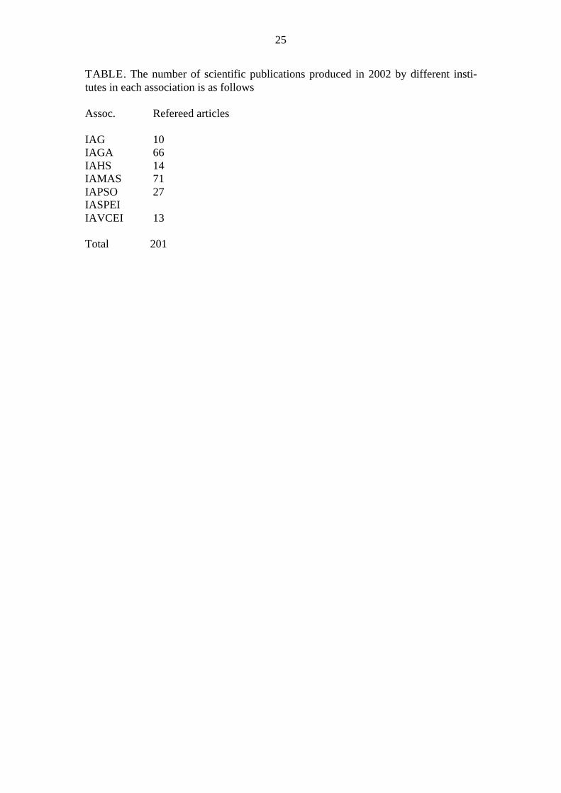
TABLE. The number of scientific publications produced in 2002 by different insti-tutes in each association is as follows
Assoc. Refereed articles
IAG 10IAGA 66IAHS 14IAMAS 71IAPSO 27IASPEIIAVCEI 13
Total 201