Embed Size (px)
Citation preview
Geodesy and Geophysics in Slovakia 2007 - 2010
Slovak National Report to IUGG
25th General Assembly of IUGG Melbourne, Australia, June 27 – July 8, 2011
Slovak National Committee for the International Union of Geodesy and Geophysics
2011

Contributions to Geophysics and Geodesy Vol. 41/Special issue, 2011 (3–16)
3
Study of the gravity field of the Earth in Slovakia Ladislav BRIMICH1 1 Geophysical Institute of the Slovak Academy of Sciences, Dúbravská cesta 9,
845 28 Bratislava, Slovak Republic; e-mail: [email protected]
Abstract: In this contribution the investigations of the gravity field in the territory of the Slovak Republic the period 2007–2011 are presented. Key words: geodynamics, gravity field, gravimetry, Earth’s rotation, GPS (Global Position-ing System)
1. Geodesy Utilization of GOCE data to regional geodetic applications A downward continuation of vertical component of gravitation tensor based on Poisson integral formula was studied in Janák et al. (2007). However, this problem has not been studied further and our attention has been dedicated to different type of integral transformation mentioned below.
The integral transformation between the components of disturbing gravity tensor and the free-air gravity anomaly was developed in spherical coordinates, based on the Pizzetti formula, and properties of particular integration kernels were described in Janák et al. (2009a,b). The integral transformation was discretized and used to solve an inverse problem, i.e. a downward continuation and a transformation of disturbing gravity tensor to gravity anomalies in one step. A numerical simulation of this inverse problem was performed using the simulated data based on the global gravity model EGM08. Two methods of regularization were tested, the truncated singular-value decomposition and the ridge regression (ibid.).
The possibilities of smoothing the GOCE satellite gravity gradiometry data using several topographic-isostatic effects were studied in Janák and Wild-Pfeiffer (2010) and Janák et al. (in print). The topographic-isostatic reductions according to models of Airy-Heiskanen, Pratt-Hayford, combined Airy-Heis-kanen plus Pratt-Hayford, Helmert (first and second condensation) were stud-ied. Two numerical case studies were performed, in Eastern Asia and in Europe. The significant smoothing the up to 30% was obtained using the simu-
Brimich L.: Study of the gravity field of the Earth in Slovakia (3–16)
4
lated GOCE measurements. The aim of these experiments was to improve the numerical stability during the downward continuation of real GOCE data which we plan to perform in a near future. The best models for computation of topographic-isostatic effects in terms of smoothing the GOCE data are Airy-Heiskanen and Helmert first condensation.
The geometrical properties of equipotential surfaces of disturbing potential around the Earth were studied and presented in Janák et al. (2010a). The boundary value problem was formulated in near-global domain. In order to solve the geometry of disturbing gravity potential, the finite-element method FEM was applied.
Finally the computational scheme for refinement of a regional gravity field based on the combination of satellite gravity gradiometry and the terrestrial gravity data was suggested in Janák et al. (2010b).
Precise geoid and quasi-geoid computation In paper Va�ko et al. (2008) we compared the two different solutions to second term in Molodensky’s series. We studied the Molodensky’s approach and the analytical continuation approach. Both solutions were also compared with the often used approximation of the second term by the classical terrain correction. The numerical effect of the third term was also estimated.
The optimal evaluation of mean topographical effects for terrestrial gravity data during the process of precise geoid computation was studied in Janák et al. (2011). The numerical case study in Canada was presented.
Activities of the Slovak Republic in CEGRN The Central European Geodynamic Research Network (CEGRN) is active since 1994 with a consistent and systematic activity of GPS measurement, processing and reprocessing and scientific interpretation of the data. The CEGRN campaigns are of high quality, fulfill state-of-the-art standards and extend over a very long lapse of time. The published results in Caporali et al. (2008); Caporali et al. (2009) are important for connections to other networks, and in particular the European Permanent Network (EPN), for determination of homogeneous and consistent dense velocity field for application to geodynamics and seismicity. Modified theory for the physical heights determination The realization of classical physical height system involves information related
Contributions to Geophysics and Geodesy Vol. 41/Special issue, 2011 (3–16)
5
to a geometric leveling, a vertical datum, and a gravity reference system. The reference systems reflect the accuracy of a specified epoch characterized by the measurement techniques and by the adopted models of disrupting influences. If we are able to find a solution where the need disappears for at least one reference system, then the accuracy of the estimated function will naturally increase. We would like to point out that it is possible to realize the physical heights based on the solution to the modified second geodetic boundary value problem, using only the Earth Gravity Model 1996, the Global Navigation Satellite System and gravity measurements. The solution does not require any information about the local physical heights and it is therefore independent on a local vertical datum. The theoretical principle of such a solution and its practical application was studied (Mojzeš and Va�ko, 2008) in the area of Slovakia. Reference frames For the definition and maintenance of geodetic reference frames in Slovakia are exclusively applied the satellite positioning systems, mainly the U.S. GPS and as additional technique also the Russian GLONASS. The densification of International Terrestrial Reference Frame in the region of Central Europe resulting from the Central Europe Regional Geodynamic Project is summarized in Hefty et al. (2009a). For nearly 50 epoch sites their 3D position and velocity at mm level was determined. The effect of GPS repossessing activities and the improvement of coordinate time series of set of permanent GPS stations in Central Europe and Balkan Peninsula is presented in Hefty et al. (2009b).
Short period coordinate variations related to GPS satellite orbits and tidally induced phenomena are analyzed in Hefty and Igondová (2010). The residual effects demonstrated as periodic variations with tidal frequencies are dominating in the diurnal and semi-diurnal frequency bands. The potential short periodic phenomena for the incoming Galileo system are analyzed by Hefty et al. (2007).
The particular problems related to reference frame realization using combination of satellite and terrestrial techniques are investigated by Ková� and Hefty (2007) where the algorithm for complex stochastic and statistical model is introduced and verified. Positioning and applications The rapid development of GNSS positioning techniques using the undifferen-
Brimich L.: Study of the gravity field of the Earth in Slovakia (3–16)
6
ced code and phase observations known as Precise Point Positioning (PPP) stimulated thorough investigations related to software development and applications for various purposes. In Hefty et al. (2008) are summarized principles of PPP and review of phenomena which have to be modeled to achieve the subcentimetre accuracy. The multisystem approach to PPP based on combination of GPS and GLONASS is developed in Hefty et al. (2009c), Hefty et al. (2010). It was shown that for inclusion of GLONASS is necessary to enhance the adjustment GPS related models by parameters accounting for biases between the two GNSS, however the improvement of the coordinate determination is hardly noticeable.
The GNSS meteorology applied for the territory of Slovakia is discussed in Igondová (2009), Igondová and Cibulka (2010), Igondová and Hefty (2008), Hefty and Igondová (2008).
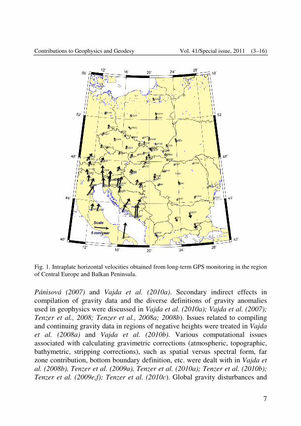
Earth rotation and geodynamics The geokinematical pattern of Central Europe and particularly of the territory of Slovakia was thoroughly studied on the basis of epoch-wise and permanent GNSS networks performed since 1994. Caporali et al. (2008) summarize the contribution of the CERGOP project for detailed investigation of geokinematics of Central Europe. Velocity fields obtained form reprocessing of GPS epoch-wise and permanent networks based on all the available GPS observations is presented in Hefty and Igondová (2006), Hefty et al. (2010a). Fig. 1 shows the typical pattern of horizontal velocity field behavior in Central Europe obtained from long-term GPS monitoring. The detailed velocity field at the territory of Slovakia is studied by Hipmanová (2009) and Hefty et al. (2010b). The upper limit of surface deformations was found below 40 nanostrain/year.
The possibilities of combination of GPS inferred surface velocities reliable for densification of velocity field in Central Europe and Balkan Peninsula are studied in Hefty (2007b), Hefty (2008) and Caporali et al. (2009). The paper by Caporali et al. (2009) brought new approach to multi-network combination and contains consistent set of horizontal velocities for more than 500 sites.
2. Gravimetry Gravimetric corrections and stripping The role of the geophysical indirect effect in interpreting gravity data, and its size and impact on the territory of Slovakia was investigated in Vajda and
Contributions to Geophysics and Geodesy Vol. 41/Special issue, 2011 (3–16)
7
Pánisová (2007) and Vajda et al. (2010a). Secondary indirect effects in compilation of gravity data and the diverse definitions of gravity anomalies used in geophysics were discussed in Vajda et al. (2010a); Vajda et al. (2007); Tenzer et al., 2008; Tenzer et al., 2008a; 2008b). Issues related to compiling and continuing gravity data in regions of negative heights were treated in Vajda et al. (2008a) and Vajda et al. (2010b). Various computational issues associated with calculating gravimetric corrections (atmospheric, topographic, bathymetric, stripping corrections), such as spatial versus spectral form, far zone contribution, bottom boundary definition, etc. were dealt with in Vajda et al. (2008b), Tenzer et al. (2009a), Tenzer et al. (2010a); Tenzer et al. (2010b); Tenzer et al. (2009e,f); Tenzer et al. (2010c). Global gravity disturbances and
Fig. 1. Intraplate horizontal velocities obtained from long-term GPS monitoring in the region of Central Europe and Balkan Peninsula.
Brimich L.: Study of the gravity field of the Earth in Slovakia (3–16)
8
geoidal undulations step-wise stripped of the crustal components using the CRUST 2.0 model were produces and mapped in Tenzer et al., (2009a,b). The correlation of various stripped gravity data with major crustal density interfaces was studied in Tenzer et al. (2009c) and Tenzer et al. (2009d). The accuracy of the topo-correction and the role of the DTM in rugged mountainous terrain was investigated in Zahorec et al. (2010). Gravitational attraction and potential of spherical shell with radially dependent density was investigated in Karcol (2011). Methodology Numerical calculation of the coordinates of vertices of the maximally regular net defined at the surface of the unit sphere, where the coordinates of 2684354562 vertices are calculated with the precision of 19 decimal digits was presented in Pohánka (2007). The maximally regular net on the unit sphere adapted for the surface of the rotational ellipsoid using the ellipsoidal coordinates were produced in Pohánka (2008). Development of new methods for gravity data inter-pretation Requirements for compiling input gravity data for the Truncation Filtering Methodology were defined in Vajda and Vaní�ek (2008). Interpretation of microgravity Microgravity survey for cavity detection in the interior of Slovak Gothic church was presented in Pánisová and Pašteka (2009a) and (Pánisová and Pašteka (2009b). Two cavities (probably medieval crypts) were detected using the combination of GPR and microgravity techniques in small Romanesque church in the frame of the International course on ArchaeoGeophysics INCA 2009 (Pánisová et al., 2010).
3. Geodynamics Interpretation of temporal gravity changes A review outline of interpreting surface deformations and temporal gravity changes was given in Vajda and Brimich (2008). Quantitative estimation of the cavity effect on the tidal tilt measurements, using the FE modeling of the deformation response of the rock structure, the procedure of the corrections of the tilt measurements for the cavity effect was presented in Kohút (2007). The
Contributions to Geophysics and Geodesy Vol. 41/Special issue, 2011 (3–16)
9
study of the Earth's crust deformations caused by the Sumatra-Andaman earthquake at large distances from its focal point is the subject of the paper Brimich et al. (2008). Horizontal components of the tidal deformations was investigated in Varga et al. (2007). Microseismic identification of geological and tectonic structures in the Komjatice Depression (Western Carpathians) was studied in Kalinina et al. (2009). Mechanical properties of speleothems As very promising within the field of geodynamics appears the investigation of mechanical properties of speleothems aimed at its application to the palaeotectonic and palaeoseismic studies Bednárik and Kohút (2007) and Bednárik (2009). The dissertation Bednárik (2009) provides the readers with the knowledge necessary for the palaeoseismic analysis of speleothems, with the focus on the most vulnerable speleothems – the calcite tubular stalactites.
General theory and methodology of geothermal modeling The general theory of refraction effects in geothermal field was enhanced by new models of heat flow density refraction on Earth subsurface structures with thermal conductivity contrast. The solutions of mathematical problems were presented in exact analytical forms or they were obtained by the numerical approach of finite differences (Hvoždara, 2008b; Hvoždara and Majcin, 2009; Hvoždara, 2009; Majcin et al., 2010). Calculated model temperature distribu-tions and the distributions of the heat flow density vector components were analyzed also with regard to interpretation approaches, terrestrial heat flow maps construction and to robustness of the geothermal modeling methods.
A special attention was paid to the models groundwater flow anomalies due to spheroidal bodies (both of oblate and of prolate shapes) buried in uniform porous medium and half-spheroidal bodies (geosynclines,…) at the Earth’s surface (Hvoždara, 2008a; Hvoždara, 2009). The results obtained in exact analytical forms provide the basic knowledge to the theory of groundwater flow in laterally inhomogeneous media in the upper parts of the Earth. Geodynamics of Tatra Mountain The repeated GPS and absolute gravity measurements were organized in the Tatra Mountain for the detection of horizontal and vertical movements of the Earth’s surface. Non-permanent GPS measurements with 4-5 days observation time were provided from 1998 to 2008 every year. They were established near
Brimich L.: Study of the gravity field of the Earth in Slovakia (3–16)
10
the 3 non-permanent stations the GPS permanent stations and absolute gravity stations for better understanding and detecting of vertical movements. The analyze of GPS permanent measurements were detected subsidence effect approximately –0.72 mm/yr at the sites GANO and –0.98 mm/yr at the site SKPL and uplift effect +2 mm/yr at the site LIES. The station LIES is located 6 km from a water dam. The repeated absolute gravity measurements were detected subsidence too +0.12�Gal/yr at the station SKPL, +0.27 �Gal/yr at the station GANO and +0.85 �Gal/yr at the station LIES. The results of this study were published (Mojzeš et al., 2009). Deformation of Earth’s surface by loading effects Tall buildings can cause deformations of the earth’s crust for long distances from the area of their realization. The loading effect of the earth crust produced by tall buildings of simple geometric forms was studied (Kollar et al., 2010).
Modelling of hydrological mass variation The repeated absolute gravity measurements realized by FG5 instrument were used to test of vertical changes of the Earth surface on the site Modra-Piesok. The gravity measurements were strongly influenced by water mass variations in this area. They were used the global hydrological model WGHM with 0.5° × 0.5° grid and model GLDAS at spatial resolution 1° × 1° for computation of hydrological effects. The details of this test are presented (Mojzeš and Mikolaj, 2010).
References and publications Bednárik M., 2009: Seismometric portrayal of calcite tubular stalactites – modeller´s guide.
Dissertation submitted for the degree of doctor of philosophy. Bratislava, Geophysical Institute of the Slovak Academy of Sciences, 147 p.
Bednárik M., Kohút I., 2007: Cylindrically anisotropic tubular stalactite with mirror symetry of displacement under spatially constant body force loading – a finite element model. Contrib. Geophys. Geod., 37, 4, 315–330.
Brimich L., Latynina L. A., Kohút I., 2008: Study of extensometric measurements in non tidal frequency domain at the Russian and Slovak stations. In: Contrib. Geophys. Geod., ISSN 1335-2806, 38, 4, 429–440.
Caporali A., Aichhorn C., Becker M., Fejes I., Gerhátová �., Ghitau D., Grenerczy G., Hefty J., Krauss S., Medak D., Milev G., Mojzeš M., Mulic M., Nardo A., Pesec P., Rus T., Simek J., Sledzinski J., Solaric M., Stangl G., Vespe F., Virag G., Vodopivec
Contributions to Geophysics and Geodesy Vol. 41/Special issue, 2011 (3–16)
11
F., Zablotskyi F., 2008: Geokinematics of Central Europe: New insights from theCERGOP-2/Environment Project. J. of Geodyn., 45, 246–256, ISSN: 0264-3707, doi: 10.1016/j.jog.2008.01.004.
Caporali A., Aichhorn C., Barlik M., Becker M., Fejes I., Gerhátová �., Ghitau D., Grenerczy G., Hefty J., Krauss S., Medak D., Milev G., Mojzeš M., Mulic M., Nardo A., Pesec P., Rus T., Simek J., Sledzinski J., Solaric M., Stangl G., Stopar B., Vespe F., Virag G., 2009: Surface kinematics in the Alpine-Carpathian-Dinaric and Balkan region inferred from a new multi-network GPS combination solution. Tectonophys., 474, 295–321, ISSN: 0040-1951, doi: 10.1016/j.tecto.2009.04.035.
Hefty J., 2007a: Modelling of random errors in geodetic time series. Geodetický a kartogra-fický obzor, 53 (95), 185–196 (in Slovak).
Hefty J., 2007b: Geo-kinematics of Central and South-east Europe resulting from combination of various regional GPS velocity fields. Acta Geodyn. Geomaterialia, 4, 148, 169–185.
Hefty J., 2008: Geo-kinematics of central Europe inferred from long-term monitored regional and local GPS networks. Reports on Geodesy, 2, 85, 9–18.
Hefty J., Igondová M., 2006: Geokinematical implications inferred from analysis of permanent stations in Central European region. Reports on Geodesy, 1, 76, 29–38.
Hefty J., Gerhátová �., Bezru�ka J., 2007: Potential short-periodic variations of Galileo permanent station – comparison with GPS experience. In: 1st Colloquium scientific and fundamental aspects of the Galileo programe. Toulouse, France.
Hefty J., Igondová M., 2008: The network of permanent GPS stations in central Europe analysed for purpose of regional geodynamics and troposphere studies. Contrib. Geophys. Geod., 38, 2, 151–167.
Hefty J., Ková� M., Burgan J., 2008: Precise point positioning using Global navigation Satellite Systems. Geodetický a kartografický obzor, 54 (96), 11, 209–216 (in Slovak).
Hefty J., Gerhátová �., Becker M., Drescher R., Stangl G., Krauss S., Caporali A., Liwosz T., Kratochvíl R., 2009a: Long-Term Densification of Terrestrial Reference Frame in Central Europe as the Result of Central Europe Regional Geodynamic Project 1994-2006. In: Geodetic Reference Frames, IAG Symposium, Munich, Germany, 9.-14.10.2006, Springer Verlag London, 2009, 149–154.
Hefty J., Igondová M., Droš�ák B., 2009b: Homogenization of long-term GPS monitoring series at permanent stations in Central Europe and Balkan Peninsula. Contrib. Geophys. Geod., 39, 1, 19–42.
Hefty J., Gerhátová �., Burgan J., 2009c: First Experience with Inclusion of GLONASS Observations into the Precise Point Positioning Algorithms. In: Scientific and fundamental aspects of the Galileo Programme: 2nd International colloqiuim. Padua, Italy, 14.-16.10.2009. University of Padova.
Brimich L.: Study of the gravity field of the Earth in Slovakia (3–16)
12
Hefty J., Igondová M., 2010: Diurnal and semi-diurnal coordinate variations observed in EUREF permanent GPS network – case study for period from 2004.0 to 2006.9. Contrib. Geophys. Geod., 40, 3, 225–247.
Hefty J., Gerhátová �., Hábel B., Burgan J., 2010a: Precise Point Positioning from combination of GPS and GLONASS. In: Satellite methods applied in geodesy and cadastre. ECON Brno, 44–51 (in Slovak).
Hefty J., Hipmanová L., Gerhátová �., Igondová M., Droš�ák B., 2010b: Recent Geo-kinematics of Slovakia Based on Homogenized Solutions of Permanent and Epoch GPS Networks. Acta Geodynamica et Geomaterialia, 7, 3 (159), 303–315.
Hipmanová L., 2009: Geo-kinematic investigations in Slovakia and the region of Central and Southeastern Europe based on combination of permanent and epoch-wise GPS networks. Contrib. Geophys. Geod., 39, 4, 325–343.
Hvoždara M., 2008a: Groundwater flow anomalies due to an oblate spheroid. Contr. Geophys. Geod., 38, 1, 61–77.
Hvoždara M., 2008b: Refraction effect in the heat flow due to a 3-D prismoid, situated in two-layered earth. Contrib. Geophys. Geod., 38, 4, 371–390.
Hvoždara M., 2009: Groundwater and geothermal anomalies due to a prolate spheroid. Contrib. Geophys. Geod., 39, 2, 95–119.
Hvoždara M., Majcin D., 2009: Geothermal refraction problem for a 2-D body of polygonal cross-section buried in the two-layered earth. Contrib. Geophys. Geod., 39, 4, 301–323.
Igondová M., 2009: Analysis of precision and accuracy of Precipitable Water Vapour derived from GPS observations. Contrib. Geophys. Geod., 39, 2, 121–132.
Igondová M., Cibulka D., 2010: Precipitable water Vapour and Zenith Total Delay time series and models over Slovakia and vicinity. Contrib. Geophys. Geod., 40, 4, 299–312.
Igondová M., Hefty J., 2008: Continuous precipitable water vapor monitoring using GNSS. Contrib. Geophys. Geod., 38, 1, 17–24.
Janák J., Mikula K., Šprlák M., 2007: Downward continuation of satellite gradiometry data. In: Proceedings of the 3rd International GOCE User Workshop. ESA-ESRIN, Frascati, Italy, 109–113. (CD, ESA SP-627, ISBN 92–9092-938-3).
Janák J., Fukuda Y., Xu P. L., 2009a: Application of GOCE data for regional gravity field modeling. Earth, Planets and Space, 61, 835–843.
Janák J., Wild-Pfeiffer F., Heck B., 2009b: Smoothing the gradiometric observations using different topographic-isostatic models: A regional case study. (Accepted to IAG proceedings of Hotine-Marussi symposium 2009).
Janák J., Wild-Pfeiffer F., 2010: Comparison of various topographic-isostatic effects in terms of smoothing gradiometric observations. In: Proc. of IAG International
Contributions to Geophysics and Geodesy Vol. 41/Special issue, 2011 (3–16)
13
Symposium Gravity, Geoid and Earth Observation. IAG Symposia, 135, Mertikas S. (Ed.), Springer, Berlin, 377–382.
Janák J., Slovík S., Fašková Z., Mikula K., 2010a: Disturbing potential and its geometrical properties. Slovak Journal of Civil Engineering, 18, 3, 27–32.
Janák J., Wild-Pfeiffer F., Fašková Z., Mikula K., 2010b: Refinement of a regional Earth gravity field model using a combination of the GOCE satelite gravity gradiometry data and the terrestrial gravity data. In: Proceedings of the ESA Living Planet Symposium. SP-686, Lacoste-Francis H. (Ed.), European Space Agency, 2010. (CD, ISBN 978-92-9221-250-6).
Janák J., Vaní�ek P., Alberts B., 2011: Numerical evaluation of mean values of topographical effects. Journal of Geodetic Science, 1, 2, 89–93, DOI: 10.2478/ v10156-010-01106.
Kalinina A. V., Ammosov S. M., Volkov V. A., Volkov N. V., Hók J., Brimich L., Šujan M., 2009: Microseismic identification of geological and tectonic structures in the Komjatice Depression (Western Carpathians). In: Geologica Carpathica, 60, 4, 331–338. (1.081 – IF2008). (2009 - Current Contents). ISSN 1335-0552.
Karcol R., 2011: Gravitational attraction and potential of spherical shell with radially dependent density. Studia Geophysica et Geodaetica, 55, 1, 21–34, DOI: 10.1007/ s11200-011-0002-9, (1.000 – IF2009), (WOS/CC, ISSN 0039-3169).
Kohút I., 2007: Modelling of the cavity effect influence on tidal tilt measurements (Modelo-vanie vplyvu dutinového efektu na slapové náklonomerné merania). Dissertation submitted for the degree of doctor of philosophy. Bratislava, Geophysical Institute of the Slovak Academy of Sciences, 147 p. (in Slovak).
Kollar P., Mojzeš M., Va�ko M., 2010: Deformation of Earth´s Surface Caused Loading of Fall Butding. Slovak Journal of Civil Engineering: Volume XVIII (2010), Issue 2.
Ková� M., Hefty J., 2007: An universal approach to processing 4-dimensional geodetic reference networks. Slovak Journal of Civil Engineering, XV, 4, 10–17.
Majcin D., Hvoždara M., Bil�ík D., 2010: Heat flow refraction on structures with conductivity contrast. Geophysical J., 32, 4, 90–91.
Mojzeš M., Pap�o J., Va�ko M., 2009: Repeated Geodetic Measurements in Tatra Mountain. Proceedings of the VII Hotine-Marussi Symposium, Rome 2009 (in press).
Mojzeš M., Va�ko M., 2008: Physical Heights Determination Using Modified Second Boundary Value Problem. S.P. Merticas (ed.), Gravity, Geoid and Earth Observation, International Association of Geodesy Symposia 135, DOI 10.1007/978-3-642-10634-7_44, Springer-Verlag Berlin Heidelberg 2010.
Pánisová J., Pašteka R., 2009a: The use of microgravity technique in archaeology: A case study from the St. Nicolas Church in Pukanec, Slovakia. Contrib. Geophys. Geod., 39, 3, 237–254 (SCOPUS, Versita), (ISSN 1335-2806).
Pánisová J., Pašteka R., 2009b: The use of microgravity technique for detection of man-
Brimich L.: Study of the gravity field of the Earth in Slovakia (3–16)
14
made cavities: A case study from the St. Nicolas Church in Pukanec, Slovakia. 8th Slovak Geophysical Conference, Bratislava, June, 16–17 (poster).
Pánisová J., Pašteka R., Rabbel W., Bielik M., Wunderlich T., Pap�o J., INCA2009 team, 2010: Geophysical Survey for Crypt Detection in the Church of Virgin St. Mary’s Birth in Horné Krškany, Slovakia. Near Surface 2010–16th European Meeting of Environmental and Engineering Geophysics, Zurich, September, 5-8, 2010, B23, ISBN 978-90-73781-88-7, (EarthDoc, extended abstract, oral presentation).
Pohánka V., 2007: Calculation of the maximally regular net on the sphere. Contrib. Geophys. Geod., 37, 4, 359–376 (SCOPUS).
Pohánka V., 2008: Maximally regular net for the rotational ellipsoid. Contrib. Geophys. Geod., 38, 4, 421–428 (SCOPUS).
Tenzer R., Ellmann A., Novák P., Vajda P., 2008: The Earth’s Gravity Field Components of the Differences Between Gravity Disturbances and Gravity Anomalies, in book: Observing our changing Earth, pp 155–159, book series: IAG Symposia, ISSN 0939-9585, 133, Springer Berlin Heidelberg, ISBN 978-3-540-85425-8, doi 10.1007/978-3-540-85426-5_18.
Tenzer R., Hamayun, Vajda P., 2008a: Global map of the gravity anomaly corrected for complete effects of the topography, and of density contrasts of global ocean, ice, and sediments. Contrib. Geophys. Geod., 38, 4, 357–370 (SCOPUS).
Tenzer R., Hamayun K., Vajda P., 2008b: Global secondary indirect effects of topography, bathymetry, ice and sediments. Contrib. Geophys. Geod., 38, 2, 209–216 (SCOPUS).
Tenzer R., Hamayun K., Vajda P., 2009a: Global maps of the CRUST 2.0 crustal components stripped gravity disturbances. Journal of Geophysical Research, 114, B05408, doi:10.1029/2008JB006016, (3.147 – IF2008), (WOS/CC, ISSN 0148-0227).
Tenzer R., Hamayun K., Vajda P., 2009b: Global maps of the step-wise topography corrected and crustal components stripped geoids using the CRUST 2.0 model. Contrib. Geophys. Geod., 39, 1, 1–18, doi: 0.2478/v10126-009-0001-9, (SCOPUS, Versita), (ISSN 1335-2806).
Tenzer R., Hamayun K., Vajda P., 2009c: Roughness of three types of gravity disturbances and their correlation with topography in rugged mountains and flat regions. Acta Geophysica, 57, 3, 657–679. doi: 10.2478/s11600-009-0018-5, (0.308 – IF2008), (WOS/CC, ISSN 1895-6572).
Tenzer R., Hamayun K., Vajda P., 2009d: A global correlation of the step-wise consolidated crust-stripped gravity field quantities with the topography, bathymetry, and the CRUST 2.0 Moho boundary. Contrib. Geophys. Geod., 39, 2, 133–147, doi: 10.2478/v10126-009-0006-4 (SCOPUS, Versita) (ISSN 1335-2806).
Tenzer R., Vajda P., Hamayun, 2009e: Global atmospheric corrections to the gravity field quantities. Contrib. Geophys. Geod., 39, 3, 221–236, doi: 10.2478/v10126-009-0008-2, (SCOPUS, Versita), (ISSN 1335-2806).
Contributions to Geophysics and Geodesy Vol. 41/Special issue, 2011 (3–16)
15
Tenzer R., Novák P., Prutkin I., Ellmann A., Vajda P., 2009f: Far-zone effects in direct gravity inversion by means of Molodensky’s truncation coefficients. Studia Geophysica et Geodaetica, 53, 2, 157−167. doi: 10.1007/s11200-009-0010-1, (1.000 – IF2009), (WOS/CC, ISSN 0039-3169).
Tenzer R., Abdalla A., Vajda P., Hamayun, 2010a: The spherical harmonic representation of the gravitational field quantities generated by the ice density contrast. Contrib. Geophys. Geod., 40, 3, 207–223, doi: 10.2478/v10126-010-0009-1, (SCOPUS, Versita) (ISSN 1335-2806).
Tenzer R., Vajda P., Hamayun, 2010b: A mathematical model of the bathymetry-generated external gravitational field. Contrib. Geophys. Geod., 40, 1, 31–44, doi: 10.2478/v10126-010-0002-8, (SCOPUS, Versita) (ISSN 1335-2806).
Tenzer R., Mikuška J., Marušiak I., Pašteka R., Karcol R., Vajda P., Sirguey P., 2010c: A compilation of the detailed map of the atmospheric gravity correction for New Zealand. New Zealand Journal of Geology and Geophysics, 53, 4, 333–340, doi: 10.1080/00288306.2010.510171, (1.167 – IF2009), (CC, ISSN 0028-8306).
Vajda P., Pánisová J., 2007: An estimate of the impact of the geophysical indirect effect on interpretation of gravity with focus on the territory of Slovakia. Geologica Carpathica, 58, 1, 97–102 (0.364 – IF2006), (WOS/CC, ISSN 1335–0552).
Vajda P., Vaní�ek P., Novák P., Tenzer R., Ellmann A., 2007: Secondary indirect effects in gravity anomaly data inversion or interpretation. Journal of Geophysical Research, 112, B06411, doi: 10.1029/2006JB004470, (2.80 – IF2006), (WOS/CC, ISSN 0148-0227).
Vajda P., Brimich L., 2008: On interpreting surface deformations and gravity changes for understanding volcanoes. Proceedings of the 1st WSEAS International Conference on ENVIRONMENTAL and GEOLOGICAL SCIENCE and ENGINEERING (EG’08), Malta, 11–13 September 2008, WSEAS Press, ISBN 978-960-474-001-7, ISSN 1790-5095.
Vajda P., Vaní�ek P., 2008: Truncation Filtering Methodology: Input gravity data and pattern matching. Contrib. Geophys. Geod., 38, 2, 169–185 (SCOPUS).
Vajda P., Ellmann A., Meurers B., Vaní�ek P., Novák P., Tenzer R., 2008a: Gravity disturbances in regions of negative heights: A reference quasi-ellipsoid approach. Studia Geophysica et Geodaetica, 52, 1, 35–52, doi: 10.1007/s11200-008-0004-4, (0.733 - IF2007), (WOS/CC, ISSN 0039-3169).
Vajda P., Ellmann A., Meurers B., Vaní�ek P., Novák P., Tenzer R., 2008b: Global ellipsoid-referenced topographic, bathymetric and stripping corrections to gravity disturbance. Studia Geophysica et Geodaetica, 52, 1, 19–34, doi: 10.1007/s11200-008-0003-5, (0.733 – IF2007), (WOS/CC, ISSN 0039-3169).
Vajda P., Vaní�ek P., Novák P., Tenzer R., Ellmann A., Meurers B., 2010a: On ambiguities in definitions and applications of Bouguer gravity anomaly. In book: Mertikas, Stelios (Ed.) Gravity, Geoid and Earth Observation, IAG Commission 2: Gravity
Brimich L.: Study of the gravity field of the Earth in Slovakia (3–16)
16
Field, Chania, Crete, Greece, 23–27 June 2008, pp 19–24 (538p), book series: IAG Symposia, 135, Springer Berlin Heidelberg, ISBN 978-3-642-10633-0, DOI: 10.1007/978-3-642-10634-7 (WOS).
Vajda P., Ellmann A., Meurers B., Vaní�ek P., Novák P., Tenzer R., 2010b: Harmonic continuation and gravimetric inversion of gravity in areas of negative geodetic heights. In book: Mertikas, Stelios (Ed.) Gravity, Geoid and Earth Observation, IAG Commission 2: Gravity Field, Chania, Crete, Greece, 23–27 June 2008, pp 25–30 (538p), book series: IAG Symposia, 135, Springer Berlin Heidelberg, ISBN 978-3-642-10633-0, DOI: 10.1007/978-3-642-10634-7 (WOS).
Va�ko M., Mojzeš M., Janák J., Pap�o J., 2008: Comparison of two different solutions to Molodensky’s G1 term. Stud. Geophys. Geod., 52, 1, 71–86.
Varga P., Verbickij T. Z., Latynina L. A., Brimich L., Mentes G., Szadecki-Karda G., Eperné-Pápai I., Guseva T. V., Ignatishin V. V., 2007: Gorizontalnyje deformacie zemnoj kory v Karpatskoj regione. (in Russian) Horizontal deformations of the Earth’s crust in the Carpathian region. In: Nauka I technologija v Rossii (Science and Technology in Russia), 59, 5–9.
Zahorec P., Pašteka R., Pap�o J., 2010: The estimation of errors in calculated terrain correction in the Tatra Mountains. Contrib. Geophys. Geod., 40, 4, 323–350.
Contributions to Geophysics and Geodesy Vol. 41/Special issue, 2011 (17–35)
17
Geomagnetic and aeronomic studies in Slovakia in the period 2007-2010 Jozef BRESTENSKÝ1 1 Department of Astronomy, Physics of the Earth and Meteorology, Division of
Physics of the Earth and Planets, Faculty of Mathematics, Physics and Informatics, Comenius University, Mlynská dolina F1, 842 48 Bratislava, Slovak Republic; e-mail: [email protected]
Abstract: Some important scientific activities in the period 2007–2010 of geophysically orientated institutions in Slovakia are reported. The presented activities are related to the topics: (1) Theories of geomagnetic field generation, (2) Ground based geomagnetic observations, (3) Magnetotelluric and magneto-variational studies and theoretical EM modelling, (4) Ionosphere and (5) Solar terrestrial studies. This report informs about scientific activities of geophysically orientated institutions, namely: I. Geophysical Institute of Slovak Academy of Sciences, Bratislava, including
Geomagnetic Observatory Hurbanovo. II. Department of Astronomy, Physics of the Earth and Meteorology, Faculty of
Mathematics, Physics and Informatics, Comenius University, Bratislava, including AGO Modra (Astronomical and Geophysical Observatory Modra).
III. Other institutions that perform geophysically relevant research, see e.g. Solar Terestrial Studies Section where contributions from Institute of Experimental Physics of Slovak Academy of Sciences, Košice (including observatories in Stará Lesná, Skalnaté Pleso, Lomnický Peak) and Department of Nuclear and Subnuclear Physics, P. J. Šafárik University, Košice are included.
The report consists of a number of Sections (in brackets are [corresponding subeditors – including individual contributors]): (1) Theories of geomagnetic field generation [Brestenský – Guba, Marseni�, Revallo, Šev�ík, Šoltis], (2) Ground based geomagnetic observations [Valach – Váczyová et al.], (3) Magnetotelluric and magneto-variational studies and theoretical EM modelling [Hvoždara – Vozár], (4) Ionosphere [Šev�ík – Ondrášková] and (5) Solar terrestrial studies [Kudela – Revallo, Valach, et al.]. The list of PhD dissertations in geophysics (geomagnetism) defended in the period 2007 – 2010
Brestenský J.: Geomagnetic and aeronomic studies in Slovakia in the period 2007-2010 (17–35)
18
is in Appendix 1. Some results of these PhD theses are related to this contribution.
1. Theories of geomagnetic field generation (Guba and Worster, 2010; Marseni� and Šev�ík, 2008, 2010; Revallo, 2008; Šoltis and Brestenský, 2010)
In the Department of Astronomy, Physics of the Earth and Meteorology, Faculty of Mathematics, Physics and Informatics at Comenius University in Bratislava (FMPHI) and in Geophysical Institute of Slovak Academy of Sciences, Bratislava the studies of various Rotating magnetoconvection models continued, as well as the studies of a mushy region at the inner core/outer core boundary in the Department of Applied Mathematics and Statistics (FMPHI).
Rotating magnetoconvection
Rotating magnetoconvection; In a cylindrical annulus with the radial mag-netic field In (Revallo, 2008), the problem of rotating magnetoconvection in a cylindrical annulus in the presence of a radial magnetic field has been considered. As known from previous related studies, the convective instability in this model sets in as a wave travelling in azimuthal direction. Due to the applied magnetic field the dispersion curve for the Rayleigh number possesses two local minima. This feature was explored in dependence on the system parameters and conditions for the two local minima existence were computed. Rotating magnetoconvection; Stability of sheared magnetic fields Research was focused on linear stability of sheared right-lined magnetic fields in rotating dissipative systems. Resistive instabilities might rise under some conditions and were detected numerically. The explored model was a horizontal fluid layer between dz 5.0±= , rotating with the angular velocity 1z� 0�= about the vertical axis z . The fluid was considered to be inviscid, finitely electrically conducting and incompressible and was permeated by a horizontal magnetic field 10 yB )(0 zfB= , where 0B was the magnitude of the field and the function )(zf defined its shape. The imposed magnetic fields featured a zero point in 0zz = inside the layer by what the critical level condition was automatically satisfied. In the dimensionless form, the magnitude of the field
Contributions to Geophysics and Geodesy Vol. 41/Special issue, 2011 (17–35)
19
was measured by Elsasser number �. The fluid was heated from below and Rayleigh number R determined the temperature gradient between the boundaries.
In the study (Marseni� and Šev�ík, 2008), a linear profile magnetic field was considered and 0)( zzzf −= . Influence of a position of the critical level was studied for various boundary conditions. Boundaries were chosen to be either both perfectly conducting, insulating or a combination thereof when the bottom wall was conducting and the top one insulating. Thank to the uniform gradient of the field, the excited modes of instabilities were always bulk and characterized by a simple structure along the vertical. In the asymmetric cases,
00 ≠z , the preferred type of instability was the so called quasi-sinuous mode. The critical level was the most important feature of the system and its position inside the layer with respect to a given boundary appeared to have a crucial influence on critical parameters of instability. It was found that magnetic instability could exist even in the layer without a critical level. This was possible also in the layer bounded by perfectly conducting walls. Instability was then driven by the magnetic field gradient between the boundaries but a very strong field was required ))1000100( −= O� .
A similar exploration was performed in the study (Marseni� and Šev�ík, 2010) for the hyperbolic-tangent profile field )](tanh[)( 0zzzf −= γ . In this case the field gradient was non-uniform and could be modified through the parameter �. When � was large, the field gradient was concentrated near 0zz = , the critical level, the field being almost homogeneous elsewhere. In this way it controlled the width of the magnetic shear layer associated with the current sheet. It was found that at conditions when the magnetic field gradient was large enough 80( =γ was considered throughout) and the critical level was placed close enough to the (bottom) perfectly conducting boundary <0(z
)388.0 d− , stationary magnetically driven convection appeared localized to a close neighbourhood of the critical level – the so called critical layer. It was also found that the nature of the distant boundary did not have an influence on this kind of instability named the critical-layer mode. Based on the circumstances of its rise and its properties it was identified with the resistive tearing-mode. Otherwise, for central positions of the critical level or close at the insulating wall, instability had always a bulk character and mostly appeared as stationary convection. A wave motion was detected for dz 25.00 = for both,
Brestenský J.: Geomagnetic and aeronomic studies in Slovakia in the period 2007-2010 (17–35)
20
insulating and mixed boundaries, and it was mainly driven magnetically. It was found that boundaries had a crucial importance for release of the magnetic field energy to drive instability. That was more evident here than in the results for the linear profile field since not only the critical level was positioned within the layer but also the whole gradient region around it. Rotating magnetoconvection; Anisotropic diffusivities influence The influence of anisotropic viscosity and thermal diffusivity on two models of rotating magnetoconvection in the horizontal fluid layer was studied. In both models the layer is unstably stratified with the vertical thermal profile and is lying in a uniform magnetic field in the horizontal y-direction. In the first case, called V case, the layer rotates about vertical z-axis. This configuration with gravity in the –z direction is good approximation of the polar regions of the Earth’s core sufficiently distant from the rotation axis. Due to sufficient distance from the centre of the Earth, the homogeneous horizontal magnetic field is also a good approximation of the dominant azimuthal magnetic field. In the second case, called H case, the layer rotates about the horizontal x-direction, what is an approximation of the equatorial regions.
The anisotropy of diffusive coefficients was introduced into the models in the simplest form, namely in the form of the diagonal tensor, which has two of three components equal but different from the third component. If the horizontal isotropy is preserved, so if the diffusion coefficients in the horizontal direction are equal (but different from the coefficient in the vertical z direction), we call such anisotropy the stratification anisotropy. We label it also as the SA anisotropy. If the coefficients in the horizontal direction are greater than in the vertical direction (�xx = �yy > �zz), we speak of the stratification anisotropy of oceanic type labeled as So. If the opposite is valid, i.e. coefficients in the vertical directions are greater than in the horizontal directions (�xx = �yy < �zz), we speak of the stratification anisotropy of atmospheric type and we label it as Sa. The V case enables to introduce, besides the SA anisotropy, also anisotropy, at which the diffusion coefficients are equal in y and z directions, but they are greater than the coefficient in x direction. In this case the horizontal isotropy is violated (�yy = �zz < �xx) and this anisotropy is called by Braginsky and Meytlis (1990) and is labeled as BM anisotropy.
The linear stability analysis was performed, which is based on the assumption that all disturbances have infinitely small amplitudes. This enables to linearize the basic equations. Next, we made the equations dimensionless,
Contributions to Geophysics and Geodesy Vol. 41/Special issue, 2011 (17–35)
21
which in fact means that we rescaled them through the characteristic size, time, velocity, ... By this, the equations became more transparent and several dimensionless numbers appeared in them (e.g. the Rayleigh number, Elsasser number, Ekman number, ... ), which are the ratios of the basic forces (e.g. the buoyancy, Lorentz, viscous ... , respectively) and Coriolis force. We solved the system of equations at the simplest boundary conditions, namely for mechanically free and electrically infinitely conductive boundaries. Considering the anisotropy of the diffusion coefficients, another dimensionless number – anisotropic parameter, was introduced into equations, which is the measure of anisotropy (measure of deviation from the isotropic case).
We searched solution in the form of stationary and non-stationary horizontal rolls. Rolls can have various orientations with respect to the direction of the magnetic field, where orientation is connected, through the input parameters, with the influence of the basic forces on convection. In case of rolls perpendicular to the magnetic field, rotation has the dominant influence on convection. In case of dominant influence of the magnetic field, rolls tilt in direction towards the magnetic field and, they can be even parallel to the magnetic field in the stationary case. If influence of the Coriolis and Lorentz forces is comparable, then the rolls are oblique.
The results of the V case study are presented in (Šoltis and Brestenský, 2010). It was found, that investigated anisotropies influence not only the system stability conditions but also properties of arising instabilities. Two types of anisotropy, SA anisotropy of atmospheric type and BM, facilitate the onset of convection, but SA of oceanic type inhibits it. There is one unique property of the BM anisotropy (in comparison with the SA or/and isotropic cases). BM anisotropy handicaps the overstability by reducing the ranges of the Elsasser number as well as the Ekman number at which overstability occurs. This reduction is in the sense that the greater the BM anisotropy, the smaller the maximum � and Ez at which nonstationary convection ceases to occur. The results of the H case with the horizontal rotation axis were compared with the results of the V case in the isotropic as well as in the anisotropic case in PhD thesis by T. Šoltis; see Appendix.
Mushy region at the inner core/outer core boundary
The boundary between the liquid outer core and the solid inner core is a freezing interface. The release of the light elements, such as sulphur, oxygen or silicon, into the melt during the freezing process implies that this boundary is a
Brestenský J.: Geomagnetic and aeronomic studies in Slovakia in the period 2007-2010 (17–35)
22
source of compositionally-buoyant fluid, believed to be the main source of energy to generate the Earth's magnetic field. The compositional considerations of the inner core/outer core boundary indicate that the freezing interface is not flat; instead, a mushy region forms, which is a region of partially solidified melt with a complex dendritic structure. For application to the Earth, of particular importance is the nature of compositional convection in the mushy region, providing the motivation for the study of Guba and Worster (2010). They examine the nonlinear stability of compositional convection in a mushy layer during solidification of a binary mixture by considering a regime in which steady convection interacts with oscillatory convection at finite amplitude. In this regime the onset of oscillatory convection just precedes the onset of steady convection, and the oscillation frequency is small. A pivotal result of their analysis is a complex amplitude equation, which describes the dynamics of the mushy-layer system near the simultaneous onset of steady and oscillatory flows. Analysing this equation, they have identified new nonlinear stability limits associated with the modal stability exchanges at the primary and secondary bifurcation points. Comprehensive stability maps have been obtained, which show the alternative stable convection patterns expected for particular operating conditions and illustrate their non-unique nature involving abrupt (hysteretic) transitions. The relevance of the theoretical predictions to recent experiments on directionally solidifying mushy layers is also discussed.
2. Ground-based geomagnetic observations (Dolinský et al., 2009; Valach et al., 2007)
Hurbanovo Geomagnetic Observatory of the Geophysical Institute, Slovak Academy of Sciences, is located at geographical latitude 47.87° and geographical longitude 18.18°. It performs continuous monitoring and registration of the geomagnetic field components. The one-minute mean values of all components of the geomagnetic field as well as the records acquired with the one-second sampling interval are available. K-indexes characterising the geomagnetic activity in the middle latitudes are computed regularly. Main equipment of the observatory includes the digital variometer station TPM made in Poland (1996) and magnetoregistration device DI-fluxgate Magson gained on the co-operation bases with Geo Forschung Zentrum Potsdam and VW Stiftung. For absolute geomagnetic measurements, the DI-fluxgate magnetometer and proton precession magnetometer ELSEC are employed. The magnetovariational
Contributions to Geophysics and Geodesy Vol. 41/Special issue, 2011 (17–35)
23
data in the one-minute step are supplied via the internet to the INTERMAG-NET centre. The data are sent to World Data Centers in Edinburgh and Paris, from where they are available for the whole geomagnetic and space weather community. The data are published also on the DVD-ROMs prepared in the frame of INTERMAGNET. It is because the Hurbanovo Geomagnetic Observatory GPI SAS is a member of INTERMAGNET, the international network of world first order magnetic observatories. Information about the geomagnetic activity is also published on the web site of the observatory, http://www.geomag.sk. The level of the geomagnetic activity si reported to public media (TV), too.
Old geomagnetic registrations of Hurbanovo Geomagnetic Observatory of GPI SAS (previous names of the observatory were Ógyalla and Stará �ala) were rewritten to a digital form - bitmap pictures. Now, the data are available for the research of the geomagnetic field variations back to the beginning of the 20th century.
The members of the Hurbanovo Geomagnetic Observatory staff regularly perform field measurements at the observation points of the national magnetic repeat station network, which is a part of the European repeat station network (Valach et al., 2007; Dolinský et al., 2009). The measurements are coordinated by the MagNetE Group. The measurements were accomplished for the 2008.5 and 2010.5 epochs. The magnetic ground survey was carried out at approxima-tely 130 observation points over the territory of Slovakia which was reduced to the 2007.5 epoch (Dolinský et al., 2009). Measurements of the magnetic decli-nation are determined regularly at selected Slovak airports.
3. Magnetotelluric and magneto-variational studies and theoretical EM modeling (Hvoždara, 2007; Hvoždara and Vozár, 2008, 2010; Vozár and Semenov, 2010)
In the topics of magnetotelluric (MT) and magneto-variational (MV) studies, covered mainly by Geophysical Institute of the Slovak Academy of Sciences, Bratislava, there was participation in the international project CEMES (Central Europe Mantle geo-Electrical Structure). Using field MT soundings and geomagnetic observatories data there was constructed 3D model expressing geoelectrical structures in the Earth’s mantle in the region of middle and eastern Europe. There was revealed clear difference in geoelectrical charac-
Brestenský J.: Geomagnetic and aeronomic studies in Slovakia in the period 2007-2010 (17–35)
24
teristics between East European platform and the Phanerosoic tectonic plate separated by the Trans European Suture Zone. These results are presented in (Semenov et al., 2008). The compatibility of various characterictics used in the magnetovariational methods of mantle soundings is discussed in (Vozár and Semenov, 2010).
There was also performed detailed theoretical analysis of the electromag-netic induction in the rotating layered Earth for the exciting magnetic field due to steady electric current distributed as a current loop or current belt above the Earth (in the magnetosphere or ionosphere). The axis of symmetry of the current system is considered to be inclined to the Earth rotation axis, so the EM induction can be observed, even the exciting electric currents are steady. There was proved that the EM field in the rotating Earth becomes time variable with discrete time frequencies equal to m�, where � is the angular frequency of the Earth rotation and m is azimuthal number of the exciting field potential transformed into spherical system with polar axis identical with the rotation axis. The axially symmetric part of the exciting magnetic field (m = 0) does not produce the EM induction effect. This model calculations presented in (Hvoždara and Vozár, 2008) explains some properties of the Sq variations, namely existence of pronounced periods 24, 12, 8, 6 hours which correspond to spherical harmonics with m = 1, 2, 3, 4.
The forward DC geoeletric problem was solved by means of the boundary integral method for the 3D block with sloped faces situated in a two-layered Earth. Theoretical formulae and numerical results are presented in (Hvoždara, 2007), these are useful for the practical DC sounding and profiling. For the purposes of geophysical magnetometry there was solved forward problem of calculation of anomalies due to a vertical prolate rotational ellipsoid of Hvoždara and Vozár (2007). The anomalies of �Z and �T are calculated for the network of points in the plane z=const above the ellipsoid as well as for the points on model surfaces of the volcanic hill (the cut cone, Gaussian curve shape). These theoretical results can be useful for the interpretation of land or aeromagnetic survey in the volcanic areas.
4. Ionosphere (Ondrášková et al. 2007; 2008a,b,c; 2009; 2010)
In the Department of Astronomy, Physics of the Earth and Meteorology, Faculty of Mathematics, Physics and Informatics, Comenius University, Brati-
Contributions to Geophysics and Geodesy Vol. 41/Special issue, 2011 (17–35)
25
slava, the study of the effects of the solar proton events (SPE) on the upper atmosphere continued. Some studies are based on the data from Schumann resonance (SR) measurements at the Astronomical and Geophysical Observa-tory (AGO) near Modra, Slovakia. Lower ionosphere Response of the mesosphere and the lower ionosphere to the 14 July 2000 Solar proton event was modelled over both South and North Poles. The general cir-culation model and 3D global transport-photochemical middle atmosphere model were used for simulations of neutral composition, wind and temperature response. 1-D photochemical model of the lower ionosphere was used for simulations of ion and electron composition. Our simulations show that elec-tron concentrations over both poles increase by more than 3 orders of magni-tude. In the northern polar region (in polar summer) this enhancement lasts longer than in the southern polar region (in polar night). Riometric measure-ments in Finland and the Antarctic are in agreement with this finding. Signifi-cant temperature changes in northern polar mesosphere during the SPE found by Krivolutsky et al. (2006) contribute to the modelled electron concentration changes by 10% at 88-98 km on day 5 to 8 after the SPE onset (Ondrášková et al., 2008a). Changes in ozone after the same SPE show a decrease of ozone of about 80% at altitudes of 65-75 km above the northern and 25% in a layer 55-65 km above the southern polar region (Kukoleva et al., 2010).
Schumann resonances First results of Schumann resonance (SR) measurements at the Astronomical and Geophysical Observatory (AGO) near Modra, Slovakia, were shown in (Ondrášková et al., 2007). Frequencies, amplitudes and Q-factors of the first four modes were computed by fitting the spectrum with 4 Lorentz functions. Our electric field component measurements were carefully compared with corresponding measurements at the neighbouring observatory in Nagycenk (NCK), Hungary. Excellent agreement of the time series of the permanent background as well as in isolated events (transients) from the two observatories was found (Ondrášková et al., 2008b).
From the many transient signals, so called Q-bursts, which superimpose on the continuous SR background, a peculiar group of events was analysed. According to the waveform analysis, these peculiar events in most cases consist
Brestenský J.: Geomagnetic and aeronomic studies in Slovakia in the period 2007-2010 (17–35)
26
of two overlapping transients with a characteristic time difference of 0.13 – 0.15 s between their onsets. The natural character of these peculiar events was verified from the NCK data and the source location was determined. The results suggest that the two consecutive transients originated in the same thunderstorm. The spectrum of these peculiar transients showed discernible SR peaks for modes up to 7 – 15. Furthermore, the phase spectrum analysis indicates that the source have coherently excited the Earth-ionosphere cavity (Ondrášková et al., 2008c).
Influence of various manifestations of the solar activity on Schumann resonances was studied, too. Changes of the first SR frequency as measured at AGO, Modra, during the December 2006 SPE showed an increase due to increased X-rays fluxes. Significant decrease of SR frequency was observed after the major enhancement of the particle flux on December 14.
By August 2009, SR measurements at AGO covered an interval of nearly 8 years, including both solar cycle maximum and minimum. This enabled the SR frequency variability on the solar cycle time scale to be analysed. A decrease by 0.31 Hz from the latest solar cycle maximum to the deep minimum of 2009 is found in data from AGO. This extraordinary fall of the fundamental mode frequency can be attributed to the unprecedented drop in the ionizing radiation in X-ray frequency band. Although the patterns of the daily and seasonal variations remain the same in the solar cycle minimum as in the solar cycle maximum, they are significantly shifted to lower frequencies during the minimum. Analysis of the daily frequency range suggests that the main thunderstorm regions during the north hemisphere summer are larger in the solar cycle maximum than in the minimum (Ondrášková et al., 2009).
Since April 2007, dozens of sprites, optical transients above some +CG discharges, have been captured by automated all-sky TV system at AGO. As long continuing current in tens of ms in the parent +CG stroke radiates electromagnetic energy also in the SR band we analysed SR observations from Modra to find these ELF associates (counterparts). It was found that a majority (77%) of the optical transient events are accompanied with the transients in the SR band. No ELF counterparts are found for 23 % of the captured sprites. Our observations were verified by simultaneous observations in Sopron (sprites) and NCK (ELF counterparts). Our results suggest a possible difference between parameters of the American and the European sprite producing +CG discharges (Ondrášková et al., 2010).
Contributions to Geophysics and Geodesy Vol. 41/Special issue, 2011 (17–35)
27
5. Solar terrestrial studies (Bobík et al., 2008, 2009; Bochní�ek et al., 2007; Dorotovi� et al., 2008; Hejda et al., 2009; Kudela, 2009; Kudela et al., 2008, 2010; Kudela and Langer, 2009; Luká� and Rybanský, 2010; Prikryl et al., 2009; Revallo et al., 2010; Valach et al., 2007, 2009; Vörös et al., 2008)
In the Geophysical Institute of the Slovak Academy of Sciences, Bratislava and Hurbanovo, a number of issues important within the frame of the solar terrestrial relations as well as space weather forecast were studied. A prediction scheme for geomagnetic activity has been set up using the method of artificial neural networks.
The activities of Space Physics Department of IEP SAS Košice is tradionally targeted to the study of energetic particle dynamics in the magnetosphere of Earth; modulation of cosmic rays (CR) in the heliosphere and to solar flares accelerating particles to high energies. The studies are based on data from ground based observations including that at high mountain Lomnický štít (real-time measurements available at http://neutronmonitor.ta3.sk ) as well as on various available satellite energetic particle data, including those from own experiments (at http://space.saske.sk). Studies are mainly provided in the frame of international collaborations.
Processes in ionosphere, magnetosphere and heliosphere Geomagnetic response on solar energetic events A prediction scheme for geomagnetic activity has been set up using the method of artificial neural networks (Bochní�ek et al., 2007; Valach et al., 2007). Here, the data obtained from the solar disk observations (the solar flares XRA and the radio bursts RSP) were used as an input for the prediction model. The neural network was designed and trained to provide the output in terms of the geomagnetic response (measured by geomagnetic indices Kp). A four-grade scale was used to evaluate the geomagnetic response of the separately studied impulsive events according to the series of geomagnetic indices Kp (The geomagnetic response to be severe, medium, weak, or insignificant). Energetic particle Dynamics in the magnetosphere Analysis of measurements on satellite IK-25 and its sub-satellite by Baranets et al. (2007) reported the excitation of HF and VLF-LF waves and the generation of fast charged particle flows in the ionospheric plasma. At 1 AU and outside the Earth’s magnetosphere, the relative abundances to protons for He (He/p), C
Brestenský J.: Geomagnetic and aeronomic studies in Slovakia in the period 2007-2010 (17–35)
28
(C/p) and Fe (Fe/p) nuclei were calculated using the observation data of AMS-01 (for p and He) and HEAO-3 (for C and Fe) > 0.8 GeV/nucleon (Bobík et al., 2009). Good correlation is demonstrated between ULF Pc5 waves and the consecutive injection of magnetosheath low energy protons in high altitude magnetosphere (Bochev et al., 2009). Solar flares accelerating particles to high energies Reviews in (Vainio et al., 2009; Kudela, 2009) report the current status of energetic particle research in space. Papers (Lu et al., 2007; 2008a,b; 2010; McKenna-Lawlor et al., 2010) analyzed data from energetic neutral atom imager NUADU on satellite TC-2 with the aim to obtain informations about ring current development during geomagnetically active periods in comparison with expectations of geomagnetic field models. Modulation of cosmic rays CR penetrate into the magnetosphere according to its rigidity and status of the geomagnetic field. A review of geomagnetic field models used for CR transmissivity is in (Desorgher et al., 2009). Paper by Kudela et al. (2008) indicates that using different geomagnetic field models for geomagnetically disturbed periods leads to different expectations in transmissivity and asymptotic directions for CR. Geomagnetic disturbances are accompanied by reconfiguration of the particle population as measured on low altitude satellites with polar orbit, as CORONAS-F and others (Grigoryan et al., 2008; Kuznetsov et al., 2007a,b; Myagkova et al., 2007).
The quasi-periodic variations of CR at periodicities longer than that at ~ 27 days are discussed by Kudela et al. (2010). Overview of selected results obtained during the CR observations in High Tatra during a half of the century of measurements is in (Kudela and Langer, 2009). Solar modulation of CR including the re-entrant particles from interstellar space to heliosphere was analyzed by Bobík et al. (2008). Discussion of the CR modulations “measured” by coronal index of solar activity is in (Luká� and Rybanský, 2010). Solar flares observed in high energy gamma rays on the satellite and in secondary CR on the ground by neutron monitors during GLEs have been analyzed in (Dorotovi� et al., 2008; Firoz et al., 2010; Kurt el al., 2010a,b; Kuznetsov et al., 2007c). Relations of high frequency emisions from solar flares and energetic electron appearance are discussed in (Prokudina et al., 2009).
Contributions to Geophysics and Geodesy Vol. 41/Special issue, 2011 (17–35)
29
Space weather In later works (Valach et al., 2009; Hejda et al., 2009) using the method of artificial neural networks, the question was answered whether successfulness of the prediction based solely on the solar disk observations can be improved by additional information concerning the solar energetic particle (SEP) flux. The new forecasting model was an extension of the scheme used previously in (Valach et al., 2007). Several combinations of input parameters for the neural network were tested and the results were compared. The input parameters were the heliographic coordinates of the flare on the solar disk, � and , the data on the type of radio burst (RSP II and/or IV), class of XRA and quantity characterizing the enhancement of the energetic proton flux after 12 h following the occurrence of the XRA. The forecast for the joint set of the training and validation specimens (years 1996 – 2004) was successful in 55% of the cases. It was shown that the worst results were obtained for the models in which the information about SEP was not considered. The sort of research presented in (Valach et al., 2009; Hejda et al., 2009) can be helpful to reveal which parameters are the most important for the space weather forecast.
A model of the magnetic storm of August 4, 2010 has been studied in (Revallo et al., 2010). Here, the focus was made on empirical modeling rather than statistics. Simulated Dst index series was obtained from the model of the solar wind magnetosphere interaction and was compared with real data. The onset as well as the return phase of the magnetic storm was captured and a test based on mean square errors was performed.
The IEP SAS Košice results of the studies related to space weather event forecast and alert can be found in (McKenna-Lawlor et al., 2008; 2010; Mavromichalaki et al., 2010) while relations of CR and/or solar wind on weather characteristics are discussed in papers (Erlykin et al., 2009a,b; Prikryl et al., 2009).
Planetary plasma and magnetic fields The research of planetary plasma and magnetic field started at IEP SAS in the recent period. Methodological works performed by IEP SAS contributed partially to the analysis of the Venus magnetic field characteristics and results reported in (Zhang et al., 2007; 2008a,b,c,d; Vörös et al., 2008). IEP SAS in preparatory phase for BePi Columbo mission is contributing to the development of plasma instrument within the complex SERENA (Orsini et al., 2010).
Brestenský J.: Geomagnetic and aeronomic studies in Slovakia in the period 2007-2010 (17–35)
30
References and publications Baranets N. V., Sobolev Ya. P., Ciobanu M., Vojta J., Smilauer J., Klos Z., Rothkaehl H.,
Kiraga A., Kudela K., Matišin J., Afonin V. V., Ryabov B. S., Isaev N. V., 2007: Development of beam-plasma instability during the injection a low-energy electron beam into the ionospheric plasma. Plasma Phys. Rep., 33, 12, 995–1013.
Bobík P., Kudela K., Boschini M. J., Grandi D., Gervasi M., Rancoita P. G., 2008: Solar modulation model with reentrant particles. Advances in Space Research, 41, 2, 339–342.
Bobík P., Boella G., Boschini M. J., Geravsi M., Grandi D., Kudela K., Pensotti S., Rancoita P. G., 2009: Fluxes and nuclear abundances of cosmic rays inside the magnetosphere using a transmission function approach. Advances in Space Research, 43, 3, 385–393.
Bochev A. Z., Kudela K., Dimitrova I. A., Nenovski P., Sinha A. Slivka M., 2009: Observations of Pc5 pulsations near field-aligned current regions. Studia Geophysica et Geodaetica, 53, 4, 537–556.
Bochní�ek J., Hejda P., Valach F., 2007: Solar energetic events in the years 1996-2004. The analysis of their geoeffectivennes. Studia geophysica et geodaetica, 51, 3, 439–447, ISSN 0039-3169.
Braginsky S. I., Meytlis V. P., 1990: Local turbulence in the Earth's core, GAFD, 55, 71–87.
Desorgher L., Kudela K., Flückiger E. O., Storini M., Kalegaev V., 2009: Comparison of Earth´s Magnetospheric Magnetic Field Models in the Context of Cosmic Ray Physics. In Acta Geophysica, 57, 1, 75–87.
Dolinský P., Valach F., Váczyová M., Hvoždara M., 2009: Geomagnetic ground survey in Slovakia far the 2007.5 epoch. Contrib. Geophys. Geod., 39, 3, 255–272 (SCOPUS), ISSN 1335-2806.
Dorotovi� I., Kudela K., Lorenc M., Rybanský M., 2008: On 17–22 January 2005 Events in Space Weather. Solar Physics, 250, 2, 339–346.
Erlykin A. D., Gyalai G., Kudela K., Sloan T., Wolfendale A.W., 2009a: On the correlation between cosmic ray intensity and cloud cover. J Atmos Solar Terr Phys., 71, 1794–1806.
Erlykin A. D., Gyalai G., Kudela K., Sloan T., Wolfendale A. W., 2009b: Some aspects of ionization and the cloud cover, cosmic ray correlation problem. Journal of Atmospheric and Solar - Terrestrial Physics, 71, 8-9, 823–829.
Firoz K. A., Cho K. S., Hwang J., Phani Kumar D. V., Lee J. J., Oh S. Y., Kaushik Subbash C., Kudela K., Rybanský M., Dorman L. I., 2010: Characteristics of ground-level enhancement-associated solar flares, coronal mass ejections, and solar energetic particles. Journal of Geophysical Research, 115, A9, art. no. A09105.
Grigoryan O. R., Kudela K., Rothkaehl H., Sheveleva V. N., 2008: The electron formations
Contributions to Geophysics and Geodesy Vol. 41/Special issue, 2011 (17–35)
31
under the radiation belts at L-shell 1.2-1.9. Advances in Space Research, 41, 1, 81–85.
Guba P., Worster M. G., 2010: Interactions between steady and oscillatory convection in mushy layers Journal of Fluid Mechanics, 645, 411–434, DOI: 10.1017/ S0022112009992709.
Hejda P., Bochní�ek J., Valach F., Revallo M., 2009: On the solar energetic events, neural networks and forecasts of the geomagnetic activity. SGEM 2009: 9th international multidisciplinary scientific geoconference, 14-19 june 2009, 1, Modern management of mine producing, geology and environmental protection – Albena, 685–692.
Hvoždara M., 2007: The boundary integral numerical modeling of the DC geoelectric field with a 3D block inhomogeneity bounded by sloped faces. Contrib. Geophys. Geod., 37, 1, 1–22.
Hvoždara M., Vozár J., 2008: Electromagnetic induction in the spherical rotating earth due to asymmetric current loop or belts. In: Proceedings of the 22nd Colloquium Electromagnetic Depth Research. 82–97. CD-ROM, ISSN 0946-7467.
Hvoždara M., Vozár J., 2010: Anomalies of geomagnetic field due to a vertical prolate rotational ellipsoid. Contrib. Geophys. Geod., 40, 3, 185–205.
Krivolutsky A. A., Klyuchnikova A. V., Zakharov G. R., Vyushkova T. Yu., Kuminov A. A., 2006: Dynamical response of the middle atmosphere to solar proton event of July 2000: Three-dimensional model simulations, Adv. Space Res., 37, 8, 1602–1613.
Kudela K., 2009: On energetic particles in space. Acta Physica Slovaca, 59, 5, 537–652.
Kudela K., Bu�ík R., Bobík P., 2008: On transmissivity of low energy cosmic rays in disturbed magnetosphere. Advances in Space Research, 42, 7, 1300–1306.
Kudela K., Langer R., 2009: Cosmic ray measurements in High Tatra mountains: 1957-2007. Advances in Space Research. Cosmic Rays from Past to Present, 44, 10, 1166–1172.
Kudela K., Mavromichalaki H., Papaioannou A., Gerontidou M., 2010: On Mid-Term Periodicities in Cosmic Rays. Solar Physics, 266, 1, 173–180.
Kukoleva A. A., Krivolutsky A. A., Ondrášková A., 2010: Variations of the atmospheric Chemical Composition in the Earth's polar regions after Solar Proton Flare on July 14, 2000 (Photochemical Simulations). Cosmic Research, 48, 1, 56–69.
Kurt V. G., Svertilov S. I., Yushkov B. Y., Bogomolov A. V., Grechnev V. V., Galkin V. I., Bogomolov V. V., Kudela K., Logachev Y. I., Morozov O. V., Myagkova I. N., 2010a: Dynamics and Energetics of the Thermal and Nonthermal Components in the Solar Flare of January 20, 2005, Based on Data from Hard Electromagnetic Radiation Detectors Onboard the CORNAS-F Satellite. Astronomy Letters: a journal of astronomy and space astrophysics, 36, 4, 280–291.
Kurt V. G., Yushkov B. Y., Kudela K., Galkin V. I., 2010b: High-Energy Gamma Radiation of Solar Flares as an Indicator of Acceleration of Energetic Protons. Cosmic
Brestenský J.: Geomagnetic and aeronomic studies in Slovakia in the period 2007-2010 (17–35)
32
Research, 48, 1, 70–79.
Kuznetsov S. N., Myagkova I. N., Yushkov B. Yu., Denisov Yu. I., Murav'eva E. A., Kudela K., 2007a: Dynamics of the earth radiation belts during strong magnetic storms based on CORONAS-F data. Solar System Research, 41, 4, 338–347.
Kuznetsov S. N., Yushkov B. Yu., Denisov Yu. I., Kudela K., Myagkova I. N., 2007b: Dynamics of the boundary of the penetration of solar energetic particles to Earth's magnetosphere according to CORONAS-F data. Solar System Research, 41, 4, 348–353.
Kuznetsov S. N., Yushkov B. Yu., Kudela K., 2007c: Measurement of the spectrum of relativistic protons from solar flares on October 28 and November 2, 2003 onboard the CORONAS-F satellite. Cosmic Research, 45, 4, 373–375.
Lu L., McKenna-Lawlor S., Barabash S., Liu Z., Cao J., Baláž J., Kudela K., Zhang T. L., Carr C. M., 2007: Plasma sheet stretching accompanied by field aligned energetic ion fluxes observed by the NUADU instrument aboard TC-2. Chinese Science Bulletin, 52, 12, 1719–1723.
Lu L., McKenna-Lawlor S., Barabash S., Kudela K., Baláž J., Strhárský I., Liu Z. X., Shen C., Cao J. B., Brandt P. C., Tang C. L., Dandouras I., 2008a: Iterative inversion of global magnetospheric ion distributions using energetic netral atom (ENA) images recorded by the NUADU/TC2 instrument. Annales Geophysicae, 26, 6, 1641–1652.
Lu L., McKenna-Lawlor S., Barabash S., Baláž J., Liu Z. X., Shen C., Cao J. B., Tang C. L., 2008b: Iterative inversion of global magnetospheric information from energy neutral atom (ENA) images recorded by the TC-2/NUADU instrument. Science in China Series E: Technological Sciences, 51, 10, 1731–1744.
Lu L., McKenna-Lawlor S., Barabash S., Brandt S., Baláž J., Liu Z. Y., He Z. H., Reeves G. D., 2010: Comparison between ion distributions retrieved from ENA images of the ring current and contemporaneous, multipoint ion measurements recorded in situ during the major magnetic storm of 15 May 2005. Journal of Geophysical Research, 115, A12, art. no. A12218.
Luká� B., Rybanský M., 2010: Modified Coronal Index of the Solar Activity. Solar Physics, 263, 1-2, 43–49.
Marseni� A., Šev�ík S., 2008: Influence of a position of the critical level inside a plane layer on the rise of magnetically and thermally driven instabilities. Geophys. Astrophys. Fluid Dynamics, 102, 457–476.
Marseni� A., Šev�ík S., 2010: Stability of sheared magnetic field in dependence on its critical level position. Phys. Earth Planet. Inter., 179, 32–44.
Mavromichalaki H., Souvatzoglou G., Sarlanis C., Mariatos G., Papaioannou A., Belov A., Eroshenko E., Yanke V. G., Kudela K., Strhárský I., Langer R., 2010: Implementa-tion of the ground level enhancement alert software at NMDB database. New Astronomy, 15, 8, 744–748.
Contributions to Geophysics and Geodesy Vol. 41/Special issue, 2011 (17–35)
33
McKenna-Lawlor S., Dryer M., Fry C. D., Smith Z., Intriligator D. S., Courtney W. R., Deehr C. S., Sun W., Kecskeméty K., Kudela K., Baláž J., Barabash S., Futaana Y., Yamauchi M., Lundin R., 2008: Predicting interplanetary shock arrivals at Earth, Mars, and Venus: A real-time modeling experiment following the solar flares of 5-14 December 2006. Journal of Geophysical Research: Space Physics, 113, A6, art. no A06101.
McKenna-Lawlor S., Li L., Dandouras I., Brandt P. C., Zheng Y., Barabash S., Bu�ík R., Kudela K., Baláž J., Strhárský I., 2010: Moderate geomagnetic storm (21-22 January 2005) triggered by an outstanding coronal mass ejection viewed via energetic neutral atoms. Journal of Geophysical Research, 115, A8, art. no. A08213.
Myagkova I. N., Kuznetsov S. N., Kurt V. G., Yushkov B. Y., Galkin V. I., Muravyeva E. A., Kudela K., 2007: X-ray, gamma emission and energetic particles in near-Earth space as measured by CORONAS-F satellite: From maximum to minimum of the last solar cycle. Advances in Space Research, 40, 12, 1929–1934.
Ondrášková A., Kostecký P., Šev�ík S., Rosenberg L., 2007: Long-term observations of Schumann resonances at Modra Observatory. Radio Science, 42, RS2S09, doi: 10.1029/2006RS003478.
Ondrášková A., Krivolutsky A. A., Kukoleva A. A., Vyushkova T., Kuminov A., Zakharov G., 2008a: Response of the lower ionosphere to solar proton event on July 14 2000. Model simulations over both poles. J. Atmos. Sol. Terr. Phys., 70, 2-4, 539–545.
Ondrášková A., Šev�ík S., Kostecký P., Rosenberg L., 2008b: Simultaneous Measurements of Low-Frequency Natural Electric Field at Two Neighbouring Stations. Measurement Science Review, 8, 5, 122–125.
Ondrášková A., Bór J., Šev�ík S., Kostecký P., Rosenberg L., 2008c: Peculiar transient events in the Schumann resonance band and their possible explanation. J. Atmos. Sol. Terr. Phys., 70, 6, 937–946, doi: 10.1016/j.jastp.2007.04.013.
Ondrášková A., Šev�ík S., Kostecký P., 2009: Significant decrease of the fundamental Schumann resonance frequency during the solar cycle minimum of 2008-9 as observed at Modra Observatory. Contrib. Geophys. Geod., 39, 4, 345–354.
Ondrášková A., Šev�ík S., Kostecký P., Tóth J., Kysel R., 2010: On the relation between the red sprites and the transients in the ELF band. Contrib. Geophys. Geod., 40, 2, 149–157.
Orsini S., Livi S., Torkar K., Barabash S., Millilo A., Wurz P., Di Lellis A. M., Kallio E., Baláž J., Kudela K., 2010: SERENA: A suite of four instruments (ELENA, STROFIO, PICAM and MIPA) on board BepiColombo-MPO for particle detection in the Hermean environment (SERENA Team). Planetary and Space Science, 58, 1-2, 166–181.
Prikryl P., Rušin V., Rybanský M., 2009: The influence of solar wind on extratropical cyclones - Part 1: Wilcox effect revisited. Annales Geophysicae, 27, 1, 1–30.
Brestenský J.: Geomagnetic and aeronomic studies in Slovakia in the period 2007-2010 (17–35)
34
Prokudina V. S., Kurilchik V. N., Yermolaev Y. I., Kudela K., Slivka M., 2009: Peculiarities of Long-Wave Radio Bursts from Solar Flares Preceding Strong Geomagnetic Storms. Cosmic Research, 47, 1, 14–21.
Revallo M., 2008: The effect of a radial magnetic field on thermal convection in a rotating cylindrical annulus. Contrib. Geophys. Geod., 38, 1, 53–60 (SCOPUS), ISSN 1335-2806.
Revallo M., Valach F., Váczyová M., 2010: The geomagnetic storm of August 2010 as a lesson of the space weather modeling. Contrib. Geophys. Geod., 40, 4, 313–322. (SCOPUS), ISSN 1335-2806.
Semenov V. Yu., Pek J., Ádám A., Jówiak W., Ladanyvsky B., Logvinov I. M., Pushkarev P., Vozár J., 2008: Electrical Structure of the Upper Mantle Beneath Central Europe: Results of the CEMES Project. Acta Geophysica, 56, 4, 957–981. DOI: 10.2478/ s11600-008-0058-2.
Šoltis T., Brestenský J., 2010: Rotating magnetoconvection with anisotropic diffusivities in the Earth's core. Phys. Earth Planet. Inter., 178, 27–38.
Vainio R., Desorgher L., Heynderickx D., Storini M., Flückiger E. O., Horne R. B., Kovaltsov G. A., Kudela K., Laurenza M., McKenna-Lawlor S., Rothkaehl H., Usoskin L., 2009: Dynamics of the Earth´s Particle Radiation Environment. Space Science Reviews, 147, 3-4, 187–231.
Valach F., Hejda P., Bochní�ek J., 2007: Geoeffectiveness of XRA events associated with RSP II and/or RSP IV estimated using the artificial neural network. Studia geophysica et geodaetica, 51, 4, 551–562, ISSN 0039-3169.
Valach F., Revallo M., Bochní�ek J., Hejda P., 2009: Solar energetic particle flux enhance-ment as a predictor o geomagnetic activity. Space Weather, 7, S04004, doi: 10.1029/ 2008SW000421.
Valach F., Váczyová M., Dolinský P., 2007: Slovak geomagnetic repeat stations – the 2006.5 Epoch. Contrib. Geophys. Geod., 37, 4, 377–385 (SCOPUS), ISSN 1335-2806.
Vörös Z., Zhang T. L., Leubner M. P., Volwerk M., Delva M., Baumjohann W., Kudela K., 2008: Magnetic fluctuations and turbulence in the Venus magnetosheath and wake. Geophysical Research Letters, 35, 11, L11102-1-5 13.
Vozár J., Semenov V. Yu., 2010: Compatibility of induction methods for mantle soundings. J. Geophys. Res – Solid Earth, 115, B03101, 1–9, ISSN 01480227.
Zhang T. L., Delva M., Baumjohann W., Auster H.-U., Carr C., Russell C. T., Barabash S., Balikhin M., Kudela K., Berghofer G., Biernat H. K., Lammer H., Lichtenegger H., Magnes W., Nakamura R., Schwingenschuh K., Volwerk M., Vörös Z., Zambelli W., Fornacon K.-H., Glassmeier K.-H., Richter I., Balogh A., Schwarzl H., Pope S. A., Shi J. K., Wang C., Motschmann U., Lebreton J.-P., 2007: Little or no solar wind enters Venus' atmosphere at solar minimum. Nature, 450, 7170, 654–656.
Contributions to Geophysics and Geodesy Vol. 41/Special issue, 2011 (17–35)
35
Zhang T. L., Delva M., Baumjohann W., Volwerk M., Russell C. T., Wei H. Y., Wang C., Balikhin M., Barabash S., Auster H. U., Kudela K., 2008a: Induced magnetosphere and its outer boundary at Venus. Journal of Geophysical Research, 113, E, art. no. E00B20.
Zhang T. L., Delva M., Baumjohann W., Volwerk M., Russell C. T., Barabash S., Balikhin M., Pope S. A., Glassmeier K. H., Kudela K., Wang C., Vörös Z., Zambelli W., 2008b: Initial Venus Express magnetic field observations of the Venus bow shock location at solar minimum. Planetary and Space Science, 56, 6, 785–789.
Zhang T. L., Delva M., Baumjohann W., Volwerk M., Russell C. T., Barabash S., Balikhin M., Pope S. A., Glassmeier K. H., Wang C., Kudela K., 2008c: Initial Venus Express magnetic field observations of the magnetic barrier at solar minimum. Planetary and Space Science, 56, 6, 790–795.
Zhang T. L., Pope S. A., Balikhin M., Russell C. T., Jian L. K., Volwerk M., Delva M., Baumjohann W., Wang C., Cao J. B., Gedalin M., Glassmeier K. H., Kudela K., 2008d: Venus Express observations of an atypically distant bow shock during the passage of an interplanetary coronal mass ejection. Journal of Geophysical Research, 113, E, art. no. E00B12.

Contributions to Geophysics and Geodesy Vol. 41/Special issue, 2011 (37–56)
37
Soil-water-plant-atmosphere interactions on various scales Ján SZOLGAY1 1 Department of Land and Water Resources Management, Faculty of Civil
Engineering, Slovak University of Technology, Radlinského 11, SK 813 68 Bratislava, Slovak Republic; e-mail: [email protected]
Abstract: Attempts to increase the understanding of hydrological processes on various scales have been the focus of the international scientific community in recent years. Studying hydrological processes on small as well as large temporal and spatial scales, land-atmosphere interactions, the impact of land use and climate change on the hydrological cycle and water resources, etc., have been at centre of interest. This report reviews the response of hydrologic research in Slovakia to these trends from 2006 to 2010. It also gives references to PhD. dissertations in hydrology from the same period. Key words: catchment processes, hydrological regime, hydrological extremes, landuse and climate change
1. Introduction The need to develop an increased understanding of hydrological processes has been stressed by the international scientific community in recent years. Areas such as the study of runoff generation processes on different temporal and spatial scales, land atmosphere interactions, understanding the impact of global change on the hydrological cycle and water resources, etc., have increasingly been tackled in international science. International and interdisciplinary co-operation have been seen as one of the prerequisites for this development. This paper reviews the response of hydrological research in Slovakia to these trends. The results of the main research programs in hydrology from 2006 to 2010 are reviewed and references to publications in English or such with extended English abstracts are given.
2. Soil-water-plant-atmosphere interactions on the catchment scale Recent extreme flood and drought events in Europe have stimulated public
Szolgay J.: Soil-water-plant-atmosphere interactions on various scales (37–56)
38
discussion also on the issue of whether the frequency and severity of these have been increasing and if such changes could be attributed to anthropogenic influence. The effect of land-use changes (particularly that of deforestation) on runoff and the water balance was therefore an important issue frequently discussed among environmentalists, hydrologists and water resources managers also in Slovakia (Hlav�ová et al., 2009). The availability of spatially distributed data such as digital elevation models, land use, and soil information made the use of distributed hydrologic models convenient in studying these issues (Mi�ietová and Iva�ák, 2008). Several modelling and experimental studies using data from agricultural and mountainous experimental plots and catchments tried to venture answers to the questions how to predict the hydrological effect of land use change and how to give adequate physical interpretation of the parameters and structures of distributed rainfall-runoff models (e.g. Holko and Kostka, 2008; Horvát, 2009; Horvát et al., 2010; Laczová and Štekauerová, 2007; Malík et al., 2008). The impact of natural vegetation on runoff formation was estimated; in particular, changes in the water balance and its components were analysed (e.g. Holko et al., 2009a; 2009b; 2009c). Long-term changes in the water balance of experimental catchments, including sediment and nutrient transport, have been investigated with respect to climate, land use and societal changes (Szolgay et al., 2008; 2009a). Tracer techniques have been used to study the movement of soil water and the mean transit times in catchments (Vogel et al., 2007). With special interest taken in the component of subsurface and groundwater runoff, runoff components have been estimated by mathematical rainfall-runoff models, water balance studies, runoff separation methods and isotope methods. Both the modelling and separation methods have also confirmed the important role of subsurface flow also during floods. (For details see Ditmarová et al., 2010; Gusev and Novák, 2007; Hlav�ová et al., 2009; Holko et al., 2009a; Holko, 2010; Holko and Kostka, 2008; Mihalíková et al., 2008; Novák, 2009; Novák et al., 2011; Novák and Šurda, 2010; Orfánus and Eitzinger, 2010; Pekárová et al., 2009a; Štekauerová and Nagy, 2007; Šútor and Gomboš, 2008; Velísková et al., 2009; Velísková, 2010; Zele�áková and Jakubíková, 2010.)
Taking into account the two main problems related to determining evapotranspiration in mountainous environments, i.e. the availability of input data and the high spatial variability, evapotranspiration in mountainous basins of Slovakia has been studied both by experimental methods and mathematical modelling. Several methods for the modelling and approximation of potential
Contributions to Geophysics and Geodesy Vol. 41/Special issue, 2011 (37–56)
39
and actual evapotranspiration at different elevations have been developed. In modelling the dependence of energy income and evapotranspiration in a very complex mountainous terrain from topographical and astronomical inputs, slopes, inclination and aspect, have been taken into account (Hrvo� et al., 2009; St�elcová et al., 2006, St�elcová et al., 2009).
Research in snow hydrology has a long tradition in Slovakia (Holko and Kostka, 2007). Such research has concentrated on determining overall trends in the spatial and temporal distributions of snow density, height and water equivalent in several mountainous catchments. Estimation of snow redistribution by wind has also been outlined (Holko et al., 2009b; 2009c; Hríbik et al., 2009; Sadovský et al., 2007). The modelling of snow accumula-tion and melt has recently become practically oriented; the modification and application of degree-day based methods and the development of distributed energy balance based snow accumulation and melt models have been at a focus of interest (Danko et al., 2010; Miklánek and Pekárová, 2007).
The impact of land use and water management on stream water quality was analysed using water quality data observed by the regular network of the Slo-vak Hydrometeorological Institute and experimental basins. A higher frequency sampling of the data (daily for duration of several years) was used for a more precise estimation of the pollutant loads and their temporal variations in surface streams. The impact of forestry, agriculture and urban activities on the quality of surface water was analysed in several studies; various models were verified in several experimental basins for the simulation of runoff, nutrient and pesti-cide washout under various land uses during extreme rainfall-runoff situations. Fluctuations in the loads of nitrogen, phosphates, sulphates and chlorides were analysed. The characteristics of the water quality regime were determined, as well as the total and specific yields of the pollutants. The applicability of diffe-rent types of time series models for predicting the concentrations of pollutant was tested (e.g. Pekárová et al., 2008; Pekárová et al., 2009b; Rusnák and Stanko, 2007; Soká�, 2009a; Soká�, 2009b; Velísková, 2007; Velísková et al., 2009). It was also shown, that nitrate concentrations in surface waters have decreased in Slovakia after 1989 as a result of the lower application rates of inorganic nitrogen fertilizers in course of the decrease in agricultural produc-tion in Slovakia due to the economic changes. Empirical relationships and long-term trends have been derived for estimating concentrations and loads for seve-ral water quality constituents, which will serve the purpose of the implementa-tion of the EU WFD in Slovakia.
Szolgay J.: Soil-water-plant-atmosphere interactions on various scales (37–56)
40
3. Soil-water-plant-atmosphere interactions on a plot scale Research on water, ion and energy transport interactions involving the soil-water-plant-atmosphere system (SWPA) interactions has focused mainly on the following problems:
− quantitative characterizations of the soil water, energy and dissolved matter regimes in the SWPA system,
− the development and improvement of mathematical models for the transport of water, energy and solutes in the SWPA system at various levels of spatial and temporal integration,
− transport phenomena in non-homogeneous SWPA systems with different kinds of heterogeneity,
− measurement and calculation of the intensity of water and energy transport between plants and the atmosphere, depending on the plants’ properties,
− properties of plant roots depending on the SWPA system’s characteristics and the transport of water and ions between the soil and roots.
Detail on these issues can be found e.g. in �istý (2010b); Doležal et al. (2007); Nagy et al. (2008); Lichner et al. (2010); Nagy and Igaz (2009); Neményi et al. (2008); Štekauerová et al. (2010); Štekauerová and Stehlová (2009); Štekauerová and Šútor (2008); Šútor et al. (2008); Šútor et al. (2010a); Šútor et al. (2010b); Velísková and Dulovi�ová (2008).
To accelerate obtaining data and minimizing the disturbances from measu-rement-induced flow, experimental techniques were tested to monitor the rela-tive concentration of non-reactive chemicals vs. depth distributions in structu-red clay-loam soils and to follow the transport of cadmium in the unsaturated zone of loam soils (Nagy et al., 2008; Nagy and Igaz, 2009; Štekauerová and Šútor, 2008). Soil-water repellency was studied at several sites on actual soils. It was demonstrated that microscopic soil fungi can create only a small (sub-critical) degree of soil-water repellency with their hyphae and exudates, beca-use the soils also include constituents alleviating the water repellency (e.g., kaolinite and calcite) (Dušek et al., 2010; Vogel et al., 2007; Czachor et al., 2010; Hernandez-Fernandez et al., 2007; Lichner et al., 2008).
Estimation of the components of the water balance in forests and agricultu-ral ecosystems, as well as the interpretation of infiltration, evaporation, transpi-ration, capillary inflow and the seepage of water into lower horizons by means of monitoring and mathematical modelling resulted in an advanced quantitative analysis of the water balance equation (Malík et al., 2008; Miklánek and Peká-
Contributions to Geophysics and Geodesy Vol. 41/Special issue, 2011 (37–56)
41
rová, 2007; Mészároš and Miklánek, 2009; Novák et al., 2011; Stehlová and Štekauerová, 2008; St�elcová et al., 2006; St�elcová et al., 2009). The spatial and temporal variability of the hydraulic conductivity of the soil was studied as a function of the percentage of effective pores (i.e., pores through which water and solute are transported), and the bypassing ratio was estimated during the whole growing season in order to predict the transport of agrochemicals or pollutants in surface-vented macropores in the course of or after heavy rain-storms (Orfánus and Eitzinger, 2010; Štekauerová and Stehlová, 2009). The methodical aspects were tested and verified under the conditions of the Žitný ostrov (Ray Island) (Velísková and Dulovi�ová, 2008; Velísková et al., 2009). Experimental laboratory and field research on shrinking and swelling processes in heavy soils was conducted on the East Slovak Lowlands. Relationships bet-ween the volume changes in these soils and the soil water content, fractions with various soil particle sizes, and density were derived, which can be used to estimate crack porosity, net formation of cracks, subsidence of the soil’s sur-face, and the potential for linear extensibility. (Šoltész et al., 2009; Šútor and Gomboš, 2008; Šútor et al., 2008.)
4. Groundwater – surface water interactions The groundwater research was mainly oriented towards the influence of human activities on the natural groundwater regime and surface-groundwater interac-tions in the lowland areas of Slovakia (Baroková and Šoltész, 2008; Kriš et al., 2010; Velísková and Dulovi�ová, 2009). The quantitative aspects of groundwa-ter formation and regimes were also studied in several regions (Fendeková and Fendek, 2010; Fendeková et al., 2010, Machlica et al., 2010). Several studies were concerned with the interrelationship between surface waters and ground-water under withdrawal (Burger, 2007; Kriš et al., 2010; Šútor et al., 2010b). Research on the influence of human activities on the recharging groundwater amounts under different hydrologic conditions was conducted using both sto-chastic and physically-based numerical models (Baroková et al., 2007; Burger, 2007). Stochastic modelling was used for estimating the relationship between surface waters and groundwaters, several numerical groundwater models based on finite elements and boundary elements were used for the analysis, prediction and control of groundwater levels at several water structures in Slovakia (Šol-tész et al., 2007; Šoltész and Baroková, 2010). The conditions under which technical measures could be used to improve groundwater regimes even in ex-
Szolgay J.: Soil-water-plant-atmosphere interactions on various scales (37–56)
42
treme hydrologic conditions, were sought (Baroková and Šoltész, 2008; Šoltész et al., 2009).
5. Erosion, river morphology and sediment transport The need to develop an increased understanding of the erosion and transport processes on the plot and catchment scales under the specific physiographic conditions of Slovakia was stressed (Lehotský et al., 2008; Rodný et al., 2010; Zele�áková and Jakubíková, 2010).
The impact of river training, dredging and other human interventions on the channels were also analysed with regard to the possible morphological development of riverbeds in the future. Several projects were focused on the study of river and floodplain processes (flow regimes, development of river channels and floodplains, sediment transport) by means of numerical and physical models in order to analyse the negative impacts of river regulation and other human interventions on the environmental quality of the river and the adjacent protected landscape area. The study of meander hydrodynamics and sediment transport regimes was aimed at evaluating the efficiency of recently implemented river restoration measures (Dulovi�ová and Velísková, 2007; Dulovi�ová and Velísková, 2010; Le Coz et al., 2010; Lehotský et al., 2010; Michalková, 2009a; 2009b; Onderka and Rodný, 2010; Szma�da et al., 2008).
The granulometry of river sediments was studied, and qualitative and quantitative investigations of the effect of river morphology on ichthyological fauna in both natural and regulated segments of selected rivers were conducted. Sediment transport studies based on extended field measurements and surveys were focused on the identification of changes in the sediment transport regime. Morphologically stable and environmentally sensitive river training measures were proposed with the aim of supporting creation of a natural range of in-stream and bankside habitats for fisheries, flora and fauna, and protecting the wetland ecosystems. It was observed that in a natural stream segment, the number and diversity of the species and equitability indices were higher than in regulated ones (Ando et al., 2009; Škrinár and Macura, 2007; Macura and Škrinár, 2007).
6. Hydrological processes: change and fluctuations Time series of precipitation and runoff were analysed in several studies in order
Contributions to Geophysics and Geodesy Vol. 41/Special issue, 2011 (37–56)
43
to detect signals of climate change in the data series using statistical methods. These series were also analysed with the aim to detect long term fluctuations (among these trends and expected changes in the groundwater regime were also studied) (Auer et al., 2007; Fendeková et al., 2010; Fendeková and Fendek, 2010; Miklánek et al., 2010; Stahl et al., 2010; Škvarenina et al., 2009a; 2009b).
Downscaled results from various global circulation models and regional climate change scenarios developed within the framework of the Slovak National Climate Program (NCP) were used in the impact studies to drive diverse hydrological models. For determining climate change impact on the mean annual flows the Budyko-Turc model has been used, and grid maps of the long-term average runoff yields for the whole territory of Slovakia have been constructed. Map algebra methods in a GIS environment were employed to estimate the areal averages of expected changes in runoff and to derive regions with different degrees of climate change risk. Several spatially lumped conceptual hydrological rainfall-runoff models were used in the climate change impact studies. The models were calibrated under a variety of different hydrologic situations in a number of catchments, which represent a wide spectrum of runoff regimes (Hlav�ová et al., 2009; Macurová et al., 2010; Stehlová and Skalová, 2009; Szolgay et al., 2008; 2009a,b).
Simulated runoff from different models exhibits the same character of changes in the seasonal distribution of mean monthly flows. In the northern parts of Slovakia the mean monthly discharges should increase in the winter low flow periods, spring flows could (partly and/or substantially) decrease. The flow regime in summer and the autumn will exhibit stationary behaviour with a moderate decrease in runoff. The extremity of the decrease in mean monthly flows will accelerate with the broadening time horizon of the scenarios. In the southern areas the scenarios show a tendency towards the creation of stable dry periods with low flows substantially below the values from the baseline time series. September remains the month with the lowest mean monthly discharges despite the slight increase in flows in this month. Studies of groundwater runoff changes in different geological conditions in the last four decades showed a decrease in groundwater runoff in most of the assessed catchments in Slovakia. Studies of spring yields in the karstic areas of Slovakia showed decreasing trends in almost all the evaluated cases (Hlav�ová et al., 2009; Miklánek et al., 2010; Stehlová, 2007; Stehlová and Skalová, 2009; Stehlová and Štekauerová, 2008).
Szolgay J.: Soil-water-plant-atmosphere interactions on various scales (37–56)
44
The whole territory of Slovakia could become more vulnerable to drought in the summer and the autumn. Basic strategies for adaptation processes in water resources management in order to account for the impacts of climate change were suggested. These include transforming natural hydrologic resources into managed resources. The interannual and seasonal redistribution of water and the territorial redistribution of runoff from the north to the south may have to be considered in order to compensate for the expected water shortage in the south of Slovakia. Revitalisation programs for watersheds in order to slow down runoff from the upper parts of basins and restoration projects for existing river training schemes will have to be implemented. Forestation and forest protection in the northern parts of Slovakia will become increasingly important (Halmová and Melo, 2010; Macurová et al., 2010; Stanko et al., 2008; Stanko, 2009; Stehlová and Skalová, 2009; Szolgay et al., 2008).
7. Hydrological extremes Catastrophic floods occurred in some regions of Central Europe during the period covered by this report. Therefore the most severe events in Slovakia were also particularly analysed with respect to flow, nutrient and sediment transport during the flood events (Jurík, 2010). The flood formation in the catchments of regions which are known for their extreme flash floods was studied (Solín, 2007; Zele�áková, 2009). Extreme events were individually investigated, and the formation of the floods in ungauged basins was reconstructed using data from at site hydrological surveillance and available data from the hydrological and meteorological network together with radar and satellite data (Hríbik et al., 2009; Szma�da et al., 2008). Lumped and distribu-ted rainfall-runoff models were used to reconstruct the events (Danko et al., 2010). The model results were mutually comparable and also in good agreement with the hydraulic calculations using the measured stream geometry data. Measured and historical flows and volumes of flood waves were statistically analysed separately for dry and wet periods. Valuable knowledge of the formation of extreme flood runoff and data on rare events needed for the frequency analysis of peak flows in structural design was gained (Gaál et al., 2010; Gaume et al., 2010; Mitková-Ba�ová and Onderka, 2010; Solín et al., 2010). Methods for transferring flood and drought frequency model parameters and catchment responses from gauged to ungauged catchments are needed in water resources modelling studies in poorly gauged regions (van Loon et al.,
Contributions to Geophysics and Geodesy Vol. 41/Special issue, 2011 (37–56)
45
2010). Although a great deal of experience has been gained from using such estimation methods for ungauged catchments, there is a continuing need to upgrade these methods using process based and seasonality analysis and test them against practical requirements, since the problem of regional parameters and response estimation still constitutes the largest obstacle to the successful application of models in ungauged catchments (Parajka et al., 2008; 2009; Zvolenský et al., 2008).
Previous comparisons of design values of extremes derived from classical regional formulae with statistically computed values using new data from small and mid-sized basins indicated a rather arbitrarily defined safety factor in these schemes. The need to test different regional approaches was therefore at the centre of interest (Kohnová et al., 2010). The growing number of gauging stations in small basins with longer records made it possible to question the necessity of the use of envelope curves in the previous approaches and to examine how some of the several concepts of homogeneity reported in the literature perform in the estimation of design discharges under the specific conditions of Slovakia (Gaál et al., 2010; Gaume et al., 2010; Kohnová et al., 2008). Homogeneous regions were defined in numerous ways, and the idea of continuous geographical regions was abandoned. The concept of hydrological regionalization, which is based on the pooling of catchments with similar physiographic characteristics, that control the spatial variability of hydrological responses into groups meeting the requirements of internal hydrological homogeneity and heterogeneity among different groups, was central to the regional frequency analysis (Demeterová and Škoda, 2009). Catchment charac-teristics were selected from digitized analogous thematic maps created in previous studies and hydrological atlases with the help of GIS (Mi�ietová and Vališ, 2009). The results of the CORINE Land Cover Project were also used. Aspects under which the concept of homogeneity can be used for design purposes, the influence of the variability of flood processes, the length and quality of the relevant data series on the validity of the concept, and the benefits gained from using different physiographic characteristics in the regionalization were discussed (Podolinská and Šipikalová, 2008; Števková et al., 2010).
Estimation of the spatial patterns of precipitation is particularly difficult in mountain regions, where data are sparse and the spatial variability of the governing processes and of the properties of the hydrological environment is high (Kohnová et al., 2006). Several studies were aimed at the development of
Szolgay J.: Soil-water-plant-atmosphere interactions on various scales (37–56)
46
methodologies for the spatial interpolation of precipitation data and scaling properties of extreme rainfall for hydrological mapping and rainfall-runoff modelling (Bara et al., 2008; 2010a; 2010b).
The applicability and effectiveness of using GIS-based methods and grid representation of precipitation data for the computation of areal averages of precipitation, precipitation maps of average and extreme precipitation, and daily rainfall fields as input for rainfall-runoff modelling were tested. The predictive accuracy of the various interpolation methods using cross-validation and split-sample techniques, as well as using GIS map algebra operations, was evaluated (Mi�ietová and Iva�ák, 2008; Szolgay et al., 2009b).
The performance of several current forecasting and risk estimation methods was also evaluated. A pressing need to increase the standard of forecasts in cases of floods and droughts striking larger territories has been identified. A number of recent studies therefore dealt with the development of methods for forecasting extremes and managing risk in water resources systems (e.g., �istý, 2009; 2010a; 2010c; Láte�ková et al., 2009; Luká� and Holubová, 2008; Luká� et al., 2009; Nagy and Brezianská, 2010; Šútor and Rodný, 2009; Šulek, 2008).
8. Conclusions Attempts to increase the understanding of hydrological processes on various scales have been the focus of the international scientific community in recent years. This report reviews the response of hydrologic research in Slovakia to these challenges of global hydrologic research. The published results of the main research programs in hydrology from 2006 to 2010 were reviewed herein and references to these provided. It was shown, that studying hydrological processes by experimental and modelling approaches on small as well as large temporal and spatial scales in order to better understand land-atmosphere interactions and the impact of land use and climate change on the hydrological cycle and water resources, etc., have been in the centre of interest of research in Slovakia. Acknowledgement: The preparation of this review was supported by the Slovak Research and Development Agency under the contract No. APVV-0496-10 and by the VEGA Scientific Grant Agency grant No. 1/0908/11. The supports are gratefully acknowledged.
Contributions to Geophysics and Geodesy Vol. 41/Special issue, 2011 (37–56)
47
References and publications Ando M., Macura V., Škrinár A., Za�ka T., 2009: Evaluation of some ecological aspects of
the Drietomica brook by decision-making. Slovak Journal of Civil Engineering, 17, 1, 16–21.
Auer I., Böhm R., Jur�ovi� A., Lipa W., Orlík A., Potzmann R., Schöner W., Uungerböck M., Matulla Ch., Brifa K., Jones P., Efthymiadis D., Brunetti M., Nanni T., Maugeri M., Mercalli L., Bochní�ek O., Š�astný P., Lapin M., Szalai S., Szentimrey T., Cegnar T., Dolinar M., Gajic-Capka M., Zaninovic K., Majstrovic Z., Nieplová E., 2007: Histalp – Historical Instrumental Climatological Surface Time Series of the Greater Alpine Region 1760–2003. International Journal of Climatology, 27, 17–46.
Bara M., Gaál L., Kohnová S., Szolgay J., Hlav�ová K., 2008: Simple scaling of extreme rainfall in Slovakia: a case study. Meteorological Journal, 11, 4, 153–157.
Bara M., Gaál L., Kohnová S., Szolgay J., Hlav�ová K., 2010a: On the use of the simple scaling of heavy rainfall in regional estimation of IDF curves in Slovakia. J. Hydrol. Hydromech., 58, 1, 49–63.
Bara M., Gaál L., Kohnová S., Szolgay J., Hlav�ová K. 2010b: Assessingof IDF curves for hydrological design by simple scaling of 1-day precipitation totals. Slovak Journal of Civil Engineering, 18, 3, 1–6.
Baroková D., Šoltész A., Malík P., 2007: Simulation of Unsteady Groundwater Flow in the Vicinity of Snow-up Lakes in Mountain Region. In: Proceedings of Xth Int. Symp. on Water Management and Hydralic Engineering WMHE 2007 Šibenik, Faculty of Civil Engineering, Zagreb.
Baroková D., Šoltész A., 2008: Groundwater modelling for improving groundwater-surface water regime in Slovak part of the Medzibodrožie region. In: Int. Interdiscip. conf. on Predictions for Hydrology, Ecology and Water Resources Management, HydroPredict 2008, �AH, Prague, 375–379.
Burger F., 2007: Modelling and numerical simulation of groundwater flow in the reparian alluvial aquifer. J. Hydrol. Hydromech., 55, 3, 168–184.
�istý M., 2009: Application of the artificial neural networks with SOM architecture in water management of the landscape. Acta Hydrologica Slovaca, 10, 2, 254–265.
�istý M., 2010a: Application of the Harmony Search Optimization in Irrigation. In: Geem Z. W. (eds) Recent advances in harmony search algorithm. ISBN 978-3-642-04316-1, Springer Verlag London, 123–134.
�istý M., 2010b: Comparison of various data driven models application to the soil water content modeling. In: Štemberk P., eds: International Conference on Modelling and Simulation 2010. Prague, Czech Republic. ISBN 978-80-01-04574-9, 9 p.
�istý M., 2010c: Hybrid genetic algorithm and linear programming method for least-cost design of water distribution systems. Water Resources Management, 24, 1, 1–24.
Szolgay J.: Soil-water-plant-atmosphere interactions on various scales (37–56)
48
Czachor H., Doerr S. H., Lichner L., 2010: Water retention of repellent and subcritical repellent soils: new insights from model and experimental investigations. Journal of Hydrology, 380, 104–111.
Danko M., Hlav�ová K., Kohnová S., Szolgay J., 2010: Extreme runoff from snowmelt in the Ra�iansky potok. Acta Hydrologica Slovaca, 11, 46–57.
Demeterová B., Škoda P., 2009: Low flow in selected streams of Slovakia. J. Hydrol. Hydromech., 57, 1, 55–69.
Ditmarová �., Kurjak D., Palmroth S., Kme� J., St�elcová K., 2010: Physiological responses of Norway spruce (Piceaabies) seedlings to drought stress. Tree Physilogy, 30, 2, 205–213.
Doležal F., Zumr D., Vacek J., Zavadil J., Štekauerová V., 2007: Dual permeability soil water dynamics and water uptake by roots in irrigated potato fields. Biologia, 62, 5, 552–556.
Dulovi�ová R., Velísková Y., 2007: Change of Žitný Ostrov channel network aggradation state. J. Hydrol. Hydromech., ISSN 0042-790X, 55, 3, 185–198.
Dulovi�ová R., Velísková Y., 2010: Aggradation of irrigation canal network in Žitný Ostrov, southern Slovakia. Journal of Irrigation and Drainage Engineering, American Society of Civil Engineering-ASCE, 136, 6, 421–428.
Dušek J., Vogel T., Lichner L., �ipáková A., 2010: Cadmium transport in three different soils simulated by dual-continuum approach. Journal of Plant Nutrition and Soil Science, 103, 536–547.
Fendeková M., Fendek M., 2010: Groundwater drought development in the Nitra River catchment. In: Global Change Facing Risk and Threats to Water Resources. Proceed. of the 6th World FRIEND Conference, Fez, Morocco, October 2010. IAHS Publ. 340, 32–39.
Fendeková M., Ženišová Z., Demeterová B., Fendek M., Flaková R., Gavurník J., Kr�már D., Macura V., Némethy P., Slivová V., 2010: Hydrogeological drought (in Slovak). Slovak Association of Hydrogeologists, Bratislava,1, 190 p.
Gaál L., Szolgay J., Kohnová S., Hlav�ová K., Viglione A., 2010: Inclusion of historical information in flood frequency analysis using a Bayesian MCMC technique: a case study for the power dam Orlík, Czech Republic. Contrib. Geophys. Geod., 40, 2, 121−147.
Gaume E., Gaál L., Viglione A., Szolgay J., Kohnová S., Blöschl G., 2010: Bayesian MCMC approach to regional flood frequency analyses involving extraordinary flood events on ungauged sites. Journal of Hydrology, 394, 1-2, 101–107. doi:10.1016/ j.jhydrol.2010.01.008.
Gusev Y., Novák V., 2007: Soil water - main water resources for terrestrial ecosystems of biosphere. J. Hydrol. Hydromech, 55, 1, 3–15.
Halmová D., Melo M., 2010: Impact of climate change on water supply in northern
Contributions to Geophysics and Geodesy Vol. 41/Special issue, 2011 (37–56)
49
Slovakia. IAHS Publ., 340, 236–243.
Hernandez-Fernandez M., Mataix-Solera J., Lichner �., Štekauerová V., Zaujec A., 2007: Assessing the microbiological, biochemical, soil-physical and hydrological effects of amelioration of degraded soils in semiarid Spain. Biologia, 62, 5, 542–546.
Hlav�ová K., Szolgay J., Kohnová S., Horvát O. 2009: The limitations of accesing impacts of landuse changes on run – off with a distributed model: case study of the Hron River. Biologia, 64, 3, 589–593.
Holko L., Kostka Z., 2007: Snow cover in northern Slovakia-past, present and future. Folia Geographica, series Geographica-Physica, 37-38, 1, 37–51.
Holko L., Kostka Z., 2008: Impact of Landuse on Runoff in Mountain Catchments of Different Scale. Soil and Water Research, 3, 3, 113–120.
Holko L., Hlavatá H., Kostka Z., Novák J., 2009a: Hydrological regimes of small catchments in the High Tatra Mountains before and after extraordinary wind-induced deforestation. Folia Geographica, Series Geographica-Physica, 40, 33–44.
Holko L., Škvarenina J., Kostka Z., Fri� M., Staro� J., 2009b: Impact of spruce forest on rainfall interception and seasonal snow cover evolution in the Western Tatra Mountains, Slovakia. Biologia, Section Botany, DOI: 10.2478/s11756-009-0087-6, 64, 3, 594–599.
Holko L., Škvarenina J., Kostka Z., Fri� M., Staro� J., 2009c: Impact of spruce forest on rainfall interception and seasonal snow cover evolution in the Western Tatra Mountains, Slovakia. In: Biologia. Section botany. ISSN 0006-3088, 64, 3, 594–599.
Holko L., 2010: Short-time measurements of interception in mountain spruce forest. J. Hydrol. Hydromech., 58, 4, 213–220. DOI: 10.2478/v10098-010-0020-2.
Horvát O., 2009: Parameterization of hydrologic processes in rainfall-runoff modelling. NOVPRESS, Brno 2009, 149 p.
Horvát O., Hlav�ová K., Kohnová S., Danko M., 2010: Application of the FRIER distributed model for estimating the impact of land use changes on the eater balance in selected basins in Slovakia. J. Hydrol. Hydromech, 57, 4, 213–225.
Hríbik M., Majlingová A., Škvarenina J., Kyselová D., 2009: Winter snow supply in small mountain watershed as a potential hazard of spring flood formation. In: Bioclimatology and natural hazards. Dordrecht : Springer Science+Business Media B.V., 119–128.
Hrvo� J., Horecká V., Škvarenina J., St�elcová K., Škvareninová J., 2009: Long-term results of evaporation rate in xerothermic Oak altitudinal vegetation stage in Southern Slovakia. In: Biologia, 64, 3, 605–609.
Jurík �., 2010: Floods in Slatvinec stream in 2008 a 2010. In: Floods 2010: Causes, Development and Experience, November 3-5, 2010, Štrbské Pleso, Slovakia. ISBN 978-80-8962-71-3.
Szolgay J.: Soil-water-plant-atmosphere interactions on various scales (37–56)
50
Kohnová S., Gaál L., Szolgay J., Hlav�ová K., 2006: Regional estimation of design 10-day precipitation totals in the upper Hron region. Slovak Journal of Civil Engineering, 14, 1, 10–18.
Kohnová S., Szolgay J., Hlav�ová K., 2008: Regional flood frequency analysis of annual maximum floods from the winter season in Slovakia. Meteorological Journal, 11, 1-2, 65–70.
Kohnová S., Števková A., Hlav�ová K., Bohdalová M., 2010: Regional estimation of low flow characteristics in Slovakia. In: Workshop Adolfa Patery 2010: Extrémní hydrologické jevy v povodích. Brno, �R, May 27, 2010. Vysoké u�ení technické v Brn�, 2010. ISBN 978-80-02-02260-2. 8 p.
Kriš J., Škultétyová I., Stanko Š., Adler P., 2010: Use of Groundwater Aquifers Overlapping the Borders of States. In: XXIst International Scientific and Technical Conference: Water supply and Water Quality. Volom 1, Pozna, Poland, 139–149.
Laczová E., Štekauerová V., 2007: Soil water dynamics of the hillside. Cereal Research Communications, 35, 2, 705–706.
Láte�ková J., Števková A., Kohnová S., 2009: K možnosti využitia neurónových sietí pri odhade návrhového prietoku na miestach bez priamych pozorovaní. In: Acta Hydrologica Slovaca, 10, 1, 168–175.
Le Coz J., Michalková M., Hauet A., �omaj M., Dramais G., Holubová K., Piégay H., Paquier A., 2010: Morphodynamics of the exit of a cutoff meander:experimental findings from field and laboratory studies. Earth Surface Processes and Landforms, 35, 3, 249–261.
Lehotský M., Novotný J., Grešková A., 2008: Complexity and Landscape. Geographical journal; 60, 2, 95–112.
Lehotský M., Novotný J., Szmada J. B., Grešková A., 2010: A suburban inter-dike river reach of a large river: Modern morphological and sedimentary changes (the Bratislava reach of the Danube River, Slovakia). Geomorphology, 117, 3-4, 298–308.
Lichner �., Nagy V., Houšková B., Šír M., Tesa� M., 2008: Impact of land-use change on hydraulic properties of wettable and hydrophobic soils. Cereal Research Communications, 36, 1, 1599–1602.
Lichner �., Hallett P. D., Orfanus T., Czachor H., Rajkai K., Šír M., Tesa� M., 2010: Vegetation impact on the hydrology of an aeolian sandy soil in a continental climate. Ecohydrology, 3, 413–420.
Luká� M., Holubová K., 2008: Extreme Flood Events & Flood Management Strategy at the Slovak-Austrian Part of the Morava River Basin. In: Flood Risk Management: Research and Practice. Proceedings of the European Conference Flood Risk 2008. Oxford, UK. CRC Press/Balkema, Leiden, 877–883.
Luká� M., Holubová K., Mravcová K., 2009: Mapping of Floods at the Slovak-Austrian
Contributions to Geophysics and Geodesy Vol. 41/Special issue, 2011 (37–56)
51
Section of the Morava River – Tool to Improve Decision in Crisis Situation. In: Decision Support for Natural Disasters and Intentional Threats to Water Security. Proceedings of the NATO Advanced Research Workshop. Dubrovnik, Croatia, April 2007. NATO Science for Peace and Security Series C: Environmental Security. Illangasekare, T. H. Springer, Dordrecht, 83–91.
Machlica A., Fendeková M., Fendek M., 2010: Modelling of groundwater runoff parameters development in different geological conditions. Acta geologica slovaca, 11, 2, 103–112.
Macura V., Škrinár A., 2007: Ecological state of Drietomica river in Slovakia in response to channel morphology and discharge. Pollution and water resources: Columbia University Seminar Proceedings. XXXVII, 2006-2007, 173–180.
Macurová Z., Hlav�ová K., Szolgay J., Kohnová S., 2010: Impact of climate change on daily discharges in the upper Hron River basin. Meteorological Journal, 13, 2, 45–53.
Malík P., Švasta J., Baroková D., 2008: Attempt of reconstruction and extension of the Muránska planina plateau water balance for the period of 1971–1985. Podzemná voda SAH, 14, 1, 71–87.
Mészároš I., Miklánek P., 2009: Influence of vegetation cover on evapotranspiration patterns in mountainous areas. Biologia, 64, 3, 610–614.
Michalková M., 2009a: Analysis of lateral channel activity of the Sacramento River from aerial photos. Geografický �asopis, 61, 3, 199–213.
Michalková M., 2009b: Diachronic analysis of floodplain lakes of the Sacramento River. Geografický �asopis, 61, 4, 257–268.
Mi�ietová E., Iva�ák M., 2008: The concept of GIS data base for water management. Meteorological Journal, 11, 4, 169–178.
Mi�ietová E., Vališ J., 2009: The contemporaly phase and coming vision of open geospatial intelligence in Slovakia. Geographia Slovaca, 6, 261–274.
Mihalíková K., Škvarenina J., St�elcová K., Gömöryová E., 2008: Through fall chemistry and atmospheric deposition in a Norway spruce - subalpine climax forest in the Po�ana Biosphere reserve, Slovakia. In: Folia oecologica. 35, 1, 30–39.
Miklánek P., Pekárová P., 2007: Influence of forest on snowmelt runoff in small highland basins in Slovakia. Folia Geographica (Poland), 37-38, 51–62.
Miklánek P., Pekárová P., Pekár J., Škoda P., 2010: Mean monthly runoff scenarios of the Danube River. IAHS Publ., 340, 646–652.
Mitková-Ba�ová V., Onderka M., 2010: Analysis of extreme hydrological events on the Danube using the Peak Over Threshold method. J. Hydrol. Hydromech., 58, 2, 88–101.
Nagy V., Štekauerová V., Milics G., Lichner �., Neményi M., 2008: Harmonisation of different measuring methods of soil moisture used in Žitný ostrov (SK) and
Szolgay J.: Soil-water-plant-atmosphere interactions on various scales (37–56)
52
Szigetköz (HU). Cereal Research Communications, 36, 1, 1475–1478.
Nagy V., Igaz D., 2009: Use of the gravimetric and tdr methods for characterizing soil water storage stress for the vegetation. Cereal Research Communications, 37, 481–484.
Nagy V., Brezianská K., 2010: Short-term forecasts of water storage in soil. Növényterme-lés, 59, 279–282.
Neményi M., Nagy V., Štekauerová V., 2008: Limiting factors of precision farming – soil compaction and precipitation. Cereal Research Communications, 36, 1, 1859–1862.
Novák V., 2009: Physiological Drought - How to Quantity it? In: Bioclimatology and Natural Hazards, Part II, Floods and Ecosystem Responses Drought, Floods and Ecosystem Responses, Springer Science + Bussines Media B. V, 89–95.
Novák V., Šurda P., 2010: The water retention of a granite rock fragments in High Tatras stony soils. J. Hydrol. Hydromech., 58, 3, 181–187.
Novák V., Pichler V., Graf-Panatier E., Farrell E. P., Homolák M., 2011: Forest management effects on below – ground hydrological processes. In: Forest management and water cycle, an ecosystem based approach. Ecological Studies 212, Springer Science+ Bussines Media B. V., 291–312.
Onderka M., Rodný M., 2010: Can Suspended Sediment Concentrations be estimated from Multispectral Image ryusingonly Image-derived Information?. Photon irvachak-Journal of theIndian Society of Remote Sensing, 38, 1, 85–87.
Orfánus T., Eitzinger J., 2010: Factors influencing the occurrence of water stress at field scale. In: Ecohydrology: specialIssue: Biohydrology – couplingbiology and soil hydrology from pores to landscapes, 4, 3, 478–486.
Parajka J., Merz R., Szolgay J., Blöschl G., Kohnová S., Hlav�ová K., 2008: A comparison of precipitation and runoff seasonality in Slovakia and Austria. Meteorological Journal, 11, 1-2, 9–14.
Parajka J., Kohnová S., Merz R., Szolgay J., Hlav�ová K., Blöschl G., 2009: Comparative analysis of these asonality of hydrological characteristic in Slovakia and Austria. Hydrological Sciences Journal. 54, 3, 456–473.
Pekárová P., Sebí� M., Pekár J., Onderka M., Miklánek P., 2008: Simulation of the impact of fertilizer dozes on nitrate concentrations in the stream. Cereal Research Communications, 36, 1, 1051–1054.
Pekárová P., Miklánek P., Onderka M., Kohnová S., 2009a: Water balance comparison of two small experimental basins with different vegetation cover. Biologia, 64, 3, 487–491.
Pekárová P., Onderka M., Pekár J., Ron�ák P., Miklánek P., 2009b: Prediction of water quality in the Danube River under extreme hydrological and temperature conditions. J. Hydrol. Hydromech., 57, 1, 3–15.
Podolinská J., Šipikalová H., 2008: T-year maximum discharges on water courses in
Contributions to Geophysics and Geodesy Vol. 41/Special issue, 2011 (37–56)
53
Slovakia. IOP Conference Series: Earth and Environmental Science 4 012012, XXIVth Conference of the Danubian Countries, 6 p.
Rodný M., Maderková L., Onderka M., Šurda P., 2010: Rainfall kinetic energy, erosivity, and their possible impact on soil resilience in ten growing periods. Növénytermelés, 59, 97–100.
Rusnák D., Stanko Š., 2007: Appraisal of CSO structures operation impacts on recipient water quality in Slovakia. In: Water Management and Hydraulic Engineering: Proceedings of 10th International symposium./Croatia, Šibenik, September 4-9, 2007. Zagreb: Faculty of Civil Engineering.
Sadovský Z., Faško P., Pecho J., Bochní�ek O., Mikulová K., Š�astný P., 2007: Collection and analysis of climatic measurements for the assessment of snow loads on structures. International Journal of Reliability, Quality and Safety Engineering, 14, 6, 603–615.
Škrinár A., Macura V., 2007: Assessment of the quality of the Drietomica rivulet habitat by means of the IFIM method. Natur in Tirol: Internationales LIFE-Symposium Riverine Landscapes Band 13, Innsbruck: Amt der Tiroler Landes-regierung, 371–377.
Škvarenina J., Tomlain J., Hrvo� J., Škvareninová J., 2009a: Occurrence of dry and wet periods in altitudinal vegetation stages of West Carpathians in Slovakia: time-series analysis 1951-2005. In: Bioclimatology and natural hazards. Dordrecht. Springer Science+Business Media B. V., 2009.
Škvarenina J., Tomlain J., Hrvo� J., Škvareninová J., Nejedlík P., 2009b: Progress in dryness and wetness parameters in altitudinal vegetation stages of West Carpathians: Time-series analysis 1951-2007. Idjárás, 113, 1-2 Spec. Iss., 47–54.
Soká� M., 2009a: Mathematical Simulation of the Influence of the Point Source of Pollution on the Water Quality in the River Hron (in Slovak). Acta Hydrologica Slovaca, 10, 2, 186–192.
Soká� M., 2009b: Balance Modeling of the Transport of the Pollution from Some Sewerage Systems in Slovakia (in Slovak). Acta Hydrologica Slovaca, 10, 2, 193–198.
Solín �., 2007: Single scaleflood risk of small basins in Slovakia. Ecohydrology and Hydrobiology, 7, 165–177.
Solín �., Feranec J., Nová�ek J., 2010: Land cover changes in small catchments in Slovakia during 1990–2006 and their effects on frequency of flood events. Natural Hazards, 56, 195–214.
Šoltész A., Baroková D., Hašková L., 2007: Optimization of water regime in Medzibodrozie region, Acta Hydrologica Slovaca, 8, 2, 173–181.
Šoltész A., Baroková D., �ubanová L., Kamenský J., Gomboš T., 2009: Water Logging Possibility of the Senianska Depression Parts. Acta Hydrologica Slovaca, UH SAV, 10, 2, 231–244.
Šoltész A., Baroková D., 2010: Expected impact assessment of underground railway line on
Szolgay J.: Soil-water-plant-atmosphere interactions on various scales (37–56)
54
the groundwater regime. Podzemná voda SAH, 16, 1, 103–112.
Stahl K., Hisdal H., Hannaford J., Tallaksen L. M., van Lanen H. A. J., Sauquet E., Demuth S., Fendeková M., Jódar J., 2010: Streamflow trends in Europe: evidence from a dataset of near-natural catchments. Hydrol. Earth Syst. Sci., 14, 2367–2382.
Stanko Š., 2009: Reuse of waste water in Slovakia, water supply sustainability. In: Risk management of water supply and sanitation systems impaired by operational failures, natural disasters and war conflicts: Proceedings of the NATO Advanced Research Workshop: Ohrid, Macedonia: October 22-26, 2008. Dordrecht: Springer Science-Business Media, 2009, 233–240.
Stanko Š., Tóthová K., Kleinertová J., 2008: Water utility sector performance monitoring and benchmarking in Slovak Republic. In: Performance assessment of urban infrastructure services: Drinking water, wastewater and solid waste. London: IWA, 2008, 377–386.
Stehlová K., 2007: Assessment of the soil water storage with regard to prognosis of the climate change at lowlands. Cereal Research Communications, 35, 2, 1093–1096.
Stehlová K., Skalová J., 2009: Soil Water Regime Influenced by Climate Change. Pollution and Water Resources, Columbia University Seminar Proceedings. Ed.: G. Halasi-Kun, 259–285.
Stehlová K., Štekauerová V., 2008: Prognosis of hydrological balance members in the Žitný ostrov region. Cereal Research Communications, 36, 1, 1451–1454.
Štekauerová V., Nagy V., 2007: The influence of extreme meteorological phenomena on soil water regime of lowlands. Cereal Research Communications, 35, 2, 1097–1100.
Štekauerová V., Šútor J., 2008: Alternative method to soil water infiltration experiment. Cereal Research Communications, 36, 1, 1471–1474.
Štekauerová V., Stehlová K., 2009: Analysis of saturated hydraulic conductivity to the root’s water supply stress. Cereal Research Communications, 37, 489–492.
Štekauerová V., Skalová J., Nováková K., 2010: Assignment of hydrolimits for estimation of soil ability to supply plants by water. Növénytermelés, 59, 195–198.
Števková A., Kohnová S., Hlav�ová K., Bohdalová M., 2010: Regional typization of low flows in Slovakia. Acta Hydrologica Slovaca, 11, 1, 36–45.
St�elcová K., Min�áš J., Škvarenina J., 2006: Influence of tree transpiration on mass water balance of mixed mountain forests of the West Carpathians. Biologia, Special Issue, 61, 305–311.
St�elcová K., Ku�era J., Fleischer P., Giorgi S., Gomoryová E., Škvarenina J., Ditmarová �., 2009: Canopy trenspiration of mountain mixed forest as a funkcion of environmental conditions in boundary layer. Biologia, 64, 3, 507–511.
Šulek P., 2008: Optimization Model of the Váh Cascade Operation, Engineering Mechanics, 16, 429–435.
Contributions to Geophysics and Geodesy Vol. 41/Special issue, 2011 (37–56)
55
Šútor J., Gomboš M., 2008: Quantification of the vegetation co ereffect upon the soil water storage dynamics. Cereal Research Communications, 36, 1, 595–598.
Šútor J., Gomboš M., Kutílek M., Krej�a M., 2008: Soil water regime estimated from the soil water storage monitored in time. In Soil and Water Research, 3, 1, 139–146.
Šútor J., Rodný M., 2009: Prognosis of soil drought. Cereal Research Communications, 37, 395–398.
Šútor J., Rehák Š., Stradiot P., Kalúz K., 2010a: Soil water storage treshold value in processes of agro-ecosystem disruption. Növénytermelés, 59, 295–298.
Šútor J., Štekauerová V., Nagy V., 2010b: Comparison of the monitored and modeled soil water storage of the upper soil layer: the influence of soil properties and groundwater table level. J. Hydrol. Hydromech., 4, 279–283.
Szmada J. B., Lehotský M., Novotný J., 2008: Sedimentological record of flood events from years 2002 and 2007 in the Danube River overbank deposits in Bratislava (Slovakia). Moravian Geographical Reports, 16, 4, 25–32.
Szolgay J., Hlav�ová K., Kohnová S., Hlásny T., 2008: Simulation of hydrological response to the future climate in the Hron river basin. J. Hydrol. Hydromech, 56, 3, 163–175.
Szolgay J., Hlav�ová K., Parajka J., Lapin M., Kohnová S., Hlásny T., 2009a: Climate Change Impact on Runoff in the Hron River Basin. KEY Publishing, Ostrava 2009, 116 p., ISBN 978-80-7418-006-4.
Szolgay J., Parajka J., Kohnová S., Hlav�ová, K., 2009b: Comparison of mapping approaches of design annual maximum daily precipitation. Atmospheric Research, 92, 289–307.
van Loon A., van Lanen H. A. J., Hisdal H., Tallaksen L. M., Fendekova M., Oosterwijk J., Horvat O., Machlica A., 2010: Understanding hydrological winter drought in Europe. In: Global Change Facing Risk and Threats to Water Resources. Proceed. of the sixth World FRIEND Conference, Fez, Morocco, October 2010. IAHS Publ. 340, 189–197.
Velísková Y., 2007: Possibilities of numerical simulations as useful tool for prediction of pollutant dispersion in natural streams. Pollution and Water Resources, Columbia University Seminar Proceedings, 2006-2007, Bratislava, Slovak Academy of Sciences, ISBN 978-80-89139-12-5, 37, 111–128.
Velísková Y., Dulovi�ová R., 2008: Surface water as natural reserves of soil water in Rye Island. Cereal Research Communications, 36, 1, 1595–1598.
Velísková Y., Dulovi�ová R., 2009: Interaction between Groundwater and Surface Water along Gab�íkovo-Topo�níky Channel. Pollution and Water Resources, Columbia University Seminar Proceedings: Scientific and Social-Institutional Aspects of Central Europe and USA, ISBN 978-963-9899-11-7, Pécs: Hungarian Academy of Sciences, 77–97.
Velísková Y., Dulovi�ová R., Skalová J., 2009: Quality and quantity of water resources as
Szolgay J.: Soil-water-plant-atmosphere interactions on various scales (37–56)
56
stress factor for agri-environment at eastern part of Rye Island (Slovakia). Cereal Research Communications, ISSN 0133-3720, 2009, Supplementum, 37, 493–496.
Velísková Y., 2010: Changes of water resources and soils as components of agro-ecosystem in Slovakia. Növénytermelés, 59, 203–206.
Vogel T., Lichner L., Dušek J., �ipáková A., 2007: Dual-continuum analysis of cadmium tracer field experiment. Journal of Contaminant Hydrology, 92, 50–65.
Zele�áková M., 2009: Preliminary flood risk assessment in the Hornád watershed. In: Brebbia C. A. (Eds.) Proc. 5th International conference on River Basin Management including all aspects of Hydrology, Ecology, Environmental, Management, Flood plains and Wetlands: Ramla Bay Resort, Malta, September 7–9, 2009, Southampton: Wessex Institute of Technology, 15–24.
Zele�áková M., Jakubíková A., 2010: Modeling of erosion and transport processes. Ecology (Bratislava): International Journal for Ecological Problems of the Biosphere, 29, 87–98.
Zvolenský M., Kohnová S., Hlav�ová K., Szolgay J., Parajka J., 2008: Regionalisation of rainfall-runoff model parameters based on geographical location of gauged catchments. J. Hydrol. Hydromech, 56, 3, 176–189.
Contributions to Geophysics and Geodesy Vol. 41/Special issue, 2011 (57–82)
57
Significant achievements in Meteorology and Atmospheric Sciences in Slovakia in 2007-2010 Milan LAPIN1 1 Department of Astronomy, Physics of the Earth and Meteorology, Faculty of
Mathematics, Physics and Informatics, Comenius University, Mlynská dolina F1, 842 48 Bratislava, Slovak Republic; e-mail: [email protected]
Abstract: Comparing several previous Reports to IAMAS predominantly the reviewed papers published in international and in Slovak Journals and monographs are presented in this study. We consider that these sources can contribute to spread more effectively national scientific information abroad. It is an advantage that except the textbooks and papers for education nearly all cited papers and contributions have been published in English language. The authors involved in meteorology, climatology and atmospheric sciences from Slovakia cited in the references of presented analysis work in 13 institutions.
1. Weather forecast, modeling of atmosphere processes This field of meteorology has widely developed in Slovakia mainly since 1990, when new computer technology was installed at the Slovak Hydrometeorologi-cal Institute (SHMI), new education subjects have been established at the Comenius University and collaboration with the METEOFRANCE on Aladin Arpege atmospheric models has started. The progress in this field can be clearly seen also from the titles and short abstracts of selected attached references. In Derková and Belluš (2007) results as follows are listed: “The blending by digi-tal filter is a technique allowing for the obtaining of a more exact initial state for the integration of the limited area numerical weather prediction system, by a combination of large-scale information coming from the driving model with small scale features resolved by the high-resolution model. The basic idea of the blending is briefly explained and its possible applications to the ALADIN numerical weather prediction system are presented. The standard usage is in the (pseudo) data assimilation cycle, documented by a case study and example in advanced specific application. The innovative approach exploits the blending in the limited area ensemble forecasting”. Catry et al. (2008) inform about a new sub-grid scale lift formulation in a mountain drag parameterization scheme. The main novelty is a new approach to make the lift force act on an estimate of the
Lapin M.: Significant achievements in Meteorology and Atmospheric Sciences... (57–82)
58
geostrophic wind vector (instead of acting on the local near-surface wind vec-tor). The goal of this new formulation is to avoid the envelope topography what is otherwise still needed in the ALADIN/ARPEGE Numerical Weather Predic-tion (NWP) model. The validation of this new lift formulation inside the ARPEGE/ALADIN parameterization for sub-grid scale topographic effects takes place on three prediction scales with their proper tools: semi-idealized tests performed by ALADIN on an idealized flow over a complex topography to yield momentum budgets. Weidle et al. (2009) characterize in their paper the Central European Limited Area Ensemble Forecasting system ALADIN-LAEF developed at ZAMG in frame of the international cooperation ALADIN/LACE. A modified version of the LAEF-system was presumably in operational use since 1st February 2009. The horizontal resolution is 18km with 31 levels in the vertical direction. Wang et al. (2010a, 2010b and 2010c) offer in their pub-lications profound information on the Central European limited area ensemble forecasting system ALADIN-LAEF (Aire Limitée Adaptation Dynamique Développement InterNational – Limited Area Ensemble Fore-casting) that has been developed in the frame of the international cooperation ALADIN and the Regional Cooperation for Limited Area modeling in Central Europe (RC LACE). It was put into pre-operation in March 2007. Bénard et al. (2010) pro-vide us on the results of theoretical studies about the behavior of constant-coef-ficients semi-implicit schemes, the dynamical kernel of the Aladin–NH spectral limited-area numerical weather prediction (NWP) model that has been modified in order to allow for a stable and efficient integration of the fully elastic Euler equations. The resulting dynamical kernel offers the possibility to use semi-Lagrangian transport schemes together with two-time-level discretizations at kilometric scales for NWP purposes.
2. Upper atmosphere meteorology, ozone, UV radiation and aerosols Several papers on this topic have been presented in previous Slovak National Report to IUGG (2007), at conferences and workshops, we selected only five of them published in reviewed meteorological journals and proceedings. Ground ozone is regularly measured in Slovakia at about 8 stations only since 1993 (now about 20 stations in all Slovakia). The Observatory at Stará Lesná and the SHMI branch at Gánovce are specialized also on solar radiation measurements and analyses, including the UV-B fraction. The ground ozone concentration can be very high in the area of the Tatras Mts. and it is comparable with other
Contributions to Geophysics and Geodesy Vol. 41/Special issue, 2011 (57–82)
59
European mountains. It was found a very close correlation of nocturnal and the highest daily concentrations of ground ozone at the Stará Lesná Observatory. New model of daily UV radiation sums calculation enables to assess typical UV values for Slovakia during cases of extreme total ozone and cloudiness conditions. Results are published in Bi�árová (2008a,b), Bi�árová and Fleischer (2008), Pribullová and Chmelík (2008; 2009).
3. Meteorology of the atmosphere boundary layer and mountain climatology
The High Tatras area is a model territory for study of boundary layer meteorology and mountain climatology. This is enabled thanks to dense and long lasting meteorological measurements at several stations with different altitude and topography. Based on measurements of solar radiation at the Skalnaté Pleso and Stará Lesná Observatories the influence of the atmospheric boundary layer on the diffuse radiation flux density can be studied. Different altitudes as well as the various topographical conditions at the both localities are manifested in the different diffuse radiation sums. The measurements of the radiation fluxes and sunshine duration, as well as the observations of the cloud amount were completed by the measurements of the air temperature and the air humidity. These data enable to study the radiative heating rate as well as the emissivity of the atmospheric boundary layer caused by absorption of the direct solar radiation in the investigated layer. Detail review of such research results was presented in previous Slovak National Report to IUGG (2007). Processes in the boundary layer and complex topography influence the regime of other climatic variables as well. That is why now several results on mountain climatology study are presented only (Bi�árová et al., 2009; Pribullová et al., 2009a; Ostrožlík, 2010). In 1961-2007 significant warming by 0.21 to 0.30°C per decade was found (the highest in July and August). This influenced significant change of snow regime and snow conditions for winter sports in lower localities (up to 1200 m a.s.l.) and increase of precipitation totals all year round, mainly in winter and higher localities.
4. Methods of measurements and data quality control Meteorological and other elements measurements and observations are mostly
Lapin M.: Significant achievements in Meteorology and Atmospheric Sciences... (57–82)
60
provided by the SHMI (Slovak Hydrometeorological Institute), some activities have been carried out also within the international collaboration with other Central European countries. The paper by Auer et al. (2007) describes and gives a synthesis on the recent status of a database of the instrumental climate data in the Greater Alpine Region. To date, it was fulfilling for five leading climate elements at monthly resolution. Data will be available for the future climate variability analysis and for all kinds of climate impact research in the European Alps – a region of high vulnerability to climate change. In Chvíla and Sevruk (2008; 2009) and Sevruk et al. (2009) new results on international precipitation measurement intercomparisons organized by the World Meteoro-logical Organization between 1955 and 2008 are presented. They have focused on the impact of wind, evaporation and other systematic error sources on rain, snow and precipitation intensity measurement using standard gauges and different types of tipping-bucket and weighing gauges. Duvernoy et al. (2008) a very effective form of the Calibration Laboratory qualities verification as the Interlaboratory comparison (ILC) present. The Australian Bureau of Meteor-ology has developed a transportable suite of reference meteorological instruments suitable for Regional inter-comparisons of temperature, humidity and pressure. The instruments have uncertainties suitable for this application and can operate independently of local power supplies. This paper also outlines an inter-comparison between the three Regional Instruments Centers of RA VI, Slovakia, Slovenia and France using this suite. Ka�ák et al. (2009) inform on the most precise temperature and humidity vertical profiles that are used for determination of stability of the atmosphere comes from aerological measurements. Unfortunately the density of aerological stations provides only very rare information that can be used only locally or inside of certain air mass. In the recent years new possibility in determination of atmospheric stability is to use multispectral data from geostationary satellite – measured brightness temperatures by IR channels to retrieve temperature and humidity profiles and to compute instability parameters in regular high resolution grid. The paper from Fendeková and Petrovi� (2008) is devoted to utilization of the double-mass curve method at analyzing of precipitation series inhomogeneities in the Nitra River basin. These series have been used in hydrological balance elements modeling, focusing on hydrological drought within the WATCH FP6 project.
Contributions to Geophysics and Geodesy Vol. 41/Special issue, 2011 (57–82)
61
5. Climatic changes and variability and regional climatic studies Climatic changes and variability can be studied in Slovakia using monthly climatic time series since 1881 (3 air temperature stations, monthly areal precipitation totals calculated from 203 precipitation stations and about 20 precipitation stations of higher quality), there are also series of another elements from several stations since 1901. Daily precipitation totals and daily temperature means have been edited in the computer format series from nearly all stations since 1951, all stations data are available in the SHMI databank since 1961, most of them from 1951 and from the Hurbanovo Observatory since 1871. Detailed studies on precipitation and other climatic elements variability in Slovakia, including daily total extremes and seasonality changes, have been prepared mainly at the SHMI, Division of Meteorology and Climatology, KAFZM, Comenius University and SAS Institute of Geophysics. It is beneficial that also researchers from other institutions started to study variability of climatic elements and their cross-comparisons with other elements (hydrologic at Slovak University of Technology, biologic at Forestry Faculty in Zvolen and Slovak University of Agriculture in Nitra). Except the climatic changes and variability some research have been carried out also in the field of regional climatic studies. Selection of several papers does not cover all results.
Bara et al. (2010c) present interesting study on short-term rainfall intensity scaling over whole Slovakia. The scaling behavior of rainfall intensities was examined and it was shown that for time scaling the properties of rainfall follow the hypothesis of simple scaling. The scaling exponents were derived in all stations analyzed. In the selected test station, the influence of excluding 5 min duration by simple scaling procedure on derived IDF curves was examined also. The possibility of using wide sense simple scaling in Slovakia was shown. Gaál et al. (2008) demonstrate results on heavy precipita-tion totals regional frequency analysis in the High Tatras and Kohnová et al. (2010) a mapping of precipitation totals at ungaged sites in Slovakia. Gaál et al. (2007) show similar study on heavy precipitation regional analysis for multi-day totals in cold half-year. Hrvo� et al. (2009c) present in their study model computation results of drought index on the territory of Slovakia for the period 1951-2007. Monthly totals of potential evapotranspiration were computed by the turbulent diffusion method from the energy balance equation of saturated soil surface. Air temperature and water vapor pressure, cloudiness, number of days with snow cover and precipitation totals for 31 stations were used as input
Lapin M.: Significant achievements in Meteorology and Atmospheric Sciences... (57–82)
62
parameters. Analysis of time and space distribution was performed for the year, vegetation season and summer. Attention was devoted to the long-term trends of potential evapotranspiration, precipitation totals and drought index for the period mentioned above. Lapin et al. (2008) present paper that demonstrates a series of possible difficulties related to the reliable selection and processing of extreme weather events. However, the most essential principles may be summarized as follows: (1) Extreme weather events must be correctly defined, selected, and tested, otherwise the result of the evaluation is not reliable; (2) Several theoretical distribution functions may be applied in design values estimation; nevertheless, the distribution function with at least three parameters is advised to be used; (3) The return period of design values t should be shorter than three times the number of observing years n; the best way is to confine the estimation to the values t � n; (4) Any complex event of extraordinary weather (combined from several meteorological and other variables, like droughts, wild fire risk, etc.) should be selected very carefully, otherwise the evaluated statistical characteristics will be impossible to interpret and apply correctly; (5) Special attention should be devoted to the statistical stationarity of long-term time series. In this chapter also an analysis of extreme weather events and climatic variability in Slovakia in 1881-2007 is shown.
6. Climate change scenarios, impacts and adaptive options The first climate change scenarios for Slovakia were prepared within the Slovak National Climate Program and the U.S. Country Studies Program projects in 1991-1997. In 1998 a new stage of such activities started at the Division of Meteorology and Climatology (Comenius University in Bratislava) under collaboration with the Slovak Hydrometeorological Institute (SHMI) adopting outputs of new General Circulation Models (GCMs) with coupled systems of atmospheric and ocean circulation. This effort continued also in 2006-2010 and new outputs from the GCMs CGCM3.1 and ECHAM5 as well as from the Regional Circulation Models (RCMs) KNMI (Holland) and MPI (German) have been tested and modified for Slovakia. Besides this also combined GCMs (RCMs) – Analogue statistical methods and dynamic methods of downscaling were applied. Climatic scenarios have been applied in analysis of vulnerability and impacts in several sectors (Water, Forestry, Agriculture etc.). Besides these scenarios also those designed by other authors and institutions have been used.
Contributions to Geophysics and Geodesy Vol. 41/Special issue, 2011 (57–82)
63
The potential impact of climate change on the mean monthly runoff in the upper Hron River basin, which was chosen as a representative mountainous region in Central Slovakia and in other mountain regions of Slovakia, was evaluated (Hlav�ová et al., 2007; 2008; 2010; Szolgay et al., 2009a, Macurová et al., 2010). A conceptual hydrological balance model calibrated with data from the period 1971–2000 was used for modeling changes in runoff with monthly time steps. Changes in climate variables in the future were expressed by two different climate change scenarios developed within the framework of the CECILIA (Central and Eastern Europe Climate Change Impact and Vulnerability Assessment) project. The climate change scenarios were con-structed using the pattern scaling method from the outputs of transient simulations made by 2 GCMs – ECHAM4/OPYC3 and HadCM2. The runoff change scenarios for the selected basin in the future time horizons of 2025, 2050 and 2100 show changes in the runoff distribution within a year. Ninnen et al. (2008) selected 7 indicators to describe the recent and future climate change impacts on the Atmosphere in Europe. Indicator–based assessment was made for temperature, precipitation, temperature extremes, precipitation extremes, storms and storm surges and air pollution by ozone. Such as main sources the more recent IPCC assessments and relevant European projects outcomes were used. Lapin et al. (2007a) prepared combined GCMs – Analogue scenarios of possible snow cover change in the mountainous regions of Slovakia and Melo et al. (2009) several methods of climate scenarios design. Lapin et al. (2009a, b, c) present a series of scenarios and results oriented mostly on hydrological balance analysis (precipitation and evaporation). Sobocká et al. (2007) applied alternative climate change scenarios in the estimation of soil organic matter behavior during the next several decades. Climate change impacts on soil water content on the Danubian Lowland were evaluated according to simulations carried out by agroecological model DAISY (Taká� et al., 2008). On the base of emission scenarios SRES A2 and SRES B2 there were generated meteorological data according to general circulation model CCCM (Canadian CGCM2 and 3 GCMs). Five field crops were simulated. According to the statistical analyses of simulations increasing of variability and decreasing of soil water content in vegetation period in both regions is expected. In the 5th National Communication on Climate Change (2009) a summary and synthesis of all national sources on climate change, vulnerability to climate change, impacts, adapting and mitigation options is presented. This report was agreed by the Slovak Government in 2010.
Lapin M.: Significant achievements in Meteorology and Atmospheric Sciences... (57–82)
64
7. Extreme and harmful weather events in Slovakia The period since 1990 was exceptional in Slovakia because of several unusual and extreme harmful weather events occurrence. Regional and flash floods have been registered mainly in 1997, 1998, 2002 and 2010, severe droughts mainly in 1992, 1993, 2000, 2003 and 2007, wind storms nearly every year, but in 2004 and 2010 they were the most extreme. Mean number of days with thunderstorms is in Slovakia about 25 annually, but thunderstorms are only very seldom connected with tornadoes or hail greater than 3 cm. Wild fires occurred now also in altitudes above 800 m a.s.l. and also in March and top Summer months (seldom registered before).
Numerous regions in Slovakia have been stricken by heavy and extensive rainfalls caused mostly by cyclonic weather situation in May and in early June 2010. Apart form usually flooding-vulnerable catchments (Ondava, Hornád, Top�a, Myjava) there were also stricken some other basins in the south of Slovakia, e.g. Žitava, Nitra, as well as in the north of the country, e.g. Poprad. From the long-term precipitation point of view May 2010 was unprecedently record-breaking in Slovakia. Pecho et al. (2010a) present very detail analysis of those exceptional heavy rains and flood events. The rainfalls in May 2010 were characterized by theirs extreme intensity and overall quantity (309% of normal on Slovakia average), moreover they hit repeatedly the most flooding-vulnerable river basins in Slovakia. The results either show how the changed physical state conditions of lower troposphere could contribute to extreme precipitation totals in May and June 2010 (mostly higher average air temperature and air humidity; monthly mean air temperature in May 2010 was ~2°C above normal conditions). Faško et al. (2008) analyze 20-year unusually warm period 1988-2007 with numerous weather extremes in Slovakia. Ka�ák et al. (2007) analyze severe thunderstorms in southwestern Slovakia on May 9, 2003. This synoptic situation is considered as one of the most severe convective event to have happened in Slovakia during the past ten years. The majority of reported damage was caused by very strong outflowing winds and hail. The downburst (macroburst) nature of the event was confirmed by a damage survey carried out in the area hit by the thunderstorm. The supercell nature of the storm was inferred from radar measurements, with the fields of radar reflecti-vity and radial Doppler velocity showing typical supercell features (e.g. BWER echo). It was concluded based on structure and development that the storm showed many similarities to the so called High Precipitation (HP) supercell type. Hurtalová et al. (2007; 2008) and Ostrožlík et al. (2008) present studies
Contributions to Geophysics and Geodesy Vol. 41/Special issue, 2011 (57–82)
65
on snow damage in spruce stand and on aerodynamic characteristics of mountain area in the High Tatras damaged by the severest windstorm in the Tatras Mts. history (November 19, 2004). This windstorm totally destroyed area of about 12,000 ha and 50 km long at the southeastern foot of the High Tatras. Pecho and Pol�ák (2009) analyze possible consequences of the wind-storm in November 2004 on mesoclimate. It is highly probable the radical surface change might result in modification of meso- and microclimatic conditions of the affected region. Apart from this fact an impact of expected meso- and microclimatic condition changes on regional climate could modify the atmospheric component of the High Tatras environment. In Brunovský et al. (2009) it is carried out a statistical analysis of daily precipitation total time series from the SHMI Hurbanovo Observatory and elaboration of potentially dangerous precipitation events. Then, combined characteristics based on daily temperature, daily air humidity and daily precipitation totals are computed. The drought index based on normalized deviations from long-term averages is defined. Alternatively, to define extreme events "Data envelopment analysis" (DEA) is employed with K-day periods of values of temperature, humidity and precipitation corresponding to decision making units. In this paper the period of K = 10 days for both methodologies for identification of extreme events have been used. The results of all definitions of extreme events are compared. In the studies by Bara et al. (2008; 2009; 2010a,b) and Kohnová et al. (2008) a simple scaling theory is applied to the intensity-duration-frequency (IDF) characteristics of short duration rainfall on local and regional basis. The rainfall data for the analysis consists of rainfall intensities of durations ranging from 5 minutes to 180 minutes and daily rainfall amounts for 55 stations from the whole territory of Slovakia. The scaling behavior of rainfall intensities was examined and it was shown that for time scaling the properties of rain-fall follow the hypothesis of simple scaling. The scaling exponents were derived in all stations analyzed. In the selected test station, the influence of excluding 5 min duration by simple scaling procedure on derived IDF curves was examined as well. The possibility of using wide sense simple scaling in Slovakia was demonstrated. In studies by Szolgay et al. (2007; 2009b) and Kohnová et al. (2008; 2009) 2-year and 100-year annual maximum of daily precipitation totals for rainfall–runoff studies and estimating flood hazard were mapped. The daily precipitation totals at 23 climate stations from the period 1961–2000 were used in the upper Hron basin in central Slovakia. The choice of data preprocessing and interpolation methods was guided by their practical
Lapin M.: Significant achievements in Meteorology and Atmospheric Sciences... (57–82)
66
applicability and acceptance in the engineering hydrologic community. The main objective was to discuss the quality and properties of maps of design precipitation with a given return period with respect to the expectations of the end user. Four approaches to the preprocessing of annual maximum 24-hour precipitation data were used, and three interpolation methods employed. Pecho et al. (2009a,b) analyze extreme precipitation and snow cover in Slovakia and regional intensities of precipitation using scaling model approach. Assessment of possible fire danger in wildland–urban interface area is complicated due to many influencing factors (Hrvo� et al., 2009a). One of them is meteorological condition important for the fire ignition and spread. This paper brings the trend of fire danger development on the base of occurrence of fire prone days assessed by the meteorological situations suitable for the fire occurrence and by the meteorological fire indices (Baumgartner index, Angström index). The trend of 25 years (1983-2007) is showing increase in number of days during the fire season with suitable meteorological conditions for fire occurrence. In Nejedlík et al. (2008) and Pecho et al. (2010b) a regional analysis of short term a 1- to 5-day extreme precipitation totals is presented as short abstracts.
8. Snow in mountainous environment and hydrological applications Requirements for regular snow cover and snow quality information have been applied mainly from selected ski centers, hydrology resorts and avalanche precaution center. Snow cover depth is regularly measured at the SHMI climatological and precipitation stations since 1921. At the SHMI a continual completion and quality control of series from about 500 stations is realized since 1991. That is why nearly every year some preliminary or final results are published. Now just eight papers are cited, at conferences and proceedings several other results published by these and other authors can be found. Lapin et al. (2007b); Pecho et al. (2008a, 2009a) and Faško et al. (2009a) present information on snow climatic characteristics, including extremes, elaborated for different regions of Slovakia. Decreasing trend in snowy days number and snow cover was found only in lower localities. In altitudes above 1200 m rise of snow cover depth was recognized, mainly since 1996, when increase in winter precipitation totals has started. This research contributes to the knowledge how the snow cover depth acts with respect to meteorological elements especially in the late winter season, this could be useful mainly for hydrologists, sport activities (tourism) and for avalanche control. Holko et al.
Contributions to Geophysics and Geodesy Vol. 41/Special issue, 2011 (57–82)
67
(2009a) and Pribulová et al. (2009b) prepared common study on snow condi-tions and skiing possibilities in the High Tatra Mts. They also found worsening of snow conditions in the last decades and increase of winter precipitation totals in higher altitudes. In the study by Pecho et al. (2010c) a review of comprehensive SHMI snow conditions analysis covering whole Slovakia is presented as abstract. Sadovsky et al. (2008) the analysis of climatic measurements for the assessment of snow loads on structures prepared.
9. Air pollution, atmospheric chemistry, greenhouse gases emission Special department for atmospheric chemistry and air quality measurements and analyses exists within the SHMI. This department is involved also in green-house gases (GHGs) emission inventory and connected climate change issues. Some activities in this field have been carried out also by the Slovak University of Agriculture in Nitra and the University of Technology in Zvolen. Lapin and Szemesová (2009) presented a short review of the 5th Slovak National Communication on Climate Change. This Communication summarizes inventory of GHGs emission and up to present climate change in Slovakia. Important part of its content are also: review of Slovak mitigation measures (reduction of GHGs), scenarios of climate change scenarios for Slovakia, assessment of vulnerability of different socio-economic sector on expected climate change and design of adapting measures to reduce negative and utilize of positive climate change impacts. In this paper we present only brief review of selected preconditions and sources for elaboration of such Communication. Elaboration of National Communications on Climate Change is an obligation of all countries signed the UNFCCC. Szemesová and Gera (2010) stressed that GHGs concentrations will require a tremendous effort. One of the sectors identified as a significant source of methane (CH4) emissions are solid waste disposal sites (SWDS). Landfills are the key source of CH4 emissions in the emissions inventory of Slovakia, and the actual emission factors are estimated with a high uncertainty level. The calculation of emission uncertainty of the landfills using the more sophisticated Tier 2 Monte Carlo method is evaluated in this article. The software package that works with the probabilistic distributions and their combination was developed with this purpose in mind. The results, sensitivity analysis, and computational methodology of the CH4 emissions from SWDS are presented in this paper. The work by Mihalíková et al. (2008) deals with the chemistry of precipitation and atmospheric deposition
Lapin M.: Significant achievements in Meteorology and Atmospheric Sciences... (57–82)
68
in a climax spruce stand in the Po�ana Mts. Vertical precipitation and through fall was sampled on the Predná Po�ana Mt. research plot in the years 2004–2006. Precipitation was collected from two plots − spruce forest stand and open area. The purpose of our work was to interpret the chemical-physical characteristics of vertical precipitation (pH, electric conductivity), to determine concentrations of selected chemical substances (H+, SO4
2–, NO3–, K+, Na+,
Mg2+, Ca2+, NH4+) and to evaluate the wet atmospheric depositions of the main
elements (H+, S, N and alkali elements). They observed an increasing precipitation acidity and significant pollution more enriching stand precipita-tion than the open area. The pH values in throughfall ranged from 3.43 to 6.09, in lysimetric waters from 3.29 to 5.86 and in open area from 4.9 to 6.42. The results show an increase in pH values, and decrease in all the followed elements and substances in both concentration and deposition, both on the open plot and in the stand. Direct measurements of N2O emissions were made on a loamy sand Spodosol (Russia) onagricultural plots with spring barley (Hordeum vulgare L.), potato (Solanum tuberosum L.), and white head cabbage (Brassica oleracea var. capitata f. alba L.) during the growing seasons of 2004 and 2006 (Balashov et al., 2010). A closed chamber method was used for measurements of N2O fluxes from the soil. The DNDC model was applied to predict N2O emissions from agricultural soils in the Danubian Lowland in Slovakia and in a northwestern region of Russia. Comparison of the modeled against the observed data demonstrated that the DNDC model adequately predicted the N2O fluxes from soils in Russia and was sensitive to precipitation, soil water-filled pore space and rates of Nfertilizers. A comparison of the modeled N2O cumulative fluxes from soils in Slovakia and Russia showed that the DNDC model could be applied for the prediction of their seasonal dynamics in the selected agricultural sites. A biogeochemical model Denitrification-Decomposi-tion (DNDC) was used to predict greenhouse gas (GHG) emissions of N2O from agricultural soils in the study by Horák and Šiška (2008). DNDC emissions were compared with the emissions estimated according to IPCC methodology. N2O emissions estimated according to IPCC methodology during years 2000-2004 ranged from 1.47 – 3.88 kg N2O-N ha-1 yr-1 with the average 2.43 kg N2O-N ha-1 yr-1. N2O emissions estimated by DNDC model during years 2000-2004 ranged from 0.9–2.58 N2O-N ha-1 yr-1 with the average 1.7 kg N2O-N ha-1 yr-1. N2O emissions estimated according to IPCC methodology were higher at the average by 25% as compare with N2O emissions from DNDC model. There was found very close correlation between N2O emissions esti-
Contributions to Geophysics and Geodesy Vol. 41/Special issue, 2011 (57–82)
69
mated according IPCC methodology and by using DNDC (R = 0.95). DNDC model was consequently subject of sensitivity analysis on farming management and environmental factors. Type of applied fertilizers had the most significant influence on N2O emissions among the tested alternative of farming manage-ment. Soil properties, air temperature and soil organic carbon content (C) had the most significant influence on N2O emissions among the all tested environ-mental factors.
10. Water balance and hydroclimatology Meteorological conditions, changes and variability of climate influence hydro-logical cycle, water management and also short-term regime of river stages very significantly. That is why hydrologists in Slovakia collaborate very closely with meteorologists and climatologists. From plenty of papers and conference contributions on this topic only four have been selected for this chapter. The main objective of studies by Parajka et al. (2008; 2009; 2010) is to compare the seasonality of selected precipitation and runoff characteristics in Austria and Slovakia. Monthly seasonality indices are analyzed to understand the long-term climatic behavior while the seasonality of extremes is analyzed to understand flood occurrence. The analysis is based on mean monthly precipitation data at 555 (Austria) and 202 (Slovakia) stations, annual maxi-mum daily precipitation at 520 (Austria) and 56 (Slovakia) stations, and mean monthly runoff and annual maximum floods at 258 (Austria) and 85 (Slovakia) gauging stations. The results suggest that the seasonality of the selected hyd-rological characteristics is an important indicator of flood processes, but varies considerably in space. The seasonality of extreme flood events and hence processes tend to change with the flood magnitude. This change is more pronounced in the lowland and hilly regions than it is in the mountains. Both in Austria and Slovakia, decades of flood seasonality exist. Pecho et al. (2008b) analyze periods with precipitation deficiency in the Danubian lowland in Slovakia. All precipitation stations with long measurements and standard method applied in Slovakia before 1980 are utilized at elaboration. It seems that in spite of increase of precipitation totals after 1994 the occurrence of periods with deficit precipitation is higher than prior to 1975. Ditmarová et al. (2010) analyzed response of Norway spruce (Picea abies) seedlings to drought stress. The results indicate that not all observed physiological parameters display the same degree of sensitivity to dehydration. Already after the day 12 of the
Lapin M.: Significant achievements in Meteorology and Atmospheric Sciences... (57–82)
70
dehydration, �L of ss seedlings was significantly lower than that of the two other groups. On day 26, significant differences in �L were recorded among all treatments. Decreasing values of water potential were accompanied by early changes in the PN, gs and Pro. A significant decrease in Chlt and Fv/Fm were only observed during the more advanced stages of dehydration. These results demonstrate that drought response of P. abies seedlings include a number of parallel physiological and biochemical changes in concert enhancing the capability of plants to survive and grow during drought periods, but only to a point.
11. Agrometeorology, Forestry and Phenology Agrometeoroly and Forestry bioclimatology use the same climatological and precipitation stations and observed data as other sectors, at some stations special agrometeorological and bioclimatological observations are provided (soil temperature and moisture, evapotranspiration, measurements in canopy etc.). Phenology is based on special biological observations around selected regular climatological stations neighborhood. Faško et al. (2009b) present analysis of selected characteristics of precipitation trends in The Northern Carpathians in the light of water supply for agriculture. The paper by Holko et al. (2009b) shows an analyze on the impacts of the spruce forest on precipita-tion interception and evolution of snow cover in the mountain catchment of the Jalovecký creek, the Western Tatra Mountains, Slovakia. Both processes were monitored at the elevation of 1420 m a.s.l. Interception was measured from the end of August 2006 until November 2008 by a network of 13 rain gages. Mean interception over the studied period in forest window was 23%. Mean values for the dripping zone under tree branches, near stems of the trees and under the young trees were 28%, 65% and 44%, respectively. With exception of forest window, the interception at the same characteristic positions was highly variable. Matejka et al. (2007) present the cumulative evapotranspiration of a maize stand growing at Žab�ice situated in the south-east part of the Czech Republic. It was determined over the periods from planting to harvest in three consecutive years 1999, 2000 and 2001. The mean daily sums of the evapotranspiration averaged over the periods of sixteen weeks after planting were 2.48 mm/day in 1999, but only 2.06 mm/day in 2000 and 1.73 mm/day in 2001. It followed from further analysis that the soil water availability practically did not affect the evapotranspiration when at least 58.2% of
Contributions to Geophysics and Geodesy Vol. 41/Special issue, 2011 (57–82)
71
extractable soil water was present in the root zone, but below this value, the evapotranspiration decreased linearly with the decrease in the soil water content. When the amount of available water for plants approaches the wilting point, the actual evapotranspiration was negligible. A three-layer one-dimen-sional steady-state soil–vegetation–atmosphere transfer model was developed, tested and designed for simulations of the transpiration daily totals (Matejka et al., 2008). Seasonal changes in the soil water content were simulated by daily step during the growing period, balancing changes in the soil water content in the root zone with the interception, precipitation and evapotranspiration. Model input data were obtained in a spruce primeval forest growing in the Biosphere Reserve Po�ana, Slovak Republic. The results of the model simulations were compared with the stand transpiration scaled up from sap flow measurements and with the soil water content determined gravimetrically. The compared data sets were closely related and the standard deviation of differences between the measured and simulated values was comparable with the experimental data error. Hrvo� et al. (2009b) present results of the model computation of actual and potential evapotranspiration as well as evaporation measurements from the GGI-3000 Pan (evaporimeter) at 3 selected stations in Slovakia for the periods 1971–2000 (2 stations) and 1986–2000 (1 station). The localities are situated in the most southern parts of Slovakia in 1st Oak stage and on southern slopes of the Carpathian promontories. A model computation of the monthly totals of actual and potential evapotranspiration was performed by a common solution of energy and water balance equations of the top one-meter layer of the soil. The dependence of the ratio of actual evapotranspiration/ evaporation measured by the GGI-3000 Pan (E/Ep) on relative evapotranspiration (E/Eo), when E, Eo are calculated, is linear with a high correlation coefficient during the season from April to October. It was found that the mean free water surface temperature for the period from April to October is close to the mean temperature of saturated surface during that period. The mean temperatures of free water surface in the GGI-3000 Pan from April to October tend to increase for the period 1971–2000. The canopy transpiration of mountain mixed forest was investigated during summer 2006 at research plot Smrekovec in the Tatra National Park in Slovakia after heavy windstorm in November 2004 on the area of 12 000 hectares (St�elcová et al., 2009a). The research plot is situated in untouched forest at altitude 1249 m on the southern-east oriented slope. The forest is mixed with 80% of spruce trees and 20% of larch trees with rich under storey vegetation, 120 years old, 7th vegetation stage. Whole tree sap flow based on up
Lapin M.: Significant achievements in Meteorology and Atmospheric Sciences... (57–82)
72
to dated stem tissue heat balance method was continuously measured in nine 120-years old larch and spruce trees. Stem basal area was used for tree-canopy up-scaling. Meteorological parameters were measured on the top of eddy stuff tower above investigated forest. Two virtual monocultures were assumed for characterizing of both species. The sap flow and tree transpiration were calculated for the whole measured period for both spruce and larch virtual forests. Škvarenina et al. (2009a, b) analyze trends in occurrence of dry and wet periods in altitudinal vegetation stages in West Carpathians region, which occupies the territory of Slovakia for the period 1951-2007. Radiation drought index was applied on meteorological data from 8 meteorological stations representing the predominant vegetation stages in the investigated region. This index expresses energy of net radiation in amounts of heat needed to evaporize annual precipitation total. It ranges from 1.31 for the area heavily prone to drought (southern part) to 0.41 for the mountainous areas (northern part) where sum of precipitation exceeds potential evapotranspiration. A significant increase in the severity of drought was identified by means of radiation drought index for the given period only in Danube Lowland (1st Oak vegetation stage). A significant trend in increase of humidity was determined in mountains and in the northern part of Eastern Slovakia. The paper by Škvareninová et al. (2008) presents the course of phenophases in pedunculate oak (Quercus robur L.) in the Zvolenská kotlina basin. The phenophases were observed according to the SHMI methodology. There were evaluated vegetative (leaf unfolding, bud-burst, leafing, autumn leaf discolouration, leaf-fall) and generative (flower buds, flowering, end of flowering, ripening of fruits) phenophases over 2003–2006, in relation to the bio-meteorological variables. The spring generative phenophases were launched when the effective air temperature was higher – at 8 °C. The beginning of these phenophases also depended on temperature and precipitation conditions during the growing season. The ripening of fruits was influenced by temperature and the rate of solar radiation, but it may be conditioned by genetic properties, too. Ripening of pedunculate oak fruits was observed towards September 19. The autumn phenophases finished sooner in dry years than in wet years. According to the results by Šiška and Taká� (2009), agricultural regions of the Slovak Republic will become more sensitive in conditions of climate change on drought occurrence as compared with climate conditions of the last normal period 1961–1990. While 5 categories of drought conditions were recognized on the territory of the Slovak Republic in the reference period 1961–1990, additional two very dry categories can be recog-
Contributions to Geophysics and Geodesy Vol. 41/Special issue, 2011 (57–82)
73
nized in agricultural regions of Slovakia according to climatic indices of both drought and evapotranspiration deficit. This fact has serious effects on potential acreage of some crops. High sums of potential evapotranspiration can evoke occurrence of drought more frequently. This fact should be taken into account in the future on the levels of both crop selections and water saving rotations. Climate change impacts on spring barley and winter wheat yields in conditions of Danubian lowland were evaluated by agroecological model DAISY in the paper by Taká� and Šiška (2009). Effect of gradual increase of CO2 concentra-tion was taken into account both for yield simulation of cereals and climate change scenarios. Emission scenarios SRES A2 and SRES B2 were applied. Meteorological data were generated according to general circulation model CCCM (Canadian CGCM2 and CGCM3 GCMs). Acceleration of spring barley development was found as a consequence of increasing air temperatures. Effect of CO2 concentration on formation of maximum yields was found in years where croplands were not short of water and nutrition. Irrigation was confirmed as an effective adaptive measure reducing yield loss and significant factor stabilizing yield of spring barley.
12. Monographs, education in meteorology, climatology and other related sciences
In Slovakia about 200 meteorologists and climatologists work in different branches at present, mainly at the SHMI. Beside them several hundreds of students and other specialists are interested in meteorology and climatology because of their profession or hobby. That is why every year several papers and textbooks are issued for education purpose, nearly all only in Slovak language. In this selection just two of them are shown, both from agrometeorology and bioclimatology prepared at the Slovak University of Agriculture in Nitra (Škvarenina and Repa, 2008, Špánik et al., 2008). Quite good international acceptance had a Springer book by St�elcová et al. (2009b). This book presents carefully edited and reviewed selection of papers from the International Scientific Conference on Bioclimatology and Natural Hazards held in Slovakia at the Po�ana Biosphere Reserve on September 17–20, 2007 where 250 participants from the 14 different countries of Europe discussed recent research on the interactions between meteorological, climatological, hydrological and biological processes in the atmosphere and terrestrial environment. All contributing authors come from renowned scientific research institutions and
Lapin M.: Significant achievements in Meteorology and Atmospheric Sciences... (57–82)
74
universities in Europe and specialize in issues of climate change, soil-plant-atmosphere interactions, hydrologic cycle, ecosystems, biosphere, and natural hazards. From the total of 215 conference contributions, 25 most important issues have been selected for this book to highlight a spectrum of topics associated with climate change and weather extremes and their impact on different sectors of the national economy. Most of the presented papers point out that the damage caused by the occurrence of extreme climate events and its impact on ecosystems seems to have substantially increased over the past decades. Some of these climate extremes can induce disastrous effects. For instance, drought and windstorms can act as promoters of wind throws and can result in increased population sizes of different kinds of insects. This in turn can have effects on landscape wild fire occurrence and enhance the vulnerability of ecosystems and their resilience. The vulnerability and the impacts of disaster on ecosystems and society are influenced by many factors. The combination of methods and knowledge from various academic disciplines provide efficient set of tools and procedures to reduce the vulnerability of ecosystems by strengthening their resilience. The contributions reflect the diversity and the interdisciplinary character of the research concerning the occurrence of natural hazards. Some contributions report results of research in the fields of severe storms, heavy precipitation and floods, soil erosion and degradation resulting from the destruction of forest by wild fire as well as results of modeling the impacts of natural hazards on tree growth.
References and publications Auer I., Böhm R., Jurkovic A., Lipa W., Orlík A., Potzmann R., Schöner W., Ungersböck
M., Matulla Ch., Briffa K., Jones P., Efthymiadis D., Brunetti M., Nanni T., Maugeri M., Mercalli L., Bochní�ek O., Š�astný P., Lapin M., Szalai S., Szentimrey T., Cegnar T., Dolinar M., Gajic-Capka M., Zaninovic K., Majstrovic Z., Nieplová E., 2007: Histalp-Historical Instrumental Climatolo-gical Surface Time Series of the Greater Alpine Region 1760–2003. International Journal of Climatology, 27, 17–46.
Balashov E., Horák J., Šiška B., Buchkina N., Rizhiya E., Pavlík S., 2010: N2O fluxes fromagricultural soils in Slovakia and Russia – direct measurements and prediction using the DNDCmodel. Folia oecol., 37, 8–15.
Bara M., Gaál L., Kohnová S., Szolgay J., Hlav�ová K., 2008: Simple scaling of extreme rainfall in Slovakia: a case study. Slovak Meteorological Journal (Meteorologický �asopis), 11, 4, 153–157.
Bara M., Kohnová S., Gaál L., Szolgay J., Hlav�ová K., 2009: Estimation of IDF curves of
Contributions to Geophysics and Geodesy Vol. 41/Special issue, 2011 (57–82)
75
extreme rainfall by simple scaling in Slovakia. Contrib. Geophys. Geod., 39, 187–206.
Bara M., Gaál L., Kohnová S., Szolgay J., Hlav�ová K., 2010a: On the use of the simple scaling of heavy rainfall in regional estimation of IDF curves in Slovakia. Journal of Hydrology and Hydromechanics, 58, 1, 49–63.
Bara M., Kohnová S., Szolgay J., Gaál L., Hlav�ová K., 2010b: Assessing of IDF curves for hydrological design by simple scaling of 1-day precipitation totals. Slovak Journal of Civil Engineering, 18, 3, 1–6.
Bara M., Kohnová S., Gaál L., Szolgay J., Hlav�ová K., 2010c: Scaling of short-term rainfall intensities in Slovakia. KEY Publishing, Ostrava, 74 p., ISBN 978-80-7418-083-5.
Bénard P., Vivoda J., Mašek J., Smoliková P., Yessad K., Smith Ch., Brožková R., Geleyn J.-F., 2010: Dynamical kernel of the Aladin-NH spectral limited-area model: formulation and sensitivity experiments. Quarterly Journal of the Royal Meteorologi-cal Society, 136, 645, 155–169.
Bi�árová S., 2008a: Nocturnal ground level ozone at the rural station Stará Lesná, Slovakia. Contrib. Geophys. Geod., 38, 3, 275–291.
Bi�árová S., 2008b: The EU-25 Emissions from Road Transport and Ground Level Ozone Air Pollution at Rural Mountain Sites in Slovakia. The Open Transportation Journal. ISSN 1874-4478, 2, 88–93.
Bi�árová S., Fleischer P., 2008: Ozone Air Pollution in Extreme Weather Situation – Environmental Risk in Mountain Ecosystems. In: Bioclimatology and Natural Hazard. Springer, Netherlands, 75–85, ISBN 978-1-4020-8875-9.
Bi�árová S., Pribullová A., Ma�utek J., 2009: Spatial distribution of the precipitation in Skalnata valley in the High Tatra Mountains. In: K. Ostapowicz and J. Kozak (Eds.), Conference Proceedings of the 1st Forum Carpaticum, Integrating Nature and Society Towards Sustainability. ISBN: 978-83-88424-54-0.
Brunovský P., Lapin M., Melicher�ík I., Somor�ík J., Šev�ovi� D., 2009: Risks due to variability of K-day extreme precipitation totals and other K-day extreme events. Journal of Hydrology and Hydromechanics, 57, 4, 250–263.
Catry B., Geleyn J. F., Bouyssel F., Cedilnik J., Brožková R., Derková M., Mládek R., 2008: A new sub-grid scale lift formulation in a mountain drag parametarisation scheme, Meteorologische Zeitschrift, 17, 2, 193–208.
Chvíla B., Sevruk B., 2008: Intercomparison measurements by the ground level and elevated disdrometer. In: WMO/CIMO Technical Conference on Meteorological and Environ-mental Instruments and Methods of Observation, St. Petersburg, Russian Federation, 27-29 November 2008. WMO IOM Report No.96, WMO/TD-No.1462, Geneva, WMO, CD-ROM, 6 pp.
Chvíla B., Sevruk B., 2009: Errors in the assessment of systematic wind-induced losses of precipitation measurements using ground level and elevated gauges (preliminary
Lapin M.: Significant achievements in Meteorology and Atmospheric Sciences... (57–82)
76
results). In: Rainfall in the urban context: forecasting, risk and climate change. Proceedings of the 8th International Workshop on Precipitation in Urban Areas, St. Moritz, Switzerland, 10-13 December 2009. Zürich, ETH IfU 2009, CD ISBN 978-3-909386-27-7, 5 p.
Derková M., Belluš M., 2007: Various applications of the blending by digital filter technique in the ALADIN numerical weather prediction system. Slovak Meteorological Journal, 10, 1, 27–36.
Ditmarová �., Kurjak D., Palmroth S., Kme� J., St�elcová K., 2010: Physiological responses of Norway spruce (Picea abies) seedlings to drought stress. Tree Physilogy, 30, 2, 205–213.
Duvernoy J., Dan� J., Groselj D., 2008: Intercomparison between RAVI Regional Instrument Centres. Slovak Meteorological Journal, 11, 4, 165–168.
Faško P., Lapin M., Pecho J., 2008: 20-year Extraordinary Climatic Period in Slovakia. Slovak Meteorological Journal, 11, 3, 99–105.
Faško P., Lapin M., Pecho J., Mikulová K., 2009a: Analysis of snow cover characteristics change in Slovakia. In: Proceedings from 30th International Conference on Alpine Meteorology, Extended Abstracts, Germany, Rastatt, Deutscher Wetterdienst, Offenbach am Main, Germany; 170–171, ISBN 978-3-88148-440-4.
Faško P., Pecho J., Mikulová K., Nejedlík P., 2009b: Trends of selected characte-ristics of precipitation in The Northern Carpathians in the light of water supply for agriculture. In: Eitzinger J., Kubu G. (ed.), Impact of Climate Change and Adaptation in Agriculture. Extended Abstracts of the International Symposium, University of Natural Ressources and Applied Life Sciences (BOKU),Vienna. BOKU-Met Report 17, 106–109, ISSN 1994-4179 (Print), ISSN 1994-4187 (Online) – http://www.boku .ac.at/met/report
Fendeková M., Petrovi� P., 2008: Precipitation data homogeneity assessment for hydrological drought modelling in the Nitra basin. Slovak Meteorological Journal, 11, 4, 147–151.
Gaál L., Szolgay J., Lapin M., Faško P., 2007: Process-based delineation of regions for a regional frequency analysis of multi-day precipitation totals in the cold season in Slovakia. Contrib. Geophys. Geod., 37, 3, 197–225.
Gaál L., Szolgay J., Lapin M., 2008: Regional frequency analysis of heavy precipitation totals in the High Tatras region in Slovakia for flood risk estimation. Contrib. Geophys. Geod., 38, 3, 327–355.
Hlav�ová K., Lapin M., Szolgay J., Kohnová S., 2007: A simple model for estimation of climate change induced extreme daily precipitation changes for flash flood modelling flash floods. In: Proceedings of the third International Conference on Climate and Water, Helsinki, Finnish Environment Institute, 188–193, ISBN 978-952-11-2790-8.
Hlav�ová K., Szolgay J., Kohnová S., Hlásny T., 2008: Simulation of hydrological response
Contributions to Geophysics and Geodesy Vol. 41/Special issue, 2011 (57–82)
77
to the future climate in the Hron river basin. J. Hydrol. Hydromech., 56, 3, 163–175.
Hlav�ová K., Výleta R., Szolgay J., Kohnová S., Macurová Z., Šúrek P., 2010: Modelling changes in a runoff regime in Slovakia using high resolution climate scenarios. In: HydroPredict 2010. 2nd International Interdisciplinary Conference on Predictions for Hydrology, Ecology and Water Resources Management. Charles University, Prague 2010.
Holko L., Bi�árová S., Kostka Z., Pribullová A., 2009a: Climatic conditions and develop-ment of skiing in the Skalnata dolina valley, the High Tatra Mountains. In: Sustainable development and bioclimate, reviewed conference proceedings. A. Pribullová, S. Bi�árová (Eds.). Stará Lesná. Geophysical Institute of the SAS, Slovak Bioclimatological Society of the SAS, 24–25, ISBN 978-80-900450-1-9.
Holko L., Škvarenina J., Kostka Z., Fri� M., Staro� J., 2009b: Impact of spruce forest on rainfall interception and seasonal snow cover evolution in the Western Tatra Mountains, Slovakia. Biologia, 64, 3, 594–599.
Horák J., Šiška B., 2008: Emissions from Agricutural Soils as Influenced by Change of Environmental Factors. In: Bioclimatology and Natural Hazards. Dordrecht, Sprin-ger, 289–296, ISBN 978-1-4020-8875-9.
Hrvo� J., Vida T., Škvarenina J., Nejedlík P., 2009a: Fire danger trend of the period 1983-2007 in the Bratislava wildland-urban interface area. Sustainable development and bioclimate. In: Sustainable Development and Bioclimate. Bratislava, Slovak Bioclimatological Society at SAS, 197–198, ISBN 978-80-900450-1-9.
Hrvo� J., Horecká V., Škvarenina J., St�elcová K., Škvareninová J., 2009b: Long-term results of evaporation rate in xerothermic Oak altitudinal vegetation stage in Southern Slovakia. Biologia, 64, 3, 605–609.
Hrvo� J., Mikulová K., Tomlain J., 2009c: Time and space distribution of drought index on the territory of Slovakia for the period 1983-2007. Acta Meteorologica Universitatis Comenianae, XXXVI, Comenius University, Bratislava, 1–14.
Hurtalová T., Matejka F., Janouš D., Pokorný R., Rožnovský J., 2007: Influence of snow damage on aerodynamic characteristics of a spruce stand. Folia Oecol., 34, 97–104.
Hurtalová T., Ostrožlík M., Matejka F., 2008: Aerodynamic characteristics of disaster area in High Tatra Mts. Contrib. Geophys. Geod., 38, 3, 261–273.
Ka�ák J., Benko M., Simon A., Sokol A., 2007: Case study of the 9 May 2003 windstorm in southwestern Slovakia. Atmospheric Research, 83, 2-4, 162–175.
Ka�ák J., Habrovský R., Csaplár J., Sokol A., 2009: Implementation of EUMET-SAT GII/RII software to SHMÚ ALADIN operational suite and first validation results. 2009 EUMETSAT Meteorological Satellite Conference Proceedings, Bath, United Kingdom 21-25 September 2009. EUMETSAT P.55, ISBN 978-92-9110-086-6, ISSN 1011-3932.
Kohnová S., Gaál L., Bara M., Szolgay J., Hlav�ová K., 2008: Indirect estimation of IDF
Lapin M.: Significant achievements in Meteorology and Atmospheric Sciences... (57–82)
78
curves by using simple scaling of extreme rainfall in a selected region of Slovakia. In: 8th International Workshop on Precipitation in Urban Areas: Rainfall in the Urban Context: Forecasting, Risk and Climate Change. St. Moritz, Switzerland, 67–70.
Kohnová S., Parajka J., Szolgay J., Hlav�ová K., 2009: Mapping of Gumbel extreme value distribution parameters for estimation of design precipitation totals at ungagued sites. In: Bioclimatology and Natural Hazards. Dordrecht: Springer, 129–136, ISBN 978-1-4020-8875-9.
Kohnová S., Gaál L., Parajka, J., Szolgay J., Hlav�ová K., 2010: Mapping precipitation quantiles by means of pooling approaches at ungauged sites in Slovakia. In: Proceedings of the First IAHR European Division Congress, Edinburgh, UK, 4.-6.5.2010, Edinburgh, Heriot Watt University.
Lapin M., Melo M., Faško P., Pecho J., 2007a: Snow Cover Changes Scenarios for the Tatra Mountains in Slovakia. In: Proceedings of the 29th International Conference on Alpine Meteorology, Extended Abstracts, Oral Sessions, 1, Toulouse, Météo France, 175–178.
Lapin M., Faško P., Pecho J., 2007b: Snow Cover Variability and Trends in the Tatra Mountains in 1921-2006. In: 29th International Conference on Alpine Meteorology, Extended Abstracts, 1, Toulouse, Météo France, 175–178.
Lapin M., Damborská I., Faško P., Gaál L., Melo M., 2008: Some facts on extreme weather events analysis in Slovakia. In: Bioclimatology and Natural Hazards. Dordrecht: Springer, 39–53, ISBN 978-1-4020-8875-9.
Lapin M., Damborská I., Gera M., Kremler M., 2009a: Air humidity and temperature change scenarios of lower troposphere and Tatra Mountains. In: Sustainable Development and Bioclimate. Bratislava, Slovak Bioclimatological Society at SAS, 36–37, ISBN 978-80-900450-1-9.
Lapin M., Gera M., Hrvo� J., Melo M., Tomlain J., 2009b: Possible impacts of climate change on hydrologic cycle in Slovakia and results of observations in 1951 2007. Biologia, 64, 3, 454–459.
Lapin M., Gera M., Kremler M., 2009c: Climate change-saturation deficit scenarios for Slovakia. In: Sustainable Development and Bioclimate. Bratislava, Slovak Bioclimatological Society at SAS, 38–39, ISBN 978-80-900450-1-9.
Lapin M., Szemesová J., 2009: Review of climate change and GHGs inventory in Slovakia. Slovak Meteorological Journal, 12, 4, 151–155.
Macurová Z., Hlav�ová K., Szolgay J., Kohnová S., 2010: Impact of climate change on the daily discharges in the upper Hron river basin. Slovak Meteorological Journal, 13, 2, 45–53.
Matejka F., Rožnovský J., Chalupníková B., Hurtalová T., 2007: Evapotranspiration of a maize stand as related to soil moisture (case study). Contrib. Geophys. Geod., 37, 2, 153–169.
Contributions to Geophysics and Geodesy Vol. 41/Special issue, 2011 (57–82)
79
Matejka F., St�elcová K., Hurtalová T., Gömöryová, E., Ditmarová, �., 2008: Seasonal changes in transpiration and soil water content in a spruce primeval forest during a dry period. In: Bioclimatology and Natural Hazards. Springer, 197–206, ISBN 978-1-4020-8875-9.
Melo M., Lapin M., Damborská I., 2009: Methods for the design of climate change scenario in Slovakia for the 21st century. In: Bulletin of Geography, Physical geography series, 1. Toru�: Wydawnictwo Naukowe Uniwersytetu Mikolaja Kopernika, 77–90, ISBN 20807686.
Mihalíková K., Škvarenina J., St�elcová K., Gömöryová E., 2008: Forest vegetation affecting the chemistry of precipitation and atmospheric deposition in a climax spruce stand in the Po�ana Mts. Biosphere Reserve. Slovak Meteorological journal, 11, 1-2, 43–51.
Minnen J., Š�astný P., Van Dingenen R., 2008: Atmosphere and climate. In: Impacts of Europe’s changing climate – 2008 indicator-based assessment. EEA Report, 4, 39–59.
Nejedlík P., Pecho J., Faško P., Gaál L., Koš�álová J., Kajaba P., 2008: Short-term rainfall instensity maxima and maximal 1-day and k-days precipitation totals in Slovakia. In: Abstracts of the Scientific Programme, Eighth Annual Meeting of the European Meteorological Society, Seventh European Conf, on Applied Climatology (ECAC), Amsterdam - The Netherlands, 29 September – 3 October, 5, ISSN 1812-7053 (CD).
Ostrožlík M., Hurtalová T., Matejka F., 2008: The air circulation over disaster area in the High Tatras. Contrib. Geophys. Geod., 38, 3, 249–259.
Ostrožlík M., 2010: Variability of the air temperature and atmospheric precipitation in the high-mountain positions of the Low and High Tatras in winter. Contrib. Geophys. Geod., 40, 1, 87–101.
Parajka J., Merz R., Szolgay J., Blöschl G., Kohnová S., Hlav�ová K., 2008: A comparison of precipitation and runoff seasonality in Slovakia and Austria. Slovak Meteorological Journal (Meteorologický �asopis), 11, 1-2, 9–14.
Parajka J., Kohnová S., Merz R., Szolgay J., Hlav�ová K., Blöschl G., 2009: Comparative analysis of the seasonality of hydrological characteristic in Slovakia and Austria. Hydrological Sciences Journal, 54, 3, 456–473.
Parajka J., Kohnová S., Bálint G., Barbuc M., Borga M., Claps P., Cheval S., Dumitrescu A., Gaume E., Hlav�ová K., Merz R., Pfaundler M., Stancalie G., Szolgay J., Blöschl G., 2010: Seasonal characteristics of flood regimes across the Alpine-Carpathian range. Journal of Hydrology, 394, 1-2, 78–89.
Pecho J., Faško P., Mikulová K., Sadovský Z., Bochní�ek O., Kajaba P., 2008a: Snow water equivalent regime and processing of its maximum values in Slovakia as basic data source for snow load standard assessment. In: Proceedings of the Eighth Annual Meeting of the European Meteorological Society, Seventh European Conf., on Applied Climatology (ECAC), Amsterdam, The Netherlands, 5, ISSN 1812-7053.
Lapin M.: Significant achievements in Meteorology and Atmospheric Sciences... (57–82)
80
Pecho J., Faško P., Melo M., 2008b: Precipitation deficit periods in the Danubian lowland in Slovakia. In: Brilly M., Šraj M. (eds.). XXIVth Conference of the Danubian Countries on the Hydrological Forecasting and Hydrological Bases of Water Management, Bled, Slovenia, ISBN 978-961-91090-2-1, 15 p. [CD].
Pecho J., Pol�ák N., 2009: Climatological analysis of windstorm from November 2004 and evaluation of its impacts on meso- and microclimatic conditions in the High Tatras Region. In: Landform Analysis, 10. Bogucki Wydawnictwo Naukove, Poznan, 108–116. ISSN 1429-799X.
Pecho J., Faško P., Lapin M., Mikulová K., Š�astný P., 2009a: Extreme values of precipita-tion and snow cover characteristics in Slovakia. In: Sustainable development and bioclimate, reviewed conference proceedings. A. Pribullová, S. Bi�árová (Eds.). Stará Lesná. Geophysical Institute of the SAS, Slovak Bioclimatological Society of the SAS, 48–49, ISBN 978-80-900450-1-9.
Pecho J., Faško P., Gaál L., Lapin M., Š�astný P., 2009b: Regional analysis of Intensity-Duration-Frequency Relationships in Slovakia using Scaling Model Approach. In: Abstracts of the Scientific Programme, Nineth Annual Meeting of the European Meteorological Society, Nineth European Conf, on Applied Meteorology (ECAM), Toulouse - France, 28 September - 2 October, 6.
Pecho J., Faško, P., Lapin M., Kajaba P., Mikulová K., Š�astný P., 2010a: Extreme Precipitation Totals in Slovakia in Spring and Early Summer of 2010. Slovak Meteorological Journal (Meteorologický �asopis), 13, 69–80.
Pecho J., Faško P., Gaál L., Mikulová K., Nejedlík P., Lapin M., Bochní�ek O., Š�astný P., 2010b: Statistical and frequency analysis of extreme 2-days and 5-days precipitation totals in western Slovakia within the 1951-2009 period. In: Abstracts of the Scientific Programme, Tenth Annual Meeting of the European Meteorological Society, Eighth European Conf, on Applied Climatology (ECAC), Zürich – Switzer-land, 13–17 September 2010, 7, ISSN 1812-7053.
Pecho J., Faško P., Mikulová K., Š�astný P., Nejedlík P., Koš�álová J., 2010c: Comparative spatial and statistical analysis of selected snow cover climatological characteristics (SC duration) in Slovakia within the 1950/1951-1979/1980 and 1980/1981-2009/2010 winters. In: Abstracts of the Tenth Annual Meeting of the European Meteorological Society, Eighth European Conf, on Applied Climatology (ECAC), Zürich, Switzerland, 7, 2010 ISSN 1812-7053 [CD].
Pribullová A., Chmelík M., 2008: Typical distribution of the solar erythemal UV radiation over Slovakia. Atmospheric Chemistry and Physics, 8, 17, 5393–5401.
Pribullová A., Chmelík M., 2009: Estimation of UV radiation variability over Slovakia. In: Sustainable development and bioclimate, reviewed conference proceedings. A. Pribullová, S. Bi�árová (Eds.), Stará Lesná, Geophysical Institute of the SAS, Slovak Bioclimatological Society of the SAS, ISBN 978-80-900450-1-9.
Pribullová A., Chmelík M., Bi�árová S., Ma�utek J., 2009a: Variability of air temperature in
Contributions to Geophysics and Geodesy Vol. 41/Special issue, 2011 (57–82)
81
the High Tatra Mountains. In: K. Ostapowicz and J. Kozak (Eds.), Conference Proceedings of the 1st Forum Carpaticum, Integrating Nature and Society Towards Sustainability. ISBN: 978-83-88424-54-0.
Pribullová A., Pecho J., Bi�árová S., 2009b: Analysis of snow cover at selected meteorological stations in the High Tatra Mts. In: Sustainable development and bioclimate, reviewed conference proceedings. A. Pribullová, S. Bi�árová (Eds.). Stará Lesná. Geophysical Institute of the SAS, Slovak Bioclimatological Society of the SAS, 54–55, ISBN 978-80-900450-1-9.
Sadovský Z., Faško P., Pecho J., Bochní�ek O., Mikulová K., Š�astný P., 2008: Collection and analysis of climatic measurements for the assessment of snow loads on structures. Reliability and Risk Analysis: Theory & Application (Electronic Journal of International Group on Reliability), 1, 2, 118–126.
Sevruk B., Ondráš M., Chvíla B., 2009: The WMO precipitation measurement intercompari-son. Atmospheric Research, 92, 3, 376–380.
Šiška B., Taká� J., 2009: Drought Analyses of Agricultural Regions as Influenced by Climatic Conditions in the Slovak Republic. Id�járás, 113, 1-2, 135–143.
Škvarenina J., Repa Š., 2008: Biometeorology III. Update, Nitra, Slovak University of Agriculture, 227 p., ISBN 978-80-552-0068-2. (in Slovak).
Škvarenina J., Tomlain J., Hrvo� J., Škvareninová J., Nejedlík P., 2009a: Progress in dryness and wetness parameters in altitudinal vegetation stages of West Carpathians: Time-series analysis 1951-2007. Idöjárás, 113, 1-2, 47–54.
Škvarenina J., Tomlain J., Hrvo� J., Škvareninová J., 2009b: Occurrence of dry and wet periods in altitudinal vegetation stages of West Carpathians in Slovakia: time-series analysis 1951-2005. In: Bioclimatology and natural hazards, Springer, 97–106, ISBN 978-1-4020-8875-9.
Škvareninová J., Dom�eková D., Snopková Z., Škvarenina J., Šiška B., 2008: Phenology of pedunculate oak (Quercus robur L.) in the Zvolen basin, in dependence on biometeo-rological factors. In: Folia oecologica, Zvolen, Institute of Forest Ecology SAS, 35, 1, 40–47, ISSN 1336-5266.
Slovak National Report to IUGG 2003-2006, 2007: Contributions to Geophysics and Geodesy, 37, Special issue, 162 p., ISSN 1335-2806.
Sobocká J., Balkovi� J., Lapin M., 2007: A CENTURY 5 Model Using for Estimation of Soil Organic Matter Behaviour at Predicted Climate Change. Soil and Water Research, 2, 1, 25–34.
Špánik F., Šiška B., Antal J., Tomlain J., imo J., Novotná B., 2008: Agroclimatic landscape evaluation and basic agroclimatic regionalization, Methodology. 1st issue. Nitra, Slovak University of Agriculture, 88 p. ISBN 978-80-552-0017-0 (in Slovak).
St�elcová K., Ku�era J., Fleischer P., Giorgi S., Gomoryová E., Škvarenina J., Ditmarová �., 2009a: Canopy trenspiration of mountain mixed forest as a funkcion of environ-
Lapin M.: Significant achievements in Meteorology and Atmospheric Sciences... (57–82)
82
mental conditions in boundary layer. Biologia, 64, 3, 507–511.
St�elcová K., Mátyás Cs., Kleidon A., Lapin M., Matejka F., Blaženec M., Škvarenina J., Holécy J., 2009b: Bioclimatology and Natural Hazards. Springer Book. 298 pp. ISBN: 978-1-4020-8875-9. K. St�elcová et al. (eds.), Bioclimatology and Natural Hazards, DOI 10.1007/978-1-4020-8876-6 8, Springer Science+Business Media B. V. 2009.
Szemesová J., Gera M., 2010: Uncertainty analysis for estimation of landfill emissions and data sensitivity for the input variation. Climatic Change, 103, 1-2, 37–54, doi: 10.1007/s10584-010-9919-1.
Szolgay J., Parajka J., Kohnová S., Hlav�ová K., Lapin M., Faško P., 2007: Testing of mapping approaches for estimation of 100-year maximum daily precipitation totals in the upper Hron River basin. Contrib. Geophys. Geod., 37, 3, 225–246.
Szolgay J., Hlav�ová K., Parajka J., Lapin M., Kohnová S., Hlásny T., 2009a: Climate change impact on runoff in the Hron river basin. KEY Publishing, Ostrava, 116 p., ISBN 978-80-7418-006-4.
Szolgay J., Parajka J., Kohnová S., Hlav�ová K., 2009b: Comparison of mapping approa-ches of design annual maximum daily precipitation. Atmospheric Research, 92, 289–307.
Taká� J., Bárek V., Halaj P., Igaz D., Jurík �., 2008: Possible Impact of Climate Change on Soil Water Content in Danubian Lowland. Cereal Research Communications, 36, 1623–1626, ISSN 0133-3720.
Taká� J., Šiška B., 2009: Climate Change Impact on Spring Barley and Winter Wheat Yields on Danubian Lowland. In: Bioclimatology and Natural Hazards. Springer, 283–288, ISBN: 978-1-4020-8875-9.
The 5th National Communication of the Slovak Republic on Climate Change, 2009: Slovak Ministry of the Environment and the SHMI, URL: http://unfccc.int/resource/docs /natc/svk_nc5.pdf.
Wang Y., Kann A., Belluš M., Pailleux J., Wittmann Ch., 2010a: A strategy for perturbing surface initial conditions in LAMEPS. Atmospheric Science Letters, 11, 2, 108–113.
Wang Y., Belluš M., Wittmann C., Steinheimer M., Weidle F., Ivatek-Sahdan S., Kann A., Tian W., Ma X., Bazile E., 2010b: The Central European limited area ensemble forecasting system: ALADIN-LAEF. Quarterly Journal of the Royal Meteorological Society, 137, 655, 483–502.
Wang Y., Belluš M., Smet G., Weidle F., 2010c: Use of ECMWF EPS perturbations in ALADIN-LAEF. ECMWF Newsletter, 126, Winter 2010/11.
Weidle F., Belluš M., Kann A., Steinheimer M., Wittmann C., Wang Y., 2009: 2nd genera-tion of the ALADIN-Limited Area Ensemble Forecasting System at ZAMG. Geophysical Research Abstracts, 11, EGU2009-8463.
Contributions to Geophysics and Geodesy Vol. 41/Special issue, 2011 (83–111)
83
Seismological and integrated geophysical research in Slovakia 2007-2010 Peter MOCZO1,3, Miroslav BIELIK2,3, Jozef KRISTEK1,3, Miriam KRISTEKOVÁ1,3, Martin GÁLIS1,3, Lucia FOJTÍKOVÁ3, Andrej CIPCIAR1,3, Peter FRANEK3, Erik BYSTRICKÝ3 1 Department of Astronomy, Physics of the Earth and Meteorology, Division of
Physics of the Earth, Faculty of Mathematics, Physics and Informatics, Comenius University, Mlynská dolina F1, 842 48 Bratislava, Slovak Republic; e-mail: [email protected]
2 Department of Applied and Environmental Geophysics, Faculty of Natural Sciences, Comenius University, Mlynská dolina, 842 15 Bratislava, Slovak Republic
3 Geophysical Institute of the Slovak Academy of Sciences, Dúbravská cesta 9, 845 28 Bratislava, Slovak Republic
1. Numerical modeling of seismic motion and seismic wave propaga-tion
A 3D hybrid finite-difference – finite-element viscoelastic modeling of seis-mic wave motion (Galis et al., 2008) We have developed a new hybrid numerical method for 3D viscoelastic modeling of seismic wave propagation and earthquake motion in heterogeneous media. The method is based on a combination of the 4th-order velocity-stress staggered-grid finite-difference (FD) scheme that covers a major part of a computational domain, with the 2nd-order finite-element (FE) method which can be applied to one or several relatively small subdomains. The FD and FE parts causally communicate at each time level in the FD-FE transition zone. The transition zone consisting of the FE Dirichlet boundary, FD-FE averaging zone and FD Dirichlet zone is the key algorithmical part of the causally communicating FD and FE parts. Extensive numerical tests confirm that the smooth transition zone numerically performs better than the algorithmically minimal transition zone which does not include the FD-FE averaging zone.
The implemented FE formulation makes use of the concept of the global restoring-force vector which significantly reduces memory requirements com-
Moczo P. et al.: Seismological and integrated geophysical research in Slovakia ... (83–111)
84
pared to the standard formulation based on the global stiffness matrix. The realistic attenuation in the whole medium is incorporated using the rheology of the generalized Maxwell body in definition by Emmerich and Korn (1987). The rheology is strictly equivalent to that of the generalized Zener body - as shown by Moczo and Kristek (2005).
The FE subdomains can comprise extended kinematic or dynamic models of the earthquake source or the free-surface topography. The kinematic source can be simulated using the body-force term in the equation of motion. The traction-at-split-node (TSN) method is implemented in the FE method for simulation of the spontaneous rupture propagation. The hybrid method can be applied to a variety of problems related to the numerical modeling of earthquake ground motion in structurally complex media and source dynamics.
The developed hybrid method can be applied to a variety of problems related to the numerical modeling of the earthquake ground motion in structurally complex media and particularly in near-surface laterally hetero-geneous sedimentary structures including the free-surface topography and the extended kinematic or dynamic earthquake sources. The method can be also useful in the source dynamics studies. Time-frequency misfit and goodness-of-fit criteria for quantitative com-parison of time signals (Kristekova et al., 2009) We elaborated and extended the concept of the time-frequency misfit criteria originally introduced by Kristekova et al. (2006). Kristekova et al. (2006) used the time-frequency (TF) representation of signals to define envelope and phase differences at a point of the TF plane, and the corresponding TF envelope and phase misfit criteria. They defined and numerically tested globally normalized criteria for one-component signals assuming that one of the compared signals can be considered a reference. The locally normalized criteria were defined but not tested and analyzed.
The extension can be summarized as follows. We found more proper definition of the phase difference at a point of the TF plane. We defined TF misfit criteria for three-component signals. We distinguished two basic situations: 1. It is reasonable and possible to consider one of the compared signals a reference. 2. There is no reason, pertinent or attributable to the investigated problem, to choose one signal a reference. We also treated two principal normalizations of the misfits – local and global normalizations – in a unified way.
Contributions to Geophysics and Geodesy Vol. 41/Special issue, 2011 (83–111)
85
The values of the locally normalized misfit criteria for one point depend only on the characteristics at that point. The locally normalized misfit criteria should be used if it is important to investigate a) relatively small parts of the signal (e.g., wave groups, pulses, transients, spikes, so-called seismic phases), no matter how large amplitudes of those parts are with respect to the maximum amplitude of the signal, b) a detailed TF anatomy of the disagreement between signals in the entire considered TF region.
The globally normalized misfit criteria give the largest weights to the local envelope/phase differences for those parts of the reference signal (true or formally algorithmically determined) in which the envelope reaches the largest values. The globally normalized misfit criteria should be used if it is reasonable a) to quantify an overall level of disagreement, b) to account for both the envelope/phase difference at a point and the significance of the envelope at that point with respect to the maximum envelope of the reference signal, e.g., in the earthquake ground motion analyses and earthquake engineering.
We also introduced the TF envelope and phase goodness-of-fit criteria derived from the TF misfit criteria. Thus the TF goodness-of-fit criteria are based on the complete signal representation and have the same TF structure as the TF misfits. They are suitable for comparing arbitrary time signals in their entire TF complexity. The TF goodness-of-fit criteria quantify the level of agreement and are most suitable in the case of larger differences between the signals. They can be used when we look for the agreement rather than details of disagreement. The robust “verbal quantification” enables us to see/find out the “essential” level of agreement between the compared signals.
Program package TF_MISFIT_and_GOF_CRITERIA is available at http://www.nuquake.eu/Computer_Codes/. A brief summary of some PML formulations and discretizations for the velocity-stress equation of seismic motion (Kristek et al., 2009) The perfectly matched layer (PML) is an efficient tool to simulate nonreflecting boundary condition at boundaries of a grid in the finite-difference modeling of seismic wave propagation. We showed relations between different formulations of the perfectly matched layer with respect to their three key aspects – split/unsplit, classical/convolutional, with the general/special form of the stretching factor. We derived two variants of the split formulations for the general form of the stretching factor. Both variants naturally lead to the convolutional formulations in case of the general form of the stretching factor.
Moczo P. et al.: Seismological and integrated geophysical research in Slovakia ... (83–111)
86
One of them, L-split, reduces to the well-known classical split formulation in case of the special form of the stretching factor. The other, R-split, remains convolutional even for the special form of the stretching factor. The R-split formulation eventually leads to the equations identical with those obtained straightforwardly in the unsplit formulation.
We also developed a time discretization of the unsplit formulation which is a slightly algorithmically simpler alternative to the time discretization presented by Komatitsch and Martin (2007). The latter is shown in the form consistent with our discretization. We implemented both discretizations in the 3D velocity-stress staggered-grid finite-difference scheme. The interior grid was solved with the 4th-order whereas the PML with the 2nd-order scheme in space, both being the 2nd-order in time. Numerical tests showed a very good level of agreement of the two discretizations. An adaptive smoothing algorithm in the TSN modelling of rupture propa-gation with the linear slip-weakening friction law (Galis et al., 2010) We have developed an adaptive smoothing algorithm for reducing spurious high-frequency oscillations of the slip-rate time histories in the finite-element—traction-at-split-node modeling of dynamic rupture propagation on planar faults with the linear slip-weakening friction law. The algorithm spatially smoothes trial traction on the fault. The smoothed value of the trial traction at a grid point and time level is calculated if the slip is larger than 0 simultaneously at the grid point and 8 neighboring grid points on the fault. The smoothed value is a weighted average of the Gaussian-filtered and unfiltered values. The smoothed value of the trial traction at the grid point ( , )i j , at a given time level, is obtained as a weighted average of the Gaussian-filtered and unfiltered values:
3 3
1 1( , ) ( 2, 2)kl
k lT i j w T i k j l
= == + − + −� �
� � .
T�
denotes the original value of the trial traction,
16 8 16
8 1 3 4 816 8 16
p p p
w p p p
p p p
� �� �= −� �� �� �
,
and parameter p varies during slip development linearly from 0 for zero slip
Contributions to Geophysics and Geodesy Vol. 41/Special issue, 2011 (83–111)
87
up to 0.4maxp = for the critical slip value. Extensive numerical tests demonstrate that the adaptive smoothing
algorithm effectively reduces spurious high-frequency oscillations of the slip-rate time histories without affecting rupture time. The smoothing algorithm is a purely numerical tool. The algorithm does not need an artificial damping term in the equation of motion.
We implemented the smoothing algorithm in the finite-element part of the 3D hybrid finite-difference—finite-element method. This makes it possible to simulate dynamic rupture propagation inside a finite-element sub-domain surrounded by the finite-difference sub-domain covering major part of the whole computational domain.
We assume that the presented algorithm or some slightly modified algorithm should work also with the finite-difference implementations. Quantitative comparison of four numerical predictions of 3D ground motion in the Grenoble Valley, France (Chaljub et al., 2010) The third international symposium on the effects of surface geology in Grenoble, France, (ESG2006) provided an excellent opportunity to focus the traditional blind prediction experiment on numerical modeling of earthquake motion in a typical deep Alpine sediment-filled structure – the Grenoble valley.
Fourteen groups from 8 countries contributed to the ESG 2006 comparison with at least one numerical method and possibly different cases, providing a total of 18 prediction sets; seven groups addressed the 3D problem, out of which three could account for the effects of both underground and surface topography. The numerical schemes used for the 3D contributions belong to the finite-difference, spectral-element and discontinuous-Galerkin finite-element methods. Predictions by four participants were surprisingly close. They were analyzed and quantitatively compared using the misfit criteria proposed by Kristekova et al. (2006).
One of the main lessons of this comparative exercise concerns the present capabilities of numerical simulation and is indeed a lesson of modesty: all the submitted predictions exhibit a very large variability. This variability confirms that the numerical prediction of ground motion in general certainly cannot be considered a mature, press-button approach, and the variability in direct uncor-rected numerical predictions can be significantly larger than the variability associated with empirical predictions. This is also because not all applied numerical codes implement the best methodologically possible algorithms and
Moczo P. et al.: Seismological and integrated geophysical research in Slovakia ... (83–111)
88
some of the codes are not yet bug free. Much care should be also given to an unambiguous definition of the "input solicitation" (input signal and/or source kinematics). Not sufficiently elaborated numerical predictions may yield wrong results and therefore will lead to large mistrust from end-users.
Another lesson: the striking similarity between predictions by completely different numerical methods is a very encouraging result. Despite the structural complexity, that is geometry and relatively large velocity contrast at the sediment-basement interface as well as smooth heterogeneity, and the methodological differences among the simulation methods, we found a surprisingly good level of agreement among four of the submitted predictions obtained by the finite-difference method (FDM), two implementations of the spectral-element method (SEM1 and SEM2) and arbitrary high-order derivative – discontinuous Galerkin method (ADER-DGM). It clearly shows that, when "used with caution", numerical simulation is actually able to handle correctly wave radiation from an extended source and their subsequent propagation in complex 3D media.
The comparison of the numerical predictions obtained with the FDM, two implementations of the SEM, and ADER-DGM indicates that each of these methods can be applied to simulation of the earthquake motion in structurally complex sediment-filled valleys with the flat free surface. In addition to being methodologically relatively simpler than the SEM and ADER-DGM, the presented implementation of the FDM can be computationally more efficient because the volume harmonic averaging of moduli and volume arithmetic averaging of density allows to account for irregular interfaces in regular grids well-suited to parallel implementation, while abrupt changes in the grid size are also allowed at the transition between sediments and much stiffer bedrock. In the case of the presented predictions, the FDM needed approximately 65% of the computational time used by SEM but, obviously, the difference may depend on the used computer and on the particular case under study. On the other hand, for the SEM and ADER-DGM the incorporation of the non-planar free-surface poses no methodological problem and thus the methods can be equally easily applied to both the flat and non-planar free surface.
Two main conclusions based on the ESG2006 simulation exercise and the detailed comparison of the four closest numerical predictions are: 1. No single numerical-modeling method can be considered as the best for all
important medium-wavefield configurations in both computational effi-ciency and accuracy.
Contributions to Geophysics and Geodesy Vol. 41/Special issue, 2011 (83–111)
89
2. Reliable predictions of the earthquake ground motion in complex structures should be made using at least two different but comparably accurate methods to enhance reliability of the prediction. Our study indicates that the proper formulations and implementations of the FDM, SEM and ADER-DGM can be applied.
Local site-effects for the city of Thessaloniki (N. Greece) using a 3-D finite-difference method: a case of complex dependence on source and model parameters (Skarlatoudis et al., 2010) The site effects of seismic motion in the metropolitan area of the city of Thessaloniki (Northern Greece) were investigated using a 3-D finite-difference modelling approach. Three different seismic scenarios were assumed with two different focal mechanisms for each one. Standard spectral ratios (SSR) were calculated from 3-D synthetics and compared with the ratios from the recorded motion, as well as ratios obtained from 1-D and 2-D modelling by other researchers. The average SSR curves from the six scenarios are in good agreement with the empirical ones. The SSR results from the 3-D modelling are different from those from the 1-D modelling, exhibiting higher fundamental frequencies and larger amplification amplitudes – in much better agreement with the observed SSR ratios. Comparisons of the Fourier amplitude spectra obtained for various scenarios for the broader area of Thessaloniki show considerable dependence of the site effects on the source properties (position, depth and fault-plane solution), as well as on the local structure. On accuracy of the finite-difference and finite-element schemes with respect to P-wave to S-wave speed ratio (Moczo et al., 2010) Numerical modeling of seismic motion in sedimentary basins often has to account for P-wave to S-wave speed ratios as large as five and even larger, mainly in sediments below groundwater level. Therefore, we analyzed finite-difference (FD) schemes
− displacement on a conventional grid (FD_D_CG), − displacement-stress on a partly-staggered grid (FD_DS_PSG), − displacement-stress on a staggered grid (FD_DS_SG), − velocity-stress on a staggered grid (FD_VS_SG),
and the finite-element (FE) schemes,
− with Lobatto 4-point integration (FE_L),
Moczo P. et al.: Seismological and integrated geophysical research in Slovakia ... (83–111)
90
− with Gauss 4-point integration (FE_G), − with Gauss 1-point integration (FE_G1).
for their behavior with a varying P-wave to S-wave speed ratio. We analyze 2D 2nd-order schemes assuming an elastic homogeneous iso-
tropic medium and a uniform grid in order to compare schemes at the most fundamental level and identify basic aspects responsible for their behaviors with the varying speed ratio. We presented all the schemes in a unified form. We considered propagation of plane S wave and derived specific schemes.
We defined (full) local errors of the schemes in amplitude and polarization in one time step. Because different schemes use different time steps (following the appropriate stability conditions), we normalized the errors for a unit time. The normalization enabled us to directly compare errors of the investigated schemes.
Accuracy of the FD scheme on the conventional grid, FD_D_CG, strongly depends on the speed ratio. A computationally efficient application to sedimen-tary basins with a large speed ratio is practically impossible. Errors of the FD schemes on the staggered grid, FD_DS_SG and FD_VS_SG, are very close and small (in comparison to other schemes). The difference in errors is just due to different time-integrations in the schemes. The errors are practically insensitive to variation in the speed ratio. Considering the negligible difference between errors of FD_DS_SG and FD_VS_SG, schemes FD_D_CG and FD_DS_SG can be considered representative of the significantly different behaviors with varying speed ratio. The only apparent difference between the two schemes is in the way of approximating the second mixed spatial derivative. Where does it come from?
In deriving FD_DS_SG, only one and the same approximation formula is applied to all the first spatial derivatives. It is not so in FD_D_CG: one approximation formula is applied to the first spatial derivative in deriving the approximation to the second non-mixed derivative, whereas a different approxi-mation formula is applied to the first spatial derivative in deriving the approximation to the second mixed derivative. The “heterogeneity” in approxi-mating the first spatial derivatives seems to be the key factor causing the sensitivity of the scheme to varying and the inaccuracy of the scheme for large speed ratio.
Our results indicate that not only displacement FD schemes on the conventional grid but also displacement FE schemes on the conventional grid are inaccurate in media with a large P-wave to S-wave speed ratio if commonly
Contributions to Geophysics and Geodesy Vol. 41/Special issue, 2011 (83–111)
91
used spatial sampling is applied. FE_G1, identical with FD_DS_PSG, is an exception but (as it is well known) the scheme suffers from the presence of the hour-glass modes that have to be artificially suppressed. Stable discontinuous staggered grid in the finite-difference modeling of seismic motion (Kristek et al., 2010) We have developed an algorithm of the stable spatial discontinuous grid for the 3D 4th-order velocity-stress staggered-grid finite-difference modeling of seis-mic wave propagation and earthquake motion. The ratio between the grid spacings of the coarser and finer grids can be an arbitrary odd number. The stability of the algorithm is achieved by application of the Lanczos downsampling filter. The algorithm allows for large numbers of time levels without inaccuracy and possible eventual instability due to numerical noise that is generated at the contact of the two grids with different spatial grid spacings. The algorithm of the discontinuous grid is directly applicable also to the displacement-stress staggered-grid finite-difference scheme. The concept of the Lanczos downsampling filter is general and robust – its effect on the stability should not be dependent on a particular algorithm of the discontinuous grid.
2. Analysis of earthquakes and explosions Focal mechanisms of micro-earthquakes in the Dobrá Voda seismoactive area and tectonic stress in the Malé Karpaty Mts (Little Carpathians), Slovakia (Fojtíková et al., 2010; Briestenský et al., 2010) Focal mechanisms and moment tensor solutions for a set of weak earthquakes in the region of the Little Carpathians Mts. were determined. In order to account for small magnitudes of the analyzed earthquakes three independent methods were used for computation of the focal mechanisms. The majority of the analyzed micro-earthquakes have similar left-lateral strike-slip focal mecha-nism with weak normal or reverse components. Tectonic stress in the region of the Little Carpathians Mts. was estimated from stable focal mechanisms. The stress has a maximum compression in the northeast–southwest direction. The retrieved maximum compression lies along the belt of the Malé Karpaty Mts. Focal mechanisms of the selected earthquakes were confronted with the results of analyses of local measurements of microdisplacements at active tectonic faults.
Moczo P. et al.: Seismological and integrated geophysical research in Slovakia ... (83–111)
92
Time-frequency analysis of explosions in the ammunition dismounting factory in Novaky, Slovakia (Kristekova et al., 2008) A sequence of explosions occurred in the ammunition dismounting factory in Novaky, Slovakia, on March 2, 2007, and caused a major industrial accident in the history of Slovakia. Origin times and number of explosions were the key aspects for the state investigation team to explain primary cause and develop-ment of the accident. Analysis of seismic records was the only way to determine reliable origin times.
Only the strongest of the explosions Ex4 with Ml (BRA) = 2.1, was auto-matically located by the BRA, GFU and EMSC agencies. The automatic location by BRA used 8 automatic picks. Only 2 automatic picks available in the automatic system of BRA for explosion Ex3, with Ml (BRA) = 0.6, did not allow the automatic location. We can speculate that the threshold size of an event that can be automatically located by BRA lies somewhere in between Ex3 and Ex4, likely closer to Ex4.
Although the magnitude of Ex4 is close to the EMSC reporting threshold (2.0), the automatic locations of Ex4 by the BRA, GFU and EMSC agencies were sufficiently accurate – the distances between the true hypocenter and its automatic locations are at the level of round-off error.
The manual location made use of the identified phases (including S waves) from a larger number of stations and considerably improved the location – the distance between the true hypocenter and its location decreased from 5.7 km (automatic) down to 1 km (manual).
The time-frequency analysis (TFR) of the seismic records enabled us to identify specific TFR patterns that were afterwards interpreted as due to acoustic waves caused by two weaker explosions (Ex1 and Ex2) which we were originally unable to notice in the seismic records themselves due to the low signal to noise ratio and partial overlapping of the records. The TFR also led us to indication that the mechanism or conditions of Ex1 were different from those of other explosions, mainly Ex3 and Ex4. Ex1 produced relatively stronger acoustic wave. Moreover, the detailed TFR led to indication of two another weaker explosions with timing between Ex1 and Ex2.
Our results are supported by the on-site investigations based on the directly found and uncovered craters, distribution of explosives, and the other available facts. Ex1 was the first initialization explosion. The crater was found after removal of debris. The conditions and type of explosives were different from those in the later explosions. Ex1, inside a building, had caused a fire which
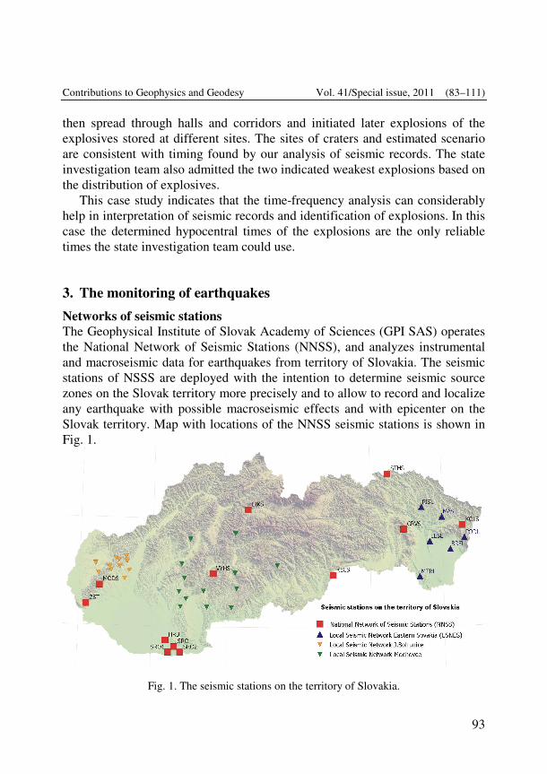
Contributions to Geophysics and Geodesy Vol. 41/Special issue, 2011 (83–111)
93
then spread through halls and corridors and initiated later explosions of the explosives stored at different sites. The sites of craters and estimated scenario are consistent with timing found by our analysis of seismic records. The state investigation team also admitted the two indicated weakest explosions based on the distribution of explosives.
This case study indicates that the time-frequency analysis can considerably help in interpretation of seismic records and identification of explosions. In this case the determined hypocentral times of the explosions are the only reliable times the state investigation team could use.
3. The monitoring of earthquakes Networks of seismic stations The Geophysical Institute of Slovak Academy of Sciences (GPI SAS) operates the National Network of Seismic Stations (NNSS), and analyzes instrumental and macroseismic data for earthquakes from territory of Slovakia. The seismic stations of NSSS are deployed with the intention to determine seismic source zones on the Slovak territory more precisely and to allow to record and localize any earthquake with possible macroseismic effects and with epicenter on the Slovak territory. Map with locations of the NNSS seismic stations is shown in Fig. 1.
Fig. 1. The seismic stations on the territory of Slovakia.
Moczo P. et al.: Seismological and integrated geophysical research in Slovakia ... (83–111)
94
Faculty of Mathematics, Physics and Informatics of Comenius University in Bratislava (FMPI UK) operates the Local Seismic Network Eastern Slovakia (LSNES) and analyzes instrumental data for the eastern part of Slovakia. The seismic stations of LSNES are deployed with intention to better monitor and understand the seismic regime of that part of our territory. The decision about importance of more detailed monitoring of seismic activity in eastern Slovakia by local seismic network was accepted by the Slovak Government after the wide-felt earthquake in Jasenovo on May 20, 2003 (ML = 3.7, I0 = 6-7). There-after the LSNES was planned, constructed and finally put in operation in 2007. Locations of the LSNES seismic stations are shown in Fig. 1.
Besides the two seismic networks operated by research institutions, there are two local seismic networks on the territory of Slovakia operated by company Progseis, s.r.o. Seismic stations of these networks are deployed around two nuclear power plants Jaslovské Bohunine and Mochovce (Fig. 1) with intension to monitor in detail local seismic microactivity. Data collection, processing and analysis A data centers of the national network and of the local network Eastern Slovakia are located in the GPI SAS, Bratislava or in the FMPI UK, Bratislava, respectively. Both data centers are created in the mirror way, equipped with the similar software and functional features. The data center collects waveforms from all stations of NNSS and LSNES and from selected seismic stations of some other institutions from Central and Southeastern European countries. Data are collected in real or near-real time using the SeisComp/SeedLink (Hanka et al., 2000; Van Eck et al., 2004; Hanka and Saul, 2006) or SEMS SeedLink software, respectively. The miniSeed format is used for both data collection and data exchange. In total, data from 62 seismic stations are collected. These stations create Regional Virtual Seismic Network in the GPI SAS (Fig. 2). More information about NNSS and live seismograms from the seismic stations of NNSS are available at http://ww.seismology.sk web page. Live seismograms are archived for 30 days. More information about LSNES can be found at http://www.fyzikazeme.sk /mainpage/index_en.htm.
Seismic waveforms are exchanged with all institutions which supply data to the data center in Bratislava. In addition, the seismic waveforms are sent also to the Orfeus Data Center, De Bilt, Netherlands.
A two-step analysis of seismic waveforms is performed – automatic analysis and localization of earthquakes and manual analysis and localization.
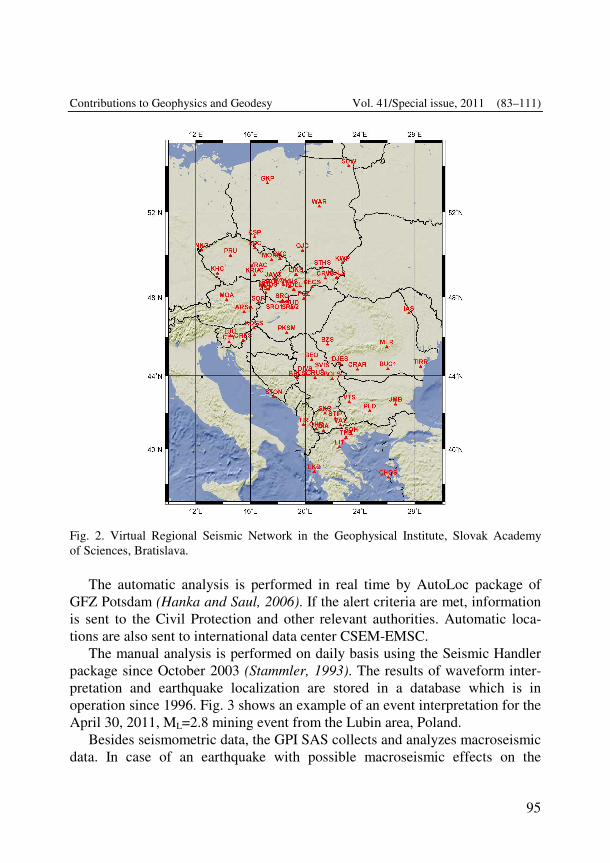
Contributions to Geophysics and Geodesy Vol. 41/Special issue, 2011 (83–111)
95
Fig. 2. Virtual Regional Seismic Network in the Geophysical Institute, Slovak Academy of Sciences, Bratislava.
The automatic analysis is performed in real time by AutoLoc package of
GFZ Potsdam (Hanka and Saul, 2006). If the alert criteria are met, information is sent to the Civil Protection and other relevant authorities. Automatic loca-tions are also sent to international data center CSEM-EMSC.
The manual analysis is performed on daily basis using the Seismic Handler package since October 2003 (Stammler, 1993). The results of waveform inter-pretation and earthquake localization are stored in a database which is in operation since 1996. Fig. 3 shows an example of an event interpretation for the April 30, 2011, ML=2.8 mining event from the Lubin area, Poland.
Besides seismometric data, the GPI SAS collects and analyzes macroseismic data. In case of an earthquake with possible macroseismic effects on the
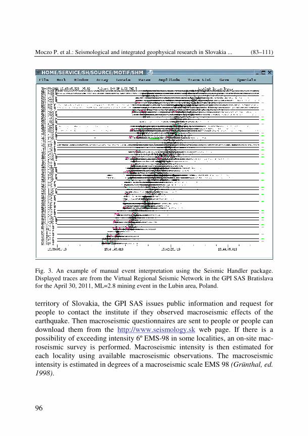
Moczo P. et al.: Seismological and integrated geophysical research in Slovakia ... (83–111)
96
Fig. 3. An example of manual event interpretation using the Seismic Handler package. Displayed traces are from the Virtual Regional Seismic Network in the GPI SAS Bratislava for the April 30, 2011, ML=2.8 mining event in the Lubin area, Poland.
territory of Slovakia, the GPI SAS issues public information and request for people to contact the institute if they observed macroseismic effects of the earthquake. Then macroseismic questionnaires are sent to people or people can download them from the http://www.seismology.sk web page. If there is a possibility of exceeding intensity 6º EMS-98 in some localities, an on-site mac-roseismic survey is performed. Macroseismic intensity is then estimated for each locality using available macroseismic observations. The macroseismic intensity is estimated in degrees of a macroseismic scale EMS 98 (Grünthal, ed. 1998).
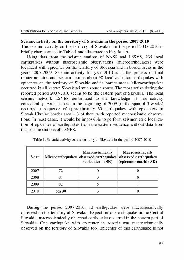
Contributions to Geophysics and Geodesy Vol. 41/Special issue, 2011 (83–111)
97
Seismic activity on the territory of Slovakia in the period 2007-2010 The seismic activity on the territory of Slovakia for the period 2007-2010 is briefly characterized in Table 1 and illustrated in Fig. 4a, 4b.
Using data from the seismic stations of NNSS and LSSVS, 235 local earthquakes without macroseismic observations (microearthquakes) were localized with epicenter on the territory of Slovakia and in border areas in the years 2007-2009. Seismic activity for year 2010 is in the process of final reinterpretation and we can assume about 90 localized microearthquakes with epicenter on the territory of Slovakia and in border areas. Microearthquakes occurred in all known Slovak seismic source zones. The most active during the reported period 2007-2010 seems to be the eastern part of Slovakia. The local seismic network LSNES contributed to the knowledge of this activity considerably. For instance, in the beginning of 2009 (in the span of 3 weeks) occurred a sequence of approximately 30 earthquakes with epicenters in Slovak-Ukraine border area – 3 of them with reported macroseismic observa-tions. In most cases, it would be impossible to perform seismometric localiza-tion of epicenter of earthquakes from the eastern sequence without data from the seismic stations of LSNES.
Table 1. Seismic activity on the territory of Slovakia in the period 2007-2010
Year Microearthquakes Macroseismically
observed earthquakes (epicenter in SK)
Macroseismically observed earthquakes (epicenter outside SK)
2007 72 0 0
2008 81 3 0
2009 82 5 1
2010 cca 90 3 0
During the period 2007-2010, 12 earthquakes were macroseismically observed on the territory of Slovakia. Expect for one earthquake in the Central Slovakia, macroseismically observed earthquake occurred in the eastern part of Slovakia. One earthquake with epicenter in Austria was macroseismically observed on the territory of Slovakia too. Epicenter of this earthquake is not
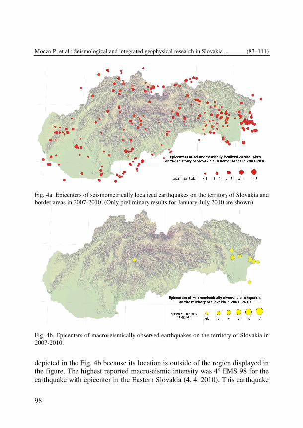
Moczo P. et al.: Seismological and integrated geophysical research in Slovakia ... (83–111)
98
depicted in the Fig. 4b because its location is outside of the region displayed in the figure. The highest reported macroseismic intensity was 4° EMS 98 for the earthquake with epicenter in the Eastern Slovakia (4. 4. 2010). This earthquake
Fig. 4a. Epicenters of seismometrically localized earthquakes on the territory of Slovakia and border areas in 2007-2010. (Only preliminary results for January-July 2010 are shown).
Fig. 4b. Epicenters of macroseismically observed earthquakes on the territory of Slovakia in 2007-2010.
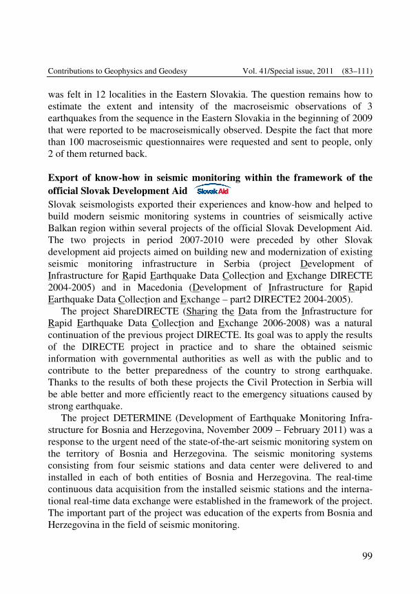
Contributions to Geophysics and Geodesy Vol. 41/Special issue, 2011 (83–111)
99
was felt in 12 localities in the Eastern Slovakia. The question remains how to estimate the extent and intensity of the macroseismic observations of 3 earthquakes from the sequence in the Eastern Slovakia in the beginning of 2009 that were reported to be macroseismically observed. Despite the fact that more than 100 macroseismic questionnaires were requested and sent to people, only 2 of them returned back. Export of know-how in seismic monitoring within the framework of the official Slovak Development Aid Slovak seismologists exported their experiences and know-how and helped to build modern seismic monitoring systems in countries of seismically active Balkan region within several projects of the official Slovak Development Aid. The two projects in period 2007-2010 were preceded by other Slovak development aid projects aimed on building new and modernization of existing seismic monitoring infrastructure in Serbia (project Development of Infrastructure for Rapid Earthquake Data Collection and Exchange DIRECTE 2004-2005) and in Macedonia (Development of Infrastructure for Rapid Earthquake Data Collection and Exchange – part2 DIRECTE2 2004-2005).
The project ShareDIRECTE (Sharing the Data from the Infrastructure for Rapid Earthquake Data Collection and Exchange 2006-2008) was a natural continuation of the previous project DIRECTE. Its goal was to apply the results of the DIRECTE project in practice and to share the obtained seismic information with governmental authorities as well as with the public and to contribute to the better preparedness of the country to strong earthquake. Thanks to the results of both these projects the Civil Protection in Serbia will be able better and more efficiently react to the emergency situations caused by strong earthquake.
The project DETERMINE (Development of Earthquake Monitoring Infra-structure for Bosnia and Herzegovina, November 2009 – February 2011) was a response to the urgent need of the state-of-the-art seismic monitoring system on the territory of Bosnia and Herzegovina. The seismic monitoring systems consisting from four seismic stations and data center were delivered to and installed in each of both entities of Bosnia and Herzegovina. The real-time continuous data acquisition from the installed seismic stations and the interna-tional real-time data exchange were established in the framework of the project. The important part of the project was education of the experts from Bosnia and Herzegovina in the field of seismic monitoring.
Moczo P. et al.: Seismological and integrated geophysical research in Slovakia ... (83–111)
100
4. Carpathian-Pannonian lithosphere: integrated geophysical study Solution of 3D forward gravimetric problem in the Western Carpathian-Pannonian region Alasonati Tašárová et al. (2008, 2009) presented the first three-dimensional (3D) combined gravity and seismic modeling in the Western Carpathian-Pannonian region, based mainly on the CELEBRATION 2000 data (e.g. �roda et al., 2006; Grad et al., 2006). The forward modeling of the Bouguer gravity anomaly was performed using the Interactive Gravity and Magnetic System (IGMAS) (e.g. Götze, 1976; Götze and Lahmeyer, 1988). The modeled geological bodies are in IGMAS approximated by polyhedra of constant density. The structures are defined and modeled along 2D cross-sections that are automatically connected via triangulation into a volume. Thus, the geometry of the geological bodies between the cross-sections is interpolated. Therefore, in order to obtain more reliable results, a greater number of 2D planes must be included. The model presented was developed along 36 cross-sections, separated by 10 to 20 km across the Western Carpathians and Pannonian Basin (the focus of the modeling) and 40 km in the surrounding Bohemian Massif and Eastern Alps. The model reaches the depth of 250 km. The direction of the modeled cross-sections is identical to one of the seismic profiles from the CELEBRATION 2000 experiment (CEL05 profile). Constraining data and density determination. Seven CELEBRATION 2000 profiles were used for the combined 3D gravity-seismic modeling: CEL01, CEL02, CEL03, CEL04, CEL05, CEL09 and CEL 10 (�roda et al., 2006; Malinowksi et al., 2005; Janik et al., 2005; Grad et al., 2006; Hrubcová et al., 2005, 2008). Moreover, the results from 2D integrated modeling of Zeyen et al. (2002) and Dérerová et al. (2006) served as a starting point for the 3D gravity modeling. First of all, these results constrained one of the two input parameters used for the gravity modeling, namely the geometry of the modeled structures (i.e. depth to the main boundaries). The density, which is the second input parameter, can be constrained by geological data. The results from borehole measurements provide the best information on the composition of the rocks. However, such measurements are only sparse and restricted to the uppermost part of the upper crust. At larger depths and for large-scales models, other information constraining the composition must be used. For the igneous rocks, relationships of Christensen and Mooney (1995) and Sobolev and Babeyko (1994) were applied. Since the tectonic units of the modeled region are
Contributions to Geophysics and Geodesy Vol. 41/Special issue, 2011 (83–111)
101
characterized by extremely different thermal regimes, the relationship of Sobolev and Babeyko (1994) was found more appropriate for the density determination. The densities of the sediments in the units surrounding the Western Carpathian-Pannonian region were calculated from the P-wave seismic velocities using the relationships of Gardner et al. (1974) and Wang (2000). The densities of the sediments in the Pannonian Basin (PB) and Western Carpathians were based on the previous investigations (e.g. Makarenko et al., 2002; Bielik et al., 2005). Nevertheless, both densities and geometries were subject of the modeling and the resulting values are a trade-off between the seismic results and gravity anomalies.
The temperature and density distribution in the uppermost mantle was calculated using a combination of petrological, mineralogical and geophysical information. This calculation was performed in order to enhance the 3D gravity modeling, particularly in the PB, because it is characterized by an astheno-spheric upwelling and thus by anomalous temperatures and densities in the uppermost mantle. The mantle densities were estimated using the methodology of Afonso (2006). This approach is based on a self-consistent combination of data from petrology, geophysics, mineral physics and thermodynamics. The numerical implementation of this method, referred to as LitMod, is a 2D code. Based on the input parameters (thermal conductivity, radiogenic heat produc-tion, crustal densities, chemical composition of the uppermost mantle), it calculates temperature and pressure distribution within the whole lithosphere and sublithospheric mantle, and for the mantle part also densities and seismic velocities. The calculations were performed along 3 selected profiles and the resulting structures were extrapolated into the 3D gravity model (Alasonati Tašárová et al., 2009). Results. The thickness of the sediments in the different sedimentary units is quite variable. In the PB in it reaches 0–7.8 km. The Western Carpathians are characterized by infill of 0–2 km in the Inner Western Carpathians, maximum of 21.5 km in the Outer Western Carpathians flysch zone and 1–3 km in the Western Carpathian Foredeep. Note that the maximal value of 21.5 km includes both the sediments of the Outer Western Carpathian Flysch zone and the Trans European Suture Zone (TESZ) cover, which contains the Upper Palaeozoic to Mesozoic strata (�roda et al., 2006). The southern part of the Polish Basin, which was included in the 3D model, has sedimentary infill of ~7 km. The border between the TESZ and the East European Craton (EEC – Lublin
Moczo P. et al.: Seismological and integrated geophysical research in Slovakia ... (83–111)
102
Trough) is characterized by 5 to 8 km of sedimentary cover. Elsewhere, the EEC is covered by a thin layer of sediments (less than 3 km).
The thinnest crust was modeled in the central and eastern part of the PB. The minimum crustal thickness of ~22 km is located along the CEL05. The Danube Basin is characterized by crustal thickness of 28–30 km, increasing to 35 km toward the west. The Central Western Carpathians have 28–35 km thick crust, while the crust beneath the Outer Western Carpathians and the Carpathian Foredeep is 35 to 43 km thick. The maximum crustal thickness of ~50 km is modeled beneath the TESZ/EEC along the CEL05.
Similarly to the crust, also the lithospheric mantle resulting from our best-fitting model is extremely thin in the PB. The lithosphere-asthenosphere boundary (LAB) reaches here depths of 60–100 km. The lithospheric thickness is gradually increasing toward the west and north. In general, the lithosphere is ~160 km thick in the Eastern Alps, ~140 km in the Bohemian Massif and Western Carpathians. The thickest lithosphere (~200 km) is included in the EEC.
The 3D model enabled also to perform gravity stripping. It allowed to identify the sources of the anomalies, to separate their effects and localize the lithospheric inhomogeneities. The sediment stripped map of the PB is generally characterized by a positive anomaly of 20–50 mGal. Particularly the eastern part of the PB is characterized by pronounced residual gravity high, which is related to the extremely shallow Moho in this region. In contrary, the Central Western Carpathians reflects a negative effect of the thick low-density upper and middle crust. The thickness of the upper and middle crust reaches in the density model 25 km. A complete stripped map was calculated by removing the gravity effects of the sediments, Moho and the low-density uppermost part of the upwelling asthenosphere from the Bouguer anomaly. In contrast to the sediment stripped map, it clearly shows similarities of the PBS and Western Carpathians. The Moho in the PB is some 10 km shallower than in the Western Carpathians. When its gravity effect is accounted for (together with the low-density upwelling asthenosphere in the PBS), both microplates ALCAPA and Tisza-Dacia are characterized by residual anomalies, which are much lower than in the surrounding regions. The greatest gradient coincides with the location of the PKB, separating the microplate ALCAPA from the platform. This suggests that the lithospheric structure of the microplates ALCAPA and Tisza-Dacia is in terms of density distribution quite different from the surrounding units. Also, it can be reflecting different degree of crustal con-
Contributions to Geophysics and Geodesy Vol. 41/Special issue, 2011 (83–111)
103
solidation. It follows that the ALCAPA and Tisza-Dacia are characterized by low-density unconsolidated crust, whereas the European Platform has a consolidated crust of high-densities. Solution of 3D forward gravimetric problem in the Liptovská kotlina basin region Detailed 3D forward gravity modelling was applied for calculation of the stripped gravity map in the Liptovská kotlina basin (Szalaiová et al., 2008). The Liptovská kotlina basin is located in the northern part of Slovakia, just at the bottom of the High Tatras. This territory orthographically represents an extensive terrain depression of an irregular shape, elongated in the east-west direction. The length and width of the Liptovská kotlina basin are 50 km and 15 km, respectively. It slopes from the east to the west with the average elevation difference of 550 m. It is built by the Quaternary and Central Carpa-thian Palaeogene sediments. The Palaeogene filling of the basin represents one of the most classic developments of the Central Carpathian Palaeogene. A number of mineral and thermal water springs is located in the Liptov region. The growing interest for the use of geothermal water for energetic purposes and recreation in an attractive territory makes the Liptovská kotlina basin a very interesting locality. It is well-known that Mesozoic rocks in the basement are possible thermal water collectors. From this point of view a research concern-ing the structure of the pre-Tertiary basement is very important.
It is well-known that for an objective study of the basement structure it is very useful to calculate the stripped gravity map. Therefore the paper focused on the calculation of the stripped gravity map in the Liptovská kotlina basin by means of 3D forward gravity modeling. The stripped gravity map is a result of subtracting the 3D gravity effect of the sedimentary filling density contrast from the Bouguer gravity anomalies. This type of gravity map contributes significantly to the geophysical investigation of the basement structures in the Liptovská kotlina basin and to an assessment of assumed geothermal water supply.
The resultant stripped gravity maps showed new gravity features, which consist of the relative gravity highs and lows. The largest gravity high correlates with the cropping out of the Tatricum on the northern margin of the Liptovská kotlina basin. The source of this anomaly would be looked for in the larger mass of the crystalline rocks underlying the cover unit, as well as the Fatricum and Hronicum tectonic units. A significant gravity high can be seen in
Moczo P. et al.: Seismological and integrated geophysical research in Slovakia ... (83–111)
104
the Liptovská Mara depression. It consists of two local maxima. The first maximum is probably due to the rocks of the Hronicum with higher density (predominantly dolomites), while the second maximum could result in the rocks of the Fatricum which are underlain by Tatricum. The source of the Štrbské Pleso gravity high can be explained by the elevation of the Tatricum underlain by Mesozoic rocks. The Štrba gravity high can be explained by higher density masses of volcano-sedimentary Palaeozoic rocks of the Hronicum complex. The pattern of the gravity field on the stripped gravity map is also accompanied by the gravity lows. They are characterized by almost the same amplitude values of –62 mGal. One can be observed in the west-eastern part of the Liptovská kotlina basin. This gravity low, consisting of two different local minima, is due to less dense marly rocks of the Hronicum. The same source is also suggested for the gravity lows extended in the southernmost part of the Liptovská kotlina basin. Note that the depressions of the Fatricum unit in the basement of the Hronicum could also represent a partial source of all the relative gravity lows. 2D gravity field interpretation in the Tur�ianska Kotlina Basin Grin� et al. (2010) studied the geological structure and composition of the Tur�ianska Kotlina Basin by the quantitative interpretation of the gravity field. The interpretation was done by application of the 2D density modeling method using the GM-SYS software. Geophysical constraints of the density models were represented by the existing geophysical measurements and interpretations. The Tu�ianska Kotlina Basin in the picture of the regional gravity field is characterized by the local gravity low with amplitude of about 12 mGal. The source of this gravity low is low density Tertiary sediments, which fill the basin. From the Tertiary sediments the Neogene sediments play dominant role in observed gravity, because their gravity effects are considerably larger in comparison with the gravity effects of the Paleogene sediments. The contacts between the Malá Fatra and Ve�ká Fatra Mts., and the Tur�ianska Kotlina Basin are characterized by the significant gravity gradients. They reflect tectonic contact between the basin and crystalline core mountains. In the Tur�ianska gravity low we can see three local gravity lows. The highest local gravity low is explained by the largest thickness of the Tertiary sediments. Another two local gravity lows are also characterised by thicker layers of the Tertiary sediments. Density models assume that the eastern (western) part of the basin basement is built by the Mesozoic (crystalline) rocks. In the central
Contributions to Geophysics and Geodesy Vol. 41/Special issue, 2011 (83–111)
105
part of basin the thick Paleogene sedimentary filling (more than 1 km) compensates the deepest part of the pre-Tertiary basement. 2D density models in the basin do not suggest a presence of the Paleogene sediments in the eastern part of the basin filling. It is also indicated that the Mesozoic rocks underlie the Tertiary sediments. The pre-Tertiary basement was interpreted in the depths from 0 km up to the 2 km. Note that all geological structures (blocks) are sliding from the East to the West. The dipping of the Malá Fatra Mts. is steeper than in a case of the Ve�ká Fatra Mts. The anomalous bodies observed on the western part of the basin result from the alluvial and detrital cones. Their presence and gravity effect can be observed mainly on the eastern slope of the Malá Fatra Mts. Modeling refracted and reflected waves along the CELEBRATION 2000 profiles During the CELEBRATION 2000 seismic experiment, the Western Carpathians and Pannonian basin region was investigated by a dense system of deep seismic sounding profiles. In the paper of Grad et al. (2007) it was presented the results of modeling refracted and reflected waves employing 2-D ray tracing for seven interlocking profiles CEL01, CEL04, CEL05, CEL06, CEL11, CEL12 and CEL28, that were jointly modeled and interpreted with the constraint that the models match at the crossing points of the profiles. The resulting P-wave velocity models revealed complex structures in the crust and large variations in the depth of the Moho discontinuity (~25-45 km). In the southern part of the area, the relatively thin Pannonian basin crust consists of 3-7 km thick sediments and two crustal layers with velocities of 5.9-6.3 km/s in the upper crust and 6.3-6.6 km/s in the lower crust. In the central region, the upper crust of the ALCAPA (Alpine-Carpathian-Pannonian) microplate contains a high velocity body of Vp � 6.4 km/s, which spatially corresponds with the Bükk Composite Terrane. The total thickness of the ALCAPA crust is 1-2 km greater than in the adjacent Tisza-Dacia microplate. To the north in the area of the TESZ and Carpathian foredeep, it was observed a 10-20 km thick upper crust with low velocity (Vp � 6.0 km/s). Sub-Moho velocities have average values of 7.8-8.0 km/s for the Pannonian basin, while in the Western Carpathians, the TESZ and the East European Craton (EEC) area, they are slightly higher (8.0-8.1 km/s). Lower velocities beneath the ALCAPA and Tisza-Dacia microplates could be caused by compositional variations and the significantly higher surface heat flow. Beneath some profiles, reflectors in the lithospheric mantle
Moczo P. et al.: Seismological and integrated geophysical research in Slovakia ... (83–111)
106
were found sub-parallel to the Moho but 10-20 km below it. Our integrated geophysical and geological analysis indicates that the observed structure was created by collision of two lithospheric plates with only a moderate degree of convergence. The northern plate consists of older European tectonic units of the EEC and TESZ. However, the southern one consists of younger tectonic units of the Western Carpathians and the back-arc Pannonian basin that generated the ALCAPA and Tisza-Dacia microplates. The authors interpreted the complex present day structure to be the result of the soft continental collision between the ALCAPA and Tisza-Dacia microplates and the south margin of the Euro-pean plate, which was mainly followed by the extensional process beneath the back-arc Pannonian basin. Interpretation of deep seismic reflection profiles in the northern part of the Malé Karpaty Mountains Interpretation of deep seismic reflection profiles in the northern part of the Malé Karpaty Mountains, which are westernmost part of the Western Carpathi-ans was presented in the paper published by Kytková et al. (2007). The goal was to recognize the tectonic character of western and eastern mountain range limitation in the area between Plavecký Mikuláš and Dolné Orešany, study the character of the Záhorsky fault and the declination of inner structures. Result of the interpretation was the confirmation that the Vienna Basin is a pull-appart basin and that the western mountain range border is formed by an orthogonal strike slip connected with the mountain range uplift. On the eastern border (from the Danube Basin side) which was until now considered as fault, appears to have a fold character. Hence, the Malé Karpaty Mountains represent at least in the northern part an anticline.
The improved geophysical image of the lithospheric structure and tectonics in the Carpathian-Pannonian Basin region, which was based on our systematic and integrated intepretation of the geophysical fields was presented and summerized in the papers of Bielik et al. (2010); Bielik et al. (2009); Vozár et al. (2007) and Plašienka et al. (2008). The method of the 2-D integrated geo-physical modelling was also applied in study of the lithosphere in Aswan area (Radwan et al., 2007).
References Afonso J. C., 2006: Thermal, density, seismological, and rheological structure of the
Contributions to Geophysics and Geodesy Vol. 41/Special issue, 2011 (83–111)
107
lithospheric-sublithospheric mantle from combined petrological-geophysical model-ing: Insights on lithospheric stability and the initiation of subduction. Ph.D. thesis, Carleton Univ., Ottawa.
Bielik M., Makarenko I., Starostenko V., Legostaeva O., Dérerová J., Šefara J., Pašteka R., 2005: New 3D gravity modeling in the Carpathian-Pannonian region. Contrib. Geophys. Geod., 35, 1, 65–78.
Christensen N. I., Mooney W. D., 1995: Seismic velocity structure and composition of the continental crust: A global view. J. Geophys. Res., 100, B7, 9761–9788.
Dérerová J., Zeyen H., Bielik M., Salman K., 2006: Application of integrated geophysical modeling for determination of the continental lithospheric thermal structure in the eastern Carpathians. Tectonics, 25, TC3009, doi: 10.1029/2005TC001883.
Emmerich H., Korn M., 1987: Incorporation of attenuation into time-domain computations of seismic wave fields. Geophysics, 52, 1252–1264.
Gardner G. H. F., Gardner L. W., Gregory A. R., 1974: Formation velocity and density – The diagnostic basics for stratigraphic traps. Geophysics, 29, 6, 770–778.
Götze H.-J., Lahmeyer B., 1988: Application of three-dimensional interactive modeling in gravity and magnetics. Geophysics, 53, 8, 1096–1108.
Götze H.-J., 1976: Ein numerisches Verfahren zur Berechnung der gravimetrischen und magnetischen Feldgrößen für dreidimensionale Modellkörper. Dissertation, Techni-cal University Clausthal, Germany.
Grad M., Guterch A., Keller G. R, Janik T., Hegedus E., Vozar J., Slaczka A., Tiira T., Yliniemi J., 2006: Lithospheric structure beneath trans-Carpathian transect from Precambrian platform to Pannonian basin: CELEBRATION 2000 seismic profile CEL05. J. Geophys. Res., 111, B03301.
Grünthal G. (Eds.), 1998: European Macroseismic Scale 1998. Conseil de l`Europe, Cahiers du Centre Européen de Géodynamique et de Séismologie, Luxembourg, 15, 99 p.
Hanka W., Heinloo A., Jäckel K.-H., 2000: Networked Seismographs: GEOFON Real-Time Data Distribution, ORFEUS Electronic Newsletter, 2, 3. (http://orfeus. knmi.nl/)
Hanka W., Saul J., 2006: GEOFON and its Role in Earthquake Monitoring and Tsunami Warning. Proceedings of the NATO Workshop on Earthquake Monitoring and Seismic Hazard Mitigation in Balkan Countries, Borovetz, Bulgaria, September 11-17, 2005.
Hrubcová P., �roda P., Špi�ák A., Guterch A., Grad M., Keller G. R., Brückl E., Thybo H., 2005: Crustal and uppermost mantle structure of the Bohemian Massif based on CELEBRATION 2000 data. J. Geophys. Res., 110, B11305.
Hrubcová P., �roda P., CELEBRATION 2000 Working Group, 2008: Crustal structure at the easternmost termination of the Variscan belt based on CELEBRATION 2000 and ALP 2002 data. doi: 10.1016/j.tecto.2008.07.009, Tectonophysics, 460, 55–75.
Moczo P. et al.: Seismological and integrated geophysical research in Slovakia ... (83–111)
108
Janik T., Grad M., Guterch A., Dadlez R., Yliniemi J., Tiira T., Keller G. E., Gaczy�ski G. R., CELEBRATION 2000 Working Group, 2005: Lithospheric structure of the Trans-European Suture Zone along the TTZ-CEL03 seismic transect (from NW to SE Poland). Tectonophysics, 411, 129–156.
Komatitsch D., Martin R., 2007: An unsplit convolutional Perfectly Matched Layer improved at grazing incidence for the seismic wave equation. Geophysics, 72, SM155–SM167.
Kristeková M., Kristek J., Moczo P., Day S. M., 2006: Misfit Criteria for Quantitative Comparison of Seismograms. Bull. Seism. Soc. Am., 96, 1836–1850.
Makarenko I., Legostaeva O., Bielik M., Starostenko V., Dérerová J., Šefara J., 2002: 3D gravity effects of the sedimentary complexes in the Carpathian-Pannonian region. Geologica Carpathica, 53, Special Issue.
Malinowski M., Zelazniewicz A., Grad M., Guterch A., Janik T., 2005: Seismic and geological structure of the crust in the transition from Baltica to Palaeozoic Europe in SE Poland - CELEBRATION 2000 experiment, profile CEL02. Tectonophysics, 401, 1-2, 55–77.
Moczo P., Kristek J., 2005: On the rheological models used for time-domain methods of seismic wave propagation. Geophys. Res. Lett., 32, L01306.
Sobolev S. V., Babeyko A. Y., 1994: Modeling of mineralogical composition, density and elastic wave velocities in anhydrous magmatic rocks. Surveys in Geophysics, 15, 5, 515–544.
Stammler K., 1993: Seismic-Handler - Programmable multichannel data handler for inter-active and automatic processing of seismological analyses. Computers & Geoscien-ces, 19, 2, 135–140.
�roda P., Czuba W., Grad M., Guterch A., Tokarski A. K., Janik T., Rauch M., Keller G. R., Hegedüs E., Vozar J., Celebration 2000 Working Group, 2006: Crustal and upper mantle structure of the Western Carpathians from CELEBRATION 2000 profiles CEL01 and CEL04: seismic models and geological implications. Geophys. J. Int., 167, 737–760.
Van Eck T., Trabant C., Dost B., Hanka W., Giardini D., 2004: Setting up a virtual Broadband Seismograph Network Across Europe. EOS, Transactions, AGU, 85, 13, 125–129.
Wang Z., 2000: Velocity-Density Relationships in Sedimentary Rocks. Geophysics reprint series, 19, 258–268, Society of Exploration Geophysicists.
Zeyen H., Dérerová J., Bielik M., 2002: Determination of the continental lithosphere thermal structure in the western Carpathians: Integrated modeling of surface heat flow, gravity anomalies and topography. Phys. Earth Planet. Inter., 134, 89–104.
Contributions to Geophysics and Geodesy Vol. 41/Special issue, 2011 (83–111)
109
Publications Alasonati Tašárová Z., Bielik M., Götze H. J., 2008: Stripped image of the gravity field of
the Carpathian-Pannonian region based on the combined interpretation of the CELEBRATION 2000 data. Geologica Carpathica, 59, 3, 199–209.
Alasonati Tašárová Z., Afonso J. C., Bielik M., Götze H. J., Hók J., 2009: The lithospheric structure of the Western Carpathian-Pannonian Basin region based on the CELEBRATION 2000 seismic experiment and gravity modeling. Tectonophysics, 475, 3-4, 454–469.
Archuleta R. J., Moczo P., Labák P. (Eds.), 2007: Proceedings of the Workshop - Abstract Book. Numerical Modeling of Earthquake Source Dynamics - NMESD 2007. FMFI UK a GFÚ SAV, Bratislava. 54 p.
Archuleta R. J., Moczo P., Kristek J., Galis M. (Eds.), 2010: Proceedings of the Workshop - Abstract Book. Earthquake Source Dynamics: Data and Data-constrained Numerical Modeling - ESD 2010. FMFI UK a GFÚ SAV, Bratislava, 69 p.
Bielik M., Šefara J., Alasonati Tašárová Z., Vozár J., 2009: Geofyzikálny obraz karpatsko-panónskej oblasti. In: Spolo�ný geologický kongres �eskej a Slovenskej geologickej spolo�nosti. Bratislava, Štátny geologický ústav D. Štúra, 1–20. ISBN 978-80-89343-24-9.
Bielik M., Alasonati Tašárová Z., Zeyen H., Dérerová J., Afonso J. C., Csicsay K., 2010: Improved geophysical image of the Carpathian-Pannonian Basin region. Acta Geodaetica et Geophysica Hungarica, 45, 3, 284–298.
Briestenský M., Koš�ák B., Stemberk J., Petro ., Vozár J., Fojtíková L., 2010: Active tectonic fault microdisplacement analyses: a comparison of results from surface and underground monitoring in Western Slovakia. Acta Geodyn. Geomater., 7, 4(160), 387–397.
Fojtíková L., Vavry�uk V., Cipciar A., Madarás J., 2010: Focal mechanisms of micro-earthquakes in the Dobrá Voda seismoactive area in the Malé Karpaty Mts (Little Carpathians), Slovakia. Tectonophysics, 492, 213–229.
Galis M., Moczo P., Kristek J., 2008: A 3-D hybrid finite-difference—finite-element viscoelastic modeling of seismic wave motion. Geophys. J. Int., 175, 153–184.
Galis M., Moczo P., Kristek J., Kristekova M., 2010: An adaptive smoothing algorithm in the TSN modelling of rupture propagation with the linear slip-weakening friction law. Geophys. J. Int., 180, 418–432.
Grad M., Guterch A., Keller G. R., Brückl E., Belinsky A. A., Asudeh R. C., Hajnal Z., Špi�ák A., Jensen S. L., Thybo H., Komminaho K., Luosto U., Tiira T., Yliniemi J., Fancsik T., Hegedüs E., Kovacs A., Csabafi R., Jacyna J., Korabliova L., Motuza G., Nasedkin V., Czuba W., Gaczynski E., Janik T., Malinowski M., Slaczka A., Sroda P., Wilde-Piórko M., Kostiuchenko S. L., Bielik M., Vozár J., Selvi O., Harder S., Miller K. C., 2007: Variations in lithospheric structure across the margin of Baltica
Moczo P. et al.: Seismological and integrated geophysical research in Slovakia ... (83–111)
110
in central Europe and role of the variscan and Carpathian orogenesis. Geological Society of America Memoir 200. In: 4-D framework of continental crust. Boulder, Geological Society of America, 341–356. ISBN 978-0-8137-1200-0.
Grin� M., Bielik M., Mojzeš A., Hók J., 2010: Results of the gravity field interpretation in the Tur�ianska Kotlina Basin. Contrib. Geophys. Geod., 40, 2, 103–120.
Chaljub E., Moczo P., Tsuno S., Bard P.-Y., Kristek J., Käser M., Stupazzini M., Kristekova M., 2010: Quantitative Comparison of Four Numerical Predictions of 3D Ground Motion in the Grenoble Valley, France. Bull. Seism. Soc. Am., 100, 1427–1455.
Kristek J., Moczo P., Galis M., 2009: A brief summary of some PML formulations and discretizations for the velocity-stress equation of seismic motion. Studia Geoph. Geod., 53, 459–474.
Kristek J., Moczo P., Galis M., 2010: Stable discontinuous staggered grid in the finite-difference modeling of seismic motion. Geophys. J. Int., 183, 1401–1407.
Kristekova M., Kristek J., Moczo P., 2009: Time-frequency misfit and goodness-of-fit criteria for quantitative comparison of time signals. Geophys. J. Int., 178, 813–825.
Kristekova M., Moczo P., Labak P., Cipciar A., Fojtikova L., Madaras J., Kristek J., 2008: Time-Frequency Analysis of Explosions in the Ammunition Factory in Novaky, Slovakia. Bull. Seism. Soc. Am., 98, 2507–2516.
Kytková B., Tomek �., Bielik M., Putiš M., 2007: Interpretation of deep seismic reflection profiles in the northern part of the Malé Karpaty Mountains. Contrib. Geophys. Geod., 37, 1, 43–58.
Moczo P., Kristek J., Galis M., Pazak P., 2010: On accuracy of the finite-difference and finite-element schemes with respect to P-wave to S-wave speed ratio. Geophys. J. Int., 182, 493–510.
Moczo P., Kristek J., Galis M., Pazak P., Balazovjech M., 2007: The Finite-Difference and Finite-Element Modeling of Seismic Wave Propagation and Earthquake Motion. Acta Physica Slovaca, 57, 177–406.
Moczo P., Robertsson J. O. A., Eisner L., 2007: The finite-difference time-domain method for modeling of seismic wave propagation. In Advances in Wave Propagation in Heterogeneous Earth, 421-516, R.-S. Wu and V. Maupin, eds., Advances in Geo-physics, 48, R. Dmowska, ed., Elsevier – Academic Press.
Plašienka D., Vozár J., Bielik M., 2008: The Pieniny Klippen Belt at the depth rooted, or unrooted? In: 6th Meeting of the Central European Tectonic Studies Group CETeG and 13th Meeting of the Czech Tectonic Studies Group �TS. Upohlav, 23.-26.4.2008. SlovTec 08 Bratislava, Štátny geologický ústav D. Štúra, 104–108. ISBN 978-80-89343-01-0.
Radwan A. H., Bielik M., Dérerová J., Kohút I., Elsayed A. I., 2007: Determination of the lithospheric structure along a profile 1 in Aswan area: 2-D integrated geophysical modeling. Al-Azhar Bulletin of Science, 17, 2, 23–33.
Contributions to Geophysics and Geodesy Vol. 41/Special issue, 2011 (83–111)
111
Skarlatoudis A. A., Papazachos C. B., Theodoulidis N., Kristek J., Moczo P., 2010: Local site-effects for the city of Thessaloniki (N. Greece) using a 3-D finite-difference method: a case of complex dependence on source and model parameters. Geophys. J. Int., 182, 279–298.
Szalaiová E., Bielik M., Makarenko I., Legostaeva O., Hók J., Starostenko V., Šujan M., Šefara J., 2008: Calculation of a stripped gravity map with a high degree of accuracy: a case study of Liptovská Kotlina Basin (Northern Slovakia). Geological Quarterly, 52, 2, 103–114.
Vozár J., Szalaiová V., Bielik M., Potfaj M., Grad M., Guterch A., Keller G. R., Janik T., Hegedüs E., Slaczka A., Tiira T., Yliniemi J., Vozár J., 2007: Transects across the geological units of the WesternCarpathians and interpretation (seismic, gravity, magnetoteluric). Mineralia Slovaca, 39, 1, 25–26.

Contributions to Geophysics and Geodesy Vol. 41/Special issue, 2011 (113–144)
113
APPENDIX
Slovak National Committee for IUGG
President of the Slovak NC IUGG and National correspondent for IASPEI: Prof. RNDr. Peter Moczo, DrSc. Department of Astronomy, Physics of the Earth and Meteorology Division of Physics of the Earth Faculty of Mathematics, Physics and Informatics Comenius University Mlynská dolina F1 842 48 Bratislava Slovak Republic Phone: +421-2-6542-9025 Fax: +421-2-6542 5982 E-mail: [email protected] and Geophysical Institute of the Slovak Academy of Sciences Dúbravská cesta 9 845 28 Bratislava Slovak Republic Phone: +421-2-5941 0608 Fax: +421-2-5941 0626
Vice-president of the Slovak NC IUGG: Prof. Ing. Ján Hefty, CSc. Department of Theoretical Geodesy, Slovak University of Technology Radlinského 11 813 68 Bratislava Slovak Republic Phone: +421-2-5927 4533 Fax:+421-2-5292 5476 E-mail: [email protected]
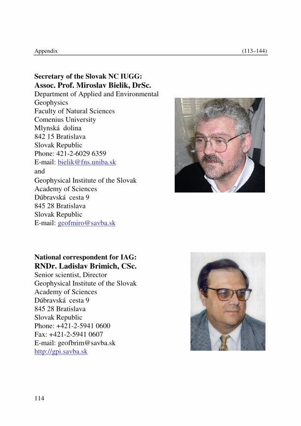
Appendix (113–144)
114
Secretary of the Slovak NC IUGG: Assoc. Prof. Miroslav Bielik, DrSc. Department of Applied and Environmental Geophysics Faculty of Natural Sciences Comenius University Mlynská dolina 842 15 Bratislava Slovak Republic Phone: 421-2-6029 6359 E-mail: [email protected] and Geophysical Institute of the Slovak Academy of Sciences Dúbravská cesta 9 845 28 Bratislava Slovak Republic E-mail: [email protected]
National correspondent for IAG: RNDr. Ladislav Brimich, CSc. Senior scientist, Director Geophysical Institute of the Slovak Academy of Sciences Dúbravská cesta 9 845 28 Bratislava Slovak Republic Phone: +421-2-5941 0600 Fax: +421-2-5941 0607 E-mail: [email protected] http://gpi.savba.sk
Contributions to Geophysics and Geodesy Vol. 41/Special issue, 2011 (113–144)
115
National correspondent for IAGA: Assoc. Prof. Dr. Jozef Brestenský, CSc., Department of Astronomy, Physics of the Earth and Meteorology Division of Physics of the Earth Faculty of Mathematics, Physics and Informatics, Comenius University Mlynská dolina F1 842 48 Bratislava Slovak Republic Phone: +421-2-6029-5673 Fax: +421-2-6542 5982 E-mail: [email protected]
National correspondent for IAMAS: Prof. Dr. Milan Lapin, PhD. Senior scientist Department of Astronomy, Physics of the Earth and Meteorology Faculty of Mathematics, Physics and Informatics Comenius University Mlynská dolina, F1, 842 48 Bratislava Slovak Republic Phone: +421-2-6542 6820 Fax: +421-2-6542 5882 Mobil: 0908 575 538 E-mail: [email protected] http://www.dmc.fmph.uniba.sk
http://www.dmc.fmph.uniba.sk/public_html/profil/elapin.htm

Appendix (113–144)
116
National correspondent for IAHS: Prof. Ing. Ján Szolgay, CSc. Department of Land and Water Resources Management, Faculty of Civil Engineering, Slovak University of Technology Radlinského 11 813 68 Bratislava Slovak Republic Phone: +421-2-5927 4498 Fax:+421-2-5292 3575 E-mail: [email protected]
Members: RNDr. Pavol Miklánek, CSc. Institute of Hydrology of the Slovak Academy of Sciences Ra�ianska 75, P.O. Box 94 838 11 Bratislava Slovak Republic Phone: +421-2-4425 9311 Fax: +421-2-4425 9404 E-mail: [email protected] Doc. Ing. Marcel Mojzeš, CSc. Department of Theoretical Geodesy Faculty of Civil Engineering Slovak University of Technology Radlinského 11 813 68 Bratislava Phone: +421-2-5249 4401 Fax: +421-2-5927 4535 E-mail: [email protected] RNDr. Pavol Nejedlík, PhD. Slovak Hydrometeorological Institute
Contributions to Geophysics and Geodesy Vol. 41/Special issue, 2011 (113–144)
117
Jeséniova 17 833 15 Bratislava Slovak Republic Phone: +421-5941 5324 Fax: +421-2-5477 1058 Mobil: +421 918 806 108 E-mail: [email protected] Doc. RNDr. Sebastián Šev�ík, CSc. Department of Astronomy, Physics of the Earth and Meteorology Faculty of Mathematics, Physics and Informatics Comenius University Mlynská dolina F1 842 48 Bratislava Slovak Republic Phone: +421-2-6029 5328 Fax: +421-2-6542 5982 E-mail: [email protected] Mgr. Miriam Kristeková, PhD. Geophysical Institute of the Slovak Academy of Sciences Dúbravská cesta 9 845 28 Bratislava Slovak Republic Phone: +421-2-5941 0610 Fax: +421-2-5941 0607 E-mail: [email protected] Doc. RNDr. Jozef Kristek, PhD. Department of Astronomy, Physics of the Earth and Meteorology Faculty of Mathematics, Physics and Informatics Comenius University Mlynská dolina F1 842 48 Bratislava Slovak Republic Phone: +421-2-6029 5327 Fax: +421-2-6542 5982

Appendix (113–144)
118
E-mail: [email protected]
Doc. RNDr. Vlasta Štekauerová, CSc. Institute of Hydrology of Slovak Academy of Science Ra�ianska 75 831 02 Bratislava 3 Slovak Republic Phone: +421-2-4926 8302 Fax: +421-2-4425 9404 E-mail: [email protected] RNDr. Martin Gera, PhD. Department of Astronomy, Physics of the Earth and Meteorology Division of Meteorology and Climatology Faculty of Mathematics, Physics and Informatics Comenius University Mlynská dolina F1 842 48 Bratislava Slovak Republic Phone: +421-2- 6029 5495 Fax: +421-2- 6542 5882 E-mail: [email protected] Mgr. Martin Gális, PhD. Department of Astronomy, Physics of the Earth and Meteorology Faculty of Mathematics, Physics and Informatics Comenius University Mlynská dolina F1 842 48 Bratislava Slovak Republic Phone: +421-2- 6029 5167 Fax: +421-2-6542 5982 E-mail: [email protected] RNDr. Igor Túnyi, DrSc. Geophysical Institute of the Slovak Academy of Sciences Dúbravská cesta 9
Contributions to Geophysics and Geodesy Vol. 41/Special issue, 2011 (113–144)
119
845 28 Bratislava Slovak Republic Phone: +421-2-5941 0605 Fax: +421-2-5941 0626 E-mail: [email protected] IAHS National Representative and Commission/Committee Representatives: National Representative: Prof. Ján Szolgay Department of Land and Water Resources Management Faculty of Civil Engineering, Slovak University of Technology Radlinského 11, 813 68 Bratislava, Slovak Republic tel.: +4212 59 27 44 98, fax: +4212 52 92 35 75 e-mail: [email protected] International Commission on Surface Water (ICSW): Dr. Pavol Miklánek Institute of Hydrology Slovak Academy of Sciences Ra�ianska 75, P.O.Box 94, 830 08 Bratislava 38, Slovak Republic tel.: +4212 44 25 93 11, fax: +4212 44 25 93 11 e-mail: [email protected] International Commission on Groundwater (ICGW): Prof. Andrej Šoltész Department of Hydrotechnics Faculty of Civil Engineering Slovak University of Technology Radlinského 11, 813 68 Bratislava, Slovak Republic tel.: +4212 59 27 43 20, fax: +4212 52 96 13 58 e-mail: [email protected] International Commission on Continental Erosion (ICCE): Dr. Katarína Holubová Water Research Institute
Appendix (113–144)
120
nábr. L. Svobodu 5, 812 49 Bratislava, Slovak Republic tel.: +4212 59 34 33 10 fax: +4212 54 41 84 79 e-mail: [email protected] International Commission on Snow and Ice Hydrology (ICSIH): Dr. Ladislav Holko Institute of Hydrology Slovak Academy of Sciences Ra�ianska 75, P.O.Box 94, 830 08 Bratislava 38, Slovak Republic tel.: +4212 44 25 93 11, fax: +4212 44 25 93 11 e-mail: [email protected] International Commission on Water Quality (ICWQ): Dr. Peter Ron�ák Ekoron s.r.o Jahodová 11 83101 Bratislava tel.: +421 905 619 107 e-mail: [email protected] International Commission on Water Resources Systems (ICWRS): Prof. Ján Szolgay Department of Land and Water Resources Management Faculty of Civil Engineering Slovak University of Technology Radlinského 11, 813 68 Bratislava, Slovak Republic tel.: +421 2 59 27 44 98, fax: +421 2 52 92 35 75 e-mail: [email protected] International Commission on Remote Sensing (ICRS): Dr. Pavol Nejedlík Slovak Hydrometeorological Institute, Jeséniova 17, 833 15 Bratislava, Slovak Republic, tel.: +4212 54 77 57 30, fax: +4212 59 41 53 93, e-mail: [email protected] International Commission on the Coupled Land-Atmosphere System (ICCLAS):
Contributions to Geophysics and Geodesy Vol. 41/Special issue, 2011 (113–144)
121
Dr. Viliam Novák Institute of Hydrology Slovak Academy of Sciences Ra�ianska 75, P.O.Box 94, 830 08 Bratislava 38, Slovak Republic tel.:+4212 52 49 56 76, fax: +4212 52 49 56 76 e-mail: [email protected] International Commission on Tracers (ICT): Dr. �ubomír Lichner Institute of Hydrology Slovak Academy of Sciences Ra�ianska 75, P.O.Box 94, 830 08 Bratislava 38, Slovak Republic tel.: +4212 49 26 82 27, fax: +4212 44 25 94 04 e-mail: [email protected]
List of Scientific Institutions Geophysical Institute of the Slovak Academy of Sciences Dúbravská cesta 9 845 28 Bratislava Slovak Republic Phone: +421-2-5941 0600 Fax: +421-2-5941 0607 E-mail : [email protected] http://gpi.savba.sk Department of Astronomy, Physics of the Earth and Meteorology Division of Physics of the Earth Faculty of Mathematics, Physics and Informatics Comenius University Mlynská dolina F1 842 48 Bratislava Slovak Republic Phone: +421-2-6542 9025 Fax: +421-2-6542 5982 E-mail: [email protected]

Appendix (113–144)
122
http://www.fyzikazeme.sk/kafzm/index_en.html Department of Applied and Environmental Geophysics Faculty of Natural Sciences Comenius University Mlynská dolina G1 842 15 Bratislava Slovak Republic Phone: +421-2-6029 6359 Fax: +421-2-6029 6362 E-mail: [email protected] Slovak Hydrometeorological Institute Jeséniova 17 833 15 Bratislava Slovak Republic Phone: +421- 59415 324 Fax: +421-2-5477 1058 Mobil: +421 918 806 108 E-mail : [email protected] http://www.shmu.sk Institute of Hydrology of the Slovak Academy of Sciences Ra�ianska 75, P.O. Box 94 838 11 Bratislava Slovak Republic Phone: +421-2-4425 9404 Fax: +421-2-4425 9404 E-mail: [email protected] Department of Theoretical Geodesy Faculty of Civil Engineering Slovak University of Technology Radlinského 11 813 68 Bratislava Phone: +421-2-5927 4537, +421-2-5927 4535, +421-2-5249 4401 Fax: +421-2-5292 5476 E-mail: [email protected], [email protected]
Contributions to Geophysics and Geodesy Vol. 41/Special issue, 2011 (113–144)
123
Selected Journals Contributions to Geophysics & Geodesy ISSN 1335-2806, 4 volumes per year Since: 1969 Publishing Institutions / house: Geophysical Institute of the Slovak Academy of Sciences Address of the Editorial office: Geophysical Institute of the Slovak Academy of Sciences Dúbravská cesta 9 845 28 Bratislava Slovak Republic Phone: +421–2–5941 0602 Fax: +421–2–5941 0607 E-mail: [email protected] [email protected] Meteorological Journal ISSN 1335-339X, 4 volumes per year Since: 1998 Publishing Institutions / house: Slovak Hydrometeorological Institute Address of the Editorial office: Slovak Hydrometeorological Institute Jeséniova 17 833 15 Bratislava Slovak Republic Phone : + 421-2-5945 1352 Fax : + 421-2-5477 1058 E-mail : [email protected] Web page: http://www.shmu.sk Acta Meteorologica Universitatis Comenianae ISSN 0231-8881, 1 volume per year Since: 1972 Publishing Institutions / house: Comenius University Bratislava
Appendix (113–144)
124
Address of the Editorial office: Division of Meteorology and Climatology, KAFZM, FMFI UK Mlynská dolina, F1 842 48 Bratislava Slovak Republic Phone : + 421-2-6542 6820 Fax : + 421-2-6542 5882 E-mail : [email protected] Web page: http://www.dmc.fmph.uniba.sk Acta astronomia et geophysica Universitatis Comenianae Since 1975 University Press Address of the Editorial office: Department of Astronomy, Physics of the Earth, and Meteorology Faculty of Mathematics, Physics and Informatics, Comenius University, Mlynská dolina 842 48 Bratislava Slovak Republic. Phone: +421-2-6029 5328 Fax: +421-2-6542 5982 E-mail: [email protected]
International Research/grant projects COST-726 Long-term changes and climatology of UV radiation over Europe since 2004 United calibration network of broadband UV-meters, involving instruments operating at the meteorological observatories of the GPI SAS, was established in cooperation with the Slovak Hydrometeorological Institute (SHMI). Reconstruction of solar UV radiation time-series has been performed at different localities in Slovakia. The maps and other information are available at internet site of the GPI Meteorological observatories http://www.ta3.sk/ gfu/atlas.htm and they can be used for the future studies on UV radiation
Contributions to Geophysics and Geodesy Vol. 41/Special issue, 2011 (113–144)
125
impact on man and biosphere. National coordinator – Anna Pribullová, GPI SAS and SHMI Bratislava Participating institutions: nearly all European countries COST 734 Impacts of Climate Change and Variability on European Agriculture (CLIVAGRI) 2006–2011 The main objective of the Action is the evaluation of possibleimpacts from climate change and variability on agriculture and the assessment of critical thresholds for various European areas. Project coordinator – Simone Orlandini National coordinator for Slovak Republic – Pavol Nejedlík, SHMI Bratislava Participating institutions from: AT, BE, BG, HR, CY, CZ, DK, FI, FR, DE, GR, HU, IE, IT, LU, NL, NO, Pl, PT, RO, SR, SK, SI, ES, SE, CH, TR, UK Action ES0601 Advances in homogenisation methods of climate series: an integrated approach (HOME) 2007–2011 The main objective of the Action is to achieve a general method for homogeni-sing climate and environmental datasets. Project coordinator – Olivier Mestre National coordinator for Slovak Republic – Pavol Nejedlík, SHMI Bratislava Participating institutions from: AT, BE, BG, Bosnia-Herz, HR, CY, CZ, DK, FI, FR, DE, GR, HU, IE, IT, Latvia, NL, NO, Pl, PT, RO, SR, SK, SI, ES, SE, CH, TR, UK Action ES0603 Assessment of Production, Release, Distribution and Health Impact of Allergenic Pollen in Europe (EUPOL) 2007–2011 The main objective of the Action is to set up a multi-disciplinary forum for critical review of existing information on allergenic pollen in Europe and its representation in assessment and forecasting systems. Project coordinator – Mikhail Sofiev National coordinator for Slovak Republic – Pavol Nejedlík, SHMI Bratislava
Appendix (113–144)
126
Participating institutions from: AT, HR, CY, CZ, EE,FI, FR, DE, GR, HU, IE, IL, IT, LV, LT, NL, NO, Pl, PT, RO, RS, SR, SK, SI, ES, SE, CH, TR, UK TAQI Transnational Air Quality Improvement: A Management Tool for Regional Planning 2004–2007 Project coordinator – AEEG, AT Subproject coordinator for Slovak Republic – Jozef Lengyel, SHMI Bratislava Participating institutions from: AT, CZ, HU, SK FLOODMED Monitoring, forecasting and best practices for FLOOD mitigation and prevention in the CADSES region 2006–2008 Project coordinator – M. Mimikou, National Technical University of Athens Subproject coordinator for Slovak Republic – Jozef Vivoda, SHMI Bratislava Participating institutions from: BG, DE, GR, HU, IT, PL, RO, Serbia, SK HYDROCARE Hydrological Cycle in CADSES Region 2006–2007 Project coordinator – V. Lucarini, CINFAI, Italy Subproject coordinator for Slovak Republic – Lotta Blaškovi�ová, SHMI Bratislava Participating institutions from: DE, GR, IT, PL, RO, SK OPERA 3 Operational Programme for the Exchange of weather RAdar information 2007–2010 Project coordinator – I. Holleman, KNMI, NL Subproject coordinator for Slovak Republic – Dagmar Kotláriková, SHMI Bratislava Participating institutions from: 23 European countries H - SAF Support to Operational Hydrology and Water Management
Contributions to Geophysics and Geodesy Vol. 41/Special issue, 2011 (113–144)
127
2005–2010 Project coordinator – R. Sorani, Dipartimente Protezione Civile, Rome, IT Subproject coordinator for Slovak Republic – Ján Ka�ák, SHMI Bratislava Participating institutions from: BE, ECMWF, DE, HI, HU, IT, PL, RO, SK, TR FLASH 2005–2007 Project coordinator – Pasi Rosenquist, Vaisala, FI Subproject coordinator for Slovak Republic – Martin Jurášek, SHMI Bratislava Participating institutions from: AT, FI, HU,SK NitroEurope project (NEU), EU FP6, Element 9158 Nitrogen cycle analysis and Greenhouse gases emission balance in the atmosphere 2006–2011 Subproject coordinator for Slovak Republic – Marta Mitošinková, SHMI Bratislava Participating institutions: 65 institutions from nearly all European countries. INTERMAGNET– First order world network of geomagnetic observatories From 2003 Local coordinator for Slovak Republic – Magdaléna Váczyová, GPI SAS, Bratislava Participating institutions: multilateral EC 6th FRAMEWORK PROGRAM Grant Project MRTN-CT-2003-504267 (SPICE) Seismic Wave Propagation nad Imaging in Complex Media: a European Network 2004–2007 National coordinator – Peter Moczo (Heiner Igel – coordinator) Participating institutions from: Czech Republic, France, Germany, Great Britain, Holland, Ireland, Italy, Norway, Slovak Republic, Switzerland EC 6th FRAMEWORK PROGRAM Grant Project NERIES Access to SISMOS infrastructure 2010
Appendix (113–144)
128
National coordinator – Miroslav Srbecký Participating institutions from: Italy, Slovak Republic EC 7th FRAMEWORK PROGRAM Grant agreement 238007 (QUEST) Quantitative estimation of Earth's seismic sources and structure 2009–2013 National coordinator – Peter Moczo (Heiner Igel – coordinator) Participating institutions from: Czech Republic, France, Germany, Great Britain, Ireland, Italy, Netherland, Slovak Republic, Switzerland EC 7th FRAMEWORK PROGRAM Grant Project FP7-PEOPLE-IAPP-2009-230669 (AIM) Advanced Industrial Microseismic Monitoring 2009–2013 National coordinator – Miriam Kristeková (Václav Vavry�uk – coordinator) Participating institutions from: Canada, Czech Republic, Norway, Slovak Republic, South Africa Republic EC 7th FRAMEWORK PROGRAM Grant agreement 262330 (NERA) Network of European Research Infrastructures for Earthquake Risk Assessment and Mitigation 2010–2014 National coordinator – Peter Moczo (Domenico Giardini – coordinator) The Bratislava team is a sub-contractor to ISTerre UJF Grenoble in the JRA1 (Joint Research Activity 1) NATO project ESP.EAP.SFPP 983289 (LADATSH) Prevention of Landslide Dam Disasters in the Tien Shan, Kyrgyz Republic 2009–2011 National coordinator – Miriam Kristeková (Hans-Balder Havenith – coordi-nator) Participating institutions from: Belgium, Kirgiz, Russia, Slovak Republic, Switzerland
Contributions to Geophysics and Geodesy Vol. 41/Special issue, 2011 (113–144)
129
CEA, France E2VP - EuroseisTest Verification and Validation Project 2008–2010 Coordinator – Fabrice Hollender ITALIAN – SLOVAK Bilateral Project Contribution to the Euro-Mediterranean archive of historical macroseis-mic data 2006–2010 Coordinators – Peter Labák, Paola Albini ITALIAN – SLOVAK Bilateral Project Hybrid Finite-element – Finite-difference Modeling of Earthquake Source Dynamics 2004–2007 Coordinators – Massimo Cocco and Peter Moczo FRENCH – SLOVAK Bilateral Project Advanced numerical simulations for deterministic seismic hazard assessment 2010–2011 Coordinators – Pierre-Yves Bard and Peter Moczo Slovak Official Development Aid Fund Project NPOA G64/2006 (ShareDIRECTE) Sharing the data from the infrastructure for rapid Earthquake data collection and exchange 2006–2008 Coordinators – Peter Labák (2006–2007), Andrej Cipciar (2008) Participating institutions from: Serbia, Slovak Republic Slovak Official Development Aid Fund Project SAMRS/2009/04/24 (DETERMINE) Development of Earthquake Monitoring Infrastructure for Bosnia and Herzegovina 2009–2011 Coordinator – Miriam Kristeková
Appendix (113–144)
130
Participating institutions from: Bosnia and Herzegovina, Slovak Republic EC 5th Framework Program CERGOP-2/Environment, a multipurpose and interdisciplinary sensor array for environmental research in Central Europe 2003–2007 National coordinator – Marcel Mojzeš Coordinator – Peter Pesec Participating institutions from: Austria, Bulgaria, Bosnia & Herzegovina, Bulgaria, Croatia, Czech Republic, Germany, Hungary, Italy, Romania, Slovakia, Slovenia and Ukraine. COST 724 Developing the basis for monitoring, modelling, and predicting Space Weather 2003–2007 The project in its final stage was focused on forecasting of the geomagnetic activity based on the data on solar energetic events. The prediction scheme was set up by means of the method of artificial neural networks. The results obtained can be used for aims of forecasting of the space weather. National coordinator – Fridrich Valach Participating institutions: multilateral COST ES 0803 Developing space weather products and services in Europe 2008–2012 National coordinator – Karel Kudela, member of Management Committee for Slovak Republic Laboratories from 23 countries including Slovakia, 3 labs from non-COST countries http://www.cost.esf.org/domains_actions/essem/Actions/ES0803? 6th Framework PROGRAM 2007 SWEETS (Space Weather and Europe - an Educational Tool with the Sun) Coordinator – Karel Kudela, member of consortium for Institute of Experimen-tal Physics, SAS, Košice 17 laboratories from european countries
Contributions to Geophysics and Geodesy Vol. 41/Special issue, 2011 (113–144)
131
http://www.physik.uni-greifswald.de/sweets2007/ 7th Framework PROGRAM 2009-2010 Neutron Monitor Data Base (NMDB) Coordinator – Karel Kudela – responsible for Lomnický štít NM, IEP SAS Košice 15 laboratories from european and non-european countries http://nmdb.eu Scientific-Technological Projects: Ministry of Education of the Slovak Republic Local Seismic Network Eastern Slovakia 2004–2007 Coordinator – Peter Moczo
Defended PhD Theses Institution: Geophysical Institute, Slovak Academy of Sciences,
Bratislava, Slovak Republic Title: Algorithm of mesoscale data assimilation in the limited area
model (in English) Student: Mária Derková Supervisor: Ferdinand Hesek Year of defense: 2009 ------------------------------------------------------------------------------------------------- Institution: Geophysical Institute, Slovak Academy of Sciences Bratislava, Slovak Republic Title: Ground level ozone and model study of the meteorological
and photochemical processes in the High Tatra Mountains region.
Student: Svetlana Bi�árová Supervisor: Marián Ostrožlík Year of defense: 2007 ------------------------------------------------------------------------------------------------- Institution: Geophysical Institute, Slovak Academy of Sciences Bratislava, Slovak Republic
Appendix (113–144)
132
Title: Research of relations among turbulent fluxes and cyclogenese during synoptic situations with strong stability in the atmosphere boundary layer (in English).
Student: André Simon Supervisor: Ferdinand Hesek Year of defense: 2008 ------------------------------------------------------------------------------------------------- Institution: Geophysical Institute, Slovak Academy of Sciences Bratislava, Slovak Republic Title: Magnetic susceptibility as indicator of soil pollution by
heavy metals Student: Denisa Klu�iarová Supervisor: Igor Túnyi Year of defense: 2009 ------------------------------------------------------------------------------------------------- Institution: Geophysical Institute, Slovak Academy of Sciences Bratislava, Slovak Republic Title: Radon activity concentration changes in boreholes and
underground objects Student: Iveta Smetanová Supervisor: Igor Túnyi Year of defense: 2010 ------------------------------------------------------------------------------------------------- Institution: Geophysical Institute, Slovak Academy of Sciences Bratislava, Slovak Republic Title: Seismometric portrayal of calcite tubular stalactites.
Modeller´s guide Student: Martin Bednárik Supervisor: Ladislav Brimich Year of defense: 2010 ------------------------------------------------------------------------------------------------- Institution: Geophysical Institute, Slovak Academy of Sciences Title: Modelling of the cavity effect influence on the tidal tilt
measurements (in Slovak) Student: Igor Kohút Supervisor: Ladislav Brimich Year of defense: 2007
Contributions to Geophysics and Geodesy Vol. 41/Special issue, 2011 (113–144)
133
------------------------------------------------------------------------------------------------- Institution: Geophysical Institute, Slovak Academy of Sciences Title: Mathematical modeling of dispersion of chemicals released
by open burning of household waste and the health risks associated with their transfer through environmental media
Student: Janka Kraj�ovi�ová Supervisor: Ferdinand Hesek Year of defense: 2007 -------------------------------------------------------------------------------------------------- Institution: Geophysical Institute, Slovak Academy of Sciences Title: Moment tensors of earthquakes and tectonic stress in the
Little Carpathians Mts. focal area (in Slovak) Student: Lucia Fojtíková Supervisor: Peter Moczo Year of defense: 2010 ------------------------------------------------------------------------------------------------- Institution: Geophysical Institute, Slovak Academy of Sciences Title: Modeling of Seismic Motion at Real Sites. Cadarache and
Mygdonian Basin (in Slovak) Student: Peter Franek Supervisor: Peter Moczo Year of defense: 2010 ------------------------------------------------------------------------------------------------- Institution: Slovak University of Technology, Bratislava, Slovak
Republic Title: Use of permanent GPS networks for troposphere and
ionosphere modeling (in Slovak) Student: Miroslava Igondová Supervisor: Ján Hefty Year of defense: 2006 ------------------------------------------------------------------------------------------------- Institution: Slovak University of Technology, Bratislava, Slovak
Republic Title: Software modeling of combination of various geodetic
observations (in Slovak) Student: Marián Ková� Supervisor: Ján Hefty
Appendix (113–144)
134
Year of defense: 2005 ------------------------------------------------------------------------------------------------- Institution: Faculty of Mathematics, Physics and Informatics,
Comenius University Bratislava, Slovak Republic Title: The influence of anisotropic diffusivities on hydromagnetic
instabilities in the Earth's Student: Tomáš Šoltis Supervisor: Jozef Brestenský Year of defense: 2010 ------------------------------------------------------------------------------------------------- Institution: Faculty of Mathematics, Physics and Informatics,
Comenius University Bratislava, Slovak Republic Title: Stability of shear magnetic fields Student: Alexandra Marseni� Supervisor: Sebastián Šev�ík Year of defense: 2010 ------------------------------------------------------------------------------------------------- Institution: Faculty of Mathematics, Physics and Informatics,
Comenius University Bratislava, Slovak Republic Title: Hybrid FD-FE method for simulation of earthquakes and
seismic motion (in Slovak) Student: Martin Gális Supervisor: Peter Moczo Year of defense: 2008 ------------------------------------------------------------------------------------------------- Institution: Faculty of Mathematics, Physics and Informatics,
Comenius University Bratislava, Slovak Republic Title: Efficient computation of seismic motion by finite-element
method (in Slovak) Student: Martin Balažovjech Supervisor: Peter Moczo Year of defense: 2008 ------------------------------------------------------------------------------------------------- Institution: Faculty of Mathematics, Physics and Informatics,
Comenius University Bratislava, Slovak Republic Title: Optimization of finite-difference schemes for modeling of
seismic wave motion (in Slovak)
Contributions to Geophysics and Geodesy Vol. 41/Special issue, 2011 (113–144)
135
Student: Peter Pažák Supervisor: Peter Moczo Year of defense: 2009 ------------------------------------------------------------------------------------------------- Institution: Faculty of Mathematics, Physics and Informatics, Comenius
University, Division of Meteorology and Climatology, KAFZM,Bratislava, Slovak Republic
Title: Extreme precipitation design values statistical analysis (in Slovak)
Student: Ladislav Gaál Supervisor: Milan Lapin Year of defense: 2007 ------------------------------------------------------------------------------------------------- Institution: Faculty of Mathematics, Physics and Informatics, Comenius
University, Division of Meteorology and Climatology, KAFZM, Bratislava, Slovak Republic
Title: Parametrization of physical processes in the numerical forecast model and their contribution to forecast reliability of selected meteorological variables
Student: Ivan Bašták-�urán Supervisor: Eva Hrouzková Year of defense: 2009 ------------------------------------------------------------------------------------------------- Institution: Faculty of Mathematics, Physics and Informatics, Comenius
University, Division of Meteorology and Climatology, KAFZM, Bratislava, Slovak Republic
Title: Lagrangian stochastic dispersion model IMS Model Suite and its validation against experimental data (in English)
Student: Juraj Bartók Supervisor: Dušan Závodský Year of defense: 2010 ------------------------------------------------------------------------------------------------- Institution: Faculty of Mathematics, Physics and Informatics, Comenius
University, Division of Meteorology and Climatology, KAFZM, Bratislava, Slovak Republic
Title: Practical use of GIS in Climatology Student: Katarína Mikulová
Appendix (113–144)
136
Supervisor: Pavel Š�astný Year of defense: 2010 ------------------------------------------------------------------------------------------------- Institution: Faculty of Mathematics, Physics and Informatics, Comenius
University, Division of Meteorology and Climatology, KAFZM, Bratislava, Slovak Republic
Title: The dynamics of snow cover in mountainous regions of Slovakia (in English)
Student: Martin Vojtek Supervisor: Pavel Š�astný Year of defense: 2010 ------------------------------------------------------------------------------------------------- Institution: Faculty of Mathematics, Physics and Informatics, Comenius
University, Division of Meteorology and Climatology, KAFZM, Bratislava, Slovak Republic
Title: Possibilities of satellite data „A-Train“ use for the study of convective clouds
Student: Alois Sokol Supervisor: Martin Setvák Year of defense: 2010 ------------------------------------------------------------------------------------------------- Institution: Institute of Hydrology, Slovak Academy of Sciences Title: Hydro-physical parameters of inhomogeneous soil and their
impact on processes of water flow in it. Student: Vladimír Mikulec Supervisor: Vlasta Štekauerová Year of defense: 2007 ------------------------------------------------------------------------------------------------- Institution: Institute of Hydrology, Slovak Academy of Sciences Title: Interpretation of spatial variability of vadose zone
hydrophysical characteristics using GIS and mathematical modeling
Student: Tomáš Orfánus Supervisor: Július Šútor Year of defense: 2007 -------------------------------------------------------------------------------------------------
Contributions to Geophysics and Geodesy Vol. 41/Special issue, 2011 (113–144)
137
Institution: Department of Hydrogeology, Faculty of Natural Sciences, Comenius University in Bratislava, Slovak Republic
Title: Modeling of high level radioactive waste disposal impacts on aquifer system (in English)
Student: Matej Gedeon Supervisor: Marián Fendek Year of defense: 2007 ------------------------------------------------------------------------------------------------- Institution: Department of Hydrogeology, Faculty of Natural Sciences,
Comenius University in Bratislava, Slovak Republic Title: Compilation of groundwater vulnerability maps for karst-
fissure environment using GIS tools Student: Jaromír Švasta Supervisor: Marián Fendek Year of defense: 2007 ------------------------------------------------------------------------------------------------- Institution: Department of Hydrogeology, Faculty of Natural Sciences,
Comenius University in Bratislava, Slovak Republic Title: Remediation of rock environment and groundwater
contaminated by organic matters Student: Katarína Kminiaková Supervisor: Dušan Bodiš Year of defense: 2008 ------------------------------------------------------------------------------------------------- Institution: Department of Hydrogeology, Faculty of Natural Sciences,
Comenius University in Bratislava, Slovak Republic Title: Prognosis of groundwater runoff development in Slovakia in
dependency on precipitation changes Student: Martin Vojtek Supervisor: Miriam Fendeková Year of defense: 2009 ------------------------------------------------------------------------------------------------- Institution: Department of Hydrogeology, Faculty of Natural Sciences,
Comenius University in Bratislava, Slovak Republic Title: Interaction of waste disposals of the valley type with the
hydrosphere Student: Slavomír Mikita
Appendix (113–144)
138
Supervisor: Peter Némethy Year of defense: 2010 ------------------------------------------------------------------------------------------------- Institution: Department of Hydrogeology, Faculty of Natural Sciences,
Comenius University in Bratislava, Slovak Republic Title: Groundwater runoff modeling Student: Andrej Machlica Supervisor: Miriam Fendeková Year of defense: 2010 ------------------------------------------------------------------------------------------------- Institution: Department of Land and Water Resources Management,
Faculty of Civil Engineering, Slovak University of Technology Bratislava, Slovak Republic
Title: Conceptual rainfall-runoff model for hydrological forecasting
Student: Richard Kubeš Supervisor: Ján Szolgay Year of defense: 2007 ------------------------------------------------------------------------------------------------- Institution: Department of Land and Water Resources Management,
Faculty of Civil Engineering, Slovak University of Technology Bratislava, Slovak Republic
Title: Methods of water balance estimation Student: Jana Poórová Supervisor: Kamila Hlav�ová Year of defense: 2007 ------------------------------------------------------------------------------------------------- Institution: Department of Land and Water Resources Management,
Faculty of Civil Engineering, Slovak University of Technology Bratislava, Slovak Republic
Title: Parametrisation of hydrological balance processes in runoff modeling
Student: Oliver Horvát Supervisor: Kamila Hlav�ová Year of defense: 2007 -------------------------------------------------------------------------------------------------
Contributions to Geophysics and Geodesy Vol. 41/Special issue, 2011 (113–144)
139
Institution: Department of Land and Water Resources Management, Faculty of Civil Engineering, Slovak University of Technology Bratislava, Slovak Republic
Title: Multilinear modeling of flood waves transformation Student: Michaela Daná�ová Supervisor: Ján Szolgay Year of defense: 2008 ------------------------------------------------------------------------------------------------- Institution: Department of Land and Water Resources Management,
Faculty of Civil Engineering, Slovak University of Technology Bratislava, Slovak Republic
Title: Hybrid methods in hydrological forecasting Student: Daniela Svetlíková Supervisor: Silvia Kohnová Year of defense: 2008 ------------------------------------------------------------------------------------------------- Institution: Department of Land and Water Resources Management,
Faculty of Civil Engineering, Slovak University of Technology Bratislava, Slovak Republic
Title: Influence of wetland management on their water balance Student: Branislav Jaroš Supervisor: Jana Skalová Year of defense: 2008 ------------------------------------------------------------------------------------------------- Institution: Department of Land and Water Resources Management,
Faculty of Civil Engineering, Slovak University of Technology Bratislava, Slovak Republic
Title: Spatial regionalization of at site climatic characteristics Student: Renáta Remiášová Supervisor: Kamila Hlav�ová Year of defense: 2010 ------------------------------------------------------------------------------------------------- Institution: Department of Land and Water Resources Management,
Faculty of Civil Engineering, Slovak University of Technology Bratislava, Slovak Republic
Title: Analysis of rainfall intensities in Slovakia Student: Márta Bara
Appendix (113–144)
140
Supervisor: Silvia Kohnová Year of defense: 2010 ------------------------------------------------------------------------------------------------- Institution: Department of Land and Water Resources Management,
Faculty of Civil Engineering, Slovak University of Technology Bratislava, Slovak Republic
Title: Method for flash food evaluation Student: Lotta Blaškovi�ová Supervisor: Silvia Kohnová Year of defense: 2010 ------------------------------------------------------------------------------------------------- Institution: Department of Land and Water Resources Management,
Faculty of Civil Engineering, Slovak University of Technology Bratislava, Slovak Republic
Title: Methods for estimation of design discharges on small catchments
Student: Elena Matúšová Supervisor: Silvia Kohnová Year of defense: 2010 ------------------------------------------------------------------------------------------------- Institution: Department of Land and Water Resources Management,
Faculty of Civil Engineering, Slovak University of Technology Bratislava, Slovak Republic
Title: Influence of climate change on water balance of wetlands Student: Martina Juráková Supervisor: Jana Skalová Year of defense: 2010 ------------------------------------------------------------------------------------------------- Institution: Department of Land and Water Resources Management,
Faculty of Civil Engineering, Slovak University of Technology Bratislava, Slovak Republic
Title: Modeling and forecasting of hydrological time series in uncertainty conditions
Student: Stanislav Jur�ák Supervisor: Ján Szolgay Year of defense: 2010 -------------------------------------------------------------------------------------------------
Contributions to Geophysics and Geodesy Vol. 41/Special issue, 2011 (113–144)
141
Institution: Department of Land and Water Resources Management, Faculty of Civil Engineering, Slovak University of Technology Bratislava, Slovak Republic
Title: Methods for estimating of wave speed in rivers for hydrological modeling
Student: Miroslav Baláž Supervisor: Ján Szolgay Year of defense: 2010 ------------------------------------------------------------------------------------------------- Institution: Institute of Hydrology, Slovak Academy of Sciences Title: Simulation of Hydrological Conditions Determining
Eutrophication in the Danube River (in English) Student: Milan Onderka Supervisor: Pavla Pekárová Year of defense: 2008 ------------------------------------------------------------------------------------------------- Institution: Institute of Hydrology, Slovak Academy of Sciences Title: Simulation of nitrate concentrations in the streams of
microbasins with different land use Student: Michal Sebí� Supervisor: Pavla Pekárová Year of defense: 2008 ------------------------------------------------------------------------------------------------- Institution: Institute of Hydrology, Slovak Academy of Sciences Title: Quantification and formation of soil drought relative to
meteorological elements Student: Branislav Kandra Supervisor: Milan Gomboš Year of defense: 2008 ------------------------------------------------------------------------------------------------- Institution: Institute of Hydrology, Slovak Academy of Sciences Title: The prognosis of soil water regime on the base of assumed
climatic changes Student: Katarína Brezianska (Stehlová) Supervisor: Vlasta Štekauerová Year of defense: 2009 -------------------------------------------------------------------------------------------------
Appendix (113–144)
142
Institution: Institute of Hydrology, Slovak Academy of Sciences Title: The influence of groundwater level on the temporal and
spatial division of water supply in area of Medzibodrozie soils
Student: Danka Pavelková Supervisor: Milan Gomboš Year of defense: 2010 ------------------------------------------------------------------------------------------------- Institution: P. J. Šafárik University, Department of Nuclear and
Subnuclear Physics, Košice Title: Cosmic Rays and Space Weather Student: Kazi Md. Abul Firoz, Bangladesh Supervisor: Karel Kudela Year of defense: 2008 -------------------------------------------------------------------------------------------------
International Conferences
NMESD 2007 Workshop on Numerical Modeling of Earthquake Source Dynamics September 2–6, 2007, Smolenice Castle, Slovak Republic Organizers: Faculty of Mathematics, Physics and Informatics, Comenius
University, Bratislava, Geophysical Institute, Slovak Academy of Sciences
http://www.nuquake.eu/NMESD2007 ESD 2010 Workshop on Earthquake Source Dynamics: Data and Data-constrained Numerical Modeling June 27–July 1, 2010, Smolenice Castle, Slovak Republic Organizers: Faculty of Mathematics, Physics and Informatics, Comenius
University, Bratislava, Geophysical Institute, Slovak Academy of Sciences
http://www.nuquake.eu/ESD2010
Contributions to Geophysics and Geodesy Vol. 41/Special issue, 2011 (113–144)
143
Bioclimatology and Natural hazards September 2007, Po�ana and Zvolen, Slovak Republic, (210 participants from 10 countries) Organizer: Slovak Bioclimatological Society at SAS, Slovak Technical
University at Zvolen and Slovak Hydrometeorological Institute Contact address: [email protected] Flood Impacts and Structural & Non-structural Measures in order to increase awareness and disseminate useful information to all the stakeholders and parties involved (W.P. 6.4) October 2007, Bojnice, Slovak Republic Organizer: Slovak Hydrometeorological Institute Contact address: [email protected] Sustainable Development and Bioclimate October 2009, Stará Lesná, Slovak Republic (120 participants from 9 countries) Organizer: Slovak Bioclimatological Society at SAS, Geophysical Institute,
Slovak Academy of Sciences and Slovak Hydrometeorological Institute
Contact address: [email protected] 21st European Cosmic Ray Symposium September 9–12, 2008, Košice, Slovak Republic Organizer: Institute of Experimental Physics, Slovak Academy of Sciences ,
Košice with 4 more organizers Contact address: http://ecrs2008.saske.sk/ 11th Castle Meeting: Paleo, Rock and Environmental Magnetism June 22–28, 2008, Bojnice Castle, Slovak Republic Organizers: Geophysical Institute of Slovak Academy of Sciences, Institute of
Geophysics, Bratislava; Institute of Geophysics, The Academy of Sciences of the Czech Republic, Prague
Contact address: http://gauss.savba.sk/nt2008.php Conference on Natural Dynamos August 30–September 5, 2009, Stará Lesná, High Tatras, Slovak Republic
Appendix (113–144)
144
Organizers: Department of Astronomy, Physics of the Earth and Meteorology, Faculty of Mathematics, Physics and Informatics, Comenius University, Bratislava; Geophysical Institute of Slovak Academy of Sciences, Institute of Geophysics, Bratislava; Institute of Geophysics, The Academy of Sciences of the Czech Republic, Prague
Contact address: http://rebel.ig.cas.cz/Tatry2009/
Web pages http://www.gpi.savba.sk http://www.seismology.sk http://www.nuqake.eu http://www.fyzikazeme.sk


![Geodesy and Geophysics in Slovakia 2015 – 2018 Slovak ...potential in global and regional scale Bucha B., BH]G N A., Sebera - , -anák - , 2015: Global and regional gravity field](https://img.pdfslide.us/doc/110x75/60b860f8a0ab822bfc457bd7/geodesy-and-geophysics-in-slovakia-2015-a-2018-slovak-potential-in-global.jpg)