Embed Size (px)
Citation preview
Report of the 3rd Meeting of the GOFC-GOLD Scientific and Technical Board
Including reports on:
Initiation meeting for a GOFC-GOLD East Asia Regional Network; and Symposium on Improved Observations of Land Cover and Fire
for Earth Science and Sustainable Development
National Remote Sensing Centre of China Beijing, China
19-22 April 2005
Brady, M.A and M. Larsen
GOFC-GOLD Report No. 21 GTOS Report No. 39
GOFC-GOLD Project Office Edmonton, Canada
September 2005
Global Observation of Forest and Land Cover Dynamics (GOFC-GOLD) is a coordinated international effort to ensure a continuous program of space-based and in situ forest and other land cover observations to better understand global change, to support international assessments and environmental treaties and to contribute to natural resources management.
GOFC-GOLD encourages countries to increase their ability to measure and track forest and land cover dynamics by promoting and supporting participation on implementation teams and in regional networks. Through these forums, data users and providers share information to improve understanding of user requirements and product quality.
GOFC-GOLD is a Panel of the Global Terrestrial Observing System (GTOS), sponsored by FAO, UNESCO, WMO, ICSU and UNEP. The GOFC-GOLD Secretariat is hosted by Canada and supported by the Canadian Space Agency and Natural Resources Canada. Other contributing agencies include NASA, ESA, START and JRC. Further information can be obtained at http://www.fao.org/gtos/gofc-gold
ii
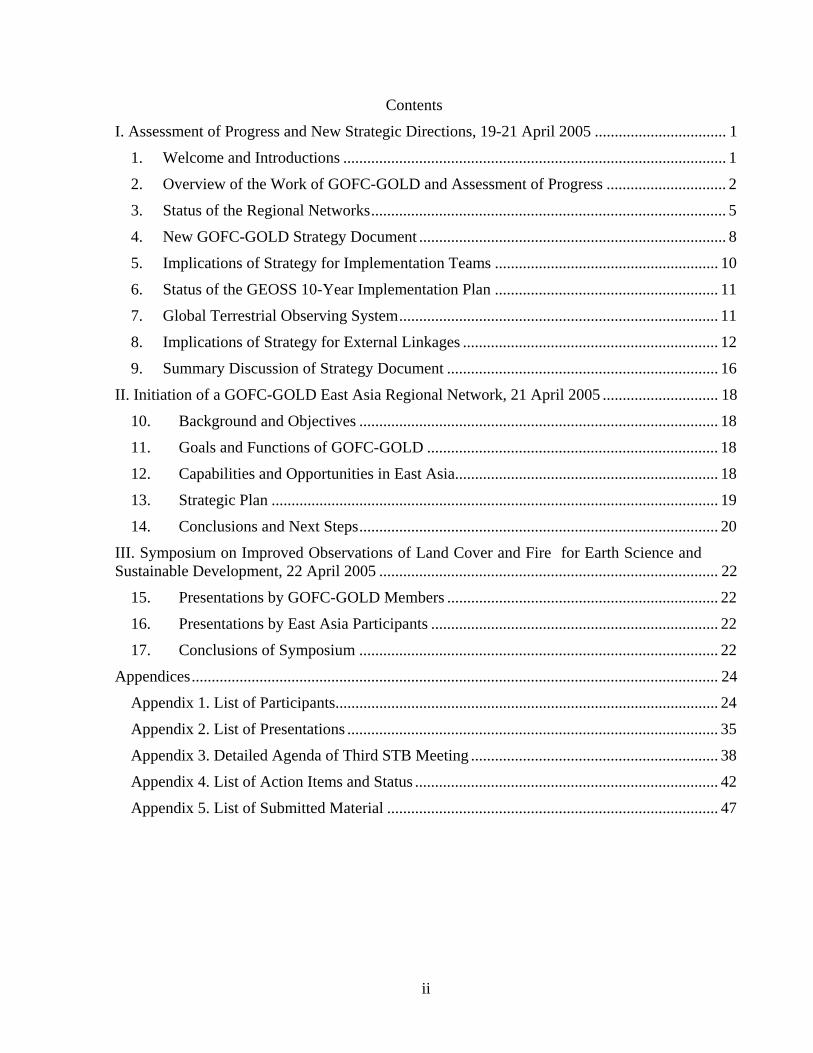
Contents
I. Assessment of Progress and New Strategic Directions, 19-21 April 2005 ................................. 1
1. Welcome and Introductions ................................................................................................ 1
2. Overview of the Work of GOFC-GOLD and Assessment of Progress .............................. 2
3. Status of the Regional Networks......................................................................................... 5
4. New GOFC-GOLD Strategy Document ............................................................................. 8
5. Implications of Strategy for Implementation Teams ........................................................ 10
6. Status of the GEOSS 10-Year Implementation Plan ........................................................ 11
7. Global Terrestrial Observing System................................................................................ 11
8. Implications of Strategy for External Linkages ................................................................ 12
9. Summary Discussion of Strategy Document .................................................................... 16
II. Initiation of a GOFC-GOLD East Asia Regional Network, 21 April 2005 ............................. 18
10. Background and Objectives .......................................................................................... 18
11. Goals and Functions of GOFC-GOLD ......................................................................... 18
12. Capabilities and Opportunities in East Asia.................................................................. 18
13. Strategic Plan ................................................................................................................ 19
14. Conclusions and Next Steps.......................................................................................... 20
III. Symposium on Improved Observations of Land Cover and Fire for Earth Science and Sustainable Development, 22 April 2005 ..................................................................................... 22
15. Presentations by GOFC-GOLD Members .................................................................... 22
16. Presentations by East Asia Participants ........................................................................ 22
17. Conclusions of Symposium .......................................................................................... 22
Appendices.................................................................................................................................... 24
Appendix 1. List of Participants................................................................................................ 24
Appendix 2. List of Presentations ............................................................................................. 35
Appendix 3. Detailed Agenda of Third STB Meeting .............................................................. 38
Appendix 4. List of Action Items and Status ............................................................................ 42
Appendix 5. List of Submitted Material ................................................................................... 47
1
Report of the 3rd Meeting of the GOFC-GOLD Scientific and Technical Board The third meeting of the Scientific and Technical Board (STB) of the panel for Global Observation of Forest and Land Cover Dynamics (GOFC-GOLD) included three separate, but related events. The first was a 2-day STB meeting to assess the progress and new strategic directions of the GOFC-GOLD panel. This involved an examination of the soundness of existing strategy, progress made to date in implementation, the relation of GOFC-GOLD to other international activities, status of Implementation Teams and the status of Regional Networks. The second was a 1-day meeting during which the STB participants were joined by representatives from the East Asia region to consider the possibilities of establishing a GOFC-GOLD regional network in East Asia. The third event was a 1-day joint GOFC-GOLD - China symposium on improved observations of land cover and fire for earth science and sustainable development.
I. Assessment of Progress and New Strategic Directions, 19-21 April 2005
1. Welcome and Introductions The meeting was opened by John Townshend (Chair, GOFC-GOLD) and Shao Liqin (MOST). Each of the participants introduced themselves (listed in Appendix 1).
John Townshend reviewed the background of the STB, which included the following:
− GOFC was first proposed as a prototype of an Integrated Global Observing System, CEOS-ST, Irvine Feb 1997
− A workshop on user requirements and capabilities was held at Ottawa in June 1997
− The design phase comprised six meetings in 1998 to create first set of strategy documents
− Plenary meetings of GOFC during the 1st STB at Ottawa in June 2000
− The 2nd STB was held at Frascati in April 2001
− An extended Executive Committee meeting was held at Ispra in March 2003
− The 3rd STB held at Beijing in April 2005
The primary goal of the 3rd STB is to revisit the strategy of GOFC-GOLD and its implementation.
Further details are in the overview of the objectives of the 3rd STB (Presentation 1). A complete list of presentations is in Appendix 2.
John Townshend reviewed the agenda of the 2-day meeting and also referred to the subsequent and associated meetings on 21st April for the initiation of a GOFC-GOLD East Asia Regional Network, and on 22nd April for a symposium on Improved Observations of Land Cover and Fire for Earth Science and Sustainable Development. Following a brief discussion, the agenda contained in Appendix 3 was approved. It was also agreed that the meeting would identify action items during discussions and that these would form the basis for follow-up activities to the meeting. Actions are identified throughout the report and listed by responsible groups in Appendix 4.
2
2. Overview of the Work of GOFC-GOLD and Assessment of Progress Michael Brady explained the organization of GOFC-GOLD (Presentation 2). John Townshend presented an overview of the work of GOFC-GOLD and an assessment of progress (Presentation 3). The latter presentation addressed the following seven topics:
Overall objectives and operation of GOFC-GOLD
John Townshend reviewed the rationale for establishing GOFC-GOLD and its original objectives. He explained the unique role played by GOFC-GOLD in international coordination. He emphasized that the focus has shifted towards developing operational capabilities. This presents major challenges since there have been relatively few national or international operational organizations responsible for terrestrial observations (cf. oceans and atmosphere). Some encouraging signs, however, include:
− meteorological agencies are beginning to extend remit to the land (e.g. NOAA and Eumetsat);
− following 2nd Adequacy Report COP of FCCC is requesting an operational plan from GCOS and this includes terrestrial observations;
− proposals exist for an international coordination mechanism laying down standards for observations;
− VIIRS on NPOESS will serve as an operational moderate resolution land imager; and
− proposed new Integrated Global Observations Strategy Partnership Theme on the Land (Integrated Global Observations of the Land).
Land and forest cover achievements
The work of the Land Cover Implementation Team was summarized (based on report provided by Co-chairs: Christiane Schmullius and David Skole), including sample data products, work with regional networks, and work plans. Of note, the near future priorities of the team are to:
− encourage consistency, continuity, adequacy, and accessibility of land cover observations;
− establish international standards and specifications for the production of land-cover characterization maps and their accuracy assessment;
− complete procedures for validation of land cover classification;
− refine procedures for validation of continuous fields products;
− cooperate with ongoing international mapping initiatives (e.g. GLOBCOVER);
− further engage in capacity building and regional partnerships and networks (link to GLCN); and
− implement land cover interoperability case studies to make best use of existing resources.
3
Expectations of the Land Cover Implementation Team from the STB include:
− advice to further specify objectives and priorities;
− develop responses to GCOS IP and GEOSS IP;
− develop action plans for: land observations (satellite, in situ) and product development, harmonization/validation standards and initiatives, integration with users, partners, and national programs, and information delivery and systems; and
− secure STB commitment for: funding and resources (operational funding for implementation, observation continuity, land product development, harmonization and validation initiative, regional networks capacity building), and adoption of GOFC-GOLD standards.
Fire monitoring and mapping achievements
The work of the Fire Implementation Team was summarized (based on report provided by Co-chairs: Johan Goldammer and Chris Justice), including goals, users, information types and product examples. Of note, the near future priorities of the team include:
− promoting and enabling advances in fire observations and information services;
− improving communication between data providers and users – leading to products designed to meet user needs;
− refining requirements and articulating needs;
− sharing code and methods, and working to meet common objectives;
− building the regional networks of fire practitioners;
− developing standards for fire products and reporting;
− building a strong lobby for operational provision of high quality fire data;
− provision of products of known accuracy;
− establish infrastructure for operational data flows; and
− building the framework for international cooperation for integrated global fire monitoring.
Examples of needed fire projects to be discussed at the STB meeting include:
− expand active fire monitoring networks to provide global coverage with <24-hour turnaround time – multiple satellite and ground station sources;
− produce 1 km resolution regional and global area burned products, with moderate resolution sensors, such as ATSR, VGT and MODIS with known accuracy;
− develop a network of fire validation sites with standard data collection protocols and reporting – providing accuracy assessment of fire products;
− develop community (producers and users) demonstration projects for selected regions, e.g. integration of enhanced multi-source satellite data and GIS, satellite and modeled

4
annual emissions, and end to end fire monitoring system; and
− prepare regional case studies of operational use of satellite fire data for: fire management, emissions estimation and smoke trace gas monitoring, and the role of fire in the carbon budget.
Progress in achieving goals
John Townshend presented a template for GOFC-GOLD to operationalize land cover and fire products according to nine development stages. The stages were used in progress charts that were shown, which were prepared in 2003 to track development of various land and fire products.
ACTION: Implementation Teams to update progress charts.
Status of space and in situ observations
John Townshend summarized where we are now in relation to remote sensing observations. He used a schedule of transition for moderate polar orbiting satellites to illustrate the following concerns about earth observation continuity:
− large numbers of missions in orbit, but many have no continuity planned;
− many have poor data policies and weak distribution; and
− overall cooperation to use satellites is weak compared with weather satellites.
Data continuity poses a large challenge for the new GEOSS.
Regarding the status of in situ observations, it remains taxing to provide an overall assessment. There are clear signs from the GCOS Implementation Plan that many terrestrial data sets are becoming less available. There are burgeoning ecological networks, however ILTER seems slow to develop. Flux towers have expanded in number and sophistication in recent years. There have been recent attempts by GTOS to make data more accessible, but this is largely at the directory or catalog level.
Overall, the terrestrial community still has reluctance to share hard-won in situ data. Coordination efforts such as that at the LCIT office should make validation data more available.
The Integrated Global Observations of the Land (IGOL) activity
John Townshend explained that the Integrated Global Observation Strategy Partnership (IGOS-P) organizes itself around broad themes; Carbon, Oceans, Water Cycle, Coastal, etc. The World Summit on Sustainable Development pointed to the need to "Promote the development and wider use of earth observation technologies, including satellite remote sensing, global mapping and geographic information systems, to collect quality data on environmental impacts, land use and land -use changes.” GOFC-GOLD was encouraged to propose a Land Theme: Integrated Global Observations of the Land (IGOL). Subsequently, the IGOL Theme was adopted formally at IGOS-P 11 in Rome, May 27, 2004. A team was formed from interested partners and internationally recognized experts and held the 1st IGOL Team Meeting from 13-15 September 2004 at FAO. The meeting defined the scope of the
5
IGOL theme and built consensus among team members on theme topics. They also agreed on work organization and timelines.
Under the IGOL theme, the main types of measurements needed include: land cover, land use, (e.g., tenure, rotation, fertilizers, management etc.), population distribution, soils, topography, plus many others from other themes e.g., carbon, water, etc. The initial list of priorities to be promoted by IGOL was presented. It was noted that many of the cross cutting issues to be addressed also relate to the goals and activities of GOFC-GOLD.
Global Earth Observing System of Systems (GEOSS)
John Townshend provided the following comments on the need for GEO and GEOSS:
− CEOS has limits as it is largely informal, is comprised of best efforts and does not include in situ measurements;
− IGOS-P has been successful in building consensus about requirements, but has been slow to develop consensus and weak in terms of implementation; and
− GXOS is a set of under-funded activities - only GOOS is genuinely strong within its own host organization.
The experiences of GOFC-GOLD suggest that the challenges for GEO and GEOSS will include:
− a coherent governance structure;
− a continuing process and not just one-off;
− keep the attention of ministers at least periodically;
− deficiencies of current observational capabilities must be clearly stated; and
− a funding mechanism to ensure remote sensing and in situ observations are collected in the developing world.
He observed that GEOSS and IGOS-P have a great deal of overlap and that GEOSS will likely survive. The themes of IGOS-P may play a major role within GEOSS. However, they will need to be somewhat realigned with the Societal Benefit Areas. IGOL serves more than one societal benefit area. He pointed out the uncertainty of what happens when implementation of IGOL starts. It is not clear who becomes responsible for international coordination within the framework of GEOSS - parts of GTOS, or perhaps an expanded GOFC-GOLD?
ACTION: Project Office to distribute web link for GEOSS 10-year plan and reference document to STB participants. (http://earthobservations.org )
3. Status of the Regional Networks Representatives from the following GOFC-GOLD regional networks made presentations consisting of an overview, goals and progress, recent activities, future plans and priorities, constraints and inter network interactions:
NERIN, Olga Krankina presented an update of the land cover and fire activities of the Northern Eurasia Regional Information Network (Presentation 4). In particular, plans were

6
described for the proposed Northern Eurasia Land Cover Dynamics Analysis (NELDA) project.
Recent network activities include the workshop on observational data in support of NEESPI held at St. Petersburg in February 2004, and the regional fire workshop held at Moscow in November 2004.
SEARRIN, Mastura Sharifah presented an update of the land cover and fire warning activities of the Southeast Asia Regional Research and Information Network (Presentation 5). In particular, plans were described for a Southeast Asia – Southern Africa GOFC-GOLD fire network training initiative.
SEARRIN has established a new network trust fund, which should provide ongoing support for the local project office. Also, as a pilot activity this year, GOFC-GOLD provided SEARRIN and SAFNET with limited funds to support network coordination and development activities. If successful, the pilot will be expanded to other networks.
Recent network activities include the Southeast Asia burnt area mapping workshop held at Bangi, Malaysia in May 2004, and the assessment of impacts of the December 2004 Tsunami in Aceh, Indonesia prepared in January 2005.
Miombo, Paul Desanker presented an update of the land cover activities of the Miombo Network: Southern Africa GOFC-GOLD (Presentation 6). The Miombo network is also involved in a working group under the Clean Development Mechanism (CDM). The network sees a role for GOFC-GOLD to strengthen the reforestation/afforestation component of the CDM.
Recent network activities include the publication of research on Miombo soil carbon in May 2004, and completion of the Zambezi basin mapping in 2004 for the MEA.
SAFNET, Opha Pauline Dube presented an update of the activities of the Southern Africa Fire Network, which is a collaborative effort for developing capacity for operational fire monitoring and management Systems in Southern Africa (Presentation 7). SAFNET faces challenges of addressing both GOFC-GOLD issues, as well as to be locally relevant.
Recent network activities in 2004 include the 5th fire and land cover science meeting held at Mangochi, Malawi, and the GFMC training course for SADC government officers.
OSFAC, Didier Devers presented an update of the activities of Observation par satellite des forêts d’Afrique Centrale (OSFAC) – GOFC-GOLD Central Africa Network (Presentation 8). The network faces an urgent need to acquire data for the region.
Recent network activities include the OSFAC website launch in February 2004 at Kinshasa, DRC. The website provides access to regional data holdings and a web GIS mapper tool.
NEESPI Program, Jiaguo Qi presented the results of the International Conference on Land Cover and Land Use Change Processes in North East Asia Region, Harbin, Feb. 2 – 5, 2005 (Presentation 9). The Northern Eurasian Earth Science Partnership Initiative (NEESPI) is linked to NERIN and will also likely have links to the newly established GOFC-GOLD East Asia Network discussed in Section II below.
A summary of the needs and constraints presented by each network indicates that while the networks have some unique needs, there are several areas of common interest among all of
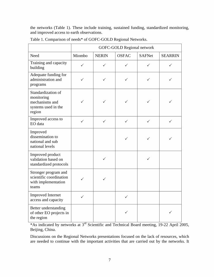
7
the networks (Table 1). These include training, sustained funding, standardized monitoring, and improved access to earth observations.
Table 1. Comparison of needs* of GOFC-GOLD Regional Networks.
GOFC-GOLD Regional network
Need Miombo NERIN OSFAC SAFNet SEARRIN
Training and capacity building
Adequate funding for administration and programs
Standardization of monitoring mechanisms and systems used in the region
Improved access to EO data
Improved dissemination to national and sub national levels
Improved product validation based on standardized protocols
Stronger program and scientific coordination with implementation teams
Improved Internet access and capacity
Better understanding of other EO projects in the region
*As indicated by networks at 3rd Scientific and Technical Board meeting, 19-22 April 2005, Beijing, China.
Discussions on the Regional Networks presentations focused on the lack of resources, which are needed to continue with the important activities that are carried out by the networks. It
8
was suggested that agencies such as UNEP, FAO, GCOS and WMO should assist the networks.
ACTION: GOFC-GOLD should assist the networks to contact these agencies.
4. New GOFC-GOLD Strategy Document John Townshend presented an overview of the revised strategy document, which was distributed to participants prior to the meeting (Presentation 10).
The document differs from the first strategy document (GOFC-GOLD report no. 2, 1999) as follows:
− in identifying much more specifically the roles that GOFC-GOLD, as an international coordination organization, should play;
− considers all land cover and not merely forests; and
− references to CEOS are much reduced as GOFC-GOLD is a panel of the Global Terrestrial Observing System.
John Townshend asked the participants to consider the following changes to the strategy:
− realign with GEOSS societal benefits;
− expand our role to correspond more closely with IGOL e.g., Land use, socio-economic variables such as population;
− play a role in GCOS Implementation Plan, but must address who pays; and
− GTOS to have an inter-governmental mechanism, or should we use other developing mechanisms?
The strategy document also includes nine updated functions of GOFC-GOLD, which distinguish its roles from those of the predominantly national bodies that actually collect observations. John Townshend reviewed the functions (Section 7) listed below and identified issues for some that need further discussion during the meeting.
Function 1 - Specifying requirements
Are the GOFC-GOLD functions sufficient and comprehensive enough? Should all product specifications be revisited? We ask for 5 yearly monitoring of land cover – nations need yearly. Should we adopt the “challenges” model – technical continuity and access challenges? Is there a need to specify acquisition strategies for all sampled observations?
Function 2 - Algorithms and data assimilation procedures
Need to evaluate algorithms more and to include consideration of data assimilation.
Function 3 - Ensuring the availability of observations
Should we provide better information on products?
Function 4 - Harmonization and the development of protocols and standardization
9
GOFC-GOLD should either adopt existing procedures or in their absence create new ones, so that there is harmonization between: observations, products; classification schemes; validation; and QA.
Function 5 - Ensuring that products meet requirements (validation and harmonization)
As necessary GOFC-GOLD should also develop internationally agreed standards and protocols especially for validation. Should MODIS phased validation criteria be adopted?
Function 6 - Capacity building
Function 7 - Developing new GOFC-GOLD products and services
The Implementation Teams should consider whether the creation of GOFC-GOLD products and services is necessary for them to achieve their goals and what funding mechanisms are available to support such ventures.
Function 8 - Supporting international assessments
Increase role in international assessments? If so which ones?
Function 9 - Advocacy role
Other changes to the strategy document discussed include:
Advances made by GOFC-GOLD since 1999 suggest that an improved scheme for monitoring progress. John Townshend presented the monitoring format included in the strategy document and to be updated.
The biophysical observations and products described in the original strategy should be left to others to address and is currently being considered as a topic for the newly reorganized Terrestrial Carbon Observation (TCO) Panel of GTOS.
During the discussions it was suggested that GOFC-GOLD should realign with GEOSS in order to have a system that would fulfill national alignment with an obligation to report annually. It was pointed out that GOFC-GOLD should ensure that other organizations are aware of our capabilities, e.g. IPCC. GOFC-GOLD can provide remote sensing products. GOFC-GOLD can provide guidelines on standardized methodology. The implementation teams can formulate these methodologies. There is an immediate need for information and therefore the creation of a library for best practices products. GOFC-GOLD needs a mandate to ensure the capability for producing products and acquiring resources for these activities. Implementation teams should include data assimilation in their activities. GOFC-GOLD should collaborate with CEOS group in validation of products. A workshop in October, 2005 to be held at the University of South Dakota, Brookings, will produce a report on the development of international agreed standards and products especially for validation of Vegetation Continuous Fields, also known as Proportional Cover products.
ACTION: GOFC-GOLD Chair to revise Function section in strategy document.
10
5. Implications of Strategy for Implementation Teams Two break-out groups discussed and made recommendations for the strategy document on the following topics:
Land cover implementation team
David Skole and Martin Herold reviewed the structure and composition of the team and the current status of land cover products (Presentation 11). They summarized the current challenges in land cover mapping and concluded with a review of future priorities as specified in the strategy document.
The break-out group agreed that GOFC-GOLD should provide leadership in demonstrating how an IGOL-GEOSS vision could be implemented through a carefully orchestrated internationally-coordinated observation test bed. A potential GEOSS Demo could develop a few key data products to demonstrate:
− multi-sensor integration and international cooperation;
− multi-resolution sensors;
− integration of space and in-situ measurements;
− derived products to meet key concerns, e.g. carbon, forest management, etc.;
− focus on changes from a standard baseline;
− harmonized and interoperable observations to meet a range of needs by users;
− known accuracy and quality; and
− data management and dissemination.
During the discussion concerns were raised that there is need to have internationally standardized classifications for land cover products. It was pointed out that this has commenced with the FAO LCCS.
ACTION: Land Cover IT to prepare a demonstration project that links GOFC-GOLD to GEOSS.
Fire monitoring and mapping implementation team
Chris Justice reviewed the aims of the team (Presentation 12). He then reviewed each of the nine goals the team had established, provided examples of associated products, and indicated how the goals have been further refined in the revised strategy. He concluded with a review of future priorities as specified in the strategy document.
The break-out group agreed on the following top priorities for GOFC-GOLD Fire:
− advocate international space agency coordination of global high resolution data acquisition and availability;
− obtain meteorological agency support for the global geostationary fire network;
− ensure operational fire monitoring capabilities on NPOESS and METOP providing
11
data continuity (MODIS and Landsat (NPOESS), AVHRR (METOP));
− develop an international collaborative program on global burned area product validation;
− obtain support to run the regional network fire programs and develop capacity building programs on the use of satellite fire data;
− identify research priorities and gaps, e.g., fire affected area, rather than just burned area; and
− establish GOFC-GOLD Fire as a coordination mechanism for securing the necessary fire observations for GEOSS and products in support of the international conventions.
During the discussion concerns were raised that ecosystem degradation is increasing, but information is very limited. There is need to develop a pathway articulating what has been accomplished. High resolution products should be produced to support the environmental conventions. This will require vast resources to get this done properly. There is a workshop planned in less than six months. One of the key issues would be a demo on product acquisition and distribution. There is need to provide an approach that takes into consideration national and also global needs. Recommendations for high resolution products are extremely important.
ACTION: IT to prepare a demo on product acquisition and distribution.
6. Status of the GEOSS 10-Year Implementation Plan Toshio Koike, a member of the GEO Implementation Plan Task Team, presented the current status of the GEOSS 10-Year Implementation Plan (Presentation 13). Of particular interest, for each societal benefit area he reviewed the 2-, 6-, and 10-year targets contained in the Reference Document, which related to forests and forest fires, The targets of importance to GOFC-GOLD were mainly in disasters, and agriculture societal benefit areas.
7. Global Terrestrial Observing System John Latham briefly explained the GTOS mission, organizational structure, an overview of programme and panel activities (GOFC-GOLD, TCO, TOPC); and emerging issues (Presentation 14). He emphasized the important role of GTOS and the environmental conventions. GTOS aims at providing the Parties with data, information, tools and assistance required to monitor and predict the underlying causes of desertification, loss of biodiversity, and changes in climate. To do this, GTOS coordinates the role of the Panels within the international mechanisms on specific thematic issues. For example, GOFC-GOLD seeks to increase operational use of earth-observation data for policy decision making at national, regional and global levels; Several international agreements require reliable land cover and fire information. These include:
− CBD/loss of biodiversity e.g., forest loss and forest fragmentation;
− UNCCD/land degradation e.g., changes in agricultural land cover;
− Ramsar/World Heritage/Intl. Sites e.g., monitoring of protected areas and surrounding landscape; and
− UNFCCC and Kyoto Protocol e.g., forest change on carbon sequestration.
12
8. Implications of Strategy for External Linkages Three break-out groups discussed and presented the following topics:
Group 1 - Regional networks: changing roles and responsibilities, including implications of GOFC-GOLD’s evolving strategy; relations to national priorities
The breakout group on regional networks was co-chaired by Ashbindu Singh and Michael Brady and included all of the network representatives, plus other STB participants. The group discussed a wide range of issues (Presentation 15), including:
− vision of GOFC-GOLD from regions;
− role, function, minimum requirements;
− capacity building strategy;
− links to national priorities and requirements;
− outreach needs; and
− funding strategy and coordination (for all networks).
Key issues and recommended actions from discussions include:
Minimum requirements: There is a need for formalizing the relationship with the GOFC-GOLD STB through an elaboration of minimum requirements for linking a regional network to GOFC-GOLD, and an outline of expectations from the STB to the networks.
ACTION: STB to propose TORs. Elements could include suggestions for regional networks to publish a strategic plan and a work plan as appropriate, and to have a communication plan within regions to member countries and other relevant stakeholders. The STB to assist in formal letters of support for fund-raising and letters of introduction of networks to national and regional entities.
International conventions: The role of regional networks is evolving with more formal roles of GOFC-GOLD in multilateral environmental agreements (the Rio Conventions and others), and by implication, the regional networks are in a unique position to facilitate implementation of GOFC-GOLD at the national and regional level by facilitating development of data and information for member countries to fulfill and respond to the Rio conventions.
ACTION: Alan Belward to explore possibilities for support from GEF for regional activities that address mandates for product degeneration in the GCOS Implementation Plan under the UNFCCC as it relates to GOFC-GOLD.
National Priorities: At the regional level, there is a growing recognition for the need to closely link network activities to national priorities and requirements, including initiatives to cultivate new and improved application of remotely sensed data and products to support management and decision making.
ACTION: Regional networks to introduce themselves to Rio convention National Focal Points and become familiar with national data requirements in fulfilling obligations to the various conventions and other multilateral environmental agreements. Incorporate these into work plans as appropriate.
13
Sustained funding: The need for more secure funding for core activities of the networks was recognized, and there were suggestions for joint proposals amongst all networks to solicit core funding. No immediate targets were identified for such a proposal, but it was felt that this is an area that the STB can assist with given the new expectations of semi-formal links between regional networks with the STB.
ACTION: STB and Regional Network coordinators to further explore this idea with a view to submit proposals as opportunities arise.
Capacity building: There is renewed interest in coordinating activities across regions, as well as cultivating the end-to-end stream of capacity building from product generation to application in decision support.
ACTION: Regional Networks to share information on capacity building initiatives such as training workshops with a view to explore synergies and joint implementation.
Recognizing achievements: Regional networks have played a unique role in GOFC-GOLD. It was suggested that key products and outputs be collated and listed visibly on the GOFC-GOLD website to demonstrate progress made.
ACTION: Regional Networks to submit information on products and outputs to the GOFC-GOLD Project Office for synthesis and publication on the website.
ACTION: Project Office to provide brochures and related GOFC-GOLD documents and materials to regional networks upon request.
Strategy document: The group recommended the following changes to the strategy document related to the regional networks:
− Revise introduction to make role of regional networks clearer/stronger, including some achievements.
− Acknowledge the balance between regional level activities and interactions with nations, with international coordination provided by GOFC-GOLD through activities such as GEOSS, such that activities of the networks are seen to be supportive of nations fulfilling their obligations under international agreements.
− Need to define minimum requirements and expectations for regional networks under GOFC-GOLD and the minimum obligations of GOFC-GOLD to the networks e.g., facilitate role of regional networks to nations, provision of information materials and data.
ACTION: GTOS secretariat to contact GCOS secretariat to ensure contact and exchange of information between the GOFC Regional Networks and the GCOS Regional workshops and subsequent networks.
Group 2 - EO continuity: developing a strategy for fine resolution requirements
The breakout group on EO continuity was jointly chaired by Chris Justice and Garik Gutman, and included members of both implementation teams, plus other STB participants. The group discussed a wide range of issues (Presentation 16), including: current GOFC-GOLD high resolution data needs and steps to secure new systems.
14
Chris Justice described the advances made by Landsat 7 in terms of global data acquisition. GOFC-GOLD recognizes the important contribution and cost of the NASA Global Data Buys (1990/2000) and encourages other agencies to contribute to similar efforts. He also described the large number of high resolution systems in place and planned by the international community in the next decade which could help meet our needs. He proposed that to access alternative operational systems we need a well-crafted statement of our real requirements. He then reviewed the high resolution requirements formulated by GOFC-GOLD five years ago (GOFC-GOLD Report no. 4) for land cover and change. He added preliminary requirements for fire, including burned area validation and post fire assessment.
Garik Gutman described the Landsat data gap study (Presentation 17), which is analyzing potential solutions. Two key findings are that:
− Landsat data cannot be duplicated. Existing and near-term alternate data sources will only reduce the impact of a Landsat data gap.
− Based on preliminary analysis, the following systems are the leading candidates for addressing the minimum requirements:
o global coverage: ResourceSat (India); CBERS (China and Brazil); and
o special coverage: EO-1/ALI; ASTER (Japan); SPOT (France).
The group discussed near term needs for the next 5 years – starting 2005, and concluded that:
− global coverage is needed but unlikely that 1 system provide all the data;
− suggest take advantage of all the available resources to meet the international data needs (IGBP DIS High Resn Project provide an early proof of concept); and
− different GOFC activities (with different data quality needs) could be met by a patchwork of data types and sets.
A suggested approach for fire and land cover agreed by the group included:
− annual multi-date coverage would meet our needs;
− global 5-year cloud-free will satisfy some needs; and
− annual multi-date coverage is essential for some regions and tasks (areas of rapid change), and for some regions the latter is currently being obtained.
The group agreed that the full acquisition potential of current systems (ground stations, central) is not well known.
ACTION: Form an ad hoc working group to prepare a rapid assessment (4 months) study to define:
− real capabilities and potentialities;
− demonstrations of multi-satellite data acquisition and utilization (CEOP for Land);
− what flexibility exists for regional acquisition; and
− acquisition requests for priority regions acquisitions ASAP – so that retrospective studies can be undertaken.
15
The group also addressed Operational Land Imager (OLI) requirements and beyond. Key issues included:
− NASA will place a next-generation Landsat sensor, the Operational Land Imager (OLI), on several satellites of the National Polar-orbiting Operational Environmental Satellite System (NPOESS) series;
− the operational status of NPOESS is a major advance;
− there is a need to carefully evaluate proposed specs for instrument and acquisition and operations concept e.g., OLI needs an Operational Requirements Document with associated identified Environmental Data Records;
− GOFC-GOLD needs to advocate open data policy and free data;
− recognize that OLI will not meet all community needs e.g., higher temporal frequency of coverage e.g. 8 day; and
− GOFC-GOLD also needs to advocate continued multi-satellite acquisition to complement OLI.
ACTION: Working group to characterize the High Resolution System that is ultimately needed (for GEOSS) – where multiple nations can participate. From our technical perspective we would encourage the space agencies to:
− explore well calibrated small-sat constellations;
− explore sensor web technology; and
− pursue the provision of information from high resolution SAR (X,C,L Band).
Group 3 - The role(s) of GOFC-GOLD in relation to the international conventions and treaties: implications for alignment with GEOSS
Alan Belward chaired the break out group. With support from John Latham of GTOS, he explained the interactions between multilateral environmental agreements and the role of GOFC-GOLD (Presentation 18). He also provided details of the Implementation Plan of the Global Observing System for Climate in support of the UNFCCC (GCOS IP), including the actions relevant to GOFC-GOLD land cover and fire (Presentation 19).
Alan Belward explained that acting as an international agent for action, GOFC-GOLD could:
− undertake coordination and planning for systematic land cover and fire related climate observations, as identified in the GCOS/GEOSS Implementation Plans;
− produce plans for the Parties contributions to the global observing system for climate; and
− report to the Parties concerning progress, and provide guidance on additional actions they need to take to address any identified problems.
By accepting ownership of those parts of the GCOS IP dealing with land cover and fire GOFC-GOLD becomes a key player in the realisation of the UNFCCC and provides concrete support to realising selected GEOSS goals.
16
ACTION: Implementation teams to prepare a status report on relevant actions in GCOS IP (Land cover: T22, T23, T26, T27; Fire: T32, T33, T34, T35). Report will be included in GTOS report to upcoming SBSTA 22 and COP 11. These plans will include resource implications where relevant.
ACTION: The strategy document should be revised to reflect the mandate to implement the actions specified in the GCOS IP.
9. Summary Discussion of Strategy Document John Townshend concluded the two-day meeting with the following summary of discussions regarding the completion of the strategy document and key activities for the implementation teams and regional networks.
The way forward - strategy document
There is a need to revise the strategy plan taking account of the multiple suggestions from the meeting. Detailed comments are still very much needed and some restructuring of report is required.
ACTION: STB Chair to revise the document as follows:
− add section on achievements including those of the networks;
− clearer statement of who we are carrying out our activities for especially with respect to international agreements;
− remove this material from section 7;
− identify specific responsibilities of GOFC-GOLD for international agreements with regards to land cover and fire; and
− describe changes in future operations because of specific obligations e.g., role of offices of GOFC-GOLD - extra costs involved must be clearly stated.
The way forward - implementation teams and regional networks
There is a need for the teams to revise their specific sections on the basis of the break-out discussions.
ACTION: Project Office should cross walk the components of the strategic plan to the IT plans to ensure that all are being covered.
There is a need to specify terms of reference for the regional networks (their responsibilities) and the obligations of GOFC-GOLD including ITs to the networks, and reflect this better in the strategy document.
ACTION: Executive Committee to establish a small ad hoc working group to formulate terms of reference and develop plans to improve linkages.
ACTION: Executive Committee to prepare formal TORs for GOFC-GOLD and those of the Implementation Teams.
ACTION: Project Office to improve outreach materials. e.g., uniform set of viewgraphs for us all to use and updated brochures.
17
ACTION: Land cover IT to hold a follow up workshop on end to end concept in regards to GEOSS.
Other matters
Regarding the continuity issue, there is a need for swift action to develop a fine resolution EO sensing strategy. From this, there is a need to extract specific actions with respect to agencies e.g., NOAA, Eumetsat, etc.
Regarding future STB meetings, the format and frequency of meetings needs to be reconsidered. Practical issues include how long before the next STB and where should it be held? The changed strategy may have significant resource issues for GOFC-GOLD, which will need to be addressed.
John Townshend concluded the discussions with the observation that GOFC-GOLD is changing fundamentally from a purely best efforts organization to one with obligations and formal expectations. The panel needs to be very aware of the changing international structures in terms of observations and adapt to take best advantage of these in fulfilling our goals.
18
II. Initiation of a GOFC-GOLD East Asia Regional Network, 21 April 2005 10. Background and Objectives The meeting was opened by the co-Chairs David Skole and Congbin Fu. A short welcoming address was provided by Zhang Guocheng, NRSCC. Participants introduced themselves (List in Appendix 1).
David Skole explained that the objective of the workshop was to consider the possibilities of establishing a regional network in East Asia. Specifically, the aim of the one day scoping workshop was to assess interest in creating a network in the region that can:
− support GOFC-GOLD strategic plans,
− catalyze on-going work in the region,
− provide increased visibility and cross-national cohesion and cooperation, and
− provide direct benefits to the region.
The workshop approach was to: a) identify current activities in the region, b) gain a broad perspective of current capabilities and future plans, c) ascertain interest and identify how GOFC-GOLD might mutually benefit and reinforce aims and objectives of regional activities and GOFC-GOLD, d) solicit broad input from the region, and e) develop an initial plan for growing and establishing a network.
The expected outcomes of the workshop included a brief assessment needs and potentials, and a plan for establishing the network in the form of a brief workshop report, consisting of:
− action plan for further development;
− participants vision for the region; and
− key regional priorities.
11. Goals and Functions of GOFC-GOLD John Townshend provided a brief overview of the goals and functions of GOFC-GOLD (Presentation 20).
David Skole and Chris Justice explained that a key role of the Regional Networks in GOFC-GOLD is to provide the interface between the program and national level data users and needs (Presentation 21). The Regional Networks have developed to highlight regional priorities and requirements for operational observations and establish improved communication between data users, data providers and researchers. More specifically, they reviewed the nine functions of the GOFC-GOLD. A new and increasingly important function of the networks is to provide a mechanism to implement regional responses to the observation and data product needs of the environmental Conventions in the framework of GOFC-GOLD, GTOS and GCOS.
David Skole and Sharifah Mastura described the SEARRIN network in Southeast Asia to illustrate the structure and activities of the regional networks (Presentation 5 [from Day-1]).
12. Capabilities and Opportunities in East Asia East Asia country presentations were made on the capabilities and opportunities for global and regional observations of forest and land cover dynamics.
19
Shao Liqin of the Ministry of Science and Technology, China reported on “Capabilities and Opportunities for Observations of Forest and Land Cover in China (Presentation 22). He concluded that China is willing to participate and support the East Asia Regional Network.
Liu Rui of the Remote Sensing and GIS Center, Beijing Normal University reported on his Center’s activities (Presentation 23). He suggested that the needs and activities of the new network should address: land cover change; global change; forest monitoring & assessment; habitat degradation; forest change detection; early warning system; and spectrum database.
Cao Chunxiang of the Institute of Remote Sensing Applications (IRSA), China reported on “Remote Sensing Applications in Landuse / Landcover” (Presentation 24). She described her Institute’s vision of: data sharing; landcover and landuse standards; service platform sharing; education and training; and international cooperation. The IRSA is willing to participate in and support the East Asia network with research and technology.
Congbin Fu of the START Regional Center for Temperate East Asia, Chinese Academy of Sciences, reported on START and its network activities in Temperate East Asia related to GOFC-GOLD (Presentation 25). The Monsoon Asia Integrated Regional Study (MAIRS) is a new initiative of START. MAIRS will be a very active user of EO products from GOFC-GOLD, especially Land cover/land use datasets. START has a well built regional network in East Asia for global change research and could provide service for international coordination of GOFC-GOLD in Temperate East Asia, particularly with the land portion of the observing system of MAIRS.
Joon Kim of Yonsei University, South Korea reported on the Korea Fluxnet ‘KoFlux’ Contribution to GOFC-GOLD (Presentation 26).
Renchin Tsolmon of the Remote Sensing Laboratory Research Center for Geophysics, National University of Mongolia reported on “Environmental Issues in Mongolia: Remote Sensing and GIS Applications” (Presentation 27).
Jiaguo Qi of Michigan State University reported on “An International Effort on LCLUC Processes in the North East Asia Region: Potential Contribution to the GOFC-GOLD and E. Asia Regional Science” (Presentation 28).
Sergey Bartalev of the Space Research Institute, Russian Academy of Sciences reported on “Russia Land Cover Mapping and Fire Monitoring in Northern Eurasia” (Presentation 29).
Vladimir Gershenzon of ScanEx Research and Development Centre, Russia, reported on “ScanEx’ technological possibilities for GOFC-GOLD initiatives” (Presentation 30).
13. Strategic Plan Among the East Asia participants from China, South Korea, North Korea, Mongolia and Russia there was consensus to form an East Asia Regional Network. Participants from Japan were not present at the discussion, and their support is pending.
David Skole proposed a preliminary strategy for an East Asian Regional Network consisting of three stages:
1. initial scoping workshop (this meeting);
2. regional workshop: science/organizational plan/identify core high level activities and projects that are common in the region; and
20
3. funding strategy and implementation.
During an open discussion the participants formulated a general strategy consisting of:
− Evaluate the need for a GOFC-GOLD Regional Network in East Asia and articulate the potential benefits of forming the network at the outset.
− Build on what has gone before and what is currently in place (minimize duplication). This involves identifying current and previous regional and national observations-oriented initiatives and programs relevant to GOFC-GOLD.
− Identify the goals for the network:
o identify major observation gaps and current priorities and identify possible goals;
o identify desired major players and develop a plan for engaging them; and
o consider an appropriate structure for meeting network regional goals.
Specific elements and plans
Points of contact for next meeting of the East Asia Regional Network:
− China-Shao Liqin
− Mongolia-Renchin Tsolmon
− S Korea-Joon Kim
− Japan-not identified
− GOFC-GOLD Executive Committee-David Skole
− Land Cover Implementation Team-Martin Herold
− Fire Implementation Team-Ivan Csiszar
− GOFC-GOLD Project Office-Michael Brady
ACTION: Project Office to assist points of contact to develop roster of institutional points of contact and list of potential people to be involved.
ACTION: Project Office to ensure East Asia network participation in proposed GOFC-GOLD regional network workshop to be held in 2006.
ACTION: GOFC-GOLD chair send a letter to MOST – China informing them of the success of the meeting and suggest that MOST in collaboration with GOFC-GOLD should hold an East Asia Regional Network workshop.
14. Conclusions and Next Steps
David Skole presented the following conclusions for the first meeting of the East Asia Regional Network:
− Significant capabilities exist within the region.
− There are opportunities for advanced work with existing EO assets, e.g., MODIS. Also,
21
new assets present special opportunities, e.g. CBERS.
− Many active research areas were identified during the meeting presentations including:
o land cover mapping: forests and pasture;
o land cover condition and state: fractional cover, biomass;
o agriculture and land management;
o modeling: climate and carbon; and
o in-situ observations are strong: flux towers, ground data.
− Needs were identified for cooperation and collaboration in areas such as: capacity building; data sharing; and development of regional approaches and data standards.
22
III. Symposium on Improved Observations of Land Cover and Fire for Earth Science and Sustainable Development, 22 April 2005
The symposium was co-Chaired by Shi Peijun and John Townshend. Opening remarks included a welcome to the 30 Chinese students attending the symposium.
15. Presentations by GOFC-GOLD Members John Townshend provided an overview of GOFC-GOLD (Presentation 31). He explained that GOFC-GOLD is an international framework for coordination of long-term observations of land cover and fire. The Regional Networks are an integral part of GOFC-GOLD’s work. On Day-3 of the meeting the participants established the basis for a GOFC-GOLD Temperate East Asia Regional Network. The next meeting of the new network is expected within six months.
Chris Justice presented the work of the Fire Monitoring and Mapping Implementation Team (Presentation 32).
David Skole presented the work of the Land Cover Characteristics and Change Implementation Team (Presentation 33).
16. Presentations by East Asia Participants Jiyuan Liu, Institute of Geographical Sciences and Natural Resources Research, Chinese Academy of Sciences presented a “Study on Land-Use/Land-Cover Change and Terrestrial Carbon Cycle in China by Space-borne and Ground Based Observations” (Presentation 34).
Zengyuan Li of the Research Institute of Forest Resources Information Technique, Chinese Academy of Forestry, Beijing, reported on “Forest Resources Monitoring using Multi-source Remote Sensing Data in China” (Presentation 35).
Shi Peijun of the Institute of Disaster and Public Security, College of Resources Science and Technology, Beijing Normal University, reported on “Land Use/Cover and Ecological Capital Mapping in China” (Presentation 36).
17. Conclusions of Symposium John Townshend concluded the symposium with the following points:
The world’s land cover is changing very quickly, but differentially across the globe. Our knowledge, however, remains weak for many reasons:
− too much data and not enough products;
− data are often collected and not made available;
− need to develop better algorithms;
− need for improved processing;
− need for products to be distributed much more openly, and
− need for products to be made easily useable.
Clearly there is enormous expertise in the region, including: observational capabilities, information technology, and earth systems science and sustainability science. Improved
23
cooperation will be mutually beneficial.
Technology for information processing is changing rapidly. As a result we need to take advantage of these technologies to build a Digital Earth with seamless user access to a variety of products and services, which can be linked to models. These can use web services and take advantage of technologies such as data and computing grids.
We make the most rapid advances when we apply the observation and geospatial information technologies to solve real problems in earth system science and sustainable development.
On behalf of GOFC-GOLD, John Townshend and other members of the Executive Committee presented each of the symposium presenters with a recently published textbook: Land Change Science: Observing, Monitoring and Understanding Trajectories of Change on the Earth’s Surface (Gutman et al. 2004).
The symposium adjourned at 17:30.
Evening-reception hosted by Minister Xu (speech listed in Appendix 5).
24
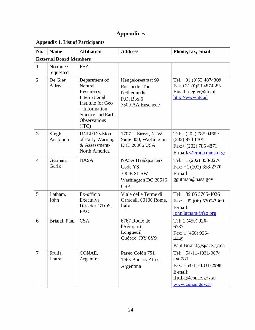
Appendices Appendix 1. List of Participants
No. Name Affiliation Address Phone, fax, email External Board Members 1 Nominee
requested ESA
2 De Gier, Alfred
Department of Natural Resources, International Institute for Geo – Information Science and Earth Observations (ITC)
Hengelosestraat 99 Enschede, The Netherlands P.O. Box 6 7500 AA Enschede
Tel. +31 (0)53 4874309 Fax +31 (0)53 4874388 Email: [email protected] http://www.itc.nl
3 Singh, Ashbindu
UNEP Division of Early Warning & Assessment- North America
1707 H Street, N. W. Suite 300, Washington, D.C. 20006 USA
Tel:+ (202) 785 0465 / (202) 974 1305 Fax:+ (202) 785 4871 [email protected]:
4 Gutman, Garik
NASA NASA Headquarters Code YS 300 E St. SW Washington DC 20546 USA
Tel: +1 (202) 358-0276 Fax: +1 (202) 358-2770 E-mail: [email protected]
5 Latham, John
Ex-officio: Executive Director GTOS, FAO
Viale delle Terme di Caracall, 00100 Rome, Italy
Tel: +39 06 5705-4026 Fax: +39 (06) 5705-3369 E-mail: [email protected]
6 Briand, Paul CSA 6767 Route de l'Aéroport Longueuil, Québec J3Y 8Y9
Tel: 1 (450) 926-6737 Fax: 1 (450) 926-4449 [email protected]
7 Frulla, Laura
CONAE, Argentina
Paseo Colón 751 1063 Buenos Aires Argentina
Tel: +54-11-4331-0074 ext 281 Fax: +54-11-4331-2998 E-mail: [email protected] www.conae.gov.ar
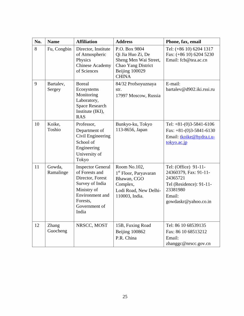
25
No. Name Affiliation Address Phone, fax, email 8 Fu, Congbin Director, Institute
of Atmospheric Physics Chinese Academy of Sciences
P.O. Box 9804 Qi Jia Huo Zi, De Sheng Men Wai Street, Chao Yang District Beijing 100029 CHINA
Tel: (+86 10) 6204 1317 Fax: (+86 10) 6204 5230 Email: [email protected]
9 Bartalev, Sergey
Boreal Ecosystems Monitoring Laboratory, Space Research Institute (IKI), RAS
84/32 Profsoyuznaya str. 17997 Moscow, Russia
E-mail: [email protected]
10 Koike, Toshio
Professor, Department of Civil Engineering School of Engineering University of Tokyo
Bunkyo-ku, Tokyo 113-8656, Japan
Tel: +81-(0)3-5841-6106 Fax: +81-(0)3-5841-6130 Email: [email protected]
11 Gowda, Ramalinge
Inspector General of Forests and Director, Forest Survey of India Ministry of Environment and Forests, Government of India
Room No.102, 1st Floor, Paryavaran Bhawan, CGO Complex, Lodi Road, New Delhi-110003, India.
Tel: (Office) 91-11-24360379, Fax: 91-11-24365721 Tel (Residence): 91-11-23381980 Email: [email protected]
12 Zhang Guocheng
NRSCC, MOST
15B, Fuxing Road Beijing 100862 P.R. China
Tel: 86 10 68539135 Fax: 86 10 68513212 Email: [email protected]
26
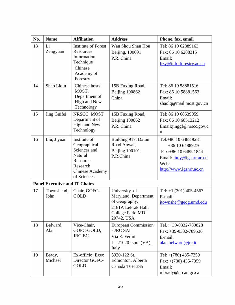
No. Name Affiliation Address Phone, fax, email 13 Li
Zengyuan
Institute of Forest Resources Information Technique Chinese Academy of Forestry
Wan Shou Shan Hou Beijing, 100091 P.R. China
Tel: 86 10 62889163 Fax: 86 10 6288315 Email: [email protected]
14 Shao Liqin Chinese hosts-MOST, Department of High and New Technology
15B Fuxing Road, Beijing 100862 China
Tel: 86 10 58881516 Fax: 86 10 58881563 Email: [email protected]
15 Jing Guifei NRSCC, MOST Department of High and New Technology
15B Fuxing Road, Beijing 100862 P.R. China
Tel: 86 10 68539059 Fax: 86 10 68513212 Email:[email protected]
16 Liu, Jiyuan
Institute of Geographical Sciences and Natural Resources Research Chinese Academy of Sciences
Building 917, Datun Road Anwai, Beijing 100101 P.R.China
Tel:+86 10 6488 9281 +86 10 64889276 Fax:+86 10 6485 1844 Email: [email protected] Web: http://www.igsnrr.ac.cn
Panel Executive and IT Chairs 17 Townshend,
John Chair, GOFC-GOLD
University of Maryland, Department of Geography, 2181A LeFrak Hall, College Park, MD 20742, USA
Tel: +1 (301) 405-4567 E-mail: [email protected]
18 Belward, Alan
Vice-Chair, GOFC-GOLD, JRC-EC
European Commission - JRC SAI Via E. Fermi I – 21020 Ispra (VA), Italy
Tel. :+39-0332-789828 Fax: +39-0332-789536 E-mail: [email protected]
19 Brady, Michael
Ex-officio: Exec Director GOFC-GOLD
5320-122 St. Edmonton, Alberta Canada T6H 3S5
Tel: +(780) 435-7259 Fax: +(780) 435-7359 Email: [email protected]
27
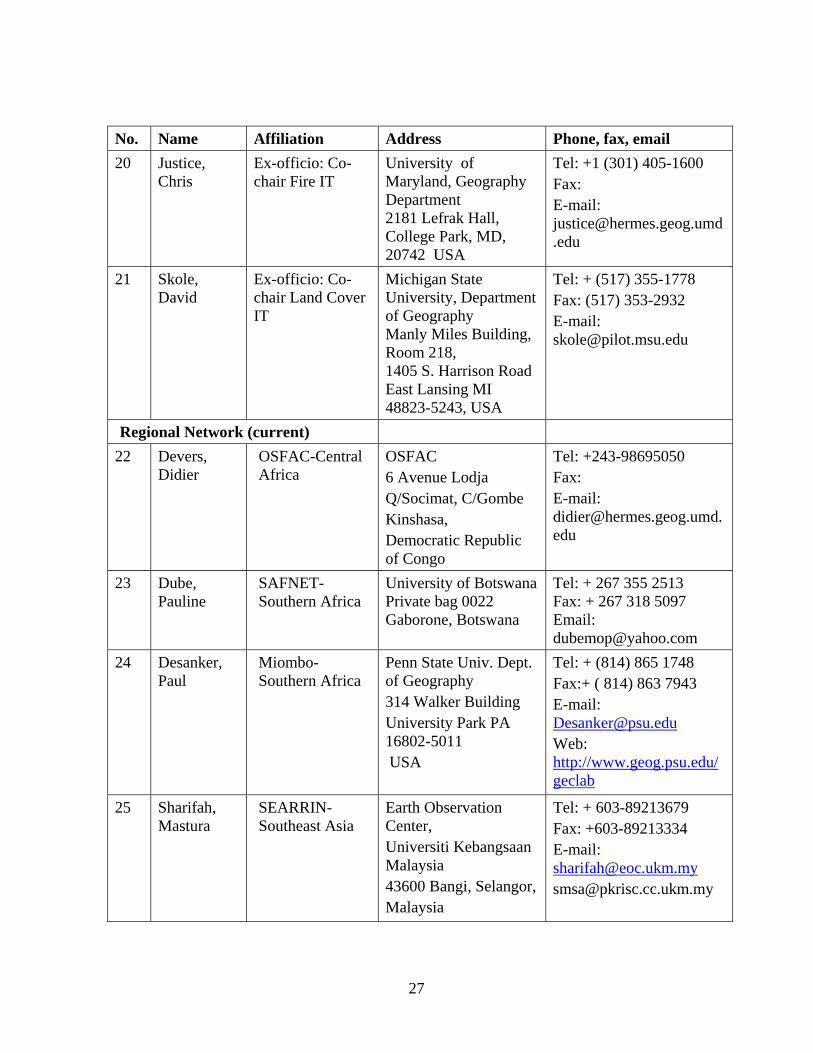
No. Name Affiliation Address Phone, fax, email 20 Justice,
Chris Ex-officio: Co-chair Fire IT
University of Maryland, Geography Department 2181 Lefrak Hall, College Park, MD, 20742 USA
Tel: +1 (301) 405-1600 Fax: E-mail: [email protected]
21 Skole, David
Ex-officio: Co-chair Land Cover IT
Michigan State University, Department of Geography Manly Miles Building, Room 218, 1405 S. Harrison Road East Lansing MI 48823-5243, USA
Tel: + (517) 355-1778 Fax: (517) 353-2932 E-mail: [email protected]
Regional Network (current) 22 Devers,
Didier OSFAC-Central Africa
OSFAC 6 Avenue Lodja Q/Socimat, C/Gombe Kinshasa, Democratic Republic of Congo
Tel: +243-98695050 Fax: E-mail: [email protected]
23 Dube, Pauline
SAFNET-Southern Africa
University of BotswanaPrivate bag 0022 Gaborone, Botswana
Tel: + 267 355 2513 Fax: + 267 318 5097 Email: [email protected]
24 Desanker, Paul
Miombo-Southern Africa
Penn State Univ. Dept. of Geography 314 Walker Building University Park PA 16802-5011 USA
Tel: + (814) 865 1748 Fax:+ ( 814) 863 7943 E-mail: [email protected] Web: http://www.geog.psu.edu/geclab
25 Sharifah, Mastura
SEARRIN-Southeast Asia
Earth Observation Center, Universiti Kebangsaan Malaysia 43600 Bangi, Selangor, Malaysia
Tel: + 603-89213679 Fax: +603-89213334 E-mail: [email protected] [email protected]
28
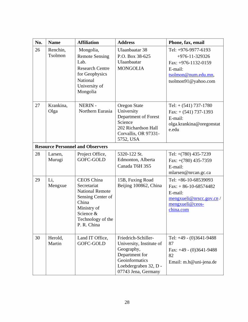
No. Name Affiliation Address Phone, fax, email 26 Renchin,
Tsolmon Mongolia,
Remote Sensing Lab. Research Centre for Geophysics National University of Mongolia
Ulaanbaatar 38 P.O. Box 38-625 Ulaanbaatar MONGOLIA
Tel: +976-9977-6193 +976-11-329326 Fax: +976-1132-0159 E-mail: [email protected], [email protected]
27 Krankina, Olga
NERIN -Northern Eurasia
Oregon State University Department of Forest Science 202 Richardson Hall Corvallis, OR 97331-5752, USA
Tel: + (541) 737-1780 Fax: + (541) 737-1393 E-mail: [email protected]
Resource Personnel and Observers 28 Larsen,
Murugi Project Office, GOFC-GOLD
5320-122 St. Edmonton, Alberta Canada T6H 3S5
Tel: +(780) 435-7239 Fax: +(780) 435-7359 E-mail: [email protected]
29 Li, Mengxue
CEOS China Secretariat National Remote Sensing Center of China Ministry of Science & Technology of the P. R. China
15B, Fuxing Road Beijing 100862, China
Tel: +86-10-68539093 Fax: + 86-10-68574482 E-mail: [email protected] / [email protected]
30 Herold, Martin
Land IT Office, GOFC-GOLD
Friedrich-Schiller-University, Institute of Geography, Department for Geoinformatics Loebdergraben 32, D - 07743 Jena, Germany
Tel: +49 - (0)3641-9488 87 Fax: +49 - (0)3641-9488 82 Email: [email protected]
29
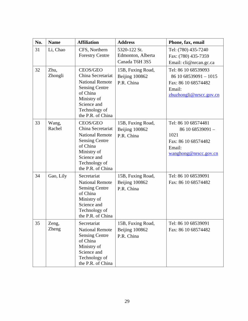
No. Name Affiliation Address Phone, fax, email 31 Li, Chao CFS, Northern
Forestry Centre 5320-122 St. Edmonton, Alberta Canada T6H 3S5
Tel: (780) 435-7240 Fax: (780) 435-7359 Email: [email protected]
32 Zhu, Zhongli
CEOS/GEO China Secretariat National Remote Sensing Centre of China Ministry of Science and Technology of the P.R. of China
15B, Fuxing Road, Beijing 100862 P.R. China
Tel: 86 10 68539093 86 10 68539091 – 1015 Fax: 86 10 68574482 Email: [email protected]
33 Wang, Rachel
CEOS/GEO China Secretariat National Remote Sensing Centre of China Ministry of Science and Technology of the P.R. of China
15B, Fuxing Road, Beijing 100862 P.R. China
Tel: 86 10 68574481 86 10 68539091 – 1021 Fax: 86 10 68574482 Email: [email protected]
34 Gao, Lily Secretariat National Remote Sensing Centre of China Ministry of Science and Technology of the P.R. of China
15B, Fuxing Road, Beijing 100862 P.R. China
Tel: 86 10 68539091 Fax: 86 10 68574482
35 Zeng, Zheng
Secretariat National Remote Sensing Centre of China Ministry of Science and Technology of the P.R. of China
15B, Fuxing Road, Beijing 100862 P.R. China
Tel: 86 10 68539091 Fax: 86 10 68574482
30
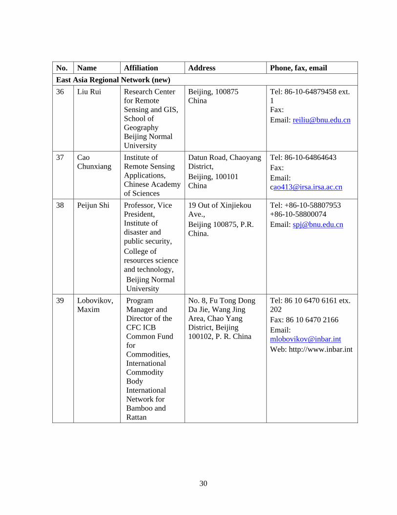
No. Name Affiliation Address Phone, fax, email East Asia Regional Network (new) 36 Liu Rui Research Center
for Remote Sensing and GIS, School of Geography Beijing Normal University
Beijing, 100875 China
Tel: 86-10-64879458 ext. 1 Fax: Email: [email protected]
37 Cao Chunxiang
Institute of Remote Sensing Applications, Chinese Academy of Sciences
Datun Road, Chaoyang District, Beijing, 100101 China
Tel: 86-10-64864643 Fax: Email: [email protected]
38 Peijun Shi Professor, Vice President, Institute of disaster and public security, College of resources science and technology, Beijing Normal University
19 Out of Xinjiekou Ave., Beijing 100875, P.R. China.
Tel: +86-10-58807953 +86-10-58800074 Email: [email protected]
39 Lobovikov, Maxim
Program Manager and Director of the CFC ICB Common Fund for Commodities, International Commodity Body International Network for Bamboo and Rattan
No. 8, Fu Tong Dong Da Jie, Wang Jing Area, Chao Yang District, Beijing 100102, P. R. China
Tel: 86 10 6470 6161 etx. 202 Fax: 86 10 6470 2166 Email: [email protected] Web: http://www.inbar.int
31
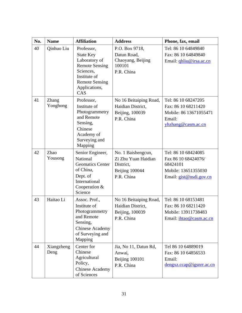
No. Name Affiliation Address Phone, fax, email 40 Qinhuo Liu Professor,
State Key Laboratory of Remote Sensing Sciences, Institute of Remote Sensing Applications, CAS
P.O. Box 9718, Datun Road, Chaoyang, Beijing 100101 P.R. China
Tel: 86 10 64849840 Fax: 86 10 64849840 Email: [email protected]
41 Zhang Yonghong
Professor, Institute of Photogrammetry and Remote Sensing, Chinese Academy of Surveying and Mapping
No 16 Beitaiping Road, Haidian District, Beijing, 100039 P.R. China
Tel: 86 10 68247205 Fax: 86 10 68211420 Mobile: 86 13671055471 Email: [email protected]
42 Zhao Yousong
Senior Engineer, National Geomatics Center of China, Dept. of International Cooperation & Science
No. 1 Baishengcun, Zi Zhu Yuan Haidian District, Beijing 100044 P.R. China
Tel: 86 10 68424085 Fax 86 10 68424076/ 68424101 Mobile: 13651355030 Email: [email protected]
43 Haitao Li Assoc. Prof., Institute of Photogrammetry and Remote Sensing, Chinese Academy of Surveying and Mapping
No 16 Beitaiping Road, Haidian District, Beijing, 100039 P.R. China
Tel: 86 10 68153481 Fax: 86 10 68211420 Mobile: 13911738483 Email: [email protected]
44 Xiangzheng Deng
Center for Chinese Agricultural Policy, Chinese Academy of Sciences
Jia, No 11, Datun Rd, Anwai, Beijing 100101 P.R. China
Tel 86 10 64889019 Fax: 86 10 64856533 Email: [email protected]
32
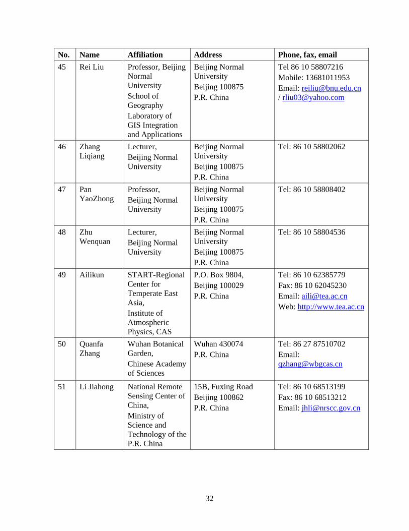
No. Name Affiliation Address Phone, fax, email 45 Rei Liu Professor, Beijing
Normal University School of Geography Laboratory of GIS Integration and Applications
Beijing Normal University Beijing 100875 P.R. China
Tel 86 10 58807216 Mobile: 13681011953 Email: [email protected] / [email protected]
46 Zhang Liqiang
Lecturer, Beijing Normal University
Beijing Normal University Beijing 100875 P.R. China
Tel: 86 10 58802062
47 Pan YaoZhong
Professor, Beijing Normal University
Beijing Normal University Beijing 100875 P.R. China
Tel: 86 10 58808402
48 Zhu Wenquan
Lecturer, Beijing Normal University
Beijing Normal University Beijing 100875 P.R. China
Tel: 86 10 58804536
49 Ailikun START-Regional Center for Temperate East Asia, Institute of Atmospheric Physics, CAS
P.O. Box 9804, Beijing 100029 P.R. China
Tel: 86 10 62385779 Fax: 86 10 62045230 Email: [email protected] Web: http://www.tea.ac.cn
50 Quanfa Zhang
Wuhan Botanical Garden, Chinese Academy of Sciences
Wuhan 430074 P.R. China
Tel: 86 27 87510702 Email: [email protected]
51 Li Jiahong National Remote Sensing Center of China, Ministry of Science and Technology of the P.R. China
15B, Fuxing Road Beijing 100862 P.R. China
Tel: 86 10 68513199 Fax: 86 10 68513212 Email: [email protected]
33
No. Name Affiliation Address Phone, fax, email 52 Xiaohan
Liao Department of High& New Technology and Industrialization Ministry of Science and Technology, China
15B Fuxing Rd., Beijing 100862 P.R. China
Tel: 86 10 58881512 Fax: 86 10 58881563 Email: [email protected]
53 Liu Minliang
Project Coordinator and Assoc. Prof., Chinese Ecosystem Research Network-Synthesis Center, Institute of Geographic Sciences and Natural Resources Research, Chinese Academy of Sciences
Datun Road No. 11, Anwei, Beijing 100101 P.R. China
Tel: 86 10 64889453 Fax: 86 10 64889399 Email: [email protected]
54 Li Jing Director, Dept. of Globe Change and Sustainable Development, Geoinformatics Center, Beijing Normal University
B712, Science and Technology Building, Beijing Normal University, Beijing 100875 P.R. China
Tel/Fax: 86 10 58807163 Email: [email protected] [email protected]
55 Majianwen Institute of Remote Sensing Applications, Chinese Academy of Sciences
Datun Rd., Chaoyang District P.O. Box 9718, Beijing 100101 P.R. China
Tel: 86 10 64850643 Email: [email protected]

34
No. Name Affiliation Address Phone, fax, email 56 Wen Wang Institute of
Remote Sensing Applications, Chinese Academy of Sciences
P.O. Box 9718, Datun Road, Beijing 100101 P.R. China
Tel: 86 10 64870453 Fax: 86 10 64889786 Email: [email protected]
57 Joon Kim Dept. of Atmospheric Sciences, Yonsei University
134 Shinchon-dong, Seodaemun-ku, Seoul 120-749, Korea
Tel: +82-2-2123-2691 Fax: +82-2-312-5691 email: [email protected]
58 Kim Song Chol
Embassy of Democratic Peoples Republic of N. Korea
Beijing, China 86 10 65320328
59 Vladimir Gershenzon
President Research and Development Center ScanEx.
22/5 L’va Tolstogo str..Moscow 119021. Russian Federation
Tel: 095 246-3853 Fax: 095 246-2593 Email: [email protected] Web: www..scanex.ru
60 Jiaguo Qi Department of Geography and Center for Global Change and Earth Observations Michigan State University
1405 S. Harrison Road, Romm 101, East Lansing, MI 48823-5243 USA
Tel. 517-353-8736 Fax. 517-353-2932 Email: [email protected] Web: www.globalchange.msu.edu
61 Shuming Bao
Senior Research Associate, Senior Research Coordinator for China Initiatives, The University of Michigan, International Institute China Data Center,
Suite 3630, 1080 S. University
Ann Arbor, MI 48109-1106 USA
Tel: 734 647-9610 Fax 734 764-5540 Email: [email protected] Web: http://www.umich.edu/~iinet/chinadata
62+ ~25 invitees to the symposium, mainly students
Beijing agencies and universities
35
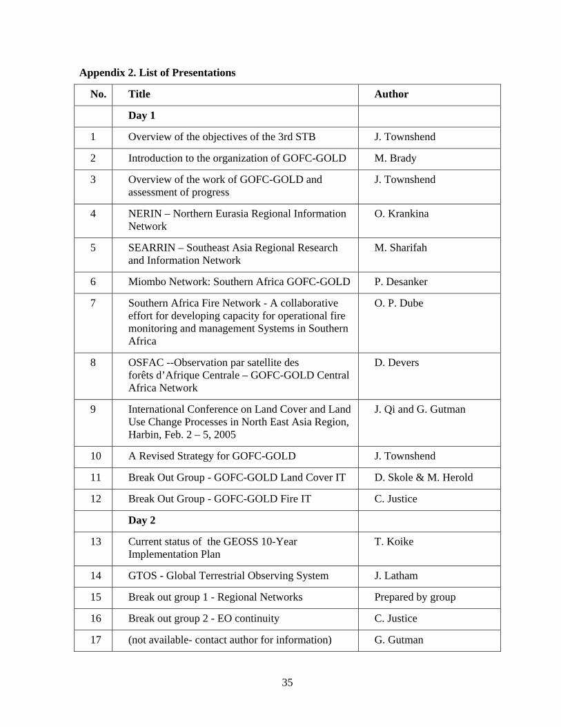
Appendix 2. List of Presentations
No. Title Author
Day 1
1 Overview of the objectives of the 3rd STB J. Townshend
2 Introduction to the organization of GOFC-GOLD M. Brady
3 Overview of the work of GOFC-GOLD and assessment of progress
J. Townshend
4 NERIN – Northern Eurasia Regional Information Network
O. Krankina
5 SEARRIN – Southeast Asia Regional Research and Information Network
M. Sharifah
6 Miombo Network: Southern Africa GOFC-GOLD P. Desanker
7 Southern Africa Fire Network - A collaborative effort for developing capacity for operational fire monitoring and management Systems in Southern Africa
O. P. Dube
8 OSFAC --Observation par satellite des forêts d’Afrique Centrale – GOFC-GOLD Central Africa Network
D. Devers
9 International Conference on Land Cover and Land Use Change Processes in North East Asia Region, Harbin, Feb. 2 – 5, 2005
J. Qi and G. Gutman
10 A Revised Strategy for GOFC-GOLD J. Townshend
11 Break Out Group - GOFC-GOLD Land Cover IT D. Skole & M. Herold
12 Break Out Group - GOFC-GOLD Fire IT C. Justice
Day 2
13 Current status of the GEOSS 10-Year Implementation Plan
T. Koike
14 GTOS - Global Terrestrial Observing System J. Latham
15 Break out group 1 - Regional Networks Prepared by group
16 Break out group 2 - EO continuity C. Justice
17 (not available- contact author for information) G. Gutman
36
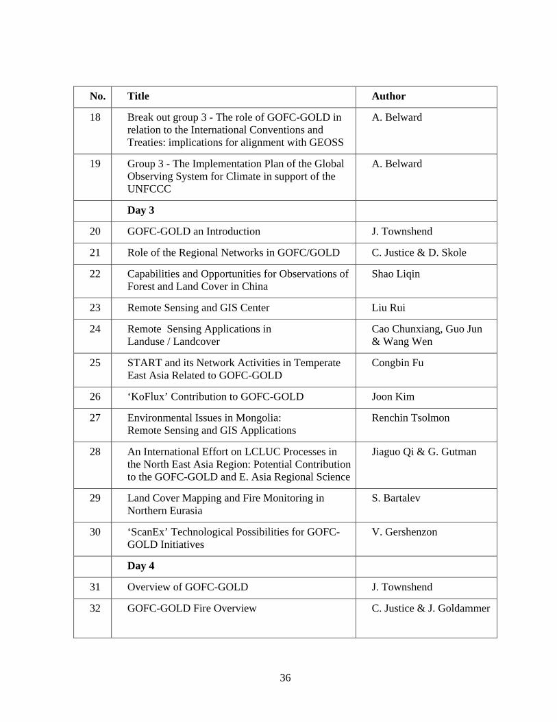
No. Title Author
18 Break out group 3 - The role of GOFC-GOLD in relation to the International Conventions and Treaties: implications for alignment with GEOSS
A. Belward
19 Group 3 - The Implementation Plan of the Global Observing System for Climate in support of the UNFCCC
A. Belward
Day 3
20 GOFC-GOLD an Introduction J. Townshend
21 Role of the Regional Networks in GOFC/GOLD C. Justice & D. Skole
22 Capabilities and Opportunities for Observations of Forest and Land Cover in China
Shao Liqin
23 Remote Sensing and GIS Center Liu Rui
24 Remote Sensing Applications in Landuse / Landcover
Cao Chunxiang, Guo Jun & Wang Wen
25 START and its Network Activities in Temperate East Asia Related to GOFC-GOLD
Congbin Fu
26 ‘KoFlux’ Contribution to GOFC-GOLD Joon Kim
27 Environmental Issues in Mongolia: Remote Sensing and GIS Applications
Renchin Tsolmon
28 An International Effort on LCLUC Processes in the North East Asia Region: Potential Contribution to the GOFC-GOLD and E. Asia Regional Science
Jiaguo Qi & G. Gutman
29 Land Cover Mapping and Fire Monitoring in Northern Eurasia
S. Bartalev
30 ‘ScanEx’ Technological Possibilities for GOFC-GOLD Initiatives
V. Gershenzon
Day 4
31 Overview of GOFC-GOLD J. Townshend
32 GOFC-GOLD Fire Overview
C. Justice & J. Goldammer
37
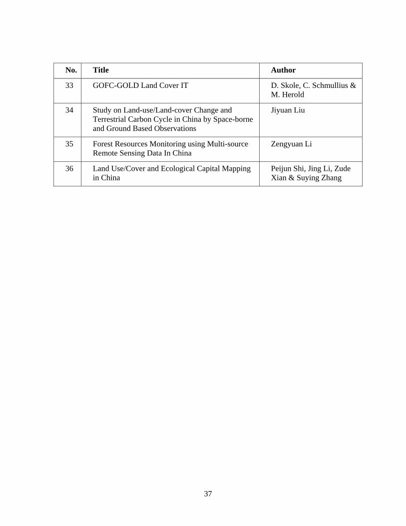
No. Title Author
33 GOFC-GOLD Land Cover IT D. Skole, C. Schmullius & M. Herold
34 Study on Land-use/Land-cover Change and Terrestrial Carbon Cycle in China by Space-borne and Ground Based Observations
Jiyuan Liu
35 Forest Resources Monitoring using Multi-source Remote Sensing Data In China
Zengyuan Li
36 Land Use/Cover and Ecological Capital Mapping in China
Peijun Shi, Jing Li, Zude Xian & Suying Zhang
38
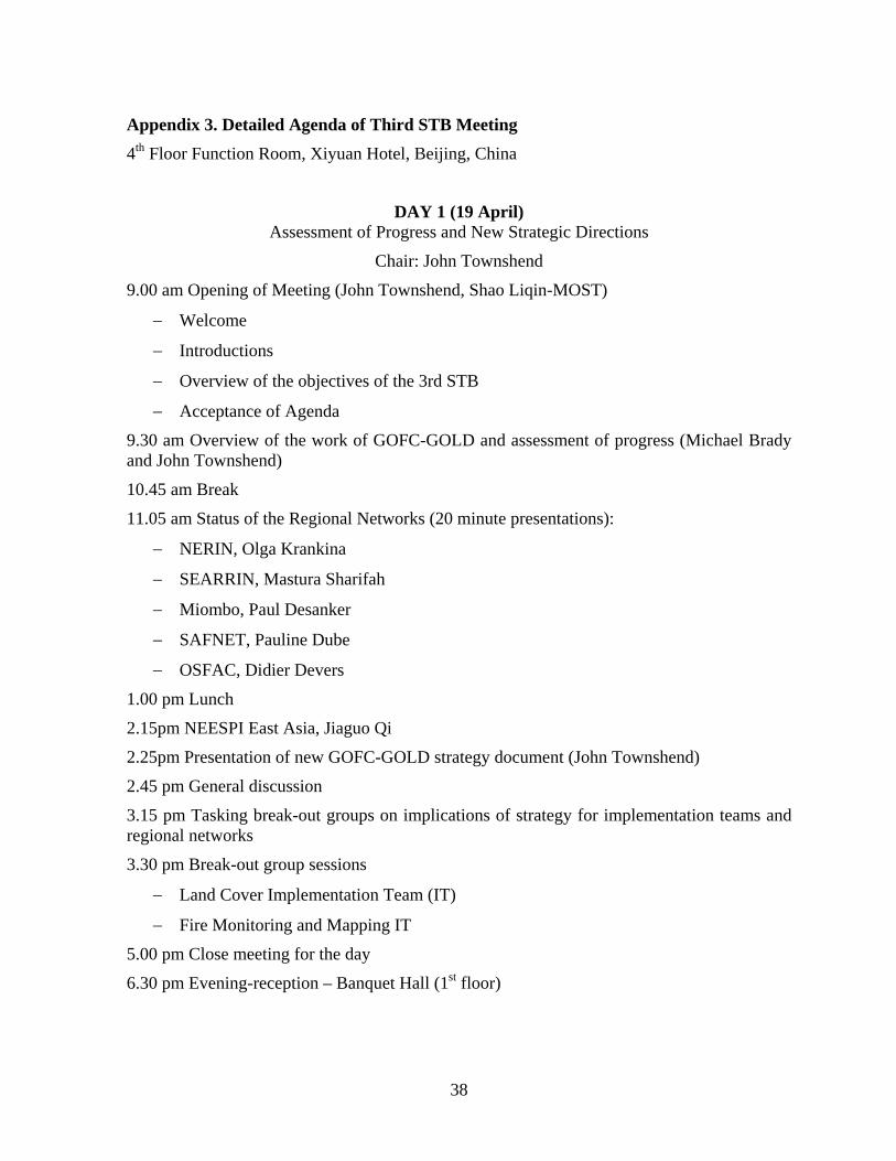
Appendix 3. Detailed Agenda of Third STB Meeting 4th Floor Function Room, Xiyuan Hotel, Beijing, China
DAY 1 (19 April) Assessment of Progress and New Strategic Directions
Chair: John Townshend
9.00 am Opening of Meeting (John Townshend, Shao Liqin-MOST)
− Welcome
− Introductions
− Overview of the objectives of the 3rd STB
− Acceptance of Agenda
9.30 am Overview of the work of GOFC-GOLD and assessment of progress (Michael Brady and John Townshend)
10.45 am Break
11.05 am Status of the Regional Networks (20 minute presentations):
− NERIN, Olga Krankina
− SEARRIN, Mastura Sharifah
− Miombo, Paul Desanker
− SAFNET, Pauline Dube
− OSFAC, Didier Devers
1.00 pm Lunch
2.15pm NEESPI East Asia, Jiaguo Qi
2.25pm Presentation of new GOFC-GOLD strategy document (John Townshend)
2.45 pm General discussion
3.15 pm Tasking break-out groups on implications of strategy for implementation teams and regional networks
3.30 pm Break-out group sessions
− Land Cover Implementation Team (IT)
− Fire Monitoring and Mapping IT
5.00 pm Close meeting for the day
6.30 pm Evening-reception – Banquet Hall (1st floor)
39
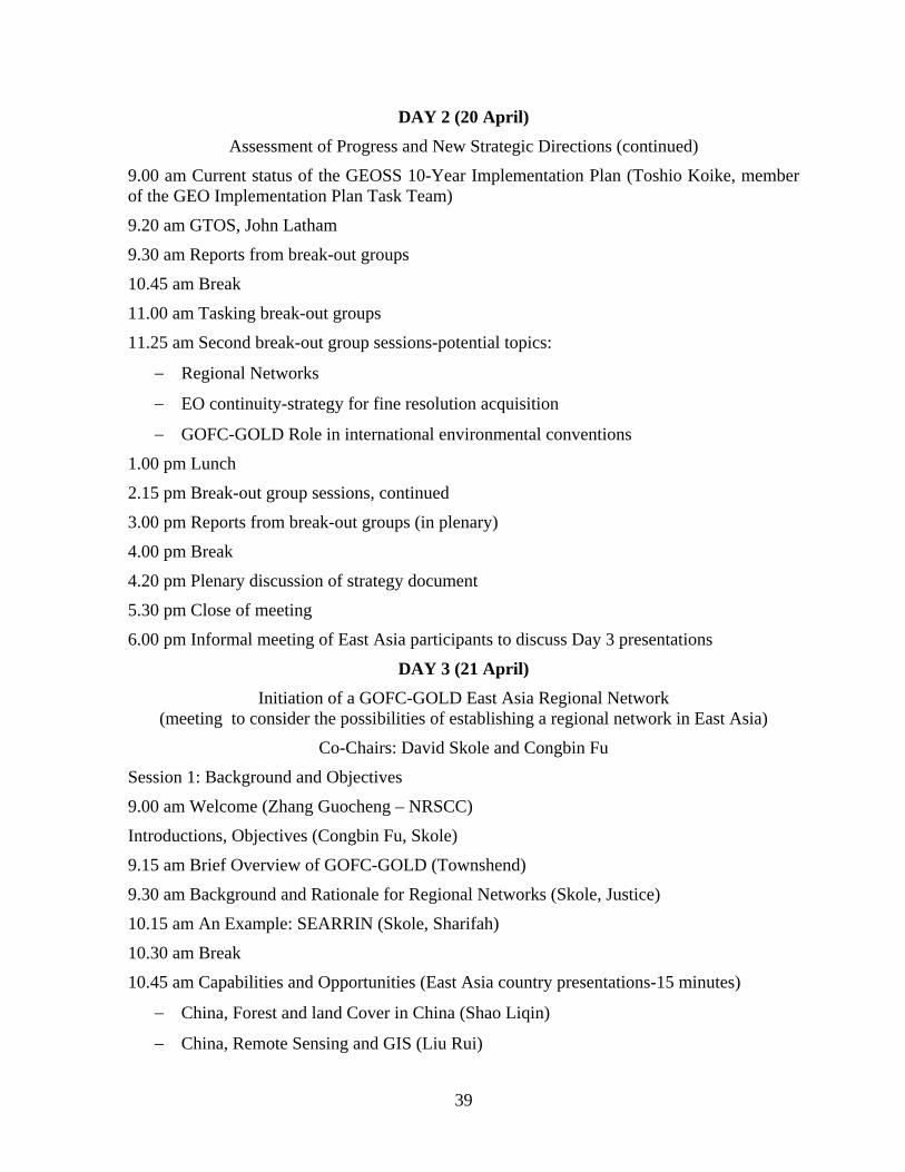
DAY 2 (20 April) Assessment of Progress and New Strategic Directions (continued)
9.00 am Current status of the GEOSS 10-Year Implementation Plan (Toshio Koike, member of the GEO Implementation Plan Task Team)
9.20 am GTOS, John Latham
9.30 am Reports from break-out groups
10.45 am Break
11.00 am Tasking break-out groups
11.25 am Second break-out group sessions-potential topics:
− Regional Networks
− EO continuity-strategy for fine resolution acquisition
− GOFC-GOLD Role in international environmental conventions
1.00 pm Lunch
2.15 pm Break-out group sessions, continued
3.00 pm Reports from break-out groups (in plenary)
4.00 pm Break
4.20 pm Plenary discussion of strategy document
5.30 pm Close of meeting
6.00 pm Informal meeting of East Asia participants to discuss Day 3 presentations
DAY 3 (21 April) Initiation of a GOFC-GOLD East Asia Regional Network
(meeting to consider the possibilities of establishing a regional network in East Asia)
Co-Chairs: David Skole and Congbin Fu
Session 1: Background and Objectives
9.00 am Welcome (Zhang Guocheng – NRSCC)
Introductions, Objectives (Congbin Fu, Skole)
9.15 am Brief Overview of GOFC-GOLD (Townshend)
9.30 am Background and Rationale for Regional Networks (Skole, Justice)
10.15 am An Example: SEARRIN (Skole, Sharifah)
10.30 am Break
10.45 am Capabilities and Opportunities (East Asia country presentations-15 minutes)
− China, Forest and land Cover in China (Shao Liqin)
− China, Remote Sensing and GIS (Liu Rui)
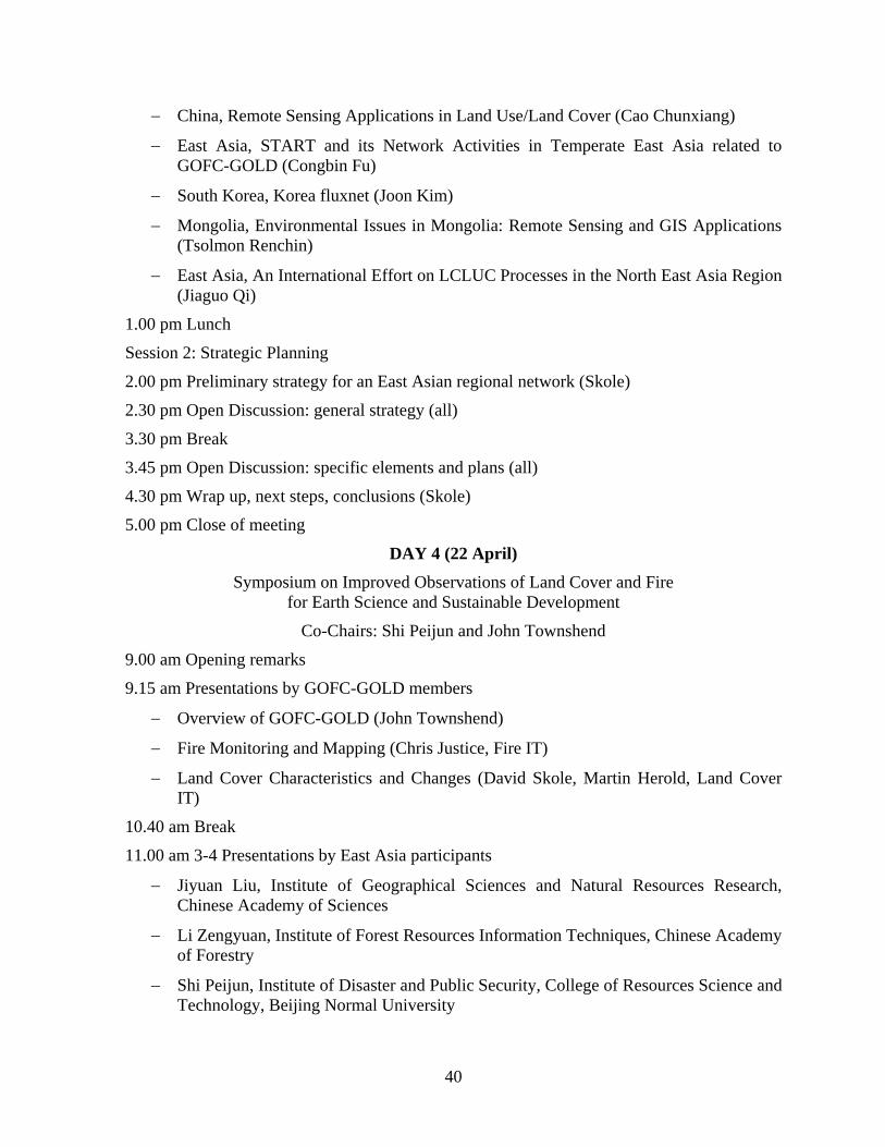
40
− China, Remote Sensing Applications in Land Use/Land Cover (Cao Chunxiang)
− East Asia, START and its Network Activities in Temperate East Asia related to GOFC-GOLD (Congbin Fu)
− South Korea, Korea fluxnet (Joon Kim)
− Mongolia, Environmental Issues in Mongolia: Remote Sensing and GIS Applications (Tsolmon Renchin)
− East Asia, An International Effort on LCLUC Processes in the North East Asia Region (Jiaguo Qi)
1.00 pm Lunch
Session 2: Strategic Planning
2.00 pm Preliminary strategy for an East Asian regional network (Skole)
2.30 pm Open Discussion: general strategy (all)
3.30 pm Break
3.45 pm Open Discussion: specific elements and plans (all)
4.30 pm Wrap up, next steps, conclusions (Skole)
5.00 pm Close of meeting
DAY 4 (22 April) Symposium on Improved Observations of Land Cover and Fire
for Earth Science and Sustainable Development
Co-Chairs: Shi Peijun and John Townshend
9.00 am Opening remarks
9.15 am Presentations by GOFC-GOLD members
− Overview of GOFC-GOLD (John Townshend)
− Fire Monitoring and Mapping (Chris Justice, Fire IT)
− Land Cover Characteristics and Changes (David Skole, Martin Herold, Land Cover IT)
10.40 am Break
11.00 am 3-4 Presentations by East Asia participants
− Jiyuan Liu, Institute of Geographical Sciences and Natural Resources Research, Chinese Academy of Sciences
− Li Zengyuan, Institute of Forest Resources Information Techniques, Chinese Academy of Forestry
− Shi Peijun, Institute of Disaster and Public Security, College of Resources Science and Technology, Beijing Normal University
41
− Shao Liqin, MOST, Department of High and New Technology
12:30 pm Conclusions and close of symposium
1.00 pm Lunch
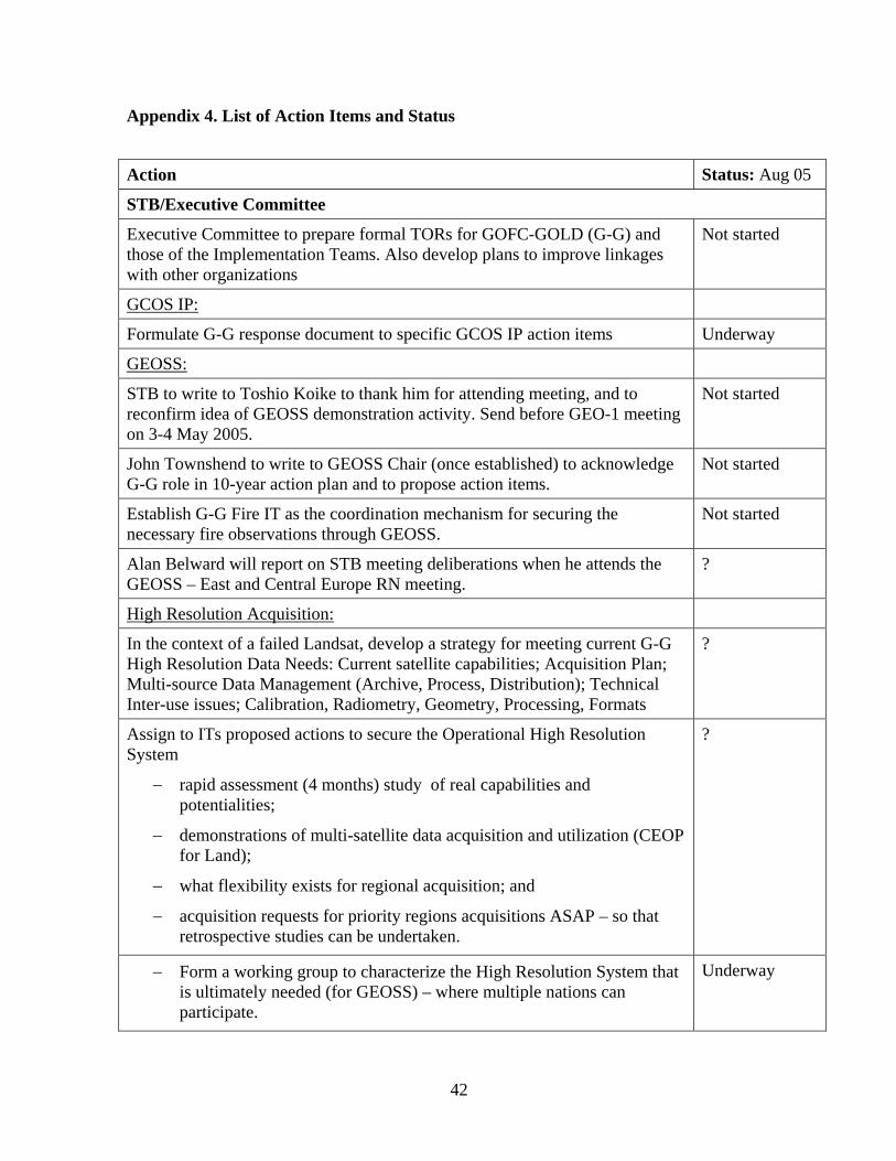
42
Appendix 4. List of Action Items and Status
Action Status: Aug 05
STB/Executive Committee
Executive Committee to prepare formal TORs for GOFC-GOLD (G-G) and those of the Implementation Teams. Also develop plans to improve linkages with other organizations
Not started
GCOS IP:
Formulate G-G response document to specific GCOS IP action items Underway
GEOSS:
STB to write to Toshio Koike to thank him for attending meeting, and to reconfirm idea of GEOSS demonstration activity. Send before GEO-1 meeting on 3-4 May 2005.
Not started
John Townshend to write to GEOSS Chair (once established) to acknowledge G-G role in 10-year action plan and to propose action items.
Not started
Establish G-G Fire IT as the coordination mechanism for securing the necessary fire observations through GEOSS.
Not started
Alan Belward will report on STB meeting deliberations when he attends the GEOSS – East and Central Europe RN meeting.
?
High Resolution Acquisition:
In the context of a failed Landsat, develop a strategy for meeting current G-G High Resolution Data Needs: Current satellite capabilities; Acquisition Plan; Multi-source Data Management (Archive, Process, Distribution); Technical Inter-use issues; Calibration, Radiometry, Geometry, Processing, Formats
?
Assign to ITs proposed actions to secure the Operational High Resolution System
− rapid assessment (4 months) study of real capabilities and potentialities;
− demonstrations of multi-satellite data acquisition and utilization (CEOP for Land);
− what flexibility exists for regional acquisition; and
− acquisition requests for priority regions acquisitions ASAP – so that retrospective studies can be undertaken.
?
− Form a working group to characterize the High Resolution System that is ultimately needed (for GEOSS) – where multiple nations can participate.
Underway
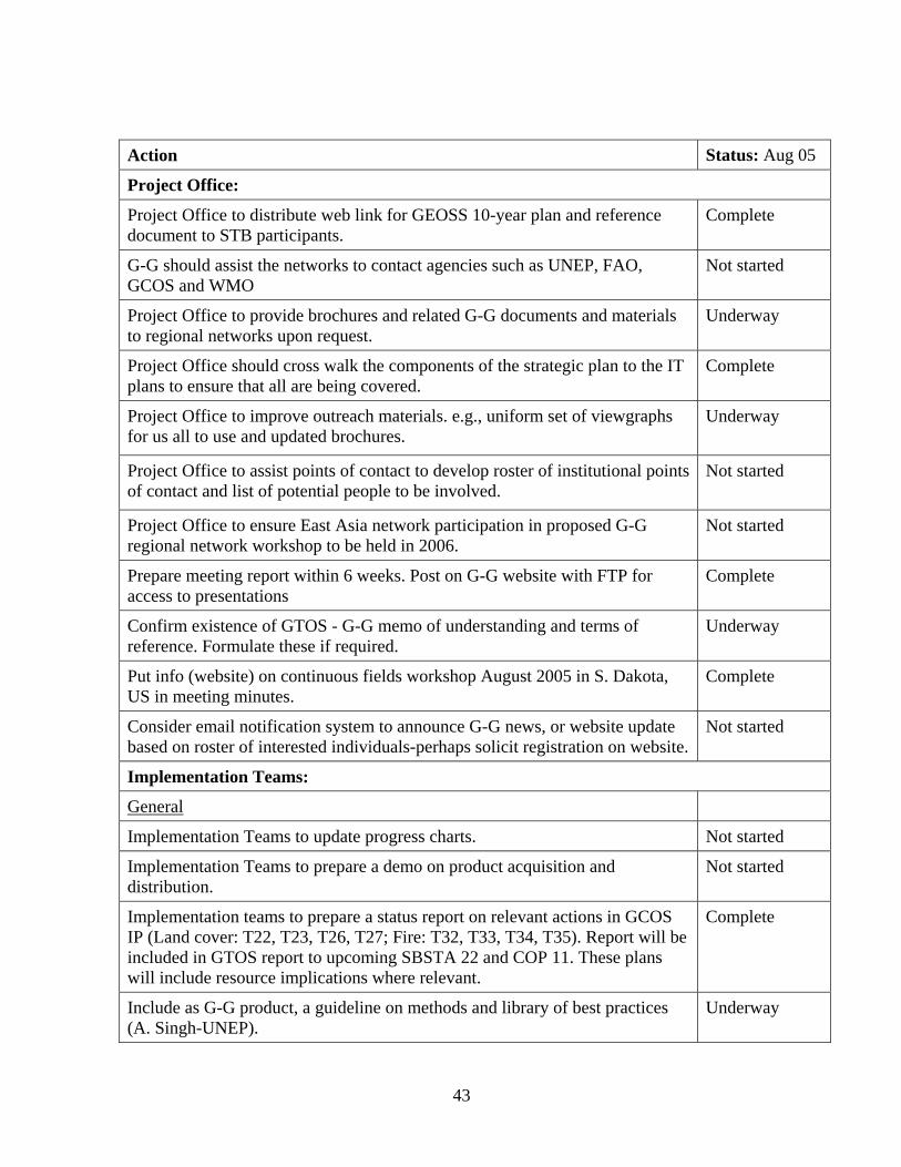
43
Action Status: Aug 05
Project Office:
Project Office to distribute web link for GEOSS 10-year plan and reference document to STB participants.
Complete
G-G should assist the networks to contact agencies such as UNEP, FAO, GCOS and WMO
Not started
Project Office to provide brochures and related G-G documents and materials to regional networks upon request.
Underway
Project Office should cross walk the components of the strategic plan to the IT plans to ensure that all are being covered.
Complete
Project Office to improve outreach materials. e.g., uniform set of viewgraphs for us all to use and updated brochures.
Underway
Project Office to assist points of contact to develop roster of institutional points of contact and list of potential people to be involved.
Not started
Project Office to ensure East Asia network participation in proposed G-G regional network workshop to be held in 2006.
Not started
Prepare meeting report within 6 weeks. Post on G-G website with FTP for access to presentations
Complete
Confirm existence of GTOS - G-G memo of understanding and terms of reference. Formulate these if required.
Underway
Put info (website) on continuous fields workshop August 2005 in S. Dakota, US in meeting minutes.
Complete
Consider email notification system to announce G-G news, or website update based on roster of interested individuals-perhaps solicit registration on website.
Not started
Implementation Teams:
General
Implementation Teams to update progress charts. Not started
Implementation Teams to prepare a demo on product acquisition and distribution.
Not started
Implementation teams to prepare a status report on relevant actions in GCOS IP (Land cover: T22, T23, T26, T27; Fire: T32, T33, T34, T35). Report will be included in GTOS report to upcoming SBSTA 22 and COP 11. These plans will include resource implications where relevant.
Complete
Include as G-G product, a guideline on methods and library of best practices (A. Singh-UNEP).
Underway
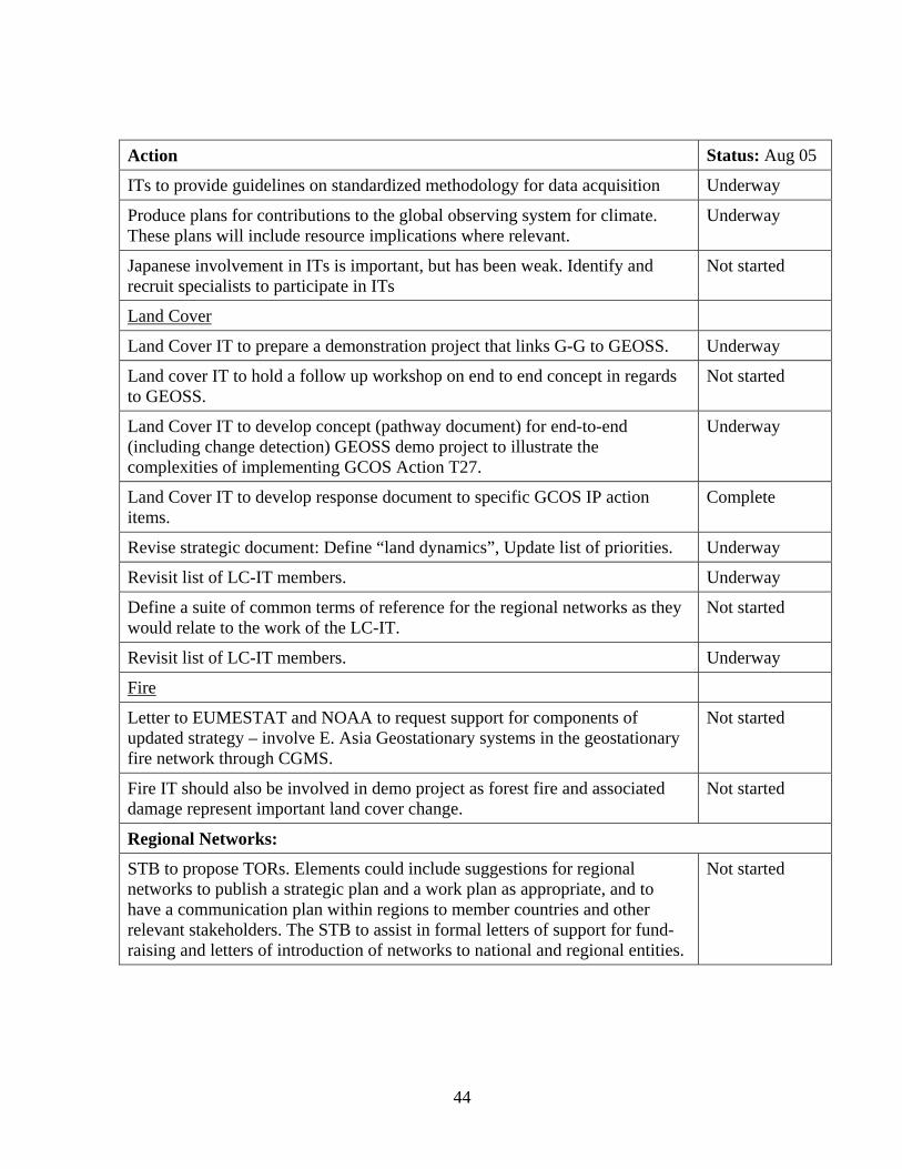
44
Action Status: Aug 05
ITs to provide guidelines on standardized methodology for data acquisition Underway
Produce plans for contributions to the global observing system for climate. These plans will include resource implications where relevant.
Underway
Japanese involvement in ITs is important, but has been weak. Identify and recruit specialists to participate in ITs
Not started
Land Cover
Land Cover IT to prepare a demonstration project that links G-G to GEOSS. Underway
Land cover IT to hold a follow up workshop on end to end concept in regards to GEOSS.
Not started
Land Cover IT to develop concept (pathway document) for end-to-end (including change detection) GEOSS demo project to illustrate the complexities of implementing GCOS Action T27.
Underway
Land Cover IT to develop response document to specific GCOS IP action items.
Complete
Revise strategic document: Define “land dynamics”, Update list of priorities. Underway
Revisit list of LC-IT members. Underway
Define a suite of common terms of reference for the regional networks as they would relate to the work of the LC-IT.
Not started
Revisit list of LC-IT members. Underway
Fire
Letter to EUMESTAT and NOAA to request support for components of updated strategy – involve E. Asia Geostationary systems in the geostationary fire network through CGMS.
Not started
Fire IT should also be involved in demo project as forest fire and associated damage represent important land cover change.
Not started
Regional Networks:
STB to propose TORs. Elements could include suggestions for regional networks to publish a strategic plan and a work plan as appropriate, and to have a communication plan within regions to member countries and other relevant stakeholders. The STB to assist in formal letters of support for fund-raising and letters of introduction of networks to national and regional entities.
Not started
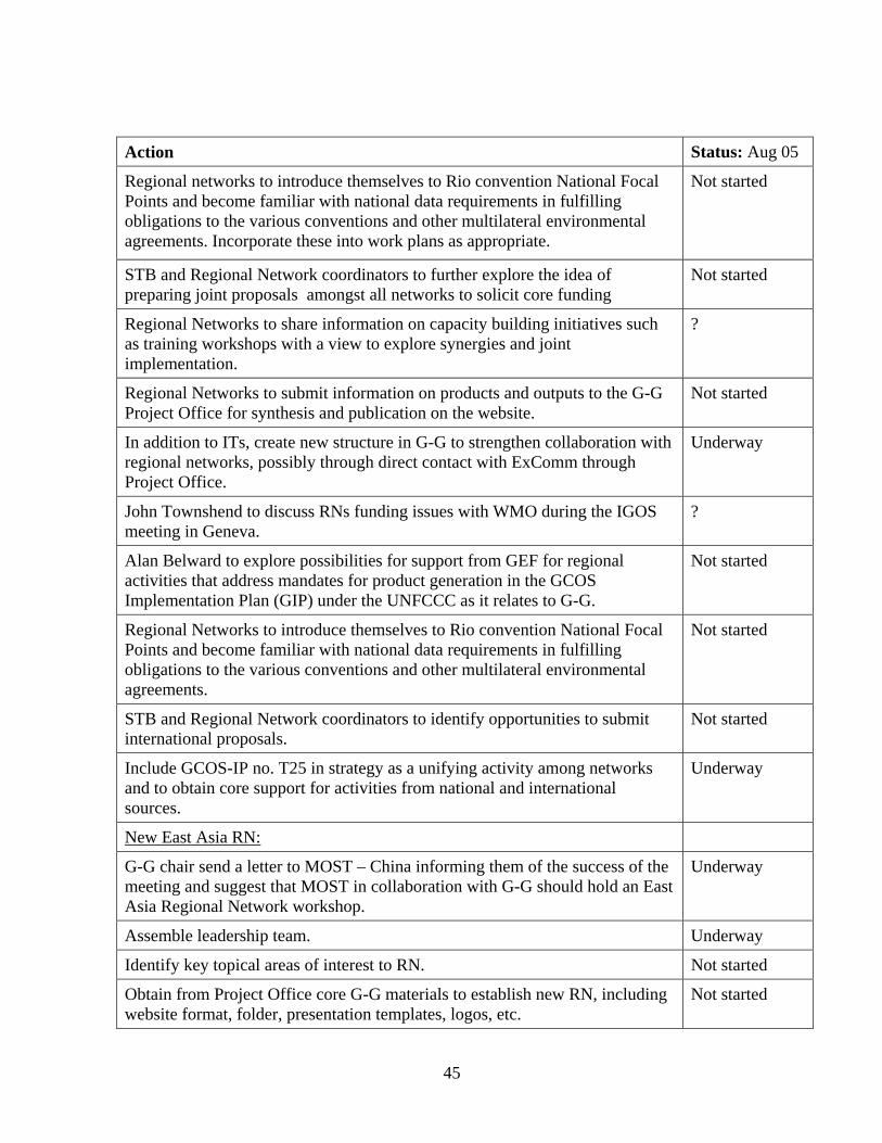
45
Action Status: Aug 05
Regional networks to introduce themselves to Rio convention National Focal Points and become familiar with national data requirements in fulfilling obligations to the various conventions and other multilateral environmental agreements. Incorporate these into work plans as appropriate.
Not started
STB and Regional Network coordinators to further explore the idea of preparing joint proposals amongst all networks to solicit core funding
Not started
Regional Networks to share information on capacity building initiatives such as training workshops with a view to explore synergies and joint implementation.
?
Regional Networks to submit information on products and outputs to the G-G Project Office for synthesis and publication on the website.
Not started
In addition to ITs, create new structure in G-G to strengthen collaboration with regional networks, possibly through direct contact with ExComm through Project Office.
Underway
John Townshend to discuss RNs funding issues with WMO during the IGOS meeting in Geneva.
?
Alan Belward to explore possibilities for support from GEF for regional activities that address mandates for product generation in the GCOS Implementation Plan (GIP) under the UNFCCC as it relates to G-G.
Not started
Regional Networks to introduce themselves to Rio convention National Focal Points and become familiar with national data requirements in fulfilling obligations to the various conventions and other multilateral environmental agreements.
Not started
STB and Regional Network coordinators to identify opportunities to submit international proposals.
Not started
Include GCOS-IP no. T25 in strategy as a unifying activity among networks and to obtain core support for activities from national and international sources.
Underway
New East Asia RN:
G-G chair send a letter to MOST – China informing them of the success of the meeting and suggest that MOST in collaboration with G-G should hold an East Asia Regional Network workshop.
Underway
Assemble leadership team. Underway
Identify key topical areas of interest to RN. Not started
Obtain from Project Office core G-G materials to establish new RN, including website format, folder, presentation templates, logos, etc.
Not started
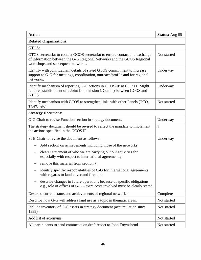
46
Action Status: Aug 05
Related Organizations:
GTOS:
GTOS secretariat to contact GCOS secretariat to ensure contact and exchange of information between the G-G Regional Networks and the GCOS Regional workshops and subsequent networks.
Not started
Identify with John Latham details of stated GTOS commitment to increase support to G-G for meetings, coordination, outreach/profile and for regional networks.
Underway
Identify mechanism of reporting G-G actions in GCOS-IP at COP 11. Might require establishment of a Joint Commission (JComm) between GCOS and GTOS.
Underway
Identify mechanism with GTOS to strengthen links with other Panels (TCO, TOPC, etc).
Not started
Strategy Document:
G-G Chair to revise Function section in strategy document. Underway
The strategy document should be revised to reflect the mandate to implement the actions specified in the GCOS IP.
?
STB Chair to revise the document as follows:
− Add section on achievements including those of the networks;
− clearer statement of who we are carrying out our activities for especially with respect to international agreements;
− remove this material from section 7;
− identify specific responsibilities of G-G for international agreements with regards to land cover and fire; and
− describe changes in future operations because of specific obligations e.g., role of offices of G-G - extra costs involved must be clearly stated.
Underway
Describe current status and achievements of regional networks. Complete
Describe how G-G will address land use as a topic in thematic areas. Not started
Include inventory of G-G assets in strategy document (accumulation since 1999).
Not started
Add list of acronyms. Not started
All participants to send comments on draft report to John Townshend. Not started
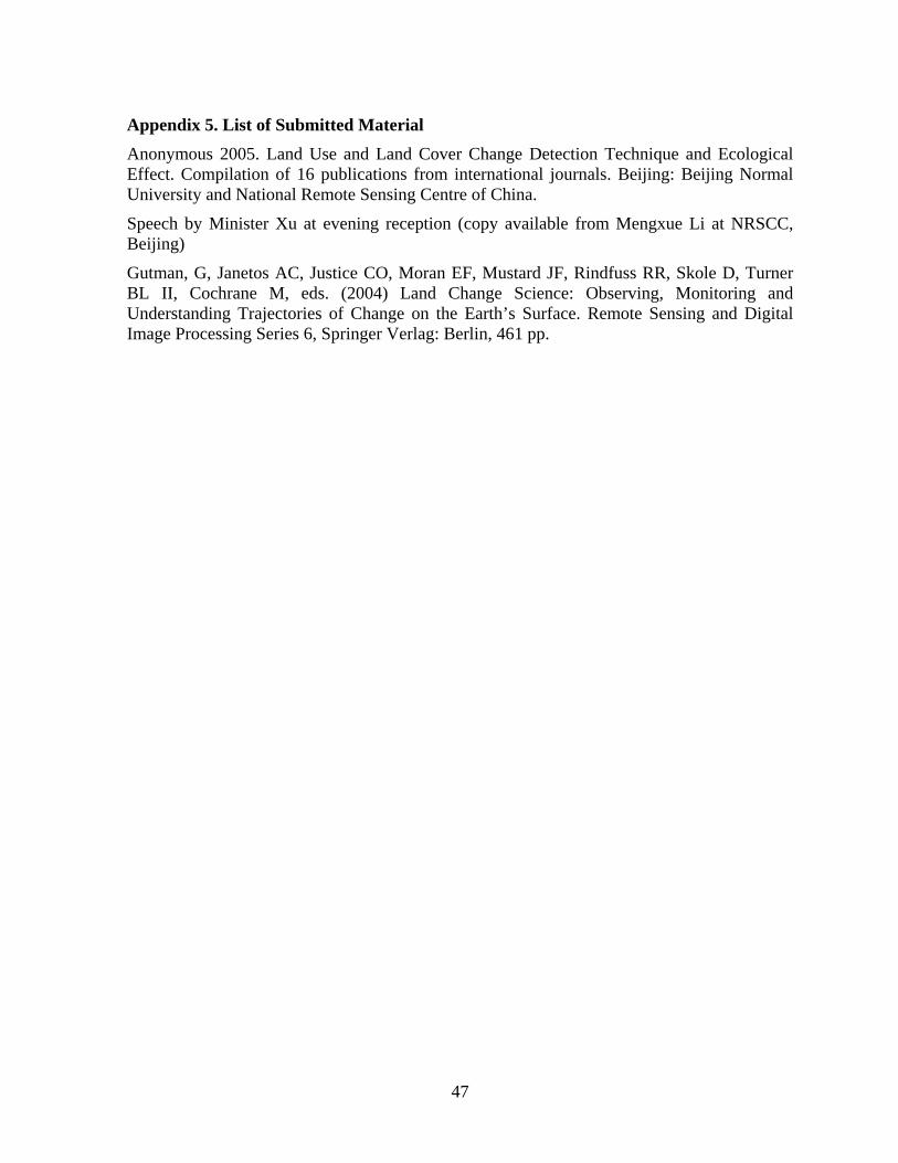
47
Appendix 5. List of Submitted Material Anonymous 2005. Land Use and Land Cover Change Detection Technique and Ecological Effect. Compilation of 16 publications from international journals. Beijing: Beijing Normal University and National Remote Sensing Centre of China.
Speech by Minister Xu at evening reception (copy available from Mengxue Li at NRSCC, Beijing)
Gutman, G, Janetos AC, Justice CO, Moran EF, Mustard JF, Rindfuss RR, Skole D, Turner BL II, Cochrane M, eds. (2004) Land Change Science: Observing, Monitoring and Understanding Trajectories of Change on the Earth’s Surface. Remote Sensing and Digital Image Processing Series 6, Springer Verlag: Berlin, 461 pp.