Embed Size (px)
Citation preview
Document number: 21280-RP-001 Sherpa Consulting Pty Ltd (ABN 40 110 961 898) Revision: 2 Phone: 61 2 9412 4555 Revision Date: 18-Mar-2020 Web: www.sherpaconsulting.com File name: 21280-RP-001-Rev2
REPORT
HAZARDS AND RISK
LOT 9 DP 1205673
28 MCPHERSON STREET, BANKSMEADOW
ORICA AUSTRALIA PTY LTD
PREPARED FOR: Orica Australia Pty Ltd
c/o DBL Property
Jeffrey Lord
DOCUMENT NO: 21280-RP-001
REVISION: 2
DATE: 18-Mar-2020
Document: 21280-RP-001 Revision: 2 Revision Date: 18-Mar-2020 File name: 21280-RP-001-Rev2 Page 2
DOCUMENT REVISION RECORD
Rev Date Description Prepared Checked Approved Method of issue
A 11-Jan-19 Issued to Client for comments O. Alim J. Polich S. Chia Email [PDF]
0 21-Jan-19 Updated with Client comments
O. Alim S. Chia S. Chia Email [PDF]
1 06-Mar-19 Updated to address DPE comments
O. Alim J. Polich G. Peach Email [PDF]
2 18-Mar-19 Updated following NSW DPIE release of 2018 BIP QRA and to reflect final population case
O. Alim J. Polich S. Chia Email [PDF]
RELIANCE NOTICE
This report is issued pursuant to an Agreement between Sherpa Consulting Pty Ltd (‘Sherpa Consulting’) and Orica Australia Pty Ltd which agreement sets forth the entire rights, obligations and liabilities of those parties with respect to the content and use of the report.
Reliance by any other party on the contents of the report shall be at its own risk. Sherpa Consulting makes no warranty or representation, expressed or implied, to any other party with respect to the accuracy, completeness, or usefulness of the information contained in this report and assumes no liabilities with respect to any other party’s use of or damages resulting from such use of any information, conclusions or recommendations disclosed in this report.
Title:
Report
Hazards and Risk
Lot 9 DP 1205673
28 McPherson Street, Banksmeadow
QA verified:
N. Benova
Date: 18-Mar-2020
Document: 21280-RP-001 Revision: 2 Revision Date: 18-Mar-2020 File name: 21280-RP-001-Rev2 Page 3
CONTENTS
ABBREVIATIONS ...................................................................................................................................... 5
1. INTRODUCTION ............................................................................................................................... 6
1.1. Background ................................................................................................................................ 6
1.2. Study objectives......................................................................................................................... 6
1.3. Scope ......................................................................................................................................... 7
1.4. Exclusions and limitations ......................................................................................................... 7
2. SITE DESCRIPTION ......................................................................................................................... 8
3. SEPP 33 RISK SCREENING .......................................................................................................... 11
3.1. Overview .................................................................................................................................. 11
3.2. Risk screening ......................................................................................................................... 11
3.3. Other risk factors ..................................................................................................................... 11
3.4. Conclusions ............................................................................................................................. 12
4. RISK ASSESSMENT ....................................................................................................................... 13
4.1. Overview .................................................................................................................................. 13
4.2. Development in vicinity of potentially hazardous facilities ....................................................... 13
4.3. Assessment - Qualitative risks ................................................................................................ 13
4.4. Assessment – Quantitative risks ............................................................................................. 14
4.5. Assessment of risks from the BIP complex ............................................................................. 15
4.6. Societal Risk ............................................................................................................................ 21
5. BOTANY/RANDWICK AREA LUSS RECOMMENDATIONS ......................................................... 27
APPENDIX A. TFNSW TRAVEL ZONE DATA USED IN 2018 BIP QRA
APPENDIX B. REFERENCES
Document: 21280-RP-001 Revision: 2 Revision Date: 18-Mar-2020 File name: 21280-RP-001-Rev2 Page 4
TABLES
Table 4.1: Assessment – HIPAP 10 qualitative risk criteria .................................................... 13
Table 4.2: Applicable HIPAP 10 criteria ................................................................................. 14
Table 4.3: Assessment of risks from the BIP (all criteria) ....................................................... 16
Table 4.4: Population definition ............................................................................................. 21
Table 4.5: SRI estimate ......................................................................................................... 26
Table 5.1: Botany/Randwick industrial area LUSS recommendations.................................... 27
FIGURES
Figure 2.1: Site aerial view ...................................................................................................... 9
Figure 2.2: Site plan .............................................................................................................. 10
Figure 4.1: Individual fatality risk contours ............................................................................. 18
Figure 4.2: Damage and propagation risk contours – Heat radiation (23 kW/m2) ................... 19
Figure 4.3: Damage and propagation risk contours – Explosion overpressure (14 kPa) ........ 20
Figure 4.4: Comparison against BIP QRA 2018 ‘Current Development’ ................................ 23
Figure 4.5: Comparison against BIP QRA 2018 ‘Approved Development’ ............................. 23
Figure 4.6: Incremental societal risk profile – Proposed development ................................... 24
Document: 21280-RP-001 Revision: 2 Revision Date: 18-Mar-2020 File name: 21280-RP-001-Rev2 Page 5
ABBREVIATIONS
ADGC Australian Dangerous Goods Code
ALARP As Low As Reasonably Practicable
BIP Botany Industrial Park
DA Development Application
DG Dangerous Goods
DOP (NSW) Department of Planning (now DPIE)
DP Deposited Plan
DPE (NSW) Department of Planning and Environment (now DPIE)
DPIE (NSW) Department of Planning, Industry and Environment
DUAP (NSW) Department of Urban Affairs and Planning (now DPIE)
EIS Environmental Impact Statement
ha Hectare
HIPAP Hazardous Industry Planning Advisory Paper
HSE (UK) Health and Safety Executive
LGA Local Government Area
LUSS Land Use Safety Study
OH&S Occupational Health & Safety
PHA Preliminary Hazard Analysis
SDS Safety Data Sheet
SEARs Secretary’s Environmental Assessment Requirements
SEPP State Environmental Planning Policy
SRD State and Regional Development
SRI Scaled Risk Integral
SSD State Significant Development
Document: 21280-RP-001 Revision: 2 Revision Date: 18-Mar-2020 File name: 21280-RP-001-Rev2 Page 6
1. INTRODUCTION
1.1. Background
Orica Australia Pty Ltd (Orica) is the owner of the site (formerly part of the Orica
Southlands Estate) located at 28 McPherson Street, Banksmeadow. The site is officially
referred to as Lot 9 in Deposited Plan (DP) 1205673 in the Bayside Local Government
Area (LGA).
Orica is proposing to establish a warehouse estate (the project) at the site for the storage
and distribution of general merchandise including goods arriving from Port Botany.
The project is a State Significant Development (SSD) under the State Environmental
Planning Policy (State and Regional Development) 2011 (SRD SEPP), which requires
a Development Application (DA) to be submitted under the NSW Environmental
Planning and Assessment Act 1979.
Orica has retained Sherpa Consulting Pty Ltd (Sherpa) to undertake a Hazards and Risk
Assessment for input to the Environmental Impact Statement (EIS) required for the DA
submission.
1.2. Study objectives
The overall study objective is to address the ‘Hazards and Risk’ component of the EIS
outlined in the Secretary’s Environmental Assessment Requirements (SEARs) (Ref.1),
which includes:
1. A preliminary risk screening completed in accordance with State Environmental
Planning Policy No.33 (SEPP 33) - Hazardous and Offensive Development and
Applying SEPP 33 (DOP, 2011), with a clear indication of class, quantity and
location of all dangerous goods and hazardous materials associated with the
development. Should preliminary screening indicate that the development is
“potentially hazardous”, a Preliminary Hazard Analysis (PHA) must be prepared in
accordance with NSW Department of Planning and Environment (DPE) Hazardous
Industry Planning Advisory Paper (HIPAP) No. 6 – Guidelines for Hazard Analysis
(DOP, 2011) and Multi-Level Risk Assessment (DOP, 2011).
2. An evaluation and assessment of the risks posed by the Botany Industrial Park
(BIP) complex on the development and demonstrate that the development
complies with the risk criteria for development in the vicinity of potentially hazardous
facilities published in Hazardous Industry Planning Advisory Paper No. 10 – Land
Use Safety Planning (DOP, 2011). The assessment must be undertaken in
consultation with BIP, must be based on the most recently available data and must
demonstrate that the development would not result in any increase of the overall
societal risk in the area.
3. Address all relevant recommendations published in Botany-Randwick Industrial
Area Land Use Safety Study (DUAP 2001).
Document: 21280-RP-001 Revision: 2 Revision Date: 18-Mar-2020 File name: 21280-RP-001-Rev2 Page 7
1.3. Scope
The study scope covered the proposed warehouse estate including the warehouse
buildings and offices.
1.4. Exclusions and limitations
The exclusions and limitations of this study are as follows:
• The scope of work is limited to the requirements under the ‘Hazards and Risks’
component of the EIS specified in the SEARs. As such:
- This report does not constitute a full EIS.
- The scope of work excluded assessment of risks from other potential sources
of risks apart from the BIP. Other potentially hazardous facilities in the vicinity
of the proposed development include Solvay Interox and United Initiators
located on 22 McPherson Street. These facilities are located approximately 295
metres away from the proposed development (i.e. closest distance between site
boundaries).
• The scope of work excludes assessment of risks to temporary facilities or
populations (i.e. the construction stage of the project is outside the scope of
assessment).
Document: 21280-RP-001 Revision: 2 Revision Date: 18-Mar-2020 File name: 21280-RP-001-Rev2 Page 8
2. SITE DESCRIPTION
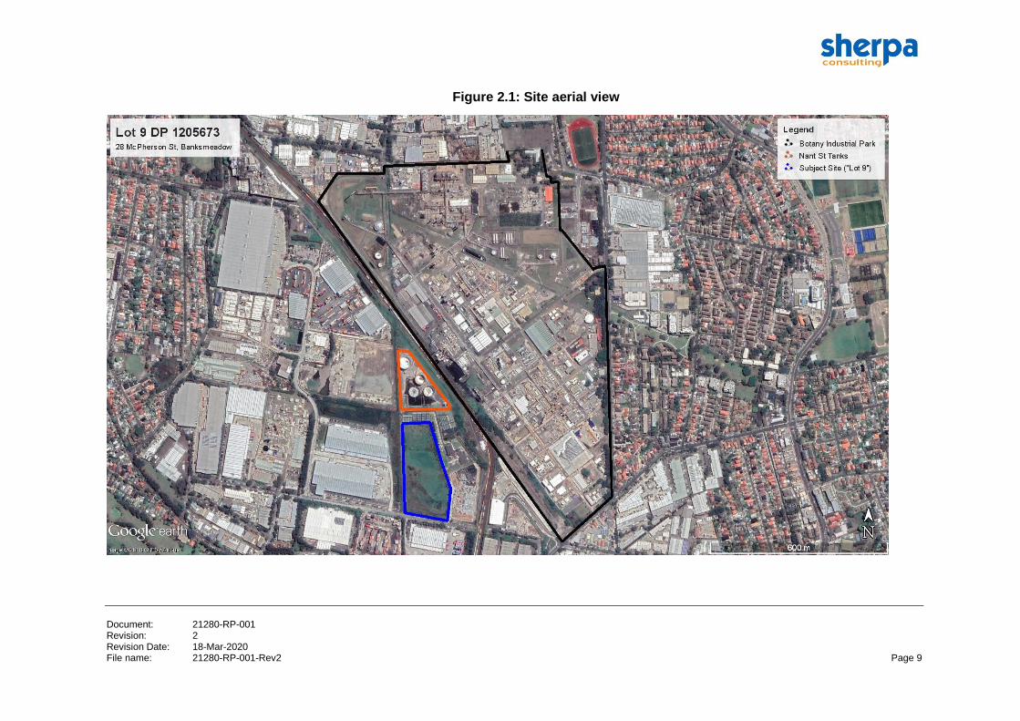
The site is located at 28 McPherson Street, Banksmeadow. The site is officially referred
to as Lot 9 in DP 1205673 in the Bayside Local Government Area.
The site occupies a total area of 41,290 m2 with surrounding sites characterised
predominantly by industrial developments including several warehousing and
distribution facilities.
The site is situated approximately 50 m south of the Nant Street tank farm (operated by
Qenos) and 120 m south west of the BIP. Directly adjacent east of the site is an
Australian Government office premises for detector dog functions facilities of the
Australian Border Force, Australian Federal Police and Department of Agriculture and
Water Resources and a new 8-unit industrial warehousing development currently under
construction.
An aerial view of the site showing the site boundary and location in relation to the BIP is
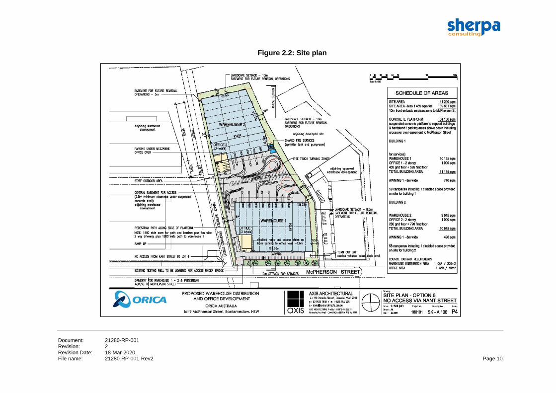
provided in Figure 2.1. The site plan is shown in Figure 2.2.
The proposed project will include development and construction of:
• A suspended concrete platform above the flood detention basin to support
warehouse buildings and hardstand/parking areas.
• Construction of warehouse buildings for the storage and distribution of general
merchandise including goods arriving from Port Botany.
Document: 21280-RP-001 Revision: 2 Revision Date: 18-Mar-2020 File name: 21280-RP-001-Rev2 Page 9
Figure 2.1: Site aerial view
Document: 21280-RP-001 Revision: 2 Revision Date: 18-Mar-2020 File name: 21280-RP-001-Rev2 Page 10
Figure 2.2: Site plan
Document: 21280-RP-001 Revision: 2 Revision Date: 18-Mar-2020 File name: 21280-RP-001-Rev2 Page 11
3. SEPP 33 RISK SCREENING
3.1. Overview
SEPP 33 (Ref.2) defines potentially hazardous industry as follows:
‘Potentially hazardous industry’ means a development for the purposes of an industry which, if
the development were to operate without employing any measures (including, for example,
isolation from existing or likely future development on other land) to reduce or minimise its impact
in the locality or on the existing or likely future development on other land, would pose a
significant risk in relation to the locality:
(a) to human health, life or property; or
(b) to the biophysical environment, and:
includes a hazardous industry and a hazardous storage establishment.
Development proposals that are classified as ‘potentially hazardous’ industry must
undergo a PHA as per the requirements set in HIPAP No. 6 (Ref.3) to determine the risk
to people, property and the environment. If the residual risk exceeds the acceptability
criteria, the development is ‘hazardous industry’ and may not be permissible within
NSW.
The risk screening process in the Applying SEPP 33 guideline (Ref.4) considers the type
and quantity of hazardous materials to be stored on site, distance of the storage area to
the nearest site boundary, as well as the expected number of transport movements.
‘Hazardous materials’ are defined within the guideline as substances that fall within the
classification of the Australian Dangerous Goods Code (ADGC), i.e. have a Dangerous
Goods (DG) classification. Detail of the DG classification is typically obtained from the
materials’ Safety Data Sheet (SDS).
Risk screening is undertaken by comparing the storage quantity and the number of road
movements of the hazardous materials associated with the development against the
screening threshold specified in the guideline. The screening threshold presents the
quantities below which it can be assumed that significant off-site risk is unlikely.
3.2. Risk screening
As per the project description, the proposed warehouse estate will be used for storage
and distribution of general merchandise. Approval is not being sought for storage and
handling of hazardous materials or DGs in any of the warehouses. Therefore, the
quantity of hazardous materials and DGs will not exceed the relevant risk screening
thresholds for either storage or transport.
3.3. Other risk factors
Appendix 2 of Applying SEPP 33 outlines other risk factors for consideration to identify
hazards not addressed by the DG risk screening method.
A review of these risk factors was undertaken. The proposed warehouse estate
development for general merchandise would not involve:
Document: 21280-RP-001 Revision: 2 Revision Date: 18-Mar-2020 File name: 21280-RP-001-Rev2 Page 12
• Storage or transport of incompatible materials (i.e. hazardous and non-hazardous
materials).
• Generation of hazardous waste.
• Generation of dusts within confined areas.
• Incompatible, reactive or unstable materials and process conditions that could lead
to uncontrolled reaction or decomposition.
• Storage or processing operations involving high (or extremely low) temperature
and/or pressures.
3.4. Conclusions
The assessment against the SEPP 33 guidelines are summarised as follows:
• The proposed warehouse development will not exceed the relevant SEPP 33 DG
risk screening thresholds for storage or transport.
• No other risk factors were identified that could result in significant offsite impacts.
• Therefore, the proposed project is not ‘potentially hazardous’ with respect to storage
and transportation within the meaning of SEPP 33 and does not require a PHA.
Document: 21280-RP-001 Revision: 2 Revision Date: 18-Mar-2020 File name: 21280-RP-001-Rev2 Page 13
4. RISK ASSESSMENT
4.1. Overview
The following requirements for assessment of risks are specified in the SEARs:
• An assessment of the risks posed by the BIP complex on the development.
• Demonstrate that the development complies with the risk criteria for development in
the vicinity of potentially hazardous facilities published in HIPAP No. 10 Land Use
Safety Planning.
• The assessment must be undertaken in consultation with BIP, must be based on the
most recently available data and must demonstrate that the development would not
result in any increase of the overall societal risk in the area.
4.2. Development in vicinity of potentially hazardous facilities
HIPAP 10 Land Use Safety Planning (Ref 5) specifies qualitative and quantitative risk
criteria for new development in the vicinity of potentially hazardous facilities (i.e. the BIP
and Nant Street tank farm). Qualitative and quantitative risk assessment against the
HIPAP 10 criteria are included and presented in the following sections.
4.3. Assessment - Qualitative risks
The HIPAP 10 qualitative risk criteria address certain qualitative principles to be adopted
concerning the land use safety acceptability of the proposed development.
Assessment against HIPAP 10 qualitative risk criteria for the proposed development is
presented in Table 4.1.
Table 4.1: Assessment – HIPAP 10 qualitative risk criteria
No Suggested criteria Assessment
1 All ‘avoidable’ risks should be
avoided.
Risk avoidance in this case would mean avoiding any new
population being exposed to the existing risk. Whilst this is an
option, it means that any potentially affected land (i.e. all land
within predicted consequence area at any level of risk) would
be sterilised. Risk avoidance for this proposal is applied at the
level of avoiding exposure of public or sensitive populations
(i.e. choice of industrial land use) and scaling the development
such that the number of people potentially exposed is
inherently limited.
2 The risk from a major hazard
should be reduced wherever
practicable
Not applicable for the proposed development.
The proposed development is not ‘potentially hazardous’ and
approval is not being sought for hazardous materials/DG
storage and handling.
Risks from the BIP complex and Nant Street tank farm are
managed by respective operators. This is outside of the
proponent’s control.
Document: 21280-RP-001 Revision: 2 Revision Date: 18-Mar-2020 File name: 21280-RP-001-Rev2 Page 14
No Suggested criteria Assessment
3 The consequences (effects) of
the more likely hazardous
events (i.e. those of high
probability of occurrence)
should, wherever possible, be
contained within the
boundaries of the installation.
Not applicable for the proposed development.
The proposed development is not ‘potentially hazardous’ and
approval is not being sought for hazardous materials/DG
storage and handling.
Risks from the BIP complex and Nant Street tank farm are
managed by respective operators. This is outside of the
proponent’s control.
4 Where there is an existing
high risk from a hazardous
installation, additional
hazardous developments
should not be allowed if they
add significantly to that
existing risk.
Not applicable for the proposed development.
The proposed development is not ‘potentially hazardous’ (as
per SEPP 33 screening) and approval is not being sought for
hazardous materials and DG storage and handling.
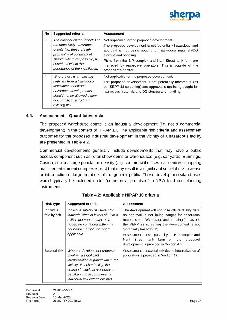
4.4. Assessment – Quantitative risks
The proposed warehouse estate is an industrial development (i.e. not a commercial
development) in the context of HIPAP 10. The applicable risk criteria and assessment
outcomes for the proposed industrial development in the vicinity of a hazardous facility
are presented in Table 4.2.
Commercial developments generally include developments that may have a public
access component such as retail showrooms or warehouses (e.g. car yards, Bunnings,
Costco, etc) or a large population density (e.g. commercial offices, call centres, shopping
malls, entertainment complexes, etc) that may result in a significant societal risk increase
or introduction of large numbers of the general public. These developments/land uses
would typically be included under “commercial premises” in NSW land use planning
instruments.
Table 4.2: Applicable HIPAP 10 criteria
Risk type Suggested criteria Assessment
Individual
fatality risk
Individual fatality risk levels for
industrial sites at levels of 50 in a
million per year should, as a
target, be contained within the
boundaries of the site where
applicable
The development will not pose offsite fatality risks
as approval is not being sought for hazardous
materials and DG storage and handling (i.e. as per
the SEPP 33 screening the development is not
‘potentially hazardous’).
Assessment of risks posed by the BIP complex and
Nant Street tank farm on the proposed
development is provided in Section 4.5.
Societal risk Where a development proposal
involves a significant
intensification of population in the
vicinity of such a facility, the
change in societal risk needs to
be taken into account even if
individual risk criteria are met.
Assessment of societal risk due to intensification of
population is provided in Section 4.6.

Document: 21280-RP-001 Revision: 2 Revision Date: 18-Mar-2020 File name: 21280-RP-001-Rev2 Page 15
4.5. Assessment of risks from the BIP complex
Assessment of risks posed by the BIP complex (and Nant Street tank farm) on the
proposed warehouse estate was undertaken using the most recent 2018 BIP QRA
model (Ref.6). The risk results are available in the public domain. Consent from the BIP
was obtained by Sherpa to use the latest QRA model for assessing the risk impact of
population changes associated with the development.
Risks were assessed by comparison of risk levels at the proposed development site
against the applicable NSW land use planning risk criteria as published in HIPAP 10.
Individual injury risk criteria (heat radiation, explosion overpressure, toxic injury and
irritation) are applicable for residential and sensitive land uses only, i.e. are not
applicable for industrial developments.
A summary of the assessment of the risks posed by the BIP complex on the proposed
development against all individual risk criteria is presented in Table 4.3. Reference
figures illustrating the BIP risk profiles used for assessment are included where relevant.
Assessment of societal risk impact due to the proposed development is included in
Section 4.6.
Document: 21280-RP-001 Revision: 2 Revision Date: 18-Mar-2020 File name: 21280-RP-001-Rev2 Page 16
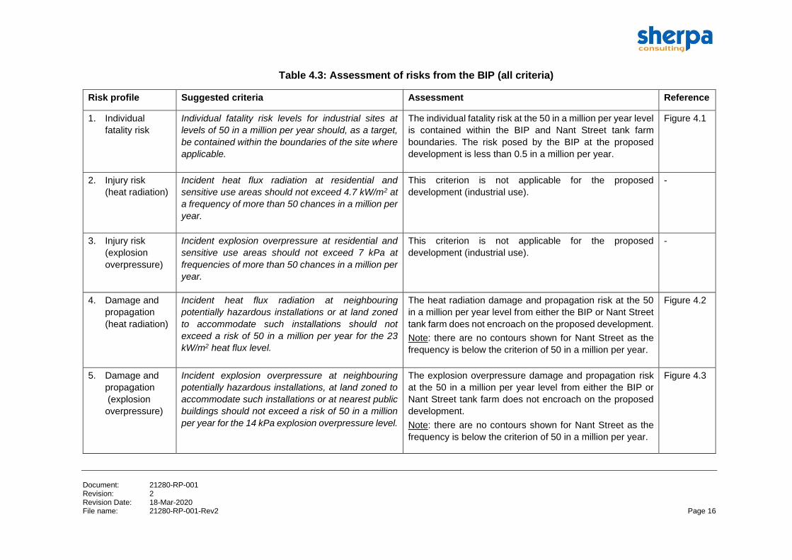
Table 4.3: Assessment of risks from the BIP (all criteria)
Risk profile Suggested criteria Assessment Reference
1. Individual
fatality risk
Individual fatality risk levels for industrial sites at
levels of 50 in a million per year should, as a target,
be contained within the boundaries of the site where
applicable.
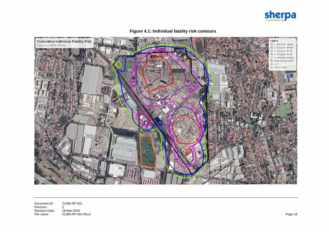
The individual fatality risk at the 50 in a million per year level
is contained within the BIP and Nant Street tank farm
boundaries. The risk posed by the BIP at the proposed
development is less than 0.5 in a million per year.
Figure 4.1
2. Injury risk
(heat radiation)
Incident heat flux radiation at residential and
sensitive use areas should not exceed 4.7 kW/m2 at
a frequency of more than 50 chances in a million per
year.
This criterion is not applicable for the proposed
development (industrial use).
-
3. Injury risk
(explosion
overpressure)
Incident explosion overpressure at residential and
sensitive use areas should not exceed 7 kPa at
frequencies of more than 50 chances in a million per
year.
This criterion is not applicable for the proposed
development (industrial use).
-
4. Damage and
propagation
(heat radiation)
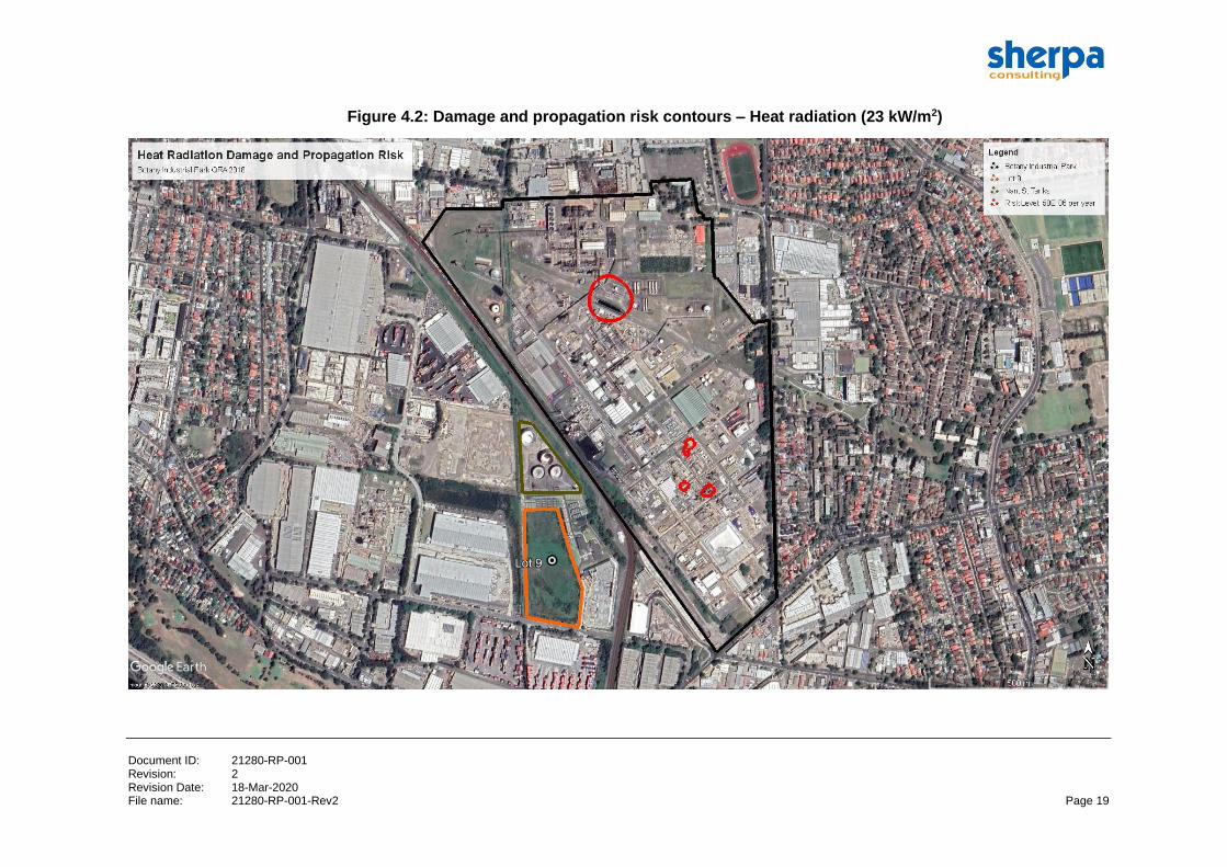
Incident heat flux radiation at neighbouring
potentially hazardous installations or at land zoned
to accommodate such installations should not
exceed a risk of 50 in a million per year for the 23
kW/m2 heat flux level.
The heat radiation damage and propagation risk at the 50
in a million per year level from either the BIP or Nant Street
tank farm does not encroach on the proposed development.
Note: there are no contours shown for Nant Street as the
frequency is below the criterion of 50 in a million per year.
Figure 4.2
5. Damage and
propagation
(explosion
overpressure)
Incident explosion overpressure at neighbouring
potentially hazardous installations, at land zoned to
accommodate such installations or at nearest public
buildings should not exceed a risk of 50 in a million
per year for the 14 kPa explosion overpressure level.
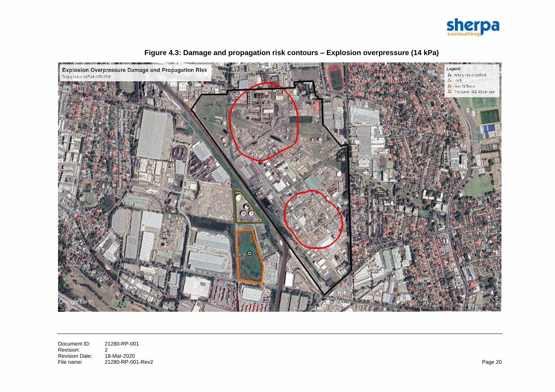
The explosion overpressure damage and propagation risk
at the 50 in a million per year level from either the BIP or
Nant Street tank farm does not encroach on the proposed
development.
Note: there are no contours shown for Nant Street as the
frequency is below the criterion of 50 in a million per year.
Figure 4.3
Document: 21280-RP-001 Revision: 2 Revision Date: 18-Mar-2020 File name: 21280-RP-001-Rev2 Page 17
Risk profile Suggested criteria Assessment Reference
6. Toxic injury risk Toxic concentrations in residential and sensitive use
areas should not exceed a level which would be
seriously injurious to sensitive members of the
community following a relatively short period of
exposure at a maximum frequency of 10 in a million
per year.
This criterion is not applicable for the proposed
development (industrial use).
-
7. Toxic irritation
risk
Toxic concentrations in residential and sensitive use
areas should not cause irritation to eyes or throat,
coughing or other acute physiological responses in
sensitive members of the community over a
maximum frequency of 50 in a million per year.
This criterion is not applicable for the proposed
development (industrial use).
-
Document ID: 21280-RP-001 Revision: 2 Revision Date: 18-Mar-2020 File name: 21280-RP-001-Rev2 Page 18
Figure 4.1: Individual fatality risk contours
Document ID: 21280-RP-001 Revision: 2 Revision Date: 18-Mar-2020 File name: 21280-RP-001-Rev2 Page 19
Figure 4.2: Damage and propagation risk contours – Heat radiation (23 kW/m2)
Document ID: 21280-RP-001 Revision: 2 Revision Date: 18-Mar-2020 File name: 21280-RP-001-Rev2 Page 20
Figure 4.3: Damage and propagation risk contours – Explosion overpressure (14 kPa)
Document: 21280-RP-001 Revision: 2 Revision Date: 18-Mar-2020 File name: 21280-RP-001-Rev2 Page 21
4.6. Societal Risk
4.6.1. Overview
Societal risk is a measure of the probability of incidents affecting an actual
person/population. In accordance with the HIPAP 10 requirement, where a development
proposal involves a significant intensification of population in the vicinity of a potentially
hazardous facility, the change in societal risk needs to be accounted for, even if
individual risk criteria are met.
For this study, the following assessments on societal risk were undertaken:
• Impact to cumulative societal risk due to the proposed development.
• Incremental societal risk from the proposed development.
The societal risk profiles were evaluated against the HIPAP 10 societal risk criteria.
Provided the incremental societal risk lies within the negligible region, development
should not be precluded. If incremental risks lie within the ALARP (As Low As
Reasonably Practicable) region, options should be considered to relocate people away
from the affected areas. Finally, if there is still a significant portion of the societal risk plot
within the ALARP region, the proposed development should only be approved if benefits
clearly outweigh the risks.
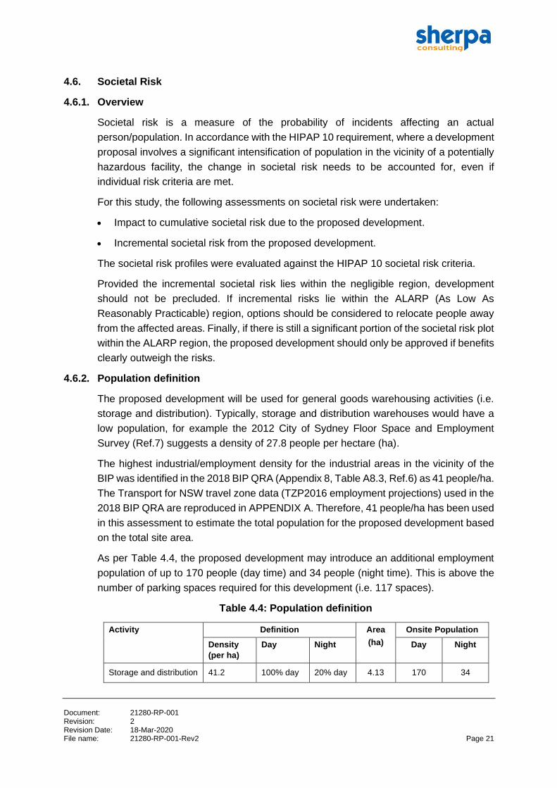
4.6.2. Population definition
The proposed development will be used for general goods warehousing activities (i.e.
storage and distribution). Typically, storage and distribution warehouses would have a
low population, for example the 2012 City of Sydney Floor Space and Employment
Survey (Ref.7) suggests a density of 27.8 people per hectare (ha).
The highest industrial/employment density for the industrial areas in the vicinity of the
BIP was identified in the 2018 BIP QRA (Appendix 8, Table A8.3, Ref.6) as 41 people/ha.
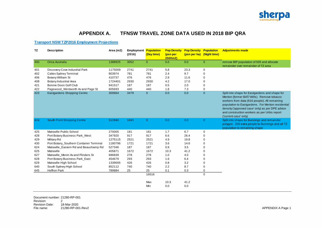
The Transport for NSW travel zone data (TZP2016 employment projections) used in the
2018 BIP QRA are reproduced in APPENDIX A. Therefore, 41 people/ha has been used
in this assessment to estimate the total population for the proposed development based
on the total site area.
As per Table 4.4, the proposed development may introduce an additional employment
population of up to 170 people (day time) and 34 people (night time). This is above the
number of parking spaces required for this development (i.e. 117 spaces).
Table 4.4: Population definition
Activity Definition Area
(ha)
Onsite Population
Density
(per ha)
Day Night Day Night
Storage and distribution 41.2 100% day 20% day 4.13 170 34

Document: 21280-RP-001 Revision: 2 Revision Date: 18-Mar-2020 File name: 21280-RP-001-Rev2 Page 22
4.6.3. BIP QRA 2018 societal risk profiles
For the 2018 BIP QRA, two societal risk profiles were assessed. These include:
1. Current Development – this refers to the societal risk profile assessed for populations
on existing developments which were based on the latest 2016 census data
(residential) and journey to work data (employment).
2. Approved Development – this refers to the societal risk profile assessed for Current
Development plus population estimates for developments that have been approved
around the BIP, but are not yet occupied or were likely to be occupied after the
collection data of the 2016 census. These include:
- BIP subdivision on Denison Street and Corish Circle
- Bunnings Warehouse on Denison Street (opposite the BIP)
- Meriton redevelopment of the former British-American Tobacco site adjacent to
Westfield Eastgardens.
It was noted that the populations assumed for these developments are thought to
be conservative estimates (i.e. likely to overestimate the populations once
occupancy commences).
4.6.4. Impact to cumulative societal risk
The cumulative societal risk profile was compared against the 2018 BIP QRA societal
risk profile for both (1) Current Development and (2) Approved Development to
determine the impact of the proposed development (population density of 41 people/ha)
to the overall societal risk and evaluation against the HIPAP societal risk criteria.
The cumulative societal risk comparison and evaluation are presented as follows:
• Comparison against BIP QRA 2018 ‘Current Development’ (Figure 4.4)
- There is a very slight increase in the overall societal risk. However, this is
insignificant to the overall societal risk in the area.
• Comparison against BIP QRA 2018 ‘Approved Development’ (Figure 4.5)
- There is a very slight increase in the overall societal risk. However, this is
insignificant to the overall societal risk in the area.
Overall, the assessment demonstrates that the proposal has very little impact on the
overall societal risk from the BIP.
Document: 21280-RP-001 Revision: 2 Revision Date: 18-Mar-2020 File name: 21280-RP-001-Rev2 Page 23
Figure 4.4: Comparison against BIP QRA 2018 ‘Current Development’
Figure 4.5: Comparison against BIP QRA 2018 ‘Approved Development’
1.00E-10
1.00E-09
1.00E-08
1.00E-07
1.00E-06
1.00E-05
1.00E-04
1.00E-03
1.00E-02
1 10 100 1000
Fre
qu
en
cy o
f N
or
mo
re fa
talit
ies
pe
r ye
ar
Number of fatalities, N
Societal Risk Profile
Acceptable Region Intolerable Region N limit With Proposed Dev BIP 2018 (Current Development)
Intolerable Region
ALARP Region
Negligible Region
1.00E-10
1.00E-09
1.00E-08
1.00E-07
1.00E-06
1.00E-05
1.00E-04
1.00E-03
1.00E-02
1 10 100 1000
Fre
qu
en
cy o
f N
or
mo
re fa
talit
ies
pe
r ye
ar
Number of fatalities, N
Societal Risk Profile
Acceptable Region Intolerable Region N limit With Proposed Dev BIP 2018 Approved Development
Intolerable Region
ALARP Region
Negligible Region
Document: 21280-RP-001 Revision: 2 Revision Date: 18-Mar-2020 File name: 21280-RP-001-Rev2 Page 24
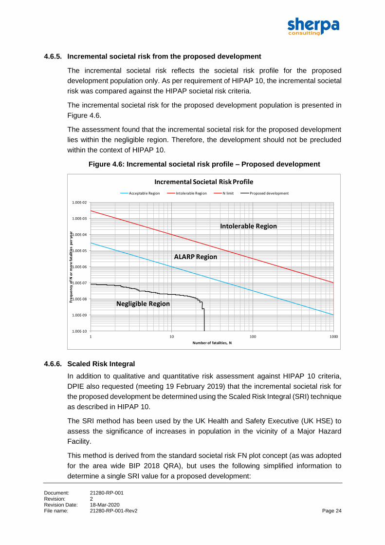
4.6.5. Incremental societal risk from the proposed development
The incremental societal risk reflects the societal risk profile for the proposed
development population only. As per requirement of HIPAP 10, the incremental societal
risk was compared against the HIPAP societal risk criteria.
The incremental societal risk for the proposed development population is presented in
Figure 4.6.
The assessment found that the incremental societal risk for the proposed development
lies within the negligible region. Therefore, the development should not be precluded
within the context of HIPAP 10.
Figure 4.6: Incremental societal risk profile – Proposed development
4.6.6. Scaled Risk Integral
In addition to qualitative and quantitative risk assessment against HIPAP 10 criteria,
DPIE also requested (meeting 19 February 2019) that the incremental societal risk for
the proposed development be determined using the Scaled Risk Integral (SRI) technique
as described in HIPAP 10.
The SRI method has been used by the UK Health and Safety Executive (UK HSE) to
assess the significance of increases in population in the vicinity of a Major Hazard
Facility.
This method is derived from the standard societal risk FN plot concept (as was adopted
for the area wide BIP 2018 QRA), but uses the following simplified information to
determine a single SRI value for a proposed development:
1.00E-10
1.00E-09
1.00E-08
1.00E-07
1.00E-06
1.00E-05
1.00E-04
1.00E-03
1.00E-02
1 10 100 1000
Fre
qu
en
cy o
f N
or
mo
re fa
talit
ies
pe
r ye
ar
Number of fatalities, N
Incremental Societal Risk Profile
Acceptable Region Intolerable Region N limit Proposed development
Intolerable Region
ALARP Region
Negligible Region
Document: 21280-RP-001 Revision: 2 Revision Date: 18-Mar-2020 File name: 21280-RP-001-Rev2 Page 25
• Average individual risk results
• The land use category of each site (e.g. housing, retail, industrial etc.)
• Details of the number of persons (n) at each site
• The proportion of time each site is occupied by n persons
• The area of each site.
The number of persons (‘n’) at each site is adjusted by a factor (‘c’) to accommodate
differing categories of development. For developments where the general public may be
present (e.g. housing; hotel or holiday accommodation; retail facilities; community or
leisure facilities; etc.) a value of ‘c’ of 1 is suggested by the HSE. Similarly, for
developments where vulnerable populations may be present (e.g. hospitals; homes for
the elderly; schools; etc.) a value of 4 is suggested, and for industrial, commercial or
rural developments where working populations may be present (e.g. factories;
warehouses; offices; farm buildings; etc.) a value of 0.25 is suggested.
A ‘comparison value’ is used for assessment purposes. The basis for the lower
‘comparison value’ adopted by the HSE is that an individual risk of exposure to a
‘dangerous dose’ is broadly acceptable at 1 per million per year for a development
involving up to 75 people. Assuming an average of 2.5 people per dwelling, 75 people
equates to 30 dwellings with a typical land area of 1.2 hectares and the SRI equals
0.5 x (75+752) x 1 / 1.2 = 2,375. This limiting case (suitably rounded) gives a lower
‘comparison value’ of 2500 (Ref 8). When the SRI is calculated on the basis of individual
fatality risk (as per the NSW HIPAPs) rather than a ‘dangerous dose’, the ‘comparison
value’ is reduced from 2500 to 1100 (Ref 5).
Note that in Sherpa’s view the site is too large to apply this methodology successfully as
the risk levels vary significantly across the site from north to south. However, a
conservative estimate of SRI has been made based on the overall proposed
development area using:
• The calculated population case (i.e. 170 people/employment introduced for the
proposed development as per Table 4.4).
• The highest risk level at the site (i.e. northern end of the proposed development), i.e.
9 x 10⁻⁸ per year.
The SRI inputs and results are shown in Table 4.5. The estimated SRI is 10, well below
the comparison value of 1100. Hence the conclusion is the same as that reached from
the FN curve analysis, i.e. the societal risk will not change significantly as a result of the
proposed Lot 9 development.
Document: 21280-RP-001 Revision: 2 Revision Date: 18-Mar-2020 File name: 21280-RP-001-Rev2 Page 26
Table 4.5: SRI estimate
Sensitivity Cases Comparison Value (acceptable risk if SRI value below this) < 1100
Basis for Population Area Approx
Area
No of
people
Basis for population Site
Category
Factor
(c)
Adjusted
pop (N)
Pop factor
(P)
Average Risk
over area
Assumed
probability of
presence
SRI Acceptable
(m2) =no of
people x
factor
0.5x (N+N2) (pmpy) Assumed
probability of
presence-
day only
Total
Lot 9 overall area - Day 41534 170 As per Table 4.4 Industrial 0.25 43 924 0.09 0.50 10
Lot 9 overall area - Night 41534 34 Assume 20% of daytime
population remains at night
Industrial 0.25 9 40 0.09 0.50 0
Total - accounts for 20% population at night time 10 OK
Document: 21280-RP-001 Revision: 2 Revision Date: 18-Mar-2020 File name: 21280-RP-001-Rev2 Page 27
5. BOTANY/RANDWICK AREA LUSS RECOMMENDATIONS
The relevant recommendations published in Botany-Randwick Industrial Area Land Use
Safety Study (LUSS) (Ref.9) are addressed in Table 5.1.
Table 5.1: Botany/Randwick industrial area LUSS recommendations
Recommendations Applicable
(Y/N)
Remarks
Future developments within the
Botany/Randwick industrial area
should be subject to full risk
assessment, following the seven-stage
approval process. In addition,
proposed developments should
undergo comprehensive environmental
impact assessment to conclusively
demonstrate that the development will
not produce off-site risks that are
inappropriate for surrounding land
uses.
Yes The SEPP 33 risk screening review
demonstrates that the development
will not pose offsite fatality risks as
no hazardous materials and DGs
are proposed. The general
warehousing development is not
‘potentially hazardous’, therefore a
PHA is not required and the full
seven-stage approval process is
not required.
Any future development in the vicinity
of the Botany/Randwick industrial area
should generally provide a buffer
between the industrial area and
surrounding residential zones. In
assessing a proposed development,
residential intensification should not be
considered in the shaded region of
Figure 1 until the new Orica chlorine
plant is operational and bulk chlorine
storage on the site has ceased. The
Department should be consulted
regarding proposed development
within the 'consultation region' of
Figure 1. It would also be prudent for
the Department to be consulted
regarding these regions after the
replacement of the existing (pre-2001)
Orica chlorine plant, at least during the
early stages of plant operation.
No No residential intensification
associated with the proposed
development (i.e. industrial land
use).
As this study has not included the
impacts of dangerous goods traffic
along Stephen Road and Denison
Street, or the operations of Port Botany
and the Sydney Airport, it is strongly
recommended that these activities be
taken into account in the assessment
of any development in the
Botany/Randwick area.
No The development will not result in
increased DG transport as there will
be no hazardous materials and
DGs (i.e. not ‘potentially
hazardous’).
Document: 21280-RP-001 Revision: 2 Revision Date: 18-Mar-2020 File name: 21280-RP-001-Rev2 Page 28
Recommendations Applicable
(Y/N)
Remarks
It is recommended that all facilities
investigated as part of this study
review and strengthen safety
management systems. These systems
should be monitored by periodic
independent compliance audits at
intervals of not less than two years. As
part of the review of safety
management systems, incident/near
miss reporting and follow-up
procedures should be updated to be
consistent with best practice. Training
arrangements should be reviewed to
ensure that a safety management
system is supported by an employee
understanding of operational hazards
and emergency procedures.
No This relates to the BIP as the
potentially hazardous facility
generating the risk. It does not
apply to the proposed warehousing
development.
Emergency procedures for facilities
within the industrial area should be
reviewed and updated with the aim of
establishing greater consistency
between the procedures at different
sites. There should also be a greater
level of integration between facilities in
terms of regional emergency planning.
An integrated emergency plan for the
area should be developed and mutual
aid agreements established.
Yes Suitable emergency response
procedures will be developed for
the proposed development.
The proponent will liaise with the
BIP to ensure the emergency plan
for the warehousing site accounts
for the required response to an
incident in the BIP or at the Nant
Street tank farm. It is noted that this
could be achieved via a condition of
consent.
The community should be adequately
informed about activities, associated
risks and safety management
measures adopted within the
Botany/Randwick industrial area. A
formal mechanism needs to be
established to implement a community
right-to-know program. Community
Consultative Committees should be
established for developments, or
groups of developments, in the
industrial complex to act as an
interface between the community and
industry, particularly in regard to safety
issues.
Yes The proponent will consult with the
(1) community and relevant
stakeholders as part of the DA
application process (i.e. public
exhibition period) and (2) liaise with
the BIP in regard to associated
emergency planning.
Document number: 21280-RP-001 Revision: 2 Revision Date: 18-Mar-2020 File name: 21280-RP-001-Rev2 APPENDIX A Page 1
APPENDIX A. TFNSW TRAVEL ZONE DATA USED IN 2018 BIP QRA
Transport NSW TZP2016 Employment Projections
TZ Description Area (m2) Employment
(2016)
Population
(Day time)
Pop Density
(psn per
2500m2)
Pop Density
(psn per ha)
Population
(Night time)
Adjustments made
400 Orica Australia 1388925 3052 0 0.0 0.0 0 remove BIP population of 505 and allocate
remainder over remainder of TZ area
401 Discovery Cove Industrial Park 1175009 2741 2741 5.8 23.3 0
402 Caltex Sydney Terminal 803974 781 781 2.4 9.7 0
406 Botany William St 410737 476 476 2.9 11.6 0
408 Botany Industrial Area 1724401 2930 2930 4.2 17.0 0
421 Bonnie Doon Golf Club 941517 187 187 0.5 2.0 0
422 Pagewood_Wentworth Av and Page St 605693 440 440 1.8 7.3 0
423 Eastgardens Shopping Centre 300664 3479 0 0.0 0.0 0 Split into shape for Eastgardens and shape for
Meriton (former BAT/ Wills). Remove tobacco
workers from data (616 people). All remaining
population to Eastgardens. For Meriton residential
density ('approved case' only) as per DPE advice
and construction workers as per Urbis report
('current case' only)
424 South Point Shopping Centre 512840 1041 0 0.0 0.0 0 Split into shape for Bunnings and remainder
polygon. 200 extra people to Bunnings and all TZ
population to remaining shape
425 Matraville Public School 270005 181 181 1.7 6.7 0
428 Port Botany Business Park_West 347920 917 917 6.6 26.4 0
429 Military Rd 1275115 2521 2521 4.9 19.8 0
430 Port Botany_Southern Container Terminal 1180796 1721 1721 3.6 14.6 0
624 Matraville_Eastern Rd and Beauchamp Rd 527346 187 187 0.9 3.5 0
625 Matraville 405871 1672 1672 10.3 41.2 0
627 Matraville_Menin Av and Flinders St 686839 278 278 1.0 4.0 0
628 Port Botany Business Park_East 454679 293 293 1.6 6.4 0
629 Matraville High School 1339005 426 426 0.8 3.2 0
640 South Sydney High School 852112 740 740 2.2 8.7 0
645 Heffron Park 789884 25 25 0.1 0.3 0
16516 0
Max 10.3 41.2
Min 0.0 0.0
Document number: 21280-RP-001 Revision: 2 Revision Date: 18-Mar-2020 File name: 21280-RP-001-Rev2 APPENDIX B Page 1
APPENDIX B. REFERENCES
1 NSW Department of Planning and Environment (2018): Secretary’s Environmental
Assessment Requirements, SSD 9691.
2 NSW State Government (1992): State Environmental Planning Policy No 33 –
Hazardous and Offensive Development.
3 NSW Department of Planning (2011): Hazardous Industry Planning Advisory Paper
No.6: Hazard Analysis.
4 NSW Department of Planning (2011): Applying SEPP 33.
5 NSW Department of Planning and Environment (2011): Hazardous Industry Planning
Advisory Paper No 10 – Land Use Safety Planning.
6 Sherpa Consulting Pty Ltd (2018): Botany Industrial Park Quantitative Risk Assessment
(QRA) Report, Document Number: 21158-RP-001, Rev 1.
Webpage: https://www.planning.nsw.gov.au/Policy-and-Legislation/Hazards/Industrial-
Hazards?acc_section=sites_of_interest
7 City of Sydney (2012): Local Government Area Summary Report, City of Sydney Floor
Space and Employment Survey, Table 10 and Table 11, Pp 25-26.
8 Carter D A (1995) The Scaled Risk Integral, Proceedings of the 8th International
Symposium on Loss Prevention & Safety Promotion in the Process Industries, Antwerp,
June Elsevier Science, 1995
9 NSW Department of Urban Affairs and Planning (2001): Botany/Randwick Industrial
Area Land Use Safety Study.