Embed Size (px)
DESCRIPTION
GIS
Citation preview
EU-DEM Statistical Validation
Report
August 2014

2
Prepared by DHI GRAS • c/o Geocenter Denmark
Øster Voldgade 10
DK-1350 Copenhagen K
Denmark
Phone: +45 4516 9200
www.dhi-gras.com
Project No at DHI 18800150-5
Project manager Christian Tøttrup
Quality supervisor Mikael Kamp Sørensen
Prepared for European Environment Agency (EEA)
Kongens Nytorv 6
DK-1050 Copenhagen K
Denmark
Phone: +45 3336 7100
www.eea.europa.eu
Project manager Eugenija Schuren
Specific contract No 3436/B2014/R0-GIO/EEA.55694
Implementing Framework Service Contract No EEA/SES/12/003/Lot3
Relation to GMES/Copernicus Initial Operations Land Monitoring 2011-2013
Regulation (EU) No. 911/2010
Type of the document Report
Description The document describes data and methodology used in the statistical
validation of EU-DEM and presents the results of the statistical validation of
EU-DEM
Review and
Contribution
(in alphabetical order) H. Dufourmont, J. Gallego, H. Reuter, P. Strobl
Creation date 05-08-2014
Status Final
Access Public
This report has been prepared under the DHI Business Management System
certified by DNV to comply with ISO 9001 (Quality Management)

3
Executive summary
The Geoscience Laser Altimeter System (GLAS) instrument onboard the Ice, Cloud, and
land Elevation Satellite (ICESat) provides a globally distributed elevation data set that is
well-suited to independently evaluate the accuracy of continent-wide digital elevation
models (DEMs), such as EU-DEM. EU-DEM is a hybrid product based mainly on SRTM and ASTER GDEM but also public available Russian topographic maps. The EU-DEM statistical validation documents a relatively unbiased (-0.56 meters) overall vertical accuracy of 2.9 meters RMSE, which is fully within the contractual specification of 7m RMSE. Evaluation of RMSE values as per country revealed higher RMSE values for the Nordic countries of Iceland (RMSE=9.41 m), Norway (RMSE=5.75 m) and Sweden (RMSE=7.41 m), which can be explained by the absence of SRTM data north of 60
oN.
Further, investigations of EU-DEM elevation accuracy documented increasing elevation biases and variability in areas of variable topography and ground cover. The results are generally consistent and can be explained by the measurement characteristics and differences between the involved data sources. As a general conclusion, it can be stated that the validation of the EU-DEM dataset yields overall values within specifications. Furthermore, the detailed validation provides valuable insights into the characteristics of the EU-DEM elevation data, which will improve its utilization potential and help to prepare for the planned update of EU-DEM.
4
CONTENTS
Executive summary .................................................................................................................. 3
1 Introduction ............................................................................................................ 6
2 Data and Methodology ........................................................................................... 6 2.1 EU-DEM .................................................................................................................................... 6 2.2 ICESat Global Land Surface Altimetry Data ............................................................................. 7 2.3 Ancillary data ............................................................................................................................. 9 2.4 Data comparison ....................................................................................................................... 9 2.5 Statistical validation ................................................................................................................ 10 2.5.1 Reference data........................................................................................................................ 10 2.5.2 Measures of Accuracy ............................................................................................................ 11 2.5.3 Processing workflow ............................................................................................................... 11
3 Results .................................................................................................................. 13 3.1 Fundamental accuracy ............................................................................................................ 13 3.1.1 Latitudes south of 60
oN ........................................................................................................... 15
3.1.2 Latitudes north of 60oN ........................................................................................................... 17
3.2 Supplemental and Consolidated Vertical Accuracies ............................................................. 17 3.2.1 Slope ....................................................................................................................................... 18 3.2.2 Forest cover ............................................................................................................................ 19 3.2.3 Urban land cover ..................................................................................................................... 22
4 Discussion ............................................................................................................ 23
5 Conclusion ............................................................................................................ 25
6 Recommendation ................................................................................................. 25
7 References ............................................................................................................ 26
APPENDIX: Specifications of the EU-DEM ........................................................................... 27
FIGURES
Figure 1. EU-DEM geographic coverage and tiling system. ......................................................................... 7 Figure 2. Overview map over ICESat paths and footprints over Western Europe (left) and zoom
window over the British Islands (right). ................................................................................... 10 Figure 3. Processing workflow for the EU-DEM statistical validation. ......................................................... 12 Figure 4. Histograms of errors (∆h) for fundamental accuracy assessment of EU-DEM. ........................... 13 Figure 5. Histograms of errors (∆h) for fundamental accuracy at locations south of 60
oN. ........................ 15
Figure 6. Histograms of the errors (∆h) for fundamnetal accuracy at locations north of 60o N. .................. 17
Figure 7. Histograms of the errors (∆h) for the assessment of elevation bias due to slope at
locations south of 60oN. .......................................................................................................... 18
Figure 8. Histograms of the errors (∆h) for the assessment of elevation bias due to slope at
locations north of 60o N. .......................................................................................................... 19
Figure 9. Histograms of the errors (∆h) for the assessment of elevation bias due to forest cover
south of 60oN. ......................................................................................................................... 20
Figure 10. Variability of RMSE relative to forest cover percentages for locations south of 60oN. .............. 21
Figure 11. Histograms of the errors (∆h) for the assessment of elevation bias due to forest cover at
locations north of 60oN. ........................................................................................................... 21
5
Figure 12. Variability of RMSE relative to forest cover percentages for locations north of 60oN. ............... 22
Figure 13. Histograms of the errors (∆h) for the assessment of EU-DEM elevation bias over urban
areas. ...................................................................................................................................... 23 Figure 14. Graph of ASTER GDEM and SRTM vertical errors plotted against slope (sources:
ASTER GDEM Validation Team 2009 and Falorni et al. 2005) .............................................. 24 Figure 15. ICESat waveform over forest canopy relative to wavelengths signal from SRTM and
ASTER GDEM (from Ensle et al 2012). .................................................................................. 25
TABLES
Table 1. ICESAT GLAH14 data quality flags................................................................................................. 8 Table 2. List of ancillary layers used for the EU-DEM statistical validation. ................................................. 9 Table 3. Accuracy measures for EU-DEM validation. ................................................................................. 11 Table 4. Results of the EU-DEM fundamental accuracy for entire EEA39. ................................................ 14 Table 5. Results of the EU-DEM fundamental accuracy for locations south of 60
oN. ............................... 16
Table 6. Results of the EU-DEM fundamental accuracy for locations north of 60oN. ................................ 17
Table 7. Results of the EU-DEM elevation bias due to slope for locations south of 60oN. ......................... 18
Table 8. Results of the EU-DEM elevation bias due to slope for locations north of 60oN........................... 19
Table 9. Results of the EU-DEM elevation bias due to forest cover for locations south of 60oN. ............... 20
Table 10. Results of the EU-DEM elevation bias due to forest cover for locations north of 60oN. ............. 21
Table 11. Results of the EU-DEM elevation bias due to urban land cover. ................................................ 23
6
1 Introduction
Digital Elevation Models (DEMs) provide fundamental information that is required across a
broad set of application areas, each with different technical and usage requirements. The
EU-DEM has been developed in response to an urgent need for continent-wide elevation
data at 1 arc-second (approximately 30m x 30 m) posting, and at an overall vertical
resolution of approximately 5m (European Commission 2009).
As no single data source provides consistent and complete pan-European coverage the EU-
DEM has arrived from DEM fusion techniques combining data from different sources into a
single, consistent and homogeneous elevation dataset. The fusion process relied mainly on
data from ASTER GDEM and SRTM but also, in latitudes over 60º N, using elevation data
from freely available Russian topomap series. The EU-DEM is further edited to ensure that
water features are adequately represented and in order to arrive at a mid-scale digital
elevation model, for instance to be used for modelling purposes on a river catchment basis.
Validation of the vertical accuracy of the EU-DEM is of critical importance to ensure that the
elevation data achieve the accuracy of the specifications. The primary challenge in
validating a pan-European elevation model is obtaining a useful reference data set that is
accurate enough and has suitable coverage to encompass the entire area of interest.
NASA's Ice, Cloud and land Elevation Satellite (ICESat) employing the Geoscience Laser
Altimeter System (GLAS) has collected a unique set of full-waveform Light Detection And
Ranging (LiDAR) data with global coverage during campaigns that began in 2003 and
ended late 2009.
This ICESat/GLAS system provides a consistently referenced elevation data set with
unprecedented accuracy and quantified measurement errors that can be used to generate
Ground Control Points (GCPs) with a vertical accuracy high enough for validating the EU-
DEM.
The objective of this specific document is to present the methods and implementation of
statistical procedures for the validation of the EU-DEM vertical accuracy based on ICESat
data. The validation results is needed to document the current vertical accuracy relative to
the specification standards and to clarify potential issues with EU-DEM that need to be
targeted for the planned upgrade of EU-DEM.
2 Data and Methodology
2.1 EU-DEM
The EU-DEM provides Pan-European elevation data at 1 arc-second (+/-30 meters)
postings. The EU-DEM provides full coverage of the EEA countries (i.e. the so called
EEA39) consisting of 33 member states and 6 cooperating ones. Area wise the EU-DEM
covers 5.84M km². The EU-DEM is a hybrid product based mainly on SRTM and ASTER
GDEM but also public available Russian topographic maps for regions north of 60oN
latitude. The data are fused by a weighted averaging approach and it has been generated
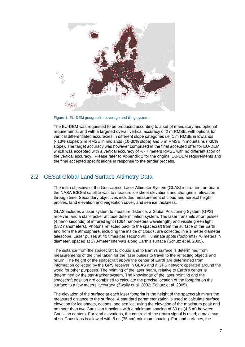
as a contiguous dataset divided into 1 degree by 1 degree tiles (cf. Figure 1). The spatial
reference system is geographic, lat/lon with horizontal datum ETRS89, ellipsoid GRS80 and
vertical datum EVRS2000 with geoid EGG08.
7
Figure 1. EU-DEM geographic coverage and tiling system.
The EU-DEM was requested to be produced according to a set of mandatory and optional
requirements, and with a targeted overall vertical accuracy of 2 m RMSE, with options for
vertical differentiated accuracies in different slope categories i.e. 1 m RMSE in lowlands
(<10% slope); 2 m RMSE in midlands (10-30% slope) and 5 m RMSE in mountains (>30%
slope). The target accuracy was however comprised in the final accepted offer for EU-DEM
which was accepted with a vertical accuracy of +/- 7 meters RMSE with no differentiation of
the vertical accuracy. Please refer to Appendix 1 for the original EU-DEM requirements and
the final accepted specifications in response to the tender process.
2.2 ICESat Global Land Surface Altimetry Data
The main objective of the Geoscience Laser Altimeter System (GLAS) instrument on-board
the NASA ICESat satellite was to measure ice sheet elevations and changes in elevation
through time. Secondary objectives included measurement of cloud and aerosol height
profiles, land elevation and vegetation cover, and sea ice thickness.
GLAS includes a laser system to measure distance, a Global Positioning System (GPS)
receiver, and a star-tracker attitude determination system. The laser transmits short pulses
(4 nano seconds) of infrared light (1064 nanometers wavelength) and visible green light
(532 nanometers). Photons reflected back to the spacecraft from the surface of the Earth
and from the atmosphere, including the inside of clouds, are collected in a 1 meter diameter
telescope. Laser pulses at 40 times per second will illuminate spots (footprints) 70 meters in
diameter, spaced at 170-meter intervals along Earth's surface (Schutz et al. 2005).
The distance from the spacecraft to clouds and to Earth's surface is determined from
measurements of the time taken for the laser pulses to travel to the reflecting objects and
return. The height of the spacecraft above the center of Earth are determined from
information collected by the GPS receiver in GLAS and a GPS network operated around the
world for other purposes. The pointing of the laser beam, relative to Earth's center is
determined by the star-tracker system. The knowledge of the laser pointing and the
spacecraft position are combined to calculate the precise location of the footprint on the
surface to a few meters' accuracy (Zwally et al. 2002; Schutz et al. 2005).
The elevation of the surface at each laser footprint is the height of the spacecraft minus the
measured distance to the surface. A standard parameterization is used to calculate surface
elevation for ice sheets, oceans, and sea ice, using the elevation of the maximum peak and
no more than two Gaussian functions with a minimum spacing of 30 ns (4.5 m) between
Gaussian centers. For land elevations, the centroid of the return signal is used; a maximum
of six Gaussians is allowed with 5 ns (75 cm) minimum spacing. For land surfaces, the

8
algorithm characterizes the return pulse by fitting Gaussian distributions to each mode
(peak) in the waveform. Surface elevation over land is derived from the centroid of the
return.
Over most of the ice sheets, the accuracy of each elevation measurement is at sub-
decimeter level. Over land, however, the vertical accuracy of the elevation measurements is
less due to the effect of surface roughness i.e. the combined effect of slope, vegetation and
cultural features. Still, according to Carabajal (2011) rigorous analysis has shown that for
low relief locations in open terrain the ICESat data return elevation values with sub-meter
accuracy.
Data was collected from February, 2003 to October, 2009 during approximately month long
observation periods, three times per year through 2006 and twice per year thereafter. These
altimetry profiles provide a highly accurate and consistently referenced elevation data set
with quantified errors. Three lasers were used sequentially during the mission. Still, only
data acquired by Laser 3 was used for EU-DEM validation, since the spatial distribution of
the footprint energy was Gaussian with a diameter of about 50 meters, and hence more
suitable to evaluate a 30 m resolution elevation model. Laser 3 coverage period is from
October 2004 to October 2009.
There are several standard ICESat data products (cf. http://nsidc.org/data/icesat/data.html).
For the EU-DEM validation GLAH14 (GLAS/ICEsat L2 Global Land Surface Altimetry Data)
product was obtained. Strict editing criteria were applied to the ICESat data in order to
select ICESat records with the highest possible accuracy and to exclude ICESat data with
potential error sources that could degrade its accuracy. First, filtering of invalid or critical
values was performed using the internal quality flags in the ICESat GLAH14 data files (cf.
Table 1).
Table 1. ICESAT GLAH14 data quality flags.
Attribute Group Description Flag values and meanings
elev_use_flg Data_40HZ/Quality Flag indicating whether the elevations on this record should be used.
0 (valid)
1 (not_valid)
sat_corr_flg Data_40HZ/Quality Saturation Correction Flag; Indicates if the returns is saturated or not.
0 (not_saturated)
1 (inconsequential
2 (applicable)
3 (not computed)
4 (not applicable)
d_satElevCorr Data_40HZ/Elevation_Corrections
Correction to elevation for saturated waveforms. This correction has NOT been applied to the data.
If this is zero then no correction is necessary and the signal is assumed not saturated
rng_uqf_xxxx Data_40HZ/Quality Range offset quality flags 0 (valid)
1 (not_valid)
elv_cloud_flg Data_40HZ/Elevation_Flags Cloud contamination; Indicates probable cloud contamination
0 (false)
1 (true)
From Table it is seen that a non-zero data use or frame quality flag indicates a less than
ideal situation during processing and the record was therefore excluded for further
interpretation. In addition extreme outliers can be attributed to cloud contamination why
ICESat locations with elevations deviating more than 50 meters from the EU-DEM were
excluded using an ICESat and EU-DEM difference edit. Finally, laser beams with off-nadir
9
pointing (> 1o) were also exclude from the analysis as the off-nadir pointing introduces
errors that are a function of the angle with which the surface is intercepted.
2.3 Ancillary data
A number of ancillary data sources were used to support the selection of ICESat data
records for the assessment of the fundamental vertical accuracy as well as supplemental
and consolidated accuracies. These data sets included the high resolution and pan-
European maps of soil sealing and forest cover for the reference year 2006; the 2006
Corine land cover; the EU-DEM derived slope map (Table 2) as well as national borders for
the EEA39 countries.
Table 2. List of ancillary layers used for the EU-DEM statistical validation.
Theme Description Resolution Reference Year Source
Slope Slope derived from EU-DEM 25 meters 2000 JRC, 2012
Forest
cover
Pan-European Forest/Non-Forest Map
(version 1.0) 25 meters 2006 JRC, 2010
Soil
sealing
Raster data set of built-up and non-built-
up areas including continuous degree of
soil sealing ranging from 0 - 100% (revised
version)
20 meters 2006 EEA, 2013
Land
cover
Raster data on land cover for the CLC2006
inventory (version 17/2013) 100 meters 2006 EEA, 2013
2.4 Data comparison
ICESat GLA14 data contain land elevations with respect to the TOPEX/Poseidon-Jason
ellipsoid which is about 70 cm smaller than the WGS 84 ellipsoid. As a consequence,
comparison of ICESat elevations to those obtained from other sources must take into
account the potential effect of ellipsoid differences. The comparison of EU-DEM with ICESat
elevations was done using WGS84 as the reference ellipsoid. First, the ICESat footprint
locations were converted to the WGS84 ellipsoid using the empirically derived formula
provided by NSIDC1 . Hereafter, the EU-DEM orthometric heights were transformed back to
ellipsoidal heights by applying the European Gravimetric Quasigeoid model EGG20082 and
assuming the GRS80 and WGS84 ellipsoids being equal3.
For every ICESat footprint the corresponding EU-DEM elevation and slope values was
computed as the mean and standard deviation within a 3x3 pixel neighbourhood. Moreover,
values for each of the ancillary data layers were also extracted for each ICESat footprint
including i.e. forest cover and soil sealing percentage as derived within a 3x3
neighbourhood as well as the direct extraction of the CORINE land cover classes and
country labels.
The EU-DEM fundamental accuracy was evaluated using ICESat footprints located in open
low relief terrain only, while the supplemental and consolidated accuracies were derived
using different selection procedures based on the combined usage of forest cover and soil
1 The National Snow and Ice Data Center (NSIDC) - http://nsidc.org/data/icesat/
2 Dr.-Ing. Heiner Denker (personal communication 2014).
3 This is justified by the fact that the WGS 84 originally used the GRS 80 reference ellipsoid, but has undergone
some minor refinements in later editions since its initial publication. Most of these refinements are important for high-precision orbital calculations for satellites but have little practical effect on typical topographical uses.
10
sealing percentages, slope categories as well CORINE land cover. Accuracy measures are
given not only for EU-DEM as whole but also (when applicable) per country in order to
reveal any potential regional biases.
2.5 Statistical validation
The procedure for statistical validation of the EU-DEM vertical accuracies is based on
industry standards as put forward in the “Guidelines for Digital Elevation Data” published by
the National Digital Elevation Program (NDEP 2004).
2.5.1 Reference data
Accuracy assessment of the DEM is carried out by means of independent reference data. In
this case independent means having no connection with the production of the EU-DEM.
Further, requirements of the reference data relates to validity and representativeness.
As for the validity of reference data then it is normal to presume that reference data are
error free and that discrepancies therefore can be attributable to the tested product which is
assumed to have lower accuracy. However, reference data are not always error free and the
general rule of thumb, to ensure trustworthy validation, is to use reference data with
accuracies at least three times greater than the expected accuracy of the product being
tested. It is generally recognised that ICESat data after quality filtering achieve sub-meter
accuracies over low relief locations (Carabajal 2011) and ICESat data therefore makes an
adequate reference for EU-DEM which has been requested to meet an overall vertical
accuracy in the order of +/- 5 meters.
Representativeness refers to the number and distribution of reference data i.e. the number
of reference data should be high enough to fulfil statistical requirements but also distributed
to reflect the geographical area of interest. The main advantage of using ICESat for the
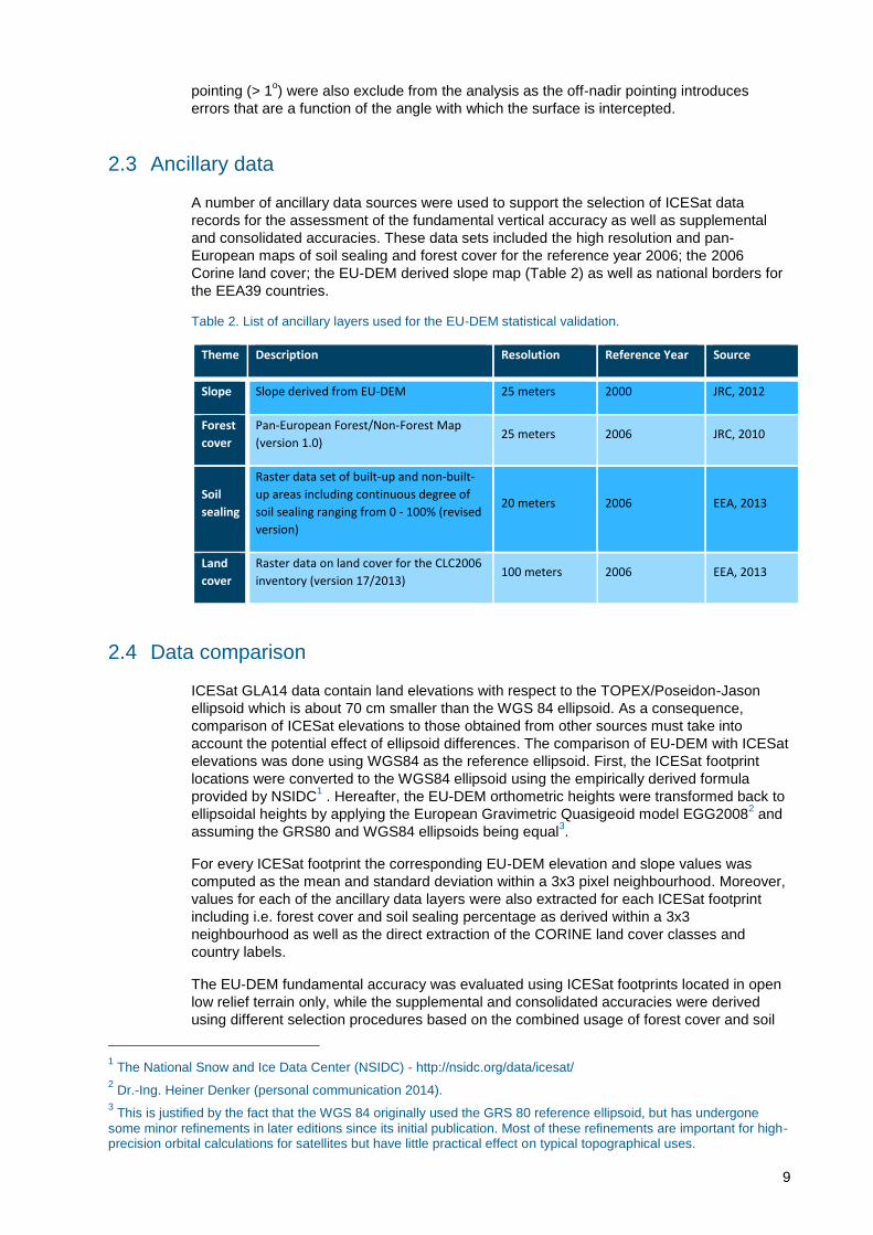
validation of EU-DEM is the fact it represent a single homogenous reference dataset with
continent wide representation (cf. Figure 2).
Figure 2. Overview map over ICESat paths and footprints over Western Europe (left) and zoom window over the British Islands (right).
The exact number of reference points available for the validation varies with the ICESat
selection criteria which are being dictated by the requirement for the different accuracy
calculations (cf. fundamental vs. supplemental and consolidated accuracy measures). The
critical sample size, however, can be estimated to be 384 samples using the multi-nominal
distribution with a confidence level of 95% and a margin of error of 5% (Congalton and
Green 2009). Any accuracy measure based on samples below the critical sample size will
therefore be omitted or clearly marked with an asterisk to indicate the result should be
treated cautiously.
11
2.5.2 Measures of Accuracy
Error! Reference source not found. summarises the accuracy measures and associated
tatistics that will be used for the reporting of EU-DEM vertical accuracy.
Table 3. Accuracy measures for EU-DEM validation.
Number of checkpoints
Vertical error
Root mean square error
√
∑
Mean error (or bias)
∑
Standard deviation
√
∑
Linear error at 95% confidence level
95th percentile
Threshold for outliers | |
The measures are based on the assumption of normal error distribution with no outliers.
Still, outliers and non-normal distributed data occur especially over topographic complex
and/or non-open terrain. The approach to deal with outliers is to remove them by applying a
threshold. For example, the threshold can be selected from an initial calculation of the
accuracy measures. The threshold for eliminating outliers in the EU-DEM validation is
selected as three times the Root Mean Square Error (RMSE), i.e. an error will be classified
as an outlier if ∆hi > 3.RMSE. In cases where outlier removal is not sufficient to achieve
normal distributed errors a nonparametric testing method (the 95th Percentile) can be used.
2.5.3 Processing workflow
The use of ICESat data requires working with millions of potential reference points across
the European continent and the EU-DEM statistical validation has therefore followed a
processing workflow based on automated tasks to the largest extent possible (cf. Figure 3).
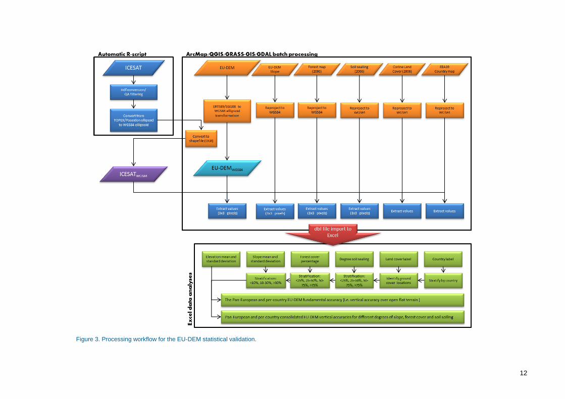
12
Figure 3. Processing workflow for the EU-DEM statistical validation.
13
3 Results
3.1 Fundamental accuracy
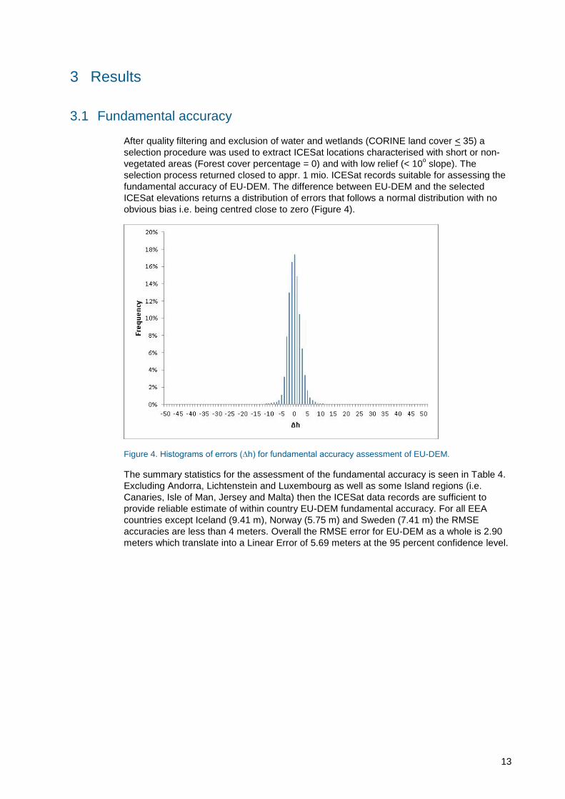
After quality filtering and exclusion of water and wetlands (CORINE land cover < 35) a
selection procedure was used to extract ICESat locations characterised with short or non-
vegetated areas (Forest cover percentage = 0) and with low relief (< 10o slope). The
selection process returned closed to appr. 1 mio. ICESat records suitable for assessing the
fundamental accuracy of EU-DEM. The difference between EU-DEM and the selected
ICESat elevations returns a distribution of errors that follows a normal distribution with no
obvious bias i.e. being centred close to zero (Figure 4).
Figure 4. Histograms of errors (∆h) for fundamental accuracy assessment of EU-DEM.
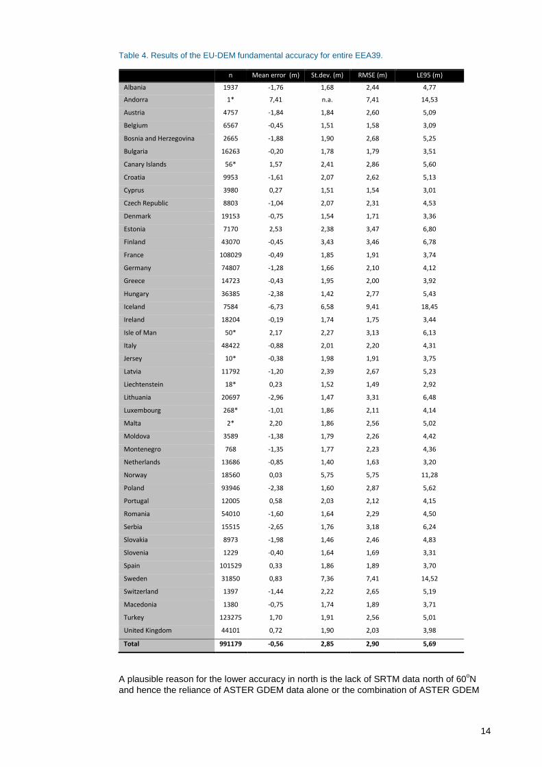
The summary statistics for the assessment of the fundamental accuracy is seen in Table 4.
Excluding Andorra, Lichtenstein and Luxembourg as well as some Island regions (i.e.
Canaries, Isle of Man, Jersey and Malta) then the ICESat data records are sufficient to
provide reliable estimate of within country EU-DEM fundamental accuracy. For all EEA
countries except Iceland (9.41 m), Norway (5.75 m) and Sweden (7.41 m) the RMSE
accuracies are less than 4 meters. Overall the RMSE error for EU-DEM as a whole is 2.90
meters which translate into a Linear Error of 5.69 meters at the 95 percent confidence level.
14
Table 4. Results of the EU-DEM fundamental accuracy for entire EEA39.
n Mean error (m) St.dev. (m) RMSE (m) LE95 (m)
Albania 1937 -1,76 1,68 2,44 4,77
Andorra 1* 7,41 n.a. 7,41 14,53
Austria 4757 -1,84 1,84 2,60 5,09
Belgium 6567 -0,45 1,51 1,58 3,09
Bosnia and Herzegovina 2665 -1,88 1,90 2,68 5,25
Bulgaria 16263 -0,20 1,78 1,79 3,51
Canary Islands 56* 1,57 2,41 2,86 5,60
Croatia 9953 -1,61 2,07 2,62 5,13
Cyprus 3980 0,27 1,51 1,54 3,01
Czech Republic 8803 -1,04 2,07 2,31 4,53
Denmark 19153 -0,75 1,54 1,71 3,36
Estonia 7170 2,53 2,38 3,47 6,80
Finland 43070 -0,45 3,43 3,46 6,78
France 108029 -0,49 1,85 1,91 3,74
Germany 74807 -1,28 1,66 2,10 4,12
Greece 14723 -0,43 1,95 2,00 3,92
Hungary 36385 -2,38 1,42 2,77 5,43
Iceland 7584 -6,73 6,58 9,41 18,45
Ireland 18204 -0,19 1,74 1,75 3,44
Isle of Man 50* 2,17 2,27 3,13 6,13
Italy 48422 -0,88 2,01 2,20 4,31
Jersey 10* -0,38 1,98 1,91 3,75
Latvia 11792 -1,20 2,39 2,67 5,23
Liechtenstein 18* 0,23 1,52 1,49 2,92
Lithuania 20697 -2,96 1,47 3,31 6,48
Luxembourg 268* -1,01 1,86 2,11 4,14
Malta 2* 2,20 1,86 2,56 5,02
Moldova 3589 -1,38 1,79 2,26 4,42
Montenegro 768 -1,35 1,77 2,23 4,36
Netherlands 13686 -0,85 1,40 1,63 3,20
Norway 18560 0,03 5,75 5,75 11,28
Poland 93946 -2,38 1,60 2,87 5,62
Portugal 12005 0,58 2,03 2,12 4,15
Romania 54010 -1,60 1,64 2,29 4,50
Serbia 15515 -2,65 1,76 3,18 6,24
Slovakia 8973 -1,98 1,46 2,46 4,83
Slovenia 1229 -0,40 1,64 1,69 3,31
Spain 101529 0,33 1,86 1,89 3,70
Sweden 31850 0,83 7,36 7,41 14,52
Switzerland 1397 -1,44 2,22 2,65 5,19
Macedonia 1380 -0,75 1,74 1,89 3,71
Turkey 123275 1,70 1,91 2,56 5,01
United Kingdom 44101 0,72 1,90 2,03 3,98
Total 991179 -0,56 2,85 2,90 5,69
A plausible reason for the lower accuracy in north is the lack of SRTM data north of 60oN
and hence the reliance of ASTER GDEM data alone or the combination of ASTER GDEM

15
and Russian topographic maps. Accordingly, the EU-DEM fundamental accuracy was
further investigated for latitudes north and south of 60oN respectively.
3.1.1 Latitudes south of 60oN
The approximately 900.000 ICESat records available for the region south of 60oN follow a
normal distribution centred close to zero (cf. Figure 5).
Figure 5. Histograms of errors (∆h) for fundamental accuracy at locations south of 60oN.
The summary statistics for the assessment of the fundamental accuracy for latitudes south
of 60oN is seen in in Table 5. Excluding Andorra, Lichtenstein and Luxembourg, Finland as
well as some Island regions (i.e. Canaries, Isle of Man, Jersey and Malta) then the ICESat
data records are sufficient to provide reliable estimate of within country EU-DEM
fundamental accuracy for the region south of 60oN. RMSE accuracies vary from a low of
1.39 meters in Cyprus to a maximum of 3.25 in Lithuania. Overall the RMSE error for EU-
DEM south of 60oN is 2.23 meters which translate into a Linear Error of 4.37 meters at the
95 percent confidence level.

16
Table 5. Results of the EU-DEM fundamental accuracy for locations south of 60oN.
n Mean error (m) St.dev. (m) RMSE (m) LE95 (m)
Albania 1926 -1,72 1,58 2,34 4,58
Austria 4704 -1,79 1,68 2,45 4,81
Belgium 6553 -0,45 1,46 1,52 2,99
Bosnia and Herzegovina 2635 -1,80 1,73 2,49 4,89
Bulgaria 16212 -0,19 1,71 1,72 3,37
Canary Islands 55* 1,77 1,92 2,60 5,09
Croatia 9842 -1,62 1,74 2,38 4,67
Cyprus 3960 0,28 1,36 1,39 2,72
Czech Republic 8734 -0,98 1,73 1,99 3,90
Denmark 19109 -0,74 1,48 1,66 3,25
Estonia 6848 2,18 1,65 2,73 5,35
Finland 23* 3,33 2,72 4,27 8,36
France 107550 -0,49 1,75 1,82 3,56
Germany 74524 -1,27 1,54 2,00 3,91
Greece 14631 -0,39 1,80 1,85 3,62
Hungary 36273 -2,37 1,35 2,72 5,33
Ireland 18137 -0,20 1,64 1,65 3,23
Isle of Man 50* 2,17 2,27 3,13 6,13
Italy 48153 -0,86 1,90 2,09 4,09
Jersey 10* -0,38 1,98 1,91 3,75
Latvia 11615 -1,33 2,02 2,42 4,74
Liechtenstein 18* 0,23 1,52 1,49 2,92
Lithuania 20577 -2,96 1,34 3,25 6,36
Luxembourg 267* -0,98 1,79 2,03 3,99
Malta 2* 2,20 1,86 2,56 5,02
Moldova 3571 -1,35 1,66 2,14 4,20
Montenegro 757 -1,24 1,52 1,96 3,85
Netherlands 13649 -0,83 1,32 1,56 3,05
Norway 1719 0,82 2,50 2,63 5,16
Poland 93576 -2,38 1,51 2,82 5,52
Portugal 11891 0,52 1,83 1,90 3,73
Romania 53737 -1,58 1,54 2,20 4,32
Serbia 15476 -2,64 1,70 3,14 6,16
Slovakia 8926 -1,96 1,36 2,38 4,67
Slovenia 1220 -0,39 1,47 1,52 2,97
Spain 101007 0,33 1,74 1,77 3,47
Sweden 13463 1,09 2,54 2,76 5,41
Switzerland 1376 -1,39 2,00 2,43 4,76
Macedonia 1368 -0,69 1,58 1,73 3,39
Turkey 122332 1,67 1,78 2,44 4,79
United Kingdom 43771 0,71 1,75 1,89 3,70
Total 900247 -0,56 2,16 2,23 4,37
17
3.1.2 Latitudes north of 60oN
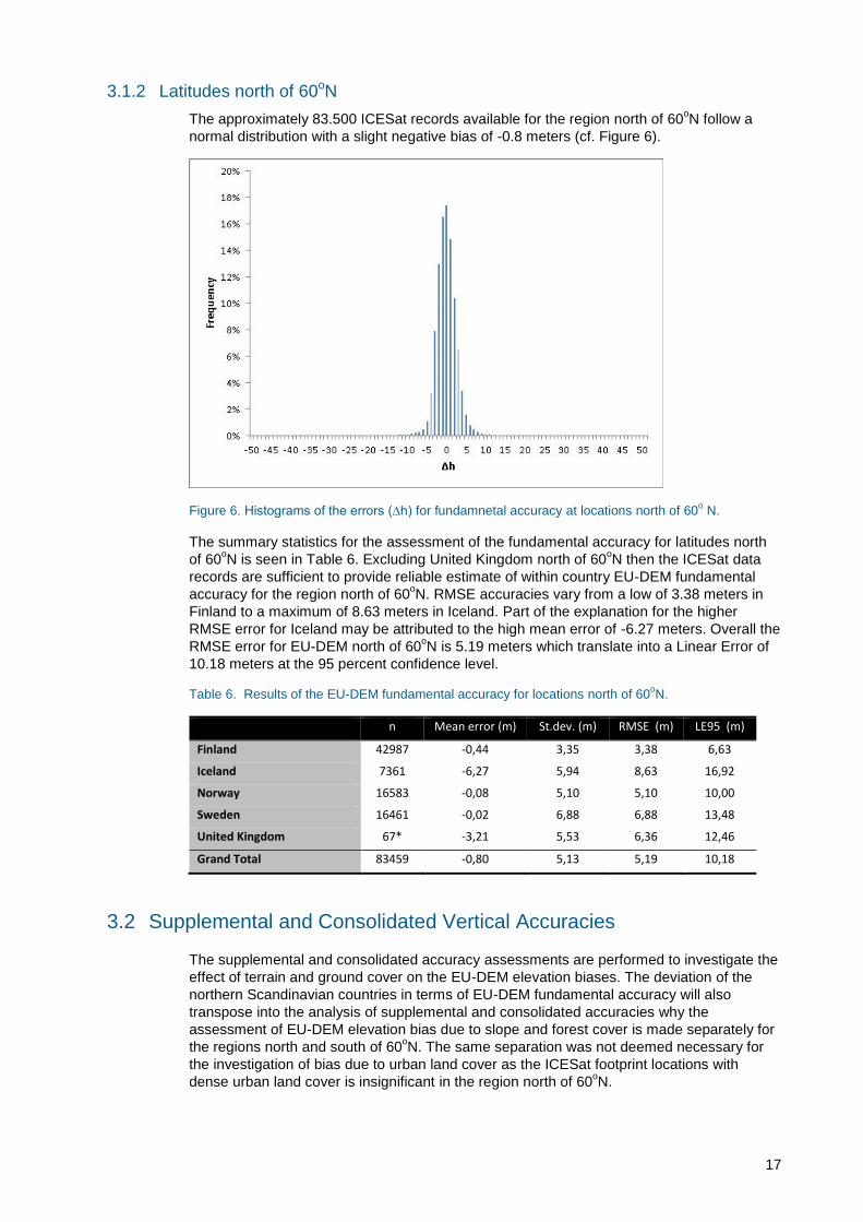
The approximately 83.500 ICESat records available for the region north of 60oN follow a
normal distribution with a slight negative bias of -0.8 meters (cf. Figure 6).
Figure 6. Histograms of the errors (∆h) for fundamnetal accuracy at locations north of 60o N.
The summary statistics for the assessment of the fundamental accuracy for latitudes north
of 60oN is seen in Table 6. Excluding United Kingdom north of 60
oN then the ICESat data
records are sufficient to provide reliable estimate of within country EU-DEM fundamental
accuracy for the region north of 60oN. RMSE accuracies vary from a low of 3.38 meters in
Finland to a maximum of 8.63 meters in Iceland. Part of the explanation for the higher
RMSE error for Iceland may be attributed to the high mean error of -6.27 meters. Overall the
RMSE error for EU-DEM north of 60oN is 5.19 meters which translate into a Linear Error of
10.18 meters at the 95 percent confidence level.
Table 6. Results of the EU-DEM fundamental accuracy for locations north of 60oN.
n Mean error (m) St.dev. (m) RMSE (m) LE95 (m)
Finland 42987 -0,44 3,35 3,38 6,63
Iceland 7361 -6,27 5,94 8,63 16,92
Norway 16583 -0,08 5,10 5,10 10,00
Sweden 16461 -0,02 6,88 6,88 13,48
United Kingdom 67* -3,21 5,53 6,36 12,46
Grand Total 83459 -0,80 5,13 5,19 10,18
3.2 Supplemental and Consolidated Vertical Accuracies
The supplemental and consolidated accuracy assessments are performed to investigate the
effect of terrain and ground cover on the EU-DEM elevation biases. The deviation of the
northern Scandinavian countries in terms of EU-DEM fundamental accuracy will also
transpose into the analysis of supplemental and consolidated accuracies why the
assessment of EU-DEM elevation bias due to slope and forest cover is made separately for
the regions north and south of 60oN. The same separation was not deemed necessary for
the investigation of bias due to urban land cover as the ICESat footprint locations with
dense urban land cover is insignificant in the region north of 60oN.

18
3.2.1 Slope
The results of the investigation of slope on EU-DEM elevation biases are presented below
for the regions south and north of 60oN respectively.
3.2.1.1 Latitudes south of 60oN
After quality filtering and exclusion of water and wetlands (CORINE land cover < 35) a
selection procedure was used to extract non-urban (soil sealing=0) ICESat locations with
short or no vegetation (Forest cover percentage = 0). The selection process returned
around 875.000. ICESat records with the majority located in lowlands (<10%) and only 4.1%
located in moderate terrain and a mere 0.2% located in mountainous terrain (>30%).The
error distribution from the EU-DEM and ICESat elevation difference follows a normal
distribution centred on zero for all three slope categories, but the distributions widen as the
slope categories increases (Figure 7).
Figure 7. Histograms of the errors (∆h) for the assessment of elevation bias due to slope at locations south of 60
oN.
The summary statistics for the vertical accuracy assessment of slope categories is seen in
Table 6, and showing a clear trend towards higher variability and higher errors for the
steeper slope categories.
Table 7. Results of the EU-DEM elevation bias due to slope for locations south of 60oN.
Slope category* n Mean error (m) Std (m) RMSE (m) LE95 (m) Optional RMSE specifications (m)**
Less than 10% 839953 -0,52 2,23 2,29 4,49 1
10-30% 36220 0,19 3,98 3,98 7,80 2,5
Above 30% 1785 0,16 4,35 4,35 8,53 5
Total 877958 -0,49 2,34 2,39 4,69 7
* Mean slope within 3x3 pixel neighbourhood (i.e. 75x75 m) at the latitude and longitude location of each ICESat
footprint
** The tender specifications operated with options for a vertical differentiated accuracy of EU-DEM according to
slope categories.
19
3.2.1.2 Latitudes north of 60oN
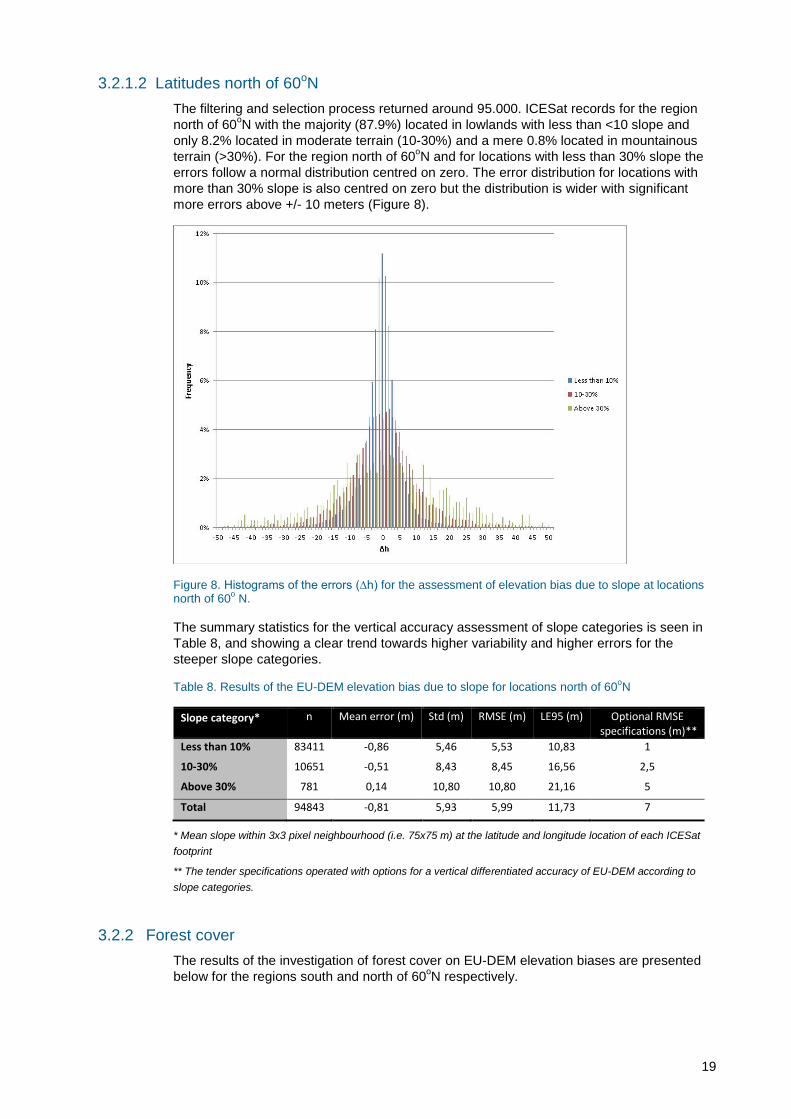
The filtering and selection process returned around 95.000. ICESat records for the region
north of 60oN with the majority (87.9%) located in lowlands with less than <10 slope and
only 8.2% located in moderate terrain (10-30%) and a mere 0.8% located in mountainous
terrain (>30%). For the region north of 60oN and for locations with less than 30% slope the
errors follow a normal distribution centred on zero. The error distribution for locations with
more than 30% slope is also centred on zero but the distribution is wider with significant
more errors above +/- 10 meters (Figure 8).
Figure 8. Histograms of the errors (∆h) for the assessment of elevation bias due to slope at locations north of 60
o N.
The summary statistics for the vertical accuracy assessment of slope categories is seen in
Table 8, and showing a clear trend towards higher variability and higher errors for the
steeper slope categories.
Table 8. Results of the EU-DEM elevation bias due to slope for locations north of 60oN
Slope category* n Mean error (m) Std (m) RMSE (m) LE95 (m) Optional RMSE specifications (m)**
Less than 10% 83411 -0,86 5,46 5,53 10,83 1
10-30% 10651 -0,51 8,43 8,45 16,56 2,5
Above 30% 781 0,14 10,80 10,80 21,16 5
Total 94843 -0,81 5,93 5,99 11,73 7
* Mean slope within 3x3 pixel neighbourhood (i.e. 75x75 m) at the latitude and longitude location of each ICESat
footprint
** The tender specifications operated with options for a vertical differentiated accuracy of EU-DEM according to
slope categories.
3.2.2 Forest cover
The results of the investigation of forest cover on EU-DEM elevation biases are presented
below for the regions south and north of 60oN respectively.
20
3.2.2.1 Latitudes south of 60oN
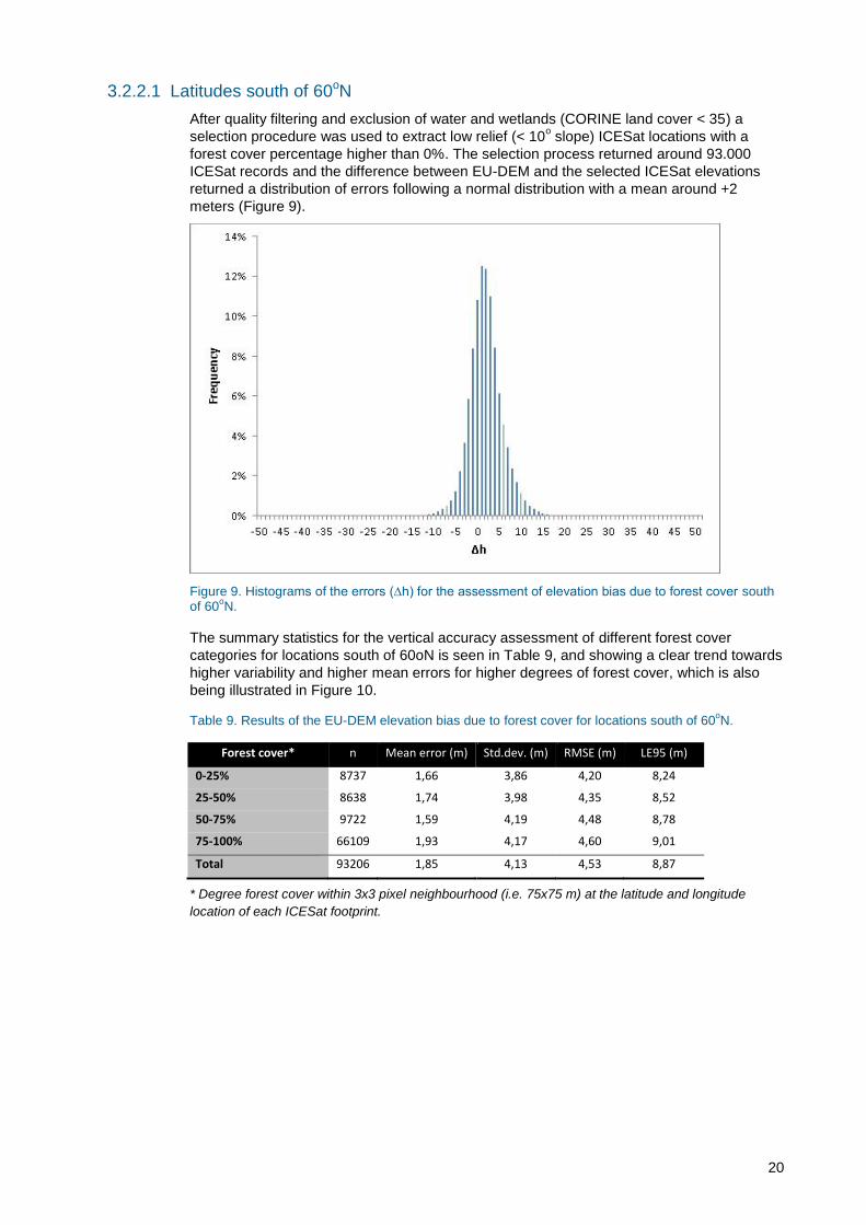
After quality filtering and exclusion of water and wetlands (CORINE land cover < 35) a
selection procedure was used to extract low relief (< 10o slope) ICESat locations with a
forest cover percentage higher than 0%. The selection process returned around 93.000
ICESat records and the difference between EU-DEM and the selected ICESat elevations
returned a distribution of errors following a normal distribution with a mean around +2
meters (Figure 9).
Figure 9. Histograms of the errors (∆h) for the assessment of elevation bias due to forest cover south of 60
oN.
The summary statistics for the vertical accuracy assessment of different forest cover
categories for locations south of 60oN is seen in Table 9, and showing a clear trend towards
higher variability and higher mean errors for higher degrees of forest cover, which is also
being illustrated in Figure 10.
Table 9. Results of the EU-DEM elevation bias due to forest cover for locations south of 60oN.
Forest cover* n Mean error (m) Std.dev. (m) RMSE (m) LE95 (m)
0-25% 8737 1,66 3,86 4,20 8,24
25-50% 8638 1,74 3,98 4,35 8,52
50-75% 9722 1,59 4,19 4,48 8,78
75-100% 66109 1,93 4,17 4,60 9,01
Total 93206 1,85 4,13 4,53 8,87
* Degree forest cover within 3x3 pixel neighbourhood (i.e. 75x75 m) at the latitude and longitude
location of each ICESat footprint.
21
Figure 10. Variability of RMSE relative to forest cover percentages for locations south of 60oN.
3.2.2.2 Latitudes north of 60oN
After quality filtering and exclusion of water and wetlands (CORINE land cover < 35) a
selection procedure was used to extract low relief (< 10o slope) ICESat locations with a
forest cover percentage higher than 0%. The selection process returned around 125.000
ICESat records and the difference between EU-DEM and the selected ICESat elevations
returned a distribution of errors following a normal distribution with a mean around -1.5
meters (Figure 11).
Figure 11. Histograms of the errors (∆h) for the assessment of elevation bias due to forest cover at locations north of 60
oN.
The summary statistics for the vertical accuracy assessment of different forest cover
categories for locations north of 60oN is seen in
Table 10 and showing a clear trend towards higher variability and higher mean errors for the
steeper slope categories, which is being further illustrated in Figure 12.
Table 10. Results of the EU-DEM elevation bias due to forest cover for locations north of 60oN.
Forest cover* n Mean error (m) Std.dev. (m) RMSE (m) LE95 (m)
0-25% 12299 -0,73 5,43 5,48 10,74
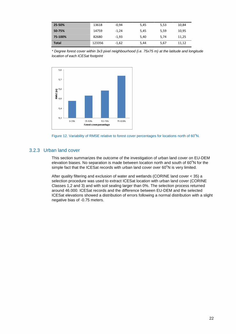
22
25-50% 13618 -0,94 5,45 5,53 10,84
50-75% 14759 -1,24 5,45 5,59 10,95
75-100% 82680 -1,93 5,40 5,74 11,25
Total 123356 -1,62 5,44 5,67 11,12
* Degree forest cover within 3x3 pixel neighbourhood (i.e. 75x75 m) at the latitude and longitude
location of each ICESat footprint
Figure 12. Variability of RMSE relative to forest cover percentages for locations north of 60oN.
3.2.3 Urban land cover
This section summarizes the outcome of the investigation of urban land cover on EU-DEM
elevation biases. No separation is made between location north and south of 60oN for the
simple fact that the ICESat records with urban land cover over 60oN is very limited.
After quality filtering and exclusion of water and wetlands (CORINE land cover < 35) a
selection procedure was used to extract ICESat location with urban land cover (CORINE
Classes 1,2 and 3) and with soil sealing larger than 0%. The selection process returned
around 46.000. ICESat records and the difference between EU-DEM and the selected
ICESat elevations showed a distribution of errors following a normal distribution with a slight
negative bias of -0.75 meters.
23
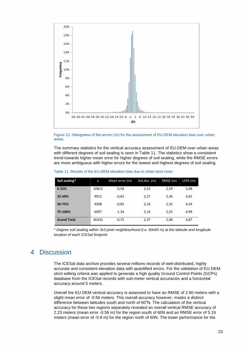
Figure 13. Histograms of the errors (∆h) for the assessment of EU-DEM elevation bias over urban areas.
The summary statistics for the vertical accuracy assessment of EU-DEM over urban areas
with different degrees of soil sealing is seen in Table 11. The statistics show a consistent
trend towards higher mean error for higher degrees of soil sealing, while the RMSE errors
are more ambiguous with higher errors for the lowest and highest degrees of soil sealing.
Table 11. Results of the EU-DEM elevation bias due to urban land cover.
Soil sealing* n Mean error (m) Std.dev. (m) RMSE (m) LE95 (m)
0-25% 20815 -0,58 2,53 2,59 5,08
25-50% 9912 -0,63 2,27 2,36 4,62
50-75% 9508 -0,85 2,16 2,32 4,54
75-100% 6097 -1,34 2,16 2,55 4,99
Grand Total 46332 -0,75 2,37 2,48 4,87
* Degree soil sealing within 3x3 pixel neighbourhood (i.e. 60x60 m) at the latitude and longitude
location of each ICESat footprint
4 Discussion
The ICESat data archive provides several millions records of well-distributed, highly
accurate and consistent elevation data with quantified errors. For the validation of EU-DEM
strict editing criteria was applied to generate a high quality Ground Control Points (GCPs)
database from the ICESat records with sub-meter vertical accuracies and a horizontal
accuracy around 5 meters.
Overall the EU-DEM vertical accuracy is assessed to have an RMSE of 2.90 meters with a
slight mean error of -0.56 meters. This overall accuracy however, masks a distinct
difference between latitudes south and north of 60oN. The calculation of the vertical
accuracy for these two regions separately revealed an overall vertical RMSE accuracy of
2.23 meters (mean error -0.56 m) for the region south of 60N and an RMSE error of 5.19
meters (mean error of -0.8 m) for the region north of 60N. The lower performance for the
24
region north of 60N can be explained by the lack of SRTM data and hence the heavier
reliance on ASTER GDEM and Russian topographic maps. This observation is underpinned
by the difference in EU-DEM accuracies for the regions in Norway and Sweden which
resides south and north of 60oN respectively. The RMSE error for locations south of 60N in
Sweden is 2.76 m compared to 6.88 m for regions north of 60N. Similar in Norway the
RMSE error for locations south of 60N is an estimated 2.63 m compared to 5.10 m for the
region north of 60N.
When looking into the potential elevation biases caused by relief and ground cover
categories it is observed that that EU-DEM becomes a less reliable measure of ground
topography as the terrain slope becomes steeper and the density of the tree cover
increases.
When comparing height differences between EU-DEM and ICESat versus slope categories
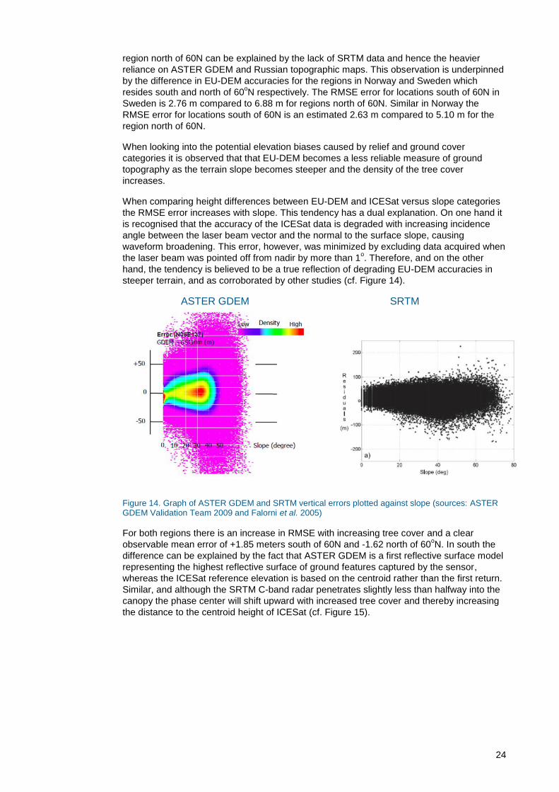
the RMSE error increases with slope. This tendency has a dual explanation. On one hand it
is recognised that the accuracy of the ICESat data is degraded with increasing incidence
angle between the laser beam vector and the normal to the surface slope, causing
waveform broadening. This error, however, was minimized by excluding data acquired when
the laser beam was pointed off from nadir by more than 1o. Therefore, and on the other
hand, the tendency is believed to be a true reflection of degrading EU-DEM accuracies in
steeper terrain, and as corroborated by other studies (cf. Figure 14).
ASTER GDEM SRTM
Figure 14. Graph of ASTER GDEM and SRTM vertical errors plotted against slope (sources: ASTER GDEM Validation Team 2009 and Falorni et al. 2005)
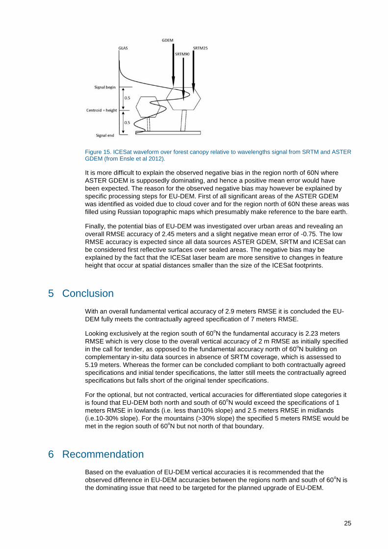
For both regions there is an increase in RMSE with increasing tree cover and a clear
observable mean error of +1.85 meters south of 60N and -1.62 north of 60oN. In south the
difference can be explained by the fact that ASTER GDEM is a first reflective surface model
representing the highest reflective surface of ground features captured by the sensor,
whereas the ICESat reference elevation is based on the centroid rather than the first return.
Similar, and although the SRTM C-band radar penetrates slightly less than halfway into the
canopy the phase center will shift upward with increased tree cover and thereby increasing
the distance to the centroid height of ICESat (cf. Figure 15).
25
Figure 15. ICESat waveform over forest canopy relative to wavelengths signal from SRTM and ASTER GDEM (from Ensle et al 2012).
It is more difficult to explain the observed negative bias in the region north of 60N where
ASTER GDEM is supposedly dominating, and hence a positive mean error would have
been expected. The reason for the observed negative bias may however be explained by
specific processing steps for EU-DEM. First of all significant areas of the ASTER GDEM
was identified as voided due to cloud cover and for the region north of 60N these areas was
filled using Russian topographic maps which presumably make reference to the bare earth.
Finally, the potential bias of EU-DEM was investigated over urban areas and revealing an
overall RMSE accuracy of 2.45 meters and a slight negative mean error of -0.75. The low
RMSE accuracy is expected since all data sources ASTER GDEM, SRTM and ICESat can
be considered first reflective surfaces over sealed areas. The negative bias may be
explained by the fact that the ICESat laser beam are more sensitive to changes in feature
height that occur at spatial distances smaller than the size of the ICESat footprints.
5 Conclusion
With an overall fundamental vertical accuracy of 2.9 meters RMSE it is concluded the EU-
DEM fully meets the contractually agreed specification of 7 meters RMSE.
Looking exclusively at the region south of 60oN the fundamental accuracy is 2.23 meters
RMSE which is very close to the overall vertical accuracy of 2 m RMSE as initially specified
in the call for tender, as opposed to the fundamental accuracy north of 60oN building on
complementary in-situ data sources in absence of SRTM coverage, which is assessed to
5.19 meters. Whereas the former can be concluded compliant to both contractually agreed
specifications and initial tender specifications, the latter still meets the contractually agreed
specifications but falls short of the original tender specifications.
For the optional, but not contracted, vertical accuracies for differentiated slope categories it
is found that EU-DEM both north and south of 60oN would exceed the specifications of 1
meters RMSE in lowlands (i.e. less than10% slope) and 2.5 meters RMSE in midlands
(i.e.10-30% slope). For the mountains (>30% slope) the specified 5 meters RMSE would be
met in the region south of 60oN but not north of that boundary.
6 Recommendation
Based on the evaluation of EU-DEM vertical accuracies it is recommended that the
observed difference in EU-DEM accuracies between the regions north and south of 60oN is
the dominating issue that need to be targeted for the planned upgrade of EU-DEM.
26
7 References
ASTER GDEM Validation Team (2009): ASTER Global DEM Validation, Summary Report.
Downloaded from
https://lpdaac.usgs.gov/sites/default/files/public/aster/docs/ASTER_GDEM_Validation_Summary_Rep
ort.pdf
Carabajal, C. C., & Harding, D. J. (2005). ICESat validation of SRTM C‐band digital elevation models.
Geophysical Research Letters, 32(22).
Carabajal, C. C. (2011) Aster Global DEM version 2.0 evaluation using ICESat geodetic ground control. http://www.jspacesystems.or.jp/ersdac/GDEM/ver2Validation/Appendix_D_ICESat_GDEM2_validation_report.pdf
Congalton, R.G. & Green, K. (2009) Assessing the accuracy of remotely sensed data – principles and practices, 2nd edn. CRC: Lewis Publishers
Ensle, F., Heinzel, J., and Koch, B. (2012) Evaluating Height Differences between global digital surface models and ICESat heights at footprint geolocation. In GIS Ostrava 2012 Surface models for geosciences (eds. Ruzika J., Ruzickova K.). Ninth International Symposium Ostrava, Czech Republic, Proceedings. Technical University of Ostrava.
Falorni, G., Teles, V., Vivoni, E. R., Bras, R. L., & Amaratunga, K. S. (2005). Analysis and characterization of the vertical accuracy of digital elevation models from the Shuttle Radar Topography Mission. Journal of Geophysical Research: Earth Surface (2003–2012), 110(F2).
National Digital Elevation Program – NDEP (2004) Guidelines for Digital Elevation Data. Version 1.0. downloaded from http://www.ndep.gov
Schutz, B. E., Zwally, H. J., Shuman, C. A., Hancock, D., & DiMarzio, J. P. (2005). Overview of the ICESat mission. Geophysical Research Letters, 32(21).
Zwally, H. J., Schutz, B., Abdalati, W., Abshire, J., Bentley, C., Brenner, A., ... & Thomas, R. (2002). ICESat's laser measurements of polar ice, atmosphere, ocean, and land. Journal of Geodynamics, 34(3), 405-445.

27
APPENDIX: Specifications of the EU-DEM
The EU-DEM was requested to be produced according to a set of mandatory and optional
requirements (cf. Table A.1).
Table A.1. EU-DEM mandatory and optional requirements (from CALL FOR TENDERS No ENTR/2009/27 - Implementation of an Initial GMES Service for Geospatial Reference Data Access)
Mandatory requirements Optional requirements
Coverage EU27
Extended coverage of EEA38, EEA38 + international river basin districts according to the requirements as set out by the Water Framework Directive, or full wall to wall pan-European coverage
Consistency / homogeneity
Cross border consistency (countries, different data sources etc…)
Consistency both with the geometry of the hydrographical pattern and Consistency with the hydrological modelling of (continuity of water flow)
Water surfaces burnt in the DEM
Resolutions Horizontal: 1 arcsec (+/-30 m) posting (consistent with 1:100.000 scale for other (topographic) data themes);
Vertical units: integer meters
Minimum variation in Z between 2 adjacent posting values should be properly described in DEM values according to following differentiation:
• lowland plains: 2m (<10% slopes) ;
• midlands: 5m (10 – 30 % slopes);
• mountains: 10m (> 30% slopes).
Accuracies Horizontal: better than 5 m
Vertical: overall accuracy of 2 m RMSE
Vertical differentiated accuracies, corresponding with the differential resolution categories:
• lowlands: 1 m absolute RMSE;
• midlands: 2,5 m absolute RMSE;
• mountains: 5 m absolute RMSE
Projections WGS84, ETRS 89 and EVRF2000; geographic coordinates (Lat/Long)
the INSPIRE compliant European projection systems(LCC, LAEA, UTM) - national projections/datums
Table A.1 represent the EU-DEM specifications as set out in the Tender but the final offer
for EU-DEM was accepted with the following specifications (A.2).
Table A.2. Summary of EU-DEM specifications as accepted in response to tender*.
Product Coverage Data Sources Resolution Vertical
Accuracy
Access
EU-
DEM EEA38
SRTM & ASTER GDEM
(+ topomaps north of 60oN)
1 arc-second
(~30 m) +/- 7.0 m RMSE
Unrestrict
ed
* Directly taken from Table 2-1 in Technical proposal by Indra. Information in brackets has been added by DHI
GRAS