Embed Size (px)
Citation preview

REPORT DOCUMENTATION PAGE
OMB No. 0704-0188
Public reporting burden for this collection of information estimated to average 1 hour per response, including the time for reviewing instructions. Send comments regarding this burden estimate or any other aspects of this collection information including suggestions for reducing this burden to Washington Headquarters Services, Directorate for Information Operations and Reports, 1215 Jefferson Davis Highway, Suite 1204, Arlington, VA 22202-4302 and to the Office of Management and Budget Paperwork Reduction Project (0704-0188), Washington DC 20503 1. AGENCY USE ONLY (LEAVE BLANK)
2. REPORT DATE June 2001
3. REPORT TYPE AND DATES COVERED Final Report
4. TITLE AND SUBTITLE RCRA Facility Investigation, Former Main Post Landfill No. 3, WSMR-61, (SWMU 65)
5. FUNDING NUMBERS
6. AUTHOR(S) Margaret Dubbin, EIT, Environmental Engineer/Task Coordinator 7. PERFORMING ORGANIZATION NAME(S) AND ADDRESS(ES) MEVATEC Corporation Box 399 WSMR, NM 88002
8. PERFORMING ORGANIZATION REPORT NUMBER 700A23/01/001F
9. SPONSORING/MONITORING AGENCY NAME(S) AND ADDRESS(ES) U.S. Army White Sands Missile Range WS-ES-EC Attn: Ms Robin Paul, Technical Inspector
10. SPONSORING/MONITORING AGENCY REPORT NUMBER WS-ES-EC-0108
11. SUPPLEMENTARY NOTES 12a. DISTRIBUTION AVAILABILITY STATEMENT
12b. DISTRIBUTION CODE
13. ABSTRACT (MAXIMUM 200 WORDS) This document contains findings from historical research, non-intrusive natural and cultural resource surveys, previous site investigations, and groundwater monitoring analysis at the former Main Post Landfill No. 3. 14. SUBJECT TERMS Main Post Landfill No. 3, Former Scrap Yard Landfill, SWMU#65, DSERTS-61, RFI, site investigation
15. NUMBER OF PAGES
38 16. PRICE CODE
17. SECURITY CLASSIFICATION OF REPORT Unclassified
18. SECURITY CLASSIFICATION OF THIS PAGE Unclassified
19. SECURITY CLASSIFICATION OF ABSTRACT Unclassified
20. LIMITATION OF ABSTRACT
NSN 7540-01-280-5500 STANDARD FORM 298 (2-89) PREPARED BY ANSI Std 239-8 299-102
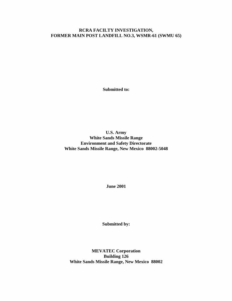
RCRA FACILTY INVESTIGATION, FORMER MAIN POST LANDFILL NO.3, WSMR-61 (SWMU 65)
Submitted to:
U.S. Army White Sands Missile Range
Environment and Safety Directorate White Sands Missile Range, New Mexico 88002-5048
June 2001
Submitted by:
MEVATEC Corporation Building 126
White Sands Missile Range, New Mexico 88002

RCRA Facility Investigation, Former Main Post Landfill No. 3, WSMR-61 (SWMU 65)
ii
EXECUTIVE SUMMARY The Former Main Post Landfill No. 3 (MPLF#3), identified as Solid Waste Management Unit (SWMU) #65 in the Resource Conservation and Recovery Act (RCRA) Part B Permit Corrective Action Module VIII, is located in the southeast portion of the White Sands Missile Range (White Sands) Main Post area. MPLF#3 has also been identified as WSMR-61 under the Defense Site Environmental Restoration Tracking System (DSERTS). Described as a trench type sanitary landfill where only inert materials were disposed, MPLF#3 was reported to have been in operation from 1965 through 1982. Landfill operations ceased, prior to the implementation of RCRA, due to the proximity of the landfill to the shallow freshwater aquifer utilized as potable drinking water by the Main Post area. Also formerly located over a small portion of this site was the Scrap Metal Accumulation Point, as shown in Figure 1-3. This document has been developed to support a petition for no further action with the New Mexico Environment Department and to serve as a 5-year U.S. Army Installation Restoration Plan (IRP) Review document. Activities included in developing this document consisted of research of previous investigations, historical groundwater monitoring results, background site information, and natural and cultural resource surveys conducted at this site. Historical groundwater monitoring results have indicated that MPLF#3 has not impacted the fresh water aquifer. No concentrations of VOCs, fuel hydrocarbons, metals, or explosives have been detected above reporting limits in the samples collected from the monitoring wells at MPLF#3.

RCRA Facility Investigation, Former Main Post Landfill No. 3, WSMR-61 (SWMU 65)
iii
TABLE OF CONTENTS Section Page EXECUTIVE SUMMARY............................................................................................................. ii LIST OF ACRONYMS .................................................................................................................. v 1.0 INTRODUCTION............................................................................................................... 1
1.1 White Sands Missile Range – Background ............................................................. 2 1.1.1 Location and Background ........................................................................... 2 1.1.2 Regional Geology........................................................................................ 2 1.1.3 Regional Hydrology .................................................................................... 3
1.1.3.1 Climatology .................................................................................. 3 1.1.3.2 Surface Water ............................................................................... 3 1.1.3.3 Groundwater ................................................................................ 4
1.1.4 Site Specific Geology and Hydrogeologic Conditions ............................... 4 1.2 Regulatory Requirements ........................................................................................ 6 1.3 Other Regulatory Issues .......................................................................................... 6
2.0 SITE BACKGROUND ....................................................................................................... 6
2.1 Site Description and History ................................................................................... 6 2.2 Previous Investigations ........................................................................................... 6
2.2.1 RCRA Facility Assessment ......................................................................... 6 2.2.2 Phase I RFI .................................................................................................. 7 2.2.3 Phase II RFI ............................................................................................... 11 2.2.4 Groundwater Quality Investigation Report ............................................... 11
3.0 CONTINUED SITE INVESTIGATION .......................................................................... 28
3.1 Archeological Survey ............................................................................................ 28 3.2 Groundwater Monitoring ...................................................................................... 29
4.0 SUMMARY, CONCLUSIONS, AND RECOMMENDATIONS .................................... 32 REFERENCES ............................................................................................................................. 38
List of Figures Figure 1-1. White Sands Missile Range, New Mexico. .................................................................. 1 Figure 1-2. Generalized East-West Cross Section Across the Southern Part of the Tularosa
Basin, North Of Highway 70, White Sands Missile Range ......................................... 3 Figure 1-3. Former Main Post Landfill No. 3 Site Map................................................................. 5 Figure 2-1. SWMU 65 Phase I RFI Monitoring Well (MW-04) Location Map. ........................... 8 Figure 2-2. SWMU 65 Phase I RFI monument Location Map. ..................................................... 9 Figure 2-3. SWMU 65 Phase I RFI monitoring Well (MW-05) Location Map. ......................... 10 Figure 2-4. SWMU 65 Phase II RFI Soil Sample Location Map................................................. 12

RCRA Facility Investigation, Former Main Post Landfill No. 3, WSMR-61 (SWMU 65)
iv
TABLE OF CONTENTS (concluded)
Section Page List of Tables Table 1-1. Location and Well Construction Data – Former Main Post Landfill No. 3. ................ 4 Table 2-1. Groundwater Analytical Results SWMU 65 RCRA Facility Investigation (RFI) ........ 7 Table 2-2. Drilling Mud and Cuttings Analytical Results SWMU 65 RCRA Facility .................. 7 Table 2-3. WSMR Phase-II RFI SWMU 65 Soil Analysis Detected Volatiles. .......................... 13 Table 3-4. WSMR Phase-II RFI SWMU 65 Soil Analysis Detected Semi-Volatiles .................. 17 Table 2-5. WSMR Phase-II RFI SWMU 65 Soil Analysis Detected Metals. .............................. 24 Table 2-6. WSMR Phase-II RFI SWMU 65 Groundwater Analysis Detected Volatiles ............. 26 Table 2-7. WSMR Phase-II RFI SWMU 65 Groundwater Analysis Detected Metals. ............... 27 Table 2-8. Groundwater Analytical Data Main Post Former Landfill #3. ................................... 28 Table 2-9. Fall 1996 Results of Groundwater Analsis SWMU 65 Former
Main Post Lanfill No.3………………………………………………………….. 31 Table 2-10. Fall 1997 Groundwater Sampling Analytical Results -
Main Post Landfill No. 3 at (Scrap Yard)………………………………………….32 Table 2-11. January, Spring 1998 (2nd Quarter) Groundwater Sampling Analytical Results -
Main Post Landfill No. 3 at (Scrap Yard)………………………………………….33 Table 2-12. Analytical Results of the Fall 1998 Sampling Event,
Former Main Post Landfill No. 3………………………………………………….34 Table 2-13. Analytical Results of the Spring 1999 Sampling Event,
Former Main Post Landfill No. 3. …………………………………………………35 Table 2-14. Analytical Results of the Spring 2000 Sampling Event,
Former Main Post Landfill No. 3…………………………………………………..37 Table 2-15. Analytical Results of the Fall 2000 Sampling Event,
Former Main Post Landfill No. 3………………………………………………. .38
RCRA Facility Investigation, Former Main Post Landfill No. 3, WSMR-61 (SWMU 65)
v
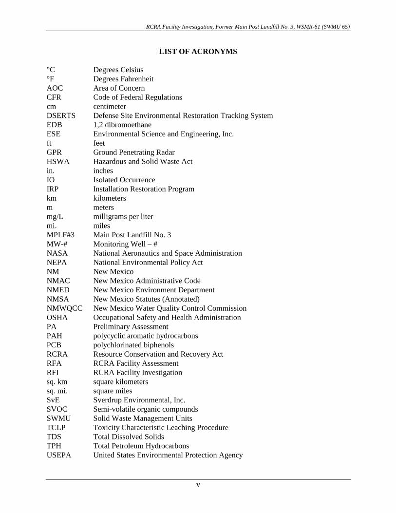
LIST OF ACRONYMS °C Degrees Celsius °F Degrees Fahrenheit AOC Area of Concern CFR Code of Federal Regulations cm centimeter DSERTS Defense Site Environmental Restoration Tracking System EDB 1,2 dibromoethane ESE Environmental Science and Engineering, Inc. ft feet GPR Ground Penetrating Radar HSWA Hazardous and Solid Waste Act in. inches IO Isolated Occurrence IRP Installation Restoration Program km kilometers m meters mg/L milligrams per liter mi. miles MPLF#3 Main Post Landfill No. 3 MW-# Monitoring Well – # NASA National Aeronautics and Space Administration NEPA National Environmental Policy Act NM New Mexico NMAC New Mexico Administrative Code NMED New Mexico Environment Department NMSA New Mexico Statutes (Annotated) NMWQCC New Mexico Water Quality Control Commission OSHA Occupational Safety and Health Administration PA Preliminary Assessment PAH polycyclic aromatic hydrocarbons PCB polychlorinated biphenols RCRA Resource Conservation and Recovery Act RFA RCRA Facility Assessment RFI RCRA Facility Investigation sq. km square kilometers sq. mi. square miles SvE Sverdrup Environmental, Inc. SVOC Semi-volatile organic compounds SWMU Solid Waste Management Units TCLP Toxicity Characteristic Leaching Procedure TDS Total Dissolved Solids TPH Total Petroleum Hydrocarbons USEPA United States Environmental Protection Agency
RCRA Facility Investigation, Former Main Post Landfill No. 3, WSMR-61 (SWMU 65)
vi
LIST OF ACRONYMS (concluded)
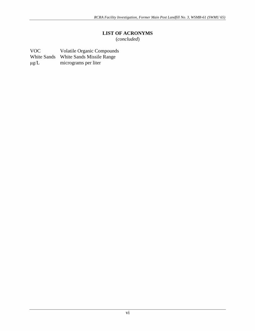
VOC Volatile Organic Compounds White Sands White Sands Missile Range μg/L micrograms per liter

RCRA Facility Investigation, Former Main Post Landfill No. 3, WSMR-61 (SWMU 65)
1
RCRA FACILTY INVESTIGATION, FORMER MAIN POST LANDFILL NO.3, WSMR-61 (SWMU#65)
1.0 INTRODUCTION In operation for seventeen years, from 1965 to 1982, the Main Post Landfill No. 3 (MPLF#3) functioned as a inert sanitary materials receiving landfill located in the southeast portion of the White Sands Missile Range (White Sands) Main Post area (see Figure 1-1). MPLF#3 has been identified as Solid Waste Management Unit (SWMU) #65 under the Resource Conservation and Recovery Act (RCRA) Part B Permit Corrective Action Module VIII and as WSMR-61 under the Defense Site Environmental Restoration Tracking System (DSERTS). The former Scrap Metal Accumulation Point was also located over a small portion of MPLF#3, as indicated in Figure 1-3.
MAIN POST LANDFILLNO. 3 (SCRAP YARD)
LEGEND
Figure 1-1. White Sands Missile Range, New Mexico.

RCRA Facility Investigation, Former Main Post Landfill No. 3, WSMR-61 (SWMU 65)
2
Contained in the following text are summaries of findings from previous site investigations, historical groundwater monitoring, and natural and cultural resource surveys that support a petition for no further action with the regulatory authority. This document has also been developed to serve as the five year U.S. Army Installation Restoration Program (IRP) review document for MPLF#3. 1.1 White Sands Missile Range – Background 1.1.1 Location and Background Originally established 9 July 1945 as White Sands Proving Ground, and later renamed White Sands Missile Range in 1958, the installation is situated within the Tularosa Basin; with areas along the western and northwestern boundary extending into the Jornada del Muerto Basin. The Range is located in the Dona Ana, Socorro, Lincoln, Otero, and Sierra Counties, New Mexico (NM). The Main Post area of White Sands is located at the southwestern corner of the installation, approximately 43 kilometers (km [27 miles (mi.)]) east-northeast of Las Cruces, NM. White Sands headquarters and most installation support activities are located at the Main Post area. White Sands Missile Range is the largest land-area military installation in the United States, comprised of nearly 5,631 Square Kilometers (sq. km [3,200 Square Miles (sq. mi.)]). The installation is approximately 159-km (99 mi.) long and 40 to 64-km (25 to 40 mi.) wide. The New Mexico desert was selected to be the nation’s testing range for several reasons: the desert is sparsely populated, has almost year-round clear weather and unlimited visibility, and as such, affords relatively easy recovery of spent missiles. The Range now functions as an outdoor laboratory consisting of a large complex of test ranges, launch sites, impact areas and instrumentation sites required to develop and test tactical and strategic weapons and weapons systems. White Sands is designated as a national range whose mission is the support of missile development and test programs for the Army, Navy, Air Force, National Aeronautics and Space Administration (NASA) and other government agencies. 1.1.2 Regional Geology White Sands Missile Range lies within the Mexican Highland Section of the Basin and Range Province, characterized by a series of tilted fault blocks forming longitudinal, asymmetric ridges or mountains and broad intervening basins (Figure 1-2). The major portion of the Range lies within the Tularosa Basin, bound on the west by the Organ, San Augustin, and San Andres Mountains. The eastern limit of the Tularosa Basin lies outside of the Range, and is formed from north to south by the Jicarilla, Sierra Blanca, and Sacramento Mountains (not shown on Figure 1-2). The Tularosa Basin contains thick sequences of Tertiary and Quaternary age alluvial and bolson fill deposits. These sediments, more than 1,524 meters (m [5,000 feet (ft)]) thick in some areas, consist mainly of silt, sand, gypsum, and clay weathered from the surrounding mountain ranges. The average elevation of the basin floor is 1,219-m (4,000-ft) above mean sea level and surface features consist of flat sandy areas, sand dunes, basalt flows, and playas (dry lakebeds). The average elevation of the mountain ranges from 1,737-m (5,700-ft) at San Augustine Pass to more than 2,743-m (9,000-ft) at Salinas Peak, the highest elevation at White Sands.

RCRA Facility Investigation, Former Main Post Landfill No. 3, WSMR-61 (SWMU 65)
3
EastWest
Figure 1-2. Generalized East-West Cross Section Across the Southern Part of the Tularosa Basin, North Of Highway 70, White Sands Missile Range
The nature of the bolson-fill deposits varies both laterally and vertically throughout the Main Post Area. Coarse-grained, poorly sorted sediments deposited near mountain fronts grade into fine-grained, well-sorted sediments toward the center of the basin (Kelly, 1973). Sediments further from the mountains also contain a greater percentage of clay and gypsum. Vertically, the sediments are reported to become finer-grained and more consolidated until reaching a laterally continuous clay unit at about 304.8-m (1,000-ft) below ground surface (Kelly and Hearne, 1976). 1.1.3 Regional Hydrology 1.1.3.1 Climatology The elevation of White Sands Main Post is approximately 1,219-m (4,000-ft) above mean sea level. Snowfall is infrequent, although heavy snows have occurred. With an average annual rainfall of only 27.4-cm (10.8-in), mostly occurring during late summer thunderstorms, often accompanied by hail, the area is considered semi-arid. Intense localized thunderstorms have caused flash flooding in the past. The average summer high temperature is 33.3 oC (92 oF) with lows of about 18.3 oC (65 oF). During the winter months (December, January, and February), the average high is 13.9 oC (57 oF), with lows of about 2.2 oC (36 oF). Average annual humidity readings are approximately 37 percent. 1.1.3.2 Surface Water Very little surface water exists at White Sands due to the low annual precipitation, high evapo-transpiration rates, and high infiltration characteristics of the soils. During the summer season when thunderstorm activity is most common, playas within the basin may contain standing water. Arroyos (intermittent watercourses), which facilitate runoff from the surrounding mountains, usually contain water only following heavy precipitation events.

RCRA Facility Investigation, Former Main Post Landfill No. 3, WSMR-61 (SWMU 65)
4
1.1.3.3 Groundwater The Main Post area is supplied with potable water from the aquifer in the upper bolson deposits. The majority of the groundwater recharge to this bolson aquifer occurs through the coarse, unconsolidated Tertiary/Quaternary alluvial fan deposits and arroyos along the eastern flanks of the Organ, San Augustin, and San Andres Mountains. This aquifer consists of a wedge-shaped belt of potable water more than 48.3-km (30 mi.) long (from north to south) and 4.8 to 8.0-km (3 to 5 mi.) east from the mountain front. Groundwater in the vicinity of the Main Post is of sufficient quality (less than 1,000-mg/L total dissolved solids) for human consumption. McClean (1970) reported this freshwater zone extends down to about 550-m (1,800-ft) below ground surface. Recharge to the regional aquifer is from precipitation falling on the mountain ranges and alluvial fans that border the bolson on the west (White Sands, 1993b). This precipitation infiltrates the unconsolidated, relatively coarse deposits of the alluvial fans, and the resultant groundwater flows toward the center of the Tularosa Basin, generally in the east-southeasterly direction. However, groundwater flow direction within the western Tularosa Basin region is presumed to discharge to the south as underflow into the contiguous, northern Hueco Basin of western Texas. No surface expressions of groundwater discharge have been reported within the western Tularosa Basin. Dissolved constituents in groundwater increase with distance eastward from the mountain front, reflecting the increased residence time of groundwater moving from the western bolson margin toward the center of the Tularosa Basin. 1.1.4 Site Specific Geology and Hydrogeologic Conditions Subsurface geologic conditions at the site were characterized from stratigraphic descriptions logged during soil boring activities. The unconsolidated deposits are characterized as alternating sequences of Quaternary/Tertiary sands, silts, and clays originating from the Organ Mountains. Groundwater flow direction is interpreted to be to the southeast, based on groundwater elevations (approx. 207-ft bgs) measured in the monitoring wells. Table 1-1 contains location and construction details for the four wells used for monitoring groundwater beneath the site. Figure 1-3 illustrates the location of the monitoring wells and the inferred potentiometric contours.
Table 1-1. Location and Well Construction Data – Former Main Post Landfill No. 3.
Well No. Northing1 Easting1 Elevation2
Brass Marker ft (meters)
Elevation2 Top of PVC ft
(meters)
Total3 Well Depth ft (meters)
Screen Interval3
ft (meters)
MW04 3579662.1 362971.401 4079.18 (1243.33)
4080.36 (1243.69)
268 (81.69)
241-266 (73.46-81.08)
MW05 3579228.22 363180.735 4055.31 (1236.06)
4056.72 (1236.49)
266 (80.16)
244-264 (74.37-80.47)
MW07 3579017.77 362965.656 4058.78 (1237.12)
4060.74 (1237.71)
263 (80.16)
233-263 (71.02-80.16)
MW08 3579239.37 362785.233 4075.92 (1242.34)
4077.95 (1242.95)
265 (80.77)
245-265 (74.68-80.77)
Notes: 1. Universal Transverse Mercator Coordinate Systems, Zone 13, NAD83 2. Elevations are based on North American Vertical Datum, 1988 (NAVD88) 3. bgs - below ground surface

RCRA Facility Investigation, Former Main Post Landfill No. 3, WSMR-61 (SWMU 65)
5
SWMU 65
Figure 1-3. Former Main Post Landfill No. 3 Site Map.
RCRA Facility Investigation, Former Main Post Landfill No. 3, WSMR-61 (SWMU 65)
6
1.2 Regulatory Requirements A Resource Conservation and Recovery Act (RCRA) Facility Assessment (RFA) was conducted in August 1988 to identify SWMUs, Areas of Concern (AOC), and existing information on contaminant releases (US EPA, 1988). It also identified releases or suspected releases at sites that require further investigation. Approximately 138 SWMU sites and AOCs were identified during the RFA. Following receipt of the RFA, EPA Region VI, as the lead regulatory agency, provided RCRA permit conditions and recommendations to WSMR authorities. These conditions included performing RCRA Facility Investigations (RFI) at 18 SWMU sites with suspected releases of concern, and implementing corrective measures, if required. The Former Main Post Landfill No. 3 was investigated during the following: • Phase I RFI, performed by IT Corporation (1992) • Phase II RFI, performed by Sverdrup Corporation (1994) A complete description of each investigation is found in Section 2.2, Previous Investigations. 1.3 Other Regulatory Issues Based on the results of the investigations, corrective measures are not required at this site. However, any corrective measures that may have been selected as a result of these investigations would have been subject to the requirements of the New Mexico Hazardous Waste Act (NMSA 1978, Chapter 74-4-1 through 14), Title 20 of the New Mexico Administrative Code (NMAC), Chapter 4.1 (NMED, 1998), and Title 40 of the Code of Federal Regulations (CFR) Part 264 (HSWA). 2.0 SITE BACKGROUND 2.1 Site Description and History The Former Main Post Landfill No. 3 is described as a trench-type, sanitary landfill where only “inert materials” were disposed. The landfill was in operation between 1965 and 1982, prior to the implementation of RCRA, and was closed due to the relatively shallow depth to groundwater below the unit (Sverdrup Environmental, Inc. [SvE], 1994). The area of concern is roughly 20 hectares (49 acres); however, the exact locations of the landfill trenches are unknown. No information is available regarding the size, design, construction, or operating procedures of the landfill. 2.2 Previous Investigations 2.2.1 RCRA Facility Assessment In 1988, A.T. Kearney performed a Preliminary Assessment/RCRA Facility Assessment (PA/RFA), assessing the MPLF#3. It was recommended that a RCRA Facility Investigation (RFI) and subsurface sampling be conducted to determine the constituents and the boundaries of the landfill.
RCRA Facility Investigation, Former Main Post Landfill No. 3, WSMR-61 (SWMU 65)
7
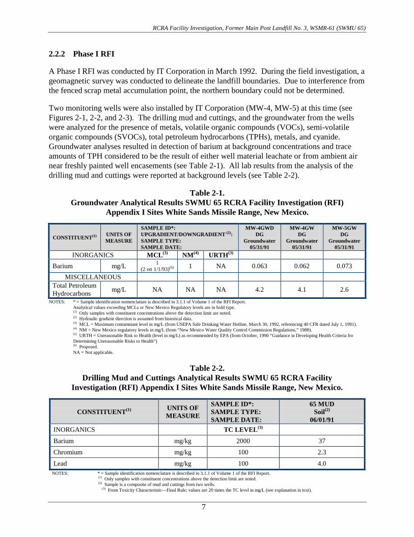
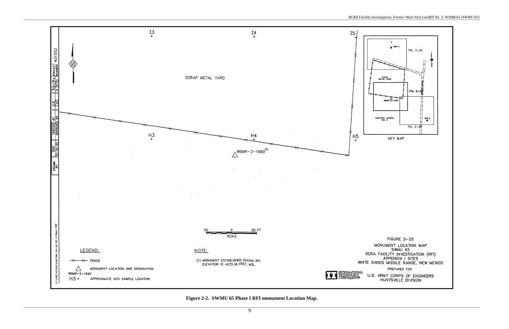
2.2.2 Phase I RFI A Phase I RFI was conducted by IT Corporation in March 1992. During the field investigation, a geomagnetic survey was conducted to delineate the landfill boundaries. Due to interference from the fenced scrap metal accumulation point, the northern boundary could not be determined. Two monitoring wells were also installed by IT Corporation (MW-4, MW-5) at this time (see Figures 2-1, 2-2, and 2-3). The drilling mud and cuttings, and the groundwater from the wells were analyzed for the presence of metals, volatile organic compounds (VOCs), semi-volatile organic compounds (SVOCs), total petroleum hydrocarbons (TPHs), metals, and cyanide. Groundwater analyses resulted in detection of barium at background concentrations and trace amounts of TPH considered to be the result of either well material leachate or from ambient air near freshly painted well encasements (see Table 2-1). All lab results from the analysis of the drilling mud and cuttings were reported at background levels (see Table 2-2).
Table 2-1. Groundwater Analytical Results SWMU 65 RCRA Facility Investigation (RFI)
Appendix I Sites White Sands Missile Range, New Mexico.
CONSTITUENT(1) UNITS OF MEASURE
SAMPLE ID*: UPGRADIENT/DOWNGRADIENT (2): SAMPLE TYPE: SAMPLE DATE:
MW-4GWD DG
Groundwater 05/31/91
MW-4GW DG
Groundwater 05/31/91
MW-5GW DG
Groundwater 05/31/91
INORGANICS MCL(3) NM(4) URTH(3)
Barium mg/L 1 (2 on 1/1/93)(6) 1 NA 0.063 0.062 0.073
MISCELLANEOUS Total Petroleum Hydrocarbons mg/L NA NA NA 4.2 4.1 2.6
NOTES: * = Sample identification nomenclature is described in 3.1.1 of Volume 1 of the RFI Report. Analytical values exceeding MCLs or New Mexico Regulatory levels are in bold type. (1) Only samples with constituent concentrations above the detection limit are noted. (2) Hydraulic gradient direction is assumed from historical data. (3) MCL = Maximum contaminant level in mg/L (from USEPA Safe Drinking Water Hotline, March 30, 1992, referencing 40 CFR dated July 1, 1991). (4) NM = New Mexico regulatory levels in mg/L (from “New Mexico Water Quality Control Commission Regulations,” 1988). (5) URTH = Unreasonable Risk to Health (level in mg/L) as recommended by EPA (from October, 1990 “Guidance in Developing Health Criteria fro Determining Unreasonable Risks to Health”) (6) Proposed. NA = Not applicable.
Table 2-2.
Drilling Mud and Cuttings Analytical Results SWMU 65 RCRA Facility Investigation (RFI) Appendix I Sites White Sands Missile Range, New Mexico.
CONSTITUENT(1) UNITS OF MEASURE
SAMPLE ID*: SAMPLE TYPE: SAMPLE DATE:
65 MUD Soil(2)
06/01/91 INORGANICS TC LEVEL(3)
Barium mg/kg 2000 37
Chromium mg/kg 100 2.3
Lead mg/kg 100 4.0 NOTES: * = Sample identification nomenclature is described in 3.1.1 of Volume 1 of the RFI Report.
(1) Only samples with constituent concentrations above the detection limit are noted. (2) Sample is a composite of mud and cuttings from two wells.
(3) From Toxicity Characteristic—Final Rule; values are 20 times the TC level in mg/L (see explanation in text).

RCRA Facility Investigation, Former Main Post Landfill No. 3, WSMR-61 (SWMU 65)
8
Figure 2-1. SWMU 65 Phase I RFI Monitoring Well (MW-04) Location Map.
RCRA Facility Investigation, Former Main Post Landfill No. 3, WSMR-61 (SWMU 65)
9
Figure 2-2. SWMU 65 Phase I RFI monument Location Map.

RCRA Facility Investigation, Former Main Post Landfill No. 3, WSMR-61 (SWMU 65)
10
Figure 2-3. SWMU 65 Phase I RFI monitoring Well (MW-05) Location Map.

RCRA Facility Investigation, Former Main Post Landfill No. 3, WSMR-61 (SWMU 65)
11
The soil vapor survey that was conducted during Phase I revealed a “hot spot” in the southeastern quarter of the suspected landfill area. IT Corporation recommended the following Phase II activities for this site: • auger several soil borings in the “hot spot”, • conduct a second phase soil vapor survey to assess horizontal limits of contamination, and • to monitor MW-4 and MW-5 for Phase I constituents of concern (trace amounts of TPH and
heavy metals, primarily barium). 2.2.3 Phase II RFI During December 1994, a Phase II RFI was conducted at MPLF#3 by Sverdrup Corp. A surface geophysical survey utilizing Ground Penetrating Radar (GPR) was planned in an attempt to delineate the extents of the landfill. However, the presence of gypsum in the soil causes interference with the GPR’s depth penetration thus reducing its effectiveness and the GPR survey was not performed. A soil gas survey was conducted during Phase II of the RFI, resulting in confirmation of the Phase I findings. Forty soil samples were taken up to depths of 30 feet and analyzed for VOCs, SVOCs, TPH, and metals (see Figure 2-4). The soil boring logs indicated that the landfill depth ranged between 5.2 and 6.0-m (17 & 21-ft). Results of analysis revealed no constituents of concern above background levels (see Tables 2-3 thru 2-5). Two additional monitoring wells (MW-7, MW-8) were installed to increase the monitoring coverage at this site (see Figure 2-4). Groundwater samples were taken from all four monitoring wells (MW-4, MW-5, MW-7, and MW-8) and no constituents of concern exceeded their respective regulatory limits (see Tables 2-6 and 2-7). The investigation indicated that a significant release of contaminants had not occurred and a request for a Class III permit modification should be submitted by WSMR to terminate the RFI for SWMU 65. However, it was recommended that SWMU 65 be monitored periodically due to its proximity to the freshwater aquifer utilized by WSMR. 2.2.4 Groundwater Quality Investigation Report In April 1996, Environmental Science and Engineering (ESE) conducted a Groundwater Quality Investigation. Dedicated submersible pumps were installed in all four of the groundwater monitoring wells at the site. Groundwater samples were collected and analyzed for VOCs, SVOCs, metals, total dissolved solids (TDS), and organochlorine pesticides/polychlorinated biphenols (PCBs). One sample was also analyzed for Nitrogen, polycyclic aromatic hydrocarbons (PAHs), 1,2 dibromoethane (EDB), radionuclides, and other inorganics. No constituents were detected, at concentrations exceeding any federal or state regulatory limits (see Table 2-8).

RCRA Facility Investigation, Former Main Post Landfill No. 3, WSMR-61 (SWMU 65)
12
Figure 2-4. SWMU 65 Phase II RFI Soil Sample Location Map.

Table 2-3. WSMR Phase-II RFI SWMU 65 Soil Analysis Detected Volatiles.
CONSTITUENT (Units in ug/kg)
Site Sample ID Date Depth (ft)
0065SB01 0065SB01 (004.0) 12/05/93 4.0
0065SB01 0065SB01 (009.0) 12/05/93 9.0
0065SB01 0065SB01 (014.0) 12/05/93 14.0
0065SB01 0065SB01 (019.0) 12/05/93 19.0
0065SB01 0065SB01 (024.0) 12/05/93 24.0
0065SB01 0065SB01 (028.5) 12/05/93 28.5
Methylene chloride <5.06 <5.16 <5.08 <5.06 <5.15 <5.03
Toluene <5.06 <5.16 <5.08 <5.06 <5.15 <5.03
Ethyl benzene <5.06 <5.16 <5.08 <5.06 <5.15 <5.03
Total Xylenes <5.06 <5.16 <5.08 <5.06 <5.15 <5.03
1,4-Dichlorobenzene <5.06 <5.16 <5.08 <5.06 <5.15 <5.03
Acetone <20.2 <20.7 <20.3 <20.2 <20.6 <20.1
Carbon disulfide <5.06 <5.16 <5.08 <5.06 <5.15 <5.03
2-Butanone <20.2 <20.7 <20.3 <20.2 <20.6 <20.1
Styrene <5.06 <5.16 <5.08 <5.06 <5.15 <5.03
CONSTITUENT (Units in ug/kg)
Site Sample ID Date Depth (ft)
0065SB02 0065SB02 (004.0) 12/06/93 4.0
0065SB02 0065SB02 (014.0) 12/06/93 14.0
0065SB02 0065SB02 (019.0) 12/06/93 19.0
0065SB02 0065SB02 (024.0) 12/06/93 24.0
0065SB02 0065SB02 (029.0) 12/06/93 29.0
0065SB03 0065SB03 (004.0) 12/06/93 4.0
Methylene chloride <5.08 <5.05 <5.18 <5.04 <5.05 <5.08
Toluene <5.08 <5.05 <5.18 <5.04 <5.05 <5.08
Ethyl benzene <5.08 <5.05 <5.18 <5.04 <5.05 <5.08
Total Xylenes <5.08 <5.05 <5.18 <5.04 <5.05 <5.08
1,4-Dichlorobenzene <5.08 <5.05 <5.18 <5.04 <5.05 <5.08
Acetone <20.3 <20.2 <20.7 <20.2 <20.2 <20.3
Carbon disulfide <5.08 <5.05 <5.18 <5.04 <5.05 <5.08
2-Butanone <20.3 <20.2 <20.7 <20.2 <20.2 <20.3
Styrene <5.08 <5.05 <5.18 <5.04 <5.05 <5.08 Values represent total concentrations unless noted < = Not detected at indicated reporting limit n/a = Not analyzed
RCRA Facility Investigation, Form
er Main Post Landfill N
o. 3, WSM
R-61 (SWM
U 65)
13

Table 2-3. WSMR Phase-II RFI SWMU 65 Soil Analysis Detected Volatiles.
(continued)
CONSTITUENT (Units in ug/kg)
Site Sample ID Date Depth (ft)
0065SB03 0065SB03 (009.0) 12/05/93 9.0
0065SB03 0065SB03 (015.0) 12/05/93 15.0
0065SB03 0065SB03 (018.0) 12/05/93 18.0
0065SB03 0065SB03 (024.0) 12/05/93 24.0
0065SB03 0065SB03 (029.0) 12/05/93 29.0
0065SB04 0065SB04 (004.0) 12/05/93 4.0
Methylene chloride <5.25 6.69 <5.10 UJ <5.20 <5.08 <5.11
Toluene 16.7 18.3 <5.10 UJ <5.20 <5.08 <5.11
Ethyl benzene 12.4 19.6 <5.10 UJ <5.20 <5.08 <5.11
Total Xylenes 46.0 88.6 <5.10 UJ <5.20 <5.08 <5.11
1,4-Dichlorobenzene <5.25 27.5 <5.10 UJ <5.20 <5.08 <5.11
Acetone 592. 249 <20.4 UJ <20.8 <20.3 <20.4
Carbon disulfide 8.61 <5.14 <5.10 UJ <5.20 <5.08 <5.11
2-Butanone 236. 348.2 <20.4 UJ <20.8 <20.3 <20.4
Styrene 5.99 <5.14 <5.10 UJ <5.20 <5.08 <5.11
CONSTITUENT (Units in ug/kg)
Site Sample ID Date Depth (ft)
0065SB04 0065SB04 (014.0) 12/05/93 14.0
0065SB04 0065SB04 (018.0) 12/05/93 18.0
0065SB04 0065SB04 (024.0) 12/05/93 24.0
0065SB04 0065SB04 (029.0) 12/05/93 29.0
0065SB05 0065SB05 (004.0) 12/06/93 4.0
0065SB05 0065SB05 (010.0) 12/06/93 10.0
Methylene chloride <5.34 <5.27 <5.26 <5.08 <5.07 <5.29
Toluene <5.34 <5.27 <5.26 <5.08 <5.07 12.6
Ethyl benzene <5.34 <5.27 <5.26 <5.08 <5.07 8.89
Total Xylenes <5.34 <5.27 <5.26 <5.08 <5.07 30.2
1,4-Dichlorobenzene 204. <5.27 <5.26 <5.08 <5.07 22.8
Acetone 103 J <21.1 <21.0 <20.3 <20.3 928.
Carbon disulfide <5.34 <5.27 <5.26 <5.08 <5.07 <5.29
2-Butanone 96.3 J <21.1 <21.0 <20.3 <20.3 183
Styrene <5.34 <5.27 <5.26 <5.08 <5.07 <5.29 Values represent total concentrations unless noted < = Not detected at indicated reporting limit n/a = Not analyzed
RCRA Facility Investigation, Form
er Main Post Landfill N
o. 3, WSM
R-61 (SWM
U 65)
14

Table 2-3. WSMR Phase-II RFI SWMU 65 Soil Analysis Detected Volatiles.
(continued)
CONSTITUENT (Units in ug/kg)
Site Sample ID Date Depth (ft)
0065SB05 0065SB05 (015.0) 12/06/93 15.0
0065SB05 0065SB05 (019.0) 12/06/93 19.0
0065SB05 0065SB05 (024.0) 12/06/93 24.0
0065SB05 0065SB05 (029.0) 12/06/93 29.0
0065SB06 0065SB06 (008.5) 12/06/93 8.5
0065SB06 0065SB06 (014.0) 12/06/93 14.0
Methylene chloride 14.4 <5.12 <5.09 <5.10 <5.06 <5.09
Toluene 70.2 5.94 <5.09 <5.10 9.11 <5.09
Ethyl benzene 201 9.43 <5.09 <5.10 <5.06 <5.09
Total Xylenes 920 44.2 <5.09 <5.10 <5.06 <5.09
1,4-Dichlorobenzene 322 38.2 <5.09 <5.10 <5.06 <5.09
Acetone 2360 212. <20.4 <20.4 74.9 901.
Carbon disulfide <5.20 <5.12 <5.09 <5.10 <5.06 8.85
2-Butanone 232 32.8 <20.4 <20.4 <20.2 205.
Styrene 47.1 <5.12 <5.09 <5.10 <5.06 <5.09
CONSTITUENT (Units in ug/kg)
Site Sample ID Date Depth (ft)
0065SB06 0065SB06 (019.0) 12/06/93 19.0
0065SB06 0065SB06 (024.0) 12/06/93 24.0
0065SB06 0065SB06 (029.0) 12/06/93 29.0
0065SB07 0065SB07 (004.0) 12/05/93 4.0
0065SB07 0065SB07 (009.0) 12/05/93 9.0
0065SB07 0065SB07 (014.0) 12/05/93 14.0
Methylene chloride <5.21 <5.08 <5.09 <5.16 UJ <5.06 <5.19
Toluene <5.21 <5.08 <5.09 <5.16 UJ <5.06 <5.19
Ethyl benzene <5.21 <5.08 <5.09 <5.16 UJ <5.06 <5.19
Total Xylenes <5.21 <5.08 <5.09 <5.16 UJ <5.06 <5.19
1,4-Dichlorobenzene <5.21 <5.08 <5.09 <5.16 UJ <5.06 <5.19
Acetone <20.8 <20.3 <20.4 <20.7 UJ <20.2 901.
Carbon disulfide <5.21 <5.08 <5.09 <5.16 UJ <5.06 <5.19
2-Butanone <20.8 <20.3 <20.4 <20.7 UJ <20.2 205.
Styrene <5.21 <5.08 <5.09 <5.16 UJ <5.06 <5.19 Values represent total concentrations unless noted < = Not detected at indicated reporting limit n/a = Not analyzed
RCRA Facility Investigation, Form
er Main Post Landfill N
o. 3, WSM
R-61 (SWM
U 65)
15

Table 2-3. WSMR Phase-II RFI SWMU 65 Soil Analysis Detected Volatiles.
(concluded)
CONSTITUENT (Units in ug/kg)
Site Sample ID Date Depth (ft)
0065SB07 0065SB07 (019.0) 12/05/93 19.0
0065SB07 0065SB07 (024.0) 12/05/93 24.0
0065SB07 0065SB07 (028.5) 12/05/93 28.5
Methylene chloride <5.31 <5.19 <5.06
Toluene <5.31 <5.19 <5.06
Ethyl benzene <5.31 <5.19 <5.06
Total Xylenes <5.31 <5.19 <5.06
1,4-Dichlorobenzene <5.31 <5.19 <5.06
Acetone <21.2 <20.8 <20.2
Carbon disulfide <5.31 <5.19 <5.06
2-Butanone <21.2 <20.8 <20.2
Styrene <5.31 <5.19 <5.06 Values represent total concentrations unless noted < = Not detected at indicated reporting limit n/a = Not analyzed
RCRA Facility Investigation, Form
er Main Post Landfill N
o. 3, WSM
R-61 (SWM
U 65)
16

Table 2-4. WSMR Phase-II RFI SWMU 65 Soil Analysis Detected Semi-Volatiles.
CONSTITUENT
Site Sample ID Date Depth (ft)
0065SB01 0065SB01 (004.0) 12/05/93 4.0
0065SB01 0065SB01 (009.0) 12/05/93 9.0
0065SB01 0065SB01 (014.0) 12/05/93 14.0
0065SB01 0065SB01 (019.0) 12/05/93 19.0
0065SB01 0065SB01 (024.0) 12/05/93 24.0
0065SB01 0065SB01 (028.5) 12/05/93 28.5
Phenol (ug/kg) <334 <341 <335 <334 <340 <332
Benzyl alcohol (ug/kg) <334 <341 <335 <334 <340 <332
2-Methylaphthalene (ug/kg) <334 <341 <335 <334 <340 <332
Dibenzofuran (ug/kg) <334 <341 <335 <334 <340 <332
1,4-Dichlorobenzene (ug/kg) <334 <341 <335 <334 <340 <332
Naphthalene (ug/kg) <334 <341 <335 <334 <340 <332
Acenaphthene (ug/kg) <334 <341 <335 <334 <340 <332
Fluorene (ug/kg) <334 <341 <335 <334 <340 <332
Phenanthrene (ug/kg) <334 <341 <335 <334 <340 <332
Anthracene (ug/kg) <334 <341 <335 <334 <340 <332
Di-n-butylphthalate (ug/kg) <334 <341 <335 <334 <340 <332
Fluoranthene (ug/kg) <334 <341 <335 <334 <340 <332
Pyrene (ug/kg) <334 <341 <335 <334 <340 <332
Butylbenzylphthalate (ug/kg) <334 <341 <335 <334 <340 <332
Bis(2-ethylhexyl)phthalate (ug/kg) <334 <341 <335 <334 <340 <332
Benzo(k)fluoranthene (ug/kg) <334 <341 <335 <334 <340 <332
Benzo(a)pyrene (ug/kg) <334 <341 <335 <334 <340 <332
Total Pet. Hydrocarbons-IR (mg/kg) 79.9 <31.0 <30.4 <30.4 <30.9 <30.2
Values represent total concentrations unless noted < = Not detected at indicated reporting limit n/a = Not analyzed
RCRA Facility Investigation, Form
er Main Post Landfill N
o. 3, WSM
R-61 (SWM
U 65)
17

Table 2-4. WSMR Phase-II RFI SWMU 65 Soil Analysis Detected Semi-Volatiles. (continued)
CONSTITUENT
Site Sample ID Date Depth (ft)
0065SB02 0065SB02 (004.0) 12/06/93 4.0
0065SB02 0065SB02 (014.0) 12/06/93 14.0
0065SB02 0065SB02 (019.0) 12/06/93 19.0
0065SB02 0065SB02 (024.0) 12/06/93 24.0
0065SB02 0065SB02 (029.0) 12/06/93 29.0
0065SB03 0065SB03 (004.0) 12/06/93 4.0
Phenol (ug/kg) <335. <333. <342 <333 <333. <335
Benzyl alcohol (ug/kg) <335. <333. <342 <333 <333. <335
2-Methylaphthalene (ug/kg) <335 <333. <342 <333 <333. <335
Dibenzofuran (ug/kg) <335 <333. <342 <333 <333. <335
1,4-Dichlorobenzene (ug/kg) <335 <333. <342 <333 <333. <335
Naphthalene (ug/kg) <335 <333. <342 <333 <333. <335
Acenaphthene (ug/kg) <335 <333. <342 <333 <333. <335
Fluorene (ug/kg) <335 <333. <342 <333 <333. <335
Phenanthrene (ug/kg) <335 <333. <342 <333 <333. <335
Anthracene (ug/kg) <335 <333. <342 <333 <333. <335
Di-n-butylphthalate (ug/kg) <335 <333. <342 <333 <333. <335
Fluoranthene (ug/kg) <335 <333. <342 <333 <333. <335
Pyrene (ug/kg) <335 <333. <342 <333 <333. <335
Butylbenzylphthalate (ug/kg) <335 <333. <342 <333 <333. <335
Bis(2-ethylhexyl)phthalate (ug/kg) <335 <333. <342 <333 <333. <335
Benzo(k)fluoranthene (ug/kg) <335 <333. <342 <333 <333. <335
Benzo(a)pyrene (ug/kg) <335 <333. <342 <333 <333. <335
Total Pet. Hydrocarbons-IR (mg/kg) 56.8 <30.3 <31.0 <30.2 <30.3 <30.5
Values represent total concentrations unless noted < = Not detected at indicated reporting limit n/a = Not analyzed
RCRA Facility Investigation, Form
er Main Post Landfill N
o. 3, WSM
R-61 (SWM
U 65)
18

Table 2-4. WSMR Phase-II RFI SWMU 65 Soil Analysis Detected Semi-Volatiles.
(continued)
CONSTITUENT
Site Sample ID Date Depth (ft)
0065SB03 0065SB03 (009.0) 12/05/93 9.0
0065SB03 0065SB03 (015.0) 12/05/93 15.0
0065SB03 0065SB03 (018.0) 12/05/93 18.0
0065SB03 0065SB03 (024.0) 12/05/93 24.0
0065SB03 0065SB03 (029.0) 12/05/93 29.0
0065SB04 0065SB04 (004.0) 12/05/93 4.0
Phenol (ug/kg) <347 n/a <337 <343. <335. <337
Benzyl alcohol (ug/kg) <347 n/a <337 <343. <335. <337
2-Methylaphthalene (ug/kg) <347 n/a <337 <343. <335. <337
Dibenzofuran (ug/kg) <347 n/a <337 <343. <335. <337
1,4-Dichlorobenzene (ug/kg) <347 n/a <337 <343. <335. <337
Naphthalene (ug/kg) <347 n/a <337 <343. <335. <337
Acenaphthene (ug/kg) <347 n/a <337 <343. <335. <337
Fluorene (ug/kg) <347 n/a <337 <343. <335. <337
Phenanthrene (ug/kg) <347 n/a <337 <343. <335. <337
Anthracene (ug/kg) <347 n/a <337 <343. <335. <337
Di-n-butylphthalate (ug/kg) <347 n/a <337 <343. <335. 570
Fluoranthene (ug/kg) <347 n/a <337 <343. <335. <337
Pyrene (ug/kg) <347 n/a <337 <343. <335. <337
Butylbenzylphthalate (ug/kg) <347 n/a 340 <343. <335. <337
Bis(2-ethylhexyl)phthalate (ug/kg) <347 n/a 582 <343. <335. <337
Benzo(k)fluoranthene (ug/kg) <347 n/a <337 <343. <335. <337
Benzo(a)pyrene (ug/kg) <347 n/a <337 <343. <335. <337
Total Pet. Hydrocarbons-IR (mg/kg) 4360 167 152. <31.2 <30.5 <30.6
Values represent total concentrations unless noted < = Not detected at indicated reporting limit n/a = Not analyzed
RCRA Facility Investigation, Form
er Main Post Landfill N
o. 3, WSM
R-61 (SWM
U 65)
19

Table 2-4. WSMR Phase-II RFI SWMU 65 Soil Analysis Detected Semi-Volatiles. (continued)
CONSTITUENT
Site Sample ID Date Depth (ft)
0065SB04 0065SB04 (014.0) 12/05/93 14.0
0065SB04 0065SB04 (018.0) 12/05/93 18.0
0065SB04 0065SB04 (024.0) 12/05/93 24.0
0065SB04 0065SB04 (029.0) 12/05/93 29.0
0065SB05 0065SB05 (004.0) 12/06/93 4.0
0065SB05 0065SB05 (010.0) 12/06/93 10.0
Phenol (ug/kg) <352. <348 <347. <335. <335 <349.
Benzyl alcohol (ug/kg) <352. <348 <347. <335. <335 <349.
2-Methylaphthalene (ug/kg) <352. <348 <347. <335. <335 <349.
Dibenzofuran (ug/kg) <352. <348 <347. <335. <335 <349.
1,4-Dichlorobenzene (ug/kg) <352. <348 <347. <335. <335 <349. UJ
Naphthalene (ug/kg) <352. <348 <347. <335. <335 <349. UJ
Acenaphthene (ug/kg) <352. <348 <347. <335. <335 <349. UJ
Fluorene (ug/kg) <352. <348 <347. <335. <335 <349. UJ
Phenanthrene (ug/kg) <352. <348 <347. <335. <335 <349. UJ
Anthracene (ug/kg) <352. <348 <347. <335. <335 <349. UJ
Di-n-butylphthalate (ug/kg) <352. <348 <347. <335. <335 <349. UJ
Fluoranthene (ug/kg) <352. <348 <347. <335. <335 <349. UJ
Pyrene (ug/kg) <352. <348 <347. <335. <335 <349. UJ
Butylbenzylphthalate (ug/kg) <352. <348 <347. <335. <335 <349. UJ
Bis(2-ethylhexyl)phthalate (ug/kg) <352. <348 <347. <335. <335 <349. UJ
Benzo(k)fluoranthene (ug/kg) <352. <348 <347. <335. <335 <349. UJ
Benzo(a)pyrene (ug/kg) <352. <348 <347. <335. <335 <349. UJ
Total Pet. Hydrocarbons-IR (mg/kg) 203 <31.6 <31.6 <30.5 <30.4 <324
Values represent total concentrations unless noted < = Not detected at indicated reporting limit n/a = Not analyzed
RCRA Facility Investigation, Form
er Main Post Landfill N
o. 3, WSM
R-61 (SWM
U 65)
20

Table 2-4. WSMR Phase-II RFI SWMU 65 Soil Analysis Detected Semi-Volatiles. (continued)
CONSTITUENT
Site Sample ID Date Depth (ft)
0065SB05 0065SB05 (015.0) 12/06/93 15.0
0065SB05 0065SB05 (019.0) 12/06/93 19.0
0065SB05 0065SB05 (024.0) 12/06/93 24.0
0065SB05 0065SB05 (029.0) 12/06/93 29.0
0065SB06 0065SB06 (008.5) 12/06/93 8.5
0065SB06 0065SB06 (014.0) 12/06/93 14.0
Phenol (ug/kg) 1970 <338. <336. <337 <334. <336
Benzyl alcohol (ug/kg) 3510 <338. <336. <337 <334. <336
2-Methylaphthalene (ug/kg) 525. <338. <336. <337 <334. <336
Dibenzofuran (ug/kg) 398. <338. <336. <337 <334. <336
1,4-Dichlorobenzene (ug/kg) 357 <338. <336. <337 <334. <336
Naphthalene (ug/kg) 708 <338. <336. <337 <334. <336
Acenaphthene (ug/kg) 604 <338. <336. <337 <334. <336
Fluorene (ug/kg) 1090 <338. <336. <337 <334. <336
Phenanthrene (ug/kg) 8210 <338. <336. <337 <334. <336
Anthracene (ug/kg) 1890 <338. <336. <337 <334. <336
Di-n-butylphthalate (ug/kg) <343. <338. <336. <337 <334. <336
Fluoranthene (ug/kg) 6420 <338. <336. <337 <334. <336
Pyrene (ug/kg) 3610 <338. <336. <337 <334. <336
Butylbenzylphthalate (ug/kg) 364. <338. <336. <337 <334. <336
Bis(2-ethylhexyl)phthalate (ug/kg) <343. <338. <336. <337 886 <336
Benzo(k)fluoranthene (ug/kg) 1560 <338. <336. <337 <334. <336
Benzo(a)pyrene (ug/kg) 1060 <338. <336. <337 <334. <336
Total Pet. Hydrocarbons-IR (mg/kg) 13000 971. <30.5 <30.6 202. 80.4
Values represent total concentrations unless noted < = Not detected at indicated reporting limit n/a = Not analyzed
RCRA Facility Investigation, Form
er Main Post Landfill N
o. 3, WSM
R-61 (SWM
U 65)
21

Table 2-4. WSMR Phase-II RFI SWMU 65 Soil Analysis Detected Semi-Volatiles.
(continued)
CONSTITUENT
Site Sample ID Date Depth (ft)
0065SB06 0065SB06 (019.0) 12/06/93 19.0
0065SB06 0065SB06 (024.0) 12/06/93 24.0
0065SB06 0065SB06 (029.0) 12/06/93 29.0
0065SB07 0065SB07 (004.0) 12/05/93 4.0
0065SB07 0065SB07 (009.0) 12/05/93 9.0
0065SB07 0065SB07 (014.0) 12/05/93 14.0
Phenol (ug/kg) <344 <335. <336. <341 <334 <342.
Benzyl alcohol (ug/kg) <344 <335. <336. <341 <334 <342.
2-Methylaphthalene (ug/kg) <344 <335. <336. <341 <334 <342.
Dibenzofuran (ug/kg) <344 <335. <336. <341 <334 <342.
1,4-Dichlorobenzene (ug/kg) <344 <335. <336. <341 <334 <342.
Naphthalene (ug/kg) <344 <335. <336. <341 <334 <342.
Acenaphthene (ug/kg) <344 <335. <336. <341 <334 <342.
Fluorene (ug/kg) <344 <335. <336. <341 <334 <342.
Phenanthrene (ug/kg) <344 <335. <336. <341 <334 <342.
Anthracene (ug/kg) <344 <335. <336. <341 <334 <342.
Di-n-butylphthalate (ug/kg) <344 <335. <336. <341 <334 <342.
Fluoranthene (ug/kg) <344 <335. <336. <341 <334 <342.
Pyrene (ug/kg) <344 <335. <336. <341 <334 <342.
Butylbenzylphthalate (ug/kg) <344 <335. <336. <341 <334 <342.
Bis(2-ethylhexyl)phthalate (ug/kg) <344 <335. <336. <341 <334 <342.
Benzo(k)fluoranthene (ug/kg) <344 <335. <336. <341 <334 <342.
Benzo(a)pyrene (ug/kg) <344 <335. <336. <341 <334 <342.
Total Pet. Hydrocarbons-IR (mg/kg) <31.2 <30.4 <30.5 <31.0 <30.3 <31.1
Values represent total concentrations unless noted < = Not detected at indicated reporting limit n/a = Not analyzed
RCRA Facility Investigation, Form
er Main Post Landfill N
o. 3, WSM
R-61 (SWM
U 65)
22

Table 2-4. WSMR Phase-II RFI SWMU 65 Soil Analysis Detected Semi-Volatiles. (concluded)
CONSTITUENT
Site Sample ID Date Depth (ft)
0065SB07 0065SB07 (019.0) 12/05/93 19.0
0065SB07 0065SB07 (024.0) 12/05/93 24.0
0065SB07 0065SB07 (028.5) 12/05/93 28.5
Phenol (ug/kg) <350. <343 UJ <334
Benzyl alcohol (ug/kg) <350. <343 UJ <334
2-Methylaphthalene (ug/kg) <350. <343 UJ <334
Dibenzofuran (ug/kg) <350. <343 UJ <334
1,4-Dichlorobenzene (ug/kg) <350. <343 <334
Naphthalene (ug/kg) <350. <343 <334
Acenaphthene (ug/kg) <350. <343 <334
Fluorene (ug/kg) <350. <343 <334
Phenanthrene (ug/kg) <350. <343 <334
Anthracene (ug/kg) <350. <343 <334
Di-n-butylphthalate (ug/kg) <350. <343 <334
Fluoranthene (ug/kg) <350. <343 <334
Pyrene (ug/kg) <350. <343 <334
Butylbenzylphthalate (ug/kg) <350. <343 <334
Bis(2-ethylhexyl)phthalate (ug/kg) <350. <343 <334
Benzo(k)fluoranthene (ug/kg) <350. <343 <334
Benzo(a)pyrene (ug/kg) <350. <343 <334
Total Pet. Hydrocarbons-IR (mg/kg) <31.8 <31.2 <30.3
Values represent total concentrations unless noted < = Not detected at indicated reporting limit n/a = Not analyzed
23
RCRA Facility Investigation, Form
er Main Post Landfill N
o. 3, WSM
R-61 (SWM
U 65)

Table 2-5. WSMR Phase-II RFI SWMU 65 Soil Analysis Detected Metals.
CONSTITUENT (Units in mg/kg)
Site Sample ID Date Depth (ft)
0065HA01 0065HA01 (000.0) 01/07/94 0.0
0065SB01 0065SB01 (004.0) 12/05/93 4.0
0065SB01 0065SB01 (009.0) 12/05/93 9.0
0065SB01 0065SB01 (014.0) 12/05/93 14.0
0065SB01 0065SB01 (019.0) 12/05/93 19.0
0065SB01 0065SB01 (024.0) 12/05/93 24.0
Arsenic <2.68 3.68 <2.58 4.44 <2.23 <2.57
Barium 84.6 118. 74.1 46.9 151 75.0
Cadmium 6.43 <5.06 <5.16 <5.08 <5.06 <5.15
Lead 7.30 8.92 9.30 7.59 5.99 11.1
Mercury <0.0214 UJ <0.0202 <0.0207 <0.0203 <0.0202 <0.0206
CONSTITUENT (Units in mg/kg)
Site Sample ID Date Depth (ft)
0065SB01 0065SB01 (028.5) 12/05/93 28.5
0065SB02 0065SB02 (004.0) 12/06/93 4.0
0065SB02 0065SB02 (014.0) 12/06/93 14.0
0065SB02 0065SB02 (019.0) 12/06/93 19.0
0065SB02 0065SB02 (024.0) 12/06/93 24.0
0065SB02 0065SB02 (029.0) 12/06/93 29.0
Arsenic <2.52 <2.54 <2.52 <2.59 <2.52 <2.52
Barium <2.52 31.5 <25.2 84.8 <25.2 41.5
Cadmium <5.03 <5.08 <5.05 <5.18 <5.06 <5.05
Lead 7.38 8.66 7.62 12.2 5.04 8.16
Mercury <0.0201 <0.0203 <0.0202 <0.0414 <0.0202 <0.0202
CONSTITUENT (Units in mg/kg)
Site Sample ID Date Depth (ft)
0065SB03 0065SB03 (004.0) 12/05/93 4.0
0065SB03 0065SB03 (009.0) 12/05/93 9.0
0065SB03 0065SB03 (015.0) 12/05/93 15.0
0065SB03 0065SB03 (018.0) 12/05/93 18.0
0065SB03 0065SB03 (024.0) 12/05/93 24.0
0065SB03 0065SB03 (029.0) 12/05/93 29.0
Arsenic 3.41 2.63 <2.57 5.49 <2.60 3.34
Barium 61.7 67.8 44.0 71.2 49.1 <25.4
Cadmium <5.08 <5.25 <5.14 <5.10 <5.20 <5.08
Lead 9.79 26.5 16.4 13.8 7.93 8.61
Mercury <0.0203 <0.0945 <0.0617 <0.0306 <0.0208 <0.0203 Values represent total concentrations unless noted < = Not detected at indicated reporting limit n/a = Not analyzed
RCRA Facility Investigation, Form
er Main Post Landfill N
o. 3, WSM
R-61 (SWM
U 65)
24

Table 2-5. WSMR Phase-II RFI SWMU 65 Soil Analysis Detected Metals. (continued)
CONSTITUENT (Units in mg/kg)
Site Sample ID Date Depth (ft)
0065SB04 0065SB04 (004.0) 12/05/93 4.0
0065SB04 0065SB04 (014.0) 12/05/93 14.0
0065SB04 0065SB04 (018.0) 12/05/93 18.0
0065SB04 0065SB04 (024.0) 12/05/93 24.0
0065SB04 0065SB04 (029.0) 12/05/93 29.0
0065SB05 0065SB05 (004.0) 12/06/93 4.0
Arsenic <2.55 <2.67 <2.63 <2.63 <2.54 <2.54
Barium 65.7 70.8 77.6 88.0 <25.4 40.0
Cadmium <5.11 <5.34 <5.27 <5.26 <5.08 <5.07
Lead 8.82 85.6 11.1 9.53 6.44 8.81
Mercury <0.0204 <0.0748 <0.0211 <0.0210 <0.0203 <0.0203
CONSTITUENT (Units in mg/kg)
Site Sample ID Date Depth (ft)
0065SB05 0065SB05 (010.0) 12/06/93 10.0
0065SB05 0065SB05 (015.0) 12/06/93 15.0
0065SB05 0065SB05 (019.0) 12/06/93 19.0
0065SB05 0065SB05 (024.0) 12/06/93 24.0
0065SB05 0065SB05 (029.0) 12/06/93 29.0
0065SB06 0065SB06 (008.5) 12/06/93 8.5
Arsenic <2.64 4.55 <2.56 4.18 <2.55 <2.53
Barium <26.4 41.2 51.0 105 44.9 46.6
Cadmium <5.29 <5.20 <5.12 <5.09 <5.10 <5.06
Lead 5.74 35.1 31.8 7.85 12.2 9.30
Mercury <0.0317 <0.0936 <0.0717 <0.0204 <0.0204 <0.0708
CONSTITUENT (Units in mg/kg)
Site Sample ID Date Depth (ft)
0065SB05 0065SB05 (010.0) 12/06/93 10.0
0065SB05 0065SB05 (015.0) 12/06/93 15.0
0065SB05 0065SB05 (019.0) 12/06/93 19.0
0065SB05 0065SB05 (024.0) 12/06/93 24.0
0065SB05 0065SB05 (029.0) 12/06/93 29.0
0065SB06 0065SB06 (008.5) 12/06/93 8.5
Arsenic <2.64 4.55 <2.56 4.18 <2.55 <2.53
Barium <26.4 41.2 51.0 105 44.9 46.6
Cadmium <5.29 <5.20 <5.12 <5.09 <5.10 <5.06
Lead 5.74 35.1 31.8 7.85 12.2 9.30
Mercury <0.0317 <0.0936 <0.0717 <0.0204 <0.0204 <0.0708 Values represent total concentrations unless noted < = Not detected at indicated reporting limit n/a = Not analyzed
RCRA Facility Investigation, Form
er Main Post Landfill N
o. 3, WSM
R-61 (SWM
U 65)
25

Table 2-5. WSMR Phase-II RFI SWMU 65 Soil Analysis Detected Metals. (concluded)
CONSTITUENT (Units in mg/kg)
Site Sample ID Date Depth (ft)
0065SB06 0065SB06 (014.0) 12/06/93 14.0
0065SB06 0065SB06 (019.0) 12/06/93 19.0
0065SB06 0065SB06 (024.0) 12/06/93 24.0
0065SB06 0065SB06 (029.0) 12/06/93 29.0
0065SB07 0065SB07 (004.0) 12/05/93 4.0
0065SB07 0065SB07 (009.0) 12/05/93 9.0
Arsenic <2.54 <2.60 <2.54 <2.54 3.685 <2.53
Barium 51.94 266 3970 65.5 92.8 <25.3
Cadmium <5.09 <5.21 <5.08 <5.09 <5.16 <5.06
Lead 10.2 10.4 9.32 14.2 8.99 5.16
Mercury <0.0203 <0.0208 <0.0203 <0.0204 <0.0207 <0.0202
CONSTITUENT (Units in mg/kg)
Site Sample ID Date Depth (ft)
0065SB07 0065SB07 (014.0) 12/05/93 14.0
0065SB07 0065SB07 (019.0) 12/05/93 19.0
0065SB07 0065SB07 (024.0) 12/05/93 24.0
0065SB07 0065SB07 (028.5) 12/05/93 28.5
Arsenic <2.59 <2.65 <2.60 <2.53
Barium 44.94 57.6 <26.0 <25.3
Cadmium <5.19 <5.31 <5.19 <5.06
Lead 6.93 10.6 9.44 4.66
Mercury <0.0207 <0.0212 <0.0208 <0.0202 Values represent total concentrations unless noted < = Not detected at indicated reporting limit n/a = Not analyzed
Table 2-6. WSMR Phase-II RFI SWMU 65 Groundwater Analysis Detected Volatiles
CONSTITUENT (Units in ug/L)
Site Sample ID Date
0065MW04 0065MW04 (WTR) 01/20/94
0065MW05 0065MW05 (WTR)RS 01/19/94
0065MW07 0065MW07 (WTR) 01/19/94
0065MW08 0065MW08 (WTR) 01/18/94
0065PW01 0065PW01 (WTR) 11/18/93
1,1-Dichloroethene
<5 <5 5.10 J <5 UJ <5 UJ
1,1,1-Trichloroethane
<5 <5 6.20 J <5 UJ <5 UJ
Values represent total concentrations unless noted < = Not detected at indicated reporting limit n/a = Not analyzed
RCRA Facility Investigation, Form
er Main Post Landfill N
o. 3, WSM
R-61 (SWM
U 65)
26

Table 2-7. WSMR Phase-II RFI SWMU 65 Groundwater Analysis Detected Metals.
CONSTITUENT Site Sample ID Date
0065MW04 0065MW04 (WTR) 01/20/94
0065MW05 0065MW05 (WTR) RS 01/19/94
0065MW07 0065MW07 (WTR) 01/19/94
0065MW08 0065MW08 (WTR) 01/18/94
0065PW01 0065PW01 (WTR) 11/18/93
Arsenic (ug/L) <5 <5 <5 <5 <5
Arsenic (Dissolved) (ug/L) <5 6 <5 <5 n/a
Barium (ug/L) 70 120 90 124 200
Barium (Dissolved) (ug/L) <50 70 <50 <50 n/a
Cadmium (ug/L) <5 UJ <5 UJ <5 UJ <5 UJ <5 Cadmium (Dissolved) (ug/L) <5 <5 <5 <5 n/a
Chromium (ug/L) <25 UJ <25 UJ <25 UJ <25 UJ <10
Chromium (Dissolved) (ug/L) <25 <25 <25 <25 n/a
Lead (ug/L) 5.2 9 4.8 12.3 <3
Lead (Dissolved) (ug/L) <3 4 5 <3 n/a
Mercury (ug/L) <0.2 UJ <0.2 UJ <0.2 UJ <0.2 UJ <0.2
Mercury (Dissolved) (ug/L) <0.2 UJ <0.2 UJ <0.2 UJ <0.2 UJ n/a
Selenium (ug/L) <5 <5 <5 <5 <5 Selenium (Dissolved) (ug/L) <5 <5 <5 <5 n/a
Silver (ug/L) <25 UJ <25 UJ <25 UJ <25 UJ <10
Silver (Dissolved) (ug/L) <25 <25 <25 <25 n/a
Total Dissolved Solids (mg/l) 230 390 280 592 n/a
PH 7.18 7.3 7.64 7.64 n/a
Specific conductance (uS/cm) 340 384 513 505 n/a
Temperature (0C) 23.9 25.1 24 24.7 n/a Values represent total concentrations unless noted < = Not detected at indicated reporting limit n/a = Not analyzed
RCRA Facility Investigation, Form
er Main Post Landfill N
o. 3, WSM
R-61 (SWM
U 65)
27

RCRA Facility Investigation, Former Main Post Landfill No. 3, WSMR-61 (SWMU 65)
28
Table 2-8. Groundwater Analytical Data Main Post Former Landfill #3.
(Detected Analytes Only)
Analyte (Units) – (EPA Method Note) SAMPLE ID/LAB ID
MW4/ WSMR*9
MW-5/ WSMR*10
QC Split 1/ WSMR*48
MW-7/ WSMR*11
MW8/ WSMR*12
Methylene Chloride (ug/L) - (1) *6 *5 <1 <1 *5
Aluminum (ug/L) - (2) 86.9 <50 <50 2,760 709
Barium (ug/L) - (2) 67.8 79.0 84.2 58.8 81.5
Boron (ug/L) - (2) <5 <5 22.2 7.1 <5
Calcium (mg/L) - (2) 28.2 30.4 30.6 44.8 38.8
Iron (ug/L) - (2) 50.8 <10 <10 2,080 461
Magnesium (mg/L) - (2) 5.6 5.6 5.82 6.8 6.9
Manganese (ug/L) - (2) <5 <5 <5 33.5 8.9
Silicon (ug/L) - (2) 21,300 19,100 18,700 26,100 21,600
Sodium (mg/L) - (2) 19.6 23.1 20.8 30.5 24
Vanadium (ug/L) - (2) <10 <10 <10 10.6 <10
Zinc (ug/L) - (2) 28.5 20 24.5 15 12.4
TDS (mg/L) - (3) 202 215 204 291 248
Chloride (mg/L) - (4) 10 N/A N/A N/A N/A Fluoride (mg/L) – (5) 0.56 N/A N/A N/A N/A Nitrogen NO2+NO3 (mg/L as N) – (6) 100 N/A N/A N/A N/A Gross, Alpha (PCI/L) – (7) 2.7 N/A N/A N/A N/A Gross, Alpha (CT Error)(+/- PCI/l) – (7) 2.4 N/A N/A N/A N/A Gross, Beta (PCI/L) – (7) 3.3 N/A N/A N/A N/A Gross, Beta (CT Error)(+/- PCI/L) – (7) 1.3 N/A N/A N/A N/A Gross, Uranium (PCI/L) – (8) 0.6 N/A N/A N/A N/A Gross, Uranium (CT Error)(+/- PDI/L) – (8) 0.3 N/A N/A N/A N/A
NOTES: (1) – Analyses performed using EPA Method 8260 (Volaile Organics) N/A - Not analyzed by this method (2) - Analyses performed using EPA Method 6010 (Metals) mg/L - milligrams per Liter (3) - Analyses performed using EPA Method 160.1 (TDS) ug/L - micrograms per Liter (4) - Analyses performed using EPA Method 9252 TDS - Total Dissolved Solids (5) - Analyses performed using EPA Method 340.2 QC SPLIT – Duplicate of well MW-5, performed by QC Lab (6) - Analyses performed using EPA Method 353.2 PCI/L - Pico Curies per Liter (7) - Analyses performed using EPA Method 9310 * - Probable lab contaminant (8) - Analyses performed using EPA Method 908.8 3.0 CONTINUED SITE INVESTIGATION 3.1 Archeological Survey A Class III cultural-resources inventory was conducted at MPLF#3 and an adjacent undisturbed block of land to the southeast during May 2000, by Human Systems Research, Inc. archaeologists. By Bureau of Land Management standards, a Class III Cultural Resources inventory is a 100% inventory survey conducted to identify and record artifact and historical areas of concern and includes literature research, a preliminary site review, and an intensive field reconnaissance of the site and surrounding area. The survey was conducted to meet the WSMR

RCRA Facility Investigation, Former Main Post Landfill No. 3, WSMR-61 (SWMU 65)
29
National Environmental Policy Act (NEPA) requirements as well as Section 106 compliance responsibility under the National Historic Preservation Act of 1966. This inventory process involved consultation with cultural-resource archival sources to identify any previously recorded historic properties in the vicinity, surveying the site to locate any unrecorded cultural-resources, and assessing cultural-resources for eligibility to the National Register of Historic Places. A pedestrian survey of the site resulted in the documentation of the landfill as a Cold War era site. Surface artifacts were inventoried and diagnostic historic/recent artifacts found on the surface were mapped. Fourteen Isolated Occurrences (IOs), some consisting of more than one artifact, were recorded during the survey. All but three of the IOs are listed as prehistoric lithic artifacts. No additional archaeological sites were encountered during the survey. MPLF#3 contains evidence relevant to daily lifeways/social history of White Sands personnel; the history and events associated with the functions of the range; and the role of White Sands Missile Range in the local, regional, and national events associated with the Cold War and national defense efforts. This site is considered potentially eligible to the National Register for historic preservation; however, due to the extensive recordation of the site it has been determined that the research potential of the isolated prehistoric artifacts has been exhausted. Therefore, a determination of no adverse affect to cultural resources was made by HSR for MPLF# 3. 3.2 Groundwater Monitoring Groundwater at this site has been monitored since 1996 for a suite of analytes that includes VOCs, SVOCs, metals, explosive residues, cyanide, dissolved ions, fuel hydrocarbons, and a specific set of water quality parameters. Samples collected semi-annually are used to determine whether contaminants originating from the landfill leachate are migrating to groundwater. Samples collected as part of the 1996 SWMU Groundwater Monitoring Program revealed trace amounts of two VOCs, toluene and trichlorofluoromethane (at concentrations of 1 microgram per liter (µg/L) and 16 µg/L, respectively), from the field blank prepared for MW-8 (MEVATEC, 1997). Trichloroflouromethane was also detected in the field blank prepared for MW-5 at a concentration of 3 µg/L. The detection of these constituents was considered to be the result of contamination from the neoprene gloves worn by the field crew during preparation of the field blanks or from the plastic container in which the reagent water that was used for the blanks was stored. Results of the Fall 1996 Groundwater Sampling Event are provided in Table 3-1. No samples were collected during Spring 1997 at MPLF#3. Consistent with the 1996 sampling event results, no VOCs, SVOCs, or explosive residue compounds were detected in any of the groundwater samples collected during the August 1997 sampling period. Detected constituents included various dissolved anions, cations, and metals. With the exception of Iron (1.8 mg/L, NMWQCC standard is 1.0 mg/L) in MW-4 and thallium (0.012 mg/L, NMED standard is 0.002 mg/L) in MW-8, all concentrations of detected analytes were below the applicable NMWQCC standards and NMED Drinking Water standards (see Table 3-2). Total dissolved solids (TDS) values in all wells reported below the NMWQCC standard of 1000 mg/L, ranging between 210 mg/L in MW05 and 280 mg/L in MW-7.
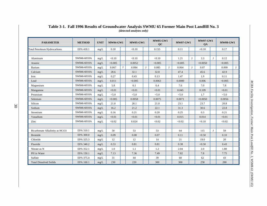
Table 3-1. Fall 1996 Results of Groundwater Analysis SWMU 65 Former Main Post Landfill No. 3 (detected analytes only)
PARAMETER METHOD UNIT MW04-GW1 MW05-GW1 MW05-GW1 QC MW07-GW1 MW07-GW1
QA MW08-GW1
Total Petroleum Hydrocarbons EPA 418.1 mg/L 0.10 <0.10 0.155 0.11 <0.10 0.17
Aluminum SW846-6010A mg/L <0.10 <0.10 <0.10 1.21 J 3.3 J 0.12
Arsenic SW846-6010A mg/L <0.005 0.0052 <0.005 <0.005 <0.0050 <0.005 Barium SW846-6010A mg/L 0.067 J 0.084 J 0.085 J 0.064 J 0.07 0.099 J Calcium SW846-6010A mg/L 28.6 32.1 32.8 47.4 45.6 42.9 Iron SW846-6010A mg/L 0.27 0.43 0.13 1.47 1.9 0.11 Lead SW846-6010A mg/L 0.011 <0.005 0.0063 0.0089 0.006 <0.005
Magnesium SW846-6010A mg/L 5.8 6.1 6.4 7.6 7.0 7.8
Manganese SW846-6010A mg/L <0.01 <0.01 <0.01 0.045 0.109 <0.01 Potassium SW846-6010A mg/L <5.0 <5.0 <5.0 <5.0 1.7 <5.0 Selenium SW846-6010A mg/L <0.005 0.0058 0.0075 0.0071 <0.0050 0.0056 Silicon SW846-6010A mg/L 21.0 20.1 21.0 23.1 23.7 20.8 Sodium SW846-6010A mg/L 16.2 21.2 22.1 31.3 30.6 22.8 Strontium SW846-6010A mg/L 0.16 0.21 0.20 0.25 0.3 0.21 Vanadium SW846-6010A mg/L <0.01 <0.01 <0.01 0.015 0.014 <0.01
Zinc SW846-6010A mg/L <0.02 0.024 <0.02 <0.02 <0.10 <0.02
Bicarbonate Alkalinity as HCO3 EPA 310.1 mg/L 50 53 53 64 115 J 59 Bromide EPA 300.0 mg/L 0.09 0.08 0.07 0.11 <0.50 0.10 Chloride EPA 325.3 mg/L 12 12 14 21 19.0 20
Fluoride EPA 340.2 mg/L 0.53 0.81 0.81 0.38 <0.50 0.43
Nitrate as N EPA 352.1 mg/L 1.0 1.1 1.2 2.04 2.0 1.80 PH in Water EPA 150.1 mg/L 7.13 7.36 7.49 7.82 7.8 7.75 Sulfate EPA 375.4 mg/L 31 44 39 60 62 43 Total Dissolved Solids EPA 160.1 mg/L 230 220 300 300 258 280
RCRA Facility Investigation, Form
er Main Post Landfill N
o. 3, WSM
R-61 (SWM
U 65)
30

Table 3-2. Fall 1997 Groundwater Sampling Analytical Results – Main Post Landfill No. 3 at (Scrap Yard).
(detected analytes only)
PARAMETER METHOD UNIT MW-4-GW2 MW-5-GW2 MW-5-GW2 QC
MW-5-GW2 QA MW-7-GW2 MW-8-GW2 NMWQCC
Standard Total METALS Arsenic SW846-6010A mg/L 0.007 0.006 0.006 0.0027 J 0.007 0.012 0.1 Barium SW846-6010A mg/L 0.081 0.081 0.081 0.0809 0.063 0.093 1.0 Boron SW846-6010A mg/L <0.1 0.51 J <0.1 UJ <0.05 UJ <0.1 <0.1 0.75 Cadmium SW846-6010A mg/L <0.0005 <.0005 <0.0005 <0.005 0.0007 0.0017 0.01 Calcium SW846-6010A mg/L 33 30 30 30.8 47 44 NE Chromium SW846-6010A mg/L 0.008 0.002 0.002 <0.010 UJ 0.004 0.01 0.05 Cobalt SW846-6010A mg/L <0.002 <0.002 <0.002 <0.020 <0.002 0.003 0.05 Copper SW846-6010A mg/L <0.02 0.02 J <0.02 UJ <0.005 UJ <0.02 <0.02 1.0 Iron SW846-6010A mg/L 1.8 0.25 0.14 0.463 0.10 0.14 1.0 Lithium SW846-6010A mg/L <0.1 0.867 <0.1 <0.1 <0.1 <0.1 NE Magnesium SW846-6010A mg/L 0.004 <0.002 0.002 5.73 7.2 7.7 NE Manganese SW846-6010A mg/L 6.2 <5.7 5.8 <0.005 0.004 0.003 0.2 Molybdenum SW846-6010A mg/L 0.004 0.203 J <0.02 UJ 0.0113 J <0.02 <0.02 1.0 Silicon SW846-6010A mg/L <0.02 12.75 12.7 J 19.5 13.7 J 14.4 J NE Sodium SW846-6010A mg/L 14.6 J 19 19 NA 27 18 NE Strontium SW846-6010A mg/L 16 0.327 J 0.329 J 0.219 J 0.483 J 0.463 J NE Thallium SW846-6010A mg/L 0.316 J 0.006 <0.005 <0.005 <0.005 0.012 0.002* Vanadium SW846-6010A mg/L <0.005 0.008 0.007 <0.010 0.011 0.006 NE Zinc SW846-6010A mg/L 0.03 0.03 0.02 <0.030 <0.02 <0.02 10 Dissolved METALS Calcium SW846-6010A mg/L 31 30 31 29.0 43 37 NA Magnesium SW846-6010A mg/L 5.7 5.6 5.7 5.34 6.3 6.3 NA Potassium SW846-6010A mg/L <5 <5 <5 1.52 <5 <5 NA Sodium SW846-6010A mg/L 16 19 20 21.8 27 18 NA Water Quality Parameters Bicarbonate Alkalinity as HCO3 EPA 310.1 mg/L 51 39 51 92 56 49 NE Bromide EPA 300.0 mg/L <2.00 2.18 J <2 UJ <0.2 UJ <2.00 <2.00 NE Chloride EPS 300.0 mg/L 13.5 12.74 13.31 10.9 21.8 18.7 250.0 Conductance EPS 120.1 uS/cm 1120 380 360 288 720 480 NA Fluoride EPS 340.2 mg/L 0.545 0.891 0.813 0.74 0.387 0.452 1.6 Nitrate EPS 300.0 mg/L 1.29 1.36** 1.28 1.55 2.12 2.12 10.0* pH EPA 150.1 N/A 7.17 7.17 7.16 7.43 7.01 7.5 6-9 Sulfate EPA 300.0 mg/L 42.9 52.1 50.4 38.4 78.5 56.5 600.0 TOC EPA 415.1 mg/L <1.0 5.4 J <1.0 UJ 1.5 J <1.0 1.6 NE TDS EPA 160.1 mg/L 217 220 210 252 280 216 1000.0
N/A – Not Analyzed N/A – Not Applicable NE – Not Established * NMED Drinking Water Standard ** Nitrate/Nitrite as N
RCRA Facility Investigation, Form
er Main Post Landfill N
o. 3, WSM
R-61 (SWM
U 65)
31

RCRA Facility Investigation, Former Main Post Landfill No. 3, WSMR-61 (SWMU 65)
32
VOCs and explosive compounds were not detected in the samples collected during the January 1998 sampling event (see Table 3-3). Among the remaining constituents, fluoride was the only one detected (in MW-4 and MW-5 Quality Control [QC]) above NMWQCC standards for this sampling event. Samples collected during Fall 1998 and Spring 1999 also yielded consistent results (see Tables 3-4 and 3-5). No VOCs, SVOCs, or explosive compounds were detected in samples collected for either event. Reported pH, TDS, conductivity, and alkalinity were also consistent and did not exceed NMWQCC standards. No samples were collected during Fall 1999 at MPLF#3. For the Spring 2000 and Fall 2000 sampling events, no concentrations of VOCs, fuel hydrocarbons, or explosive compounds were detected above applicable NMWQCC (see Tables 3-6 and 3-7). The groundwater analysis also revealed no metal concentrations exceeding the NMWQCC standards. General chemistry analysis indicated that pH, TDS, conductivity, alkalinity, chloride, fluoride, sulfate, bromide, nitrate, and total organic carbon (TOC) did not exceed the NMWQCC standards. 4.0 SUMMARY, CONCLUSIONS, AND RECOMMENDATIONS No concentrations of VOCs, fuel hydrocarbons or explosives have been detected above reporting limits in soil samples collected at this site. Analyses of groundwater samples have revealed no VOCs, other than those attributable to field contamination in the 1996 groundwater sampling event, or metal concentrations that exceed the NMWQCC standards. In addition, general chemistry analyses have revealed no concentrations of pH, total dissolved solids, conductivity, total alkalinity, bicarbonate alkalinity, carbonate alkalinity, chloride, fluoride, sulfate, bromide, nitrate, or total organic carbon exceeding the NMWQCC standards. Comparison of analytical results, of groundwater samples collected from the upgradient (MW-04 and MW-08) and downgradient (MW-05 and MW-07) monitoring wells at MPLF#3 since 1992 (see Tables 2-1 thru 2-8 and 3-1 thru 3-7), reveal that the 35 year presence of the landfill has not impacted the groundwater. White Sands Missile Range will use this determination in conjunction with the Phase I and II RFIs to support a petition for no further action with the State. A Class III permit modification will be submitted to the New Mexico Hazardous Waste Bureau requesting that the site be removed from the RCRA Part B Permit Corrective Action Module VIII.

Table 3-3. January, Spring 1998 (2nd Quarter) Groundwater Sampling Analytical Results – Main Post Landfill No. 3 at (Scrap Yard).
(detected analytes only)
PARAMETER METHOD UNIT MW-4-GW3 MW-5-GW3 MW-5-GW3 QC
MW-5-GW3 QA MW-7-GW3 MW-8-GW3 NMWQCC
Standard Total METALS Arsenic SW846-6010A mg/L 0.035 0.009 0.011 <0.0025 0.064 0.062 0.1 Barium SW846-6010A mg/L 0.079 0.092 0.105 0.0834 0.062 0.091 1.0 Cadmium SW846-6010A mg/L 0.0012 0.0014 <0.0005 <0.0050 0.0010 0.0009 0.01 Calcium SW846-6010A mg/L 29 34 42 30.8 43 40 NE Chromium SW846-6010A mg/L 0.004 0.002 0.002 <0.0100 0.004 0.002 0.05 Cobalt SW846-6010A mg/L 0.002 0.002 <0.002 <0.0200 0.002 <0.002 0.05 Iron SW846-6010A mg/L 0.15 <0.1 <0.1 <0.0450 <0.1 <0.1 1.0 Lead SW846-6010A mg/L <0.003 <0.003 0.021 0.0046 <0.003 <0.003 0.05 Magnesium SW846-6010A mg/L 6.2 7.1 9.6 5.7 6.4 7.1 NE Manganese SW846-6010A mg/L 0.002 <0.002 <0.002 <0.0050 0.004 0.003 0.2 Nickel SW846-6010A mg/L <0.01 <0.01 0.02 <0.0150 <0.01 <0.01 0.2 Silicon SW846-6010B mg/L 21 19 19 19,500 20 20 NE Sodium SW846-6010A mg/L 16 23 41 NA 26 19 NE Strontium SW846-6010B mg/L 0.22 0.248 0.24 0.232 0.34 0.26 NE Vanadium SW846-6010A mg/L 0.005 0.008 0.011 <0.0100 0.011 0.006 NE Zinc SW846-6010A mg/L 0.03 0.02 0.04 <0.0300 0.02 0.02 10 Dissolved METALS Calcium SW846-6010A mg/L 30 41 31 31.8 45 39 NA Magnesium SW846-6010A mg/L 6.7 9.1 5.9 5.95 6.7 7.2 NA Potassium SW846-6010A mg/L <5 <5 <5 1.53 <5 <5 NA Sodium SW846-6010A mg/L 18 38 20 24.3 27 19 NA Water Quality Parameters Bicarbonate Alkalinity as HCO3 EPA 310.1 mg/L 41.5 48.8 43.9 86.0 58.6 53.7 NE Chloride EPA 300.0 mg/L 9.64 9.50 8.14 11.6 18.97 14.93 250.0 Conductance EPA 120.1 uS/cm 440 260 250 308 330 290 NA Fluoride EPA 340.2 mg/L 1.65 1.42 1.60 0.829 1.07 1.28 1.6 Nitrate/Nitrite as N EPA 300.0 mg/L 1.17 1.09 1.10 1.44 1.56 1.54 10.0* pH EPA 150.1 N/A 7.22 7.31 7.32 7.60 7.70 7.61 6-9 Sulfate EPA 300.0 mg/L 34.47 38.18 28.59 39.8 65.22 65.95 600.0 Total Dissolved Solids EPA 160.1 mg/L 196 208 210 217 282 243 1000.0 Total Petroleum Hydrocarbons EPA 418.1 mg/L 0.35 0.41 0.41 <0.17 0.58 0.33 NE Semi-Volatile Organic Compounds Bis (2-ethylhexyl) phthalate SW846-8270 ug/L <10 <10 <10 2.3 <10 <10 NE
N/A – Not Analyzed N/A – Not Applicable NE – Not Established * NMWQCC Standard for Nitrate as Nitrogen
RCRA Facility Investigation, Form
er Main Post Landfill N
o. 3, WSM
R-61 (SWM
U 65)
33
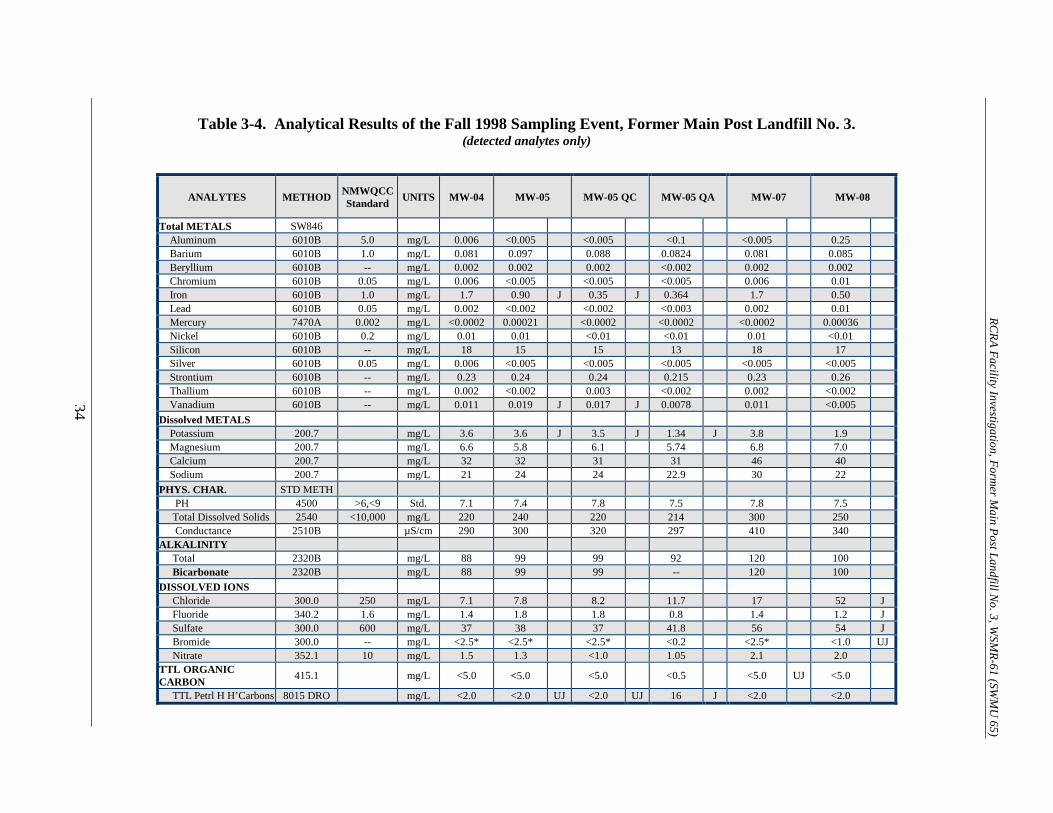
Table 3-4. Analytical Results of the Fall 1998 Sampling Event, Former Main Post Landfill No. 3.
(detected analytes only)
ANALYTES METHOD NMWQCC Standard UNITS MW-04 MW-05 MW-05 QC MW-05 QA MW-07 MW-08
Total METALS SW846 Aluminum 6010B 5.0 mg/L 0.006 <0.005 <0.005 <0.1 <0.005 0.25 Barium 6010B 1.0 mg/L 0.081 0.097 0.088 0.0824 0.081 0.085 Beryllium 6010B -- mg/L 0.002 0.002 0.002 <0.002 0.002 0.002 Chromium 6010B 0.05 mg/L 0.006 <0.005 <0.005 <0.005 0.006 0.01 Iron 6010B 1.0 mg/L 1.7 0.90 J 0.35 J 0.364 1.7 0.50 Lead 6010B 0.05 mg/L 0.002 <0.002 <0.002 <0.003 0.002 0.01 Mercury 7470A 0.002 mg/L <0.0002 0.00021 <0.0002 <0.0002 <0.0002 0.00036 Nickel 6010B 0.2 mg/L 0.01 0.01 <0.01 <0.01 0.01 <0.01 Silicon 6010B -- mg/L 18 15 15 13 18 17 Silver 6010B 0.05 mg/L 0.006 <0.005 <0.005 <0.005 <0.005 <0.005 Strontium 6010B -- mg/L 0.23 0.24 0.24 0.215 0.23 0.26 Thallium 6010B -- mg/L 0.002 <0.002 0.003 <0.002 0.002 <0.002 Vanadium 6010B -- mg/L 0.011 0.019 J 0.017 J 0.0078 0.011 <0.005 Dissolved METALS Potassium 200.7 mg/L 3.6 3.6 J 3.5 J 1.34 J 3.8 1.9 Magnesium 200.7 mg/L 6.6 5.8 6.1 5.74 6.8 7.0 Calcium 200.7 mg/L 32 32 31 31 46 40 Sodium 200.7 mg/L 21 24 24 22.9 30 22 PHYS. CHAR. STD METH PH 4500 >6,<9 Std. 7.1 7.4 7.8 7.5 7.8 7.5 Total Dissolved Solids 2540 <10,000 mg/L 220 240 220 214 300 250 Conductance 2510B µS/cm 290 300 320 297 410 340 ALKALINITY Total 2320B mg/L 88 99 99 92 120 100 Bicarbonate 2320B mg/L 88 99 99 -- 120 100 DISSOLVED IONS Chloride 300.0 250 mg/L 7.1 7.8 8.2 11.7 17 52 J Fluoride 340.2 1.6 mg/L 1.4 1.8 1.8 0.8 1.4 1.2 J Sulfate 300.0 600 mg/L 37 38 37 41.8 56 54 J Bromide 300.0 -- mg/L <2.5* <2.5* <2.5* <0.2 <2.5* <1.0 UJ Nitrate 352.1 10 mg/L 1.5 1.3 <1.0 1.05 2.1 2.0 TTL ORGANIC CARBON 415.1 mg/L <5.0 <5.0 <5.0 <0.5 <5.0 UJ <5.0
TTL Petrl H H’Carbons 8015 DRO mg/L <2.0 <2.0 UJ <2.0 UJ 16 J <2.0 <2.0
RCRA Facility Investigation, Form
er Main Post Landfill N
o. 3, WSM
R-61 (SWM
U 65)
34

Table 3-5. Analytical Results of the Spring 1999 Sampling Event, Former Main Post Landfill No. 3. (detected analytes only)
ANALYTES METHOD NMWQCC Standard UNITS MW-04 MW-05 MW-05 QC MW-05 QA MW-07 MW-08
Total METALS
Barium 6010B 1.0 mg/L 0.058 0.09 0.12 0.088 0.038 0.09 Iron 6010B 1.0 mg/L 0.23 0.16 J 0.41 J 0.13 <0.10 <0.10 Molybdenum 1.0 mg/L <0.10 <0.10 <0.10 0.012 <0.10 <0.10 Silicon 6010B n.e. mg/L 22.0 19.0 J 23.0 8.2 J 22.0 23.0 Strontium 6010B n.e. mg/L <0.10 0.26 0.31 0.22 <0.10 0.29 Vanadium 6010B n.e. mg/L <0.005 <0.005 0.008 0.0081 <0.005 <0.005
Dissolved METALS Potassium 200.7 n.e. mg/L 2.2 1.8 2.1 1.5 <10.0 2.1 Magnesium 200.7 n.e. mg/L 6.4 6.5 7.6 5.9 7.1 8.2 Calcium 200.7 n.e. mg/L 33.0 37.0 44.0 30.0 54.0 48.0 Sodium 200.7 n.e. mg/L 17.0 24.0 28.0 24.0 J 30.0 24.0
PHYS. CHAR. PH 4500 >6, <9 Std. 7.1 7.3 7.3 7.5 7.8 7.6 Total Dissolved Solids 2540 <10,000 mg/L 230 200 200 220 300 250
Conductance 2510B n.e. µS/cm 280 300 300 300 410 350 ALKALINITY Total 2320B n.e. mg/L 88 110 92 86 110 100 Bicarbonate 2320B n.e. mg/L 88 110 92 86 110 100
DISSOLVED IONS Chloride 300.0 250 mg/L 12 12 12 13 21 18 Fluoride 340.2 1.6 mg/L <0.5 <0.5 <0.5 0.84* 2x <0.5 <0.5 Sulfate 300.0 600 mg/L 36 39 35 44* 5x 64 44 Nitrate 352.1 10 mg/L 1.2 1.2 1.2 1.1 1.8 1.9
n.e - no standard established * Samples were diluted prior to analysis
34
RCRA Facility Investigation, Form
er Main Post Landfill N
o. 3, WSM
R-61 (SWM
U 65)

Table 3-6. Analytical Results of the Spring 2000 Sampling Event, Former Main Post Landfill No. 3. (detected analytes only)
ANALYTES METHOD NMWQCC Standard UNITS MW-04 MW-05 MW-05 QC MW-05 QA MW-07 MW-08
METALS SW846 Barium 6010B 1.0 mg/L 0.073 0.082 0.085 0.082 0.053 0.084 Boron 6010B 0.75 mg/L 0.035 0.037 0.033 0.037 0.036 0.021 Calcium 6010B NE mg/L 29 30 31 30.4 46 39 Iron 6010B 1.0 mg/L 0.092 <0.050 <0.050 <0.050 0.058 <0.050 Magnesium 6010B NE mg/L 6.4 6.0 6.2 5.64 6.9 7.2 Molybdenum 6010B 1.0 mg/L <0.010 0.012 0.011 0.012 <0.010 <0.010 Potassium 7470A NE mg/L 1.5 1.5 1.5 1.5 1.8 1.7 Sodium 6010B 20* mg/L 20 23 24 22 33 23 Strontium 6010B 17* mg/L 0.21 0.22 0.23 0.22 0.3 0.24 Vanadium 6010B 0.02* mg/L <0.010 <0.010 <0.010 <0.010 0.012 <0.010 SVOCs SW846 Bis(2-ethylhexyl)phthalate 8270 NE µg/l <1.0 4.5 JB 4.1 JB 4.5 JB 3.4 JB 3.5 JB PHYS. CHAR. STD METH PH 150.1 >6,<9 Std. 7.3 7.7 7.6 7.2 7.3 8 Total Dissolved Solids 160.1 <10,000 mg/L 210 220 220 261 290 250 Conductivity 120.1 NE µS/cm 330 300 300 NA 420 320 ALKALINITY Total 2320B NE mg/L 82 89 89 87 110 94 Bicarbonate 2320B NE mg/L 82 89 89 89.6 110 94 DISSOLVED IONS Chloride 300.0 250 mg/L 14 14 12 23.4 -- 19 Fluoride 340.2 1.6 mg/L 0.57 0.84 0.85 0.82 -- 0.5 Sulfate 300.0 600 mg/L 43 45 43 81.7 70 49 Nitrate 353.3 10 mg/L 1.4 1.2 1.3 0.13 -- 2 TTL ORGANIC CARBON 9060 NE mg/L 0.77 2.6 7.2 2.6 3.3 7.3
Notes: µS/cm = microsiemens per centimeter J = Estimated * = EPA Health Advisory standard used for lack of NMWQCC standard B = Analyte found in the associated blank as well as the sample µg/L = micrograms per liter NE = No NMWQCC standard is established mg/L = milligrams per liter NA = Not analyzed Std. = Standard unit of measureme
RCRA Facility Investigation, Form
er Main Post Landfill N
o. 3, WSM
R-61 (SWM
U 65)
36
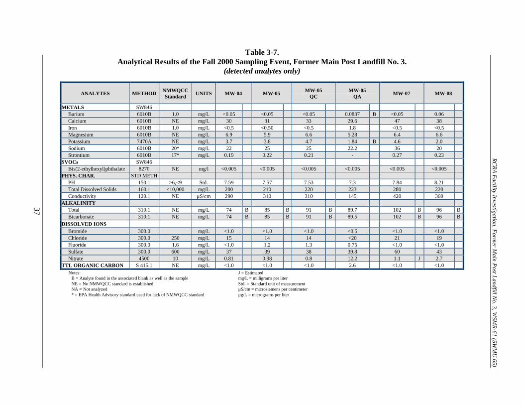
Table 3-7. Analytical Results of the Fall 2000 Sampling Event, Former Main Post Landfill No. 3.
(detected analytes only)
ANALYTES METHOD NMWQCC Standard UNITS MW-04 MW-05 MW-05
QC MW-05
QA MW-07 MW-08
METALS SW846 Barium 6010B 1.0 mg/L <0.05 <0.05 <0.05 0.0837 B <0.05 0.06 Calcium 6010B NE mg/L 30 31 33 29.6 47 38 Iron 6010B 1.0 mg/L <0.5 <0.50 <0.5 1.8 <0.5 <0.5 Magnesium 6010B NE mg/L 6.9 5.9 6.6 5.28 6.4 6.6 Potassium 7470A NE mg/L 3.7 3.8 4.7 1.84 B 4.6 2.0 Sodium 6010B 20* mg/L 22 25 25 22.2 36 20 Strontium 6010B 17* mg/L 0.19 0.22 0.21 - 0.27 0.23 SVOCs SW846 Bis(2-ethylhexyl)phthalate 8270 NE mg/l <0.005 <0.005 <0.005 <0.005 <0.005 <0.005 PHYS. CHAR. STD METH PH 150.1 >6,<9 Std. 7.59 7.57 7.53 7.3 7.84 8.21 Total Dissolved Solids 160.1 <10,000 mg/L 200 210 220 223 280 220 Conductivity 120.1 NE µS/cm 290 310 310 145 420 360 ALKALINITY Total 310.1 NE mg/L 74 B 85 B 91 B 89.7 102 B 96 B Bicarbonate 310.1 NE mg/L 74 B 85 B 91 B 89.5 102 B 96 B DISSOLVED IONS Bromide 300.0 mg/L <1.0 <1.0 <1.0 <0.5 <1.0 <1.0 Chloride 300.0 250 mg/L 15 14 14 <20 21 19 Fluoride 300.0 1.6 mg/L <1.0 1.2 1.3 0.75 <1.0 <1.0 Sulfate 300.0 600 mg/L 37 39 38 39.8 60 43 Nitrate 4500 10 mg/L 0.81 0.98 0.8 12.2 1.1 J 2.7 TTL ORGANIC CARBON S 415.1 NE mg/L <1.0 <1.0 <1.0 2.6 <1.0 <1.0
Notes: J = Estimated B = Analyte found in the associated blank as well as the sample mg/L = milligrams per liter NE = No NMWQCC standard is established Std. = Standard unit of measurement NA = Not analyzed µS/cm = microsiemens per centimeter * = EPA Health Advisory standard used for lack of NMWQCC standard µg/L = micrograms per liter
RCRA Facility Investigation, Form
er Main Post Landfill N
o. 3, WSM
R-61 (SWM
U 65)
37

RCRA Facility Investigation, Former Main Post Landfill No. 3, WSMR-61 (SWMU 65)
38
REFERENCES
Environmental Science and Engineering, Inc., 1996. Groundwater Quality Investigation for the Groundwater Monitoring Program at White Sands Missile Range, New Mexico.
IT Corporation, 1992. Final RCRA Facility Investigation (RFI) Report, Appendix II, III, and IV
Sites, White Sands Missile Range, New Mexico. Human Systems Research, Inc., 2000. Cultural-Resource Survey of Main Post Landfill No. 3
and Borrow Area, White Sands Missile Range, Doña Ana County, New Mexico: NMCRIS Project No. 70717; HSR Report No. 2002; White Sands Missile Range Archaeological Research Report No. 00-07, Project No. 374.
Kelly, T.E. and Hearne, G.A., 1976. The Effects of Groundwater Development on the Water
Supply of the Post Headquarters Area, White Sands Missile Range, New Mexico: U.S. Geological Survey Open File Report 72-308.
Kelly, T.E., 1973. Summary of Groundwater Data, Post Headquarters and Adjacent Areas,
White Sands Missile Range: U.S. Geological Survey Open File Report 72-308. McClean, J.S. 1970. Saline Groundwater Resources of the Tularosa Basin, New Mexico:
Department of the Interior, U.S. Office of Saline Water Research and Development Progress Report 561, 128 p.
MEVATEC. 1997. SWMU Groundwater Monitoring Program, White Sands Missile Range;
MEVATEC Corporation, Report No. 300SS/96/002F. MEVATEC. 1999. Results of the Fall 1998 and Spring 1999 Groundwater Sample Events at the
Former Main Post Landfill No. 3 (Scrap Yard), White Sands Missile Range, New Mexico Neher, R. E., and O. F. Baily. 1976. Soil Survey of White Sands Missile Range, New Mexico;
Parts of Dona Ana, Lincoln, Otero, Sierra, and Socorro Counties. U. S. Dept. of Agriculture, Soil Conservation Service, Washington, D.C.
New Mexico Water Quality Control Commission. 1996. New Mexico Water Quality Control
Commission Regulations. Sverdrup Environmental, Inc., 1994. Phase II RCRA Facility Investigation, Appendix I, II, III
and IV Sites, White Sands Missile Range, New Mexico. U.S. Environmental Protection Agency, 1986. Guidelines for Groundwater Classification Under
the EPA Groundwater Protection Strategy, Office of Groundwater Protection, December, 1996.
U.S. Environmental Protection Agency, 1989. RCRA Facility Investigation (RFI) Guidance,
Development of an RFI Sampling and Analysis Plan and General Considerations for RCRA Facility Investigations, Office of Solid Waste, EPA 530/SW-89-031.
RCRA Facility Investigation, Former Main Post Landfill No. 3, WSMR-61 (SWMU 65)
39
REFERENCES (concluded)
U.S. Environmental Protection Agency, Region VI. 1988. RCRA Facility Assessment PR/VSI
Report, White Sands Missile Range, New Mexico, EPA ID No. NM 2750211235, prepared by A.T. Kearny, Inc. Alexandria, VA, for the U.S. Environmental Protection Agency, Region VI.


![6FKXW]JHELHWH XQG VRQVWLJH VFKXW]Z UGLJH %HUHLFKH …€¦ · 7540-0092-001 7540-0091-001 7540-0092-002 bk-02 bk-04 bk-03 bk-01 d-2-74-120-66 3urylvrulxp i u 6\vwhph / / v51 b312](https://img.pdfslide.us/doc/110x75/5f06df047e708231d41a267e/6fkxwjhelhwh-xqg-vrqvwljh-vfkxwz-ugljh-huhlfkh-7540-0092-001-7540-0091-001-7540-0092-002.jpg)