Embed Size (px)
Citation preview
Report and recommendations of the Environmental Protection Authority
Report 1518
June 2014
City of Armadale
Keane Road Strategic Link
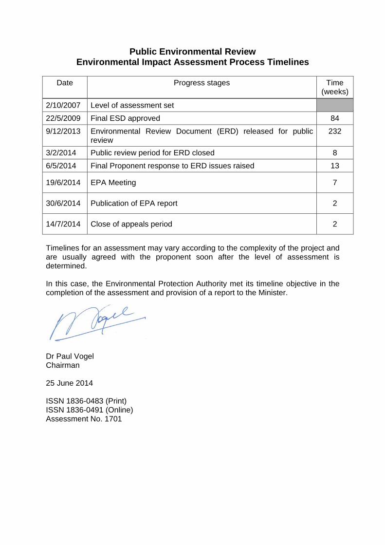
Public Environmental Review Environmental Impact Assessment Process Timelines
Date Progress stages Time
(weeks)
2/10/2007 Level of assessment set
22/5/2009 Final ESD approved 84
9/12/2013 Environmental Review Document (ERD) released for public review
232
3/2/2014 Public review period for ERD closed 8
6/5/2014 Final Proponent response to ERD issues raised 13
19/6/2014 EPA Meeting 7
30/6/2014 Publication of EPA report 2
14/7/2014 Close of appeals period 2
Timelines for an assessment may vary according to the complexity of the project and are usually agreed with the proponent soon after the level of assessment is determined. In this case, the Environmental Protection Authority met its timeline objective in the completion of the assessment and provision of a report to the Minister.
Dr Paul Vogel Chairman 25 June 2014 ISSN 1836-0483 (Print) ISSN 1836-0491 (Online) Assessment No. 1701
i
Summary and recommendations This report provides the Environmental Protection Authority’s (EPA’s) advice and recommendations to the Minister for Environment on the proposal to construct, operate and maintain a 1.5 kilometre (km) long single carriageway from Skeet Road to Anstey Road, Forrestdale by the City of Armadale. Section 44 of the Environmental Protection Act 1986 (EP Act) requires the EPA to report to the Minister for Environment on the outcome of its assessment of a proposal. The report must set out:
• the key environmental factors identified in the course of the assessment; and
• the EPA’s recommendations as to whether or not the proposal may be implemented, and, if the EPA recommends that implementation be allowed, the conditions and procedures to which implementation should be subject.
The EPA may include in the report any other advice and recommendations as it sees fit. The EPA is also required to have regard for the principles set out in section 4A of the Environmental Protection Act 1986.
Key environmental factors and principles The EPA decided that the following key environmental factors relevant to the proposal required detailed evaluation in the report:
(a) Flora and Vegetation; (b) Hydrological Processes; (c) Terrestrial Fauna; and (d) Inland Waters Environmental Quality.
There were a number of other factors which were relevant to the proposal, but the EPA is of the view that the information set out in Appendix 3 provides sufficient evaluation. The following principles were considered by the EPA in relation to the proposal:
(a) The precautionary principle; (b) The principle of intergenerational equity; and (c) The principle of the conservation of biological diversity and ecological
integrity.
ii
Conclusion The EPA has considered the proposal by the City of Armadale to construct, operate and maintain a 1.5 km section of Keane road between Anstey and Skeet roads, Forrestdale (Figure 1(a) and 1(b)). The proposal is located within Bush Forever Site 342 (approximately 369 hectares (ha)), which meets all six of the EPA’s criteria for the identification of regionally significant natural areas, contains one of the largest remaining areas of damplands of high conservation value on the Swan Coastal Plain, and is the largest consolidated area of Southern River vegetation complex (a poorly represented vegetation complex) in the Perth Metropolitan Region, in predominately very good to excellent condition. The proposal coincides with priority ecological communities, priority flora and a mapped Conservation Category Wetland. Environmental surveys and studies undertaken by the proponent shows that the proposal area supports a high diversity of flora and fauna. Seven floristic community types and eight habitat types, including upland and wetland habitats, were identified. This diversity of communities and habitats is associated with the sensitive damplands in Bush Forever Site 342. Due to the high biological diversity of the site, the principle of the conservation of biological diversity and ecological integrity (set out in section 4A of the EP Act) was a fundamental consideration in the EPA’s assessment of the proposal. The EPA notes that the proponent has proposed mitigation measures to avoid and minimise impacts, however implementation of the proposal would still result in direct impacts (clearing) to 1.65 ha of native vegetation. In addition the proponent predicts there will be up to 0.92 ha of indirect impacts from threats such as interruption to hydrological processes. The proponent has therefore predicted that the proposal would have a residual impact of up to 2.57 ha within a 2.75 ha development envelope. The EPA considers the proposal to construct a road through Bush Forever site 342 will have a significant residual impact because the construction and operation of the road will:
(i) have direct and indirect impacts on an area of very high biological diversity value at a local and regional scale;
(ii) fragment a largely intact area of natural bushland, and impact on the ecological integrity of the reserve through the separation of vegetation communities and the restriction of movement of fauna; and
(iii) result in further changes in hydrological processes to the point where the range and diversity of the microhabitats of the dampland are significantly impacted over time.
The EPA has therefore concluded that the proposal is environmentally unacceptable and therefore recommends it should not be implemented.
iii
In coming to this conclusion, the EPA acknowledges the measures the City of Armadale proposes to undertake to avoid, minimise, rectify and offset the impacts of the proposal, but considers these measures do not adequately mitigate or counterbalance the significant residual impacts on this important area of natural bushland. In making this recommendation, the EPA had particular regard to:
• the principle of the conservation of biological diversity and ecological integrity;
• its environmental objectives for flora and vegetation, hydrological processes and terrestrial fauna; and
• Environmental Protection Bulletin No. 20 Protection of Naturally Vegetated Areas through Planning and Development.
The EPA has provided other advice in Section 4 of this report in relation to a revised proposal, in the form of an elevated piled bridge from Anstey Road to Skeet Road, which together with an appropriate offsets package, may meet the EPA’s objectives for Flora and Vegetation, Hydrological Processes and Terrestrial Fauna. The EPA has also provided advice in relation to the consolidation of Bush Forever Site 342.
Recommendations The EPA recommends that the Minister for Environment:
1. considers the report on the key environmental factors of Flora and Vegetation, Hydrological Processes, Terrestrial Fauna, and Inland Waters Environmental Quality, as set out in Section 3;
2. notes that the EPA has concluded that the proposal cannot meet the EPA’s environmental objectives for Flora and Vegetation, Hydrological Processes, and Terrestrial Fauna;
3. notes that the EPA has not included in this report conditions and procedures to which the proposal should be subject, if implemented, because the EPA has concluded that the proposal should not be implemented;
4. consults the EPA on the conditions and procedures to which implementation should be subject, if the Minister, after considering appeals, decides to allow the proposal to be implemented; and
5. notes the EPA’s other advice presented in Section 4 in relation to the potential for a revised proposal and consolidation of Bush Forever site 342.

iv
This page is intentionally blank
v
Contents
Page Summary and recommendations .................................................................. i 1 Introduction and background ................................................................ 1
2 The proposal ........................................................................................... 3
3 Key environmental factors and principles............................................ 8
3.1 Flora and Vegetation and Hydrological Processes ........................ 8
3.2 Terrestrial Fauna .......................................................................... 21
3.3 Inland Waters Environmental Quality ........................................... 25
3.4 Environmental principles .............................................................. 26
4 Other advice .......................................................................................... 27
5 Recommendations ................................................................................ 29
Tables Table 1: Summary of key proposal characteristics .......................................... 3 Table 2: Values of Bush Forever site 342 against the EPA’s criteria for
determining regional significance .................................................... 11 Table 3: Significant fauna species within Bush Forever site 342 ................... 23 Figures Figure 1a: Regional context ............................................................................. 5 Figure 1b: Regional location ............................................................................ 6 Figure 2: Proposed Road Alignment ............................................................... 7 Figure 3: Development envelope .................................................................. 10 Figure 4: Floristic values of the site ............................................................... 14 Figure 5: Extent of Conservation Category Wetland ..................................... 15 Figure 6: Jandakot Regional Park Management Zones and Areas (DEC,
2010) .............................................................................................. 20 Appendices 1. List of submitters 2. References 3. Summary of identification of key environmental factors 4. Decision-Making Authorities 5. Summary of submissions and proponent’s response to submissions

vi
This page is intentionally blank
1
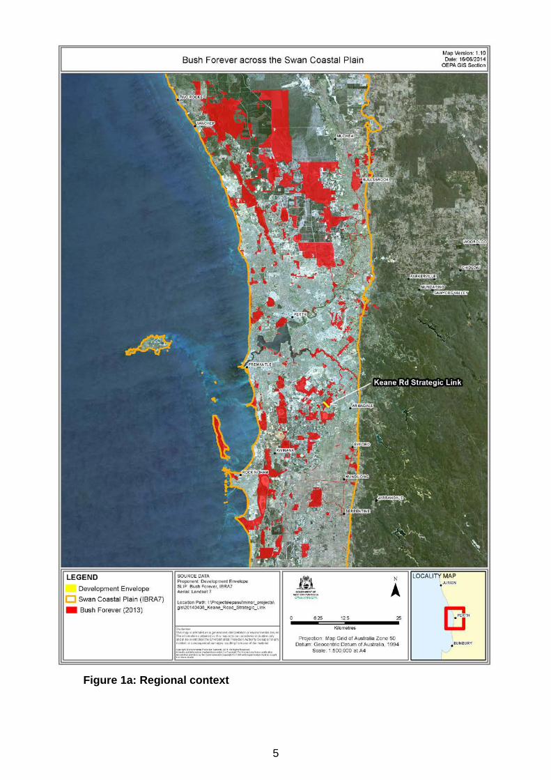
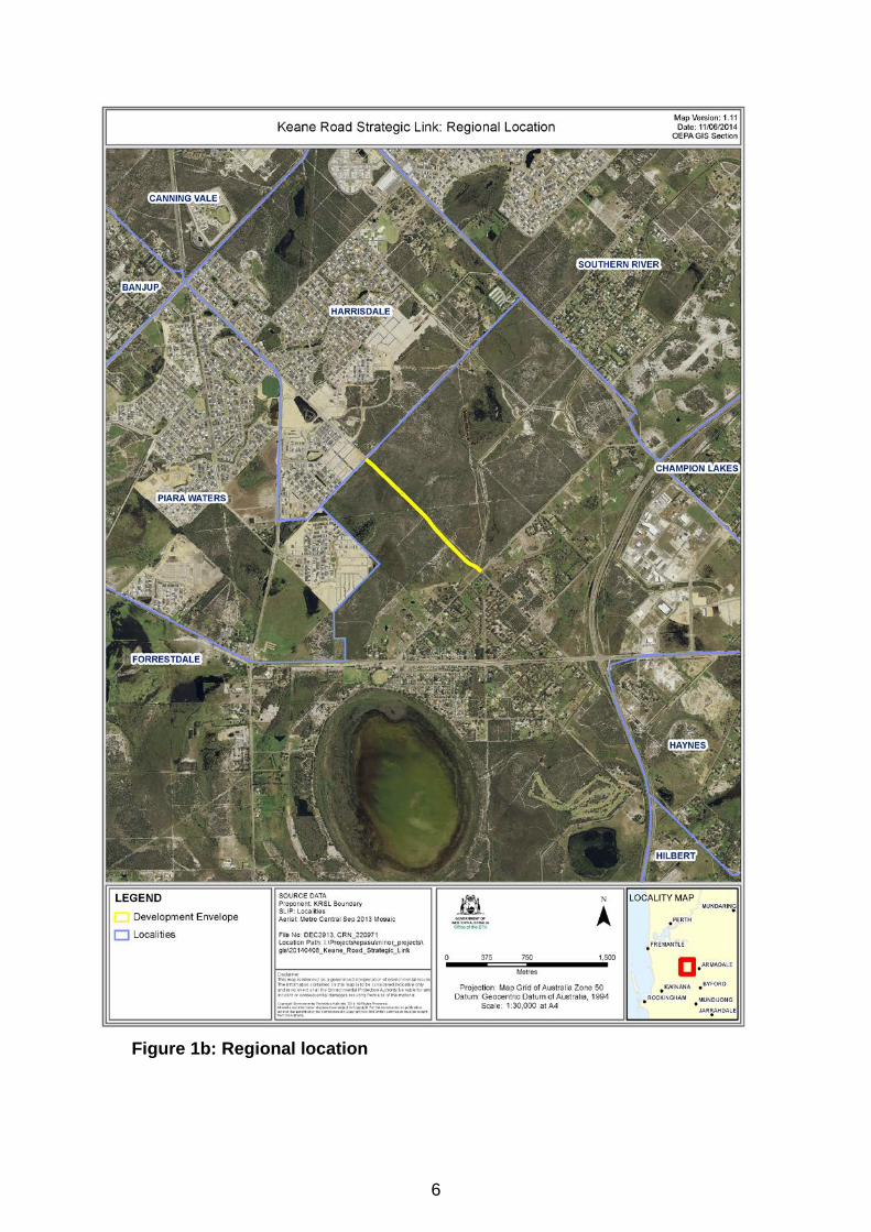
1 Introduction and background This report provides the advice and recommendations of the Environmental Protection Authority (EPA) to the Minister for Environment on the key environmental factors and principles for the proposal by the City of Armadale, to construct, operate and maintain a 1.5 km section of Keane Road, Forrestdale (Figure 1(a) and 1(b)). The City of Armadale referred the proposal to the EPA on 26 April 2007 and the EPA set the level of assessment at Public Environmental Review (PER) on 2 October 2007. The proposal was also determined to be a controlled action under the Environment Protection and Biodiversity Conservation Act 1999 (EPBC Act) and is being assessed separately by the Commonwealth Government. During the eight-week public review period from 9 December 2013 to 3 February 2014, a total of 93 submissions were received. The majority of these submissions were not supportive of the proposal on environmental grounds. The proponent provided a final response to submissions document on 6 May 2014. Planning context Keane Road is an unconstructed but public road. The road was established as part of the Crown subdivision of the region circa 1880. The road is owned by the Crown but is under the care, control and management of the City of Armadale. The purpose of Keane Road is to provide a local link between the Harrisdale and Forrestdale town sites. The land subject to the proposal is reserved for Parks and Recreation under the Metropolitan Region Scheme (MRS) and City of Armadale Local Planning Scheme No.4, with a small portion deviating from the existing gazetted road reserve into Lot 331, which is owned by the Western Australian Planning Commission, and the adjacent privately owned rural zoned land on Lot 101 (see Figure 7). The proposed road is shown in the Southern River/Forrestdale/Brookdale/ Wungong District Structure Plan, which was endorsed by the WAPC in 2001. However, the EPA understands that the structure plan did not identify Keane Road as part of the regional road and public transport planning hierarchy that would as a consequence involve reservation in the MRS. The EPA notes that the structure plan forms a non-statutory planning instrument which is intended to guide the future development of the study area and management of key environmental issues. The EPA provided advice under Section 16 (j) of the EP Act in 2000 (EPA Report 987) on the draft structure plan which considered three options, two of
2
which contained the Keane Road alignment. The EPA recommended that further assessment and evaluation of wetlands within the study area be undertaken as part of more detailed planning required ahead of land use changes. The EPA also considered that all Conservation Category Wetlands (CCWs) and their buffers should be protected, and not be used for drainage purposes or encroached by roads (EPA, 2000). Justification for proposal The EPA notes that a considerable number of submissions raised issues relating to the justification for the need for this section of Keane Road, particularly in relation to the guidance provided in the State Planning Policy 2.8: Bushland Policy for the Perth Metropolitan Region (SPP2.8). In terms of the justification for the proposal, the proponent contends that the proposal is necessary in order to facilitate east-west local traffic movement between surrounding residential developments that have been implemented in accordance with land use changes set out in the Southern River/ Forrestdale/ Brookdale/ Wungong District Structure Plan and City of Armadale Town Planning Scheme No. 4. However, the EPA has been advised that, based on the available documentation, a case for approving the road link has not been established that would warrant overriding the site’s environmental values, particularly at the regional level. While there will be longer trip outcomes and a less direct connection of planned communities, there is, nonetheless, an established regional road hierarchy that can meet transport objectives. While the EPA notes there is some conjecture on the proponent’s justification for the proposal, the planning context is not central to the EPA’s decision on the environmental acceptability of the proposal. The EPA can only assess the proposal as referred and presented to it by the proponent. In doing so, however, the EPA has taken into account all the opportunities the proponent has examined to avoid and minimise impacts to the environment. Further details of the proposal are presented in Section 2 of this report. Section 3 discusses the key environmental factors and principles for the proposal. Section 4 provides other advice by the EPA and Section 5 presents the EPA’s recommendations. Appendix 5 contains a summary of submissions and the proponent’s response to submissions and is included as a matter of information only and does not form part of the EPA’s report and recommendations. Issues arising from this process, and which have been taken into account by the EPA, appear in the report itself.
3
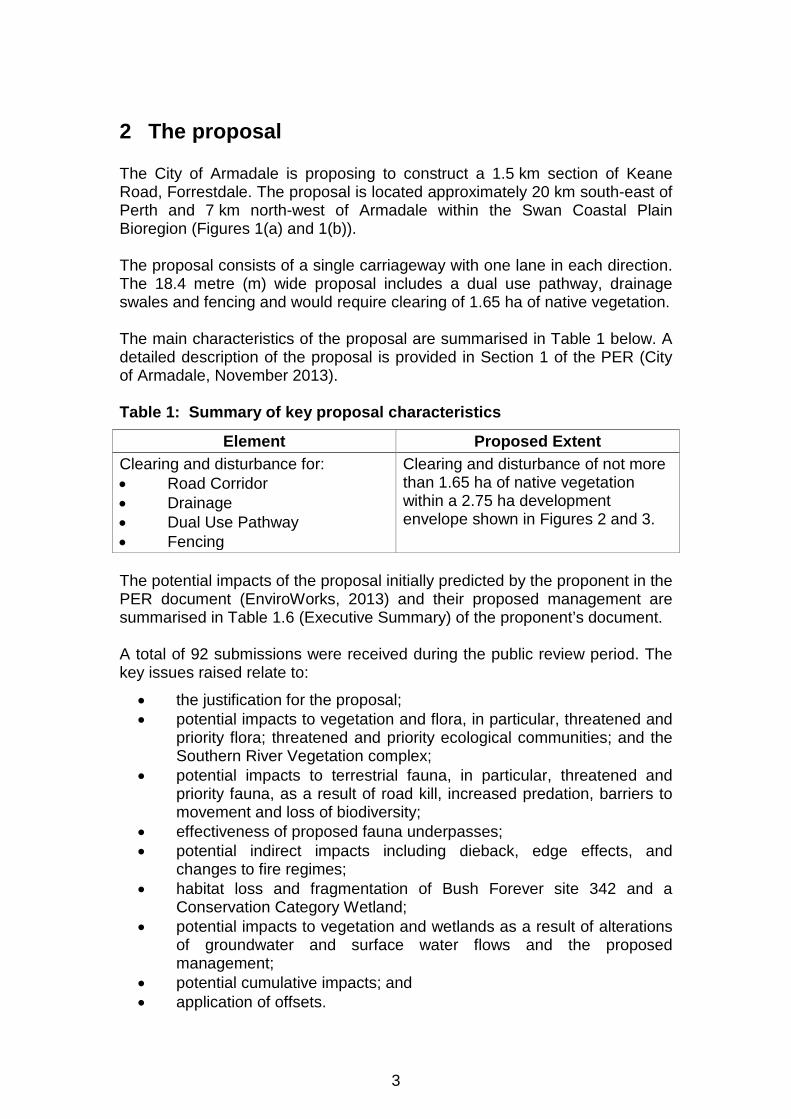
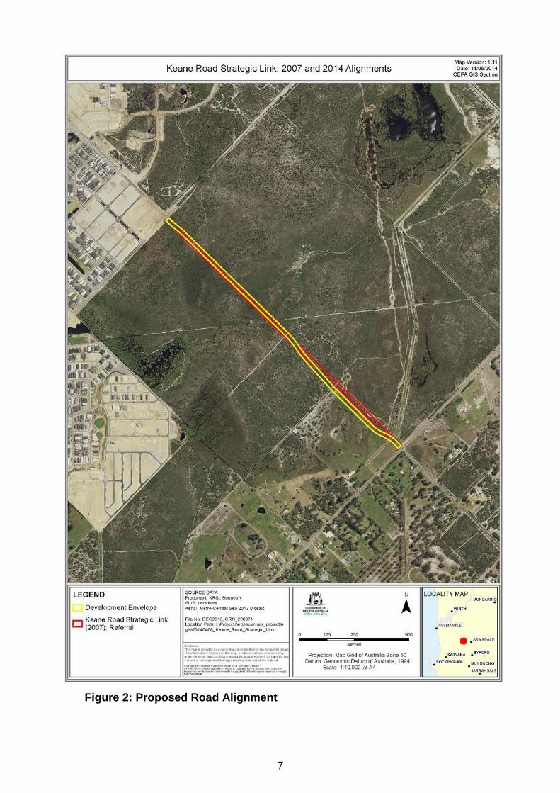
2 The proposal The City of Armadale is proposing to construct a 1.5 km section of Keane Road, Forrestdale. The proposal is located approximately 20 km south-east of Perth and 7 km north-west of Armadale within the Swan Coastal Plain Bioregion (Figures 1(a) and 1(b)). The proposal consists of a single carriageway with one lane in each direction. The 18.4 metre (m) wide proposal includes a dual use pathway, drainage swales and fencing and would require clearing of 1.65 ha of native vegetation. The main characteristics of the proposal are summarised in Table 1 below. A detailed description of the proposal is provided in Section 1 of the PER (City of Armadale, November 2013). Table 1: Summary of key proposal characteristics
Element Proposed Extent Clearing and disturbance for: • Road Corridor • Drainage • Dual Use Pathway • Fencing
Clearing and disturbance of not more than 1.65 ha of native vegetation within a 2.75 ha development envelope shown in Figures 2 and 3.
The potential impacts of the proposal initially predicted by the proponent in the PER document (EnviroWorks, 2013) and their proposed management are summarised in Table 1.6 (Executive Summary) of the proponent’s document. A total of 92 submissions were received during the public review period. The key issues raised relate to:
• the justification for the proposal; • potential impacts to vegetation and flora, in particular, threatened and
priority flora; threatened and priority ecological communities; and the Southern River Vegetation complex;
• potential impacts to terrestrial fauna, in particular, threatened and priority fauna, as a result of road kill, increased predation, barriers to movement and loss of biodiversity;
• effectiveness of proposed fauna underpasses; • potential indirect impacts including dieback, edge effects, and
changes to fire regimes; • habitat loss and fragmentation of Bush Forever site 342 and a
Conservation Category Wetland; • potential impacts to vegetation and wetlands as a result of alterations
of groundwater and surface water flows and the proposed management;
• potential cumulative impacts; and • application of offsets.
4
Issues raised were addressed in the Response to Submissions document received on 6 May 2014 (Appendix 5). In assessing this proposal, the EPA notes that the proponent has sought to avoid, minimise and mitigate environmental impacts by:
• proposing the road alignment in existing cleared areas; • deviating the southern end of the road alignment into predominantly
cleared farmland to avoid the TEC SCP10a Shrublands on dry clay flats, and applying a five metre buffer (Figure 2);
• reducing the width of the proposed road from 20 m to 18.4 m; • proposing design measures including fencing, fauna underpasses and
vegetated drainage swales; • proposing rehabilitation of areas no longer required to be free of
vegetation after construction (e.g. drainage swales and embankments and entrances to fauna underpasses);
• maintaining existing hydrological conditions based on 100-year ARI level, no excavation below the water table or dewatering;
• proposing preparation and implementation of management plans in relation to dieback, weeds, water quantity;
• restricting heavy vehicles via signage; and • proposing an offsets package which includes both direct and indirect
offsets.
5
Figure 1a: Regional context
6
Figure 1b: Regional location
7
Figure 2: Proposed Road Alignment
8
3 Key environmental factors and principles Section 44 of the EP Act requires the EPA to report to the Minister for Environment on the key environmental factors relevant to the proposal and the conditions and procedures, if any, to which the proposal should be subject. In addition, the EPA may make recommendations as it sees fit. The identification process for the key factors selected for detailed evaluation in this report is summarised in Appendix 3. The reader is referred to Appendix 3 for the evaluation of factors not discussed below. It is the EPA’s opinion that the following key environmental factors for the proposal require detailed evaluation in this report:
(a) Flora and Vegetation; (b) Hydrological Processes; (c) Terrestrial Fauna; and (d) Inland Waters Environmental Quality.
The above key factors were identified from the EPA’s consideration and review of all environmental factors generated from the PER document and the submissions received, in conjunction with the proposal characteristics set out in Table 1. Details on the key environmental factors and their assessment are contained in Sections 3.1 - 3.3. The description of each factor shows why it is relevant to the proposal and how it will be affected by the proposal, taking into consideration environmental impact management by the proponent. The assessment of each factor is where the EPA decides whether or not a proposal meets the environmental objective set for that factor. The following principles were considered by the EPA in relation to the proposal:
(a) The precautionary principle; (b) The principle of intergenerational equity; and (c) The principle of the conservation of biological diversity and ecological
integrity.
3.1 Flora and Vegetation and Hydrological Processes The discussion on the assessment of these two factors has been grouped due to the interrelatedness of the processes and impacts, particularly on wetlands. The EPA’s environmental objective for the factor of Flora and Vegetation is to maintain representation, diversity, viability and ecological function at the species, population and community level.
9
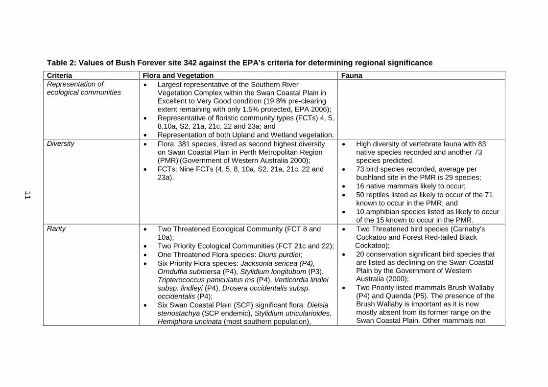
The EPA’s environmental objective for the factor of Hydrological Processes is to maintain the hydrological regimes of groundwater and surface water so that existing and potential uses, including ecosystem maintenance, are protected. The area considered for assessment of these factors is the native flora and vegetation, and surface and groundwater systems within and surrounding the 2.75 ha development envelope as shown in Figure 3. Environmental values While all naturally vegetated areas have values, the EPA is primarily concerned with the protection of regionally significant natural areas. Bush Forever site 342 is recognised in the Bush Forever report (Government of Western Australia, 2000) as “part of a regionally significant bushland/wetland linkage” and as “one of the most plant species diverse areas in the Swan Coastal Plain in the Perth Metropolitan region”. Bush Forever Site 342, within which the proposal is located, meets all six of the EPA’s criteria (EPA 2003, 2006, 2008) for the identification of regionally significant natural areas as listed below and further detailed in Table 2:
• Adequate representation of the range of ecological communities. • Areas with a high diversity of landforms, flora and /or fauna species or
communities. • Areas containing rare or threatened species or communities. • Maintaining ecological processes or natural systems. • Areas of scientific or evolutionary importance. • Areas of wetland, streamline and estuarine fringing vegetation and
coastal vegetation. Bush Forever site 342 contains one of the largest remaining areas of damplands (seasonally waterlogged basins that support rich plant and animal communities) of high conservation value on the Swan Coastal Plain. The south eastern corner of the proposal is within the Gibbs Road Swamp System which is listed on the Directory of Nationally Important Wetlands in Australia. This system encompasses a large area of surface drainage and is representative of a network of formerly extensive swamps in the area.
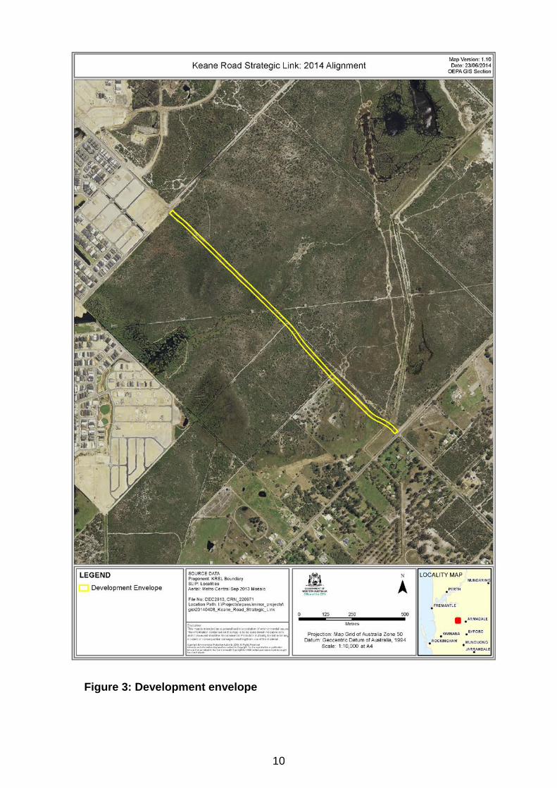
10
Figure 3: Development envelope
11
Table 2: Values of Bush Forever site 342 against the EPA’s criteria for determining regional significance Criteria Flora and Vegetation Fauna Representation of ecological communities
• Largest representative of the Southern River Vegetation Complex within the Swan Coastal Plain in Excellent to Very Good condition (19.8% pre-clearing extent remaining with only 1.5% protected, EPA 2006);
• Representative of floristic community types (FCTs) 4, 5, 8,10a, S2, 21a, 21c, 22 and 23a; and
• Representation of both Upland and Wetland vegetation.
Diversity • Flora: 381 species, listed as second highest diversity on Swan Coastal Plain in Perth Metropolitan Region (PMR)'(Government of Western Australia 2000);
• FCTs: Nine FCTs (4, 5, 8, 10a, S2, 21a, 21c, 22 and 23a).
• High diversity of vertebrate fauna with 83 native species recorded and another 73 species predicted.
• 73 bird species recorded, average per bushland site in the PMR is 29 species;
• 16 native mammals likely to occur; • 50 reptiles listed as likely to occur of the 71
known to occur in the PMR; and • 10 amphibian species listed as likely to occur
of the 15 known to occur in the PMR. Rarity • Two Threatened Ecological Community (FCT 8 and
10a); • Two Priority Ecological Communities (FCT 21c and 22); • One Threatened Flora species: Diuris purdiei; • Six Priority Flora species: Jacksonia sericea (P4),
Ornduffia submersa (P4), Stylidium longitubum (P3), Tripterococcus paniculatus ms (P4), Verticordia lindlei subsp. lindleyi (P4), Drosera occidentalis subsp. occidentalis (P4);
• Six Swan Coastal Plain (SCP) significant flora: Dielsia stenostachya (SCP endemic), Stylidium utricularioides, Hemiphora uncinata (most southern population),
• Two Threatened bird species (Carnaby's Cockatoo and Forest Red-tailed Black Cockatoo);
• 20 conservation significant bird species that are listed as declining on the Swan Coastal Plain by the Government of Western Australia (2000);
• Two Priority listed mammals Brush Wallaby (P4) and Quenda (P5). The presence of the Brush Wallaby is important as it is now mostly absent from its former range on the Swan Coastal Plain. Other mammals not
12
Dysphania giomulifera subsp. giomulifera (one of two populations on SCP), Evandra pauciflora (most northern population), Myriocephalus helichrysoides (SCP endemic)
surveyed; • Populations of one Threatened native bee
Neopasophae simplicor and a newly discovered Leioproctus sp. (Megamouth Bee).
Maintaining Ecological Processes of Natural Systems
• Part of a continuous ecological corridor extending from Forrestdale lake to Canning River;
• Large consolidated size.
• Valuable breeding and foraging habitat for a large number of vertebrate species.
Scientific or Evolutionary Importance
• Type locality for the newly discovered Leioproctus sp. (Megamouth Bee).
General Criteria for protection of Wetland, Streamline, and Estuarine fringing vegetation and Coastal vegetation
• Conservation Category Wetland
13
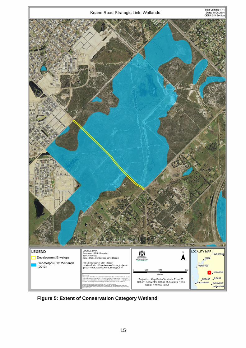
The proposal development envelope itself coincides with the following critical and high value environmental assets: Poorly represented vegetation complex - The proposal is within the Southern River Vegetation Complex of which 19.6% of the pre-European extent remains with only 2.16% in secure tenure (Edith Cowan University, 2013). Threatened ecological community (TEC) - The proposed road alignment is adjacent to TEC SCP10a Shrublands on dry clay flats, which is listed as endangered under the EPBC Act. SCP10a is known from 16 separate locations from Kaloorup to Wattle Grove (~205 km range) and totals about 90 ha. Of this, about 28 ha is on Department of Parks and Wildlife managed land. The occurrence of the TEC within this location (Bush Forever site 342), where it occurs in excellent condition, totals 20.5 ha and is the largest area of this community in any isolated intact bushland area. The proponent has proposed to deviate the southern end of the road alignment into predominantly cleared farmland lot to avoid the TEC and has applied a five metre buffer to avoid indirect impacts (Figure 4). At this stage, the lot is still in private ownership and hence there is uncertainty as to whether the proponent can give effect to this deviation. In addition, the Department of Parks and Wildlife has advised that a site specific buffer study would be required to determine an appropriate buffer to the TEC, and in particular taking into consideration the changes to local hydrology which may have potential adverse impacts. Priority Ecological Communities (PECs) - Priority 3 PEC SCP 21c Low lying Banksia attenuata woodland or shrubland and Priority 2 SCP 22 Banksia Ilicifolia woodland would be impacted by the proposal (Figure 4). Impacts of 0.8 ha and 0.15 ha respectively are predicted as a result of both direct and indirect impacts of the proposal. The EPA notes the proposed clearing of these communities has been minimised through the alignment of the road on the existing cleared track, however the proposal would result in the fragmentation of both priority ecological communities. Priority flora - The proponent identified three priority species within the study area, Jacksonia sericea and Ornduffia submersa (Priority 4), and Stylidium longitubum (Priority 3). Of these, approximately 70 individuals of Priority 4 species, Jacksonia sericea, are located within the development envelope and would be impacted as a result of this proposal. No species of declared rare flora or species listed under the EPBC Act were recorded in the study area. Conservation Category Wetlands (CCW) - The proposal would impact on the Anstey-Keane dampland which is identified as a CCW (Figure 5) in the Geomorphic Wetlands Swan Coastal Plain dataset (Hill, A.L, Semeniuk, C.A, Semeniuk, V & Del Marco, A l., 1996). CCWs are high priority wetlands which support a high level of environmental attributes and functions. The proposed road alignment would result in the fragmentation of this large wetland and a direct loss of approximately 1.84 ha of a mapped CCW.
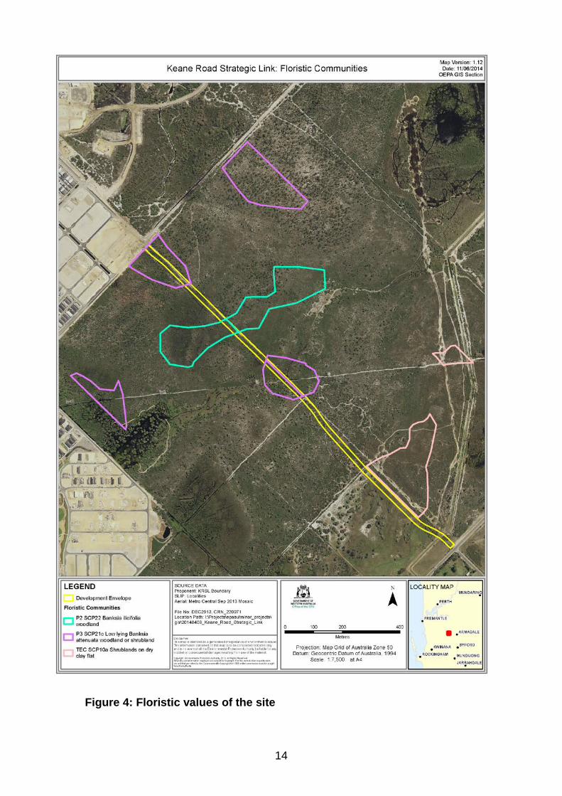
14
Figure 4: Floristic values of the site
15
Figure 5: Extent of Conservation Category Wetland
16
The proponent undertook a vegetation and flora survey in a study area 500 m either side of the proposed development envelope and identified seven floristic communities across the study area (EnviroWorks, 2012). The proponent considers that the vegetation condition in the proposal area ranges from completely degraded to very good (EnviroWorks, 2013). The EPA notes that the development envelope includes an existing cleared track, however, the vegetation on either side of the track is considered to be predominantly in very good to excellent condition. This is consistent with the condition rating in Bush Forever (WAPC, 2000). Potential environmental impacts The potential impacts of the proposal can be described with respect to the direct and indirect impacts, and also the wider-scale impacts on the Bush Forever site. The summary of impacts is as follows: Direct impacts – based on construction width of 18.4 m, the proposal will result in the clearing of 1.65 ha of native vegetation. Indirect impacts - indirect impacts are from threats such as localised changes in hydrological processes and the spread of weeds and dieback, which extend outside the clearing ‘footprint’ of the proposal and would result in changes to the composition and health of vegetation communities. As part of the Response to Submissions the proponent has prepared an Assessment of Edge Effects and Other Indirect Impacts of the Proposed Keane Road Strategic Link (Van Etten, 2014). This report has predicted edge effects would be limited to three metres from the drainage swales in dampland communities and five metres in Banksia woodland communities, resulting in potential indirect impacts to 0.92 ha of vegetation as a result of hydrological changes, and spread of weeds and dieback, which the proponent has proposed to minimise through management. Management actions identified by the proponent include: careful clearing of vegetation to avoid damage to remaining vegetation, fencing to control access, effective and ongoing weed control at the edge of the proposal, and construction of swales to capture stormwater run-off (EnviroWorks, 2014). The Department of Parks and Wildlife concurs with the EPA’s view that the proponent may have under-estimated the potential indirect impacts of the proposal, particularly on the hydrological processes of the site, and that further modelling and validation would be necessary. The combination of direct and indirect impacts amounts to 2.57 ha, based on the proponent’s conservative prediction of indirect impacts. The total area of disturbance is predicted to be 2.75 ha (including existing cleared tracks). Wider-scale impacts – the wider-scale impacts associated with permanently dividing the Bush Forever site into two smaller areas are significant, but difficult to quantify. In the case of this proposal, the road bisects the core of the vegetation in good to excellent condition increasing the edge to area ratio of the site. There is potential for disruption to ecosystem processes such as
17
fauna movement (further discussed under terrestrial fauna), genetic transfer, recruitment and germination cues which may not be immediately evident. Overall, the significant values and viability of the site would erode over time. Other potential impacts include the increased risk of fire ignition from ongoing traffic. From a cumulative impact perspective, the road also introduces additional pressures to a bush reserve which is already under pressure from threats caused by uncontrolled access, rubbish dumping, weeds and ongoing impacts from surrounding urban developments. EPA assessment of impacts The road reserve and the majority of Bush Forever site 342 has the State Planning Policy 2.8: Bushland Policy for the Perth Metropolitan Region (SPP 2.8) site implementation category of ‘Bush Forever Reserve’, which is considered to represent the highest conservation value. The aim of SPP 2.8 is to provide a policy and implementation framework that will ensure bushland protection and management issues in the Perth Metropolitan Region are appropriately addressed and integrated with broader land use planning and decision-making. The specific policy measure for Bush Forever Reserves outlined in Section 5.1.2.1 (i) of SPP 2.8 states that proposals or decision-making within Bush Forever reserves should ‘support a general presumption against the clearing of regionally significant bushland, or other degrading activities, except where a proposal or decision (e) … can be reasonably justified with regard to wider environmental, social, economic or recreational needs, and all reasonable alternatives have been considered in order to avoid or minimise any direct loss of regionally significant bushland, and reasonable offset strategies are secured to offset any loss of regionally significant bushland. The EPA’s Environmental Protection Bulletin No. 20 Protection of naturally vegetated areas through planning and development (EPB No.20) (EPA, 2013) outlines the EPA’s views and expectations for the design of development proposals in order to protect naturally vegetated areas in urban and peri urban environments. It complements the principles as set out in EPA Guidance Statement 10 (EPA, 2006), Bush Forever (WAPC, 2000 and WAPC 2010) and the Clearing Principles in Schedule 5 of the EP Act, Guidance Statement 33 (EPA, 2008) and Liveable Neighbourhoods Policy (WAPC, 2007). EPB No.20 outlines the following design guidelines to aid in meeting the EPA’s objectives for flora and vegetation, and terrestrial fauna:
• Locate development on cleared land. • Consider the impact of fire protection requirements on biodiversity. • Protect large consolidated naturally vegetated areas. • Ecological linkages should be planned in the regional context and
connect large naturally vegetated areas.
18
• Ensure clear and ongoing management responsibilities in retained naturally vegetated areas.
• Infrastructure should not be located within consolidated retained naturally vegetated areas.
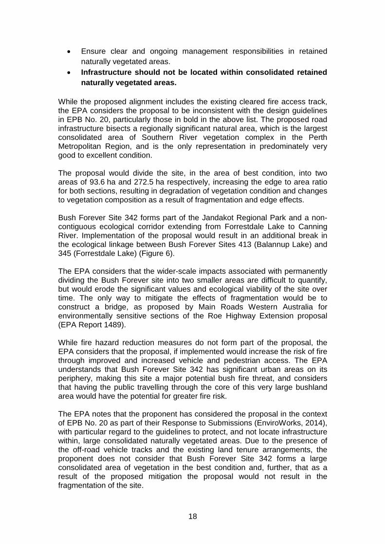
While the proposed alignment includes the existing cleared fire access track, the EPA considers the proposal to be inconsistent with the design guidelines in EPB No. 20, particularly those in bold in the above list. The proposed road infrastructure bisects a regionally significant natural area, which is the largest consolidated area of Southern River vegetation complex in the Perth Metropolitan Region, and is the only representation in predominately very good to excellent condition. The proposal would divide the site, in the area of best condition, into two areas of 93.6 ha and 272.5 ha respectively, increasing the edge to area ratio for both sections, resulting in degradation of vegetation condition and changes to vegetation composition as a result of fragmentation and edge effects. Bush Forever Site 342 forms part of the Jandakot Regional Park and a non-contiguous ecological corridor extending from Forrestdale Lake to Canning River. Implementation of the proposal would result in an additional break in the ecological linkage between Bush Forever Sites 413 (Balannup Lake) and 345 (Forrestdale Lake) (Figure 6). The EPA considers that the wider-scale impacts associated with permanently dividing the Bush Forever site into two smaller areas are difficult to quantify, but would erode the significant values and ecological viability of the site over time. The only way to mitigate the effects of fragmentation would be to construct a bridge, as proposed by Main Roads Western Australia for environmentally sensitive sections of the Roe Highway Extension proposal (EPA Report 1489). While fire hazard reduction measures do not form part of the proposal, the EPA considers that the proposal, if implemented would increase the risk of fire through improved and increased vehicle and pedestrian access. The EPA understands that Bush Forever Site 342 has significant urban areas on its periphery, making this site a major potential bush fire threat, and considers that having the public travelling through the core of this very large bushland area would have the potential for greater fire risk. The EPA notes that the proponent has considered the proposal in the context of EPB No. 20 as part of their Response to Submissions (EnviroWorks, 2014), with particular regard to the guidelines to protect, and not locate infrastructure within, large consolidated naturally vegetated areas. Due to the presence of the off-road vehicle tracks and the existing land tenure arrangements, the proponent does not consider that Bush Forever Site 342 forms a large consolidated area of vegetation in the best condition and, further, that as a result of the proposed mitigation the proposal would not result in the fragmentation of the site.
19
In response, the Department of Parks and Wildlife has advised that the proposal, if implemented, is likely to have a significant impact with respect to hydrological function and ecological connectivity as the road dissects the best quality (least disturbed) vegetation within the Bush Forever site and CCW, and would effectively create two reserves separated by a fenced corridor. The Department of Parks and Wildlife has also advised that a site-specific buffer study would be required to determine an appropriate buffer to the TEC, in particular taking into consideration the changes to local hydrology which may have potential adverse impacts. With respect to the potential impacts on hydrological processes, the EPA notes that the hydrology of the site has been modified by existing tracks, however the area still supports a high diversity of flora. The complexity in the underlying stratigraphy (layers of different soils) means that there are likely to be uncertainties around the proponent’s predictions on the subsurface hydrological processes and the vegetation communities that rely on them. Notwithstanding the uncertainties in predictions, any impacts from the road on hydrological processes are likely to be localised. The combination of the direct impacts (from clearing) and the indirect impacts from the interruption of hydrological processes would have significant impacts to the biodiversity values of the site. The EPA considers that, even if the potential change to hydrological processes is predicted to be localised, it would have significant adverse impacts due to the diversity and sensitivity of the microhabitats and the ecological communities that they maintain. The proposal would also have a significant impact to the core of an area of best condition (rated as excellent condition). For the reasons explained above, the EPA considers that the overall residual impacts from the direct and indirect impacts, fragmentation and loss of connectivity of this large, consolidated naturally vegetated area as a result of the implementation of the proposal are significant enough to be environmentally unacceptable. The EPA’s view is that the proposal cannot be managed to meet the EPA’s objective for maintaining the viability and ecological function of flora and vegetation at the community level; and maintaining the hydrological regimes so that ecosystem maintenance is protected.
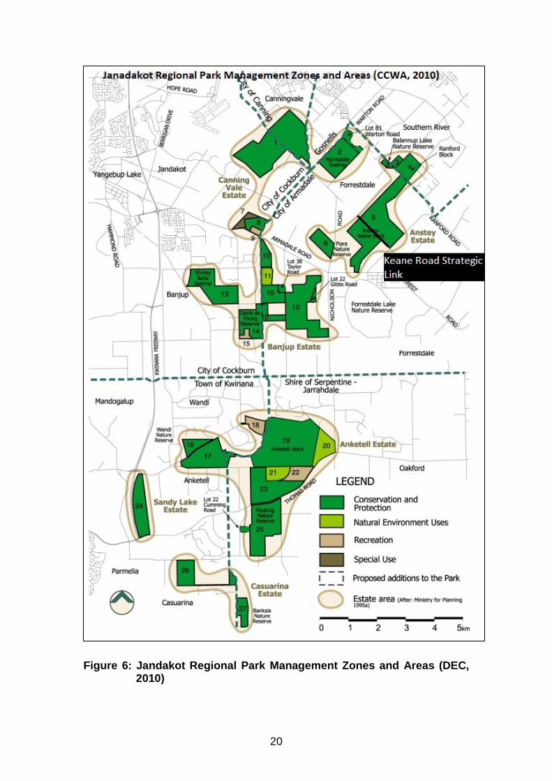
20
Figure 6: Jandakot Regional Park Management Zones and Areas (DEC,
2010)
21
Summary Having particular regard to:
• studies and investigations that have been undertaken by the proponent;
• the proponent’s proposed avoidance, minimisation and mitigation measures;
• the significant residual impacts of the proposal; • the likelihood of indirect impacts as a result of edge effects and
fragmentation of the surrounding regionally significant bushland; • uncertainty regarding indirect impacts to the TEC SCP10a; • the likelihood of indirect impacts from edge effects and also the
fragmentation of a large consolidated regionally significant bushland; • the potential for localised changes to hydrological processes to have
significant adverse impacts due to the sensitivity and significant values of the microhabitats that they maintain; and
• proposed offsets which do not adequately counterbalance the potential significant impacts of fragmentation and loss of ecological connectivity;
it is the EPA’s opinion that the proposal cannot be managed to meet the EPA’s objective for maintaining the viability and ecological function of flora and vegetation at the community level; and maintaining the hydrological regimes so that ecosystem maintenance is protected and thus does not meet the EPA’s objectives for Flora and Vegetation and Hydrological Processes.
3.2 Terrestrial Fauna The EPA’s environmental objective for the factor of Terrestrial Fauna is to maintain representation, diversity, viability and ecological function at the species, population and assemblage level. The area considered for assessment of this factor is the terrestrial fauna and fauna habitat within and surrounding the 2.75 ha development envelope (Figure 3). Implementation of the proposal would result in the loss of up to 2.75 ha of fauna habitat and the fragmentation of a currently large and intact habitat area. The construction and operation of the project may also result in impacts to fauna from road kill, restriction of fauna movement and genetic flow regime and the abundance of introduced predators. The proponent conducted two short range endemic studies, to determine the presence of the Graceful Sun Moth and four threatened native bee species, in addition to a fauna assessment which identified eight habitat types occurring within the proposal area (Bamford Consulting Ecologists, 2013).
22
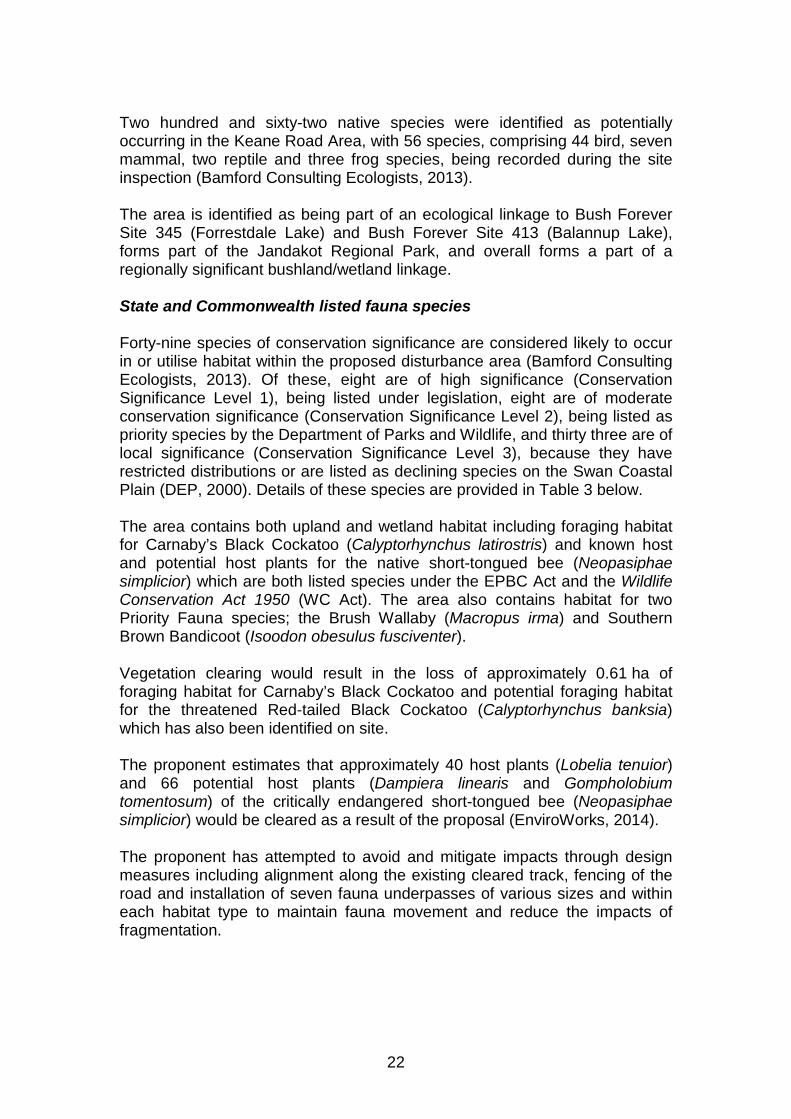
Two hundred and sixty-two native species were identified as potentially occurring in the Keane Road Area, with 56 species, comprising 44 bird, seven mammal, two reptile and three frog species, being recorded during the site inspection (Bamford Consulting Ecologists, 2013). The area is identified as being part of an ecological linkage to Bush Forever Site 345 (Forrestdale Lake) and Bush Forever Site 413 (Balannup Lake), forms part of the Jandakot Regional Park, and overall forms a part of a regionally significant bushland/wetland linkage. State and Commonwealth listed fauna species Forty-nine species of conservation significance are considered likely to occur in or utilise habitat within the proposed disturbance area (Bamford Consulting Ecologists, 2013). Of these, eight are of high significance (Conservation Significance Level 1), being listed under legislation, eight are of moderate conservation significance (Conservation Significance Level 2), being listed as priority species by the Department of Parks and Wildlife, and thirty three are of local significance (Conservation Significance Level 3), because they have restricted distributions or are listed as declining species on the Swan Coastal Plain (DEP, 2000). Details of these species are provided in Table 3 below. The area contains both upland and wetland habitat including foraging habitat for Carnaby’s Black Cockatoo (Calyptorhynchus latirostris) and known host and potential host plants for the native short-tongued bee (Neopasiphae simplicior) which are both listed species under the EPBC Act and the Wildlife Conservation Act 1950 (WC Act). The area also contains habitat for two Priority Fauna species; the Brush Wallaby (Macropus irma) and Southern Brown Bandicoot (Isoodon obesulus fusciventer). Vegetation clearing would result in the loss of approximately 0.61 ha of foraging habitat for Carnaby’s Black Cockatoo and potential foraging habitat for the threatened Red-tailed Black Cockatoo (Calyptorhynchus banksia) which has also been identified on site. The proponent estimates that approximately 40 host plants (Lobelia tenuior) and 66 potential host plants (Dampiera linearis and Gompholobium tomentosum) of the critically endangered short-tongued bee (Neopasiphae simplicior) would be cleared as a result of the proposal (EnviroWorks, 2014). The proponent has attempted to avoid and mitigate impacts through design measures including alignment along the existing cleared track, fencing of the road and installation of seven fauna underpasses of various sizes and within each habitat type to maintain fauna movement and reduce the impacts of fragmentation.
23
Table 3: Significant fauna species within Bush Forever site 342 Reptiles Mammals 1. *South-west Carpet Python (Morelia spilota imbricata, CS1, likely) 1. *Southern Brown Bandicoot (Isoodon obesulus fusciventer, CS2, recorded) 2. *Perth Lined Lerista (Lerista lineata, CS2, likely) 2. *Brush Wallaby (Macropus irma, CS2, likely) 3. Black-striped Snake (Neelaps calonotos, CS2, likely) 3. Western False Pipistrelle (Falsistrellus mackenziei, CS2, likely 4. Jewelled Ctenotus (Ctenotus gemmula, CS2. likely) 4. *Water Rat, Rakali (Hydromys chrysogaster, CS2, seasonal visitor) 5. Black-headed Tree Goanna (Varanus tristis, CS3, likely) 5. *Honey Possum (Tarsipes rostratus, CS3, likely) 6. *Gould’s Sand Goanna (Varanus gouldii, CS3, likely) 6. *Western Pygmy-possum (Cercartetus concinnus, CS3, likely) 7. Rosenberg’s Goanna (Varanus rosenbergi, CS3, likely) 7. Western Freetail Bat (Mormopterus sp. 4, CS3, likely) 8. Beaked Blind Snake (Ramphotyphlops waitii, CS3 likely) 9. Keeled Legless-lizard (Pletholax gracilis, CS3, likely) Birds
1. Baudin’s Black-Cockatoo (Calyptorhynchus baudinii, CS1, likely: visitor) 18. *Golden Whistler (Pachycephala pectoralis, CS3, recorded)
2. *Carnaby’s Black-Cockatoo (Calyptorhynchus latirostris, CS1, likely) 19. *Grey Shrike-thrush (Colluricincla harmonica, CS3, recorded)
3. 3. *Forest Red-tailed Black-Cockatoo (C. banksii naso, CS1, likely visitor) 20. Restless Flycatcher (Myiagra inquieta, CS3, likely)
4. *Peregrine Falcon (Falco peregrinus, CS1, likely: visitor) 21. *Square-tailed Kite (Lophoictinia isura, CS3, recorded) 5. *Rainbow Bee-eater (Merops ornatus, CS1, recorded) 22. *Whistling Kite (Haliastur sphenurus, CS3, recorded) 6. *Fork-tailed Swift (Apus pacificus, CS1: rare aerial visitor) 23. *Brown Goshawk (Accipiter fasciatus, CS3, recorded) 7. *Great Egret (Ardea alba, CS1, occasional visitor) 24. *Collared Sparrowhawk (Accipiter cirrhocephalus, CC3, recorded)
8. Southern Barking Owl (Ninox connivens connivens, CS2, rare visitor) 25. *Wedge-tailed Eagle (Aquila audax, CS3, recorded)
9. *Scarlet Robin (Petroica multicolour, CS3, likely) 26. *Little Eagle (Hieraaetus morphnoides, CS3, recorded) 10. *Common Bronzewing (Phaps chalcoptera, CS3, recorded) 27. *Brown Falcon (Falco berigora, CS3, recorded) 11. *Splendid Fairy-wren (Malurus splendens, CS3, recorded) 28. *Painted Button-quail (Turnix varia, CS3, recorded) 12. *White-browed Scrubwren (Sericornis frontalis, CS3, recorded) 29. *Western Wattlebird (Anthochaera lunulata, CS3, recorded) 13. *Weebill (Smicrornis brevirostris, CS3, recorded) 30. *New Holland Honeyeater (Phylidonyris novaehollandiae, CS3, recorded) 14. *Inland Thornbill (Acanthiza apicalis, CS3, recorded) 31. *White-cheeked Honeyeater (Phylidonyris nigra, CS3, recorded) 15. *Western Thornbill (Acanthiza inornata, CS3, recorded) 32. *Tawny-crowned Honeyeater (Phylidonyris melanops, CS3, recorded) 16. *Yellow-rumped Thornbill (Acanthiza chrysorrhoa, CS3, recorded) 33. *Black-faced Woodswallow (Artamus cinereus, CS3, recorded)
17. *Varied Sittella (Daphoenositta chrysoptera, CS3, recorded) 34. Additionally conservation significant waterbird species may occur in adjacent habitats or during seasonal flooding of the site
Species marked with an asterisk (*) have been recorded at the project area or within 10 km of the site according to the Western Australian Museum database (WAM, 2008).
24
EPA assessment of impacts While the EPA supports the use of fauna underpasses where appropriate, the proposed road infrastructure bisects a regionally significant natural area, and would divide the site, in the area of best condition, into two. This would increase the edge-to-area ratio for both sections, resulting in degradation of vegetation condition and changes to vegetation composition as a result of fragmentation and edge effects. The EPA notes that the importance of this site is evident by the high diversity of vertebrate fauna and the known or likely occurrence of several species of conservation significance including several species recognized as regionally significant on the Swan Coastal Plain by Bush Forever (Government of Western Australia, 2000). The EPA considers that there is the potential for a long term reduction in the vertebrate fauna assemblage, in particular species that are sedentary or poor dispersers, as a result of the proposal. Increasing fragmentation of the remnant may lead to changes in the microhabitats of the site, a loss in the diversity of reptile species and a change in the bird assemblage, which may not be immediately evident. Small insectivorous understorey-foraging species, for example the Splendid Fairy-wren and White-browed Scrubwren, may be shy to cross open road areas which will therefore act as a barrier to dispersal. The barrier effects of roads are known to have a negative impact on the genetic diversity of populations by leading to a lower effective population size which will reduce genetic dispersal between fragments (Krawiec, 2011). In coming to this conclusion the EPA carefully considered what size of conservation area is needed in order to maintain the environmental values in the long term. Large sites are important for facilitating the movement of species between fragments and also act as a refuge for feeding and breeding areas. There is information that suggests that when an area is less that 100 ha in size there is an incremental drop off in fauna species survival (Kitchener D.J, Dell J and Muir B.J, 1982). As noted previously, the proposal, if implemented would increase the risk of fire through improved and increased vehicle and pedestrian access. How and Dell (1994) stated that an increased frequency of fire can have serious consequences to fauna and the impact on vertebrates of urban bushlands can be devastating. The frequency of burns is important with some species only found in habitats that had been unburnt for long periods. Consequently, increased fire frequency can impact on the long term ability of fauna to survive particularly in fragmented bushland. The EPA considers that the impacts on terrestrial fauna from fragmentation and loss of connectivity of this large, consolidated naturally vegetated area as a result of the implementation of the proposal would be significant. The importance of this site is evident by the high diversity of the vertebrate fauna assemblages. The area is large enough to maintain and support a wide array
25
of fauna in a variety of habitats due to the different interacting vegetation and soil types, as well as the wide range of wetland and dryland habitats. Summary Having particular regard to the:
• studies and investigations that have been undertaken by the proponent;
• proponent’s proposed avoidance, minimisation and mitigation measures;
• significant residual impacts of the proposal; and • the potential for long term reduction of fauna assemblages as a result
of fragmentation of the regionally significant surrounding bushland, it is the EPA’s opinion that the proposal cannot be managed to meet the EPA’s objective for maintaining the viability and diversity of Terrestrial Fauna at the assemblage level and thus does not meet the EPA’s objective for Terrestrial Fauna.
3.3 Inland Waters Environmental Quality The EPA’s environmental objective for the factor of Inland Waters Environmental Quality is to maintain the quality of groundwater and surface water, sediment and biota so that the environmental values, both ecological and social, are protected. The area considered for assessment of this factor is the quality of surface and groundwater systems within and outside the 2.75 ha development envelope. The proposal has the potential to impact on Inland Waters Environmental Quality during both construction and operation. Construction (Acid Sulfate Soils) During construction the proponent has committed to only undertake shallow excavation when groundwater levels are at their minimum (end of summer) and hence dewatering will be not necessary. As the proposal does not require dewatering or excavation below the groundwater table it is unlikely that there will be potential impacts from disturbance to Acid Sulfate Soils and groundwater acidification. Operations The potential impacts from the constructed road on Inland Water Environmental Quality include runoff from ongoing vehicular traffic and potential spills as a result of accidents on the road. The proponent has designed the proposal such that road runoff will be captured in roadside swales (within development envelope) that are planted with local sedge
26
species, where suspended solids, contaminants and nutrients will be detained, filtered and assimilated, prior to infiltration to the water table. The Department of Water supports the proponent’s approach to infiltrate runoff into roadside swales. Infiltration at source is considered best practice stormwater management to help maintain pre-development hydrological regimes. Based on the above, the EPA considers that stormwater runoff can be satisfactorily managed to meet the EPA’s objective subject to the implementation of standard road drainage measures by the proponent. In the event of a chemical or hydrocarbon spill from an accident however, these drainage measures will not adequately protect the quality of ground and surface waters. The proponent’s views on this matter are as follows:
• In the case of a spill, the spill would be contained by the roadside swales to avoid release to the environment and emergency authorities would be contacted and the spill remediated appropriately.
• Road use will be restricted to local vehicles only, with no heavy vehicle traffic, through signage.
The EPA acknowledges that there is still a residual risk of water quality impacts occurring from an accident, albeit a low risk. The potential impacts can be mitigated by the proponent preparing a Spill Containment and Response Management Plan in consultation with the Department of Parks and Wildlife and Department of Environment Regulation. This plan would serve to set out the additional drainage measures and response that would be implemented to minimise the impacts of a spill on water quality. Summary Having regard to the fact that there is a relatively low risk for potential impacts to water quality as a result of a fuel spill, it is the EPA’s opinion that it is likely that the EPA’s environmental objective for this factor can be achieved provided there are requirements on the proponent to have in place a Spill Containment and Response Management Plan in consultation with the Department of Parks and Wildlife and the Department of Environment Regulation in order to mitigate the impacts of an accidental spill. This requirement combined with the proponent’s proposed avoidance, minimisation and mitigation measures for construction and operations would enable the proposal to meet the EPA’s objective for Inland Waters Environmental Quality.
3.4 Environmental principles In preparing this report and recommendations, the EPA has had regard for the object and principles contained in s4A of the EP Act. Appendix 3 contains a summary of the EPA’s consideration of the principles.
27
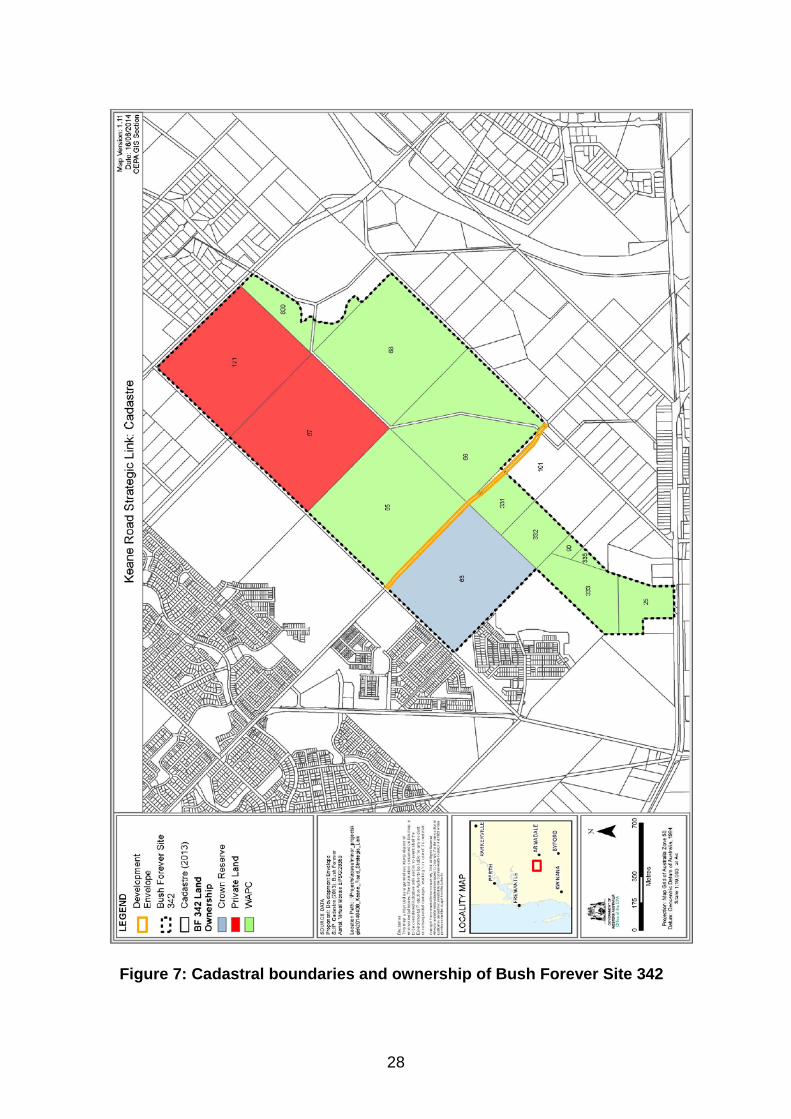
4 Other advice Revised proposal The EPA considers that a revised proposal, which involves an elevated piled bridge spanning Bush Forever Site 342 from Anstey Road to Skeet Road, may meet the EPA’s objectives for Flora and Vegetation and Hydrological Processes and Terrestrial Fauna. A revised proposal would still likely result in significant residual impacts, and these impacts would need to be appropriately counterbalanced through the application of offsets. The EPA notes that the proponent considers that the construction of a bridge would not be economically feasible. Consolidation of Bush Forever Site 342 The proposal is located within Bush Forever Site 342 – Anstey Keane Dampland and Adjacent Bushland, Forrestdale. The EPA notes that since 1994 the WAPC has gradually acquired freehold ownership of the majority of Bush Forever Site 342, and it is understood that negotiations are currently underway to acquire lot 67 which is one of the two remaining privately owned lots (Figure 7). Bush Forever Site 342 is managed by the Department of Parks and Wildlife under the Jandakot Regional Park Management Plan. While the site is currently owned as freehold land by the WAPC, the intention is for the land to be vested to the Conservation Commission for the purpose of Conservation. The existing road reserve is currently vested in the City of Armadale. It is noted that the Jandakot Regional Park Management Plan states that, should road reserves be closed, they will be amalgamated into adjoining reserves which will be afforded an appropriate reserve purpose and tenure arrangement consistent with the protection and enhancement of the park values (DEC, 2010). The EPA supports the acquisition of the remaining privately owned Lots within Bush Forever Site 342, and the closure of the road reserve and its amalgamation into the adjoining reserves. This would allow for comprehensive long-term management of the site and greater protection and enhancement of the values of Bush Forever Site 342.
28
Figure 7: Cadastral boundaries and ownership of Bush Forever Site 342
29
5 Recommendations The EPA submits the following recommendations to the Minister for Environment. That the Minister:
1. considers the report on the key environmental factors of Flora and Vegetation, Hydrological Processes, Terrestrial Fauna, and Inland Waters Environmental Quality, as set out in Section 3;
2. notes that the EPA has concluded that the proposal cannot meet the EPA’s environmental objectives for Flora and Vegetation, Hydrological Processes, and Terrestrial Fauna;
3. notes that the EPA has not included in this report conditions and procedures to which the proposal should be subject, if implemented, because the EPA has concluded that the proposal should not be implemented;
4. consults the EPA on the conditions and procedures to which implementation should be subject, if the Minister, after considering appeals, decides to allow the proposal to be implemented; and
5. notes the EPA’s other advice presented in Section 4 in relation to the potential for a revised proposal and consolidation of Bush Forever site 342.

30

Appendix 1
List of submitters
Organisations: Armadale City Rivercare Group Armadale Gosnells Landcare Group Canning Regional Greens WA Conservation Commission of WA Department of Aboriginal Affairs Department of Education Department of Parks and Wildlife Department of Planning Department of Water Friends of Cockburn Wetland Education Centre Friends of Ellis Brook Valley (Inc) Friends of Forrestdale (Inc.) Friends of Paganoni Swamp Friends of Yellagonga Jandakot Regional Park Community Advisory Committee Peel Preservation Group Save Beeliar Wetlands South East Regional Centre for Urban Landcare Spineless Wonders Urban Bushland Council WA Inc Water Corporation Wetlands Conservation Society Inc. Wetlands Research Association Inc. Wildflower Society of WA (Murdoch Branch) Wildflower Society WA (Inc.) Individuals: Allison Schultz Amy Krupa Amy Sharpe Andrew Harris Belinda Lumsden Bryony Fremlin Caitlyn White Caroline Wielinga Cathryn Julius Chloe Flaherty Chris Burgess Craig Lumsden Dave Blackburn David James David Wake Debbie Payne Debbie Walker Dian Maney
Dr. Christina Birnbaum Dr. Jonathan Whale Ella Maesepp Felicity McGeorge Heinrich Kaiser Janet Knight & Peter Wilmot Janice Dawson Jeff Munn Jim Prince Joan Payne John Adeney Joy Rogers Julie Robert Justin Hanson Kasey Green Kate Kevin McLean Kim Fletcher
Kim Sarti Lauren McBride Linda Metz Margaret Owen Maria Cash Mark Hutchinson Mary Thomas Matthew Grimbly Matthew Woods Melissa Gaikhorst Micheal Ian Butland Nandi Chinna Nonie Jekabsons Noreen & Michail Petrovic Norma Calcutt Pam Nairn Paul & Margaret Wilson
Paul Rosser Pawel Waryszak Penny Lee Peter Curtain Sallyanne Cousans Santhosh Philip Sarah McElwee Senator Scott Ludlam Simon Norrish Stan & Margaret Telford Susan Radford Thalia Joanne Taylor Trudy Burnett T. Tholstrup Wendy Dugmore

Appendix 2
References
Bamford Consulting Ecologists. (2013a). Keane Road Strategic Link, Armadale - Fauna Assessment. DEC (2010) Jandakot Regional Park Management Plan 2010, prepared by the Department of Environment and Conservation on behalf of the Conservation Commission, Perth. Edith Cowan University, Joondalup (2013), Local Biodiversity Program, prepared by ECU on behalf of Western Australian Local Government Association. Eddie van Etten. (2014). Assessment of Edge Effects and Other Indirect Impacts of the Proposed Keane Road Strategic Link. Perth: Unpublished Report Prepared for City of Armadale. EnviroWorks Consulting (2013), Keane Road Strategic Link – Public Environmental Review – City of Armadale. EnviroWorks Consulting (2014) Keane Road Strategic Link – PER Response to Submissions, City of Armadale. EPA (2006). Guidance Statement No. 10 - Level of assessment for proposals affecting natural areas within the System 6 region and Swan Coastal Plain Portion of the System 1 region. Environmental Protection Authority, Perth EPA (2008). Guidance Statement No. 33 - Environmental guidance for planning and development. Environmental Protection Authority, Perth EPA (2013). Environmental Protection Bulletin No. 20 - Protection of naturally vegetated areas through planning and development, Environmental Protection Authority, Perth Hill, AL, Semeniuk, CA, Semeniuk, V & Del Marco, A (1996), Wetlands of the Swan Coastal Plain Volume 2A: Wetland Mapping, Classification and Evaluation, Main Report, Water and Rivers Commission and Department of Environmental Protection, Perth. Kitchener D.J, Dell J and Muir B.J (1982) Birds in Western Australian Wheatbelt Reserves – Implications for Conservation, Biological Conservation 22 127-163, Applied Science Publishers. Krawiec, J. (2011). The effects of urban habitat fragmentation on the population genetic structure of the scincid lizard Ctenotus fallens. Honours Thesis School of Natural Sciences. Western Australian Planning Commission (2000) Bush Forever – Volume 1 Policies Principles and Processes, Perth.

Western Australian Planning Commission (2000). Bush Forever – Volume 2: Directory of Bush Forever sites. Department of Environmental Protection, Perth. Western Australian Planning Commission (2007) Liveable Neighbourhoods, Perth.

Appendix 3
Summary of identification of key environmental factors and principles
Preliminary
Environmental Factors
Proposal Characteristics Government Agency and Public Comments Identification of Key
Environmental Factors
BIOPHYSICAL
Flora and Vegetation; and Hydrological Processes
• Proposed clearing of 1.65 ha of native vegetation.
• Clearing of two Priority Ecological Communities and one species of Priority flora.
• Fragmentation of Bush Forever site 342.
• Increased threat of introducing and spreading weeds.
• Increased threat of spreading Dieback.
• Potential to change surface water flows by changing the flow and/or capacity of the arterial drainage in the area leading to excessive flooding or drying of wetland or urban areas.
Public and non-government organisations • Concern over the loss of priority flora. • Concern over loss of priority vegetation communities. • Concern over loss of vegetation complex. • Indirect impacts of the proposal. • Fragmentation of Bush Forever site 342 and CCW. • Lack of information regarding residual impacts of
fragmentation. • Concern over the potential of the proposal to cause the
spread of Dieback
Department of Parks and Wildlife • Conflicting information regarding the vegetation
condition of the site. • Concern that the proposal will directly impact suitable
habitat for the endangered Diuris purdiei. • Proponent should undertake a site specific buffer study
to determine an appropriate buffer to the critically endangered TEC SCP 10a.
• Dieback Hygiene Management Plan should address requirements such as eliminating cross-contamination.
• Concern that local scale changes can affect a wide range of ecological processes on site.
• Concern over a lack of focus on potential local scale
Considered to be a key environmental factor and is discussed in Section 3.1
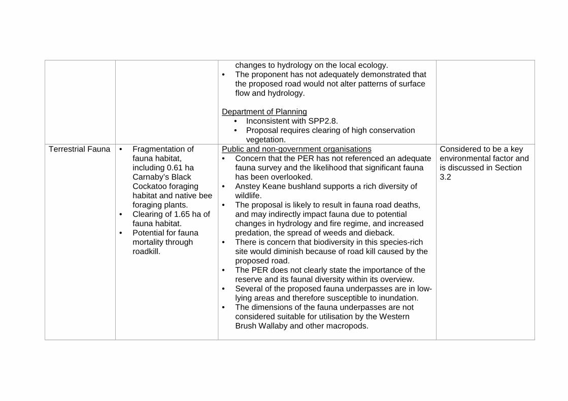
changes to hydrology on the local ecology. • The proponent has not adequately demonstrated that
the proposed road would not alter patterns of surface flow and hydrology.
Department of Planning • Inconsistent with SPP2.8. • Proposal requires clearing of high conservation
vegetation. Terrestrial Fauna • Fragmentation of
fauna habitat, including 0.61 ha Carnaby’s Black Cockatoo foraging habitat and native bee foraging plants.
• Clearing of 1.65 ha of fauna habitat.
• Potential for fauna mortality through roadkill.
Public and non-government organisations • Concern that the PER has not referenced an adequate
fauna survey and the likelihood that significant fauna has been overlooked.
• Anstey Keane bushland supports a rich diversity of wildlife.
• The proposal is likely to result in fauna road deaths, and may indirectly impact fauna due to potential changes in hydrology and fire regime, and increased predation, the spread of weeds and dieback.
• There is concern that biodiversity in this species-rich site would diminish because of road kill caused by the proposed road.
• The PER does not clearly state the importance of the reserve and its faunal diversity within its overview.
• Several of the proposed fauna underpasses are in low-lying areas and therefore susceptible to inundation.
• The dimensions of the fauna underpasses are not considered suitable for utilisation by the Western Brush Wallaby and other macropods.
Considered to be a key environmental factor and is discussed in Section 3.2
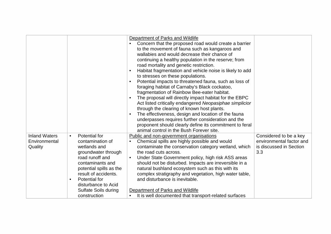
Department of Parks and Wildlife • Concern that the proposed road would create a barrier
to the movement of fauna such as kangaroos and wallabies and would decrease their chance of continuing a healthy population in the reserve; from road mortality and genetic restriction.
• Habitat fragmentation and vehicle noise is likely to add to stresses on these populations.
• Potential impacts to threatened fauna, such as loss of foraging habitat of Carnaby’s Black cockatoo, fragmentation of Rainbow Bee-eater habitat.
• The proposal will directly impact habitat for the EBPC Act listed critically endangered Neopasiphae simplicior through the clearing of known host plants.
• The effectiveness, design and location of the fauna underpasses requires further consideration and the proponent should clearly define its commitment to feral animal control in the Bush Forever site.
Inland Waters Environmental Quality
• Potential for contamination of wetlands and groundwater through road runoff and contaminants and potential spills as the result of accidents.
• Potential for disturbance to Acid Sulfate Soils during construction
Public and non-government organisations • Chemical spills are highly possible and would
contaminate the conservation category wetland, which the road cuts across.
• Under State Government policy, high risk ASS areas should not be disturbed. Impacts are irreversible in a natural bushland ecosystem such as this with its complex stratigraphy and vegetation, high water table, and disturbance is inevitable.
Department of Parks and Wildlife • It is well documented that transport-related surfaces
Considered to be a key environmental factor and is discussed in Section 3.3
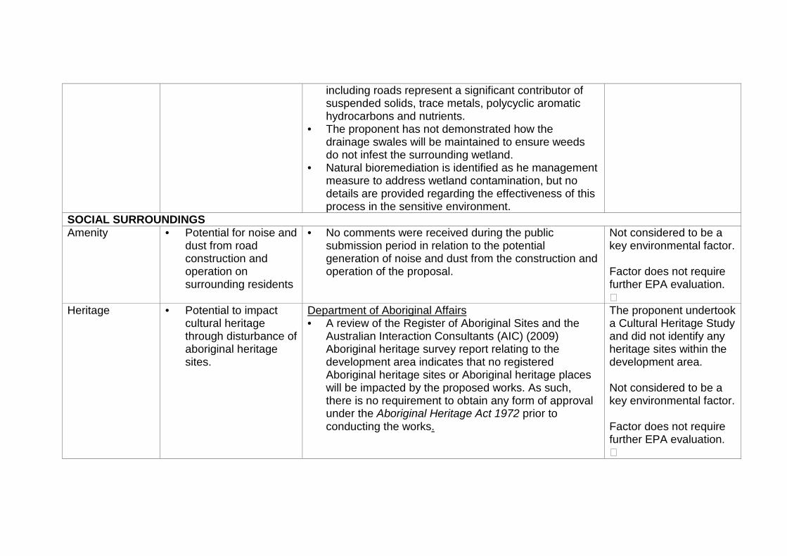
including roads represent a significant contributor of suspended solids, trace metals, polycyclic aromatic hydrocarbons and nutrients.
• The proponent has not demonstrated how the drainage swales will be maintained to ensure weeds do not infest the surrounding wetland.
• Natural bioremediation is identified as he management measure to address wetland contamination, but no details are provided regarding the effectiveness of this process in the sensitive environment.
SOCIAL SURROUNDINGS Amenity • Potential for noise and
dust from road construction and operation on surrounding residents
• No comments were received during the public submission period in relation to the potential generation of noise and dust from the construction and operation of the proposal.
Not considered to be a key environmental factor. Factor does not require further EPA evaluation.
Heritage • Potential to impact cultural heritage through disturbance of aboriginal heritage sites.
Department of Aboriginal Affairs • A review of the Register of Aboriginal Sites and the
Australian Interaction Consultants (AIC) (2009) Aboriginal heritage survey report relating to the development area indicates that no registered Aboriginal heritage sites or Aboriginal heritage places will be impacted by the proposed works. As such, there is no requirement to obtain any form of approval under the Aboriginal Heritage Act 1972 prior to conducting the works.
The proponent undertook a Cultural Heritage Study and did not identify any heritage sites within the development area. Not considered to be a key environmental factor. Factor does not require further EPA evaluation.
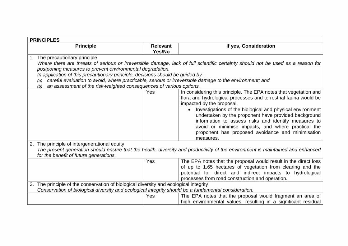
PRINCIPLES Principle Relevant
Yes/No If yes, Consideration
1. The precautionary principle Where there are threats of serious or irreversible damage, lack of full scientific certainty should not be used as a reason for postponing measures to prevent environmental degradation. In application of this precautionary principle, decisions should be guided by – (a) careful evaluation to avoid, where practicable, serious or irreversible damage to the environment; and (b) an assessment of the risk-weighted consequences of various options.
Yes In considering this principle. The EPA notes that vegetation and flora and hydrological processes and terrestrial fauna would be impacted by the proposal.
• Investigations of the biological and physical environment undertaken by the proponent have provided background information to assess risks and identify measures to avoid or minimise impacts, and where practical the proponent has proposed avoidance and minimisation measures.
2. The principle of intergenerational equity The present generation should ensure that the health, diversity and productivity of the environment is maintained and enhanced for the benefit of future generations.
Yes The EPA notes that the proposal would result in the direct loss of up to 1.65 hectares of vegetation from clearing and the potential for direct and indirect impacts to hydrological processes from road construction and operation.
3. The principle of the conservation of biological diversity and ecological integrity Conservation of biological diversity and ecological integrity should be a fundamental consideration.
Yes The EPA notes that the proposal would fragment an area of high environmental values, resulting in a significant residual
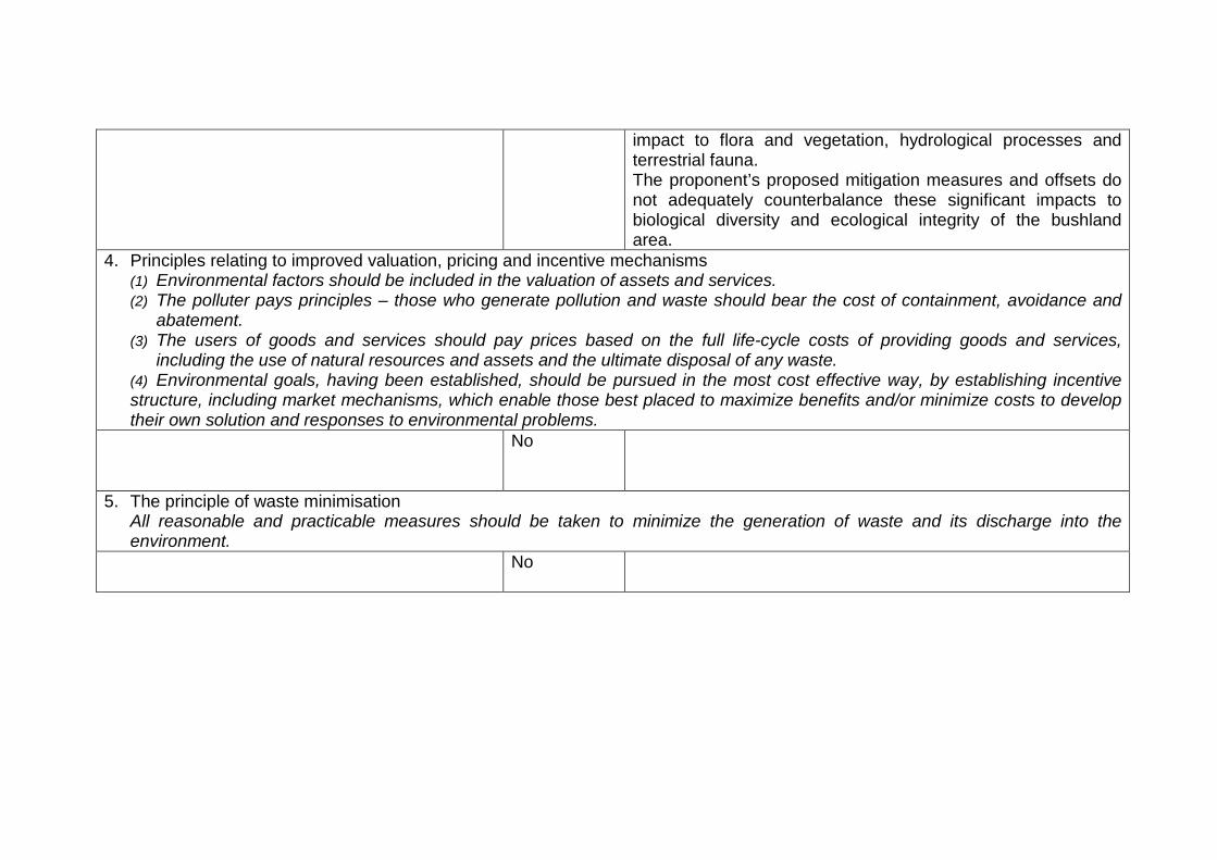
impact to flora and vegetation, hydrological processes and terrestrial fauna. The proponent’s proposed mitigation measures and offsets do not adequately counterbalance these significant impacts to biological diversity and ecological integrity of the bushland area.
4. Principles relating to improved valuation, pricing and incentive mechanisms (1) Environmental factors should be included in the valuation of assets and services. (2) The polluter pays principles – those who generate pollution and waste should bear the cost of containment, avoidance and
abatement. (3) The users of goods and services should pay prices based on the full life-cycle costs of providing goods and services,
including the use of natural resources and assets and the ultimate disposal of any waste. (4) Environmental goals, having been established, should be pursued in the most cost effective way, by establishing incentive structure, including market mechanisms, which enable those best placed to maximize benefits and/or minimize costs to develop their own solution and responses to environmental problems.
No
5. The principle of waste minimisation All reasonable and practicable measures should be taken to minimize the generation of waste and its discharge into the environment.
No

Appendix 4
Identified Decision-making Authorities
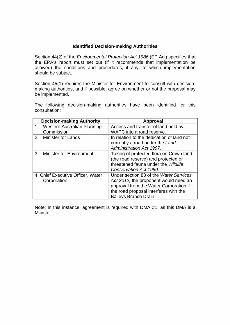
Identified Decision-making Authorities
Section 44(2) of the Environmental Protection Act 1986 (EP Act) specifies that the EPA’s report must set out (if it recommends that implementation be allowed) the conditions and procedures, if any, to which implementation should be subject. Section 45(1) requires the Minister for Environment to consult with decision-making authorities, and if possible, agree on whether or not the proposal may be implemented. The following decision-making authorities have been identified for this consultation:
Decision-making Authority Approval
1. Western Australian Planning Commission
Access and transfer of land held by WAPC into a road reserve.
2. Minister for Lands In relation to the dedication of land not currently a road under the Land Administration Act 1997.
3. Minister for Environment Taking of protected flora on Crown land (the road reserve) and protected or threatened fauna under the Wildlife Conservation Act 1950.
4. Chief Executive Officer, Water Corporation
Under section 88 of the Water Services Act 2012, the proponent would need an approval from the Water Corporation if the road proposal interferes with the Baileys Branch Drain.
Note: In this instance, agreement is required with DMA #1, as this DMA is a Minister.
Appendix 5
Summary of Submissions and Proponent’s Response to Submissions
Provided on CD in hardcopies of this report and on the EPA’s website at www.epa.wa.gov.au