Embed Size (px)
Citation preview

2 September 2015
GRANTHAM QUARRY - GEOTECHNICAL INVESTIGATIONS & EXPERT OPINION ON FORMATION OF EARTHWORKS - SUPPLEMENTARY REPORT CONCERNING PRE-QUARRY TERRAIN AT SAND BATCHING PLANT
Grantham Floods Commission of Inquiry
REP
OR
T
Report Number. 1532696-003-Rev2
Distribution:
Ms Joanne Paterson Director Flood Commission of Inquiry
Submitted to:Grantham Floods Commission of Inquiry Level 3, Annexe 100 George Street BRISBANE QLD 4000

GRANTHAM QUARRY - GEOTECHNICAL INVESTIGATIONS - EXPERT OPINION
2 September 2015 Report No. 1532696-003-Rev2 i
Table of Contents
1.0 THE COMMISSION ................................................................................................................................................... 1
1.1 Background .................................................................................................................................................. 1
1.2 My Previous Instructions ............................................................................................................................... 1
1.3 My Current Instructions ................................................................................................................................. 1
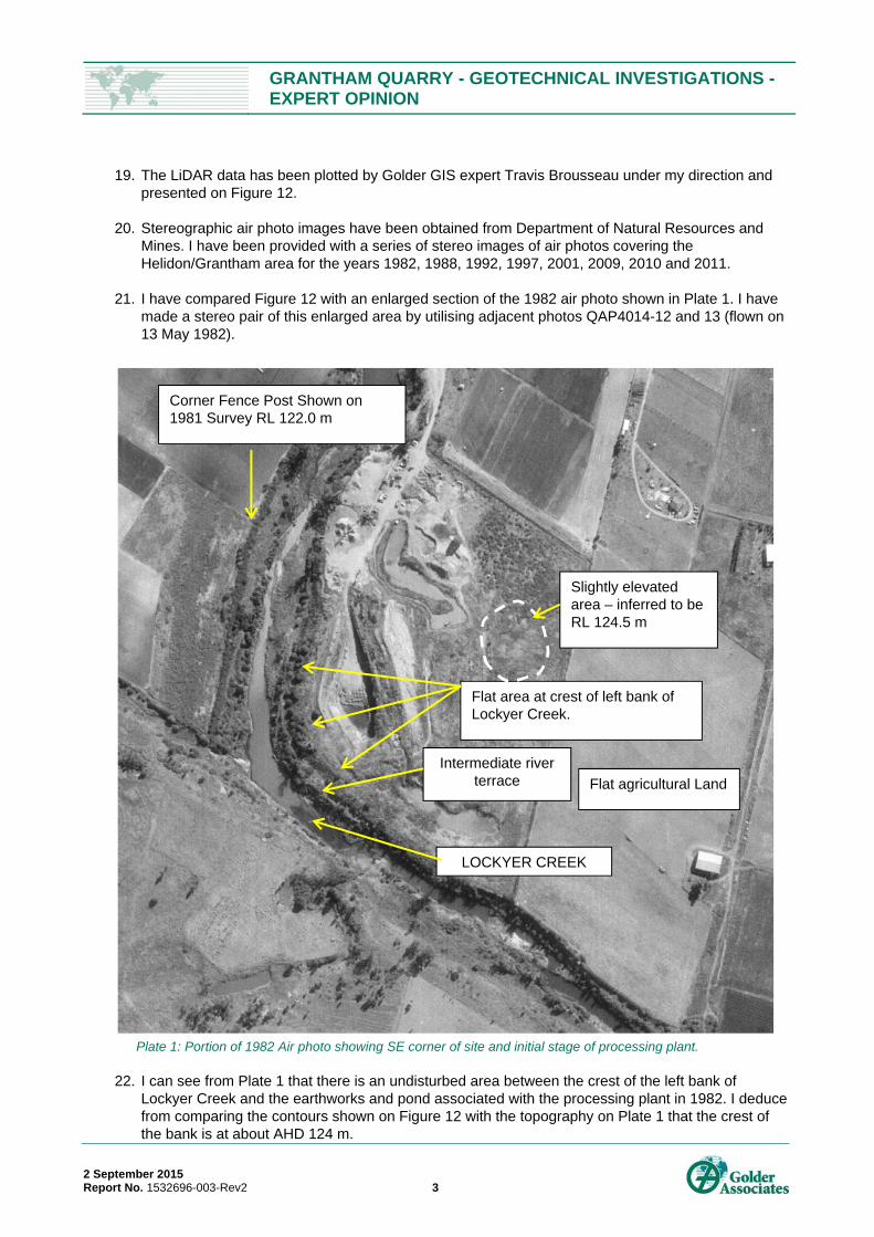
2.0 QUALIFICATIONS & EXPERIENCE ......................................................................................................................... 2
3.0 DOCUMENTATION & DATA PROVIDED ................................................................................................................. 2
4.0 THE QUARRY SITE & GEOLOGICAL SETTING ..................................................................................................... 2
5.0 TOPOGRAPHY & MORPHOLOGY OF THE CONCRETE BATCHING PLANT AREA ............................................ 2
6.0 RECONSTRUCTION OF PRE-QUARRY CONTOURS, BATCHING PLANT AREA ................................................ 5
7.0 COMMENT ON PRE-QUARRY GROUND SURFACE .............................................................................................. 5
8.0 CONCLUSIONS ABOUT THE PRE-QUARRY GROUND SURFACE IN THE BATCHING PLANT AREA .............. 6
TEXT PLATES
Plate 1: Portion of 1982 Air photo showing SE corner of site and initial stage of processing plant.
Plate 2: Survey Plan of Quarry Site dated August 1981.
Plate 3: Reconstructed topographic plan of Batching Plant Site superimposed on LiDAR survey.
FIGURES:
Figure12: Pre-flood contours South East.
Figure13: Re-constructed pre-quarry contours South East.
APPENDICES
APPENDIX A Letter of Instruction
GRANTHAM QUARRY - GEOTECHNICAL INVESTIGATIONS - EXPERT OPINION
2 September 2015 Report No. 1532696-003-Rev2 1
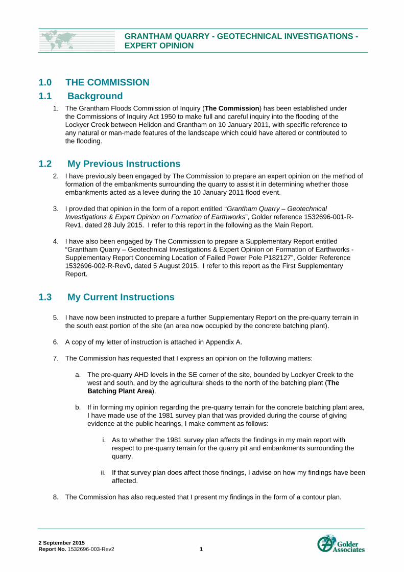
1.0 THE COMMISSION
1.1 Background 1. The Grantham Floods Commission of Inquiry (The Commission) has been established under
the Commissions of Inquiry Act 1950 to make full and careful inquiry into the flooding of the Lockyer Creek between Helidon and Grantham on 10 January 2011, with specific reference to any natural or man-made features of the landscape which could have altered or contributed to the flooding.
1.2 My Previous Instructions 2. I have previously been engaged by The Commission to prepare an expert opinion on the method of
formation of the embankments surrounding the quarry to assist it in determining whether those embankments acted as a levee during the 10 January 2011 flood event.
3. I provided that opinion in the form of a report entitled “Grantham Quarry – Geotechnical Investigations & Expert Opinion on Formation of Earthworks”, Golder reference 1532696-001-R-Rev1, dated 28 July 2015. I refer to this report in the following as the Main Report.
4. I have also been engaged by The Commission to prepare a Supplementary Report entitled “Grantham Quarry – Geotechnical Investigations & Expert Opinion on Formation of Earthworks - Supplementary Report Concerning Location of Failed Power Pole P182127”, Golder Reference 1532696-002-R-Rev0, dated 5 August 2015. I refer to this report as the First Supplementary Report.
1.3 My Current Instructions
5. I have now been instructed to prepare a further Supplementary Report on the pre-quarry terrain in the south east portion of the site (an area now occupied by the concrete batching plant).
6. A copy of my letter of instruction is attached in Appendix A.
7. The Commission has requested that I express an opinion on the following matters:
a. The pre-quarry AHD levels in the SE corner of the site, bounded by Lockyer Creek to the west and south, and by the agricultural sheds to the north of the batching plant (The Batching Plant Area).
b. If in forming my opinion regarding the pre-quarry terrain for the concrete batching plant area, I have made use of the 1981 survey plan that was provided during the course of giving evidence at the public hearings, I make comment as follows:
i. As to whether the 1981 survey plan affects the findings in my main report with respect to pre-quarry terrain for the quarry pit and embankments surrounding the quarry.
ii. If that survey plan does affect those findings, I advise on how my findings have been affected.
8. The Commission has also requested that I present my findings in the form of a contour plan.

GRANTHAM QUARRY - GEOTECHNICAL INVESTIGATIONS - EXPERT OPINION
2 September 2015 Report No. 1532696-003-Rev2 2
2.0 QUALIFICATIONS & EXPERIENCE 9. My name is David Clark Starr and I am a Principal Geotechnical Engineer with Golder Associates
Pty Ltd (Golder Associates) of 147 Coronation Drive, Milton, Brisbane, Queensland 4064.
10. I am a Geotechnical Engineer with 44 years’ experience in consulting in geotechnical engineering and engineering geology.
11. My experience is detailed in a CV presented as Appendix D in the Main Report. I confirm that there
has been no change in qualifications since preparation of the Main Report.
3.0 DOCUMENTATION & DATA PROVIDED
12. In forming my opinion, I have relied upon the following documents:
a. The 1982 air photography discussed and presented in Section 9.1 of my Main Report.
b. The 1981 spot height survey of the quarry site included in evidence presented as page 28 of Attachment IF2 to the statement of Ian Flint, CEO Lockyer Valley Regional Council made on 24 July 2015 (Exhibit 94).
c. Pre-flood contours derived from LiDAR data, taken over the quarry area in August 2010.
d. The findings and material contained in the Main Report.
4.0 THE QUARRY SITE & GEOLOGICAL SETTING 13. The quarry site is located approximately 4 km west of the town of Grantham, Queensland. It is
enclosed within an oxbow bend in the Lockyer River, creating a ”U” shaped parcel of land bounded on three sides by the creek.
14. I note that the site is formed of Quaternary Flood Plain material comprising alluvial sands, gravel and silt, and is underlain by Marburg Formation sandstone and siltstone of Lower to Middle Jurassic age. The geological setting is described in further detail in Section 5.0 of my Main Report.
15. The Concrete Batching Plant is located on the left bank of Lockyer Creek, downstream of the ford crossing point. I consider that this area is also formed of alluvial flood plain material.
5.0 TOPOGRAPHY & MORPHOLOGY OF THE CONCRETE BATCHING PLANT AREA
16. In order to re-construct the pre-quarry topography of the Batching Plant Area, I have made use of topographic data plotted from pre-flood LiDAR data (2010) for the area of the Batching Plant.
17. The first LiDAR survey was undertaken between 1st to 22nd August 2010 before the flood.
18. LIDAR is a remote sensing method that uses light in the form of a pulsed laser to measure ranges (variable distances) to the earth surface. These light pulses - combined with other data recorded by the airborne system - generate precise, three-dimensional information about the surface characteristics of the area being surveyed.
GRANTHAM QUARRY - GEOTECHNICAL INVESTIGATIONS - EXPERT OPINION
2 September 2015 Report No. 1532696-003-Rev2 3
19. The LiDAR data has been plotted by Golder GIS expert Travis Brousseau under my direction and presented on Figure 12.
20. Stereographic air photo images have been obtained from Department of Natural Resources and
Mines. I have been provided with a series of stereo images of air photos covering the Helidon/Grantham area for the years 1982, 1988, 1992, 1997, 2001, 2009, 2010 and 2011.
21. I have compared Figure 12 with an enlarged section of the 1982 air photo shown in Plate 1. I have made a stereo pair of this enlarged area by utilising adjacent photos QAP4014-12 and 13 (flown on 13 May 1982).
Plate 1: Portion of 1982 Air photo showing SE corner of site and initial stage of processing plant.
22. I can see from Plate 1 that there is an undisturbed area between the crest of the left bank of Lockyer Creek and the earthworks and pond associated with the processing plant in 1982. I deduce from comparing the contours shown on Figure 12 with the topography on Plate 1 that the crest of the bank is at about AHD 124 m.
Flat area at crest of left bank of Lockyer Creek.
Flat agricultural Land
LOCKYER CREEK
Intermediate river terrace
Corner Fence Post Shown on 1981 Survey RL 122.0 m
Slightly elevated area – inferred to be RL 124.5 m

GRANTHAM QUARRY - GEOTECHNICAL INVESTIGATIONS - EXPERT OPINION
2 September 2015 Report No. 1532696-003-Rev2 4
23. I can also see from comparing Figure 12 with Plate 1 that: a. There is an intermediate river terrace at about 120 m AHD. b. There is a small area to the east of the Batching Plant which is at a slightly higher elevation
than the flat area surrounding. This is marked on Plate 1, and based on the contours shown on Figure 12, I believe the elevation of this area is about 124.5 m AHD. In my opinion, this area which is shown in the 1982 photo probably had the same elevation before the quarry development.
24. I have compared Plate 1 with the 1981 Survey Plan that was provided to me during the course of
my evidence at the hearings (presented as Exhibit 94).
25. I can recognise a corner of an agricultural field on the right bank of Lockyer Creek which has an RL at the base of a fence post of 122.0 m – refer to 1981 survey plan (see Plate 2).
Plate 2: Survey Plan of Quarry Site dated August 1981
Corner Fence Post – Base RL 122.00 m

GRANTHAM QUARRY - GEOTECHNICAL INVESTIGATIONS - EXPERT OPINION
2 September 2015 Report No. 1532696-003-Rev2 5
26. On examining the 1982 air photo under a stereo viewer, I can detect that the fence post location is slightly lower than the crest of the creek bank on the opposite (eastern) side of Lockyer Creek. I have marked the fence post location on Plate 1.
6.0 RECONSTRUCTION OF PRE-QUARRY CONTOURS, BATCHING PLANT AREA
27. I have created a pre-quarry contour plan based on the inferences outlined above. This is
reproduced below as Plate 3. It should be noted that the reconstructed contours apply only to the batching plant area on the left bank of Lockyer Creek i.e. on the right side of plate. The contours on the right bank near the quarry lake have not been adjusted (but I have blanked out the area of the quarry lake and associated earthworks).
Plate 3: Reconstructed topographic plan of Batching Plant Site superimposed on LiDAR survey
28. The version of this plan produced for the purposes of making a digital terrain model is presented as Figure 13. Again, it should be noted that the reconstructed contours apply only to the batching plant area.
7.0 COMMENT ON PRE-QUARRY GROUND SURFACE 29. The survey plan presented as Plate 2 in this supplementary report was not available to me prior to
preparing my Main Report.
30. From the above considerations, I can comment as follows on the Pre-Quarry Topography:
GRANTHAM QUARRY - GEOTECHNICAL INVESTIGATIONS - EXPERT OPINION
2 September 2015 Report No. 1532696-003-Rev2 6
a. After examining the spot heights depicted on Plate 2, I can confirm that the 1981 survey plan does not affect the findings in my Main Report as to the pre-quarry terrain for the quarry pit and embankments around the quarry;
b. The spot height survey shows that the flow path from the site of the Main Breach pre-quarry crosses a land surface which dips gently from about RL 124 in the NW to about 122 m AHD in the SE of the Quarry site. This fall is consistent with the model shown in Plate 21 of my Main Report.
.
8.0 CONCLUSIONS ABOUT THE PRE-QUARRY GROUND SURFACE IN THE BATCHING PLANT AREA
31. Based on the findings from examination of available data, I draw the following conclusions about the Pre-Quarry topography in the Batching Plant Area:
a. The initial stages of the plant were built on flat agricultural land. The top of the river bank was about 124 AHD, and the ground was then essentially a flat flood plain (similar to the pre-flood quarry pit area to the east of the western levee).
b. I have marked up on a LiDAR survey plan the inferred location of the 124 m AHD contour – the land to the east of this (now occupied by the batching plant) is also interpreted to be at about RL 124 m, although I observed a small area with a slightly higher elevation of about 124.5 m AHD.
c. On the river bank there was one intermediate terrace as shown by the contours at about 120 m AHD.
d. The reconstructed contour plan for the Batching Plant Area is presented as Plate 13.
GOLDER ASSOCIATES PTY LTD
David Starr Principal Geotechnical Engineer BSc MSc FIEAust CPEng RPEQ 5836
DCS/dcs/mm
A.B.N. 64 006 107 857
Golder, Golder Associates and the GA globe design are trademarks of Golder Associates Corporation.
f:\1532696-002-r-revb_2 aug 2015.docx

Inform
ation
conta
ined o
n this
draw
ing is
the c
opyri
ght o
f Gold
er As
socia
tes Pt
y. Ltd
. Una
uthori
sed u
se or
repro
ducti
on of
this
plan e
ither
wholl
y or in
part w
ithou
t writt
en pe
rmiss
ion in
fringe
s cop
yrigh
t. ©
Gold
er As
socia
tes Pt
y. Ltd
.
125.5
124123.5123
122.5122120.5120
114113.5113
129
126.5
126125121
119.5
119115.5115
114.5112.5
130129.5
129128.5
128127.5
127126.5
126
125.5125
124.5
121120
116
113
131130.5
122.5122
121.5120.5
119.5
114.5
129
127126.5 127.5 12
6 124.5 124
130.5130
126.5126125124
123122
121.5
127124.5
121119118
116.5
118.5
117.5115
130
128
127
125
127.5126
126125 12
4127
123.5
125.5124
.5122
121.5
129128.5
128
126
125.5
127
125
128.5126
126.5125.5
126.5125
128
126
127.5 127
128126.5
128126
126 125
130.5
130
127.5127
128
126.5
126
125.5
131.5
131
128.5128
124.5124
124.5
124
128127
126 125.5
125124.5
124.5124
124123.5
129
128.5
128
127.5
125.5 12
5
125
124.5
121 120.5
112.5112
131.5
129.5
128
127.5
127121
.5
118.5
118
117.5
117
116.5
116
124
123.5
123
119
118.5
118
117.5
117
116.5115.5
115
114
113.5
112
131.5
129.5
128.5
128
125.5
123.5
122.5
121
120.5
120
119.5
117
116
115.5
114.5
114
129
125.5
123
123.5
123
122.5
127.5
127
126.5
128
127.5
127
127
126.5
128
126
126.5
126
125.5
125
126
125
126
131
126.5127
127
124
123.5
123
128.5
127
126.5
127
126
126
125.5
125.5
125
124
119
131
129.5
128
127.5
126.5
127
127
126
125
125
125
124
124
123.5
123
122
119117
.5
114.5
113
132
132
132
132
130.5130
129 129129
128
127.5
127.5
128
128
128
128
127.5
126.5
126.5
127
127
127
127
127
126.5
126
126
126
126
125.5
125.5
125
125.5
125.5
125
125
125
125
125
125
125
125
124
124.5
124.5
124
124
124.5
124.5
124
124
124
124
124
123.5
123
123.5
123
123
122
121
120
118
113.5
113.5
112.5
112.5
112.5
112.5
112.5
112.5
112
112
112
124.5
124
124
124
124
124
124
124124
417,800
417,800
417,900
417,900
418,000
418,000
418,100
418,100
418,200
418,200
418,300
418,300
6,949
,300
6,949
,300
6,949
,400
6,949
,400
6,949
,500
6,949
,500
6,949
,600
6,949
,600
6,949
,700
6,949
,700
GRANTHAM FLOOD COMMISSIONOF INQUIRYGRANTHAM QUARRY
PRE FLOOD CONTOURSSOUTHEAST
SCALE (at A1)DATUM GDA94, PROJECTION MGA Zone 56
FIGURE 12
1:900
0 20 40 60 80 10010Scale in Metres
±
DSTB
LEGENDContour (0.5m)
PROJECT:
CHECKED:
DATE:DRAWN:
19 AUG 2015
File Location: R:\01 Client\Grantham Floods Commission of Inquiry\1532696\Programs\ArcGIS\1532696-001-F012-REV1.mxd
1532696

Infor
matio
n con
taine
d on t
his dr
awing
is th
e cop
yrigh
t of G
older
Ass
ociat
es P
ty. Lt
d. U
nauth
orise
d use
or re
prod
uctio
n of t
his pl
an e
ither
who
lly or
in pa
rt wi
thout
writte
n per
miss
ion in
fring
es co
pyrig
ht.
© Go
lder A
ssoc
iates
Pty.
Ltd.
File Location: R:\01 C lient\Grantham Floods Commission of Inquiry\1532696\Programs\ArcGIS\1532696-001-F013-REV2.mxd
RECONSTRUCTED PRE-QUARRY CONTOURS SOUTHEAST
GRANTHAM FLOOD COMMISSIONOF INQUIRY
GRANTHAM QUARRY 1532696
DS
02 SEP 2015TB
PROJECT:
CHECKED:
DATE:DRAWN:
FIGURE 13
d. Clay Hill Stockpile removal DEM created by Golder.
Note: reconstructed contoursapply to Batching Plant Area only.

GRANTHAM QUARRY - GEOTECHNICAL INVESTIGATIONS - EXPERT OPINION
2 September 2015 Report No. 1532696-003-Rev2
APPENDIX A Letter of Instruction
PO Box 15185 Telephone Email CITY EAST QLD 4002 (07) 300 39451 [email protected]
Reference number: DOC/15/146730
Mr David Starr Golder Associates Pty Ltd By email: [email protected]
Dear Mr Starr
GRANTHAM FLOODS COMMISSON OF INQUIRY – GEOTECHNICAL OPINION CONCERNING CONCRETE BATCHING PLANT
We refer to our letter of instructions dated 10 July 2015 in which we requested that you provide an expert opinion concerning the formation of embankments surrounding the Grantham quarry. We note that this opinion was provided in your report provided to the Commission on 28 July 2015 (First Report).
In addition to the First Report, we now request your opinion concerning the pre-quarry terrain in the South East corner of the Quarry site, bounded by Lockyer Creek to the west and south, and by the agricultural sheds to the north. More specifically, we request that you opine on the pre-quarry AHD levels for this area, an area that is presently occupied by a concrete batching plant.
If, in forming your opinion on the matters above, you consider it necessary to refer to a 1981 survey plan provided to you during the course of the hearings before the Commission, we request that you opine on whether that survey plan affects the findings in your First Report. If it does affect those findings, we request that you advise how those findings are so affected.
We request that you provide your opinion on the above matters in the form of a supplementary expert report. To the extent that you consider it necessary, please include in that report suitable drawings, maps, contour plans and photographs to explain your opinion.
We look forward to receiving your supplementary report in due course.
Yours sincerely

Joanne Paterson Director Grantham Floods Commission of Inquiry
26 /8 /2015
Page 2 of 2

Golder Associates Pty Ltd
147 Coronation Drive
Milton, Queensland 4064
Australia
T: +61 7 3721 5400