Embed Size (px)
Citation preview
URBAN RENEWAL- CHETPUT STATION AREA
A THESIS
Submitted by
RAMACHANDRAN A
in partial fulfillment of the requirements for the degree
of
MASTER OF PLANNING
DEPARTMENT OF PLANNING
SCHOOL OF ARCHITECTURE AND PLANNING
ANNA UNIVERSITY
CHENNAI 600 025
JUNE 2014
CERTIFICATE
The present Thesis tilted "URBAN RENEWAL – CHEPUT STATION AREA" has been
carried out as part of the Course "TP 9142 Thesis" at the Department of Planning, School of
Architecture and Planning Campus, Anna University.
The work reported herein is original and does not form part of any other thesis or dissertation
on the basis of which a degree or award was conferred on an earlier occasion or to any other
student / scholar.
I understand the University's Policy on Plagiarism and declare that this thesis is my own
work, except where specifically acknowledged and has not been copied from other sources or
been previously submitted for any award.
Ramachandran AReg. No. 2012803012
Dr. Pratheep Moses KSupervisor
i
ABSTRACT
The pace of urbanization in India is faster than many other countries in the region; its
heavy concentration in large mega cities is a unique condition. Due to these Large cities are
growing too rapidly, worsening the balance between population and resources. They are
becoming "problem cities" and "cities with all type of shortages". Limited existing
infrastructure and civic amenities, and constraints of available funds, slow the process of
development. Further, the lack of policies and systematic planning in these rapidly growing
cities has led to a situation where living has become strenuous with supply not able to meet
even the minimum requirements. The situation is already bad, and getting worse; it is
threatening the real fiber of life there.
The developing countries used the concept of urban renewal as a method for social
reform as a reaction to the increasingly cramped and unsanitary conditions of the urban poor
in the rapidly urbanizing cities in the mid 19th century. After that the agenda emerged was a
progressive doctrine that assumed better housing conditions would reform its residents
morally and economically. So, urban renewal used as a program of land redevelopment in
areas of moderate to high density urban land use and to revitalize the older parts of the cities.
Therefore urban renewal is a term used for the process of replanning and
comprehensive redevelopment of land structures, physical and social infrastructure as well as
conservation and rehabilitation of areas which have been decline and blighted areas. Urban
renewal was considered an important aspect of urban land policy in India about two decades
ago. For instance the committee on urban land policy (Ministry of health, government of
India 1965) is mentioned about the urban renewal programs. To tackle the problems of the
congested and overcrowded areas three alternatives may be considered Whole sale
demolition and through redevelopment, a program of selective urban renewal and program of
gradual improvement
Over the past two decades Chennai has experienced rapid urban growth, with increase
of population in urban area from 4.4 million in 2001 to 8.9 million in 2011, making it the
fourth most populous metropolitan area in the country. This urban expansion indeed has
resulted in problems, such as growing congestion and chaos in inner city, overcrowded and
poorly equipped urban housing, and old neighborhoods deterioration etc.
ii
Urban development in historical perspective is a cyclic phenomenon depicting
continuous decline and renewal in physical as well as socio economic aspects of human
settlements. As decline and renewal are inevitable process the balancing factor is the pace of
change. In earlier generations, the change was slower but the twentieth century is witnessing
dramatic acceleration resulting in radical disruptions in the physical and socio economic
aspects of urban settlements. Urban renewal program are being implemented in Chennai
cities and renewal is taking place in his mainly in two ways. First rebuilding the old
properties particularly commercial areas George Town and Anna Salai replace the old
buildings with modern buildings for offices and other commercial uses at higher density and
replacing of old central jail into general hospital.
Chennai city main residential areas and older settlements are Chintadripet, Triplicane,
Egmore, Mylapore, Purusawalkam, Vepery and Royapuram. Most of the areas outside these
settlements were covered by gardens and agriculture lands interspersed with bungalows of the
elite. Nungambakkam, Chetput and Kilpauk were some of the areas, which developed in this
manner; Saidapet in the southwest was a separate small settlement. The above residential
areas have developed in the past but some of the areas which are under developed and
unhealthy environment condition for living.
Chetput, not too far from historic Egmore, is located on the picturesque banks of the
river Cooum. According to some scholars, the name Chetput is derived from Chetti Pettah
obviously alluding to the Chettiar community that once lived in many parts of this locality.
Chetput is the case were developed and constructed as bungalows with beautiful gardens and
the agricultural land in the 18th century. Chetput is the older area with major residential
activities as high since the Chennai main commercial activities located in the Egmore which
is near to Chetput. But recent development taken place outer part of the Chetput but along the
station area were obsolete development have taken place and makes unhealthy environment
along the station area. In the current trends were station area is the potential for development
in the fast moving world and it is also important that the station area is vibrant and for major
commercial and economic activity so its need series attention for developing the station area.
Chetput Station Area is located in the centre of Chennai near Egmore. The station
area is connected by NH along the northern side and it is served by Chetput railway station in
iii
the Beach-Tambaram line of Chennai Suburban Railway. The population of Chetput station
area is 16223 and it covers an extent of 0.5sq.km. The population density is of about 325
persons per hectare and net residential density is alone above 550 persons per hectare.
Chetput has a few heritage buildings, mainly in and around Spur Tank Road.
The study area is of high density with slums and less open spaces, it shows that the
area has attained maximum density as per the Master Plan of Chennai. Also the study areas
are of obsolete development because of continuous building that is permitted in this zone.
Building constructed without side setbacks and it creates no open space between buildings. It
affects livelihood environment in that study area. The station area is also facing problems like
dilapidated building, traffic congestion, poor parking facilities etc. Urban renewal for the
station area with suitable recommendations and suggestions can be worked for smaller
pockets to clear the issues based on the urban renewal concept.
The vision is to make the station area to create distinct identity for the station area, to
make transportation improvement and to revitalize for the healthy environment. The
objectives for creating a distinct identity for the station area include creating boundaries,
making streetscape improvements, conservation of older buildings for landmarks and
implementing design guidelines. The objectives for improving the transportation through this
area include traffic flow, pedestrian and parking improvements. The objective for revitalizing
the unhealthy area includes slums providing affordable housing and encourage for
commercial activity in the vacant lots around the station area. The final objective is for
provision of social facilities that would be responsible for the station area.
The proposals for the station area is of redevelopment of slum, major road widening,
modernization of Dhobi kana, conservation of historical buildings, creating for pedestrian
environment, relieve of traffic congestion and modernization of station. Therefore, the above
proposals can be implemented with active involvement of people, governments and other
stake holders. The station area can be used as a tool to guide the urban renewal process.
iv
ACKNOWLEDGEMENT
I take this opportunity to express my sincere thanks to Dr. K . Pratheep Moses,
Associate Professor, Department of Planning, School of Architecture and Planning, Anna
University, Chenai-25. He inspired and supported me at every juncture and was available
every time, even for minor questions to clarify.
I take this opportunity to express my sincere thanks to Dr. Suresh Kuppusamy
external Review member for his valuable comments and suggestion during all the reviews.
I gratefully thank Dr. S. R. Masilamani, Head of the Department, Professor,
Department of Planning, School of Architecture and Planning, Anna University,
Chennai-25, who has coordinated this thesis throughout this semester and for his
encouragement at all stages of thesis.
I express my great sense of appreciation and thanks to all my family members
and friends who offered moral, intellectual and material support without which the
successful completion of this work would have been difficult.
RAMACHANDRAN A
v
TABLE OF CONTENTS
CHAPTER.NO TITLE PAGE NO
ABSTRACT iLIST OF TABLES x
LIST OF FIGURES xi
LIST OF MAPS xiii
LIST OF ABBREVIATIONS xiv
1. INTRODUCTION 1
1.1 BACKGROUND 1
1.2 IMPORTANCE OF URBAN RENEWAL 2
1.3 CONTEXT 3
1.4 JUSTIFICATION 5
1.5 AIM AND OBJECIVES 6
1.6 SCOPE AND LIMITATION 7
1.7 METHODOLOGY 8
1.8 STRUCTURE OF THESIS 11
2. LITERTURE REVIEW 12
2.1 INTRODUCTION 12
2.2 UNDERSTANDING OF URBAN RENEWAL 12
2.2.1 Definition of Urban Renewal 12
2.2.2 Concept of Urban Renewal 15
2.2.3 Dimensions of Urban Renewal 16
2.2.4 Goals of Urban Renewal 17
2.3 CHANGING PERSPECTIVE OF URBAN RENEWAL 17
2.4 URBAN RENEWAL IN INDIAN CONTEXT 21
2.5 PRACTICAL EXPERIENCE 22
2.5.1 Scenario in Mumbai 22
2.5.1.1 Redevelopment on free hold land in Mumbai 22
2.5.1.2 Cluster development in Mumbai 23
vi
2.5.1.3 TOD-Transit oriented development 24
2.5.2 Scenario in Delhi 24
2.5.2.1 Walled city of Delhi 25
2.5.2.2 Delhi master plan recommendation
for the walled city 25
2.6 INFERENCE 26
3. CHENNAI CITY ANALYSIS 27
3.1 INTRODUCTION 27
3.2 CHENNAI CITY PROFILE 27
3.3 PHYSICAL ASPECTS 28
3.3.1 Land Use 28
3.3.2 Physical Infrastructure 30
3.3.2.1 Water supply and sanitation 30
3.3.2.2 Solid waste 31
3.3.2.3 Drainage system 32
3.3.3 Transportation 33
3.3.1 Road network 33
3.3.2 Rail network 34
3.4 SOCIAL ASPECTS 35
3.4.1 Population Growth and Density 35
3.4.2 Development in Chennai 36
3.4.3 Housing 37
3.5 ECONOMIC ASPECTS 40
3.6 ENVIRONMANT ASPECTS 41
3.6.1 Pollution by Waterways 41
3.6.2 Air Pollution 42
3.6.3 Noise Pollution 42
3.6.4 Pollution by Urban Solid Waste 43
3.6.5 Green Cover 43
3.7 LEGAL ASPECTS 43
3.8 INFERENCE 45
vii
4. DELINEATION OF STUY AREA 47
4.1 INTRODUCTION 47
4.2 POPULATION GROWTH AND DENSITY 48
4.3 SLUM 51
4.4 AGE CRITERIA 52
4.5 LOCATION FACTOR 53
4.6 SELECTION OF STUDY AREA 54
5. CHETPUT STATION AREA 57
5.1 INTRODUCTION 57
5.2 LOCATION AND CONNECTIVITY 57
5.3 HISTORY OF CHETPUT 58
5.4 DEMOGRAPHY 59
5.4.1 Population Growth 60
5.4.2 Density 61
5.4.3 Literacy Rate and Sex Ratio 61
5.4.3.1 Literacy rate 61
5.4.3.2 Sex ratio 61
5.4.4 Occupation Pattern 62
5.4.5 Economic Base of the Area 62
5.4 DEVELOPMENT PATTERN 63
5.6 EXISTING LAND USE 64
5.7 IDENTITY FOR CHETPUT STATION AREA 64
5.7.1 Chetput Lake 64
5.7.2 Dhobi Khana 65
5.7.3 Chetput Station 66
5.7.4 Historical Building 67
5.8 PHYSICAL INFRASTRUCTURE 68
5.8.1 Water Supply and Sanitation 68
5.8.2 Solid Waste 68
5.8.3 Transportation 69
5.8.3.1 Roads 69
viii
5.8.3.2 Pedestrian environment 69
5.8.3.3 Bus shelter 69
5.8.3.4 street light 69
5.9 SOCIAL INFRASTRUCTURE 70
5.9.1 Housing 70
5.9.2 Hospital 70
5.9.3 Recreation facilities 70
5.10 INFERENCE 70
6. ANALYSIS AND PROPOSALS 75
6.1 INTRODUCTION 75
6.2 RESTORING ITS IDENTITY 75
6.2.1 Chetput Lake 75
6.2.1.1 Issues 76
6.2.1.2 Proposals 76
6.2.2 Modernization of Dhobi Khana 78
6.2.2.1 Issues 78
6.2.2.2 Proposals 79
6.2.3 Conservation of Historical Building 81
6.2.3.1 Issues 81
6.2.3.2 Proposals 81
6.2.4 Chetput Station 82
6.2.4.1 Issues 83
6.2.4.2 Proposals 83
6.3 PHYSICAL INRASTRUCTURE 84
6.3.1 Solid Waste 84
6.3.1.1 Issues 84
6.3.1.2 Proposals 85
6.3.2 Storm water Drain 86
6.3.2.1 Issues 86
6.3.2.2 Proposals 86
6.4 TRANSPORTATION 87
ix
6.4.1 Roads and Traffic Improvements 87
6.4.1.1 Issues 87
6.4.1.2 Proposals 88
6.5 HOUSING 91
6.5.1 Issues 91
6.5.2 Proposals 92
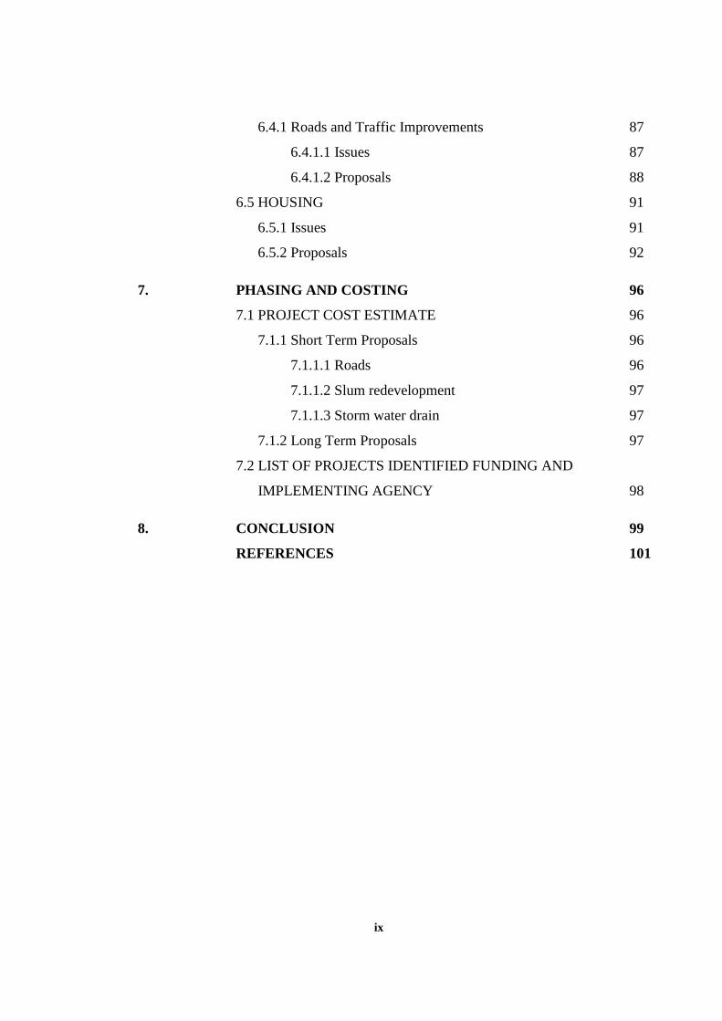
7. PHASING AND COSTING 96
7.1 PROJECT COST ESTIMATE 96
7.1.1 Short Term Proposals 96
7.1.1.1 Roads 96
7.1.1.2 Slum redevelopment 97
7.1.1.3 Storm water drain 97
7.1.2 Long Term Proposals 97
7.2 LIST OF PROJECTS IDENTIFIED FUNDING AND
IMPLEMENTING AGENCY 98
8. CONCLUSION 99
REFERENCES 101
x
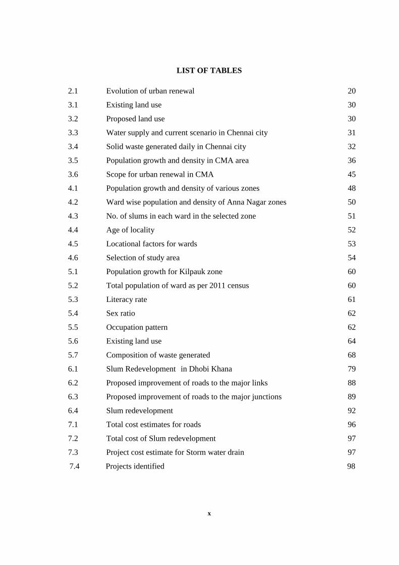
LIST OF TABLES
2.1 Evolution of urban renewal 20
3.1 Existing land use 30
3.2 Proposed land use 30
3.3 Water supply and current scenario in Chennai city 31
3.4 Solid waste generated daily in Chennai city 32
3.5 Population growth and density in CMA area 36
3.6 Scope for urban renewal in CMA 45
4.1 Population growth and density of various zones 48
4.2 Ward wise population and density of Anna Nagar zones 50
4.3 No. of slums in each ward in the selected zone 51
4.4 Age of locality 52
4.5 Locational factors for wards 53
4.6 Selection of study area 54
5.1 Population growth for Kilpauk zone 60
5.2 Total population of ward as per 2011 census 60
5.3 Literacy rate 61
5.4 Sex ratio 62
5.5 Occupation pattern 62
5.6 Existing land use 64
5.7 Composition of waste generated 68
6.1 Slum Redevelopment in Dhobi Khana 79
6.2 Proposed improvement of roads to the major links 88
6.3 Proposed improvement of roads to the major junctions 89
6.4 Slum redevelopment 92
7.1 Total cost estimates for roads 96
7.2 Total cost of Slum redevelopment 97
7.3 Project cost estimate for Storm water drain 97
7.4 Projects identified 98
xi
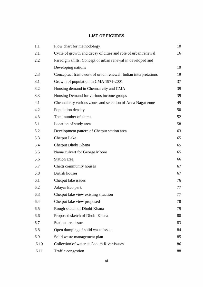
LIST OF FIGURES
1.1 Flow chart for methodology 10
2.1 Cycle of growth and decay of cities and role of urban renewal 16
2.2 Paradigm shifts: Concept of urban renewal in developed and
Developing nations 19
2.3 Conceptual framework of urban renewal: Indian interpretations 19
3.1 Growth of population in CMA 1971-2001 37
3.2 Housing demand in Chennai city and CMA 39
3.3 Housing Demand for various income groups 39
4.1 Chennai city various zones and selection of Anna Nagar zone 49
4.2 Population density 50
4.3 Total number of slums 52
5.1 Location of study area 58
5.2 Development pattern of Chetput station area 63
5.3 Chetput Lake 65
5.4 Chetput Dhobi Khana 65
5.5 Name culvert for George Moore 65
5.6 Station area 66
5.7 Chetti community houses 67
5.8 British houses 67
6.1 Chetput lake issues 76
6.2 Adayar Eco park 77
6.3 Chetput lake view existing situation 77
6.4 Chetput lake view proposed 78
6.5 Rough sketch of Dhobi Khana 79
6.6 Proposed sketch of Dhobi Khana 80
6.7 Station area issues 83
6.8 Open dumping of solid waste issue 84
6.9 Solid waste management plan 85
6.10 Collection of water at Cooum River issues 86
6.11 Traffic congestion 88
xii
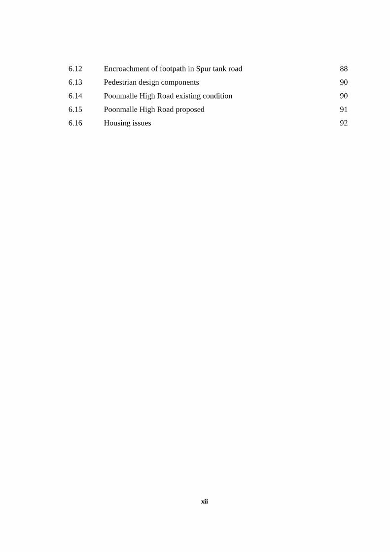
6.12 Encroachment of footpath in Spur tank road 88
6.13 Pedestrian design components 90
6.14 Poonmalle High Road existing condition 90
6.15 Poonmalle High Road proposed 91
6.16 Housing issues 92
xiii
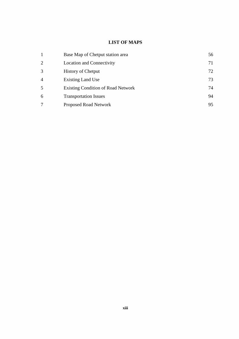
LIST OF MAPS
1 Base Map of Chetput station area 56
2 Location and Connectivity 71
3 History of Chetput 72
4 Existing Land Use 73
5 Existing Condition of Road Network 74
6 Transportation Issues 94
7 Proposed Road Network 95
xiv
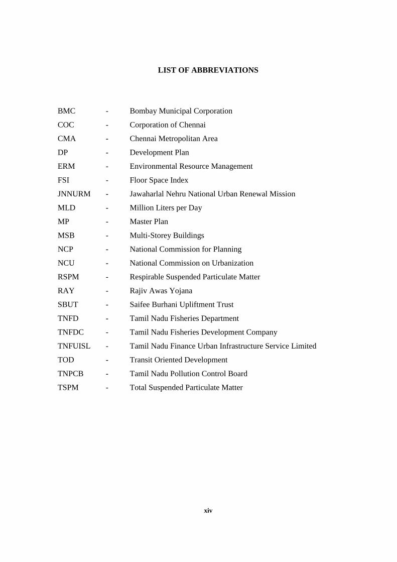
LIST OF ABBREVIATIONS
BMC - Bombay Municipal Corporation
COC - Corporation of Chennai
CMA - Chennai Metropolitan Area
DP - Development Plan
ERM - Environmental Resource Management
FSI - Floor Space Index
JNNURM - Jawaharlal Nehru National Urban Renewal Mission
MLD - Million Liters per Day
MP - Master Plan
MSB - Multi-Storey Buildings
NCP - National Commission for Planning
NCU - National Commission on Urbanization
RSPM - Respirable Suspended Particulate Matter
RAY - Rajiv Awas Yojana
SBUT - Saifee Burhani Upliftment Trust
TNFD - Tamil Nadu Fisheries Department
TNFDC - Tamil Nadu Fisheries Development Company
TNFUISL - Tamil Nadu Finance Urban Infrastructure Service Limited
TOD - Transit Oriented Development
TNPCB - Tamil Nadu Pollution Control Board
TSPM - Total Suspended Particulate Matter
1
CHAPTER I
INTRODUCTION
1.1 BACKGROUND
Urban renewal means a program for rejuvenation of towns to improve specific areas
of a city that are poorly developed or underdeveloped. These areas can have old deteriorated
buildings, bad streets and utilities or the areas can lack streets and utilities altogether. Urban
Renewal typically goes beyond the redevelopment of the physical area of a location and will
tackle the social and economic activity there as well.
Urban renewal used as a program of land redevelopment in areas of moderate to high
density urban land use to improve undesirable conditions. The process has a major impact on
many urban landscapes, and has played an important role in the history and demographics of
cities around the world.
Therefore, the term urban renewal signifies a complex phenomenon interfacing the
humans with their physical, socio-economic and historical relationships. In a broader frame
the term involves renewing the urban life where the process of degeneration or decline is set
into motion due to a variety of factors like technological advance industrialization,
modernization and their cumulative impact on the settlement pattern and social organizations.
However, it was never understood in clear terms. Different interpretations were made in
different countries and different to suit the local interest.
The redevelopment policy adopted by the America in the post war period had led to
the demolition of old buildings and replacing them with modern structures. Virtually these
lead to the destruction of the old to give place to new. There was no continuum, but only
replacement as per the new needs. Further, the decentralization of urban functions from the
core areas of the suburban had led to neglect of central business areas and some of their
traditional functions which are less attractive and lower economic status.
As each city is unique indigenous proposals have to be made based on their location,
historical importance traditional and modern function and existing traffic network. In the path
2
of renewal efforts were focused on the conservation and rehabilitation of areas rather than
development. India’s renewal experience indicates the need for better housing for urbanities.
It also needs rehabilitation of buildings as well as conservation of old buildings because of
the historical significances.
The inner cities present most dramatic and intractable problems they called as
microcosms of deprivation of economic decline and social disintegration. The present
phenomenon of decaying and dilapidated houses, decreasing income inadequate transport
residual land use, etc. Indian experience of urban renewal is fairly recent though several
cities, particularly metropolises have been attempting to tackle the problem of decline
through ad-hoc initiatives.
1.2 IMPORTANCE OF URBAN RENEWAL
The pace of urbanization in India is faster than many other countries in the region, its
heavy concentration in large mega cities is a unique condition. Due to these Large cities are
growing too rapidly, worsening the balance between population and resources. They are
becoming "problem cities" and "cities with all types of shortages". Limited existing
infrastructure and civic amenities, and constraints of available funds, slow the process of
development. Further, the lack of policies and systematic planning in these rapidly growing
cities has led to a situation where living has become strenuous with supply not able to meet
even the minimum requirements. The situation is already bad, and getting worse; it is
threatening the real fiber of life there.
The developing countries used the concept of urban renewal as a method for social
reform as a reaction to the increasingly cramped and unsanitary conditions of the urban poor
in the rapidly urbanizing cities in the mid 19th century. After that the agenda emerged was a
progressive doctrine that assumed better housing conditions would reform its residents
morally and economically. So, urban renewal used as a program of land redevelopment in
areas of moderate to high density urban land use and to revitalize the older parts of the cities.
Urban renewal in Indian context should be viewed not merely as a physical
redevelopment of decayed buildings, or of slums, but a comprehensive city restructuring
3
exercise, involving: reorganization of space and activities; replacement and augmentation of
utilities and road systems and regeneration of the economic base. One without the other is
incomplete and may lead to imbalances and consequent failure of the entire exercise. It is a
massive program for the rejuvenation of a town or portion of town. The objective is to secure
improvement in the functional efficiency of town.
Urban renewal is an answer to urban crisis, an increasing universal phenomenon with
its multidimensional concept. It has evoked multi disciplinary interest. As a public policy it
has given rise to a variety of basic socio economic political organizational and managerial
issues. The scale and urgency of urban renewal have been identified recently which has left
planners administration and politician and analysis required to be facilitated by other
planning management tools to initiate.
Urban renewal is continuing the complex process derived from long term planning
often carried out in steps delimited according to priorities almost always situation and
location specific integrating the traditional and contemporary features looking for economic
and financial opportunities and overall improving the quality of the older areas by eliminating
the negative and enhancing the positive features.
1.3 CONTEXT
Population growth in India has placed significant strains on urban infrastructure and
civic services. The Indian government has proposed the National Urban Renewal Mission
(NURM) to develop infrastructure and services in approximately 63 cities. As cities and
towns sprawl into the countryside, it becomes more expensive and less equitable to provide
services to outlying suburbs. Congestion increases, farmlands are lost and the stability of
surrounding rural areas is threatened by land speculation. The livability of both city and
countryside is greatly diminished for almost all, while a handful benefit from inappropriate
forms of development.
Need for urban renewal arises in every society and city. Its significance in the Indian
context is qualitatively different. For one thing, most of our towns developed irregularly over
the years, the older areas are almost getting busted and narrow lanes zigzagging along
4
unplanned building lines. Due to population increase in urban area density is increased, high
rate of occupancy, reduction in open space and demand in services, the development of
mixed land use buildings is observed. Due to this factor, high rate inflation, low per capita
income, inability to pay economic rents heavy charges for the services provided and used by
the residents and finally political unwillingness forfeited by administrative incompetence to
deal with the complex problem.
Over the past two decades Chennai has experienced rapid urban growth, with increase
of population in urban area from 4.4 million in 2001 to 8.9 million in 2011, making it the
fourth most populous metropolitan area in the country. This urban expansion indeed has
resulted in some urban problems in Chennai city, such as growing congestion and chaos in
the inner city, overcrowded and poorly equipped urban housing, and old neighborhood
deterioration without proper maintenance and so on. In the early 1980s, there was no research
undertaken by the researchers in the redevelopment involved in the planning and construction
of the whole Indian cities. However, it is initiated as a scheme in the name of the first prime
minister of India. The name of the scheme is JNNURM started in the year 2005 to look back
Indian cities for urban renewal. Under these schemes some of the major projects were started
in the infrastructure development in Chennai city.
The present urban renewal mission is more inclined towards the provision of
infrastructure rather than renewal. The redevelopment is taking place only on the prime
locations of the cities occupied by slums without proper social and economic interventions
resulting in displacement of slums. However, most of the areas have to pay attention for
urban renewal due to cities problems. The Urban renewal process has to be started at the
neighborhood level for distressed condition, so as to make Chennai city as an inclusive
development. Therefore, it is necessary to have urban renewal at the small pocket level itself.
Land availability is very less. The city expands to the long distance and the provision
of infrastructure and cost of transportation is high. There is a need for land within a city for
development. But the city remains congested without minimum open space. Therefore, urban
renewal program has potential to solve many issues like open space, infrastructure facilities,
housing for all etc.
5
1.4 JUSTIFICATION
Chennai city main residential areas and older settlements are Chintadripet, Triplicane,
Egmore, Mylapore, Purusawalkam, Vepery and Royapuram. Most of the areas outside these
settlements were covered with gardens and agriculture lands interspersed with bungalows of
the elite. Nungambakkam, Chetput and Kilpauk were some of the areas, which developed in
this manner. Saidapet in the southwest was a separate small settlement. The above residential
areas have developed in the past, but some of the areas which are underdeveloped and
unhealthy environment condition for living.
Chetput, not too far from historic Egmore, is located on the picturesque banks of the
river Cooum. According to some scholars, the name Chetput is derived from Chetti Pettai
obviously alluding to the Chettiar community that once lived in many parts of this locality.
Chetput is the case were developed and constructed as bungalows with beautiful gardens and
the agricultural land in the 18th century. A Chetput is the older area with a larger major
chunk of residential activities. It is because of Chennai main commercial activities located in
the Egmore which is near to Chetput. But recent development taken place outer part of the
Chetput, but along the station area were obsolete development have taken place and makes
unhealthy environment along the station area. With the current trends were station area is the
potential for development in the fast moving world and it is also important that the station
area is vibrant and for major commercial and economic activity. Therefore, this area needs
series attention to developing the station area.
Although the universal conditions of these countries are as bad as that of slums in
some other developing states, till many problems exist in these countries. Broadly speaking,
most of the problems come from social, economic, physical and legal views. From the social
point of view, the problems are dense population, indifference to physical surroundings and
increase of immigrants combined with low-income citizens, etc. From the economic point of
view, the problems include poverty and lack of financial assistance to support maintenance.
From the physical point of view, the problems tend to be narrow roads, crowded houses, lack
of infrastructure and poor environment, etc. Finally, from the legal point of view, the
problems are unclear land ownership, little attention from the governments and ineffective
programs and so on.
6
The present urban renewal is taking place in Chennai city in the form of
redevelopment rather than renewal. The redevelopment is taking place in the prime location
occupied by slums without proper social and economic interventions resulting in
displacement of slums. But, the goal of urban renewal is to be done for the decline and
blighted areas in the context of the older area need to be redeveloped. Therefore, urban
renewal can be used in Chennai city to identify older, smaller pockets or declining area to
improve the quality of life. The smaller pockets of older settlement Chetput station area in
Chennai city chosen for urban renewal. The three components of urban renewal,
conservation, rehabilitation and redevelopment are used for improving the inhabitants living
conditions in all the aspects physical, social, economic and legal.
1.5 AIM AND OBJECTIVE
AIM
To demonstrate that urban renewal is an indispensable component of urban planning
in the existing metros case study of Chetput station area.
OBJECTIVE
To make Chetput station area as an identity in Chennai city by conserving and
restoring its identity.
To relieve congestion and improve the visual appearance of the station area and help
in the creation of better living environment.
To create conditions in which provision of adequate social facilities and public
amenities would be responsible.
To provide ease of accessibility to motorized as well as non-motorized mode of
transport.
To provide affordable housing to the population in a good living environment.
To suggest renewal programs with feasible implementation strategies.
7
1.6 SCOPE AND LIMITATIONS
Urban development in historical perspective is a cyclic phenomenon depicting the
continuous decline and renewal in physical as well as socioeconomic aspects of human
settlement. As decline and renewal are inevitable process the balancing factor is the pace of
change. In earlier generations, the change was slower, but the twentieth century is witnessing
a dramatic acceleration resulting in radical disruptions in the physical and socioeconomic
aspects of urban settlements. The Urban renewal program is being implemented in most of
our cities.
Chennai city is no exception and renewal is taking place in his prime locations. First
rebuilding the old properties, particularly commercial areas George Town and Anna Salai are
replaced with modern buildings for offices and other commercial uses at higher density, like
replacing of old central jail into general hospital. This form of redevelopment is taking place
in Chennai city without any social and economic intervention in the area. Due to these the
functions of the area is affected and it changes the whole scenario. Even in the case of slum
redevelopment projects leads to failure because of no public participation and no economic
intervention in the area.
Urban renewal program in Chennai city in the name JNNURM majorly funding for
infrastructure facilities. But urban renewal is to be done for decline and blighted area in the
context of older area need to be conserved, rehabilitated and redeveloped. So the Chennai city
has to pay attention to developing older settlements as well as the decline and blighted area.
The old settlement of Chennai city like Egmore, Royapuram, Triplicane, Chetput etc.
is covered along the railway station. With the current trends were station area is the potential
for development in the fast moving world and it is also important that the station area is
vibrant and for major commercial and economic activity so its need series attention for
developing the station area.
Chetput is the older area with major residential activities as high since the Chennai
main commercial activities located in the Egmore which is near to Chetput. But recent
development taken place outer part of the Chetput, but along the station area obsolete
developments have taken place and makes unhealthy environment along the station area.
8
Chetput station area is a high density area with slums and low raised buildings. It is
more congested and older settlements and having dilapidated buildings and also having major
problems like no open space, vehicle parked on the road side, incomplete circulation pattern
and obsolete development, not proper sewerage system and improper functioning of the area.
It affects the livelihood and bad environment due to obsolete development, so is there need
for some urban renewal programs. Proposals based upon major issues and response of
stakeholders of the study area.
The study is limited to smaller pockets since to prove urban renewal is an
indispensable component of existing metro cities. The part of the Chetput is well developed
and also recent development taking place of Chetput on the outer part, but around the station
area remains an underdeveloped area. So, the study area is confined to Chetput station area
which is underdeveloped and unhealthy environment living condition. The various proposals
given for the case study area, it is limited to the particular area only for other areas these
proposals cannot be used. Due to time constraints, for micro level in the approaches depth
analysis of the study area, consider into a small area.
1.7 METHODOLOGY
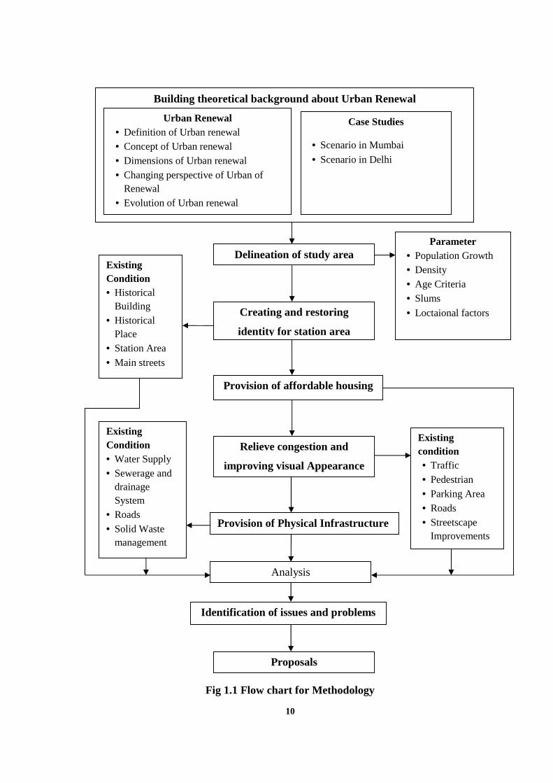
The theoretical background about urban renewal is studied in detail first. This is done
with the help of various literature collected. In this definition, concept, dimensions, changing
perspective and evolution of urban renewal are studied. Some relative practical experiences
of urban renewal are also studied in the context of Mumbai and Delhi metro cities.
The next step after studying theoretical background the study area assessed into
various zones based on their density. For this, the various zones of the Corporation of
Chennai, is taken into consideration. In this higher density zone is identified and taken into
consideration for selection of a case study area. The selection of a case study area is
delineated based on the parameter population growth, density, slums, age criteria and location
of the area. After delineation of the study area is compared with a physical condition with
other area.
9
The next step after delineation the cultural aspects of the existing condition of the
identity of that area are studied in detailed. The existing condition of historical building,
historical place, station area and main streets are studied for the importance of that area and
historical background of that area for restoring its identity.
The next step the social aspects of urban renewal of the case study area are studied in
detailed. The housing, hospitals and recreational facilities are studied for the social aspects.
From the housing sectors slums, housing condition, dwelling unit size and dilapidated
buildings is studied.
The next step for the physical aspects of urban renewal of the case study area are
studied in detailed. The existing condition of traffic, pedestrian, parking area, roads and
streetscape improvements are studied from the physical point of view.
The next step for the physical aspects of infrastructure facilities are studied in
detailed. The existing condition of physical infrastructure, water supply, drainage, sewerage
and solid waste management are studied.
The next steps after studying the existing condition of the area for the various aspects
analysis have been done in identifying the issues.
The next step after identifying the case study analysis to the study area in depth and
various findings is taken into consideration. Primary survey is done to find out the main
issues in the area. Related secondary data are also collected from various agencies. After
identifying the issues suitable proposals and recommendation and urban renewal plans are
suggested.
10
Fig 1.1 Flow chart for Methodology
Building theoretical background about Urban Renewal
Urban Renewal Definition of Urban renewal Concept of Urban renewal Dimensions of Urban renewal Changing perspective of Urban of
Renewal Evolution of Urban renewal
Case Studies
Scenario in Mumbai
Scenario in Delhi
Delineation of study areaParameter
Population Growth Density Age Criteria Slums
Loctaional factorsCreating and restoring
identity for station area
ExistingCondition Historical
Building Historical
Place Station Area
Main streets
Provision of affordable housing
Relieve congestion and
improving visual Appearance
Existingcondition Traffic Pedestrian Parking Area Roads Streetscape
ImprovementsProvision of Physical Infrastructure
Analysis
ExistingCondition Water Supply Sewerage and
drainageSystem
Roads Solid Waste
management
Identification of issues and problems
Proposals
11
1.8 STRUCTURE OF THESIS
Chapter 1. This chapter deals with an introduction, first starting with the background and
importance of the topic, in what context the topic is selected, a justification, for the topic. The
second it deals with Aim and objective for the selected topic with the study area, scope and
limitations of the topic, steps of activity in the methodology and the final structure of the
thesis.
Chapter 2. This chapter builds the theoretical background of urban renewal such as definition,
concept, dimensions of urban renewal, change of perspective of urban renewal and evolution
of urban renewal. The last it discusses about practical experience with two city case studies of
India.
Chapter 3. This chapter deals with Chennai city analysis with various dimensions of urban
renewal, physical, social, economic, environment and legal aspects.
Chapter 4. This chapter deals with delineation of the study area with the renewal parameters.
Chapter 5. This chapter explains with an introduction to the case study area and existing
situations of the study area.
Chapter 6. This chapter explains the analysis of the problem, finding the issues relating the
analysis and suitable proposals.
Chapter 7. This chapter deals with phasing and costing.
Chapter 8. This chapter deals with conclusion of the thesis.
12
CHAPTER II
LITERATURE REVIEW
2.1 INTRODUCTION
Every city is affected by trends of transformations or the process of change. The term
decline in the context of urban development is applied to describe undesirable changes. Local
policies and strategies designed to deal with urban decline, decay or transformation is termed
as urban renewal. Roberts and Sykes (2000) state that ‘Urban renewal can be delineated as a
comprehensive and integrated vision and natural process which conduces to the solution of
urban problems and which seeks to bring about a lasting improvement in the economic,
physical, social and environmental conditions of an area that has been subject to change’.
In this chapter, there are six parts around the keyword of this study, urban renewal.
The first part is about introduction of urban renewal for the literature review. The second
section is a basic understanding of urban renewal, used to explain definitions and what is
urban renewal, its concept, dimensions and goal of urban renewal. The third part is about
changing the perspective of urban renewal, which is used to explain the paradigm shift
concept of urban renewal with developing and developed nations. The conceptual framework
with Indian interpretation and evolution of urban renewal also explained in the third part. The
fourth part is used to explain about urban renewal in Indian context. The fifth part explains
practical experience with Indian case studies, it discusses about two city scenario Mumbai
and Delhi. The final part explains results from the studies of literature review.
2.2 UNDERSTANDING OF URBAN RENEWAL
2.2.1 Definition of Urban Renewal
Urban renewal as term of urban planning is American in origin. An advisory
committee founded by Eisenhower used it for the first time in 1954. Studies were taken to
analyze the older parts of the American cities with problems of urban decay. As Buissink
(1985) has said, “the recommendation of the committee was incorporated in the Housing Act
13
of 1954. This Act and the one previous to it in 1949 are generally considered the foundation
stones of urban renewal policies” (Buissink 1985).
Urban renewal would concern itself with the revitalization of derelict areas in a city
three components of urban renewal are conservation, rehabilitation and redevelopment.
According to him larger towns and metropolitan areas create major problems of public health
environmental law and society. Redevelopment of slums and blighted areas require an
adequate public housing program. Once implemented the program apart from providing
better housing for section of the population would result environment improvement and
increase the efficiency of the city system (Keskar 1987).
Urban renewal is generally associated with making provision of housing for the
community, particularly in the older parts of towns and cities, but renewal programs began to
incorporate social infrastructure as well as planned intervention in economic regeneration and
employment programs (Basu 1991).
The urban renewal becomes the process of replacing and comprehensive
redevelopment of land, structures, physical and social infrastructure as well as conservation
and rehabilitation of areas which have been declining and blighted areas. Urban renewal was
considered an important aspect of urban land policy in India about two decades ago, For
instance the committee on urban land policy (Ministry of Health, Government of India 1965)
is mentioned about the urban renewal programs. To undertake the problem of the congested
and overcrowded areas three alternatives may be considered they are,
1. Wholesale demolition and through redevelopment
2. A program of selective urban renewal
3. Program of Gradual improvement
Urban renewal the Indian experience-Ravindra Prasad 1995
The urban renewal has four important objectives
Provision of housing
Creating a better living environment in older areas
Provision of social facilities and public amenities
Correction of the distortions of land use pattern (Sundarm 1997).
14
Author argues that one cannot solve the problems of old cities without constructing
new ones. When a new city or townships has built its easy to solve the most intricate
problems of urban design. Author emphasizes the need for surveys from the point of
planning, architecture and engineering as well as social economic and political points of
view. Without proper policy making and effective control urban development would be
haphazard. The author cautions that for sentimental reason the people do not easily shift to
new townships. It requires long and sustained efforts accelerated urban growth without
provision of basic amenities is a typical pattern of urbanization in our cities. The rapid urban
growth is resulting in the rapid deterioration in our cities (Subbramaya 1995).
The less expensive, but slower process would be through the introducing of planning
guidelines and design briefs for the redevelopment of older areas. If this process succeeds,
there have to be number of incentives to the property owners in term of the bonus on FAR,
freedom in marketing of space and finance support at reasonable interest with an extended
period of repayment. An intelligent, highly professional team planners, architects and
financier who can appreciate the complex problems and motive developers and an
enlightened band of property owners who set their sights not only on profits but on the
general welfare of the city essential (Dattatri 1993).
One of the necessary concomitants of urbanization and urban planning has been urban
renewal. The author suggests that urban plans should provide for redevelopment and renewal
as on the organic component of the overall plan. He identifies indices like age and physical
condition of structure, the nature and condition of the roads, the quality and quantity of
various services, demographic pattern, and the nature of land use and economic linkages of
the area designates an area for urban renewal. He emphasizes the need for formulation of
urban policy and acceptance of renewal as a national objective (Mukhaji 1985).
Urban renewal is a process of rejuvenation of a dilapidated area in a city having
physical decay and economic stagnation; caused by old age of buildings, poor accessibility,
loss of real estate value, and changes in technology, transportation systems, land use and
activity patterns; through improvement of buildings, accessibility, circulation system,
augmentation of facilities and services and reassignment of compatible land uses
(Kulshrestha 2006).
15
The term Urban renewal means rebirth or regeneration of a metropolis or a portion of
it which has been blighted by the ills of urbanization. The planning concept originated in
England and America to improve the living conditions in the parts of the city decayed by
unhealthy condition by demolishing the areas and rebuilding it with new housing or other
functions and infrastructure. These programs were thrust upon the city and its people with the
intention of determining the city’s economic, social and urban character and improving it.
Most of these programs being anti poor and dictatorial in nature were criticized and
halted on opposition by organized community movements. The urban renewal programs
taken up later, involved greater participation of the communities and looked after aspects
such as sustainability and inclusiveness. For example, Glasgow identified culture to be the
catalyst and engine for regeneration in the early 1980s. It encouraged the gentrification of
part of the central city by developing art gallery, theatre, concert hall, etc. A new business
district around the city’s derelict dock area was created. Marketing campaign ‘Glasgow’s
Miles Better’ marketed the city as the desired place to live and work, and with its designation
as European City of Culture, improved the profile of the city on an international basis. The
concept was followed in North American cities and UK for attracting capital investment in
the city and improving it.
2.2.2 Concept of Urban Renewal
Like other living organisms, cities also pass through a process of growth and decay.
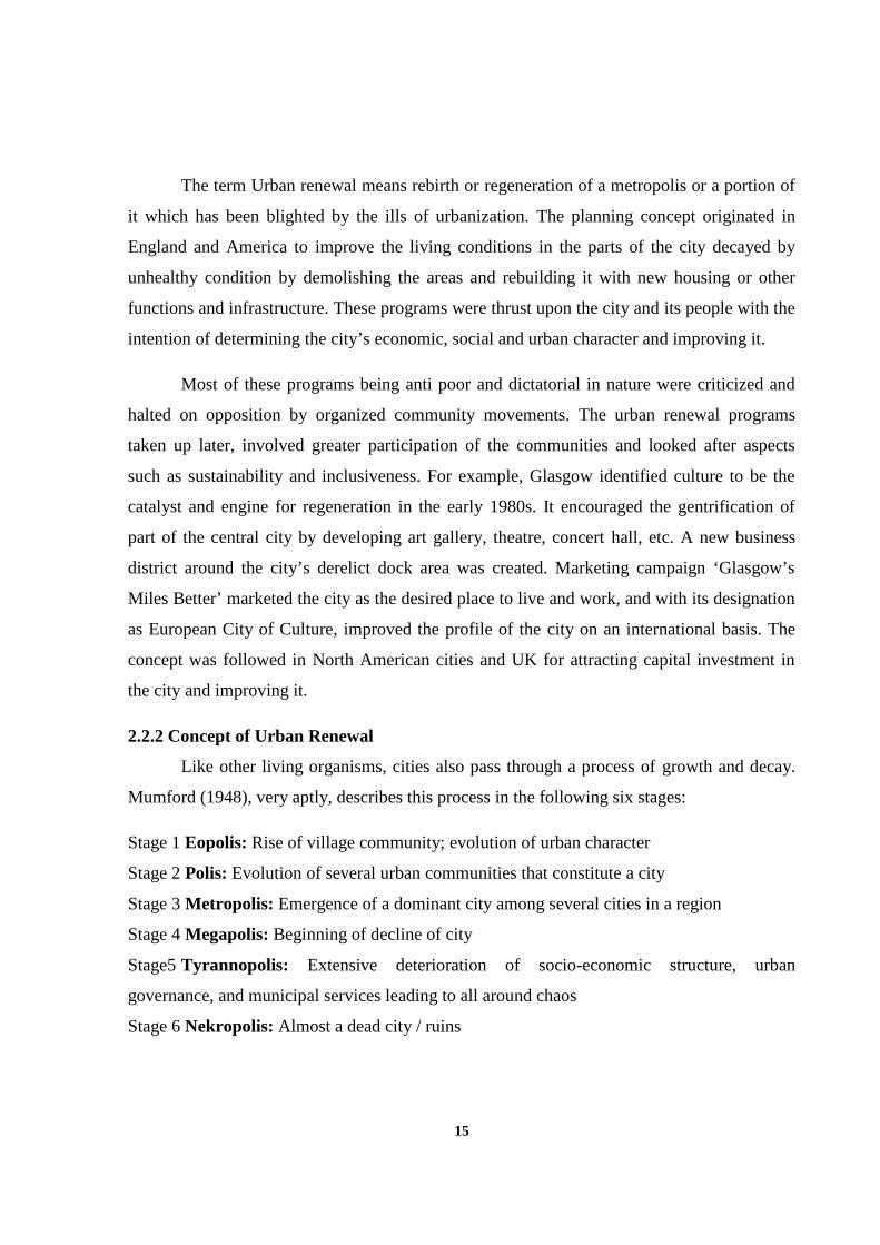
Mumford (1948), very aptly, describes this process in the following six stages:
Stage 1 Eopolis: Rise of village community; evolution of urban character
Stage 2 Polis: Evolution of several urban communities that constitute a city
Stage 3 Metropolis: Emergence of a dominant city among several cities in a region
Stage 4 Megapolis: Beginning of decline of city
Stage5 Tyrannopolis: Extensive deterioration of socio-economic structure, urban
governance, and municipal services leading to all around chaos
Stage 6 Nekropolis: Almost a dead city / ruins
16
Fig 2.1: Cycle of Growth and Decay of Cities
and Role of Urban Renewal
2.2.3 Dimensions of Urban Renewal
Different definitions given by planners, academicians and researchers aim the
sustainability by integrating the different dimensions of urban renewal. These are,
• Physical renewal leads to the improvement of urban fabric;
• Social renewal leads to the improvement of community and housing;
• Cultural renewal, promotes enhancement of culture and traditions;
• Economic renewal leads to a new generation of employment and revenue; and
• Environmental renewal leads to minimizing ecological imbalances in an urban environment
Urban renewal is a dynamic term, which is evolved with reference to transformations
of the city and its economy. It refers to the various attempts to reverse the decline in cities
that have been worst hit by the capitalist urbanization.
Most of the cities have large blighted areas, with severe stress on the existing, aged
infrastructure and services. Many of them have lost businesses, and are functioning at sub-
optimal productivity levels. Notwithstanding the valuable land on which such areas stand,
they contribute little to city finances. Maintaining them in their present state without any
returns has become a liability.
According to him, these are
logical stages of the process of growth
and decay of cities ‘systematized
through intellectual analysis’
(Mumford: 1948) and a city may not,
necessarily, follow all the six stages and
end up as a dead city. In real world
situations, signs of decline in cities are,
generally, addressed to by deliberate
policies of urban renewal and / or
through actions of individuals and
groups.
17
It is important also to recognize that renewal embraces more holistic perspectives
such as economic and social improvement. Urban renewal seeks ways to improve
disadvantaged places and the lives of people who live and work there. Regeneration and
renewal activities are varied and may reflect joined-up holistic or relatively less integrated
programs of physical, social and economic change.
2.2.4 Goals of Urban Renewal
The goals of urban renewal are based on the desire to maintain the health of the urban
settlement. The following factors are considered as a health of urban settlements.
1. Age of building
2. Function of the city
3. Financial adequacy of civic government
4. Capacity of the resident and users
5. Population density
6. Traffic and transportation
7. Maintenance of basic services
The negligence of these factors may cumulatively contribute to urban decay.
Depending of the decay the strategy of urban renewal has to be decided. That’s whether
decay can be treated through redevelopment, rehabilitation or conservation, or through their
combination can be determined on the existing nature decay.
2.3 CHANGING PERSPECTIVES OF URBAN RENEWAL
Urban renewal is controversial, as it often implies the use of eminent domain law to
enforce reclaiming private property for civic projects. While envisioned as a way to
redevelop residential slums and blighted commercial areas, ‘renewal’ often resulted in the
creation of urban sprawl - vast areas being demolished and replaced by freeways and
expressways, housing projects, and vacant lots - some of which remained vacant at the
beginning of the 21st century. Urban renewal was widely resisted by movements of residents
of US in it is the then contemporary form. In 1961 the book ‘The Death and Life of Great
American Cities’ by Jane Jacobs led to organized movements to oppose urban renewal.
18
While renewal projects did revitalize many cities, it has been often at a high cost to
existing communities, and in many cases simply resulted in the destruction of vibrant - if run
down - neighborhoods. Urban renewal in its original form has been called a failure by many
urban planners and civic leaders, and has since been reformulated with a focus on
redevelopment of existing communities. However, many cities link the revitalization of the
central business district and gentrification of residential neighborhoods to earlier urban
renewal programs. Over time, urban renewal evolved into a policy based less on destruction
and more on renovation and investment, and today is an integral part of many local
governments, often combined with small and big business incentives.
Urban renewal has become a multi-dimensional task. Whilst traditionally urban
renewal in Europe was mainly concerned with physical improvement, over time the aims and
the means of regeneration have become multi-faceted and more complex to deal with. They
integrate different sectors and actors on several levels and contexts, combining physical
investment in ‘hardware’ with investment in the social ‘software’ of a neighborhood. It is
against this background that partnership led regeneration becomes pivotal.
Cases and experience suggests strongly that a new set of regeneration aim is emerging
that reflects the objectives to integrate ‘people, business and place’ and bring about
appropriate policies to achieve this aim. They are embedded in wider city and national aims
and strategies; they promote the objective of community capacity building and aim at
delivering tangible changes and exploit the geographical competitiveness of the
neighborhood in the long run.
As urban renewal is becoming a multi-dimensional task it not only integrates various
dimensions of urban development. It also has to manage tensions and conflicts between them.
In order to balance the occurring ambiguities, urban renewal policies often work with a
hierarchical system of primary and secondary aims – the more aims there are, the more
important is the need to prioritize aims. In some cases, at the local level, there are efforts to
make this agenda setting more transparent and more based on democratic processes.
19
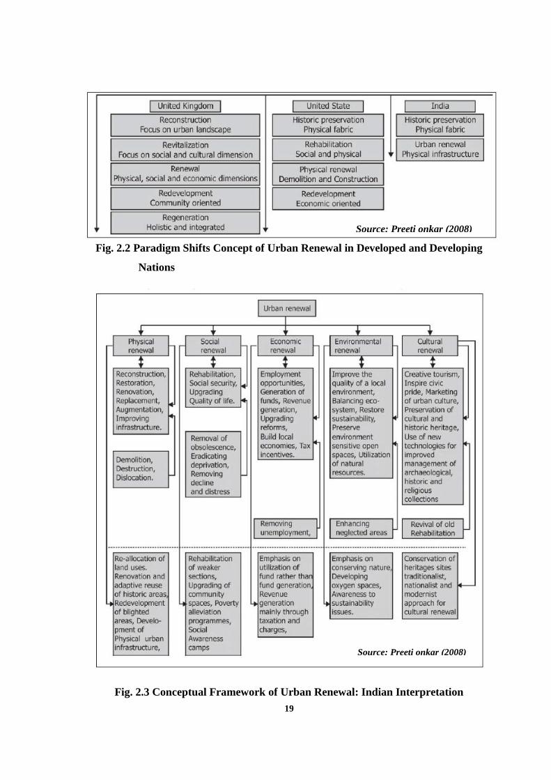
Fig. 2.2 Paradigm Shifts Concept of Urban Renewal in Developed and Developing
Nations
Fig. 2.3 Conceptual Framework of Urban Renewal: Indian Interpretation
Source: Preeti onkar (2008)
Source: Preeti onkar (2008)
20
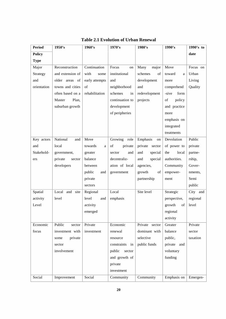
Table 2.1 Evolution of Urban Renewal
Period 1950’s 1960’s 1970’s 1980’s 1990’s 1990’s to
datePolicy
Type
Major
Strategy
and
orientation
Reconstruction
and extension of
older areas of
towns and cities
often based on a
Master Plan,
suburban growth
Continuation
with some
early attempts
of
rehabilitation
Focus on
institutional
and
neighborhood
schemes in
continuation to
development
of peripheries
Many major
schemes of
development
and
redevelopment
projects
Move
toward a
more
comprehend
-sive form
of policy
and practice
more
emphasis on
integrated
treatments
Focus on
Urban
Living
Quality
Key actors
and
Stakehold-
ers
National and
local
government,
private sector
developers
Move
towards a
greater
balance
between
public and
private
sectors
Growing role
of private
sector and
decentraliz-
ation of local
government
Emphasis on
private sector
and special
and special
agencies,
growth of
partnership
Devolution
of power to
the local
authorities.
Community
empower-
ment
Public
private
partne-
rship,
Gover-
nments,
Semi
public
Spatial
activity
Level
Local and site
level
Regional
level and
activity
emerged
Local
emphasis
Site level Strategic
perspective,
growth of
regional
activity
City and
regional
level
Economic
focus
Public sector
investment with
some private
sector
involvement
Private
investment
Economic
renewal
resource
constraints in
public sector
and growth of
private
investment
Private sector
dominant with
selective
public funds
Greater
balance
public,
private and
voluntary
funding
Private
sector
taxation
Social Improvement Social Community Community Emphasis on Emergen-
21
context and housing and
living standards
welfare
improve-
ment
based action
and greater
empowerment
self help with
very selective
state support,
High rise
housing for
displaced
citizens.
Become
centers for
social ills
the role of
the
community
ce of the
new
social
organizati
on,
commuty
partci-
pation
Physical
context
Replacement of
inner areas and
peripheral
development,
gentrification in
UK
Rehabilitation
of existing
areas
More
extensive
renewal of
older urban
areas
Major schemes
or replaced
and new
development
Emphasis on
the role of
community
Emerg-
ence of
social
organiz-
ation,
communit
y partcip-
ation
Environ-
mental
approach
Landscaping and
some greenery
Selective
improveme-
nts
Environme-
ntal
improveme-nt
with some
innovation
Growth of
concern for
wider
approach to
improvement
Intoduction
of broader
idea of
environm-
ental
sustainabi-
lity
Environm
ental
sustain-
ability
impact
assess-
ments
2.4 URBAN RENEWAL IN INDIAN CONTEXT
Indian urban centers in history emerged with two primary characteristics first - a high
density of population concentrated within a special space and second a predominantly
nonagricultural, particularly non-cultivating occupation of these people (Amos and Hawley,
1971). Indians by and large have been naturally oriented rather than city oriented. The report
of the National Commission on Urbanization (National Commission on Urbanization Reports
Volume - II, 1988) made commendable proposals to shift the prototype of urban planning to
become more reactive to the existing urban condition, but without success.
22
The Indian experience of urban renewal is fairly recent, though several cities,
particularly metropolises, have been attempting to tackle the problem of decline and
dilapidation through ad-hoc initiatives. In diverse and complex nature of Indian society,
problems are different, contexts differ, needs change, and therefore, policies and programme
to deal with each city and town would also differ. For instance, urban renewal of Jaipur city
would be conservation and renovation of its cultural heritage of being a pink city while in
Delhi it would be of effective utilization of traditional core areas or in Calcutta it would rotate
about the phenomenon of basis as providing ameliorative measures. Basically, it can be at
macro level like the redevelopment of inner city core or at micro scale like traffic operation
plan, conservation of old buildings and up gradation of services, depending upon the
character or issues of town or a city.
There is an absence of holistic and integrated approach in understanding the term
urban renewal. The six dimensions of urban renewal should be integrated focusing on quality
of life. The prevailing planning tool, master plan, does not incorporate the integrated concept
of renewal. The concept of renewal was restricted to conservation of heritage sites in early
master plan of metro cities. No specific attempts were established for the development of
heritage zones. Even the present urban renewal mission is more inclined towards the
provision of infrastructure rather than renewal. The redevelopment is taking place only on the
prime locations of the cities occupied by slums without proper social and economic
interventions resulting in displacement of slums.
2.5 PRACTICAL EXPERIENCE
2.5.1 Scenario in Mumbai
2.5.1.1 Redevelopment on free hold land in Mumbai
Currently redevelopment is taken up in a scattered manner at the initiative of the
owner/society/ tenants for old buildings which have started dilapidating or are dilapidated and
dangerous to inhabit. The lure/ initiative being the Higher FSI proposed on the plot in the
form of TDR where existing tenements on redevelopment have increased the size and
developer getting constructs more tenements for market sale due to additional FSI.
23
The entire process is completely voluntary. The same occurs in several pockets in the
city at different degrees of time and results only in densification of these areas with more or
less the same substructure. Though it solves the problem of dilapidation, it does not solve the
cities’ problems of congestion and inadequate infrastructure, open spaces, and so on
2.5.1.2 Cluster development in Mumbai
The Bhendi Bazar cluster redevelopment project is arguably one of the most
ambitious urban renewal schemes Mumbai has witnessed. Founded 3 years ago, it aspires to
become one of the cities’ most congested and ramshackle neighborhoods, into a swank, new
green precinct. When the project was first announced by the Saifee Burhani Upliftment Trust
(SBUT), it was greeted with a fair amount of skepticism. The proposition was to work with
3,200 dwellings and 1,200 shops located in 250 buildings and convert these into eight clusters
of 40-storey buildings, all of them green. The scope of the project was 16.5 acres in the
middle of an already congested Mumbai, and with the living spaces and livelihood of
approximately 20,000 residents on the crease. Three years down the line, with most
clearances in hand (including a critical one from the environment ministry), the Rs 2,000
crore project is well underway. The SBUT, which is both financially and planning the
project, estimates that if things stay on track, the new-look Bhendi Bazaar should be ready in
five years from now.
The proposal envisages about one-sixth of Bhendi Bazaar to be emptied out for green
areas, terrace gardens and shady avenues. The high-rises will be aligned with a wind tunnel,
so that the apartments are cooled by sea breezes, and also receive a good amount of natural
light. Each building will also have its own rainwater harvesting system, recycling of grey
water and solar panels to power both street lights as well as circulating hot water in the
bathrooms. Each cluster will have its own sewage treatment and garbage disposal plant. The
streets will be widened and tree-lined pedestrian ways made to create more foot traffic. The
project hopes to inspire the thought that low-cost green housing can be a reality. SBUT is
determined to make sure that the only changes locals experience is a vastly improved quality
of life, not a more costly one.
24
2.5.1.3 TO D – TRANSIT ORIENTED DEVELOPMENT
TOD is a relatively new concept in India. However the awareness of the concept has
increased over the years. Transit stations are crucial nodes of activity in the city and optimum
utilization of these areas would help in managing the congestion, transportation of the city.
Transit oriented Redevelopment around transit areas like railway stations, city bus stands,
metro-rail stations help in removing bottlenecks in the circulation around these areas along
with the intensification of land use to reduce travel to work place and improved urban design.
TOD should not be construed as just an intensification of land use by higher FSI on plots
around Transit. Such short sightedness would lead to more congestion and degradation of the
environs instead of improving the same. Hence the concept of TOD in developed area of the
older cites need to be judiciously considered and defined considering all aspects of city
development.
In Navi Mumbai the stations at Vashi and Belapur on the suburban rail network are
developed as integrated station cum commercial complexes to some extent. Third such
development is coming up at the Seawood railway station.
In Mumbai there is a proposal to grant higher FSI around proposed metro stations. In
its draft Development Plan (DP) for 2014-34, the BMC has proposed to encourage maximum
development in areas closest to mass transit corridors in contrast to its previous DP of 1991,
in which it had restricted development on either side of the transit corridors to ensure
accessibility.
2.5.2 Scenario in Delhi
Delhi is one of the most important of all historic cities of India. It has remained the
capital of India even from the prehistoric era. Remnants and ruins of Delhi of yester years are
still preserved. No effort has been left to ensure conservation of the heritage of this historic
city in an era of globalization. While technology today is taking us to all directions in the
universe, our heritage retains and relates us with the mother earth.
In order to conserve the heritage precincts also, we need to develop and redevelop
them only to retain their glorious past. But the passage of time and the present day trends
including the building and town planning regulations pose restrictions and at times seem to
discourage this process of conservation/ redevelopment of heritage sites.
25
2.5.2.1 Walled City of Delhi
A case study of Delhi, there has been a series of proposals and alternatives for the
redevelopment of the city of Shahjahanabad (the walled city of Delhi) over the past fifty
years – after independence. Committees on the redevelopment of walled city have been set up
a number of times by the Centre, state and also at the municipal level.
Walled City: Shajahanabad was built in the 17th century for a population of 60,000
persons, covering an area of about 569.0 ha. The city was developed in typical Mughal style,
densely built with organic street pattern.
The Old and the New: How old traditional values gel with the modern outlook is to be
seen and experienced in Delhi. The Mughal built their capital in Delhi in the name of
Shahjahanabad while the Britishers without disturbing the environs of Shahjahanabad built
their capital at New Delhi to the South of Shahjahanabad. Even the Civil Lines developed by
the Britishers respected the heritage of Shahjahanabad and was conceived in the ridges to the
north of Shahjahanabad overlooking river Yamuna.
2.5.2.2 Delhi master plan recommendation for the Walled city
First master plan for Delhi -1962 perspective 1980
There is a heavy concentration of population in the Old City which is also closely
built up. Since large scale clearance and reconstruction is ruled out as an immediate
possibility because of the lack of resources and the low capacity of the people to pay rent, at
least the minimum community facilities and services and here, which will in a way remove
congestion from the area.
Commercial areas
General Business and Commercial: Chandni Chowk – Khari Baoli – Sadar Bazar will
continue to be the Central Business District of Delhi. General business and commercial
activity will, in fact extend to the whole Complex, which includes, Nai Sarak, Chawri Bazar,
Kashmeri Gate, Faiz Bazar and Asaf Ali Road. Some of these areas will undergo gradual
redevelopment in order to be able to retain their present supreme position in the commercial
activity of the Delhi Metropolitan Area.
26
Second (Modified) master Plan for Delhi-1990 perspective-2001
Conservation of the Walled City: The Walled City has a wide range of features and design
elements which need to be conserved. Shahjahanabad has important historical buildings, like
Red Fort, Jama Masjid, City Wall and Entry Gates, Vista of Chandni Chowk, the street scape,
Mohals and Katras. All these elements are outburst of a lifestyle which is not found in any
other part of the metropolitan city of Delhi.
• The rebuilding/renovation of the buildings in the Walled City should be done sensitively
conserving the important monuments, and the architectural style, skyline and street picture.
• At different places, the city wall of Shahjahanabad is in ruins; there should be conservation
work for the wall and gates. Bazar of Chandni Chowk could be re-vamped by eliminating
traffic of automobiles etc.
• The road and street pattern in the Walled City is the most important feature of its urban
character, if conservation is to be successful in the overall perspective, it would be essential
to retain. The monuments, sites and old city’s network as existing.
2.6 INFERENCE
Urban renewal is an answer to urban crisis an increasing universal phenomenon. With
its multidimensional concept, it has evoked multi disciplinary interest. As a public policy it
has given rise to a variety of basic social economic political organizations and managerial
issues. The scale and urgency of urban renewal have been identified recently which has left
planners, administrators and political unprepared and uninitiated. The policy making process
and the level of information and analysis required to be facilitated by other planning
management tools to initiate.
Urban renewal has been a continuing complex process derived from the long term
planning often carried out in steps delimited according to priorities almost situation and
location specific integrating the traditional and overall improving the quality of the older
areas by eliminating the negative and enhancing the positive features.
27
As with every development policy, urban renewal requires political will and
administrative commitment. Institutional support is important as the political initiatives
because of its complex nature urban renewal requires the coordinated efforts of a multitude of
agencies the Indian experience shows the administrative problems are plenty and inter agency
coordination is a major hurdle.
People’s participation is really important in renewal efforts. The task of urban renewal
is gigantic and government alone cannot undertake the renewal efforts. Therefore, non-
governmental organization's community leaders and social; workers and the community itself
must be actively associated with the formulation and implementation of renewal programs.
The present phenomenon of decaying and dilapidated houses, uncared people, decreasing
incomes inadequate transport residual land use, etc. the state of the inner cities are almost
warning urban future. There is need therefore to focus along the growth of inner cities to
arrest future decline and to provide more dependable services. Inner city's development
appears to be effective if single institutional approach is adopted for the redevelopment of the
inner city.
Implementation of renewal programs require many other policies and operational
intervention like change in law, association of private developers with the government
support provision of financial and other incentives to make renewal and conservation
attractive.
Thus, all the literature collected points out the advantages urban renewal. But it has its
own demerits too. So this thesis tries to find out the awareness of policy makers, planners,
administrators articulate the need and significance of urban renewal and formulate and
implement renewal policies and programs to regain the urban glory and to ensure better
quality of life to the urbanities through urban renewal and its implications in the city of
Chennai.
28
CHAPTER III
CHENNAI CITY ANALYSIS
3.1 INTRODUCTION
The process of modern city planning seeks to steer market forces in the city building
towards citizen welfare and the public good. Master plans and detailed development plans see
that physical pattern of land use and transportation routes within the city and for the city as a
whole. Zoning and building byelaws are still among the primary tools of such planning. In
addition, urban renewal program seeks to lay out a development or re-development or
improvement of the specific area. This urban renewal serves as a guide for public agencies to
tailor their sectoral programming to the plan while facilitating private investments in the
same manner.
Chennai the fourth largest city in India is the focus of economic, societal and ethnic
development and is the capital of the Tamil Nadu province. It is developing at a speedy rate,
and there is a need for integration of the past developments with the future demands. A co-
ordinate and integrated approach among the various authorities involved in urban
development is the demand of the hour. In this chapter, the dimension of urban renewal in
Chennai city context is analyzed for the urban center as a whole. The various dimensions of
urban renewal, physical, social, economic, legal and environmental aspects are discussed
below in Chennai city. Urban renewal plays vital part in a participatory process in planning
with equal importance and at the local body level to accomplish the aims of building this city
more livable and of international standard.
3.2 CHENNAI CITY PROFILE
Chennai situated on the shores of the Bay of Bengal is the capital of Tamil Nadu state.
It is the fourth largest metropolitan in India. Its older name ‘Madras’ was officially changed
to ‘Chennai’ in 1996. It is located [with latitude between 12°50'49" and 13°17'24", and
longitude between 79°59'53" and 80°20'12"] on the coramandal coast of southern India and
the land is a flat coastal plain.
29
Three rivers viz. Kosasthalaiyar, Cooum and Adyar pass through the Chennai
Metropolitan Area. These rivers are placid and meander on their way to the sea. Buckingham
Canal, a man made canal, is another large waterway which runs north south through this
Metropolis. Sholavaram lake, Red Hills lake and Chembarambakkam lake are the three big
lakes in Chennai city. Chennai lies close to the equator and most of the year it is hot and
humid. The highest temperature attained in May-June is usually about 400C (104 0F) for a
few days. The coldest time of the year is early January when the temperature is about 200C
(68 0F). Predominant wind direction is from South East to North West.
Chennai Metropolitan Area comprises the region encompassed by the Chennai City
Corporation (Chennai District), 16 Municipalities, 20 Town Panchayats and 214 villages
forming part of 10 Panchayat Unions in Thiruvallur and Kancheepuram Districts. The
expanse of the city is 174sq. Km, whereas the Chennai metro covers an area about
1,177sq.Km. The population of the city is 4.3 million and that of the CMA is 7.04 million.
The Density of the Chennai city is approximately 247/ ha. Whereas that CMA has a
population density of approximately 59/ha (Source: Second Master Plan for Chennai
Metropolitan Area, 2026).
3.3 PHYSICAL ASPECTS
3.3.1 Land Use
The purpose of land use is to segregate certain uses, particularly hazardous and
environmentally unsuitable uses from other urban uses of work, housing and recreation,
reduce the effect of negative externalities, which the former have on the latter. By providing
spatial segregation of highly conflicting uses it benefits some uses to find advantage in being
grouped together with other similar uses. Thus the separation of hazardous industries would
enable the provision of special infrastructure to safeguard environmental quality at the same
112 time providing reduction of costs in providing certain common public services. Because
of zoning’s vital role in planning, modern strategies encompass expanded objectives for
providing all important public amenities such as open places for recreation, conservation of
prime agricultural country and protection of ecologically sensitive areas from unsustainable
uses (Source: Second Master Plan for Chennai Metropolitan Area, 2026).
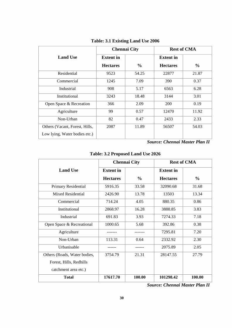
30
Table: 3.1 Existing Land Use 2006
Land Use
Chennai City Rest of CMA
Extent in
Hectares %
Extent in
Hectares %
Residential 9523 54.25 22877 21.87
Commercial 1245 7.09 390 0.37
Industrial 908 5.17 6563 6.28
Institutional 3243 18.48 3144 3.01
Open Space & Recreation 366 2.09 200 0.19
Agriculture 99 0.57 12470 11.92
Non-Urban 82 0.47 2433 2.33
Others (Vacant, Forest, Hills,
Low lying, Water bodies etc.)
2087 11.89 56507 54.03
Source: Chennai Master Plan II
Table: 3.2 Proposed Land Use 2026
Land Use
Chennai City Rest of CMA
Extent in
Hectares %
Extent in
Hectares %
Primary Residential 5916.35 33.58 32090.68 31.68
Mixed Residential 2426.90 13.78 13503 13.34
Commercial 714.24 4.05 880.35 0.86
Institutional 2868.97 16.28 3888.85 3.83
Industrial 691.83 3.93 7274.33 7.18
Open Space & Recreational 1000.65 5.68 392.86 0.38
Agriculture ------- ------- 7295.81 7.20
Non-Urban 113.31 0.64 2332.92 2.30
Urbanisable ------ ------ 2075.89 2.05
Others (Roads, Water bodies,
Forest, Hills, Redhills
catchment area etc.)
3754.79 21.31 28147.55 27.79
Total 17617.70 100.00 101298.42 100.00
Source: Chennai Master Plan II
31
It may be observed that while there is no great increase in extent of lands zoned for
urban activities the intensity of development is likely to increase in sparsely developed and
less developed areas to optimum levels thus increasing the efficiency of urban form.
Restricting reclassification and open layout developments would prevent urban sprawl
beyond the area zoned for urban development.
3.3.2 Physical Infrastructure
3.3.2.1 Water Supply and sanitation
Provision of water supply for potable purposes as well as commercial and industrial
uses, evacuation of usable water and ensuring good sanitation is basic to economic
development and safeguarding the health of the people The present situation is that while the
city corporation area is better served with water and sanitation infrastructure and facilities,
the rest of the area suffers in comparison (Source: Second Master Plan for Chennai
Metropolitan Area, 2026).
Table 3.3 Water supply and current scenario in Chennai city
Area Max. Water
Availability
million liters
per day 2007
Per capita
supply Best of
times (lpcd)
Extent of
Sewered Area
%
Effluent
treated millions
liters per day
2007
Chennai city 645 107 99 486
Source: Second Master Plan for Chennai Metropolitan Area, 2026
While the supply side situation overall is as above the availability of services for the
poorer sections is minimal. Even in the better-serviced City area most of the slum settlements
– more than 90% of slum households – receive water from metro tankers (according to a
recent study). In spite of near 100% underground sewerage available in the City, the toilets
(including community/public latrines) connected to the sewer system cover only 77.5% of
slum households. According to a recent survey, less than 30% of slum households have
individual latrine facilities.
The above analysis shows that city have better water supply and sanitation facilities,
but still in slums are not fully connected to the sewer system. The source of water supply for
32
slum people is from metro tank, so during the summer season scarcity of water can be seen in
part of Chennai city. Due to improper maintenance of the sewer system and the missing
connection of sewer system creates problems for Chennai city these need to be addressed in
improving the area.
3.3.2.2 Solid waste
The Corporation of Chennai is the largest generator of solid waste estimated at 3000
metric tons per day. It sustains a network of transfer stations and two landfill sites at
Kodungaiyur and Perungudi. The present system of collection, transport and dumping does
not draw any differentiation between cases of waste other than domestic and commercial
waste and to any extent construction debris. The disposal of hospital waste and industrial
waste is the responsibility of the generator, but much of this waste also gets into the
Corporation system. Separate system has not been established for e-waste so far.
Table 3.4 Solid Waste generated Daily in Chennai city (in tonnes)
Area Residential &
Commercial
Hospital Total e-waste Construction
Debris
Chennai City 2620 80 2700 5 500
Source: Second Master Plan for Chennai Metropolitan Area, 2026
The current solid waste management system in the Corporation needs to be improved
and the management in the rest of CMA requires immediate attention. The City Corporation
has privatized (contracted) solid waste collection in a few zones. This has improved the
quantity collected but no progress has been made in respect of total solid waste management.
The Consultants M/s. Environmental Resource Management, UK (ERM) in 1996, made a
study on Solid Waste Management in CMA but the recommendations of the study are yet to
be implemented (Source: Second Master Plan for Chennai Metropolitan Area, 2026).
The Corporation maintains two solid waste dumping yards, one at Kodungaiyur in the
northward and the other at Perungudi in the S. Both are overloaded and have severe health
problems for nearby residents. These need to be addressed in solving the problems in
Chennai city.
33
3.3.2.3 Drainage system
Chennai City and environs are very flat with contours ranging from 2m to 10 m above
MSL with a few isolated hillocks in the southwest at the St. Thomas Mount, Pallavaram and
Tambaram. It is traversed by three major rivers, namely Kosasthalaiyar River, Cooum River
and Adyar River. Cooum River from the Kesavaram Anicut flows through the Kancheepuram
District enters CMA and finally reaches Sea near Fort St. George. Adyar River having its
catchment area in the Kancheepuram District and originating from the Pillaipakkam Tank
Group and Kavanur Tank Group flows through the CMA enters the City and reaches Sea near
Adyar. Sholavaram Tank, Red Hills Tank and Chembarambakkam Tank are the major water
bodies in the CMA. Sholavaram Tank is the secondary storage tank receiving water from the
Poondi Reservoir via Poondi Feeder Canal to supply Red Hills Tank. Red Hills Tank is the
main source of water supply to the Chennai City and during storm events water is released to
Red Hills Surplus Channel, which enters the Kosasthalaiyar River and discharges into the
Sea. Its maximum storage capacity is 3285 Mft3 (9.3 Mm3). Chembarambakkam Tank has
recently been developed as one of the sources for water supply to Chennai City and has a
maximum storage capacity of 103 Million m3.
In spite of the fact that the region has such large lengths of drainage (158 km) and
extensive water storage systems of tanks and reservoirs the region, especially the City suffers
from regular annual flooding of developed and settled areas. The last century records showed
that there were several catastrophic flooding in Chennai in 1943, 1978, 1985, 2002 and 2005
caused by heavy rain associated with cyclonic activity. These events of catastrophic flooding
were found to be attributable to the failure of the major rivers and other drainage systems.
Flooding of less catastrophic nature occurs regularly in low-lying areas of the City and its
suburbs because of inadequacy or in operativeness of the local drainage infrastructure
(Source: Second Master Plan for Chennai Metropolitan Area, 2026).
The annual flooding of low-lying areas has besides causing loss of property, is
disrupting the life of many slum dwellers through displacement and heavy expenditure on
their relief, loss of manpower in industry and business and damage to infrastructure. More
importantly, it impinges on the health of the citizens through epidemics like dysentery,
typhoid and cholera.
34
3.3.3 Transportation
3.3.3.1 Road network
The total length of road network in Chennai City is 2780 km. Chennai has radial and
ring pattern of road network. The prime radial network comprises
(i) Anna Salai (NH45)
(ii) Periyar EVR Salai (NH4)
(iii) Chennai-Kolkotta Salai (NH5) and
(iv) Chennai-Thiruvallur Salai (NH205)
Other radial roads include Kamarajar Salai, East Coast Road, Rajiv Gandhi Salai
(OMR), NSK Salai (Arcot Road) and Thiruvottiyur High Road. Orbital road network
implemented as per the First Master Plan comprises Jawaharlal Nehru Road (IRR) and
Chennai By-pass Road. The orbital road network has improved the accessibility and reduced
the congestion on the radial network, particularly Anna Salai and Periyar EVR 27 Salai.
Radial roads in and around Chennai Metropolitan Area (CMA) for a length of 250 km have
also been improved.
Arterial roads leading to the CBD carry heavy traffic and are congested. Level of
congestion on arterial and other major roads has increased sevenfold for the period 1984 to
2004. The average volume carried by Anna Salai during 2006 was about 1.58 lakh PCU as
against its capacity of 60,000 PCU per day. 4.14 The volume capacity (V/C) ratio on many
links during peak hours was more than one. In CBD, the V/C ratio was more than 1.5 for
most of the road links. The phenomenal growth of vehicles coupled with minimal increase in
road space, has led to a low speed of 15 kmph in CBD and 20 kmph in other major roads
(Source: Second Master Plan for Chennai Metropolitan Area, 2026).
Following problems mark the road network:
Poor quality of riding surface
Inadequate, shrunken, and encroached footpaths
Lack of properly designed intersections
Poor lighting conditions
Missing links in the road network
35
Mismatch between the growth rate of vehicles and road supply. Increase in road space
accounts only 3 to 4% of the total area while 425 vehicles are added to the City every
day and
Poor drainage system compounded by frequent cutting open of carriageways and
footpaths for attending to utility / service lines repair, thereby substantially reducing
the effective availability of road space / footpath.
3.3.3.2 Rail network
A commuter rail system in CMA operated by Southern Railway essentially consists of
the following 3 lines:
i. Chennai Beach - Tambaram, running south-west
ii. Chennai Central – Thiruvallur, running west and
iii. Chennai Central – Gummidipoondi, running north.
The first 2 lines have dedicated tracks for commuter trips. The 3rd line, however,
caters to both suburban and intercity passenger movements. In addition to phase I and phase
II of MRTS are currently in operation traversing a length of more than 15 km covering the
residential and IT corridor in the southeastern part of the City.
The capacity of Chennai Beach – Tambaram rail line is especially restricted by the
presence of a number of road / rail level crossings. Both the two lines from Chennai Beach –
Tambaram and the Chennai Central – Gummidipoondi rail corridors witness overcrowding of
trains during peak hours. Despite development of the new rail corridor viz. MRTS, the
patronage of the corridor has been below par. The same can be attributed to many factors
which include lack of adequate access and circulation, under-development of inter-modal
interchanges at the stations, higher rail fares and non-exploitation of the inter- operability of
services among the four rail sectors (Source: Second Master Plan for Chennai Metropolitan
Area, 2026).
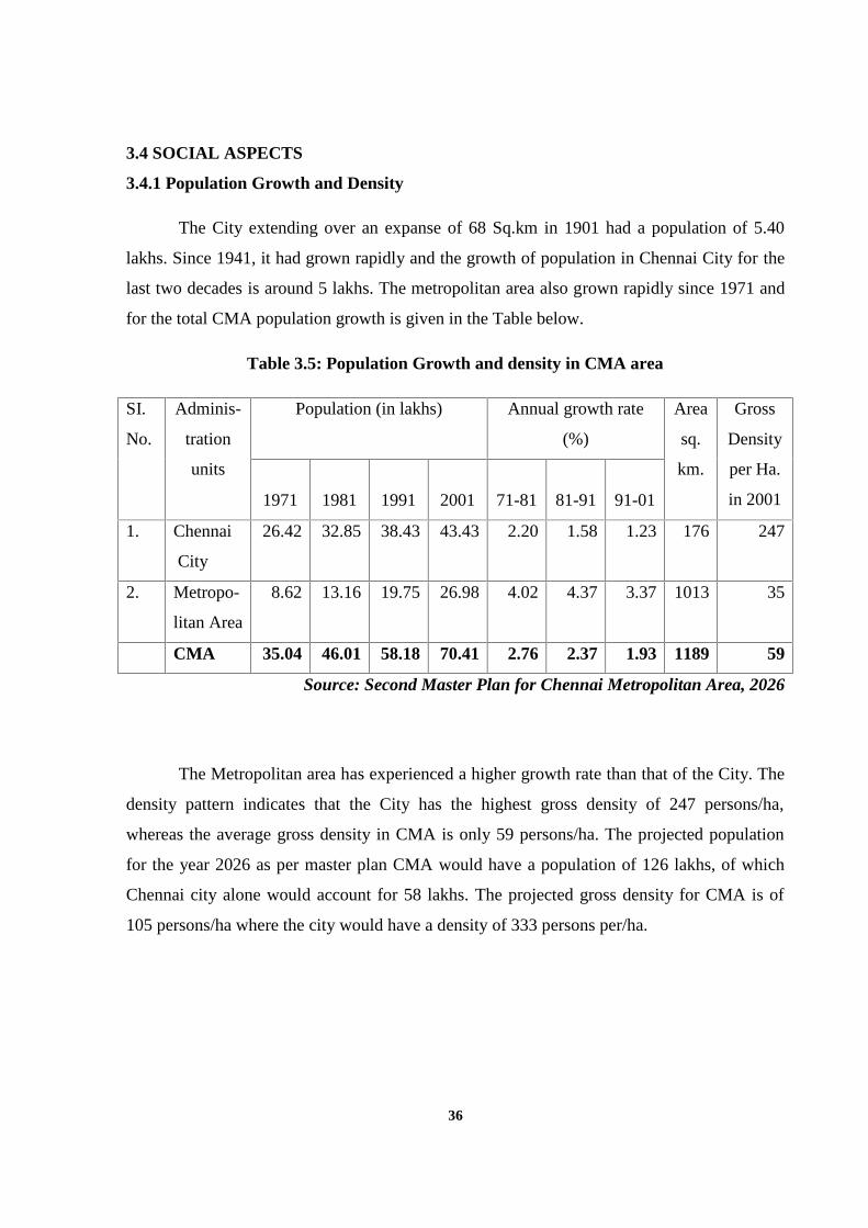
36
3.4 SOCIAL ASPECTS
3.4.1 Population Growth and Density
The City extending over an expanse of 68 Sq.km in 1901 had a population of 5.40
lakhs. Since 1941, it had grown rapidly and the growth of population in Chennai City for the
last two decades is around 5 lakhs. The metropolitan area also grown rapidly since 1971 and
for the total CMA population growth is given in the Table below.
Table 3.5: Population Growth and density in CMA area
SI.
No.
Adminis-
tration
units
Population (in lakhs) Annual growth rate
(%)
Area
sq.
km.
Gross
Density
per Ha.
in 20011971 1981 1991 2001 71-81 81-91 91-01
1. Chennai
City
26.42 32.85 38.43 43.43 2.20 1.58 1.23 176 247
2. Metropo-
litan Area
8.62 13.16 19.75 26.98 4.02 4.37 3.37 1013 35
CMA 35.04 46.01 58.18 70.41 2.76 2.37 1.93 1189 59
Source: Second Master Plan for Chennai Metropolitan Area, 2026
The Metropolitan area has experienced a higher growth rate than that of the City. The
density pattern indicates that the City has the highest gross density of 247 persons/ha,
whereas the average gross density in CMA is only 59 persons/ha. The projected population
for the year 2026 as per master plan CMA would have a population of 126 lakhs, of which
Chennai city alone would account for 58 lakhs. The projected gross density for CMA is of
105 persons/ha where the city would have a density of 333 persons per/ha.
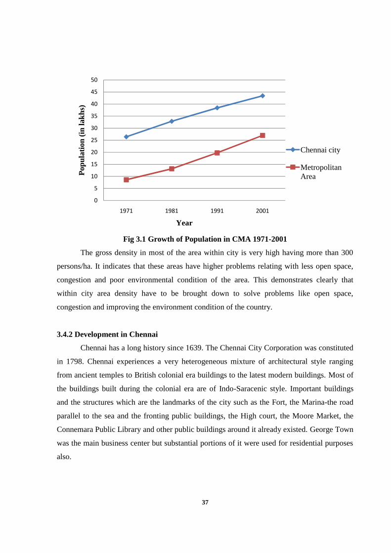
37
Fig 3.1 Growth of Population in CMA 1971-2001
The gross density in most of the area within city is very high having more than 300
persons/ha. It indicates that these areas have higher problems relating with less open space,
congestion and poor environmental condition of the area. This demonstrates clearly that
within city area density have to be brought down to solve problems like open space,
congestion and improving the environment condition of the country.
3.4.2 Development in Chennai
Chennai has a long history since 1639. The Chennai City Corporation was constituted
in 1798. Chennai experiences a very heterogeneous mixture of architectural style ranging
from ancient temples to British colonial era buildings to the latest modern buildings. Most of
the buildings built during the colonial era are of Indo-Saracenic style. Important buildings
and the structures which are the landmarks of the city such as the Fort, the Marina-the road
parallel to the sea and the fronting public buildings, the High court, the Moore Market, the
Connemara Public Library and other public buildings around it already existed. George Town
was the main business center but substantial portions of it were used for residential purposes
also.
0
5
10
15
20
25
30
35
40
45
50
1971 1981 1991 2001
Pop
ulat
ion
(in
lakh
s)
Chennai city
MetropolitanArea
Year
38
The main residential areas, however were Chintadripet, Triplicane, Egmore,
Mylapore, Purasawalkam, Vepery and Royapuram. Most of the areas outside these
settlements were covered with gardens and agriculture lands interspersed with bungalows of
the elite. Nungambakkam, Chetput and Kilpauk were some of the areas, which germinated in
this manner; Saidapet in the southwest was a separate small settlement. Both sides of Mount
Road for a distance of 5 to 6 km, from Fort St. George were occupied by large business
houses, clubs, and hotel; industries were few located in George Town or Perambur area. The
West of Nungambakkam was covered by Nungambakkam Tank and this long tank, extending
in the form of crescent for nearly 6 km covered and the west of the southwest. The city was
mainly a commercial, military and Administrative center for the entire south.
Triplicane, Mylapore, Purasawalkam and also the northern part of George Town and
Royapuram are the old residential areas characterized by street housing with shopping along
main streets. New residential areas of Mylapore and Thegarayanagar had developed with
bungalow type houses but densities here were higher than the exclusive older residential area
of Egmore, Nungambakkam and Chetput, which lie between these areas and the central
business district. This intervening area was developed for multi-storied apartments, offices
and hotels in view of their relative proximity to the central business district.
3.4.3 Housing
The gap between households and housing units in 2001 was of the order of 36,000
units in the Chennai Metropolitan Area while in the City it was much less. The problem in
Chennai city is that 15% of the dwelling units are Semi-Pucca and 10% of the units are
Kutcha. Nearly 41% of the dwelling units are either one room units or units without an
exclusive room.
Even though the proportion of the housing units with ‘Kutcha’ roofing materials
accounts for only about 10%, in absolute numbers it is large i.e., 93,701 and these are
vulnerable to fire accidents, particularly in summer months sometimes resulting in casualties.
Chennai City has a slum population of 819,872, which constitutes about 19% of the
City Population. The Scheduled Castes Population in slums is of the order of 269,301 persons
apart from 1830 constituting the Scheduled Tribe population(Source: Second Master Plan
for Chennai Metropolitan Area, 2026).
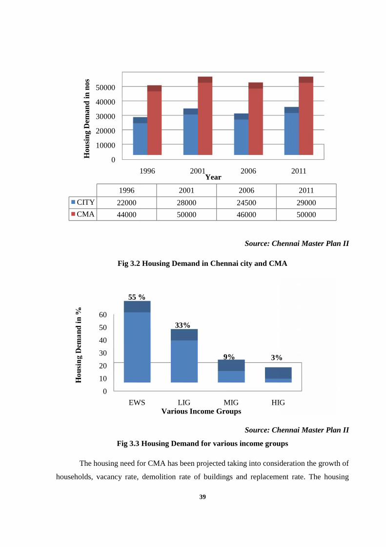
39
Source: Chennai Master Plan II
Fig 3.2 Housing Demand in Chennai city and CMA
Source: Chennai Master Plan II
Fig 3.3 Housing Demand for various income groups
The housing need for CMA has been projected taking into consideration the growth of
households, vacancy rate, demolition rate of buildings and replacement rate. The housing
0
10000
20000
30000
40000
50000
1996
Hou
sing
Dem
and
in n
os
1996
CITY 22000
CMA 44000
0
10
20
30
40
50
60
EWS
55 %
39
Source: Chennai Master Plan II
Fig 3.2 Housing Demand in Chennai city and CMA
Source: Chennai Master Plan II
Fig 3.3 Housing Demand for various income groups
The housing need for CMA has been projected taking into consideration the growth of
households, vacancy rate, demolition rate of buildings and replacement rate. The housing
1996 2001 2006
2001 2006
22000 28000 24500
44000 50000 46000
Year
EWS LIG MIG HIG
55 %
33%
9% 3%
Various Income Groups
39
Source: Chennai Master Plan II
Fig 3.2 Housing Demand in Chennai city and CMA
Source: Chennai Master Plan II
Fig 3.3 Housing Demand for various income groups
The housing need for CMA has been projected taking into consideration the growth of
households, vacancy rate, demolition rate of buildings and replacement rate. The housing
2011
2011
29000
50000
HIG
3%
40
demand is estimated based on the growth of households, vacancy rate, replacement rate and
affordability. The above fig shows that inadequacy of housing in the year 20011. These need
to be addressed by planning of housing sectors. In fig 3.3 shows housing demand of various
income groups. The EWS and LIG people having more housing demand 55% and 35%
respectively so need of housing demand should be rectified.
3.5 ECONOMIC ASPECTS
The economic base of Chennai City had shifted from trade and commerce to
administration and services by the early part of the 20th Century. In the post-Independence
period, manufacturing became an important sector and CMA continues to be the most
important industrial area in the State. Recent trend shows that the economic structure of the
City is tertiarised with growing contributions by Information Technology/Information
Technology Enabling Service/Business Process Outsourcing Industries.
The participation rate i.e. proportion of main workers to the population of CMA was
30.74percent in 1991 and 30.96percent in 2001. The corresponding figures for Chennai City
were 30.50 percent in 1991 and 31.79percent in 2001. The number of marginal workers both
in Chennai City and in CMA is negligible.
The workers in primary activity constitute 6.52 per cent in CMA and 1.05 percent in
City 1991. In 2001, it was 2.91 percent and 1.52 percent respectively in CMA and Chennai
City indicating that the primary activities are on the decline in the peripheral areas due to the
emergence of manufacturing and new economy industry. The workers in primary activity are
dwindling and it is negligible compared to total, both in Chennai City and in CMA with more
than 90 percent of the people engaged in the tertiary sector. The percentage of non- workers
was 65.73 percent in City and 69.14 percent in CMA during 2001.
The percentage of workers as per 2001 Census works out to 54.6 % out of the male
population and 18.26 % out of the female population. It is assumed that in future years by
2011, 87.5 % of male and 30% of the female eligible working population will be willing to
work and for them jobs would have to be created. Similarly this % for male and female is
assumed as 90% and 33% for 2016, 92.5% and 36% for 2021 and 95% and 40% for the year
41
2026, considering the improvements in the education level, aptitude, willingness to work etc
in future years (Source: Second Master Plan for Chennai Metropolitan Area, 2026).
The projection shows that 7.5 % of the male working population and 10 % of eligible
female working population job have to be created from various sectors for the year 2026. The
non-workers percentage is also more in Chennai city and also CMA area, so more jobs have
to be created for the city as well as for the CMA.
3.6 ENVIRONMENT ASPECTS
Sustainable cities are fundamental to social and economic development. As stated in
the tenth plan document of the National Planning Commission, sustainability is not an option
but imperative. For a better world to live in, we need good air, pure water, nutritious food,
healthy environment and greenery around us. Without sustainability, environmental
deterioration and economic decline will be feeding on each other, leading to poverty,
pollution, poor health, political upheaval and unrest. The environment is not to be seen as a
stand-alone concern. It cuts across all sectors of development. We have to improve our
economic growth rate, provide basic minimum life support services to a large section of our
population and deal with the problems of poverty and unemployment. At the same time, we
have to pay attention to conserving our natural resources and also improving the status of our
environment.
3.6.1 Pollution of Waterways
The six major waterways and drains, viz. Cooum, Adyar, Buckingham Canal, Captain
Cotton Canal, Otteri Nallah and Mambalam drain severe pollution for the CMA with visible
manifestation. The sewage carried by them is of the order of 532 MLD, which is more than
the quantity of sewage collected from the City for treatment by the Metro water treatment
plants. The waterways of Chennai are not perennial in nature and receive flood discharge
only during monsoon season; in the rest of the year they act as carriers of wastewater from
sewage treatment plants and sewage from defective storm water outlets. The sludge disposal
consultancy study conducted in 1994 by the consultant M/s. Mott MacDonald Inc. has
revealed that contamination of waterways and anaerobic digestion of wastewater flowing in
the waterways has led to the accumulation of sludge causing hindrance to the hydraulic
42
functioning of the waterways and also causing contamination of waterways in the ecosystem
(Source: Second Master Plan for Chennai Metropolitan Area, 2026).
The above shows that the waterways of Chennai are not perennial in nature and it
causes flooding during monsoon season. Due to disposal of solid waste in the waterways
causes pollution and also it obstruct the free flow of water. The waste water comes out from
the drainage and stagnates on the roadside some time causes pollution for the people. The
improper planning and inadequate sewerage system facilities within the city cause flooding in
most of the areas in Chennai city during monsoon season causes pollution. So, proper
planning of sewerage system facilities would result for avoiding pollution form waterways in
Chennai city.
3.6.2 Air Pollution
The invisible part yet the more dangerous one are the air pollution load. The major
contribution is from the vehicular sector (71.28%) followed by industrial sector (19.70%).
According to TNPCB at major traffic intersections the TSPM and RSPM values are
exceeding the standard values. Pollution by industries is widely prevalent in the Manali
industrial complex and surrounding areas. The annual average pollution load for industrial
areas—sulphur-di-oxide, oxides of nitrogen, RSPM & TSPM are way above the acceptable
levels (Source: Second Master Plan for Chennai Metropolitan Area, 2026).
The above shows that air pollution caused majorly by vehicle sector in Chennai city
due to increase private vehicle in the city. The proper planning for planting green covers on
the roadside should be done means it will reduce vehicle pollution.
3.6.3 Noise Pollution
The noise level survey conducted by the TNPCB reveals that noise level exceeded the
limits, mostly in commercial areas, mainly due to vehicular movement. During festive
seasons in Chennai, the noise levels were noted high and particularly during Deepavali, it
exceeded 120 dB (Source: Second Master Plan for Chennai Metropolitan Area, 2026)
The above shows the noise level is high in the commercial areas alone, so proper
planning for vehicular movement in commercial area will reduce noise pollution.
43
3.6.4 Pollution by Urban Solid waste
The disposal of wastes – solid waste, bio-medical waste, hazardous industrial wastes
is a major problem and the municipal dumping yards at Kodungaiyur and Perungudi which
are generators of greenhouse gases and smoke due to burning have degraded the environment
around them severely. In the recent past, one of the major pollution problems identified is the
one due to the non-degradable plastic wastes (Source: Second Master Plan for Chennai
Metropolitan Area, 2026)
The preventive, promotional and mitigative aspects considered to tackle this problem
by the authorities concerned include source segregation of municipal wastes, raising
consumer and public awareness, specifying plastics suitable for recycling, penalties for
littering and specifying minimum thickness of plastic carry bags.
3.5.5 Green Cover
Chennai City has only about 2% of the area as declared parks. In Chennai
Metropolitan Area, the declared forest cover is about 24 sq. kms, which is about 2 percent of
the CMA area (Source: Second Master Plan for Chennai Metropolitan Area, 2026).
However, satellite imageries show that green cover over the City due to trees along
roadside and within the sites is of considerable extent. There is ample scope for further
development of this green cover within the City and also in the rest of CMA, particularly
along roads, drains, riverbanks etc.
3.7 LEGAL ASPECTS
The legal aspects of the Chennai metropolitan area have been introduced in the master
plan for regularizing the land use and control of developments. The Master plan for CMA
approved in 1976 proposed the structure of the Metropolis taking into account various
factors. The structure proposed was of radial pattern with the city as a hub. The second
master plan approved in the year 2006 proposed some urban development strategies. The
main elements of the strategy were
Restriction of density and population growth in the city.
Restriction of industrial and commercial development within CMA.
Dispersal of certain activities from CBD.
44
Redefining special buildings as the ones exceeding 6 dwelling units
Permitting IT buildings and bio-informatics centers in Mixed Residential,
Commercial, and Institutional use zones.
To encourage social housing provision by private developers of large group
developments/ multi-storied developments through Development Regulations.
To encourage LIG housing by allowing additional FSI of 0.25 to private developers
for such developments.
To consider extension of the Transfer of Developments Rights concept for lands taken
over for the development to solve problems of land acquisition for housing and
infrastructure.
Proposing higher FSI of 2.00 for special buildings and group developments with
dwelling units not exceeding 75sq.m in floor area each in the MRTS influence area
between Luz and Velachery.
Allowing Multi-storey Building (MSBs) along 12m and 15m wide roads with
limitations on FSI and height.
Allowing additional FSI 0.25 in case of special buildings and group development with
dwelling units each not exceeding 45sq.km in floor area.
Providing for conservation of heritage buildings
Rationalizing the planning parameters for special buildings with reference to plot
extent, number of dwellings, and number of floors
Revising the parking standards totally based on the recommendations made in a recent
consultancy study of parking requirements
Reducing plot extent or side setback requirements
The legal aspects of the Chennai metropolitan area focused on various policies
relevant to the problems. As of each and every sector for development of the Chennai
metropolitan area, the master plan clearly indicates various policies and proposed some
strategies for the developments. The spatial allocation of various uses for whole CMA, they
also proposed land policy and spatial strategy. The legal aspects will also solve the problem
for unclear land ownerships in Chennai. The polices, proposed strategy and development
regulation for the Chennai metropolitan area shows some thrust of change in the development
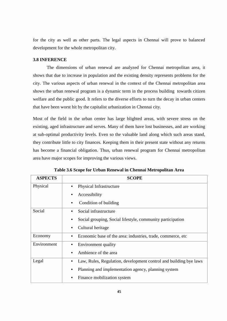
45
for the city as well as other parts. The legal aspects in Chennai will prove to balanced
development for the whole metropolitan city.
3.8 INFERENCE
The dimensions of urban renewal are analyzed for Chennai metropolitan area, it
shows that due to increase in population and the existing density represents problems for the
city. The various aspects of urban renewal in the context of the Chennai metropolitan area
shows the urban renewal program is a dynamic term in the process building towards citizen
welfare and the public good. It refers to the diverse efforts to turn the decay in urban centers
that have been worst hit by the capitalist urbanization in Chennai city.
Most of the field in the urban center has large blighted areas, with severe stress on the
existing, aged infrastructure and serves. Many of them have lost businesses, and are working
at sub-optimal productivity levels. Even so the valuable land along which such areas stand,
they contribute little to city finances. Keeping them in their present state without any returns
has become a financial obligation. Thus, urban renewal program for Chennai metropolitan
area have major scopes for improving the various views.
Table 3.6 Scope for Urban Renewal in Chennai Metropolitan Area
ASPECTS SCOPE
Physical Physical Infrastructure
Accessibility
Condition of building
Social Social infrastructure
Social grouping, Social lifestyle, community participation
Cultural heritage
Economy Economic base of the area: industries, trade, commerce, etc
Environment Environment quality
Ambience of the area
Legal Law, Rules, Regulation, development control and building bye laws
Planning and implementation agency, planning system
Finance mobilization system
46
The above table shows that various scope for urban renewal in the Chennai
metropolitan area. The assessment of various aspects for smaller pockets of development
which is declining in its activity and too blighted of smaller pockets have a problem for the
city as well for the whole Chennai metropolitan area. So, it’s important to recognize that
urban renewal will lead proper replanning of the area for the citizen goods and welfare.
Urban renewal seeks ways to improve disadvantaged places and the lives of people who live
and work there. Regeneration and renewal activities are varied and may reflect joined-up
holistic or relatively less integrated programs of physical, social and economic change.
47
CHAPTER IV
DELINEATION OF STUDY AREA
4.1 INTRODUCTION
Chennai city and the whole metropolitan area have very good development in the
present situations due to investment in the particular activity. Like investment in IT sector in
the city limits experienced change in the development when comparing the past as well as
present in that particular area. So the investment in various sectors changes the development
completely in Chennai city. All these developments have targeted along the fringes of the city
boundaries. But still Chennai has a diversified economic base anchored by the
automobile, software services, medical tourism, hardware manufacturing and financial
services within the city limits. As we know the Chennai city is the oldest settlement in Tamil
Nadu with the age of 375 years. The old settlement of Chennai city has experienced decline
in its activity and too blighted off in a particular area in the city. Some of the areas within the
city have experienced low development due to less investment and less concentration of older
settlements. The oldest some part of Chennai suffering the most with urban problems due to
growth of population and trends of change in developments in the present scenario.
So, urban management issues are increasingly becoming important for supporting
economic activities in the Chennai city and widely affect the quality of life of urban citizens.
Given the pace of its growth, Chennai is facing challenges of rapid urbanization like many
other cities around the world. The process of modern city planning seeks to steer market
forces in the city building towards citizen welfare and the public good. So, Urban renewal
program plays a vital role for proper ripening of the older settlements with three components
conservation, rehabilitation and redevelopment. The urban renewal program is used as a
treatment for the older settlements, which is blighted. The treatment for urban renewal is
done in smaller areas with perspective consideration of the whole metropolitan city. For the
study purpose and also to prove doing urban renewal for smaller pockets will be very vital in
the metropolitan city context the area have been delineated. The delineation has been done by
considering certain parameters for choosing an urban renewal program in particular smaller
pocket. In this chapter explains the process in which delineation of smaller pockets is done.
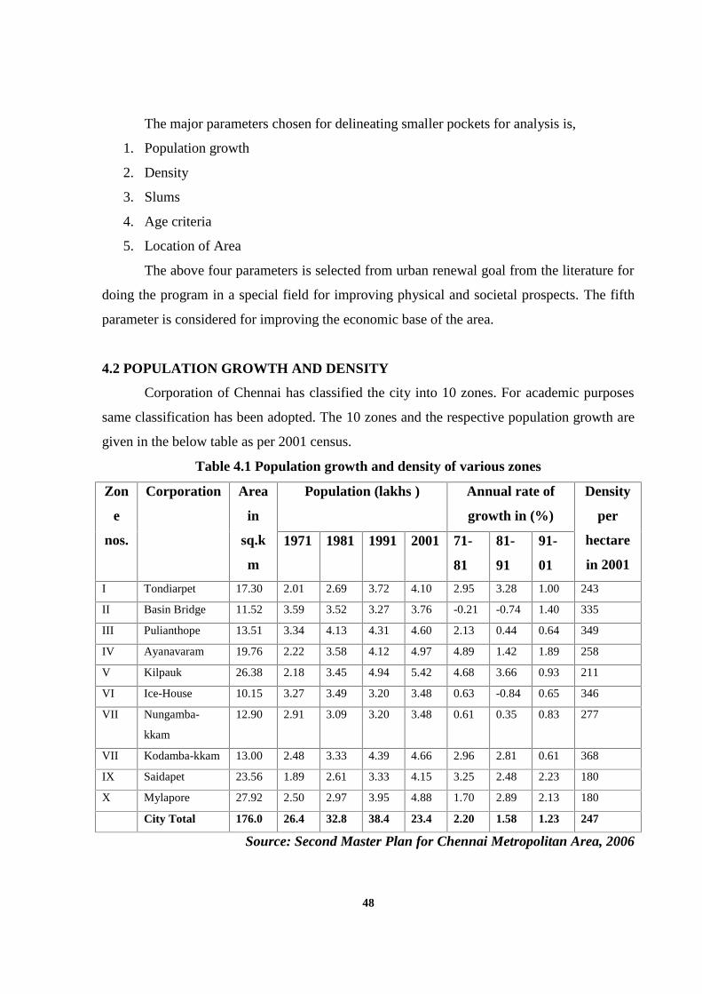
48
The major parameters chosen for delineating smaller pockets for analysis is,
1. Population growth
2. Density
3. Slums
4. Age criteria
5. Location of Area
The above four parameters is selected from urban renewal goal from the literature for
doing the program in a special field for improving physical and societal prospects. The fifth
parameter is considered for improving the economic base of the area.
4.2 POPULATION GROWTH AND DENSITY
Corporation of Chennai has classified the city into 10 zones. For academic purposes
same classification has been adopted. The 10 zones and the respective population growth are
given in the below table as per 2001 census.
Table 4.1 Population growth and density of various zones
Zon
e
nos.
Corporation Area
in
sq.k
m
Population (lakhs ) Annual rate of
growth in (%)
Density
per
hectare
in 2001
1971 1981 1991 2001 71-
81
81-
91
91-
01
I Tondiarpet 17.30 2.01 2.69 3.72 4.10 2.95 3.28 1.00 243
II Basin Bridge 11.52 3.59 3.52 3.27 3.76 -0.21 -0.74 1.40 335
III Pulianthope 13.51 3.34 4.13 4.31 4.60 2.13 0.44 0.64 349
IV Ayanavaram 19.76 2.22 3.58 4.12 4.97 4.89 1.42 1.89 258
V Kilpauk 26.38 2.18 3.45 4.94 5.42 4.68 3.66 0.93 211
VI Ice-House 10.15 3.27 3.49 3.20 3.48 0.63 -0.84 0.65 346
VII Nungamba-
kkam
12.90 2.91 3.09 3.20 3.48 0.61 0.35 0.83 277
VII Kodamba-kkam 13.00 2.48 3.33 4.39 4.66 2.96 2.81 0.61 368
IX Saidapet 23.56 1.89 2.61 3.33 4.15 3.25 2.48 2.23 180
X Mylapore 27.92 2.50 2.97 3.95 4.88 1.70 2.89 2.13 180
City Total 176.0 26.4 32.8 38.4 23.4 2.20 1.58 1.23 247
Source: Second Master Plan for Chennai Metropolitan Area, 2006
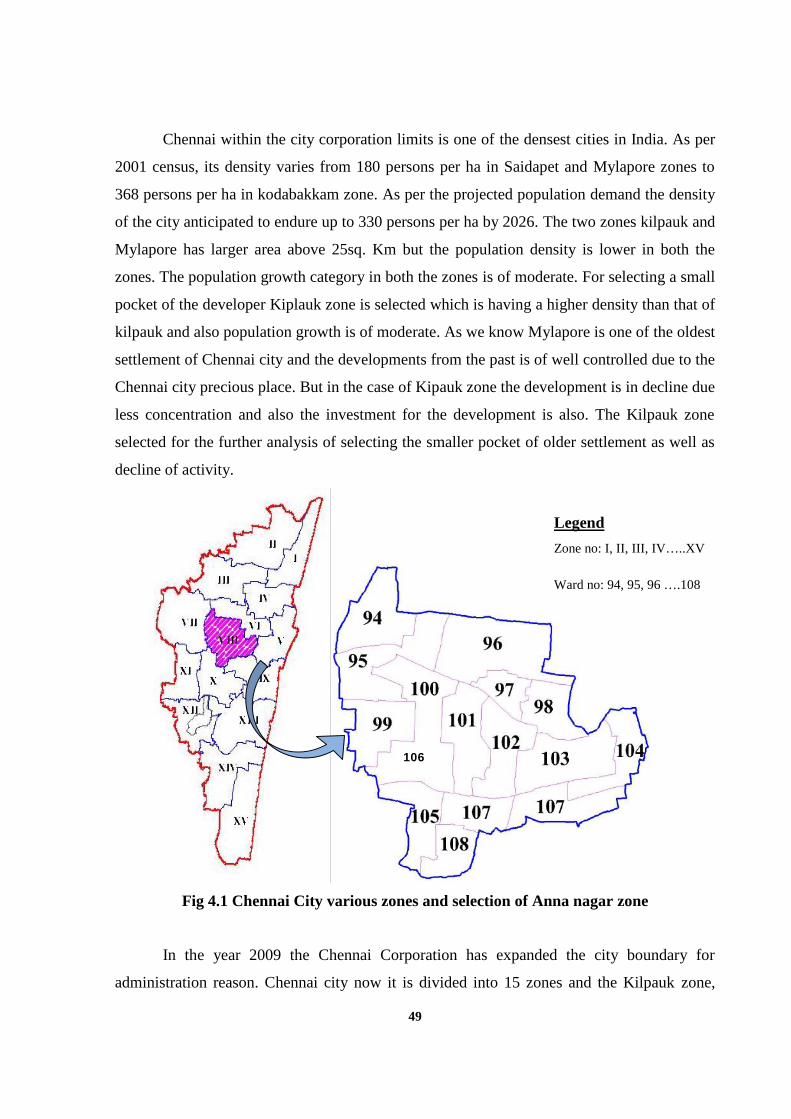
49
Chennai within the city corporation limits is one of the densest cities in India. As per
2001 census, its density varies from 180 persons per ha in Saidapet and Mylapore zones to
368 persons per ha in kodabakkam zone. As per the projected population demand the density
of the city anticipated to endure up to 330 persons per ha by 2026. The two zones kilpauk and
Mylapore has larger area above 25sq. Km but the population density is lower in both the
zones. The population growth category in both the zones is of moderate. For selecting a small
pocket of the developer Kiplauk zone is selected which is having a higher density than that of
kilpauk and also population growth is of moderate. As we know Mylapore is one of the oldest
settlement of Chennai city and the developments from the past is of well controlled due to the
Chennai city precious place. But in the case of Kipauk zone the development is in decline due
less concentration and also the investment for the development is also. The Kilpauk zone
selected for the further analysis of selecting the smaller pocket of older settlement as well as
decline of activity.
Fdfnkjdn mn bdkjf b
In the year 2009 the Chennai Corporation has expanded the city boundary for
administration reason. Chennai city now it is divided into 15 zones and the Kilpauk zone,
Fig 4.1 Chennai City various zones and selection of Anna nagar zone
106
Legend
Zone no: I, II, III, IV…..XV
Ward no: 94, 95, 96 ….108
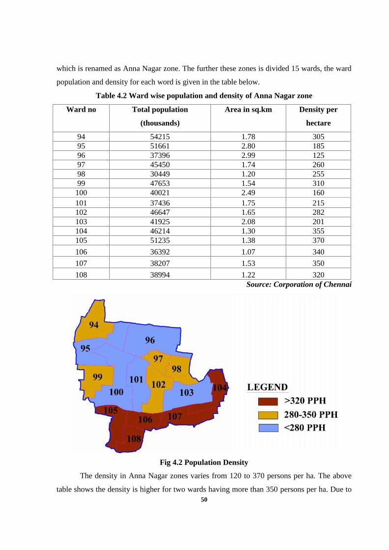
50
which is renamed as Anna Nagar zone. The further these zones is divided 15 wards, the ward
population and density for each word is given in the table below.
Table 4.2 Ward wise population and density of Anna Nagar zone
Ward no Total population
(thousands)
Area in sq.km Density per
hectare
94 54215 1.78 30595 51661 2.80 18596 37396 2.99 12597 45450 1.74 26098 30449 1.20 25599 47653 1.54 310100 40021 2.49 160101 37436 1.75 215102 46647 1.65 282103 41925 2.08 201104 46214 1.30 355105 51235 1.38 370
106 36392 1.07 340
107 38207 1.53 350
108 38994 1.22 320Source: Corporation of Chennai
Fig 4.2 Population Density
The density in Anna Nagar zones varies from 120 to 370 persons per ha. The above
table shows the density is higher for two wards having more than 350 persons per ha. Due to
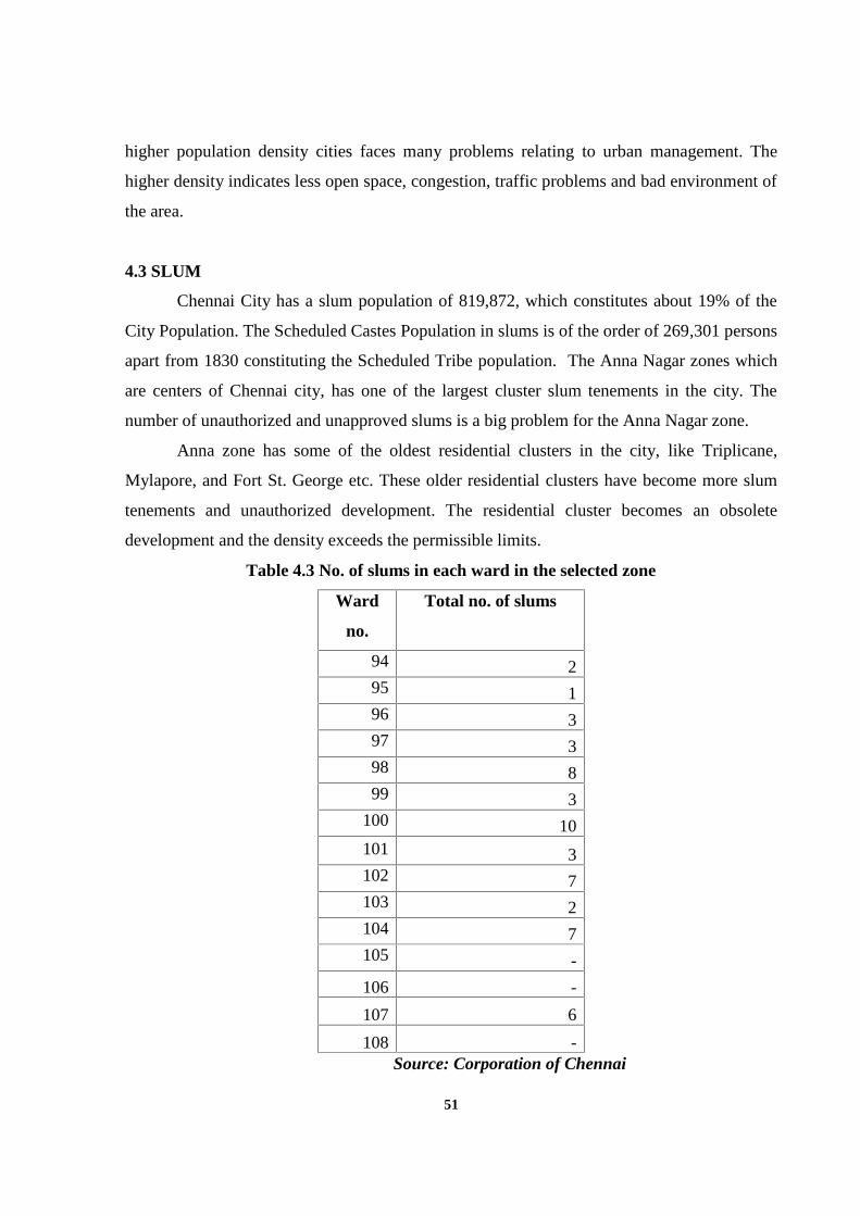
51
higher population density cities faces many problems relating to urban management. The
higher density indicates less open space, congestion, traffic problems and bad environment of
the area.
4.3 SLUM
Chennai City has a slum population of 819,872, which constitutes about 19% of the
City Population. The Scheduled Castes Population in slums is of the order of 269,301 persons
apart from 1830 constituting the Scheduled Tribe population. The Anna Nagar zones which
are centers of Chennai city, has one of the largest cluster slum tenements in the city. The
number of unauthorized and unapproved slums is a big problem for the Anna Nagar zone.
Anna zone has some of the oldest residential clusters in the city, like Triplicane,
Mylapore, and Fort St. George etc. These older residential clusters have become more slum
tenements and unauthorized development. The residential cluster becomes an obsolete
development and the density exceeds the permissible limits.
Table 4.3 No. of slums in each ward in the selected zone
Ward
no.
Total no. of slums
94 295 196 397 398 899 3
100 10101 3102 7103 2104 7105 -
106 -
107 6
108 -Source: Corporation of Chennai
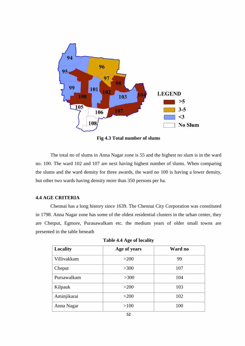
52
Fig 4.3 Total number of slums
The total no of slums in Anna Nagar zone is 55 and the highest no slum is in the ward
no. 100. The ward 102 and 107 are next having highest number of slums. When comparing
the slums and the ward density for three awards, the ward no 100 is having a lower density,
but other two wards having density more than 350 persons per ha.
4.4 AGE CRITERIA
Chennai has a long history since 1639. The Chennai City Corporation was constituted
in 1798. Anna Nagar zone has some of the oldest residential clusters in the urban center, they
are Chetput, Egmore, Purasawalkam etc. the medium years of older small towns are
presented in the table beneath
Table 4.4 Age of locality
Locality Age of years Ward no
Villivakkam >200 99
Cheput >300 107
Pursawalkam >300 104
Kilpauk >200 103
Aminjikarai >200 102
Anna Nagar >100 100
53
The above table shows that Chetput and Purasawalkam are the two older settlements
present in the ward no104 and107. The Chennai city has experienced older settlement decline
in its activity and the villages are also blighted off. Urban renewal is made out for older small
towns to bring past glory, therefore, while selecting the area age criteria should be taken.
4.5 LOCATIONAL FACTORS
The most important parameter to be analyzed for doing urban renewal is locational
factors. The location of the area will give a clear picture whether it has any impact for the
development. The consideration for selecting the study area is
Natural features like water bodies
Located on Transportation Network
Many cities have experienced problem based on the location of various activities.
Chennai city is one of the case have experienced many problems based on the location
factors. Chennai is one of the cities having more number of unauthorized, unapproved
developments and slums.
Based on above two conditions Anna Nagar zone is studied for each ward and apart from the
15 wards only two wards have seen the presence of locational factors.
Table 4.5 Location factors of ward
Ward no. Locational Factors
104 NH and Rail Network
107 NH, Rail network and Cooum river
These two wards are the one located along Transportation network and the natural
features. The presence of unauthorized and unapproved developments creates problems like
traffic congestion, less open space and insecurity for the people who they live along these
locations so while selecting these study areas locational parameter is considered.
54
4.6 SELECTION OF CHETPUT STATION AREA
The parameter like population growth and density for corporation of Chennai shows
that the Anna Nagar zone has moderate growth category and low density. But in depth
analyses within the zones shows that more or less of the wards have higher density and has
attained maximum limit. The other parameter slums which show that Anna Nagar zone,
which is having more slums with higher density. The parameter age criteria are chosen for
finding the older settlements within the city limits since the some of the older settlement lost
its past glory. The location parameter shows that how it is significant for the city for selecting
the subject area since loctaional factors gives a major problem for the metropolis. The table
shows the analysis of all parameters.
Table 4.6 Selection of study area
Ward
no
Weightage for Parameter Total
weightagePopulation
Growth
Density Slum Age
criteria
Locational
Factors
94 1 1
95
96
97 1 1
98 1 1
99
100 1 1
101
102 1 1 2
103
104 1 1 1 1 4
105 1
106 1 1
107 1 1 1 1 4
108 1 1
55
The weightage for each ward is given based on the parameter present in the ward. If
the weightage is one if the parameter is present and zero if the parameter is absent. The above
table shows the weightage for each parameter it shows that two ward are having higher
weightage. Ward no 104 and 107 are the two wards having higher problems in the Anna
Nagar zones within the Chennai city. The two wards face more urban problems from the
parameter considered. Also, it states that these areas have problems of dilapidated buildings,
bad living environment, no open space, traffic congestion, poor parking facilities, etc. These
two words have urban problems so there is need for doing urban renewal in both the woods.
The award is to too big for making out in depth analysis at the micro level.
For study purposes and also for doing urban renewal these two words have again
delineated for selecting the smaller pockets of growth. The parameter is considered for
selecting smaller pockets is locational factors. These two wards have rail network
connectivity, so loctaional factor sees that development of the rail station area and station
area one being the center of the Chennai city. In today’s context station area become viable
for having major activity and also have good development along the rail station area. Chennai
city is the event where the unauthorized development, the presence of the slum and insecurity
of life of the masses around the station area. So, Chetput station area is taken from these two
wards for doing in depth micro level analysis. The Chetput station area faces urban problems
like higher density, obsolete development, no open space, traffic congestion, parking facility
and insecurity threatening of life. So the problems need to be worked by doing urban renewal
with three component form of renewal program. The Chetput station area should be treated
through urban renewal and restoring the Chetput the past glory.
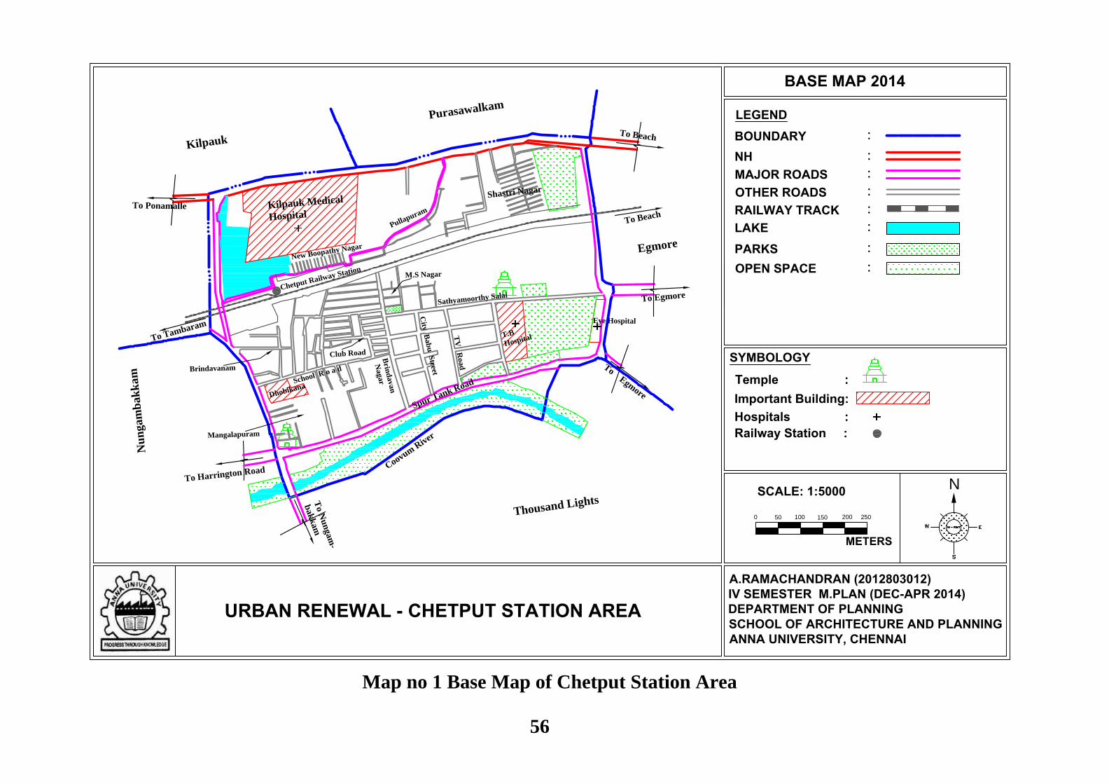
0
N
LEGEND
URBAN RENEWAL - CHETPUT STATION AREA
BASE MAP 2014
SCALE: 1:5000
METERS
:BOUNDARY:NH:MAJOR ROADS:OTHER ROADS:RAILWAY TRACK:LAKE
A.RAMACHANDRAN (2012803012)IV SEMESTER M.PLAN (DEC-APR 2014)DEPARTMENT OF PLANNINGSCHOOL OF ARCHITECTURE AND PLANNINGANNA UNIVERSITY, CHENNAI
Shastri Nagar
:PARKS:OPEN SPACE
T.B
Hospital
Eye Hospital
Temple :Important Building:Hospitals :
Kilpauk Medical
Hospital
Dhobikana
To Beach
To Tambaram
Sathyamoorthy Salai
TV
Road
City
Bab
u S
treet
Brin
davan
NagarSchool R o a d
Club Road
Brindavanam
M.S Nagar
Mangalapuram
New Boopathy Nagar
Pullapuram
Chetput Railway Station
Railway Station :
To Ponamalle
To Beach
To Egmore
To N
un
gam
-
bak
kam
To Harrington Road
To Egmore
Spur Tank Road
Thousand Lights
Coovum R
iver
Egmore
Nu
ngam
bak
kam
Purasawalkam
Kilpauk
50 100 150 200
SYMBOLOGY
250
Map no 1 Base Map of Chetput Station Area
56
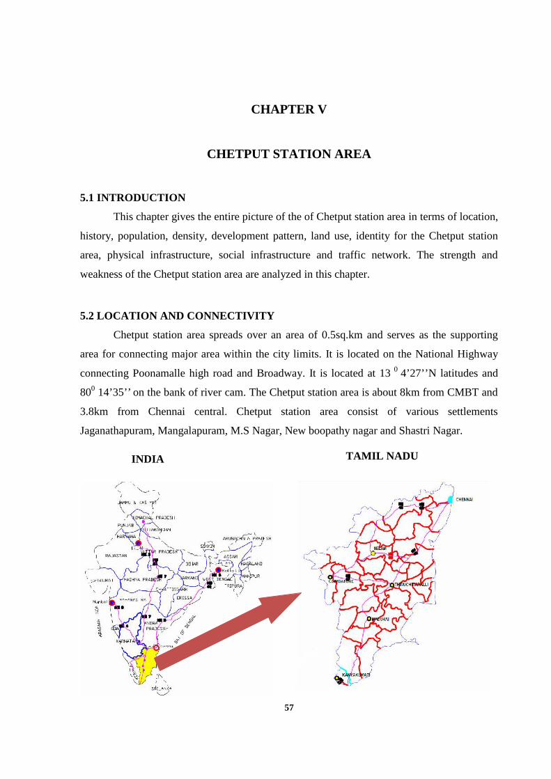
57
CHAPTER V
CHETPUT STATION AREA
5.1 INTRODUCTION
This chapter gives the entire picture of the of Chetput station area in terms of location,
history, population, density, development pattern, land use, identity for the Chetput station
area, physical infrastructure, social infrastructure and traffic network. The strength and
weakness of the Chetput station area are analyzed in this chapter.
5.2 LOCATION AND CONNECTIVITY
Chetput station area spreads over an area of 0.5sq.km and serves as the supporting
area for connecting major area within the city limits. It is located on the National Highway
connecting Poonamalle high road and Broadway. It is located at 13 0 4’27’’N latitudes and
800 14’35’’ on the bank of river cam. The Chetput station area is about 8km from CMBT and
3.8km from Chennai central. Chetput station area consist of various settlements
Jaganathapuram, Mangalapuram, M.S Nagar, New boopathy nagar and Shastri Nagar.
INDIA TAMIL NADU
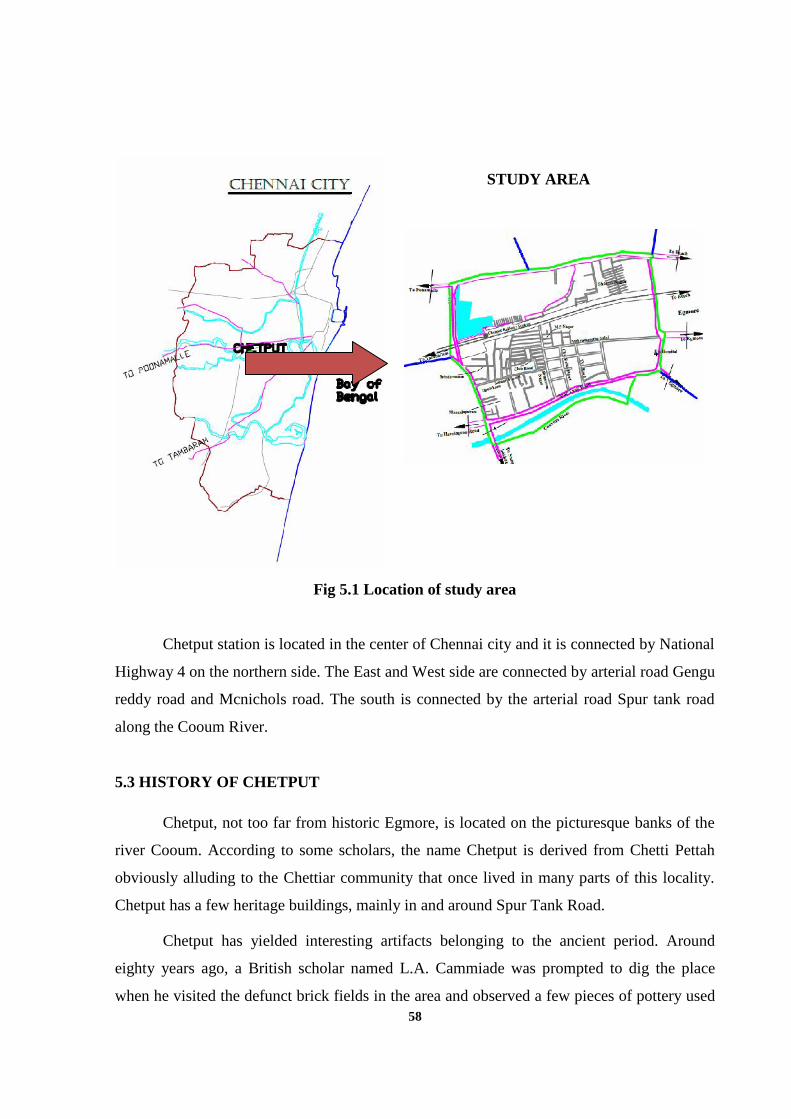
58
Fig 5.1 Location of study area
Chetput station is located in the center of Chennai city and it is connected by National
Highway 4 on the northern side. The East and West side are connected by arterial road Gengu
reddy road and Mcnichols road. The south is connected by the arterial road Spur tank road
along the Cooum River.
5.3 HISTORY OF CHETPUT
Chetput, not too far from historic Egmore, is located on the picturesque banks of the
river Cooum. According to some scholars, the name Chetput is derived from Chetti Pettah
obviously alluding to the Chettiar community that once lived in many parts of this locality.
Chetput has a few heritage buildings, mainly in and around Spur Tank Road.
Chetput has yielded interesting artifacts belonging to the ancient period. Around
eighty years ago, a British scholar named L.A. Cammiade was prompted to dig the place
when he visited the defunct brick fields in the area and observed a few pieces of pottery used
STUDY AREA
59
for burying the dead by ancient people. Preliminary excavations revealed that these pottery
fragments were scattered over an area of 10 acres and were clustered at the bottom of clay
pits at a depth of about 15 to 20 feet below the present ground level.
The occurrence of a large quantity of ancient pottery at such a depth prompted further
digs which revealed that these pottery pieces were mostly found at the bottom of silted-up
wells. Around 20 to 30 such wells existed within the excavated area.Judging by the large
number of wells and their compact arrangement within a limited area, these wells cannot be
drawn-wells but soak-pits. The soak-pits should be located near a human settlement.
The excavator’s search for such a settlement revealed the traces of an ancient village
extending from the northeastern corner of the brick field across the Poonamallee High Road
into a part of the Landon’s Garden property.
The site of the village was marked by a layer of broken pottery which, at places, was
three feet thick. The village also revealed a single well- a regular well for drawing water from
the ground. The area covered by the village is now completely obscured by modern
construction.
The excavations yielded many other interesting things, including animal bones, stone
tools, gold ornaments, beads and a unique terracotta figure of a Hindu God, probably Shiva.
These objects ranged in date from the Stone Age down to the eighth century A.D. Some of
these objects were sent to the museums in London.
5.4 DEMOGRAPHY
In examining the existing condition of this area, it is important to understand the some
of the population characteristics. In this some of the demographic data were examined,
including population growth, density, Literacy rate, and sex ratio and occupation pattern. The
census data for the study area is compared with ward of particular area and with the city.

60
5.4.1 Population Growth
Chetput station area comes under the zone of Kilpauk as per 2001 census. The total
population and annual growth rate for the last three decades of Kilpauk zone is shown in
below table.
Table 5.1 Population growth in Kilpauk zone
Zone
nos.
Corporation Area
in
sq.km
Population (lakhs ) Annual rate of
growth in (%)
1971 1981 1991 2001 71-
81
81-
91
91-
01
V Kilpauk 26.38 2.18 3.45 4.94 5.42 4.68 3.66 0.93
Source: Corporation of Chennai
The Kilpauk zones show for the last three decades, they have a medium growth
category when comparing with the other zones. So there is no decline of population in the
study area since it has a medium growth of population.
The study area comes under the two wards 104 and 107 in the Kilpauk zone. Due to
change in the administrative boundary the comparison is of difficult, so the present
population gives the clear idea of the population in the study area.
Table 5.2 Total population of ward as per 2011 census
Ward no Total population
(thousands)
Area in sq.km
104 46214 1.30
107 38207 1.53Source: Corporation of Chennai
The present population of the ward shows they have very significant growth when
compare with the other wards. The present population of the Chetput station area is 16,223 as
per 2011 census and it covers with an extent of 0.5sq.Km. In this male population constitutes
8,183 and female population constitutes of 8,040.
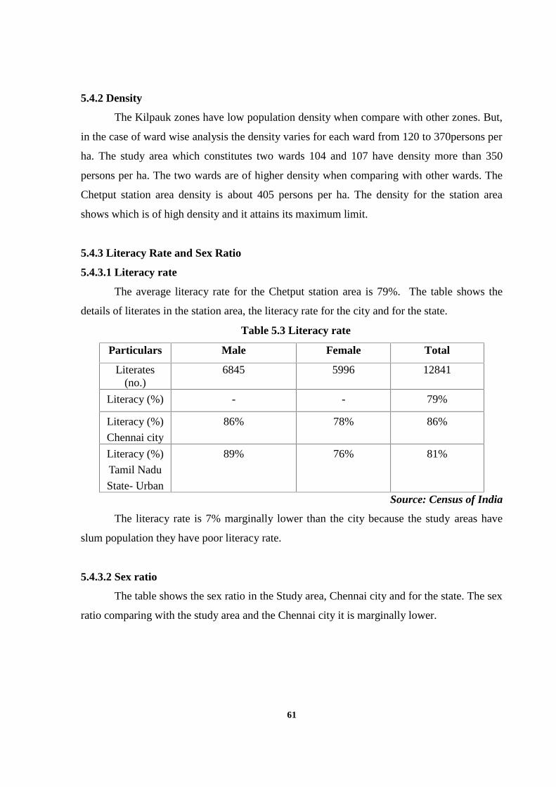
61
5.4.2 Density
The Kilpauk zones have low population density when compare with other zones. But,
in the case of ward wise analysis the density varies for each ward from 120 to 370persons per
ha. The study area which constitutes two wards 104 and 107 have density more than 350
persons per ha. The two wards are of higher density when comparing with other wards. The
Chetput station area density is about 405 persons per ha. The density for the station area
shows which is of high density and it attains its maximum limit.
5.4.3 Literacy Rate and Sex Ratio
5.4.3.1 Literacy rate
The average literacy rate for the Chetput station area is 79%. The table shows the
details of literates in the station area, the literacy rate for the city and for the state.
Table 5.3 Literacy rate
Particulars Male Female Total
Literates(no.)
6845 5996 12841
Literacy (%) - - 79%
Literacy (%)
Chennai city
86% 78% 86%
Literacy (%)
Tamil Nadu
State- Urban
89% 76% 81%
Source: Census of India
The literacy rate is 7% marginally lower than the city because the study areas have
slum population they have poor literacy rate.
5.4.3.2 Sex ratio
The table shows the sex ratio in the Study area, Chennai city and for the state. The sex
ratio comparing with the study area and the Chennai city it is marginally lower.
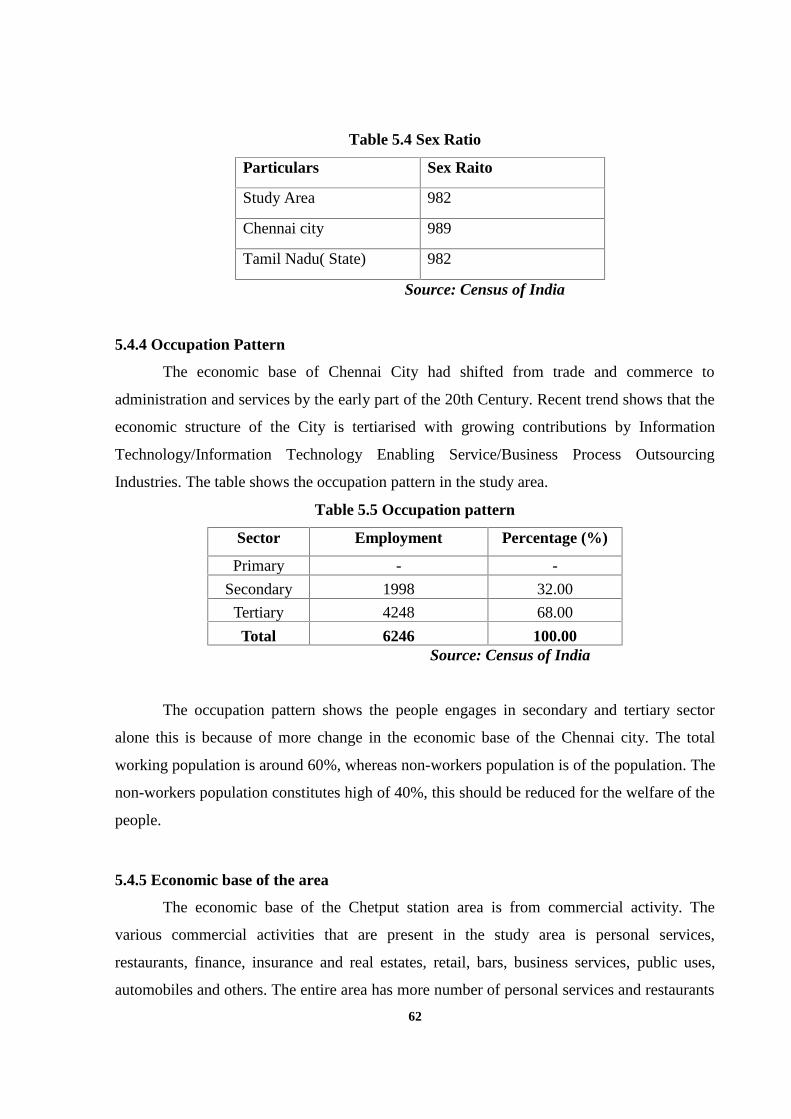
62
Table 5.4 Sex Ratio
Particulars Sex Raito
Study Area 982
Chennai city 989
Tamil Nadu( State) 982
Source: Census of India
5.4.4 Occupation Pattern
The economic base of Chennai City had shifted from trade and commerce to
administration and services by the early part of the 20th Century. Recent trend shows that the
economic structure of the City is tertiarised with growing contributions by Information
Technology/Information Technology Enabling Service/Business Process Outsourcing
Industries. The table shows the occupation pattern in the study area.
Table 5.5 Occupation pattern
Sector Employment Percentage (%)
Primary - -
Secondary 1998 32.00
Tertiary 4248 68.00
Total 6246 100.00Source: Census of India
The occupation pattern shows the people engages in secondary and tertiary sector
alone this is because of more change in the economic base of the Chennai city. The total
working population is around 60%, whereas non-workers population is of the population. The
non-workers population constitutes high of 40%, this should be reduced for the welfare of the
people.
5.4.5 Economic base of the area
The economic base of the Chetput station area is from commercial activity. The
various commercial activities that are present in the study area is personal services,
restaurants, finance, insurance and real estates, retail, bars, business services, public uses,
automobiles and others. The entire area has more number of personal services and restaurants
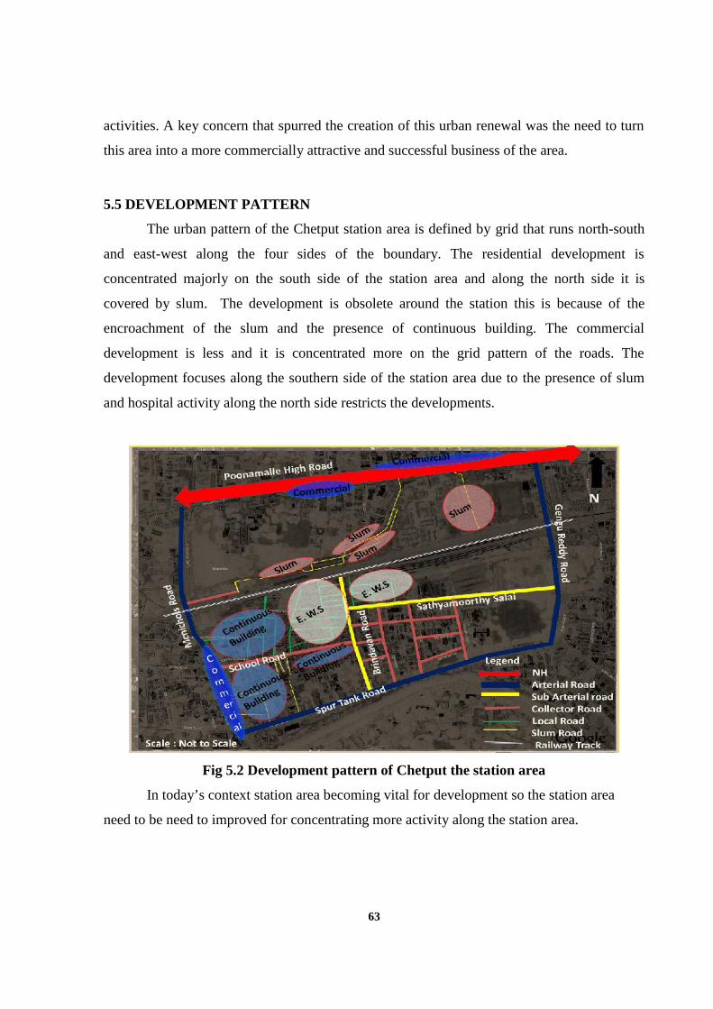
63
activities. A key concern that spurred the creation of this urban renewal was the need to turn
this area into a more commercially attractive and successful business of the area.
5.5 DEVELOPMENT PATTERN
The urban pattern of the Chetput station area is defined by grid that runs north-south
and east-west along the four sides of the boundary. The residential development is
concentrated majorly on the south side of the station area and along the north side it is
covered by slum. The development is obsolete around the station this is because of the
encroachment of the slum and the presence of continuous building. The commercial
development is less and it is concentrated more on the grid pattern of the roads. The
development focuses along the southern side of the station area due to the presence of slum
and hospital activity along the north side restricts the developments.
Fig 5.2 Development pattern of Chetput the station area
In today’s context station area becoming vital for development so the station area
need to be need to improved for concentrating more activity along the station area.
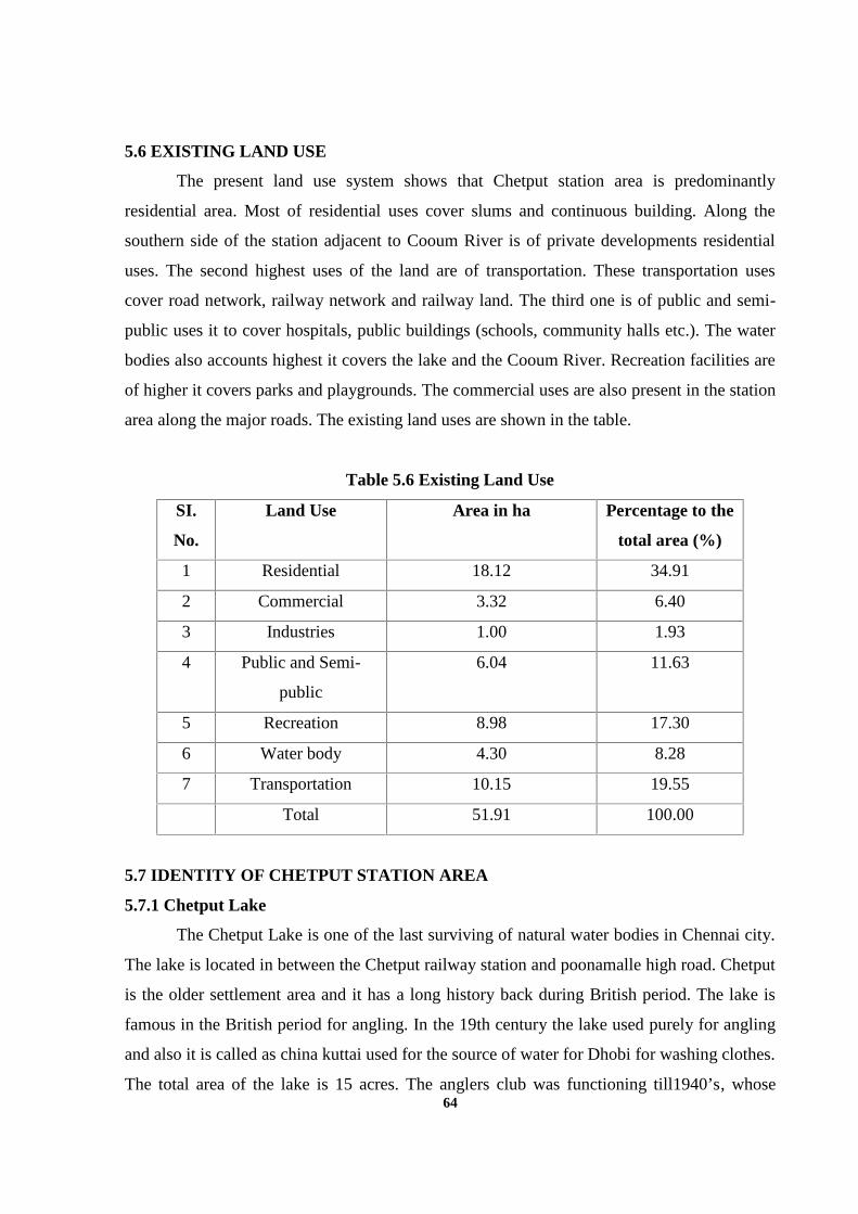
64
5.6 EXISTING LAND USE
The present land use system shows that Chetput station area is predominantly
residential area. Most of residential uses cover slums and continuous building. Along the
southern side of the station adjacent to Cooum River is of private developments residential
uses. The second highest uses of the land are of transportation. These transportation uses
cover road network, railway network and railway land. The third one is of public and semi-
public uses it to cover hospitals, public buildings (schools, community halls etc.). The water
bodies also accounts highest it covers the lake and the Cooum River. Recreation facilities are
of higher it covers parks and playgrounds. The commercial uses are also present in the station
area along the major roads. The existing land uses are shown in the table.
Table 5.6 Existing Land Use
SI.
No.
Land Use Area in ha Percentage to the
total area (%)
1 Residential 18.12 34.91
2 Commercial 3.32 6.40
3 Industries 1.00 1.93
4 Public and Semi-
public
6.04 11.63
5 Recreation 8.98 17.30
6 Water body 4.30 8.28
7 Transportation 10.15 19.55
Total 51.91 100.00
5.7 IDENTITY OF CHETPUT STATION AREA
5.7.1 Chetput Lake
The Chetput Lake is one of the last surviving of natural water bodies in Chennai city.
The lake is located in between the Chetput railway station and poonamalle high road. Chetput
is the older settlement area and it has a long history back during British period. The lake is
famous in the British period for angling. In the 19th century the lake used purely for angling
and also it is called as china kuttai used for the source of water for Dhobi for washing clothes.
The total area of the lake is 15 acres. The anglers club was functioning till1940’s, whose
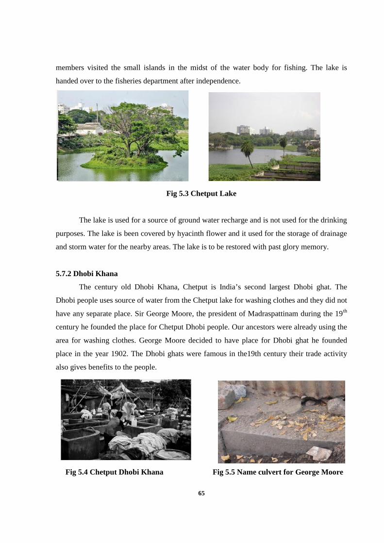
65
members visited the small islands in the midst of the water body for fishing. The lake is
handed over to the fisheries department after independence.
Fig 5.3 Chetput Lake
The lake is used for a source of ground water recharge and is not used for the drinking
purposes. The lake is been covered by hyacinth flower and it used for the storage of drainage
and storm water for the nearby areas. The lake is to be restored with past glory memory.
5.7.2 Dhobi Khana
The century old Dhobi Khana, Chetput is India’s second largest Dhobi ghat. The
Dhobi people uses source of water from the Chetput lake for washing clothes and they did not
have any separate place. Sir George Moore, the president of Madraspattinam during the 19th
century he founded the place for Chetput Dhobi people. Our ancestors were already using the
area for washing clothes. George Moore decided to have place for Dhobi ghat he founded
place in the year 1902. The Dhobi ghats were famous in the19th century their trade activity
also gives benefits to the people.
Fig 5.4 Chetput Dhobi Khana Fig 5.5 Name culvert for George Moore
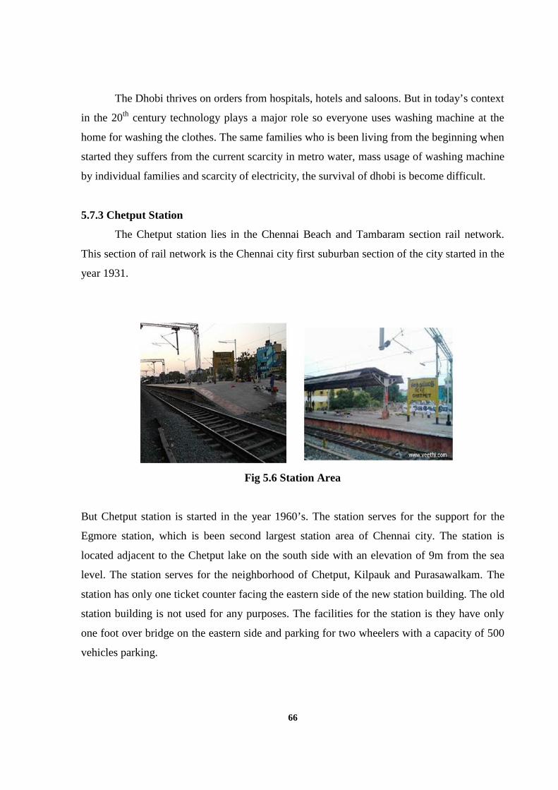
66
The Dhobi thrives on orders from hospitals, hotels and saloons. But in today’s context
in the 20th century technology plays a major role so everyone uses washing machine at the
home for washing the clothes. The same families who is been living from the beginning when
started they suffers from the current scarcity in metro water, mass usage of washing machine
by individual families and scarcity of electricity, the survival of dhobi is become difficult.
5.7.3 Chetput Station
The Chetput station lies in the Chennai Beach and Tambaram section rail network.
This section of rail network is the Chennai city first suburban section of the city started in the
year 1931.
Fig 5.6 Station Area
But Chetput station is started in the year 1960’s. The station serves for the support for the
Egmore station, which is been second largest station area of Chennai city. The station is
located adjacent to the Chetput lake on the south side with an elevation of 9m from the sea
level. The station serves for the neighborhood of Chetput, Kilpauk and Purasawalkam. The
station has only one ticket counter facing the eastern side of the new station building. The old
station building is not used for any purposes. The facilities for the station is they have only
one foot over bridge on the eastern side and parking for two wheelers with a capacity of 500
vehicles parking.
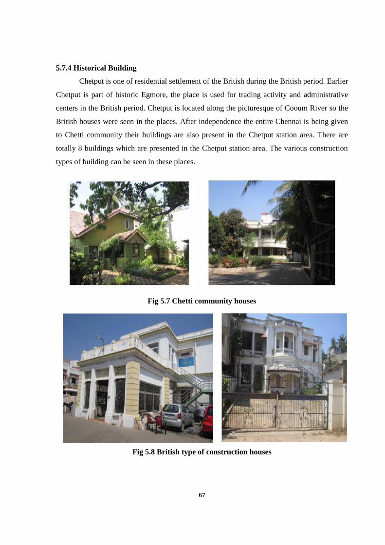
67
5.7.4 Historical Building
Chetput is one of residential settlement of the British during the British period. Earlier
Chetput is part of historic Egmore, the place is used for trading activity and administrative
centers in the British period. Chetput is located along the picturesque of Cooum River so the
British houses were seen in the places. After independence the entire Chennai is being given
to Chetti community their buildings are also present in the Chetput station area. There are
totally 8 buildings which are presented in the Chetput station area. The various construction
types of building can be seen in these places.
Fig 5.7 Chetti community houses
Fig 5.8 British type of construction houses
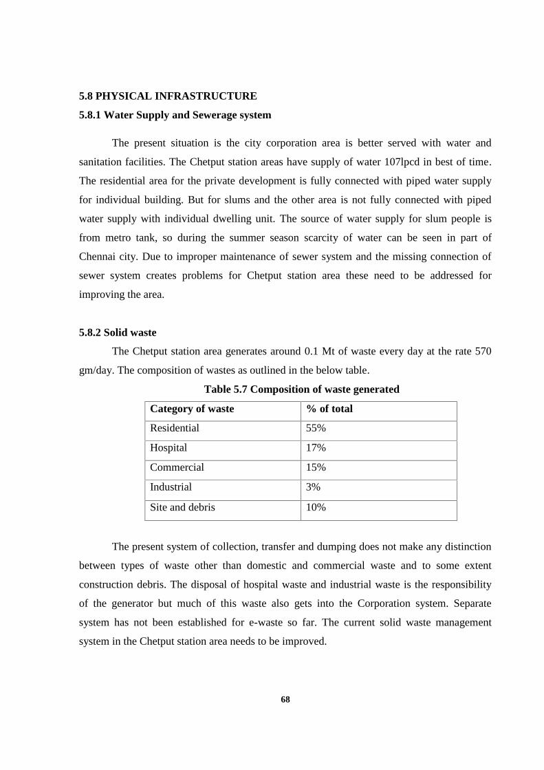
68
5.8 PHYSICAL INFRASTRUCTURE
5.8.1 Water Supply and Sewerage system
The present situation is the city corporation area is better served with water and
sanitation facilities. The Chetput station areas have supply of water 107lpcd in best of time.
The residential area for the private development is fully connected with piped water supply
for individual building. But for slums and the other area is not fully connected with piped
water supply with individual dwelling unit. The source of water supply for slum people is
from metro tank, so during the summer season scarcity of water can be seen in part of
Chennai city. Due to improper maintenance of sewer system and the missing connection of
sewer system creates problems for Chetput station area these need to be addressed for
improving the area.
5.8.2 Solid waste
The Chetput station area generates around 0.1 Mt of waste every day at the rate 570
gm/day. The composition of wastes as outlined in the below table.
Table 5.7 Composition of waste generated
Category of waste % of total
Residential 55%
Hospital 17%
Commercial 15%
Industrial 3%
Site and debris 10%
The present system of collection, transfer and dumping does not make any distinction
between types of waste other than domestic and commercial waste and to some extent
construction debris. The disposal of hospital waste and industrial waste is the responsibility
of the generator but much of this waste also gets into the Corporation system. Separate
system has not been established for e-waste so far. The current solid waste management
system in the Chetput station area needs to be improved.
69
5.8.3 Transportation
5.8.3.1 Road Network
The total length of road network in Chetput station area is 22 km. Chetput has a grid
pattern of the road network on the major roads. The prime radial network comprises of
Poonammalle high road (NH4)- North side
Mcnichols road-East side
Spur tank road- South Side
Gengu reddy road- West side
Apart from this prime arterial road they have Sub-arterial, collector and local roads
with a length of 16 km. The major roads have a higher v/c ratio during the peak hours it has
more than 1 and in normal time the v/c is about 0.8. The sub-arterial roads also carries an
equal amount of vehicle for moving to the station area. The collector and local roads carry a
less amount of the vehicle. The major road does not have any proper earmark for onstreet
parking it creates traffic congestion during peak hours.
5.8.3.2 Pedestrian Environment
The Chetput station area has a poor pedestrian environment. Due to these pedestrian a
flow rate is low. Unclear street signs, unmarked street crossing, ill-maintained sidewalks and
obstruction of sidewalks pose danger to pedestrians. The Chetput station area must have
maximum pedestrian flow rates so pedestrian facilities to be improved.
5.8.3.3 Bus Stands
Chetput station area has totally 15 bus stands. These are not fully provided by the bus
shelter.
5.8.3.4 Street lights
The Chetput station area has a total of 825 street lights of which 30% is of high power
tube lights. The Chetput have a street light in the average spacing distance of 15m between
the lamppost at the residential area and in the other area is of 24m which is adequate
considering the norm of 30.0m spacing between adopted in the city.
70
5.9 SOCIAL INFRASTRUCTRE
5.9.1 Housing
The total no. of households in Chetput station area is 4495 and the slum alone
constitutes 2041 households. The slum households consist of 40% of pucca house, 40% of
semi-pucca house and 20% of kuccha house. The remaining household consists of 70% of
pucca house 25% of semi-pucca house and 5% of kuccha house. The Chetput station area
also has dilapidated building which is of 30 numbers. The present situations of Chetput
station are of slum households are more in number it indicates that slum population is more.
These households’ faces major problems like no open space, traffic congestion, and improper
provision of basic services like water supply, sanitation facilities and storm water drain.
5.9.2 Hospital facilities
The Chetput station area has two government hospital and four private hospitals. The
government hospital which has multi-specialty treatment and also it is expertise in the fire
accident treatment. Another government hospital is specialized in tuber clousis treatment.
The private hospital two has multi specialty treatment and other two hospitals is specialized
in cardiology. The existing bed in the government multi-specialty hospital is sufficient as per
prescribed norms.
5.9.3 Recreational facilities
Besides providing basic amenities and utilities to its citizens, local bodies are also
responsible for providing recreational facilities. Recreational facilities include parks,
playgrounds, open spaces and cinema theaters. There is a total of 3 playgrounds in the study
area, of which 1 is maintained by private parties. There are total 3 parks present in the study
area, all of them are maintained by private parties.
5.10 INFERENCE
The detailed study of the existing condition of Chetput station area reveals that the
exact problem based on the cultural, physical, social, environmental and economic aspects. It
will form the base for analyzing the issues framing of proposals for the Chetput station area.
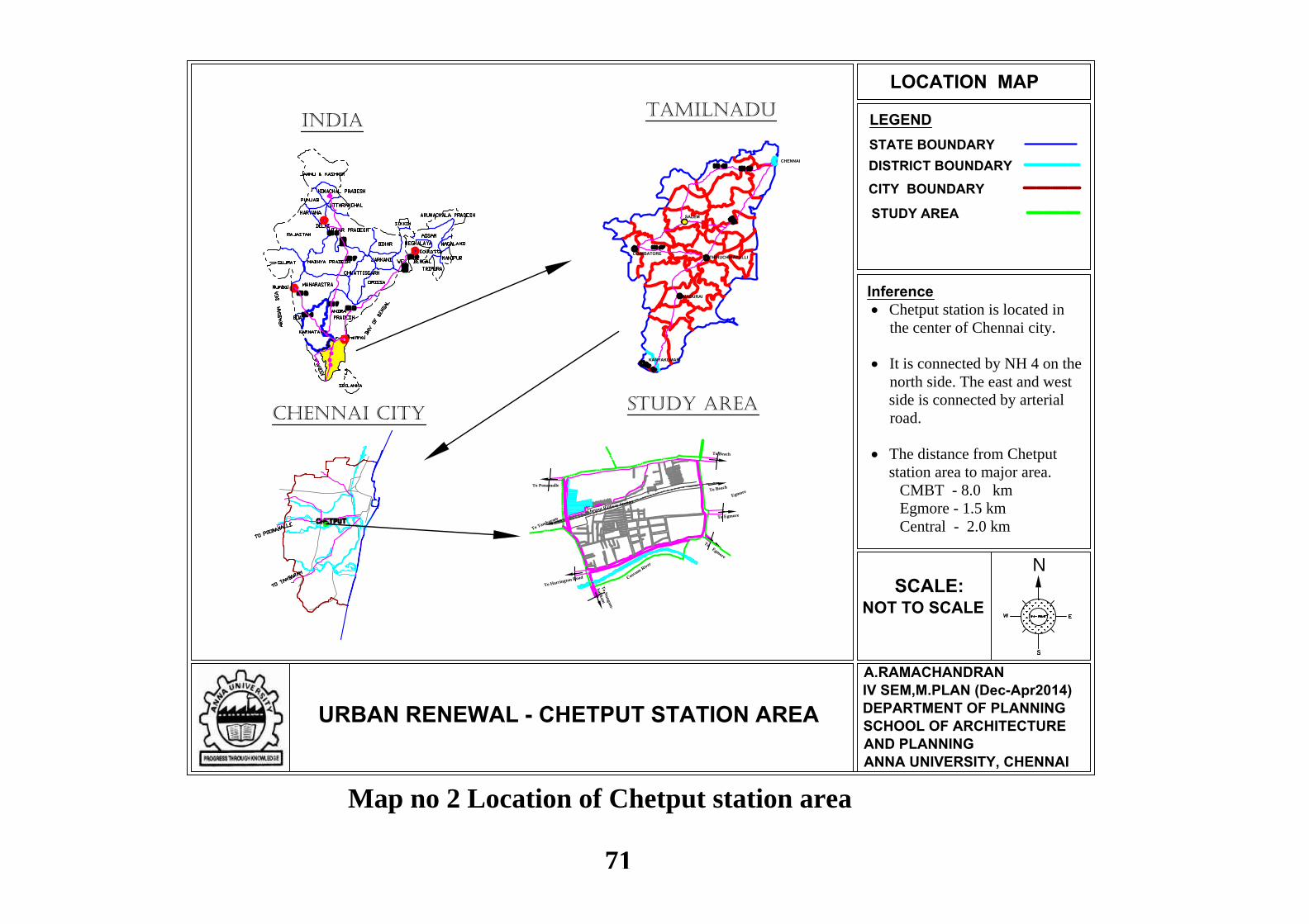
N
LEGEND
URBAN RENEWAL - CHETPUT STATION AREA
LOCATION MAP
SCALE:NOT TO SCALE
STATE BOUNDARY
STUDY AREA
A.RAMACHANDRANIV SEM,M.PLAN (Dec-Apr2014)DEPARTMENT OF PLANNINGSCHOOL OF ARCHITECTUREAND PLANNINGANNA UNIVERSITY, CHENNAI
DISTRICT BOUNDARY
Inference Chetput station is located in
the center of Chennai city.
It is connected by NH 4 on the
north side. The east and west
side is connected by arterial
road.
The distance from Chetput
station area to major area.
CMBT - 8.0 km
Egmore - 1.5 km
Central - 2.0 km
TAMILNADUINDIA
CHENNAI
SALEM
THIRUCHIRAPALLICOIMBATORE
KANYAKUMARI
MADURAI
CHENNAI CITY
To Beach
To Tambaram
Chetput Railway Station
To Ponamalle
To Beach
To Egmore
To N
un
gam
-
bak
kam
To Harrington Road
To Egmore
Coovum River
Egmore
STUDY AREA
CITY BOUNDARY
Map no 2 Location of Chetput station area
71
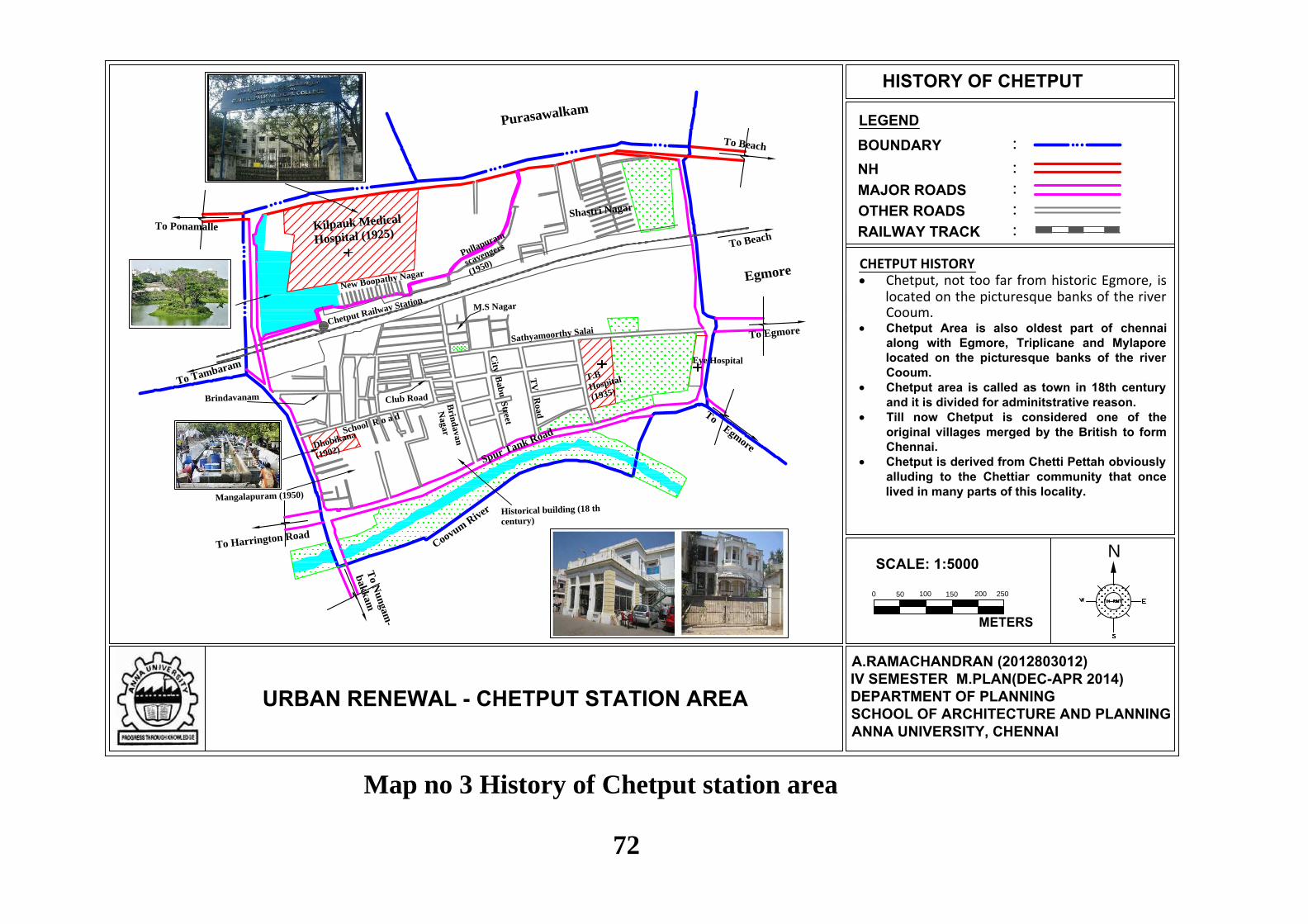
N
LEGEND
URBAN RENEWAL - CHETPUT STATION AREA
HISTORY OF CHETPUT
:BOUNDARY:NH:MAJOR ROADS:OTHER ROADS:RAILWAY TRACK
A.RAMACHANDRAN (2012803012)IV SEMESTER M.PLAN(DEC-APR 2014)DEPARTMENT OF PLANNINGSCHOOL OF ARCHITECTURE AND PLANNINGANNA UNIVERSITY, CHENNAI
Shastri Nagar
T.B
Hospital
(1935)
Eye Hospital
Kilpauk Medical
Hospital (1925)
Dhobikana
(1902)
To Beach
To Tambaram
Sathyamoorthy Salai
TV
Road
City
Bab
u S
treet
Brin
davan
NagarSchool R o a d
Club RoadBrindavanam
M.S Nagar
Mangalapuram (1950)
New Boopathy Nagar
Pullapuram
scavengers
(1950)
Chetput Railway Station
To Ponamalle
To Beach
To Egmore
To N
un
gam
-
bak
kam
To Harrington Road
To Egmore
Spur Tank Road
Coovum R
iver
Egmore
Purasawalkam
Kilpauk
CHETPUT HISTORY Chetput, not too far from historic Egmore, is
located on the picturesque banks of the riverCooum.
Chetput Area is also oldest part of chennaialong with Egmore, Triplicane and Mylaporelocated on the picturesque banks of the riverCooum.
Chetput area is called as town in 18th centuryand it is divided for adminitstrative reason.
Till now Chetput is considered one of theoriginal villages merged by the British to formChennai.
Chetput is derived from Chetti Pettah obviouslyalluding to the Chettiar community that oncelived in many parts of this locality.
Historical building (18 th
century)
0
SCALE: 1:5000
METERS
50 100 150 200 250
Map no 3 History of Chetput station area
72
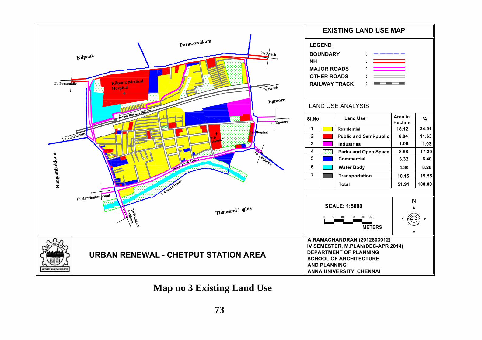
N
LEGEND
URBAN RENEWAL - CHETPUT STATION AREA
EXISTING LAND USE MAP
:BOUNDARY:NH:MAJOR ROADS:OTHER ROADS:RAILWAY TRACK
A.RAMACHANDRAN (2012803012)IV SEMESTER, M.PLAN(DEC-APR 2014)DEPARTMENT OF PLANNINGSCHOOL OF ARCHITECTUREAND PLANNINGANNA UNIVERSITY, CHENNAI
T.B
Hospital
Eye Hospital
Kilpauk Medical
Hospital
Dhobikana
To Beach
To Tambaram
Chetput Railway Station
To Ponamalle
To Beach
To Egmore
To N
un
gam
-
bak
kam
To Harrington Road
To Egmore
Spur Tank Road
Thousand Lights
Coovum R
iver
Egmore
Nu
ngam
bak
kam
Purasawalkam
Kilpauk
LAND USE ANALYSIS
Area inHectare
Land UseSI.No %
ResidentialPublic and Semi-publicIndustriesParks and Open SpaceCommercial
12345
18.126.041.008.983.32
34.91
6.4017.30
11.631.93
Water Body6 4.30 8.28
Transportation7 10.15 19.55
51.91 100.00Total
0
SCALE: 1:5000
METERS
50 100 150 200 250
Map no 3 Existing Land Use
73
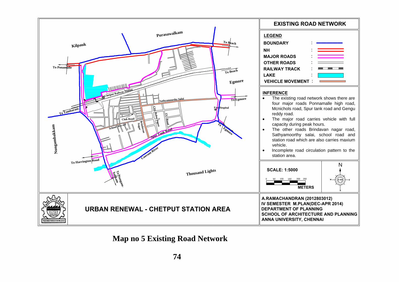
N
LEGEND
URBAN RENEWAL - CHETPUT STATION AREA
EXISTING ROAD NETWORK
:BOUNDARY:NH:MAJOR ROADS:OTHER ROADS:RAILWAY TRACK:LAKE
A.RAMACHANDRAN (2012803012)IV SEMESTER M.PLAN(DEC-APR 2014)DEPARTMENT OF PLANNINGSCHOOL OF ARCHITECTURE AND PLANNINGANNA UNIVERSITY, CHENNAI
Eye Hospital
To Beach
To Tambaram
Sathyamoorthy Salai
TV
Road
City
Bab
u S
treet
Brin
davan
NagarSchool R o a d
Club Road
Chetput Railway Station
To Ponamalle
To Beach
To Egmore
To N
un
gam
-
bak
kam
To Harrington Road
To Egmore
Thousand Lights
Coovum R
iver
Egmore
Nu
ngam
bak
kam
Purasawalkam
Kilpauk
Spur Tank Road
VEHICLE MOVEMENT :
0
SCALE: 1:5000
METERS
50 100 150 200 250
INFERENCE The existing road network shows there are
four major roads Ponnamalle high road,Mcnichols road, Spur tank road and Gengureddy road.
The major road carries vehicle with fullcapacity during peak hours.
The other roads Brindavan nagar road,Sathyamoorthy salai, school road andstation road which are also carries maxiumvehicle.
Incomplete road circulation pattern to thestation area.
Map no 5 Existing Road Network
74
75
CHAPTER VI
ANALYSIS AND PROPOSALS
6.1 INTRODUCTION
In this chapter, the methodology developed in chapter 1 will be applied to the case
study area. In order to make the analysis process clearer, four main contents are considered in
this chapter. They are,
Restoring its identity by rehabilitation
Conservation of historic buildings
Improving the station area of rehabilitation
Redevelopment of certain area.
The listed above are the urban renewal program which is considered for solving the
urban problems. The programs are selected in the context of Physical, social, cultural,
economic and legal aspects. Therefore, the identified projects are discussed elaborately in this
chapter explaining with the issues and suitable proposals.
6.2 RESTORING ITS IDENTITY
6.2.1 Chetput Lake
Chetput lake is being one of the last surviving natural water bodies of Chennai city
and also it have some historical context. So it is important to restore the lake for the future,
making it one of the identities for Chennai city. In today’s context lake is used as a major
tourism hub for cities. The conservation of the lake is done through the construction of an
eco - park. The water bodies of Chennai city is heavily encroached so it creates the problem
of flooding during rainy seasons. So to avoid these and lake is used as eco-park with city
beautification with one of the conservation techniques. The Chetput Lake is surrounded by
slums and hospitals it creates a big problem for the lake. So lake should be used as potential.
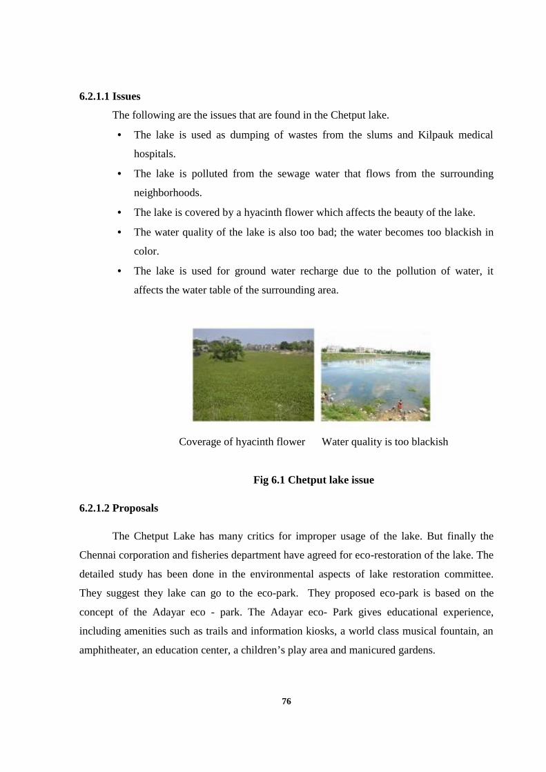
76
6.2.1.1 Issues
The following are the issues that are found in the Chetput lake.
The lake is used as dumping of wastes from the slums and Kilpauk medical
hospitals.
The lake is polluted from the sewage water that flows from the surrounding
neighborhoods.
The lake is covered by a hyacinth flower which affects the beauty of the lake.
The water quality of the lake is also too bad; the water becomes too blackish in
color.
The lake is used for ground water recharge due to the pollution of water, it
affects the water table of the surrounding area.
Coverage of hyacinth flower Water quality is too blackish
Fig 6.1 Chetput lake issue
6.2.1.2 Proposals
The Chetput Lake has many critics for improper usage of the lake. But finally the
Chennai corporation and fisheries department have agreed for eco-restoration of the lake. The
detailed study has been done in the environmental aspects of lake restoration committee.
They suggest they lake can go to the eco-park. They proposed eco-park is based on the
concept of the Adayar eco - park. The Adayar eco- Park gives educational experience,
including amenities such as trails and information kiosks, a world class musical fountain, an
amphitheater, an education center, a children’s play area and manicured gardens.
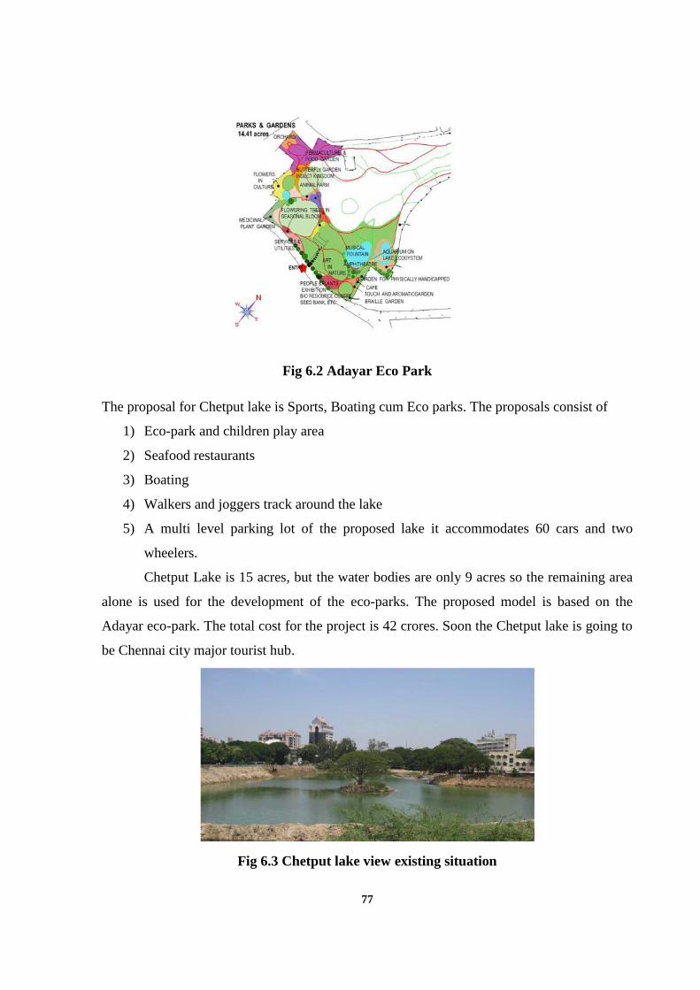
77
Fig 6.2 Adayar Eco Park
The proposal for Chetput lake is Sports, Boating cum Eco parks. The proposals consist of
1) Eco-park and children play area
2) Seafood restaurants
3) Boating
4) Walkers and joggers track around the lake
5) A multi level parking lot of the proposed lake it accommodates 60 cars and two
wheelers.
Chetput Lake is 15 acres, but the water bodies are only 9 acres so the remaining area
alone is used for the development of the eco-parks. The proposed model is based on the
Adayar eco-park. The total cost for the project is 42 crores. Soon the Chetput lake is going to
be Chennai city major tourist hub.
Fig 6.3 Chetput lake view existing situation
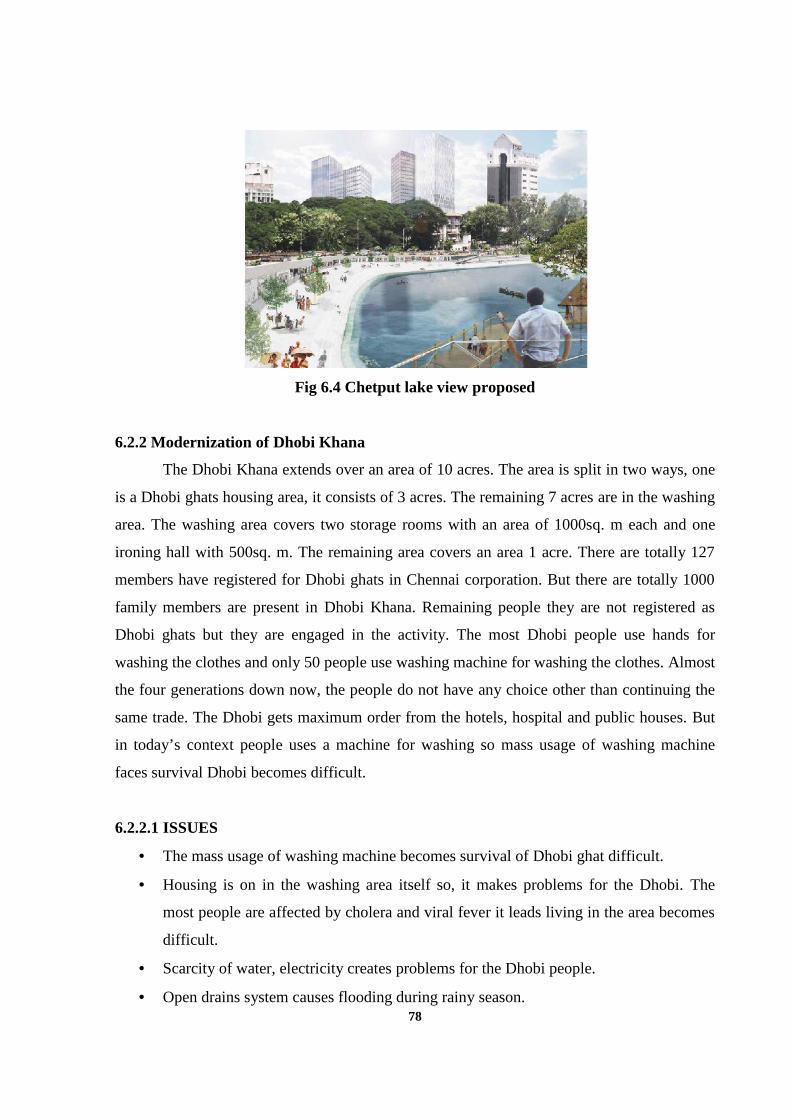
78
Fig 6.4 Chetput lake view proposed
6.2.2 Modernization of Dhobi Khana
The Dhobi Khana extends over an area of 10 acres. The area is split in two ways, one
is a Dhobi ghats housing area, it consists of 3 acres. The remaining 7 acres are in the washing
area. The washing area covers two storage rooms with an area of 1000sq. m each and one
ironing hall with 500sq. m. The remaining area covers an area 1 acre. There are totally 127
members have registered for Dhobi ghats in Chennai corporation. But there are totally 1000
family members are present in Dhobi Khana. Remaining people they are not registered as
Dhobi ghats but they are engaged in the activity. The most Dhobi people use hands for
washing the clothes and only 50 people use washing machine for washing the clothes. Almost
the four generations down now, the people do not have any choice other than continuing the
same trade. The Dhobi gets maximum order from the hotels, hospital and public houses. But
in today’s context people uses a machine for washing so mass usage of washing machine
faces survival Dhobi becomes difficult.
6.2.2.1 ISSUES
The mass usage of washing machine becomes survival of Dhobi ghat difficult.
Housing is on in the washing area itself so, it makes problems for the Dhobi. The
most people are affected by cholera and viral fever it leads living in the area becomes
difficult.
Scarcity of water, electricity creates problems for the Dhobi people.
Open drains system causes flooding during rainy season.
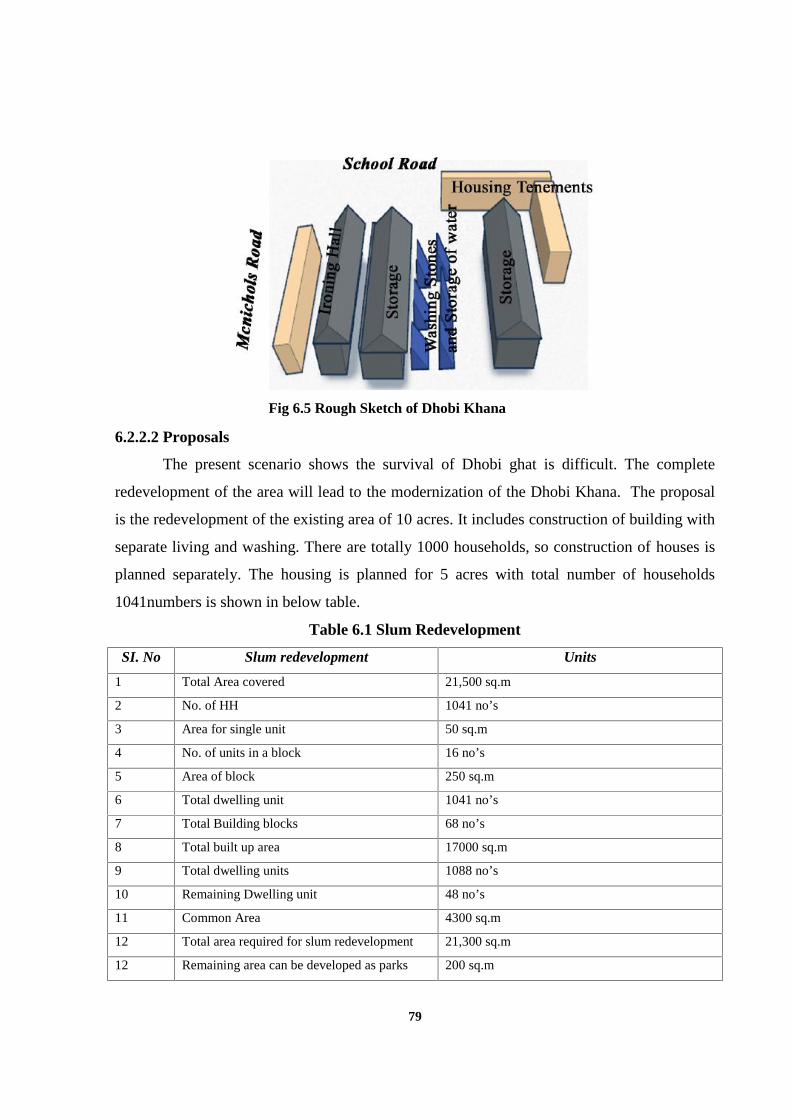
79
6.2.2.2 Proposals
The present scenario shows the survival of Dhobi ghat is difficult. The complete
redevelopment of the area will lead to the modernization of the Dhobi Khana. The proposal
is the redevelopment of the existing area of 10 acres. It includes construction of building with
separate living and washing. There are totally 1000 households, so construction of houses is
planned separately. The housing is planned for 5 acres with total number of households
1041numbers is shown in below table.
Table 6.1 Slum Redevelopment
SI. No Slum redevelopment Units
1 Total Area covered 21,500 sq.m
2 No. of HH 1041 no’s
3 Area for single unit 50 sq.m
4 No. of units in a block 16 no’s
5 Area of block 250 sq.m
6 Total dwelling unit 1041 no’s
7 Total Building blocks 68 no’s
8 Total built up area 17000 sq.m
9 Total dwelling units 1088 no’s
10 Remaining Dwelling unit 48 no’s
11 Common Area 4300 sq.m
12 Total area required for slum redevelopment 21,300 sq.m
12 Remaining area can be developed as parks 200 sq.m
Fig 6.5 Rough Sketch of Dhobi Khana
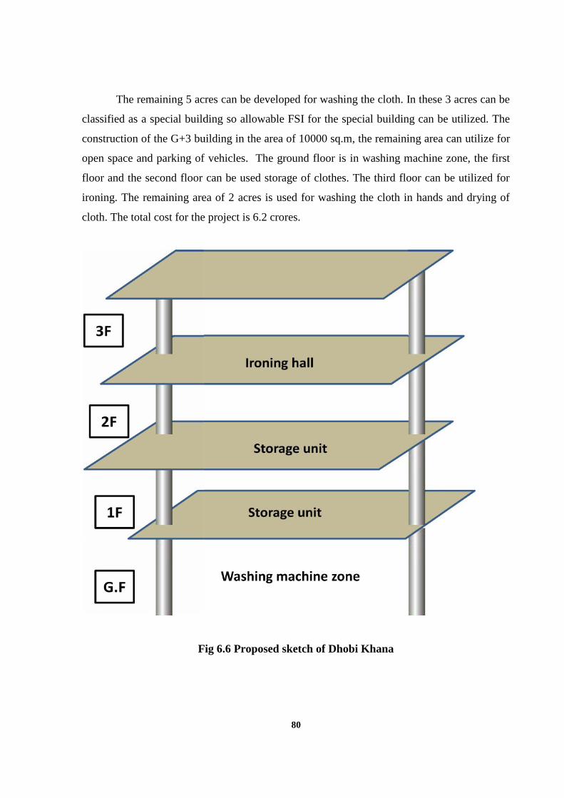
80
The remaining 5 acres can be developed for washing the cloth. In these 3 acres can be
classified as a special building so allowable FSI for the special building can be utilized. The
construction of the G+3 building in the area of 10000 sq.m, the remaining area can utilize for
open space and parking of vehicles. The ground floor is in washing machine zone, the first
floor and the second floor can be used storage of clothes. The third floor can be utilized for
ironing. The remaining area of 2 acres is used for washing the cloth in hands and drying of
cloth. The total cost for the project is 6.2 crores.
Fig 6.6 Proposed sketch of Dhobi Khana
81
6.2.3 Conservation of Heritage buildings
Chetput station area has few heritage buildings located in around the spur tank road.
A Chetput is one older settlement of Chennai city so it is important for conserving the
heritage buildings.
6.2.3.1 Issues
Heritage buildings are demolished for other uses like construction of plotted house.
Buildings are not used for any purposes it is and some of the buildings are used for
commercial activity.
6.2.3.2 Proposals
The conservation of heritage buildings for restoring its identity in the study area is
made based on the criteria for declaring heritage buildings as per Chennai II master plan.
There are totally 8 historical buildings which represent the cultural and aesthetical view of the
British. These buildings match the criteria for declaring the historical building as per criteria
declaring the historical buildings. The below are the criteria matches for declaring as heritage
buildings.
Architectural
a. Design;
The building may be significant because of its excellence, artistic merits, or
uniqueness of its design, compositions, craftsmanship or details. It includes decoration, color,
texture, massing notable proportion.
b. Style;
The building may exhibit features of a particular architecture style, period of
construction (style compared to others of its particular architecture style)
c. Designer / Builder;
The building might have been designed by an Architect / Engineer or other design
professional or constructed by a builder whose work is local, regional or national importance.
82
d. Physical conditions;
The condition of the structure may be superior or it may require minor structural
repair, or extensive repair, or it may be in a dilapidated condition.
e. Design Integrity;
In a heritage building if alterations had already been carried out, then its repairable
nature and worthiness to conserve.
Historical
a. Date / Period of construction;
This criteria may ensure that the building / precincts age gives due consideration in
determining historical significance
b. Trends exhibited by the building;
The building or a precinct may reflect a particular social, economic, political or
cultural pattern, characteristic of the local settlement area.
c. Events associated with;
A building or structure may be directly linked to an event of local, regional, or
national significance or a noteworthy historical event.
d. Persons associated with;
Building or precincts may be linked to a notable person, group, and institution and has
historical significance.
The above are the parameter that matches for the Chetput historical building so it can
be decelerated as historical building.
6.2.4 Chetput Station
Chetput station serves for the neighborhood of Chetput, Kilpauk and Purasawalkam.
The station has only one ticket counter facing the eastern side of the new station building.
The old station building is not used for any purposes. The facilities for the station is they have
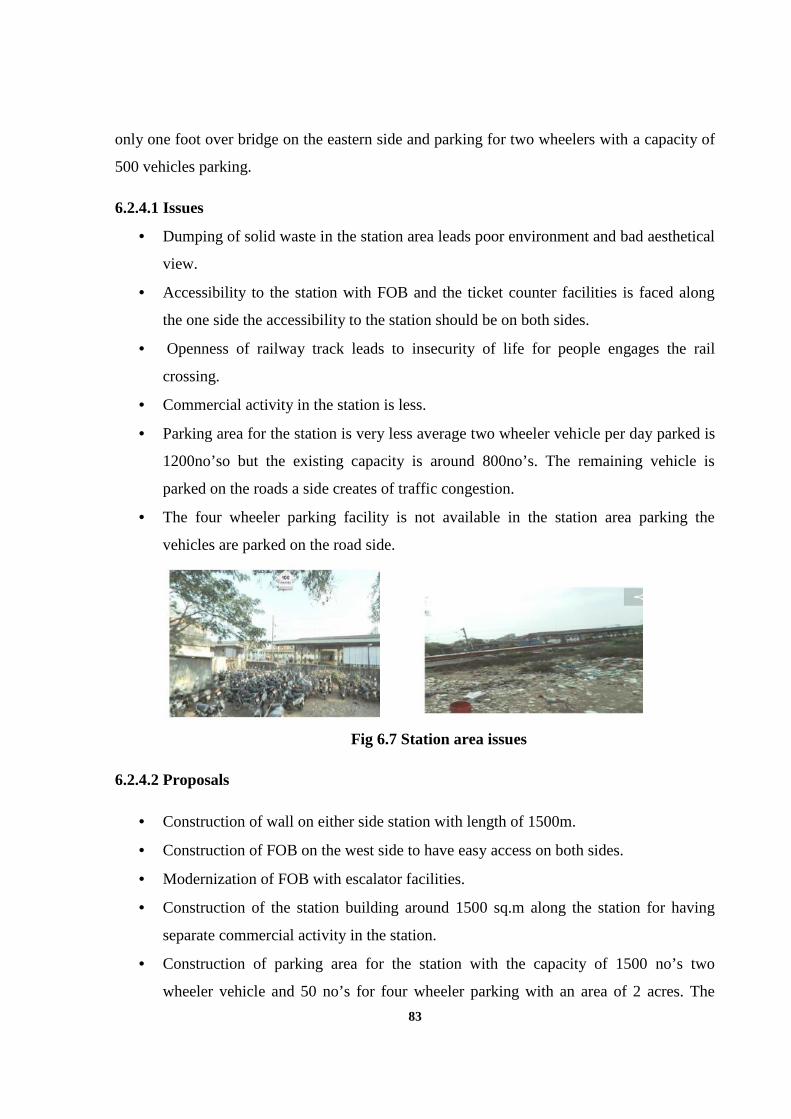
83
only one foot over bridge on the eastern side and parking for two wheelers with a capacity of
500 vehicles parking.
6.2.4.1 Issues
Dumping of solid waste in the station area leads poor environment and bad aesthetical
view.
Accessibility to the station with FOB and the ticket counter facilities is faced along
the one side the accessibility to the station should be on both sides.
Openness of railway track leads to insecurity of life for people engages the rail
crossing.
Commercial activity in the station is less.
Parking area for the station is very less average two wheeler vehicle per day parked is
1200no’so but the existing capacity is around 800no’s. The remaining vehicle is
parked on the roads a side creates of traffic congestion.
The four wheeler parking facility is not available in the station area parking the
vehicles are parked on the road side.
Fig 6.7 Station area issues
6.2.4.2 Proposals
Construction of wall on either side station with length of 1500m.
Construction of FOB on the west side to have easy access on both sides.
Modernization of FOB with escalator facilities.
Construction of the station building around 1500 sq.m along the station for having
separate commercial activity in the station.
Construction of parking area for the station with the capacity of 1500 no’s two
wheeler vehicle and 50 no’s for four wheeler parking with an area of 2 acres. The
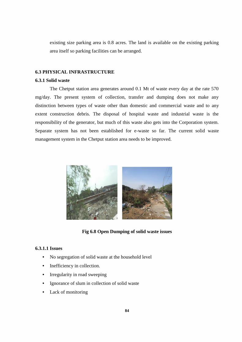
84
existing size parking area is 0.8 acres. The land is available on the existing parking
area itself so parking facilities can be arranged.
6.3 PHYSICAL INFRASTRUCTURE
6.3.1 Solid waste
The Chetput station area generates around 0.1 Mt of waste every day at the rate 570
mg/day. The present system of collection, transfer and dumping does not make any
distinction between types of waste other than domestic and commercial waste and to any
extent construction debris. The disposal of hospital waste and industrial waste is the
responsibility of the generator, but much of this waste also gets into the Corporation system.
Separate system has not been established for e-waste so far. The current solid waste
management system in the Chetput station area needs to be improved.
Fig 6.8 Open Dumping of solid waste issues
6.3.1.1 Issues
No segregation of solid waste at the household level
Inefficiency in collection.
Irregularity in road sweeping
Ignorance of slum in collection of solid waste
Lack of monitoring
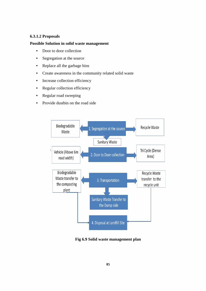
85
6.3.1.2 Proposals
Possible Solution in solid waste management
Door to door collection
Segregation at the source
Replace all the garbage bins
Create awareness in the community related solid waste
Increase collection efficiency
Regular collection efficiency
Regular road sweeping
Provide dustbin on the road side
Fig 6.9 Solid waste management plan
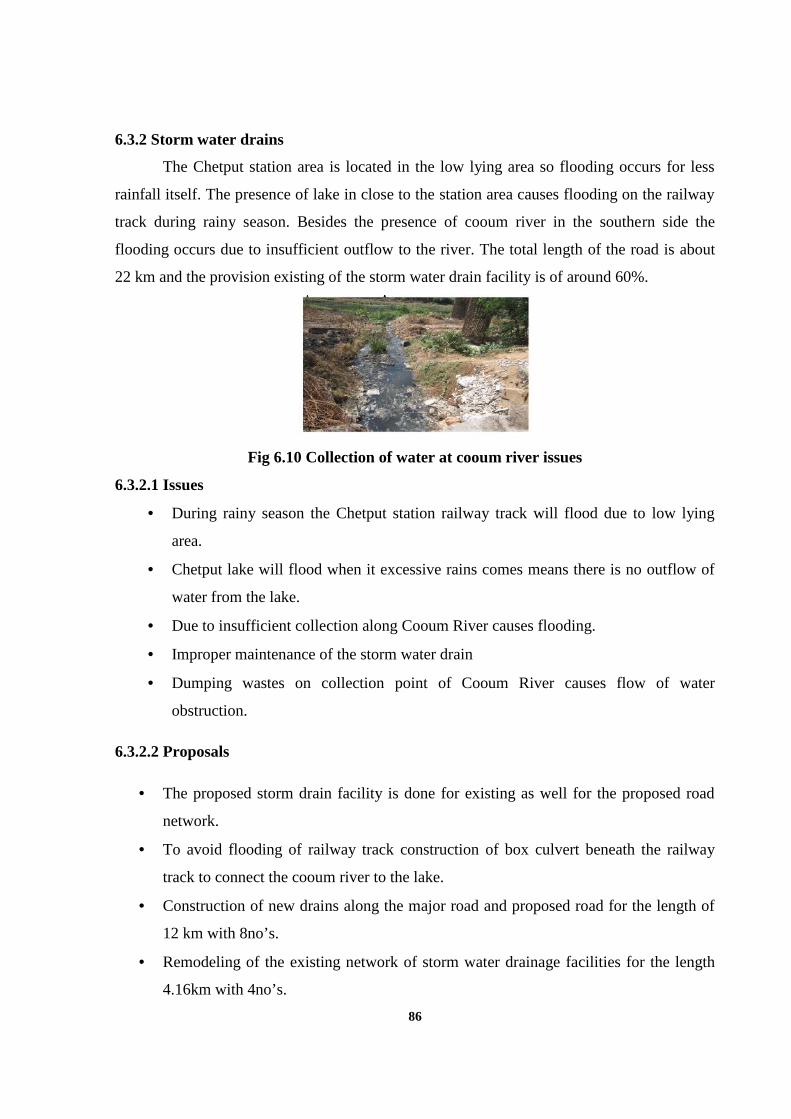
86
6.3.2 Storm water drains
The Chetput station area is located in the low lying area so flooding occurs for less
rainfall itself. The presence of lake in close to the station area causes flooding on the railway
track during rainy season. Besides the presence of cooum river in the southern side the
flooding occurs due to insufficient outflow to the river. The total length of the road is about
22 km and the provision existing of the storm water drain facility is of around 60%.
Fig 6.10 Collection of water at cooum river issues
6.3.2.1 Issues
During rainy season the Chetput station railway track will flood due to low lying
area.
Chetput lake will flood when it excessive rains comes means there is no outflow of
water from the lake.
Due to insufficient collection along Cooum River causes flooding.
Improper maintenance of the storm water drain
Dumping wastes on collection point of Cooum River causes flow of water
obstruction.
6.3.2.2 Proposals
The proposed storm drain facility is done for existing as well for the proposed road
network.
To avoid flooding of railway track construction of box culvert beneath the railway
track to connect the cooum river to the lake.
Construction of new drains along the major road and proposed road for the length of
12 km with 8no’s.
Remodeling of the existing network of storm water drainage facilities for the length
4.16km with 4no’s.
87
6.4 TRANSPORTATION
6.4.1 Roads and traffic improvements
The existing condition of the roads shows that traffic congestion on the major roads
with have a higher v/c ratio during the peak hours it has more than 1 and in normal time the
v/c is about 0.8. The sub-arterial road also carries an equal amount of vehicle for moving to
the station area. The collector and local roads carry a less amount of the vehicle. The major
road does not have any proper earmark for on street parking it creates traffic congestion
during peak hours.
6.4.1 Issues
The major roads found high density and congested lanes due to high movement of the
vehicle.
The four major roads carry a heavy volume their v/c is more than 0.8.
The margins of roads are encroached upon in several sections in the major roads by
the informal activities.
The effective carriage way of roads the road is reduced along the major roads
drastically leading to congestion.
Absence of street furniture/signage’s: The road lack for signals, signage and
footpaths.
Improper road sweeping results in most roads being covered with wastes and soil
which reduces driving safety.
Lack of connectivity to the station area along the north and south side.
Free flow of movement of vehicle to the station makes difficult due to incomplete
circulation pattern.
Absence of grade separator and pedestrian crossing facilities.
Absence of traffic infrastructure facilities
1. Organized on-street parking facilities
2. Junction improvement
3. Pedestrian facilities such as footpaths, safe pedestrian crossing.
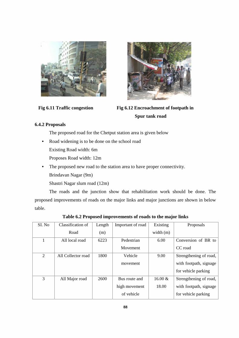
88
Fig 6.11 Traffic congestion Fig 6.12 Encroachment of footpath in
Spur tank road
6.4.2 Proposals
The proposed road for the Chetput station area is given below
Road widening is to be done on the school road
Existing Road width: 6m
Proposes Road width: 12m
The proposed new road to the station area to have proper connectivity.
Brindavan Nagar (9m)
Shastri Nagar slum road (12m)
The roads and the junction show that rehabilitation work should be done. The
proposed improvements of roads on the major links and major junctions are shown in below
table.
Table 6.2 Proposed improvements of roads to the major links
SI. No Classification of
Road
Length
(m)
Important of road Existing
width (m)
Proposals
1 All local road 6223 Pedestrian
Movement
6.00 Conversion of BR to
CC road
2 All Collector road 1800 Vehicle
movement
9.00 Strengthening of road,
with footpath, signage
for vehicle parking
3 All Major road 2600 Bus route and
high movement
of vehicle
16.00 &
18.00
Strengthening of road,
with footpath, signage
for vehicle parking
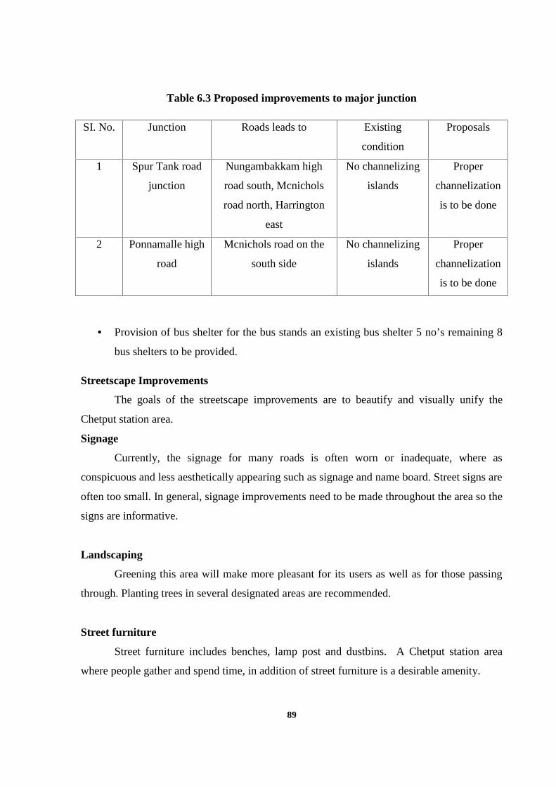
89
Table 6.3 Proposed improvements to major junction
SI. No. Junction Roads leads to Existing
condition
Proposals
1 Spur Tank road
junction
Nungambakkam high
road south, Mcnichols
road north, Harrington
east
No channelizing
islands
Proper
channelization
is to be done
2 Ponnamalle high
road
Mcnichols road on the
south side
No channelizing
islands
Proper
channelization
is to be done
Provision of bus shelter for the bus stands an existing bus shelter 5 no’s remaining 8
bus shelters to be provided.
Streetscape Improvements
The goals of the streetscape improvements are to beautify and visually unify the
Chetput station area.
Signage
Currently, the signage for many roads is often worn or inadequate, where as
conspicuous and less aesthetically appearing such as signage and name board. Street signs are
often too small. In general, signage improvements need to be made throughout the area so the
signs are informative.
Landscaping
Greening this area will make more pleasant for its users as well as for those passing
through. Planting trees in several designated areas are recommended.
Street furniture
Street furniture includes benches, lamp post and dustbins. A Chetput station area
where people gather and spend time, in addition of street furniture is a desirable amenity.
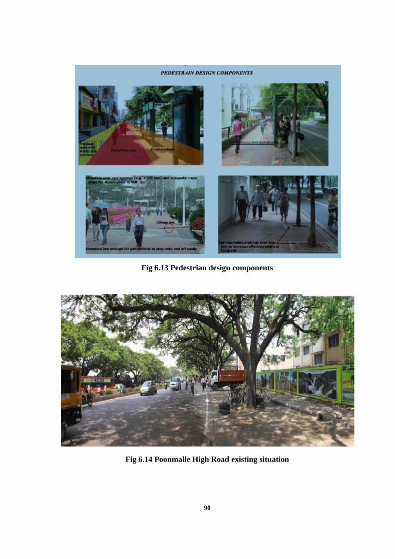
90
Fig 6.13 Pedestrian design components
Fig 6.14 Poonmalle High Road existing situation
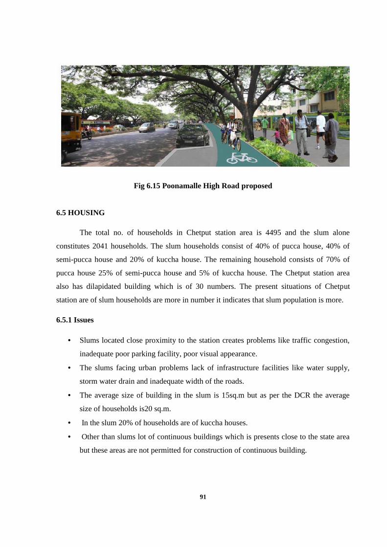
91
Fig 6.15 Poonamalle High Road proposed
6.5 HOUSING
The total no. of households in Chetput station area is 4495 and the slum alone
constitutes 2041 households. The slum households consist of 40% of pucca house, 40% of
semi-pucca house and 20% of kuccha house. The remaining household consists of 70% of
pucca house 25% of semi-pucca house and 5% of kuccha house. The Chetput station area
also has dilapidated building which is of 30 numbers. The present situations of Chetput
station are of slum households are more in number it indicates that slum population is more.
6.5.1 Issues
Slums located close proximity to the station creates problems like traffic congestion,
inadequate poor parking facility, poor visual appearance.
The slums facing urban problems lack of infrastructure facilities like water supply,
storm water drain and inadequate width of the roads.
The average size of building in the slum is 15sq.m but as per the DCR the average
size of households is20 sq.m.
In the slum 20% of households are of kuccha houses.
Other than slums lot of continuous buildings which is presents close to the state area
but these areas are not permitted for construction of continuous building.
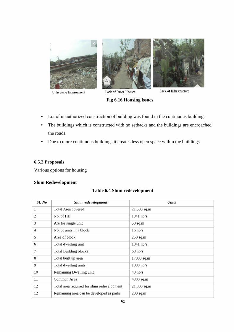
92
Fig 6.16 Housing issues
Lot of unauthorized construction of building was found in the continuous building.
The buildings which is constructed with no setbacks and the buildings are encroached
the roads.
Due to more continuous buildings it creates less open space within the buildings.
6.5.2 Proposals
Various options for housing
Slum Redevelopment
Table 6.4 Slum redevelopment
SI. No Slum redevelopment Units
1 Total Area covered 21,500 sq.m
2 No. of HH 1041 no’s
3 Are for single unit 50 sq.m
4 No. of units in a block 16 no’s
5 Area of block 250 sq.m
6 Total dwelling unit 1041 no’s
7 Total Building blocks 68 no’s
8 Total built up area 17000 sq.m
9 Total dwelling units 1088 no’s
10 Remaining Dwelling unit 48 no’s
11 Common Area 4300 sq.m
12 Total area required for slum redevelopment 21,300 sq.m
12 Remaining area can be developed as parks 200 sq.m
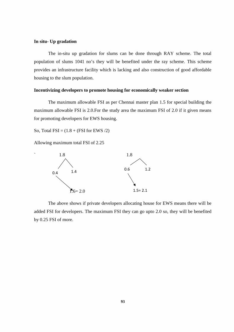
93
In situ- Up gradation
The in-situ up gradation for slums can be done through RAY scheme. The total
population of slums 1041 no’s they will be benefited under the ray scheme. This scheme
provides an infrastructure facility which is lacking and also construction of good affordable
housing to the slum population.
Incentivizing developers to promote housing for economically weaker section
The maximum allowable FSI as per Chennai master plan 1.5 for special building the
maximum allowable FSI is 2.0.For the study area the maximum FSI of 2.0 if it given means
for promoting developers for EWS housing.
So, Total FSI = (1.8 + (FSI for EWS /2)
Allowing maximum total FSI of 2.25
` 1.8 1.8
1.6= 2.0
The above shows if private developers allocating house for EWS means there will be
added FSI for developers. The maximum FSI they can go upto 2.0 so, they will be benefited
by 0.25 FSI of more.
0.4 1.4 0.6 1.2
1.5= 2.1
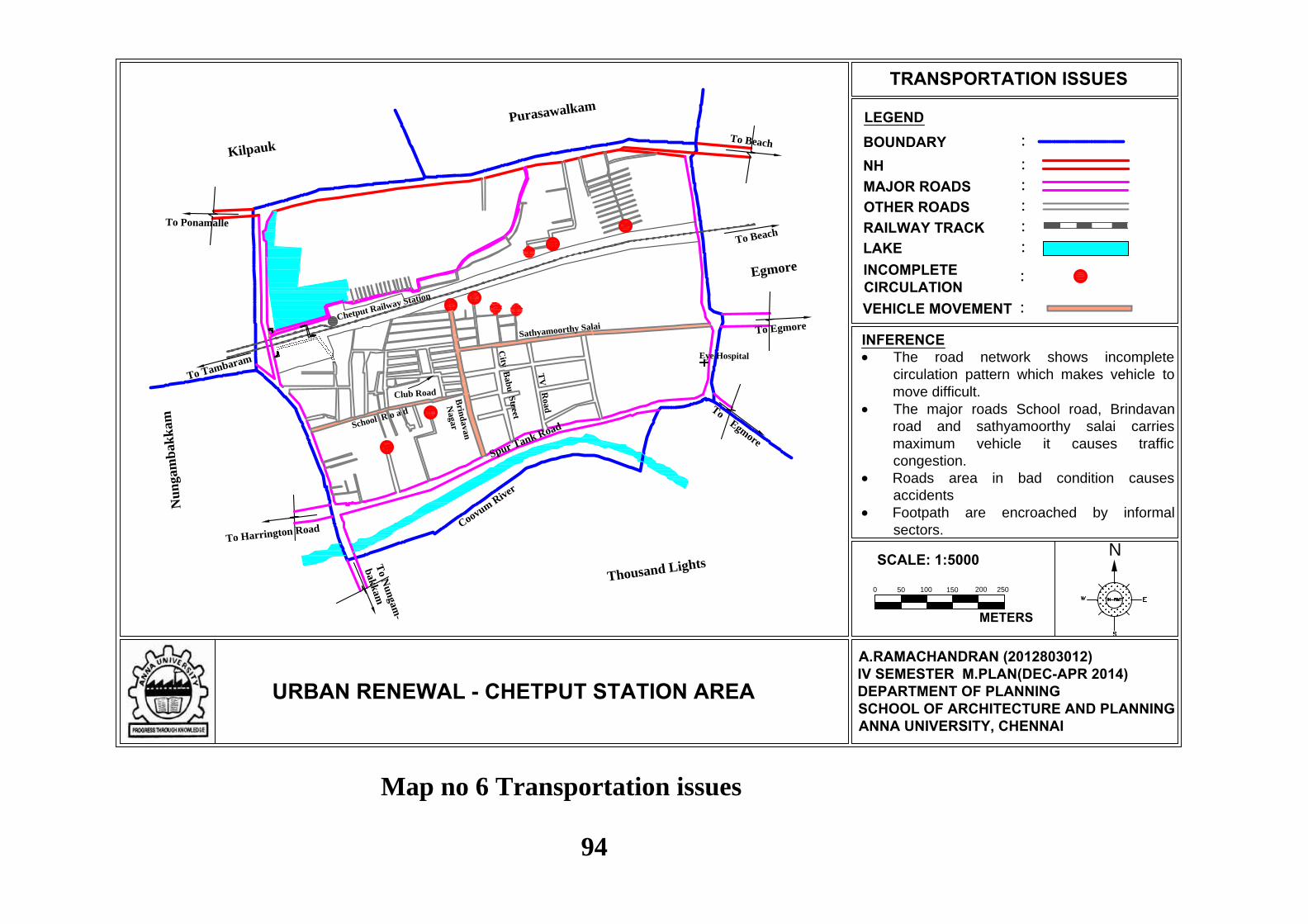
N
LEGEND
URBAN RENEWAL - CHETPUT STATION AREA
TRANSPORTATION ISSUES
:BOUNDARY:NH:MAJOR ROADS:OTHER ROADS:RAILWAY TRACK:LAKE
A.RAMACHANDRAN (2012803012)IV SEMESTER M.PLAN(DEC-APR 2014)DEPARTMENT OF PLANNINGSCHOOL OF ARCHITECTURE AND PLANNINGANNA UNIVERSITY, CHENNAI
Eye Hospital
To Beach
To Tambaram
Sathyamoorthy Salai
TV
Road
City
Bab
u S
treet
Brin
davan
NagarSchool R o a d
Club Road
Chetput Railway Station
To Ponamalle
To Beach
To Egmore
To N
un
gam
-
bak
kam
To Harrington Road
To Egmore
Thousand Lights
Coovum R
iver
Egmore
Nu
ngam
bak
kam
Purasawalkam
Kilpauk
Spur Tank Road
INCOMPLETECIRCULATION
:
VEHICLE MOVEMENT :
0
SCALE: 1:5000
METERS
50 100 150 200 250
INFERENCE The road network shows incomplete
circulation pattern which makes vehicle tomove difficult.
The major roads School road, Brindavanroad and sathyamoorthy salai carriesmaximum vehicle it causes trafficcongestion.
Roads area in bad condition causesaccidents
Footpath are encroached by informalsectors.
Map no 6 Transportation issues
94
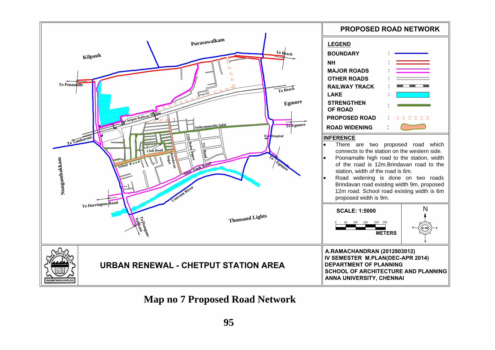
N
LEGEND
URBAN RENEWAL - CHETPUT STATION AREA
PROPOSED ROAD NETWORK
:BOUNDARY:NH:MAJOR ROADS:OTHER ROADS:RAILWAY TRACK:LAKE
A.RAMACHANDRAN (2012803012)IV SEMESTER M.PLAN(DEC-APR 2014)DEPARTMENT OF PLANNINGSCHOOL OF ARCHITECTURE AND PLANNINGANNA UNIVERSITY, CHENNAI
Eye Hospital
To Beach
To Tambaram
Sathyamoorthy Salai
TV
Road
City
Bab
u S
treet
Brin
davan
Nagar
Club Road
Chetput Railway Station
To Ponamalle
To Beach
To Egmore
To N
un
gam
-
bak
kam
To Harrington Road
To Egmore
Thousand Lights
Coovum R
iver
Egmore
Nu
ngam
bak
kam
Purasawalkam
Kilpauk
Spur Tank Road
STRENGTHENOF ROAD
:
PROPOSED ROAD :
School R o a d
ROAD WIDENING :
0
SCALE: 1:5000
METERS
50 100 150 200 250
INFERENCE There are two proposed road which
connects to the station on the western side. Poonamalle high road to the station, width
of the road is 12m.Brindavan road to thestation, width of the road is 6m.
Road widening is done on two roadsBrindavan road existing width 9m, proposed12m road. School road existing width is 6mproposed width is 9m.
Map no 7 Proposed Road Network
95
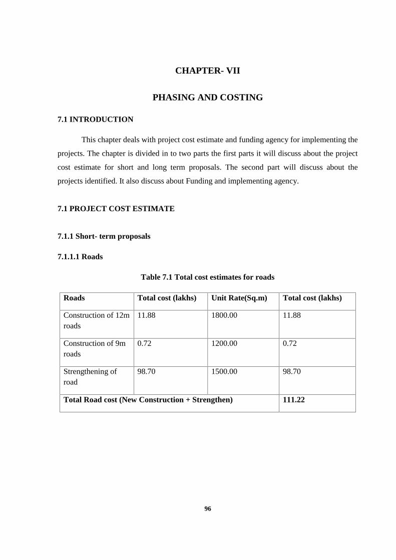
96
CHAPTER- VII
PHASING AND COSTING
7.1 INTRODUCTION
This chapter deals with project cost estimate and funding agency for implementing the
projects. The chapter is divided in to two parts the first parts it will discuss about the project
cost estimate for short and long term proposals. The second part will discuss about the
projects identified. It also discuss about Funding and implementing agency.
7.1 PROJECT COST ESTIMATE
7.1.1 Short- term proposals
7.1.1.1 Roads
Table 7.1 Total cost estimates for roads
Roads Total cost (lakhs) Unit Rate(Sq.m) Total cost (lakhs)
Construction of 12mroads
11.88 1800.00 11.88
Construction of 9mroads
0.72 1200.00 0.72
Strengthening ofroad
98.70 1500.00 98.70
Total Road cost (New Construction + Strengthen) 111.22
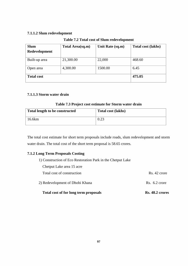
97
7.1.1.2 Slum redevelopment
Table 7.2 Total cost of Slum redevelopment
SlumRedevelopment
Total Area(sq.m) Unit Rate (sq.m) Total cost (lakhs)
Built-up area 21,300.00 22,000 468.60
Open area 4,300.00 1500.00 6.45
Total cost 475.05
7.1.1.3 Storm water drain
Table 7.3 Project cost estimate for Storm water drain
Total length to be constructed Total cost (lakhs)
16.6km 0.23
The total cost estimate for short term proposals include roads, slum redevelopment and storm
water drain. The total cost of the short term proposal is 58.65 crores.
7.1.2 Long Term Proposals Costing
1) Construction of Eco Restoration Park in the Chetput Lake
Chetput Lake area 15 acre
Total cost of construction Rs. 42 crore
2) Redevelopment of Dhobi Khana Rs. 6.2 crore
Total cost of for long term proposals Rs. 48.2 crores
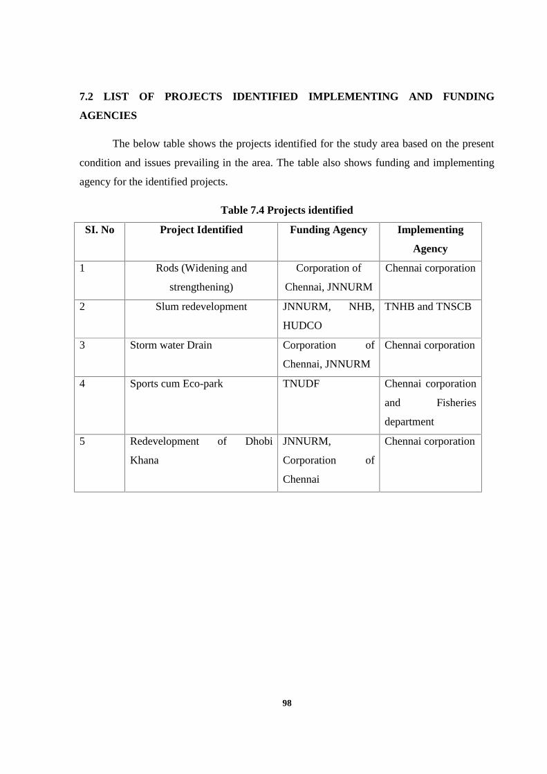
98
7.2 LIST OF PROJECTS IDENTIFIED IMPLEMENTING AND FUNDING
AGENCIES
The below table shows the projects identified for the study area based on the present
condition and issues prevailing in the area. The table also shows funding and implementing
agency for the identified projects.
Table 7.4 Projects identified
SI. No Project Identified Funding Agency Implementing
Agency
1 Rods (Widening and
strengthening)
Corporation of
Chennai, JNNURM
Chennai corporation
2 Slum redevelopment JNNURM, NHB,
HUDCO
TNHB and TNSCB
3 Storm water Drain Corporation of
Chennai, JNNURM
Chennai corporation
4 Sports cum Eco-park TNUDF Chennai corporation
and Fisheries
department
5 Redevelopment of Dhobi
Khana
JNNURM,
Corporation of
Chennai
Chennai corporation
99
CHAPTER VIII
CONCLUSION
The thesis aimed at to prove urban renewal is an indispensable component for the
existing metro cities. Moreover, the thesis evaluates factors that cause in the urban renewal
programme in the historical context. The urban renewal programs have been started in
Chennai city and it majorly funding for infrastructure facilities. But, urban renewal is the case
for developing the decline and blighted area. Urban renewal program have started in
developing countries with various dimensions for creating healthy environment in the urban
area.
Chennai the fourth largest city in India is the focus of economic, societal and ethnic
development and is the capital of the Tamil Nadu province. It is developing at a speedy rate,
and there is a need for integration of the past developments with the future demands. A co-
ordinate and integrated approach among the various authorities involved in urban
development is the demand of the hour. Chennai city is the case it is analyzed with various
dimensions physical, cultural, social, economic and environment aspects. The analyses
clearly will reveal the scopes for the urban renewal programme for the Chennai city.
The delineation of the study area is done based on parameter considered for choosing
an area for doing urban renewal programme. By the analysis of the parameter Chetput station
area is selected for doing urban renewal. The study area is chosen with focus for developing
the station area which has potential in the current trends. The objectives have been identified
for the station area with three urban renewal parameter conservation, rehabilitation and
redevelopment.
The existing condition of the area is fully analyzed with various dimensions physical,
social, economic, environment and legal point of view. It will form the base for analyzing the
issues framing of proposals for the Chetput station area. The analyses for various issues based
on the dimensions of urban renewal are analyzed and major projects are identified for the
station area.
100
The projects identified road widening and strengthening, slum redevelopment, storm
water drain system, Chetput eco-park and modernization of Dhobi Khana. The projects which
are identified from the analysis of dimensions of urban renewal will be applicable to the
particular area alone. For other area using the dimensions of urban renewal should be
analyzed and projects should be identified based on the issues pertaining in that area.
The identified projects can be implemented by various funding agency and
implementing agency. In India JNNURM is funding specifically for urban renewal
programme if these funds can be utilized for the development of smaller pockets.
The process of modern city planning seeks to steer market forces in the city building
towards citizen welfare and public good. Master plans and detailed development plans sees
that physical pattern of land use and transportation routes within the city and for the city as a
whole. Zoning and building byelaws are still among the primary tools of such planning. In
addition, urban renewal program seek to lay out a development or re-development or
improvement of the specific area. Thus urban renewal serves as a guide for public agencies to
tailor their sectoral programming to the plan while facilitating private investments in the
same manner.
For the success of any planning, diagnosis and measurement of urban health is a
prerequisite. Unfortunately there is no scale for measuring urban decline, urban stress or
deprivation which do not alarm when the city reaches the threshold. There is a need to
establish causal relationship and correlation between the six dimensions of urban renewal.
This can be achieved by further breaking up each dimension in the form of indicators which
can be measured and scaled quantitatively as well as qualitatively.
Proper understanding of the concept of urban renewal we can target changing problem
spaces to opportunity spaces. In Long term perspective of the cities can manage to grow old
gracefully.
101
REFERNCES
1. Buissink, J.D 1985, Aspects of urban renewal: Report of an enquiry by questionnaire
concerning the relation between urban renewal and economic development. The
Hague, International Federation for Housing and Planning (IFHP).
2. Chennai Metropolitan Development Authority 2006, Second Master Plan for CMA
2021, CMDA, Chennai.
3. DDA 2010, Master Plan for Delhi 2021, DDA, New Delhi.
4. DMU-JNNURM 2012, Progress Report MoUD, New Delhi.
5. GoI 2012, Report of the Task Force on Promoting Affordable Housing, MoHUPA,
New Delhi.
6. Kulshrestha, S, K, (eds) 2006, Dictionary of Urban and Regional Planning, Kalpaz
Publications, Delhi.
7. National Town and Country Planners Congress 2014, Urban Renewal,
Redevelopment and Regenerations: Challenges and Options, ITPI, Pune.
8. Nallathiga, R 2011, ‘Redevelopment in Mumbai’, Journal of ITPI, vol. 8, no.1, pp.95-
106.
9. Ranjan, A, & Pipraliya, S 2008, ‘Urban Reforms: The Urban Planning in New
Paradigm’, Journal of ITPI, vol. 5, no. 2, pp. 39-41.
10. Richard, G 1991, Report on Development of Urban Renewal Programme, India.
11. Roberts, P & Sykes, H 1999, urban regeneration: A handbook, Amazon publication,
United Kingdom.
12. Tian, Y, & Wong, C 2007, ‘Large urban redevelopment projects and socio spatial
stratification in Shanghai’, China’s emerging cities: the making of new urbanism,
2010.


![[MS-RPL]: Report Page Layout (RPL) Binary Stream Format€¦ · MS-RPL] —. stream report. report page. report report report](https://img.pdfslide.us/doc/110x75/5fd9f7a7a90b7c34145fa364/ms-rpl-report-page-layout-rpl-binary-stream-format-ms-rpl-a-stream-report.jpg)


![For The Region: Report, Report, Report [Eng]](https://img.pdfslide.us/doc/110x75/579079761a28ab6874c751c6/for-the-region-report-report-report-eng.jpg)