Embed Size (px)
Citation preview
ESF Report: Remote Sensing of Shelf Sea Ecosystems Draft for Review: 31 Oct, 2006
Remote Sensing of Shelf Sea Ecosystems
DRAFT 1. Background & Introduction .............................................................................................. 2 2. The importance of shelf sea ecosystems........................................................................ 3 3. Modelling of shelf sea ecosystems ................................................................................. 5
State-of-the-art ............................................................................................................... 5 Observational data required for ecosystem models....................................................... 6
4. Remote sensing for monitoring shelf sea ecosystems.................................................... 8 Measuring the ocean by remote sensing ....................................................................... 8 Challenges to monitoring shelf sea ecosystems by remote sensing ............................. 8 Limitations of shelf seas ocean colour remote sensing ................................................. 9
5. Challenges in ocean colour and bio-optical science ..................................................... 14 Gaps in scientific knowledge and understanding that underlie the retrieval errors for ocean colour products. ................................................................................................. 14 Degree of knowledge of water IOPs ............................................................................ 15 Present state of sampling of IOPs and AOPs in European shelf seas ........................ 17 Requirements for acquiring comprehensive datasets of bio-optical variables............. 18 The way forward for shelf sea bio-optics...................................................................... 19
6. Improvements required in the analysis of satellite ocean colour data .......................... 23 Calibration .................................................................................................................... 23 Atmospheric correction in shelf seas ........................................................................... 24 Chlorophyll algorithm development for Case 2 waters ................................................ 26 Retrieval of other water content variables from ocean colour...................................... 28 Retrieval of optical attenuation coefficient from ocean colour...................................... 30 Data compositing and combining inputs from several sources.................................... 30
7. Improvements in methods of exploiting ocean colour data........................................... 32 Tailoring ocean-colour products to meet the actual needs of end users ..................... 32 Improved approaches for assimilation of ocean colour information into ecosystem models .......................................................................................................................... 33 Monitoring and understanding climate changes in shelf seas ..................................... 36
8. Enabling technologies and future technological developments .................................... 38 Scope and Timescales for technological developments .............................................. 38 Satellite and sensor hardware...................................................................................... 38 Marine technology ........................................................................................................ 40 Other technology .......................................................................................................... 40
9. Conclusion..................................................................................................................... 42 9.1 Summary of the science recommendations ........................................................... 42 9.2 Policy, Organisation and Implementation............................................................... 44 References ................................................................................................................... 45 Bibliography.................................................................................................................. 45
1
ESF Report: Remote Sensing of Shelf Sea Ecosystems Draft for Review: 31 Oct, 2006
1. Background & Introduction In the last twenty years observations of the ocean by sensors on Earth orbiting satellites have become an essential element of 21st century oceanography. Today physical properties of the ocean such as surface temperature and slope, wave height and surface winds are measured globally at high resolution and provide reliable inputs to ocean circulation models. This is the basis for the new operational ocean forecasting systems currently being developed for European seas. Satellite measurements of chlorophyll are also needed for models of marine ecosystems but their accuracy is not yet sufficient for many operational requirements. Because the spatial overview and regular sampling provided by satellite data are so important for monitoring shelf-seas ecosystems the slow progress towards precise parameter retrievals from ocean colour data presents an urgent challenge to the marine science community.
In Europe today there is a strong vision for establishing a network of ocean numerical models, supplied by observations from satellites and in situ sensors, for operationally describing the present state of the ocean and forecasting its evolution in the near future. Such a system will deliver the data products and decision support information needed by government agencies, commercial organisations and individual citizens in order to ensure the safety of maritime operations, to manage the marine environment sustainably and to protect its resources. The European Global Monitoring for Environment and Security (GMES) Programme has selected the Marine Core Services as one of the fast-track sectors to pioneer this activity.
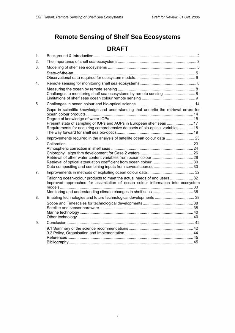
It is therefore timely to consider why the pull-through of ocean colour research into improvements to shelf-sea ecosystems models has been slow to emerge in comparison with the benefits of other satellite oceanography techniques. The richness of detail on images such as Figure 1 encourages us to expect that valuable quantitative information about the pelagic ecosystem and water quality is waiting to be extracted from ocean colour datasets. What then are the factors hindering retrieval of chlorophyll and other measurements needed by operational users? Are there shortcomings in basic scientific knowledge? Is more technical skill needed in processing satellite data specifically to support ocean biogeochemical models as well as physical models? Is the infrastructure of satellites and sensors for ocean colour inadequate to meet the challenge of monitoring European shelf sea ecosystems?
The Marine Board of the European Science Foundation (ESF-MB) established an expert working group with the remit of addressing such questions, and this document reports its conclusions. It is written to inform those responsible for planning and funding marine science, remote sensing technology and the Earth observation space programme. It aims to enlighten those concerned with developing operational oceanography in Europe. It also hopes to inspire scientific colleagues to engage in the intellectual endeavour needed to solve interesting problems in a challenging field of science.
Primarily this report provides a scientific analysis of the state of the art in relation to the remote sensing of shelf seas ecosystems, both the strengths and weaknesses. It identifies what can be improved, the research needed to close the deficit and the scientific infrastructure that must be in place to achieve this. Figure 1 An ocean colour image exemplifying the richness of spatially detailed information potentially available about ecosystem processes in European shelf seas.
2
ESF Report: Remote Sensing of Shelf Sea Ecosystems Draft for Review: 31 Oct, 2006
2. The importance of shelf sea ecosystems Shelf seas are the coastal waters surrounding every continent and are usually shallow (typically less than 200m). Geologically, shelf seas can be considered as submerged extensions of the continent. About 60% of all people in the world live adjacent to this relatively small but very productive, highly valued, dynamic, and sensitive area. Coastal zones occupy about 18 percent of the surface of the globe, supplying about 90% of global fish catch and accounting for some 25% of global primary production. At the same time, they are among the most endangered areas. Pollution, eutrophication, urbanization, over-fishing, and tourism continually threaten the future of shelf seas ecosystems. A major challenge facing us today is managing the human use of shelf seas so that future generations can continue to enjoy the products they provide.
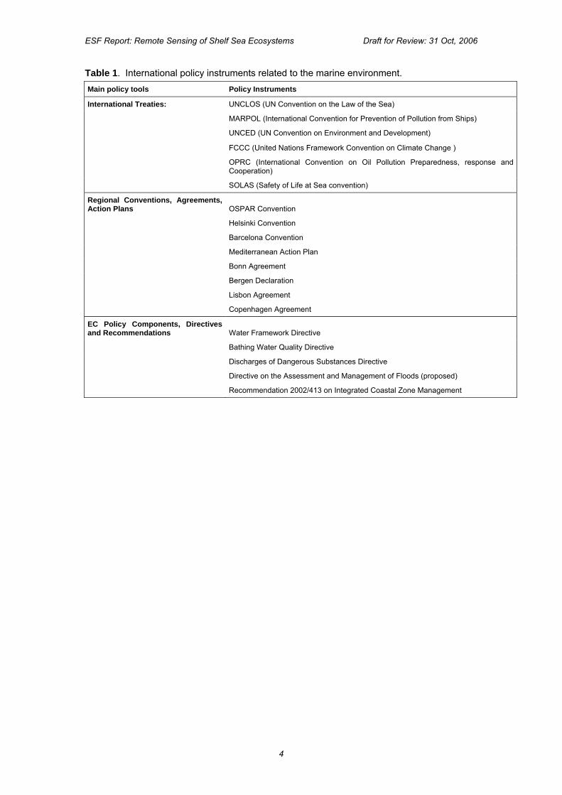
Most coastal waters of Europe support a multitude of socio-economically important activities. They are busy commercial highways, productive farming areas, a bountiful source of wild stock, and in some places an extraordinary recreational domain. European shelf sea systems are, however, experiencing unprecedented changes and becoming more susceptible to natural hazards, more costly to live in, and less able to support living resources. A broad spectrum of phenomena from global warming and sea level rise to harmful algal blooms and losses of biodiversity are exhibiting troubling trends in their magnitude or frequency. These trends represent the combined response to both natural processes and human uses. Such changes, their causes and their effects often transcend national borders. In order to respond to them numerous intergovernmental conventions and international treaties have been agreed (see Table 1). These, together with global and European initiatives such as GEOSS and GMES, imply a need for regular, reliable and sustained observations of oceanic and coastal systems at local, regional and global scales.
Industries working in the coastal zone need even more detailed information to comply with environmental standards and to reduce accidents. There are ever-increasing human demands made on shelf sea ecosystems in support of commerce, living resources, recreation, and living space, and in order to receive, process and dilute the effluents of human society. Informed management for sustained use of these goods and services requires the capacity to routinely and rapidly assess the state and health of marine systems, to detect changes on a broad spectrum of time and space scales, and to provide predictions of likely future state. Routine, continuous provision of reliable data and information will make possible rapid and repeated assessment of the conditions of shelf sea systems; and enable timely predictions of the effects of extreme weather, climate change and human activities. Regular monitoring will also support the development of ecosystem-based approaches to managing and mitigating the effects of human activities and natural variability on the socio-economic systems that underpin the health and well-being of human populations.
In recent decades a number of complementary developments within oceanographic modelling and monitoring have taken place. Numerical modelling has advanced to the stage where operational systems are now run on a routine basis, predicting a variety of physical and biogeochemical properties. Simultaneously, a growing number of observations (from space and in-situ) of many of these properties in the shelf and coastal seas are being made available in real or near-real time. One of the most exciting and socio-economically beneficial upcoming uses of numerical modelling in combination with remote sensing and in-situ observations is the forecasting of harmful algal blooms (HAB). Remote sensing allows us to monitor the severity of bloom events that, when effectively forecast, can mitigate economic loss and public health incidents. With increased notice of a HAB event, the number of management options can expand from beach clean-up to changing water quality monitoring strategies, temporarily changing harvesting quotas, and notifying the public of health concerns. Other challenges are to include water chemistry, light transmission, photosynthesis, sediment transport, and primary productivity of phytoplankton in truly ecological models in order to fulfil the growing demand both from public institutions with societal and governmental responsibilities and from service providers.
3
ESF Report: Remote Sensing of Shelf Sea Ecosystems Draft for Review: 31 Oct, 2006
Table 1. International policy instruments related to the marine environment. Main policy tools Policy Instruments
International Treaties: UNCLOS (UN Convention on the Law of the Sea)
MARPOL (International Convention for Prevention of Pollution from Ships)
UNCED (UN Convention on Environment and Development)
FCCC (United Nations Framework Convention on Climate Change )
OPRC (International Convention on Oil Pollution Preparedness, response and Cooperation)
SOLAS (Safety of Life at Sea convention)
Regional Conventions, Agreements, Action Plans OSPAR Convention
Helsinki Convention
Barcelona Convention
Mediterranean Action Plan
Bonn Agreement
Bergen Declaration
Lisbon Agreement
Copenhagen Agreement
EC Policy Components, Directives and Recommendations Water Framework Directive
Bathing Water Quality Directive
Discharges of Dangerous Substances Directive
Directive on the Assessment and Management of Floods (proposed)
Recommendation 2002/413 on Integrated Coastal Zone Management
4
ESF Report: Remote Sensing of Shelf Sea Ecosystems Draft for Review: 31 Oct, 2006
3. Modelling of shelf sea ecosystems State-of-the-art
The ecosystem approach to marine and fisheries management is based on an understanding and knowledge of how different organisms in the marine biota interact with each other and their environment. An ecosystem model encapsulates that knowledge and needs to be capable of resolving ecosystem dynamics and predicting consequences of external impact on the system. The core element of a numerical ecosystem model consists of a number of ecological components in a single box, whose interactions are represented by mathematical equations. The degree of ecological complexity that can be represented depends on the number and type of state variables used to represent the ecological components, the nature of the governing equations and which other variables are used to represent the environment in those equations, e.g. the water temperature or the photosynthetically available radiation (PAR). The simplest ecosystem models, called NPZD because the state variables simply represent the partitioning of an element, typically nitrogen, between Nutrient, Phytoplankton, Zooplankton and Detritus, are quite well developed and thoroughly tested, both in coastal and pelagic frameworks. They are capable of reproducing reasonably well the concentration of both phytoplankton and nutrients. Their degree of complexity, however, may be inadequate for the issues associated with coastal ecosystems such as harmful algae blooms (HAB), aquaculture, or eutrophication. This has prompted the community to develop more complex models, the main three types are: (1) Multi size-class models; in which the phytoplankton and zooplankton are divided into two
or more size-classes. These models can also include several types of nutrients and the largest phytoplankton group is typically treated as diatoms. This approach is often chosen for pelagic ecosystems, but is less common when modelling coastal ecosystems.
(2) Multi-species models that divide the plankton into the species types or functional groups that are thought to be dominant for the ecosystem in question. There may be just two functional groups which could be diatoms and flagellates (as in the NORWECOM model), but the level of complexity in these models can be very great and some of them include higher trophic layers, such as fish or additional functional algae groups (e.g. HAB-species such as Chattonella spp,). For example, one version of ERSEM has three functional groups of phytoplankton and a total of 36 pelagic and 18 benthic state variables. Some ecosystem models include variable internal element ratios for the plankton functional groups.
(3) A third group of ecosystem models focus on one or two specific species, often organisms with a complicated life-history, like migrating fish or zooplankton, or organisms of special interest such as harmful algae, or interaction between mussels and algae.
A single box model describes how the ecosystem develops over time, and assumes that each variable is homogeneous within the box. In order to represent the spatial variability occurring in shelf sea ecosystems, a three dimensional grid of such boxes must be used, allowing the state variables to vary with position, and also allowing different environmental variables to be defined in each box. Additional equations are required to describe the flux of each ecological variable between adjacent boxes by advection and diffusion, depending on the currents in the sea and the mixing processes. This requires that the ecosystem model be closely linked to a three dimensional ocean circulation model that defines all the physical variables required by the ecosystem model.
Thus as well as making the choice of ecosystem complexity, the modeller must also select the complexity and resolution of the physical models in which they are embedded, appropriate to the degree of realism required by the application. While relatively simple physical models can be used for scientific studies of the processes, when the objective is operational monitoring and forecasting of the environmental health of a shelf sea then the model must reflect as closely as possible what is happening in the real world. A realistic physical setting, including models at sufficiently fine scales to resolve essential physical processes, transports, river inputs and realistic bathymetry, as well as initial and boundary conditions, is a prerequisite for a successful simulation with the ecosystem model. Open sea boundary conditions for coastal models are usually created by nesting into a larger area model with coarser resolution. The complexity of the physical models ranges from box-models to high-resolution three-dimensional physical models. Three-dimensional models are
5
ESF Report: Remote Sensing of Shelf Sea Ecosystems Draft for Review: 31 Oct, 2006
often run with simpler ecosystem models because of the added computational load that comes from models with numerous state variables. In addition to modelling the water column plankton community, some models include processes for sedimentation, resuspension, sediment transport and separate models for benthic biota and nutrient cycling. Moll and Radach (2003) provide a review of the range of models that have been applied in the North Sea.
The more complex ecosystem models reflect the level of complexity that biologists observe in the field, although models with this level of complexity have proven hard to validate. A major criticism is that, because the number of parameters (several of which are difficult to define) gives the model a large degree of freedom, the available data are not sufficient to constrain the model parameters and the results must be interpreted with caution. The level of complexity in the model must be adjusted to the kind of problem that is being addressed, so that different models are used according to their particular application.
Observational data required for ecosystem models
Although the scientific understanding of the processes underlying ecosystem models has developed in recent years, the methodology has not yet reached sufficient maturity to be relied upon in an operational context. In a few specific situations for monitoring harmful algal blooms three-dimensional ecosystem models embedded in ocean circulation models have been used in a support role. But we are far from realising the vision in which models assimilating observations of phytoplankton can provide a nowcasting capability that gives marine managers the best knowledge of the present state of a coastal sea. A major obstacle to this goal is that the coupling between observational data and ecosystem models, essential for a successful operational forecasting system, is still at an early stage of development.
Numerical ecosystem models require measured data for several aspects of their operation. Firstly it is self evident that observations of the modelled ocean state variables are needed to be able to determine whether the model is providing a realistic description of the ocean. For the most complex ecosystem models this implies that many different biological and chemical parameters of the ocean need to be measured, in sufficient spatial detail to resolve the characteristic length scales, and frequently enough to resolve the dominant time scale of variability. The space-time sampling capacity required is very demanding, which is why satellite data are considered to be necessary, even though remote sensing does not sample very well below the surface layer, and there are many ecological variables that are not directly observable by remote sensing, such as the zooplankton or nutrient concentration.
Observations of the space-time distribution of the model state variables are also required for establishing the value of tuneable parameters used in model expressions that represent the dynamic interactions between the variables. Smoothed climatological seasonal time series of chlorophyll data are well suited to this task of model parameter estimation. They have been used to determine the appropriate values for some of the coefficients used in NPZD models, optimised so that the predicted seasonal variation of chlorophyll is close to what is observed. However, even if chlorophyll data are available the lack of observations of some of the other state variables of the ecological model remains a problem.
Observations of the physical environmental variables are also required for validating the circulation models in which the ecosystem model is embedded. Measurements of the space-time fields of water temperature and velocity are important for shelf sea models, as well as tide gauge records of sea surface height. A knowledge of the underwater light field is essential for driving the ecosystem model. In European shelf seas the average illumination received by the phytoplankton cells as they move around in the water column is normally the limiting factor for the initiation of the Spring bloom. This depends on the physical model predicting mixed layer depth (using satellite observations of SST and in situ T,S profiles as a constraint), the day length, the PAR reaching the sea surface (which may be estimated by remote sensing) and light attenuation in the water column. Regularly updated observations of the optical attenuation coefficient, and how it varies across a shelf sea, is therefore desirable for maintaining the most realistic physical optical environment within the model.
In some operational models, the temperature and current information is now being assimilated directly in near-real time as a means of constraining the model physics and dynamics to follow the way the real ocean is behaving. It is a goal of those planning operational forecasting systems for European shelf seas that near-real time observations of
6
ESF Report: Remote Sensing of Shelf Sea Ecosystems Draft for Review: 31 Oct, 2006
chlorophyll should also be assimilated, in order to constrain the phytoplankton population within the ecosystem model to follow the same timing and spatial distribution as in the ocean itself.
The importance of remote sensing data for parameter estimation, forcing, constraining and validating ecosystem models is one of the underlying reasons for this report. The next chapter explores the capacity of satellite remote sensing methods to provide the type of observational data required by shelf-seas ecosystem models, and whether the space and time scales for their sampling are adequate. Chapter 7 will return to the question of how best to confront ecosystem models with those observations that are available, in order to achieve the best operational accuracy.
7
ESF Report: Remote Sensing of Shelf Sea Ecosystems Draft for Review: 31 Oct, 2006
4. Remote sensing for monitoring shelf sea ecosystems Measuring the ocean by remote sensing
Understanding marine ecosystems, in which organisms are studied in relation to their environment, requires knowledge of the physical, chemical and biological components of an ecosystem in order to define its properties. In recent years the scientific community has confirmed the value of a multi-disciplinary approach to marine ecosystem studies while recognizing that physical processes impact on biological productivity at both short and long space-time scales. Consequently to monitor and understand the dynamics and variability of marine ecosystems requires a diversity of parameters to be measured. Remote sensing has an important role to play by observing both physical and biological variables with regular space-time sampling over large areas.
For two decades, satellite data have contributed increasingly to investigating marine ecosystems, estimating estuarine, coastal and ocean productivity and climate variability. Regular and sustained global, regional and local observations of oceanic parameters are being made from satellites by several different types of sensor including passive radiometers in the visible, infrared and microwave parts of the spectrum, and active microwave devices such as scatterometers, altimeters, and synthetic aperture radars.
These instruments deliver a variety of oceanographic data (e.g. chlorophyll concentration, surface temperature, wind stress, wave height, currents, ice thickness and type, salinity, etc.), reveal ocean phenomena such as fronts and eddies, and allow detection and monitoring of marine hazards (e.g. oil spills, pollution and harmful algal blooms). The opacity of the ocean to electromagnetic signals limits most measurements to the very top surface layer of the ocean, although various methods have been developed which analyse satellite data to yield information about ocean dynamics and phenomena at greater depths.
Given the diversity of remote sensing instruments and techniques available for oceanographers (Robinson, 2004) this report focuses on the key methods for observing shelf seas and their ecosystems. It is primarily concerned with parameters derived from satellite ocean colour data which can tell us about the water content and its optical properties, relevant to measuring the distribution of chlorophyll concentration and primary production. These are outlined in Box 1. Other types of satellite data, such as sea surface temperature (SST), surface slope and winds over the sea, are also relevant, since these are needed to understand the ocean circulation and physical forcing which affect ecosystem parameters. They are outlined in Box 2. It is important to emphasise that parameters of this second type are implicitly required by the ecosystem models through their links to associated circulation models. Such coupled systems have the same basic EO data requirements as ocean circulation models, in addition to ocean colour data.
Challenges to monitoring shelf sea ecosystems by remote sensing
Shelf seas are subject to the same seasonal cycles of warming and cooling as the open ocean. However, the task of monitoring ecosystems is complicated by factors peculiar to the coastal zone.
The first of these is the shallowness which leads to a situation in which the surface mixed layer may extend to the sea bed. Since dead biological material and detritus tend to accumulate and decompose on the bottom, in this case the nutrients they release may be carried to the surface and rapidly re-used in photosynthesis.
Another important difference from open seas is that, adjacent to land, the monitoring of small scale circulation features becomes a basic requirement both for scientific and operational applications. In coastal and shelf regions, the spatial variability scales are no greater than a few kilometres and the physical processes are complicated by stronger couplings between different dynamical phenomena, e.g. associated with tidal currents, wind-driven circulation, upwelling and downwelling, local instabilities, inertial and topographically-trapped features, filaments, bottom boundaries, etc.
At the same time, information from shallow seas and inshore regions is often the most important in terms of the strong impact it can have on managing human activities such as fishing, transportation and recreation. Certainly, operational data products for the coastal
8
ESF Report: Remote Sensing of Shelf Sea Ecosystems Draft for Review: 31 Oct, 2006
ocean and knowledge of the state of the ecosystem in shallow seas are crucially needed to aid policy-makers and end-users for a sustainable exploitation of marine resources in the coastal areas.
Because many coastal/shelf processes are characterized by very short spatial and temporal scales that cannot be resolved by conventional ship-based sampling techniques, there is a deficit of information just where it is needed most urgently. Remote sensing, with its dense spatial and regular temporal coverage of almost any coastal area, is potentially an ideal technique for situations where large amounts of near real-time information are needed.
However, it is important to underline that the very high space-time sampling required to study shelf sea ecosystems and the physical processes and phenomena which control them is not achieved by all RS sensors (altimetry, for example), and for visible and infra-red sensors is compromised by cloud cover. Moreover, problems related to land contamination, bottom reflection or data processing procedures often degrade the quality of coastal remote sensing products. Restricted sampling and the quality of the data are therefore the major limitations of satellite products for coastal applications. The present challenges for remote sensing of physical parameters in shelf seas are summarised in Box 3.
However, although further development work is needed before the use of satellite-derived physical data is fully optimised in shelf sea models forecasting circulation and mixing, this is not considered to be a serious obstacle to progress. Rather, it is the shortcomings of data products derived from ocean colour, and the steps needed to remedy them, that represent the greatest challenge hindering the effective use of remote sensing for shelf sea ecosystems. These are considered in some detail in the rest of this document.
Limitations of shelf seas ocean colour remote sensing
Stated simply, the problem with using ocean-colour derived satellite data products in shelf seas ecosystem models is that the measurements lack sufficient accuracy. Compared with the assimilation of SST or SSH into physical ocean models where the data accuracy is better than 0.3K or 3 cm respectively, the most reliable chlorophyll concentrations retrieved from ocean colour data have errors of around 30% using the standard algorithms. This is for optimal open ocean conditions, called “Case 1”, where the colour of the water is determined entirely by its phytoplankton content. In shallow coastal seas, the water colour is also influenced by dissolved organic material and suspended sediments that derive from land drainage, coastal erosion and river discharge, as well as the local phytoplankton population. In these “Case 2” conditions, the algorithms for retrieving chlorophyll concentration from the measured spectral reflectance lose accuracy and may fail entirely, with errors in excess of 100%.
The magnitude of these error estimates, even in Case 1 waters, implies that it would be inappropriate to attempt to assimilate satellite derived chlorophyll data into ecosystem models in the same way as SSH or SST are assimilated into ocean circulation models. In shelf seas, where the need for observational constraint is most important if ecosystem models are to gain credible skill in forecasting algal blooms or eutrophication events, the difficulty of retrieving accurate measurements in the optically complex Case 2 conditions almost rules out the possibility of assimilation. Even the simpler approach of using satellite data to validate ecosystem models is of questionable value if the uncertainties in the retrieved parameters are not reduced.
There are additional reasons why biogeochemical parameters derived from ocean colour tend to have larger errors than physical measurements retrieved from infrared or microwave data. One arises from the natural heterogeneity of biological processes. There are many species of phytoplankton with subtly different optical properties; primary production in the sea is notoriously patchy on a variety of length scales making it difficult to precisely sample chlorophyll concentrations; both of these limit the precision with which a relationship between water colour and chlorophyll concentration can be defined even in Case 1 conditions. Another difficulty for ocean colour remote sensing is the magnitude of the atmospheric correction required to estimate water-leaving radiance from what is measured at the top of the atmosphere (TOA). Typically more than 80% of the TOA signal is sunlight scattered from the atmosphere. Although there are robust techniques available for retrieving the sea-level radiance, additional errors are introduced into the estimates of water leaving spectral reflectance which form the input to the parameter retrieval algorithms.
9
ESF Report: Remote Sensing of Shelf Sea Ecosystems Draft for Review: 31 Oct, 2006
Stated as barely as this, the goals of using ocean colour data quantitatively to monitor the evolution of shelf seas ecosystems and to constrain numerical operational ecosystem models may appear to be unreachable. However, the richness of spectral detail observed in shelf sea images from the latest generation of imaging spectrometers in space implies that there is a lot of information waiting to be extracted. Given the benefits that potentially would flow from successful application of ocean colour data, not to mention the considerable sums already invested to develop today’s satellite ocean colour measurement infrastructure, it is appropriate and timely to apply further scientific effort to overcoming the obstacles that presently block progress. The purpose of this report is to clarify what the main issues are. The next chapter reviews the science of marine optics which underpins ocean colour remote sensing, and identifies the key questions still to be answered. Then chapter 6 explores the methodological and technical problems to be addressed if remote sensing is to fulfil its promise in monitoring shelf seas ecosystems. Chapter 7 considers the potential for improving the ways in which data products retrieved from remotely sensed ocean colour are used for particular applications.
However, it should not be overlooked that the assimilation of chlorophyll concentration into models is not the only way that ocean colour may be used operationally to monitor shelf seas ecosystems. Qualitative interpretation of multispectral images can serve a useful function; even if the geophysical parameter extracted from the satellite images are affected by errors, the patterns and gradients in the images may indicate boundaries between water of different quality and can be useful to intepret periodic in situ coastal measurements made by local authorities. Another approach is to develop ways of estimating coastal management indicators using satellite image data (for example to flag possible harmful blooms or eutrophication).
Summary of recommendations derived from Chapters 1 to 4 a. The demands of managing coastal seas in today’s international regulatory framework
require an integrated system of ecosystem models and multiparameter observations. b. Operational shelf sea observing systems require long term continuity of satellite and in
situ sensors measuring physical and biological properties of shelf seas at fine resolution. c. Significant improvements are needed in analysing satellite ocean colour data before their
information content is fully exploited for monitoring the state of shelf sea ecosystems.
10
ESF Report: Remote Sensing of Shelf Sea Ecosystems Draft for Review: 31 Oct, 2006
Box 1 Parameters derived from ocean-colour. After atmospheric correction, ocean colour sensors measure the radiance of light reflected from below the sea surface in a number of narrow wavebands spanning the visible part of the electromagnetic spectrum. This box describes parameters that are retrieved from these spectral radiance measurements. Chlorophyll concentration Phytoplankton distribution in the sea is characterised by measurements of chlorophyll-a, the photosynthetic pigment found in all phytoplankton species. Chlorophyll-a concentration is the principal parameter retrieved from satellite ocean colour sensors, normally using empirical algorithms based on the ratio between the radiance of blue and green light reflected by the sea (e.g. 443 nm and 550 nm). The chlorophyll concentration is considered to be the observation most useful to improve ecosystem models through assimilation schemes or to validate their results. Yellow Substance or CDOM The absorption of chromophoric dissolved organic matter (CDOM, also called Yellow Substance) can also be estimated from the spectral distribution of light reflected by the sea water. It is estimated using a semi-analytical algorithm or computed by a neural-network method. It is an important parameter when we consider coastal ecosystems, where it may vary independently of phytoplankton. Diffuse attenuation coefficient Diffuse attenuation coefficient, Kd, at one typical wavelength (e.g. at 490 nm) is an apparent optical property which represents the turbidity of the water column. It is a measure of how the visible light penetrates within the water column and is directly related to the scattering of particles in the water column. A typical operational algorithm for deriving Kd relies on the ratio of light at 490 nm and 555 nm. Suspended Particulate Matter The total suspended matter concentration can be estimated from the measured reflectance, although most of the available algorithms have been developed empirically with regionally specific data sets. The measured parameter relates to scattering of light from the phytoplankton population and also suspended particulate matter not related to phytoplankton. This may be re-suspended bottom sediment, river particles or beach material and is an important parameter to monitor in shelf seas. Solar radiation entering the sea (PAR and SSI) Incident photosynthetically active radiation (PAR) is a key variable required by almost all marine ecosystem models and primary production models. This parameter can be estimated by combining satellite information on spectral reflectance at the top of the atmosphere and radiative transfer models. In the framework of the SeaWiFS Project NASA developed daily, weekly and monthly operational products from the SeaWiFS sensors. For a long time Sea Surface Irradiance (SSI) has been produced using data in the visible channel of geostationary satellites (GOES, Meteosat, MSG).
Box 2. Other satellite-derived parameters needed for monitoring shelf seas Sea Surface Temperature Sea surface temperature (SST) is an ocean parameter that is used in many applications as it provides a synoptic view of the dynamic thermal character of the ocean surface. This parameter is widely used in monitoring and forecasting the ocean state and is assimilated in ocean forecasting models. SST has been measured for a long time by infrared radiometers and also more recently by microwave sensors. A number of different SST products from several different satellite systems are now readily available in near-real time. Sea Surface Height The horizontal pressure gradient in the upper ocean is given by the sea surface slope, detected by altimeters. Actually, the sea surface elevation is related to the heat content of the whole water column, as the volume of water is modified mainly by temperature and to a minor extent by salt variations. For this reason satellite altimetry is one of the most important data sets to constrain ocean modelling and data assimilation systems. An accurate measure of the geoid is needed to obtain absolute sea surface height from altimeter data. In its absence so far only sea level anomaly was used. In the near future the availability of data from the GRACE and GOCE geodetic missions will allow absolute surface elevations to be obtained, but only on scales longer than 100 km. As a consequence, altimeter-derived absolute ocean topography will be used to test general circulation models only at the larger scales. Surface currents The most direct remote sensing method is to deduce surface geostrophic currents from altimetry slope data, but until the geoid is known only the time-variability of currents is derived from altimeter sea level anomaly in most cases. In special cases other remotely sensed data can also be used to estimate the detailed structure of the ocean surface velocity field. For example the surface roughness patterns revealed by hydrodynamic modulation in SAR images can be inverted to estimate the velocity field, notably the strength of the deformation (a combination of shear and convergence), which has important consequences for vertical transport of nutrients as well as accumulation of surface film and pollutant materials in the upper ocean. Another proven technique for estimating mesoscale currents uses the correlation analysis of patterns in a time sequence of ocean colour or infrared images. However,
11

ESF Report: Remote Sensing of Shelf Sea Ecosystems Draft for Review: 31 Oct, 2006
such methods are still in the scientific development phase and their operational utility remains to be proved.. Surface winds Surface wind is one of the main parameters used to compute the forcing field for ocean model forecasts. Surface wind vectors can be retrieved from scatterometer data, but their space-time resolution (25 km, twice a day) and uncertainties near the coasts limit their use. Instead, blended products (combining scatterometer data with meteorological model output) have been developed to almost achieve the time frequency required for forcing ocean models. Water column structure Recently new methods have been developed to reconstruct the 3-D density structure of the ocean, combining altimetry with in situ climatology and other satellite observations (for example vertical profiles of temperature can be obtained from SST, SSH and dynamic height climatology). These methods also seem promising to reconstruct vertical profiles of chlorophyll in shelf sea and deserve further investigation in various conditions.
12
ESF Report: Remote Sensing of Shelf Sea Ecosystems Draft for Review: 31 Oct, 2006
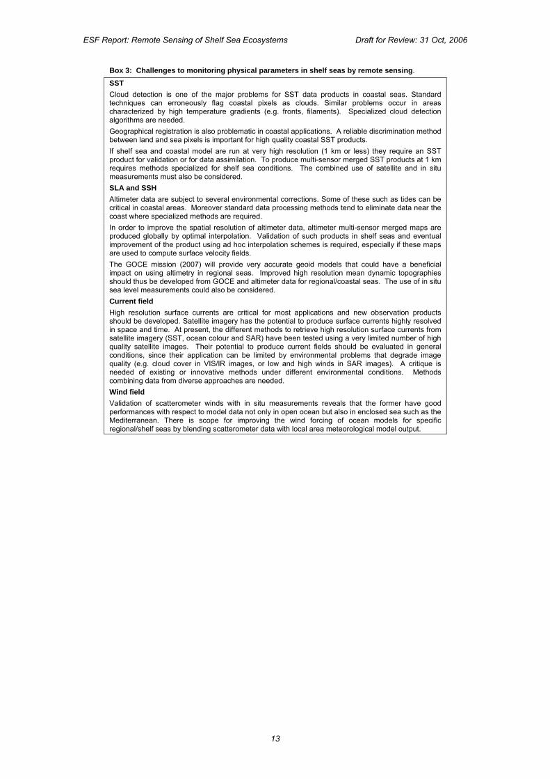
Box 3: Challenges to monitoring physical parameters in shelf seas by remote sensing.
SST Cloud detection is one of the major problems for SST data products in coastal seas. Standard techniques can erroneously flag coastal pixels as clouds. Similar problems occur in areas characterized by high temperature gradients (e.g. fronts, filaments). Specialized cloud detection algorithms are needed. Geographical registration is also problematic in coastal applications. A reliable discrimination method between land and sea pixels is important for high quality coastal SST products. If shelf sea and coastal model are run at very high resolution (1 km or less) they require an SST product for validation or for data assimilation. To produce multi-sensor merged SST products at 1 km requires methods specialized for shelf sea conditions. The combined use of satellite and in situ measurements must also be considered. SLA and SSH Altimeter data are subject to several environmental corrections. Some of these such as tides can be critical in coastal areas. Moreover standard data processing methods tend to eliminate data near the coast where specialized methods are required. In order to improve the spatial resolution of altimeter data, altimeter multi-sensor merged maps are produced globally by optimal interpolation. Validation of such products in shelf seas and eventual improvement of the product using ad hoc interpolation schemes is required, especially if these maps are used to compute surface velocity fields. The GOCE mission (2007) will provide very accurate geoid models that could have a beneficial impact on using altimetry in regional seas. Improved high resolution mean dynamic topographies should thus be developed from GOCE and altimeter data for regional/coastal seas. The use of in situ sea level measurements could also be considered. Current field High resolution surface currents are critical for most applications and new observation products should be developed. Satellite imagery has the potential to produce surface currents highly resolved in space and time. At present, the different methods to retrieve high resolution surface currents from satellite imagery (SST, ocean colour and SAR) have been tested using a very limited number of high quality satellite images. Their potential to produce current fields should be evaluated in general conditions, since their application can be limited by environmental problems that degrade image quality (e.g. cloud cover in VIS/IR images, or low and high winds in SAR images). A critique is needed of existing or innovative methods under different environmental conditions. Methods combining data from diverse approaches are needed. Wind field Validation of scatterometer winds with in situ measurements reveals that the former have good performances with respect to model data not only in open ocean but also in enclosed sea such as the Mediterranean. There is scope for improving the wind forcing of ocean models for specific regional/shelf seas by blending scatterometer data with local area meteorological model output.
13
ESF Report: Remote Sensing of Shelf Sea Ecosystems Draft for Review: 31 Oct, 2006
5. Challenges in ocean colour and bio-optical science The scientific discipline of ocean optics provides the underpinning for ocean colour remote sensing. This chapter explores the current scientific challenges in this field and in particular those aspects most relevant to the remote sensing of shelf seas ecosystems.
The heart of the matter is the fact that the colour of the visible and near infrared radiation emerging from the sea, either measured locally or remotely-sensed, is related to the optical properties of the water itself and of the optically-significant water constituents. These can be summarised as: • Phytoplankton, bacteria, small heterotrophic plankton (influence the absorption and
scattering of light, as well as generating fluorescence) • Non-living organic detrital particles (absorption and scattering) • Dissolved substances produced by phytoplankton or derived from degradation of organic
particles, referred to as “Coloured Dissolved Organic Matter” or CDOM (absorption and fluorescence)
• River-driven or bottom re-suspended slits, clays and other inorganic particles (absorption and scattering)
• Air bubbles (scattering) • The bottom (reflection).
From the outset it is important to recognise that the optical properties of shelf-sea waters span the full scale of natural variability, from sometimes clear “oceanic-type” waters (e.g., deep waters off some sheer coasts of the Mediterranean without any shelf) to muddy shallow waters of estuaries. These properties are the result of the combination of various amounts of phytoplankton, suspended living or non-living organic matter, suspended inorganic matter and dissolved organic matter.
The terminology of ocean optics and “bio-optics” is recurrently used in this chapter. To assist readers unfamiliar with the subject, without interrupting the main flow of the argument, an Appendix on ocean optics is added to the report. It provides basic notions about ocean colour, as well as more specific definitions of the inherent optical properties (IOPs; those properties determined only by the composition of the medium), and of the apparent optical properties (AOPs; those depending both on the IOPs and on how the medium illumination is affected by sun position and diffuseness of the incoming radiation). The relationships between both are explained in the Appendix. Similarly Box 4 explains the concept of “Case 1” and “Case 2” waters, which is highly relevant for shelf seas where both types of waters are to be found.
Gaps in scientific knowledge and understanding that underlie the retrieval errors for ocean colour products. The relevant questions are, “How can we improve the remote sensing capability in shelf seas?” and “What are the gaps in scientific knowledge and understanding that need to be filled?” The response to these questions starts with a summary of the knowledge gaps, which are then elaborated in the subsequent sections, particularly in relation to the water optical properties.
It is supposed here that a perfectly calibrated ocean colour sensor is available to provide the relevant measure of the top-of-the-atmosphere (TOA) total radiance exiting the Earth atmosphere. It is left to the chapter 6 to consider issues of sensor calibration.
The focus is on the errors that will inevitably be introduced in the process of deriving the water-leaving radiance spectrum from the TOA total radiance (atmospheric corrections), and then of deriving some geophysical quantity from this spectrum (bio-optical algorithms). Errors are introduced because of insufficient knowledge of the optics of both the atmospheric aerosols and the coastal waters, and of how the various optically-significant components interact to form the radiative field.
The shortcomings are not strictly “gaps in knowledge”, which would mean that some physical processes are unknown or not understood, but essentially gaps in the documentation of a series of identified processes, and difficulties in modelling the radiative transfer in coastal waters, both of which prevent inversion algorithms from performing accurately. The following list identifies aspects of the subject where more research work is needed to remedy a lack of
14
ESF Report: Remote Sensing of Shelf Sea Ecosystems Draft for Review: 31 Oct, 2006
detailed knowledge. It is meant to be indicative but is neither exhaustive nor prioritised. It starts with elements concerning the knowledge of the optical properties and continues with considerations more related to algorithms. • The natural variations of (specific) inherent optical properties of optically-significant
components of shelf seas. This includes dissolved materials, particles of all origins and bubbles.
• The determination of phytoplankton groups (or species in some cases) from ocean colour. This is entirely dependent on the previous point about IOPs, because it will only become feasible after the optical properties of these groups are well documented.
• The bidirectional structure and polarisation of the light field. • The optical properties of aerosols (spectral dependence of scattering and single
scattering albedo) and their vertical structure. • The modelling of reflectance due to white caps and foam. • The surface accumulation of phytoplankton species and their accompanying products
(when ocean colour remote sensing tends to resemble land vegetation remote sensing). • The sun glint. • The interpretation of the natural phytoplankton fluorescence signal in terms of chlorophyll
concentration or of phytoplankton physiological status, particularly in the presence of high sediment loads.
• The inability of present inversion algorithms to tackle the problem of ambiguities. Most of these points are relevant to both Case 1 and Case 2 waters, although they
are more severe in the latter. We focus here on the optical properties of water, while atmospheric properties are considered in chapter 6 in the discussion on improving atmospheric correction procedures.
Degree of knowledge of water IOPs
Knowledge of the IOPs of sea water and its constituents is now recognised to be a fundamental prerequisite for improving remote sensing analytical methods. This section therefore addresses the current state of the art, providing qualitative statements about the degree of knowledge of the natural variability of IOPs. Absorption and scattering are first considered, followed by directionality of the light field and other miscellaneous points. The capabilities for actual sampling of IOPs is discussed in the subsequent section.
Absorption Absorption is the process that has the major influence on the spectral shape of the water reflectance. The absorption coefficient of water itself and of the particles and dissolved substances found in the sea are better known than the scattering and backscattering properties, although by no means are they all correctly and fully defined. At least the major components whose contributions are added to form the total absorption are all identified, which is not the case for backscattering, for which the absence of any knowledge about some contributors still prevents closure of the light budget.
There is still a significant uncertainty on the absorption coefficient of pure water or pure seawater, in particular in the near ultraviolet and blue parts of the e.m. spectrum, and in the near infrared, where the uncertainty is both on the absolute values and their dependence on temperature. Any improvement in the knowledge of this fundamental quantity is important for the remote sensing of ocean colour. The near infrared domain is where the effort should be prioritised, since it is admittedly less important in the blue part of the spectrum where absorption by water is typically a very small part of total absorption. The UV domain is also fundamental, yet poorly known, for photochemistry (e.g., CDOM photo-oxidation, availability of elements such as iron and mercury …).
Absorption by phytoplankton is highly variable, and has been relatively well documented. It is due to the combined presence of all photosynthetic and non-photosynthetic pigments, which all have marked spectral features. This variability is related to the characteristics of the algal species (size, intra-cell concentration of pigments) and their physiological state, which can all change with time, location and depth. The range of variations of phytoplankton absorption in coastal waters would not be larger than it is offshore.
In shelf seas, the other components of the water absorption, CDOM and sediments, make large contributions to the total absorption, and sometimes much more than
15
ESF Report: Remote Sensing of Shelf Sea Ecosystems Draft for Review: 31 Oct, 2006
phytoplankton. They have however smoother spectral shapes. As far as absorption by CDOM is concerned, the absolute values and the slope of the spectral dependence have to be documented. What is known is that CDOM from different sources have different spectral behaviours. The presence of CDOM from different sources leads to the superposition of several slopes, which are not necessarily separable. The same comment can be made about absorption properties of non living particles.
Absorption properties of the inorganic suspended matter are probably the least known compared to the other components, because these depend heavily on the local conditions, such as depth and bottom type or river water inputs. The presence of some elements in the inorganic matter, e.g., iron, can clearly manifest spectral features of the absorption by inorganic suspended matter.
Scattering and backscattering Scattering by pure water can be calculated theoretically and hence is relatively well known. Because of its dependency on salinity, in coastal areas with fresh water inputs, the additional variations in scattering related to the changes in salinity should be taken into account.
The lack of adequate instrumentation in past decades has resulted in a poor knowledge of the volume scattering function (VSF) of particles (both its shape and spectral changes) and of their backscattering properties in particular. Not only is the VSF poorly described, but also the particles contributing to backscattering are not fully identified. It is not totally clear whether this “missing backscatter” is a physical reality or simply the result of the absence of closure. Indeed, it has for long been conjectured that phytoplankton particles themselves have low back-scattering coefficients (except for peculiar species like coccolithophorids that produce calcite plaques), so that backscattering would be essentially due to other sub-micron particles such as bacteria and also small-sized detritus. These considerations are based in particular on Mie theory that assumes spherical homogeneous particles. Obvious deviations from this theory may lead to a revisit of the role of phytoplankton in the total backscattering. It is worth noting as well that the forward part of the VSF is also important in highly scattering waters as well as the backscattering. Indeed, multiple scattering ends up with successive forward scattering being involved in the formation of the upward radiative flux.
The knowledge of back-scattering properties of mineral particles is also still very limited and mainly comes from general theoretical estimation or indirect measurements, which are based on many assumptions that are not necessarily true in the much more complicated coastal environment. There is no doubt that the variations of sediment type (grain size and refractive index) significantly affect the backscattering properties and hence the reflectance signal of coastal waters. Similar comments are valid for viruses and bacteria.
A specific problem exists for the particle scattering in the near infrared. Atmospheric correction schemes fail when applied to observations taken above coastal waters, in particular because they rely on the “black pixel assumption”, i.e., no marine signal in the near infrared. This assumption is most of the time invalid in such environments because of the presence of large amounts of particles. The consequence is usually an overcorrection of the visible bands (leading sometimes to negative water-leaving radiances). A better characterisation of the scattering properties of particles in this spectral domain is therefore needed.
Scattering or backscattering could also be influenced by the presence of colloids. The knowledge of this possibly significant optical component is poor.
Therefore, there is much debate about the values and the spectral behaviour of the VSF and scattering and backscattering coefficients of particles, which is not limited just to Case 2 waters. An increasing number of measurements are now performed, yet the effort is still insufficient and must be pursued, first in terms of instrument development (spectral range, angular range for the VSF) and then on data collection in various environments, including not only the VSF and backscattering coefficients, but also the particle size distributions and particle characterisation.
Scattering due to bubbles can be predicted theoretically, yet the difficulty is in the estimation of the bubble sizes and concentration, which are not easily parameterised, being functions of temperature, mixing etc.
16
ESF Report: Remote Sensing of Shelf Sea Ecosystems Draft for Review: 31 Oct, 2006
Directionality, polarization, surface effects The knowledge of the bidirectionality is fundamental in order to compare reflectance measurements made under different solar elevations and sky diffuseness, and this is valid for in situ as well as satellite measurements. To make data comparable, and ultimately to merge them in the case of satellite data, normalisation is mandatory, which means that bi-directional aspects are understood and correctly parameterised. This is so far true only for Case 1 waters (and still further validation of existing models is desirable). There is no generally accepted parameterisation for Case 2 waters, which is again related to the insufficient knowledge of IOPs and the VSF in particular.
The polarisation state of the underwater radiance changes with the amount of multiple scattering that occur with particles of various origins, which all tend to depolarise the signal as compared to what it would be for pure water (where there is only molecular scattering). It has been shown that measurements of the polarised radiances may help in distinguishing between sediment-dominated and phytoplankton-dominated waters. This possibility should therefore be further investigated, in particular by developing under-water instrumentation that gives access not only to the total radiance but also to the polarised radiance. This is one way to verify whether the theoretical predictions can lead to some practical method using polarisation measurements.
The statistical knowledge of the wave slope distribution is the current way to model surface effects such as the specular reflection (sun glint). The existing models are likely to need adaptation for application to the coastal domain, where the presence of the coast and of the bottom may modify the relationship between the wind speed and the probability distribution function of wave slopes. The optical properties of white caps and foam, and their relation to environmental conditions such as wind and temperature, are also poorly constrained.
Present state of sampling of IOPs and AOPs in European shelf seas
Sampling effort Throughout European marine institutes it has become more and more common to optically monitor coastal waters, although this is done on an individual basis with few if any cooperative programs, and is typically limited to areas adjacent to the national institutes. Monitored areas vary from tidal, suspended-matter dominated locations such as the Wadden Sea, CDOM-dominated water like the Balti,c towards more open water like the Adriatic and the western English Channel.
Bio-optical properties and their variation at oceanographic and coastal scales are scarcely measured, i.e., the optical monitoring of natural water basins is more or less performed on an ad-hoc basis rather than through a well spread exercise concerning European seas. Starting a few years ago more and more optical sensors have been used to optically sample European waters but such measurements are far from covering all the different cases of water types.
More initiatives are currently being undertaken to collaborate among European oceanographic institutes, in order to share knowledge, ship time and to expand research areas (see Box 5 for examples of such programs). A few automated monitoring stations covering the whole set of bio-optical parameters are thinly spread over European waters. Nonetheless, the overall situation is one in which there is a dramatic temporal and spatial under-sampling of the optical properties of European shelf seas.
Technical restraints due to existing instrumentation State of the art commercial instrumentation is available to measure IOPs and AOPs, yet the choice is rather limited. Radiometers cover a broad enough spectral range (350 – 1000 nm), but instrumentation measuring beam attenuation, absorption and (back-) scattering are limited in the number of channels. The coverage of the ultraviolet and near infrared parts of the spectrum is scarce or non-existent. Therefore, increasing the spectral range of these instruments should be considered, as well as the development of hyperspectral versions allowing a finer description of absorption features in particular.
17
ESF Report: Remote Sensing of Shelf Sea Ecosystems Draft for Review: 31 Oct, 2006
Requirements for acquiring comprehensive datasets of bio-optical variables
Rationale In the mid 1990’s a start was made to investigate parts of European shelf seas by bio-optical sampling, in close relation with satellite observations. Constrained by specific but limited scientific goals and due to lack of time, only small parts of these waters were visited. Historic datasets were obtained using a more specific than a common measuring protocol and were stored nationally in different formats. At this time there is a need to extend the historic bio-optical datasets with new data collected under a common protocol and preferably stored in one format in order to build a new European bio-optical databank.
The actual applicability of ocean colour data in ecological and climate studies largely depends on their accuracy. This, in turn, depends on the quality of, and how statistically representative are, the in situ data used for the vicarious calibration of the space sensors, the development of bio-optical algorithms, and the final assessment of products. These different processes may simply call for the measurement of some apparent optical properties like the normalized water leaving radiance needed for the vicarious calibration process, or may demand a more extended set of inherent and apparent optical properties measured together with the concentration of optically significant seawater constituents as required for the development of multi-component bio-optical models.
In relation to the different applications, the characteristics of the measurement region have specific relevance. In situ data from regions with spatially homogenous and predictable optical properties better support vicarious calibrations, while globally distributed data from different bio-optical regimes better serve the development and validation activities. Ideally, the collection of these data should be conducted in order to generate time-series of a few specific bio-optical quantities through moorings and fixed structures like oil platforms or navigation aids, as well as to assemble comprehensive sets of inherent and apparent optical properties through conventional oceanographic vessels and ships of opportunity.
This broad range of field activities suggests that the standardisation of measurements through the adoption of comparable instruments, common calibration and measurement protocols, identical processing schemes and archival tools, is essential to minimise uncertainties, to ensure traceability to data collected by various teams in different regions of the globe and to successively warrant easy and wide access to data for long-term studies and applications. This requires the creation of networks of laboratories developing and endorsing the different standardization elements. Essential to this process are the creation of facilities supporting the calibration and characterisation of instruments, and the execution of regular inter-comparison experiments to assess intra-laboratory accuracies. Finally the implementation of archival schemes supporting the storage of raw and derived data in addition to estimated uncertainties, instrument characteristics, calibration coefficients and specific correction factors applied for removing artefacts, would provide prolonged existence to measurements and also support their independent or successive reprocessing.
A data policy rewarding the ownership of measurements is a final element facilitating data access and use.
Inherent optical properties A comprehensive characterisation of the seawater inherent optical properties requires determination of the beam attenuation, absorption, scattering and back-scattering coefficients in addition to the scattering phase function. Quantification of the individual contributions of dissolved and particulate matter to total absorption coefficient, has relevance for an accurate modelling of the light attenuation processes in seawater. Multi-wavelength measurements are then important to derive spectral dependences which provide information on the nature of particles.
The measurement of most of the inherent optical properties relies on advanced methods and equipment whose performance necessarily requires planning and execution of extensive intra-laboratory comparison experiments.
Apparent optical properties Among apparent optical properties, the normalized water leaving radiance (or the equivalent remote sensing reflectance) is a fundamental quantity for vicarious calibrations and any validation process. Additional quantities such as the diffuse attenuation coefficient, the
18
ESF Report: Remote Sensing of Shelf Sea Ecosystems Draft for Review: 31 Oct, 2006
irradiance reflectance and the Q-factor are mostly relevant for the development of bio-optical algorithms and models (and more generally to bio-optics research).
The apparent optical properties are determined through radiometric measurements by applying in-water and above-water methods. In-water radiometry provides the capability of producing continuous or discrete profiles of radiance and irradiance for the determination of most of the apparent optical properties. Above-water radiometry is generally restricted to the estimation of the normalized water-leaving radiance.
When analysing the potentials of radiometric methods at fixed deployment sites for the production of time-series, optical moorings are more suited for oligotrophic regions where the bio-fouling perturbations are less pronounced than in the more eutrophic coastal regions. Above-water systems deployed from superstructures are more suitable for coastal regions where bio-fouling and the subsurface vertical inhomogeneity of optically significant constituents may seriously affect the accuracy of quantities derived from in-water methods.
The accurate determination of the radiometric characteristics of instruments, such as the absolute calibration coefficient, immersion factor (for in water radiometers), deviation from cosine response, spectral band-pass, field-of-view, is essential for the quantification of measurement uncertainties. Equally relevant is the determination of perturbation effects due to self-shading, superstructure, bi-directional distribution of radiance and waves, which may play a significant role in the definition of the total uncertainty budget.
Non-optical measurements When considering the seawater optically significant constituents, the suspended particulate matter and pigments are those generally quantified in terms of concentration. While the determination of suspended particulate matter mostly relies on a single method, the determination of pigments concentration (in many cases restricted to chlorophyll a) still relies on various fluorimetric, spectrophotometric and chromatographic techniques. Among these, high performance liquid chromatography (HPLC) is the most accurate being suitable for the quantification of chlorophylls, chlorophyll degradation products and carotenoid pigments.
Additional quantities relevant to link the inherent optical properties to the nature of particles and dissolved matter are the concentration of particle and dissolved organic carbon, the concentration of particle inorganic carbon, and the particle size distribution.
Atmospheric measurements The aerosol optical thickness and its spectral dependence are optical quantities resulting from the atmospheric correction process of satellite ocean colour data. The availability of in situ aerosol data comprising multi-wavelength optical thickness, scattering phase function and single scattering albedo, provide invaluable inputs for vicarious calibrations and validation activities. When considering autonomous systems, their deployment on offshore structures like lighthouses provides the capability of collecting data at some distance from the coast and thus reducing the effects of land particle contamination on maritime aerosols.
The way forward for shelf sea bio-optics
As far as ocean colour remote sensing in the coastal domain is concerned, a major part of the research effort in the past decade has been devoted to the inverse problem, i.e., deriving some biogeochemical parameters (chlorophyll, sediments…) from the water-leaving radiance spectrum, whereas the direct problem, i.e., the understanding of the causes of variability in IOPs and AOPS, has been insufficiently addressed (but see, e.g., the “Colors” or “Coastlooc” programs mentioned in Box 5)
This situation is essentially a response to the pressing requests from space Agencies, in particular in the frame of the ESA MERIS mission, to produce products for coastal, Case 2 waters. It is now clear that the description of the direct problem was (and still is) insufficient for any type of inversion method to produce meaningful results. The effort is therefore to be concentrated onto a better knowledge of the direct problem.
In order to make progress in answering the outstanding questions in shelf sea bio-optics, the priority is for programmes of intensive field work, which are the only avenue to better document the IOPs and AOPs in the coastal environment, as well as the parameters that contribute to their variability. Laboratory work is also needed to better characterise optical properties of the various materials present in water.
19
ESF Report: Remote Sensing of Shelf Sea Ecosystems Draft for Review: 31 Oct, 2006
To stress the importance of developing the field work is not to imply that the algorithmic work no longer needs research and improvements. In particular, efforts should be directed towards the outstandingly difficult problem of removing ambiguities (i.e., several combinations of optically-active components can lead to essentially identical water-leaving radiance spectra).
In order to tackle the IOPs and AOPs description, comprehensive and coherent data sets should be built, based on measurements from a variety of platforms, including ships, moorings, lagrangian floats, gliders and motorised underwater autonomous vehicles. In order for these measurements to be useful, agreed-upon acquisition and data processing protocols must be respected, which is not granted as far as the new types of platforms are concerned since most of the existing protocols concern ship-based measurements. A particular effort is needed here.
Combining a variety of platforms allows the various scales of spatial and temporal variability to be documented and their mechanisms understood, which is particularly important in the rapidly changing coastal environment.
The development of new, miniaturised, instrumentation is also an important aspect, in order to get a finer description of the optically-active compartments, in particular concerning the particle types and size distributions. For instance, this may be partly reachable by using miniaturised flow cytometers. Extension of the spectral range of IOP and AOP instruments is needed.
It is important also to encourage long-term, systematic in situ data collection programs, which are among the best ways to understand the causes of the natural variability in the relationships between the various components of the water and the IOPs, as well as between the IOPs and the AOPs. In that case, some core parameters have to be defined as suited for a routine and long-term collection program, the constraints attached to this type of measurement scenario being different from those attached to more focused, process-oriented, short-term data acquisitions (i.e. a given cruise).
It is recommended to have a number of automated stations covering most common European water types. For the validation of ocean colour satellite observations, daily ground truth data throughout the satellite sensor’s operational lifetime are important, especially in the cloudy areas of the higher latitudes.
Near-real time types of observations, with the associated data communication, interpretation and dissemination infrastructure, should also be developed in order to make possible warning systems using jointly remotely-sensed and in situ data.
Concerning laboratory analyses it is of the utmost importance to validate the different methodologies by means of round-robin exercises focussed at the retrieval of, e.g., chlorophyll, total suspended matter and yellow substance concentrations, to establish the accuracy of the different methods used. The marine optics community needs common protocols concerning this matter.
Summary of recommendations made in chapter 5 a. The effort invested in field work leading to better knowledge of IOPs and AOPs needs to
be extended. b. IOP instrumentation should be spectrally enhanced to include the UV and near infrared
part of the spectrum. c. Round-robin intercalibration experiments are essential for minimising instrumental and
handling failure of individual bio-optical field experiments. d. Uniformity in bio-optical sampling and measuring methods should be established by
insisting that common protocols are adopted by all experimental programmes. e. A European bio-optical databank needs to be established for all new data, eventually to
include historic archived data after validation. f. There is a need to identify those European water areas whose bio-optical properties are
under sampled . g. A network of automated optical monitoring stations is required, well spread over
European shelf seas.
20
ESF Report: Remote Sensing of Shelf Sea Ecosystems Draft for Review: 31 Oct, 2006
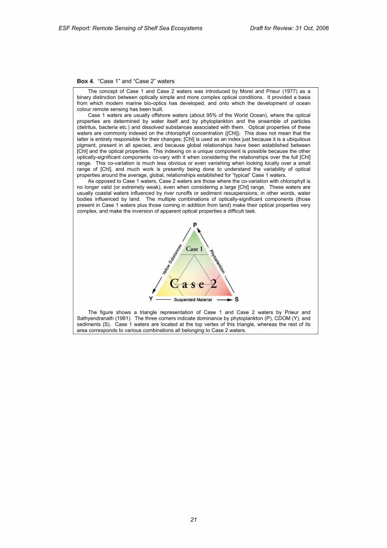
Box 4. “Case 1” and “Case 2” waters The concept of Case 1 and Case 2 waters was introduced by Morel and Prieur (1977) as a
binary distinction between optically simple and more complex optical conditions. It provided a basis from which modern marine bio-optics has developed, and onto which the development of ocean colour remote sensing has been built.
Case 1 waters are usually offshore waters (about 95% of the World Ocean), where the optical properties are determined by water itself and by phytoplankton and the ensemble of particles (detritus, bacteria etc.) and dissolved substances associated with them. Optical properties of these waters are commonly indexed on the chlorophyll concentration ([Chl]). This does not mean that the latter is entirely responsible for their changes; [Chl] is used as an index just because it is a ubiquitous pigment, present in all species, and because global relationships have been established between [Chl] and the optical properties. This indexing on a unique component is possible because the other optically-significant components co-vary with it when considering the relationships over the full [Chl] range. This co-variation is much less obvious or even vanishing when looking locally over a small range of [Chl], and much work is presently being done to understand the variability of optical properties around the average, global, relationships established for “typical” Case 1 waters.
As opposed to Case 1 waters, Case 2 waters are those where the co-variation with chlorophyll is no longer valid (or extremely weak), even when considering a large [Chl] range. These waters are usually coastal waters influenced by river runoffs or sediment resuspensions; in other words, water bodies influenced by land. The multiple combinations of optically-significant components (those present in Case 1 waters plus those coming in addition from land) make their optical properties very complex, and make the inversion of apparent optical properties a difficult task.
The figure shows a triangle representation of Case 1 and Case 2 waters by Prieur and
Sathyendranath (1981). The three corners indicate dominance by phytoplankton (P), CDOM (Y), and sediments (S). Case 1 waters are located at the top vertex of this triangle, whereas the rest of its area corresponds to various combinations all belonging to Case 2 waters.
21
ESF Report: Remote Sensing of Shelf Sea Ecosystems Draft for Review: 31 Oct, 2006
Box 5: Some examples of EU funded collaborative programs that contributed to the collection of bio-optical properties in European shelf sea waters. Some nationally-funded programmes have also involved international collaboration
COASTlOOC (COAstal Surveillance Through Observation of Ocean Colour) was a shared cost action, Environment and Climate programme (FP IV), with the objective of algorithm development for the use of ocean colour data in coastal waters to detect optically active material and assess biological processes. One of the scientific goals was to produce a large data set of the inherent optical properties of the main classes of optically active substances in European coastal waters. Between 1997 and 1998 425 stations were visited. The sites were situated in the North Sea, the English Channel, the Baltic, the Atlantic Ocean and Mediterranean Sea. The COASTLOOC data set relates AOP’s like the subsurface hemispherical reflectance at 13 wavelengths between 412 nm and 865 nm to a variety of IOP’s and water constituent concentrations.
BIOCOLOR (Ocean Colour for the determination of Water Column Biological Processes) was a
MAST III and INCO project. Its objective was to relate changes in the properties of the water column and associated successions in the phytoplankton with changes in optical properties. The study sites were in the southern Baltic and on the continental shelf of Ireland. Biological, physical and optical data were collected on seven cruises (1998-2000) by the project consortium of partners from Ireland, UK and Poland.
COLORS (Coastal region long-term measurements for colour remote sensing development and
validation) was a shared cost action in the Environment and Climate programme (FP IV). The main objective was to establish a basis for a European network of sampling sites, where a systematic programme of long term colour measurements, both oceanic and atmospheric, could be carried out. The three sites, located near Plymouth and Helgoland and at the Venice Aqua-Alta tower, provided a cross section of European Case 2 coastal waters. Each was equipped with identical instrument packages and careful inter-calibration ensured compatibility of data across sites. From 1998 to 2000, COLORS provided a series of optical and biogeochemical measurements collected at a total of 185 stations.
REVAMP (Regional Validation of MERIS chlorophyll Products in North Sea coastal waters) was
co-funded by the European Commission within the Fifth Framework Programme "Energy, Environment and Sustainable Development". REVAMP was launched in February 2002 by a consortium of 8 partners from different European countries, and was completed in January 2005. One of the objectives of the project was to collect and analyse historical North Sea data on concentrations and optical properties of optical active constituents of the North Sea. Another objective was to collect a limited, complementary (spring 2002 to spring 2003) field data-set of high quality observations of inherent and apparent optical properties and concentrations.
22
ESF Report: Remote Sensing of Shelf Sea Ecosystems Draft for Review: 31 Oct, 2006
6. Improvements required in the analysis of satellite ocean colour data
This chapter considers the methodology for processing the measurements made by satellite ocean colour sensors in order to retrieve quantitative data about marine ecosystems and to use those data to enhance the modelling of shelf seas ecosystems. It is useful to recall the distinct stages in that process, which are outlined in Figure A. Each of these procedures is examined separately to identify the techniques involved and to reveal present limitations which are hindering the effectiveness of satellite ocean colour data for monitoring shelf sea ecosystems. The aim is to point out where there is scope for further methodological R & D to overcome the limitations, and where improvements are needed in sensor technology and the data processing infrastructure. Figure A. A flow diagram showing the key stages of the Ocean colour data processing chain, from sensor, through calibration, atmospheric correction, geophysical algorithm, retrieval of IOPs, assimilation into models and application to operational tasks.
Calibration
A meaningful use of satellite ocean colour observations requires highly sensitive and well-calibrated sensors, which implies correspondingly demanding calibration activities based on in situ measurements. While this statement may seem obvious, it is particularly acute in the ocean colour domain, especially when considering advanced uses of satellite ocean colour in coastal areas. It should be recalled that ocean colour missions have been designed for a stated requirement in the open ocean for a 5% accuracy of water leaving radiance in the blue (i.e., around 440 nm) when the marine signal is maximum in this domain, i.e., for an oligotrophic ocean (Gordon, 1997). This requirement corresponds to an uncertainty of about ±0.002 in terms of reflectance in the same part of the e.m. spectrum (Antoine and Morel, 1999). Another requirement was expressed for the open ocean, where it should be feasible to detect 10 logarithmically-equal classes of chlorophyll concentration within each of the three decades from 0.03 to 30 mg(Chl) m-3.
Several lessons have been learned since the proof-of-concept Coastal Zone Colour Scanner mission of NASA (1978-86), and through the successive planning, development and operational phases of the new-generation sensors such as MERIS (ESA;), SeaWiFS (NASA) or MODIS (NASA). Based on this experience, it is now evident that in order to satisfy the calibration requirements enumerated above, the “core” elements of a comprehensive calibration plan for any satellite ocean colour sensor must include: • The creation of a pre-launch calibration team that involves the scientists who will be in
charge of performing the post-launch calibration and validation as well as the algorithm development, in order to insure that the instrument has the required capabilities. In other words, a close collaboration between instrument engineers and science teams is crucial at this stage. The satellite-plus-instrument design should include, as far as possible, a capability to view the moon (as a means of tracking the time degradation of the sensor).
• The pre-launch characterisation and calibration of the sensor must be as extensive as possible. Insufficient investment here cannot be fully counterbalanced after launch by the other elements of the calibration process, although these other elements are mandatory. Among other things, this characterisation must include the linearity of the detector(s) responses, the polarisation sensitivity of the optics, the BRDF of the sun diffusers (if any). The calibration should be done with respect to International Standards (NIST or similar).
• A vicarious calibration program that will provide the data needed to detect, and then to possibly correct, any change in the pre-launch radiometric calibration (resulting from the launch stress or post-launch aging of the instrument). This activity should provide the in situ data against which the satellite-derived parameters will be matched, allowing pre-launch calibration to be verified or adjusted. This program must establish a series of measurement sites ideally covering the whole range of values for the parameters that contribute to the total signal at the top of atmosphere (TOA) level. This includes marine parameters (e.g., concentrations of phytoplankton, terrigenous particulates or dissolved substances) as well as atmospheric ones (aerosols). Radiometric measurements must be collected, as well as any of the parameters needed to simulate the TOA signal with the
23
ESF Report: Remote Sensing of Shelf Sea Ecosystems Draft for Review: 31 Oct, 2006
best possible accuracy. The calibration programme must continue for the full operational life of each sensor. To maintain such a comprehensive and ambitious program implies that international cooperation should always be sought, and the in situ calibration sampling activities for different missions ought to be fully co-ordinated.
• An agreed-upon set of protocols for the collection of in situ data. • A centralised data base, accessible to a vicarious calibration team in charge of performing
the necessary analyses. The above elements are needed whether the target is open ocean Case 1 waters or coastal environments. However, in the latter case, it is even more difficult to meet the requirements as elaborated in IOCCG, 2000).
The processing entity (i.e. the mission ground segment), the entities responsible for the coordination of the vicarious calibration activities and of the vicarious calibration analyses should be collocated, as far as possible. When this is impossible for logistic or other reasons, key personnel with the necessary experience and scientific skills should be hired by the Space Agency responsible for the colour sensor, in order to ensure a coordinated effort and a critical assessment of the inputs from the different vicarious calibration sites.
Atmospheric correction in shelf seas
Background For quantitative applications of optical remote sensing data of shelf seas, the optical effects of the earth’s atmosphere must first be removed from the detected light. This procedure, termed “atmospheric correction”, will transform top-of-atmosphere radiance data into the water-leaving radiance or reflectance data used as input to algorithms estimating water parameters such as chlorophyll a concentration. Unfortunately for oceanographers, the sea is relatively dark and the earth’s atmosphere is not perfectly transparent at the visible wavelengths. Even in the best conditions of clear, sunny skies, the signal detected by a remote sensor may be dominated by photons that have been scattered by air molecules or aerosol particles and that contain no information about the sea. Correction for this unwanted component of radiance must be very accurate to avoid large relative errors in the remaining marine component.
In practice, errors in atmospheric correction are one of the most important causes of inaccuracies in marine parameters derived from optical remote sensing (IOCCG, 2000). Improvement of atmospheric correction algorithms and sensor design are required and expected in order to improve the quality of ocean colour data used for shelf sea ecosystem applications.
For the purposes of this assessment the term “atmospheric correction” will include also the effects of the air-sea interface (sunglint, skyglint, whitecaps) because of the natural coupling of atmospheric and air-sea interface processes in data processing algorithms. Attention is focussed here on automated processing of satellite data, especially from the ocean colour sensors SeaWiFS, MODIS and MERIS which provide the main data source for shelf sea ecosystem applications.
Current practice and problems The atmospheric correction consists of estimating: atmospheric absorption (using auxiliary data such as ozone column content), Rayleigh scattering (requiring atmospheric pressure) and sky glint reflection, aerosol scattering, whitecap reflectance and sun glint (if not excessive). The final products give the atmospheric path reflectance and the atmospheric transmittance from water to sensor, from which the at-sensor reflectance can be converted to the desired water-leaving reflectance. By-products of this atmospheric correction procedure include the aerosol optical thickness and reflectance spectrum or related parameters such as Angstrom exponent for aerosols. These can be used for quality control of the atmospheric correction or diagnosis of problems. These data may be accompanied by a number of processing “flags” which are set equal to one or zero for each pixel and denote whether special conditions were detected during processing.
Many problems may occur in the atmospheric correction step, either because of inaccuracies in the input data (e.g. from calibration error or from auxiliary meteorological data) or, more commonly, because of assumptions made in the data processing which are not appropriate to the pixel being processed. The causes of problems include:
24
ESF Report: Remote Sensing of Shelf Sea Ecosystems Draft for Review: 31 Oct, 2006
Clouds Despite their simple optical properties and many decades of experience in detecting clouds in remote sensing data, imperfect masking of clouds remains a significant source of bad ocean colour data. Sub-pixel scale clouds, cloud edges, thin clouds and cirrus are specific cases where errors may occur.
Aerosol models
Near infrared wavelengths are used to determine aerosol optical properties which are then extrapolated to shorter wavelengths using tabulated models. Such procedures assume essentially that the aerosol spectral reflectance can be uniquely defined from two or three infrared wavelengths, while in reality more than one aerosol model may fit the observed near infrared properties. Errors associated with the estimation of aerosol properties increase from green to blue wavelengths because of the extrapolation.
Turbid waters
Turbid water effects form an important subclass of aerosol model problems giving potentially severe errors, especially for blue wavelengths. In the early years of SeaWiFS (1997-1999) it was very common to find physically impossible negative water-leaving radiances for blue wavelengths in turbid coastal waters because of the assumption of zero near infrared water-leaving reflectance. Such problems have been dramatically reduced by improved algorithms taking account of non-zero water-leaving reflectance, although this remains a significantsource of error for water-leaving reflectance.
Absorbing aerosols
Absorbing aerosols form another important subclass of aerosol model problems, particularly for coastal waters subject to urban aerosols. Algorithms have been developed to detect and if possible mitigate such problems. However, the use of spectral information alone may be insufficient to determine uniquely and accurately the optical properties of aerosols with varying absorption properties.
Rayleigh scattering
Single Rayleigh scattering from air molecules can be estimated a priori from geometrical and auxiliary meteorological information. However, the estimation of full Rayleigh scattering including Rayleigh-aerosol interaction must be especially accurate at blue wavelengths because it may represent 90% or more of the observed signal.
Adjacency effects
Processing of ocean colour sensors usually assumes that pixels can be treated independently. However, it is well-known that atmospheric scattering may lead to contamination of data for a single pixel by light from adjacent pixels. This is most severe for very dark targets adjacent to very bright targets. In particular, in the near infrared, where water is dark and terrestrial vegetation is very bright, estimation of aerosol properties over coastal water may be highly erroneous. Such ”adjacency” problems are generally thought to occur only within a few kilometres of land and such data are often masked a priori, though the increasing economic and environmental interest in near shore (and estuarine and inland) waters will increase the motivation to improve algorithms here
Sunglint For sensors such as MODIS and MERIS which are not tilted away from sunglint (unlike SeaWiFS) a significant proportion of each image is discarded or possibly contaminated for geometries with strong direct reflection of sunlight at the air-sea interface.
In practice, two or more of these problems may occur simultaneously and it may be very difficult to determine the exact cause of observed errors (such as over/underestimation of blue reflectances) in processed imagery.
Future perspectives At present atmospheric correction is generally based only on pixel-by-pixel multispectral information supplemented by gridded auxiliary data (e.g. wind speed, ozone column content, atmospheric pressure) from meteorological models. While some minor improvements in data quality may be expected in the future from cleverer algorithm design it is probable that more significant improvements will be achieved by the use of extra information, which could remove ambiguities, constrain solutions more realistically and allow relaxation of certain restrictive model assumptions. This extra information could come in any or all of the following forms: Spectral: existing ocean colour sensors such as SeaWiFS, MERIS and even MODIS do not have enough spectral bands to retrieve all possible spectral information from the sea-atmosphere system. The addition of near infrared (NIR) and short wave infrared wavelengths (SWIR) could lead to reductions in errors associated with the abovementioned turbid water effects and, more generally, aerosol models. Alternatively such extra bands could be used to improve quality control of the atmospheric correction. Extra ultraviolet (UV) wavelengths, such as the 380nm band of GLI might also lead to improved atmospheric correction though the very large Rayleigh effects at such wavelengths may cause difficulties. The use of bands relating to oxygen absorption may help identify absorbing aerosols.
25
ESF Report: Remote Sensing of Shelf Sea Ecosystems Draft for Review: 31 Oct, 2006
Spatial: by processing pixels independently no account is taken of the fact that atmospheric properties such as aerosol type are generally highly correlated spatially over tens or hundreds of kilometres. This information is often used implicitly by image analysts who can easily spot certain aerosol-related problems by relating spatial artefacts seen in water property images with similar shapes found on top-of-atmosphere colour composites or on aerosol property images. Similarly the spatial correlation of retrieved aerosol properties with known regions of turbid water such as the submerged sandbanks of the Southern North Sea or with proximity to bright targets is a clear indication of atmospheric correction problems. At present spatial information is generally used subjectively and for data quality control rather than for improving data processing. Even for the relatively simple case of detection and masking of scattered clouds or cloud edges, analysis of spatial inhomogeneities is often not used in ocean colour data processing. Temporal: again images acquired at different times are generally processed entirely independently. However, physical reasoning suggests, for example, that the day to day variation of certain geophysical parameters is likely to be limited. Even over a period of years at any specific location many parameters, including aerosol type, are unlikely to vary over the entire range of values possible in a general data processing algorithm. For example, desert dust or urban type aerosols are unlikely to occur far from desert/urban regions . By constraining certain variables used in data processing to lie within usual ranges, as given in climatologies, certain atmospheric correction problems may be avoided or reduced. Angular: better information on atmospheric optical properties can be obtained by probing the same location at different angles and hence, atmospheric paths. This approach has been used operationally for thermal remote sensing by the Along-Track Scanning Radiometer (ATSR) and has been suggested for optical remote sensing with the multiangle imaging spectroradiometers (MISR). Polarisation: sensors such as POLDER providing information on the polarisation of light and hence aerosol scattering may lead to some improvements in atmospheric correction. Other: the growth in earth observation systems (not just optical) and in atmospheric and marine models will increase the availability of complete though imperfect space-time information on many marine and atmospheric parameters. Combinations of model-based information with remote sensing data, by data assimilation or simpler constraint procedures, should lead to reductions in the uncertainties of both information sources. The use of meteorological information for wind, ozone and atmospheric pressure data as input for atmospheric correction may in future be expanded to include aerosol parameters obtained from models or other observing systems.
Chlorophyll algorithm development for Case 2 waters
Following atmospheric correction, the resulting estimates of water-leaving radiance, or reflectance, sampled at several narrow wavebands across the visible spectrum, are analysed in order to retrieve estimates of the chlorophyll concentration. In open ocean Case 1 waters (see Box 4) this is done by examining the ratio between blue and green reflectance. Although the accuracy of Case 1 retrievals needs to be improved, this should follow from the improved calibration and atmospheric correction procedures discussed above, and there are no strong reasons for abandoning the standard blue-green algorithms for chlorophyll as long as the Case 1 conditions are properly fulfilled.
However, in Case 2 waters the spectral composition of the reflectance is a convolution of optical impacts produced by all coexisting colour producing agents (CPA), including those that vary in time and space independently of phytoplankton abundance. Consequently the bio-optical algorithms developed for inferring the concentration of chlorophyll as a proxy of phytoplankton content in Case 1 waters have proved to be untenable for Case 2 waters. Different algorithms have therefore been proposed to estimate the concentration of chlorophyll, and of the other coloured constituents, from satellite-measured reflectances sampled across the whole of the visible spectrum. The approaches attempted can be broadly classified into four types: 1. Alterations are made to the blue-green ratio algorithms. Such attempts to adjust locally
the Case 1 algorithms have not been very successful, because the presence of CDOM independent of the phytoplankton population has an additional impact on the blue-green reflectance ratio. In the high concentrations often found in coastal waters CDOM reduces
26
ESF Report: Remote Sensing of Shelf Sea Ecosystems Draft for Review: 31 Oct, 2006
the reflected blue light to nearly zero, so the Case 1 algorithms become meaningless. 2. Band-ratio algorithms using reflectance in the green, red and near-IR have been
developed for use in turbid waters with high Chl concentrations. This relies on finding parts of the spectrum where the reflectance is affected mainly by the phytoplankton but not by the other constituents.
3. Multi-spectral inversion methods attempt to use all the spectral information available from the satellite sensor. Some methods attempt an inversion of the optical model, using an iterative non-linear equation solver and a radiative transfer model to fit the spectral reflectance curve. Others use neural network analysis or genetic programming techniques to achieve algorithms whose applicability depends on the availability of a comprehensive and representative training data set of matched satellite and in situ observations.
4. Fluorescence line height algorithms require sensors that can distinguish the fluorescence peak at about 685 nm against the background reflectance. Since light at this wavelength is rapidly absorbed by water, the methods detects only chlorophyll very close to the surface.
There are presently very few Case 2 algorithms available for chlorophyll that can be used with confidence, and those are for well defined local situations. Relatively little effort has been invested so far in Case 2 algorithm development activity, because after the launch of SeaWiFS in 1997 most effort went into calibrating and validating Case 1 algorithms. Moreover, it was only after imaging spectrometers like MODIS and MERIS were launched that data of the type needed for Case 2 algorithms became available. Clearly there is an urgent need for more research and development in this field, following up the various approaches listed above. If they are to contribute effectively to enhancing the operational applications of ocean colour data, algorithm development research programmes need to have a wider vision than geographically localised solutions. Whichever type of algorithm is being developed, their objectives need to address a range of generic issues including the following: • In future ocean colour algorithms should not only provide estimates of the given variable,
in this case chlorophyll, but also assign an error to that estimate, within given confidence intervals. Ideally they should also attach any other ancillary information that may be necessary to qualify the use of the estimated properties. This is required for most operational applications, including not only assimilation in forecasting models or analysis in climatologies, but also the direct interpretation of chlorophyll image maps. Without error estimates and quality flags, preferably unique to each pixel, the algorithms are of very little value in the operational context. This is a challenging requirement, since any method of quantifying retrieval errors must be proved against a fairly extensive set of in situ validation data for each of the CPAs.
• The issue of algorithm applicability must be addressed in all cases. On the one hand, some fundamental research is needed to ascertain whether it is possible in Case 2 waters to retrieve chlorophyll for all water types with a single algorithm, or instead necessary to have different algorithms (or different tuning parameters) for different water types. On the other hand, where research is targeted to produce an algorithm for a particular region, it is essential to know the limiting conditions within which the algorithm is valid. These need to be specified in such a way that it is feasible in practice to determine whether that algorithm can be applied to any given set of satellite derived reflectance data. It is anticipated that this will require a fairly comprehensive databank of knowledge of SIOPs and in situ measurements from European seas so that a hydro-optical model can be constructed that adequately describes the absorbing and scattering properties of the indigenous CPAs. A promising approach is one in which several algorithms are applied to an ocean colour image data set, and then the error estimates for each solution can be used to select the best estimate on a pixel-by-pixel basis.
• The issue of ambiguous solutions of the inversion problem must be addressed. The problem is that in Case 2 waters there may not be a single unique solution to the inversion of the optical data. In other words, it may be possible for more than one combination of CPAs to produce the same reflectance spectrum, within the accuracy, precision and spectral sampling limitations of the remotely sensed data. Proposed algorithms must consider this, and identify combination ranges of CPAs in which it may constitute a problem.
27
ESF Report: Remote Sensing of Shelf Sea Ecosystems Draft for Review: 31 Oct, 2006
• Chlorophyll algorithms must consider the impact of realistic atmospheric correction errors on the retrieval accuracy. It may be that an algorithm which works best when the water-leaving radiance is known accurately may be more sensitive than other algorithms to atmospheric correction errors. The particular character of the atmospheric correction errors needs to be taken into account. It may even be that in Case 2 waters it is worth considering algorithms that combine atmospheric correction and chlorophyll retrieval in a single procedure.
• There is a need for algorithms that go beyond simply retrieving chlorophyll-a concentration to discriminate between phytoplankton functional groups.
Retrieval of other water content variables from ocean colour
While most research effort has been invested in the development of chlorophyll algorithms, in principle the ocean’s colour can yield information about the concentration of the other CPAs in suspension or solution. These are generally represented as just two classes of water content, CDOM and SPM, although the detailed composition of these generic components is likely to vary considerably from place to place. In Case 1 waters, by definition (See Box 4, Chapter 5) CDOM and SPM should be retrievable from satellite ocean colour data using algorithms similar to those for Chl, since all three properties are assumed to be related. The greater challenge is for Case 2 waters where the goal is to measure CDOM and / or SPM as well as Chl when each component may be largely independent of the others. In very special circumstances there may be a specific CPA having a characteristic colour signature which allows that constituent to be quantified directly, but here we just consider the current ability to estimate CDOM and SPM from ocean colour in Case 2 waters. Attention is also drawn to an alternative approach in which the IOPs themselves, rather than the water constituents, are retrieved.
Algorithms to retrieve CDOM Coloured (or chromophoric) dissolved organic matter (CDOM) is not only a bi-product of the local phytoplankton population but also of terrestrial organic materials that have washed to sea, so that in coastal and especially enclosed shelf seas, such as the Baltic, the distribution of CDOM is a strong indicator of the dispersion of riverine inputs and land drainage. This gives it an importance of its own in relation to monitoring and managing water quality, and so the capacity to measure its distribution from satellites is of considerable importance to understanding and monitoring shelf sea ecosystems.
Unfortunately, there are at present no reliable algorithms available for estimating CDOM from ocean colour in Case 2 waters, and research is needed to develop them. As for Chl, some researchers favour band-ratio algorithms and others prefer the inversion approach to retrieve CDOM as one of several contributors to the full reflectance spectrum. The few available algorithms are mainly regionally specific and based on only limited numbers of field data. Most of the obstacles in the way of CDOM algorithm development relate to the fact that light absorption by CDOM strongly affects the blue end of the spectrum and has little impact at the red end. Thus while small concentrations of CDOM can be detected from the blue-green spectral slope of reflectance, high concentrations may absorb the blue light entirely, preventing any quantitative estimation. Moreover, this behaviour is broadly similar, although different in detail, to that of chlorophyll making it difficult to distinguish independent variability of Chl and CDOM.
The other problem with using the blue - green part of the reflectance spectrum is the increased uncertainly of atmospheric correction discussed above, especially in Case 2 waters where there may also be high turbidity causing enhanced reflectance in the near IR which corrupts existing atmospheric correction algorithms.
The remaining challenge to developing Case 2 CDOM algorithms comes from the variety of different organic compounds that may constitute the CDOM. As mentioned in Chapter 5, there is a lack of detailed knowledge of these compounds and their characteristic SIOPs.
Algorithms to retrieve SPM The remote sensing of suspended particulate material (SPM) has quite a long history. Because SPM is revealed mainly by enhancing the reflectance broadly across the visible
28
ESF Report: Remote Sensing of Shelf Sea Ecosystems Draft for Review: 31 Oct, 2006
spectrum, it was possible qualitatively to detect moderate to high concentrations of SPM from the earliest visible waveband sensors in the 1970s, such as Landsat (with coarse spectral resolution and fine spatial resolution) and the monochromatic visible band of NOAA meteorological satellites. However, for those types of sensor the difficulty of atmospheric correction prevented the development of reliable quantitative retrieval of SPM, unless in situ measurements were available for calibrating each overpass.
Today’s efforts focused on measuring SPM in Case 2 waters from modern ocean colour sensors follow a similar strategy as for Chl and CDOM. Some algorithms look at particular bands, basing SPM on the magnitude of reflectance across the green and red part of the spectrum, or using the ratio of reflectance between the near infrared and red bands. Others use inversion models. In Case 2 water the more successful attempts have been with local models based on a knowledge of the SIOPs appropriate to a particular region.
A particular challenge for retrieving SPM stems from the wide diversity of particulate material suspended in shelf seas. The optical character of SPM can vary significantly depending on the size distribution of particles in suspension, the ratio of organic and inorganic particulate material, and the mineralogy and source of the particles. Therefore to make serious progress in algorithm development requires a comprehensive knowledge of both the optical characteristics and the physical-chemical composition of the SPM, as well as the relationship between the two. This is the same issue that is highlighted in Chapter 5. Without a comprehensive study of SIOPs across the seas of Europe, it will not be possible to extract all the information potentially available from satellite ocean colour sensors.
Direct retrieval of IOPs Because research is increasingly demonstrating that the retrieval of individual water constituents from ocean colour data depends on a detailed knowledge of the SIOPs appropriate to a particular constituent in a specific sea, an alternative approach is being developed for extracting useful seawater information from ocean colour data. This is to estimate directly the IOPs, absorption and backscattering (or scattering), from the spectral reflectance data. These are primarily determined by the inversion techniques mentioned previously, which could use either top or bottom of atmosphere data. From the total IOPs it should then be possible to extract some of the constituent IOPS such as the absorption due to chlorophyll.
Essentially this approach seeks to extract from the satellite data estimates of purely physical properties of the sea water, without making any reference to the chemical or biological processes in the ocean which affect the retrieved optical properties. In principle it should be possible to achieve greater precision and accuracy when retrieving physical optical properties from the measured radiances, comparable to the retrieval of SST from infrared radiances. Such retrievals do not depend on any knowledge of the SIOPs and should be universally applicable, independent of local factors such as whether the water is Case 1 or 2, although local factors must still affect the atmospheric correction needed to reach the IOP retrieval.
Of course the typical user of ocean colour data is unlikely to consider that a measure of light absorption and scattering at certain wavelengths is as immediately useful as an estimate of Chl, CDOM or SPM. But the advantage is that the accuracy of the IOPs should be better assured than the water constituent concentration can ever be. Moreover, the interpretation of the IOPs in terms of the desired biogeochemical variables can then be left to the individual using local relationships based on knowledge of the SIOPs. This approach makes a sensible distinction between physical water properties which should be retrievable using universally applicable algorithms, and the oceanographic variables that can be derived from them and tailored by users to the local needs of particular ecosystem studies.
At present, IOP analysis is being performed by several agencies although IOPs are not yet provided as standard products of ocean colour missions. In practice, whenever Case 2 data products are produced using an inversion method, there is likely to be a stage in the processing when IOPs are generated. The production and validation of IOPs as data products is to be encouraged.
29
ESF Report: Remote Sensing of Shelf Sea Ecosystems Draft for Review: 31 Oct, 2006
Retrieval of optical attenuation coefficient from ocean colour
The results of ecosystem models, including the timing and strength of phytoplankton blooms, are highly sensitive to the light forcing and, in particular, input data for PAR attenuation coefficient, KPAR, (or spectral diffuse attenuation coefficient, KD(λ)) for which information at the required space and time scales is currently lacking. While ocean colour remote sensing clearly has the potential to fulfil this need to a large extent, algorithms for diffuse attenuation, whether broadband PAR or spectral, are only beginning to emerge for coastal waters. The corresponding products from MODIS and MERIS are far from mature and, if supplied, have not yet been validated to the same extent as the standard products such as Chl a concentration. Further research into algorithms for attenuation products for coastal waters and corresponding validation measurements is required to meet adequately the needs of ecosystem models.
Data compositing and combining inputs from several sources
Most users of satellite ocean colour data would prefer to be given fields of derived ocean variables distributed on a regular geographical grid, updated at regular time intervals, and with a minimum of data absence caused by cloud, sun glitter or algorithm malfunction. In reality, the Level 2 data products derived from ocean colour sensors are generated on a grid in satellite co-ordinates (along and cross track), at intervals dictated by the overpass times, and frequently have large areas of null data distributed randomly and patchily over each image. The final part of the data processing chain to be considered in this chapter is therefore that concerned with generating Level 3 and 4 data products. The term level 3 is normally used to refer to global products where data from several overpasses of the same sensor are composited onto a geographical grid at regular intervals. Level 4 refers to analysed products in which the information from different satellites is blended and an attempt may be made to fill gaps in the data by an interpolation process.
The production of Level 3 composites is a fairly standard process in which the contributions of all valid level 2 pixels acquired during a given time interval and which overlap a given level 3 pixel (larger in area than the level 2 pixel) are averaged to produce the level 3 pixel value. Most of the important issues associated with this process have been identified and resolved (IOCCG, 2004) but there are a number of pitfalls for the unwary. These are related, for example, to the different ways of accumulating and averaging individual pixels into bins, and the anomalies that can arise when comparing data resampled onto different spatio-temporal grids. It is important for data users, especially those using binned data in ecosystem models, to be aware of and to avoid the artefacts such anomalies might produce.
Data merging to produce Level 4 products is needed to facilitate the efficient application of remotely sensed water colour data and to maximise the synergy of information available from several different ocean colour programmes. It addresses the pressing problem of how best to build a harmonized multi-sensor, multi-year ocean colour data set that can resolve inter-annual-to-decadal changes in marine ecosystems. Data merging is also essential to provide ocean colour products for data assimilation in those numerical models that need data to be provided on a regular space time grid without gaps .
There are several factors that make it difficult to blend data products such as Chl derived from different ocean colour missions. These include differences in ocean colour sensor attributes (aperture viewing geometry, number of channels, their band widths and centres, channel dark noise level, sensitivity and its temporal deterioration, calibration, orbit configuration); the different approaches to geometric and atmospheric correction, removal of sun glint, cloud and haze flagging; and the different bio-optical retrieval algorithms that are used for processing data from different sensors.
One approach is to establish statistical relationships directly between Chl fields generated by different ocean colour sensors in order to merge the respective data into a harmonized, homogeneous information product. The simple methods of binning (as for level 3) or weighted averaging have the advantage of simplicity and speed but a drawback for some applications is that they do not correct biases and do not fully fill data gaps. An alternative is to use the more complex methods of blended analysis and optimal interpolation (IOCCG, 2006), traditionally applied to merge SST satellite and in situ data. The ESA GlobColour initiative is currently attempting this for open ocean Case I water.
30
ESF Report: Remote Sensing of Shelf Sea Ecosystems Draft for Review: 31 Oct, 2006
However, for optically complex coastal and shelf waters, the chlorophyll products retrieved from each of the ocean colour sensors are likely to suffer from poor accuracy. With such large errors in Case 2 waters, optimal interpolation is unlikely to succeed, especially given the short length and time scales characteristic of the field to be reproduced. In order to attain a more reliable and realistic merging, it is preferable to apply the merging to a more directly retrievable physical parameter such as the spectral remote sensing reflectance, Rrs(λ), instead of the derived Chl or other CPAs. This alleviates the uncertainties arising from the application of different standard bio-optical algorithms embedded into the software of different sensors. Moreover for European latitudes Rrs(λ) is rather insensitive to sun-elevation. Of course ways still have to be found to cope with the problem that different sensors do not have identical wavebands. The end product of the merging would be a space time field of Rrs(λ) which could then be used as it is for some applications, or used to estimate the IOPS from which the concentration of chlorophyll or other CPAs could be retrieved using local algorithms based on knowledge of local SIOPs. This is a field of study where more research is urgently needed.
Summary of recommendations made in chapter 6 a. The highest priority in all future ocean colour satellite missions must be given to a
comprehensive calibration plan tied to International Standards and a sustained programme of in situ measurements for vicarious calibration
b. The ocean colour mission ground segment should take responsibility for co-ordinating the vicarious calibration activity, using staff skilled in ocean optics.
c. Improvement of atmospheric correction methods are needed in order to achieve the quality of ocean colour data needed for shelf sea ecosystem applications.
d. To underpin atmospheric correction algorithm development, fundamental research is needed in the optical processes that cause atmospheric degradation of ocean colour data over coastal and shelf seas.
e. A major research effort in novel algorithm development is needed to achieve the improvements in the accuracy of ocean-colour derived chlorophyll that are needed for Case 2 data to be operationally useful in monitoring shelf sea ecosystems.
f. Further research effort is needed to explore the options for deriving other optically related parameters (CDOM, SPM, IOPs) from satellite ocean colour.
g. Further research is required to improve algorithms that retrieve attenuation products for coastal waters, needed for direct input to ecosystem models.
h. Present work on merging data from different ocean colour missions should be encouraged since it promises useful benefits to ecosystem monitoring and modelling.
31
ESF Report: Remote Sensing of Shelf Sea Ecosystems Draft for Review: 31 Oct, 2006
7. Improvements in methods of exploiting ocean colour data
This chapter considers the ways in which the products derived from satellite ocean colour data are applied to the study and monitoring of shelf seas ecosystems, and how these can be improved. It examines first the direct analysis and interpretation of satellite images, then revisits the prospects for better coupling between satellite data and numerical ecosystem models, and finally considers the special requirements for observing shelf sea ecosystems in relation to monitoring and understanding climate change in the ocean.
Tailoring ocean-colour products to meet the actual needs of end users
Although the most explicit pressure for enhancing the analysis and interpretation of satellite ocean colour is driven by the requirements of the ecosystem modelling community, there is already widespread ad hoc usage of ocean colour products associated with shelf seas ecosystems. The existing end user community for ocean-colour derived products covers a spectrum of applications, including those engaged in fundamental scientific research on ecosystems in the shelf seas, monitoring of shelf sea ecosystems conducted by scientific institutions or local authorities in order to meet the international agreements and treaty obligations mentioned in chapter 2, and those with responsibilities to manage the quality of coastal waters with respect to fisheries, aquaculture, tourism or other commercial reasons. The applications address issues at different scales from global to local, which require different spatial resolutions from >1º for global studies down to ≤ 30 m for coastal investigations. The temporal scales vary from yearly and seasonal means for assessment of inter-annual variations of phytoplankton blooms down to daily images for bloom dynamics and several hours to follow harmful algal blooms or special events. Here we note the special requirements expressed by users in the context of some specific areas of research.
Interactions between dynamics of shelf seas and the ecological conditions. The position of physical fronts and the characteristics of mesoscale dynamical features are readily observed in satellite imagery from SST and, to a lesser extent, SSH sensors. At the same time ocean colour imagery reveals the location of turbid water plumes or plankton blooms. Therefore the availability of coincident images of colour and SST provide valuable qualitative insights about the dynamical and ecological interactions in coastal seas, even though in Case 2 waters at present it is hard to obtain reliable chlorophyll estimates. At the very least the combined colour and SST data can be used to derive ‘first guess’ indices on water quality and to better direct in situ sampling or pollution remedial action.
Phytoplankton and harmful algae blooms Studies of phytoplankton blooms include the assessment of bloom timing and magnitude, their seasonal and inter-annual variation as well as the productivity in the water column and the threat of a eutrophication stage in the coastal ecosystem. The accurate detection of the concentration of chlorophyll is essential for such work, whether the application is the immediate monitoring of the water quality, or wider studies such as determining the contribution of shelf primary production to the global marine carbon cycle. Daily, weekly, monthly, seasonal, yearly products need to be derived with improved accuracy particularly in enclosed seas with high concentrations of CDOM. If part of the monitoring task is to identify harmful algal blooms it will be particularly beneficial if ocean colour data can be analysed to distinguish between different algae groups, including diatoms, dinoflagellates, cyanobacteria, and coccolithophore etc. although some in situ sampling will almost certainly be required to confirm the actual species. Local authorities would benefit from Indicators alerting to the possible occurrence of harmful algae blooms such as red tides or mucillages, which would allow them to initiate field sampling to monitor the affected sea area and coastlines. Various European legislation such as the “Water framework directive” require the monitoring of optical parameters and water constituents in coastal waters. In addition to improving the capacity to distinguish phytoplankton groups, to measure suspended matter and light attenuation using ocean colour sensors, it would be useful to explore remote sensing methods that can monitor the macro phytobenthos by mapping of potential substrates areas when exposed, or nearly exposed, at low tides.
32
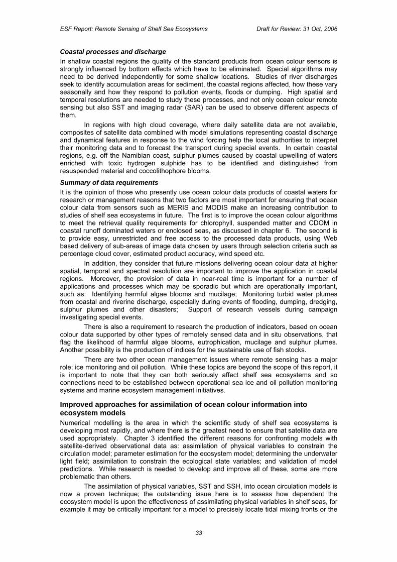
ESF Report: Remote Sensing of Shelf Sea Ecosystems Draft for Review: 31 Oct, 2006
Coastal processes and discharge In shallow coastal regions the quality of the standard products from ocean colour sensors is strongly influenced by bottom effects which have to be eliminated. Special algorithms may need to be derived independently for some shallow locations. Studies of river discharges seek to identify accumulation areas for sediment, the coastal regions affected, how these vary seasonally and how they respond to pollution events, floods or dumping. High spatial and temporal resolutions are needed to study these processes, and not only ocean colour remote sensing but also SST and imaging radar (SAR) can be used to observe different aspects of them.
In regions with high cloud coverage, where daily satellite data are not available, composites of satellite data combined with model simulations representing coastal discharge and dynamical features in response to the wind forcing help the local authorities to interpret their monitoring data and to forecast the transport during special events. In certain coastal regions, e.g. off the Namibian coast, sulphur plumes caused by coastal upwelling of waters enriched with toxic hydrogen sulphide has to be identified and distinguished from resuspended material and coccolithophore blooms.
Summary of data requirements It is the opinion of those who presently use ocean colour data products of coastal waters for research or management reasons that two factors are most important for ensuring that ocean colour data from sensors such as MERIS and MODIS make an increasing contribution to studies of shelf sea ecosystems in future. The first is to improve the ocean colour algorithms to meet the retrieval quality requirements for chlorophyll, suspended matter and CDOM in coastal runoff dominated waters or enclosed seas, as discussed in chapter 6. The second is to provide easy, unrestricted and free access to the processed data products, using Web based delivery of sub-areas of image data chosen by users through selection criteria such as percentage cloud cover, estimated product accuracy, wind speed etc. In addition, they consider that future missions delivering ocean colour data at higher spatial, temporal and spectral resolution are important to improve the application in coastal regions. Moreover, the provision of data in near-real time is important for a number of applications and processes which may be sporadic but which are operationally important, such as: Identifying harmful algae blooms and mucilage; Monitoring turbid water plumes from coastal and riverine discharge, especially during events of flooding, dumping, dredging, sulphur plumes and other disasters; Support of research vessels during campaign investigating special events. There is also a requirement to research the production of indicators, based on ocean colour data supported by other types of remotely sensed data and in situ observations, that flag the likelihood of harmful algae blooms, eutrophication, mucilage and sulphur plumes. Another possibility is the production of indices for the sustainable use of fish stocks. There are two other ocean management issues where remote sensing has a major role; ice monitoring and oil pollution. While these topics are beyond the scope of this report, it is important to note that they can both seriously affect shelf sea ecosystems and so connections need to be established between operational sea ice and oil pollution monitoring systems and marine ecosystem management initiatives.
Improved approaches for assimilation of ocean colour information into ecosystem models Numerical modelling is the area in which the scientific study of shelf sea ecosystems is developing most rapidly, and where there is the greatest need to ensure that satellite data are used appropriately. Chapter 3 identified the different reasons for confronting models with satellite-derived observational data as: assimilation of physical variables to constrain the circulation model; parameter estimation for the ecosystem model; determining the underwater light field; assimilation to constrain the ecological state variables; and validation of model predictions. While research is needed to develop and improve all of these, some are more problematic than others. The assimilation of physical variables, SST and SSH, into ocean circulation models is now a proven technique; the outstanding issue here is to assess how dependent the ecosystem model is upon the effectiveness of assimilating physical variables in shelf seas, for example it may be critically important for a model to precisely locate tidal mixing fronts or the
33
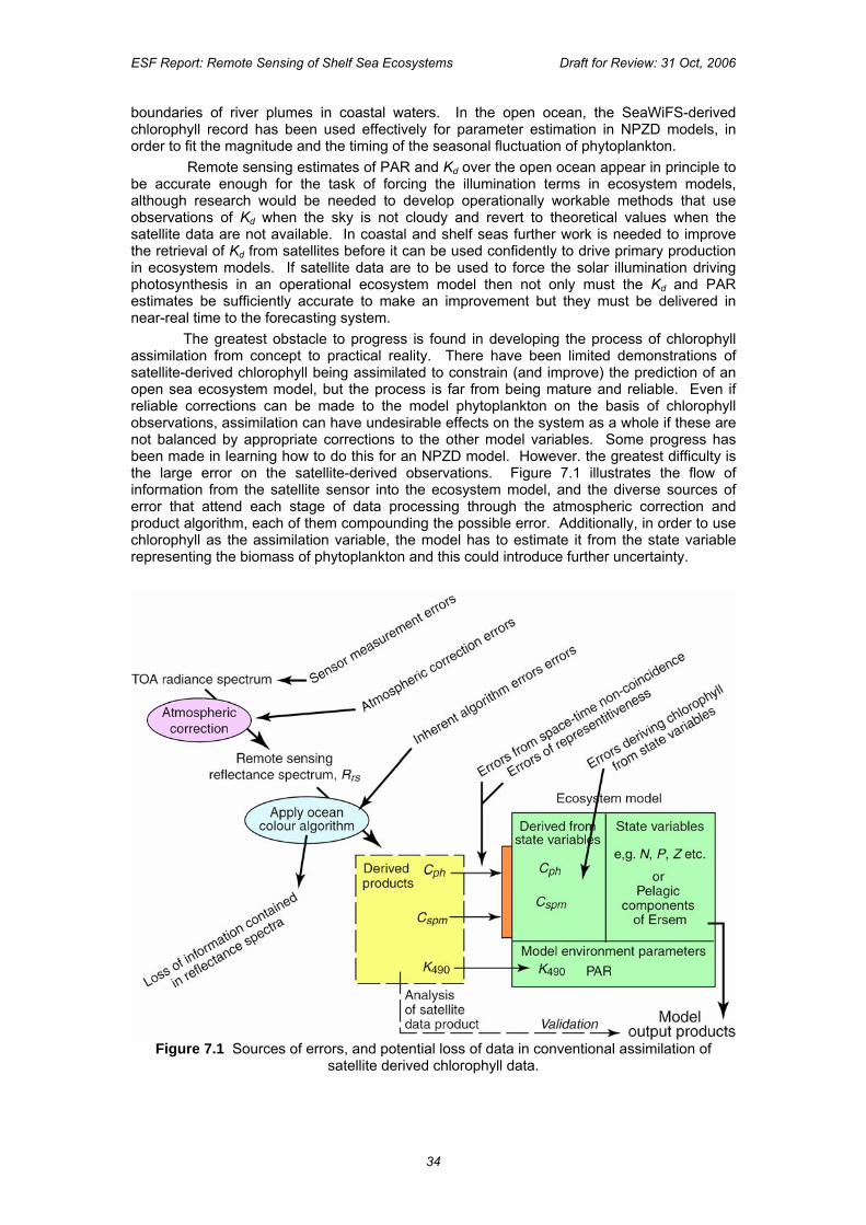
ESF Report: Remote Sensing of Shelf Sea Ecosystems Draft for Review: 31 Oct, 2006
boundaries of river plumes in coastal waters. In the open ocean, the SeaWiFS-derived chlorophyll record has been used effectively for parameter estimation in NPZD models, in order to fit the magnitude and the timing of the seasonal fluctuation of phytoplankton.
Remote sensing estimates of PAR and Kd over the open ocean appear in principle to be accurate enough for the task of forcing the illumination terms in ecosystem models, although research would be needed to develop operationally workable methods that use observations of Kd when the sky is not cloudy and revert to theoretical values when the satellite data are not available. In coastal and shelf seas further work is needed to improve the retrieval of Kd from satellites before it can be used confidently to drive primary production in ecosystem models. If satellite data are to be used to force the solar illumination driving photosynthesis in an operational ecosystem model then not only must the Kd and PAR estimates be sufficiently accurate to make an improvement but they must be delivered in near-real time to the forecasting system. The greatest obstacle to progress is found in developing the process of chlorophyll assimilation from concept to practical reality. There have been limited demonstrations of satellite-derived chlorophyll being assimilated to constrain (and improve) the prediction of an open sea ecosystem model, but the process is far from being mature and reliable. Even if reliable corrections can be made to the model phytoplankton on the basis of chlorophyll observations, assimilation can have undesirable effects on the system as a whole if these are not balanced by appropriate corrections to the other model variables. Some progress has been made in learning how to do this for an NPZD model. However. the greatest difficulty is the large error on the satellite-derived observations. Figure 7.1 illustrates the flow of information from the satellite sensor into the ecosystem model, and the diverse sources of error that attend each stage of data processing through the atmospheric correction and product algorithm, each of them compounding the possible error. Additionally, in order to use chlorophyll as the assimilation variable, the model has to estimate it from the state variable representing the biomass of phytoplankton and this could introduce further uncertainty.
Figure 7.1 Sources of errors, and potential loss of data in conventional assimilation of satellite derived chlorophyll data.
34
ESF Report: Remote Sensing of Shelf Sea Ecosystems Draft for Review: 31 Oct, 2006
The global error estimate of 30% on satellite-derived chlorophyll in the open ocean makes it difficult for the model to assign a lot of weight to the discrepancy between model and observation during the assimilation procedure. Consequently it is hard to see how occasional cloud-free views of the ocean will be able effectively to constrain the model to represent real bloom events with the correct spatial patchiness and timing. This is why it is so essential that not only are the ocean colour-derived chlorophyll estimates improved, but also error estimates are assigned to each observation. In that way, those pixels for which the chlorophyll is confidently known will carry more influence in the assimilation scheme. Present research and development of operational chlorophyll assimilation schemes should show in the next few years how well the open ocean ecosystem models can be constrained by satellite data. Unfortunately, on moving from the open ocean to shelf seas and coastal waters the assimilation problem is compounded. Not only do the errors on satellite chlorophyll increase greatly, approaching 100% in Case 2 conditions, but the ecosystem models are typically of much greater complexity. Even in the case of the simple NPZD approach, several of the state variables are not readily observed, such as the zooplankton biomass or the detritus, and so there are potential problems when assimilation is performed on only one of these. In complex ecosystem models there may be twenty or more pelagic state variables, including several functional types of phytoplankton. This raises questions of how to match a single satellite-measured value of chlorophyll to several model partitions containing chlorophyll. On the other hand, it can be argued that, in principle the detailed spectral reflectance from an ocean colour sensor can be interrogated to yield estimates not only of total chlorophyll, but of the proportion of different functional groups. Moreover, independent estimates of CDOM and SPM are potentially available from the satellite, and these may be useful for approximately constraining model variables representing dissolved organic carbon and suspended sediments. Thus we are presented with the challenging task of developing the most effective way of confronting a shelf ecosystem model with data from an ocean colour sensor in order to maximise the transfer of relevant information that will constrain the model to represent the actual ocean as closely as possible. This is likely to require new approaches to assimilation. One suggestion is to get the model to predict for itself what the water leaving reflectance should be, and then to confront the atmospherically corrected reflectance spectra directly at the assimilation interface, as shown schematically in figure 7.2. The advantage of this would be to eliminate several of the stages in the standard approach (fig 7.1) where errors are introduced by uncertain inversion of the forward optical model (see chapters 5 and 6). The extra internal errors from predicting the reflectance should be much less since the forward optical model itself is well defined. Another significant advantage is that it allows the whole spectrum, as measured, to be utilised. The model would need to rely very heavily on a comprehensive knowledge of the SIOPs in order to predict the subsurface reflectance, reinforcing the issues raised in chapter 6.
Figure 7.2 Schematic for a reflectance assimilation scheme.
35
ESF Report: Remote Sensing of Shelf Sea Ecosystems Draft for Review: 31 Oct, 2006
As well as developing more effective assimilation strategies, there is also an important need for the marine modelling community to perform sensitivity studies of the impact of observations on the models’ performance. Given the long lead time for establishing a secure and stable flow of satellite data, it is important for the modelling community to be able to articulate as precisely as possible their requirements for observational data. As Europe moves towards the provision of an operational ocean forecasting system, it is essential for the planning of space infrastructure that realistic and rationally justified requirements for ocean colour and other satellite data over the next ten years are plainly stated. These should identify the type of data, the space-time sampling frequency, the desirable accuracy and its age on delivery. Given the cost of providing such data it is important that model experiments are performed which demonstrate the performance benefits gained from different scenarios of observational data, from both satellites and in situ sensors.
Monitoring and understanding climate changes in shelf seas
As the climate of our planet changes with accelerating rapidity, and increasing concentrations of atmospheric CO2 go hand in hand with rising global temperatures, the oceans serve to provide a stabilising influence, but they themselves are also changing measurably and the consequences of the ocean’s physical, chemical and biological feedbacks to the whole Earth system are not well understood. For example ocean pH has increased to a level not exceeded during the last 10 million years. The shelf seas are affected by global climate change because of several factors, including the slowly changing conditions of the deep oceans at their open boundaries, because of the changing weather patterns they experience directly, and because of the changing inputs from their coastal and inland hinterlands forced directly by changing weather and also by the human response to climate change. In addition to changes associated with global warming are other climate-scale changes produced anthropogenically as a consequence of industrialisation and economic development. Shelf sea ecosystems provide ample evidence of interannual-to-decadal changes in response to both natural and anthropogenic forcing at a variety of spatial and temporal scales, manifest for example in the decline of particular fisheries, in the increased occurrence of harmful algal blooms, or in eutrophication events.
If we are to cope with the consequences of climate scale changes to shelf sea ecosystems, it is essential that we gain a better scientific understanding of the processes which control the interactions between physical, chemical and biological factors in shelf seas. There is a need to unravel the complex web of cause, effect and feedbacks in the system if we are to learn what actions are needed to prevent or mitigate the worst problems. At the same time as improving understanding it is essential to monitor systematically and continuously the changes that are occurring in the shelf seas. This information is required for iterative improvement of the predictive capacity of ocean models over climate time scales. It is also needed to provide evidence-based policy guidance.
Faced with the prospect of an increasing pace of changes to ecosystems in shelf seas, it is important to be able to define a baseline of what is considered to be the present state of a sea, so that any future deviations from that norm can be readily recognised and objectively identified. This is difficult to do using only in situ records from isolated points, however extensive the time series, since not only the magnitude but also the spatial patterns of ocean parameters, vary climatically. For instance it is difficult with isolated point samples of a particular variable to distinguish a large scale temporal change from the spatial shift of an otherwise stable pattern of the variable. This is where the spatial sampling, broad overview, and long-term repeated sampling capability of satellite remote sensing can make a unique contribution. An example of this can be found in the global anomaly images of ocean chlorophyll which are being produced from SeaWiFS data now that an annual climatology is available from an eight year time series of global data.
Unfortunately, as discussed in previous chapters, the retrieval of ecosystem variables from SeaWiFS contains too many uncertainties in Case 2 waters for those climatologies to be useful in most shelf seas, but they point to what is needed as soon as improved retrieval of ecosystem variables in shelf seas can be achieved from ocean colour sensors. Because a decade or more of data are recommended to derive a reliable seasonal climatology, there is an urgency to secure the long term continuity of today’s imaging spectrometers such as
36
ESF Report: Remote Sensing of Shelf Sea Ecosystems Draft for Review: 31 Oct, 2006
MERIS which have the potential to retrieve useful ecosystem variables for defining the current climatology against which future changes can be measured. Fortunately, this urgent requirement for continued ocean colour observations at high spatial and temporal sampling frequency, with detailed spectral discrimination, is consistent with the needs of operational forecasting and downstream applications of ocean colour in shelf seas. However, when operational ocean colour monitoring needs are being addressed, it is essential that the practical solutions are found which will also meet this requirement to produce a high quality, stable, fine resolution climate time series of ocean colour image data. The climate archive of satellite ocean colour data should also include routine in situ observations of the ecosystem variables, and in situ optical measurements. Such a dataset will enable retrospective reanalysis of today’s ocean colour observations, using the improved understanding and skill in retrieving ecosystem variables from ocean colour data which may be expected to accrue in the future.
For several of the physical ocean variables discussed in chapter 4, especially SST, wind and waves, it is possible already to establish climatologies based on the time series of data already available, and therefore to be able to identify anomalies in near-real time as they occur.
List of recommendations from Chapter 7 a. Images of ocean colour data products should be accompanied, where possible, by the
coincident SST images. b. There is a requirement for ocean colour algorithms that can distinguish phytoplankton
functional groups c. There is a need to research the production of indicators, based on ocean colour data
supported by other types of remotely sensed data and in situ observations, that would flag the likelihood of harmful algae blooms, eutrophication, and other water quality problems.
d. Wider uptake of satellite ocean colour data requires that users are given easy, unrestricted and free access to the processed data products, using on-line Web based scene selection according to user-specified criteria.
e. Ecosystem parameters (such as concentration of chlorophyll, CDOM etc) retrieved from remotely sensed ocean colour should be accompanied by error estimates, preferably pixel specific in the case of image data fields.
f. There is a need to explore new approaches to assimilation of ocean colour data into ecosystem models, in order more effectively to utilise the information content of ocean colour image data in constraining the model.
g. While improvements in the retrieval of Kd and PAR are still needed for Case 2 waters, these variables need to be delivered in near-real time if they are to enhance the performance of operational ecosystem models.
h. The marine modelling community needs to perform sensitivity studies which measure the impact of observations on a model’s performance and quantify the benefits associated with improved accuracy and resolution of the data products assimilated by the model.
i. In order to monitor climatic changes within shelf sea ecosystems it is important to ensure that a consistent and continuous record of ocean colour remote sensing is made available for the foreseeable future, with sufficient spectral resolution to support the retrieval of ecosystem variables from Case 2 waters. The satellite climate dataset should be complemented by a comprehensive set of in situ samples of ecosystem variables, and in situ optical measurements, for validation purposes.
j. Provision should be made for regular reanalysis of archived ocean colour data, in order that the historic record reflects the best available knowledge of data retrieval methods.
k. A reliable climate record of shelf sea chlorophyll concentration and other ecosystem properties requires an effective strategy for combining the products from different ocean colour missions without introducing sensor specific bias.
37
ESF Report: Remote Sensing of Shelf Sea Ecosystems Draft for Review: 31 Oct, 2006
8. Enabling technologies and future technological developments
Scope and Timescales for technological developments
The previous chapter has emphasised the importance of maintaining indefinitely the daily global acquisition of medium resolution, 1 km, multispectral measurements of ocean colour from satellites, with at least the same capacity that is available today. In this section the impact of future technological developments for remote sensing of shelf sea ecosystems is assessed from three perspectives: satellite and sensor hardware, marine technology, other technology. The timescale for this assessment is best appreciated by considering technological developments that have impacted this science over the last ten years. In 1996 the new generation of ocean colour sensor was beginning to be launched with MOS, OCTS and POLDER, but data were not easily available. Remote sensing of shelf sea ecosystems was limited to a few, mainly large European research organizations performing mainly theoretical studies or using airborne or old CZCS data. The Internet was beginning to be used by the science community but high speed access was limited to large research organizations. In 2006 there are now a number of high quality ocean colour sensors in space, delivering data in near-real time to scientists worldwide. Any well-trained scientist with a PC and a high speed Internet connection and just a few weeks software preparation can receive, process and disseminate high quality satellite data products such as chlorophyll a maps, in near-real time. Most conference presentations on shelf sea ecosystems now show or refer to satellite imagery as a data source. This dramatic progress from 1996 to 2006 has been made possible by three key technological advances, the last of which could not have been easily predicted: the launching of satellite hardware prepared in the 1980s and 1990s; the continual improvements in computer processing power; the generalisation of low cost, high speed Internet access. The open data and software policy of NASA (cf. SeaWiFS/MODIS and SeaDAS) was also a crucial enabling factor in stimulating this revolution in remote sensing of shelf sea ecosystems. Theory and processing algorithm have seen a similar dramatic development, but it is clearly the technological advances in satellite, computer and communications hardware that have driven this revolution. Because of the ecosystem focus, the scope of this analysis is limited to biological, particularly phytoplankton-related, parameters, but it should not be overlooked that technological advances are also to be expected in the remote sensing and in situ measurements of physical ocean properties that will undoubtedly also impact on the monitoring of shelf seas.
Satellite and sensor hardware
Current usage of remote sensing for shelf sea ecosystems is based primarily on chlorophyll a related products derived from medium resolution (e.g. 1km), multispectral optical sensors such as SeaWiFS, MODIS and MERIS. Most current ocean colour sensors are mounted on large multi-sensor satellite platforms, managed and/or supported by national and international space agencies. However, a new generation of sensors is beginning to emerge through more experimental missions already in space such as Hyperion and CHRIS/PROBA as well as new missions currently in the development or planning stages. Over the next twenty years the following technological developments are likely to improve significantly data quality or availability for remote sensing of shelf sea ecosystems: Hyperspectral sensors can provide additional information needed for improved atmospheric corrections and better retrieval of ecosystem-related parameters from ocean colour data. In addition to improvements in existing chlorophyll a products, marine scientists are hoping that remote sensing will provide many new products relating to, for example: phytoplankton functional groups, cyanobacteria, harmful algae blooms, benthic vegetation, coral reefs, fluorescence, primary production, air-sea CO2 flux, etc. The remote sensing system design requirements proposed in (IOCCG, 2000) give a number of examples of useful spectral bands that are missing from the current generation of ocean colour sensors. Even if such discrete bands are added it is probable that the full potential of optical remote sensing of coastal waters will not be reached until hyperspectral resolution from the ultraviolet (UV) to the short
38
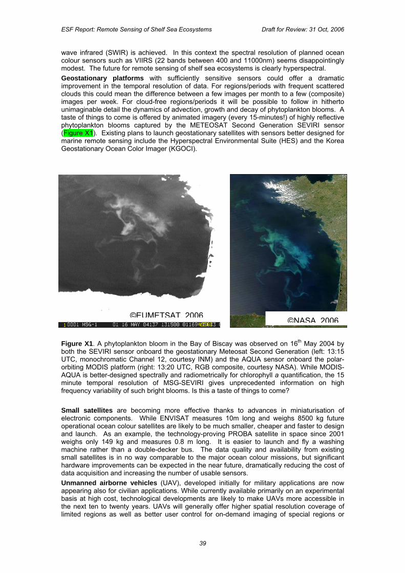
ESF Report: Remote Sensing of Shelf Sea Ecosystems Draft for Review: 31 Oct, 2006
wave infrared (SWIR) is achieved. In this context the spectral resolution of planned ocean colour sensors such as VIIRS (22 bands between 400 and 11000nm) seems disappointingly modest. The future for remote sensing of shelf sea ecosystems is clearly hyperspectral. Geostationary platforms with sufficiently sensitive sensors could offer a dramatic improvement in the temporal resolution of data. For regions/periods with frequent scattered clouds this could mean the difference between a few images per month to a few (composite) images per week. For cloud-free regions/periods it will be possible to follow in hitherto unimaginable detail the dynamics of advection, growth and decay of phytoplankton blooms. A taste of things to come is offered by animated imagery (every 15-minutes!) of highly reflective phytoplankton blooms captured by the METEOSAT Second Generation SEVIRI sensor (Figure X1). Existing plans to launch geostationary satellites with sensors better designed for marine remote sensing include the Hyperspectral Environmental Suite (HES) and the Korea Geostationary Ocean Color Imager (KGOCI).
©EUMETSAT, 2006 ©NASA, 2006
Figure X1. A phytoplankton bloom in the Bay of Biscay was observed on 16th May 2004 by both the SEVIRI sensor onboard the geostationary Meteosat Second Generation (left: 13:15 UTC, monochromatic Channel 12, courtesy INM) and the AQUA sensor onboard the polar-orbiting MODIS platform (right: 13:20 UTC, RGB composite, courtesy NASA). While MODIS-AQUA is better-designed spectrally and radiometrically for chlorophyll a quantification, the 15 minute temporal resolution of MSG-SEVIRI gives unprecedented information on high frequency variability of such bright blooms. Is this a taste of things to come? Small satellites are becoming more effective thanks to advances in miniaturisation of electronic components. While ENVISAT measures 10m long and weighs 8500 kg future operational ocean colour satellites are likely to be much smaller, cheaper and faster to design and launch. As an example, the technology-proving PROBA satellite in space since 2001 weighs only 149 kg and measures 0.8 m long. It is easier to launch and fly a washing machine rather than a double-decker bus. The data quality and availability from existing small satellites is in no way comparable to the major ocean colour missions, but significant hardware improvements can be expected in the near future, dramatically reducing the cost of data acquisition and increasing the number of usable sensors. Unmanned airborne vehicles (UAV), developed initially for military applications are now appearing also for civilian applications. While currently available primarily on an experimental basis at high cost, technological developments are likely to make UAVs more accessible in the next ten to twenty years. UAVs will generally offer higher spatial resolution coverage of limited regions as well as better user control for on-demand imaging of special regions or
39
ESF Report: Remote Sensing of Shelf Sea Ecosystems Draft for Review: 31 Oct, 2006
events, a niche currently occupied by manned airborne remote sensing. Whether UAVs will compete with satellites at the larger spatial scale of the shelf seas is less clear because of the complications of processing less systematic observations. The potential advantage of extra data by flying under clouds seems compromised by air traffic safety restrictions on UAV operations at low altitude. Nevertheless this is a technology to watch for the future. Improvements can be expected in many other aspects of satellite and sensor technology and the number of earth observation satellites with data of usable quality is likely to increase. On-demand pointable satellites, such as SPOT, will allow imaging of special events such as harmful algae blooms. Sensors with much higher spatial resolution will allow imaging of estuaries and the near shore region. However, in cases where limited signal to noise ratio leads to design compromises between spectral and spatial resolution it is likely that the spectral requirements will prevail for shelf sea ecosystem applications. Similarly for shelf sea ecosystems it is likely that the need for systematic observations will be more important than observations pointed on demand. The above considerations are based essentially on improvements of existing operational systems for passive optical remote sensing of marine parameters related to absorption, scattering or fluorescence. In the longer term entirely new types of sensor may become feasible allowing effective remote measurement of new parameters. It is difficult to predict which new technologies will actually deliver feasible new systems, though it is worth mentioning an interest in LIDAR systems, exploitation of Frauenhofer lines and bioluminescence.
Marine technology
The last ten years has seen rapid progress in real-time in situ observing systems thanks in part to corresponding technological advances and cost reductions in telecommunications and electronic systems. This has facilitated integration of remote sensing with in situ data, combining the excellent spatial coverage of remote sensing data with the excellent temporal coverage and extra parameters available from in situ data. Of particular interest for shelf sea ecosystems is the development of automated flow cytometers, which can provide information on phytoplankton species, thus complementing the spatial distribution on phytoplankton total biomass (or related parameters) available from remote sensing. For the open ocean the massive deployment of autonomous underwater vehicles (AUV), such as the ARGO profilers, has provided an enormous increase in information on the vertical structure of water masses (salinity and temperature), complementing surface information from remote sensing and less reliable but more complete information from models. For shelf seas the deployment of AUVs is less simple: horizontal and vertical space constraints increase the likelihood of failure by grounding and the denser ship traffic raises important issues of safety for navigation and legal responsibility for AUV operators.
Other technology
As well as the improvements in satellite and in situ data mentioned earlier, continued advances in computer technology will lead to improvements in the spatial resolution of ecosystem models and in perspectives for data assimilation. Thus the excellent spatial coverage of remote sensing data is complemented by the better temporal and vertical coverage of models. Computer security will become increasingly important as remote sensing systems become more and more reliant on networking of the data acquisition, processing and exploitation chain. Finally, by looking back twenty years to the pre-Internet era we should learn to expect that revolutionary new technologies may arise that will further stimulate remote sensing of shelf sea ecosystems. While the specifics are unpredictable it seems certain that remote sensing will continue to progress very significantly in the next twenty years driven by technological pro, in part, steered towards solving the present technological limitations faced by shelf sea science. For that reason it is important that a strong dialogue be maintained between agencies concerned with Earth observation technology and the community of ocean scientists and those responsible for the emerging field of marine forecasting.
40
ESF Report: Remote Sensing of Shelf Sea Ecosystems Draft for Review: 31 Oct, 2006
List of recommendations from Chapter 8 a. The development of “hyperspectral” ocean colour sensors, capable of sampling across
the whole visible spectrum at spectral resolutions down to a few nm, is recommended because such data promise additional ecosystem-related information especially in Case 2 water. Further benefits may be derived by extending their range into the UV and SWIR.
b. For low to mid latitude coastal seas, the development of ocean colour sensors for geostationary platforms is recommended, because of their enhanced sampling frequency appropriate for tracking shelf sea processes.
c. Encouragement should be given to exploring the utility of small satellites carrying ocean colour micro-sensors in order to extend the coverage and sampling frequency of the primary ocean colour missions.
d. The development of automated flow cytometers to provide information on phytoplankton species needs to be harnessed for enhancing the analysis and interpretation of ocean colour data.
41
ESF Report: Remote Sensing of Shelf Sea Ecosystems Draft for Review: 31 Oct, 2006
9. Conclusion 9.1 Summary of the science recommendations
In order to address fully the environmental and societal issues associated with the shelf seas, this report recognises that the monitoring systems being established to describe the state of the sea must include the marine ecosystem as a key element to be observed alongside the marine physical properties. Given the review of the field presented in this report, it is concluded that a priority task is to improve our scientific capacity for using ocean colour data as a basis for monitoring and describing shelf sea ecosystems. The goal is to match the achievements already reached in the observation and modelling of physical conditions in shelf seas. A large amount of work is still needed before observational and modelling tools for shelf sea ecosystems reach a standard comparable to those available for reporting and forecasting physical processes. The recommendations and necessary actions set out below offer a framework to assist in reaching that goal. They have been condensed from the detailed recommendations made at the end of each chapter {individually indicated by the characters in parentheses} Recommendation 1: Enhance the quantity and quality of the basic ecosystem parameters retrieved from optical measurements To improve our capacity to characterise the conditions in shelf sea ecosystems using ocean colour remote sensing methods, it is necessary that certain essential bio-optical variables can be retrieved with the best level of quality (accuracy, spatial and temporal resolution). These include: normalised water-leaving radiance, inherent optical properties (IOPs) of the water, phytoplankton pigments, phytoplankton functional types, CDOM (coloured dissolved organic material), optical diffuse attenuation coefficient (KD), suspended particular matter, PAR (photosynthetically available radiation) and SSI (surface solar irradiance). To achieve this, the following actions are essential: 1.1. Support the extensive field-based research needed to radically improve the basic knowledge of water optical properties (AOPs and IOPs) and their variability over shelf areas, and to build a comprehensive record of specific inherent optical properties (SIOPs) related to components of marine ecosystems. {5a, 5b, 6c, 5d, 5e, 5f, 5g} 1.2. Establish and maintain a long term high quality calibration/validation program supporting ocean colour observations including extensive in situ measurements referring to standardised protocols and a common archive standard. {5c, 5d, 5e, 6a, 6b} 1.3. Initiate a programme of research to solve specific problems of atmospheric corrections of coastal areas. {6c, 6d} 1.4. Reinforce the current research engaged in developing retrieval algorithms for ecosystem parameters from ocean colour remote sensing. {4c, 6e, 6f, 6g} 1.5. Ensure that all ecosystem data products retrieved from satellite observations are accompanied by individual error estimates. {7e} Recommendation 2: Improve the methodology for applying satellite ocean colour products to operational ecosystem monitoring The most promising route for maximising the ecosystem information extracted from satellite ocean colour data is through direct assimilation into operational shelf sea ecosystem models {4a}, but this presents considerable scientific challenges summarised in actions 2.1 - 2.3. However, there are also many downstream operational users of ocean colour data whose requirements must not be overlooked, justifying actions 2.4 - 2.5.
42
ESF Report: Remote Sensing of Shelf Sea Ecosystems Draft for Review: 31 Oct, 2006
2.1. Support research to develop new schemes for assimilating ocean colour data into marine ecosystem models, acknowledging the character of Case 2 bio-optical data products and maximising the information flow into the model. {7f} 2.2. Establish systems for delivering near-real time operational-level Kd and PAR products ready for assimilation in ecosystem models. {7g} 2.3. Promote effective dialogue between operational users of ecosystem model outputs or satellite ocean colour products, ocean colour scientists and ecosystem modellers. {7h} 2.4. Encourage research to enhance the applicability of ocean colour data products. {7a, 7b, 7c} 2.5. Unrestricted access to ocean colour data products as a public good is to be encouraged as the best way to expand the use of data and thus maximise the benefits from the investment in space infrastructure. {7d} Recommendation 3: Promote the availability of high quality climatologies and time series of ecosystem parameters The increasing urgency to understand how local environments are likely to respond to the climate changes expected to accompany global warming translates in this context into a requirement for long term stable records of shelf sea ecosystems that provide reference states against which the occurrence and extent of climate variability can be measured in future. This requires the following actions: 3.1. Establish long term plans for a system of ocean colour sensors, ecosystem models and in situ validation measurements, sufficiently secure to record shelf sea ecosystem parameters for the foreseeable future without gaps. Sensors having a capability comparable to MERIS would be adequate. {4b, 7i} 3.2. Develop strategies that harmonise ecosystem data retrieved from different ocean colour missions, and provide for regular reanalyses of the climate archive of ocean colour data in order to use the latest knowledge of the best processing methods {6h, 7j, 7k} Recommendation 4: Ensure that future observational systems are scaled to meet the sampling requirements for monitoring rapidly changing ecosystems in shelf seas Although there is much fundamental bio-optical science to be done before we can fully utilise the data from today’s ocean colour sensors, and the priority for future satellite missions must be to sustain data flow that supports operational models and lays down a climate record, new technological developments should still be pursued if they can improve the monitoring of shelf sea ecosystems. The following actions have been identified. 4.1 Encourage the testing and exploitation of data from geostationary sensors to explore whether they add value to the retrieval of information about shelf sea ecosystems {8b}. 4.2 Promote the development of new space and in situ technologies, such as hyperspectral sensors, micro sensors and automated flow cytometers, which promise improved sampling capabilities or additional ecosystem information retrieval. {8a, 8c, 8d}
43
ESF Report: Remote Sensing of Shelf Sea Ecosystems Draft for Review: 31 Oct, 2006
9.2 Policy, Organisation and Implementation
Having identified the scientific issues that need to be addressed if ocean colour data are to be effectively harnessed to the task of monitoring shelf sea ecosystems, the working group finally considered the organisational obstacles that may hinder progress. The following issues were identified: • There is an outstanding requirement to provide investment in fundamental scientific
research on the bio-optics of shelf sea ecosystems. This is needed to unlock the full potential of the ocean colour sensors already in place. If the underpinning science questions identified here are not addressed, ocean colour data from satellites will continue to under-perform as a tool for monitoring shelf sea ecosystems, in comparison with the successful application and assimilation of physical ocean data in monitoring the ocean’s physical state.
• The validity of ecosystem information retrieved by optical observations is critically dependent on the quality control of all instruments and measured bio-optical parameters. There would be considerable benefit in creating a quality oversight body which can set standards, establish measurement protocols, monitor experimental quality and promote best practice in all aspects of marine bio-optics, both in situ and remote sensing.
• There is considerable segregation between the separate scientific communities representing ocean colour optics and remote sensing, experimental ecosystem science, and shelf sea ecosystem modelling. Interaction and collaboration between these groups should be promoted.
• Ocean colour satellite missions in Europe tend previously to have suffered from inadequate investment in the fieldwork programmes needed for calibration and validation. Future ocean colour programs are likely to serve a semi-operational role and it is strongly recommended that the expense of field measurements for calibration and validation (the latter extending through the lifetime of the sensor) should be budgeted as an integral part of the mission’s ground segment.
• If ocean colour remote sensing is to be considered as a tool for monitoring shelf sea ecosystems, either operational or scientific, it is essential to assure long-term continuity of data provision if users are to have enough confidence to invest in their own infrastructure for using the satellite data in ecosystem models.
• There is a need to liberalise the data policy for European satellite programmes in order to meet the aspirations of recommendation 2.5. The scientific community is presently forced to use data from alternative (in some cases possibly inferior) sensors, or else does not engage at all, because of the obstacles to acquiring large volumes of high quality data in near-real time. Until this blockage is eased, there will be a failure to exploit fully the investment in satellite infrastructure.
44
ESF Report: Remote Sensing of Shelf Sea Ecosystems Draft for Review: 31 Oct, 2006
References
[incomplete] The few key references cited in the text are defined here. The bibliography below provides a much wider sample of the literature on which this report is based Antoine and Morel, 1999 Gordon, 1997 Morel and Prieur Prieur and Sathyendranath Robinson, I. S. (2004).
Bibliography
[incomplete] The following scientific publications provide the basis for the chapter contents
Chapter 3 Allen, J.I., Blackford, J., Holt, J., Proctor, R., Ashworth, M. and Siddorn, J., 2001. A highly spatially
resolved ecosystem model for the North West European Continental Shelf. Sarsia, 86(6): 423-440.
Alvain, S., Moulin, C., Dandonneau, Y. and Breon, F.M., 2005. Remote sensing of phytoplankton groups in case 1 waters from global SeaWiFS imagery. Deep-Sea Research Part I-Oceanographic Research Papers, 52(11): 1989-2004.
Anderson, T.R., 2005. Plankton functional type modelling: running before we can walk? Journal of Plankton Research, 27(11): 1073-1081.
Armstrong, R.A., 2003. A hybrid spectral representation of phytoplankton growth and zooplankton response: The "control rod" model of plankton interaction. Deep-Sea Research Part Ii-Topical Studies in Oceanography, 50(22-26): 2895-2916.
Chai, F., Dugdale, R.C., Peng, T.H., Wilkerson, F.P. and Barber, R.T., 2002. One-dimensional ecosystem model of the equatorial Pacific upwelling system. Part I: model development and silicon and nitrogen cycle. Deep-Sea Research Part Ii-Topical Studies in Oceanography, 49(13-14): 2713-2745.
Edelvang, K., Kaas, H., Erichsen, A.C., Alvarez-Berastegui, D., Bundgaard, K. and Jorgensen, P.V., 2005. Numerical modelling of phytoplankton biomass in coastal waters. Journal of Marine Systems, 57(1-2): 13-29.
European Science Foundation, 2005. Modelling in Coastal and Shelf Seas – European Challenges. ESF Marine Board Position Paper 7
Fennel, W., Neumann, T. 2004: Introduction to the Modelling of Marine Ecosystems, Elsevier Oceanography Series 72, Elsevier, 297pp
Garcia, S.M., Zerbi, A., Aliaume, C., Do Chi, T. and Lasserre, G., 2003. The ecosystem approach to fisheries: issues, terminology, principles, institutional foundations, implementation and outlook. FAO Fisheries Technical Paper No. 443, Rome.
Kone, V., Machu, E., Penven, P., Andersen, V., Garcon, V., Freon, P. and Demarcq, H., 2005. Modeling the primary and secondary productions of the southern Benguela upwelling system: A comparative study through two biogeochemical models. Global Biogeochemical Cycles, 19(4).
Le Fouest, V., Zakardjian, B., Saucier, F.J. and Cizmeli, S.A., 2006. Application of SeaWIFS- and AVHRR-derived data for mesoscale and regional validation of a 3-D high-resolution physical-biological model of the Gulf of St. Lawrence (Canada). Journal of Marine Systems, 60(1-2): 30-50.
Martin, A.P., Zubkov, M.V., Burkill, P.H. and Holland, R.J., 2005. Extreme spatial variability in marine picoplankton and its consequences for interpreting Eulerian time-series. Biology Letters, 1(3): 366-369.
Miller, P.I., Shutler, J.D., Moore, G.F. and Groom, S.B., 2006. SeaWiFS discrimination of harmful algal bloom evolution. International Journal of Remote Sensing, in press.
Moll, A., 2000. Assessment of three-dimensional physical-biological ECOHAM1 simulations by quantified validation for the North Sea with ICES and ERSEM data. Journal of Marine Science, 57(4): 1060-1068.
45
ESF Report: Remote Sensing of Shelf Sea Ecosystems Draft for Review: 31 Oct, 2006
Moll, A. and Radach, G., 2003. Review of three-dimensional ecological modelling related to the North Sea shelf system - Part 1: models and their results. Progress in Oceanography, 57(2): 175-217.
Moore, J.K., Doney, S.C., Kleypas, J.A., Glover, D.M. and Fung, I.Y., 2002. An intermediate complexity marine ecosystem model for the global domain. Deep-Sea Research Part Ii-Topical Studies in Oceanography, 49(1-3): 403-462.
Oschlies, A., Garçon, V., 1998. An eddy-induced enhancement of primary production in a model of the North Atlantic Ocean. Nature, 394, 266–269.
Oschlies, A., Garçon, V., 1999. An eddy-permitting coupled physical – biological model of the North Atlantic: 1. Sensitivity to advection numerics and mixed layer physics. Glob. Biogechem. Cycles, 13 (1), 135–160.
Oschlies, A., Koeve, W., Garçon, V., 2000. An eddy-permitting coupled physical-biological model of the North Atlantic 2. Ecosystem dynamics and comparison with satellite and JGOFS local studies data. Global Biogeochemical Cycles, 14, 499-523.
Palmer, J.R. and Totterdell, I.J., 2001. Production and export in a global ocean ecosystem model. Deep-Sea Res. I, 48(5), 1169-1198.
Powell, E.N., Klinck, J.M., Hofmann, E.E. and McManus, M.A., 2003. Influence of water allocation and freshwater inflow on oyster production: A hydrodynamic-oyster population model for Galveston Bay, Texas, USA. Environmental Management, 31(1): 100-121.
Proctor, R., Holt, J.T., Allen, J.I. and Blackford, J., 2003. Nutrient fluxes and budgets for the North West European Shelf from a three-dimensional model. Science of the Total Environment, 314: 769-785.
Salihoglu, B. and Hofmann, E.E., 2006. Modelling the effects of physical and biogeochemical processes on phytoplankton species and carbon production in the equatorial Pacific Ocean. Submitted to Progress in Oceanography.
Skogen, M. and Soiland, H., 1998. A user's guide to NORWECOM v2, The Norwegian Ecological Modeling System. Fisken og Havet, 18: 42.
Skogen, M.D. and Moll, A., 2005. Importance of ocean circulation in ecological modeling: An example from the North Sea. Journal of Marine Systems, 57(3-4): 289-300.
Spitz, Y.H., Allen, J.S. and Gan, J., 2005. Modeling of ecosystem processes on the Oregon shelf during the 2001 summer upwelling. Journal of Geophysical Research-Oceans, 110(C10).
Tittensor, D.P., Deyoung, B. and Tang, C.L., 2003. Modelling the distribution, sustainability and diapause emergence timing of the copepod Calanus finmarchicus in the Labrador Sea. Fisheries Oceanography, 12(4-5): 299-316.
Villanoy, C.L., Azanza, R.V., Alternerano, A. and Casil, A.L., 2006. Attempts to model the bloom dynamics of Pyrodinium, a tropical toxic dinoflagellate. Harmful Algae, 5(2): 156-183.
Chapter 4 Siegel, H., T. Seifert, G. Schernewski, M. Gerth, J. Reißmann, T. Ohde, V. Podsetchine,. 2005):
Discharge and transport processes along the German Baltic Sea Coast. Ocean Dynamics, V.55, 1, April 2005, 47-66
TBC
Chapter 5 Bukata, R. P., Jerome, J. H., Kondratyev, K. Ya., & Pozdnyakov, D. V. (1995). Optical Properties and
Remote Sensing of Inland and Coastal Waters, CRC Press, Boca Raton. Darecki M., A. Weeks, S. Sagan, P. Kowalczuk S., Kaczmarek, 2003, Optical characteristics of two
contrasting Case 2 waters and their influence on remote sensing algorithms. Continental Shelf Research, 23, 3-4, 237-250.
Ficek D., Kaczmarek S., Stoń-Egiert J., Wozniak B., Majchrowski R., Dera J., 2004, Spectra of light absorption by phytoplankton pigments in the Baltic; conclusions to be drawn from a Gaussian analysis of empirical data, Oceanologia, 46(4), 533-555
Højerslev, N. K. & Aas, E. (2001). Spectral light absorption by yellow substance in the Kattegat - Skagerrak area. Oceanologia, 43, 39-60.
Kowalczuk P., 1999, Seasonal variability of yellow substance absorption in the surface layer of the Baltic Sea. Journal of Geophysical Research, 104(C12), 30 047-30 058.
Majchrowski R., Wozniak B., Dera J., Ficek D., Kaczmarek S., Ostrowska M., Koblentz-Mishke O. I., 2000, Model of the in vivo spectral absorption of algal pigments. Part 2. Practical application of the model, Oceanologia, 42(2), 191-202.
Ohde, T., H. Siegel, M. Gerth (2005): Results of MERIS Level-2 product validation in the Baltic Sea, the Namibian coastal area and the Atlantic Ocean. Int. J. Remote Sensing, in press.
46
ESF Report: Remote Sensing of Shelf Sea Ecosystems Draft for Review: 31 Oct, 2006
Olszewski J., Sagan. S., Darecki M., 1993, Spatial and temporal changes in some optical parameters in the Southern Baltic. Oceanologia, 33 pp 87.
Siegel, H., M. Gerth, T. Ohde, T. Heene (2005). Ocean colour remote sensing relevant water constituents and optical properties of the Baltic Sea. Int. J. Remote Sensing, Vol. 26, 2, 315-330.
Wozniak B., Dera J., 2000, Luminescence and photosynthesis of marine phytoplankton - a brief presentation of new results, Oceanologia, 42(2), 137-156.
Wozniak B., Dera J., Ficek D., Majchrowski R., Kaczmarek S., Ostrowska M., Koblentz-Mishke O. I., 2000, Model of the in vivo spectral absorption of algal pigments. Part 1. Mathematical apparatus, Oceanologia, 42(2), 177-190.
TBC
Chapter 6 References; 6-1 Hooker, S. B., Esaias, W. E., Feldman, G. C., Gregg, W. W. and Mc Clain, C. R. (1992), An overview of SeaWiFS
and ocean colour. In S. B. Hooker and E. R. Firestone, SeaWiFS Technical report series, NASA Technical Memorandum 104566, 1,(pp. 24). Greenbelt, Maryland, NASA Goddard Space Flight Centre.
IOCCG (2000). Remote Sensing of Ocean Colour in Coastal, and Other Optically-Complex, Waters. Sathyendranath, S. (ed.), Reports of the International Ocean-Colour Coordinating Group, No. 3, IOCCG, Dartmouth, Canada.
Rast, M., Bézy, J.L. and Bruzzi, S. (1999), The ESA Medium Resolution Imaging Spectrometer MERIS – a review of the instrument and its mission. Int. J. Remote Sensing, 20, 1681-1702.
Salomonson, V. V., Toll, D. L. & Lawrence, W. T. (1992). Moderate resolution imaging spectroradiometer (MODIS) and observations of the land surface. Proceeding de 1992 International Geoscience and Remote Sensing Symposium (IGARSS'92à, Houston, Texas.
References; 6-2 Antoine, D., and A. Morel. 1999. A multiple scattering algorithm for atmospheric correction of remotely sensed ocean
colour (MERIS instrument): principle and implementation for atmospheres carrying various aerosols including absorbing ones. International Journal of Remote Sensing 20: 1875-1916.
Arnone, R. A., P. Martinolich, R. W. Gould, R. Stumpf, and S. Ladner. 1998. Coastal optical properties using SeaWiFS. Presented at Ocean Optics XIV held in Kailua-Kona Hawaii, 10-13 November 1998. Ocean Optics XIV CD-ROM (Office of Naval Research, Washington, D.C., 1998).
Behnert, I., R. Doerffer, V. Matthias, and P. R. Kipp. 2003. An aerosol climatology over the North Sea for an atmospheric correction of MERIS imagery. Journal of Aerosol Science Supplement: 889-890.
Gordon, H. R. 1997. Atmospheric correction of ocean color imagery in the Earth Observing System era. Journal of Geophysical Research 102: 17081-17106.
Gordon, H. R., J. W. Brown, and R. H. Evans. 1988. Exact Rayleigh scattering calculations for use with the Nimbus-7 Coastal Zone Color Scanner. Applied Optics 27: 862-871.
Gordon, H. R., T. Du, and T. Zhang. 1997. Remote sensing of ocean color and aerosol properties: resolving the issue of aerosol absorption. Applied Optics 36: 8670-8684.
Gordon, H. R., and M. Wang. 1994a. Influence of oceanic whitecaps on atmospheric correction of ocean-color sensors. Applied Optics 33: 7754-7763.
Gordon, H. R., and M. Wang. 1994b. Retrieval of water-leaving radiance and aerosol optical thickness over the oceans with SeaWiFS: a preliminary algorithm. Applied Optics 33: 443-452.
Hu, C., K. L. Carder, and F. Muller-Karger. 2000. Atmospheric correction of SeaWiFS imagery over turbid coastal waters: a practical method. Remote Sensing of the Environment 74: 195-206.
IOCCG, 2000. Remote sensing of ocean colour in coastal, and other optically-complex waters. Sathyendranath, S. (ed.), Reports of the International Ocean Colour Coordinating Group No. 3, IOCCG, Dartmouth, Canada, 140pp.
IOCCG. 2004. Guide to the creation and use of ocean-colour level-3 binned data products. Antoine, D. (ed.), IOCCG Report Reports of the International Ocean Colour Coordinating Group No. 4 , IOCCG, Dartmouth, Canada, 88pp
IOCCG. 2006. Ocean colour data merging. Reports of the International Ocean Colour Coordinating Group No. 5 , IOCCG, Dartmouth, Canada, 60pp
Kaufman, Y. J., D. Tanré, H. R. Gordon, T. Nakajima, J. Lenoble, R. Frouin, H. Grassl, B. M. Herman, M. D. King, and P. M. Teillet. 1997. Passive remote sensing of tropospheric aerosol and atmospheric correction for the aerosol effect. Journal of Geophysical Research 102: 16815-16830.
Lavender, S. J., M. H. Pinkerton, G. F. Moore, J. Aiken, and D. Blondeau-Patissier. 2005. Modification to the atmospheric correction of SeaWiFS ocean colour images over turbid waters. Continental Shelf Research 25: 539-555.
Moore, G. F., J. Aiken, and S. J. Lavender. 1999. The atmospheric correction of water colour and the quantitative retrieval of suspended particulate matter in Case II waters: application to MERIS. International Journal of Remote Sensing 20: 1713-1734.
47
ESF Report: Remote Sensing of Shelf Sea Ecosystems Draft for Review: 31 Oct, 2006
Reinart, A., and D. Pierson. 2005. Water quality monitoring of large European lakes using MERIS full resolution data. Envisat and ERS Symposium. European Space Agency.
Reinersman, P. N., and K. L. Carder. 1995. Monte Carlo simulation of the atmospheric point-spread function with an application to correction for the adjacency effect. Applied Optics 34: 4453-4471.
Ruddick, K., V. D. Cauwer, and B. V. Mol. 2005. Use of the near infrared similarity spectrum for the quality control of remote sensing data. In R. J. Frouin, M. Babin and S. Sathyendranath [eds.], SPIE international conference 5885 on Remote sensing of the coastal oceanic environment. SPIE.
Ruddick, K. G., V. De Cauwer, Y. Park, and G. Moore. 2006. Seaborne measurements of near infrared water-leaving reflectance - the similarity spectrum for turbid waters. Limnol. and Oceanogr. 51: 1167-1179.
Ruddick, K. G., F. Ovidio, and M. Rijkeboer. 2000. Atmospheric correction of SeaWiFS imagery for turbid coastal and inland waters. Applied Optics 39: 897-912.
Santer, R., and C. Schmechtig. 2000. Adjacency effects on water surfaces: primary scattering approximation and sensitivity study. Applied Optics 39: 361-375.
Stumpf, R. P., R. A. Arnone, R. W. Gould, P. M. Martinolich, and V. Ransibrahmanakhul. 2002. A partially-coupled ocean-atmosphere model for retrieval of water-leaving radiance from SeaWiFS in coastal waters., p. 51-59. Algorithm Updates for the Fourth SeaWiFS Data reprocessing. NASA Technical Memorandum.
Sturm, B. 1980. The atmospheric correction of remotely sensed data and the quantitative determination of suspended matter in marine water surface layers, p. 163-197. In A. P. Cracknell [ed.], Remote sensing in meteorology, oceanography and hydrology. Ellis Horwood.
Viollier, M., D. Tanré, and P. Y. Deschamps. 1980. An algorithm for remote sensing of water color from space. Boundary Layer Meteorology: 247-267.
Wang, M., and W. Shi. 2005. Estimation of ocean contribution at the MODIS near-infrared wavelengths along the east coast of the U.S.: Two case studies. Geophysical Research Letters 32.
References; 6-3, 6-4 Darecki M, Stramski D., 2004. An Evaluation of Modis and Seawifs Bio-Optical Algorithms in the Baltic
Sea, Remote Sensing of Environment. Vol 89/3 pp 326-350.
Darecki M., Kaczmarek S., Olszewski J., 2005, SeaWiFS chlorophyll algorithms for the Southern Baltic. International Journal of Remote Sensing,Vol.26, No.2, 247-260.
Lee Z, Darecki M., Carder K.L., Davis C.O., Stramski D.,. Rhea W.J,2005 Diffuse attenuation coefficient of downwelling irradiance: An evaluation of remote sensing methods. Journal of Geophysical Research - Oceans, Vol.110, C02017.
Lee, Z.P., and K.L. Carder, Band-ratio or spectral-curvature algorithms for satellite remote sensing?, Applied Optics, 39, 4377-4380, 2000.
Lee, Z.P., and K.L. Carder, Absorption spectrum of phytoplankton pigments derived from hyperspectral remote-sensing reflectance, Remote Sens. Environ., 89, 361-368, 2004.
Olszewski J., P. Kowalczuk, M. Darecki, 1999, In-water remote sensing algorithms for the detection of chlorophyll and yellow substances in the Pomeranian Bay, Oceanologia, 41(3), pp. 461-474.
Wozniak B., Krężel A., Dera J., 2004, Development of a satellite method for Baltic ecosystem monitoring (DESAMBEM) - an ongoing project in Poland, OCEANOLOGIA, 46(3), 445-455.
Chapter 7 Siegel, H., M. Gerth, T. Ohde (2002): Remote Sensing Applications in Coastal Zone Management.
Schernewski, G. & U. Schiewer (Eds.): Baltic coastal ecosystems: Structure, function and coastal zone management. CEEDES Series, Springer Verlag, 279-292.
Siegel, H., M. Gerth (2000): The exceptional summer 1997 in the Baltic Sea – The warmest August, the Oder flood, and phytoplankton blooms. In Satellites, Oceanography and Society, Ed. D. Halpern, Elsevier Oceanography Series, 239-254.
Siegel, H., W. Matthäus, R. Bruhn, G. Nausch, T. Neumann, C. Pohl (1998): The exceptional Oder flood in summer 1997- Distribution patterns of the Oder discharge in the Pomeranian Bight, DHZ, 50, (2/3), 145-167.
Siegel, H., T. Seifert, G. Schernewski, M. Gerth, J. Reißmann, T. Ohde, V. Podsetchine (2005): Discharge and transport processes along the German Baltic Sea Coast. Ocean Dynamics, 55 (1), April 2005, 47-66.
TBC
Chapter 8 TBC
48