Embed Size (px)
Citation preview
Remote Sensing and Digital Databases to Recovery Terrestrial Boundaries in West Africa – Cape Roxo Region
(7856)
Adélia Sousa, Ana Melo, Maria Nunes, Ana Cabral and Ana Morgado (Portugal)
FIG Working Week 2015
From the Wisdom of the Ages to the Challenges of the Modern World
Sofia, Bulgaria, 17-21 May 2015
1/15
Remote Sensing and Digital Databases to Recovery Terrestrial Boundaries
in West Africa – Cape Roxo Region
Adélia SOUSA, Ana MELO, Maria NUNES, Ana CABRAL, Fernando COSTA and Ana
MORGADO, Portugal
Keywords: Remote Sensing, International Boundaries, GIS, Multitemporal Analysis
SUMMARY
This case study focuses on borderlands located in Guinea Bissau, more specifically on the
borderland of Cape Roxo region, with a controversial geographic location which have been
raising great interest and several disputes, mainly due to the lack of geographical information.
This study intends to contribute to clarify the problem combining geographical information
and multitemporal analysis to define the exact position of some boundary beacons.
The geographical information used, includes all available data, from old and actual maps and
technical reports to most recent data obtained from new geospatial technologies. Historic and
geographic information, describing the Guinea Bissau boundaries, combined with ancient
aerial photographs (1950-1960) and recent high spatial resolution satellite images (2013),
WorldView-2, are used in a Geographic Information System (GIS) to perform the
multitemporal study.
The spatial resolution of WorldView-2 images was improved using several pan-sharpening
algorithms to combine multispectral and panchromatic bands in order to obtain a pan-
sharpened image with higher spatial resolution. This procedure enhances the spatial
information improving the interpretation of terrain features.
Multitemporal analysis detected changes in coastal landforms, in Cape Roxo region, showing
significant shoreline erosion/accretion, a high dynamic lagoon-beach system and relative
stability of the inshore dune, where a boundary beacon is located.
Remote Sensing and Digital Databases to Recovery Terrestrial Boundaries in West Africa – Cape Roxo Region
(7856)
Adélia Sousa, Ana Melo, Maria Nunes, Ana Cabral and Ana Morgado (Portugal)
FIG Working Week 2015
From the Wisdom of the Ages to the Challenges of the Modern World
Sofia, Bulgaria, 17-21 May 2015
2/15
SUMÁRIO
O presente estudo incide sobre a região do Cabo Roxo, na Guiné-Bissau, cuja localização
geográfica suscita bastante interesse, a tal ponto que várias disputas que têm ocorrido
principalmente devido à falta de informação geográfica. Neste estudo usa-se os Sistemas de
Informação Geográfica e os estudos multitemporais para definir a posição exacta dos marcos
de fronteira.
A informação geográfica utilizada inclui todos os dados disponíveis desde os mapas antigos e
relatórios técnicos, sobre essa região, aos dados mais recentes obtidos a partir das novas
tecnologias geoespaciais. Informação histórica e geográfica, descrevendo os limites da Guiné-
Bissau, juntamente com fotografias aéreas (1950-1960) e imagens de alta resolução espacial
recentes (2013), WorldView-2. O cruzamento destes dados é feito e analisado no Sistema de
Informação Geográfica (SIG), para realizar um estudo multitemporal.
Para melhorar a resolução espacial da imagem WorldView-2, são aplicadas várias técnicas às
bandas multiespectrais e pancromática, através da utilização de vários algoritmos de fusão
disponíveis, para obter uma imagem fundida com maior resolução espacial. Este
procedimento permitirá melhorar a informação espacial e beneficiar a interpretação do
terreno.
O resultado da análise multitemporal permitiu detectar algumas mudanças nas formas de
relevo litorais na região do Cabo Roxo, mostrando uma significativa erosão / sedimentação
costeira, uma dinâmica activa do sistema praia-laguna e uma relativa estabilidade da duna
localizada na pré-praia, onde se localiza um marco de fronteira.
Remote Sensing and Digital Databases to Recovery Terrestrial Boundaries in West Africa – Cape Roxo Region
(7856)
Adélia Sousa, Ana Melo, Maria Nunes, Ana Cabral and Ana Morgado (Portugal)
FIG Working Week 2015
From the Wisdom of the Ages to the Challenges of the Modern World
Sofia, Bulgaria, 17-21 May 2015
3/15
Remote Sensing and Digital Databases to Recovery Terrestrial Boundaries
in West Africa – Cape Roxo Region
Adélia SOUSA, Ana MELO, Maria NUNES, Ana CABRAL, Fernando COSTA and Ana
MORGADO, Portugal
1. INTRODUCTION
In Africa, most of the states continue without having their boundaries demarcated (AUBP,
2013). Even those with international boundaries well established before the decolonization
still show difficulty to identify their borderlines due to the physical loss of the beacons and
deficiencies in delimitation or in demarcation which has been a recurrent source of tension
and conflict between several African States.
On 12 May 1886, France and Portugal signed a Franco-Portuguese Convention for the
delimitation of their respective possessions in West Africa, which was later rectified in
Lisbon, on August 31, 1887. Although the two parties recognized the Convention, later both
countries differed in their interpretation. Many disputes occurred during the boundary
demarcation (1886-1906), mainly due to the lack of knowledge about Africa coast, the lack of
details in frontier delimitation and the native resistance, to prevent Europeans from entering
their land to demarcate a border (JIU/IICT, 1965; Esteves, 1988). The last paragraph of article
I of the 1886 Convention refers that: “Portugal will possess all the islands included between
the meridian of Cape Roxo, the coast and the southern limit formed by a line following the
thalweg of the Cajet River, and the turning towards the south-west, ..., where it reaches the
parallel 10º 40’ North latitude, and follow it as far as the meridian of Cape Roxo”.
The demarcation of Guinea Bissau frontier, completed between 1900 and 1906, was one of
the first works carried out in the Portuguese-speaking countries in Africa. The French and
Portuguese commissioners demarcated the boundary with pillars, numbered from 1 to 184,
using the more update survey equipment, recorded in memoranda (JIU/IICT, 1965). The final
approval with the current Senegal of the southeast and east limits with the current Guinea
Conakry, was held in 1904 and the agreement on the northern boundary was implemented in
1906 between Portugal and France, based on limits represented by a 1:250 000 scale map.
The north maritime boundary in Cape Roxo was assigned according with the 1960 agreement,
and following the last renegotiations with Senegal in 1995. The south maritime boundary was
established in 1985, with Guinea Conakry.
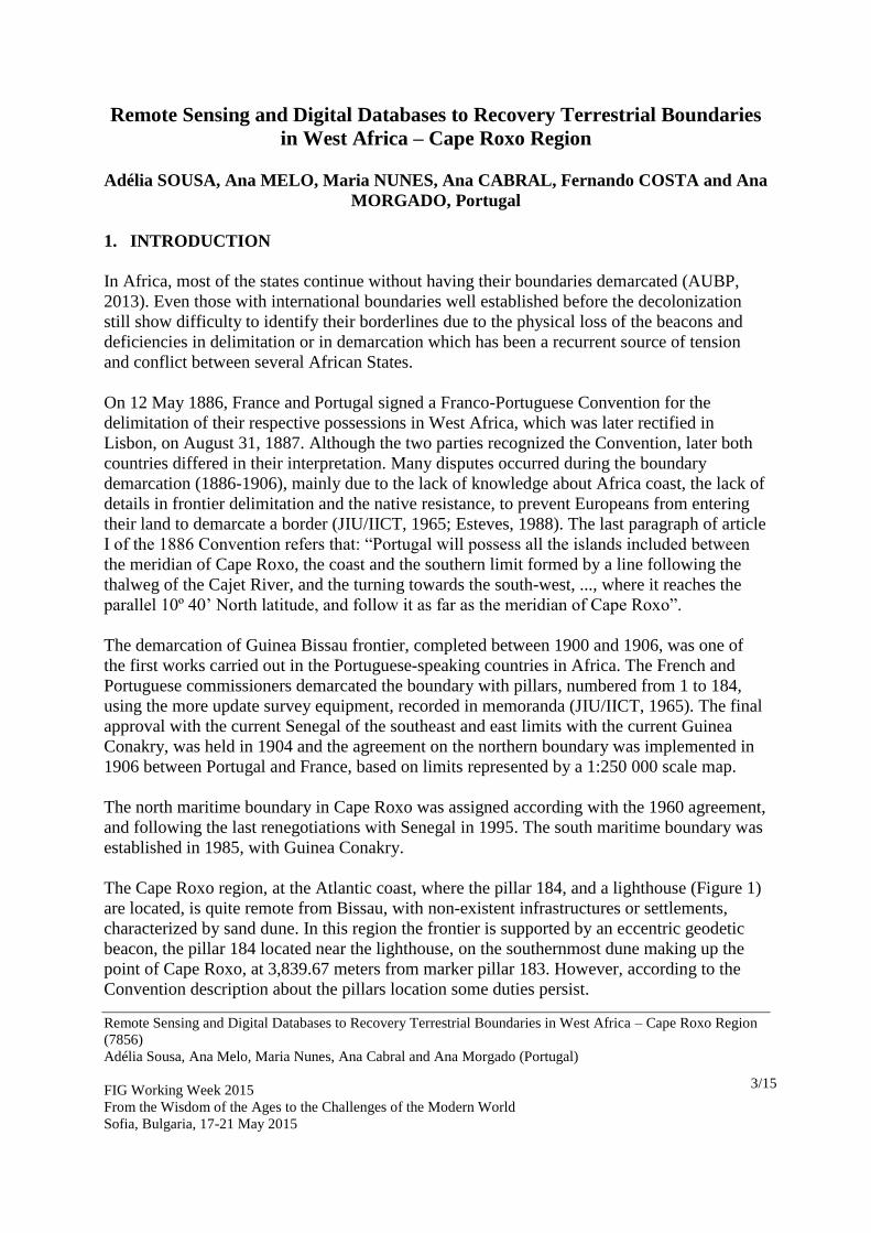
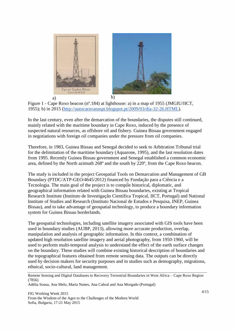
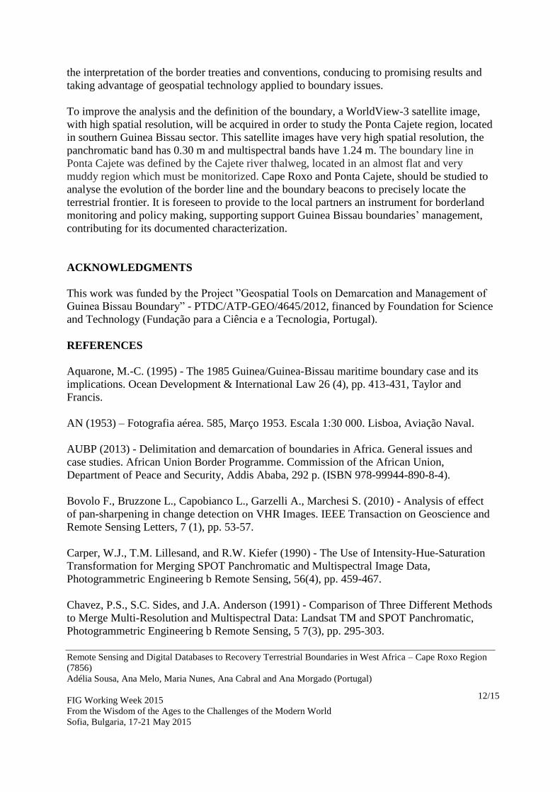
The Cape Roxo region, at the Atlantic coast, where the pillar 184, and a lighthouse (Figure 1)
are located, is quite remote from Bissau, with non-existent infrastructures or settlements,
characterized by sand dune. In this region the frontier is supported by an eccentric geodetic
beacon, the pillar 184 located near the lighthouse, on the southernmost dune making up the
point of Cape Roxo, at 3,839.67 meters from marker pillar 183. However, according to the
Convention description about the pillars location some duties persist.
Remote Sensing and Digital Databases to Recovery Terrestrial Boundaries in West Africa – Cape Roxo Region
(7856)
Adélia Sousa, Ana Melo, Maria Nunes, Ana Cabral and Ana Morgado (Portugal)
FIG Working Week 2015
From the Wisdom of the Ages to the Challenges of the Modern World
Sofia, Bulgaria, 17-21 May 2015
4/15
a)
b)
Figure 1 - Cape Roxo beacon (nº.184) at lighthouse: a) in a map of 1955 (JMGIU/IICT,
1955); b) in 2015 (http://autocaravanaspt.blogspot.pt/2009/03/dia-32-26.HTML).
In the last century, even after the demarcation of the boundaries, the disputes still continued,
mainly related with the maritime boundary in Cape Roxo, induced by the presence of
suspected natural resources, as offshore oil and fishery. Guinea Bissau government engaged
in negotiations with foreign oil companies under the pressure from oil companies.
Therefore, in 1983, Guinea Bissau and Senegal decided to seek to Arbitration Tribunal trial
for the delimitation of the maritime boundary (Aquarone, 1995), and the last resolution dates
from 1995. Recently Guinea Bissau government and Senegal established a common economic
area, defined by the North azimuth 268º and the south by 220º, from the Cape Roxo beacon.
The study is included in the project Geospatial Tools on Demarcation and Management of GB
Boundary (PTDC/ATP-GEO/4645/2012) financed by Fundação para a Ciência e a
Tecnologia. The main goal of the project is to compile historical, diplomatic, and
geographical information related with Guinea Bissau boundaries, existing at Tropical
Research Institute (Instituto de Investigação Científica Tropical, IICT, Portugal) and National
Institute of Studies and Research (Instituto Nacional de Estudos e Pesquisa, INEP, Guinea
Bissau), and to take advantage of geospatial technology, to produce a boundary information
system for Guinea Bissau borderlands.
The geospatial technologies, including satellite imagery associated with GIS tools have been
used in boundary studies (AUBP, 2013), allowing more accurate production, overlap,
manipulation and analysis of geographic information. In this context, a combination of
updated high resolution satellite imagery and aerial photography, from 1950-1960, will be
used to perform multi-temporal analysis to understand the effect of the earth surface changes
on the boundary. These studies will combine existing historical description of boundaries and
the topographical features obtained from remote sensing data. The outputs can be directly
used by decision makers for security purposes and in studies such as demography, migrations,
ethnical, socio-cultural, land management.
Remote Sensing and Digital Databases to Recovery Terrestrial Boundaries in West Africa – Cape Roxo Region
(7856)
Adélia Sousa, Ana Melo, Maria Nunes, Ana Cabral and Ana Morgado (Portugal)
FIG Working Week 2015
From the Wisdom of the Ages to the Challenges of the Modern World
Sofia, Bulgaria, 17-21 May 2015
5/15
2. STUDY AREA AND DATA
2.1 Study area
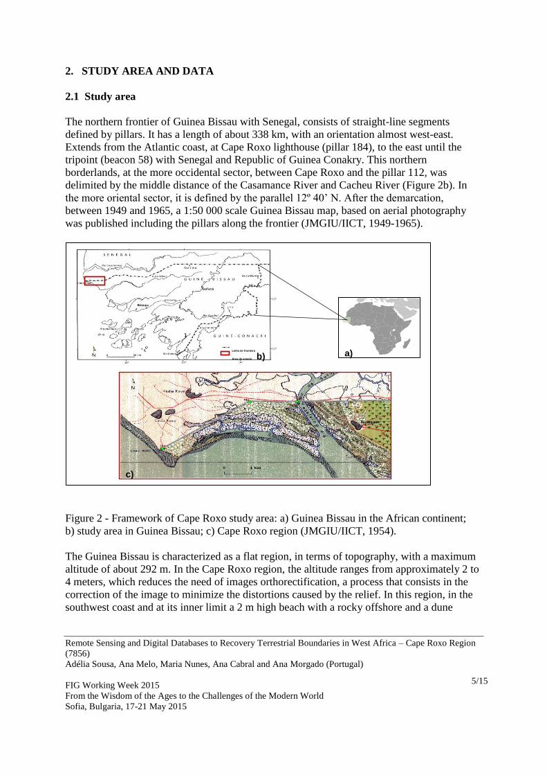
The northern frontier of Guinea Bissau with Senegal, consists of straight-line segments
defined by pillars. It has a length of about 338 km, with an orientation almost west-east.
Extends from the Atlantic coast, at Cape Roxo lighthouse (pillar 184), to the east until the
tripoint (beacon 58) with Senegal and Republic of Guinea Conakry. This northern
borderlands, at the more occidental sector, between Cape Roxo and the pillar 112, was
delimited by the middle distance of the Casamance River and Cacheu River (Figure 2b). In
the more oriental sector, it is defined by the parallel 12º 40’ N. After the demarcation,
between 1949 and 1965, a 1:50 000 scale Guinea Bissau map, based on aerial photography
was published including the pillars along the frontier (JMGIU/IICT, 1949-1965).
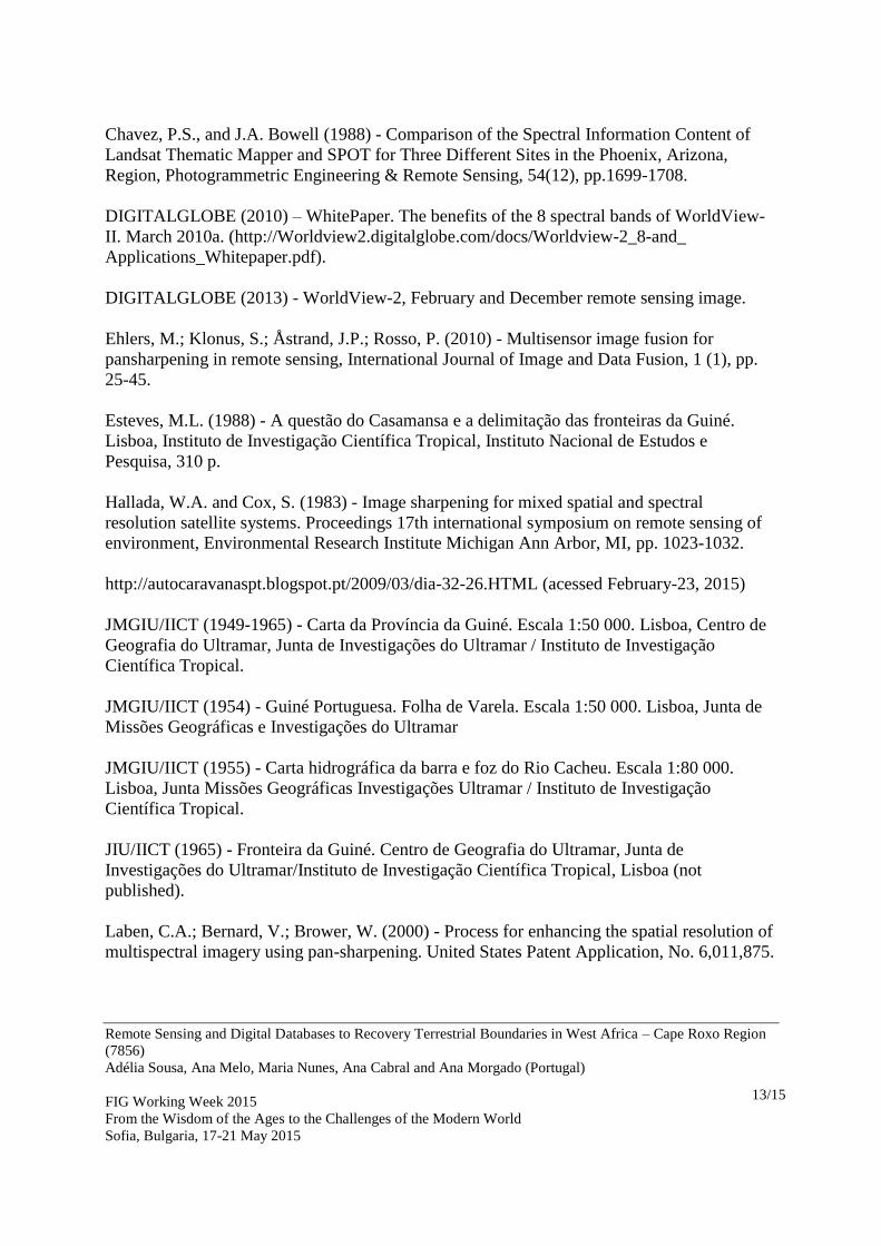
Figure 2 - Framework of Cape Roxo study area: a) Guinea Bissau in the African continent;
b) study area in Guinea Bissau; c) Cape Roxo region (JMGIU/IICT, 1954).
The Guinea Bissau is characterized as a flat region, in terms of topography, with a maximum
altitude of about 292 m. In the Cape Roxo region, the altitude ranges from approximately 2 to
4 meters, which reduces the need of images orthorectification, a process that consists in the
correction of the image to minimize the distortions caused by the relief. In this region, in the
southwest coast and at its inner limit a 2 m high beach with a rocky offshore and a dune
Linha de fronteira
Área de estudo b)
c)
a)
Remote Sensing and Digital Databases to Recovery Terrestrial Boundaries in West Africa – Cape Roxo Region
(7856)
Adélia Sousa, Ana Melo, Maria Nunes, Ana Cabral and Ana Morgado (Portugal)
FIG Working Week 2015
From the Wisdom of the Ages to the Challenges of the Modern World
Sofia, Bulgaria, 17-21 May 2015
6/15
stabilised by vegetation, can be found. At the southeast coast beach-lagoon system (Figure 2c)
is located, induced by an active continental fluvial and marine dynamics.
2.2 Data
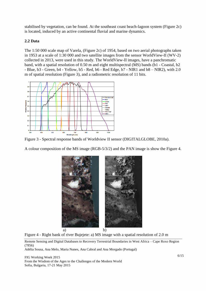
The 1:50 000 scale map of Varela, (Figure 2c) of 1954, based on two aerial photographs taken
in 1953 at a scale of 1:30 000 and two satellite images from the sensor WorldView-II (WV-2)
collected in 2013, were used in this study. The WorldView-II images, have a panchromatic
band, with a spatial resolution of 0.50 m and eight multispectral (MS) bands (b1 - Coastal, b2
- Blue, b3 - Green, b4 - Yellow, b5 - Red, b6 - Red Edge, b7 - NIR1 and b8 – NIR2), with 2.0
m of spatial resolution (Figure 3), and a radiometric resolution of 11 bits.
Figure 3 - Spectral response bands of Worldview II sensor (DIGITALGLOBE, 2010a).
A colour composition of the MS image (RGB-5/3/2) and the PAN image is show the Figure 4.
a)
b)
Figure 4 - Right bank of river Bujejete: a) MS image with a spatial resolution of 2.0 m
Remote Sensing and Digital Databases to Recovery Terrestrial Boundaries in West Africa – Cape Roxo Region
(7856)
Adélia Sousa, Ana Melo, Maria Nunes, Ana Cabral and Ana Morgado (Portugal)
FIG Working Week 2015
From the Wisdom of the Ages to the Challenges of the Modern World
Sofia, Bulgaria, 17-21 May 2015
7/15
(RGB-5/3/2); b) PAN image with a spatial resolution of 0.5 m.
The WorldView-2 satellite images were initially georeferenced using the WGS84 coordinate
system, and the Bissau datum, in order to use a common coordinate system.
3. METHODS
The increase of the spatial resolution of multispectral bands can be a valid tool in
multitemporal studies. Pan-sharpening is a type of data fusion that increases the spatial
resolution of the data through the combination of low-spatial resolution images with high
resolution panchromatic image in order to produce a high resolution multispectral image
(Laben et al. 2000; Padwick, 2010).
To improve the spatial resolution of the multispectral images several fusion algorithms
merging PAN band with the MS bands were applied. The Pan-sharpening methods used were
the most cited in literature, Gram-Schmidt (GS), Principal Component (PC), Intensity-Hue-
Saturation (IHS) and Colour Normalized (Brovey).
The GS fusion method simulates a PAN band from the lower spatial resolution spectral bands
(Laben et al, 2000). This method removes the redundant information in the dataset by an
orthogonal transformation applied to the simulated PAN band and the spectral bands. The
statistics of the PAN band are adjusted to the statistics of the first transformation bands
obtained from GS transformation. Then the high spatial resolution PAN band replaces the first
Gram Schmidt band and at the last step an inverse GS transform is applied to produce the pan-
sharpened multispectral bands (Laben et al, 2000).
The IHS method is a standard image fusion procedure, to separate spatial (intensity) and
spectral (hue and saturation) information from an image (Chavez et al., 1991; Carper et al.,
1990). The major limitation of this method is that only uses three bands (Chavez and Bowell,
1988; Tu et al., 2001). It first converts a RGB image into its intensity (I), hue (H) and
saturation (S) components, afterwards intensity is substituted by the high spatial resolution
panchromatic image and at the last step an inverse transformation was applied, converting
IHS components into RGB colours.
The PC spectral method transforms a multivariate dataset of correlated variables into a dataset
of uncorrelated linear combinations of the original variables (Chavez et al., 1991). In this
method the PAN image histogram is matched with the first principal component, and then it
replaces the PAN band. The last step consists of an inverse PC transform. This method is
similar to the IHS method with the advantage that can use more than three bands.
The Brovey method is a fusion technique which uses a mathematical combination of colour
images and high resolution data. Each spectral band is first divided by the sum of the three
chosen bands and then multiplied by the panchromatic image (Hallada and Cox, 1983). The
function automatically resamples the three colour bands to a high-resolution pixel size using
Remote Sensing and Digital Databases to Recovery Terrestrial Boundaries in West Africa – Cape Roxo Region
(7856)
Adélia Sousa, Ana Melo, Maria Nunes, Ana Cabral and Ana Morgado (Portugal)
FIG Working Week 2015
From the Wisdom of the Ages to the Challenges of the Modern World
Sofia, Bulgaria, 17-21 May 2015
8/15
nearest neighbour techniques, bilinear or cubic convolution. The output RGB images will
have the pixel size of the input high-resolution data (Vrabel, 1996; Bovolo et al., 2010).
The accuracy of the results is based on: i) visual comparison and ii) correlation analysis,
calculated using the original PAN band and the output bands resulting from the sharpening
methods applied.
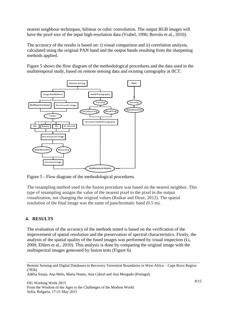
Figure 5 shows the flow diagram of the methodological procedures and the data used in the
multitemporal study, based on remote sensing data and existing cartography at IICT.
Figure 5 - Flow diagram of the methodological procedures.
The resampling method used in the fusion procedure was based on the nearest neighbor. This
type of resampling assigns the value of the nearest pixel to the pixel in the output
visualization, not changing the original values (Ruikar and Doye, 2012). The spatial
resolution of the final image was the same of panchromatic band (0.5 m).
4. RESULTS
The evaluation of the accuracy of the methods tested is based on the verification of the
improvement of spatial resolution and the preservation of spectral characteristics. Firstly, the
analysis of the spatial quality of the fused images was performed by visual inspection (Li,
2000; Ehlers et al., 2010). This analysis is done by comparing the original image with the
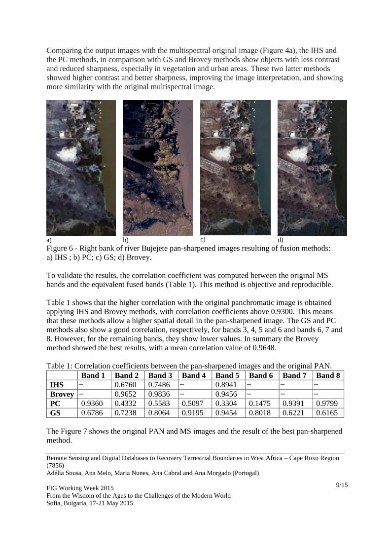
multispectral images generated by fusion tests (Figure 6).
Remote Sensing and Digital Databases to Recovery Terrestrial Boundaries in West Africa – Cape Roxo Region
(7856)
Adélia Sousa, Ana Melo, Maria Nunes, Ana Cabral and Ana Morgado (Portugal)
FIG Working Week 2015
From the Wisdom of the Ages to the Challenges of the Modern World
Sofia, Bulgaria, 17-21 May 2015
9/15
Comparing the output images with the multispectral original image (Figure 4a), the IHS and
the PC methods, in comparison with GS and Brovey methods show objects with less contrast
and reduced sharpness, especially in vegetation and urban areas. These two latter methods
showed higher contrast and better sharpness, improving the image interpretation, and showing
more similarity with the original multispectral image.
a)
b)
c)
d)
Figure 6 - Right bank of river Bujejete pan-sharpened images resulting of fusion methods:
a) IHS ; b) PC; c) GS; d) Brovey.
To validate the results, the correlation coefficient was computed between the original MS
bands and the equivalent fused bands (Table 1). This method is objective and reproducible.
Table 1 shows that the higher correlation with the original panchromatic image is obtained
applying IHS and Brovey methods, with correlation coefficients above 0.9300. This means
that these methods allow a higher spatial detail in the pan-sharpened image. The GS and PC
methods also show a good correlation, respectively, for bands 3, 4, 5 and 6 and bands 6, 7 and
8. However, for the remaining bands, they show lower values. In summary the Brovey
method showed the best results, with a mean correlation value of 0.9648.
Table 1: Correlation coefficients between the pan-sharpened images and the original PAN.
Band 1 Band 2 Band 3 Band 4 Band 5 Band 6 Band 7 Band 8
IHS ̶ 0.6760 0.7486 ̶ 0.8941 ̶ ̶ ̶
Brovey ̶ 0.9652 0.9836 ̶ 0.9456 ̶ ̶ ̶
PC 0.9360 0.4332 0.5583 0.5097 0.3304 0.1475 0.9391 0.9799
GS 0.6786 0.7238 0.8064 0.9195 0.9454 0.8018 0.6221 0.6165
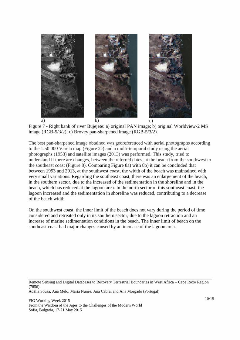
The Figure 7 shows the original PAN and MS images and the result of the best pan-sharpened
method.
Remote Sensing and Digital Databases to Recovery Terrestrial Boundaries in West Africa – Cape Roxo Region
(7856)
Adélia Sousa, Ana Melo, Maria Nunes, Ana Cabral and Ana Morgado (Portugal)
FIG Working Week 2015
From the Wisdom of the Ages to the Challenges of the Modern World
Sofia, Bulgaria, 17-21 May 2015
10/15
a)
b)
c)
Figure 7 - Right bank of river Bujejete: a) original PAN image; b) original Worldview-2 MS
image (RGB-5/3/2); c) Brovey pan-sharpened image (RGB-5/3/2).
The best pan-sharpened image obtained was georeferenced with aerial photographs according
to the 1:50 000 Varela map (Figure 2c) and a multi-temporal study using the aerial
photographs (1953) and satellite images (2013) was performed. This study, tried to
understand if there are changes, between the referred dates, at the beach from the southwest to
the southeast coast (Figure 8). Comparing Figure 8a) with 8b) it can be concluded that
between 1953 and 2013, at the southwest coast, the width of the beach was maintained with
very small variations. Regarding the southeast coast, there was an enlargement of the beach,
in the southern sector, due to the increased of the sedimentation in the shoreline and in the
beach, which has reduced at the lagoon area. In the north sector of this southeast coast, the
lagoon increased and the sedimentation in shoreline was reduced, contributing to a decrease
of the beach width.
On the southwest coast, the inner limit of the beach does not vary during the period of time
considered and retreated only in its southern sector, due to the lagoon retraction and an
increase of marine sedimentation conditions in the beach. The inner limit of beach on the
southeast coast had major changes caused by an increase of the lagoon area.
Remote Sensing and Digital Databases to Recovery Terrestrial Boundaries in West Africa – Cape Roxo Region
(7856)
Adélia Sousa, Ana Melo, Maria Nunes, Ana Cabral and Ana Morgado (Portugal)
FIG Working Week 2015
From the Wisdom of the Ages to the Challenges of the Modern World
Sofia, Bulgaria, 17-21 May 2015
11/15
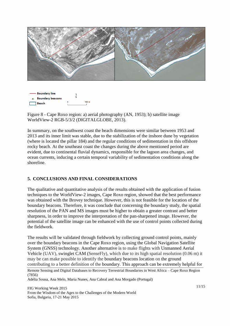
Figure 8 - Cape Roxo region: a) aerial photography (AN, 1953); b) satellite image
WorldView-2 RGB-5/3/2 (DIGITALGLOBE, 2013).
In summary, on the southwest coast the beach dimensions were similar between 1953 and
2013 and its inner limit was stable, due to the stabilization of the inshore dune by vegetation
(where is located the pillar 184) and the regular conditions of sedimentation in this offshore
rocky beach. At the southeast coast the changes during the above mentioned period are
evident, due to continental fluvial dynamics, responsible for the lagoon area changes, and
ocean currents, inducing a certain temporal variability of sedimentation conditions along the
shoreline.
5. CONCLUSIONS AND FINAL CONSIDERATIONS
The qualitative and quantitative analysis of the results obtained with the application of fusion
techniques to the WorldView-2 images, Cape Roxo region, showed that the best performance
was obtained with the Brovey technique. However, this is not feasible for the location of the
boundary beacons. Therefore, it was conclude that concerning the boundary study, the spatial
resolution of the PAN and MS images must be higher to obtain a greater contrast and better
sharpness, in order to improve the interpretation of the pan-sharpened image. However, the
potential of the satellite image can be enhanced with the use of control points collected during
the fieldwork.
The results will be validated through fieldwork by collecting ground control points, mainly
over the boundary beacons in the Cape Roxo region, using the Global Navigation Satellite
System (GNSS) technology. Another alternative is to make flights with Unmanned Aerial
Vehicle (UAV), swinglet CAM (SenseFly), which due to its high spatial resolution (0.06 m) it
may be can make possible to identify the boundary beacons location on the ground
contributing to a better definition of the boundary. This approach can be extremely helpful for
Remote Sensing and Digital Databases to Recovery Terrestrial Boundaries in West Africa – Cape Roxo Region
(7856)
Adélia Sousa, Ana Melo, Maria Nunes, Ana Cabral and Ana Morgado (Portugal)
FIG Working Week 2015
From the Wisdom of the Ages to the Challenges of the Modern World
Sofia, Bulgaria, 17-21 May 2015
12/15
the interpretation of the border treaties and conventions, conducing to promising results and
taking advantage of geospatial technology applied to boundary issues.
To improve the analysis and the definition of the boundary, a WorldView-3 satellite image,
with high spatial resolution, will be acquired in order to study the Ponta Cajete region, located
in southern Guinea Bissau sector. This satellite images have very high spatial resolution, the
panchromatic band has 0.30 m and multispectral bands have 1.24 m. The boundary line in
Ponta Cajete was defined by the Cajete river thalweg, located in an almost flat and very
muddy region which must be monitorized. Cape Roxo and Ponta Cajete, should be studied to
analyse the evolution of the border line and the boundary beacons to precisely locate the
terrestrial frontier. It is foreseen to provide to the local partners an instrument for borderland
monitoring and policy making, supporting support Guinea Bissau boundaries’ management,
contributing for its documented characterization.
ACKNOWLEDGMENTS
This work was funded by the Project ”Geospatial Tools on Demarcation and Management of
Guinea Bissau Boundary” - PTDC/ATP-GEO/4645/2012, financed by Foundation for Science
and Technology (Fundação para a Ciência e a Tecnologia, Portugal).
REFERENCES
Aquarone, M.-C. (1995) - The 1985 Guinea/Guinea-Bissau maritime boundary case and its
implications. Ocean Development & International Law 26 (4), pp. 413-431, Taylor and
Francis.
AN (1953) – Fotografia aérea. 585, Março 1953. Escala 1:30 000. Lisboa, Aviação Naval.
AUBP (2013) - Delimitation and demarcation of boundaries in Africa. General issues and
case studies. African Union Border Programme. Commission of the African Union,
Department of Peace and Security, Addis Ababa, 292 p. (ISBN 978-99944-890-8-4).
Bovolo F., Bruzzone L., Capobianco L., Garzelli A., Marchesi S. (2010) - Analysis of effect
of pan-sharpening in change detection on VHR Images. IEEE Transaction on Geoscience and
Remote Sensing Letters, 7 (1), pp. 53-57.
Carper, W.J., T.M. Lillesand, and R.W. Kiefer (1990) - The Use of Intensity-Hue-Saturation
Transformation for Merging SPOT Panchromatic and Multispectral Image Data,
Photogrammetric Engineering b Remote Sensing, 56(4), pp. 459-467.
Chavez, P.S., S.C. Sides, and J.A. Anderson (1991) - Comparison of Three Different Methods
to Merge Multi-Resolution and Multispectral Data: Landsat TM and SPOT Panchromatic,
Photogrammetric Engineering b Remote Sensing, 5 7(3), pp. 295-303.
Remote Sensing and Digital Databases to Recovery Terrestrial Boundaries in West Africa – Cape Roxo Region
(7856)
Adélia Sousa, Ana Melo, Maria Nunes, Ana Cabral and Ana Morgado (Portugal)
FIG Working Week 2015
From the Wisdom of the Ages to the Challenges of the Modern World
Sofia, Bulgaria, 17-21 May 2015
13/15
Chavez, P.S., and J.A. Bowell (1988) - Comparison of the Spectral Information Content of
Landsat Thematic Mapper and SPOT for Three Different Sites in the Phoenix, Arizona,
Region, Photogrammetric Engineering & Remote Sensing, 54(12), pp.1699-1708.
DIGITALGLOBE (2010) – WhitePaper. The benefits of the 8 spectral bands of WorldView-
II. March 2010a. (http://Worldview2.digitalglobe.com/docs/Worldview-2_8-and_
Applications_Whitepaper.pdf).
DIGITALGLOBE (2013) - WorldView-2, February and December remote sensing image.
Ehlers, M.; Klonus, S.; Åstrand, J.P.; Rosso, P. (2010) - Multisensor image fusion for
pansharpening in remote sensing, International Journal of Image and Data Fusion, 1 (1), pp.
25-45.
Esteves, M.L. (1988) - A questão do Casamansa e a delimitação das fronteiras da Guiné.
Lisboa, Instituto de Investigação Científica Tropical, Instituto Nacional de Estudos e
Pesquisa, 310 p.
Hallada, W.A. and Cox, S. (1983) - Image sharpening for mixed spatial and spectral
resolution satellite systems. Proceedings 17th international symposium on remote sensing of
environment, Environmental Research Institute Michigan Ann Arbor, MI, pp. 1023-1032.
http://autocaravanaspt.blogspot.pt/2009/03/dia-32-26.HTML (acessed February-23, 2015)
JMGIU/IICT (1949-1965) - Carta da Província da Guiné. Escala 1:50 000. Lisboa, Centro de
Geografia do Ultramar, Junta de Investigações do Ultramar / Instituto de Investigação
Científica Tropical.
JMGIU/IICT (1954) - Guiné Portuguesa. Folha de Varela. Escala 1:50 000. Lisboa, Junta de
Missões Geográficas e Investigações do Ultramar
JMGIU/IICT (1955) - Carta hidrográfica da barra e foz do Rio Cacheu. Escala 1:80 000.
Lisboa, Junta Missões Geográficas Investigações Ultramar / Instituto de Investigação
Científica Tropical.
JIU/IICT (1965) - Fronteira da Guiné. Centro de Geografia do Ultramar, Junta de
Investigações do Ultramar/Instituto de Investigação Científica Tropical, Lisboa (not
published).
Laben, C.A.; Bernard, V.; Brower, W. (2000) - Process for enhancing the spatial resolution of
multispectral imagery using pan-sharpening. United States Patent Application, No. 6,011,875.
Remote Sensing and Digital Databases to Recovery Terrestrial Boundaries in West Africa – Cape Roxo Region
(7856)
Adélia Sousa, Ana Melo, Maria Nunes, Ana Cabral and Ana Morgado (Portugal)
FIG Working Week 2015
From the Wisdom of the Ages to the Challenges of the Modern World
Sofia, Bulgaria, 17-21 May 2015
14/15
Li, J. (2000) - Spatial quality evaluation of fusion of different resolution images, ISPRS
International Archives of the Photogrammetry, Remote Sensing and Spatial Information
Sciences, 33 (B2-2), pp. 339-346.
Padwick, C.; Deskevich, M.; Pacifici, F. Smallwood, S. (2010) - Worldview-2 Pan
Sharpening. Proceedings ASPRS 2010 Annual Conference, San Diego, California, pp. 26-30.
Ruikar, S. D. and Doye, D. D. (2012). Image Denoising Using Tri Nonlinear and Nearest
Neighbor Interpolation with Wavelet Transform. I.J. Information Technology and Computer
Science, 9, pp. 36-44.
Tu, T.M., Su, S.C., Shyn, H.C. and Huang, P.S. (2001) - A new look at IHS-like image fusion
methods. Information Fusion, 2, pp. 177–186.
Vrabel J. (1996) - Multispectral Imagery Band Sharpening Study. Photogrammetric
Engineering & Remote Sensing, 62, pp. 1075-1083.
BIOGRAPHICAL NOTES
Adélia M. Oliveira de Sousa is an Auxiliar Professor at the Dep. of Rural Engineering,
School of Science and Technology of the Évora University, Portugal. She has a graduation in
Geographic Engineering, and a Master degree in GIS, Lisbon University. The PhD degree
was based on application of remote sensing data to map and analysis of spatial patterns of
occurrence of fires in Brazil, Évora University. The main research and teaching interests are
in precision agriculture and application of GIS and remote sensing data to maintenance /
management of natural resources. She participate in multidisciplinary national and
international projects and published papers in national and international journals.
Ana Raquel Melo is research fellowship at the Tropical Research Institute (IICT), Lisbon, at
project “Geospatial technologies on demarcation of Guinea Bissau boundary” (PTDC/ATP-
GEO/4645/2012) funded by the Foundation for Science and Technology. She holds a degree
in Geographic Engineering and has a Graduate in Science and Geographic Information
Systems.
Maria do Carmo Nunes is a senior researcher at Tropical Research Institute, in Lisbon. She
is a geomatic engineering, holds a PhD and a master degree in georesources. Her
multidisciplinary background on remote sensing, GIS, GPS/GNSS, multivariate statistics, and
geostatistics, allowed participation in about 10 multidisciplinary financed research projects.
Now she is the principal investigator of the “Geospatial Tools on Demarcation and
Management of Guinea Bissau Boundary” project. She has published papers in national and
international conferences, book chapters and journals.
Remote Sensing and Digital Databases to Recovery Terrestrial Boundaries in West Africa – Cape Roxo Region
(7856)
Adélia Sousa, Ana Melo, Maria Nunes, Ana Cabral and Ana Morgado (Portugal)
FIG Working Week 2015
From the Wisdom of the Ages to the Challenges of the Modern World
Sofia, Bulgaria, 17-21 May 2015
15/15
Ana I. R. Cabral is a Geographic Information System and Remote Sensing expert, working
in tropical regions, mainly in African countries, in the areas of deforestation, mapping and
modeling of land cover/land use change scenarios and quantification of carbon emissions,
with over 15 years experience. She holds a degree in Geographic Engineering, a MSc in
Geographic Information Systems and a PhD equivalence in Earth Observation. Since 2005,
she is a senior researcher in Tropical Research Institute in Lisbon, Portugal.
Fernando Lagos Costa is a senior researcher of the Tropical Research Institute (IICT),
Lisbon, holds a PhD thesis in Physical Geography about the quaternary valley landforms and
slope geomorphological processes at Cape Verde Islands, having more than 20 years of field
experience in physical geography and planning in tropical regions, natural hazards assessment
and man impacts on slope morphodynamic, soil erosion and sedimentary processes in tropical
semiarid and volcanic conditions, particularly in Cape Verde, Guinea Bissau and Angola.
Ana Morgado is a senior researcher at Tropical Research Institute, in Lisbon. She holds a
PhD in Geomatic Engineering from University College London. Since 1996 coordinated
and/or participated in research and cooperation projects in the context of Earth Observation
(EO) applications mainly applied to African Portuguese Speaking Countries, namely Cape
Verde, Guinea Bissau, Angola and Mozambique. Coordinator of “Bridging Actions for
GMES & Africa" BRAGMA FP7 Project, responsible for organising 4 pan-African
Workshops in conjunction with both EC and AUC on EO applications for Africa. EU co-chair
of the Space component of the 8th partnership of the Joint EU-Africa Strategy (JAES).
CONTACTS
Adélia Maria Oliveira de Sousa
Departamento de Engenharia Rural, Escola de Ciências e Tecnologia,
Instituto de Ciências Agrárias e Ambientais Mediterrânicas (ICAAM),
Centro de Inovação em Tecnologias de Informação (CITI)
Universidade de Évora Apartado 94, 7002 – 554, Évora, Portugal
Email: [email protected]
Web site: http://www.uevora.pt/
Ana Raquel Melo; Maria do Carmo Nunes; Ana I. R. Cabral; Fernando Lagos Costa and Ana
Morgado
IICT, Instituto de Investigação Científica Tropical
Travessa Conde da Ribeira, 9, B, 1º, 1300-142, Lisboa, Portugal
Email: [email protected]; [email protected]; [email protected];
[email protected]; [email protected].
Web site: http://www2.iict.pt/