Embed Size (px)
Citation preview
1
Relinquishment Report for
Licence P1755
Estimates, statistics, opinions and forecasts contained in this document are based on
TOTAL’s own information and knowledge. They are provided in good faith, but, by their nature,
are based on a number of assumptions and are subjective. Readers should therefore carry out
appropriate reviews and due diligence to satisfy themselves as to all information contained in
this document including, without limitation, TOTAL’s opinions, prospect evaluations, reserve
figures, production and cost forecasts and all technical aspects of production, transmission
and other facilities.
While this information was prepared in good faith, no representation or warranty, expressed or
implied, is or will be made, and no responsibility or liability is or will be accepted by TOTAL or
any of their respective affiliates or subsidiaries, employees, officers, directors and agents as
to, or in relation to, the accuracy or completeness of this document and any liability thereof is
hereby expressly disclaimed.
In furnishing this Relinquishment Report to DECC, TOTAL undertakes no obligation to provide
any Third party recipient with access to any additional information.
2
Contents 1. Licence Information ........................................................................................................................ 3
2. Licence Synopsis .............................................................................................................................. 3
3. Work Programme Summary ........................................................................................................... 5
4. Database ......................................................................................................................................... 5
5. Prospectivity Update ....................................................................................................................... 8
6. Conclusions ................................................................................................................................... 13
7. Clearance ...................................................................................................................................... 14
List of Figures
Figure 1 Location map of P1755 Blocks .................................................................................................. 3
Figure 2 P1755 Prospect Summary Map at the 26th Licence Round ...................................................... 4
Figure 3 Seismic and well database for P1755 blocks ............................................................................. 6
Figure 4 Seismic database comparison- PGS2012 Merged NVG11 data vs reprocessed Beam and
Kirchhoff PSDM data ............................................................................................................................... 7
Figure 5 N11 Depth Structure and AVO maps ......................................................................................... 9
Figure 6 NW-SE Seismic section (PSDM Beam reprocessed) and J52 Depth structure map showing
Raemoir prospect .................................................................................................................................. 10
Figure 7 WNW-ESE Seismic section (PSDM Kirchhoff reprocessed) and amplitude map showing
Ardincaple Prospect .............................................................................................................................. 11
Figure 8 NW-SE Seismic section (PSDM Kirchhoff reprocessed) and J52 Depth structure map ............ 12
Figure 9 W-E Seismic section (PSDM Beam reprocessed) and Top J36 Depth structure map showing
Skibo prospect ....................................................................................................................................... 13
3
1. LICENCE INFORMATION
Licence Number: P1755
Licence Round: 26th Round licence
Licence Type: Traditional
Block Numbers: 3/25b, 3/30b, 4/21 and 4/26b
Total E&P UK Ltd confirms DECC is free to publish this report and that all third party
ownership rights have been considered and appropriately cleared for publication
purposes. The operator has fully licensed all the most recent available data including
the NVG10 and NVG11 Long Offset Broadband Geostreamer data.
2. LICENCE SYNOPSIS
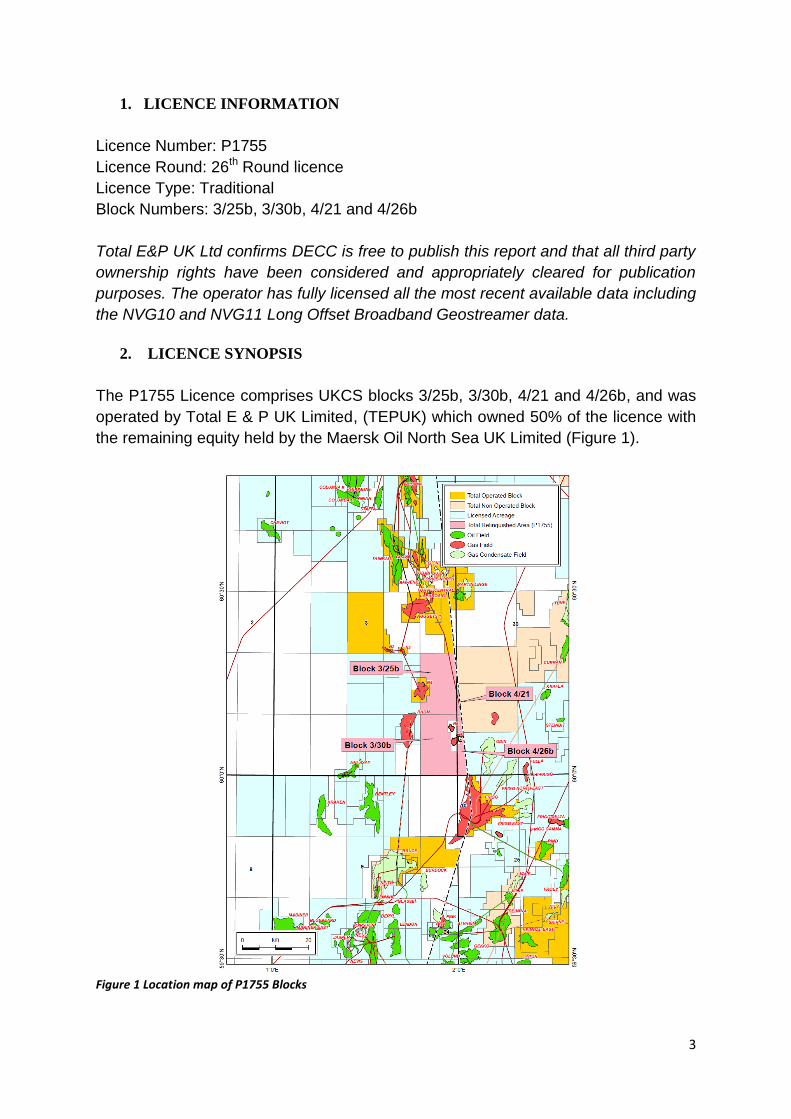
The P1755 Licence comprises UKCS blocks 3/25b, 3/30b, 4/21 and 4/26b, and was
operated by Total E & P UK Limited, (TEPUK) which owned 50% of the licence with
the remaining equity held by the Maersk Oil North Sea UK Limited (Figure 1).
Figure 1 Location map of P1755 Blocks
4
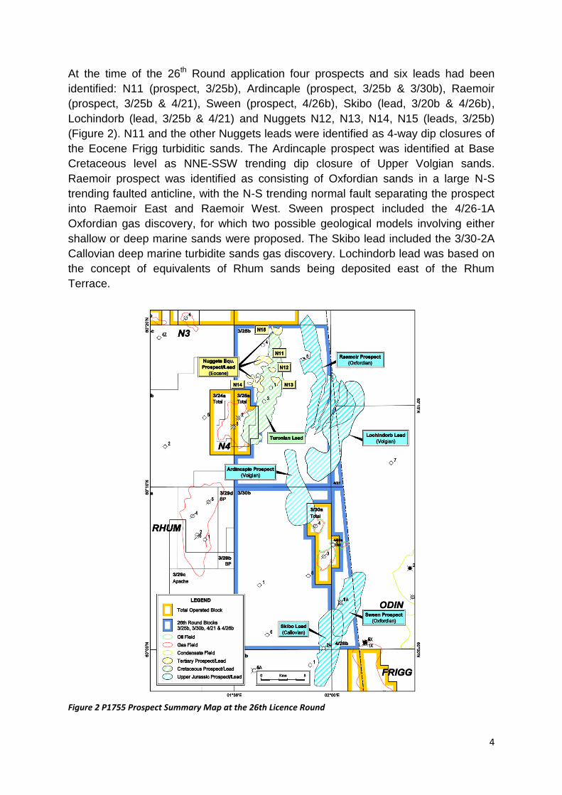
At the time of the 26th Round application four prospects and six leads had been
identified: N11 (prospect, 3/25b), Ardincaple (prospect, 3/25b & 3/30b), Raemoir
(prospect, 3/25b & 4/21), Sween (prospect, 4/26b), Skibo (lead, 3/20b & 4/26b),
Lochindorb (lead, 3/25b & 4/21) and Nuggets N12, N13, N14, N15 (leads, 3/25b)
(Figure 2). N11 and the other Nuggets leads were identified as 4-way dip closures of
the Eocene Frigg turbiditic sands. The Ardincaple prospect was identified at Base
Cretaceous level as NNE-SSW trending dip closure of Upper Volgian sands.
Raemoir prospect was identified as consisting of Oxfordian sands in a large N-S
trending faulted anticline, with the N-S trending normal fault separating the prospect
into Raemoir East and Raemoir West. Sween prospect included the 4/26-1A
Oxfordian gas discovery, for which two possible geological models involving either
shallow or deep marine sands were proposed. The Skibo lead included the 3/30-2A
Callovian deep marine turbidite sands gas discovery. Lochindorb lead was based on
the concept of equivalents of Rhum sands being deposited east of the Rhum
Terrace.
Figure 2 P1755 Prospect Summary Map at the 26th Licence Round
5
This 26th Round Licence was awarded on 10th January 2011 as a Traditional
Seaward Production Licence (4 years). The commitments were:
To acquire 1036 km2 new PGS 3D spec. data,
To reprocess 490 km2 of anisotropic 3D PSDM (Kirchhoff and Beam),
To reprocess 100 km2 of PSTM for long offset 3D data, and
To drill a contingent well on N11 prospect.
The only commitment not fulfilled in the licence is drilling the contingent well on the
N11 prospect which lies within Block 3/25b. DECC agreed to waive the contingent
well element of the Firm Licence work programme due to the uneconomic potential
of the N11 prospect (unrisked Mean resource of 2.8Mboe).
TEPUK and Maersk relinquished the P1755 licence on January 13th 2014.
3. WORK PROGRAMME SUMMARY
The exact Work Programme agreed has been discussed in the licence synopsis
above.
4. DATABASE
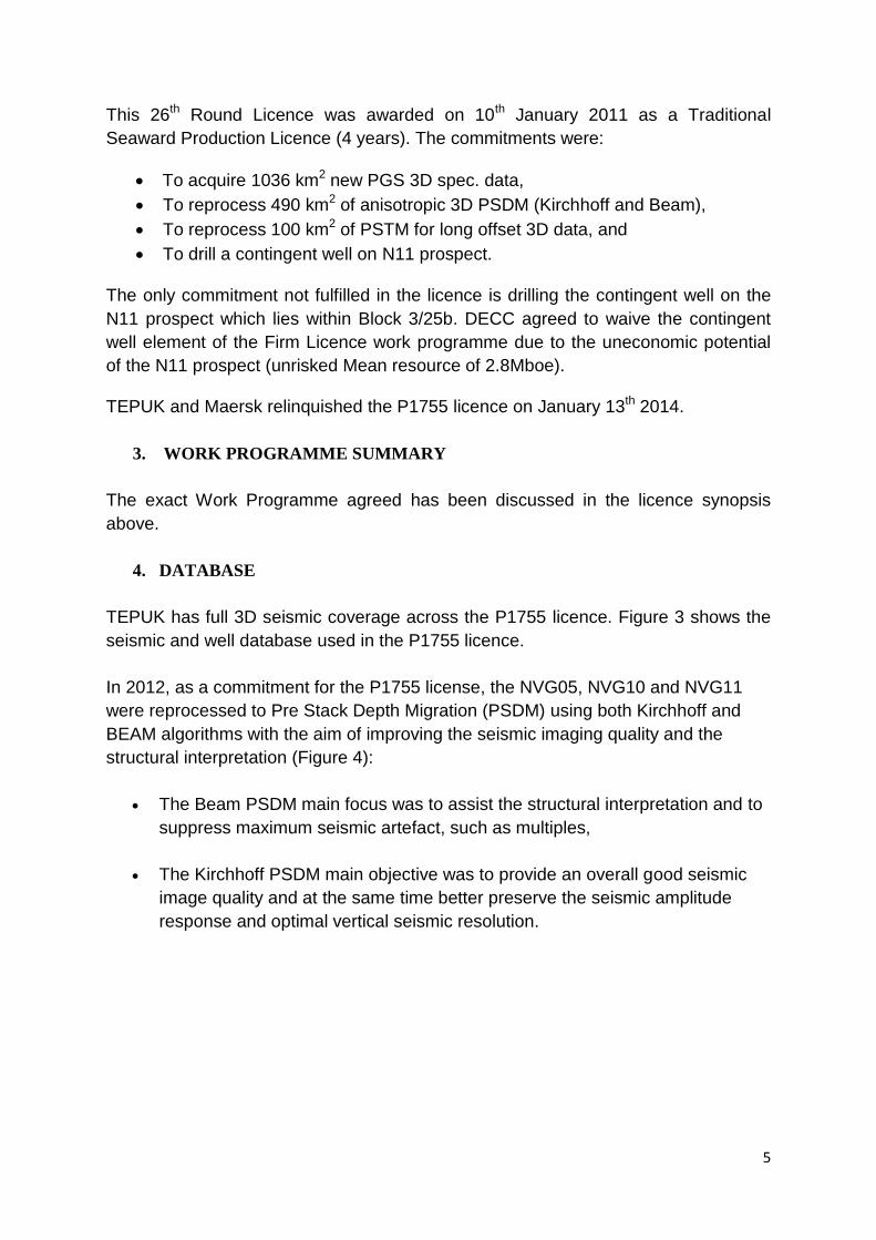
TEPUK has full 3D seismic coverage across the P1755 licence. Figure 3 shows the
seismic and well database used in the P1755 licence.
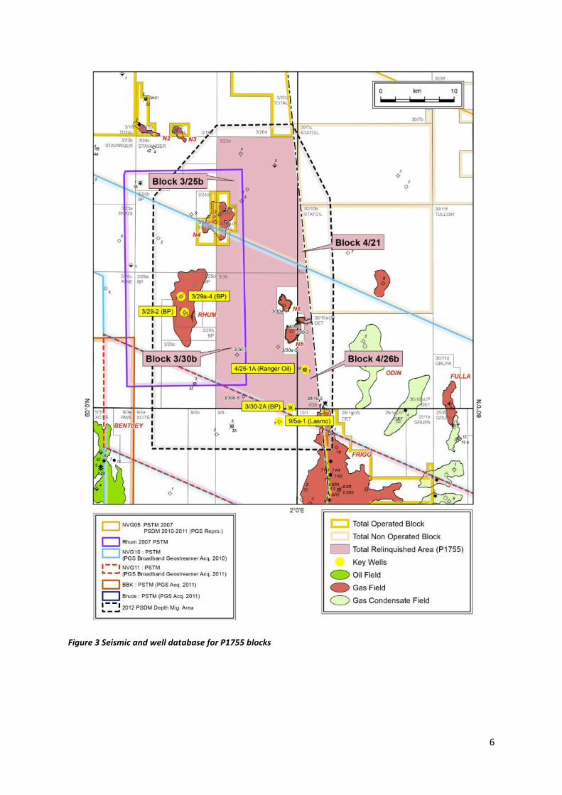
In 2012, as a commitment for the P1755 license, the NVG05, NVG10 and NVG11
were reprocessed to Pre Stack Depth Migration (PSDM) using both Kirchhoff and
BEAM algorithms with the aim of improving the seismic imaging quality and the
structural interpretation (Figure 4):
The Beam PSDM main focus was to assist the structural interpretation and to
suppress maximum seismic artefact, such as multiples,
The Kirchhoff PSDM main objective was to provide an overall good seismic
image quality and at the same time better preserve the seismic amplitude
response and optimal vertical seismic resolution.
6
Figure 3 Seismic and well database for P1755 blocks
7
Figure 4 Seismic database comparison- PGS2012 Merged NVG11 data vs reprocessed Beam and Kirchhoff
PSDM data
0km 5km 5km0km 0km 5km
A A’ A A’ A A’PGS2012_NVG11_Merged
P1755PGS2012_NVG11_Merged
P1755_Beam PSDMPGS2012_NVG11_Merged
P1755_Kirchhoff PSDM
A
A’
8
The well results on the P1755 licence and on previous licences are summarised in
the Table 1.
Table 1 P1755 Well database
5. PROSPECTIVITY UPDATE
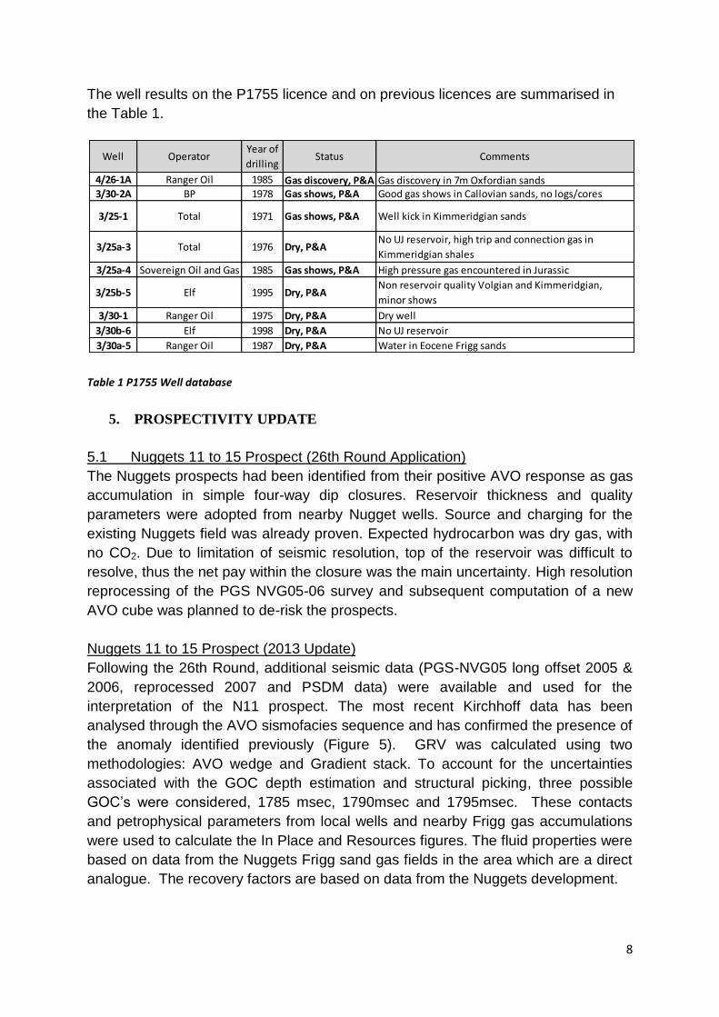
5.1 Nuggets 11 to 15 Prospect (26th Round Application)
The Nuggets prospects had been identified from their positive AVO response as gas
accumulation in simple four-way dip closures. Reservoir thickness and quality
parameters were adopted from nearby Nugget wells. Source and charging for the
existing Nuggets field was already proven. Expected hydrocarbon was dry gas, with
no CO2. Due to limitation of seismic resolution, top of the reservoir was difficult to
resolve, thus the net pay within the closure was the main uncertainty. High resolution
reprocessing of the PGS NVG05-06 survey and subsequent computation of a new
AVO cube was planned to de-risk the prospects.
Nuggets 11 to 15 Prospect (2013 Update)
Following the 26th Round, additional seismic data (PGS-NVG05 long offset 2005 &
2006, reprocessed 2007 and PSDM data) were available and used for the
interpretation of the N11 prospect. The most recent Kirchhoff data has been
analysed through the AVO sismofacies sequence and has confirmed the presence of
the anomaly identified previously (Figure 5). GRV was calculated using two
methodologies: AVO wedge and Gradient stack. To account for the uncertainties
associated with the GOC depth estimation and structural picking, three possible
GOC’s were considered, 1785 msec, 1790msec and 1795msec. These contacts
and petrophysical parameters from local wells and nearby Frigg gas accumulations
were used to calculate the In Place and Resources figures. The fluid properties were
based on data from the Nuggets Frigg sand gas fields in the area which are a direct
analogue. The recovery factors are based on data from the Nuggets development.
Well OperatorYear of
drillingStatus Comments
4/26-1A Ranger Oil 1985 Gas discovery, P&A Gas discovery in 7m Oxfordian sands3/30-2A BP 1978 Gas shows, P&A Good gas shows in Callovian sands, no logs/cores
3/25-1 Total 1971 Gas shows, P&A Well kick in Kimmeridgian sands
3/25a-3 Total 1976 Dry, P&ANo UJ reservoir, high trip and connection gas in
Kimmeridgian shales
3/25a-4 Sovereign Oil and Gas 1985 Gas shows, P&A High pressure gas encountered in Jurassic
3/25b-5 Elf 1995 Dry, P&ANon reservoir quality Volgian and Kimmeridgian,
minor shows
3/30-1 Ranger Oil 1975 Dry, P&A Dry well
3/30b-6 Elf 1998 Dry, P&A No UJ reservoir
3/30a-5 Ranger Oil 1987 Dry, P&A Water in Eocene Frigg sands
9
Figure 5 N11 Depth Structure and AVO maps
Resource and Risk Summary
Resources Mboe
Min Mode Max Mean POS
Risked Mean
Resources
N11 1.5 2.6 4.4 2.8 64% 1.8
The overall POS of N11 has been calculated at 64% with Mean Unrisked
Resources of 2.8 Mboe. The primary uncertainty is associated with the fluid contact
estimation, structural picking (trap geometry) and quality of reservoir. All other
Nuggets prospects identified at the time of application are smaller than N11, so no
further analysis has been performed on these.
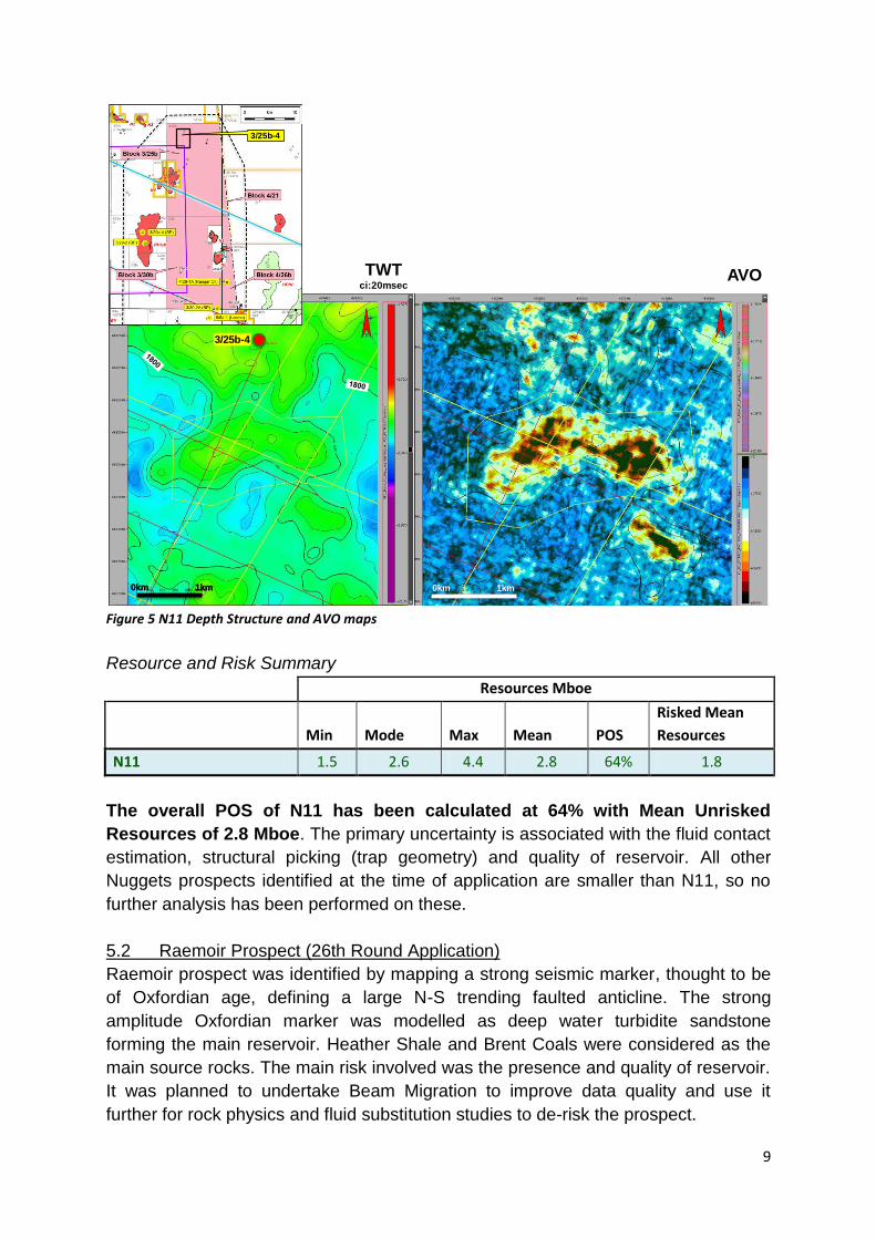
5.2 Raemoir Prospect (26th Round Application)
Raemoir prospect was identified by mapping a strong seismic marker, thought to be
of Oxfordian age, defining a large N-S trending faulted anticline. The strong
amplitude Oxfordian marker was modelled as deep water turbidite sandstone
forming the main reservoir. Heather Shale and Brent Coals were considered as the
main source rocks. The main risk involved was the presence and quality of reservoir.
It was planned to undertake Beam Migration to improve data quality and use it
further for rock physics and fluid substitution studies to de-risk the prospect.
1
TWTci:20msec
AVO
3/25b-4
3/25b-4
0km 1km0km 1km 0km 1km
10
Raemoir Prospect (2013 Update)
Reinterpretation of the Raemoir prospect was carried out in the new reprocessed 3D
seismic. It indicated two possible scenarios, a 4-way dip closure with crest at
5990mSS and 14 km2 areal extent, and a 3-way dip closure against the main N-S
trending Raemoir fault with crest at 6050mSS (Figure 6). Both the scenarios
indicated critical risk in reservoir presence and quality due to depths > 6000mSS
where the prospects had been identified. Thus further detailed study has not been
pursued with this prospect.
Figure 6 NW-SE Seismic section (PSDM Beam reprocessed) and J52 Depth structure map showing Raemoir
prospect
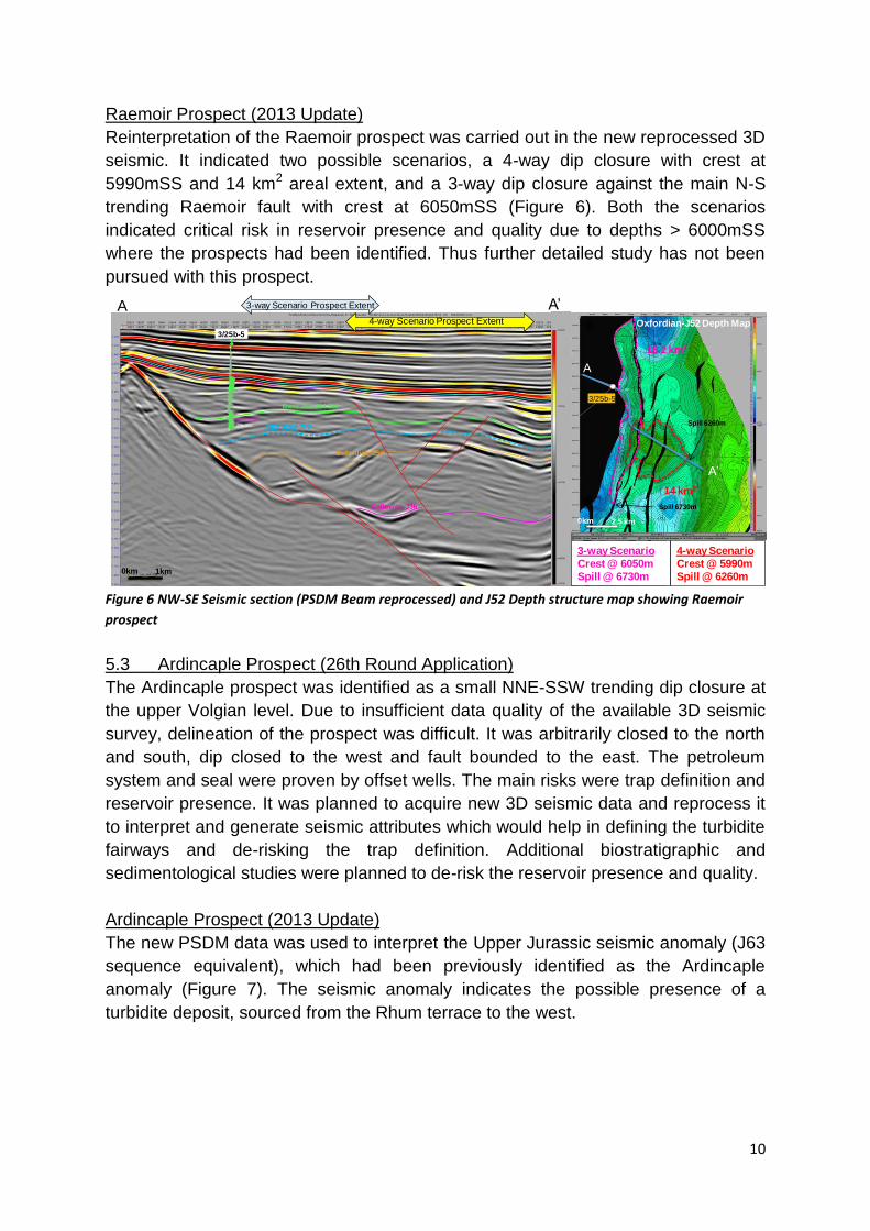
5.3 Ardincaple Prospect (26th Round Application)
The Ardincaple prospect was identified as a small NNE-SSW trending dip closure at
the upper Volgian level. Due to insufficient data quality of the available 3D seismic
survey, delineation of the prospect was difficult. It was arbitrarily closed to the north
and south, dip closed to the west and fault bounded to the east. The petroleum
system and seal were proven by offset wells. The main risks were trap definition and
reservoir presence. It was planned to acquire new 3D seismic data and reprocess it
to interpret and generate seismic attributes which would help in defining the turbidite
fairways and de-risking the trap definition. Additional biostratigraphic and
sedimentological studies were planned to de-risk the reservoir presence and quality.
Ardincaple Prospect (2013 Update)
The new PSDM data was used to interpret the Upper Jurassic seismic anomaly (J63
sequence equivalent), which had been previously identified as the Ardincaple
anomaly (Figure 7). The seismic anomaly indicates the possible presence of a
turbidite deposit, sourced from the Rhum terrace to the west.
Base J63-J64 Sst
Oxfordian-J52
Callovian-J36
4-way Scenario
Crest @ 5990m
Spill @ 6260m
3-way Scenario
Crest @ 6050m
Spill @ 6730m
J62 SSt ??
4-way Scenario Prospect Extent
3-way Scenario Prospect Extent
3/25b-5
A A’
0km 1km
3/25b-5
Oxfordian-J52 Depth Map
Spill 6260m
14 km2
18.2 km2
Spill 6730m
A
A’
0km 2.5 km
11
Figure 7 WNW-ESE Seismic section (PSDM Kirchhoff reprocessed) and amplitude map showing Ardincaple
Prospect
The updip seal is thought to be provided by the stratigraphic pinch out of the sand
body to the east. There is a possible zone of compromised top seal indicated by a
dim area that is interpreted as a gas chimney. The Kimmeridge Clay and the
underlying Heather Clay are thought to be the main contributors as source rock, and
dry gas similar to Rhum or 4/26-1A is expected. Further work is required to mature
this HP/HT prospect to drillable status.
5.4 Sween Prospect (26th Round Application)
With the available 3D seismic survey at the time of 26th round application, the Sween
prospect delineation was difficult. The extent of the prospect was conceptual and
driven by the thin gas-bearing Oxfordian sands in 4/26-1A well only. The south and
SE extent was delineated by the absence of sand in the 30/10-5 and 3/30-2A wells.
The eastern extent was thought to be delineated by the updip zone of erosional
truncation, and dip closure in the west. Due to uncertainty over the geological setting
of the sandstone, two models were considered, either shallow or deep marine. The
first model assumed the sand to be sourced from erosion of the crest to the east,
thus prospectivity development in the updip of the discovery well. The second model
assumed the sands to be deep water deposits, sourced from the west, and
prospectivity developed downdip of the well. The petroleum system and the seal
were proven by the well 4/26-1A gas discovery well. In order to de-risk and upgrade
the Sween prospect it was planned to acquire and reprocess 3D seismic data which
would help in the interpretation and computation of new seismic attributes. Additional
biostratigraphic and sedimentological studies of 4/26-1A and other neighbouring
Norwegian wells were planned to ascertain the age and depositional setting of the
12
Oxfordian sands in the Sween prospect. The Sween prospect was considered
immature for drilling until the new 3D long-offset seismic data were available for
interpretation and delineation of the prospect boundary.
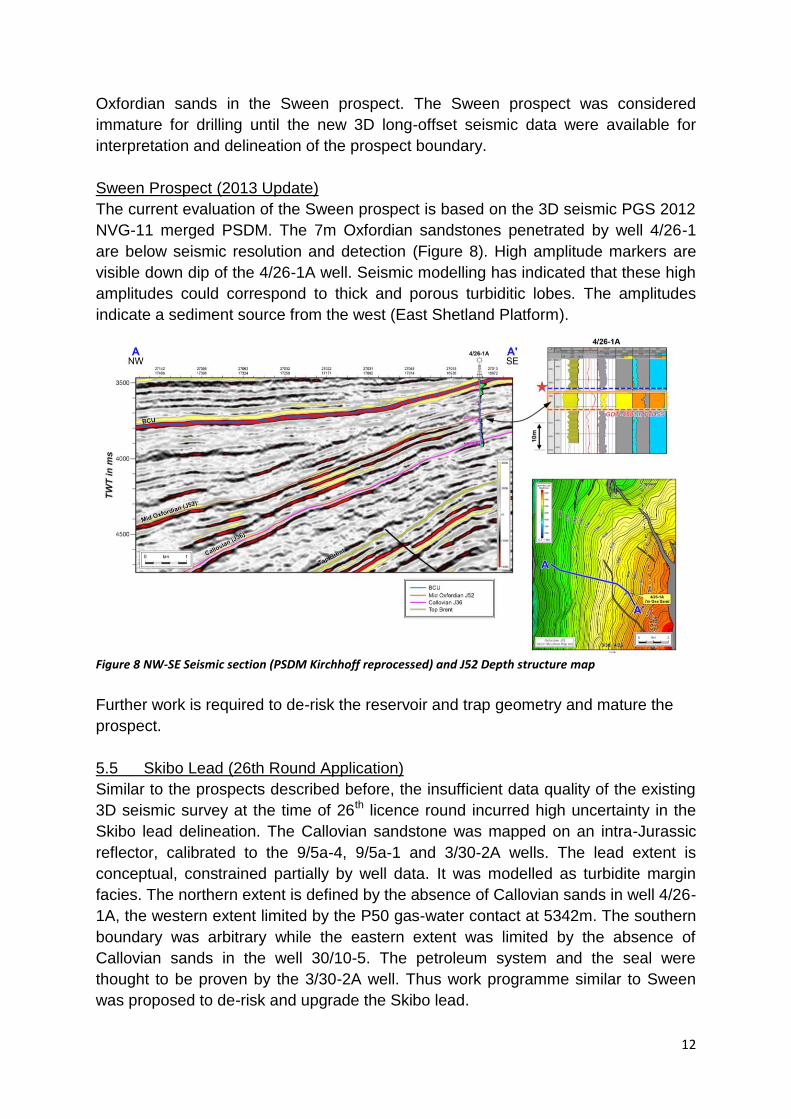
Sween Prospect (2013 Update)
The current evaluation of the Sween prospect is based on the 3D seismic PGS 2012
NVG-11 merged PSDM. The 7m Oxfordian sandstones penetrated by well 4/26-1
are below seismic resolution and detection (Figure 8). High amplitude markers are
visible down dip of the 4/26-1A well. Seismic modelling has indicated that these high
amplitudes could correspond to thick and porous turbiditic lobes. The amplitudes
indicate a sediment source from the west (East Shetland Platform).
Figure 8 NW-SE Seismic section (PSDM Kirchhoff reprocessed) and J52 Depth structure map
Further work is required to de-risk the reservoir and trap geometry and mature the
prospect.
5.5 Skibo Lead (26th Round Application)
Similar to the prospects described before, the insufficient data quality of the existing
3D seismic survey at the time of 26th licence round incurred high uncertainty in the
Skibo lead delineation. The Callovian sandstone was mapped on an intra-Jurassic
reflector, calibrated to the 9/5a-4, 9/5a-1 and 3/30-2A wells. The lead extent is
conceptual, constrained partially by well data. It was modelled as turbidite margin
facies. The northern extent is defined by the absence of Callovian sands in well 4/26-
1A, the western extent limited by the P50 gas-water contact at 5342m. The southern
boundary was arbitrary while the eastern extent was limited by the absence of
Callovian sands in the well 30/10-5. The petroleum system and the seal were
thought to be proven by the 3/30-2A well. Thus work programme similar to Sween
was proposed to de-risk and upgrade the Skibo lead.
13
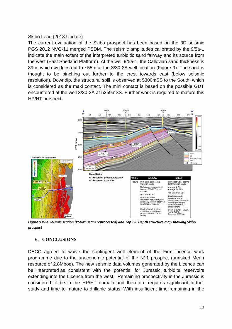
Skibo Lead (2013 Update)
The current evaluation of the Skibo prospect has been based on the 3D seismic
PGS 2012 NVG-11 merged PSDM. The seismic amplitudes calibrated by the 9/5a-1
indicate the main extent of the interpreted turbiditic sand fairway and its source from
the west (East Shetland Platform). At the well 9/5a-1, the Callovian sand thickness is
89m, which wedges out to ~55m at the 3/30-2A well location (Figure 9). The sand is
thought to be pinching out further to the crest towards east (below seismic
resolution). Downdip, the structural spill is observed at 5300mSS to the South, which
is considered as the maxi contact. The mini contact is based on the possible GDT
encountered at the well 3/30-2A at 5259mSS. Further work is required to mature this
HP/HT prospect.
Figure 9 W-E Seismic section (PSDM Beam reprocessed) and Top J36 Depth structure map showing Skibo
prospect
6. CONCLUSIONS
DECC agreed to waive the contingent well element of the Firm Licence work
programme due to the uneconomic potential of the N11 prospect (unrisked Mean
resource of 2.8Mboe). The new seismic data volumes generated by the Licence can
be interpreted as consistent with the potential for Jurassic turbidite reservoirs
extending into the Licence from the west. Remaining prospectivity in the Jurassic is
considered to be in the HP/HT domain and therefore requires significant further
study and time to mature to drillable status. With insufficient time remaining in the

14
Initial Term of P1755, TEPUK and Maersk decided to relinquish the acreage at the
end of its First term.
7. CLEARANCE
Total E&P UK Ltd confirms DECC is free to publish this report and that all third party
ownership rights have been considered and appropriately cleared for publication
purposes.