Embed Size (px)
Citation preview
MARINE ECOLOGY PROGRESS SERIES Mar. Ecol. Prog. Ser.
Published June 29
Relationship between vegetation and soil formation in a rapidly submerging coastal marsh
J. A. Nymanl, R. D. DeLaunel, H. H. ~ o b e r t s ~ , W. H. Patrick Jrl
Wetland Biogeochemistry Institute, Louisiana State University, Baton Rouge, Louisiana 70803-751 1 , USA 'Coastal Studies Institute, Louisiana State University. Baton Rouge, Louisiana 70803, USA
ABSTRACT: Purposes of this study were to determine the relative importance of organic matter and mineral matter to marsh vertical accretion and to determine if insufficient vertical accretion was a fac- tor in land loss in a Terrebonne Basin (Louisiana, USA) marsh. '"CS dating indicated that vertical accretion (0.98 cm yr-l) was extremely rapid relative to other marshes, but insufficient to counter sub- mergence (1.38 cm yr-'). Mineral and organic matter accumulation were similar to that in other marshes. Variation in vertical accretion was accounted for by variation in organic matter accumulation rather than mineral matter accumulation: thus, inadequate vertlcal accretion resulted from inadequate organic matter accumulation. Inadequate organic matter accurnulat~on (593 g m-2 yr- ') was attributed to inadequale plant production resulting primarily from flooding stresses; inadequate mineral matter accumulation (1629 g m-' yr-') was attributed to inadequate mineral matter availability. These data suggest that this marsh 1s threatened by a positive feedback loop of plant flooding stress and inade- quate vertical accretion. Inadequate plant growth limits vertical accretion, which further increases flooding and decreases plant proditction. Thus plant production, which has previously been considered only in the context of trophic dynamics, also partly determines the degree of submergence some coastal and estuarine marshes will tolerate.
INTRODUCTION
Subsidence in coastal Louisiana, USA can exceed 1.0 cm yr-l, which is greater than elsewhere on the northern Gulf of Mexico coast (Penland & Ramsey 1990). Marsh surfaces must vertically accrete by form- ing additional marsh soil if they are to counter submer- gence (the combination of global sea-level rise and subsidence). This process can be self regulating because as the marsh floods more often, tidal delivery of mineral sediments increases, and soil organic matter decomposition slows (Mitsch & Gosselink 1986, p. 178). As the marsh surface regains elevation, mineral sedi- mentation decreases and soil organic matter decompo- sition increases (Mitsch & Gosselink 1986, p. 178). However, soil formation can be inadequate (e.g. DeLaune et al. 1983a), which results in excessive marsh flooding. Soil waterlogging stresses can become severe enough to cause vegetation dieback (DeLaune et al. 1983b, Mendelssohn & McKee 1988), which might lead to pond formation. Understanding marsh
soil formation in Louisiana's rapidly subsiding coastal marshes may provide insight relevant to other coastal marshes if the rate of global sea-level rise increases as projected (e.g. Titus 1986).
Our primary purpose was to determine the relative importance of organic matter and mineral matter to marsh vertical accretion. Both mineral matter and organic matter are important components of marsh soil. In New England and Louisiana marshes, soil organic matter is composed primarily of tightly inter- locking root networks that reduce the susceptibility of mineral sediments to erosion (McCaffrey & Thomson 1980, J.A.N. pers. obs.). Organic matter accumulation defines vertical accretion in Louisiana and New Eng- land coastal marshes (McCaffrey & Thomson 1980, Hatton et al. 1983) but is apparently not as important in Atlantic coast marshes of the southeastern United States. In Louisiana, organic matter occupies more soil volume than mineral matter in fresh, intermediate, and brackish marsh soils (Nyman et al. 1990). Soil mineral matter may indirectly control vertical accretion
O Inter-Research 1993
270 Mar. Ecol. Prog. Ser.
through its effects on plant production (Bricker-Urso et al. 1989). King et al. (1982) reported a positive relation- ship between soil Fe concentrations and vegetation productivity in a Georgia marsh. Soil mineral matter provides cation exchange and sorption sites for orthophospate that reduce phosphate leaching (Patrick & Khalid 1974), and soil P and saline marsh vegetation productivity are positively related in North Carolina (Broome et al. 1975). Bradley & Morris (1990) observed a positive relationship between soil bulk density and soil water percolation velocity in South Carolina. Soil bulk density is a function of soil mineral matter content (Hatton et al. 19831, and end-of-season standing crop biornass of Spartina alterniflora is positively related to soil P, soil Fe, and soil bulk density in Louisiana saline marsh (DeLaune et al. 1979, DeLaune & Pezeshki 1988). Mineral sedimentation is often a function of tidal action, but winter storms are more important in Loui- siana (Reed 1989) and New England marshes (Harri- son & Bloom 1977, Stumpf 1983).
A secondary purpose was to determine if inadequate vertical accretion was a factor in marsh loss, as others have concluded (e.g. DeLaune et al. 1983a). Marsh loss in Louisiana is extremely rapid; Gagliano et al. (1981) documented marsh loss rates averaging 7278 ha yr-' . Marsh loss occurs in 2 landscape patterns in Louisiana (Leibowitz and Hill 1987) 'Hotspot' is a term coined by Leibowitz & Hill (1987) to describe areas of high marsh loss rates embedded within areas of internal fragmen- tation where loss rates are much lower. Leibowitz & Hi11 (1987) found that although hotspots accounted for only 12 7,) of all marsh in their study areas, they accounted for 43 O/o of all marsh loss.
STUDY AREA
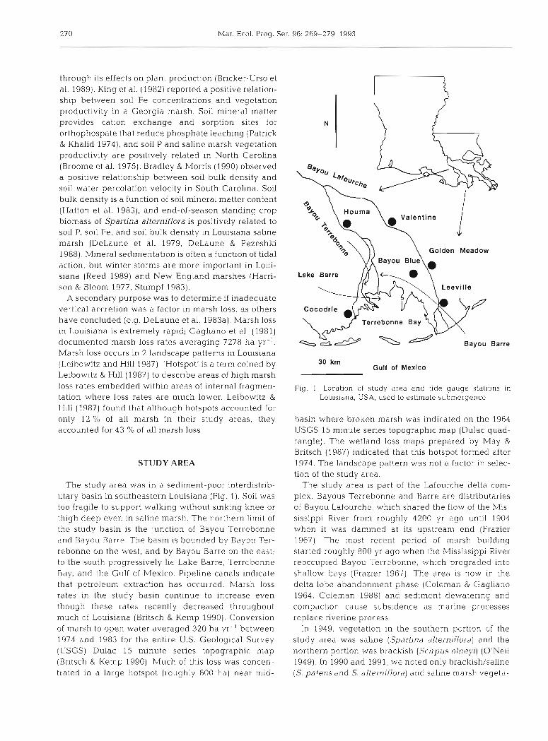
The study area was In a sediment-poor interdistrib- utary basin in southeastern Louisiana (Fig. 1) . Soil was too fragile to support walking without sinking knee or thigh deep even in saline marsh. The northern limit of the study basin is the junction of Bayou Terrebonne and Rdyou Barre. The basin is bounded by Bayou Ter- rebonne on the west, and by Bayou Barre on the east; to the south progressively lie Lake Barre, Terrebonne Bay, and the Gulf of Mexico. Pipeline canals indicate that petroleum extraction has occurred. Marsh loss rates in the study basin continue to increase even though these rates recently decreased throughout much of Louisiana (Eritsch & Kemp 1990). Conversion of marsh to open water averaged 320 ha yr. ' between 1974 and 1983 for the entire U.S. Geological Survey (L'SGS) Dulac 15 minute series topographic map (Br~tsch & Kemp 1990). Much of this loss was concen- trated in a large hotspot (roughly 600 ha) near mid-
Gulf of Mexico
Fig. 1 Location of study area and tide gauge statlons in Louisiana, USA, used to estimate submergence
basin where broken marsh was indicated on the 1964 USGS 15 minute series topographic map (Dulac quad- rangle). The wetland loss maps prepared by May & Britsch (1987) indicated that this hotspot formed after 1974. The landscape pattern was not a factor in selec- tion of the study area.
The study area is part of the Lafourche delta com- plex. Bayous Terrebonne and Barre are distributaries of Bayou Lafourche, which shared the flow of the Mis- sissippi River from, roughly 4200 yr ago until 1904 when it was dammed at its upstream end (Frazier 1967) The most rcccnt period of marsh building started roughly 800 yr ago when the Mississippi River reoccupied Bayou Terrehonnr, wh.ich prograded into shallow bays (Frazier 1967). The area is now in the delta lobe abandonment phase (Coleman & Gagliano 1964, Coleman 1988) and sediment dewatering and compaction cause subsidence as marine processes replace nverine process.
In 1949, vegetation in the southern portion of the study area was saline (Spartina alterniflora) and the northern portion was brackish (Scirpus olnq7i) (O'Neil 1949). In 1990 and 1991, we noted only brackish/saline (S. patens and S. alterniflora) and saline marsh vegeta-

Nyrnan et al.: Vegetation and soil formation in a submerging coastal marsh 27 1
tion (S. alterniflora or S. alterniflora and Juncus roerne- walled, sharpened aluminum irrigation pipe. Cores rianus), although brackish marsh may have been were sectioned into 3 cm increments and dried at 80 "C present further north of our sampling stations. Accord- to remove non-structural water ing to vegetation type maps (O'Neil 1949, Chabreck & Total vertical accretion on the marsh surface since Linscombe 1988), the border between saline and 1963 was estimated from the depth of the soil incre- brackish marsh has migrated approximately 5 km ment containing the I3?Cs maxima, and the number of inland, from near Stn 5 to near Stn 13 (see Fig. 2 ) . years between core collection and 1963 (DeLaune et al. Inland migration of saline marsh at the expense of the 1978). Vertical accretion averaged over greater depths brackish marsh is common in southeast Louisiana underestimates total vertical accretion (changes (Chabreck & Linscombe 1982) relative to shallow horizons) because of autocompac-
tion, which causes marsh surfaces to settle (Kaye &
Barghoorn 1964). Vertical accretion averaged over METHODS greater depths is required to estimate net vertical
accretion (changes in absolute elevation), which was Fifteen sites were sampled for analyses of soil forma- not estimated in this study. 137Cs activity was estimated
tion (Fig. 2). Streamside marsh was not sampled; all from the gamma ray emission rate (661.7 keV) from soil sites were located in inland marsh, i.e. beyond 5 m increments; standard deviations were also determined from the edge of bayous and lakes. Three saline marsh (Wang et al. 1975, p. 300). Entire soil increments were sites were sampled in August 1989, others were sam- counted in a Marinelli beaker that fit over a 7.6 cm X
pled between February and August 1990. The 4 north- 7.6 cm Li drifted Ge detector crystal. The '37Cs maxima ernmost sites sampled in 1990 were in brackish/saline were assumed to result from atmospheric deposition of mal-sh; others were in saline marsh. Two soil cores '"CS that marks the 1963 surfaces, rather than from were collected from each site. Cores were 45 to 55 cm deposition of eroded, I3'Cs-containing sediments that long and were collected with 15 cm diameter, thin- mark 1964 surfaces, as occurs in some reservoirs
(Ritchie et al. 1973). This is because 13'Cs pro-
2 9 0 24' 00" files in Louisiana marshes represent continual atmospheric deposition rather than discontinu- ous sediment deposition (pers, obs.). If we erred, then vertical accretion was underesti- mated by 4 %.
Vertical accretion rates were compared to published submergence estimates since 1963 to determine if vertical accretion in the study area was adequate to counter submergence. These local submergence rates more accu- rately reflect water level increases in the study area than does global sea level rise, because
0 C) the local rates also reflect local subsidence, i. C)
which is substantial in coastal Louisiana (Pen- 0 o $ land & Ramsey 1990). m m 137Cs mobility is not generally a problem
because illites, the most common clays in nature (Millot 1970, p. 8), bind 137Cs internally so that only destruction of the clay lattice (e.g. digestion with 5 N nitric acid) causes desorp- tion (Lomenick & Tamura 1965). Lomenick &
Tamura (1965) found 84 % of the I3?Cs in their soil bound to illites even though illites accounted for only 35% of their sedirnents. Illites are the major clays in the Atlantic Ocean and make up 40 to 50 %of the clays in the Gulf of Mexico (Griffin et al. 1968). Illites are com-
290 16' 00" mon off the Louisiana coast (Brooks et al.
Fig. 2. Approximate location of sites where replicate cores were 1 9 7 6 ) 9 in estuarine sediments (Gam- collected for study of soil formation brell et al. 1977), and account, for 10 to 30 % of
272 Mar Ecol. Prog Ser.
mineral m.atter in Louisiana marsh soils (Dr W. Hud- nail. Department of Agronomy, Louisiana State Uni- versity Agricultural Center, Baton Rouge, pers. comm.). X-ray diffraction analyses of soil from the northern extreme, southern extreme, and middle of our study area indicated that illites were present in all samples (Dr Alan Bailey, Department of Geology, Uni- versity of Southwestern Louisiana, Lafayette, pers. comm.). Illites are not common in freshwater bodies of the southeastern United States (Neiheisel & Weaver 1967), and Alberts et al. (1979) noted '37Cs mobility in a South Carolina freshwater reservoir that was subse- quently explained by a lack of illites (Evans et al. 1983). See Ritchie & McHenry (1990) for a recent review of I3'cs dating applications.
Initial efforts also included 2 1 0 ~ b dating techniques to estimate vertical accretion (Armentano & Woodtvell 1975), but were discontinued when we found that our cores were not long enough to reach beyond depths containing atmospherically deposited 210Pb (unpubl. data). Evidently, vertical accretion rate was so rapid that these cores (about 50 cm long) were too short to reach soil 80 yr old. This information was desired because it would have provided information relevant to autocompaction.
Bulk density in the study area was determined from the weight of oven-dried soil increments, and the vol- ume of the increments prior to drying. Bulk density estimates from the upper 5 increments (15 cm) of each core were used to estimate root zone soil bulk density at the 15 sites throughout the study area.
The amount of organic matter and mineral matter that accumulated since 1963 in each core was also esti- mated. Soil increments that contained the 1963 marsh surface, and all overlying increments, were ground for analyses. Samples from each soil increment were ignited at 400 "C for 16 h to remove organic matter (Davies 1974). The weights of mineral and organic matter per cm3 of soil in each increment were estl- mated from soil bulk density, percent mineral, and per- cent organic matter measured individually for each soil increment Total mineral and organic matter accumu- lation could not be estimated for 2 cores from different sites because data were missing from individual incre- ments in those cores.
End-of-season, above-ground biomass of saline marsh vegetation was estimated to determine if vege- tation in the study area was stressed, and also to deter- mine if biomass variability with~n the study area was related to soil bulk density variability within the study area. Vegetation and soil bulk density were sampled on 26 October 1990. Four sites were selected that rep- resented the range of Spartina alterniflora marsh vigor within the study area. These sites were not randomly chosen; instead, they were selected to document the
range of vegetation biomass, from the most healthy- appearing to the least healthy-appearing saline marsh vegetation stands in the study area. These sites were independent of the sites where cores were collected for soil formation analyses, although one was within 100 m of Stn 6 (Fig. 2). At each biomass site, above-ground vegetation was harvested from three 0.5 m' plots. A 20 cm long, 15 cm diameter core was also collected from the center of each plot to estimate soil bulk den- sity at the biomass plots. As noted, soil bulk density from elsewhere in the study area was estimated from the 30 cores collected for soil formation analyses.
Vertical accretion, mineral matter and organic mat- ter accumulation rates since 1963 and soil bulk density within the root zone were compared between brack- ish/saline and saline marsh as a Completely Random- ized Design with nesting of site within marsh type (Proc GLM; SAS Institute, Inc., Cary, NC, USA); the site-within-marsh-type (n = 15) term was the proper
W core 1 - c o r e 2
CS-137 activity (counts per section)
1 - - core l - core 2
so11 bulk dens~ty (c~ lc rn~)
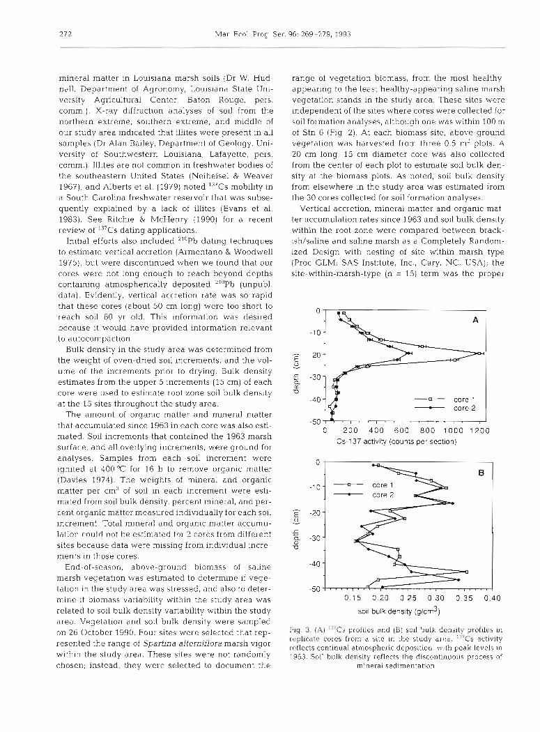
Fig. 3. (A) '"CS profiles and (B) soil hulk density profiles in replicdte cores from a site in the study arca. " 'CS activity reflects continual atmospheric deposition, with peak levels In 1963. Soil bulk density reflects the discontinuous process of
mineral sedimentation

Nyman et al.: Vegetation and soil formation in a submerging coastal marsh
estimate of error for these tests rather than the core- within-marsh-type (n = 30). All soil increments in the upper 15 cm of soil (n = 148) were used to estimate soil bulk density in the study area, but to be conservative, soil increments were considered sub-samples and were not used as independent estimates of error for statistical tests. Rather, the site-within-marsh-type term (n = 15) was used. Vertical accretion and mineral and organic matter accumulation were analyzed (Proc GLM; SAS Institute, Inc.) to determine whether organic matter accumulation, mineral matter accumu- lation, or their interaction was most strongly related to vertical accretion. For these regressions, type 111 'uniquely attributable' sums of squares were used. This is especially important because mineral and organic matter accumulation were expected to be highly correlated, i.e. these data were expected to be ill-conditioned. Vegetation and soil bulk density data were analyzed (Proc REG; SAS Institute, Inc.) to test for a linear relationship between soil bulk density and saline marsh vegetation above-ground biomass within the study area. For all tests, an alpha level of 0.05 was used.
RESULTS
The 1963 marsh surface was almost always located at identical or adjacent depths in replicate cores from the same site (e.g. Fig. 3). Vertical accretion since 1963 in the study area averaged 0.98 cm yr.' (n = 30, SE =
0.06), and was similar in brackish/saline and saline marsh (F = 0.03, 1 and 13 df, p = 0.8609) (Table 1). There was no obvious spatial pattern in vertical accre- tion rates. Brackishhaline and saline marsh also had similar organic matter accretion rates (F = 0.14, 1 and 13 df, p = 0.7111), but differed greatly in mineral mat- ter accumulation (F = 5.95, 1 and 13 df, p = 0.0298) (Table 1).
Whereas '"CS profiles represented continual atmos- pheric deposition, variable soil bulk density with depth reflected the discontinuous process of mineral sedi- mentation (e.g. Fig. 3) . Soil bulk density within the root zone, the upper 15 cm of soil, was lower in brackish/ saline marsh than in saline marsh (F = 22.11, 1 and 13 df, p = 0.0004).
Vertical accretion was correlated with both mineral matter (R - 0.70, n = 28, p = 0.0001) and organic matter
Table 1 Soil formation characteristics in the Lake Barre area marshes; data from 2 cores at each site, Terrebonne Parish, Louisiana. 1989 and 1990
Site Bulk Organic Vertical Mineral Organic densityd matter accretion accumulation accumulation (g cm-3) ( X ) (cm yr-l) (g m-Z yr.') (g m-' yr.')
Saline (1) Lake Barre 0.25 3 1.5 1.78 4178 1245 (2) Charles Theriot 0.27 17.4 0 98 2083 440 (3) Bay la Peur 0.31 24.4 0 78 2053 567 (4) downstream Chitigue 0.27 21.2 0 98 234 1 576 (5) m~dstream Chitigue 0.26 21.9 0 75 1639 456 (6) upstream Chitigue 0.21 29.9 1 22 1928 720 (7) Grand Bayoub 0.18 31.0 1 04 1126 406 (8) downstream d e ~ a n g . u e ~ 0.20 39.5 0.56 1376 439 (9) midstream deMangue 0.26 23.5 1.28 2643 776
(10) upstream deMangue 0.17 29.6 0.94 1100 624 (1 1) DuFrene 0.16 31.3 0 55 699 310 Mean 0.23 27.4 0.99 1992 613
Brackishlsaline (12) SE Madison Bay (13) W Madison Bay (14) N Madison Bay (15) N Billy Goat Bay Mean
Mean of all sites: 0.20 31.8 0.98 1629 593 1
Soil bulk density in the root zone only (top 15 cm of soil); all other parameters estimated from all soil overlying the 1963 marsh surface
b ~ i n e r a l and organic matter accumulation rates could be determined in only one core
274 Mar. Ecol Prog. S(2r. 96: 269-279, 1993
m 0 0
0 mineral matter
5 organic matter
mineral and organic matter accumulation ( k g / d )
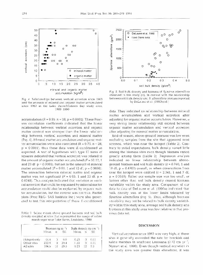
Fig. 4. Relationships between vertical accretion since 1963 and the amounts of mineral and organic matter accumulated since 1963 in the Lake Barre/Madison Bay study area,
1989-1990
accumulation (R = 0.95, n = 28, p = 0.0001). These Pear- son correlation coefficients indicated that the linear relationship between vertical accretion and organic matter content was stronger than the linear relation- ship between vertical accretion and mineral matter (Fig. 4). Mineral matter accumulation and organic mat- ter accumulation were also correlated (R = 0.75, n = 28, p = 0.0001). thus these data were ill-conditioned as expected. A test of hypotheses with type I11 sums of squares indicated that vertlcal accretion was related to the amount of organic matter accumulated (F= 52.12, 1 and 23 df, p = 0.0001), but not to the amount of mineral matter accumulated (F= 0.01, 1 and 23 df, p = 0.9696). The interaction between mineral matter and organic matter was not significant (F = 0.05, 1 and 23 df, p =
0.8248). T h ~ s analysis indicated that variation in verti- cal accretion that could be explained by mineral matter accumulation could also be explained by organic mat- ter accumulation, but the reverse was not true. Partial plots (Proc REG; S A S Institute Inc.) were also gener- ated to test this interpretat~on of these 1.11-conrIitioned
Table 2. Sa l~ne marsh above-ground b~omass and soil bulk density sampled at sites thClt rrpresented the rdnqe of saline
marsh vi(jor n ra r Lake Barrr. Louisiana, 1990
B~ornass (g m 'I Bulk densitv ( g c m ') Sfeiin n S hlcwn n SE
- - .
Hotspot only 40.4 3 9.9 0.23 3 0.01 Other sites 232.6 9 20.4 0.22 9 0.01 All sites 184 5 12 29.3 0.23 12 0.0
0 DeLaune et al. l990 o0 Lake Barre area
2000 -
soil bulk density (g/crn3)
Fig. 5. Soil bulk density and biomass of Spartina alterniflora observed in this study (0), in context with the relationship between soil bulk density and S. alternlflora biomass reported
by DeLaune et al. (1990b) (d.)
data. They indicated no relationship between mineral matter accumulation and vertical accretion after adjusting for organic matter accumulation. However, a very strong linear relationship still existed between organic matter accumulation and vertical accretion after adjusting for mineral matter accumulation.
End-of-season, above-ground biomass was low even excluding samples from the site that appeared most stressed, which wa.s near the hotspot (Table 2) . Con- trary to initial expectations, bulk density varied little among the biomass sites even though biomass varied greatly among them (Table 2) Regression analysis indicated no linear relationship between above- ground biornass and soil bulk density ( t = 0.740, 1 and 10 df, p = 0.4762) overall, or when observations from near the hotspot were omitted ( t = 2.341, 1 and 7 df, p = 0.0518). Either our sample size was too small, or factors other than soil bulk density caused biomass variability within the study area. Comparison of our data to data of DeLaune et al. (1990a) indicated that bulk density was at the lower limits tolerated by Spartina alterniflora (Fig. 5) . Thus, although biomass variab~lity may not be related to bulk density variabil- ity within this study area, average soil bulk density and biomass in this study area was low relative to that pre- vious data set.
DISCUSSION
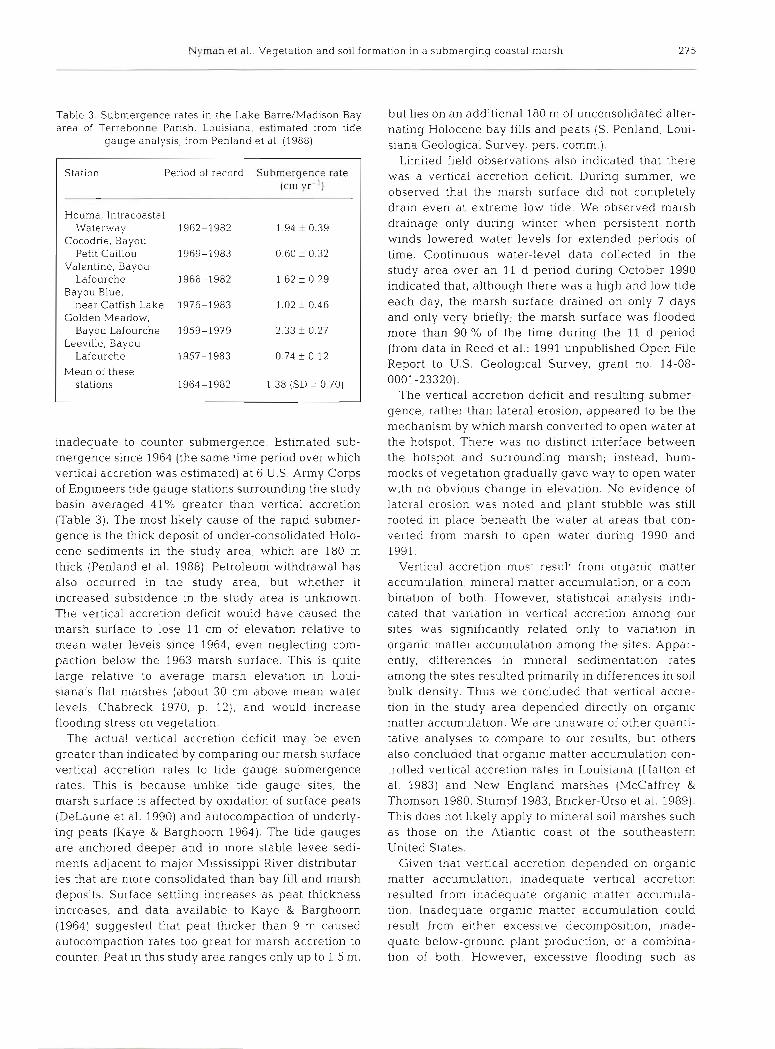
Vertical accretion since 1963 was very high; at these sites i t generally exceeded the rate for brackish and saline marshes in southeast Louisiana (0.72 cm yr '; Nyman et al. 1990). Even though vertical accretion in the study area was greater than elsewhere, it was
Nyman et a l . . Vegetation and soil formation In a submerging coastal marsh
Table 3 area of
Station Period of record Submergence rate (cm yr-l)
H.ouma, lntracoastal Waterway 1962-1982 1.94 f 0.39
Cocodrie, Bayou Petit Caillou 1969-1983 0.60 ? 0.32
Valentine, Bayou Lafourche 1966-1982 1.62 f 0.29
Bayou Blue, near Catfish Lake 1976-1983 1.02 ? 0.46
Golden Meadow, Bayou Lafourche 1959-1979 2.33 f 0.27
Leeville, Bayou Lafourche 1957-1983 0.74 f 0.12
Mean of these stalions 1964-1982 1.38 (SD = 0.70)
. Submergence rates in the Lake Barre/Madison Bay but lies on an additional 180 m of unconsolidated alter- Terrebonne Parish, Louisiana, estimated from tide nating Holocene bay fills and pests (S. Penland, Loui-
gauge analysis, from Penland et al. (1988) siana Geological Survey, pers, comm.). Limited field observations also indicated that there
was a vertical accretion deficit. During summer, we observed that the marsh surface did not completely drain even at extreme low tide. We observed marsh drainage only during winter when perslstent north w ~ n d s lowel-ed water levels for extended periods of time. Continuous water-level data collected in the study area over an 11 d period during October 1990 indicated that, although there was a high and low tide each day, the marsh surface drained on only 7 days and only very briefly; the marsh surface was flooded more than 90 % of the time during the 11 d period (from data in Reed et al.: 1991 unpublished Open File Report to U.S. Geological Survey, grant no. 14-08- 0001-23320).
The vertical accretion deficit and resulting submer- gence, rather than lateral erosion, appeared to be the mechanism by which marsh converted to open water at
inadequate to counter submergence. Estimated sub- the hotspot. There was no distinct interface between mergence since 1964 (the same time period over which the hotspot and surro.unding marsh; instead, hum- vertical accretion was estimated) at 6 U.S. Army Corps mocks of vegetation gradually gave way to open water of Engineers tide gauge stations surrounding the study with no obvious change in elevation. No evidence of basin averaged 41% greater than vertical accretion lateral erosion was noted and plant stubble was still (Table 3). The most likely cause of the rapid submer- rooted in place beneath the water at areas that con- gence is the thick deposit of under-consolidated Holo- verted from marsh to open water during 1990 and cene sediments in the study area, which are 180 m 1991. thick (Penland et al. 1988). Petroleum withdrawal has Vertical accretion must result from organic matter also occurred in the study area, but whether i t accumulation, mineral matter accumulation, or a com- increased subsidence in the study area is unknown. bination of both. However, statistical analysis indi- The vertical accretion deficit would have caused the cated that variation in vertical accretion among our marsh surface to lose 11 cm of elevation relative to sites was significantly related only to variation In mean water levels since 1964, even neglecting com- organic matter accumulation among the sites. Appar- paction below the 1963 marsh surface. This is quite ently, differences in mineral sedimentation rates large relative to average marsh elevation in Loui- among the sites resulted primarily in differences in soil siana's flat marshes (about 30 cm above mean water bulk density. Thus we concluded that vertical accre- levels; Chabreck 1970, p. 12), and would increase tion in the study area depended directly on organic flooding stress on vegetation. matter accumulation. We are unaware of other quanti-
The actual vertical accretion deficit may be even tative analyses to compare to our results, but others greater than indicated by comparing our marsh surface also concluded that organic matter accumulation con- vertical accretion rates to tide gauge submergence trolled vertical accretion rates in Louisiana (Hatton et rates. This is because unlike tide gauge sites, the al. 1983) and New England marshes (McCaffrey & marsh surface is affected by oxidation of surface peats Thomson 1980, Stumpf 1983, Bricker-Urso et al. 1989). (DeLaune et al. 1990) and autocompaction of underly- This does not llkely apply to mineral soil marshes such ing peats (Kaye & Barghoorn 1964). The tide gauges as those on the Atlantic coast of the southeastern are anchored deeper and in more stable levee sedi- United States. ments adjacent to major Mississippi River distributar- Given that vertical accretion depended on organic ies that are more consolidated than bay fill and marsh matter accumulation, inadequate vertical accretion deposits. Surface settling increases as peat thickness resulted from inadequate organic matter accumula- increases, and data available to Kaye & Barghoorn tion. Inadequate organic matter accumulation could (1964) suggested that peat thicker than 9 m caused result from either excessive decomposition, inade- autocompaction rates too great for marsh accretion to quate below-ground plant production, or a combina- counter. Peat in this study area ranges only up to 1.5 m, tion of both. However, excessive flooding such as
276 Mar. Ecol. Prog Ser 96: 269-279, 1993
occurs in the study area reduces both decom- position (Nyman et al. 1991) and production in Spartina alterniflora and S. patens marsh (DeLaune et al. 1983b, Mendelssohn &
McKee 1988, Pezeshki et al. 1991). Thus inadequate organic matter accumulation most likely resulted from inadequate produc- tion. Evidently, decreases in soil organic mat- ter decomposition rates and increases in root/shoot ratios that are also expected with increased flooding (Good et al. 1982, Nyman & DeLaune 1991) were not adequate. Given that plant production was limited by flood- ing, and that vertical accretion depended on organic matter accumulation, then a positive feedback loop of inadequate vertical accre- tion and plant flooding stress is indicated.
It would be incorrect to conclude from these data that mineral matter accumulation
Table 5. Vertical accretion and mineral and organic matter accumulation rates measured at thls site (Lakc Barre, Louislana), requiredd at this site.
and measured at other coastal marshes
Source
p-
Brackish marsh Measured Required Barataria Baslnb Saline marsh Measured Required Barataria Bas~n Chesapeake Bay'
Vertical accretion [cm y r - ' )
Accumulation rates (g m-' yr- ')
Organic matter Mlneral matter
was unimportant to the vertical accretion L process even though vertical accretion depended directly on organic matter accu- mulation. Organic matter accumulation probably depends partially on mineral matter accumulation because, a s noted, soil mineral matter enhances plant growth. This is the most likely reason that organic mat- ter accumulation and mineral matter accumulat~on were positively correlated. Others have also noted that organic matter accumulation and mineral matter accu- mula t~on were positively correlated, and concluded that this resulted from the positive effect of mineral sediments on plant growth (Brlcker-Urso et al. 1989).
Brackishkaline marsh in this study area accreted vertically at rates similar to the saline marsh, but incor- porated only 40 % as much mineral matter as saline marsh. The difference in mineral matter accumulation between brackish and saline marsh may result from differences in mineral matter availability (e.g McCaf- frey & Thomson 1980) or because brackish and saline marshes differ in SO, ' availabil.ity. This would cause
Table 3 . End-of-season standiny crop dbove-ground biornass In Louisiana saline marshes
Habitat g m-' Source I
Soil formation requirements estimated from the submergence rate and equations in Nyman et al. (1990, Fig 4 )
'Hatton et al. (1983, Table l ] 'Kearnev R Stevenson (1991, Table 21
Streamside Streamside Inland Inland Inland Inland Dieback Inland
DeLaune et al. (198310) Mendclssohn et al. (1981) Kirby & Gosselink (1976) Hopkinson et al. (1978) DeLaune et al. (198361 Mendelssohn et al. (1981) Mendelssohn et al. (1981) This study
them to have different mineral matter requirements to counter different levels of sulfide toxicity (Nyman et al. 1990).
Spartina alterniflora biomass in the study area was low relative to other marshes (Table 4 ) . This agreed with the conclusion that plant production was limited by the vertical accretion deficit and resulting flooding. Soil waterlogging reduces S. alterniflora photosynthe- sis (Pearson & Havill 1988, Pezeshkl et al. 1988), and soil drainage controls many of the factors proposed to limit S. alterniflora growth (Chalmers 1982). Above- ground production is related to end-of-season stand- ing-crop biomass and stem turnover rates (Hopkinson et al. 1980), and stem turnover rates do not differ among different height forms of S. alterniflora. (Shrew et al. 1981). Thus, although above-ground production was not estimated, the biom.ass data collected ~ n d i - cated that current above-ground production was low as would be expected from excessive flooding. Al- though low biomass most likely resulted from exces- sive flooding, low soil bulk density may also have con- tributed to low S. alterniflora biomass. As noted, soil bulk density is a function of soil mineral matter con- tent, and. soil mineral matter and plant growth are pos- itively related. It also appeared that hlgh nutria Myo- castor coypus and muskrat Ondatra zibethicus densities contributed to low S. alterniflora biomass via herbivory, but no data are available to evaluate that relationship.
Mineral and organic matter accumulation rates were inadequate to offset submergence (Table 5: required value). Requirements were estimated from the sub- mergence rate in this study area and typica.1 sol1 prop-
Nyman et a1 : Vegetation and soil formation In a submerging coastal marsh 277
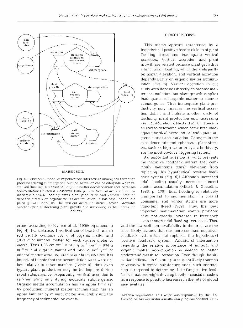
CONCLUSIONS
This marsh appears threatened by a hypothetical positive feedback loop of plant flooding stress and inadequate vertical accretion. Vertical accretion and plant growth are related because plant growth is a function of flooding, which depends partly on marsh elevation, and vertical accretion depends partly on organic matter accumu- lation (Fig. 6). Vertical accretion in our
dccornposition study area depends directly on organic mat- ter accumulation, but plant growth supplies inadequate soil organic matter to counter submergence. Thus inadequate plant pro- ductivity may increase the vertical accre- tion deficit and initiate another cycle of declining plant production and increasing vertical accretion deficits (Fig. 6). There is no way to determine which came first: inad- equate vertical accretion or inadequate or- ganic matter accun~ulation. Changes in the subsidence rate and ephemeral plant stres- ses, such as high water 01- cyclic herbivory, are the most obvious triggering factors.
An important questlon is, what prevents the negative feedback system that com- monly maintains marsh elevation from
IMARSH SOIL replacing this hypothetical positive feed-
Fig 6. Conceptual model of hypothesized interactions among soil formation back system (Fig. 6)? Although increased
processes during submergence. Vertical accretlon can be adequate when in- increases creased flooding decreases soil organic matter decolnposition and increases matter accumulation (Mitsch & Gosselink sedimentation (Mltsch & Gosselink 1986, p. 178). Vertlcal accretion can be 1986, p. 178), tidal flooding is relatively inadequate when floodlng limits plant production and vertical accretlon unimportant to sedimentation in coastal depends directly on organic matter accumulation. In this case, inadequate plant growth increases the vertical accretion deficit, which promotes Louisiana, and winter storms are more
another cycle of declining plant growth and increasing vertical accretion important (Reed 1989). Thus, the most deficits important sedimentation events probably
have not greatly increased in frequency even though tidal flooding ~ncreased. This,
erties, according to Nyman et al. (1990: equations in and the low sediment availability in the area, are the Fig. 4). For instance, 1 vertical cm of brackish marsh most likely reasons that the more common negative- soil usually contains 583 g of organic matter and feedback system has not replaced the hypothetical 1052 g of mineral matter for each square meter of positive feedback system. Additional information marsh. Thus 1.38 cm yr-' X 583 g m-2 cm-' = 804 g regarding the relative importance of mineral and
yr-' of organic matter and 1452 g m-2 yr-' of organic matter accumulation is needed to better mineral matter were required at our brackish sites. It is understand marsh soil formation. Even though the sit- important to note that the accumulation rates were not uation indicated in this study area is not likely common low relative to other marshes (Table 5 ) , thus even in areas with typical subsidence rates, such informa- typical plant production may be inadequate during tion is required to determine if similar positive feed- rapid submergence. Apparently, vertical accretion is back situations might develop in other coastal marshes self-regulating only dunng moderate submergence. as a response to possible increases in the rate of global Organic matter accumulation has an upper limit set sea-level rise. by production; mineral matter accumulation has an upper limit set by mineral matter availability and the Acknowledgements. Thls work was supported by the U S. frequency of sedimentation events. Geological Survey under a multi-year program entitled 'Criti-

278 Mar. Ecol. Prog. Ser. 96: 269-279, 1993
cal Physical Processes of Wetland Loss', grant number 14-08- DeLaune, R. D., Patrick, W. H. Jr. Buresh, R. J (1978). Sedi- 0001-23320. Dr L. R LaMotte (Department of Experlmental mentallon rates determined by "'CS dating in a rapidly Statistics, Louisiana State University) provided statistical accreting salt marsh. Nature 275: 532-533 advice. John Callaway provided thoughtful conversation and DeLaune, R. D.. Smith, C. J.. Patrlck, W. H. J r (198313). Rela- critlcal reviews. t~onship of marsh elevation, redox potential, and sulfide to
Spdrtina alterniflora productivity. So11 Sci. Soc Am. Proc. 47: 930-935
Evans, D. W., Alberts, J . J., Clark. R. A. 111 (1983). Reversible LITERATURE CITED ion-exchange fixation of cesium-137 leading to mobiliza-
tion from reservoir sediments. Geochim. cosmochim. Acta Alberts, J. J . , Tilly, L. J., Vigerstad, T J (1979). Seasonal 47: 1041-1049
cycling of cesium-137 in a reservoir. Science 203: Frazier, D. E. (1967). Recenl deltaic deposits of the Mississippi 649-651 River: their development and chronology. Trans. Gulf
Armentano. T V.. Woodwell, G. M. (1975). Sedimentation Coast Ass. geol. Soc. 17: 287-311 rates in a Long Island marsh determined by ""Pb dating. Gagliano, S. W.. Meyer-Arendt, K. J . , Wicker, K. M. (1981). L~mnol. Oceanogr. 20: 452-456 Land loss ~n the hrllssissippi River Deltaic P la~n . Trans.
Bradley, P. M., Morris. J . T (1990). Physical characteristics of Gulf Coast Ass. geol. Soc. 31: 295-300 salt marsh sediments: ecological implication. Mar Ecol. Gambrell, R. P,. Khalid, R. A., Verloo, hl. G., Patrick, W. H. Jr Prog. Ser 61. 245-252 (1977). Transformations of he~ivy metals and plant
Bricker-Urso, S., Nixon, S. W., Cochran, J. K., Hirschberg, nutrients In dredged sedirnents as affected by oxlda- D. J., Hunt, C. (1989). Accretion rates and sediment accu- tion reduction potential and pH. Volume 11. Dredgrd mulation in Rhode Island salt marshes. Estuaries 12: Material Research Program contract report D-77-4. U.S. 300-317 Army Eng~neer Waterways Expenment Station, Virks-
Britsch, L. D., Kemp, E. B. 111 (1990). Land loss rates: Missis- burg, MS sippi River Deltaic Plain Technjcal report GL-90-2. U.S. Good. R. E., Good, N. F., Frasco. B. R. (1982). A review of prl- Army Engineer District, New Orleans mary production and decomposition dynamics of the
Brooks, R. A., Ferrel. R. E. Jr, Billings, G. K. (1976). Clay min- belowground marsh component. In: Kennedy, V.S. (ed.) eralogy of sediments on the Louisiana continental shelf. Estuarine comparisons. Academic Press, New York, Trans. Gulf Coast Ass. geol. Soc. 26: 305-309 p. 139-158
Broome, S. W., Woodhouse. W. W. Jr. Seneca, E. D. (1975). Griffln, J. J., Windom, H., Goldberg, E. D. (1968). The d~strl- The relationship of mineral nutrients to growth of Spartina bution of clay minerals in the World Ocean. Deep Sea Res. alterniflora in North Carolina: I. Nutrient status of plants 15: 433-459 and soils in natural stands. Soil Sci. Soc. Am. Proc. 39: Harrlson, E. Z., Bloom, A . L. (1977). Sedlnientation rates on 295-301 tidal salt marshes in Connecticut. J. sediment. Petrol. 47.
Chabreck, R. H. (1970). Marsh zones and vegetative types of 1484-1490 the Louisiana coastal marshes. Ph.D. dissertation, Loui- Hatton, R . S., DeLaune, R . D., Patr~ck, W. H. Jr (19831. siand State University. Baton Rouge Sedimentation, accretion, and subsidence in marshes
Chabrcck, R. H., Linscombe, R. G. (1982). Changes in vegeta- of Barataria Basin, Louisiana. Limnol. Oceanog 28: tive types in Loui.siana coastal marshes over a 10-year 494-502 period. Louisiana Acad. Sci. 1982: 98-102 Hopkinson, C. S., Gosselink. J. G., Parrondo, R. T (1978).
Chabreck, R. H., Linscombe, G. (1988). Louisiana coastal Aboveground production of seven marsh plant species in marsh vegetative type map 1988 Louisiana Department of coastal Louisiana. Ecology 59: 760-769 Wildhfe and F~sheries, Baton Rouge Hopkinson, C. S . , Gosselink, J . G., Parrondo. R T. (1980). Pro-
Chalmers, A. G. (1982). Soil dynamics and the productivity of duction of coastal Louisiana marsh plants calculated from Spartina alterniflora. In: Kennedy, V S (ed.) Estuarine phenometric techniques. Ecology 61. 1091-1098 compansons. Academic Press, New York, p . 231 -242 Kaye, C. A , Barghoorn, E. S (1.964) Late quaternary sea-
Coleman. J. M. 11988). Dynamic changes and processes in the level change and crustill rise at Boston, hlassachusetts, Mississippi River delta. Geol. Soc Am. Bull. 100: 999-1015 with notes on the autocompaction of peat. Geol. Soc. Am.
Coleman, J . M. , Gayliano, S. M. (1964). Cycl~c sedimentation Bull. 75- 63-80 in the Mississippi R~ver Deltaic Plain. Trans. Gulf Coast Kearney, M. S., Stevenson, J . C. (1991). Island land loss and Ass. geol. Soc. 14: 67-80 marsh vertical accretion rate evidence for historical sea-
Davies, B. E. (1974). Loss-on-ignition as an estimate of soil level changes In Chesapeake Bay. J. coastal Res. 7: organic matter. Soil Scl. Soc. Am. Proc. 38. 150-151 403-415
DeLaune, R. D., Baumann. R. H., Gosselink, J . G. (1983a1. King, G. M.. Klug. M. J , Whiner, R. G., Chambers, A. G. Relationships among vertlcal accretion, coastal submer- (1982). Relation of soil water movement and sulfide con- gcnce, and erosion in C I Louisiana Gulf Coast marsh centration to Spartina alterniflora procluct~on in a Georgia J . sediment. Petrol. 53: 147-157 salt marsh. Science 218: 61-63
DeLaune, R. D., Buresh, R. J . , Patrick, W. H. J r 11979). Rela- Klrby, C. J. , Gosselink, J . G. (1976). Primary production in a tionship of soil properties to standing crop biomass of Louisiana Gulf Coast Spartina alternillora marsh. Ecology Spartina alterniflora in a Louis~ana marsh. Estuar coast. 57: 1052-1059 mar. Sci. 8: 477-487 Le~bowitz, S. G., Hill, J. M. (1987). Spatial patterns of Loui-
DeLaune. R. D., Pezeshki, S. R. (1988). Relat~onsh~p of m~neral siana coastal land loss. In: Turner, R. E., Cahoon, D. R . nutrients to growth of Spartlna allerrl~flora in Louisiana (eds.) Causes of wetland loss in the coastal central Gulf of salt marshes. Northeast Gulf Sci 10: 195-204 Mexico. Volume 11: Technical narrative. Contract No. 14-
DeLaune, R. D., Patrick, W. H. Jr, Van Breemen, N. (1990). 12-0001030252. OCS Study/MMS 87-0120. Final report Processes governing marsh formation in a rapidly subsid- submitted to Minerals Management Service, New ing coastal environment. Catena 17: 277-288 Orleans. LA, p. 331-355
Nyman et al.: Vegetation and soil Sol -mation in a submerging coastal marsh 279
Lomenick. T. F.. Tamura, T. (1965). Naturally occurring fixa- tion of Cesium-l37 on sediments of Lclrustrine Origin. Soil Sci. Soc. Am. Proc. 1965: 383 387
May. J . R.. Britsch, L. D. (1987). Geologic investigation of the h l~ss~ss ippi River Deltaic Plain - Land loss and land accre- tion Techn~cal Report GL-878-13. U.S. Army Corps of Eny~neel-S Water\vays Experiment Station, Vicksburg, MS (maps)
McCaffrey, R. J . , Thomson, J . (1980). A record of the accumu- latlon of s ed~ment and trace metals in a Connecticut salt marsh. Adv Geophysics 22: 165-236
Mendelssohn, I. A.. McKee, K . L. (1988). Spartind alterniflora die-back in Louisiana: time-course investigation of soil waterlogging effects. J . Ecol. 76: 509-521
Mendelssohn, I. A., McKt.e, K. L., Patrick, W. H. J r (1981). Oxygen deficiency in Spa r t~na alterniflora roots: metabolic adaptation to anoxia. Science 214: 439-441
Millot, G. (1970). Geology of clays. Springer-Verlag, New York
Mitsch. W. J.. Gosselink. J. G . (1986). Wetlands. Van Nostrand Reinhold C O , New York
Neiheisel, J , Weaver, C . E. (1967). Transport and deposltlon of clay minerals, southeastern United States J. sediment Petrol. 37 1086-1 116
Nyman, J A., DeLaune, R. D. (1991). COz elnlsslon and so11 Eh responses to different hydrological cond~tlons In fresh, brackish, and saline marsh soils. Limnol. Oceanogr 36(7) 1406-1414
Nyman, J. A., DeLaune, R. D., Patrick, W. H. J r (1990). Wet- land soil formation in the rapidly subsiding Mississippi River Deltaic Plain: mineral and organic matter relation- ships. Estuar. coast. Shelf Sci. 31: 57-69
O'Neil, T (1949). Colored type mdp of the Louisiana coastal marshes. Louisiand Department of Wild Life and Fisheries. New Orleans
Pdtrick, W. H. Jr, Khalid, R. A. (1974). Phosphate release and sorptlon by s o ~ l s and sedlments: effect of ae rob~c and anae rob~c c o n d ~ t ~ o n s . Sclence 186: 53-55
Pearson, J . , Hav~ll , D. C . (1988). The effect of hypoxia and sul- phide on culture-grown wetland and non-wetland plants J . exp. Bot. 39. 363-374
Penland, S , Ramsey, K . E. (1990). Relative sea level rlse In
This article waspresented by G. W. Thayer. Beaufort, N. Carolina, USA
Louisiana and the Gulf of Mexico: 1908-1988. J coastal Res. 6: 323-342
Penland, S., Ramsey, K. E., McBride, R. A.. Mestayer, J. D.. Westphal, K. A. (1988) Relative sea levcl rise and delta- plain development In the Terrebonne Parish Region Coastal Geology Tech. lieport No. 4. Louisiana Geological Survey, Baton Rouge
Pezeshki, S . R., DeLaune, R. D , L~ndau , C . W. (1988). Interac- tion among sed~ment anaeroblosis, nitrogen'hptake. and photosynthesis of Spa r t~na alterniflora. Physiologia Plan- tarum 74: 561-565
Pezeshki, S. R., DeLaune, R. D., Pardue, J H. (1992). Sedi- ment addition enhances transpiration and growth of Spar- tina allerniflora in deteriorating Louisiana Gulf Coast salt marshes. Mletlands Ecol. Mgmt 1: 185-189
Pezeshki, S. R., M a t t h e w , S. W., DeLaune, R. D. (1991). Root cortex structure and metabolic responses of Spartina pat- ens to soil redox conditions. Envir. exp. Bot. 31: 91-97
Reed, D. J. (1989). Patterns of sediment deposition in subsid- ing coastal salt marshes, Terrebonne Bay, Louisiana: the role of winter storms Estuaries 12: 222-227
Ritchie, J . C. , McHenry, J. R. (1990). Application of radioac- tive fallout Cesium-137 for measuring soil erosion and sediment accumulation rates and patterns: a review. J environ. Qual. 19: 215-233
Kitchie, J . C . , McHenry, J R . G111, A. C. (1973). Dating recent reservoir sediments. Limnol. Oceanogr. 18: 254-263
Shrew, D. M.. Linthurst. R. A., Seneca, E. D. (1981). Compari- son ol production computation methods in a Southeastern North Carolina Spartina alternjflora salt marsh. Estuaries 4: 97-109
Stumpf, R. P. (1983). The process of sedimentation on the sur- face of a salt marsh. Estuar. coast. Shelf Sci. 17: 495-508
Templet, P. H., h2cyer-Arendt, K. J. (1988). Louisiana wetland loss: a regional water management approach to the prob- lem. Environ. Mgmt 12: 181-192
Titus, J . C;. (1986). Greenhouse effect, sea level rise, and coastal zone management Coastal Zone Mgmt J 14 147-171
Wang, C. H., Willls, D. L., Loveland, m/. D. (1975). Radiotracer methodology In the biological, environmental, and physl- cal sciences. Prentlce-Hall Inc . Englewood Cliffs
Manuscript first received: September 18. 1992 Revised version accepted: March 18, 1993

Lafferty & Kuris: Mass mortality of abalone
Although the pattern of declining fisheries landings suggests over-harvesting (Parker et al. 1992), there is an association between mortalities in the Channel Islands and a set of morphological conditions termed withering syndrome (WS) for which the most striking feature is a withered foot. Only a quick and stealthy tug can remove a healthy abalone. However, weak- ened abalone in late stages of the disease readily detach from the substrate. A weakened foot is not diagnostic for WS because a withered foot is a common terminal symptom of several abalone diseases. Other aspects of WS include color changes of the foot and epipodium and reduced gonadal size (Haaker et al. 1992, Kuris et al. unpubl.). Sites suffering from WS have abnormally high numbers of fresh, empty shells from all sizes of recently dead individuals (Haaker et al. 1992). These observations indicate that declines in abalone densities are, at least partially, independent of the commercial or sport fishery, and may be attribut- able to WS (because landed abalone must be of legal size and have an intact shell).
Although the cause of WS has been elusive, there are a number of proposed hypotheses. While the most complicated hypothesis involves 16 interacting causal factors (Davis et al. 1992), the only explicitly tested hypothesis is that a recently discovered, as yet unde- scnbed, coccidian protozoan associated with kidney damage causes WS (Steinbeck et al. 1992). Rejection of this infectious agent as the cause of WS stems from the observation that it is present in all of the black abalone sampled (it may be present at higher intensities in healthy animals than in sick animals), and there is no association between coccidian intensity and increased WS pathology (Steinbeck et al. 1992, Friedman unpubl., Kuris & Stevens unpubl.). However, at high intensities, gonad and right kidney weights were low (Kuris & Stevens unpubl.).
Compared to other marine mass mortalities, the pre- sent episode provides some unique opportunities for study. The crash of black abalone populations has occurred over a long time (7 yr and still ongoing). Also, several jurisdictional agencies (California Department of Fish & Game, Channel Islands National Park, U.S. Fish & Wildlife Services, Pacific Gas & Electric Co.) monitor the region in which it occurred for a variety of purposes. Thus, this mass mortality had considerable prior background data and occurred slowly enough to permit study of its epidemiology.
APPROACH
Our objective was to determine what factors led to the epidemic. To separate mortality due to the fishery from losses due to WS, we concentrated our
efforts on changes in the density of sub-legal individu- als (<14.6 cm). This indicates fishery-independent mortality. It was also necessary to determine associa- tions between the activities of the fishery and the die- off associated with M'S. To test the hypothesis that the fishery is the cause of the mass mortality, we examined the relationship between fishing pressure and sub- legal abalone density at many locations throughout the Channel Islands. If the fishery was indirectly responsi- ble for the die-off, we predicted a negative association between fishing intensity and changes in sub-legal abalone density. Further, if WS is an entity spread by human activities we expected that heavily fished areas, or those close to major ports, would become affected at early dates.
Some evidence suggests that El Nifio periods with warm water temperatures were the initial cause of WS and the resultant mortality (Tissot 1988, 1990, Davis et al. 1992). A variant of this hypothesis is that because El Nirio events reduce kelp abundance (Tegner & Dayton 1987), and drift kelp is the main food source of black abalone (Cox 1962, Leighton & Boolootian 1963, Douros 1987), black abalone may have starved to death (Tissot 1988. 1990). Evidence in support of the El Nino hypothesis includes: (1) the die-offs began soon after the strong El Nino of 1983-84, (2) in 1988, mortality occurred in association with warm water discharged from Diablo Canyon Nuclear Power Plant (Steinbeck et al. 1992), and (3) abalone at Ario Nuevo, presumably north of the influence of El Nirio, did not suffer from WS (Tissot 1988). However, the occurrence of WS after El Nino could have been happenstance and warm water may not have been the sole causal factor at Diablo Canyon since mortality did not occur in previous years with similar or warmer temperatures (Steinbeck et al. 1992).
We conducted a multi-site geographic analysis to test the observations of Tissot (1988, 1990). Three pre- dictions arise from the hypothesis that El Nino was re- sponsible for WS. We expected an association between the initiation of WS die-offs and periods of warmer than average water temperature. We also predicted a positive association between changes in abalone and kelp densities because warm water reduces kelp abun- dance and black abalone feed on kelp. Because sea urchins are a potential competitor for drift kelp (Tegner & Levin 1982) and foraged aggressively after El Nino (Ebeling et al. 1985), we predicted a negative associa- tion between changes in abalone and urchin densities. We examined these relationships for potential time lags as the El Nifio might have a delayed effect on abalone survivorship.
Two other causal hypotheses are that mortality was due to a pollutant or an infectious disease agent. Unlike the fisheries or the El Nino/starvation hypothe-
24 2 Mar. Ecol. Prog. SE
ses, in which there is an established causal chain of events, the pollution and infectious disease hypotheses both rely on undiscovered agents. The gradual spread of WS from a central focus would be consistent with either an infectious process or the spread of a pollu- tant. Both of these possible causes would be supported by evidence that WS appears sooner in locations downstream of the prevailing currents than at up- current sites. Davis et al. (1992) suggest the abnor- mally high densities of black abalone led to stresses that triggered the mass mortality. If WS was a directly transmitted disease, we expected that areas with initial high population densities would suffer higher mortal- ity rates. O n the other hand, because a pollutant would tend to become diluted far from its source, we would expect mortality rates to decline at more distant loca- tions if a pollutant rather than a n infectious disease was the causative agent of WS.
METHODS
We used a correlational approach to determine if the spread of the epidemic was consistent with predictions stemming from the proposed hypotheses. We were able, in several cases, to compare the observed pat- terns with results of a more experimental nature. We first collected the available information on black abalone in the Channel Islands. Marine biologists associated with the Channel Islands National Park (CINP), California Department of Fish and Game, U.S. Fish and Wildlife Service and Oregon State University generously provided abalone population data and other helpful information. This information included biannual population surveys conducted by the Rocky Intertidal Communities Monitoring Program (Haaker e t al. 1992) and data on kelp and sea urchin abundance from the Kelp Forest Monitoring Program (Davis et al. 1992), both of the CINP. Biologists from the California Department of Fish and Game, Pacific Gas and Electric Company, and several commercial fishermen provided additional observations on WS.
Most populations in which WS was evident exhibited a decline in density over time that fit a form of the logistic curve. To estimate the rate at which. WS spread through the monitored abalone populati.ons and the date that it first affected density, we expressed the size frequency distribution for sub-legal sized abalone at each s ~ t e as a relative frequency distribution. Then, using least squares methods, w e fitted each relative frequency distribution to the following derived form of the logistic equa t~on :
where No = the initial population size; N, = the popula- tion size at time f; and a is a constant. The parameter r of the logistic equation represents the intrinsic rate of change of a population. We used this value a s a n index of the mortality rate of each population and used the date at which the mortality reached 10% of the initial population as the date of initiation of the die-off at each site. For regularly visited populations where density data were not available, we recorded the date at tvhich WS was first noted as the start of the die-off (California Department of Fish and Game, M a r ~ n e Resources Division Nearshore Invertebrate Project Field Reports).
Monthly fishing intensity for each site was estimated by using reported landings of the black abalone fishery compiled by the California Department of Fish and Game. Fishermen report landings according to a numbered grid of blocks published as the 'Southern California Fisheries Chart'. Each block represents a square area of 10 minutes of latitude by 10 minutes of longitude. Because each block covers a large area, more than one site was occasionally within a block. To examine the relationship between fishing intensity and WS, we calculated the correlation (Pearson) between the proportional change in sub-legal abalone density and the tonnes of abalone landed for each site where such data were both available.
We obtained sea water temperatures at each site from the field notes of the biologists that conducted the abalone monitoring. In addition, to estimate regional effects of El Nirio, we used a long-term record of daily sea water temperature collected at the University of Cal- dornia, Santa Barbara. Taking the average temperature record of each day of the year, over 10 yr, generated a seasonal average. This way it was possible to determine whether the temperature was unseasonably warm or cold during a particular die-off event. We determined the mean and 95 % confidence limits for sea water tem- peratures recorded during die-offs. We then compared this with the l 0 yr mean sea water ternperatme and the seasonally adjusted temperature for that date.
The Kelp Forest Monitoring Project of CINP pro- vided annual data on kelp density as presented in Davis e t al. (1992). In short. these represent the total number of adult plants (> 1 m high) per m* along a fixed transect. Although these data do not quantify drift kelp, it is likely that there is a correlation between drift kelp and kelp density over the time scale sam- pled. Data on sea urchins were collected in a similar manner to the data on kelp density. We only used in- formation from kelp forest sltes that were near inter- tidal abalone sites. To examine the association of these variablvs with WS, we calculated the correlation be- tween the proportional change in sub-legal dbalone density and the proportional change in kelp or urchin density.

Lafferty & Kuris Mass mortality of abalone 243
In our geographic analysis, we investigated the asso- ciation of the timing and rate of the die-offs with the distance of each s ~ t e from the initlal observation of WS (south side of Santa Cruz Island). Ocean distance mea- sures between each site and the south side of Santa Cruz Island or the nearest port were obtained by ap- plying mapping software to scanned charts. For each site, we examined these distances and the rate of the die-off for correlations with die-off date.
Ocean circulation maps (Resources Partnership 1974, Hendershott 1991) indicated that the prevailing currents were from the northeast but that seasonal variation allowed for occasional back-flow from the southwest. This back-flow indicated dispersal of an infectious agent or pollution was possible anywhere within the Southern California Bight but that transport to the northwest was less likely than transport to the southeast. We assumed that sites up-current (north- west) of the south side of Santa Cruz Island were, in effect, further removed from this location than sites that were down-current (southeast). To determine the 'current-adjusted' distance of sites up-current from the south side of Santa Cruz Island, we multiplied up-
current ocean distances by a 'resistance' factor We varied this resistance factor fiom 1 (no resistance) to 2 (heavy resistance) and then calculated the correlation coefficients associated wlth the date of each die-oft and the distance f ~ o m the south s ~ d e of Santa Cruz We predicted that if currents were Important f o ~ the spiead of WS, the association between die-offs and d ~ s - tance from the Initial s ~ t e would be stlonger for levels of resistance greater than 1
RESULTS
The available data on abalone densities, mortality rates, temperature, distances from the south side of Santa Cruz Island and the nearest ports, and landings for 18 sites on 7 Channel Islands are summarized in Table 1. Fishing mortality dissipated following de- clines in abalone density. There was no association between fishing intensity and changes in sub-legal abalone density whether measured at each site or for all sites and times pooled (r = -0 074, df = 65, p > 0.05). The WS-associated mortality began at various sites on
Table l . Date of initiation of die-off, initial black abalone Hallotis cracherodii density, mortality rate, water temperature, distances from the south side of Santa Cruz Island and the nearest pal-t, and landings for each site ~n the Californ~a Channel Islands where abalone densities were available Dates of the initiation of the d~e-off were estimated as a 10% decline in denslty or as observed in the field. Fishery landings represent 12 yr (1980 to 1991) sums by block number each site is in. Sea water temperatures shown are: (1) 10 yr UCSB (Univ. of California. Santa Barbara) averdge for each date of d~e -o f f , (2) temperature at UCSB for date of d ~ e - off, or (3) temperature obtained at the site near peak oi die-oft h4ortality rate was estimated as the l o q ~ s t ~ c parameter r. Distance, In kilometers, of each site is shown from (1) the ~mt i a l locat~on of the die-off (south side of Santa Crux Island), (2) the initial loca- tion of the die-off factored for resistance a g a ~ n s t prevailing currents, and (3) the nearest port (Santa Barbara, Port Hueneine, or Long Beach) l n ~ t ~ d l , pre-d~e-off denslty is given as no of ~ndividuals per m2 of fixed transect. Islands. ANA = Anacapa Island, SBA = Santa Barbara Island, SCL = San Clemente Island, SCR = Santa Cruz Island, SMI = San Miguel Island, SNI = San Nicolas
Island, SRO = Santa Rosa Island. Site abbreviations as In Fig. 1. -: no records
Island Site Die-off Landings Temperature ("C) Mortality, km from die-off start ln i t~al da te (tl UCSB UCSB At r From With l 5 From m
mean on date slte start current port
ANA Iv1 Feb 1986 0 8 1 4 0 1 3 9 1 3 8 2 13 24 7 24 7 22 3 7 0 ANA W Aug 1986 0 8 18 0 1 6 7 17 1 2 18 22 3 22 3 25 9 26 SBA SL Jun 1988 3 7 1 7 4 1 7 3 1 6 7 24 0 79 9 80 0 74 1 5 4 SCL P Jun 1990 2 3 1 7 4 1 8 3 - - 143 143 0 94 1 -
SCL EE Jun 1990 68 17 4 18 3 - - 64 7 149 0 100 -
SCL NE Jun 1990 68 17 4 1 8 3 P - 149 155 0 107 -
SCR EX Jul 1987 0 9 1 7 7 1 6 7 1 6 3 2 31 3 1 7 5 0 8 4 5 9 3 7 SCR PR Mar 1987 0 9 1 4 4 1 4 3 1 5 7 3 59 31 7 5 0 8 45 9 5 0 SMI CH J u n 1990 163 1 7 4 1 8 3 - - 155 103 0 72 9 SMI CP Jun 1990 163 1 7 4 1 8 3 1 3 9 0 65 6 8 2 1 0 9 0 8 1 1 4 1 SMI HP Jul 1990 163 1 7 7 1 8 7 - - 6 8 2 1 0 9 0 74 1 14 SMI OH Nov 1988 163 1 5 0 1 3 1 - - 7 2 9 1 1 7 0 7 8 8 2 6 SNI RC Mar 1992 86 1 4 4 1 7 4 - - 77 6 77 6 101 -
SRO EP Jun 1988 2 3 1 7 4 1 7 3 1 8 0 24 2 2 9 4 4 7 0 5 8 8 1 1 SRO FP Jul 1986 3 5 1 7 7 1 5 2 1 4 4 1 55 37 6 60 2 67 0 2 3 SRO FR J a n 1989 1 9 1 4 0 1 3 4 2 43 6 1 1 9 7 8 7 5 3 25 SRO JL Jul 1986 3 5 1 7 7 1 5 2 1 4 4 1 56 4 0 0 6 4 0 7 0 6 42 SRO NT Aug 1988 43 18 0 16 1 14 0 1 36 5 7 6 9 2 2 6 7 0 12
244 Mar. Ecol. Prog. Ser. 96: 239-248, 1993
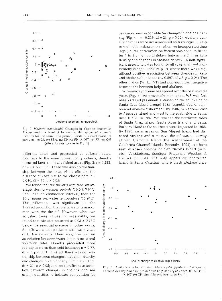
df = 211 p > 0.05) and significant Fig. 3. Haliotis cracherodii and Macrocystis pyrifera. Changes in tion between changes in abalone and sea abalone density and changes in adult kelp density at 4 sites. (m) W, (*) JL, urchin densities to indicate competition for ( A ) NT. ( 0 ) CP (site abbreviations as in F I ~ 1)
0.8
0.6
2. 0.4 --
.- L0
0.2
: rl m
2! -0.2 -- .- U
m - W
-0.4 -- .- 0) 0) 5 -0.6 -- c o
-0.8 --
-1 --
-1.2
- resources was responsible for changes in abalone den- sity (Fig 4; r = -0.236, df = 21, p > 0.05). Abalone den- -- " sity changes were not associated with changes in kelp or urchin abundance even when we incorporated time
A lags (i.e. the correlation coefficient was not significant
0 X X for 1 to 4 yr temporal delays between urchin or kelp
X ?X density and changes in abalone density). A non-signif-
o ~ ~ ~ k o X X icant association was found for all sites analyzed indi-
X X vidually except Crook Pt. (CP), where there was a sig-
0 0 +
X nificant positive association between changes in kelp * o 0 X
and abalone abundance (r = 0.897, df = 3, p = 0.04). The x A X
other 3 sites (W, JL , NT) had non-significant negative associations between kelp and abalone.
Withering syndrome has spread over the past several o A years (Fig. 5). As previously mentioned, WS was first
observed and presumably started on the south side of
A Santa Cruz Island around 1985 (unpubl. obs. of com- mercial abalone fishermen). By 1986, WS spread east
8 I I
to Anacapa Island and west to the south side of Santa 0 1 5 10 20
Rosa Island. In 1987, WS reached the northwest sides Abalone landings - tonneshlock of Santa Cruz Island. Santa Rosa Island and Santa
Fig. 2. Haliotis cracherodii. Changes In abalone density at Barbara Island to the southeast were impacted in 1988.
7 sites and the level of harvesting that occurred at each lgg08 many areas On San Miguel Island had dis- location for the same time period. Points represent biannual eased abalone and a massive die-off was underway samples. (0) M, (0) SBA, (A) EP, (0) FP, (X) NT, (+l FR, (X) OH at San Clemente Island, the southernmost of the
(site abbreviations as in Fig. 1) California Channel Islands. Recently (1992), we have seen diseased abalone on San Nicolas Island (pers.
different dates and proceeded at different rates, obs., VanBlaricom, Ruediger, Friedman, Woodard & Contrary to the over-harvesting hypothesis, die-offs Hedrick unpubl.). The only apparently unaffected occurred later at heavily fished areas (Fig. 2; r = 0.282, island is Santa Catalina (where black abalone were df = 70, p < 0.05). There was also no relation- ship between the dates of die-offs and the distance of each site to the closest port (r = 0 1 0.040, df = 16, p > 0.05).
We found that the die-offs occurred, on av- ,g 0 erage, during warmer periods (16.5 + 0.8"C, 5
95 % 2-tailed confidence interval) than the 10 yr mean sea water temperature (15.g°C). 5 -0.1
This difference was significant for the 2 l-tailed prediction that warm water is associ- ,g -0
.d
ated with the die-off. However, when we 2
adjusted these values for seasonality, we .g -0.3
found that die-offs occurred at 0.05 f 0.7OC below the seasonal average. In other words, 2
U -0 4 die-off~ were not associated with warm years : or El Nino events. There was, however, an = association between water temperatures and ' -0 5
mortality rates. Die-offs proceeded more rapidly in warm than cold instances (r = 0.77, -0 6
-
m -- m A
m -- m
l
-- A
-- m
-- m
--
A
I I I I l I I I I l
df = 7, p < 0.01). Overall, there was no rela- -0.8 -0.6 -0.4 -0.2 o 0.2 0.4 0.6 0.8 1
tionship between changes in abalone density and changes in kelp density (Fig 3; r = 0.051, Annual change in relat~ve kelp dens~ty