Embed Size (px)
Citation preview

Regional River Management:Recent developments in the Great Lakes Basin
M. J. Wiley & M. OmairSchool of Natural Resources and Environment
University of Michigan, Ann Arbor
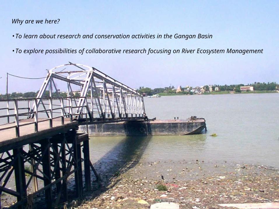
Why are we here?
•To learn about research and conservation activities in the Gangan Basin
•To explore possibilities of collaborative research focusing on River Ecosystem Management
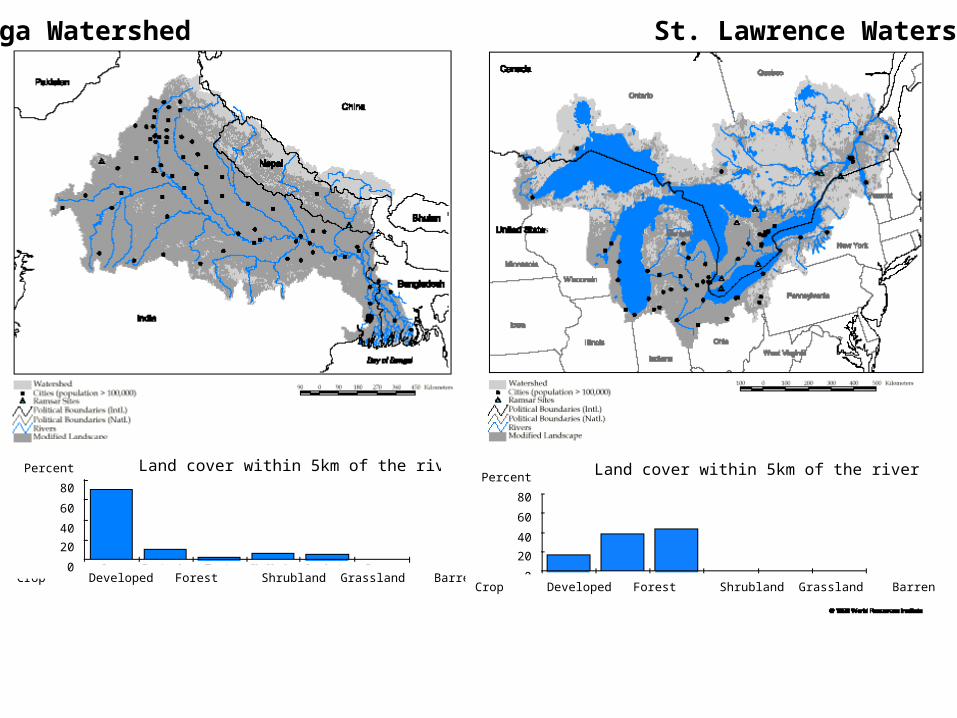
Crop Developed Forest Shrubland Grassland Barren
Land cover within 5km of the riverPercent
80
60
40
20
0
Ganga Watershed St. Lawrence Watershed
Land cover within 5km of the riverPercent
80
60
40
20
0Crop Developed Forest Shrubland Grassland Barren


Regional River Management:Recent developments in the Great Lakes Basin
1. Ecosystem Management Approach : Collaborative, Interdisciplinary, Cross-institutional
2. Classification frameworks for regional Ecological Inventory, Modeling & Assessment
The ecological complexity of large river systems and the many, inter-related impacts of our own societies on this ecology, make practical management and restoration activities in large rivers
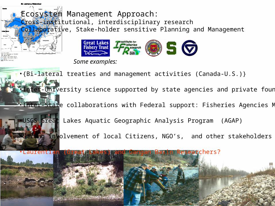
Ecosystem Management Approach: Cross-institutional, interdisciplinary research Collaborative, Stake-holder sensitive Planning and Management
•{Bi-lateral treaties and management activities (Canada-U.S.)}
•Inter-University science supported by state agencies and private foundations
•Inter-State collaborations with Federal support: Fisheries Agencies MI,WI,IL,
•USGS Great Lakes Aquatic Geographic Analysis Program (AGAP)
•Strong involvement of local Citizens, NGO’s, and other stakeholders
•Laurentian (Great Lakes) and Gangan Basin Researchers?
Some examples:

2. Ecological Classification frameworks for regional Ecological Inventory, Modeling and Assessment
Michigan Rivers Inventory
VSEC units MAP
280 main stem river segments and
2000+ tributary units[mri-vsec v1.0]
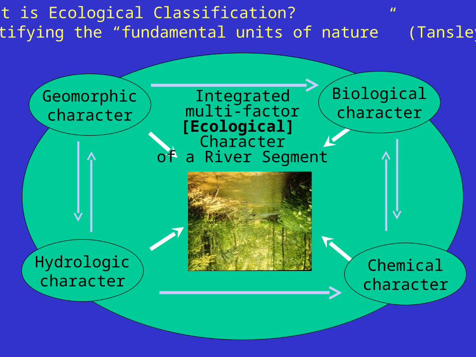
What is Ecological Classification?
Hydrologiccharacter
Biologicalcharacter
Chemicalcharacter
Identifying the “fundamental units of nature” (Tansley 1935)
Geomorphiccharacter
Integratedmulti-factor
[Ecological] Character
of a River Segment

Structural Ecosystem Units
The relatively homogeneous river segments we encounter having distinctive biology, temperature, chemistry, etc.;
Valley Segment Ecological Unit = Biogeocoenose = Ecosystem type
these are local structural expressions of functional watershed units
structural and functional units of river ecosystems
Functional Ecosystem UnitsWatersheds
{ = Landscape (Regional) ecosystems? }

Raisin Rivermainstem units
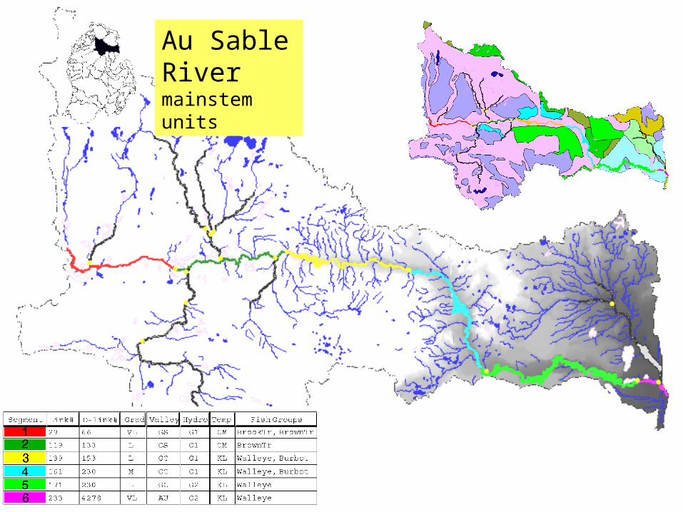
Au Sable Rivermainstem units

##
##
####
#
###
######
###
#
#
#
#
####
###
###
#########
######
########
##########
###
##
######
#####
##
##
######
#######
##
#########
###
##
#
##########
############
#
#################
######
####
####
################################
##
##########
########################
#####
#################
###################
################### ###############################
##########
#######
#########
#####
# ######
######## #########
##
##
#######
##
##
###
######
###
##
#####
####
######
##### ######### ####
####
####
##
########## #
###### ######
####
########
##############
#
####
#
###
# ####
############
#########
##
###
###### ####
#####
###########
################################################ ##
##################
###########
#####
#############
# ##
###
##
##
#
####
#
####
######
###########
###
# #
##########
### #
#####
###
##
#
##############################################
###########
######################
##### ##############################
########
####
#########
####### ########## ##
##
###
#### #
#
#
###########
##
##
##############
##############################
##########
#############
#######
#########
##
#######
#
#
####
###
#########################
####
########## #
########### ### ###
##### ########
#######
##
#
#
####
##
##
##
######
#
##
#
##
##
###
###### #### #
## #
#######
##
##
####
##
##
###
######
#####
## ###############
###
###
#
######
#
#####
##########
############################# #
#########
##
#####
####
##
## #####
###### ##
################## ####
#######
###
#
###########
##
## #######
# #####
######
#
#
#
### ####
## ############
####
########
#####
#############################
#######
##############
##########################
####
##################
###############
######
##
############
# ########
##
#########################
#### ##
##
#
##
#####
###
#
######
###
##
# ###
#
##
####
#####
#
#
#
#####
# ##
##
####
####
######
######
#####
####
######
######
#
##
#
####
##
##
#
####
######
###
###
##
############
#####
##
#####
####
#####
##
##
#
#########
##
#
##
# ######
##
#######
##
####
###
###
##
##
##
#######
##
##
##
###
###
##
##
##
#
## ##
###
#
##
##
#####
####
#####
####### ##
##########
##
####
################## ##
######
#########
####
####
######
####
#############
#########
############# ######## ###
### #
##
####
##
######
############
#####
####
##
#######
###### ###########
# ####
##
#
#########
########
###### ####
####
####
######
############ ##
####
#
######## ##############
####
#####
######
##
## ###
##
#
###
##
##
##
### #####
###########
###
#
#
#
#####
#####
# ####
# ##
###
###
#
###
##
##
##
##
##
###### ######
#
#
#
#
##
#
## #
#######
##
######
###
###
#####################
########
##################
################## ## ##################
####
#################### #####
##### ##
## ##
#################
##########
#######
###
#####
#
### #
########
#####
######
######################
###
#####
####
###
##
####
####
###########
#
######
##### #####
##
### #
######
####
####
###
##
####
###
#######
###########
#####
#######
##
######## ##
######
###
#####
#####
###### ######## #####
###### ###
## ##
########
#### ########
################ ####
#### ##
######
#######
#####
####
####
######
##
##
#####
###
##
######
######
########
###
## ####
# #
###
## ##
##
##
###
###
###
### ##
##
##
# ######
#######
##
######
###########
#####
##############
##
###########
######
############
####
################
##
### ######
###########################
##############
## #####################
#######
#####
###############
#
###### #################
#
#
#
#
# ###
###
#
#
#
###
###
#######
##
## #
#
#
# ##
# ####
############
#######################
######### ########
####
#
####
################
############
#######
#######
##################################
################################
###############
#########
#################
############
######
################
#####
############
#####
#################################
#################
###### ####
##########
############
#
############ ########### ##################
#
####
##
## #################
##### #####
##########
#################
#
##########################
######################
#####
#############
####
##
######################
############
########## #######
# ########################
#####
#############
###
#####
######################
############
###
###########
##############################################################
#############
##
#
##########
##
#################
##########################
#####
#################
##################
#####
#####
####
###
#
###
###
###################
##########
###########
#
############################
#####
### #######
#############
################
#################################
#########
####################
############# ##################
##########
###########
############## #
###########
####
#####
###########################
##
# ###############################
####
####
# ##################
####################
#####################
#######
######
#####
#
###############
####################### ##
######## ###
#######
##
#############
####
####
###################
####
##########
################
#
#############
#########
###### #######
###################
###
##########
######
######### ########
##########
##################
############ #########
####### ##
##############
##########
##
########
######
##
#####
##
#####
### ##########
#
##
#########################
#####
#####
##########
#######
###
####### #### #####
################
###########
## # #### ####
# ###
####
###
####
#
#
######## #
###
###############
####### ### ##
######
#
##
#
##
#########
###
#####
#########
#################
#
############
###
###
# ### ####
#####
#
############
#
########
#
#########
######
###########
########
# ##########
############
#########
#######
#######
###
######
##########
##############
#
###
###
##
### ### ### #########################
################
#######
#
################### #
#################
####
#
####
####
#
#######
###
#
#
#
########
##########
################
###
########
#############
#######
################
##############
####
#######################
####################
##################
#
#
#
##
##
# #############
# ############
###############
###########
###########
##
# ###
#####
####
###
###
#####
########################################
#####################
##############################
##############
######################################################
#################
############# ######### ###########
### #
#
#
###########################################
#############
#####################################
#####################
#############################
##################################
##################
################
#####
#
###########
#################
################
##############
###
############
####################
##
#####
###################
#
###
##### ########################## #####
#####
###
#######
#######
#######
####
#
###
###
#######
###
######
######## #############
#######
#####
######
#############
###########
###
############## ############
########
#
###########
###
#######
####
############
###
###########################
########################################
##########
##########################
###########################
#############
##
###
######################
######
###################
##########
#########
############
#######
#########
######################################
####
#
#####
###
###
##########
#
##########
##############
###########################
#######
#####
## #############
#############
######################
###
#####
###
####
##
####
###
#
#
##
#
##
###
###
##############
#######
#################
#####
############
#######
### ###
###
#########
############
###
########
##### #### #
########################
#### ###
####################
#####
#########
############################
#####
########################################## #########
###########
########
#
########
############
################################
###############
#
#############
#############################
###### #####
########################
#############
#####################
###################
#######################
# ################ ######################## ###
########
##### #########
###
#####
########### ##
##### #############
############
######
#############
##
# #################
#########
####
#####
###
########## #######
#
#####
#########
################
#####
#### ######
############# #
#######
#
###############
#######
############
#######
###############
#######
#####
###
###########
##########
############
########
########################
#################################
#
#################
#
########
############################
#####
#
###############
###############
##########
################## ##
#####
###
#######
##########
### ###
####
#########################
####
#################
#################
############
##
############
########
###############
##############
########### ###
##
###############
################## #####
#########################
################
####
##################
################ ################### ###### #############
###############
#########
##########
############# #######
#################################### ###########################
########################
###################
################
#
############
###########
###############
####################
#################
#############
#
##########
#######
####
#####
########### #######
###################
###################
######
#############################################
####
#
######
####
####
######
##
######
######
##########
##########
####
#
#####
######
########
##############
####
#####
####
###############
#############
#############
###
###############
####
###
#####
######
#####
#######
########
###
#######
################
###########
##### #############
#######
######
######
##################
###########################
################# ##
#############
###
##############
###############
############
##########
#######################
### ######### ################
################
###
###############################
############
#### #############
#############
############
##########
##################
#####################
###
###############################
#################################
#################
######################
####################################
##################################
#######
##################
###########
############
#################
##################################
#######################
#############
######
######
### #########
######
#########
#######
###
##
#########
######
######################
######
#######
############
#########
#
############
#####################
#####
##
#########
# ##############
############
##########
#################
#####
###########
#########
##########
###############
######################
##########
#######
###############
##########
### ######
########
########
##############
########
#####
###
##################### #########
#####
########################
#################
###############################
##
#######
#########
###############
##################
#####################################
###########
##########
############
##########
#####
########
##############
###
#
####
#
## ####
##
##
####
########
####################
##############
#############
##
###
##########
##########
######
####
##
######
###
#########
##########
### ####
### #
##
########
## ###
#############################
#########
######
#######
#############
#######
###
#########
## ####
#########
#
#
#######
########################
#####
#
###
##########
####### ### ##
#
####
####################
#################
#########
###############
#
#####
####
###
####
####
#############################
#####
#################
####################
###############
############## # ## ####
####
##############
#####
###
#######
######################################
Stream hydrologic classes# Wetland dominated# Surface water dominated# High surface water, some groundwater# Mixed groundwater and surface water# High groundwater
Lake Michigan Tributary Systems
Basin-wide hydrologic assessmentof classification units
useful for regional fisheries resourceAnd water quality planning
Example applications: regional inventory

Example application: River Otter (Kotanchik 1997)
MDNR Trapping recordPCB thresholdHg threshold
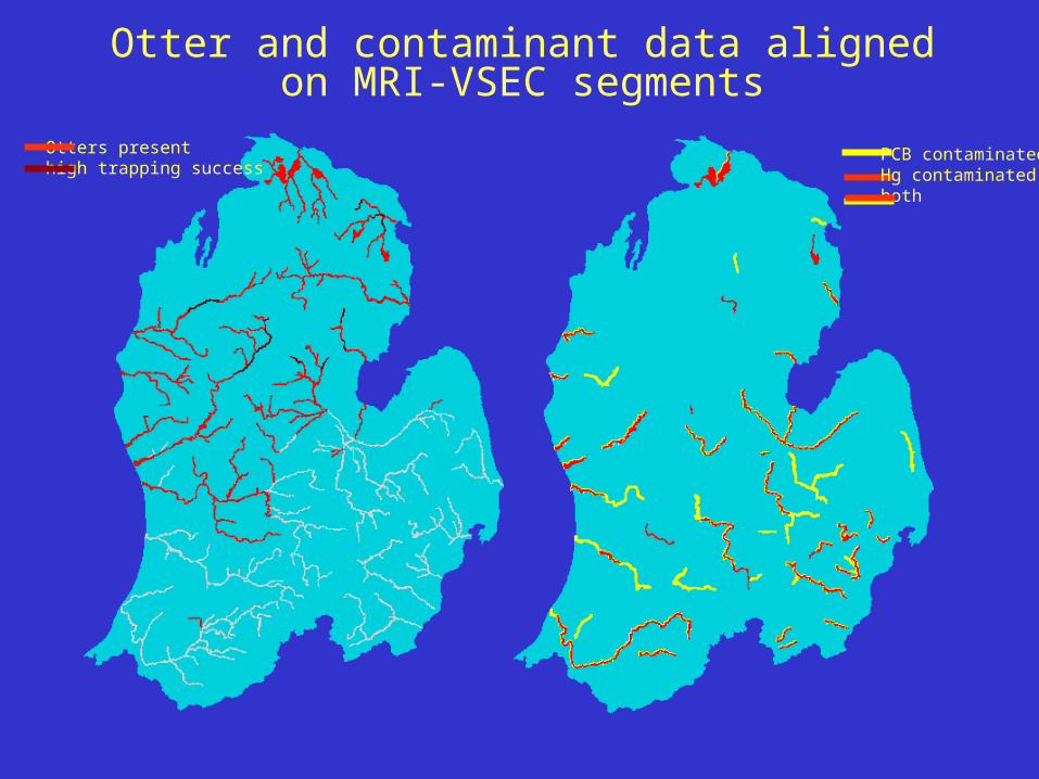
Otter and contaminant data aligned on MRI-VSEC segments
Otters presenthigh trapping success
PCB contaminatedHg contaminatedboth

Logistic modeling of Otter distribution
Logistic Regression ResultsPrediction success: 83%
Primary predictors:
- Extreme hydrologies- PCB contamination- Urban development- Ag development+ conifer forests
Using moderls to plan restoration

1820 1995 2020 2040
Landcover alterations pose a major threat to aquatic ecosystems in the Great Lakes Basin
Modeling timelines for 3-State EPA-STAR project. GIS maps based on original 1810-1830 GLO surveys, Current Air photo, and Neural Net (LTM) projections for the future.
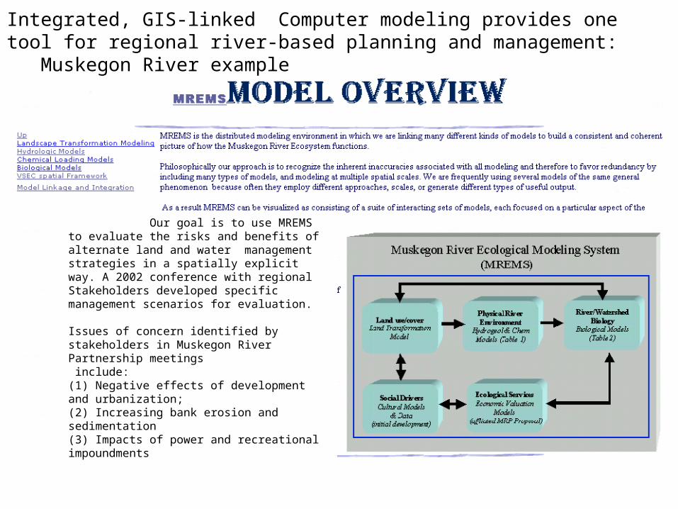
Our goal is to use MREMS to evaluate the risks and benefits of alternate land and water management strategies in a spatially explicit way. A 2002 conference with regionalStakeholders developed specific management scenarios for evaluation.
Issues of concern identified by stakeholders in Muskegon River Partnership meetings include: (1) Negative effects of development and urbanization;(2) Increasing bank erosion and sedimentation(3) Impacts of power and recreational impoundments
Integrated, GIS-linked Computer modeling provides one tool for regional river-based planning and management: Muskegon River example
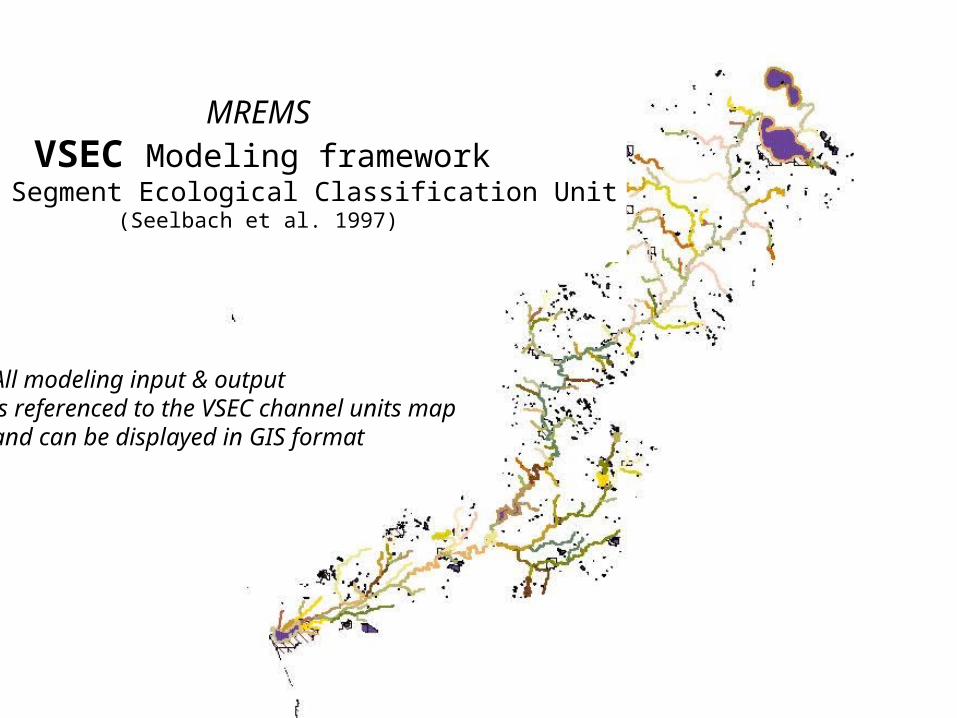
MREMS VSEC Modeling framework
Valley Segment Ecological Classification Unit(Seelbach et al. 1997)
All modeling input & outputis referenced to the VSEC channel units mapand can be displayed in GIS format
grams SRP /day @ Q10
.005 – 6.5 6.5 – 13 13 – 19 19 – 26 26 – 32 32 – 39 39 - 45
HydrologicModel
LoadingModel
1830
1978
2040
VSECFramework
Landcover maps (year)Data Source
Survey notes
Aerial photos
LTM prediction
VSECFramework
1830
1978
2040
SRP Load maps
1830 1978 2040
Database queries Output mapping
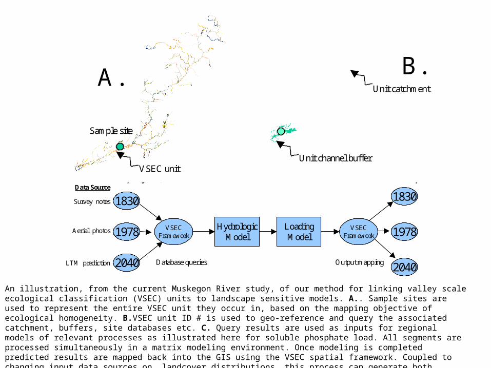
Figure 2. An illustration, from the current Muskegon River study, of our method for linking valley scale ecologicalclassification (VSEC) units to landscape models. A: Sample sites are used to represent the entire VSEC unit theyoccur in, based on the mapping objective of ecological homogeneity B: VSEC unit ID # is used to geo-reference andquery the associated catchment, buffers, site databases etc. C: Query results are used as inputs for regional models ofrelevant processes as illustrated here for soluble phosphate load. All segments are processed simultaneously in a matrixmodeling environment. Once modeling is completed predicted results are mapped back into the GIS using the VSECspatial framework. Coupled to changing input data sources on landcover distributions, this process can generate bothforecasts and hindcasts of ecological status.
A. B.
C.
Sample site
Unit catchment
VSEC unitUnit channel buffer
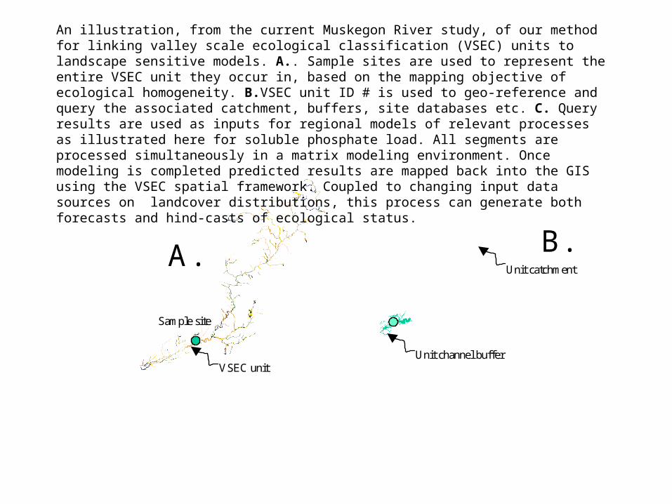
An illustration, from the current Muskegon River study, of our method for linking valley scale ecological classification (VSEC) units to landscape sensitive models. A.. Sample sites are used to represent the entire VSEC unit they occur in, based on the mapping objective of ecological homogeneity. B.VSEC unit ID # is used to geo-reference and query the associated catchment, buffers, site databases etc. C. Query results are used as inputs for regional models of relevant processes as illustrated here for soluble phosphate load. All segments are processed simultaneously in a matrix modeling environment. Once modeling is completed predicted results are mapped back into the GIS using the VSEC spatial framework. Coupled to changing input data sources on landcover distributions, this process can generate both forecasts and hind-casts of ecological status.
grams SRP /day @ Q10
.005 – 6.5 6.5 – 13 13 – 19 19 – 26 26 – 32 32 – 39 39 - 45
HydrologicModel
LoadingModel
1830
1978
2040
VSECFramework
Landcover maps (year)Data Source
Survey notes
Aerial photos
LTM prediction
VSECFramework
1830
1978
2040
SRP Load maps
1830 1978 2040
Database queries Output mapping
Figure 2. An illustration, from the current Muskegon River study, of our method for linking valley scale ecologicalclassification (VSEC) units to landscape models. A: Sample sites are used to represent the entire VSEC unit theyoccur in, based on the mapping objective of ecological homogeneity B: VSEC unit ID # is used to geo-reference andquery the associated catchment, buffers, site databases etc. C: Query results are used as inputs for regional models ofrelevant processes as illustrated here for soluble phosphate load. All segments are processed simultaneously in a matrixmodeling environment. Once modeling is completed predicted results are mapped back into the GIS using the VSECspatial framework. Coupled to changing input data sources on landcover distributions, this process can generate bothforecasts and hindcasts of ecological status.
A. B.
C.
Sample site
Unit catchment
VSEC unitUnit channel buffer
50
40
30
20
10
0
past
pres
ent
futu
re
River classification based assessment and modeling techniques retain high spatial resolution across large regional assessments, and are being used by The Nature Conservancy to map the entire Great Lakes Basin for conservation planning; by the USGS Aquatic GAP Program for the Great Lakes Basin; also in a new Three-State Regional Assessment Project; and in Muskegon River Basin Initiative.
Soluble P per day at high flow (g/d)

$
$$
$$ $$$$
$
$
$
$$$
$$
$$
$
$
$
$ $
$$$
$$$
F i g u r e 3 . E x a m p l e o f c l a s s i f i c a t i o n d r i v e n s t a t u s a n d r i s k a s s e s s m e n t f o r t h e M u s k e g o n R i v e r u s i n g t h e L a n dT r a n s f o r m a t i o n M o d e l r u n n i n g a n “ u n c o n s t r a i n e d d e v e l o p m e n t ” s c e n a r i o f o r t h e y e a r 2 0 4 0 . A : s e g m e n t s s a m p l e d f o rf i s h c o m m u n i t y c o m p o s i t i o n d u r i n g 2 0 0 1 ( i n r e d ) . B : F i s h c o m m u n i t y s t a t u s b a s e d o n 2 0 0 1 s a m p l i n g r e s u l t s a n d r e g i o n a lr e f e r e n c e m o d e l s . C : 2 0 0 1 S p e c i e s r i c h n e s s p r e d i c t e d f o r a l l s e g m e n t s u s i n g u n i t c a t c h m e n t p r o p e r t i e s , 2 0 0 1 s a m p l i n gr e s u l t s , a n d a n d r e g i o n a l f i s h m o d e l s . D : R i s k a s s e s s m e n t ; s p e c i e s r i c h n e s s p r e d i c t e d f o r 2 0 4 0 l a n d c o v e r s c e n a r i o i s
s u b t r a c t e d f r o m m o d e l e d c u r r e n t r i c h n e s s t o p r o d u c e a n e s t i m a t e o f s p e c i e s l o s s b y 2 0 4 0 f o r e a c h r i v e r s e g m e n t .
B
C
S a m p l e d s e g m e n t s2 0 0 1[ n = 3 3 , i n r e d ]
A
C u r r e n t f i s h d i v e r s i t y m o d e l e d f o r a l l s e g m e n t s
N u m b e r o f t a x a
C u r r e n t s t a t u so f s a m p l e d s e g m e n t sb a s e d o n m o d e l e d r e f e r e n c e c o n d i t i o n
O b s e r v e d / E x p e c t e d s p p .
R i s k A s s e s s m e n t s e g m e n t s a t r i s k f o rf u t u r e s p e c i e s l o s s
d u e t o d e v e l o p m e n t[ y r 2 0 4 0 ]
P r e d i c t e d t a x a l o s s
D
The same modeling approaches can be used to organize and interpret biological resource inventories and to identify future risks to river biodiversity


Why are we here?
•To learn about research and management activities in the Gangan Basin
•To explore possibilities of collaborative research on River ecosystem management

Generalized Methodology
Inventory and Data compilation
Landscape analysis leading to regional modeling
Ecological Classification
Modeling of reference condition
Status Assessment
Risk Assessment
grams SRP /day @ Q10
.005 – 6.5 6.5 – 13 13 – 19 19 – 26 26 – 32 32 – 39 39 - 45
HydrologicModel
LoadingModel
1830
1978
2040
VSECFramework
Landcover maps (year)Data Source
Survey notes
Aerial photos
LTM prediction
VSECFramework
1830
1978
2040
SRP Load maps
1830 1978 2040
Database queries Output mapping
Figure 2. An illustration, from the current Muskegon River study, of our method for linking valley scale ecologicalclassification (VSEC) units to landscape models. A: Sample sites are used to represent the entire VSEC unit theyoccur in, based on the mapping objective of ecological homogeneity B: VSEC unit ID # is used to geo-reference andquery the associated catchment, buffers, site databases etc. C: Query results are used as inputs for regional models ofrelevant processes as illustrated here for soluble phosphate load. All segments are processed simultaneously in a matrixmodeling environment. Once modeling is completed predicted results are mapped back into the GIS using the VSECspatial framework. Coupled to changing input data sources on landcover distributions, this process can generate bothforecasts and hindcasts of ecological status.
A. B.
C.
Sample site
Unit catchment
VSEC unitUnit channel buffer
An illustration, from the current Muskegon River study, of our method for linking valley scale ecological classification (VSEC) units to landscape sensitive models. A.. Sample sites are used to represent the entire VSEC unit they occur in, based on the mapping objective of ecological homogeneity. B.VSEC unit ID # is used to geo-reference and query the associated catchment, buffers, site databases etc. C. Query results are used as inputs for regional models of relevant processes as illustrated here for soluble phosphate load. All segments are processed simultaneously in a matrix modeling environment. Once modeling is completed predicted results are mapped back into the GIS using the VSEC spatial framework. Coupled to changing input data sources on landcover distributions, this process can generate both forecasts and hind-casts of ecological status.