Embed Size (px)
Citation preview

1 Economic Commission for Latin America and the Caribbean
Subregional Headquarters for the Caribbean
REGIONAL CLIMATE MODELING IN THE CARIBBEAN ____________ This document has been reproduced without formal editing.
LIMITED LC/CAR/L.265 10 June 2010 ORIGINAL: ENGLISH

Acknowledgement The Economic Commission for Latin America and the Caribbean (ECLAC) Subregional Headquarters
for the Caribbean wishes to acknowledge the assistance of Dr. Abel Centella, Institute of
Meteorology, Cuba, in the preparation of this document.

Table of Contents
Introduction................................................................................................................................................1 I. Climate models for future climate projections..............................................................................3 II. Climate modelling in the Caribbean. The PRECIS-Caribbean Initiative .....................................6 III. High resolution climate change projections for the Caribbean based on PRECIS outputs...........8 IV. Making available the PRECIS outputs through the PRECIS CARIBE online system ...............19 V. Future activities in climate modelling in the Caribbean. Conclusions and recommendations ...21 Annex ......................................................................................................................................................22 References................................................................................................................................................23

Executive Summary
The information here represents a compilation of existing and ongoing regional and national climate modeling studies that could be useful in the execution of the regional project The Economics of Climate Change in Caribbean. The report is mainly focused on the sustainable regional efforts that represent opportunities for further developments in climate change scenarios. It describes the different techniques that have been used to model changes in temperature and precipitation in the Caribbean and compares the outputs of these models. Essentially, temperatures are expected to increase while precipitation may increase for countries in the more southerly latitudes, but decrease for more northerly countries (Bahamas, Cuba and Hispaniola) resulting in drought. These changes would present tremendous challenges for the Caribbean subregion and, despite significant progress made in recent years, there is a need for continuous development of climate research and modelling in the subregion, to produce more relevant information for regional and national studies and to overcome the limitations of existing results.
This may well be realized through coordination of activities between the Caribbean
Community Climate Change Centre (CCCCC), the Institute of Meteorology (INSMET) in Cuba and the University of the West Indies (UWI). These activities will address the implementation of further analyses using available information to generate best practices and to produce useful results.
There are also new opportunities for climate research in the region with Coordinated Regional
Downscaling Experiment (CORDEX) which is planned to start early next year. It is expected that the participation of various Caribbean institutions like INSMET, UWI, CCCC and the Caribbean Institute for Meteorology and Hydrology in this global project will allow the generation of new and more abundant information.

1
INTRODUCTION
In 1886, the Swedish scientist Svante Arrhenius predicted that CO2 emissions from anthropogenic activities would accumulate in the atmosphere, causing a warming of the earth´s surface by the greenhouse effect (Arrhenius, 1886). Since then, atmospheric concentrations of CO2 (together with methane and nitrous oxide) have increased and their current concentrations far exceed pre-industrial values. There is now a very high confidence that the global net effect of human activities since 1750 has been one of unequivocal warming of the climate (IPCC, 2007). This emerged from the evidence of an increase in global average temperatures, widespread melting of snow and ice, and rising global average sea level. The total increase of global average temperature from 1850-1899 to 2001-2005 is 0.76°C, the global average sea level rose at an average rate of 1.8 mm per year over 1961-2003. Moreover, the average temperature of the global ocean has increased to depths of at least 3000m since 1961. Other long-term changes in climate such as widespread changes in precipitation amounts, ocean salinity, wind patterns and aspects of extreme weather, including drought, heavy precipitation, heat waves and the intensity of tropical cyclones, have also been observed.
As has been shown recently (Solomon et al., 2009), climate change that takes place due to
increases in carbon dioxide concentration is largely irreversible for up to 1,000 years after the cessation of emissions. These authors indicate that future carbon dioxide emissions in the twenty-first century will, therefore, lead to adverse climate changes on both short- and long-term scales that would essentially be irreversible. Based on improved complex models for projecting climate in the twenty-first century as well as other models for millennial time scales, research has shown how different peak carbon dioxide concentrations that could be attained in the twenty-first century are expected to lead to substantial and irreversible decreases in dry-season rainfall in a number of already-dry subtropical areas and lower limits to eventual sea-level rise of the order of meters, thus implying unavoidable inundation of many small islands and low-lying coastal areas.
Continued greenhouse gas emissions at, or above, current rates would cause further warming
and would result in many changes in the global climate system during the twenty-first century that would very likely be greater than those observed in the twentieth century. For many island States, such as those in the Caribbean, rising sea levels -due to ice sheet and melting glaciers and the expansion of warm water in the ocean- would lead to more salt water intrusion into aquifers, reducing the quality of fresh water resources.
Change in extreme climate events is ample cause for concern in a region where floods,
droughts and tropical cyclones are the trigger for natural disasters which have affected many people in the period 1950-2007 (www.em-dat.net The OFDA/CRED International Disaster Database. Université Catholique de Louvain, Brussels, Belgium). As recently as 2008 (since 15 August), the Caribbean subregion was affected by one tropical storm and three hurricanes that claimed more than 350 lives so far, affecting more than 2.8 million persons (UNEP, 2008). The biophysical and socio-economic impacts of climate change would have severe implications for the livelihood and survival of the Caribbean population. Every facet of Caribbean life would be affected and would put an even greater strain on its limited natural resources, raising the question of what course of action Caribbean countries should take to respond to the consequences of climate change.

2
Over the last three decades, the Caribbean subregion has suffered direct and indirect losses estimated at between US$700 million to US$3.3 billion due to natural disasters associated with extreme weather events1. While estimating the potential economic consequences of the impacts of climate change in the Caribbean is difficult, recent studies (Haites, 2002 and Bueno et al., 2008) indicate such economic losses can be very significant in terms of percentage of GDP. Despite the previous results on economic assessment of climate change impacts, more rigorous and in-depth evaluation of the main economic costs and benefits for the countries of the subregion, as well as the related costs and benefits for different socioeconomic sectors are greatly needed. This further evaluation will be conducted by the regional project entitled “A Review of the Economics of Climate Change in Caribbean”, which also includes a study of the impacts and possible options in adaptation and reduction of vulnerabilities, as well as in mitigation, relative to a scenario of inaction or continuing along the current adaptation path (Business As Usual – BAU).
The appropriate examination of climate change impacts and the response actions requires
developing a data-collective framework which ensures that adequate sources of information will be available to inform development planning and to facilitate the estimation of the economic costs of climate change responses. An important piece of this framework is the information on climate change scenarios for the next 20-50 years or more. Global Climate Models (GCMs) provide the starting point for construction of these scenarios. However, as GCMs give coarse results over a large grid (100 kilometers or more), other methods should be used to represent finer climate details, as those needed for the small islands that comprise the Caribbean and for extreme climatic events. Therefore, regional climate modeling activities have become increasingly important as a mechanism to produce relevant information for research and policymakers in order to assess impacts and develop relevant adaptation plans.
The present report will review the progress and constraints of regional climate modeling
activities in the Caribbean2, describing activities to date, the main results and the limitations of those activities. The report begins by outlining some general conceptual notes on the use of climate models for future climate projections. Secondly, a description of the PRECIS-Caribbean initiative (Taylor et al., 2007) is presented, and the recent results obtained as documented in recent reports and research papers (Centella et al., 2008) as well as current research projects3). Thirdly, a discussion on the limitations of PRECIS basically in relation to the Economic Commission for Latin America and the Caribbean (ECLAC) project scope is provided and some alternatives to tackle constraints are described. Finally recommendations of what should be done to move forward on regional climate modeling activities in the Caribbean are made.
1 Inter-American Development Bank (2002) Report on Natural Disasters in Latin America and Caribbean. 2 Consider those related with the assimilation and use of Regional Climate Models for dynamic downscaling as well as the development and use of statistical downscaling methods. The use of multi-model GCMs output is also included but with less detail. 3 INSMET and Climate Studies Group of Mona from UWI are preparing new reports and results based on PRECIS outputs

3
I. CLIMATE MODELS FOR FUTURE CLIMATE PROJECTIONS There are two main factors which determine how human activities change climate:
• The rate of greenhouse gases emission and other pollutants • The response of the climate system (including the resulting regional patterns of climate change) to these emissions (Hulme et al., 2002).
The first factor can be described using a range of emission scenarios based on different
assumptions about the future evolution of the world’s population, economy, technology transfer and lifestyle. The Special Report on Emission Scenarios (SRES) (Nakicenovic et al., 2000), produced by a group of experts set up by the Intergovernmental Panel on Climate Change (IPCC) describe and quantify how emissions could change over the twenty-first century in the absence of policy interventions to reduce greenhouse gas emissions. The other factor can only be explored through the use of global and regional models.
Based on emission scenarios documented in earlier reports such as the IS92 (Leggett, J et al
1992), the SRES or the new Representative Concentration Pathways (Moss, et al., 2008), it is possible to generate future climate projections or climate scenarios4 through the use of climate models. In general terms, a climate model could be defined as a mathematical representation of the climate system based on physical, biophysical and chemical principles (figure 1). As the atmospheric weather and the ocean circulation are governed by the fundamental laws of physics that describe the conservation of mass, energy and momentum, these well-known laws form the backbone of climate models and constitutes one very important source of confidence in them.
There is no perfect model that would satisfy all requirements. Hence a wide range of different
climate models which have been developed to address different objectives and which, therefore, have differences in the components that are represented, as well as in the complexity of the process are included. Thus, a hierarchy of models exist, ranging from energy balance type climate models that describe the climate system in simple numeric terms (Harvey et al., 1997) via Earth System Models of Intermediate Complexity (Claussen et al., 2002) to three-dimensional GCMs. The latter comprise the Atmosphere-only GCMs (AGCMs) and the couple Atmosphere-Ocean GCM (AOGCMs). These are both the most sophisticated models today and the pillar for generating consistent and physically plausible future climate change scenarios. When employed correctly, all the model types can produce useful information on the behavior of the climate system. The combination of the results from various models is often the best way to understand and reflect the more important process in action. An example of the latter is the combination of simpler climate model outputs with GCMS results though with the pattern-scaling technique as in MAGICC/SCENGEN (Hulme et al., 2000).
AOGCMS constitute the primary tool for capturing the global climate system behavior and its
change associated with a variation in atmospheric composition. Despite the fact that AOGCMs are very complex systems with many components, the full complexity of the real world cannot be represented in any of them. Limitations in computing power limit the representation of the atmospheric components to a grid spacing in the range of 125-300 km in the horizontal, while in the vertical direction there are typically only about 30 levels between the surface and the model top at a height of 30-50 km. A consequence of the above-mentioned limitations is that the results obtained from the models represent averages over regions, whose size depends on model resolution. Even for models with the highest resolution, the numerical grid is too coarse to represent small scale process and to provide useful climate information for spatial detailed impact assessment studies.
4 Climate scenario is plausible and physically consistent representation of the future climate based on greenhouse gas emission scenarios. Because we do not know with any confidence how the factors that influence the greenhouse emission will change in the future, it becoming in a primary source of uncertainty.

4
Generating information below the grid scale of AOGCMs is known as downscaling and
requires the use of dynamic or statistical approaches (Mears et al., 2003 and Wilby et al., 2004). Dynamic Downscaling (DDS) uses high-resolution climate models which are driven by either observed or AOGCM output to represent global or regional sub-domains. Like AOGCMs, the high-resolution climate models used for DDS are formulated using physical principles and, therefore, they can provide coherent information among multiple climate variables. These models can reproduce a broad range of climate around the world, increasing the confidence on their ability to realistically downscale future climates. High-Resolution AGCMs, Variable Resolution AGCMs (VAGCMs) and Nested Regional Climate Models (RCMs) are the methods forming part of a dynamical downscaling approach (see annex for further details on AGCMs, VGCMS and RCMs). On the other side, Empirical Statistical Downscaling use statistical relationships that have been derived from observed data and these are applied to climate model data. The uses of this approach have the advantage of being less expensive and able to address finer scales than dynamical downscaling.
Despite the inability of the more complex models (AOGCMs and even the AGCMs) to
generate detailed spatial climate behavior, the amount of available simulation AOGCMs results, such as those performed for the Fourth Assessment Report of the Intergovernmental Panel on Climate Change5 represent an adequate source of information for some regional applications. This information allowed for multimodel ensemble assessment to cover the uncertainties in modeling climate processes and to produce a plausible sample of the climate changes that may occur under a given forcing scenario.
On the other hand, although multi-decadal RCM experiments are being increasingly used to
generate climate information at spatial scales, typically of 25-50 km (e.g., Whetton et al., 2001; Nuñez et al., 2008), the use of nested RCM is too difficult because of its high computational cost, especially for those countries and regions with limited financial resources. Thus, using RCM
5 The results of this coordinated set of climate model simulations represent the today’s state of the art climate model intercomparison project (CMIP) and are named as CMIP-3. This is like a large “gene pool” of possible model components (Collins et al., 2006) forming the Multi-Model Data set (MMD) used to project the Caribbean regional climate change projections (Christensen et al., 2007).
Figure 1. Conceptual structure of a global climate model as the UK Met Office HadCM3 model

5
ensembles, experiments (e.g., Hewitt and Griggs 2004; Sanchez-Gomez et al., 2008), appears as a paramount opportunity. The decision, therefore, to perform RCM ensembles or even single RCM experiments has to be well justified and should be based on the demonstrable valued-added of this exercise. In this regard, it is highly recommended that RCM experiments should be performed as joint regional efforts rather than as individual country ones. Moreover, the use of RCM should be considered as long term and sustainable (including capacity-building, research and data sharing) taking place as part of a wider concept programme to address climate change impacts and adaptation assessment and not as an isolated effort to generate information for a single vulnerability and adaptation project.
Empirical statistical downscaling is a less expensive option for regional projects or studies
looking for detailed spatial detail (mainly at the local level). However, in this case observed data for long periods are essential, limiting the use of this technique for regions with scarce data availability.
There is no a unique criterion to recommend the best approach for climate change scenario development. In fact, this depends on the assessment study scope, its objective and the questions which need to be answered. As is briefly summarized by Chen et al., (2008) different approaches have been used within the Caribbean Community countries to develop climate change scenarios. These approaches range from the use of simpler climate model in combination with GCMs output (Centella et al., 1999) to more sophisticated SDS (Chen et al., 2006) using SDSM computer software (Wilby et al., 2002). Recently there has been increased use of RCM6 throughout the Caribbean (Taylor et al., 2007 and Centella et al., 2008) producing a large amount of climate data at finer scale which are available for researchers and policymakers in the entire region. Actually, the use of RCM is becoming one of the more important coordinated activities, in terms of climate change modeling in the Caribbean. Also, it is emerging as an important and promising opportunity to enhance current scientific and technical capacities as well as to develop new ones. A description of how RCMs are being used in the Caribbean and of the results that have been produced to date is presented in the following section.
6 By using the regional climate model HadRCM3P which is the core of the PRECIS regional climate modeling system developed by the Hadley Center from UK.

6
II. CLIMATE MODELING IN THE CARIBBEAN. THE PRECIS-CARIBBEAN INITIATIVE.
One of the first documented works using RCM for climate change in the Caribbean was produced by Angeles et al., (2007). These authors integrated the Regional Atmospheric Model System (RAMS) with the fully couple Parallel Climate Model to investigate possible future climate changes in the Caribbean subregion and focused on the island of Puerto Rico. This experiment was based on the IS92a emission scenario7. Two areas of the Caribbean were enclosed with RAMS RCM; the first one, with 20km resolution went from 11.5248°N to 25.5°N and from 83°W to 50.5°W. The second was finer in resolution (4 km) but was located just over the island of Puerto Rico. Although the former area included a wide part of the Caribbean subregion, it did not consider the whole region and, where it did, many of the Eastern Caribbean islands as well as Cuba were too close to the domain border where the outputs could be contaminated by the noise of the boundary conditions.
Recently there has been increased use of RCM throughout the Caribbean subregion producing
a large amount of climate data at a finer scale which is available for researchers and policymakers in the entire region. The first effort has been concentrated on the assimilation and use of the HadRCM3P -the state of the art RCM developed by the Hadley Center of United Kingdom- which is the core of the regional climate modeling system named PRECIS8. This effort represents the more important coordinated and sustained activity, in terms of climate change modeling, taking place today in the Caribbean. This initiative will be described in more detail in the following section.
The chief reason for performing regional simulation by an RCM such as PRECIS is to resolve behavior considered important for a region’s climate that a global model does not resolve. Thus, regional simulation should have clearly defined regional-scale (mesoscale) phenomena targeted for simulation. These include tropical storms, effects of mountains, jet circulations, and regional ocean-land interaction. The most immediate value of regional simulation, then, is to explore how such phenomena operate in the climate system, an understanding of which becomes a justification for the expense of performing regional simulation.
The higher resolution in regional-scale simulations provides quantitative value to climate
simulation. With finer resolution, scientists can resolve mesoscale phenomena contributing to intense precipitation. The higher resolution also includes other types of scale-dependent variability, especially short-term variability such as extreme winds and locally extreme temperature that coarser-resolution models will smooth and thus inhibit. Regional-scale simulations also have phenomenological value, simulating processes that GCMs either cannot resolve or can resolve only poorly.
A. WHAT IS PRECIS AND HOW WAS IT ASSIMILATED IN THE CARIBBEAN REGION?
PRECIS is a portable RCM that can be run on a personal computer and applied to any area of
the globe to generate detailed climate change scenarios. This model has been developed at the Hadley Centre with the idea of constructing a flexible regional modeling system originated from the growing demand of many countries for regional-scale climate projections. The PRECIS was configured using the third-generation Hadley Centre RCM so that it is easy to set up. This, along with software to allow display and processing of the data produced by the RCM, constitutes PRECIS (see Jones et al., (2004) for further details on PRECIS).
Although PRECIS is a flexible, easy-to-use and computationally inexpensive RCM, the
human and computational resources (faster personal computer processors and storage capacity) needed to both use the model and to analyze the outputs are not insignificant. This is particularly true in the developing countries (such as the Caribbean) which it targets. For that reason groups of scientists within a region are advocated to working together to set up common experiments as well as
7 We do not know if the data outputs from this work or others further developed are available in some way. 8 Providing Regional Climates for Impacts Studies

7
to run their own experiments. This is exactly what has been done in the Caribbean since 2003 when the PRECIS-Caribbean initiative was initiated.
The PRECIS-Caribbean initiative started in June 2003 when experts from the Hadley Center
met in Havana, Cuba, with representatives of Caribbean institutions. This was a coordination meeting among experts involved in the Global Environment Facility-sponsored projects “Mainstreaming Adaptation to Climate Change in the Caribbean” and “Capacity Building for Stage II Adaptation in Central America, Mexico and Cuba”. Following that meeting, a PRECIS training workshop was also held in Havana in September 2003, which was attended by scientists of different backgrounds. One relevant outcome of the workshop was the decision taken to undertake a set of coordinated PRECIS experiments, with the direct participation of scientists from the Institute of Meteorology in Cuba (INSMET) and the University of West Indies (UWI) campuses in Jamaica and Barbados). The domains and experimental details can be seen in figure 2 and table 1, respectively.
A follow- up workshop took place in Belize in 2006 where experts shared the results of the first allocation of runs. From this, a report with the results from the first stage of the PRECIS-Caribbean initiative was prepared as a testament to what can be achieved in the almost four years of PRECIS-Caribbean existence (Taylor et al., 2008). Summary information on regional climate modeling in the Caribbean is also available9.
Table 1. General characteristics of the experiments undertaken under the PRECIS-Caribbean initiative
Driving conditions No. GHG Scenario10 LBCs Data
Domain Resolution Period
1 ERA15 Big Caribbean 50 km 1979-1983 2 ERA40 Big Caribbean 50 km ongoing 3 HadAM3H Big Caribbean 50 km 1961-1990 4 SRES A2 HadAM3H Big Caribbean 50 km 2071-2100 5 SRES B2 HadAM3H Big Caribbean 50 km 2071-2100 6 SRES A2 ECHAM4 Big Caribbean 50 km 1961-2100 7 SRES B2 ECHAM4 Big Caribbean 50 km 1961-2100 8 SRES A2 ECHAM4 Eastern Caribbean 25 km 1961-2100 9 SRES B2 ECHAM4 Eastern Caribbean 25 km 1961-2100 10 SRES A2 ECHAM4 Western Caribbean 25 km 1961-2100 11 SRES B2 ECHAM4 Western Caribbean 25 km 1961-2100
*The last two red lines are relative new experiments developed at the CCCCC Headquarters. Although they were finished, the results are not yet available.
9 http://precis.insmet.cu/Precis-Caribe.htm 10 Nakicenovic et al., 2000
Figure 2. Spatial domains used for PRECIS experiment As decided in the first workshop (black boxes). Red box is a recent additional and complementary domain of the Eastern Caribbean 25 km one.

8
III. HIGH RESOLUTION CLIMATE CHANGE PROJECTIONS FOR THE CARIBBEAN BASED ON PRECIS OUTPUTS.
A. BRIEF ASSESSMENT OF THE ABILITY OF PRECIS TO SIMULATE THE CARIBBEAN CLIMATE
A common practice when using models for prediction is to assess how well the models reproduce observations. This is a normal practice in weather prediction where model simulation can be quickly verified against actual weather evolution. However, for climate projection, the previous approach is not practical due to the lack of earlier well-observed analogies of the type of primarily greenhouse-gas-induced climate change that is expected in the future.
There are various issues that complicate the model validation assessment process. Model error
identification is difficult because of the complex and sometimes poorly understood nature of the climate itself. In this sense, it is not easy to decide which of the many aspects of climate are important for a good simulation. Other complications arise from the fact that climate models must be compared against present or past observation because no future observations are available. However, present climate is not an independent dataset since it has already been used for model development (and model tuning). There are other aspects such as the lack of reliable and consistent observations for present climate and sometimes differences between observed datasets are notable reflecting significant uncertainties in the observed climate. In this context, it is important to highlight that a good model performance evaluated for present climate does not necessarily guarantee a reliable prediction of future climate.
It is clear that a detailed model assessment is beyond the scope of this report. However, as this
kind of evaluation provides some insight on model skill and provides a basis for users to have more or less confidence on the use of sophisticated Regional Climate Models to provide more accurate projections for climate change impact assessments, brief mention is made on the work carried out on climate validation by different groups in the Caribbean.
In general terms, PRECIS is being evaluated using different approaches. The simpler
approach is through the comparison of modeled and observed patterns of temperature and precipitation (Centella et al., 2009, in prep.) and the complex approach is by studying some important processes associated with atmospheric circulation processes. The main focus of these works is to evaluate the PRECIS ability to reproduce features of Caribbean climate as well as to add value over the results provided by the GCM raw data.
A clear view of the impacts of the improved resolution in PRECIS could be appreciated in the
temperature patterns of PRECIS and HadCM3P GCM (Figure 3 a-c). The PRECIS summer temperature pattern as well as its difference with respect to the GCM, largely mirrors the topography and coastal gradient (figure 3 c).

9
Figure 3. 30-years mean summer 1.5m temperature (oC) Simulated by GCM a) and PRECIS b). Panel b) shows the differences between PRECIS and GCM (PRECIS-GCM) and d) orography height (m) distribution in PRECIS RCM model.
B. FUTURE CHANGES IN MEAN TEMPERATURE AND RAINFALL
1. Temperatures
As mentioned before, some of the first future climate change projections for the Caribbean were documented by Taylor et al., (2007), on the basis of the first round of PRECIS simulations considering the GCM forcing from HadCM3H. These authors indicated that the Caribbean will be between 1°C and 5°C warmer in the annual mean by the 2080s (a 30-year period from 2071 to 2100) and concludes that: (a) a greater warming will occur in the northwest Caribbean territories (Jamaica, Cuba, Hispaniola and Belize) than in the eastern Caribbean island chain; and (b) a greater warming is observed in the summer months than in the cooler and traditionally drier early months of the year.
Centella et al., (2008) made a wider analysis incorporating PRECIS outputs resulting from the
ECHAM4 forcing. Thus a consideration of uncertainties associated with different GCM influences were added to those related with the greenhouse gases emission scenarios.

10
Figure 4. 29-years mean seasonal precipitation (mm/days) over land areas Observed CRU climatology (first column) and the differences between simulations and CRU (second and third columns are GCM, RCM_Had, respectively). Maximum, Mean and Minimum area bias values are indicated in each bias map.
Figure 5 shows the annual surface temperature change over the Caribbean considering the results of the four perturbed experiments (table 1). It is clear that temperature change over land areas is much larger than over the sea as a result of less evaporative heat loss over the land than the sea, as well as the greater thermal inertia of the oceans (IPCC, 2001). Over land areas, the annual warming is generally of the order of 4.5°C for the SRESA2 scenario and 2.8°C for the SRESB2 scenario. On the other hand, over the Caribbean Sea the annual warming is nearer 2.9°C for the SRESA2 and 2°C for the SRESB2 scenario. Annual warming values are higher than reported by Taylor et al., (2007) because of the inclusion of the projection of PRECIS_ECH, which reflects a greater increase in surface temperatures than PRECIS_Had for both emission scenarios. Despite the results being based on both different GCM forcing, as well as different emission scenarios, there is great agreement in simulating the future temperature change, mainly over land areas.
11
Figure 5. Mean changes in the annual mean surface temperature for 2071-2099 with respect to 1961-1989, as simulated by PRECIS_ECH and PRECIS_Had for SRESA2 and SRESB2
There is a significant difference between the models in the spatial distribution of temperature
gradients over the sea. In PRECIS_Had, the spatial distribution shows a north-south gradient, with lower values to the south. The PRECIS_ECH produces a more east-west gradient in the distribution of the anomalies, with a greater warming over the eastern Caribbean. This is especially evident during the dry season as shown in figure 6. Also the PRECIS_ECH produces much larger warming in the wet season where the values exceed a value of 3.0°C in almost all the areas. 2. Rainfall
The patterns of change in annual rainfall (figure 7) indicate a general future trend to drier conditions in various areas of the Caribbean subregion. However, a significant reduction of rainfall is projected by PRECIS_Had in the latitudinal band encompassing the Caribbean Sea, Central America and part of the western half of northern South America. In this zone, the reductions are in the range of 10% to 50%. Increase in precipitation occurs over the region above 24°N (10% and 30%) as well as over Costa Rica, Panama and parts of Colombia (10% and 70%). For the B2 scenario the wet area in the north part of the domain appear expanded southward to 21°N and a rainfall increase also occurs over Cuba.

12
Figure 6. Mean changes in the annual mean surface temperature for 2071-2099 with respect to 1961-1989, as simulated by PRECIS_ECH and PRECIS_Had for SRESA2 and SRESB2 for the dry season
The spatial pattern for the PRECIS_ECH also shows rainfall reduction over the Caribbean Sea and part of Central America. However, the more important dry areas occur over the Gulf of Mexico, while the wet areas over the northern part of South America are more significant and wider.
In the wet season (figure 8) the areas with decreasing rainfall appear more expanded and the
lowest values occur over the Caribbean Sea, near the south of Cuba and the island of Hispaniola (30% to 50%). For the A2 scenario, the projected reduction in precipitation is more intense for PRECIS_Had than for PRECIS_ECH. Likewise, the area of positive precipitation changes over Costa Rica, Panama, and parts of Colombia is more pronounced with values above 50%. For the B2 scenario, a less pronounced pattern is projected with the driest zone over the Caribbean Sea.
Major differences between the models occur for the dry season (not shown). Here PRECIS_Had tends to maintain the latitudinal spatial gradient with a dry band over the Caribbean Sea (10% and lower) and a wet area over the zone above 21°N (10% - 70%), while for PRECIS_ECH the driest zones appear mainly over the Northwest Caribbean, Gulf of Mexico (10% - 50%) and the southern areas of the Eastern Caribbean (10% - 30%).
3. Uncertainties in the future temperature and precipitation mean changes
There are many uncertainties that are related with each stage that involves climate change future projections. As is stated by Jones et al., (2004) and also mentioned by Taylor et al., (2007), these uncertainties should be represented, where possible, using a range of values. In the first and preliminary assessment of the PRECIS results for the Caribbean region, a consensus analysis, expressing the results as a range of possible values under low to high emissions (Taylor et al.,, 2007). Following this approach (Centella et al., 2008) produced a wider figure, by considering the contribution of two GCM and two emission scenarios.

13
Figure 7. Annual mean changes in precipitation (%) for 20712099 as simulated by PRECIS_ECH and PRECIS_Had for A2 and B2 emission scenarios
Figure 8. Wet Season mean changes in precipitation (%) for 2071-2099 as simulated by PRECIS_ECH and PRECIS_Had for A2 and B2 emission scenarios
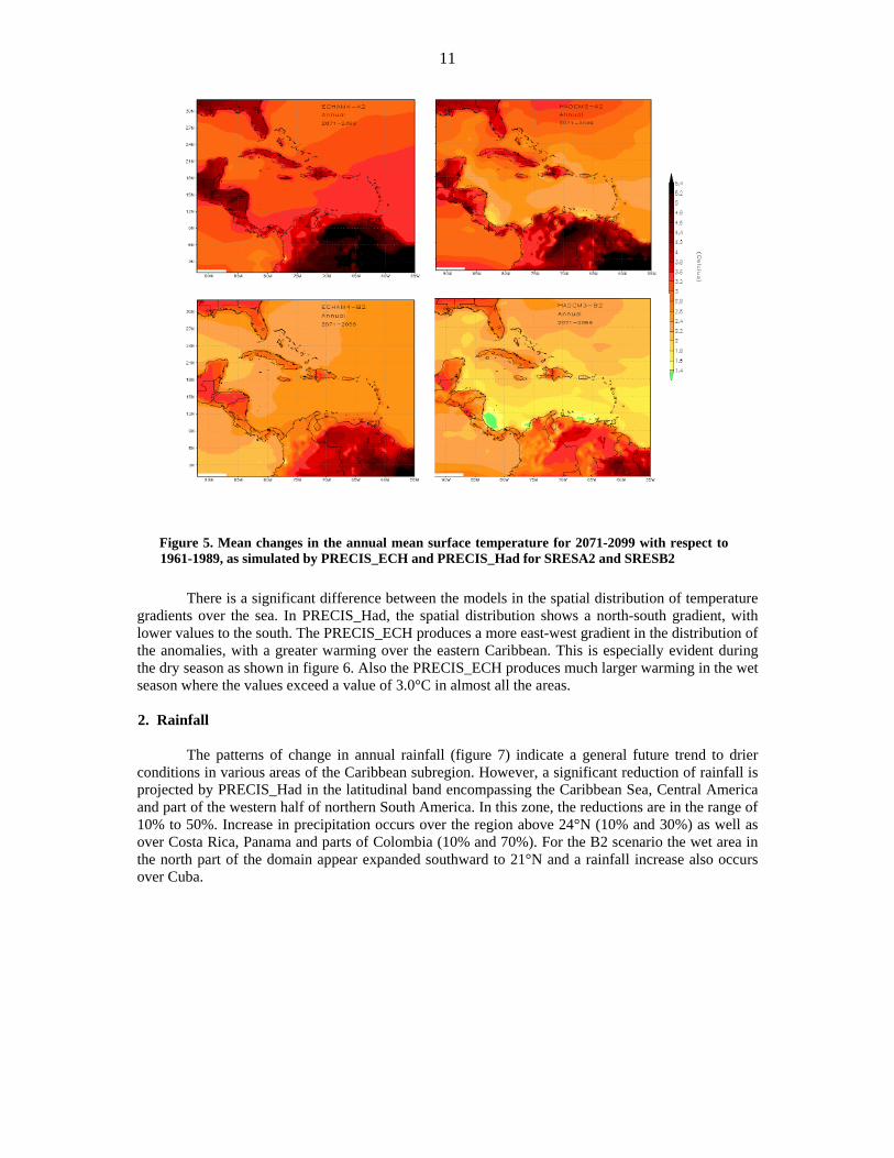
Figure 9 shows the consensus for future precipitation projections, which suggests a high level
of agreement over various areas, indicating that a massive reduction of annual rainfall will occur in larger areas of the Caribbean Sea and Central America, mainly associated with a reduction of precipitation relative to the wet season. The latter is in strong agreement with the multimodel regional projection reported in the IPCC 4AR (IPCC, 2007) where a majority of simulations indicate a decrease in precipitation during summer (JJA) season (figure 10)
14
Figure 9. Number of simulations projecting precipitation increase for 2080s
Figure 10. MMD-A1B temperature and precipitation changes over the Caribbean Top row: Annual mean, December-January-February, and June-July-August temperature change between 1980–1999 and 2080–2099, averaged over 21 models. Middle row: same for fractional change in precipitation. Bottom row: number of models out of 21 that project precipitation to increase. Source IPCC (2007)
C. FUTURE PRECIPITATION EXTREME EVENTS SIMULATED BY PRECIS RCM
It is well recognized that climate change risk is not only associated with changes in mean climate values, but also (and perhaps more importantly) with changes in extremes. Most of the AOGCMS projected increased summer dryness and winter wetness in most parts of the northern middle and high latitudes. Along with the risk of drying, there is an increased change of intense precipitation. Intense and heavy rainfall events would be interspersed with longer relatively dry periods.

15
Although temperature extremes are important, precipitation extreme events are perhaps more relevant in the Caribbean, where water availability strongly depends on rainfall and where negative impacts of drought are extremely significant. On the other hand, heavy rainfall associated with extreme weather events has the potential to produce floods, which have significant impacts as well. This explains why studies on future climate extreme events in the Caribbean based on PRECIS outputs11 increasingly have a focus on rainfall extremes, using some of the extremes indices proposed by Frich et al., (2002) which were used by IPCC in the 4AR (IPCC, 2007). The name, definition and units of the indices are listed in table 2.
Figure 11 shows some preliminary results on changes in precipitation extreme events.
Intermodel differences are significantly greater than those observed among emission scenarios. Thus while PRECIS_Had tends to produce a pattern of spatially extended reduction in consecutive wet days (CWD) and the annual maximum consecutive five-day precipitation total (R5D), PRECIS_Ech produces a general opposed pattern. Nevertheless, over Panama and some areas of Colombia and Venezuela, the projections indicate coincidences in the increase of wetter as well as intense conditions, while in isolated areas of the major Caribbean islands, reductions in CWD and intensity indices suggest an increase in drier conditions. A deeper and complete assessment is being in process as research studies at INSMET continue.
Table 2. Extremes indices description Index Units Definition
CWD days Consecutive wet days: The annual maximum number of consecutive wet days with >= 1 mm/day
R5d mm Maximum 5-day precipitation total: The annual maximum consecutive 5-day precipitation total
SDII mm/day Simple daily intensity index: Total annual precipitation divided by the number of days with 1 mm/day
11 The studies are part of an ongoing research project executing by INSMET as part of a research program of the
Cuban Environmental Agency

16
CWD (days) SDI (mm/days) R5D (mm)
Figure 11 Changes in precipitation extremes indices for 2071-2099 with respect to 1961-1989 control simulations First and second rows are for PRECIS_Had and PRECIS_Ech, respectively considering A2 scenario, while third and fourth are for the same simulations but for B2.
D. PROJECTION OF FUTURE TROPICAL STORM IN THE CARIBBEAN BASED ON PRECIS RCM
Tropical storms and hurricanes represent one of the more unwelcome natural hazards due to the tremendous socio-economic losses that they produce, directly affecting the livelihood of the Caribbean population. Therefore, the knowledge about their future evolution and their association with climate change is a major cause for concern together with their potential impacts in the Caribbean. As climate change is becoming more and more evident, policy makers are asking scientists whether global warming will affect tropical cyclones.
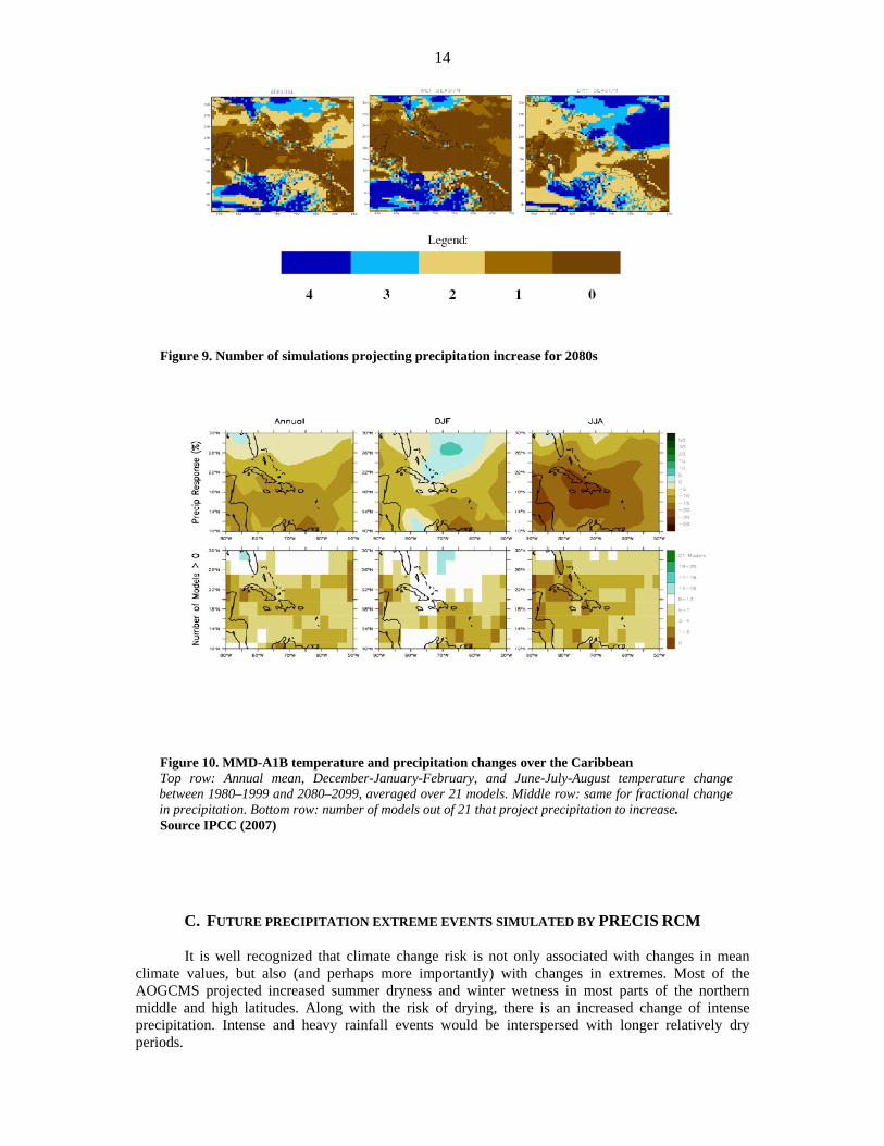
Although GCMs have the ability to create tropical vortices that have good similarities with
observed tropical cyclones, the coarse resolution of these models results in a lack of the presence of

17
relevant features such as an eye and associated eyewall, while the simulated storms have a larger horizontal extent than those observed. Thus, the few hundred kilometer resolution of GCMs does not allow them to properly represent hurricanes. Regional climate models such as PRECIS have been found to produce cyclones more realistically than the vortices generated by a GCM, representing one important value added to GCMs (figure 12).
Tropical storm assessment based on PRECIS outputs is another ongoing research activity in
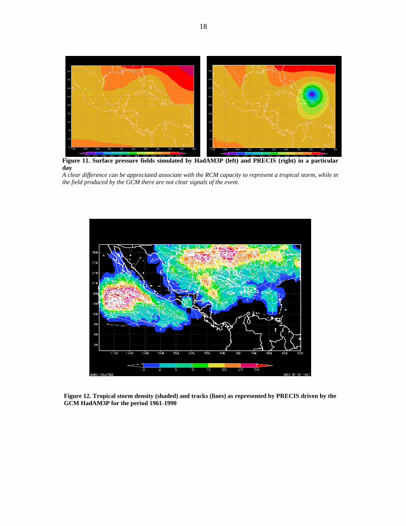
the Caribbean, which will provide results on how well PRECIS represents the behavior of hurricanes in the region, as well as on the future possible changes. For example, preliminary results as seen in figure 13 show the tropical cyclone like-vortices density and tracks for the PRECIS_Had control simulation (1961-1990). Despite the fact that this picture could not be obtained from GCM outputs, there are deficiencies in RCM storm simulation that need more in-depth and further research. These deficiencies are related, for instance, to both the low density and the lack of tracks in the eastern Caribbean, in which the frequency of storms is relatively high, mainly during the first half of the season. Preliminary analysis suggests that this is a problem associated with PRECIS and not with the driving fields. Nevertheless other features, such as the high density area located close to the Gulf of Honduras are well represented.
18
Figure 11. Surface pressure fields simulated by HadAM3P (left) and PRECIS (right) in a particular day A clear difference can be appreciated associate with the RCM capacity to represent a tropical storm, while in the field produced by the GCM there are not clear signals of the event.
Figure 12. Tropical storm density (shaded) and tracks (lines) as represented by PRECIS driven by the GCM HadAM3P for the period 1961-1990

19
IV. MAKING AVAILABLE THE PRECIS OUTPUTS THROUGH THE PRECIS CARIBE ONLINE SYSTEM.
One important part of the work done in relation to PRECIS was the development of an online system to make available the results for both climate and impact assessments on communities. Throughout the PRECIS CARIBE web page12 (figure 13), the user could produce maps and other kinds of charts as well as to download numerical data to make their own analysis. By filling a simple web form, the results from the available PRECIS experiments have been used by different users.
Figure 13. PRECIS CARIBE online web access Left panel shows the main page providing background information on the experiments and the available information. The right panel is the data access form the users must fill to get the charts or data.
Currently the INSMET team is upgrading the system by incorporating additional facilities to build graphical information and to allow access to a wider type of temporal and spatial data (see figure 14). An important facility to be added will be simple access to country specific data. The increased availability of more information from simple to complex data types could favour decision-making processes as well as the realization of more research.
12 This online system was developed by INSMET with the support of the UNDP-Caribbean Risk Management Initiative. The web page address is http://precis.insmet.cu/Precis-Caribe.htm

20
Figure 14. Examples of what the user can obtain from PRECIS CARIBE a -b) are one of the map types and text files from the system. The bottom panels are part of the new facilities that should be implemented. c) is a time series cross section over either fixed latitudes or longitude; and d) are interanual and annual variation temporal patterns. The data for these new charts will be also available for downloading.

21
V. FUTURE ACTIVITIES IN CLIMATE MODELING IN THE CARIBBEAN - CONCLUSIONS AND RECOMMENDATIONS
Despite much progress in recent years, there is a need for continuous development of climate research and modeling in the subregion to produce more relevant information for regional and national studies and to overcome the limitations of existing results.
With the coordination of the CCCCC, and the participation of INSMET and UWI, new
modeling activities were planned in a recent meeting held in Bahamas. The activities will address the realization of more analyses using the available information to generate best practices and to produce useful results. New experiments with other RCM driven by other GCMs as the perturbed parameter physics generated by the Hadley Center were also considered as a contribution for ongoing and new research projects. There are also new opportunities for climate research in the subregion with the Coordinated Regional Downscaling Experiment which is planned to start early next year. It is expected that the participation of various Caribbean institutions like INSMET, UWI, CCCCC and the Caribbean Institute for Meteorology and Hydrology in this global project will allow the generation of new and more abundant information.
It is not an easy task to deal with the above-mentioned future tasks. There are national as well
as regional limitations in human resource capacities as well as in technology13. However, the advantage of the regional work that is well-coordinated has been demonstrated in recent years and appears as a unique alternative for moving forward in the future. Future work will produce excellent and useful results and the assimilation and use of RCM in the Caribbean represent an important capacity-building activity as well. Nevertheless, as RCM continues being a computing demanding tool, financial support is required to enable research centers in the subregion to use RCM and to contribute to climate change studies in the Caribbean. Climate modeling activities should not be perceived as part of an individual project or should be delayed for the initiation of needs - assessment of the climate impacts projects to plan and undertake modeling experiments. The first stage of PRECIS Caribbean initiative produces an important amount of data at a very low cost and now projects like CARIBSAVE are using this information as part of the relevant inputs to do the analysis.
Perhaps there is not enough time to consider the development of new experiments under the ECLAC project, as the budget is now allocated for other activities and tasks. Therefore, it is strongly recommended that the PRECIS outputs available should not be used in isolation and be combined with other sources of climate change scenarios, such as the United Nations Development Programme Climate Change Country Profile (McSweeney, et al., in prep)14. Another option is to use a simpler climate model like MAGICC to complement what the PRECIS information has so far provided for socio-economic integrated assessment of sensitivity analysis.
Of course, the recommendations above are specifically concerned with the climate modeling and not with other related research activities that are also important. Recently a review of the scientific capacities related with climate variability and climate change in the region (Chen et al., 2008) summarized many of these important aspects and made important recommendations. Although this review was produced in relation to a climate change and biodiversity, most, if not all, of those conclusions are applicable for the ECLAC project.
13 A description of the regional capacities for climate scenarios and model could be find in Day O, 2009: The impacts of climate change on biodiversity in the Caribbean islands: what we know, what we need to know and building capacity for effective adaptation. CANARI Technical Report No. 386:28pp. 14 http://country-profiles.geog.ox.ac.uk

22
Annex
Atmosphere-only General Circulation Models and Regional Climate Models Atmosphere-only General Circulation Models
AGCMs include interactive land-surface schemes as in an AOGCM but require information on sea surface temperatures and sea-ice as a lower boundary condition. The sea surface temperatures and sea-ice information required can be derived from observations or AOGCMs. The use of observations can improve simulations of current climate but combing these with AOGCM-derived changes for the future climate increases the risk of inconsistency in the projected climate. The large-scale climate responses of AGCM and AOGCM appear to be similar in many regions.
Model grids of 100 km and finer have become feasible and 50 km will likely be the norm in
the near future. High performance computer systems now allow global computations at 20 km although for short time periods only. Evaluated on the scale typical of current AOGCMs, nearly all quantities simulated by high-resolution AGCMs agree better with observations, but the improvements vary significantly with regions and specific variables, and extensive recalibration of parameterisations is often required. Notable improvements occur in orographic precipitation and improved dynamics of mid-latitude weather systems. The highest resolution offers the prospect of credible simulations of the climatology of tropical cyclones.
An alternative to uniform high-resolution is variable-resolution AGCMs (VRGCM). The
VRGCM approach is attractive as it permits, within a unified modeling framework, a regional increase of resolution while retaining the interaction of all regions of the atmosphere. VRGCMs results capture, over the high-resolution region, finer scale details than uniform-resolution models while retaining global skill similar to uniform-resolution simulations with the same number of grid points.
Regional Climate Models
A regional climate model is a high resolution climate model that covers a limited area of the globe, typically 5,000 km x 5,000 km, with a typical horizontal resolution of 50 km. RCMs are based on physical laws represented by mathematical equations that are solved using a three-dimensional grid. Hence RCMs are comprehensive physical models, usually including the atmosphere and land surface components of the climate system, and containing representations of the important processes within the climate system (e.g., cloud, radiation, rainfall, soil hydrology). As in the GCMs many of these physical processes take place on much smaller spatial scales than the model grid and cannot be modeled and resolved explicitly, thus parameterizations are used to take into account their effects.
Given that RCMs are limited area models they need to be driven at their boundaries by time-
dependent large-scale fields (e.g., wind, temperature, water vapor and surface pressure). These fields are provided either by reanalysis of the observations or by GCM integrations in a buffer area that is not considered when analyzing the results of the RCM.
∗ Summarized from the Chapter 11 of the IPCC Fourth Assessment Working Group I Report.

23
References Angeles, M.E., J.E. Gonzalez, D.J. Erickson, and J.L. Hernánde, 2007: Predictions of change in the Caribbean region using global general circulation models Int. J. Climatol., 27, 555-569, doi:10.1002/joc.1416. Bueno Ramón, Herzfeld Cornelia, Stanton Elizabetha, Ackerman Frank, 2008: The Caribbean and Climate Change: the cost of inaction. Tufts University.
Centella A.,T. Gutiérrez, M. Limia and R. Rivero-Jaspe, 1999: Climate Change scenarios for impact studies in Cuba. Climate Research, 12, 223-230. Centella A, A. Bezanilla and K. Leslie, 2008: A Study of the Uncertainty in Future Caribbean Climate Using the PRECIS Regional Climate Model. Technical Report, Community Caribbean Climate Change Center, Belmopan, 16pp. Centella et al., 2009: High Resolution Climate Change Scenarios for the Caribbean (in preparation). Chen, A. A., Chadee, D. D., & Rawlins, S. C. 2006: Climate Change Impact on Dengue: The Caribbean Experience, (ISBN 976-41-0210-7). Chen. A., M. Taylor, A. Centella, D. Farrell. 2008: Climate trends and scenarios for climate change in the insular Caribbean: Report of Working Group I, Climate Change and Biodiversity in the Insular Caribbean. CANARI Technical Report No.381: 63pp. Claussen, M., et al., 2002: Earth system models of intermediate complexity: closing the gap in the spectrum of climate system models. Clim. Dyn., 18, 579–586. Collins, M., et al., 2006: Towards quantifying uncertainty in transient climate change. Clim. Dyn., 27, 127–147. Christensen, J.H., B. Hewitson, A. Busuioc, A. Chen, X. Gao, I. Held, R. Jones, R.K. Kolli, W.-T. Kwon, R. Laprise, V. Magaña Rueda, L. Mearns, C.G. Menéndez, J. Raisanen, A. Rinke, A. Sarr and P. Whetton, 2007: Regional Climate Projections. In: Climate Change 2007: The Physical Science Basis. Contribution of Working Group I to the Fourth Assessment Report of the Intergovernmental Panel on Climate Change [Solomon, S., D. Qin, M. Manning, Z. Chen, M. Marquis, K.B. Averyt, M. Tignor and H.L. Miller (eds.)]. Cambridge University Press, Cambridge, United Kingdom and New York, NY, USA. Frich, P., et al., 2002: Observed coherent changes in climatic extremes during the second half of the twentieth century. Clim. Res., 19, 193– 212. Haites, E., D. Pantin, M. Attzs, J. Bruce and J. MacKinnon., 2002: Assessment of the Impact of Climate Change on CARICOM Countries. Environmentally and Socially Sustainable Development — Latin America and Caribbean Region, the World Bank. Harvey, D., et al., 1997: An Introduction to Simple Climate Models Used in the IPCC Second Assessment Report. IPCC Technical Paper 2 [Houghton, J.T., L.G. Meira Filho, D.J. Griggs, and K. Maskell (eds.)]. IPCC, Geneva, Switzerland, 51 pp. Hewitt, C. D., and D. J. Griggs (2004), Ensembles-Based Predictions of Climate Changes and Their Impacts, Eos Trans. AGU, 85(52), doi:10.1029/2004EO520005. Hulme, M., T.M.L. Wigley, E.M. Barrow, S.C.B. Raper, A. Centella, S. Smith and A.C. Chipanshi, 2000:. Using a Climate Scenario Generator for Vulnerability and Adaptation Assessments: MAGICC and SCENGEN Version 2.4 Workbook, Climatic Research Unit, Norwich, UK, 52 pp.

24
Hulme,M., Jenkins,G.J., Lu,X., Turnpenny,J.R., Mitchell,T.D., Jones, R.G., Lowe,J., Murphy,J.M., Hassell,D., Boorman,P., McDonald,R. and Hill,S. 2002 Climate Change Scenarios for the United Kingdom: The UKCIP02 Scientific Report, Tyndall Centre for Climate Change Research, School of Environmental Sciences, University of East Anglia, Norwich, UK. 120pp Leggett, J et al 1992: "Emissions Scenarios for the IPCC: an Update", Climate Change 1992: The Supplementary Report to The IPCC Scientific Assessment, Cambridge University Press, UK, pp. 68-95 IPCC, 2007: Summary for Policymakers. In: Climate Change 2007: The Physical Science Basis. Contribution of WorkingGroup I to the Fourth Assessment Report of the Intergovernmental Panel on Climate Change [Solomon, S., D. Qin, M. Manning, Z. Chen, M. Marquis, K.B. Averyt, M.Tignor and H.L. Miller (Eds.)]. Cambridge University Press, Cambridge, United Kingdom and New York, NY, USA. Jones R. G., Noger M., Hassell D. C., Hudson D., Wilson S., Jenkins G., and Mitchell, J., 2004: Generating high resolution climate change scenarios using PRECIS. Met Offrice Hadley Center, Exeter, UK, 40 pp. Mearns, L.O., F. Giorgi, P. Whetton, D. Pabon, M. Hulme and M. Lal, 2003: Guidelines for Use of Climate Scenarios Developed from Regional Climate Model Experiments, IPCC Task Group on Data and Scenario Support for Impact and Climate Analysis, 38 pp. Moss, et al., 2008: Towards New Scenarios for Analysis of Emissions, Climate Change, Impacts, and Response Strategies. Technical Summary. Intergovernmental Panel on Climate Change, Geneva, 25 pp.ISBN: 978-92-9169-124-1 Nakicenovic, N., and R. Swart (eds.), 2000: Special Report on Emissions Scenarios. A Special Report of Working Group III of the Intergovernmental Panel on Climate Change. Cambridge University Press, Cambridge, United Kingdom and New York, NY, USA, 599 pp. Nuñez et al., 2008: Regional climate change experiments over southern South America. II: Climate change scenarios in the late twenty-first century Sanchez-Gomez et al., 2008: Ability of an ensemble of regional climate models to reproduce weather regimes over Europe-Atlantic during the period 1961–2000. Clim Dyn 33, 723-736. Solomon et al., 2009: Irreversible climate change due to carbon dioxide emissions. Proc Natl Acad Sci USA No. 106: 1704-1709. Taylor, M. A., Centella, A., Charlery, J., Borrajero, I., Bezanilla, A., Campbell, J. D., et al. 2007: Glimpses of the future: A briefing from the PRECIS Caribbean climate change project, Caribbean Community Climate Change Centre, Belmopan, Belize. 24 pp. Whetton, P.H., et al., 2001: Developing scenarios of climate change for Southeastern Australia: An example using regional climate model output. Clim. Res., 16(3), 181–201. Wilby, R.L., C.W. Dawson, and E.M. Barrow, 2002: SDSM – A decision support tool for the assessment of regional climate change impacts. Environ Model. Software, 17, 147–159. Wilby, R.L, S.P. Charles, E. Zorita, B. Timbal, P. Whetton and L.O. Mearns, 2004: Guidelines for Use of Climate Scenarios Developed from Statistical Downscaling Methods, IPCC Task Group on Data and Scenario Support for Impact and Climate Analysis, 27 pp.