Embed Size (px)
Citation preview

Regional Bicycle Route 7
Concept Design Report
Complete Urban Pty Ltd Suite 3/10 Regent Street
Chippendale NSW 2008
Version 1: 4th April 2016

Regional Bicycle Route 7 - Concept Design Report Page ii of ii File Path: Z:\Projects\2519 MAR Detailed Designs for Regional Bicycle Route 7 (RR7)\02 Activit ies\02-G Concept Design Report\Marrickvil le_Regional Bicycle Route 7_Concept Design Report_r1.docx Issue Details: Ver1 4/04/2016 Approved: MB
CONTENTS 1 Introduction ................................................................................................................. 1 2 Project Objectives and Design Principles ...................................................................... 2
2.1 Objectives .......................................................................................................... 2 2.2 Design Principles ................................................................................................ 2
3 Route Assessment Methodology and Considerations ..................................................... 4 3.1 Process .............................................................................................................. 4 3.2 Assumptions ....................................................................................................... 4 3.3 Cycle Facility Consderations ............................................................................... 5 3.4 Pedestrian Consderations ................................................................................... 5 3.5 Traffic Operation Consderations .......................................................................... 5 3.6 Parking Considerations ....................................................................................... 5 3.7 Public Transport Considerations .......................................................................... 5 3.8 Street Trees, Landscape and Public Open Space Considerations .......................... 5 3.9 Future Stages ..................................................................................................... 6
4 Concept Design Options ............................................................................................... 6 4.1 Study Area ......................................................................................................... 6 4.2 Concept Design Options ..................................................................................... 6
4.2.1 Section 2 – Longport Road, Lewisham to Crystal Street, Petersham .......... 6 4.2.2 Section 1 – York Crescent, Petersham to Mary Street, Newtown .............. 11
5 Stakeholder Consultation ............................................................................................. 15 5.1 RMS ................................................................................................................. 15 5.2 Sydney Buses ................................................................................................... 15 5.3 RailCorp ............................................................................................................ 15 5.4 Bike Marrickville ................................................................................................ 15 5.5 Community ........................................................................................................ 15
6 Conclusion and Recommendation ................................................................................ 16 Appendix A – Concept Design Proposals Appendix B – Bike Marrickville Correspondence
Regional Bicycle Route 7 - Concept Design Report Page 1 of 16 File Path: Z:\Projects\2519 MAR Detailed Designs for Regional Bicycle Route 7 (RR7)\02 Activities\02-G Concept Design Report\Marrickvil le_Regional Bicycle Route 7_Concept Design Report_r1.docx Issue Details: Ver1 4/04/2016 Approved: MB
1 INTRODUCTION COMPLETE Urban Pty. Ltd. (COMPLETE) has been commissioned by Marrickville Council to undertake the route assessment and concept design for the proposed Regional Bicycle Route 7 along the following routes:
Section 1 – Mary Street, Newtown to York Crescent, Petersham; and
Section 2 – Crystal Street, Petersham to Longport Street, Lewisham.
The project is broken into stages, the first being the assessment of the routes and development of concept design options. Future stages, involving engineering survey, detailed design and for construction documentation is subject to Council approval and dependent on the findings of the concept design process.

Regional Bicycle Route 7 - Concept Design Report Page 2 of 16 File Path: Z:\Projects\2519 MAR Detailed Designs for Regional Bicycle Route 7 (RR7)\02 Activities\02-G Concept Design Report\Marrickvil le_Regional Bicycle Route 7_Concept Design Report_r1.docx Issue Details: Ver1 4/04/2016 Approved: MB
2 PROJECT OBJECTIVES AND DESIGN PRINCIPLES
2.1 OBJECTIVES
Marrickville Council has the following primary objectives for this project:
provide bicycle infrastructure that, as far as practicable, meets user needs by providing a safe, comfortable and convenient route for bike riders and connects to intersecting bicycle routes and local destinations whilst maintaining, and preferably enhancing, the amenity of the study area for users and residents;
work closely with Council staff to include local knowledge;
undertake detailed surveys, analysis and investigation of Regional Route 7 (Sections 1 and 2) as required to evaluate options and prepare detailed design plans, cost estimates and construction set-out for cycling infrastructure along the route (Future Stage); and
prepare detailed design plans, cost estimates and construction set-out files for the works (Future Stage).
2.2 DESIGN PRINCIPLES
The following design principles are considered as part of the assessment to ensure that the developed options are appealing to existing cyclists and potential users thinking about cycling as an alternative mode of transport:
Coherence
o The network should link to popular destinations and trip generators and also to adjacent cycle routes in the area;
o The network should be continuous and it should be clear where the route leads;
o Intersections should provide a clear path for bicycle riders and other road users; and
o The quality of the bicycle facilities should be consistent throughout the length of the route regardless of the bicycle facility typology.
Directness
o The route should be as direct as safely practicable. Long detours and steep gradients should be avoided if possible;
o The route should take into account the slow speed of bike riders ascending compared to the high speed of bike riders descending; and
o Delays due to prolonged crossing times at major barriers or due to site constraints should be avoided and the route should allow for a safe comfortable and consistent operating speed throughout the length of the route.
Safety
o The proposed bicycle route and facilities should be well designed and improve and enhance the road safety of bicycle riders, pedestrians and motorists;
o Intersections should be designed to explicitly include bicycles as well as other road user types;

Regional Bicycle Route 7 - Concept Design Report Page 3 of 16 File Path: Z:\Projects\2519 MAR Detailed Designs for Regional Bicycle Route 7 (RR7)\02 Activities\02-G Concept Design Report\Marrickvil le_Regional Bicycle Route 7_Concept Design Report_r1.docx Issue Details: Ver1 4/04/2016 Approved: MB
o Bicycle routes past bus stops should be designed for safe accommodation of riders, bus passengers, other pedestrians and vehicles.
Attractiveness
o The bicycle route should fit into the surrounding environment so that the enjoyment of all road users is enhanced. Community support for cycling is greater if the activity is enjoyable and an attractive cycle facility aids enjoyment;
o Clear and well placed signposting should indicate major destinations;
o The route should feel safe and offer good personal security.
Comfort
o The bicycle route has to be easy to use for all types of riders. A smooth and well maintained riding surface is essential for both comfort and safety;
o Depending on the speed and volume of other traffic (motor vehicles or pedestrians), some level of separation is often needed;
o Clearly marked bicycle facilities that allocate operating space to bicycle users are the most appropriate types of facilities on all but low volume and low speed roads; and
o Effective intersection treatments, providing a safe and direct crossing, is important for overall route comfort.

Regional Bicycle Route 7 - Concept Design Report Page 4 of 16 File Path: Z:\Projects\2519 MAR Detailed Designs for Regional Bicycle Route 7 (RR7)\02 Activities\02-G Concept Design Report\Marrickvil le_Regional Bicycle Route 7_Concept Design Report_r1.docx Issue Details: Ver1 4/04/2016 Approved: MB
3 ROUTE ASSESSMENT METHODOLOGY AND CONSIDERATIONS
3.1 PROCESS
This report has been prepared in response to Council’s request to assess the potential bicycle route options for Regional Bicycle Route 7 connecting Lewisham, Petersham and Newtown. The route assessment has been carried out utilising the following methodology:
Site inspection of the route corridor and adjacent areas;
Site assessment and recording of site features, incorporating:
o Existing road geometry, including measurement of key site features to assist in the assessment of route options and bicycle facility typologies;
o Existing traffic conditions, including identification of sections of high traffic / pedestrian volumes, high traffic speeds, areas of traffic congestion etc.;
o Existing kerbside parking provisions, including identification of areas of high parking utilisation, high parking turnover, location of existing bus stops / mail zones etc.;
o Existing pedestrian provisions, including areas of high pedestrian concentration, location of crossings and type of control, any areas of inadequate pedestrian storage space, locations of substandard kerb ramps potentially impacted by a cycle facility etc.;
o Location and frequency of driveways and side roads along the proposed routes. In addition, assessment of the turning movements and usage (volume) associated with any side road and high use driveways;
o Location and condition of any street trees and landscaping potentially impacted by a cycle facility; and
o Location of any street furniture items potentially impacted by a cycle route.
Stakeholder meeting with Council representatives to present and discuss the route assessment findings and preliminary design opportunities; and
Preparation of a concept design report outlining the findings of the assessment process, including a finalisation of a set concept design drawings.
3.2 ASSUMPTIONS
The following assumptions are relevant to the preparation of this route assessment study:
The existing geometry and dimensions are based on assessment of the provided GIS and cadastral information, aerial photography and site assessments and measurements undertaken by COMPLETE;
Consideration of a bi-directional separated cycleway is based on a width of 2.8m, being a 2.4m wide cycleway and a 0.4m wide separator kerb. It is noted that additional separator kerb width would be desirable at locations where car parking is adjacent to the cycleway;
It is assumed that the minimum traffic lane width on roads with bus routes is 3.25m. This is the minimum requirement that has been permitted by the RMS and Sydney Buses on other routes COMPLETE have been involved with;

Regional Bicycle Route 7 - Concept Design Report Page 5 of 16 File Path: Z:\Projects\2519 MAR Detailed Designs for Regional Bicycle Route 7 (RR7)\02 Activities\02-G Concept Design Report\Marrickvil le_Regional Bicycle Route 7_Concept Design Report_r1.docx Issue Details: Ver1 4/04/2016 Approved: MB
Design proposals, whilst tested at the concept design level for swept paths, kerb relocation feasibility etc., are subject to confirmation following survey during the detailed design process; and
Design proposals at signalised intersections are subject to approval from the RMS.
3.3 CYCLE FACILITY CONSDERATIONS
Whilst the overall objective is to provide a safe and well linked cycle facility that is attractive to new and existing cyclists, the cycle route and facility typology must be balanced against the greater needs of the road network, the general public and the residents and businesses that are located along the route. In light of this, the developed options consider the potential implications of differing cycle facility typologies against existing traffic and parking provisions, public transport infrastructure, pedestrian facilities and existing landscaping / street trees.
3.4 PEDESTRIAN CONSDERATIONS
The assessment considers and identifies the existing pedestrian facilities and how potential cycle facilities would impact on those facilities.
3.5 TRAFFIC OPERATION CONSDERATIONS
The assessment also considers the potential impacts of cycleway options on the existing traffic operation of the route and intersections along the route. Specific consideration of the number of traffic lanes (including short turning lanes at intersections), lane widths, traffic volumes (assessed as high, medium, low - not measured) and vehicle speeds (assessed – not measured).
Any changes at signalised intersections are likely to require additional assessment to meet the requirements of the RMS
3.6 PARKING CONSIDERATIONS
The assessment considers the parking implications of the route alignment and the cycle facility typology options. Specific reference is made in relation to potential loss of parking on the concept design drawings.
3.7 PUBLIC TRANSPORT CONSIDERATIONS
Where public transport provisions are located on possible route alignment options, the assessment considers implications of implementing a cycleway on the traffic lane widths and bus stop facilities. (It is noted that previous guidance suggests that 3.25m traffic lanes are required on bus routes and that this should be considered the absolute minimum on such roads).
3.8 STREET TREES, LANDSCAPE AND PUBLIC OPEN SPACE CONSIDERATIONS
The concept design drawings also consider the potential impact on existing landscaping and street tree installations and make comments on potential loss as a result of providing a cycle facility adjacent.

Regional Bicycle Route 7 - Concept Design Report Page 6 of 16 File Path: Z:\Projects\2519 MAR Detailed Designs for Regional Bicycle Route 7 (RR7)\02 Activities\02-G Concept Design Report\Marrickvil le_Regional Bicycle Route 7_Concept Design Report_r1.docx Issue Details: Ver1 4/04/2016 Approved: MB
3.9 FUTURE STAGES
Following completion and endorsement of the concept design stage, and subject to Council’s direction, COMPLETE will progress the project to the engineering survey, detailed design and for construction documentation stages.
4 CONCEPT DESIGN OPTIONS
4.1 STUDY AREA
Figure 1 below outlines the study area defined in the project brief.
The Regional Bicycle Route considers the route corridor from Lewisham to Newtown via Petersham, generally following the alignment of the inner west rail corridor. The start and end points of the route are split by section and defined as follows:
Section 1 – Mary Street, Newtown to York Crescent, Petersham; and
Section 2 – Crystal Street, Petersham to Longport Street, Lewisham.
4.2 CONCEPT DESIGN OPTIONS
For the purposes of the report, and to maintain the logical west to east layout indicated on the concept design drawings, the following discussion is set out with Section 2 first, followed by Section 1.
4.2.1 SECTION 2 – LONGPORT ROAD, LEWISHAM TO CRYSTAL STREET, PETERSHAM
4.2.1.1 Longport Street – Grosvenor Crescent to Old Canterbury Road
This section considers the Longport Street link between The Greenway (at Grosvenor Crescent) and Old Canterbury Road.
Section 2 Section 1

Regional Bicycle Route 7 - Concept Design Report Page 7 of 16 File Path: Z:\Projects\2519 MAR Detailed Designs for Regional Bicycle Route 7 (RR7)\02 Activities\02-G Concept Design Report\Marrickvil le_Regional Bicycle Route 7_Concept Design Report_r1.docx Issue Details: Ver1 4/04/2016 Approved: MB
Preferred Option
Shared path on northern side of the road adjacent to Grosvenor Crescent;
Improved refuge island crossing at railway overbridge to provide separate pedestrian and cyclist crossings;
Bi-directional separated cycleway on the southern side of Longport Street between the refuge island and Old Canterbury Road. At Old Canterbury Road the facility would ramp up to a shared path to facilitate crossing of Old Canterbury Road at the existing signalised crossing. Existing kerbside parking provisions would be reduced / removed;
Shared environment intersection at Brown Street to promote continuation of the cycle link;
On road shoulder lane on the southern side of Longport Street between Smith Street and the refuge island to facilitate westbound cycle movements to Smith Street and beyond;
On road mixed traffic for eastbound cyclists on Longport Street east of the refuge island to facilitate access for confident cyclists to the proposed eastbound shoulder lanes on Railway Terrace east of Old Canterbury Road.
Alternative Options Considered:
Shared path on the southern side of Longport Street between the refuge island and Old Canterbury Road. Whilst this would retain existing parking provisions, the cycle facility on what is a Regional Route would be compromised. In addition, with the adjacent development ongoing, pedestrian volumes in the area are expected to increase and as such the provision of a shared pathway is less favourable;
Eastbound shoulder lane on the northern side of Longport Street between the refuge island and Old Canterbury Road. Whilst this would provide an improved situation for confident on road cyclists and link well with the proposed shoulder lane on Railway Terrace, the link would deter less confident cyclists and the connection to the proposed route for less confident cyclists on the Old Canterbury Road shared path would be complicated;
Standard cycleway crossing at Brown Street intersection where cyclists give way to Brown Street traffic. This would provide a slight discontinuity in the cycle route and a shared environment intersection was considered to provide an improved cycle connection.
4.2.1.2 Old Canterbury Road intersection
This section considers the cycle links through the signalised intersection of Old Canterbury Road, Longport Street and Railway Terrace.
Preferred Option
Provision of a shared pathway crossing on Old Canterbury Road on the southern side of the intersection to link the proposed sections of shared path on the southern side of Longport Street at the intersection and the shared path on the eastern side of Old Canterbury Road. This is considered the desirable route for less confident cyclists;
Provision of a mixed traffic facility through the intersection to facilitate connection to the proposed Railway Terrace shoulder lane.
Alternative Options Considered:
Continuation of bi-directional separated cycleway on the southern side of the intersection. This option, whilst initially considered, was promptly discounted due to

Regional Bicycle Route 7 - Concept Design Report Page 8 of 16 File Path: Z:\Projects\2519 MAR Detailed Designs for Regional Bicycle Route 7 (RR7)\02 Activities\02-G Concept Design Report\Marrickvil le_Regional Bicycle Route 7_Concept Design Report_r1.docx Issue Details: Ver1 4/04/2016 Approved: MB
the insufficient space on the south-eastern corner of the intersection and narrow road width on Railway Terrace.
4.2.1.3 Railway Terrace – Old Canterbury Road to West Street
This section is considered the route most likely to be utilised by existing cyclists who either already use Railway Terrace or who are confident enough to cycle on the road. It is the most direct route, but will not appeal to all users. The objective of this section, given its existing constraints, is to provide a facility that improves the current situation.
Preferred Option
Provision of an eastbound shoulder lane on Railway Terrace between Old Canterbury Road and Hunter Street. This section of Railway Terrace is uphill in the eastbound direction and would provide additional protection for cyclists in an area where the speed differential to vehicles would be highest. The resulting widths would provide a 1.4m shoulder lane and 2 x 3.3m wide traffic lanes;
Provision of mixed traffic profile for westbound traffic and cyclists on Railway Terrace between Old Canterbury Road and Hunter Street. This replicates the current arrangement for westbound cyclists and is considered appropriate given the downhill grade and low speed differential;
Provision of an improved bus stop platform on the northern side of the road and connection between the proposed eastbound shoulder lane and the bi-directional separated cycle path via a shared path and the widened bus stop platform; and
Bi-directional separated cycleway on the northern side of Railway Terrace between Hunter Street and West Street. The option would include an improved refuge island crossing adjacent to Hunter Street to facilitate access from the alternative back street route for less confident cyclists on the adjacent local streets.
Alternative Options Considered:
Shared path along the southern side of Railway Terrace between Hunter Street and West Street. The option had issues with the existing footpath width and current parking restrictions adjacent the southern kerb, in addition to the complication at the West Street intersection with accessing the northern footpath east of West Street which was preferred for continuation of the cycle route;
Continuation of the proposed eastbound shoulder lane and westbound mixed traffic profile. It is noted that the road width increases significantly east of Hunter Street and as such the desire to provide a higher quality facility where feasibility meant that this option was considered inappropriate.
4.2.1.4 Various Local Streets – Old Canterbury Road to West Street
This section is considered the route most likely to be favoured by less confident cyclists and those not keen on cycling on Railway Terrace. The route utilises adjacent local residential routes to provide a generally on road connection from Old Canterbury Road to both Hunter Street and West Street from the south of Railway Terrace.
Preferred Option
Provision of a shared path on the eastern side of Old Canterbury Road between Railway Terrace and Jubilee Reserve. The route and shared path would extend through Jubilee Reserve to Jubilee Street;
On road mixed traffic profile on Jubilee Street and a short section of Victoria Street;
On road contra flow cycle lane on Hobbs Street between Victoria Street and Denison Road;
Regional Bicycle Route 7 - Concept Design Report Page 9 of 16 File Path: Z:\Projects\2519 MAR Detailed Designs for Regional Bicycle Route 7 (RR7)\02 Activities\02-G Concept Design Report\Marrickvil le_Regional Bicycle Route 7_Concept Design Report_r1.docx Issue Details: Ver1 4/04/2016 Approved: MB
On road mixed traffic profile on Denison Street and Hunter Street north towards Railway Terrace. This would link up with the proposed refuge island crossing improvements at Hunter Street and the proposed bi-directional separated cycleway on Railway Terrace;
As an alternative to the Hunter Street link, on road mixed traffic profile on Hunter Street between Denison Street and The Boulevarde, The Boulevarde and West Street north towards Railway Terrace. The option would require the construction of a link between the West Street cul-de-sac and the southern footpath on Railway Terrace.
Alternative Options Considered:
On road mixed traffic profile on Victoria Street between Jubilee Street and Railway Terrace. Whilst more direct than some of the other back street routes, this option exited onto Railway Terrace at Victoria Street which was still within the section of Railway Terrace with narrow road width and overall width generally. In this case the link eastward would therefore be significantly constrained.
4.2.1.5 Railway Terrace / West Street intersection
This section considers the existing signalised intersection of Railway Terrace and West Street. The existing intersection is very busy with the West Street link being an important north south linking over the rail line. It is noted that there is a significant volume of right turning traffic from Railway Terrace to West Street.
Preferred Option
Continuation of the eastbound bi-directional separated cycleway on the northern side of Railway Terrace through the intersection to a kerb extension and shared path on the northeast corner via a new signalised cycle phase. It is noted that the extent of the kerb extension will require assessment and confirmation during detailed design and following survey to ensure that the required turning movements at the intersection are maintained;
Provision of a signalised shared pedestrian and cycle crossing of Railway Terrace on the eastern side of the intersection to facilitate access from the alternative local streets route for less confident cyclists to the proposed shared pathway on the northern side of Railway Terrace east of West Street.
Alternative Options Considered:
Shared path crossings utilising the existing crossing of Railway Terrace on the western side of the intersection and of West Street on the northern side of the intersection. It is noted that the existing pedestrian space on both the north-western and north-eastern corners is limited and as such extension of the kerbs and widening would be required to maintain a suitable space for a shared area.
4.2.1.6 Railway Terrace – West Street to Trafalgar Street
This section considers the connection from West Street to Trafalgar Street and the proposed continuation of the route.
Preferred Option
Provision of a shared path on the northern side of Railway Terrace utilising the existing footpath and widening where required. It is noted that the existing path is not well used from a pedestrian point of view so upgrading to a shared path will provide an alternative use for an underutilised asset.

Regional Bicycle Route 7 - Concept Design Report Page 10 of 16 File Path: Z:\Projects\2519 MAR Detailed Designs for Regional Bicycle Route 7 (RR7)\02 Activities\02-G Concept Design Report\Marrickvil le_Regional Bicycle Route 7_Concept Design Report_r1.docx Issue Details: Ver1 4/04/2016 Approved: MB
Alternative Options Considered:
Utilising the TAKE land on the southern side of Railway Terrace to link to the Railway Terrace / Trafalgar Street / Gordon Street signalised intersection. It is noted that the existing signals do not facilitate a complete connection to Trafalgar Street with a left turn slip lane and marked zebra crossing connecting to the southern side of the road and no existing crossing connecting to the northern side of Trafalgar Street.
4.2.1.7 Trafalgar Street – Railway Terrace to Audley Street
This section assesses the length of Trafalgar Street between Railway Terrace and the existing roundabout intersection with Audley Street.
Preferred Option
Due to low pedestrian volumes, provision of a shared path on the northern side of Trafalgar Street. Associated kerb widening is required to achieve a desirable path width which will require minor reduction to the adjacent parking and traffic lanes. As previously, the footpath on this section is not well used and as such a shared path will provide for increased use on a currently underutilised asset;
Transition to a bi-directional separated cycleway on approach to the Audley Street intersection to coincide with the location where pedestrian volumes increase and separation is considered beneficial to the route. The location assumes that the existing bus stop adjacent is likely to be removed (as per Sydney Buses advice). Should the bus stop review not remove the bus stop, then coordination and possible relocation of the stop may be required to ensure that a safe transition can be provided for pedestrians, cyclists and bus passengers;
Bypassing of the roundabout via a bi-directional separated cycleway on the northern side of the roundabout in between the footpath and the carriageway.
Alternative Options Considered:
Bi-directional separated cycleway on the northern side of Trafalgar Street between Railway Terrace and Audley Street. The option would require relocation of the kerb line and likely loss of parking on one side of the road to gain sufficient space to accommodate the cycleway.
Potential shared path or bi-directional separated cycleway on the southern side of Trafalgar Street. Due to the adjacent residential properties and side road intersections, this side of the road was considered less desirable than the northern side of the road. In addition, the link through Audley Street would be difficult if the facility was on the southern side of Trafalgar Street.
4.2.1.8 Trafalgar Street – Audley Street to Crystal Street
This section considers the length of Trafalgar Street between Audley Street, past the Petersham Railway Station, and linking to the existing traffic signals at the intersection with Crystal Street.
Preferred Option
Provision of a bi-directional separated cycleway on the northern side of Trafalgar Street between Audley Street and the Crystal Street approach. The option would require a bend out of the cycleway alignment past the existing bus stop adjacent to Petersham Rail Station and a new signalised cycle phase across the traffic signals opposite the station;

Regional Bicycle Route 7 - Concept Design Report Page 11 of 16 File Path: Z:\Projects\2519 MAR Detailed Designs for Regional Bicycle Route 7 (RR7)\02 Activities\02-G Concept Design Report\Marrickvil le_Regional Bicycle Route 7_Concept Design Report_r1.docx Issue Details: Ver1 4/04/2016 Approved: MB
Provision of a transition to a shared path on approach to the Crystal Street traffic signals to maintain the existing traffic lane configuration at the intersection.
Alternative Options Considered:
Shared path on the northern side of the road past the existing bus stop and Petersham Rail Station. The high pedestrian volumes associated with the Petersham Rail Station make the provision of a shared path at this location undesirable.
4.2.1.9 Crystal Street Traffic Signals
This section considers the continuation of the route through the intersection and connection to York Crescent.
Preferred Option
Provision of a shared path on the Trafalgar Street approach to the signals, linking to the existing crossing on the northern side of the intersection, and extension of the shared path on the eastern side of Crystal Street up to York Crescent.
Alternative Options Considered:
Nil – limited ability to achieve anything other than a shared pathway due to constrained width on railway overbridge and limited road width on Crystal Street.
4.2.2 SECTION 1 – YORK CRESCENT, PETERSHAM TO MARY STREET, NEWTOWN
4.2.2.1 York Crescent – Crystal Street to Gordon Crescent
This section considers the short section of York Crescent between Crystal Street up to the end of the cul-de-sac and extension of the route through the pathway connecting to Gordon Crescent.
Preferred Option
On road mixed traffic on the section of York Crescent to match the current provisions;
Widening of the existing shared pathway that runs between York Crescent and Gordon Crescent. The path is restricted in width due to the adjacent residential boundary and the existing fence that adjoins the rail corridor. Widening of the path would require relocation of the rail corridor fence and potential encroachment into Railcorp land. In addition, due to the embankment down to the rail line, any widening has the potential to require a retaining structure or cantilevered path solution;
Improved access to the pathway with improved ramps and visibility.
Alternative Options Considered:
To avoid the narrow pathway at the end of York Crescent, an alternative route via Crystal Street, Douglas Street and Stanley Street was investigated. However, the option was not considered further due to issues with directness, bus stop locations and the inability to provide a safe and sufficiently wide facility.
Regional Bicycle Route 7 - Concept Design Report Page 12 of 16 File Path: Z:\Projects\2519 MAR Detailed Designs for Regional Bicycle Route 7 (RR7)\02 Activities\02-G Concept Design Report\Marrickvil le_Regional Bicycle Route 7_Concept Design Report_r1.docx Issue Details: Ver1 4/04/2016 Approved: MB
4.2.2.2 Gordon Crescent – Stanley Street to Douglas Street
This section considered the length of Gordon Crescent between Stanley Street and the approach to Stanmore Rail Station at Douglas Street.
Preferred Option
Provision of an on road mixed traffic profile for the length of Gordon Crescent between Stanley Street and Douglas Street, connecting to the southern footway adjacent to Stanmore Rail Station via the existing road to path transition at Douglas Street.
Alternative Options Considered:
Provision of a bi-directional separated cycleway on the southern side of Gordon Crescent. Due to width limitations, this would require loss of parking on one side of the road and on that basis was not considered further.
4.2.2.3 Stanmore Rail Station
This section considered the treatment for continuation of the cycle route in front of the Stanmore Rail Station on the southern side of Douglas Street / Railway Avenue.
Preferred Option
Transition from the existing shared path treatment from the west (Gordon Crescent) to an on road bi-directional separated cycleway on the southern side of Douglas Street / Railway Avenue in front of the station and either side of the existing traffic signals. The option would require the loss of one westbound traffic lane through the intersection, and would require an amendment to the Percival Street approach to allow only one right turning lane towards Douglas Street. It is noted that the westbound route is two lanes only through the intersection, with parking restricting the width to single lanes on the approach and exit.
Alternative Options Considered:
Provision of a shared path on the southern footpath in front of the Stanmore Rail Station. Whilst this would provide a good link to the station itself, it is considered that a shared path in an area with such a high pedestrian volume is not desirable.
4.2.2.4 Railway Avenue – Stanmore Rail Station to Liberty Street / Kingston Road
This section considers the length of Railway Avenue connecting Stanmore Rail Station to the intersection of Liberty Street / Kingston Road / Trade Street.
Preferred Option
Utilisation of the existing shared path link from Stanmore Rail Station to Railway Avenue that runs to the south of the Stanmore Library;
Provision of a bi-directional separated cycleway on the southern side of Railway Avenue between the existing shared path link and Kingston Road. The option is contained fully within the existing kerb provisions, resulting in a reduced carriageway width to accommodate the cycle facility.

Regional Bicycle Route 7 - Concept Design Report Page 13 of 16 File Path: Z:\Projects\2519 MAR Detailed Designs for Regional Bicycle Route 7 (RR7)\02 Activities\02-G Concept Design Report\Marrickvil le_Regional Bicycle Route 7_Concept Design Report_r1.docx Issue Details: Ver1 4/04/2016 Approved: MB
Alternative Options Considered:
Nil – desired cycle facility can be reasonably easily accommodated and as such no further options were assessed. The option of on road mixed traffic, similar to Gordon Crescent, is feasible also.
4.2.2.5 Railway Avenue / Liberty Street / Kingston Road / Trade Street intersection
This section considers continuation of the cycle route through the intersection. It is noted that the existing roundabout layout provides a confusing route as there is no eastbound on road route between Railway Avenue and Trade Street and as such cyclists are currently directed to southern footpath in the south-eastern corner of the intersection.
Preferred Option
Upgrading of the intersection to traffic signals, with facility to continue a bi-directional separated cycleway through the intersection. It is noted that the layout and feasibility of the potential signalised intersection will require confirmation following survey and determination of the lane configurations required by the RMS.
Alternative Options Considered:
Realignment of the central roundabout island to facilitate two way access to all legs of the intersection. This would enable a standard on road mixed traffic arrangement through the intersection for cyclists. Whilst this is considered an improvement in clarity and safety over the existing situation, the provision of traffic signals is preferred and is favoured on this regional cycle route.
4.2.2.6 Railway Ave to Camperdown Memorial Park
This section considered the route between the intersection of Railway Avenue / Liberty Street / Kingston Road / Trade Street and Camperdown Memorial Park.
Preferred Option
Utilisation of the existing on road mixed traffic facility on the narrow residential streets connecting the start and end points. The route utilises Trade Street, Baltic Street and Albermarle Street and connects to the existing shared pathway through the Park. Upgrades to signs and line marking throughout the route are proposed.
Alternative Options Considered:
Nil – alternative routes in the area are on similarly narrow streets that provide no measurable benefit when compared to the current alignment. The current alignment provides the clearest and most direct route for cyclists.
4.2.2.7 Camperdown Memorial Park
This section considers the route through the Camperdown Memorial Park.
Preferred Option
Use of the existing shared pathways extending through the Camperdown Memorial Park linking to Mary Street for the west bound route and to Eliza Street for a combined eastbound and westbound route.

Regional Bicycle Route 7 - Concept Design Report Page 14 of 16 File Path: Z:\Projects\2519 MAR Detailed Designs for Regional Bicycle Route 7 (RR7)\02 Activities\02-G Concept Design Report\Marrickvil le_Regional Bicycle Route 7_Concept Design Report_r1.docx Issue Details: Ver1 4/04/2016 Approved: MB
Alternative Options Considered:
Nil
4.2.2.8 Mary Street – Camperdown Memorial Park to King Street
This section considers the one way link on Mary Street from King Street to Lennox Street and Camperdown Memorial Park.
Preferred Option
Use of the existing on road mixed traffic one way link for cyclists extending from King Street to Camperdown Memorial Park.
Alternative Options Considered:
Nil.
4.2.2.9 Eliza Street – Camperdown Memorial Park to King Street
This section considers the one way link on Eliza Street from King Street to Lennox Street and Camperdown Memorial Park.
Preferred Option
Use of the existing on road mixed traffic link for northbound cyclists and the new one way shared path on the eastern side of the road for southern bound cyclists. On approach to King Street, two way cycle access on the existing section of 10km/hr shared zone is proposed to be retained.
Alternative Options Considered:
Nil

Regional Bicycle Route 7 - Concept Design Report Page 15 of 16 File Path: Z:\Projects\2519 MAR Detailed Designs for Regional Bicycle Route 7 (RR7)\02 Activities\02-G Concept Design Report\Marrickvil le_Regional Bicycle Route 7_Concept Design Report_r1.docx Issue Details: Ver1 4/04/2016 Approved: MB
5 STAKEHOLDER CONSULTATION
5.1 RMS
Preliminary communications have been held with RMS (Stephanie Bullock and Ken Hind). Initial indications are that RMS would request concept design plans to enable internal Design Manager discussions and Feasibility and Safety in Design workshops to commence.
5.2 SYDNEY BUSES
Preliminary discussions have been held with Sydney Buses (Peter Whitney), noting the following:
Peter is generally OK from a bus operation perspective about an in lane bus stop on Trafalgar Street adjacent to Petersham Station. He did however comment that RMS may require additional information to identify potential traffic and queuing impacts;
Similar to previous advice from Council, he did indicate that the existing bus stop west of Audley Street was undergoing review. He indicated that they were expecting to meet in April / May 2016 to finalise the review and it would be only after that the need for the stop would be determined.
5.3 RAILCORP
At this stage, communications with RailCorp have not progressed. Continued efforts to make contact with RailCorp will be made.
5.4 BIKE MARRICKVILLE
Council have held discussions with the local Bicycle User Group, Bike Marrickville, to present the early findings and to seek feedback and opinion on the concept design options going forward.
A summary of the discussions is attached in Appendix B.
5.5 COMMUNITY
A 4 week community consultation engagement was commenced in mid March 2016. The outcomes will be assessed and addressed on completion.

Regional Bicycle Route 7 - Concept Design Report Page 16 of 16 File Path: Z:\Projects\2519 MAR Detailed Designs for Regional Bicycle Route 7 (RR7)\02 Activities\02-G Concept Design Report\Marrickvil le_Regional Bicycle Route 7_Concept Design Report_r1.docx Issue Details: Ver1 4/04/2016 Approved: MB
6 CONCLUSION AND RECOMMENDATION It is recommended that the options identified in this report and outlined on the concept design drawing contained within are consulted on and taken to Council Traffic Committee with a view to progressing to the survey and detailed design stage.
It is also recommended that consultation with key stakeholders, particularly the RMS and RailCorp is progressed to assess the feasibility of a number of the options and to determine the requirements to progress the potential options to the future stages.

Regional Bicycle Route 7 - Concept Design Report
APPENDIX A – CONCEPT DESIGN PROPOSALS

Regional Bicycle Route 7 - Concept Design Report
APPENDIX B – BIKE MARRICKVILLE CORRESPONDENCE

Regional Bicycle Route 7 - Concept Design Report
Comment number
Bike Marrickville comments Benny Horn response.
1 Railway Tce: Uphill bike lane between Old Canterbury Road and West Street strongly supported.
As discussed, to be incorporated into the concept plans if feasible.
2 Lewisham side streets route:
Add turn arrows on road pavement alongside proposed/existing bicycle symbols to indicate route (e.g. right turn arrow on Victoria St into Hobbs Street)
Please add.
3 Hobbs Street: Contraflow with entry/exit separation at Hobbs St supported.
As discussed, to be incorporated into the concept plans if feasible.
4 Railway Tce (between Victoria and Hunter): Marrickville’s DCP requires that redevelopment of the lots on Railway Terrace (between Victoria Street and Hunter Street) includes a dedication of 3 metres of frontage onto Railway Terrace to Council for increased pedestrian space.
Agreed. As redevelopment takes place in the medium term this will result in land becoming available for a shared path/off-road separated path on the southern footpath between Victoria and Hunter. This will provide improved connectivity but remains a medium-long term opportunity. Please note.
5 Victoria Street: Provide cyclist exemption on right-turn ban from Victoria Street into Railway Terrace to provide access to the proposed uphill bike lane.
Noted, however this has previously not been supported by Council.

Regional Bicycle Route 7 - Concept Design Report
Comment number
Bike Marrickville comments Benny Horn response.
6 West Street/Railway Terrace:
The proposal to use the existing crossing of West Street on the northern side of the intersection is dangerous and inconvenient (difficult to manoeuvre by bicycle due to slope and too narrow). Overwhelmingly not supported.
Given the constraints of this intersection, a better option is required: investigate a link (overpass) over the intersection?
Alternative option 1: The addition of a crossing arm on the eastern side of the intersection is supported, however it is recognised that it may not be supported by RMS.
Alternative option 2: Investigate use of the RMS-owned land on the south-eastern corner of the intersection (currently TAFE car park) to provide a cycle link on the southern side of Railway Terrace to Trafalgar Street.
Alternative option 3: Provide a straight 2-way separated path crossing across the northern side of the intersection, synchronised to cross with the pedestrian crossing at West Street.
As per our discussions earlier this week, the existing proposed option (bikes cross via the northern pedestrian crossing) is not suitable.
Please consult with RMS to canvass opinion on the following options:
- an additional crossing on the eastern side of the intersection
- a straight 2-way separated path crossing on the northern side of the intersection, connecting to a 2-way separated path west of the intersection and transitioning to a shared path east of the intersection.
- using RMS land at the TAFE car park for a 2-way bike path to the corner of Gordon St and Trafalgar St (which will then require a bike crossing into Trafalgar).
7 Trafalgar Street: The north-side parking lane west of Audley Street should also be replaced by a 2-way path.
Commuter parking lost could be off-set by an arrangement with Petersham RSL to utilise its spare parking capacity during weekday business hours.
As discussed, 2-way separation is a priority for the section of Trafalgar St east of Audley St. West of Audley Street, a shared path is considered appropriate due to lower pedestrian volumes.
8 Trafalgar Street bus stop (at Petersham station): A bend out bike path as per Bourke Road, Alexandria is not ideal. The preferred design (if space is available) features a straight path with bus stop island as per the bus stop near the corner of Bourke St and Cathedral St, Woolloomooloo (see page 16 of the attached PDF).
As there is no parking lane this design cannot be implemented. However, given the parking lane width at the bend in Trafalgar St, the bike path could travel behind the bus stop, partly on the kerb and partly on a raised section of the existing parking lane, thereby preserving the existing footpath for pedestrians and avoiding the need to mix bicycles and pedestrians on the existing footpath. Please incorporate if feasible.
Regional Bicycle Route 7 - Concept Design Report
Comment number
Bike Marrickville comments Benny Horn response.
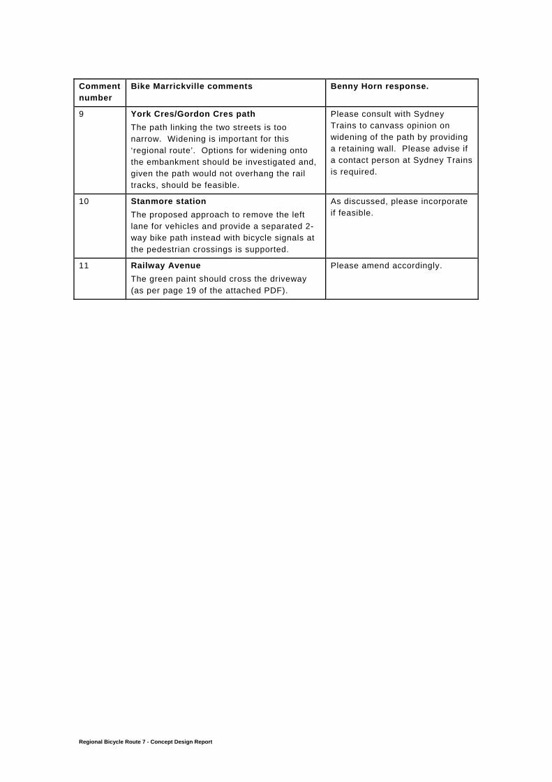
9 York Cres/Gordon Cres path
The path linking the two streets is too narrow. Widening is important for this ‘regional route’. Options for widening onto the embankment should be investigated and, given the path would not overhang the rail tracks, should be feasible.
Please consult with Sydney Trains to canvass opinion on widening of the path by providing a retaining wall. Please advise if a contact person at Sydney Trains is required.
10 Stanmore station The proposed approach to remove the left lane for vehicles and provide a separated 2-way bike path instead with bicycle signals at the pedestrian crossings is supported.
As discussed, please incorporate if feasible.
11 Railway Avenue The green paint should cross the driveway (as per page 19 of the attached PDF).
Please amend accordingly.