Embed Size (px)
Citation preview
Region 7a, Omineca Arctic Grayling
(Thymallus arcticus): Data Consolidation Review and Gap Analysis
Susanne Williamson and Ted Zimmerman
British Columbia Ministry of Water, Land and Air Protection
Environmental Stewardship Division Fish and Wildlife Science and Allocation
4051 18th Avenue Prince George, BC
V2N 1B3
December 2004

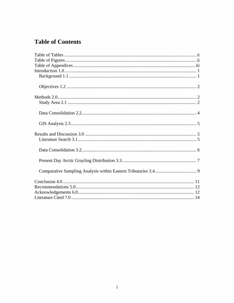
Table of Contents Table of Tables ................................................................................................................... ii Table of Figures .................................................................................................................. ii Table of Appendices .......................................................................................................... iii Introduction 1.0................................................................................................................... 1
Background 1.1 ............................................................................................................... 1
Objectives 1.2 ................................................................................................................. 2
Methods 2.0......................................................................................................................... 2 Study Area 2.1 ................................................................................................................ 2
Data Consolidation 2.2.................................................................................................... 4
GIS Analysis 2.3 ............................................................................................................. 5
Results and Discussion 3.0 ................................................................................................. 5 Literature Search 3.1....................................................................................................... 5
Data Consolidation 3.2.................................................................................................... 6
Present Day Arctic Grayling Distribution 3.3................................................................. 7
Comparative Sampling Analysis within Eastern Tributaries 3.4.................................... 9
Conclusion 4.0 .................................................................................................................. 11 Recommendations 5.0....................................................................................................... 12 Acknowledgements 6.0..................................................................................................... 12 Literature Cited 7.0 ........................................................................................................... 14
i
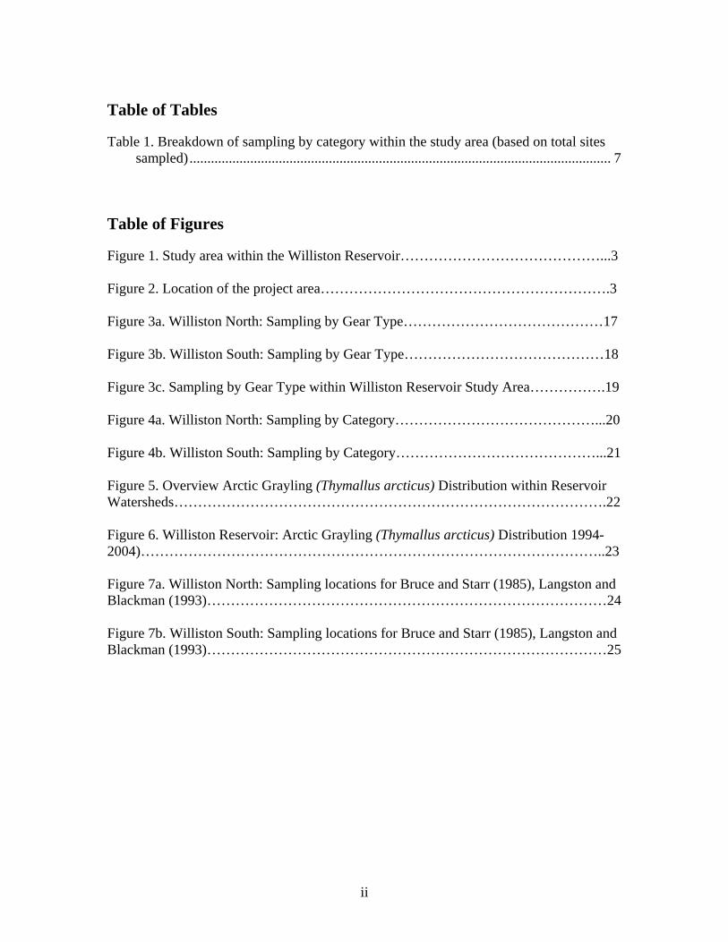
Table of Tables
Table 1. Breakdown of sampling by category within the study area (based on total sites sampled)...................................................................................................................... 7
Table of Figures
Figure 1. Study area within the Williston Reservoir……………………………………...3 Figure 2. Location of the project area…………………………………………………….3 Figure 3a. Williston North: Sampling by Gear Type……………………………………17 Figure 3b. Williston South: Sampling by Gear Type……………………………………18 Figure 3c. Sampling by Gear Type within Williston Reservoir Study Area…………….19 Figure 4a. Williston North: Sampling by Category……………………………………...20 Figure 4b. Williston South: Sampling by Category……………………………………...21 Figure 5. Overview Arctic Grayling (Thymallus arcticus) Distribution within Reservoir Watersheds……………………………………………………………………………….22 Figure 6. Williston Reservoir: Arctic Grayling (Thymallus arcticus) Distribution 1994-2004)……………………………………………………………………………………..23 Figure 7a. Williston North: Sampling locations for Bruce and Starr (1985), Langston and Blackman (1993)…………………………………………………………………………24 Figure 7b. Williston South: Sampling locations for Bruce and Starr (1985), Langston and Blackman (1993)…………………………………………………………………………25
ii

Table of Appendices
Appendix 1. Figures 3-7……………………………………………………………16 Appendix 2. Consolidated Dataset Bibliography…………………………………....26
iii
Introduction 1.0
Background 1.1
In 1961 construction of the W.A.C. Bennett Dam on the Upper Peace River began (approximately 100 km east of Hudson’s Hope), impounding the Finlay, Parsnip and Peace Rivers and their tributaries, creating the largest human-made reservoir in British Columbia. Dam construction was completed in 1968, with full pool attained in 1972. With the formation of Williston Reservoir, approximately 320 kilometres of mainstem habitat belonging to the Finlay, Parsnip, and Upper Peace Rivers was lost. The riverine habitat which supported Arctic grayling within the lower reaches of streams tributary to the upper Peace, Finlay and Parsnip Rivers (Withler 1959), now was replaced with a lacustrine environment. Withler predicted that the species would be considerably reduced in the immediate reservoir area, noting that these particular stocks did not commonly inhabit large lakes. Other more recent authors have noted Arctic grayling stocks are exclusively adapted to either a fluvial or a lacustrine life history strategy and do not appear to shift habitats (Kaya 1991; Kaya and Jeanes 1995). The first baseline fisheries inventories within the reservoir were undertaken in 1974-1975 by the B.C. Fish and Wildlife Branch to determine the species diversity and distribution within the reservoir and its tributary streams, and to identify important spawning, and rearing habitat and capacity (Bruce and Starr 1985; Barrett and Halsey 1985). The next baseline inventories were conducted fourteen years later, by the Peace Williston Fish and Wildlife Compensation Program, in a follow-up sampling program to the 1975 inventory (Langston and Blackman 1993; Blackman 1992). Results from comparisons made between these inventories, and a creel survey conducted in 1977 seemed to indicate that Arctic Grayling were disappearing from the eastern tributaries to the reservoir, and the reservoir itself. In 1995, the British Columbia Conservation Data Centre assigned Williston Watershed Arctic grayling, a provincial ranking of S1, critically imperilled. According to Cannings and Ptolemy (1998), pages 50-51, this ranking was based on:
1. known occurrences-only found within Williston Reservoir and its inlet tributaries;
2. trends in populations within the tributaries to the reservoir using the 1975 and 1989-1991 sampling programs as a basis of comparison;
3. threats to grayling; change of large river to reservoir habitat following creation of the reservoir and resulting impacts, habitat degradation, overharvest related to road construction and pipeline crossings, potential introductions of interspecific …competitors;
4. vulnerability-sensitively balanced to its environment, particularly vulnerable when concentrated in small streams at spawning time;
5. significant declines in several populations, particularly those in the eastern portion of the watershed.
1
Cannings and Ptolemy (1998) acknowledged that “current range and distribution within the reservoir and within and among tributary streams is not known in any detail”, and that “no population estimates exist”. In order to better manage and conserve Arctic grayling stocks within the watershed, a better understanding of the current and historical known range and distribution was required.
Objectives 1.2
The objectives of this study were to: 1. document the current and historical known range and distribution of Arctic
grayling (Thymallus arcticus) within Williston Reservoir, Region 7A through consolidation of all historical and contemporary fisheries sampling within the project area;
2. identify stream attribute features recorded within the regionally developed database, provincial database, and GIS, for potential future modelling applications such as Population Viability Analysis (PVA), and Resource Selection Function (RSF);
3. determine areas with significant data gaps in terms of sampling distribution, effort and/or quality, using GIS;
4. discern population distribution, abundance and/or habitat use trends or patterns within the consolidated dataset, using GIS;
5. provide direction for future research, inventory, population monitoring/indices; 6. assess potential loss of Arctic grayling from smaller eastern slope tributary
streams (draining directly into the reservoir).
Methods 2.0
Study Area 2.1
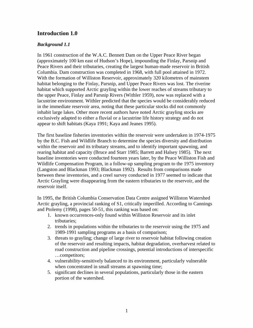
The study was undertaken for the Williston watershed basin, within the administrative boundaries of Region 7A (MWLAP, Figure 1). Peace Reach tributaries east of and including the Wicked River on the north, and east of and including the Collins River on the south (Bernard, West Nabesche, Nabesche, Schooler, Selwyn, Point, Clearwater, Ducette, Pardonet, Carbon systems) lie within the administrative boundaries of MWLAP Region 7b, and therefore were not included within this study. The Williston Reservoir is located in north central BC, approximately 240 kilometers north of Prince George (Figure 2). The entire watershed drains an area of approximately 70000 km 2. Major rivers within the project area include: the Parsnip, Pack, Crooked, Nation, Manson, Omineca, Osilinka, Mesilinka, Ingenika, Finlay, and Ospika.
2
Figure 2. Location of the project area
Figure 1. Study area within the Williston Reservoir Common fish species found throughout the watershed include: mountain whitefish (Prosopium williamsoni), rainbow trout (Oncorhynchus mykiss), lake trout (Salvelinus namaycush) , bull trout (Salvelinus confluentus), lake whitefish (Coregonus clupeaformis), Arctic grayling (Thymallus arcticus), lake chub (Couesius plumbeus), peamouth chub (Mylocheilus caurinus), northern pikeminnow (Ptycheilus oregonensis), redside shiner (Richardsonius balteatus), longnose sucker (Catostomus catostomus), and slimy sculpin (Cottus cognatus).
3
Data Consolidation 2.2
A comprehensive literature search for all relevant historical and recent fisheries inventory projects within the project area was conducted in Spring 2002. Using the Fisheries Information Summary System (FISS 2002), a literature search for all streams within the project area was completed. Ministry of Water, Land, and Air Protection Fish Collection Permit records from 1986 to present were searched for all permits issued within the project area, and subsequent fish collection permit reports were located and matched to the original permit wherever feasible. In addition to the literature search, interviews were conducted with regional fisheries staff and other private sector consultants and biologists to ensure that all sampling data for the watershed had been identified and located. Ministry of Water, Land and Air Protection, Fish and Wildlife Section Head Don Cadden, and fisheries biologists Ted Zimmerman and Ray Pillipow, and Peace Williston Fish and Wildlife Compensation Program fisheries biologists Brian Blackman, Arne Langston, and Randy Zemlak were interviewed to review and identify unpublished field program sampling. Interviews were also conducted in June 2002 in Mackenzie with the Ministry of Forests- Small Business Forest Enterprise Program, Slocan Ltd., and Abitibi Consolidated Ltd. Ministry of Sustainable Resource Management fisheries inventory specialist Lynn Blouw provided assistance in identifying all DFO Fish Habitat Inventory and Information Program (FHIIP) and Forest Renewal British Columbia (FRBC) funded Reconnaissance Fish and Fish Habitat Inventory projects (FFHI) within the reservoir. All non-electronic data sources were entered manually into a scaled-down version of the Fisheries Data Information System database (MS Access 1997), using Resource Inventory Committee standards (to the level of detail as information provided in the original report could allow). Sampling stream, location, stream conditions, gear specifications and times, and individual and summary life history information for all species captured for each sampling event were recorded. For those reports that had not yet been entered into FISS, any barriers that were identified as potential or definite barriers to upstream fish passage were also recorded within the regional fisheries database. Barrier location, watershed code, feature type, height, length, and anecdotal comments were entered as appropriate. All snorkelling data was entered into a separate database (MS Access 1997) provided by Lynn Miers, MSRM, Victoria. In instances where locations of sampling events or barriers were not supplied, MWLAP Arcview GOAT v.5.1.21 was used to determine UTM coordinates based on either a text description or map supplied in the original report. Errors or inconsistencies that were encountered within the original text of a report were resolved and documented whenever possible, or if irresolvable the sampling event/site was not entered into the database and also accordingly documented. Electronic datasets (FHIIP and FDIS databases, BC Lakes files, and FISS barriers) were obtained through Oracle queries in the Fisheries Data Warehouse in Victoria (MSRM 2003). Aerial videography stream attribute data collected within selected reservoir watersheds, on behalf of Slocan Group, Ltd., 1996-1998 was also queried for class 2
4
(definite) barriers. Upon completion of manual data entry, queries of the regional fisheries databases were merged with the queries obtained through Oracle to produce a comprehensive sampling coverage for the project area. A detailed bibliography of all projects included in the final sampling coverage is contained within Appendix 2.
GIS Analysis 2.3
Using MWLAP Arcview GOAT v.5.1.21, all sampling events and species captured along with documented potential and definite barriers were mapped. Comparisons were made between Arctic grayling positive (captured) sites, Arctic grayling negative (species other than grayling captured), and sampling negative sites (no fish captured) to determine areas of Arctic grayling utilization (historic and present), areas without grayling utilization, and areas lacking quantitative sampling and therefore unable to determine grayling utilization. Sampling distribution, effort and quality was analyzed to identify areas with significant data gaps, and to discern grayling distribution and trends in habitat use. Based on the results of the preliminary overview of sampling and species distribution within the project area, a comparative analysis was conducted between two key datasets (Bruce and Starr 1985; Langston and Blackman 1993). Sampling site locations and species catch were compared to test the hypothesis that Arctic grayling had disappeared from the smaller eastern slope tributaries draining directly into Williston Reservoir (e.g. Chowika, Davis, Collins, Lafferty, Weston, Cut Thumb, Mugaha).
Results and Discussion 3.0
Literature Search 3.1
The literature search identified a total of 367 reports/datasets with sampling sites within the project area, representing a diverse array of fisheries inventory projects and sampling methodologies. Reports/datasets included: Forest Renewal British Columbia funded Reconnaissance 1:20000 Fish and Fish Habitat Inventory projects (FFHI), 1996 and 1997 DFO FHIIP stream inventory projects, FRBC funded Watershed Restoration Program (WRP)- Fish Habitat Assessment Procedure Level 1 (FHAP), and Fish Passage Culvert Inspection projects (FPCI), BC Lakes Lake Reconnaissance Surveys, and Lake Survey Data, (EEM) Environmental Effects Monitoring projects, Fish Collection Permit Reports, research papers, MWLAP published and unpublished fisheries field studies, PWFWCP published and unpublished fisheries field studies, and fish stream identification studies within the Mackenzie Forest District. Sampling dates ranged from the mid 1950’s up to and including the 2003 field season. Multiple year datasets were identified for the Parsnip, Table, Anzac, and Mesilinka Rivers. Reports providing population abundance and/or densities for Arctic grayling are currently limited to these systems. As evidenced by the literature search, trends in population size within grayling populations throughout the reservoir, with the exception of the Parsnip mainstem, Table and Anzac Rivers are not discernable from fisheries information collected to the present time.
5
Data Consolidation 3.2
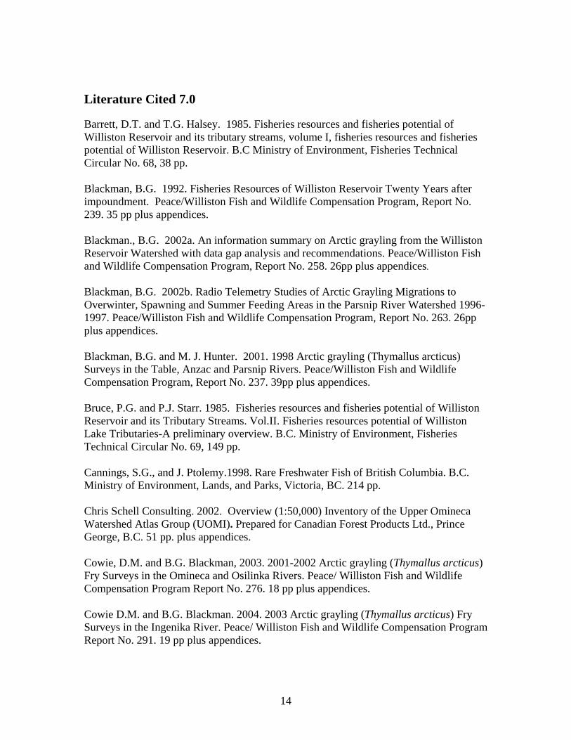
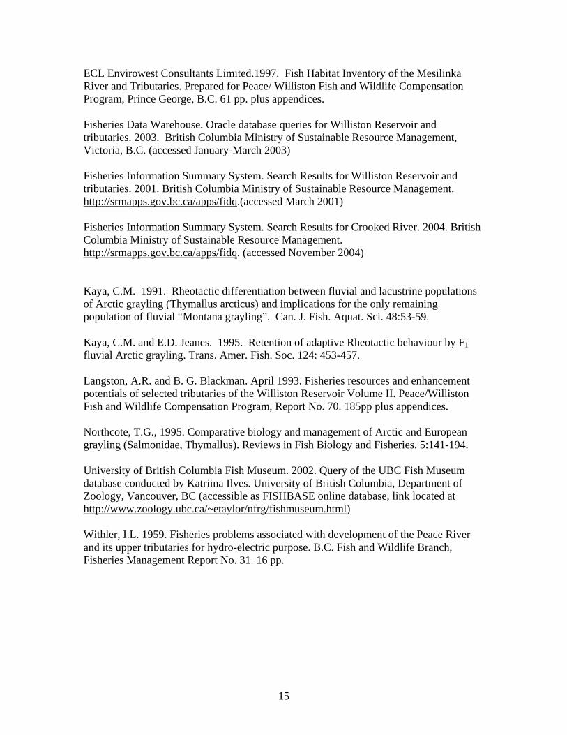
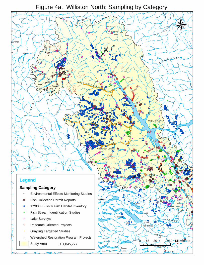
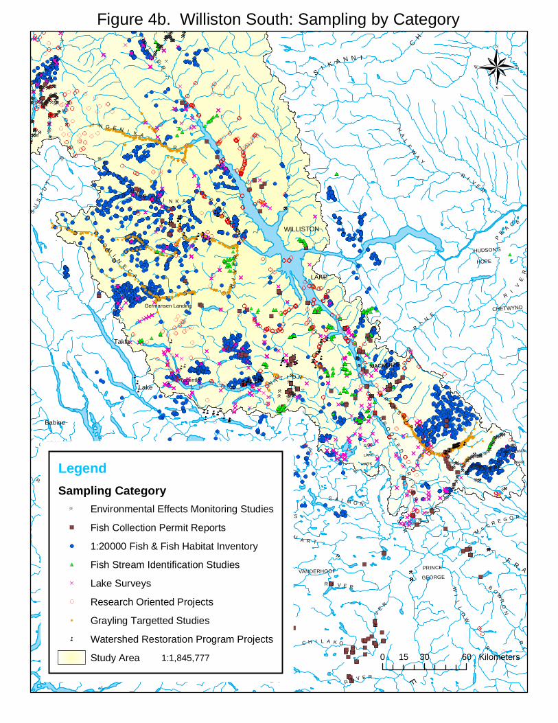
Subsequent queries of the regional databases, and datasets housed within the Fisheries Data Warehouse produced a spatial coverage of over 9100 unique sampling events at a total of 5691 unique sites within the watershed. A total of 924 probable and definite barriers to upstream fish migration were identified. As electronic queries of Oracle were conducted on all DFO FHIIP and Reconnaissance FFHI projects that registered any sampling within the project area, sampling locations and events occurring outside of the project area (i.e. Carbon, Clearwater, Nabesche, Wicked, and others as previously mentioned in Section 2.1) were also captured incidentally and included within the final consolidated sampling coverage. However, these sampling events were not considered during the subsequent GIS analysis as they fell within watersheds not investigated in this study. Stream attributes commonly used within modelling applications were identified within the regionally developed databases, the provincial database, and the GIS environment. A review of the stream attributes recorded within the regional databases revealed that historical data typically contains limited information with potential utility for future modelling applications. Beyond providing grayling presence/absence and/or life history data, and species composition, the regional databases will aid in future identification of areas of interest, and in identification of projects that may have greater utility in providing data for modelling. Attributes available from the provincial database include grayling presence/absence and life history data, species composition, and site specific water chemistry, stream gradient, wetted width, elevation, and dominant bed material. Critical stream attributes such as stream order, gradient, elevation, watershed area, flow, equivalent clear cut area within watershed, frequency of stream crossings, etc. can be obtained for future modelling purposes through the use of geographic information systems. Given the wide range of sampling objectives between projects (and resulting methodologies employed), sampling efficacy and success in terms of capturing Arctic grayling varied greatly among projects. Angling, electrofishing, snorkelling, and seining had the highest success rates among gear types. Peace Williston Fish and Wildlife Compensation Program field studies and Overview Reconnaissance FFHI projects that targeted specifically for grayling (ECL Envirowest Consultants 1997; Chris Schell Consulting 2002) had the highest success rates in terms of detecting presence (36% of grayling targeted sites were positive for grayling as compared to 12% of non-targeted sites that were positive for grayling). WRP FHAP Level 1 and FPCI studies, EEM projects, and lake inventories (BC Lakes data), in general, showed the lowest success rates. Table 1.0, and Figures 3a, 3b, 3c, 4a and 4b illustrate the distribution of sampling by gear type, and by sampling category respectively.
6
Table 1. Breakdown of sampling by category within the study area (based on total sites sampled)
1:20000 Fish and Fish Habitat Inventory projects………...41 % Grayling targeted projects ………………………………...19 % Research oriented projects………………………………...13 % BC Lakes data …………………………………………….10 % Environmental Effects Monitoring projects………………..8 % Fish Stream Identification projects…………………………4 % Fish Collection Permit reports……………………………...3 % Watershed Restoration Program projects…………………..2 %
Factors affecting potential sampling success for grayling within any given watershed included: objective and scope of sampling conducted, gear type employed, length of time gear employed, stream conditions at time of sampling (i.e. electroshocking within acceptable temperatures and conductivities), experience/knowledge of field crew, spatial distribution of sampling throughout a watershed, time of year sampling was conducted, and size of stream sampled. These factors were taken into consideration on a watershed by watershed basis during our analyses of the data.
Present Day Arctic Grayling Distribution 3.3
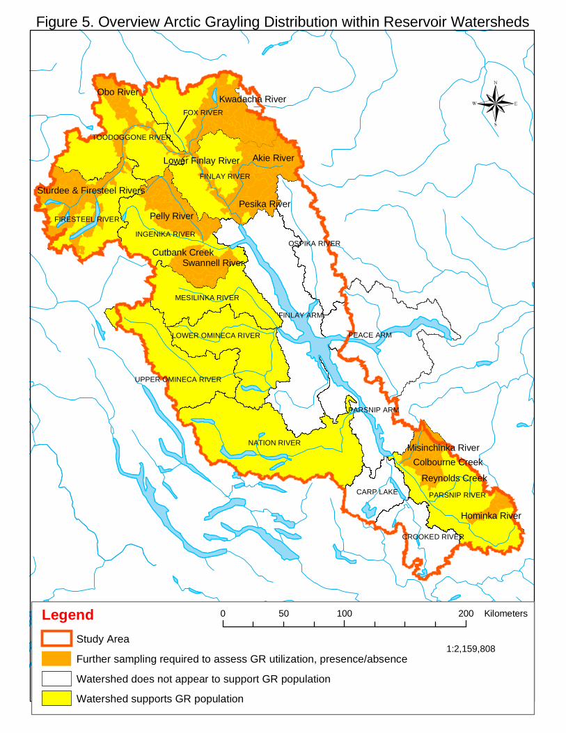
GIS analysis of sampling locations and species captured revealed a present day (2000-2004) distribution of Arctic grayling within the mainstem habitats of 5th order and higher rivers as follows: Table, Anzac, Missinka, Parsnip, Nation, Mesilinka, Osilinka, Omineca, Ingenika, Toodoggone, and Finlay (Figures 5 and 6a, 6b). Grayling fry, juveniles, and adults have been captured within the mainstem and/or lower sections of the major tributaries in these drainages (i.e. Carruthers Creek, Ominicetla Creek, Silver Creek within the Omineca watershed (Chris Schell Consulting 2002; Cowie and Blackman 2003), Lay and Kliyul Creeks within the Mesilinka (ECL Envirowest Consultants Ltd. 1997) and Lay Creek (Mesilinka) and Philip Creek (Nation)(Clarke et al. unpublished). This distribution would seem to suggest a preference for fourth order or larger systems by Arctic grayling, however very little is known about spawning and early rearing habitat within the watershed at this time. Migration to spawning areas begins shortly after ice out at temperatures near 4ºC (Northcote 1995), with spawning typically occurring mid May through early to mid June within the reservoir. Due to this very early timing, spawners and newly hatched fry have moved off of their respective sites well before fisheries field sampling typically begins. Sampling of this nature within the reservoir (targeting grayling spawning and early rearing areas) has been limited to the Parsnip system (Blackman 2002b; Blackman and Hunter 2001). Results from these studies suggest that grayling are using primarily mainstem habitats for spawning and early rearing, however further sampling in other systems (i.e. Nation, Omineca, Osilinka, Mesilinka, Ingenika, and Finlay) is needed to draw any definitive conclusions for stocks within the reservoir.
7
The degree of utilization of the larger tributary streams to the major watersheds within the reservoir (Finlay, Ingenika, Mesilinka, Osilinka, Omineca, and Nation Rivers) by local grayling stocks is unknown. The timing of capture of mature adults within systems such as Philip Creek (Nation watershed), and Lay Creek (Mesilinka watershed) (Clarke et al. unpublished) and Silver, Ominicetla, and Carruthers Creeks within the Omineca watershed (Chris Schell Consulting 2002) within the summer months suggests that these systems are likely important summer feeding areas. The capture of grayling fry within the lower sections of Silver and Ominicetla Creeks within the Omineca watershed (Chris Schell Consulting 2002), and young of the year within a small tributary 500 metres upstream of the mainstem Mesilinka (ECL Envirowest Consultants Ltd.1997) indicates that spawning and early rearing is also probably occurring within these tributaries. Further directed sampling within these or similar drainages, designed to assess the degree of utilization throughout the year, is required for a better understanding of the roles these tributaries play in sustaining viable grayling populations. Watersheds with a fair representation of sampling throughout the study area that do not appear to support Grayling populations include the Ospika, Manson, Crooked, Pack, Davis, and the Chowika. The Ospika, Davis, and Chowika Rivers are eastern slope reservoir watersheds that are characterized today by several kilometres of lower gradient stream course, leading up to a series of cascades and canyon sections before rising up into the steeper slopes of the Rocky Mountains. Cowie and Blackman (2003, 2004) and Blackman (2001) noted grayling fry showing a preference for shallow low velocity (low gradient) habitats within the Osilinka, Omineca, Ingenika, and Parsnip systems. If stream velocity and hence gradient is indeed a limiting factor to grayling distribution, these canyon sections and higher gradients may be limiting grayling within these systems. The Manson River is a fifth order western slope reservoir watershed that has experienced extensive landscape level disturbance within the lower two thirds of stream reaches. It is characterized by unstable soils, relatively frequent landslides, and heavy utilization by the forestry and mining- sectors. Fisheries assessments in previous years give indications that all species are doing poorly within this watershed. Results from MWLAP snorkel surveys within the mainstem from 1998 and 2000 suggest that the Manson does not currently support a local population of grayling (personal communication, Ray Pillipow, Ministry of Water, Land, and Air Protection fish biologist, November 2004). Stream sampling within the Crooked/Pack system, dating back to 1956, has not returned a single capture of Arctic grayling, despite considerable sampling effort through the years. Species typically found within this drainage include: rainbow trout (Salvelinus onchorynchus), peamouth chub (Mylocheilus caurinus), northern pikeminnow (Ptycheilus oregonensis), longnose sucker (Catostomus catostomus), largescale sucker (Catostomus macrocheilus), prickly sculpin (Cottus asper), lake whitefish (Coregonus clupeaformis), and mountain whitefish (Prosopium williamsoni) (FISS 2004).
8
Candidate watersheds for further field sampling (limited sampling at present) include: Misinchinka, Colburne, Reynolds, and Hominka systems within the Parsnip, the Pesika, Akie, Kwadacha, Obo, Firesteel, Sturdee and lower mainstem Finlay (downstream of Toodoggone) within the Finlay, and the Swannell, Cutbank and Pelly Rivers within the Ingenika drainage.
Comparative Sampling Analysis within Eastern Tributaries 3.4
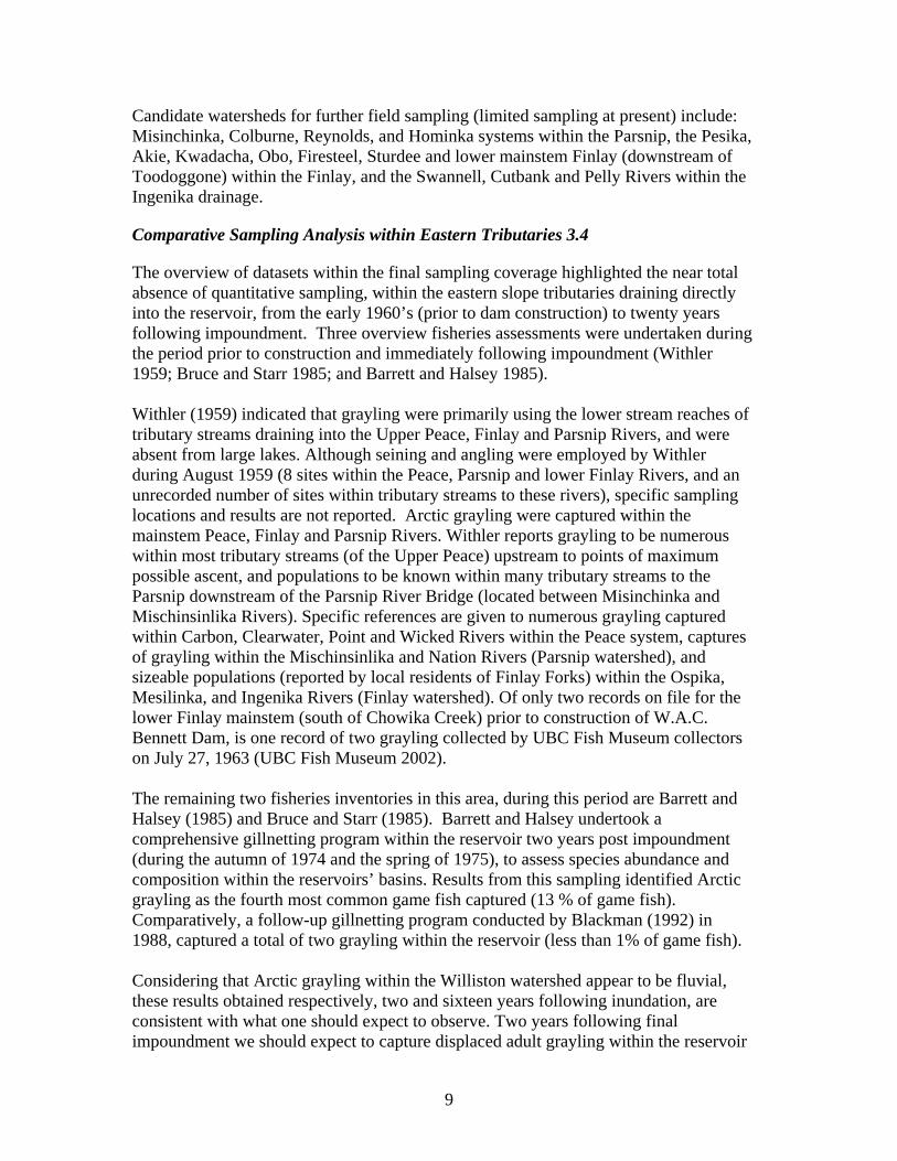
The overview of datasets within the final sampling coverage highlighted the near total absence of quantitative sampling, within the eastern slope tributaries draining directly into the reservoir, from the early 1960’s (prior to dam construction) to twenty years following impoundment. Three overview fisheries assessments were undertaken during the period prior to construction and immediately following impoundment (Withler 1959; Bruce and Starr 1985; and Barrett and Halsey 1985). Withler (1959) indicated that grayling were primarily using the lower stream reaches of tributary streams draining into the Upper Peace, Finlay and Parsnip Rivers, and were absent from large lakes. Although seining and angling were employed by Withler during August 1959 (8 sites within the Peace, Parsnip and lower Finlay Rivers, and an unrecorded number of sites within tributary streams to these rivers), specific sampling locations and results are not reported. Arctic grayling were captured within the mainstem Peace, Finlay and Parsnip Rivers. Withler reports grayling to be numerous within most tributary streams (of the Upper Peace) upstream to points of maximum possible ascent, and populations to be known within many tributary streams to the Parsnip downstream of the Parsnip River Bridge (located between Misinchinka and Mischinsinlika Rivers). Specific references are given to numerous grayling captured within Carbon, Clearwater, Point and Wicked Rivers within the Peace system, captures of grayling within the Mischinsinlika and Nation Rivers (Parsnip watershed), and sizeable populations (reported by local residents of Finlay Forks) within the Ospika, Mesilinka, and Ingenika Rivers (Finlay watershed). Of only two records on file for the lower Finlay mainstem (south of Chowika Creek) prior to construction of W.A.C. Bennett Dam, is one record of two grayling collected by UBC Fish Museum collectors on July 27, 1963 (UBC Fish Museum 2002). The remaining two fisheries inventories in this area, during this period are Barrett and Halsey (1985) and Bruce and Starr (1985). Barrett and Halsey undertook a comprehensive gillnetting program within the reservoir two years post impoundment (during the autumn of 1974 and the spring of 1975), to assess species abundance and composition within the reservoirs’ basins. Results from this sampling identified Arctic grayling as the fourth most common game fish captured (13 % of game fish). Comparatively, a follow-up gillnetting program conducted by Blackman (1992) in 1988, captured a total of two grayling within the reservoir (less than 1% of game fish). Considering that Arctic grayling within the Williston watershed appear to be fluvial, these results obtained respectively, two and sixteen years following inundation, are consistent with what one should expect to observe. Two years following final impoundment we should expect to capture displaced adult grayling within the reservoir
9
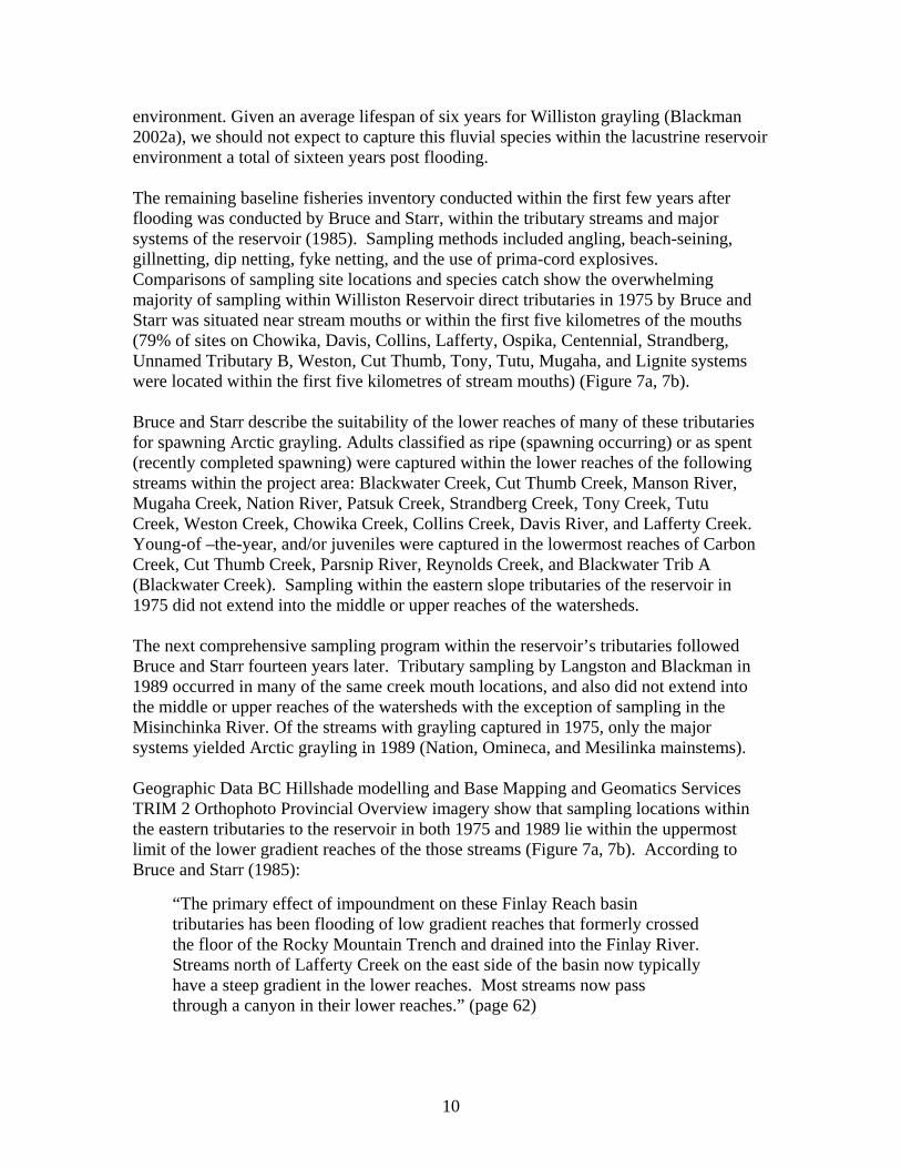
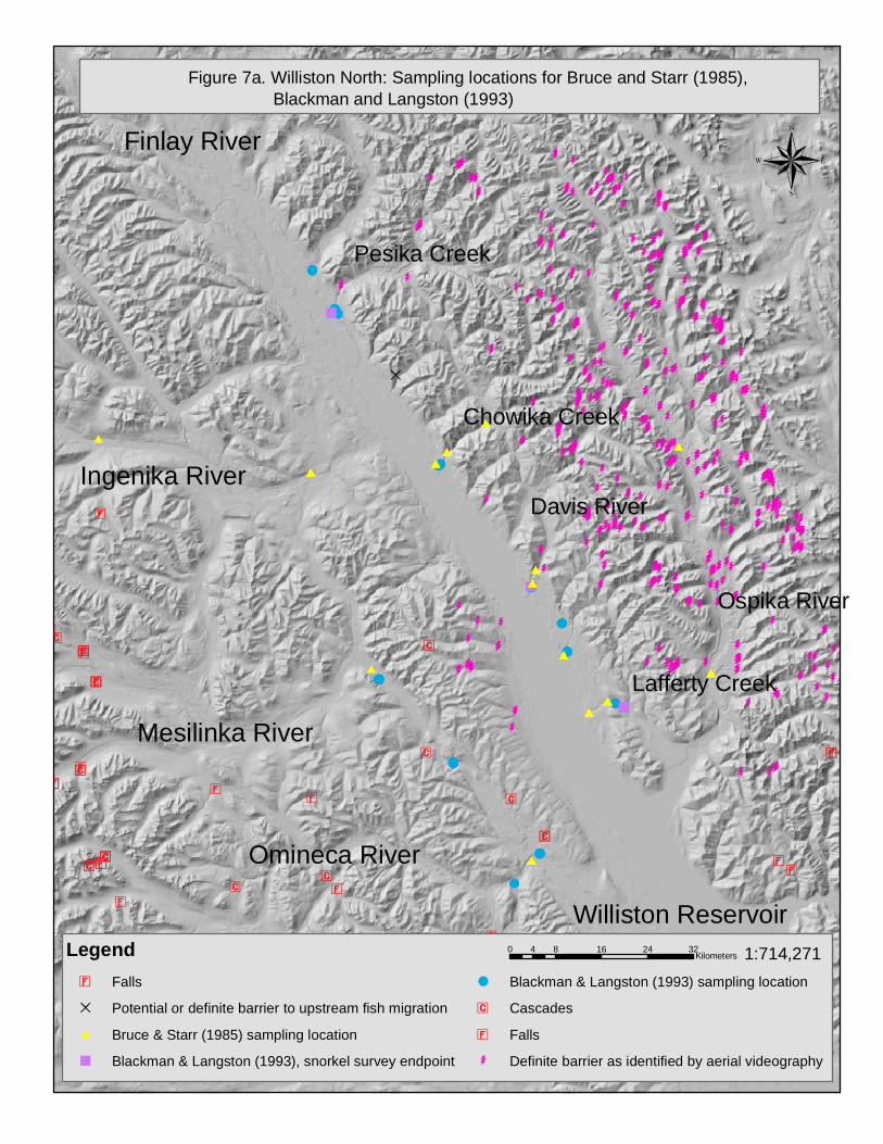
environment. Given an average lifespan of six years for Williston grayling (Blackman 2002a), we should not expect to capture this fluvial species within the lacustrine reservoir environment a total of sixteen years post flooding. The remaining baseline fisheries inventory conducted within the first few years after flooding was conducted by Bruce and Starr, within the tributary streams and major systems of the reservoir (1985). Sampling methods included angling, beach-seining, gillnetting, dip netting, fyke netting, and the use of prima-cord explosives. Comparisons of sampling site locations and species catch show the overwhelming majority of sampling within Williston Reservoir direct tributaries in 1975 by Bruce and Starr was situated near stream mouths or within the first five kilometres of the mouths (79% of sites on Chowika, Davis, Collins, Lafferty, Ospika, Centennial, Strandberg, Unnamed Tributary B, Weston, Cut Thumb, Tony, Tutu, Mugaha, and Lignite systems were located within the first five kilometres of stream mouths) (Figure 7a, 7b). Bruce and Starr describe the suitability of the lower reaches of many of these tributaries for spawning Arctic grayling. Adults classified as ripe (spawning occurring) or as spent (recently completed spawning) were captured within the lower reaches of the following streams within the project area: Blackwater Creek, Cut Thumb Creek, Manson River, Mugaha Creek, Nation River, Patsuk Creek, Strandberg Creek, Tony Creek, Tutu Creek, Weston Creek, Chowika Creek, Collins Creek, Davis River, and Lafferty Creek. Young-of –the-year, and/or juveniles were captured in the lowermost reaches of Carbon Creek, Cut Thumb Creek, Parsnip River, Reynolds Creek, and Blackwater Trib A (Blackwater Creek). Sampling within the eastern slope tributaries of the reservoir in 1975 did not extend into the middle or upper reaches of the watersheds. The next comprehensive sampling program within the reservoir’s tributaries followed Bruce and Starr fourteen years later. Tributary sampling by Langston and Blackman in 1989 occurred in many of the same creek mouth locations, and also did not extend into the middle or upper reaches of the watersheds with the exception of sampling in the Misinchinka River. Of the streams with grayling captured in 1975, only the major systems yielded Arctic grayling in 1989 (Nation, Omineca, and Mesilinka mainstems). Geographic Data BC Hillshade modelling and Base Mapping and Geomatics Services TRIM 2 Orthophoto Provincial Overview imagery show that sampling locations within the eastern tributaries to the reservoir in both 1975 and 1989 lie within the uppermost limit of the lower gradient reaches of the those streams (Figure 7a, 7b). According to Bruce and Starr (1985):
“The primary effect of impoundment on these Finlay Reach basin tributaries has been flooding of low gradient reaches that formerly crossed the floor of the Rocky Mountain Trench and drained into the Finlay River. Streams north of Lafferty Creek on the east side of the basin now typically have a steep gradient in the lower reaches. Most streams now pass through a canyon in their lower reaches.” (page 62)
10
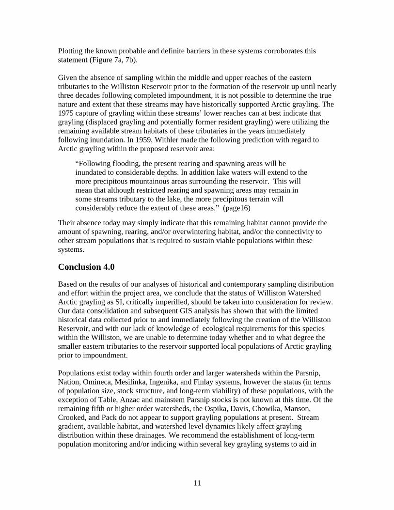
Plotting the known probable and definite barriers in these systems corroborates this statement (Figure 7a, 7b). Given the absence of sampling within the middle and upper reaches of the eastern tributaries to the Williston Reservoir prior to the formation of the reservoir up until nearly three decades following completed impoundment, it is not possible to determine the true nature and extent that these streams may have historically supported Arctic grayling. The 1975 capture of grayling within these streams’ lower reaches can at best indicate that grayling (displaced grayling and potentially former resident grayling) were utilizing the remaining available stream habitats of these tributaries in the years immediately following inundation. In 1959, Withler made the following prediction with regard to Arctic grayling within the proposed reservoir area:
“Following flooding, the present rearing and spawning areas will be inundated to considerable depths. In addition lake waters will extend to the more precipitous mountainous areas surrounding the reservoir. This will mean that although restricted rearing and spawning areas may remain in some streams tributary to the lake, the more precipitous terrain will considerably reduce the extent of these areas.” (page16)
Their absence today may simply indicate that this remaining habitat cannot provide the amount of spawning, rearing, and/or overwintering habitat, and/or the connectivity to other stream populations that is required to sustain viable populations within these systems.
Conclusion 4.0
Based on the results of our analyses of historical and contemporary sampling distribution and effort within the project area, we conclude that the status of Williston Watershed Arctic grayling as SI, critically imperilled, should be taken into consideration for review. Our data consolidation and subsequent GIS analysis has shown that with the limited historical data collected prior to and immediately following the creation of the Williston Reservoir, and with our lack of knowledge of ecological requirements for this species within the Williston, we are unable to determine today whether and to what degree the smaller eastern tributaries to the reservoir supported local populations of Arctic grayling prior to impoundment. Populations exist today within fourth order and larger watersheds within the Parsnip, Nation, Omineca, Mesilinka, Ingenika, and Finlay systems, however the status (in terms of population size, stock structure, and long-term viability) of these populations, with the exception of Table, Anzac and mainstem Parsnip stocks is not known at this time. Of the remaining fifth or higher order watersheds, the Ospika, Davis, Chowika, Manson, Crooked, and Pack do not appear to support grayling populations at present. Stream gradient, available habitat, and watershed level dynamics likely affect grayling distribution within these drainages. We recommend the establishment of long-term population monitoring and/or indicing within several key grayling systems to aid in
11
12
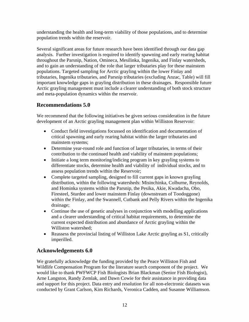
understanding the health and long-term viability of those populations, and to determine population trends within the reservoir. Several significant areas for future research have been identified through our data gap analysis. Further investigation is required to identify spawning and early rearing habitat throughout the Parsnip, Nation, Omineca, Mesilinka, Ingenika, and Finlay watersheds, and to gain an understanding of the role that larger tributaries play for these mainstem populations. Targeted sampling for Arctic grayling within the lower Finlay and tributaries, Ingenika tributaries, and Parsnip tributaries (excluding Anzac, Table) will fill important knowledge gaps in grayling distribution in these drainages. Responsible future Arctic grayling management must include a clearer understanding of both stock structure and meta-population dynamics within the reservoir.
Recommendations 5.0
We recommend that the following initiatives be given serious consideration in the future development of an Arctic grayling management plan within Williston Reservoir:
• Conduct field investigations focussed on identification and documentation of critical spawning and early rearing habitat within the larger tributaries and mainstem systems;
• Determine year-round role and function of larger tributaries, in terms of their contribution to the continued health and viability of mainstem populations;
• Initiate a long term monitoring/indicing program in key grayling systems to differentiate stocks, determine health and viability of individual stocks, and to assess population trends within the Reservoir;
• Complete targeted sampling, designed to fill current gaps in known grayling distribution, within the following watersheds: Misinchinka, Colburne, Reynolds, and Hominka systems within the Parsnip, the Pesika, Akie, Kwadacha, Obo, Firesteel, Sturdee and lower mainstem Finlay (downstream of Toodoggone) within the Finlay, and the Swannell, Cutbank and Pelly Rivers within the Ingenika drainage;
• Continue the use of genetic analyses in conjunction with modelling applications and a clearer understanding of critical habitat requirements, to determine the current expected distribution and abundance of Arctic grayling within the Williston watershed;
• Reassess the provincial listing of Williston Lake Arctic grayling as S1, critically imperilled.
Acknowledgements 6.0
We gratefully acknowledge the funding provided by the Peace Williston Fish and Wildlife Compensation Program for the literature search component of the project. We would like to thank PWFWCP Fish Biologists Brian Blackman (Senior Fish Biologist), Arne Langston, Randy Zemlak, and Dawn Cowie for their assistance in providing data and support for this project. Data entry and resolution for all non-electronic datasets was conducted by Grant Carlson, Kim Richards, Veronica Cadden, and Susanne Williamson.

We wish to acknowledge the assistance of Lynn Blouw, Regional Fisheries Inventory Specialist, Ministry of Sustainable Resource Management, Prince George, BC and Lynn Miers, Fish Information Specialist, Ministry of Sustainable Resource Management, Victoria, BC in collection of electronic datasets from the Fisheries Data Warehouse, and in provision of professional advice during subsequent data interpretation and analysis.
13
Literature Cited 7.0
Barrett, D.T. and T.G. Halsey. 1985. Fisheries resources and fisheries potential of Williston Reservoir and its tributary streams, volume I, fisheries resources and fisheries potential of Williston Reservoir. B.C Ministry of Environment, Fisheries Technical Circular No. 68, 38 pp. Blackman, B.G. 1992. Fisheries Resources of Williston Reservoir Twenty Years after impoundment. Peace/Williston Fish and Wildlife Compensation Program, Report No. 239. 35 pp plus appendices. Blackman., B.G. 2002a. An information summary on Arctic grayling from the Williston Reservoir Watershed with data gap analysis and recommendations. Peace/Williston Fish and Wildlife Compensation Program, Report No. 258. 26pp plus appendices. Blackman, B.G. 2002b. Radio Telemetry Studies of Arctic Grayling Migrations to Overwinter, Spawning and Summer Feeding Areas in the Parsnip River Watershed 1996-1997. Peace/Williston Fish and Wildlife Compensation Program, Report No. 263. 26pp plus appendices. Blackman, B.G. and M. J. Hunter. 2001. 1998 Arctic grayling (Thymallus arcticus) Surveys in the Table, Anzac and Parsnip Rivers. Peace/Williston Fish and Wildlife Compensation Program, Report No. 237. 39pp plus appendices. Bruce, P.G. and P.J. Starr. 1985. Fisheries resources and fisheries potential of Williston Reservoir and its Tributary Streams. Vol.II. Fisheries resources potential of Williston Lake Tributaries-A preliminary overview. B.C. Ministry of Environment, Fisheries Technical Circular No. 69, 149 pp. Cannings, S.G., and J. Ptolemy.1998. Rare Freshwater Fish of British Columbia. B.C. Ministry of Environment, Lands, and Parks, Victoria, BC. 214 pp. Chris Schell Consulting. 2002. Overview (1:50,000) Inventory of the Upper Omineca Watershed Atlas Group (UOMI). Prepared for Canadian Forest Products Ltd., Prince George, B.C. 51 pp. plus appendices. Cowie, D.M. and B.G. Blackman, 2003. 2001-2002 Arctic grayling (Thymallus arcticus) Fry Surveys in the Omineca and Osilinka Rivers. Peace/ Williston Fish and Wildlife Compensation Program Report No. 276. 18 pp plus appendices. Cowie D.M. and B.G. Blackman. 2004. 2003 Arctic grayling (Thymallus arcticus) Fry Surveys in the Ingenika River. Peace/ Williston Fish and Wildlife Compensation Program Report No. 291. 19 pp plus appendices.
14
ECL Envirowest Consultants Limited.1997. Fish Habitat Inventory of the Mesilinka River and Tributaries. Prepared for Peace/ Williston Fish and Wildlife Compensation Program, Prince George, B.C. 61 pp. plus appendices. Fisheries Data Warehouse. Oracle database queries for Williston Reservoir and tributaries. 2003. British Columbia Ministry of Sustainable Resource Management, Victoria, B.C. (accessed January-March 2003) Fisheries Information Summary System. Search Results for Williston Reservoir and tributaries. 2001. British Columbia Ministry of Sustainable Resource Management. http://srmapps.gov.bc.ca/apps/fidq.(accessed March 2001) Fisheries Information Summary System. Search Results for Crooked River. 2004. British Columbia Ministry of Sustainable Resource Management. http://srmapps.gov.bc.ca/apps/fidq. (accessed November 2004) Kaya, C.M. 1991. Rheotactic differentiation between fluvial and lacustrine populations of Arctic grayling (Thymallus arcticus) and implications for the only remaining population of fluvial “Montana grayling”. Can. J. Fish. Aquat. Sci. 48:53-59. Kaya, C.M. and E.D. Jeanes. 1995. Retention of adaptive Rheotactic behaviour by F1 fluvial Arctic grayling. Trans. Amer. Fish. Soc. 124: 453-457. Langston, A.R. and B. G. Blackman. April 1993. Fisheries resources and enhancement potentials of selected tributaries of the Williston Reservoir Volume II. Peace/Williston Fish and Wildlife Compensation Program, Report No. 70. 185pp plus appendices. Northcote, T.G., 1995. Comparative biology and management of Arctic and European grayling (Salmonidae, Thymallus). Reviews in Fish Biology and Fisheries. 5:141-194. University of British Columbia Fish Museum. 2002. Query of the UBC Fish Museum database conducted by Katriina Ilves. University of British Columbia, Department of Zoology, Vancouver, BC (accessible as FISHBASE online database, link located at http://www.zoology.ubc.ca/~etaylor/nfrg/fishmuseum.html) Withler, I.L. 1959. Fisheries problems associated with development of the Peace River and its upper tributaries for hydro-electric purpose. B.C. Fish and Wildlife Branch, Fisheries Management Report No. 31. 16 pp.
15

Appendix 1: Figures 3-7
16
TatlatuiL
ThutadeLake
SU
ST
UT
R
FI
NL
AY R
IV
ER
R
IV
ER
SK
EE
NA
I N G E N I K A
R
M E S I L I N K A RI
VE
R
WILLISTON
LAKE
SI K A N N I
RI
V
HA
LF
WA
Y
C
HI
EF
OM
IN
EC
A
RI
VE
R
PI
NE
HAZELTON
SMITHERS
TELKWA
BU
LK
LE
Y
RI V E R
GRANISLE
HOUSTON
Takla
Lake
Babine
Lake
LAKE
BURNS
Stuart
Lake
TrembleurL
Tezzeron
L
Pinchi
L
TchentloL
Germansen Landing
NA T I O N
R
PA
RS
NI
P
CR
OO
KE
D
RI
VE
RS A L M O N
RST U
A R T
ST JAMES
MACKENZIEMACKENZIE
RI
VE
R
P R O PH
ET
ER
FORT
KWADACHA
WILDERNESS
PARK
CARP
LAKE
PARK
SPATSIZI
PLATEAU
WILDERNESS PARK
TATLATUI
PARK
Figure 3a. Williston North: Sampling by Gear Type
0 25 5012.5 Kilometers
Legend
Gear Typeangling
dead capture
dipnet
electroshocking
gillnet
minnow trap
setline
seine
snorkel survey endpoint
trapnet
unknown method
radio telemetry location
Study Area
1:1,808,439
Thutade
TU
T
R
FI
NL
AY R
IV
ER
I N G E N I K A
R
M E S I L I N K A RI
VE
R
WILLISTON
LAKE
HUDSON'S
HOPE
SI K A N N I
HA
LF
WA
Y
RI
VE
R
C
P
EA
C E
OM
IN
EC
A
RI
VE
R
PI
NE
RI
VE
R
RI V E R
GRANISLE
HOUSTON
Takla
Lake
Babine
Lake
LAKE
BURNS
Stuart
Lake
TrembleurL
Tezzeron
L
Pinchi
L
TchentloL
Germansen Landing
NA T I O N
R
GEORGE
PRINCE
PA
RS
NI
P
R IV
E
R
CR
OO
KE
D
RI
VE
RS A L M O N
RST U
A R T
R
ST JAMES
Fraser
Lake
VANDERHOOF
NE
C
HA
KO
R I V E RFrancois Lake,
Ootsa Lake
MACKENZIEMACKENZIE
CHETWYND
Mc C R E G O R
FR
A
BO
WR
ON
RI
WI
LL
OW
RC H I L A K O
RI
VE
R
R I V E RTetachuck
L
Whitesail
Eutsuk
F
FORT
MONKMAN
PARK
CARP
LAKE
PARK
Figure 3b. Williston South: Sampling by Gear Type
0 80 16040 Kilometers
Legend
Gear Typeangling
dead capture
dipnet
electroshocking
gillnet
minnow trap
setline
seine
snorkel survey endpoint
trapnet
unknown method
radio telemetry location
Study Area
1:1,808,439
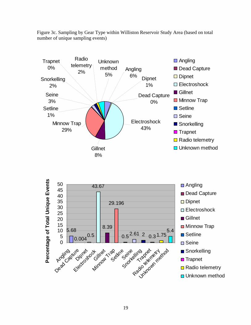
Figure 3c. Sampling by Gear Type within Williston Reservoir Study Area (based on total number of unique sampling events)
Electroshock43%
Gillnet8%
Minnow Trap29%
Trapnet0%
Seine3%
Setline1%
Snorkelling2%
Unknown method
5%Angling
6% Dipnet1%
Dead Capture0%
Radio telemetry
2%
AnglingDead CaptureDipnetElectroshockGillnetMinnow TrapSetlineSeineSnorkellingTrapnetRadio telemetryUnknown method
5.68
43.67
8.39
29.196
0.52.61 2 0.3 1.755.4
0.0040.5
05
101520253035404550
Anglin
g
Dead C
apture
Dipnet
Electro
shock
Gillnet
Minnow
Trap
Setline
Seine
Snorke
lling
Trapnet
Radio te
lemetry
Unknown m
ethod
Per
cent
age
of T
otal
Uni
que
Even
ts AnglingDead CaptureDipnetElectroshockGillnetMinnow TrapSetlineSeineSnorkellingTrapnetRadio telemetryUnknown method
19
TatlatuiL
ThutadeLake
R
SU
ST
UT
R
FI
NL
AY R
IV
ER
R
IV
ER
SK
EE
NA
I N G E N I K A
R
M E S I L I N K A RI
VE
R
WILLISTON
LAKE
SI K A N N I
HA
OM
IN
EC
A
RI
VE
R
HAZELTON
SMITHERS
TELKWA
BU
LK
LE
Y
RI V E R
GRANISLE
HOUSTON
Takla
Lake
Babine
Lake
LAKE
BURNS
Stuart
Lake
TrembleurL
Tezzeron
L
Pinchi
L
TchentloL
Germansen Landing
NA T I O N
R
PA
RS
NCR
OO
KE
D
S A L M O N
ST U
A R T
R
ST JAMES
Fraser
Lake
VANDERHOOF
O
R I V E RFrancois Lake,
MACKENZIEMACKENZIE
Morice
Lake
IV
ER
P R O P HE
T
FORT
KWADACHA
WILDERNESS
PARK
CARP
LAKE
PARK
TERRACE
SPATSIZI
PLATEAU
WILDERNESS PARK
TATLATUI
PARK
Figure 4a. Williston North: Sampling by Category
Legend
Sampling CategoryEnvironmental Effects Monitoring Studies
Fish Collection Permit Reports
1:20000 Fish & Fish Habitat Inventory
Fish Stream Identification Studies
Lake Surveys
Research Oriented Projects
Grayling Targetted Studies
Watershed Restoration Program Projects
Study Area0 30 6015 Kilometers
1:1,845,777
ThutadeLake
SU
ST
UT
R
FI
NL
AY R
IV
ER
I N G E N I K A
R
M E S I L I N K A RI
VE
R
WILLISTON
LAKE
HUDSON'S
HOPE
SI K A N N I
HA
LF
WA
Y
RI
VE
R
C
H
P
EA
C E
OM
IN
EC
A
RI
VE
R
PI
NE
RI
VE
R
RI V E R
GRANISLE
HOUSTON
Takla
Lake
Babine
Lake
LAKE
BURNS
Stuart
Lake
TrembleurL
Tezzeron
L
Pinchi
L
TchentloL
Germansen Landing
NA T I O N
R
GEORGE
PRINCE
PA
RS
NI
P
R IV
E
R
CR
OO
KE
D
RI
VE
RS A L M O N
RST U
A R T
R
ST JAMES
Fraser
Lake
VANDERHOOF
NE
C
HA
KO
R I V E RFrancois Lake,
Ootsa Lake
MACKENZIEMACKENZIE
CHETWYND
Mc C R E G O R
FR
A
BO
WR
ON
RI
WI
LL
OW
R
C H I L A K O
RI
VE
R
R I V E RTetachuck
L
Whitesail
Eutsuk
F
FORT
MONKMAN
PARK
CARP
LAKE
PARK
TATLATUI
Figure 4b. Williston South: Sampling by Category
Legend
Sampling Category
Environmental Effects Monitoring Studies
Fish Collection Permit Reports
1:20000 Fish & Fish Habitat Inventory
Fish Stream Identification Studies
Lake Surveys
Research Oriented Projects
Grayling Targetted Studies
Watershed Restoration Program Projects
Study Area 0 30 6015 Kilometers1:1,845,777
FINLAY ARM
PEACE ARM
NATION RIVER
FINLAY RIVER
FOX RIVER
PARSNIP RIVER
INGENIKA RIVER
PARSNIP ARM
FIRESTEEL RIVER
TOODOGGONE RIVER
OSPIKA RIVER
MESILINKA RIVER
UPPER OMINECA RIVER
LOWER OMINECA RIVER
CARP LAKE
CROOKED RIVER
Legend
Study Area
Further sampling required to assess GR utilization, presence/absence
Watershed does not appear to support GR population
Watershed supports GR population
0 100 20050 Kilometers
1:2,159,808
Figure 5. Overview Arctic Grayling Distribution within Reservoir Watersheds
Sturdee & Firesteel Rivers
Obo RiverKwadacha River
Akie River
Pesika River
Lower Finlay River
Pelly River
Swannell RiverCutbank Creek
Hominka River
Reynolds Creek
Colbourne Creek
Misinchinka River
ThutadeLake
SU
ST
UT
R
FI
NL
AY R
IV
ER
I N G E N I K A
R
M E S I L I N K A RI
VE
R
WILLISTON
LAKE
HUDSON'S
HOPE
SI K A N N I
HA
LF
WA
Y
RI
VE
R
C
HI
EF
P
EA
C E
OM
IN
EC
A
RI
VE
R
PI
NE
RI
VE
TELKWAR
I V E R
GRANISLE
Takla
Lake
Babine
Lake
Stuart
TrembleurL
Tezzeron
L
Pinchi
L
TchentloL
Germansen Landing
NA T I O N
R
PA
RS
NI
P
RI
VE
R
CR
OO
KE
D
RI
VE
RS A L M O N
MACKENZIEMACKENZIE
CHETWYND
P RPARK
MONKMAN
PARK
CARP
LAKE
PARK
TATLATUI
PARK
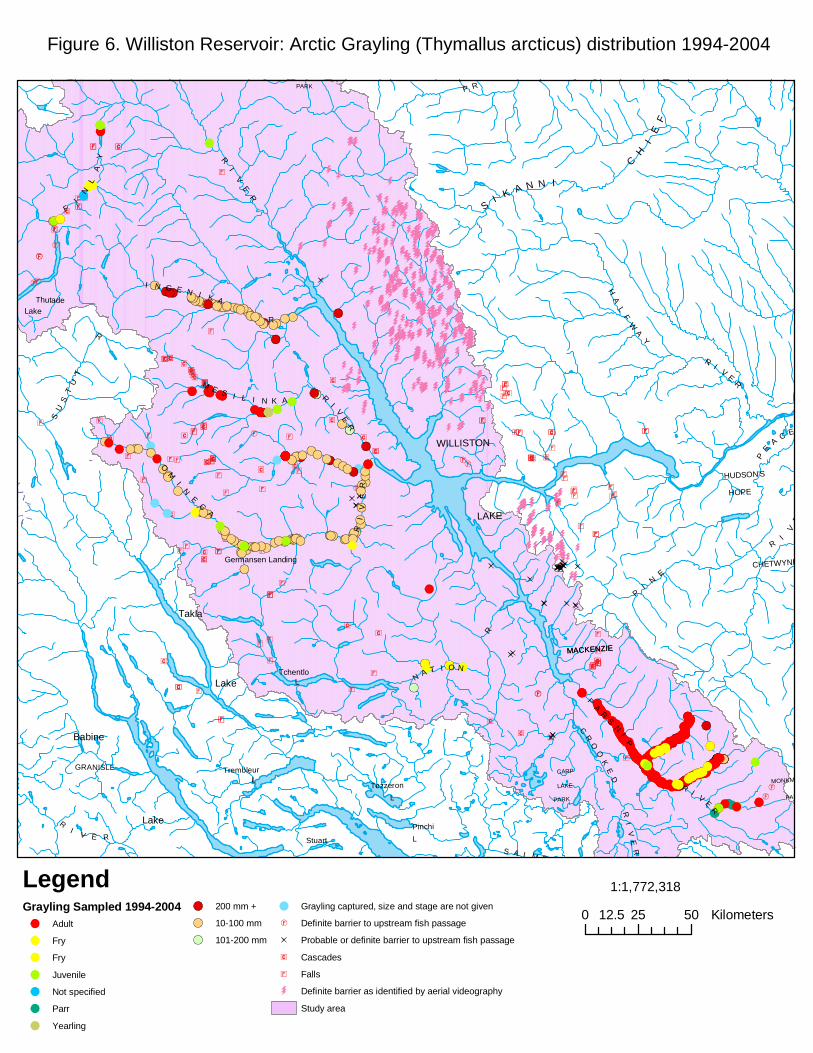
Figure 6. Williston Reservoir: Arctic Grayling (Thymallus arcticus) distribution 1994-2004
LegendGrayling Sampled 1994-2004
Adult
Fry
Fry
Juvenile
Not specified
Parr
Yearling
200 mm +
10-100 mm
101-200 mm
Grayling captured, size and stage are not given
Definite barrier to upstream fish passage
Probable or definite barrier to upstream fish passage
Cascades
Falls
Definite barrier as identified by aerial videography
Study area
0 25 5012.5 Kilometers
1:1,772,318
Pesika Creek
Chowika Creek
Davis River
Lafferty Creek
Ospika River
Finlay River
Mesilinka River
Ingenika River
Omineca River
Williston Reservoir
Figure 7a. Williston North: Sampling locations for Bruce and Starr (1985),Blackman and Langston (1993)
Legend
Falls
Potential or definite barrier to upstream fish migration
Bruce & Starr (1985) sampling location
Blackman & Langston (1993), snorkel survey endpoint
Blackman & Langston (1993) sampling location
Cascades
Falls
Definite barrier as identified by aerial videography
0 8 16 24 324Kilometers 1:714,271
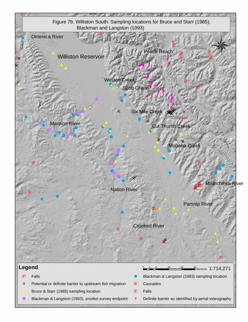
Williston Reservoir
Figure 7b. Williston South: Sampling locations for Bruce and Starr (1985),Blackman and Langston (1993)
Legend
Falls
Potential or definite barrier to upstream fish migration
Bruce & Starr (1985) sampling location
Blackman & Langston (1993), snorkel survey endpoint
Blackman & Langston (1993) sampling location
Cascades
Falls
Definite barrier as identified by aerial videography
0 8 16 24 324Kilometers 1:714,271
Manson River
Nation River
Crooked River
Parsnip River
Misinchinka River
Peace Reach
Omenica River
Weston Creek
Scott Creek
Six Mile Creek
Cut Thumb Creek
Mugaha Creek

Appendix 2: Williston Reservoir, Region 7A
Consolidated Dataset Bibliography
26
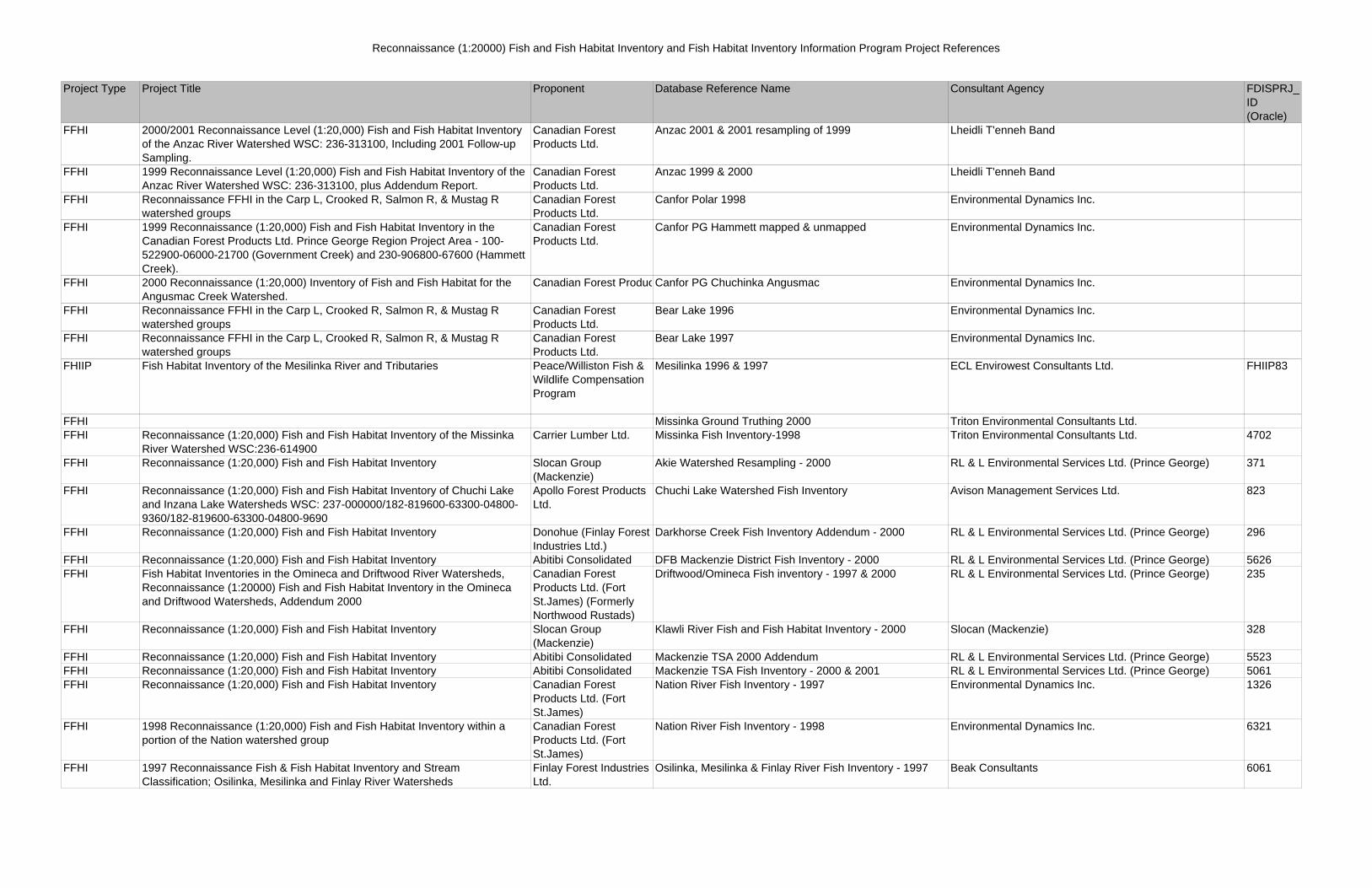
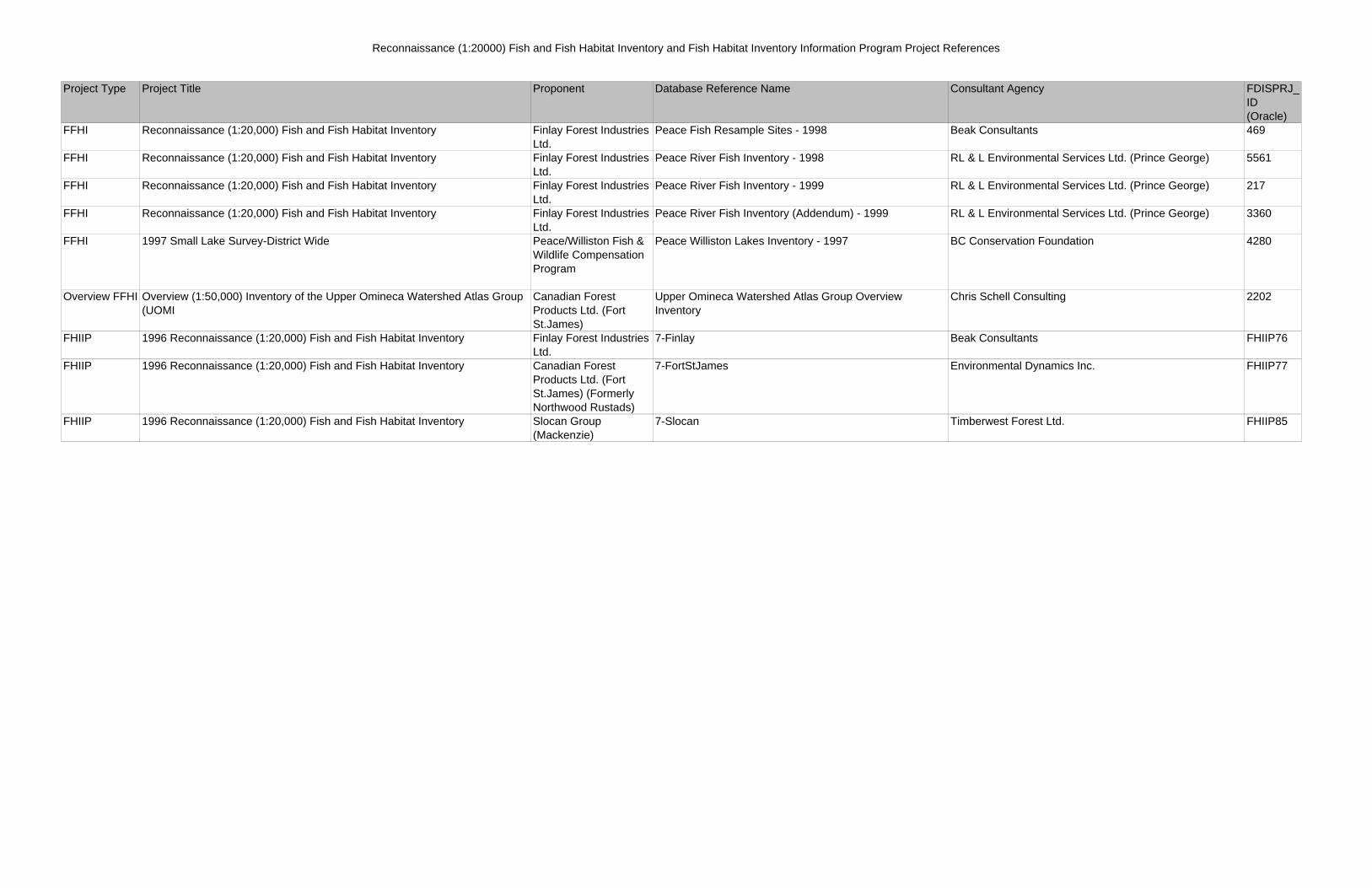
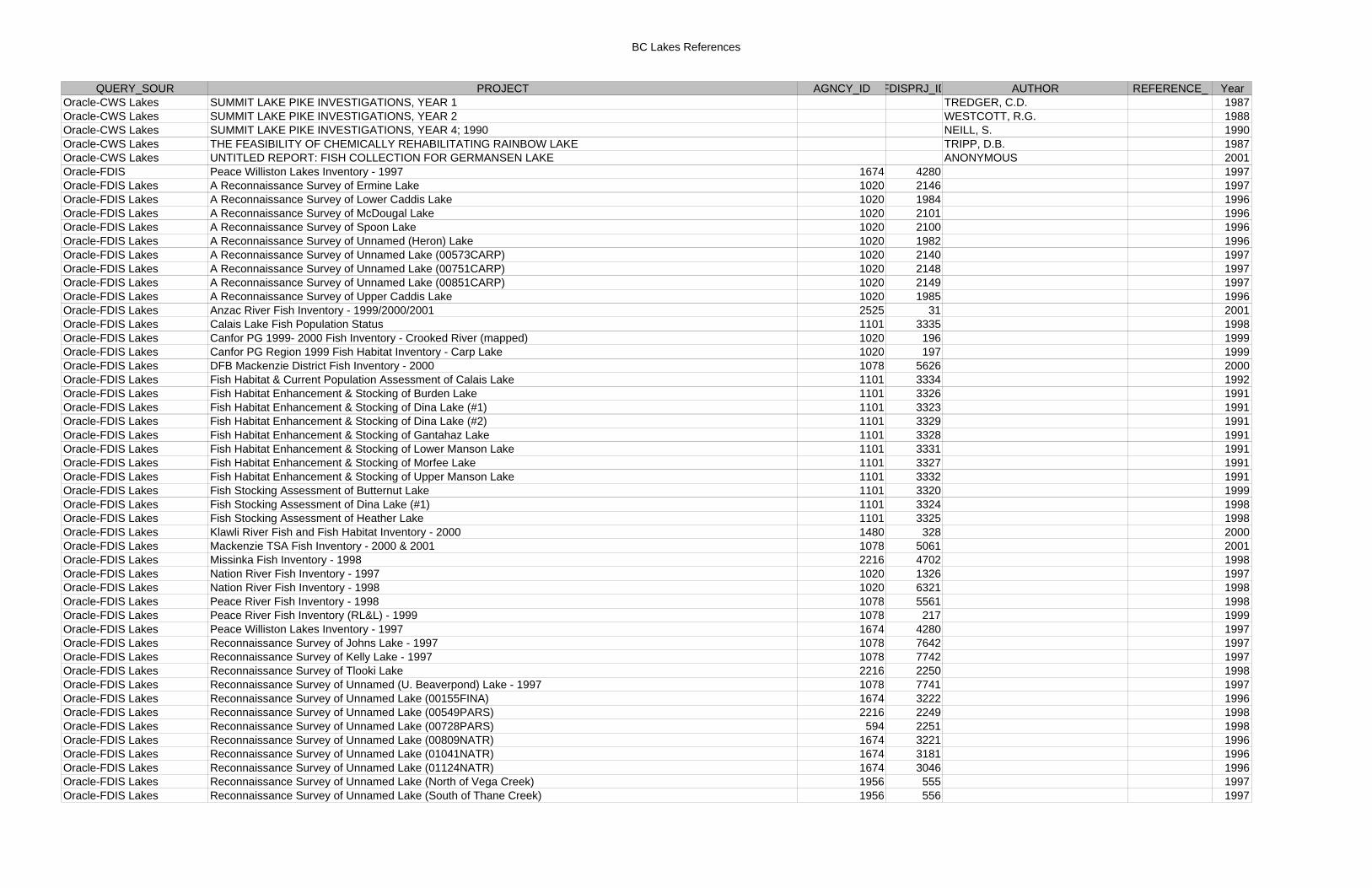
Reconnaissance (1:20000) Fish and Fish Habitat Inventory and Fish Habitat Inventory Information Program Project References
Project Type Project Title Proponent Database Reference Name Consultant Agency FDISPRJ_ID (Oracle)
FFHI 2000/2001 Reconnaissance Level (1:20,000) Fish and Fish Habitat Inventory of the Anzac River Watershed WSC: 236-313100, Including 2001 Follow-up Sampling.
Canadian Forest Products Ltd.
Anzac 2001 & 2001 resampling of 1999 Lheidli T'enneh Band
FFHI 1999 Reconnaissance Level (1:20,000) Fish and Fish Habitat Inventory of the Anzac River Watershed WSC: 236-313100, plus Addendum Report.
Canadian Forest Products Ltd.
Anzac 1999 & 2000 Lheidli T'enneh Band
FFHI Reconnaissance FFHI in the Carp L, Crooked R, Salmon R, & Mustag R watershed groups
Canadian Forest Products Ltd.
Canfor Polar 1998 Environmental Dynamics Inc.
FFHI 1999 Reconnaissance (1:20,000) Fish and Fish Habitat Inventory in the Canadian Forest Products Ltd. Prince George Region Project Area - 100-522900-06000-21700 (Government Creek) and 230-906800-67600 (Hammett Creek).
Canadian Forest Products Ltd.
Canfor PG Hammett mapped & unmapped Environmental Dynamics Inc.
FFHI 2000 Reconnaissance (1:20,000) Inventory of Fish and Fish Habitat for the Angusmac Creek Watershed.
Canadian Forest ProducCanfor PG Chuchinka Angusmac Environmental Dynamics Inc.
FFHI Reconnaissance FFHI in the Carp L, Crooked R, Salmon R, & Mustag R watershed groups
Canadian Forest Products Ltd.
Bear Lake 1996 Environmental Dynamics Inc.
FFHI Reconnaissance FFHI in the Carp L, Crooked R, Salmon R, & Mustag R watershed groups
Canadian Forest Products Ltd.
Bear Lake 1997 Environmental Dynamics Inc.
FHIIP Fish Habitat Inventory of the Mesilinka River and Tributaries Peace/Williston Fish & Wildlife Compensation Program
Mesilinka 1996 & 1997 ECL Envirowest Consultants Ltd. FHIIP83
FFHI Missinka Ground Truthing 2000 Triton Environmental Consultants Ltd. FFHI Reconnaissance (1:20,000) Fish and Fish Habitat Inventory of the Missinka
River Watershed WSC:236-614900Carrier Lumber Ltd. Missinka Fish Inventory-1998 Triton Environmental Consultants Ltd. 4702
FFHI Reconnaissance (1:20,000) Fish and Fish Habitat Inventory Slocan Group (Mackenzie)
Akie Watershed Resampling - 2000 RL & L Environmental Services Ltd. (Prince George) 371
FFHI Reconnaissance (1:20,000) Fish and Fish Habitat Inventory of Chuchi Lake and Inzana Lake Watersheds WSC: 237-000000/182-819600-63300-04800-9360/182-819600-63300-04800-9690
Apollo Forest Products Ltd.
Chuchi Lake Watershed Fish Inventory Avison Management Services Ltd. 823
FFHI Reconnaissance (1:20,000) Fish and Fish Habitat Inventory Donohue (Finlay Forest Industries Ltd.)
Darkhorse Creek Fish Inventory Addendum - 2000 RL & L Environmental Services Ltd. (Prince George) 296
FFHI Reconnaissance (1:20,000) Fish and Fish Habitat Inventory Abitibi Consolidated DFB Mackenzie District Fish Inventory - 2000 RL & L Environmental Services Ltd. (Prince George) 5626FFHI Fish Habitat Inventories in the Omineca and Driftwood River Watersheds,
Reconnaissance (1:20000) Fish and Fish Habitat Inventory in the Omineca and Driftwood Watersheds, Addendum 2000
Canadian Forest Products Ltd. (Fort St.James) (Formerly Northwood Rustads)
Driftwood/Omineca Fish inventory - 1997 & 2000 RL & L Environmental Services Ltd. (Prince George) 235
FFHI Reconnaissance (1:20,000) Fish and Fish Habitat Inventory Slocan Group (Mackenzie)
Klawli River Fish and Fish Habitat Inventory - 2000 Slocan (Mackenzie) 328
FFHI Reconnaissance (1:20,000) Fish and Fish Habitat Inventory Abitibi Consolidated Mackenzie TSA 2000 Addendum RL & L Environmental Services Ltd. (Prince George) 5523FFHI Reconnaissance (1:20,000) Fish and Fish Habitat Inventory Abitibi Consolidated Mackenzie TSA Fish Inventory - 2000 & 2001 RL & L Environmental Services Ltd. (Prince George) 5061FFHI Reconnaissance (1:20,000) Fish and Fish Habitat Inventory Canadian Forest
Products Ltd. (Fort St.James)
Nation River Fish Inventory - 1997 Environmental Dynamics Inc. 1326
FFHI 1998 Reconnaissance (1:20,000) Fish and Fish Habitat Inventory within a portion of the Nation watershed group
Canadian Forest Products Ltd. (Fort St.James)
Nation River Fish Inventory - 1998 Environmental Dynamics Inc. 6321
FFHI 1997 Reconnaissance Fish & Fish Habitat Inventory and Stream Classification; Osilinka, Mesilinka and Finlay River Watersheds
Finlay Forest Industries Ltd.
Osilinka, Mesilinka & Finlay River Fish Inventory - 1997 Beak Consultants 6061
Reconnaissance (1:20000) Fish and Fish Habitat Inventory and Fish Habitat Inventory Information Program Project References
Project Type Project Title Proponent Database Reference Name Consultant Agency FDISPRJ_ID (Oracle)
FFHI Reconnaissance (1:20,000) Fish and Fish Habitat Inventory Finlay Forest Industries Ltd.
Peace Fish Resample Sites - 1998 Beak Consultants 469
FFHI Reconnaissance (1:20,000) Fish and Fish Habitat Inventory Finlay Forest Industries Ltd.
Peace River Fish Inventory - 1998 RL & L Environmental Services Ltd. (Prince George) 5561
FFHI Reconnaissance (1:20,000) Fish and Fish Habitat Inventory Finlay Forest Industries Ltd.
Peace River Fish Inventory - 1999 RL & L Environmental Services Ltd. (Prince George) 217
FFHI Reconnaissance (1:20,000) Fish and Fish Habitat Inventory Finlay Forest Industries Ltd.
Peace River Fish Inventory (Addendum) - 1999 RL & L Environmental Services Ltd. (Prince George) 3360
FFHI 1997 Small Lake Survey-District Wide Peace/Williston Fish & Wildlife Compensation Program
Peace Williston Lakes Inventory - 1997 BC Conservation Foundation 4280
Overview FFHI Overview (1:50,000) Inventory of the Upper Omineca Watershed Atlas Group (UOMI
Canadian Forest Products Ltd. (Fort St.James)
Upper Omineca Watershed Atlas Group Overview Inventory
Chris Schell Consulting 2202
FHIIP 1996 Reconnaissance (1:20,000) Fish and Fish Habitat Inventory Finlay Forest Industries Ltd.
7-Finlay Beak Consultants FHIIP76
FHIIP 1996 Reconnaissance (1:20,000) Fish and Fish Habitat Inventory Canadian Forest Products Ltd. (Fort St.James) (Formerly Northwood Rustads)
7-FortStJames Environmental Dynamics Inc. FHIIP77
FHIIP 1996 Reconnaissance (1:20,000) Fish and Fish Habitat Inventory Slocan Group (Mackenzie)
7-Slocan Timberwest Forest Ltd. FHIIP85
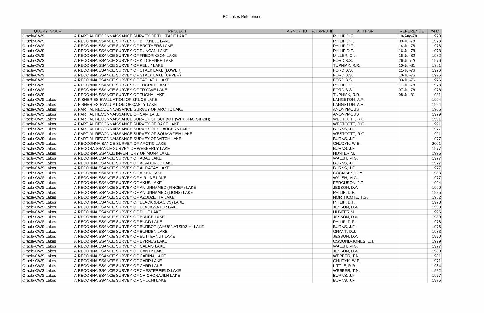
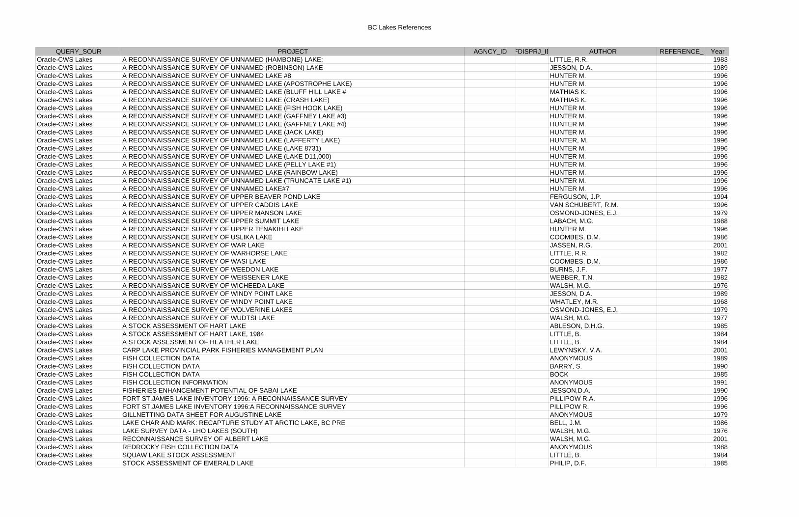
BC Lakes References
QUERY_SOUR PROJECT AGNCY_ID FDISPRJ_ID AUTHOR REFERENCE_ YearOracle-CWS A PARTIAL RECONNAISSANCE SURVEY OF THUTADE LAKE PHILIP D.F. 18-Aug-78 1978Oracle-CWS A RECONNAISSANCE SURVEY OF BICKNELL LAKE PHILIP D.F. 09-Jul-78 1978Oracle-CWS A RECONNAISSANCE SURVEY OF BROTHERS LAKE PHILIP D.F. 14-Jul-78 1978Oracle-CWS A RECONNAISSANCE SURVEY OF DUNCAN LAKE PHILIP D.F. 16-Jul-78 1978Oracle-CWS A RECONNAISSANCE SURVEY OF FREDRIKSON LAKE MILLER, C.L. 16-Jul-82 1982Oracle-CWS A RECONNAISSANCE SURVEY OF KITCHENER LAKE FORD B.S. 26-Jun-76 1976Oracle-CWS A RECONNAISSANCE SURVEY OF PELLY LAKE TUPNIAK, R.R. 10-Jul-81 1981Oracle-CWS A RECONNAISSANCE SURVEY OF STALK LAKE (LOWER) FORD B.S. 11-Jul-76 1976Oracle-CWS A RECONNAISSANCE SURVEY OF STALK LAKE (UPPER) FORD B.S. 10-Jul-76 1976Oracle-CWS A RECONNAISSANCE SURVEY OF TATLATUI LAKE FORD B.S. 03-Jul-76 1976Oracle-CWS A RECONNAISSANCE SURVEY OF THORNE LAKE PHILIP D.F. 11-Jul-78 1978Oracle-CWS A RECONNAISSANCE SURVEY OF TRYGVE LAKE FORD B.S. 07-Jul-76 1976Oracle-CWS A RECONNAISSANCE SURVEY OF TUCHA LAKE TUPNIAK, R.R. 08-Jul-81 1981Oracle-CWS Lakes A FISHERIES EVALUATION OF BRUCE LAKE LANGSTON, A.R. 1994Oracle-CWS Lakes A FISHERIES EVALUATION OF CANTY LAKE LANGSTON, A.R. 1994Oracle-CWS Lakes A PARTIAL RECCONNAISANCE SURVEY OF ARCTIC LAKE ANONYMOUS 1965Oracle-CWS Lakes A PARTIAL RECONNAISSANCE OF SAM LAKE ANONYMOUS 1979Oracle-CWS Lakes A PARTIAL RECONNAISSANCE SURVEY OF BURBOT (WHUSNATSIDZIH) WESTCOTT, R.G. 1991Oracle-CWS Lakes A PARTIAL RECONNAISSANCE SURVEY OF DACE LAKE WESTCOTT, R.G. 1991Oracle-CWS Lakes A PARTIAL RECONNAISSANCE SURVEY OF GLAUCERS LAKE BURNS, J.F. 1977Oracle-CWS Lakes A PARTIAL RECONNAISSANCE SURVEY OF SQUAWFISH LAKE WESTCOTT, R.G. 1991Oracle-CWS Lakes A PARTIAL RECONNAISSANCE SURVEY OF WITCH LAKE BURNS, J.F. 1977Oracle-CWS Lakes A RECCONNAISANCE SURVEY OF ARCTIC LAKE CHUDYK, W.E. 2001Oracle-CWS Lakes A RECONAISSANCE SURVEY OF WEBBERLY LAKE BURNS, J.F. 1977Oracle-CWS Lakes A RECONNAISSANCE INVENTORY OF MONK LAKE HUNTER M. 1996Oracle-CWS Lakes A RECONNAISSANCE SURVEY OF ABAS LAKE WALSH, M.G. 1977Oracle-CWS Lakes A RECONNAISSANCE SURVEY OF ACADEMUS LAKE BURNS, J.F. 1977Oracle-CWS Lakes A RECONNAISSANCE SURVEY OF AHDATAY LAKE BURNS, J.F. 1977Oracle-CWS Lakes A RECONNAISSANCE SURVEY OF AIKEN LAKE COOMBES, D.M. 1983Oracle-CWS Lakes A RECONNAISSANCE SURVEY OF AIRLINE LAKE WALSH, M.G. 1977Oracle-CWS Lakes A RECONNAISSANCE SURVEY OF AKUS LAKE FERGUSON, J.P. 1994Oracle-CWS Lakes A RECONNAISSANCE SURVEY OF AN UNNAMED (FINGER) LAKE JESSON, D.A. 1990Oracle-CWS Lakes A RECONNAISSANCE SURVEY OF AN UNNAMED (LIONS) LAKE PHILIP, D.F. 1985Oracle-CWS Lakes A RECONNAISSANCE SURVEY OF AZOUZETTA LAKE NORTHCOTE, T.G. 1952Oracle-CWS Lakes A RECONNAISSANCE SURVEY OF BLACK (BLACK'S) LAKE PHILIP, D.F. 1978Oracle-CWS Lakes A RECONNAISSANCE SURVEY OF BLACKWATER LAKE JESSON, D.A. 1990Oracle-CWS Lakes A RECONNAISSANCE SURVEY OF BLUE LAKE HUNTER M. 1996Oracle-CWS Lakes A RECONNAISSANCE SURVEY OF BRUCE LAKE JESSON, D.A. 1989Oracle-CWS Lakes A RECONNAISSANCE SURVEY OF BUDD LAKE PHILIP, D.F. 1978Oracle-CWS Lakes A RECONNAISSANCE SURVEY OF BURBOT (WHUSNATSIDZIH) LAKE BURNS, J.F. 1976Oracle-CWS Lakes A RECONNAISSANCE SURVEY OF BURDEN LAKE GRANT, D.J. 1983Oracle-CWS Lakes A RECONNAISSANCE SURVEY OF BUTTERNUT LAKE JESSON, D.A. 1990Oracle-CWS Lakes A RECONNAISSANCE SURVEY OF BYRNES LAKE OSMOND-JONES, E.J. 1979Oracle-CWS Lakes A RECONNAISSANCE SURVEY OF CALAIS LAKE WALSH, M.G. 1977Oracle-CWS Lakes A RECONNAISSANCE SURVEY OF CANTY LAKE JESSON, D.A. 1989Oracle-CWS Lakes A RECONNAISSANCE SURVEY OF CARINA LAKE WEBBER, T.N. 1981Oracle-CWS Lakes A RECONNAISSANCE SURVEY OF CARP LAKE CHUDYK, W.E. 1971Oracle-CWS Lakes A RECONNAISSANCE SURVEY OF CARR LAKE LITTLE, R.R. 1984Oracle-CWS Lakes A RECONNAISSANCE SURVEY OF CHESTERFIELD LAKE WEBBER, T.N. 1982Oracle-CWS Lakes A RECONNAISSANCE SURVEY OF CHICHONAJILH LAKE BURNS, J.F. 1977Oracle-CWS Lakes A RECONNAISSANCE SURVEY OF CHUCHI LAKE BURNS, J.F. 1975
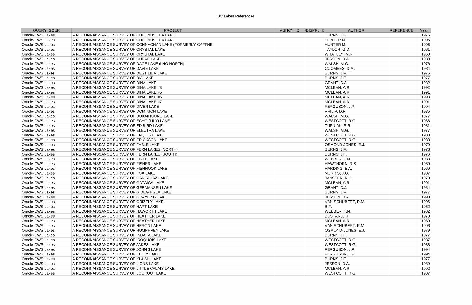
BC Lakes References
QUERY_SOUR PROJECT AGNCY_ID FDISPRJ_ID AUTHOR REFERENCE_ YearOracle-CWS Lakes A RECONNAISSANCE SURVEY OF CHUDNUSLIDA LAKE BURNS, J.F. 1976Oracle-CWS Lakes A RECONNAISSANCE SURVEY OF CHUDNUSLIDA LAKE HUNTER M. 1996Oracle-CWS Lakes A RECONNAISSANCE SURVEY OF CONNAGHAN LAKE (FORMERLY GAFFNE HUNTER M. 1996Oracle-CWS Lakes A RECONNAISSANCE SURVEY OF CRYSTAL LAKE TAYLOR, G.D. 1961Oracle-CWS Lakes A RECONNAISSANCE SURVEY OF CRYSTAL LAKE WHATLEY, M.R. 1968Oracle-CWS Lakes A RECONNAISSANCE SURVEY OF CURVE LAKE JESSON, D.A. 1989Oracle-CWS Lakes A RECONNAISSANCE SURVEY OF DACE LAKE (LHO,NORTH) WALSH, M.G. 1976Oracle-CWS Lakes A RECONNAISSANCE SURVEY OF DAVIE LAKE COOMBES, D.M. 1984Oracle-CWS Lakes A RECONNAISSANCE SURVEY OF DESTILIDA LAKE BURNS, J.F. 1976Oracle-CWS Lakes A RECONNAISSANCE SURVEY OF DIA LAKE BURNS, J.F. 1977Oracle-CWS Lakes A RECONNAISSANCE SURVEY OF DINA LAKE GRANT, D.J. 1982Oracle-CWS Lakes A RECONNAISSANCE SURVEY OF DINA LAKE #3 MCLEAN, A.R. 1992Oracle-CWS Lakes A RECONNAISSANCE SURVEY OF DINA LAKE #5 MCLEAN, A.R. 1991Oracle-CWS Lakes A RECONNAISSANCE SURVEY OF DINA LAKE #6 MCLEAN, A.R. 1993Oracle-CWS Lakes A RECONNAISSANCE SURVEY OF DINA LAKE #7 MCLEAN, A.R. 1991Oracle-CWS Lakes A RECONNAISSANCE SURVEY OF DIVER LAKE FERGUSON, J.P. 1994Oracle-CWS Lakes A RECONNAISSANCE SURVEY OF DOMINION LAKE PHILIP, D.F. 1985Oracle-CWS Lakes A RECONNAISSANCE SURVEY OF DUKAIHOONLI LAKE WALSH, M.G. 1977Oracle-CWS Lakes A RECONNAISSANCE SURVEY OF ECHO (LILY) LAKE WESTCOTT, R.G. 1988Oracle-CWS Lakes A RECONNAISSANCE SURVEY OF ED BIRD LAKE TUPNIAK, R.R. 1981Oracle-CWS Lakes A RECONNAISSANCE SURVEY OF ELECTRA LAKE WALSH, M.G. 1977Oracle-CWS Lakes A RECONNAISSANCE SURVEY OF ENQUIST LAKE WESTCOTT, R.G. 1988Oracle-CWS Lakes A RECONNAISSANCE SURVEY OF ERICKSON LAKE WESTCOTT, R.G. 1988Oracle-CWS Lakes A RECONNAISSANCE SURVEY OF FABLE LAKE OSMOND-JONES, E.J. 1979Oracle-CWS Lakes A RECONNAISSANCE SURVEY OF FERN LAKES (NORTH) BURNS, J.F. 1976Oracle-CWS Lakes A RECONNAISSANCE SURVEY OF FERN LAKES (SOUTH) BURNS, J.F. 1976Oracle-CWS Lakes A RECONNAISSANCE SURVEY OF FIRTH LAKE WEBBER, T.N. 1983Oracle-CWS Lakes A RECONNAISSANCE SURVEY OF FISHER LAKE HAWTHORN, R.S. 1969Oracle-CWS Lakes A RECONNAISSANCE SURVEY OF FISHHOOK LAKE HARDING, E.A. 1969Oracle-CWS Lakes A RECONNAISSANCE SURVEY OF FOX LAKE NORRIS, J.G. 1987Oracle-CWS Lakes A RECONNAISSANCE SURVEY OF GANTAHAZ LAKE JANSSEN, R.G. 1970Oracle-CWS Lakes A RECONNAISSANCE SURVEY OF GATAIGA LAKE MCLEAN, A.R. 1991Oracle-CWS Lakes A RECONNAISSANCE SURVEY OF GERMANSEN LAKE GRANT, D.J. 1984Oracle-CWS Lakes A RECONNAISSANCE SURVEY OF GIDEGINGLA LAKE BURNS, J.F. 1977Oracle-CWS Lakes A RECONNAISSANCE SURVEY OF GRAYLING LAKE JESSON, D.A. 1990Oracle-CWS Lakes A RECONNAISSANCE SURVEY OF GRIZZLY LAKE VAN SCHUBERT, R.M. 1996Oracle-CWS Lakes A RECONNAISSANCE SURVEY OF HART LAKE B.F. 1952Oracle-CWS Lakes A RECONNAISSANCE SURVEY OF HAWORTH LAKE WEBBER, T.N. 1982Oracle-CWS Lakes A RECONNAISSANCE SURVEY OF HEATHER LAKE BUSTARD, R 1970Oracle-CWS Lakes A RECONNAISSANCE SURVEY OF HEATHER LAKE MCLEAN, A.R. 1989Oracle-CWS Lakes A RECONNAISSANCE SURVEY OF HERON LAKE VAN SCHUBERT, R.M. 1996Oracle-CWS Lakes A RECONNAISSANCE SURVEY OF HUMPHREY LAKE OSMOND-JONES, E.J. 1979Oracle-CWS Lakes A RECONNAISSANCE SURVEY OF INDATA LAKE BURNS, J.F. 1977Oracle-CWS Lakes A RECONNAISSANCE SURVEY OF IROQUOIS LAKE WESTCOTT, R.G. 1987Oracle-CWS Lakes A RECONNAISSANCE SURVEY OF JAKES LAKE WESTCOTT, R.G. 1988Oracle-CWS Lakes A RECONNAISSANCE SURVEY OF JOHN'S LAKE FERGUSON, J.P. 1994Oracle-CWS Lakes A RECONNAISSANCE SURVEY OF KELLY LAKE FERGUSON, J.P. 1994Oracle-CWS Lakes A RECONNAISSANCE SURVEY OF KLAWLI LAKE BURNS, J.F. 1977Oracle-CWS Lakes A RECONNAISSANCE SURVEY OF LIONS LAKE JESSON, D.A. 1989Oracle-CWS Lakes A RECONNAISSANCE SURVEY OF LITTLE CALAIS LAKE MCLEAN, A.R. 1992Oracle-CWS Lakes A RECONNAISSANCE SURVEY OF LOOKOUT LAKE WESTCOTT, R.G. 1987
BC Lakes References
QUERY_SOUR PROJECT AGNCY_ID FDISPRJ_ID AUTHOR REFERENCE_ YearOracle-CWS Lakes A RECONNAISSANCE SURVEY OF LOWER BEAVER POND LAKE FERGUSON, J.P. 1994Oracle-CWS Lakes A RECONNAISSANCE SURVEY OF LOWER CADDIS LAKE VAN SCHUBERT, R.M. 1996Oracle-CWS Lakes A RECONNAISSANCE SURVEY OF LOWER MANSON LAKE OSMOND-JONES, E.J. 1979Oracle-CWS Lakes A RECONNAISSANCE SURVEY OF MACDONALD LAKE BURNS, J.F. 1977Oracle-CWS Lakes A RECONNAISSANCE SURVEY OF MCDOUGAL LAKE VAN SCHUBERT, R.M. 1996Oracle-CWS Lakes A RECONNAISSANCE SURVEY OF MCEWAN LAKE VAN SCHUBERT, R.M. 1996Oracle-CWS Lakes A RECONNAISSANCE SURVEY OF MCINTYRE LAKE JESSON, D.A. 1989Oracle-CWS Lakes A RECONNAISSANCE SURVEY OF MCLEOD LAKE GRANT, D.J. 1985Oracle-CWS Lakes A RECONNAISSANCE SURVEY OF MIDDLE TENAKIHI LAKE HUNTER M. 1996Oracle-CWS Lakes A RECONNAISSANCE SURVEY OF MORFEE LAKE JANSSEN, R.G. 1970Oracle-CWS Lakes A RECONNAISSANCE SURVEY OF MUDZENCHOOT LAKE WALSH, M.G. 1977Oracle-CWS Lakes A RECONNAISSANCE SURVEY OF MUNRO LAKE GRANT, D.J. 1985Oracle-CWS Lakes A RECONNAISSANCE SURVEY OF NEILSON LAKE WESTCOTT, R.G. 1988Oracle-CWS Lakes A RECONNAISSANCE SURVEY OF NINA LAKE COOMBES, D.M. 1986Oracle-CWS Lakes A RECONNAISSANCE SURVEY OF OBO LAKE NORRIS, J.G. 1987Oracle-CWS Lakes A RECONNAISSANCE SURVEY OF ODELL LAKE PHILIP, D.F. 1985Oracle-CWS Lakes A RECONNAISSANCE SURVEY OF PHILIP LAKE #3 BURNS, J.F. 1978Oracle-CWS Lakes A RECONNAISSANCE SURVEY OF POTHOLE LAKE #1 JESSON, D.A. 1989Oracle-CWS Lakes A RECONNAISSANCE SURVEY OF PURVIS LAKE BURNS, J.F. 1977Oracle-CWS Lakes A RECONNAISSANCE SURVEY OF QUENTIN LAKE MILLER, C.L. 1982Oracle-CWS Lakes A RECONNAISSANCE SURVEY OF RAINBOW LAKE PHILIP, D.F. 1985Oracle-CWS Lakes A RECONNAISSANCE SURVEY OF ROYER LAKE JESSON, D.A. 1989Oracle-CWS Lakes A RECONNAISSANCE SURVEY OF SABAI LAKE WESTCOTT, R.D. 1987Oracle-CWS Lakes A RECONNAISSANCE SURVEY OF SHOAL LAKE MCLEAN, A.R. 1991Oracle-CWS Lakes A RECONNAISSANCE SURVEY OF SILVER LAKE OSMOND-JONES, E.J. 1979Oracle-CWS Lakes A RECONNAISSANCE SURVEY OF SKUNK LAKE GRANT, D.J. 1985Oracle-CWS Lakes A RECONNAISSANCE SURVEY OF SPOON LAKE VAN SCHUBERT,R.M. 1996Oracle-CWS Lakes A RECONNAISSANCE SURVEY OF SPRING LAKE HUNTER M. 1996Oracle-CWS Lakes A RECONNAISSANCE SURVEY OF SQUAW LAKE WHATELY, M.R. 1968Oracle-CWS Lakes A RECONNAISSANCE SURVEY OF SUCKER (UNNAMED #4) LAKE WESTCOTT, R.G. 1988Oracle-CWS Lakes A RECONNAISSANCE SURVEY OF SUCKER LAKE (LHO,MIDDLE) WALSH, M.G. 1976Oracle-CWS Lakes A RECONNAISSANCE SURVEY OF SUMMIT LAKE OSMOND-JONES, E. 1979Oracle-CWS Lakes A RECONNAISSANCE SURVEY OF SWAMP GRASS LAKE HUNTER M. 1996Oracle-CWS Lakes A RECONNAISSANCE SURVEY OF TACHEEDA LAKES TAYLOR, G.D. 1961Oracle-CWS Lakes A RECONNAISSANCE SURVEY OF TAMASGALE LAKE WALSH, M.G. 1977Oracle-CWS Lakes A RECONNAISSANCE SURVEY OF TEEGEE LAKE HUNTER M. 2001Oracle-CWS Lakes A RECONNAISSANCE SURVEY OF TIZGAY LAKE BURNS, J.F. 1977Oracle-CWS Lakes A RECONNAISSANCE SURVEY OF TLUTSACHO LAKE WALSH, M.G. 1977Oracle-CWS Lakes A RECONNAISSANCE SURVEY OF TOBIN LAKE MCLEAN, A.R. 1989Oracle-CWS Lakes A RECONNAISSANCE SURVEY OF TOBIN LAKE WEBBER, T.N. 1981Oracle-CWS Lakes A RECONNAISSANCE SURVEY OF TOM LAKE OSMOND-JONES, E.J. 1979Oracle-CWS Lakes A RECONNAISSANCE SURVEY OF TOMIAS LAKE WEBBER, T.N. 1981Oracle-CWS Lakes A RECONNAISSANCE SURVEY OF TOODICK LAKE WESTCOTT, R.G. 1987Oracle-CWS Lakes A RECONNAISSANCE SURVEY OF TOODOGGONE LAKE NORRIS, J.G. 1987Oracle-CWS Lakes A RECONNAISSANCE SURVEY OF TSAYDAYCHI LAKE WALSH, M.G. 1977Oracle-CWS Lakes A RECONNAISSANCE SURVEY OF TSAYTA LAKE BURNS, J.F. 1977Oracle-CWS Lakes A RECONNAISSANCE SURVEY OF TUDYAH LAKE WHATELY, M.R. 1968Oracle-CWS Lakes A RECONNAISSANCE SURVEY OF TURNER LAKE PHILIP, D.F. 1985Oracle-CWS Lakes A RECONNAISSANCE SURVEY OF TUTIZZI LAKE COOMBES, D.M. 1983Oracle-CWS Lakes A RECONNAISSANCE SURVEY OF UNNAMED (CHOOYAZI) LAKE WALSH, M.G. 1977Oracle-CWS Lakes A RECONNAISSANCE SURVEY OF UNNAMED (GOOSE) LAKE LITTLE, R.R. 1983
BC Lakes References
QUERY_SOUR PROJECT AGNCY_ID FDISPRJ_ID AUTHOR REFERENCE_ YearOracle-CWS Lakes A RECONNAISSANCE SURVEY OF UNNAMED (HAMBONE) LAKE; LITTLE, R.R. 1983Oracle-CWS Lakes A RECONNAISSANCE SURVEY OF UNNAMED (ROBINSON) LAKE JESSON, D.A. 1989Oracle-CWS Lakes A RECONNAISSANCE SURVEY OF UNNAMED LAKE #8 HUNTER M. 1996Oracle-CWS Lakes A RECONNAISSANCE SURVEY OF UNNAMED LAKE (APOSTROPHE LAKE) HUNTER M. 1996Oracle-CWS Lakes A RECONNAISSANCE SURVEY OF UNNAMED LAKE (BLUFF HILL LAKE # MATHIAS K. 1996Oracle-CWS Lakes A RECONNAISSANCE SURVEY OF UNNAMED LAKE (CRASH LAKE) MATHIAS K. 1996Oracle-CWS Lakes A RECONNAISSANCE SURVEY OF UNNAMED LAKE (FISH HOOK LAKE) HUNTER M. 1996Oracle-CWS Lakes A RECONNAISSANCE SURVEY OF UNNAMED LAKE (GAFFNEY LAKE #3) HUNTER M. 1996Oracle-CWS Lakes A RECONNAISSANCE SURVEY OF UNNAMED LAKE (GAFFNEY LAKE #4) HUNTER M. 1996Oracle-CWS Lakes A RECONNAISSANCE SURVEY OF UNNAMED LAKE (JACK LAKE) HUNTER M. 1996Oracle-CWS Lakes A RECONNAISSANCE SURVEY OF UNNAMED LAKE (LAFFERTY LAKE) HUNTER, M. 1996Oracle-CWS Lakes A RECONNAISSANCE SURVEY OF UNNAMED LAKE (LAKE 8731) HUNTER M. 1996Oracle-CWS Lakes A RECONNAISSANCE SURVEY OF UNNAMED LAKE (LAKE D11,000) HUNTER M. 1996Oracle-CWS Lakes A RECONNAISSANCE SURVEY OF UNNAMED LAKE (PELLY LAKE #1) HUNTER M. 1996Oracle-CWS Lakes A RECONNAISSANCE SURVEY OF UNNAMED LAKE (RAINBOW LAKE) HUNTER M. 1996Oracle-CWS Lakes A RECONNAISSANCE SURVEY OF UNNAMED LAKE (TRUNCATE LAKE #1) HUNTER M. 1996Oracle-CWS Lakes A RECONNAISSANCE SURVEY OF UNNAMED LAKE#7 HUNTER M. 1996Oracle-CWS Lakes A RECONNAISSANCE SURVEY OF UPPER BEAVER POND LAKE FERGUSON, J.P. 1994Oracle-CWS Lakes A RECONNAISSANCE SURVEY OF UPPER CADDIS LAKE VAN SCHUBERT, R.M. 1996Oracle-CWS Lakes A RECONNAISSANCE SURVEY OF UPPER MANSON LAKE OSMOND-JONES, E.J. 1979Oracle-CWS Lakes A RECONNAISSANCE SURVEY OF UPPER SUMMIT LAKE LABACH, M.G. 1988Oracle-CWS Lakes A RECONNAISSANCE SURVEY OF UPPER TENAKIHI LAKE HUNTER M. 1996Oracle-CWS Lakes A RECONNAISSANCE SURVEY OF USLIKA LAKE COOMBES, D.M. 1986Oracle-CWS Lakes A RECONNAISSANCE SURVEY OF WAR LAKE JASSEN, R.G. 2001Oracle-CWS Lakes A RECONNAISSANCE SURVEY OF WARHORSE LAKE LITTLE, R.R. 1982Oracle-CWS Lakes A RECONNAISSANCE SURVEY OF WASI LAKE COOMBES, D.M. 1986Oracle-CWS Lakes A RECONNAISSANCE SURVEY OF WEEDON LAKE BURNS, J.F. 1977Oracle-CWS Lakes A RECONNAISSANCE SURVEY OF WEISSENER LAKE WEBBER, T.N. 1982Oracle-CWS Lakes A RECONNAISSANCE SURVEY OF WICHEEDA LAKE WALSH, M.G. 1976Oracle-CWS Lakes A RECONNAISSANCE SURVEY OF WINDY POINT LAKE JESSON, D.A. 1989Oracle-CWS Lakes A RECONNAISSANCE SURVEY OF WINDY POINT LAKE WHATLEY, M.R. 1968Oracle-CWS Lakes A RECONNAISSANCE SURVEY OF WOLVERINE LAKES OSMOND-JONES, E.J. 1979Oracle-CWS Lakes A RECONNAISSANCE SURVEY OF WUDTSI LAKE WALSH, M.G. 1977Oracle-CWS Lakes A STOCK ASSESSMENT OF HART LAKE ABLESON, D.H.G. 1985Oracle-CWS Lakes A STOCK ASSESSMENT OF HART LAKE, 1984 LITTLE, B. 1984Oracle-CWS Lakes A STOCK ASSESSMENT OF HEATHER LAKE LITTLE, B. 1984Oracle-CWS Lakes CARP LAKE PROVINCIAL PARK FISHERIES MANAGEMENT PLAN LEWYNSKY, V.A. 2001Oracle-CWS Lakes FISH COLLECTION DATA ANONYMOUS 1989Oracle-CWS Lakes FISH COLLECTION DATA BARRY, S. 1990Oracle-CWS Lakes FISH COLLECTION DATA BOCK 1985Oracle-CWS Lakes FISH COLLECTION INFORMATION ANONYMOUS 1991Oracle-CWS Lakes FISHERIES ENHANCEMENT POTENTIAL OF SABAI LAKE JESSON,D.A. 1990Oracle-CWS Lakes FORT ST.JAMES LAKE INVENTORY 1996: A RECONNAISSANCE SURVEY PILLIPOW R.A. 1996Oracle-CWS Lakes FORT ST.JAMES LAKE INVENTORY 1996:A RECONNAISSANCE SURVEY PILLIPOW R. 1996Oracle-CWS Lakes GILLNETTING DATA SHEET FOR AUGUSTINE LAKE ANONYMOUS 1979Oracle-CWS Lakes LAKE CHAR AND MARK: RECAPTURE STUDY AT ARCTIC LAKE, BC PRE BELL, J.M. 1986Oracle-CWS Lakes LAKE SURVEY DATA - LHO LAKES (SOUTH) WALSH, M.G. 1976Oracle-CWS Lakes RECONNAISSANCE SURVEY OF ALBERT LAKE WALSH, M.G. 2001Oracle-CWS Lakes REDROCKY FISH COLLECTION DATA ANONYMOUS 1988Oracle-CWS Lakes SQUAW LAKE STOCK ASSESSMENT LITTLE, B. 1984Oracle-CWS Lakes STOCK ASSESSMENT OF EMERALD LAKE PHILIP, D.F. 1985
BC Lakes References
QUERY_SOUR PROJECT AGNCY_ID FDISPRJ_ID AUTHOR REFERENCE_ YearOracle-CWS Lakes SUMMIT LAKE PIKE INVESTIGATIONS, YEAR 1 TREDGER, C.D. 1987Oracle-CWS Lakes SUMMIT LAKE PIKE INVESTIGATIONS, YEAR 2 WESTCOTT, R.G. 1988Oracle-CWS Lakes SUMMIT LAKE PIKE INVESTIGATIONS, YEAR 4; 1990 NEILL, S. 1990Oracle-CWS Lakes THE FEASIBILITY OF CHEMICALLY REHABILITATING RAINBOW LAKE TRIPP, D.B. 1987Oracle-CWS Lakes UNTITLED REPORT: FISH COLLECTION FOR GERMANSEN LAKE ANONYMOUS 2001Oracle-FDIS Peace Williston Lakes Inventory - 1997 1674 4280 1997Oracle-FDIS Lakes A Reconnaissance Survey of Ermine Lake 1020 2146 1997Oracle-FDIS Lakes A Reconnaissance Survey of Lower Caddis Lake 1020 1984 1996Oracle-FDIS Lakes A Reconnaissance Survey of McDougal Lake 1020 2101 1996Oracle-FDIS Lakes A Reconnaissance Survey of Spoon Lake 1020 2100 1996Oracle-FDIS Lakes A Reconnaissance Survey of Unnamed (Heron) Lake 1020 1982 1996Oracle-FDIS Lakes A Reconnaissance Survey of Unnamed Lake (00573CARP) 1020 2140 1997Oracle-FDIS Lakes A Reconnaissance Survey of Unnamed Lake (00751CARP) 1020 2148 1997Oracle-FDIS Lakes A Reconnaissance Survey of Unnamed Lake (00851CARP) 1020 2149 1997Oracle-FDIS Lakes A Reconnaissance Survey of Upper Caddis Lake 1020 1985 1996Oracle-FDIS Lakes Anzac River Fish Inventory - 1999/2000/2001 2525 31 2001Oracle-FDIS Lakes Calais Lake Fish Population Status 1101 3335 1998Oracle-FDIS Lakes Canfor PG 1999- 2000 Fish Inventory - Crooked River (mapped) 1020 196 1999Oracle-FDIS Lakes Canfor PG Region 1999 Fish Habitat Inventory - Carp Lake 1020 197 1999Oracle-FDIS Lakes DFB Mackenzie District Fish Inventory - 2000 1078 5626 2000Oracle-FDIS Lakes Fish Habitat & Current Population Assessment of Calais Lake 1101 3334 1992Oracle-FDIS Lakes Fish Habitat Enhancement & Stocking of Burden Lake 1101 3326 1991Oracle-FDIS Lakes Fish Habitat Enhancement & Stocking of Dina Lake (#1) 1101 3323 1991Oracle-FDIS Lakes Fish Habitat Enhancement & Stocking of Dina Lake (#2) 1101 3329 1991Oracle-FDIS Lakes Fish Habitat Enhancement & Stocking of Gantahaz Lake 1101 3328 1991Oracle-FDIS Lakes Fish Habitat Enhancement & Stocking of Lower Manson Lake 1101 3331 1991Oracle-FDIS Lakes Fish Habitat Enhancement & Stocking of Morfee Lake 1101 3327 1991Oracle-FDIS Lakes Fish Habitat Enhancement & Stocking of Upper Manson Lake 1101 3332 1991Oracle-FDIS Lakes Fish Stocking Assessment of Butternut Lake 1101 3320 1999Oracle-FDIS Lakes Fish Stocking Assessment of Dina Lake (#1) 1101 3324 1998Oracle-FDIS Lakes Fish Stocking Assessment of Heather Lake 1101 3325 1998Oracle-FDIS Lakes Klawli River Fish and Fish Habitat Inventory - 2000 1480 328 2000Oracle-FDIS Lakes Mackenzie TSA Fish Inventory - 2000 & 2001 1078 5061 2001Oracle-FDIS Lakes Missinka Fish Inventory - 1998 2216 4702 1998Oracle-FDIS Lakes Nation River Fish Inventory - 1997 1020 1326 1997Oracle-FDIS Lakes Nation River Fish Inventory - 1998 1020 6321 1998Oracle-FDIS Lakes Peace River Fish Inventory - 1998 1078 5561 1998Oracle-FDIS Lakes Peace River Fish Inventory (RL&L) - 1999 1078 217 1999Oracle-FDIS Lakes Peace Williston Lakes Inventory - 1997 1674 4280 1997Oracle-FDIS Lakes Reconnaissance Survey of Johns Lake - 1997 1078 7642 1997Oracle-FDIS Lakes Reconnaissance Survey of Kelly Lake - 1997 1078 7742 1997Oracle-FDIS Lakes Reconnaissance Survey of Tlooki Lake 2216 2250 1998Oracle-FDIS Lakes Reconnaissance Survey of Unnamed (U. Beaverpond) Lake - 1997 1078 7741 1997Oracle-FDIS Lakes Reconnaissance Survey of Unnamed Lake (00155FINA) 1674 3222 1996Oracle-FDIS Lakes Reconnaissance Survey of Unnamed Lake (00549PARS) 2216 2249 1998Oracle-FDIS Lakes Reconnaissance Survey of Unnamed Lake (00728PARS) 594 2251 1998Oracle-FDIS Lakes Reconnaissance Survey of Unnamed Lake (00809NATR) 1674 3221 1996Oracle-FDIS Lakes Reconnaissance Survey of Unnamed Lake (01041NATR) 1674 3181 1996Oracle-FDIS Lakes Reconnaissance Survey of Unnamed Lake (01124NATR) 1674 3046 1996Oracle-FDIS Lakes Reconnaissance Survey of Unnamed Lake (North of Vega Creek) 1956 555 1997Oracle-FDIS Lakes Reconnaissance Survey of Unnamed Lake (South of Thane Creek) 1956 556 1997
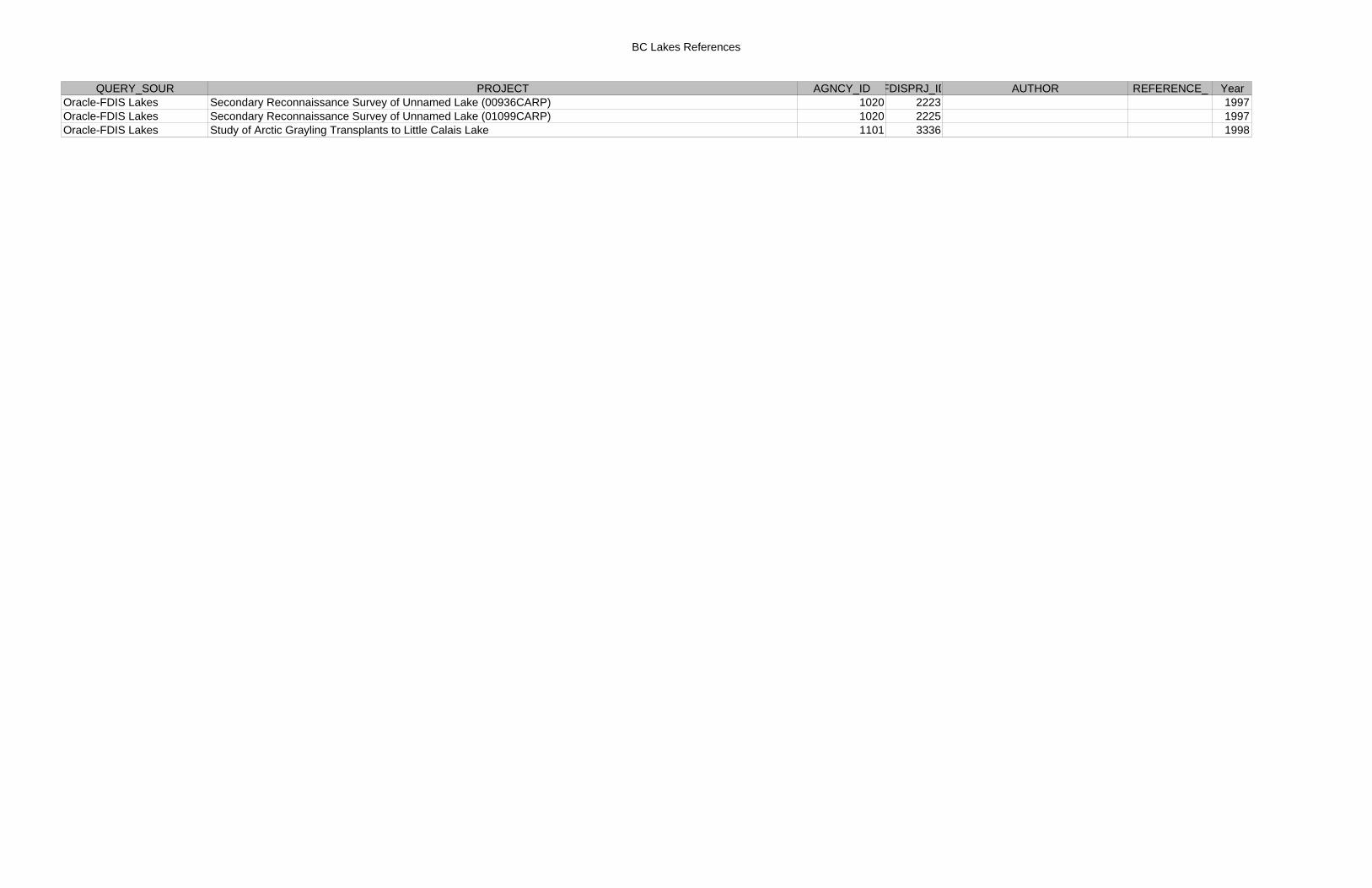
BC Lakes References
QUERY_SOUR PROJECT AGNCY_ID FDISPRJ_ID AUTHOR REFERENCE_ YearOracle-FDIS Lakes Secondary Reconnaissance Survey of Unnamed Lake (00936CARP) 1020 2223 1997Oracle-FDIS Lakes Secondary Reconnaissance Survey of Unnamed Lake (01099CARP) 1020 2225 1997Oracle-FDIS Lakes Study of Arctic Grayling Transplants to Little Calais Lake 1101 3336 1998
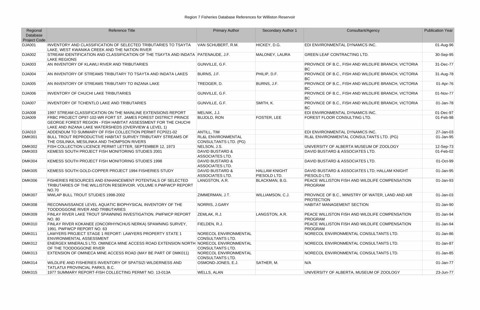
Region 7 Fisheries Database References for Williston Reservoir
Regional Database
Project Code
Reference Title Primary Author Secondary Author 1 Consultant/Agency Publication Year
DJA001 INVENTORY AND CLASSIFICATION OF SELECTED TRIBUTARIES TO TSAYTA LAKE, WEST KWANIKA CREEK AND THE NATION RIVER
VAN SCHUBERT, R.M. HICKEY, D.G. EDI ENVIRONMENTAL DYNAMICS INC. 01-Aug-96
DJA002 STREAM IDENTIFICATION AND CLASSIFICATION OF THE TSAYTA AND INDATA LAKE REGIONS
PATENAUDE, J.F. MALONEY, LAURA GREEN LEAF CONTRACTING LTD. 30-Sep-95
DJA003 AN INVENTORY OF KLAWLI RIVER AND TRIBUTARIES GUNVILLE, G.F. PROVINCE OF B.C., FISH AND WILDLIFE BRANCH, VICTORIA BC
31-Dec-77
DJA004 AN INVENTORY OF STREAMS TRIBUTARY TO TSAYTA AND INDATA LAKES BURNS, J.F. PHILIP, D.F. PROVINCE OF B.C., FISH AND WILDLIFE BRANCH, VICTORIA BC
31-Aug-78
DJA005 AN INVENTORY OF STREAMS TRIBUTARY TO INZANA LAKE TREDGER, D. BURNS, J.F. PROVINCE OF B.C., FISH AND WILDLIFE BRANCH, VICTORIA BC
01-Apr-76
DJA006 INVENTORY OF CHUCHI LAKE TRIBUTARIES GUNVILLE, G.F. PROVINCE OF B.C., FISH AND WILDLIFE BRANCH, VICTORIA BC
01-Nov-77
DJA007 INVENTORY OF TCHENTLO LAKE AND TRIBUTARIES GUNVILLE, G.F. SMITH, K. PROVINCE OF B.C., FISH AND WILDLIFE BRANCH, VICTORIA BC
01-Jan-78
DJA008 1997 STREAM CLASSIFICATION ON THE MAINLINE EXTENSIONS REPORT MELNIK, J.J. EDI ENVIRONMENTAL DYNAMICS INC. 01-Dec-97DJA009 FRBC PROJECT OP97-102-WR FORT ST. JAMES FOREST DISTRICT PRINCE
GEORGE FOREST REGION - FISH HABITAT ASSESSMENT FOR THE CHUCHI LAKE AND INZANA LAKE WATERSHEDS (OVERVIEW & LEVEL 1)
BUJOLD, RON FOSTER, LEE FOREST FLOOR CONSULTING LTD. 01-Feb-98
DJA010 ADDENDUM TO SUMMARY OF FISH COLLECTION PERMIT FCP021-02 ANTILL, TIM EDI ENVIRONMENTAL DYNAMICS INC. 27-Jan-03DMK001 BULL TROUT REPRODUCTIVE HABITAT SURVEY:TRIBUTARY STREAMS OF
THE OSILINKA, MESILINKA AND THOMPSON RIVERSRL&L ENVIRONMENTAL CONSULTANTS LTD. (PG)
RL&L ENVIRONMENTAL CONSULTANTS LTD. (PG) 01-Jan-95
DMK002 FISH COLLECTION LICENCE PERMIT LETTER, SEPTEMBER 12, 1973 NELSON, J.S. UNIVERSITY OF ALBERTA MUSEUM OF ZOOLOGY 12-Sep-73DMK003 KEMESS SOUTH PROJECT FISH MONITORING STUDIES 2001 DAVID BUSTARD &
ASSOCIATES LTD.DAVID BUSTARD & ASSOCIATES LTD. 01-Feb-02
DMK004 KEMESS SOUTH PROJECT FISH MONITORING STUDIES 1998 DAVID BUSTARD & ASSOCIATES LTD.
DAVID BUSTARD & ASSOCIATES LTD. 01-Oct-99
DMK005 KEMESS SOUTH GOLD-COPPER PROJECT 1994 FISHERIES STUDY DAVID BUSTARD & ASSOCIATES LTD.
HALLAM KNIGHT PIESOLD LTD.
DAVID BUSTARD & ASSOCIATES LTD; HALLAM KNIGHT PIESOLD LTD.
01-Jan-95
DMK006 FISHERIES RESOURCES AND ENHANCEMENT POTENTIALS OF SELECTED TRIBUTARIES OF THE WILLISTON RESERVOIR. VOLUME II.PWFWCP REPORT NO.70
LANGSTON, A.R. BLACKMAN, B.G. PEACE WILLISTON FISH AND WILDLIFE COMPENSATION PROGRAM
01-Jan-93
DMK007 MWLAP BULL TROUT STUDIES 1998-2002 ZIMMERMAN, J.T. WILLIAMSON, C.J. PROVINCE OF B.C., MINISTRY OF WATER, LAND AND AIR PROTECTION
01-Jan-03
DMK008 RECONNAISSANCE LEVEL AQUATIC BIOPHYSICAL INVENTORY OF THE TOODOGGONE RIVER AND TRIBUTARIES
NORRIS, J.GARY HABITAT MANAGEMENT SECTION 01-Jan-90
DMK009 FINLAY RIVER LAKE TROUT SPAWNING INVESTIGATION. PWFWCP REPORT NO. 80
ZEMLAK, R.J. LANGSTON, A.R. PEACE WILLISTON FISH AND WILDLIFE COMPENSATION PROGRAM
01-Jan-94
DMK010 FINLAY RIVER KOKANEE (ONCORHYNCHUS NERKA) SPAWNING SURVEY, 1991. PWFWCP REPORT NO. 63
FIELDEN, R.J. PEACE WILLISTON FISH AND WILDLIFE COMPENSATION PROGRAM
01-Jan-94
DMK011 LAWYERS PROJECT STAGE 1 REPORT: LAWYERS PROPERTY STATE 1 ENVIRONMENTAL ASSESSMENT
NORECOL ENVIRONMENTAL CONSULTANTS LTD.
NORECOL ENVIRONMENTAL CONSULTANTS LTD. 01-Jan-86
DMK012 ENERGEX MINERALS LTD. OMINECA MINE ACCESS ROAD EXTENSION NORTH OF THE TOODOGGONE RIVER
NORECOL ENVIRONMENTAL CONSULTANTS LTD.
NORECOL ENVIRONMENTAL CONSULTANTS LTD. 01-Jan-87
DMK013 EXTENSION OF OMINECA MINE ACCESS ROAD (MAY BE PART OF DMK011) NORECOL ENVIRONMENTAL CONSULTANTS LTD.
NORECOL ENVIRONMENTAL CONSULTANTS LTD. 01-Jan-85
DMK014 WILDLIFE AND FISHERIES INVENTORY OF SPATSIZI WILDERNESS AND TATLATUI PROVINCIAL PARKS, B.C.
OSMOND-JONES, E.J. SATHER, M. N/A 01-Jan-77
DMK015 1977 SUMMARY REPORT-FISH COLLECTING PERMIT NO. 13-013A WELLS, ALAN UNIVERSITY OF ALBERTA, MUSEUM OF ZOOLOGY 23-Jun-77
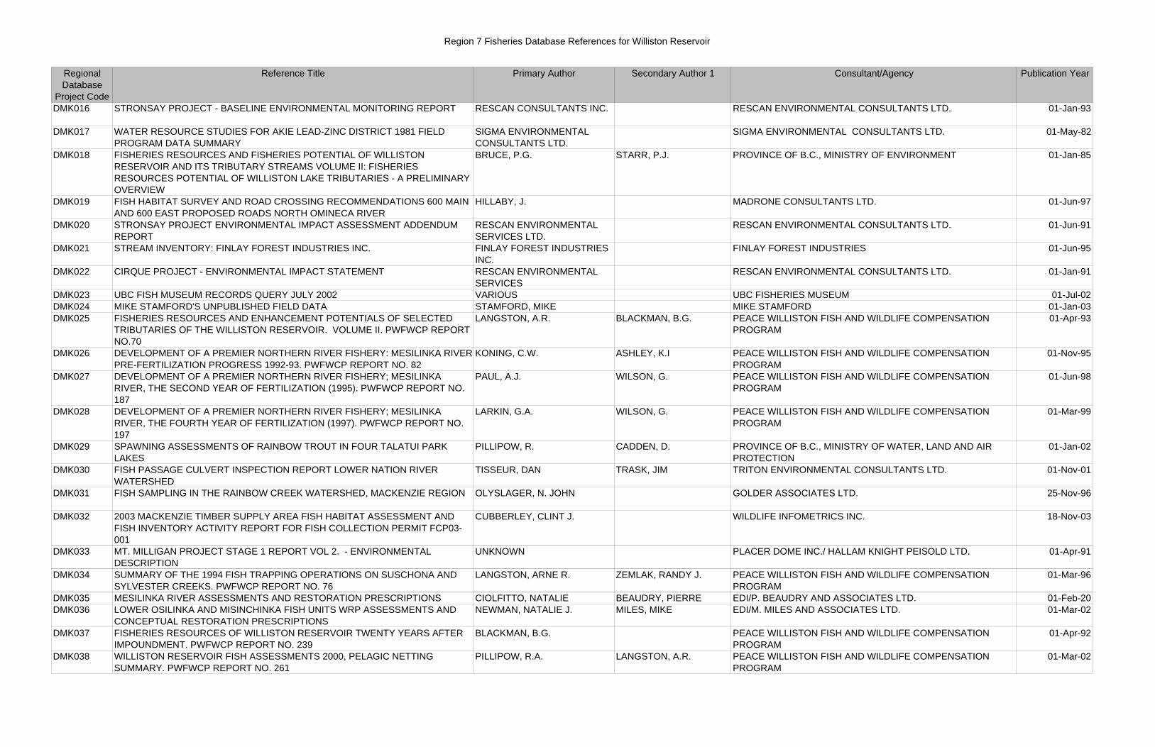
Region 7 Fisheries Database References for Williston Reservoir
Regional Database
Project Code
Reference Title Primary Author Secondary Author 1 Consultant/Agency Publication Year
DMK016 STRONSAY PROJECT - BASELINE ENVIRONMENTAL MONITORING REPORT RESCAN CONSULTANTS INC. RESCAN ENVIRONMENTAL CONSULTANTS LTD. 01-Jan-93
DMK017 WATER RESOURCE STUDIES FOR AKIE LEAD-ZINC DISTRICT 1981 FIELD PROGRAM DATA SUMMARY
SIGMA ENVIRONMENTAL CONSULTANTS LTD.
SIGMA ENVIRONMENTAL CONSULTANTS LTD. 01-May-82
DMK018 FISHERIES RESOURCES AND FISHERIES POTENTIAL OF WILLISTON RESERVOIR AND ITS TRIBUTARY STREAMS VOLUME II: FISHERIES RESOURCES POTENTIAL OF WILLISTON LAKE TRIBUTARIES - A PRELIMINARY OVERVIEW
BRUCE, P.G. STARR, P.J. PROVINCE OF B.C., MINISTRY OF ENVIRONMENT 01-Jan-85
DMK019 FISH HABITAT SURVEY AND ROAD CROSSING RECOMMENDATIONS 600 MAIN AND 600 EAST PROPOSED ROADS NORTH OMINECA RIVER
HILLABY, J. MADRONE CONSULTANTS LTD. 01-Jun-97
DMK020 STRONSAY PROJECT ENVIRONMENTAL IMPACT ASSESSMENT ADDENDUM REPORT
RESCAN ENVIRONMENTAL SERVICES LTD.
RESCAN ENVIRONMENTAL CONSULTANTS LTD. 01-Jun-91
DMK021 STREAM INVENTORY: FINLAY FOREST INDUSTRIES INC. FINLAY FOREST INDUSTRIES INC.
FINLAY FOREST INDUSTRIES 01-Jun-95
DMK022 CIRQUE PROJECT - ENVIRONMENTAL IMPACT STATEMENT RESCAN ENVIRONMENTAL SERVICES
RESCAN ENVIRONMENTAL CONSULTANTS LTD. 01-Jan-91
DMK023 UBC FISH MUSEUM RECORDS QUERY JULY 2002 VARIOUS UBC FISHERIES MUSEUM 01-Jul-02DMK024 MIKE STAMFORD'S UNPUBLISHED FIELD DATA STAMFORD, MIKE MIKE STAMFORD 01-Jan-03DMK025 FISHERIES RESOURCES AND ENHANCEMENT POTENTIALS OF SELECTED
TRIBUTARIES OF THE WILLISTON RESERVOIR. VOLUME II. PWFWCP REPORT NO.70
LANGSTON, A.R. BLACKMAN, B.G. PEACE WILLISTON FISH AND WILDLIFE COMPENSATION PROGRAM
01-Apr-93
DMK026 DEVELOPMENT OF A PREMIER NORTHERN RIVER FISHERY: MESILINKA RIVER PRE-FERTILIZATION PROGRESS 1992-93. PWFWCP REPORT NO. 82
KONING, C.W. ASHLEY, K.I PEACE WILLISTON FISH AND WILDLIFE COMPENSATION PROGRAM
01-Nov-95
DMK027 DEVELOPMENT OF A PREMIER NORTHERN RIVER FISHERY; MESILINKA RIVER, THE SECOND YEAR OF FERTILIZATION (1995). PWFWCP REPORT NO. 187
PAUL, A.J. WILSON, G. PEACE WILLISTON FISH AND WILDLIFE COMPENSATION PROGRAM
01-Jun-98
DMK028 DEVELOPMENT OF A PREMIER NORTHERN RIVER FISHERY; MESILINKA RIVER, THE FOURTH YEAR OF FERTILIZATION (1997). PWFWCP REPORT NO. 197
LARKIN, G.A. WILSON, G. PEACE WILLISTON FISH AND WILDLIFE COMPENSATION PROGRAM
01-Mar-99
DMK029 SPAWNING ASSESSMENTS OF RAINBOW TROUT IN FOUR TALATUI PARK LAKES
PILLIPOW, R. CADDEN, D. PROVINCE OF B.C., MINISTRY OF WATER, LAND AND AIR PROTECTION
01-Jan-02
DMK030 FISH PASSAGE CULVERT INSPECTION REPORT LOWER NATION RIVER WATERSHED
TISSEUR, DAN TRASK, JIM TRITON ENVIRONMENTAL CONSULTANTS LTD. 01-Nov-01
DMK031 FISH SAMPLING IN THE RAINBOW CREEK WATERSHED, MACKENZIE REGION OLYSLAGER, N. JOHN GOLDER ASSOCIATES LTD. 25-Nov-96
DMK032 2003 MACKENZIE TIMBER SUPPLY AREA FISH HABITAT ASSESSMENT AND FISH INVENTORY ACTIVITY REPORT FOR FISH COLLECTION PERMIT FCP03-001
CUBBERLEY, CLINT J. WILDLIFE INFOMETRICS INC. 18-Nov-03
DMK033 MT. MILLIGAN PROJECT STAGE 1 REPORT VOL 2. - ENVIRONMENTAL DESCRIPTION
UNKNOWN PLACER DOME INC./ HALLAM KNIGHT PEISOLD LTD. 01-Apr-91
DMK034 SUMMARY OF THE 1994 FISH TRAPPING OPERATIONS ON SUSCHONA AND SYLVESTER CREEKS. PWFWCP REPORT NO. 76
LANGSTON, ARNE R. ZEMLAK, RANDY J. PEACE WILLISTON FISH AND WILDLIFE COMPENSATION PROGRAM
01-Mar-96
DMK035 MESILINKA RIVER ASSESSMENTS AND RESTORATION PRESCRIPTIONS CIOLFITTO, NATALIE BEAUDRY, PIERRE EDI/P. BEAUDRY AND ASSOCIATES LTD. 01-Feb-20DMK036 LOWER OSILINKA AND MISINCHINKA FISH UNITS WRP ASSESSMENTS AND
CONCEPTUAL RESTORATION PRESCRIPTIONSNEWMAN, NATALIE J. MILES, MIKE EDI/M. MILES AND ASSOCIATES LTD. 01-Mar-02
DMK037 FISHERIES RESOURCES OF WILLISTON RESERVOIR TWENTY YEARS AFTER IMPOUNDMENT. PWFWCP REPORT NO. 239
BLACKMAN, B.G. PEACE WILLISTON FISH AND WILDLIFE COMPENSATION PROGRAM
01-Apr-92
DMK038 WILLISTON RESERVOIR FISH ASSESSMENTS 2000, PELAGIC NETTING SUMMARY. PWFWCP REPORT NO. 261
PILLIPOW, R.A. LANGSTON, A.R. PEACE WILLISTON FISH AND WILDLIFE COMPENSATION PROGRAM
01-Mar-02
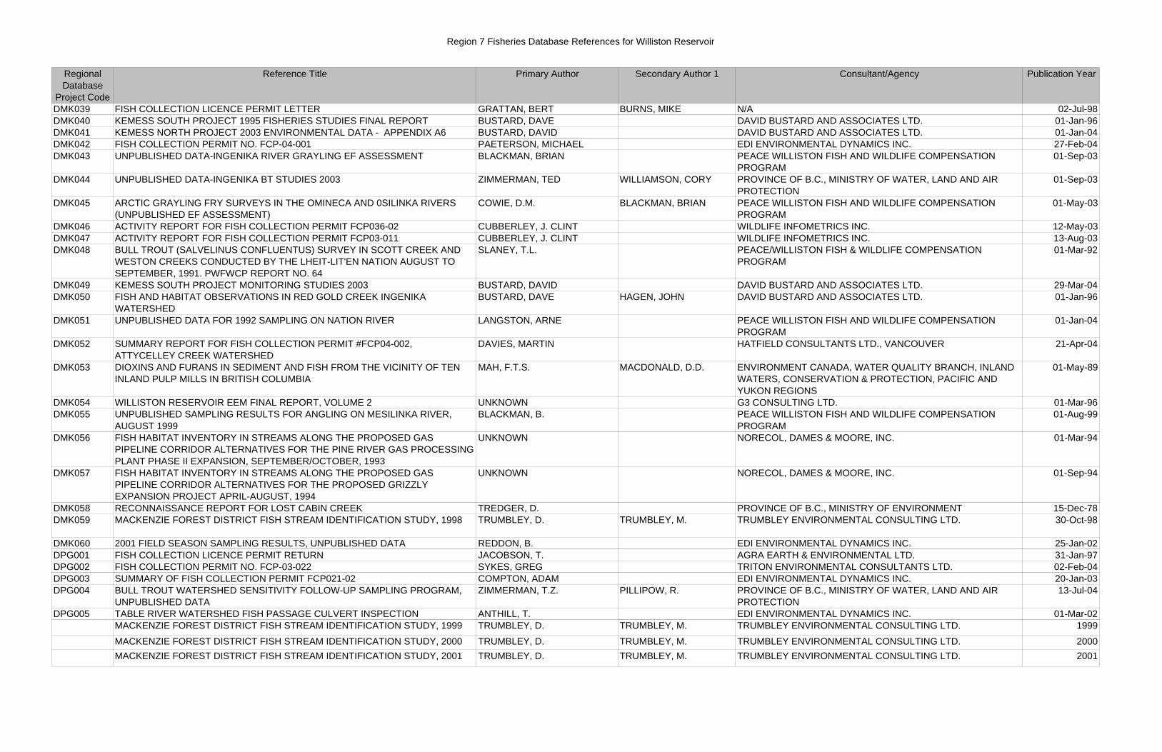
Region 7 Fisheries Database References for Williston Reservoir
Regional Database
Project Code
Reference Title Primary Author Secondary Author 1 Consultant/Agency Publication Year
DMK039 FISH COLLECTION LICENCE PERMIT LETTER GRATTAN, BERT BURNS, MIKE N/A 02-Jul-98DMK040 KEMESS SOUTH PROJECT 1995 FISHERIES STUDIES FINAL REPORT BUSTARD, DAVE DAVID BUSTARD AND ASSOCIATES LTD. 01-Jan-96DMK041 KEMESS NORTH PROJECT 2003 ENVIRONMENTAL DATA - APPENDIX A6 BUSTARD, DAVID DAVID BUSTARD AND ASSOCIATES LTD. 01-Jan-04DMK042 FISH COLLECTION PERMIT NO. FCP-04-001 PAETERSON, MICHAEL EDI ENVIRONMENTAL DYNAMICS INC. 27-Feb-04DMK043 UNPUBLISHED DATA-INGENIKA RIVER GRAYLING EF ASSESSMENT BLACKMAN, BRIAN PEACE WILLISTON FISH AND WILDLIFE COMPENSATION
PROGRAM01-Sep-03
DMK044 UNPUBLISHED DATA-INGENIKA BT STUDIES 2003 ZIMMERMAN, TED WILLIAMSON, CORY PROVINCE OF B.C., MINISTRY OF WATER, LAND AND AIR PROTECTION
01-Sep-03
DMK045 ARCTIC GRAYLING FRY SURVEYS IN THE OMINECA AND 0SILINKA RIVERS (UNPUBLISHED EF ASSESSMENT)
COWIE, D.M. BLACKMAN, BRIAN PEACE WILLISTON FISH AND WILDLIFE COMPENSATION PROGRAM
01-May-03
DMK046 ACTIVITY REPORT FOR FISH COLLECTION PERMIT FCP036-02 CUBBERLEY, J. CLINT WILDLIFE INFOMETRICS INC. 12-May-03DMK047 ACTIVITY REPORT FOR FISH COLLECTION PERMIT FCP03-011 CUBBERLEY, J. CLINT WILDLIFE INFOMETRICS INC. 13-Aug-03DMK048 BULL TROUT (SALVELINUS CONFLUENTUS) SURVEY IN SCOTT CREEK AND
WESTON CREEKS CONDUCTED BY THE LHEIT-LIT'EN NATION AUGUST TO SEPTEMBER, 1991. PWFWCP REPORT NO. 64
SLANEY, T.L. PEACE/WILLISTON FISH & WILDLIFE COMPENSATION PROGRAM
01-Mar-92
DMK049 KEMESS SOUTH PROJECT MONITORING STUDIES 2003 BUSTARD, DAVID DAVID BUSTARD AND ASSOCIATES LTD. 29-Mar-04DMK050 FISH AND HABITAT OBSERVATIONS IN RED GOLD CREEK INGENIKA
WATERSHEDBUSTARD, DAVE HAGEN, JOHN DAVID BUSTARD AND ASSOCIATES LTD. 01-Jan-96
DMK051 UNPUBLISHED DATA FOR 1992 SAMPLING ON NATION RIVER LANGSTON, ARNE PEACE WILLISTON FISH AND WILDLIFE COMPENSATION PROGRAM
01-Jan-04
DMK052 SUMMARY REPORT FOR FISH COLLECTION PERMIT #FCP04-002, ATTYCELLEY CREEK WATERSHED
DAVIES, MARTIN HATFIELD CONSULTANTS LTD., VANCOUVER 21-Apr-04
DMK053 DIOXINS AND FURANS IN SEDIMENT AND FISH FROM THE VICINITY OF TEN INLAND PULP MILLS IN BRITISH COLUMBIA
MAH, F.T.S. MACDONALD, D.D. ENVIRONMENT CANADA, WATER QUALITY BRANCH, INLAND WATERS, CONSERVATION & PROTECTION, PACIFIC AND YUKON REGIONS
01-May-89
DMK054 WILLISTON RESERVOIR EEM FINAL REPORT, VOLUME 2 UNKNOWN G3 CONSULTING LTD. 01-Mar-96DMK055 UNPUBLISHED SAMPLING RESULTS FOR ANGLING ON MESILINKA RIVER,
AUGUST 1999BLACKMAN, B. PEACE WILLISTON FISH AND WILDLIFE COMPENSATION
PROGRAM01-Aug-99
DMK056 FISH HABITAT INVENTORY IN STREAMS ALONG THE PROPOSED GAS PIPELINE CORRIDOR ALTERNATIVES FOR THE PINE RIVER GAS PROCESSING PLANT PHASE II EXPANSION, SEPTEMBER/OCTOBER, 1993
UNKNOWN NORECOL, DAMES & MOORE, INC. 01-Mar-94
DMK057 FISH HABITAT INVENTORY IN STREAMS ALONG THE PROPOSED GAS PIPELINE CORRIDOR ALTERNATIVES FOR THE PROPOSED GRIZZLY EXPANSION PROJECT APRIL-AUGUST, 1994
UNKNOWN NORECOL, DAMES & MOORE, INC. 01-Sep-94
DMK058 RECONNAISSANCE REPORT FOR LOST CABIN CREEK TREDGER, D. PROVINCE OF B.C., MINISTRY OF ENVIRONMENT 15-Dec-78DMK059 MACKENZIE FOREST DISTRICT FISH STREAM IDENTIFICATION STUDY, 1998 TRUMBLEY, D. TRUMBLEY, M. TRUMBLEY ENVIRONMENTAL CONSULTING LTD. 30-Oct-98
DMK060 2001 FIELD SEASON SAMPLING RESULTS, UNPUBLISHED DATA REDDON, B. EDI ENVIRONMENTAL DYNAMICS INC. 25-Jan-02DPG001 FISH COLLECTION LICENCE PERMIT RETURN JACOBSON, T. AGRA EARTH & ENVIRONMENTAL LTD. 31-Jan-97DPG002 FISH COLLECTION PERMIT NO. FCP-03-022 SYKES, GREG TRITON ENVIRONMENTAL CONSULTANTS LTD. 02-Feb-04DPG003 SUMMARY OF FISH COLLECTION PERMIT FCP021-02 COMPTON, ADAM EDI ENVIRONMENTAL DYNAMICS INC. 20-Jan-03DPG004 BULL TROUT WATERSHED SENSITIVITY FOLLOW-UP SAMPLING PROGRAM,
UNPUBLISHED DATAZIMMERMAN, T.Z. PILLIPOW, R. PROVINCE OF B.C., MINISTRY OF WATER, LAND AND AIR
PROTECTION13-Jul-04
DPG005 TABLE RIVER WATERSHED FISH PASSAGE CULVERT INSPECTION ANTHILL, T. EDI ENVIRONMENTAL DYNAMICS INC. 01-Mar-02MACKENZIE FOREST DISTRICT FISH STREAM IDENTIFICATION STUDY, 1999 TRUMBLEY, D. TRUMBLEY, M. TRUMBLEY ENVIRONMENTAL CONSULTING LTD. 1999
MACKENZIE FOREST DISTRICT FISH STREAM IDENTIFICATION STUDY, 2000 TRUMBLEY, D. TRUMBLEY, M. TRUMBLEY ENVIRONMENTAL CONSULTING LTD. 2000MACKENZIE FOREST DISTRICT FISH STREAM IDENTIFICATION STUDY, 2001 TRUMBLEY, D. TRUMBLEY, M. TRUMBLEY ENVIRONMENTAL CONSULTING LTD. 2001
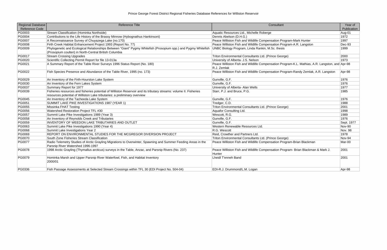
Prince George Forest District Regional Fisheries Database References for Williston Reservoir
Regional Database Reference Code
Reference Title Consultant Year of Publication
PG0003 Stream Classification (Hominka Northside) Aquatic Resources Ltd., Michelle Roberge Aug-01PG0004 Contributions to the Life History of the Brassy Minnow (Hybognathus Hankinsoni) Dennis Abelson (D.H.G.) 1972PG0007 A Reconnaissance Survey of Chuyazega Lake (no.170) Peace Williston Fish and Wildlife Compensation Program-Mark Hunter 1997PG0008 Firth Creek Habitat Enhancement Project 1993 (Report No. 77) Peace Williston Fish and Wildlife Compensation Program-A.R. Langston Dec-93PG0009 Phylogenetic and Ecological Relationships Between “Giant” Pygmy Whitefish (Prosopium spp.) and Pygmy Whitefish
(Prosopium coulteri) in North-Central British ColumbiaUNBC Biology Program, Linda Rankin, M.Sc. thesis 1999
PG0017 Stream Crossing Upgrades Triton Environmental Consultants Ltd. (Prince George) 2000PG0020 Scientific Collecting Permit Report for file 13-013a University of Alberta- J.S. Nelson 1973PG0021 A Summary Report of the Table River Surveys 1996 Status Report (No. 180) Peace Williston Fish and Wildlife Compensation Program-K.L. Mathias, A.R. Langston, and
R.J. ZemlakApr-98
PG0022 Fish Species Presence and Abundance of the Table River, 1995 (no. 173) Peace Williston Fish and Wildlife Compensation Program-Randy Zemlak, A.R. Langston Apr-98
PG0029 An Inventory of the Firth-Hourston Lake System Gunville, G.F. 1976PG0030 An Inventory of the Fern Lakes System Gunville, G.F. 1976PG0037 Summary Report for 1977 University of Alberta- Alan Wells 1977PG0039 Fisheries resources and fisheries potential of Williston Reservoir and its tributary streams: volume II. Fisheries
resources potential of Williston Lake tributaries: a preliminary overviewStarr, P.J. and Bruce, P.G. 1985
PG0045 An Inventory of the Tacheeda Lake System Gunville, G.F. 1976PG0051 SUMMIT LAKE PIKE INVESTIGATIONS 1987 (YEAR 1) Tredger, C.D. 1988PG0055 Missinka FHAT Testing Triton Environmental Consultants Ltd. (Prince George) 2001PG0056 Watershed Restoration Project TFL #30 Aquafor Consulting Ltd. 1998PG0057 Summit Lake Pike Investigations 1989 (Year 3) Wescott, R.G. 1989PG0058 An Inventory of Reynolds Creek and Tributaries Gunville, G.F. 1976PG0059 INVENTORY OF WEEDON LAKE TRIBUTARIES AND OUTLET Gunville, G.F. Sept. 1977PG0063 Summit Lake Pike Investigations 1990 (Year 4) Western Renewable Resources Ltd. Nov-90PG0068 Summit Lake Investigations Year 2 R.G. Wescott Nov. 98PG0069 REPORT ON ENVIRONMENTAL STUDIES FOR THE MCGREGOR DIVERSION PROJECT Reid, Crowther and Partners Ltd. 1978PG0070 South Zone Fisheries Stream Classification Triton Environmental Consultants Ltd. (Prince George) Nov-94PG0077 Radio Telemetry Studies of Arctic Grayling Migrations to Overwinter, Spawning and Summer Feeding Areas in the
Parsnip River Watershed 1996-1997Peace Williston Fish and Wildlife Compensation Program-Brian Blackman Mar-00
PG0078 1998 Arctic Grayling (Thymallus arcticus) surveys in the Table, Anzac, and Parsnip Rivers (No. 237) Peace Williston Fish and Wildlife Compensation Program- Brian Blackman & Mark J. Hunter
2001
PG0079 Hominka Marsh and Upper Parsnip River Waterfowl, Fish, and Habitat Inventory2000/01
Lheidl T'enneh Band 2001
PG0336 Fish Passage Assessments at Selected Stream Crossings within TFL 30 (EDI Project No. 504-04) EDI-R.J. Drummond/L.M. Logan Apr-98