Embed Size (px)
Citation preview
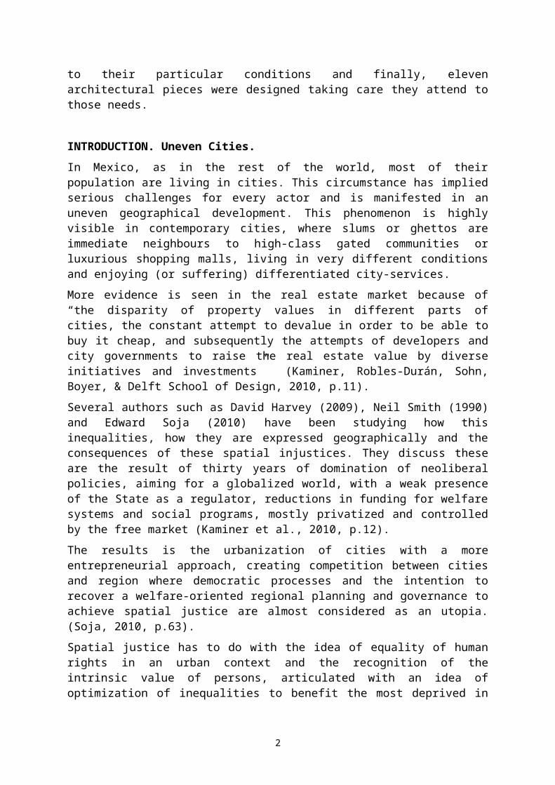
VOCACIONES. From an urban vision to architectural projects.RUBÉN GARNICA MONROY a. AGUSTIN SOLÓRZANO GIL b
a Full-time professor at Tecnológico de Monterrey Campus Querétaro; PhD in Urban and Environmental Studies; [email protected] Architect and Part-time professor at Tecnológico de Monterrey Campus Querétaro; [email protected]
ABSTRACT. In Mexico, as in many other countries, the galloping urban growth has turned a major issue for the authorities, because of their incapability to have responsive urban planning to provide of proper infrastructure and services to the whole population. The results are very uneven cities in terms of both physical and social realms. A couple of questions come to our mind as urban designers: how uneven are the cities in both realms? And, what can we do to overcome those differences?
In order to answer these questions, we decided to focus on San Miguel de Allende –SMA- in Central Mexico. This small town of almost 72 thousand inhabitants (in the urban area) has been growing in a very accelerated but unplanned way relying its economy mostly in tourism (because its downtown is part of UNESCO’s World Heritage sites) as well as being considered as an option to live for retired foreigners.
Looking at the official data, we realized that almost the whole county’s economy depends on just an area that represents 2% of the territory, where 80% of its GDP is produced but only 16% of the population are directly benefited (mostly foreigners, investors and entrepreneurs).
Hence, we decided to intervene the city to generate a more balanced economy (beyond tourism) distributed more evenly in the territory. The interventions would increase the income of the population and create a strong middle-class (actually almost absent).
According to the actual socio-economic conditions, the urban strategy then was to create four districts attending general deficiencies that can provide vitality and a good quality of life to the neighbours. For each district different possible projects (and their potential sites) were identified according to their particular conditions and finally, eleven architectural pieces were designed taking care they attend to those needs.
INTRODUCTION. Uneven Cities.
In Mexico, as in the rest of the world, most of their population are living in cities. This circumstance has implied serious challenges for every actor and is manifested in an uneven geographical development. This phenomenon is highly visible in contemporary cities, where slums or ghettos are immediate neighbours to high-class gated communities or luxurious shopping malls, living in very different conditions and enjoying (or suffering) differentiated city-services.
More evidence is seen in the real estate market because of “the disparity of property values in different parts of cities, the constant attempt to devalue in order to be able to buy it cheap, and subsequently the attempts of developers and city governments to raise the real estate value by diverse initiatives and investments” (Kaminer, Robles-Durán, Sohn, Boyer, & Delft School of Design, 2010, p.11).
Several authors such as David Harvey (2009), Neil Smith (1990) and Edward Soja (2010) have been studying how this inequalities, how they are expressed geographically and the
1
consequences of these spatial injustices. They discuss these are the result of thirty years of domination of neoliberal policies, aiming for a globalized world, with a weak presence of the State as a regulator, reductions in funding for welfare systems and social programs, mostly privatized and controlled by the free market (Kaminer et al., 2010, p.12).
The results is the urbanization of cities with a more entrepreneurial approach, creating competition between cities and region where democratic processes and the intention to recover a welfare-oriented regional planning and governance to achieve spatial justice are almost considered as an utopia. (Soja, 2010, p.63).
Spatial justice has to do with the idea of equality of human rights in an urban context and the recognition of the intrinsic value of persons, articulated with an idea of optimization of inequalities to benefit the most deprived in terms of allocation of goods and assignment of social roles (Spatial Justice Journal, 2009).
Such ideas raise very interesting questions like: How to “translate” them into spatial strategies, urban plans or even architectural projects. How can we engage a society to be part of the whole urban transformation when they are more concerned on earning enough money to live day-by-day? Is the actual urban way-of-thinking really trying to reduce the spatial injustice by promoting the ideas of density, diversity and design? What parameters should be used to any particular case, due to the fact that the experts have not set a common guideline to follow? How can we evaluate or look at the effectiveness of a strategy, plan or building when it implies very long terms to be fully implemented?
The importance of a position and strategy for “Estudio C”
From the point of view of an urban planner and architect, we are part of the problem as well as of the solution. Our position is to think about us as problem-solvers so we constantly question ourselves what can we do to overcome those spatial inequalities instead of widening the gap.
The final year -5th- of design studios1 at the School of Design and Architecture of Tecnológico de Monterrey Campus Queretaro aim to surpass the common idea that architecture is limited by a client’s request or program in an already given site. The studios’ expectations are based on the idea that “architecture has been used in a deliberated way as a media to define relationships of power between individuals, interest groups, cities and even nations... In this post-ideological era, focused mainly on rules set by the market and profit in a global context, is where we will place to explore the relationship between the public domain, power and politics” (Sánchez et al., 2015, p.2).
As part of this dynamic, the work is divided in three phases that discuss and proposes around a particular theme. The first phase is to make a proper diagnose, by an intense analysis of the history, the natural and built environment (urban form, services, infrastructure, transportation, etc.), demographics and social conditions that has given shape to the actual conditions of a society located in a particular territory.
The second phase consists on designing a strategy that could be –partially- achieved with architectural programs and that full-fills the interest of the Studio. This implied to adapt different methodologies that could challenge assumptions and conventions currently predominant by a full revision of some methodologies, “questioning and overturning some of
1 According to the number of students, there are two or three studios with two tutors each, which have different methodologies and points of view to achieve or solve urban and architectural issues.
2
the aspects of thought and action which have dominated the two disciplines for the last decades, beginning with the schism of theory and practice”(Kaminer et al., 2010, p.14)
The third phase looks for visionary architectural thinking, but not forgetting the urban realm, reinforcing the already set strategy. During this phase, the tutors of each studio make emphasis on particular themes concerned with the architectural design (e.g. our studio, Estudio C, focuses en two themes: the different elements that give its character to the space and how to present a project through a clear and self-consistent narrative).
During 2014, there were three studios, being ours the Estudio C with eleven students: Mónica Arrieta, Asela Chávez, Octavio Herrejón, Claudia Hurtado, Getsemaní Leines, Nahim Magos, Alejandra Penagos, Sara Rico, Arturo Rodríguez, Daniela Ulloa and Sebastián Yanchapaxi.
The members of Estudio C understood that an urban problem cannot be solved by a single person and with conventional methodologies. Also, we recognized that the actual common urban vision has been on urbanization or urban development rather than making a city, due to personal and real estate interest and forgetting that the common wealth should be the leading rule.
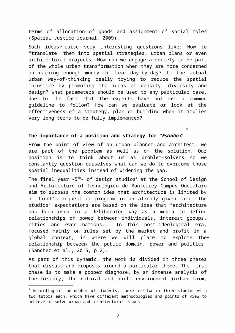
Therefore, we draw a diagram –Figure 1- that could help us understand the way we would be working. It included both the individual and the collective part (dotted lines) and the work to be done: do the analysis to have the big picture (or panorama); create a new vision; propose a social and territorial strategies; and finally, design an architectural proposal (on established areas) that fosters both vision and strategies.
Figure 1. Studio C's working plan.
San Miguel de Allende, our case study.
3
In 2014, Estudio C, as well as the other two studios, decided to work in a well-known town, 30-minutes far from Queretaro: San Miguel de Allende, Guanajuato. The decision was done taking into account two facts: its rampant urbanization2 and its convenient scale or size.
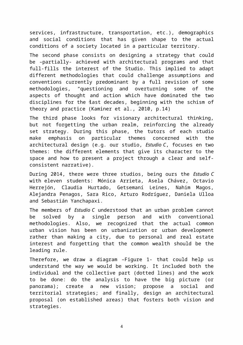
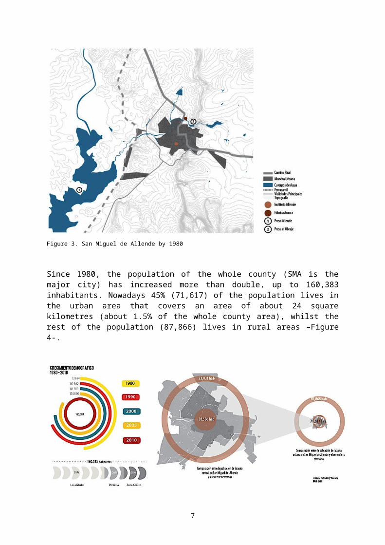
The city of San Miguel de Allende –SMA- was founded on the 16 th Century as part of the “Camino Real” that connected Mexico City with the US enabling the cultural and commerce relationship between both countries –Figure 2-. Since then until the early 20 th Century, the town grew slowly and modestly but with a relevance due to two facts: it worked as a very safe distribution centre for the mining towns located in the north of the country and also appeared into the national map as part of the towns that house the Independence movement (1810-1821).
Figure 2. Camino Real and San Miguel's location
In 1902, near the dam “El Obraje” the textile factory “La Aurora” was opened and became one of the most important sources of employment for the city until it was closed in 1991. In 1938, Felipe Cossio founded the first Beaux Arts school of Latin America in San Miguel and in 1950 a great number of foreigners arrived because the recently opened “Instituto Allende” offered scholarships to study undergraduate and postgraduate studies in arts3.
By 1967, the dam “Ignacio Allende”, was built at the west of SMA to help control the flow of the river “Laja” (the most important of San Miguel and the whole regional basin) and also provides of water to all the farming land of the region.
2 Determined on a high percentage by irregular settlements, but also, in a smaller but more flamboyant proportion, by big real estates for retired foreign people.3 These programs were officially accepted by different universities of the US (Instituto Allende, 2014).
4
Figure 3. San Miguel de Allende by 1980
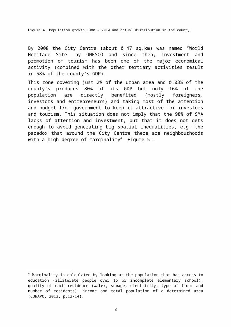
Since 1980, the population of the whole county (SMA is the major city) has increased more than double, up to 160,383 inhabitants. Nowadays 45% (71,617) of the population lives in the urban area that covers an area of about 24 square kilometres (about 1.5% of the whole county area), whilst the rest of the population (87,866) lives in rural areas –Figure 4-.
Figure 4. Population growth 1980 – 2010 and actual distribution in the county.
5
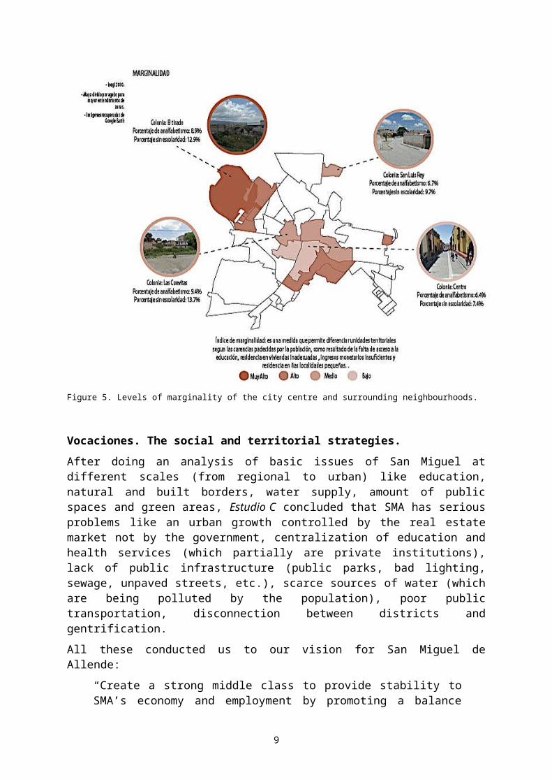
By 2008 the City Centre (about 0.47 sq.km) was named “World Heritage Site” by UNESCO and since then, investment and promotion of tourism has been one of the major economical activity (combined with the other tertiary activities result in 58% of the county’s GDP).
This zone covering just 2% of the urban area and 0.03% of the county’s produces 80% of its GDP but only 16% of the population are directly benefited (mostly foreigners, investors and entrepreneurs) and taking most of the attention and budget from government to keep it attractive for investors and tourism. This situation does not imply that the 98% of SMA lacks of attention and investment, but that it does not gets enough to avoid generating big spatial inequalities, e.g. the paradox that around the City Centre there are neighbourhoods with a high degree of marginality4 -Figure 5-.
Figure 5. Levels of marginality of the city centre and surrounding neighbourhoods.
Vocaciones. The social and territorial strategies.
After doing an analysis of basic issues of San Miguel at different scales (from regional to urban) like education, natural and built borders, water supply, amount of public spaces and green areas, Estudio C concluded that SMA has serious problems like an urban growth controlled by the real estate market not by the government, centralization of education and health services (which partially are private institutions), lack of public infrastructure (public parks, bad lighting, sewage, unpaved streets, etc.), scarce sources of water (which are being
4 Marginality is calculated by looking at the population that has access to education (illiterate people over 15 or incomplete elementary school), quality of each residence (water, sewage, electricity, type of floor and number of residents), income and total population of a determined area (CONAPO, 2013, p.12-14).
6
polluted by the population), poor public transportation, disconnection between districts and gentrification.
All these conducted us to our vision for San Miguel de Allende:
“Create a strong middle class to provide stability to SMA’s economy and employment by promoting a balance between primary, secondary and tertiary sectors; and being an intermediary between the low and the higher classes”.
In urban terms, the goals are to counterpoise centralization and gentrification by the promotion of education and employment for everybody, create high-quality housing for everyone and have a planned urban growth, according to the real needs of the population and taking advantage of the territory. All these will be achieved by creating a precisely defined –in borders and activities-, well-connected and full-provided –housing, parks, education and health services, etc.-polycentric San Miguel de Allende, based on the compacity, complexity and continuity principles (Rueda, 2012)within a set lapse of time of 30 years5 -Figure 6-.
Figure 6. Principles, sectors and actions to be done for the following thirty years.
The criteria to locate and define its aptitude for these new centralities took into account the following factors: the urban growth tendency (direction), but limited by the SMA Urban Plan for 2030 published by the authorities, the non-existence of any natural or built border (e.g. a river, dam, railroad tracks, etc.), its connectivity, the distance to the city centre, the demographic tendencies, the presence (or absence) of urban services and the land availability and land-use plans.
With all these factors in mind, Estudio C proposed 4 polygons or district with a very defined aptitude (Vocación in Spanish) –Figure 7-. Each design team was asked to envision their districts as it could be by 2045 therefore, in some cases they had to design the urban fabric or create strategies to densify the area by including housing, with diverse typologies, as the basis of success.
5 Because we know that not everything can be done at the same time, the actions or projects were organized according to the urgency or priorities of the city, first to inform the population and begin densification, then education and some city services. After these, the promotion of industries / employment, keep on with city services and rural and urban housing; finally, innovation, culture, production of the green energy and preserve the natural environment.
7
The northern district –number 1 in Figure 7- will be the one in charge of the general and specialized health services focusing in prevention, promotion of physical health and professional training; because of its bad connectivity with the rest of the city.
The Housing & Farming district -2- is proposed as the “threshold” between the urban and the rural environments. It will promote the production and consumption of local agricultural products as well as spaces for training or improving the way sustainable agriculture should be done. In this case, a new urban fabric and regulations had to be designed gradually and in a gradient where the densest areas are near the already built areas, whereas the lowest density will be located near the rural areas.
Figure 7. Location of the four new districts according to its aptitude (Vocación): 1. Prevention & Health; 2. Housing & Farming; 3. Agriculture & Environment; 4. Neighbourhood renovation
District number 3, Agriculture & Environment, takes advantage of the existence of the highway and railway that connects SMA with the main cities of the State of Guanajuato and the rest of the country, as well as the closeness to the main dam “Ignacio Allende” and the availability of farmland. The district will be focused on urban farming with a R&D institute, recycling industries, clean-energy production and green housing.
The closest district to the city centre will be the one focused on neighbourhood renovation -#4-. The plan here is to provide of high-quality public spaces (buildings, parks, plazas and streets) that foster social interaction for the people living in the new vertical housing and the refurbished buildings.
8
The next step was to determine which of the broad spectrum of possible projects for SMA would be the best to boost each district. A matrix was built with one axis listing the potential architectural projects (clustered in categories according to the activity or program) as well as the distance from the city centre and on the second axis are the four new districts. Then, the necessities for each district were identified and marked according to their relevance –Figure 8-.
Figure 8. Example of a matrix relating the potential architectural programs and their distance from the city centre and the District where these could help to boost their liveability.
Finally, each member of the studio chose a project to design in two months. The eleven architectural pieces proposed for San Miguel de Allende were designed attending the physical features of the site (weather and topography), connectivity with the neighbourhood and the other districts and the city centre, a full architectural program6, low-tech criteria for energy-saving (crossed-ventilation, water cropping, sun-light control, flora of the region, etc.). The results –Figure 9- are contemporary buildings that look to go beyond the functional issues and look to shorten the urban inequalities by the provision of a necessary service to the community as well as a beautiful building that can give a sense of self-respect to the inhabitants.
6 This part is done by looking at similar buildings to understand their programs, i.e. what should be included and what can be integrated as a complement. Also it helps to understand spatiality of the project in two ways: the first has to do with the direct spatial relationship that each space has with the rest of the program, whilst the second has to do with the location and dimensions of the space within the building and its materiality, which gives its particularity and character.
9
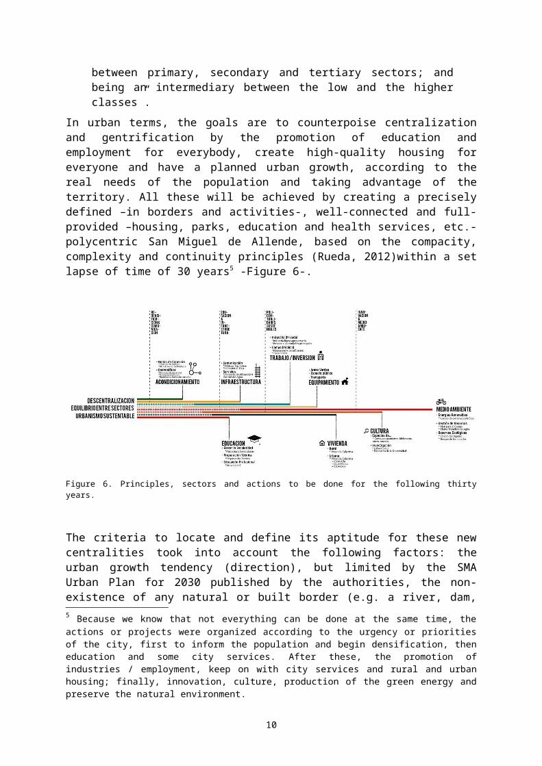
Figure 9. Six example of architectural proposals (from upper left, clockwise): NGOs and Government Office + Public Library (Octavio Herrejón), Farmers market (Mónica Arrieta), Rehab Centre (Arturo Rodríguez), Nursing + Psychology + Physiotherapy School (Daniela Ulloa), R&D Institute focused on Green Construction Materials (Asela Chávez) and Agricultural Laboratories and Experimental Fields (Sebastian Yachapaxi).
Final thoughts.
Vocaciones has been an excellent opportunity to explore not just the studio’s ideas and interests around the relationships of power manifested in the cities but also to discuss the possibilities to have more even cities.
What we first realized is that, even when observing the most radical or avant-garde urban design methodologies and guidelines, there will always be spatial injustices and distributional inequalities, which will affect in a smaller or larger proportion, not just the population but also the whole and their territory they live in. As Soja (2010, p.72) affirms “location in space will always have attached to it some degree of relative advantage of disadvantage”.
10
Therefore, we focused our efforts and creativity to generate positive effects on San Miguel de Allende by creating “propulsive growth poles in relatively backward areas” (Soja, 2010, p.65) as well as building whose aim is to bridge architectural and social divides in a very polarized city such as San Miguel de Allende
ReferencesCONAPO, 2013. Índice absoluto de marginación. Retrieved from:
http://www.conapo.gob.mx/es/CONAPO/Indice_Absoluto_de_Marginacion_2000_2010Instituto Allende, 2014. Acerca del Instituto. Retrieved from: http://instituto-allende.edu.mx/acerca-
del-instituto/Harvey, D. (2009). Social justice and the city (Rev ed.). Athens: University of Georgia Press.Sánchez et al., 2015. Polis. Syllabus Proyectos Integradores II. ITESM Campus Querétaro Escuela de
ArquitecturaKaminer, T., Robles-Durán, M., Sohn, H., Boyer, M. C., & Delft School of Design. (2010). Urban as-
ymmetries: studies and projects on neoliberal urbanization. Rotterdam: 010 Publishers.Smith, N. (1990). Uneven development nature, capital, and the production of space. Oxford: Basil
Blackwell.Rueda, S. (2012). El urbanismo ecológico: su aplicación en el diseño de un ecobarrio en Figueres.
Barcelona: Agencia de Ecología Urbana de Barcelona.Spatial Justice Journal, 2009. Who’s who? Retrieved from: http://www.jssj.org/qui-sommes-nous/Soja, E. W. (2010). Seeking spatial justice. U of Minnesota Press.
11