Embed Size (px)
Citation preview

Leaders-5 Mid Term Review
REDEVELOPMENT PLAN FOR STATION AREA
INTEGRATING LAND USE AND MOBILITY: A CASE STUDY
OF TAMBARAM STATION
Mentor : Mr.Ajay Kumar, Independent Consultant, World Bank N.S.Periyaswamy V.Kumar

Leaders-5 Mid Term Review
OBJECTIVE
To enhance pedestrian and bicycle access and connectivity in and around Sub Urban Rail Station
To enhance accessibility and dispersal by identifying deficiencies and conflicts and provide access between different modes particularly public transport modes at the station;
To propose feeder network connectivity
To Improve Parking Facilities; and
To prepare Redevelopment Plan to enhance Multi Modal Integration for the Study Area which will have mixed land use with enhanced FSI complying with Development norms

STUDY AREA - TAMBARAM
• Tambaram - Gateway to Chennai from Southern parts of Tamilnadu.
• Acts as a major urban node for the neighbouring villages.
• It has potential for future growth and development.
• Presently developed with low-rise and low density.
• Governed by Tambaram Municipality

Leaders-5 Mid Term Review
DEMOGRAPHY AND SOCIAL CHARACTERISTICS
The population of Tambaram As per 2011 census: Eastern Side = 73,086 Western Side =90955 Total = 1,64,011 Proj. popln. For the year 2026 (as per SMP) East -= 1,24,787 West = 2,02,400 Total = 32,7,187 The density at present is vey low Most of the residents in the study area are Middle-Income Group engaged in
secondary and tertiary sectors

STUDY AREA – road connectivity
• Major station in the Chennai Beach – Chengalpattu – Kanchipuram Sub-urban corridor.
• Well connected by Roads i.e. NH-45 (GST Road). Tambaram – Velachery Road (Major Dist. Road), Tambaram – Kancheepuram Road, etc.
• Chennai Bye Pass from Tambaram linking all NHs (NH 45, NH 4 (Bengaluru), NH 205 (Tirupathi,) and NH 5 (Kolkata)
• Radial road from Pallavaram connects IT corridor
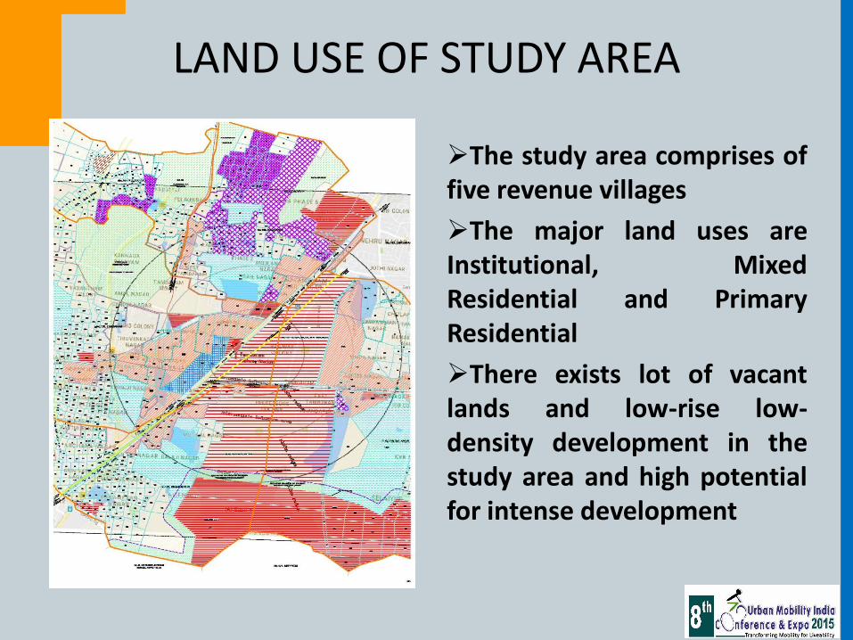
LAND USE OF STUDY AREA
The study area comprises of five revenue villages
The major land uses are Institutional, Mixed Residential and Primary Residential
There exists lot of vacant lands and low-rise low-density development in the study area and high potential for intense development

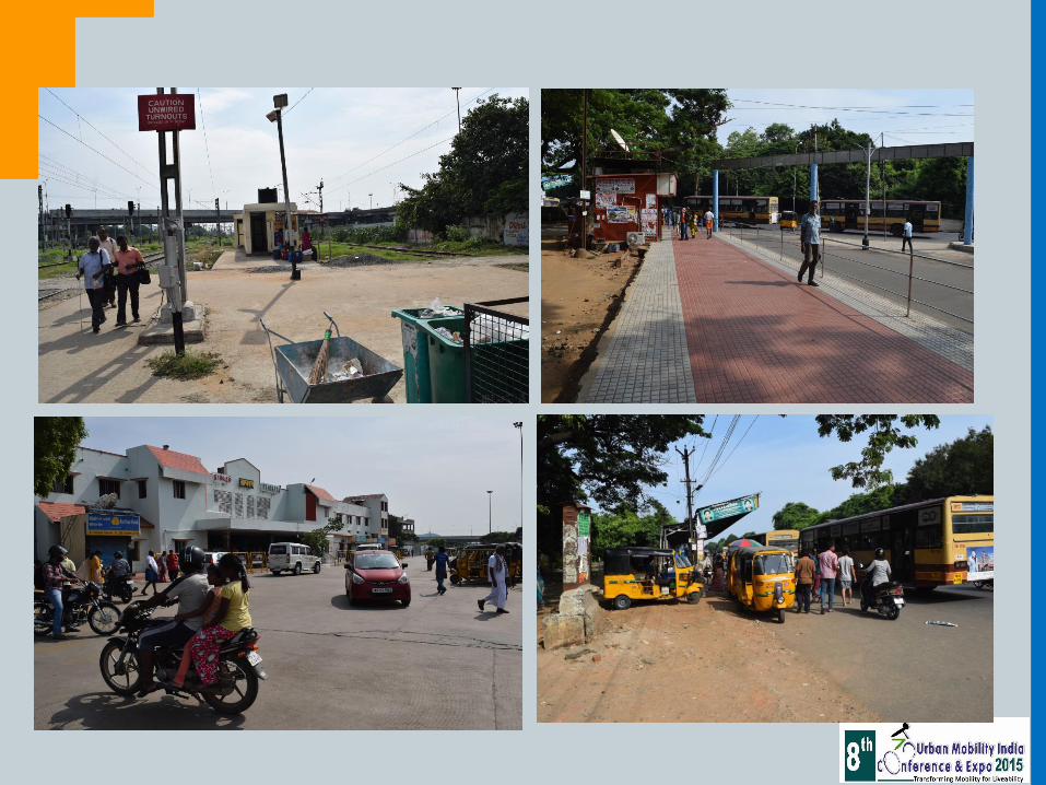
EXISTING TRANSPORT FACILITIES
• Tambaram Station is connected with NH-45 (GST Road) on the West which connects Chennai with the southern districts
• Major District Road viz. Tambaram-Velachery Road on the East connecting the City , IT Corridor and its sub-urbs
• Feeder bus routes exists
• A bus stop both on the East & West is serving the Tambaram Station
• A New Bus Terminus has been constructed at Tambaram by MTC
• IPT (Share Autos, mini vans, etc) are serving the interior areas and providing last mile connectivity
• A new bus terminus has been constructed near Tambaram Sanatorium for the buses connecting various major district centres such as Arani, Kancipuram, Chittoor, Bengaluru & Vellore

Leaders-5 Mid Term Review
METHODOLOGY
Reconnaissance Survey and Maps
Existing Infrastructure
Socimio Econoc Analysis
Delineation of Study Area
Development Potential
Landuse
Travel Conditions
TOD
Exg, Infrastructure
Identify and Evaluate Constraints and Opportunities
Analysis
Recommendations and Proposals

DELINEATION OF INFLUENCE AREA OF THE
TAMBARAM SUBURBAN RLY, STATION • The Study Area is divided
into three viz. Immediate influence area (ImFA), Intermediate influence area (InIA) and Outer influence area (OIA)
• ImIA: upto 500m radius is based on comfortable walking area
• InIA: from 500m – 1.0km • OIA: beyond 1.0km to
1.5Kms • The Study area comprises
of Institutional, Mixed Resi. & Pri. Resi land uses having scope for future growth

CONSTRAINTS (Both within and outside station)
• There is no proper integration between the Rail and Road transport modes
• The passenger facilities are being provided in a piece meal manner without any integrated approach
• Area for parking of IPT, Cycle, Two Wheeler, Four Wheeler and Bus-bays and space for drop zone are not provided to the comfortable level
• Even though large chunk of lands being owned by Railways the appropriate facilities have not been provided
• There is only one FoB to disperse all the commuters during peak hour which leads to chaos during peak hours which tends commuters to cross the Rly. Line endangering their lives
• Improper Geometrical Design on eastern side junction for entry into station
• Poor lighting
• No proper signage
• Lack of security
• Location of Public facility is difficult to access from all platforms
• Commuters need to cross the Drop-off zone lane for accessing the subway on western side
• The share of Public Transport is steadily declining


OPPORTUNITIES Varios Mass transit corridors connecting various parts of the metropolis such as
BRTS and monorail are proposed through the study area The proposed Elevated Corridor from Chennai Airport to Chengalpattu along the
NH-45 passes through the study area Tambaram is proposed to be considered as third terminal apart from Egmore &
Chennai Central for the South bound trains As core city is over crowded people prefer to stay in Tambaram area & its vicinity No. of Educational institutions, SEZ are located nearby the study area The Tambaram station area has an influence beyond CMA The percentage of people accessing stations by walk and by bicycle is likely to
increase due to existing land uses surrounding the station. The Second Master Plan for CMA envisages to increase the share of public transport and also promote cycling
Railway owns huge chunk of land on Eastern Side where the quarters are existing in a dilapidated conditions with low density; these lands have scope for better development with amenities and densification and thus the Tambaram Station area could be utilised more effectively

TRANSIT ORIENTED DEVELOPMENT
• TOD is an essential tool for any development, that is focused around a transit station to:
• (a) facilitate ease of access to the transit facility, thereby inducing people to walk and use public transport over personal modes of transport; and
• (b) Promote mixed use high density development around public transport, to bring together people, jobs, and services in a way that makes it efficient, safe, convenient and attractive to travel on public transport and improve access to opportunities

Leaders-5 Mid Term Review
TOD AS A TOOL
High Density, Mixed-use Development near stations Maximize densities within ToD, in order to facilitate maximum number of people walking or cycling, or use NMT or feeder services easily to access public transit facility.
In green field development, higher the density, lower the per kilometre infrastructure cost.
Enable a balanced mix of land use (commercial, residential, retail, office) in the study area coupled with caps on parking supply, affordable housing through design and technology options.
In co-relation with high activities around the railway station, high rise development has been proposed with an FSI (Floor Space Index) of 4 - 5 in the immediate influence area, FSI = 2 – 2.5 in intermediate influence area and FSI = 1 -2 in the outer influence area.

Leaders-5 Mid Term Review
VARIATION IN BUILT FORM FROM
IMMEDIATE INFLUENCE AREA TO OUTER INFLUENCE AREA

Leaders-5 Mid Term Review
RECOMMENDATIONS
Parking Management Plan at Station Facilitate easy access to rail mode.
Restrict private parking at station area.
Promote ‘drop & ride’ strategy for private vehicles.
Ensure parking space in the station area is used only by rail users through common ticket for parking and rail travel.
Provide ample parking space for bi-cyles
Parking for longer duration may be permitted with premium charges

Leaders-5 Mid Term Review
RECOMMENDATIONS Station Improvement Plan a) Inside Station Premises Platform level with that of coach floor level—level boarding To provide tactile markings for visually handicapped. Providing shelter to the entire stretch of platform Widening of FoB and providing one more FoB at Northern end Additional Ticket Booking counters with automatic ticket vending machines Seating arrangement for waiting passengers. Improved PA system Proper signages in all the platforms Drinking Water Supply, toilets in all the Platforms Kiosks in every platform recommended to cater the public needs and income generation Provision of safety measures

Leaders-5 Mid Term Review
RECOMMENDATIONS
Station Improvement Plan b) Outside station area
Creation of parking facilities to meet demand upto 2026.
Restoration of footpath for pedestrians.
Provide easy interchange/transfer facilities
Removal of encroachments / hawkings from the station entry/exit point/subway with suitable rehabilitation
Demarcating Bus and Auto bays on the main roads abutting the Station.
Improvement of Signage and lighting around station area
Providing access to the sub-way directly from the station building

Leaders-5 Mid Term Review
RECOMMENDATIONS
Traffic Management Plan Feeder bus routes identified along Suthananda Barathi Street and Velachery Tambaram Main Road in the east.
On the west, feeder route runs along Rajaji Road and GST Road.
Bus stops on either side to be located within the proposed parking
Existing road around Tambaram Station area are to be improved with pavement overlay
Skywalk connecting the existing FoB and the Bus Stop on the Western side
Zebra crossing (and pedestrian traffic signal) proposed at the junction of Railway Station Road and Velachery Tambaram Main Road near the proposed feeder bus stop in the East
On Street parking will be discouraged
All streets in ImIA will be made predominantly Pedestrian Movement streets; Vehicles speeds will be restricted to 10kmph;
Signages are to provided at all vantage locations

Leaders-5 Mid Term Review
LAND USE INTERVENTION
High rise – High Density will be encouraged to create more open spaces for public movement and encourage walking / cycling to approach the station Mixed land use – to permit residential, commercial, offices, institutions and green industries which will reduce work-home trip length Commercial buildings will be encouraged on both sides of the station

Leaders-5 Mid Term Review
NEXT STEPS…
To identify the routes for feeder services
To identify the junction improvements
Identify the roads for cycling, walking, etc.
Station redevelopment Plan
FSI gradation using ToD

Leaders-5 Mid Term Review
THANK YOU

PROPOSED FEEDER NETWORK (BUS)
Route Length (Kms) Trips /day
TBM 1 6.4 3194
TBM 2 6.9 3444
TBM 3 4.7 2346
TBM 4 2.8 1734
TBM 5 2.7 1672
Source: MTC