Embed Size (px)
Citation preview

Recurrent flood: effects of recent climatic variations on the city of Lagos and its environs
M. K. Ladipo1, O. E. Popoola2, V. F. Doherty3 & I. M. Phillips4 1Dept of Polymer and Textile Technology, Yaba College of Technology, Lagos, Nigeria 2Dept of Chemical Science, Yaba College of Technology, Lagos, Nigeria 3Dept of Biological Science, Yaba College of Technology, Lagos, Nigeria 4The Ministry of the Environment, Lagos, Nigeria
Abstract
This article examines the effects of the recent climatic changes being experienced as flooding in some parts of Lagos State and its environs in Southern Nigeria. Lagos State is one of the world’s most densely populated cities with a population of about 20 million people, half of which are considered to be in abject poverty. The state is recognized as being vulnerable to climate change because of its topographical situation (coastlands and wetlands) and demographics. The climatic variations has caused the rainfall regimes and patterns to be altered, causing widespread flooding which has not only led to the loss of life and properties but has also impacted negatively on the social and economic activities in the state, substantial modification of ecosystems, and general discomfort to the populace. This situation is further compounded by excessive waste generation and indiscriminate refuse disposal due to over population. Information is provided on flood management and mitigation strategies peculiar to the state. Of interest in particular, is the introduction of a proactive integrated approach for flood management. Finally, the paper provides a good reference material and guide for further studies in water-related disaster management both at the local and international levels. Keywords: flood, Lagos, climate change, rainfall, mitigation strategies, flood management, global warming, vulnerability map, Southern Nigeria, risk reduction.
Water and Society 73
www.witpress.com, ISSN 1743-3541 (on-line) WIT Transactions on Ecology and The Environment, Vol 153,© 2011 WIT Press
doi:10.2495/WS110071
1 Introduction
Global warming is defined as the gradual increase in the average temperature of the earth’s atmosphere and its oceans, an increase that is permanently changing the climatic conditions of earth. Climate change due to global warming is likely to have significant impact on society and environment, and the consequences have already started to manifest in the higher frequency of extremes of unusual weather patterns such as the flash floods recently experienced in Lagos state and its environs in the Southern Nigeria [1]. Nigeria is likely to experience an increase in global warming from 1.4°C to 5.8°C over the period 1990 to 2100. Lagos State is most likely to be adversely affected from this climate change because it is located in flat coastal plains and most areas in the state do not rise up to 700 meters above sea level. The state has about 22% of the nation’s coast line mostly in Epe, Badagry, Ikorodu, and Lagos [2]. The state has the highest population in the country, with over five percent 5% of the national estimate. The 1991 National Census figures put the population of the state at 5,725,116, out of a national estimate of 88,992,220. The UN Habitat Study and the UNDP assisted State Regional Master Plan estimated Lagos State population in year 2000 at 13.4million and over 15 million inhabitants in 2004. The recent UN study (1999) expected the City of Lagos to hit the 20 million population flux in Year 2010, thus progressively reaching 24.5million population in year 2015. It will thus be the biggest city in West Africa, and it is projected to be one of the world’s five largest cities by 2015 [3]. Thus Lagos population is growing ten times faster than New York and Los Angeles, with grave implication for urban sustainability. Massive development to meet the socio-economic needs of the emerging metropolises and mega cities are usually carried out without adequate consideration for the hydrological environment. Among the unresolved challenges being faced, as a result of this development, are destructive flood incidences, even in regions that used to be considered safe [4]. Flood is a state of high water level along a river channel or on the coast that leads to inundation of land, which is not usually submerged. There are different types of floods namely: flash flood, riverine flood, urban flood, etc. Flash floods can be defined as floods which occur within six hours of the beginning of heavy rainfall, and are usually associated with cloud bursts, storms and cyclones requiring rapid localized warnings and immediate response to reduce damage. The most important consequence of flood is the loss of life and property. There is huge loss to life caused by drowning. Drinking water facilities are affected due to contamination of water (well, ground water, piped water supply) leading to outbreak of epidemics, diarrhoea, viral infection, malaria and many other infectious diseases. Flooding also causes inundation of large areas of agricultural land leading to huge crop loss thus resulting in shortage of food. Floods may also affect the soil characteristics. The land may be rendered infertile due to erosion of top layer or may turn saline if sea water floods the area [5]. Unprecedented land reclamation without strict adherence to land use and natural waterways planning, numerous physical and social alteration of the
74 Water and Society
www witpress com ISSN 1743-3541 (on-line) WIT Transactions on Ecology and he Environment, Vol 153,© 2011 WIT PressT
natural environment and occupancy of unsafe land and hazard prone region, without an appreciable harmonizing scheme between nature and the developmental activities causes flood to be aggravated in the state and its environs [6]. The objective of this paper is to examine the effects of climatic variations on wetlands and floodplains and areas that were initially considered to be safe in Lagos State and its environs, and to suggest appropriate solutions toward solving the problem of the recurrent flood.
2 The study area
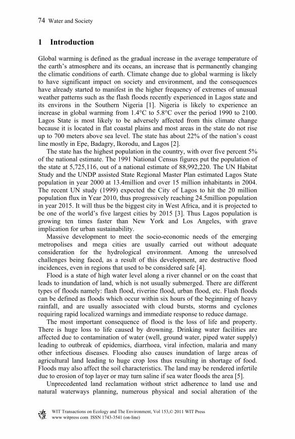
The study area is Lagos State which is located in South-Western Nigeria on the narrow coastal flood plain of the Bight of Benin. The area is found between latitude 06º 25′ N and Longitude 03º 24′ E. With a geographical size of 3,577 square kilometres, Lagos State is one of the smallest states in Nigeria, representing 0.4% of the entire geographical area Nigeria. It shares its borders mainly with Ogun State and The Republic of Benin. The state has an area of 356,861hectares, out of which 75,755 hectares are wetlands with the dominant vegetation of tropical swamp forest, comprising fresh waters and mangrove swamp forests.
2.1 Climate
It shares a double rainfall pattern, with two climatic seasons, Dry (November-March) and wet (April-October). The drainage system of the state is characterized by a maze of Lagoons and waterways which constitute about 22% or 787 sq. km of the state total landmass. The average annual temperature range is 23ºC–31ºC in the South and 18ºC–23ºC in the North.
Figure 1: Map of Nigeria showing the coastal areas. Source: Idowu et al. [11].
Water and Society 75
www witpress com ISSN 1743-3541 (on-line) WIT Transactions on Ecology and he Environment, Vol 153,© 2011 WIT PressT

3 Recent flooding incidences in Lagos State
The major water bodies in the state are the Lagos and Lekki Lagoons, Yewa and Ogun Rivers. The location of the state within the coastline implies that it is vulnerable to climate change. The changing climate is likely to exacerbate water management problems in Lagos generally through rising sea levels in the coastlines, variable rainfall and extreme events like floods. Increase in inter annual Precipitation variability will evidently increase the difficulty of flood control. Last year, several semi urban areas in the state were flooded by excess water released from the Oyan dam. The flooding was caused by the activities of Ogun-Osun River Basin Development Authority that released water from the Dam into the Ogun River, making the river to over-flow its banks and causing havoc [7]. Such intense extreme floods will obviously affect water quality and water infrastructure integrity, and increase fluvial erosion which introduces different kinds of pollutants to water resources. The Nigerian Meteorology Agency (NIMET), in its recent forecasts, put the degree of expected rainfall this year at between 300 and 1100mm in the north, and between 1,200 and 2,700mm in the south, which clearly showed there would be more rain in the south this year [8]. The grave implication of this is that the capacity of most canals in the state is not likely to contain the volume of runoff expected from the rainfall, thereby culminating in the crisis of flooding with immediate and remote consequences. The 15-hour non-stop down pour on Sunday, July 10th, 2011 in Lagos State resulted to heavy flooding. Lives were lost (25 corpses were recovered including those of 11 children) and properties destroyed as a result of the flood [9]. Some of the worst-hit areas which the State Governor, Babatunde Fashola inspected included: Mobil Filling Station, Ogba, where the fence of a company collapsed due to flood, Odejobi Street off Iju Road Agege, Abattoir canal in Orile-Agege Local Government Area, Abeokuta – Lagos Expressway failed portion of the road at Obadeyi Bus stop, and Aboru canal, at Iyana-Ipaja end of Abeokuta-Lagos Expressway among others. The flood also affected high brow areas including Ikoyi, Victoria Island and Apapa where property like vehicles, office equipment and house hold property were destroyed and the low lying areas, close to the Lagoon such as Bariga, Ajegunle in Ikorodu, Makoko etc. The Director General, Lagos Chamber of Commerce and Industry, noted that, “Lagos suffered significant losses in assets and productivity as a result of the flood. The state’s Gross Domestic Product is estimated at N3.5 trillion. An estimated output loss of N100 billion was recorded as consequence of the dislocations and disruptions caused by the flood. It took about one week for the economy of the state to regain momentum. Femi Oke-Osanyintolu, General Manager, Lagos State Emergency Management Agency (LASEMA), at a recent interaction with the media said over 1,600 victims were relocated to Agbowa Relief Camp last year from flooded communities. Table 1 below shows some past incidences of flooding in the state.
76 Water and Society
www witpress com ISSN 1743-3541 (on-line) WIT Transactions on Ecology and he Environment, Vol 153,© 2011 WIT PressT
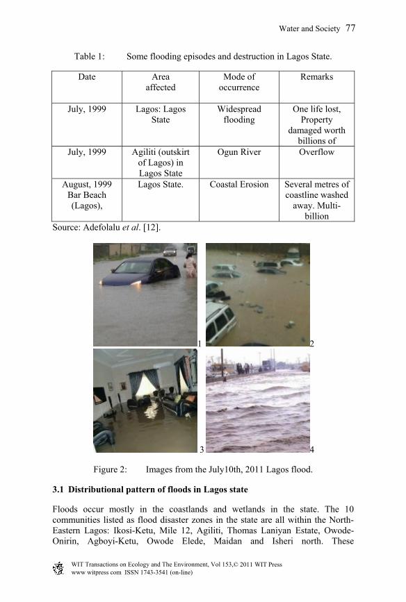
Table 1: Some flooding episodes and destruction in Lagos State.
Date Area affected
Mode of occurrence
Remarks
July, 1999 Lagos: Lagos State
Widespread flooding
One life lost, Property
damaged worth billions of
July, 1999 Agiliti (outskirt of Lagos) in Lagos State
Ogun River Overflow
August, 1999 Bar Beach (Lagos),
Lagos State. Coastal Erosion Several metres of coastline washed
away. Multi-billion
Source: Adefolalu et al. [12].
1 2
3 4
Figure 2: Images from the July10th, 2011 Lagos flood.
3.1 Distributional pattern of floods in Lagos state
Floods occur mostly in the coastlands and wetlands in the state. The 10 communities listed as flood disaster zones in the state are all within the North-Eastern Lagos: Ikosi-Ketu, Mile 12, Agiliti, Thomas Laniyan Estate, Owode-Onirin, Agboyi-Ketu, Owode Elede, Maidan and Isheri north. These
Water and Society 77
www witpress com ISSN 1743-3541 (on-line) WIT Transactions on Ecology and he Environment, Vol 153,© 2011 WIT PressT
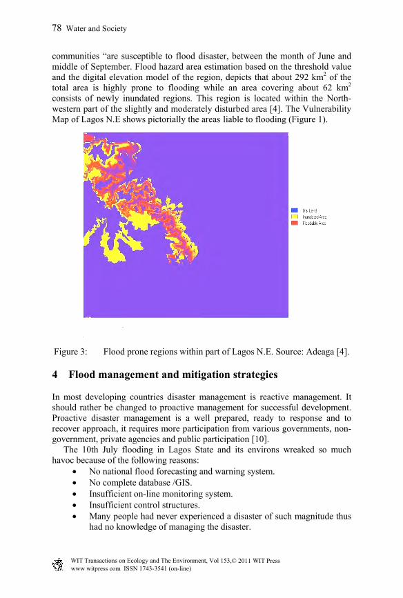
communities “are susceptible to flood disaster, between the month of June and middle of September. Flood hazard area estimation based on the threshold value and the digital elevation model of the region, depicts that about 292 km2 of the total area is highly prone to flooding while an area covering about 62 km2 consists of newly inundated regions. This region is located within the North-western part of the slightly and moderately disturbed area [4]. The Vulnerability Map of Lagos N.E shows pictorially the areas liable to flooding (Figure 1).
Figure 3: Flood prone regions within part of Lagos N.E. Source: Adeaga [4].
4 Flood management and mitigation strategies
In most developing countries disaster management is reactive management. It should rather be changed to proactive management for successful development. Proactive disaster management is a well prepared, ready to response and to recover approach, it requires more participation from various governments, non-government, private agencies and public participation [10]. The 10th July flooding in Lagos State and its environs wreaked so much havoc because of the following reasons:
No national flood forecasting and warning system. No complete database /GIS. Insufficient on-line monitoring system. Insufficient control structures. Many people had never experienced a disaster of such magnitude thus
had no knowledge of managing the disaster.
78 Water and Society
www witpress com ISSN 1743-3541 (on-line) WIT Transactions on Ecology and he Environment, Vol 153,© 2011 WIT PressT
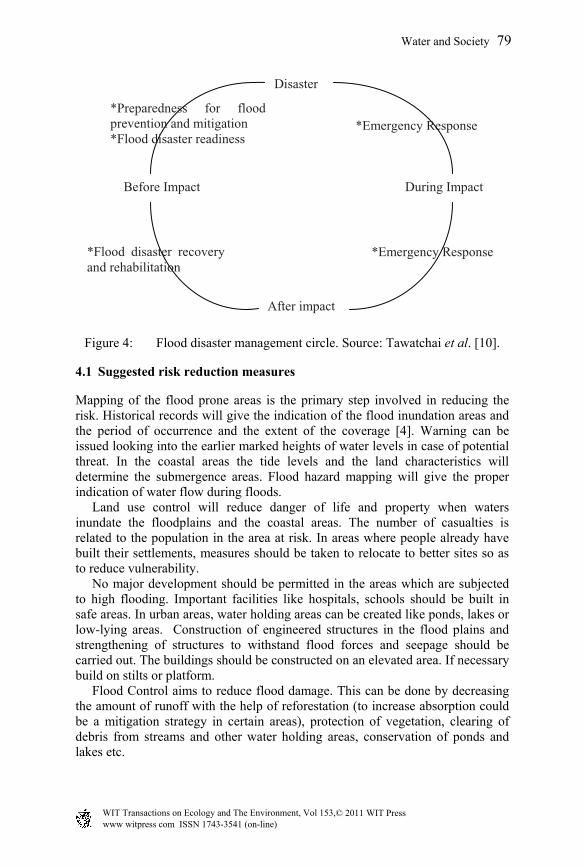
Figure 4: Flood disaster management circle. Source: Tawatchai et al. [10].
4.1 Suggested risk reduction measures
Mapping of the flood prone areas is the primary step involved in reducing the risk. Historical records will give the indication of the flood inundation areas and the period of occurrence and the extent of the coverage [4]. Warning can be issued looking into the earlier marked heights of water levels in case of potential threat. In the coastal areas the tide levels and the land characteristics will determine the submergence areas. Flood hazard mapping will give the proper indication of water flow during floods. Land use control will reduce danger of life and property when waters inundate the floodplains and the coastal areas. The number of casualties is related to the population in the area at risk. In areas where people already have built their settlements, measures should be taken to relocate to better sites so as to reduce vulnerability. No major development should be permitted in the areas which are subjected to high flooding. Important facilities like hospitals, schools should be built in safe areas. In urban areas, water holding areas can be created like ponds, lakes or low-lying areas. Construction of engineered structures in the flood plains and strengthening of structures to withstand flood forces and seepage should be carried out. The buildings should be constructed on an elevated area. If necessary build on stilts or platform. Flood Control aims to reduce flood damage. This can be done by decreasing the amount of runoff with the help of reforestation (to increase absorption could be a mitigation strategy in certain areas), protection of vegetation, clearing of debris from streams and other water holding areas, conservation of ponds and lakes etc.
Disaster
During Impact
After impact
Before Impact
*Emergency Response *Preparedness for flood prevention and mitigation *Flood disaster readiness
*Flood disaster recovery and rehabilitation
*Emergency Response
Water and Society 79
www witpress com ISSN 1743-3541 (on-line) WIT Transactions on Ecology and he Environment, Vol 153,© 2011 WIT PressT
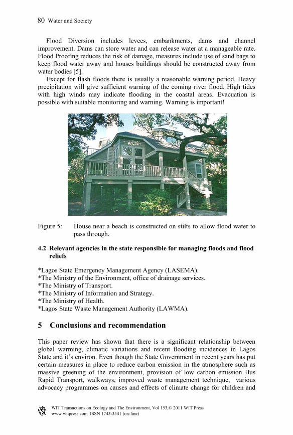
Flood Diversion includes levees, embankments, dams and channel improvement. Dams can store water and can release water at a manageable rate. Flood Proofing reduces the risk of damage, measures include use of sand bags to keep flood water away and houses buildings should be constructed away from water bodies [5]. Except for flash floods there is usually a reasonable warning period. Heavy precipitation will give sufficient warning of the coming river flood. High tides with high winds may indicate flooding in the coastal areas. Evacuation is possible with suitable monitoring and warning. Warning is important!
Figure 5: House near a beach is constructed on stilts to allow flood water to pass through.
4.2 Relevant agencies in the state responsible for managing floods and flood reliefs
*Lagos State Emergency Management Agency (LASEMA). *The Ministry of the Environment, office of drainage services. *The Ministry of Transport. *The Ministry of Information and Strategy. *The Ministry of Health. *Lagos State Waste Management Authority (LAWMA).
5 Conclusions and recommendation
This paper review has shown that there is a significant relationship between global warming, climatic variations and recent flooding incidences in Lagos State and it’s environ. Even though the State Government in recent years has put certain measures in place to reduce carbon emission in the atmosphere such as massive greening of the environment, provision of low carbon emission Bus Rapid Transport, walkways, improved waste management technique, various advocacy programmes on causes and effects of climate change for children and
80 Water and Society
www witpress com ISSN 1743-3541 (on-line) WIT Transactions on Ecology and he Environment, Vol 153,© 2011 WIT PressT
adult, and to reduce impact of flooding by construction/rehabilitation of drainages, construction of relief centres and conservation of wet lands, the paper has also shown that the measures taken to combat flood in the state is requires that more proactive measures should be taken. It is recommended that scientific studies be undertaken at regional levels so as to provide society with accurate information on the real and potential impacts of climate change, as well as, the mitigation and adaptation options available.
References
[1] Ekpoh I. J. and Ekpenyong N., The Effects of Recent Climatic Variations on Water Yield in the Sokoto Region of Northern Nigeria. International Journal of Business and Social Science Vol. 2 No. 7; [Special Issue –April 2011] 251, 2011.
[2] Babatope babalobi, http://assemblyonline.info/eWASH/?p=241 [3] Federal Ministry of Education and Research, The Urban Transition:
Research for the sustainable development of the megacities of tomorrow. Division 622, Global Change, Federal Ministry of Education and Research, Germany, 2004.
[4] Adeaga O., Flood Hazard Mapping & Risk Management in Part of Lagos N. E. , 10th Global Spatial Data Infrastructure Conference proceedings, St. Augustine, Trinidad, 25 – 29 February, 2008, Spatial Data Infrastructure – Africa Newsletter Vol. 7, No. 4 April 2008.
[5] Balaka, D. and Singh R.B., Natural Hazards and Disaster Management: A Supplementary Textbook in Geography, Central Board of Secondary Education. First Edition Published By: The Secretary, Central Board of Secondary Education. Pg 10-34, 2006.
[6] Oyebande, L. Aspects of urban hydrology and the challenges for African urban environment. African Urban Quarterly 5,(1/2), 39–63, 1990.
[7] Ugbodaga K.,pmnewsnigeria.com/.../Lagos-to-evacuate-victims-of-flood-disaster, 2010.
[8] Bassey J., Rains: Lagos’ proactive measures to combat flood crisis, Business Day News Friday, 03 June. 2011.
[9] Akoni O., Evelyn Usman E., and Olowopejo M., Lagos flood kills 25, Vanguard News Papers, July 12, 2011.
[10] Tawatchai T. Arturo G. R. and Watchara S., Tsunami, Water-related Disaster Management: Thailand Case Study. School of Civil Engineering, Asian Institute of Technology, Thailand, 2005.
[11] Idowu A.A., Ayoola S.O., Opele A.I. and Ikenweiwe N.B., Impact of Climate Change in Nigeria, Iranica Journal of Energy & Environment 2 (2): 145-152, 2011.
[12] Adefolalu D.O. et al., Climate Change and Natural Disasters During the 1999 Rainy Season FUT – NUC/U BR Res. Pub. 88 pp. 2001.
Water and Society 81
www witpress com ISSN 1743-3541 (on-line) WIT Transactions on Ecology and he Environment, Vol 153,© 2011 WIT PressT