Embed Size (px)
Citation preview

Record of Decision
for the West Davis Corridor Project in
Davis and Weber Counties, Utah
by Federal Highway Administration, Utah Division
in cooperation with Utah Department of Transportation
UDOT Project No. S-0067(14)0
September 29, 2017

This page is intentionally blank.

September 29, 2017 i
Summary Introduction This document is the Federal Highway Administration’s (FHWA) Record of Decision (ROD) for the West Davis Corridor (WDC) Project in Davis and Weber Counties, Utah. The WDC Project was initiated for two main reasons.
First, the project was initiated to address the expected population, employment, and household growth in western Davis and Weber Counties through 2040 by improving regional travel (regional mobility) for automobile, transit, and freight trips. This improvement in regional mobility would be achieved by reducing roadway congestion in the WDC study area.
Second, the project was initiated at the request of the city governments and the area’s metropolitan planning organization, whose local and regional transportation plans and corridor planning studies have identified a need for additional transportation infrastructure in the WDC study area.
This ROD constitutes FHWA’s approval of Alternative B1 with the Wetland Avoidance Option (Selected Alternative) as described in the WDC Final Environmental Impact Statement and Section 4(f) Evaluation (Final EIS). This decision is based on the information presented in the Final EIS and supporting technical documents; the associated project file; and input received from the public and interested local, state, and federal agencies. In making this decision, FHWA considered the expected impacts of the project and alternative courses of action under the National Environmental Policy Act (NEPA), Section 4(f) of the Department of Transportation Act of 1966, and other applicable laws, thereby balancing the need for safe and efficient transportation with national, state, and local environmental protection goals.
Decision FHWA, pursuant to 23 Code of Federal Regulations (CFR) 771.127 and 40 CFR 1505.2, finds that the requirements of NEPA and other applicable laws have been satisfied for the construction and operation of the Selected Alternative. This ROD is based on FHWA’s involvement in, close monitoring of, and independent evaluations of the process followed by the WDC study team in setting forth and considering the effects of the WDC and the available alternatives. This process included preparing the Draft EIS (published May 2013), the Final EIS (published June 2017), and supporting technical memoranda.
This ROD describes the basis for the decision, describes the alternatives considered, identifies the environmentally preferred alternative as the Selected Alternative, and documents the mitigation measures that will be implemented. The summary descriptions included in this ROD do not supersede or negate any of the information, descriptions, or evaluations provided in the environmental review documents, except what is expressly stated below. This ROD and the associated published environmental review documents, which are

ii Record of Decision
incorporated into this ROD by reference, constitute FHWA’s environmental record for the WDC Project.
Based on the analysis and evaluation in the Final EIS and after careful consideration of the social, economic, and environmental factors and input from the public involvement process, FHWA hereby approves the selection of Alternative B1 with the Wetland Avoidance Option (Selected Alternative) as identified in the Final EIS. This approval constitutes FHWA’s acceptance of Alternative B1 with the Wetland Avoidance Option and completes the approval process for the environmental evaluation.
The Selected Alternative, shown in Figure 1 on page 2 of this ROD, is also the environmentally preferable alternative. FHWA has determined that the Selected Alternative best meets the transportation needs for the traveling public while considering environmental, safety, and socioeconomic factors. This decision is based on the Final EIS, public and agency comments received during the EIS process, and the entire project record.
In reaching our decision, FHWA has considered all of the issues raised in the project record including the information contained in (and comments on) the Draft and Final EISs. The Selected Alternative was developed through a public process that included project adjustments to avoid and minimize environmental impacts.
FHWA consulted with other federal and state agencies including the U.S. Fish and Wildlife Service; the U.S. Environmental Protection Agency; the U.S. Army Corps of Engineers; the Utah Reclamation, Mitigation, and Conservation Commission; the Utah Department of Environmental Quality; the Utah Department of Natural Resources; the Utah Division of Wildlife Resources; the Utah State Historic Preservation Office; the Advisory Council on Historic Preservation; and Native American tribes. A full list of interagency coordination is included in Chapter 30, Public and Agency Consultation and Coordination, of the Final EIS.
Limitation on Claims FHWA will publish a notice in the Federal Register, pursuant to 23 United States Code 139(1), stating that one or more federal agencies have taken final action on permits, licenses, or approvals for this transportation project. After the notice is published, claims seeking judicial review of those federal agency actions will be barred unless such claims are filed within 150 days after the date of publication of the notice, or within such shorter time period as is specified in the federal laws pursuant to which judicial review of the federal agency action is allowed.


Contents
ACRONYMS AND ABBREVIATIONS ................................................................................. viii
GLOSSARY OF TERMS ....................................................................................................... ix
1.0 INTRODUCTION ..................................................................................................... 1 1.1 Corrections and New Information on the Final EIS..............................................3
2.0 PROJECT PURPOSE (CHAPTER 1 OF THE FINAL EIS) ......................................... 3
3.0 ALTERNATIVES (CHAPTER 2 OF THE FINAL EIS) ............................................... 4 3.1 Summary of the Alternatives-Development Process (Section 2.2 of the
Final EIS) ..............................................................................................................4 3.1.1 Identification of Preliminary Alternatives ..............................................5 3.1.2 Screening of Alternatives ..................................................................... 13
3.2 Alternatives Considered for Detailed Study (Section 2.4 of the Final EIS) ..................................................................................................................... 32 3.2.1 No-Action Alternative .......................................................................... 32 3.2.2 Alternative A1 ...................................................................................... 32 3.2.3 Alternative A2 ...................................................................................... 39 3.2.4 Alternative B1 (Selected Alternative) .................................................. 43 3.2.5 Alternative B2 ...................................................................................... 47 3.2.6 Wetland Avoidance Options ................................................................. 50
3.3 Rationale for the Selected Alternative (Section 2.6 of the Final EIS) ................ 52 3.4 Environmentally Preferred Alternative ............................................................... 53
4.0 MEASURES TO MINIMIZE HARM FROM THE SELECTED ALTERNATIVE
(CHAPTER 26 OF THE FINAL EIS) ...................................................................... 54
4.1 Mitigation Measures for Land Use Impacts ........................................................ 54 4.2 Mitigation Measures for Farmland Impacts ........................................................ 55
4.2.1 Mitigation Measures for Impacts to Cropland, Century Farms, and Other Non–Century Farms of Interest ........................................... 55
4.2.2 Mitigation Measures for Impacts to FPPA-Eligible Farmland ............. 55 4.2.3 Mitigation Measures for Impacts to Farmland Fragmentation ............. 56 4.2.4 Mitigation Measures for Impacts to Agriculture Protection
Areas ..................................................................................................... 57 4.3 Mitigation Measures for Community Impacts .................................................... 57
4.3.1 Mitigation Measures for Impacts to Community Cohesion .................. 57 4.3.2 Mitigation Measures for Impacts to Quality of Life ............................. 57 4.3.3 Mitigation Measures for Impacts to Recreation Resources .................. 57 4.3.4 Mitigation Measures for Impacts to Community Facilities .................. 58 4.3.5 Mitigation Measures for Impacts to Public Health and Safety ............. 58 4.3.6 Mitigation Measures for Impacts to Public Services and
Utilities ................................................................................................. 59 4.3.7 Mitigation Measures for Impacts to Housing and Relocations ............. 59
4.4 Mitigation Measures for Environmental Justice Impacts .................................... 59 4.5 Mitigation Measures for Transportation Impacts ................................................ 59 4.6 Mitigation Measures for Economic Impacts ....................................................... 60 4.7 Mitigation Measures for Joint Development Impacts ......................................... 60 4.8 Mitigation Measures for Impacts to Considerations Relating to
Pedestrians and Bicyclists ................................................................................... 60 4.9 Mitigation Measures for Air Quality Impacts ..................................................... 63
iv Record of Decision

4.10 Mitigation Measures for Noise Impacts .............................................................. 63 4.10.1 Feasibility Factors ................................................................................ 63 4.10.2 Reasonableness Factors ........................................................................ 64 4.10.3 Noise Mitigation for the Selected Alternative ...................................... 65
4.11 Mitigation Measures for Water Quality Impacts ................................................ 69 4.11.1 Mitigation Measures for Impacts to Surface Water .............................. 69 4.11.2 Mitigation Measures for Groundwater Impacts .................................... 69 4.11.3 Mitigation Measures for Impacts to Groundwater Wells ..................... 69
4.12 Mitigation Measures for Ecosystem Impacts ...................................................... 70 4.12.1 Mitigation Measures for Impacts to Wildlife and Wildlife
Habitat .................................................................................................. 70 4.12.2 Mitigation Measures for Impacts to Wetlands ...................................... 74
4.13 Mitigation Measures for Floodplain Impacts ...................................................... 77 4.14 Mitigation Measures for Impacts to Historic, Archaeological, and
Paleontological Resources .................................................................................. 79 4.15 Mitigation Measures for Impacts to Hazardous Waste Sites .............................. 79 4.16 Mitigation Measures for Visual Impacts ............................................................. 79 4.17 Mitigation Measures for Energy Impacts............................................................ 80 4.18 Mitigation Measures for Construction Impacts .................................................. 80
4.18.1 General Mitigation and Permit Requirements for Phased Construction ......................................................................................... 80
4.18.2 Mitigation Measures for Construction-Related Impacts to Air Quality ............................................................................................ 81
4.18.3 Mitigation Measures for Construction-Related Noise and Vibration Impacts ................................................................................. 81
4.18.4 Mitigation Measures for Construction-Related Visual and Light Impacts ........................................................................................ 81
4.18.5 Mitigation Measures for Construction-Related Impacts to Cultural Resources................................................................................ 82
4.18.6 Mitigation Measures for Construction-Related Impacts to Motorists, Pedestrians, Bicyclists, and Businesses ............................... 82
4.18.7 Mitigation Measures for Construction-Related Impacts to Utility Service ....................................................................................... 82
4.18.8 Mitigation Measures for Construction-Related Discoveries of Hazardous Materials ............................................................................. 83
4.19 Mitigation Measures for Indirect Effects ............................................................ 83 4.19.1 Mitigation Measures for Potential Indirect Effects on
Ecosystem Resources ........................................................................... 83 4.19.2 Mitigation Measures for Potential Indirect Effects on
Farmland ............................................................................................... 83 4.20 Mitigation Measures for Cumulative Impacts .................................................... 84
4.20.1 Mitigation Measures for WDC Impacts to Wetlands and Wildlife Habitat .................................................................................... 84
4.20.2 Mitigation Measures for WDC Impacts to Air Quality ........................ 84 4.20.3 Mitigation Measures for WDC Impacts to Water Quality .................... 84 4.20.4 Mitigation Measures for WDC Impacts to Floodplains ........................ 84 4.20.5 Mitigation Measures for WDC Impacts to Farmland ........................... 85 4.20.6 Mitigation Measures for WDC Economic Impacts .............................. 85 4.20.7 Mitigation Measures for WDC Community Impacts ........................... 85
September 29, 2017 v

5.0 SECTION 4(F) EVALUATION (CHAPTER 27 OF THE FINAL EIS) ....................... 86 5.1 Summary of Section 4(f) Uses by the Selected Alternative ................................ 87
5.1.1 Findings of De Minimis Impact ............................................................ 87 5.1.2 Greater than De Minimis Impacts ......................................................... 87
5.2 Avoidance Alternatives....................................................................................... 88 5.3 Least Overall Harm Analysis .............................................................................. 89
5.3.1 Least Overall Harm Analysis Conclusion ............................................ 89 5.4 Measures to Minimize Harm to Section 4(f) Properties ..................................... 91
6.0 MONITORING AND ENFORCEMENT PROGRAM ................................................. 93
7.0 PERMITS AND APPROVALS ................................................................................. 93
8.0 TRANSPORTATION CONFORMITY ...................................................................... 94
9.0 COMMENTS ON THE FINAL EIS ......................................................................... 95
10.0 NEXT STEPS ......................................................................................................... 96
11.0 REFERENCES ....................................................................................................... 97
Tables
Table 1. Comparison of Wetland Impacts in the Final EIS and This Record of Decision ................3 Table 2. Summary of the Project’s Purpose ......................................................................................4 Table 3. Preliminary Alternatives ......................................................................................................8 Table 4. Level 1 Screening Criteria for the Preliminary Alternatives ............................................. 14 Table 5. Alternatives Selected for Advancement to Level 2 Screening .......................................... 15 Table 6. Level 2 Screening Criteria ................................................................................................. 24 Table 7. Alternatives Eliminated during Level 2 Screening ............................................................ 25 Table 8. Results of the Reconsideration of the Southern Alignment Options ................................. 29 Table 9. Alternative A1 Cross Streets, Interchanges, and Park-and-Ride Lots ............................... 33 Table 10. Alternative A2 Cross Streets, Interchanges, and Park-and-Ride Lots ............................. 40 Table 11. Alternative B1 Cross Streets, Interchanges, and Park-and-Ride Lots ............................. 44 Table 12. Alternative B2 Cross Streets, Interchanges, and Park-and-Ride Lots ............................. 48 Table 13. Components of the Wetland Avoidance Options ............................................................ 50 Table 14. Measures to Minimize Harm to Historic Properties ........................................................ 91 Table 15. Measures to Minimize Harm to Parks ............................................................................. 91 Table 16. Measures to Minimize Harm to Recreation Areas .......................................................... 92 Table 17. Measures to Minimize Harm to Refuges ......................................................................... 92
vi Record of Decision

Figures
Figure 1. Selected Alternative – Alternative B1 with Wetland Avoidance Option ...........................2 Figure 2. Range of Alternatives Considered ................................................................................... 11 Figure 3. Shared Solution Alternative ............................................................................................. 12 Figure 4. Alternative 05 – I-15 and East-West Arterial Widening .................................................. 16 Figure 5. Alternative 08 – I-15, East-West, and North-South Arterial Widening ........................... 17 Figure 6. Alternative 19A – D&RG Four-Lane Divided Highway ................................................. 18 Figure 7. Alternative 10A – Level 2 Screening Options ................................................................. 19 Figure 8. Alternative 11A – Level 2 Screening Options ................................................................. 20 Figure 9. Alternative 12A – Level 2 Screening Options ................................................................. 21 Figure 10. Alternative 13A – Level 2 Screening Options ............................................................... 22 Figure 11. Alternative A Advanced from Level 2 Screening .......................................................... 26 Figure 12. Alternative B Advanced from Level 2 Screening .......................................................... 27 Figure 13. Southern Options ........................................................................................................... 30 Figure 14. Alternative A1 ................................................................................................................ 36 Figure 15. Four-Lane Highway Typical Section ............................................................................. 37 Figure 16. Two-Lane Highway Typical Section ............................................................................. 38 Figure 17. Alternative A2 ................................................................................................................ 42 Figure 18. Alternative B1 ................................................................................................................ 46 Figure 19. Alternative B2 ................................................................................................................ 49 Figure 20. Wetland Avoidance Options .......................................................................................... 51 Figure 21. Old Emigration Trail Relocation .................................................................................... 62 Figure 22. Alternatives A1, A2, B1, and B2 Noise Receptor Impacts ............................................ 66 Figure 23. Alternatives B1 and B2 Noise Receptor Impacts (1 of 2) .............................................. 67 Figure 24. Alternatives B1 and B2 Noise Receptor Impacts (2 of 2) .............................................. 68
Appendices
Appendix A. Comments and Responses for the Final EIS
September 29, 2017 vii

Acronyms and Abbreviations
APA Agriculture Protection Area CFR Code of Federal Regulations CLOMR Conditional Letter of Map Revision D&RGW Denver & Rio Grande Western Railroad dBA decibels on the A-weighted scale EIS Environmental Impact Statement EPA U.S. Environmental Protection Agency FEMA Federal Emergency Management Agency FHWA Federal Highway Administration FPPA Farmland Protection Policy Act GHG greenhouse gases I-15 Interstate 15 LOS level of service MP milepost MSAT mobile-source air toxics NAAQS National Ambient Air Quality Standards NEPA National Environmental Policy Act NRCS Natural Resources Conservation Service PM10 particulate matter 10 microns in diameter or less PM2.5 particulate matter 2.5 microns in diameter or less ROD Record of Decision RTP Regional Transportation Plan SAFETEA-LU Safe, Accountable, Flexible, Efficient Transportation Equity Act: A Legacy for Users SHPO State Historic Preservation Officer SIP State Implementation Plan SR State Route TSM/TDM Transportation System Management/Traffic Demand Management URMCC Utah Reclamation, Mitigation, and Conservation Commission USACE U.S. Army Corps of Engineers USC United States Code USFWS U.S. Fish and Wildlife Service VHT vehicle-hours traveled VMT vehicle-miles traveled WDC West Davis Corridor WFRC Wasatch Front Regional Council WMA Waterfowl Management Area
viii Record of Decision

Glossary of Terms
Agriculture Protection Areas (APAs)
Agriculture Protection Areas are geographic areas where agricultural activities are given special protections.
attainment area
An attainment area is an area that meets (or “attains”) the National Ambient Air Quality Standards for a given air pollutant.
Category I wetlands
Category I wetlands are wetlands that are of exceptionally high quality or that are important from a regulatory standpoint.
Category II wetlands
Category II wetlands are more prevalent than Category I wetlands and may provide habitat for sensitive species of plants and animals, function at high levels for wildlife habitat, or be assigned a high rating for many of the assessed values.
Category III wetlands
Category III wetlands are more prevalent than Category I and II wetlands, generally have a moderate to low plant community composition rating, and have a higher level of disturbance than Category I and II wetlands.
context-sensitive solutions
Context-sensitive solutions is a philosophy that guides UDOT in planning, designing, constructing, and maintaining safe transportation solutions in harmony with the community and the environment.
cooperating agency
A cooperating agency is any federal agency, other than a lead agency, that has jurisdiction by law or special expertise with respect to any environmental impact involved in a proposed project or project alternative (40 Code of Federal Regulations 1508.5).
criteria pollutants
Criteria pollutants are the six pollutants for which the U.S. Environmental Protection Agency has established air quality standards (criteria).
de minimis use
For publicly owned public parks, recreation areas, and wildlife and waterfowl refuges, a de minimis use is one that would not adversely affect the activities, features, or attributes of the property. For historic sites, a finding of de minimis use means that the Federal Highway Administration has determined that either the project would not affect the historic property or the project would have “no adverse effect” on the historic property.
environmental justice
Environmental justice is a term used to describe the fair and equitable treatment of minority and low-income people (environmental justice populations) with regard to federally funded projects and activities. Fair treatment means that no minority or low-income population should be forced to bear a disproportionately high share of negative effects from a project.
September 29, 2017 ix

front-row receptor
A front-row receptor is a noise-sensitive receptor (building or location) that is adjacent or nearest to a project alternative.
hot-spot analysis
A hot-spot analysis is a project-level analysis that looks at local air quality impacts, such as at intersection crosswalks or residences near a roadway.
indirect effects impact analysis area
The indirect effects impact analysis area is the area where the WDC action alternatives would improve access (see Figure 23-1, Location of Potential Indirect Effects, in Volume IV of the Final EIS).
Level 1 screening
The purpose of Level 1 screening was to identify alternatives that would meet the purpose of the project.
Level 2 screening
The purpose of Level 2 screening was to determine which of the alternatives advanced from Level 1 screening were reasonable and would be evaluated in detail in the EIS.
level of service (LOS)
Level of service is a measure of traffic flow efficiency and congestion and is represented by a letter “grade” from A (free-flowing traffic and little delay) to F (extremely congested, stop-and-go traffic and excessive delay). LOS B through LOS E represent progressively worse traffic conditions. For more information, see Section 1.7.2.2, Level of Service, of the Final EIS.
maintenance area
A maintenance area is an area previously designated as a non-attainment area for a given air pollutant that has been redesignated to attainment status and is required to have a maintenance plan.
needs assessment study area
The needs assessment study area is the same as the WDC study area (see page xi).
No-Action conditions
The No-Action conditions are the road and transit conditions in the WDC study area in 2040 if the West Davis Corridor is not built. For more information, see Section 1.7, Needs Assessment, of the Final EIS.
non-attainment area
A non-attainment area is an area that does not meet the National Ambient Air Quality Standards for a given air pollutant.
participating agency
A participating agency is a federal, state, tribal, regional, or local government agency that might have an interest in a proposed project [23 United States Code 139(d)].
peak periods
Peak periods are the periods of the day with the greatest amounts of traffic. The AM (morning) peak period is from 6 AM to 9 AM, and the PM (afternoon) peak period is from 3 PM to 6 PM. Peak periods are looked at by transportation officials when examining the need for a transportation improvement.
scoping
Scoping is an early and open process for determining the scope of issues to be addressed and for identifying the significant issues related to a proposed action.
x Record of Decision

Selected Alternative
The Federal Highway Administration’s Selected Alternative for the West Davis Corridor Project is Alternative B1 with the Wetland Avoidance Option.
State Implementation Plan (SIP)
A State Implementation Plan explains how a State will comply with the requirements of the federal Clean Air Act of 1990, as amended.
travel demand
Travel demand is the expected number of transportation trips in an area. Travel demand can be met by various modes of travel, such as automobile, bus, light rail, carpooling, and bicycling.
WDC study area
The study area for the West Davis Corridor Project is the area bounded on the north by 3000 South in Hooper and West Haven, on the south by about Parrish Lane in Centerville, on the west just east of the Great Salt Lake, and on the east by Interstate 15. For more information, see Section 1.2, Description of the Needs Assessment Study Area, of the Final EIS.
WDC team
The WDC team consists of the lead agencies for the West Davis Corridor Project, which are the Federal Highway Administration and the Utah Department of Transportation.
Wetland Avoidance Option
The Wetland Avoidance Option is a collective term for two wetland avoidance options, in Farmington and Layton, that would reduce impacts to wetlands from the A and B Alternatives. For more information, see Section 3.2.6, Wetland Avoidance Options, of this ROD.
wetland delineation
A wetland delineation is a survey to determine the extent and types of wetlands that would be affected by a project. For more information, see Section 14.3.1.3, Methodology for Identifying Wetlands and Waters of the U.S., of the Final EIS.
Zone A
Zone A is areas subject to inundation by a 100-year flood. These areas are identified by approximate studies, and no 100-year flood elevations are established.
Zone AE
Zone AE is areas subject to inundation by a 100-year flood as determined by detailed methods. 100-year flood elevations are established.
September 29, 2017 xi

This page is intentionally blank.
xii Record of Decision

1.0 Introduction This document is the Federal Highway Administration’s (FHWA) Record of Decision (ROD) for the West Davis Corridor (WDC) Project in Davis and Weber Counties, Utah. This ROD constitutes FHWA’s approval of Alternative B1 with the Wetland Avoidance Option (Selected Alternative) as shown below in Figure 1.
The Selected Alternative is described in Section 3.2.4, Alternative B1 (Selected Alternative), and Section 3.2.6, Wetland Avoidance Options, of this ROD and in Section 2.4.4, Alternative B1, and Section 2.4.6, Wetland Avoidance Options, of the Final Environmental Impact Statement and Section 4(f) Evaluation (Final EIS).
As part of this approval, FHWA requires the Utah Department of Transportation (UDOT) to adopt, monitor, and enforce the mitigation features planned for this project as described in the Final EIS and more fully in this ROD.
This decision is based on the information presented in the Final EIS and supporting technical documents; the associated project file; and input received from the public and interested local, state, and federal agencies. In making this decision, FHWA considered the expected impacts of the project and alternative courses of action under the National Environmental Policy Act (NEPA), Section 4(f) of the Department of Transportation Act of 1966, and other laws, thereby balancing the need for safe and efficient transportation with national, state, and local environmental protection goals.
FHWA also has a statutory responsibility under 23 United States Code (USC) 109(h) to reach a project decision that is in the best overall public interest taking into account the need for safe, fast, and efficient transportation and public services while eliminating or minimizing adverse natural environmental and community effects. This decision satisfies 23 USC 109(h).
September 29, 2017 1
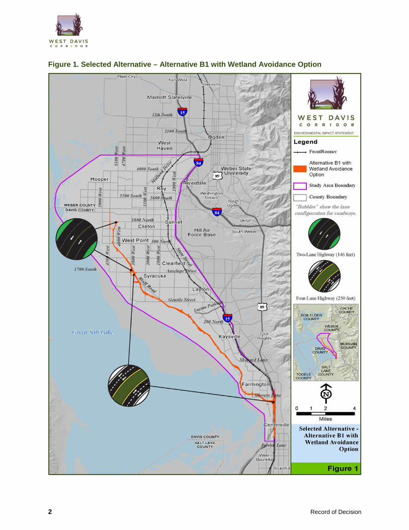
Figure 1. Selected Alternative – Alternative B1 with Wetland Avoidance Option
2 Record of Decision

1.1 Corrections and New Information on the Final EIS A few items from the Final EIS require corrections or clarification, or new information was identified based on comments received during the public and agency review of the Final EIS. These corrections or new information do not change the conclusions in the Final EIS, nor do they create a new significant environmental impact.
Wetland Impacts. The U.S. Army Corps of Engineers approved the wetland delineation for the WDC Selected Alternative (Alternative B1). The approval changed the boundaries of some wetlands and therefore the amount of wetland impacts from the A and B Alternatives, as shown in Table 1.
Table 1. Comparison of Wetland Impacts in the Final EIS and This Record of Decision in acres
Without Wetland Avoidance Option With Wetland Avoidance Option
Document A1 A2 B1 B2 A1 A2 B1 B2
Direct Wetland Impacts
Final EIS 28.1 26.9 47.9 46.6 21.0 19.9 40.9 39.6 Record of Decision 28.4 27.2 55.3 54.0 21.3 20.2 48.3 47.0
Wetlands within 300 feet of the Right-of-Way
Final EIS 80.5 64.3 101.6 85.2 68.7 52.4 89.7 73.3 Record of Decision 78.9 62.6 106.8 90.3 67.0 50.7 94.9 78.4
Note that the Clean Water Act Section 404 permit and subsequent wetland delineation review by the Corps of Engineers was conducted for the Selected Alternative only (Alternative B1). If a wetland delineation and subsequent review had been conducted for Alternative A1, A2, or B2, the resulting wetland impacts would have changed from those shown in Table 1. Any changes for Alternatives A1, A2, and B2 in the table occurred because wetland boundaries changed where Alternative A1, A2, or B2 shares an alignment with Alternative B1.
2.0 Project Purpose (Chapter 1 of the Final EIS) The WDC is intended to achieve the following purposes:
• Improve Regional Mobility. Improve regional mobility in the WDC needs assessment study area for automobile, transit, and freight trips by substantially reducing user delay on the road system compared to the No-Action conditions through the consideration of all transportation modes.
• Enhance Peak-Period Mobility. Substantially enhance mobility in the WDC needs assessment study area during the AM and PM peak periods for the main travel direction (north-south) to help accommodate the projected travel demand in the needs assessment study area in 2040.
September 29, 2017 3

3.0 Alternatives (Chapter 2 of the Final EIS)
3.1 Summary of the Alternatives-Development Process (Section 2.2 of the Final EIS) The alternatives-development process identified and evaluated a full range of alternatives that were brought forward during the NEPA scoping process, identified in previous studies, or brought forward during the EIS process.
FHWA, UDOT, the Utah Transit Authority, the cooperating and participating agencies, and the public participated in the screening process that evaluated the alternatives. Each alterna-tive was considered and reviewed against the project’s purpose and against the screening criteria to determine whether it would be carried forward for detailed study in the Final EIS.
In order to be carried forward for detailed study, an alternative needed to meet the purpose of the project (Table 2) and be reasonable and practicable.
Table 2. Summary of the Project’s Purpose
Primary Purposes Secondary Objectives
Improve regional mobility. Increase the interconnection between transportation modes.
Enhance peak-period mobility. Support local growth objectives. Increase bicycle and pedestrian options.
For more details, see Section 1.4.1, Purpose of the Project, of the Final EIS.
The alternatives-development process is summarized below and is explained in detail in Technical Memorandum 13: Alternatives-Development and Screening Process (West Davis Corridor Team 2011b), Technical Memorandum 14: Level 2 Screening Process (West Davis Corridor Team 2011c), Technical Memorandum 15: Alternatives Screening Report (West Davis Corridor Team 2012a), and the Final EIS Addendum to Technical Memorandum 15: Alternatives Screening Report (West Davis Corridor Team 2017a).
The alternatives-development process consisted of the following five steps:
1. Identification of preliminary alternatives 2. Level 1 screening 3. Level 2 screening 4. Alternatives Screening Report (with public and agency input) 5. Refinement of the advanced alternatives
4 Record of Decision

3.1.1 Identification of Preliminary Alternatives The preliminary alternatives were identified from the following sources:
• Previous studies and plans • Public and agency input
Preliminary Alternatives Identified in Previous Studies and Plans The WDC team considered alternatives from the following previous transportation studies and plans:
• 2001 North Legacy Transportation Corridor Study (WFRC 2001)
• 2007 Regional Transportation Plan from WFRC (WFRC 2007a)
• 2007 North Legacy to Legacy Connection Study (WFRC 2007b)
• 2009 North Legacy Transportation Corridor Supplemental Study (WFRC 2009)
• Wasatch Choices 2040: A Four County Land-Use and Transportation Vision (WFRC and others, no date)
• 2008 Davis Weber East-West Transportation Study Legislative Report (InterPlan Co. 2008)
• City transportation master plans
Preliminary Alternatives Identified through Public and Agency Input
NEPA Scoping
As discussed in the West Davis Corridor Summary Scoping Report (West Davis Corridor Team 2010), during the scoping period for the WDC Project, the WDC team received 189 scoping comments. Of these 189 comments, 149 pertained to alternatives development or design. These 149 comments addressed alternative locations, alternative configurations, intersection locations, modes of transportation, construction costs, construction methods, smart growth, and logical termini (endpoints) for the alternatives. Where applicable, the WDC team incorporated the alternatives scoping comments when developing the range of preliminary alternatives.
Meetings of the Stakeholder Working Group
A Stakeholder Working Group meeting devoted to developing preliminary alternatives was held on August 3, 2010. The Stakeholder Working Group included representatives of Cities in the project area, government agencies (including cooperating and participating agencies under SAFETEA-LU—the Safe, Accountable, Flexible, Efficient Transportation Equity Act: A Legacy for Users of 2005), and nongovernmental organizations. During this meeting, stakeholders were specifically asked to provide ideas for preliminary alternatives as well as comments on any alternatives from previous studies and plans.
September 29, 2017 5

Agency and Public Input under SAFETEA-LU
The WDC team used several methods to involve agencies and the public during the development and screening of preliminary alternatives. The WDC team requested agency and public input through meetings, open houses, and reviews of project materials. As described above in the section titled Meetings of the Stakeholder Working Group, on August 3, 2010, the WDC team hosted a meeting with the established Stakeholder Working Group (consisting of representatives from SAFETEA-LU cooperating and participating agencies, Cities, and nongovernmental organizations) that presented (1) the proposed alternatives-screening methodology and criteria and (2) a list of preliminary alternatives from previous studies and plans.
At this meeting, the WDC team requested comments on the alternatives-screening methodology and criteria and the preliminary alternatives for the WDC Project. Additionally, the Stakeholder Working Group and the agencies were given a 40-day review and comment period from August 3, 2010, to September 12, 2010. The WDC team received comments from 17 members of the Stakeholder Working Group that included comments from 11 cooperating and participating agencies.
The public was also asked to review and provide comments on the proposed alternatives-screening methodology and criteria and on the list of preliminary alternatives. Opportunities for public comments were provided at three open houses held between August 3 and August 5, 2010; at a booth at the Davis County Fair between August 18 and August 21, 2010; and through the project website (www.udot.utah.gov/westdavis), written comments, and e-mail. The proposed alternatives-screening methodology and criteria and the preliminary list of alternatives were posted on the project website for public review between August 3, 2010, and September 12, 2010.
Over 500 members of the public attended the open houses. During the 40-day comment period, the WDC team received 398 public or agency comments related to the development and screening of preliminary alternatives, of which 168 were submitted at the public meetings. The majority of these comments expressed support for or opposition to the preliminary corridors that were presented at the public open houses. Of the comments about the preliminary corridors, the preliminary corridors in Farmington were the subject of the largest number of comments. The WDC team posted on the project website a file containing all of the comments received and a summary of responses to unique comments (www.udot.utah.gov/westdavis/pages/documentation).
WDC team members also had focused meetings with individuals, agency representatives, city and county representatives, and representatives of nongovernmental organizations to discuss specific concerns or proposals. These meetings were recorded in meeting notes, and the notes were made available to the team as it developed the alternatives.
Finally, as part of the process, the WDC team consulted with tribal representatives regarding Native American concerns about potential alternatives and the screening process. The WDC team also consulted with Native American tribes under Section 106 of the National Historic Preservation Act.
6 Record of Decision

In February 2011, the WDC team presented the draft results of the alternatives-screening process to the agencies and the public and provided a 6-week comment period. Three public meetings were held between February 8 and February 10, 2011. During the comment period, the WDC team received over 4,500 unique comments. A summary of the public and agency comments received is included in Technical Memorandum 15: Alternatives Screening Report. Included among those comments were some new alignments, variations of existing alignments, and comments about the screening process and screening criteria. Where the alternatives suggested in the public comments were different from corridors or alternatives previously evaluated, the WDC team incorporated these suggested alternatives into the range of preliminary alternatives that were considered during the screening process.
The information gathered during the agency and public involvement process was used to help define the range of preliminary alternatives. More information about public and agency input is provided in Technical Memorandum 15: Alternatives Screening Report.
Alternatives Received after the Draft EIS Was Released (Shared Solution Alternative)
The WDC team began collecting information, analyzing data, and evaluating alternatives in 2010 as it initiated an EIS to address transportation needs in western Davis and Weber Counties. The team released a Draft EIS in May 2013, after which UDOT received a formal request to develop and evaluate a new alternative known as the Shared Solution. This alternative was proposed by the Shared Solution Coalition (Coalition) comprising various nongovernmental organizations and local resident groups. For more information about the Shared Solution Alternative process and the components of this alternative as agreed to by the Coalition and UDOT, see Development and Evaluation of the Shared Solution Alternative (West Davis Corridor Team 2016a). This report was released for public and agency review in May 2016.
List of Preliminary Alternatives Technical Memorandum 15: Alternatives Screening Report and the Final EIS Addendum to Technical Memorandum 15: Alternatives Screening Report provide detailed information about the previous iterations of the development of preliminary alternatives.
Based on previous studies and input from the agencies and the public, the WDC team identified and modeled 51 preliminary alternatives in addition to the No-Action Alternative. The 51 preliminary alternatives considered various combinations of transportation modes, facility types, and corridor alignments. The range of preliminary alternatives that was considered during the Level 1 screening process is shown in Table 3 below. Figure 2 on page 11 shows the different corridors and alignments that the WDC team considered when developing the preliminary list of alternatives. The Shared Solution Alternative is shown in Figure 3 on page 12.
September 29, 2017 7

Table 3. Preliminary Alternatives
Alternative Facility Type Description
No-Action Not applicable No action taken other than the projects in the Wasatch Front Regional Council’s (WFRC) current Regional Transportation Plan (RTP) minus the WDC.
TSM/TDM (Transportation System Management/Traffic Demand Management)
Not applicable Improve roadway operations by 10% by using systemwide mobility improvements on Hinckley Drive, 4000 South, 5500/5600 South, 1800 North, State Route (SR) 193, Antelope Drive, SR 126, and SR 108. WFRC has determined that a 10% operational improvement is the maximum reasonable improvement that could be expected from TSM/TDM projects.
01 Transit Ultimate Transit: In addition to the transit projects in the RTP, add light-rail transit along 4000 South and Antelope Drive, add bus rapid transit along 1800 North and in Layton (all lines would connect to existing FrontRunner stations), and reduce FrontRunner headway times to 30 minutes.
02 Transit Assumes the same transit projects listed in Alternative 01 with reduced household size for the socioeconomic data. The purpose of the change in the socioeconomic data was to determine whether more transit-friendly land-use assumptions would improve ridership. Reduce household size: The socioeconomic data assumed a reduced household size for the population in the study area. The assumption of reduced household size had the net effect of reducing population in the study area by 15,500 compared to the 2040 No-Action Alternative socioeconomic conditions. This change to the socioeconomic data was based on findings by Envision Utah that found higher transit use was correlated with smaller household sizes in some areas of the U.S.
03 Shared Solution Alternative
Land use, boulevard, transit, bikeway, and ramp-metering improvement alternative that makes use of existing infrastructure and smart-growth land use to reduce travel demand and improve traffic flow. Because this alternative would change land uses, jobs would be located in each community, thereby reducing the need for travel by car.
04 Upgrade existing roads
Widen Existing East-West Roads beyond RTP: Widen Hinckley Drive, 4000 South, 5500/5600 South, 1800 North, SR 193, and Antelope Drive. All east-west roads are widened from Interstate 15 (I-15) to SR 37 (Weber County) or SR 110 (Davis County).
05 Upgrade existing roads
Widen Existing East-West Roads beyond RTP plus I-15 Widening: Widen Hinckley Drive, 4000 South, 5500/5600 South, 1800 North, SR 193, and Antelope Drive. All east-west roads are widened from I-15 to SR 37 (Weber County) or SR 110 (Davis County). Include I-15 widening to add one more general-purpose lane in each direction (milepost [MP] 324/SR 225 to MP 342/SR 79).
06 Upgrade existing roads
Widen Existing North-South Roads beyond RTP: Widen SR 126 (Layton Parkway to Hinckley Drive) and SR 108 (Antelope Drive to Hinckley Drive).
07 Upgrade existing roads
Widen Existing North-South Roads beyond RTP plus I-15 Widening: Widen SR 126 (Layton Parkway to Hinckley Drive) and SR 108 (Antelope Drive to Hinckley Drive). Include I-15 widening to add one more general-purpose lane in each direction (MP 324/SR 225 to MP 342/SR 79).
08 Upgrade existing roads
Widen Existing East-West and North-South Roads beyond RTP plus I-15 Widening: Combine Alternatives 05 and 07.
(continued on next page)
8 Record of Decision

Table 3. Preliminary Alternatives
Alternative Facility Type Description
09A New four-lane divided highway
Begin at Farmington, merge to Denver & Rio Grande Western Railroad (D&RGW) corridor, and stay on D&RGW corridor to 4000 South. Interchanges at 5600 South, 1800 North, SR 193, Antelope Drive, Hill Field Road, Layton Parkway, 200 North, and Shepard Lane. Modeled with Shepard Lane and Glovers Lane Options in Farmington.a
09B New two-lane, limited-access highway
Same alignment as 09A. At-grade intersections at minimum 1-mile spacing. Modeled with Shepard Lane and Glovers Lane Options in Farmington.a
09C New five-lane arterial
Same alignment as 09A. At-grade intersections at minimum 0.5-mile spacing. Modeled with Shepard Lane and Glovers Lane Options in Farmington.a
10A New four-lane divided highway
Begin at Farmington, follow 2001 alignment to 2000 West in Layton, merge to Rocky Mountain Power corridor, and stay on power corridor to 4000 South. Interchanges at 5600 South, 1800 North, SR 193, Antelope Drive, Hill Field Road, Layton Parkway, 200 North, and Shepard Lane. Modeled with Shepard Lane, Glovers Lane, and D&RGW Options in Farmington.
10B New two-lane, limited-access highway
Same alignment as 10A. At-grade intersections at minimum 1-mile spacing. Modeled with Shepard Lane, Glovers Lane, and D&RGW Options in Farmington.
10C New five-lane arterial
Same alignment as 10A. At-grade intersections at minimum 0.5-mile spacing. Modeled with Shepard Lane, Glovers Lane, and D&RGW Options in Farmington.
11A New four-lane divided highway
Begin at Farmington, follow 2001 alignment to 4000 South. Interchanges at 5500 South, 1800 North, SR 193, Antelope Drive, 2000 West, 2700 West (Layton), 200 North, and Shepard Lane. Modeled with Shepard Lane, Glovers Lane, and D&RGW Options in Farmington.
11B New two-lane, limited-access highway
Same alignment as 11A. At-grade intersections at minimum 1-mile spacing. Modeled with Shepard Lane, Glovers Lane, and D&RGW Options in Farmington.
11C New five-lane arterial
Same alignment as 11A. At-grade intersections at minimum 0.5-mile spacing. Modeled with Shepard Lane, Glovers Lane, and D&RGW Options in Farmington.
12A New four-lane divided highway
Begin at Farmington, follow 2001 alignment to Gentile Street, swing far west crossing Antelope Drive west of 4500 West, stay west of existing development in West Point crossing the Davis County–Weber County border near 6500 West (Weber County), follow 6500 West in Hooper to 4600 South, then cut northeast to 4000 South at 5900 West. Interchanges at 5500 South, 1800 North, SR 193, Antelope Drive, 2000 West, 2700 West (Layton), 200 North, and Shepard Lane. Modeled with Shepard Lane, Glovers Lane, and D&RGW Options in Farmington.
12B New two-lane, limited-access highway
Same alignment as 12A. At-grade intersections at minimum 1-mile spacing. Modeled with Shepard Lane, Glovers Lane, and D&RGW Options in Farmington.
12C New five-lane arterial
Same alignment as 12A. At-grade intersections at minimum 0.5-mile spacing. Modeled with Shepard Lane, Glovers Lane, and D&RGW Options in Farmington.
(continued on next page)
September 29, 2017 9

Table 3. Preliminary Alternatives
Alternative Facility Type Description
13A New four-lane divided highway
Begin at Farmington, follow 2001 alignment to Gentile Street, swing west crossing Antelope Drive west of 4000 West, stay west of 4000 West in West Point crossing 4500 West near 800 North and the Davis County–Weber County border near 5700 West (Weber County), then cut northeast to 4000 South. Interchanges at 5500 South, 1800 North, SR 193, Antelope Drive, 2000 West, 2700 West (Layton), 200 North, and Shepard Lane. Modeled with Shepard Lane, Glovers Lane, and D&RGW Options in Farmington.
13B New two-lane, limited-access highway
Same Alignment as 13A. At-grade intersections at minimum 1-mile spacing. Modeled With Shepard Lane, Glovers Lane, And D&RGW Options in Farmington.
13C New five-lane arterial
Same alignment as 13A. At-grade intersections at minimum 0.5-mile spacing. Modeled with Shepard Lane, Glovers Lane, and D&RGW Options in Farmington.
a This alternative was on the D&RGW alignment, so it could be modeled with only the Shepard Lane and Glovers Lane Options in Farmington.
10 Record of Decision

Figure 2. Range of Alternatives Considered
September 29, 2017 11

Figure 3. Shared Solution Alternative
12 Record of Decision

3.1.2 Screening of Alternatives The preliminary alternatives identified during the alternatives-development process were evaluated using a two-step screening process to determine which alternatives were reasonable and should be considered for detailed study in the EIS. Level 1 screening examined roadway, transit, and geographic alternatives that focused on potential locations in the WDC study area. Level 1 screening quantitatively evaluated the range of preliminary alternatives to determine which alternatives would meet the project’s purpose.
Alternatives that passed Level 1 screening were then evaluated using the Level 2 screening process. Level 2 screening involved a primarily quantitative analysis to identify the reasonable alternatives to be studied in more detail in the EIS. In part, Level 2 screening considered alternatives’ impacts to the natural and built environment.
Level 1 Screening The purpose of Level 1 screening was to identify alternatives that would meet the purpose of the project. Alternatives that were determined to not meet the purpose of the project were considered unreasonable for NEPA purposes and were not carried forward for further analysis in Level 2 screening.
Level 1 screening was the first major decision point at which alternatives were eliminated based on specific screening criteria. During Level 1 screening, the preliminary alternatives were screened against delay and congestion criteria (see Table 4). Technical Memorandum 15: Alternatives Screening Report and the Final EIS Addendum to Technical Memorandum 15: Alternatives Screening Report provide detailed information about how the WDC team used the Level 1 screening criteria shown in Table 4 to evaluate the preliminary alternatives.
September 29, 2017 13

Table 4. Level 1 Screening Criteria for the Preliminary Alternatives
Criterion Measures
Reduce delay (improve regional mobility)
• Substantial reduction in daily hours of delay • Substantial reduction in lost productivity (dollars)a
Reduce congestion (enhance peak-hour mobility)
• Substantial reduction of lane-miles of roads operating at levels of serviceb (LOS) E or F in the PM peak periodc
• Substantial reduction in vehicle-miles traveled (VMT) in congestion during the PM peak period
• Substantial reduction in vehicle-hours traveled (VHT) at LOS E or F in the PM peak period
Have adequate capacity • Transit alternative would have enough capacity to meet ridership demands • Roadway alternative would be designed to achieve LOS D or better in the PM
peak period (must operate at or better than LOS D during the entire period) a Lost productivity is based on an aggregate user rate of $25.80 using $15.50/hour for passenger vehicles,
$56.00/hour for box trucks, and $102.00/hour for tractor trailer trucks. Assuming an average traffic composition of 86% passenger vehicles, 4% box trucks, and 10% tractor trailer trucks, the average cost is $25.80/hour for travel time.
b For the definition of level of service, see Section 1.7.2.2, Level of Service, of the Final EIS. c The PM peak period is the 3-hour period of the afternoon during which there is the greatest number of vehicles on
the roadway system.
Level 1 Screening Results
Alternatives Eliminated. As a result of Level 1 screening, the following alternatives were eliminated from further consideration for not substantially reducing delay and congestion in the WDC study area and for not meeting the purpose of the project:
• TDM/TSM Alternative • Alternative 01 • Alternative 02 • Alternative 03 • Alternative 04 • Alternative 06
• Alternative 07 • Alternatives 09B and 09C • Alternatives 10B and 10C • Alternatives 11B and 11C • Alternatives 13B and 13C
Alternatives Advanced to Level 2 Screening. Based on the analysis from the Level 1 screening process, 16 action alternatives would substantially reduce delay and congestion in the WDC study area and therefore were advanced to Level 2 screening as part of the Final EIS screening process. These alternatives are listed in Table 5 below and shown in Figure 4 through Figure 10 beginning on page 16. Although the transit alternatives (Alternatives 01 and 02) did not pass Level 1 screening, UDOT continued to evaluate potential transit options in the WDC study area that might meet the secondary objective to increase the interconnection between transportation modes.
14 Record of Decision

Table 5. Alternatives Selected for Advancement to Level 2 Screening
Alternative Facility Type Description
05 Upgrade existing roads
Widen Existing East-West Roads beyond RTP plus I-15 Widening: Widen Hinckley Drive, 4000 South, 5500/5600 South, 1800 North, SR 193, and Antelope Drive. All east-west roads are widened from I-15 to SR 37 (Weber County) or SR 110 (Davis County). Include I-15 widening to add one more general-purpose lane in each direction (MP 324/SR 225 to MP 342/SR 79).
08 Upgrade existing roads
Widen Existing East-West and North-South Roads beyond RTP plus I-15 Widening: Combine Alternatives 05 and 07.
09A New four-lane divided highway
Begin at Farmington, merge to D&RGW corridor, and stay on D&RGW corridor to 4000 South. Interchanges at 5600 South, 1800 North, SR 193, Antelope Drive, Hill Field Road, Layton Parkway, 200 North, and Shepard Lane. Modeled with Shepard Lane and Glovers Lane Options in Farmington.
10A New four-lane divided highway
Begin at Farmington, follow 2001 alignment to 2000 West in Layton, merge to Rocky Mountain Power corridor, and stay on power corridor to 4000 South. Interchanges at 5600 South, 1800 North, SR 193, Antelope Drive, Hill Field Road, Layton Parkway, 200 North, and Shepard Lane. Modeled with Shepard Lane, Glovers Lane, and D&RGW Options in Farmington.
11A New four-lane divided highway
Begin at Farmington, follow 2001 alignment to 4000 South. Interchanges at 5500 South, 1800 North, SR 193, Antelope Drive, 2000 West, 2700 West (Layton), 200 North, and Shepard Lane. Modeled with Shepard Lane, Glovers Lane, and D&RGW Options in Farmington.
12A New four-lane divided highway
Begin at Farmington, follow 2001 alignment to Gentile Street, swing far west crossing Antelope Drive west of 4500 West, stay west of existing development in West Point crossing the Davis County–Weber County border near 6500 West (Weber County), follow 6500 West in Hooper to 4600 South, then cut northeast to 4000 South at 5900 West. Interchanges at 5500 South, 1800 North, SR 193, Antelope Drive, 2000 West, 2700 West (Layton), 200 North, and Shepard Lane. Modeled with Shepard Lane, Glovers Lane, and D&RGW Options in Farmington.
13A New four-lane divided highway
Begin at Farmington, follow 2001 alignment to Gentile Street, swing west crossing Antelope Drive west of 4000 West, stay west of 4000 West in West Point crossing 4500 West near 800 North and the Davis County–Weber County border near 5700 West (Weber County), then cut northeast to 4000 South. Interchanges at 5500 South, 1800 North, SR 193, Antelope Drive, 2000 West, 2700 West (Layton), 200 North, and Shepard Lane. Modeled with Shepard Lane, Glovers Lane, and D&RGW Options in Farmington.
September 29, 2017 15

Figure 4. Alternative 05 – I-15 and East-West Arterial Widening
16 Record of Decision

Figure 5. Alternative 08 – I-15, East-West, and North-South Arterial Widening
September 29, 2017 17

Figure 6. Alternative 19A – D&RG Four-Lane Divided Highway
18 Record of Decision

Figure 7. Alternative 10A – Level 2 Screening Options
September 29, 2017 19

Figure 8. Alternative 11A – Level 2 Screening Options
20 Record of Decision

Figure 9. Alternative 12A – Level 2 Screening Options
September 29, 2017 21

Figure 10. Alternative 13A – Level 2 Screening Options
22 Record of Decision

Level 2 Screening The purpose of Level 2 screening was to determine which of the alternatives advanced from Level 1 screening were reasonable and would be evaluated in detail in the EIS. The reasonable alternatives were determined by collectively evaluating the alternatives that were found to meet the purpose of the project in Level 1 screening while also considering the degree to which these alternatives meet the project purpose as well as their impacts to the natural and built environment, estimated costs, logistical considerations, and feasibility. Table 6 below lists the Level 2 screening criteria.
During the Level 2 screening process, the WDC team found that none of the alternatives would avoid affecting the natural and built environment. The WDC study area contains urban and suburban areas, farmland, and wetlands. Because of the high density of these community and natural resources, the team found that, in all situations, avoiding or minimizing impacts to one resource would cause additional impacts to other resources.
Given that no alternatives would avoid affecting the natural and built environment, the WDC team collectively evaluated each of the alternatives to determine which alternatives would best meet the purpose of the project with the lowest overall levels of impacts to the natural and built environment while still meeting the requirements of Section 404(b)(1) of the Clean Water Act and Section 4(f) of the Department of Transportation Act of 1966.
The Final EIS Addendum to Technical Memorandum 15: Alternatives Screening Report provides detailed information about how the WDC team used the Level 2 screening criteria shown in Table 6 below to evaluate the alternatives advanced to Level 2 screening.
September 29, 2017 23

Table 6. Level 2 Screening Criteria
Criterion Measures
Access to transit and pedestrian facilities
• Number of mode transfer locations (for example, park-and-ride lots, bus stops, or commuter-rail stations)
• Mode share • Rate of growth in VMT • 2040 daily VMT • 2040 daily VMT per capita
Consistency with local and regional plans
• Alternative’s consistency with local and regional land-use and transportation plansa
Impacts to trail connections
• Number of trails that would be connected
Cost, technology, and logistics
• Estimated project cost (general) • Constructability given available technology • Logistical considerationsb
Impacts to natural resources
• Acres and types of wetlands and other waters of the U.S. affectedc • Acres and types of sensitive wildlife habitat affected • Number of drainage crossings (includes streams, canals, or ditches) • Number and acres of Agriculture Protection Areas affected • Acres of irrigated prime or unique farmland affectedd • Acres of floodplain affected • Percent increase in vehicle emissions based on VMT (impacts to air quality)
Impacts to the built environment
• Number and area of parks and trails affected • Number of community facilities affected • Number of potential property acquisitions, including residential, business, and utility
acquisitions • Number of Section 4(f)/Section 6(f) usese • Potential for impacts to low-income or minority populations (environmental justice
populations)f • Number of cultural resources affected (for example, historic and archaeological resources)
Extent to which the alternative meets the project’s purpose
• Relative effectiveness of the alternative in meeting the project’s purpose; that is, the degree to which the alternative addresses regional mobility, peak-period mobility, mode interconnection, local growth objectives, and bicycle and pedestrian options compared to other alternatives. Similar alternatives could be combined to optimize performance.
a This criterion was not used to determine whether an alternative is reasonable or practicable but was used to make minor shifts to alignments.
b Logistical considerations for each alternative are described in more detail in the Section 404(b)(1) Practicability Analysis and Section 404(b)(1) Practicability Analysis – 2016 Addendum (West Davis Corridor Team 2012b, 2016c). See Section 2.2.6, Consideration of Clean Water Act Section 404(b)(1) during Alternatives Development, of the Final EIS.
c Based on Clean Water Act requirements, an alternative with a substantially greater number of wetland impacts could be eliminated from detailed study.
d Acres of prime or unique irrigated farmland were added to the Level 2 screening criteria based on comments from the Utah Department of Agriculture and Food and farmers during the comment period in spring 2011. This metric estimates the effects on soils identified by the U.S. Department of Agriculture as being prime or unique that are irrigated and farmed.
e Based on the requirements of Section 4(f) of the Department of Transportation Act of 1966 and Section 6(f) of the Land and Water Conservation Fund Act, an alternative with a substantially greater number of Section 4(f) or Section 6(f) impacts could be eliminated from detailed study.
f Areas with higher percentages of low-income or minority populations were identified using U.S. Census data. If an alternative would cause residential relocations in areas with higher percentages of low-income or minority populations, that alternative was determined to have a “high” potential for environmental justice impacts. If an alternative would not affect areas with higher percentages of low-income or minority populations, the alternative was determined to have a “low” potential for environmental justice impacts.
24 Record of Decision

Level 2 Screening Results
Alternatives Considered for Detailed Study in the EIS. The WDC team considered two alternatives, each with two northern options, for detailed study in the EIS. These two alternatives are:
• Alternative 11A with 4100 West and 4800 West northern options (renamed Alternatives B1–B2)
• Alternative 13A with 1800 North and 5500 South northern options (renamed Alternatives A1–A2)
Figure 11 and Figure 12 below show the alignments and an impact summary for these alternatives with each of their four possible combinations.
The four alternatives (Alternatives A1–A2 and B1–B2) were advanced from Level 2 screening because they met the purpose of the project while having the lowest overall levels of collective impacts to the built environment, farmland, and the natural environment. At the conclusion of Level 2 screening, these four alternatives were considered to be constructable, to be logistically feasible, and to have reasonable costs.
Alternatives Eliminated during Level 2 Screening. Table 7 lists the alternatives that were eliminated during Level 2 screening.
Table 7. Alternatives Eliminated during Level 2 Screening
Alternative Reason for Elimination
05 Substantially higher impacts to the built environment and costs. 08 Substantially higher impacts to the built environment and costs. 09A Substantially higher impacts to the built environment and costs. 10A (all options) Substantially higher impacts to the built environment, farmland, and costs. 12A (all options) Substantially higher impacts to natural environment.
September 29, 2017 25

Figure 11. Alternative A Advanced from Level 2 Screening
26 Record of Decision

Figure 12. Alternative B Advanced from Level 2 Screening
September 29, 2017 27

Alternatives Eliminated after the Level 2 Screening Process After the Level 2 screening process and based on further design of the alternatives that passed Level 2 screening, the WDC team performed additional evaluation of the southern-connection alternatives in accordance with submitting an FHWA Interstate Access Change Request. The following two sections summarize this additional evaluation.
Southern Interchange Option – Farmington
After the Draft EIS was published in May 2013 and after the Final EIS 2016 screening process, UDOT began a more-detailed evaluation of the Shepard Lane and Glovers Lane interchange options in accordance with FHWA’s process for modifying access to an interstate. This process, which requires FHWA to approve a new interchange design before the interstate can be modified, ensures that FHWA provides the highest level of service in terms of safety and mobility on the National Interstate Highway System. UDOT’s analysis of the Shepard Lane and Glovers Lane interchange options also included updated traffic data from WFRC’s 2015–2040 RTP, which was adopted after the Draft EIS was published.
UDOT submitted for FHWA’s review an Interstate Access Change Request report, which described the Glovers Lane and Shepard Lane Options’ compliance with all eight FHWA interstate access modification policy points and state and federal design standards (West Davis Corridor Team 2016b). The report concluded that the proposed Glovers Lane Option complied with all eight FHWA policy points and met state and federal design standards. The proposed Shepard Lane Option did not comply with Policy Points 3 (Operational Safety) and 4 (Full Access/Standards Compliance) because it would adversely affect the safety and operations of I-15 and does not meet design standards.
FHWA’s review of the UDOT Interstate Access Change Request for the Glovers Lane and Shepard Lane Options concluded that the Shepard Lane Option was not acceptable for engineering and operational reasons. Therefore, FHWA concluded that the Shepard Lane Option was not a reasonable alternative. For these reasons, the Shepard Lane Option was eliminated and was not advanced for detailed study in the Final EIS.
The U.S. Army Corps of Engineers (USACE) reviewed FHWA’s findings and determined that the Shepard Lane Option was not available to FHWA and thus was not a practicable alternative under the Clean Water Act Section 404(b)(1) guidelines. More information regarding the elimination of the Shepard Lane Option is provided in the Interstate Access Change Request, West Davis Corridor Project and the Shepard Lane Interchange Section 404(b)(1) Practicability Alternative Analysis (West Davis Corridor Team 2016b, 2017b).
Southern Alignment Options Evaluated
After eliminating the Shepard Lane Option, the WDC team reconsidered the I-15 corridor in Layton, Kaysville, and Farmington to determine whether any other WDC connection to I-15 and Legacy Parkway was reasonable or practicable. This reconsideration also included an additional evaluation of the D&RGW Option and 10 other southern options.
28 Record of Decision

Table 8 summarizes the southern alignment options and the results of the analysis for each of the 11 southern options that were evaluated (see Figure 13 below). More details about this process are provided in the Southern Connection to I-15 and Legacy Parkway Section 404(b)(1) Practicability Analysis (West Davis Corridor Team 2017c).
Table 8. Results of the Reconsideration of the Southern Alignment Options
Option Determination
Shepard Lane Eliminated – Does not meet FHWA and UDOT design standards.
Layton Parkway Eliminated – Does not meet the overall project purpose and need.
Kaysville 200 North Eliminated – Does not meet the overall project purpose and need.
Kaysville Rest Area Eliminated – Does not meet FHWA and UDOT design standards.
Shepard North Eliminated – Does not meet FHWA and UDOT design standards.
Shepard Lane Tunnel Eliminated – Does not meet FHWA and UDOT design standards.
Public Comment 876, Modified Shepard Lane
Eliminated – Does not meet FHWA and UDOT design standards.
Burke Lane Eliminated – Does not meet FHWA and UDOT design standards.
D&RGW/200 West Eliminated – Does not meet FHWA and UDOT design standards.
D&RGW/Glovers Lane Eliminated – Could not be implemented by UDOT and FHWA given applicable legal and practical constraints, safety considerations, and costs.
Glovers Lane South/West Eliminated – High wetland and wildlife impacts. Impacts to Farmington Bay Waterfowl Management Area.
Conclusion of the Alternatives-Development Process During the Final EIS screening process, additional evaluation of alternatives was conducted to determine whether alternatives met safety and design standards, met traffic performance requirements, or had substantial impacts to the natural and built environment. The results of these analyses showed that the Glovers Lane Option in Farmington was the only reasonable and practicable connection to I-15 and Legacy Parkway and that various transit options would not substantially reduce delay. Based on the Final EIS alternatives-development and screening process, the WDC team advanced the following alternatives for detailed study in the Final EIS:
• No-Action Alternative
• Alternative A (formerly Alternative 13A) with two northern options and the Glovers Lane southern option (Alternatives A1 and A2)
• Alternative B (formerly Alternative 11A) with two northern options and the Glovers Lane southern option (Alternatives B1 and B2)
Figure 11 and Figure 12 beginning on page 26 show the alignments and screening results for the Alternatives A and B options that were advanced for detailed study in the Final EIS.
September 29, 2017 29

Figure 13. Southern Options
30 Record of Decision

Consideration of Clean Water Act Section 404(b)(1) during Alternatives Development The Clean Water Act Section 404(b)(1) guidelines state that “no discharge of dredged or fill material [to Section 404–regulated waters] shall be permitted if there is a practicable alternative to the proposed discharge which would have less adverse impact on the aquatic ecosystem, so long as the alternative does not have other significant adverse environmental consequences” [Section 230.10(a)]. The guidelines also state that, for actions subject to NEPA for which USACE is the permitting agency, the analysis of alternatives required under NEPA will in most cases provide the information for the evaluation of alternatives considered under the Clean Water Act 404(b)(1) process.
Although USACE makes official determinations under the Clean Water Act, the WDC team considered the requirements of the Clean Water Act during the alternatives-development process. The WDC team produced a technical memorandum, Section 404(b)(1) Practicability Analysis, to document the practicability analysis that was conducted for the Draft EIS. The WDC team produced an additional technical memorandum, Section 404(b)(1) Practicability Analysis – 2016 Addendum, which updated the practicability analysis to include the analysis conducted for the Final EIS.
Throughout the alternatives-development process, the WDC team coordinated extensively with the resource agencies on the Clean Water Act 404(b)(1) evaluation. USACE and the U.S. Environmental Protection Agency (EPA) concurred with the WDC team that no less environmentally damaging practicable alternatives were eliminated during the Level 2 screening process.
September 29, 2017 31

3.2 Alternatives Considered for Detailed Study (Section 2.4 of the Final EIS)
3.2.1 No-Action Alternative NEPA requires an analysis of the No-Action Alternative. This alternative serves as a baseline so that decision-makers can compare the environmental effects of the action alternatives. The No-Action Alternative used for the WDC Project is described in Technical Memorandum 2: EIS No-Build (No-Action) Alternative (West Davis Corridor Team 2011a).
3.2.2 Alternative A1 Figure 14 on page 36 shows the facility type, interchange locations, and alignment for Alternative A1.
Facility Type and Other Roadway Features. Alternative A1 is a four-lane divided highway with a 250-foot right-of-way (see Figure 15 on page 37) from I-15 in Farmington to 2000 West in Syracuse in Davis County. From 2000 West to 1800 North in Davis County, it is a 146-foot, two-lane, limited-access highway (see Figure 16 on page 38). This alternative would cross numerous streets and would require various cross street configurations: interchanges, overpasses, underpasses, and cul-de-sacs. Table 9 below provides an overview of the cross street configurations for Alternative A1 including the locations of park-and-ride lots. The edge of the UDOT right-of-way would include a chain link or similar type of fence.
Southern Terminus. The southern terminus is the Glovers Lane system interchange connection to I-15 and Legacy Parkway in Farmington.
Northern Terminus. The northern terminus is 4100 West/1800 North in West Point.
32 Record of Decision

Tabl
e 9.
Alte
rnat
ive
A1 C
ross
Str
eets
, Int
erch
ange
s, a
nd P
ark-
and-
Rid
e Lo
ts
Cro
ss S
tree
t R
oad
Juris
dict
iona
WD
C C
ross
Str
eet T
reat
men
t Pa
rk-
and-
Rid
e Lo
t In
terc
hang
eb C
ross
Str
eet
Ove
r C
ross
Str
eet
Und
er
Cul
-de-
Sac
I-15
Farm
ingt
on
Free
way
to
freew
ay
Tipp
etts
Lan
e Fa
rmin
gton
X
D
avis
Cou
nty
Roa
d (~
700
Wes
t) Fa
rmin
gton
X
G
love
rs L
ane
Farm
ingt
on
X
1200
Wes
t Fa
rmin
gton
X
15
25 W
est
Farm
ingt
on
X
Futu
re S
hepa
rd L
ane
exte
nsio
n (9
50 N
orth
) Fa
rmin
gton
D
iam
ond
X
Cen
tral D
avis
Sew
er D
istri
ct
acce
ss ro
ad (a
bout
215
0 S
outh
) K
aysv
ille
X
Rou
eche
Lan
e K
aysv
ille
X
200
Nor
th
Kay
svill
e D
iam
ond
X
X
Wea
ver L
ane
Layt
on
X
2700
Wes
t La
yton
D
iam
ond
X
X
3200
Wes
t La
yton
X
G
entil
e S
treet
S
yrac
use
X
2000
Wes
t S
yrac
use
Dia
mon
d
X
X
30
00 W
est
Syr
acus
e
X
27
00 S
outh
S
yrac
use
X
2200
Sou
th
Syr
acus
e
X
17
00 S
outh
(Ant
elop
e D
rive)
S
yrac
use
Dia
mon
d
X
X
14
25 S
outh
S
yrac
use
X
1315
Sou
th
Syr
acus
e
X
12
35 S
outh
S
yrac
use
X
700
Sou
th
Syr
acus
e
X
(c
ontin
ued
on n
ext p
age)
Sep
tem
ber 2
9, 2
017
33

Table 9. Alternative A1 Cross Streets, Interchanges, and Park-and-Ride Lots
Cross Street Road
Jurisdictiona
WDC Cross Street Treatment Park-and-Ride Lot Interchangeb
Cross Street Over
Cross Street Under
Cul-de-Sac
300 North West Point X 800 North West Point X 1300 North West Point X 1800 North West Point Signalized
intersection X
a Indicates the jurisdiction where the road crosses the WDC alignment. b Interchange types are provided for reference but might be modified during the final design phase of the project to take
specific conditions into account.
34 Record of Decision
Trail Improvements Included with Alternative A1. The following trail improvements are included with Alternative A1:
• A new trail segment along the WDC starting at I-15 in Farmington at the Legacy Parkway Trail extending north to the southern terminus of the Old Emigration Trail in Jensen Park in Syracuse. The new trail segments from Farmington to Syracuse would be located in a 25-foot-wide right-of-way adjacent to the WDC. From I-15 to 950 North in Farmington, the trail would be on the east side of the WDC. From 950 North to the Old Emigration Trail, the trail would be on the west side of the WDC.
• A trail crossing of I-15 on Park Lane in Farmington. This trail would be located on the north side of Park Lane and would connect the Legacy Parkway Trail to the Oakridge Preserve Trail. The trail would include expansion of the existing Park Lane bridge over I-15 to accommodate the trail.
• Connection of the Kays Creek Trail from the Kays Creek subdivision to the WDC trail. The Kays Creek Trail would be connected to the WDC trail with an overpass with the trail going over the WDC near Weaver Lane in Layton.
• Connection of the Old Emigration Trail from 1300 North in West Point to 4500 West (Davis County), then following 4500 West from 1300 North (Davis County) to the southern end of the 5500 West Trail in Weber County at the Weber County border with Davis County.
Trail Improvements Constructed If There Is Local Government Support and Funding. The following trail improvements would be constructed if there is local government support and funding:
• Grade-separated crossings of the D&RGW Trail at:
o Clark Lane in Farmington o Shepard Lane in Kaysville o 200 North in Kaysville o Layton Parkway in Layton o Gentile Street in Layton
Funding, construction, and long-term maintenance of these trail improvements would depend on coordination and support from the local governments.
September 29, 2017 35

Figure 14. Alternative A1
36 Record of Decision

Figu
re 1
5. F
our-
Lane
Hig
hway
Typ
ical
Sec
tion
Sep
tem
ber 2
9, 2
017
37

Figu
re 1
6. T
wo-
Lane
Hig
hway
Typ
ical
Sec
tion
38
Rec
ord
of D
ecis
ion

3.2.3 Alternative A2 Figure 17 on page 42 shows the facility type, interchange locations, and alignment for Alternative A2.
Facility Type and Other Roadway Features. Alternative A2 is a four-lane divided highway with a 250-foot right-of-way width from I-15 in Farmington to 2000 West in Syracuse in Davis County. From 2000 West to 5500 South in Weber County, it is a 146-foot-right-of-way, two-lane, limited-access highway. This alternative would cross numerous streets and would require various cross street configurations: interchanges, overpasses, underpasses, and cul-de-sacs. Table 10 below provides an overview of the cross street configurations for Alternative A2 including the locations of park-and-ride lots. The edge of the UDOT right-of-way would include a chain link or similar type of fence.
Southern Terminus. The southern terminus is the Glovers Lane system interchange connection to I-15 and Legacy Parkway in Farmington.
Northern Terminus. The northern terminus is 5400 West/5500 South in Weber County.
Trail Improvements. The trail improvements included with Alternative A2 are the same as those for Alternative A1.
September 29, 2017 39

Table 10. Alternative A2 Cross Streets, Interchanges, and Park-and-Ride Lots
Cross Street Road
Jurisdictiona
WDC Cross Street Treatment Park-and-Ride Lot Interchangeb
Cross Street Over
Cross Street Under
Cul-de-Sac
I-15 Farmington Freeway to freeway
Tippetts Lane Farmington X Davis County Road (~700 West) Farmington X Glovers Lane Farmington X 1200 West Farmington X 1525 West Farmington X Future Shepard Lane extension (950 North)
Farmington Diamond X
Central Davis Sewer District access road (about 2150 South)
Kaysville X
Roueche Lane Kaysville X 200 North Kaysville Diamond X X Weaver Lane Layton X 2700 West Layton Diamond X X 3200 West Layton X Gentile Street Syracuse X 2000 West Syracuse Diamond X X 3000 West Syracuse X 2700 South Syracuse X 2200 South Syracuse X 1700 South (Antelope Drive) Syracuse Diamond X X 1425 South Syracuse X 1315 South Syracuse X 1235 South Syracuse X 700 South Syracuse X
(continued on next page)
40 Record of Decision

Table 10. Alternative A2 Cross Streets, Interchanges, and Park-and-Ride Lots
Cross Street Road
Jurisdictiona
WDC Cross Street Treatment Park-and-Ride Lot Interchangeb
Cross Street Over
Cross Street Under
Cul-de-Sac
300 North West Point X 800 North West Point X 4500 West West Point X 1300 North West Point X 1800 North West Point Diamond X X 2425 North West Point X 4500 West West Point X 5900 South Hooper X 5500 South Hooper Signalized
intersection X
a Indicates the jurisdiction where the road crosses the WDC alignment. b Interchange types are provided for reference but might be modified during the final design phase of the project to take
specific conditions into account.
September 29, 2017 41

Figure 17. Alternative A2
42 Record of Decision

3.2.4 Alternative B1 (Selected Alternative) Figure 18 on page 46 shows the facility type, interchange locations, and alignment for Alternative B1.
Facility Type and Other Roadway Features. Alternative B1 is a four-lane divided highway with a 250-foot right-of-way width from I-15 in Farmington to Antelope Drive in Syracuse in Davis County. From north of Antelope Drive at about 850 South to 1800 North in Davis County, it is a 146-foot-right-of-way, two-lane, limited-access highway. This alternative would cross numerous streets and would require various cross street configurations: interchanges, overpasses, underpasses, and cul-de-sacs. Table 11 below provides an overview of the cross street configurations for Alternative B1 including the locations of park-and-ride lots. The edge of the UDOT right-of-way would include a chain link or similar type of fence.
Southern Terminus. The southern terminus is the Glovers Lane system interchange connection to I-15 and Legacy Parkway in Farmington.
Northern Terminus. The northern terminus is 4100 West/1800 North in West Point.
September 29, 2017 43

Table 11. Alternative B1 Cross Streets, Interchanges, and Park-and-Ride Lots
Cross Street Road
Jurisdictiona
WDC Cross Street Treatment Park-and-Ride Lot Interchangeb
Cross Street Over
Cross Street Under
Cul-de-Sac
I-15 Farmington Freeway to freeway
Tippetts Lane Farmington X Davis County Road (~700 West) Farmington X Glovers Lane Farmington X 1200 West Farmington X 1525 West Farmington X Future Shepard Lane extension (950 North)
Farmington Diamond X
Central Davis Sewer District access road (about 2150 South)
Kaysville X
Roueche Lane Kaysville X 200 North Kaysville Diamond X X Weaver Lane Layton X 2700 West Layton Diamond X X 3200 West Layton X Gentile Street Syracuse X 2000 West Syracuse Diamond X X 2700 South Syracuse X 1700 South (Antelope Drive) Syracuse Buttonhook X X 3000 West Syracuse X 700 South Syracuse X 300 North West Point X 800 North West Point X 1300 North West Point X 1800 North West Point Signalized
intersection X
a Indicates the jurisdiction where the road crosses the WDC alignment. b Interchange types are provided for reference but might be modified during the final design phase of the project to take
specific conditions into account.
44 Record of Decision

Trail Improvements Included with Alternative B1. The following trail improvements are included with Alternative B1:
• A new trail segment along the WDC starting at I-15 in Farmington at the Legacy Parkway Trail extending north to the southern terminus of the Old Emigration Trail in Jensen Park in Syracuse. The new trail segments from Farmington to Syracuse would be located in a 25-foot-wide right-of-way adjacent to the WDC. From I-15 to 950 North in Farmington, the trail would be on the east side of the WDC. From 950 North to the Old Emigration Trail, the trail would be on the west side of the WDC.
• A trail crossing of I-15 on Park Lane in Farmington. This trail would be located on the north side of Park Lane and would connect the Legacy Parkway Trail to the Oakridge Preserve Trail.
• Connection of the Kays Creek Trail from the Kays Creek subdivision to the WDC trail. The Kays Creek Trail would be connected to the WDC trail with an overpass with the trail going over the WDC near Weaver Lane in Layton.
• Connection of the Old Emigration Trail from 1300 North in West Point to 4500 West (Davis County), then following 4500 West from 1300 North (Davis County) to connect with the southern end of the Weber County 5500 West trail at the Weber County border with Davis County.
• A new alignment for the Old Emigration Trail between 600 South and 2100 South in Syracuse.
Trail Improvements Constructed If There Is Local Government Support and Funding. The following trail improvements would be constructed if there is local government support and funding:
• Grade-separated crossings of the D&RGW Trail at:
o Clark Lane in Farmington o Shepard Lane in Kaysville o 200 North in Kaysville o Layton Parkway in Layton o Gentile Street in Layton
Funding, construction, and long-term maintenance of these trail improvements would depend on coordination and support from the local governments.
September 29, 2017 45

Figure 18. Alternative B1
46 Record of Decision

3.2.5 Alternative B2 Figure 19 on page 49 shows the facility type, interchange locations, and alignment for Alternative B2.
Facility Type and Other Roadway Features. Alternative B2 is a four-lane divided highway with a 250-foot right-of-way width from I-15 in Farmington to Antelope Drive in Syracuse in Davis County. From north of Antelope Drive at about 850 South to 1800 North in Davis County, it is a 146-foot-right-of-way, two-lane, limited-access highway. This alternative would cross numerous streets and would require various cross street configurations: interchanges, overpasses, underpasses, and cul-de-sacs. Table 12 below provides an overview of the cross street configurations for Alternative B2 including the locations of park-and-ride lots. The edge of the UDOT right-of-way would include a chain link or similar type of fence.
Southern Terminus. The southern terminus is the Glovers Lane system interchange connection to I-15 and Legacy Parkway in Farmington.
Northern Terminus. The northern terminus is 4800 West/1800 North in West Point in Davis County.
Trail Improvements. The trail improvements included with Alternative B2 are the same as those for Alternative B1.
September 29, 2017 47

Table 12. Alternative B2 Cross Streets, Interchanges, and Park-and-Ride Lots
Cross Street Road
Jurisdictiona
WDC Cross Street Treatment Park-and-Ride Lot Interchangeb
Cross Street Over
Cross Street Under
Cul-de-Sac
I-15 Farmington Freeway to freeway
Tippetts Lane Farmington X Davis County Road (~700 West) Farmington X Glovers Lane Farmington X 1200 West Farmington X 1525 West Farmington X Future Shepard Lane extension (950 North)
Farmington Diamond X
Central Davis Sewer District access road (about 2150 South)
Kaysville X
Roueche Lane Kaysville X 200 North Kaysville Diamond X X Weaver Lane Layton X 2700 West Layton Diamond X X 3200 West Layton X Gentile Street Syracuse X 2000 West Syracuse Diamond X X 2700 South Syracuse X 1700 South (Antelope Drive) Syracuse Buttonhook X X 3000 West Syracuse X 700 South Syracuse X 300 North West Point X 800 North West Point X 4500 West West Point X 1300 North West Point X 1800 North West Point Signalized
intersection X
a Indicates the jurisdiction where the road crosses the WDC alignment. b Interchange types are provided for reference but might be modified during the final design phase of the project to take
specific conditions into account.
48 Record of Decision

Figure 19. Alternative B2
September 29, 2017 49

3.2.6 Wetland Avoidance Options The WDC team considered two wetland avoidance options to reduce impacts to wetlands from the A and B Alternatives. After the release of the Draft EIS, USACE asked whether any other wetland avoidance options were available. The WDC team responded that two options could meet design standards while still avoiding wetlands.
The two wetland avoidance options evaluated in the Final EIS are shown in Table 13 and Figure 20 below. The Farmington and Layton options could be implemented with any of the A or B Alternatives. The two options are collectively referred to as the Wetland Avoidance Option.
Table 13. Components of the Wetland Avoidance Options
Option Location City Description
Farmington Prairie View Drive and West Ranches Road
Farmington Shift the A and B Alternatives in Farmington about 150 feet east to the southwest side of the intersection of Prairie View Drive and West Ranches Road.
Layton 2200 West and 1000 South
Layton Shift the A and B Alternatives in Layton about 500 feet east to the northeast side of the intersection at 2200 West and 1000 South.
50 Record of Decision

Figure 20. Wetland Avoidance Options
September 29, 2017 51

3.3 Rationale for the Selected Alternative (Section 2.6 of the Final EIS) The action alternatives studied in detail each addressed the WDC purpose to varying degrees, and each would have affected different aspects of the environment. FHWA weighed these benefits and impacts and also considered the No-Action Alternative.
Although a number of resources and performance measures were studied in the Final EIS, no single measure alone was determinative. Instead, an accumulation of factors led FHWA to approve the selection of Alternative B1 with the Wetland Avoidance Option. The detailed comparison of alternatives is provided in Section 2.5, Summary Comparison of Alternatives, of the Final EIS. The key factors in FHWA’s decision to approve the Selected Alternative are discussed below.
During the resource-identification process, FHWA gave specific consideration to the resources with avoidance and minimization requirements under federal or state laws: resources regulated by Section 4(f) of the Department of Transportation Act of 1966, wetlands and waters regulated by Section 404 of the Clean Water Act, wetlands regulated by Executive Order 11990, farmland regulated by the Utah Agricultural Protection Act, and floodplains regulated by Executive Order 11988. All of these laws require that efforts be made to avoid impacts or uses of specific resources, except under specified conditions. However, collective and individual avoidance of all of these resources was not possible. All of the action alternatives would affect Section 4(f) resources, jurisdictional wetlands and waters of the U.S. regulated under the Clean Water Act, floodplains regulated by Executive Order 11990, and Agriculture Protection Areas as defined by the Utah Agricultural Protection Act.
The identification of Alternative B1 with the Wetland Avoidance Option as the Selected Alternative was based on the analysis in the Final EIS and close coordination with the affected Cities, resource agencies, the public, and other key stakeholders. Provided below are some of the key reasons why FHWA identified Alternative B1 with the Wetland Avoidance Option as its Selected Alternative.
Of the eight combinations of the four WDC action alternatives and the Wetland Avoidance Option, Alternative B1 with the Wetland Avoidance Option:
• Draws substantially more traffic, making it the most efficient alternative in reducing regional congestion and delay
• In the Section 4(f) least overall harm analysis, was determined to have the least overall harm considering the seven factors in 23 CFR 774.3(c)
• Affects the fewest number and acres of Agriculture Protection Areas
• Has the same impact to floodplains as the other alternatives evaluated.
• Has comparable direct impacts to high-quality wildlife habitat as the other alternatives
• Avoids the Farmington Bay Waterfowl Management Area
52 Record of Decision

• Along with Alternative B2 with the Wetland Avoidance Option, would have the lowest overall impact to the Great Salt Lake Shorelands Preserve
• Avoids bisecting highly productive farmland in Syracuse and West Point
• Has the lowest acres of impacts to prime farmland
• Has the third-lowest number of residential relocations and the lowest number of business relocations
• Avoids dividing the Bridgeway Island neighborhood in Syracuse
• Is the most consistent with local land-use plans
3.4 Environmentally Preferred Alternative Council on Environmental Quality regulations [40 CFR 1505.2(b)] require a ROD to identify the environmentally preferable alternative. The environmentally preferable alternative is defined as the alternative that causes the least damage to the biological and physical environment and best protects, preserves, and enhances historic, cultural, and natural resources. Designation of the environmentally preferable alternative typically involves judgment and the balancing of some environmental values against others. The Council notes that comments on draft environmental documents (such as the Draft EIS and Final EIS for this project) can help the lead agency develop and determine environmentally preferable alternatives.
Although the No-Action Alternative might have less environmental impact, this alternative does not meet the project’s purpose. Many mitigation measures have been added to this ROD based on comments received on the Draft EIS and Final EIS. The Selected Alternative is the environmentally preferable alternative that satisfies the project’s purpose. Although the Selected Alternative does not have the least impact to every environmental resource, FHWA found that it would have the least overall environmental impact according to the Section 4(f) evaluation, the least impacts to prime farmland, the least overall direct and indirect wetland impacts, and the least impacts to Agriculture Protection Areas.
There are no practicable alternatives that would completely avoid impacts to all wetlands and waters of the U.S. Alternative B1 with the Wetland Avoidance Option would fill 48.3 acres of wetlands, the sixth highest of the eight alternatives evaluated. Although both of the B Alternatives (B1 and B2) with the Wetland Avoidance Option would fill a larger area of wetlands, the A Alternatives with the Wetland Avoidance Option would have a greater overall impact to the overall ecosystem given their proximity to the Great Salt Lake Shorelands Preserve.
The wetlands that would be directly affected by the B Alternatives north of Gentile Street are primarily surrounded by development and roads and have associated urban runoff and noise impacts, and therefore their wetland functions and values are less. The A Alternatives north of Gentile Street would be adjacent to important high-quality wetlands and wildlife habitat associated with the Great Salt Lake Shorelands Preserve. The agencies with wetland expertise— USACE, EPA, and the U.S. Fish and Wildlife Service—all believe that the
September 29, 2017 53

A Alternatives’ proximity impacts north of Gentile Street to the preserve would result in a greater impact to the aquatic ecosystem than would the direct wetland impacts from the B Alternatives.
Of the B Alternatives, Alternative B1 with the Wetland Avoidance Option would fill a larger area (1.3 acres) of wetlands than would Alternative B2 with the Wetland Avoidance Option. However, Alternative B2 would be about 3,700 feet farther west and thus would be closer to the Great Salt Lake wetlands. The closer proximity could affect about 86 more acres of high-quality wildlife habitat and associated wetlands based on the 3,900-foot buffer zone used in the Final EIS (for more information, see Section 14.4.5, Alternatives B1–B2, of the Final EIS). In contrast, the 1.3 acres more of wetland impacts associated with Alternative B1 would be in an area surrounded by residential development.
Based on the above factors, FHWA and UDOT believe that the direct wetland impacts from Alternative B1 with the Wetland Avoidance Option would result in a lesser overall impact to the aquatic ecosystem than the other alternatives evaluated in detail in the Final EIS.
4.0 Measures to Minimize Harm from the Selected Alternative (Chapter 26 of the Final EIS)
4.1 Mitigation Measures for Land Use Impacts Mitigation for Impacts to the Great Salt Lake Shorelands Preserve. UDOT will continue to coordinate with The Nature Conservancy and the Utah Reclamation, Mitigation, and Conservation Commission (URMCC) regarding impacts to the Great Salt Lake Shorelands Preserve, including potential impacts to the current land uses on the preserve. UDOT is coordinating with these entities to ensure that water conveyance and property access are maintained at their current levels so that the conservation land use can also be maintained. UDOT is developing the necessary measures to minimize impacts to the preserve consistent with the intent of the 1996 Wetland Conservation Plan and the 2001 Davis County Shorelands Master Plan and in accordance with state and federal property acquisition laws.
As a result of this coordination, the current roadway design as identified in the Final EIS maintains access to the preserve at the Central Davis Sewer Plant, Roueche Lane in Kaysville, 200 North in Kaysville, the proposed Layton interchange, 3200 West in Layton, and Gentile Street in Davis County. The roadway design for the Selected Alternative will include properly sized water conveyance pipes or culverts to maintain all existing water conveyance to the preserve. These conveyances include all creeks, storm drains, canals, ditches, and field drains.
As part of the wetland and wildlife mitigation process for the WDC Project, UDOT plans to mitigate for wetland and wildlife impacts by purchasing private in-holdings within the Great Salt Lake Shorelands Preserve. UDOT will be responsible for all mitigation for direct and indirect impacts to the Great Salt Lake Shorelands Preserve and will either preserve or improve wetland and wildlife functions on these properties and turn the properties over to
54 Record of Decision

The Nature Conservancy and URMCC for long-term management. For additional mitigation measures, see Section 4.12, Mitigation Measures for Ecosystem Impacts, of this ROD.
For the URMCC lands that would be directly affected by the Selected Alternative’s right-of-way, URMCC will transfer these properties to UDOT. These properties will be transferred out of federal ownership to State of Utah ownership. This process will require that URMCC prepare its own decision document based on the analysis in the EIS regarding the transfer of property.
Mitigation for Impacts to the Farmington Ranches, Farmington Meadows, and Hunters Creek Conservation Easements. UDOT will provide compensation in accordance with state and federal property acquisition laws for right-of-way impacts to land that is included in the Farmington Ranches, Farmington Meadows, and Hunters Creek conservation easements.
For any wetland and wildlife impacts that occur on the easements as a result of the Selected Alternative, UDOT is providing the appropriate mitigation in accordance with the Clean Water Act Section 404 permitting process. For more information regarding the mitigation for the ecological value of the conservation easements, see Section 4.12, Mitigation Measures for Ecosystem Impacts, of this ROD.
4.2 Mitigation Measures for Farmland Impacts 4.2.1 Mitigation Measures for Impacts to Cropland, Century Farms, and
Other Non–Century Farms of Interest Owners of farmland and farm-related businesses within the Selected Alternative’s right-of-way will be compensated according to the requirements of the Uniform Relocation Assistance and Real Property Acquisition Policies Act of 1970, as amended, and other state and federal guidelines if the owners’ properties are affected by project construction. UDOT will ensure that affected irrigation infrastructure is replaced, ditch flow across the Selected Alternative is maintained, and all water use is maintained.
If irrigation infrastructure is replaced, the system will be designed to carry sufficient head pressure in order to deliver the needed flows and carrying capacity to get the water to the “end of the row.” Irrigation will be maintained during construction. If during the right-of-way negotiations UDOT determines that providing irrigation to affected parcels is unreasonable, UDOT, in coordination with the property owner, will evaluate acquisition of the parcel.
4.2.2 Mitigation Measures for Impacts to FPPA-Eligible Farmland For actions outside city limits that could affect farmland, the Farmland Protection Policy Act (FPPA) requires federal agencies to prepare a Farmland Conversion Impact Rating Form, which is known as Form NRCS-CPA-106 for corridor-type projects, and to submit the form to the Natural Resources Conservation Service (NRCS). NRCS uses this information to evaluate whether there are farmlands subject to the FPPA requiring protection in the project area. Corridors that receive a total score of less than 160 points on the NRCS-CPA-106 form do not need to be given further consideration for protection, and no additional corridors need to be evaluated.
September 29, 2017 55

Since the ratings for all of the WDC action alternatives are above the 160-point threshold, NRCS, as an administrator of the FPPA, recommends that FHWA consider the following issues as described under 7 CFR 658.4 and 658.5:
• Use of land that is not farmland or use of existing structures
• Alternate sites, locations, and designs that would serve the proposed project purpose but would convert fewer acres of farmland or other farmland that has a lower relative value
• Special siting requirements of the proposed project and the extent to which an alternate site fails to satisfy the special siting requirements as well as the originally selected site
As discussed in Chapter 2, Alternatives, of the Final EIS, an extensive alternatives analysis was conducted to develop the project alternatives. During the alternatives-refinement process, the WDC team made efforts to shift the alignments of the alternatives to be either on the edges of farm properties or on the parcel lines in some areas (instead of going through the middle of some farm properties). During the alternatives-refinement process, the WDC team also changed the Syracuse alignment of Alternative B1 from the previous alignment, which further reduced impacts to farmland in Syracuse.
However, because of the existing urban development and wetlands in the project area, alternatives that would avoid farmland would affect either homes and businesses or wetlands. The alternatives that were developed that met the project’s purpose were refined during the alternatives-development process to convert the minimum amount of farmland while avoiding or minimizing impacts to existing developments and wetlands. The shifts moved the WDC alignments to the edges of farmland to avoid bisecting a farmland and thereby potentially rendering the entire parcel as not usable for farming. Therefore, the requirements of the FPPA have been met, and, to the maximum extent practicable, adverse agricultural impacts have been minimized or avoided.
Alternative B1 has the lowest NRCS-CPA-106 rating at 185 points and would have the lowest overall farmland impacts. No further mitigation is proposed.
4.2.3 Mitigation Measures for Impacts to Farmland Fragmentation For farmland fragmentation impacts, UDOT, in coordination with the property owner, will attempt to resolve conflicts; for example, by arranging additional property transfers to consolidate ownership. However, UDOT might not be able to resolve all issues created by severing parcels and would offer compensation to landowners who demonstrate a hardship due to severed parcels.
In addition, UDOT will consider options to provide access between the bisected farm segments. If a bisected farm segment (remnant) is too small to continue to use for agricultural purposes (that is, under 5 acres), UDOT will evaluate acquisition of the remnant with the property owner.
56 Record of Decision

4.2.4 Mitigation Measures for Impacts to Agriculture Protection Areas Officials with Davis and Weber Counties have identified the parcels that are protected by Agriculture Protection Areas (APAs) defined by Utah Code. Prior to construction, UDOT will coordinate with the affected property owners who have land in an APA. Removing the APA status would require the approval of the landowner and either the Davis or Weber County Commission.
4.3 Mitigation Measures for Community Impacts 4.3.1 Mitigation Measures for Impacts to Community Cohesion
To reduce the impacts of dividing residents along Bluff Road in Syracuse, UDOT will provide a grade-separated crossing to connect the Old Emigration Trail with Fremont Park.
4.3.2 Mitigation Measures for Impacts to Quality of Life UDOT will work with the affected communities within UDOT’s guidelines to identify measures to lessen project-related impacts to quality of life. These measures might include noise barriers, dark sky lighting, noise reducing pavement, and landscaping.
4.3.3 Mitigation Measures for Impacts to Recreation Resources Any loss of land from recreation resources due to the Selected Alternative will be compensated under the federal Uniform Relocation Assistance and Real Property Acquisition Policies Act and the Utah Relocation Assistance Act for the loss of property and facilities, as appropriate [for more information about impacts to recreation resources and potential mitigation measures, see Chapter 27, Section 4(f)/6(f) Evaluation, of the Final EIS].
The following recreation resources are subject to property losses and compensation for the property taken, except for 1100 West Park, which will be relocated:
• Glen Eagle Golf Course
• Fremont Park
• South Park
• 1100 West Park – This park will be relocated as required under Section 4(f) adjacent to the Farmington Gymnasium and Regional Sports Complex at 294 South 650 West. For more information, see Chapter 27 of the Final EIS.
UDOT has coordinated with and will continue to coordinate with the owners of the golf course to ensure that the function of the golf course can be maintained through the mitigation process provided through the federal Uniform Relocation Assistance and Real Property Acquisition Policies Act for the loss of property and facilities.
September 29, 2017 57
4.3.4 Mitigation Measures for Impacts to Community Facilities Any loss of land from community facilities due to the Selected Alternative will be compensated under the federal Uniform Relocation Assistance and Real Property Acquisition Policies Act and the Utah Relocation Assistance Act for the loss of property and facilities, as appropriate. At this time, no right-of-way would be required from the Syracuse Arts Academy, but access to the school would be modified. UDOT will coordinate with the school regarding access modifications. UDOT’s current plans are to provide access to the school from 3000 West and access from the school by a new one-way loop road to the south that would connect to 3000 West.
4.3.5 Mitigation Measures for Impacts to Public Health and Safety UDOT will work with emergency providers, such as police, fire protection, and ambulance services, to ensure that the final roadway design does not hinder emergency provider access or affect responder response times. Proper access will be provided across the new highway near existing and future emergency service provider facilities. UDOT and the contractor will coordinate with emergency service providers before construction to ensure that access for their vehicles will be maintained. Before construction begins, the contractor will coordinate with the schools so that appropriate safety measures can be implemented.
UDOT has been coordinating with the Syracuse Arts Academy regarding potential impacts during construction and operation of the Selected Alternative. The items discussed have included student safety at school and while walking to school, traffic circulation and safety, air quality, noise and vibration, and visual impacts. During the final design process, UDOT will develop and finalize necessary measures with the school to ensure that traffic circulation and safety and student safety at school and while walking to school meet applicable design standards, safety requirements, and traffic level-of-service goals. Prior to construction, UDOT will meet with representatives from the school to discuss student and traffic safety requirements during construction.
During construction, equipment and excavations could pose a safety hazard for students who walk to Canyon Creek and Kays Creek Elementary Schools and the Syracuse Arts Academy. Before construction begins, the contractor will coordinate with the schools so that appropriate safety measures can be implemented.
The construction contractor will develop a maintenance-of-traffic plan that defines measures to minimize construction impacts on traffic (for more information, see Section 4.18.6, Mitigation Measures for Construction-Related Impacts to Motorists, Pedestrians, Bicyclists, and Businesses, of this ROD).
Mitigation measures for construction-related impacts to air quality will be developed as part of the Emission Control Plan submitted to the State of Utah (for more information, see Section 4.18.2, Mitigation Measures for Construction-Related Impacts to Air Quality, of this ROD).
58 Record of Decision

Construction noise would be minimized by following UDOT’s Standard Specifications for Environmental Protection. No mitigation is proposed for construction-related vibration, since little vibration is anticipated.
4.3.6 Mitigation Measures for Impacts to Public Services and Utilities The UDOT document Accommodation of Utilities and the Control and Protection of State Highway Rights-of-Way, Utah Administrative Code, Rule 930-6, will be followed. The construction contractor will contact local businesses and residences if any loss of utility service is required during construction.
4.3.7 Mitigation Measures for Impacts to Housing and Relocations Property acquisitions, both partial and total, will be completed according to the provisions of the Federal Uniform Relocation Assistance and Real Property Acquisition Policies Act of 1970, as amended, and the Utah Relocation Assistance Act, Utah Code, Section 57-12.
4.4 Mitigation Measures for Environmental Justice Impacts Under the provisions of the Uniform Relocation Assistance and Real Property Acquisition Policies Act of 1970, UDOT will ensure that property owners whose properties are directly affected by the Selected Alternative receive fair market value for the acquired right-of-way. It is UDOT’s policy that persons relocated as a result of highway programs receive fair and humane treatment and not suffer unnecessarily as a result of programs designed for the benefit of the public.
To reduce the impacts of dividing residents along Bluff Road in Syracuse, UDOT will provide a grade-separated crossing to connect the Old Emigration Trail with Fremont Park.
As described in Chapter 12, Noise, of the Final EIS, under UDOT’s noise-abatement policy, reasonableness factors must be collectively achieved in order for a noise-abatement measure to be considered reasonable. Based on UDOT’s noise-abatement policy, noise-abatement measures are warranted at three locations, two of which are in areas with low-income and minority populations.
4.5 Mitigation Measures for Transportation Impacts No mitigation is proposed.
September 29, 2017 59

4.6 Mitigation Measures for Economic Impacts For impacts related to business displacements and relocations, the impacts analysis assumed that any businesses relocated as a result of this project would receive relocation assistance in accordance with UDOT’s right-of-way acquisition practices. Property acquisitions will be completed according to the provisions of the federal Uniform Relocation Assistance and Real Property Acquisition Policies Act of 1970, as amended, and the Utah Relocation Assistance Act, Utah Code Section 57-12. For businesses that experience short-term access and visibility problems during construction, a traffic access management plan will be developed and implemented by the construction contractor that maintains the public’s access to the business during normal business hours.
Mitigation is not offered to local governments that are adversely affected when land is removed from their tax base. Over the long term, increased property values as a result of improved regional transportation access are expected by the WDC team to generate enough revenue to offset the short-term impact of the Selected Alternative on local government revenues.
Mitigation is not provided for residential properties close to, but not directly affected by, the Selected Alternative that could experience adverse noise and aesthetic impacts and potentially have a loss of property values. However, the project will include noise mitigation such as quiet pavement and aesthetic treatments to help offset some of the impacts.
4.7 Mitigation Measures for Joint Development Impacts No mitigation is proposed.
4.8 Mitigation Measures for Impacts to Considerations Relating to Pedestrians and Bicyclists Construction of the Selected Alternative could disrupt bicyclists or pedestrians using existing facilities. However, the impacts would be temporary because all crossings will be accommodated to maintain continuity and access after construction. During construction, UDOT will coordinate with the local municipalities and/or trail groups to post information regarding any temporary trail closures or detours.
No mitigation measures are proposed to address the new noise and visual elements from the Selected Alternative on the trail crossings. Any noise impacts and noise-abatement measures will be evaluated and identified pursuant to UDOT’s current Noise Abatement Policy (for more information, see Chapter 12, Noise, of the Final EIS). Any aesthetic measures would be evaluated and identified pursuant to UDOT’s current aesthetics policy (for more information, see Chapter 18, Visual Resources, of the Final EIS).
The design of connections to pedestrian and bicyclist facilities, the accommodations for planned facilities, and the design of the WDC trail will be determined during the final design phase of the project. Prior to final design, UDOT will coordinate with local municipalities, WFRC, and the Davis County Trails Advisory Board to ensure that all existing and planned
60 Record of Decision

facilities identified in the local and regional plans and existing and proposed connections to such facilities are accommodated. Options for accommodations could include either constructing and routing the facility under the WDC roadway or routing the facility over the WDC roadway. Existing and planned facilities might also connect to the proposed WDC trail in a manner that avoids a direct crossing of the WDC and improves bicyclist and pedestrian access to or across the WDC corridor.
The following list summarizes the trail crossings and the current mitigation proposals. Grade-separated crossings will be either a trail overpass or a trail underpass of the Selected Alternative. The type of grade-separated crossing will be determined during the final design phase of the project in coordination with the local City and other interested parties.
• Legacy Parkway Trail in Farmington (grade-separated crossings) • D&RGW Trail in Farmington (grade-separated crossing) • Buffalo Ranches Trail in Farmington (grade-separated crossing) • Great Salt Lake Shoreline Trail in Farmington (grade-separated crossing) • Old Emigration Trail at 1000 West in Syracuse (grade-separated crossing) • Old Emigration Trail at 1500 West in Syracuse (grade-separated crossing) • Old Emigration Trail at 1300 North in West Point (grade-separated crossing)
The Old Emigration Trail will be relocated between about 500 South and 2100 South in Syracuse. The Old Emigration Trail will be relocated to an alignment on the east side of the WDC between 500 South and 3000 West. Between 3000 West and 2100 South, the Old Emigration Trail will be relocated on an alignment between the WDC and Bluff Road. The relocated Old Emigration Trail will cross Antelope Drive with a new grade-separated trail crossing. A grade-separated trail crossing that connects the Old Emigration Trail to Fremont Park will also be provided at about 1950 S. Bluff Road in Syracuse. Figure 21 below shows the proposed relocation of the Old Emigration Trail.
September 29, 2017 61

Figure 21. Old Emigration Trail Relocation
62 Record of Decision

4.9 Mitigation Measures for Air Quality Impacts The analyses conducted for the WDC Project show that the WDC would not cause an exceedance of the applicable transportation-related criteria pollutants for which National Ambient Air Quality Standards have been established. Due to EPA’s ongoing programs to control hazardous air pollutants from mobile sources, annual mobile-source air toxics (MSAT) emissions with the No-Action Alternative would decrease by a range of about 50% to more than 90% despite a 46% increase in VMT from 2015 to 2040.
VMT with any of the action alternatives would be similar to VMT with the No-Action Alternative, and MSAT emissions are also expected to be similar.
Greenhouse gas (GHG) emissions would increase in 2040 due to the higher number of vehicles and increased VMT in 2040. This increase would occur with or without the WDC. According to the analyses conducted for the WDC, the action alternatives would have similar GHG emissions, and these additional amounts of GHGs would be small compared to the expected amount without the WDC.
Because the Selected Alternative would not cause violations of existing air quality standards and would cause small increases for other pollutants such as MSATs and GHGs, no mitigation measures are proposed.
4.10 Mitigation Measures for Noise Impacts This section discusses UDOT’s methodology for evaluating noise-abatement mitigation measures for traffic noise impacts. Noise mitigation typically consists of installing a noise wall or other physical barrier that blocks the line of sight from the roadway noise source to nearby receptors.
According to UDOT Policy 08A2-01, noise abatement will be considered for new highway construction where noise impacts are identified. The goal of noise abatement is to substantially reduce noise, which might or might not result in noise levels below the NAC.
The two primary criteria to consider when evaluating noise-abatement measures are feasibility and reasonableness. Noise abatement will be provided by UDOT only if UDOT determines that noise-abatement measures are both feasible and reasonable.
4.10.1 Feasibility Factors The feasibility of noise-abatement measures deals primarily with construction and engineering considerations such as safety, presence of cross streets, sight distance, and access to adjacent properties, among others. Under UDOT’s policy, a noise barrier must also be considered “acoustically feasible” (that is, the barrier must reduce noise by at least 5 dBA [decibels on the A-weighted scale] for at least 50% of front-row receptors). A 5-dBA change in noise would be perceptible by most people under normal listening conditions.
If a noise-abatement measure is determined to be feasible, then the abatement measure will be evaluated to determine whether its construction is reasonable. If a noise-abatement measure is determined to be not feasible, it will not be considered any further.
September 29, 2017 63

4.10.2 Reasonableness Factors Under UDOT’s noise-abatement policy, reasonableness factors must be collectively achieved in order for a noise-abatement measure to be considered “reasonable.” If any of the three reasonableness factors (noise-abatement design goal, cost-effectiveness, and viewpoints of property owners and residents) specified in the policy are not achieved, the noise-abatement measure will be considered not reasonable and therefore not included in the project.
• Noise-Abatement Design Goal. UDOT defines the minimum noise reduction (design goal) from proposed abatement measures to be 7 dBA or greater for at least 35% of front-row receptors. As a result, no abatement measure will be considered reasonable if the noise-abatement design goal cannot be achieved.
• Cost-Effectiveness. The cost of a noise-abatement measure must be considered reasonable for it to be included in the project. Noise-abatement costs are determined by multiplying a fixed unit cost per square foot by the height and length of the barrier.
For residential receptors, cost-effectiveness is based on the cost of the abatement measure (for example, a noise wall) divided by the number benefited receptors (dwelling units at which noise is reduced by a minimum of 5 dBA as a result of the abatement measure). Currently, the maximum cost used to determine the reasonableness of a noise-abatement measure is $30,000 per benefiting receptor based on a unit barrier cost of $20 per square foot of barrier.
• Viewpoints of Property Owners and Residents. If a noise-abatement measure is both feasible and cost-effective, the viewpoints of property owners and residents (non-owners) must be solicited to determine whether noise abatement is desired. Balloting will be conducted for those noise-abatement measures that both meet the noise-abatement design goal and are cost-effective.
64 Record of Decision

4.10.3 Noise Mitigation for the Selected Alternative The effectiveness of noise barriers is generally limited to areas within about 300 feet of the proposed right-of-way. Beyond this distance, noise barriers do not effectively reduce noise levels at individual residences. In addition, differences in terrain and elevation between the roadway and the nearby residences can reduce the effectiveness of noise barriers.
The noise-abatement analysis discussed below was applied to those areas adjacent to the Selected Alternative where there were clustered residences that would potentially benefit from a noise barrier. In order to be considered a reasonable noise-abatement measure, a noise barrier had to reduce project-related noise levels by at least 5 dBA for 50% of front-row receptors, reduce project-related noise levels by 7 dBA for at least 35% of front-row receptors, and meet UDOT’s cost-effectiveness criterion of costing $30,000 or less per benefiting residence. For the Selected Alternative, three noise barriers met UDOT’s feasibility and reasonableness criteria, as shown in Figure 22 through Figure 24 below.
The noise impact analysis will be revised during the final design phase of the project to more accurately reflect the Selected Alternative’s proposed vertical and horizontal alignments. In addition, any new residential developments that received a final building permit before this ROD was approved by FHWA will be accounted for in this noise impact analysis. For these reasons, the final recommendations concerning noise-abatement measures will be determined during the final design of the Selected Alternative, and the results discussed above could change based on a revised analysis.
September 29, 2017 65

Figure 22. Alternatives A1, A2, B1, and B2 Noise Receptor Impacts
66 Record of Decision

Figure 23. Alternatives B1 and B2 Noise Receptor Impacts (1 of 2)
September 29, 2017 67

Figure 24. Alternatives B1 and B2 Noise Receptor Impacts (2 of 2)
68 Record of Decision

4.11 Mitigation Measures for Water Quality Impacts 4.11.1 Mitigation Measures for Impacts to Surface Water
UDOT will mitigate stormwater runoff by discharging stormwater into detention basins before it is released into receiving waters or using vegetated filter strips where there are no adjacent water bodies that could potentially receive direct stormwater discharge. This practice will reduce impacts to streams by reducing peak-flow discharge and by allowing particulates and sediment in stormwater to settle to reduce the amount of pollutants discharged to the receiving water.
The Selected Alternative’s stormwater system will be designed to meet UDOT’s municipal stormwater permit requirements. UDOT will coordinate with the Utah Division of Water Quality during the final design phase of the project to ensure that water quality goals are being met. Other water treatment measures, including the use of hydrodynamic separators and other inline treatments, will be evaluated during the final design of the Selected Alternative.
4.11.2 Mitigation Measures for Groundwater Impacts UDOT will conduct pre- and post-construction monitoring of the upper aquifer to better understand how the Selected Alternative could change subsurface water flows under the highway.
4.11.3 Mitigation Measures for Impacts to Groundwater Wells There are groundwater wells within the proposed right-of-way for the Selected Alternative. If a well needs to be relocated, UDOT will negotiate an agreement with the water right owner to either (1) purchase the water right or the land associated with the right or (2) replace the well at a different location acceptable to the owner.
September 29, 2017 69

4.12 Mitigation Measures for Ecosystem Impacts To meet Clean Water Act and Section 4(f) requirements and to provide mitigation for direct and indirect impacts to wetlands and associated habitat, UDOT proposes to purchase and perform mitigation on privately owned properties within and around the Great Salt Lake Shorelands Preserve boundary and properties on the eastern and northern borders of the Farmington Bay Waterfowl Management Area (WMA). The plan proposes to mitigate for direct and indirect impacts to wetlands, wildlife habitat, the Great Salt Lake Shorelands Preserve, and the Farmington Bay WMA in a holistic and comprehensive manner that will provide a long-term benefit to the eastern shore of the Great Salt Lake ecosystem.
Specific properties included in this mitigation plan will be a component of meeting UDOT’s Clean Water Act requirements for mitigating wetland impacts from the Selected Alternative and will provide Section 4(f) replacement properties and mitigation for the URMCC properties affected by the Selected Alternative.
The mitigation plan was developed based on meetings, site visits, and other input and feedback from the owners and managers of the Great Salt Lake Shorelands Preserve and the Farmington Bay WMA regarding the best approach to mitigate the Selected Alternative’s wetland and wildlife impacts. The resource agencies have also provided input and feedback on this mitigation proposal in meetings and site visits to potential mitigation sites.
4.12.1 Mitigation Measures for Impacts to Wildlife and Wildlife Habitat Wildlife Impacts to Nesting Birds
Mitigation for nesting birds falls under the requirements of the Migratory Bird Treaty Act. Eagles and raptor nests within the range of disturbance of project activities (Romin and Muck 2002) will be surveyed before construction if the construction will occur during the raptor nesting season (March 1 through August 31). The U.S. Fish and Wildlife Service (USFWS) recommends identifying nests before trees leaf out and surveying again after nesting has begun to determine which nests are active and which species are using them. If an active raptor nest is identified within the USFWS guidance distance (Romin and Muck 2002), UDOT will coordinate with USFWS and/or the Utah Division of Wildlife Resources.
Clearing and grubbing of vegetation should occur outside migratory bird nesting season to make the area unattractive to nesting during nesting season. If clearing and grubbing of vegetation of any kind will occur during the migratory bird nesting season (March 15 through August 1), UDOT or its contractor will conduct preconstruction nesting surveys of the area that would be disturbed no more than 10 days before ground-disturbing activities to determine whether active bird nests are present. If active nests are found, the construction contractor will leave them untouched and will implement a 50-foot buffer of no disturbance until the young have fledged. Vegetation-clearing or -disturbance outside the migratory bird nesting season (August 2 through March 14) can occur without preconstruction surveys if no raptor nests or nest buffers are within the area to be cleared.
70 Record of Decision

Impacts to Fish and Amphibians
To mitigate potential impacts to fish and amphibians, when designing crossings of the Selected Alternative over water, UDOT will consider using natural-bottom culverts, maintaining existing gradients, and not adding any new points where slope changes could impede the movements of fish or amphibians. Consideration and identification of the locations for these types of crossings will be determined during the Clean Water Act Section 404 permitting process.
Impacts to the Great Salt Lake Shorelands Preserve
In consultation with The Nature Conservancy and URMCC, UDOT prepared this mitigation plan that it believes will mitigate for impacts to the Great Salt Lake Shorelands Preserve. The mitigation includes acquiring lands in fee along with appurtenant water rights. These lands will be rehabilitated by UDOT to restore the ecological function unique to each parcel and will then be transferred in fee to The Nature Conservancy to be managed in perpetuity as part of the Great Salt Lake Shorelands Preserve. The mitigation will also include an endowment to fund the future management of the properties. The Section 404 permitting process will also include mitigation in areas beyond the Great Salt Lake Shorelands Preserve.
UDOT’s plans are to compensate for right-of-way (direct) and indirect effects on the Great Salt Lake Shorelands Preserve caused by the Selected Alternative by purchasing private inholdings within the Great Salt Lake Shorelands Preserve. UDOT understands that there will be direct right-of-way impacts (72 acres), remnant parcel impacts (48 acres), and indirect impacts from other sources from the Selected Alternative including noise, visual, habitat fragmentation, and light. These impacts will reduce the wildlife habitat functions of those properties near the Selected Alternative within the Great Salt Lake Shorelands Preserve.
To mitigate for all impacts to the Great Salt Lake Shorelands Preserves, UDOT will mitigate by preserving and improving wetlands and wildlife habitats on private inholdings within the Great Salt Lake Shorelands Preserve. This will include purchasing about nine private inholdings totaling about 791 acres (note that UDOT has purchased some of the properties during the EIS process as part of the hardship acquisition process). Purchasing current private inholdings within the preserve and allowing them to be owned and managed by The Nature Conservancy will provide one contiguous and unfragmented wildlife habitat area not interrupted by private land holdings that could potentially be developed or used for other non-wildlife-habitat-related uses.
In consultation with The Nature Conservancy and URMCC, UDOT believes that the purchase and improvements to these parcels is necessary to mitigate for the direct and indirect effects from the Selected Alternative on the Great Salt Lake Shorelands Preserve. UDOT coordinated with The Nature Conservancy as the land manager of the Great Salt Lake Shorelands Preserve to determine the mitigation that will compensate for the Selected Alternative’s impacts.
September 29, 2017 71

Overall Wildlife Impacts
The main high-quality wildlife habitat areas potentially affected by the Selected Alternative are the habitat set aside for wildlife protection in the Great Salt Lake Shorelands Preserve west of the Selected Alternative from Kaysville to Syracuse and the areas near the Farmington Bay WMA south of Farmington. The other land adjacent to the Selected Alternative is either suburban land or farmland that typically provides a lower habitat value than the areas managed for wildlife conservation. Direct right-of-way mitigation for the Great Salt Lake Shorelands Preserve is described above in the section titled Impacts to the Great Salt Lake Shorelands Preserve.
Because different species could be affected by highways at different distances from the Selected Alternative (Benitez-Lopez and others 2010), it is difficult to determine a specific distance from the Selected Alternative at which to mitigate indirect effects. Highway noise could affect vocal communication in a number of special-status bird species that might be present near the Selected Alternative; the magnitude of this effect varies with the proximity of the birds to the highway and the required transmission distance of the species’ vocal signals. Additionally, environmental variables such as wind, atmospheric turbulence, and background noise can all affect the distance that both highway noise and species’ vocal signals can be transmitted. Moreover, behavioral adaptations by species could minimize the effects of highway noise masking. However, UDOT does realize that there would be some indirect effects on wildlife from the Selected Alternative and has worked with the resource agencies throughout the EIS process to determine satisfactory mitigation.
Under its current mitigation package, UDOT will purchase or provide about 1,111 acres (about 791 acres to The Nature Conservancy and URMCC and about 320 acres to the Utah Division of Wildlife Resources) to these agencies for the continued management of wildlife and wetland habitat. The purchase or providing of this land will provide a contiguous and unfragmented wildlife habitat parcel west of the Selected Alternative from the Farmington Bay WMA to the north end of the Great Salt Lake Shorelands Preserve.
Additionally, UDOT will consider further opportunities to acquire and preserve land for wildlife habitat and/or buffers to development throughout implementation of the project. These opportunities would be based on working with willing land owners and could include using surplus properties, land exchanges, or other measures. UDOT would coordinate with USFWS and the Utah Division of Wildlife Resources on these efforts.
Disturbance from Artificial Lights
To reduce the potential impacts from artificial lights associated with the Selected Alternative, UDOT will use directional, downward-facing lighting instead of floodlights or lights on poles more than 25 feet high in the area of interchanges. No lighting will be placed on the Selected Alternative outside of interchange areas.
72 Record of Decision

Disturbance from Noise
To reduce the impact from noise to wildlife, UDOT will construct the Selected Alternative using “quiet pavement.” During the final design phase of the project, UDOT will evaluate pavement design options and will select a pavement type with a surface texture that will reduce roadway noise while providing the necessary strength and durability to meet the pavement’s intended service life.
Vegetation Constructing the Selected Alternative would remove vegetation and could also introduce invasive species into the surrounding areas. To prevent further, permanent effects, temporary impacts to vegetation will be mitigated once construction is complete and no further disturbance is anticipated. Mitigation will include the following measures:
• All fill materials brought onto the project site will be required to be clean of any chemical contamination as per UDOT’s General Standard Specifications, Section 02056, Embankment, Borrow, and Backfill. Topsoil for landscaping must also be free of weed seeds as per UDOT’s General Standard Specifications, Section 02912, Topsoil.
• Compacted soils will be ripped, stabilized, and reseeded with native seed mixes.
• The contractor will be required to follow noxious weed mitigation and control measures identified in the most recent version of UDOT Special Provision Section 02924S, Invasive Weed Control.
• Reseeding with native plants, followed by monitoring seedlings and invasive species until the vegetation has re-established, will mitigate direct-disturbance impacts and reduce the potential for weed invasions. UDOT will be responsible for monitoring and determining when vegetation becomes re-established. The selection of native plant species will be coordinated with USFWS, the Utah Division of Wildlife Resources, The Nature Conservancy, and URMCC.
• Tree and shrub removal will be timed to occur during the non-nesting season (about August 1 to March 14). If this is not possible, preconstruction surveys will be conducted to determine whether active bird nests are present. Active nests in the area will be left untouched until the young have fledged.
• Removal of riparian vegetation will be minimized to the greatest extent practicable. UDOT will revegetate temporarily affected riparian areas with native riparian plant mixes that include willows and cottonwoods.
• All directly affected riparian habitat as identified as part of the habitat evaluation in the EIS will be mitigated at a 1-to-1 ratio. Mitigation could include restoring other riparian areas near the affected area including areas in the Great Salt Lake Shorelands Preserve, Farmington Creek, Haight Creek, and waterways entering the preserve.
September 29, 2017 73

4.12.2 Mitigation Measures for Impacts to Wetlands Before constructing the Selected Alternative, UDOT will submit a formal wetland delineation for the Selected Alternative in compliance with Section 404 of the Clean Water Act and will assess the functional value of the affected wetlands. The total acreage of jurisdictional wetlands identified during this process will determine the type and amount of mitigation required to offset impacts to waters of the U.S. A wetland mitigation plan consistent with the 2008 Mitigation Rule will be provided to USACE for approval.
Wetland Impact and Mitigation Evaluation Processes At the time of the release of this ROD, the final wetland mitigation plan has not been finalized with USACE, so all information is considered preliminary. UDOT will follow USACE’s processes for determining wetland impacts and associated mitigation. The WDC Clean Water Act process will be carried out in accordance with 33 CFR 320, General Regulatory Policies.
The amount of compensatory mitigation, ratios used to determine adequate mitigation, and wetland mitigation site development will be carried out in accordance with 33 CFR 332.3, General Compensatory Mitigation Requirements. For this process, USACE will require a mitigation ratio greater than 1 to 1 where necessary to account for the method of compensatory mitigation (for example, preservation), the likelihood of success, differences between the functions lost at the impact site and the functions expected to be produced by the compensatory mitigation project, temporal losses of aquatic resource functions, the difficulty of restoring or establishing the desired aquatic resource type and functions, and/or the distance between the affected aquatic resource and the compensation site. This process will include USACE using the South Pacific Division’s Standard Operating Procedures for Determination of Mitigation Ratios (12501-SPD) as part of the Section 404 permit review.
The WDC wetland mitigation plan process will follow the requirements of 33 CFR 332.4, Planning and Documentation. This plan will include detailed written specifications and work descriptions for the compensatory mitigation project and a description of long-term management as defined in 33 CFR 332.7, Management. An endowment process will evaluate the long-term management needs, evaluate the annual cost estimates for these needs, and identify the funding mechanism that will be used to meet those needs. UDOT is currently working with The Nature Conservancy (the future land manager) to develop the endowment for properties within the Great Salt Lake Shorelands Preserve.
UDOT will obtain water rights for properties purchased as part of the mitigation process as well as properties purchased as part of the Selected Alternative’s right-of-way requirements. UDOT will coordinate with USACE and The Nature Conservancy to ensure that the water rights are enough to result in successful wetland mitigation. This process will include a determination by a qualified wetland scientist regarding the amount of water needed to support successful implementation of wetland mitigation. UDOT will also coordinate with The Nature Conservancy regarding additional water rights beyond those required for successful implementation of mitigation to provide the opportunity for enhancement of Great Salt Lake Shorelands Preserve wetlands.
74 Record of Decision

Proposed Wetland Mitigation The WDC team coordinated with The Nature Conservancy, URMCC, and the Utah Division of Wildlife Resources to develop the specific details for wildlife and wetland mitigation described in the EIS. In addition, the WDC team conducted field visits to the proposed mitigation parcels with The Nature Conservancy, URMCC, the Utah Division of Wildlife Resources, USFWS, and USACE. The WDC team felt that coordinating with the land managers of conservation areas affected by the Selected Alternative would provide the most-valuable input regarding how to mitigate potential impacts.
The Selected Alternative would have direct impacts to about 48 acres of wetlands. Additionally, there could be indirect effects on about 95 acres of wetlands (wetlands within 300 feet of the right-of-way). These wetland acreage impact numbers could change based on the USACE permit process review. Although the mitigation plan and the wetland mitigation identified in the plan have not been approved, UDOT’s preliminary estimates anticipate that about 245 acres of wetland mitigation will be required for direct wetland impacts. This will include about 109 acres of wetland preservation (13.6 acres of impacts mitigated at a ratio of 8 to 1) and about 136 acres of wetland rehabilitation (27.3 acres of impacts mitigated at a ratio of 5 to 1). Again, the final ratios and total mitigation will be determined by USACE once a permit application is submitted, so UDOT expects the above numbers to change. However, UDOT anticipates that it will acquire about 1,111 acres for mitigation of impacts to wetlands, wildlife, and the Great Salt Lake Shorelands Preserve.
For the indirect wetland effects, UDOT’s preliminary estimates anticipate about 61 acres of wetland mitigation, which will include about 30 acres of wetland preservation (33.5 acres of impacts mitigated at a ratio of 0.89 to 1) and 31 acres of wetland rehabilitation (56 acres of impacts mitigated at a ratio of 0.56 to 1). Preservation mitigation will compensate for some direct and indirect impacts to Category I wetlands. Rehabilitation mitigation will generally compensate for impacts to Category II and III wetlands and the remaining Category I wetlands that were not mitigated with preservation. Wetland rehabilitation will generally include the following:
• Remove ditches, dikes, and fill on the eastern shore of the Great Salt Lake to restore lost wetland acreage and function.
• Remove trash, non-native plants, and other non-native items.
• Include upland buffers adjacent to wetland mitigation sites to protect the wetland areas from future adjacent development.
• Prioritize wetland mitigation sites that provide the opportunity to restore and preserve large, undeveloped, unfragmented Great Salt Lake wetland complexes and aquatic-dependent wildlife habitats at risk from future development. The Clean Water Act implementing regulations prioritize mitigation sites that are located within the same watershed and represent an in-kind replacement of wetland type and function.
USACE, USFWS, and EPA felt that wetland and wildlife impacts should be mitigated in locations that would enhance the Great Salt Lake Shorelands Preserve or the Farmington Bay WMA. Mitigation on these parcels would provide the opportunity to provide a large,
September 29, 2017 75

unfragmented Great Salt Lake wetland complex from Farmington Bay WMA to the north end of the Great Salt Lake Shorelands Preserve. Therefore, UDOT intends to provide the wetland mitigation on the private lands that are surrounded by the Great Salt Lake Shorelands Preserve and on parcels adjacent to the Farmington Bay WMA. UDOT already owns a few of these properties and will plan to purchase the remaining properties.
In order to provide the wetland mitigation of about 306 acres (245 acres for direct impacts and 61 acres for indirect effects), and based on preliminary estimates, UDOT will acquire about 948 acres of land. Note that about 414 of these 948 acres have been purchased by UDOT during the EIS process under the hardship acquisition process. These 948 acres will be the majority of the planned about 1,111 acres that UDOT will acquire within the Great Salt Lake Shorelands Preserve and adjacent to the Farmington Bay WMA. The additional acreage beyond 306 acres of wetland mitigation will provide appropriate upland wildlife habitat adjacent to the mitigated wetlands and will provide mitigation for both direct and indirect impacts to the preserve and wildlife habitat. Based on USACE’s review and approval of the Section 404 permit, the final wetland mitigation numbers and land required for the mitigation could change.
Engineering/structural avoidance options, such as additional alignment shifts and/or bridging some of the larger wetland complexes, might be incorporated into the final design of the Selected Alternative in order to satisfy avoidance and minimization requirements during Section 404 permitting. The planning and design process for the WDC avoided and minimized impacts to wetlands and waters of the U.S. by shifting the alignments and constructing retaining walls to the extent feasible while complying with engineering specifications, such as minimum radius of curvature.
When feasible, during the final design phase of the project, UDOT will apply design modifications and further minimizations including shifts of the highway within the right-of-way to avoid or minimize wetland impacts through sensitive, high-quality wetland areas and adjacent to terrestrial areas that support aquatic-dependent wildlife species. The design minimization effort will look at the potential to shift the right-of-way or the highway within the right-of-way to preserve upland buffers between wetlands and the roadway to reduce the potential for indirect effects.
Additionally, FHWA and UDOT will require the construction contractor to limit ground and wetland disturbance to the area necessary for the highway improvement that is defined in the Section 404 permit. However, during construction, if any activities not covered by the Section 404 permit would affect wetlands, the contractor would need to coordinate with UDOT to determine appropriate action and permitting requirements.
Where vegetation is disturbed or destroyed, the contractor will reseed these areas with a seed mix of native wetland plants approved by the appropriate agency. Additionally, the contractor will take steps to ensure that noxious weeds are not introduced into wetland plant communities (UDOT Special Provision Section 02924S, Invasive Weed Control). Best management practices required by FHWA and UDOT will require that construction equipment entering the highway construction site be washed to remove noxious weed seeds.
76 Record of Decision

Another concern that must be addressed concerning indirect effects on wetlands is the effect that the Selected Alternative could have on hydrology. The Selected Alternative’s design will include structures (for example, pipes, culverts, or bridges) that would allow the conveyance and hydrologic connection of all surface waters crossed by the Selected Alternative. Culverts would be designed and constructed at channelized drainages to maintain surface flow, thereby maintaining hydrology in open-water areas, areas abutting riparian wetlands, and hydrologically connected adjacent wetlands. During the final design phase of the project, UDOT will conduct additional evaluation of the hydrologic connection of wetlands to minimize impacts to hydrologic connection features comparable to the existing hydrologic conditions. UDOT will also conduct pre- and post-construction monitoring of the upper aquifer to better understand how the Selected Alternative could change subsurface water flows under the highway.
There are four locations where wetlands would be bisected. These locations are a complex south of Glovers Lane in Farmington where a small drainage feature connects the wetlands, a wetland area in west Farmington on the conservation easements where a drainage feature connects the wetlands, a wetland area north and west of the intersection of Gentile Street and Bluff Road which is connected by groundwater, and immediately south of 1800 North and 4100 West where wetlands are connected by a drainage feature that has been altered by development. In these locations, UDOT will try to maintain hydraulic connectivity through the use of culverts and other design features.
4.13 Mitigation Measures for Floodplain Impacts Measures will be taken to reduce floodplain impacts and to ensure that constructing the Selected Alternative complies with all applicable regulations. These mitigation measures include the following:
• The Selected Alternative would require a number of stream and floodplain crossings. When bridges and culverts are designed, the design will follow the UDOT Manual of Instruction (Roadway Drainage section) and WDC Project and Federal Emergency Management Agency (FEMA) requirements, where applicable. Where no regulatory floodplain is defined, culverts and bridges will be designed to accommodate a 50-year (2% annual chance) or greater magnitude flood event. Where regulatory floodplains are defined, hydraulic structures will be designed to accommodate a 100-year (1% annual chance) flood.
• Stream alteration permits will be obtained for stream crossings as required by the Utah Division of Water Rights. Note that the stream alteration permitting process is a separate process from the floodplain permitting process. The stream alteration process is required to satisfy state regulations and may also be used to meet Clean Water Act Section 404 permitting requirements.
• Floodplain development permits will be obtained for all locations where the Selected Alternative will encroach on a regulatory floodplain, and structures will be designed to meet the more stringent of FEMA requirements and local floodplain ordinances. FEMA requires that construction within a floodway must not increase the base
September 29, 2017 77

(100-year) flood elevation. FEMA Conditional Letter of Map Revision (CLOMR) and Letter of Map Revision processes will be executed in compliance with 44 CFR 60.3 and 65.12 as necessary based on hydrologic and hydraulic analyses and the nature of anticipated changes in base flood elevation and/or floodplain limits. The following cases apply:
o For areas of Zone A floodplain impacts, the approach will be to analyze existing and proposed conditions and design project features such that compliance is achieved (that is, such that a CLOMR is not required) as much as possible. In these areas, FEMA performed floodplain mapping based on approximate methods. The absence of a detailed study or floodway delineation places the burden on the project proponent (in this case, UDOT) to perform hydrologic and hydraulic analyses consistent with FEMA standards. These analyses will confirm or refine the FEMA floodplain mapping and could increase or decrease the estimate of affected areas. Near the Great Salt Lake, FEMA’s floodplain mapping in confluence areas reflects divergent and/or uncertain flow paths. In these confluence areas, streams entering the Great Salt Lake will require evaluation based on an independent extreme event on that water course with average lake levels in the Great Salt Lake rather than concurrent flooding events. In accordance with FEMA standards, both the lake floodplain and the independent stream floodplain will be evaluated.
o For areas of Zone AE floodplain impacts, the approach will be to analyze proposed conditions relative to effective floodplain mapping (with base flood elevations defined) and design project features such that compliance is achieved (that is, such that a CLOMR is not required) as much as possible.
• Roadway elevations will be a minimum of 2 feet above adjacent floodplain elevations, where those elevations are defined, so that flooding will not interfere with a transportation facility needed for emergency vehicles or evacuation.
• In areas of longitudinal crossings near the Great Salt Lake, surface water conveyance structures will be installed to allow flood waters to flow freely between the northeast and southwest sides of the WDC. Maintenance of wetland hydrology will also be considered in the design of conveyance structures. Furthermore, erosion-control measures will be implemented at these structure locations. These actions will reduce impacts to natural and beneficial floodplain values.
• In areas of longitudinal crossings near the Great Salt Lake, potential wave action against the roadway embankment will be evaluated and, as necessary, mitigated with countermeasures such as rock riprap to reduce erosion potential and impacts to natural and beneficial floodplain values.
78 Record of Decision

4.14 Mitigation Measures for Impacts to Historic, Archaeological, and Paleontological Resources Mitigation measures for architectural and archaeological resources are described in the Programmatic Agreement. The Programmatic Agreement was developed during the Final EIS process after consultation with the Utah State Historic Protection Officer (SHPO) and consulting parties to mitigate for unavoidable adverse effects. The Advisory Council on Historic Preservation was invited but declined to participate in the consultation. The Programmatic Agreement includes mitigation measures for the unavoidable adverse effects of the Selected Alternative. A copy of the Programmatic Agreement is provided in Appendix 16B, Correspondence Pertaining to Historic, Archaeological, and Paleontological Resources, of the Final EIS.
4.15 Mitigation Measures for Impacts to Hazardous Waste Sites No hazardous waste sites are expected to be affected by the Selected Alternative, so no mitigation measures are proposed. However, previously unidentified sites or contamination (such as buried drums, fuel underground storage tanks, or solvent underground storage tanks) could be encountered during construction. In such a case, all work will stop in the area of the contamination according to UDOT’s Standard Specifications, and the contractor will consult with UDOT and the Utah Division of Environmental Response and Remediation to determine the appropriate remedial measures.
Hazardous wastes will be handled according to UDOT’s Standard Specifications and the requirements and regulations of EPA and the Utah Department of Environmental Quality. Any remediation of a previously unidentified contaminated site would be considered a public health benefit.
4.16 Mitigation Measures for Visual Impacts FHWA and UDOT will consider context-sensitive solutions when developing landscape and aesthetic treatments for the Selected Alternative. FHWA and UDOT will consider mitigating the visual impacts of structural elements by incorporating architectural design elements that reflect local community or regional characteristics or the use of landscaping. The aesthetic features considered during the final design phase of the project could include lighting; vegetation and plantings; the color of bridges, structures, and retaining walls; and other architectural features such as railings.
All aesthetic treatments will be completed in accordance with UDOT Policy 08C-03, Project Aesthetics and Landscaping Plan Development and Review, and UDOT’s Aesthetics Guidelines. UDOT’s policy is to set a budget for aesthetics and landscape enhancements based on the aesthetics guidelines. Residents adjacent to a noise barrier will have the opportunity to vote on the noise barrier.
Aesthetic treatments are typically evaluated during the final design phase of the project after this ROD is issued. UDOT will coordinate with the local municipalities to determine whether the desired aesthetics can be implemented within the project budget.
September 29, 2017 79

4.17 Mitigation Measures for Energy Impacts No mitigation is proposed.
4.18 Mitigation Measures for Construction Impacts 4.18.1 General Mitigation and Permit Requirements for Phased
Construction As part of constructing a section of the Selected Alternative, UDOT will acquire the right-of-way needed to build that section. At the time of construction for each phase, UDOT will implement the mitigation measures required for that phase of construction for impacts to farmland, community impacts, relocations, economic impacts, pedestrian and bicyclist impacts, and impacts to archeological and paleontological resources.
UDOT will coordinate with USACE during the Clean Water Act Section 404 permitting process. UDOT will mitigate the impacts to wetlands based on the Section 404 permit approved by USACE. Wetland mitigation requirements will be specified by USACE during the Section 404 permitting process.
If applicable, noise, floodplain, visual, and water quality mitigation measures will be implemented for the specific design of the Selected Alternative. As part of the final design process, UDOT will conduct a noise analysis in accordance with UDOT’s noise policy to determine the locations that will receive noise mitigation measures based on expected traffic volumes and the roadway design. This will allow UDOT to account for any future design modifications or changes in traffic volumes that could affect noise impacts.
80 Record of Decision

4.18.2 Mitigation Measures for Construction-Related Impacts to Air Quality Construction-related impacts to air quality will be minimized by implementing dust- and emission-control measures. These measures will be developed as part of the emission control plan submitted to the State of Utah. These measures will include the following:
• Fugitive Dust Emission-Control Plan. In accordance with UDOT specifications, the construction contractor will submit a Fugitive Dust Emission-Control Plan to the Utah Department of Environmental Quality. The plan will describe project-specific activities for emission control and monitoring throughout construction in accordance with state and federal requirements. UDOT expects that strategies to control fugitive dust could include wetting excavation areas, unpaved parking and staging areas, and onsite stockpiles of debris, dirt, or dusty material; chemical stabilization; planting vegetative cover; providing synthetic cover and wind breaks; reducing construction equipment speed; covering loads; using conveyor systems; street sweeping at paved site-access points; setting limits on construction vehicle idling; and washing haul trucks before leaving the loading site.
Other measures recommended by EPA that could be considered to reduce air quality impacts include the following:
• Develop requirements in the project contract package to require the contractor to implement an emission-reduction plan that limits idling and encourages the use of energy-efficient equipment, equipment maintenance, emission controls, and alternative fuels and/or engines to reduce consumption and limit emissions where feasible.
• Reroute truck traffic away from schools and communities when possible.
4.18.3 Mitigation Measures for Construction-Related Noise and Vibration Impacts Construction noise will be minimized by following UDOT’s Standard Specifications for Environmental Protection (Section 01355). No mitigation is proposed for construction-related vibration.
4.18.4 Mitigation Measures for Construction-Related Visual and Light Impacts Impacts from lights used during nighttime construction will be minimized by aiming construction lights directly at the work area to avoid disturbing nearby residents.
September 29, 2017 81

4.18.5 Mitigation Measures for Construction-Related Impacts to Cultural Resources In accordance with UDOT’s Standard Specifications for Environmental Protection, if cultural resources are discovered during construction, activities in the area of the discovery will immediately stop. The construction contractor will notify UDOT of the nature and exact location of the finding and will not damage or remove the resource. Work in the area of the discovery would be delayed until UDOT evaluates the extent and cultural significance of the site in consultation with the Utah SHPO. The course of action and the construction delay would vary depending on the nature and location of the discovery. Construction will not resume until the contractor receives written authorization from UDOT to continue.
4.18.6 Mitigation Measures for Construction-Related Impacts to Motorists, Pedestrians, Bicyclists, and Businesses In accordance with UDOT’s standard operating procedures, the construction contractor will develop a maintenance-of-traffic plan that defines measures to minimize construction impacts on traffic. A requirement of this plan will be that, to the extent practicable, access to businesses and residences will be maintained and existing roads will be kept open to traffic unless alternate routes are provided. Information will be made available by phone and internet that describes construction activities and provides alternate transportation routes.
To the extent possible, trails will be kept open. If closure is required, a detour might be provided.
Even with the implementation of the maintenance-of-traffic plan, traffic congestion would increase in the short term around the construction area. Street closures would be short-term and limited to the closures that are specified in the maintenance-of-traffic plan as approved by UDOT before the start of construction.
UDOT and the contractor will coordinate with emergency service providers such as police, fire protection, and ambulance service before construction to ensure that access for their vehicles will be maintained.
4.18.7 Mitigation Measures for Construction-Related Impacts to Utility Service In accordance with UDOT’s standard operating procedures, the construction contractor will coordinate with all utility providers to minimize utility service interruptions. UDOT will coordinate with railroad companies to ensure that their operations are maintained during construction. This mitigation could require constructing temporary tracks in the area of construction.
82 Record of Decision
4.18.8 Mitigation Measures for Construction-Related Discoveries of Hazardous Materials If contamination is discovered during construction, mitigation measures will be coordinated according to UDOT Standard Specification 01355, Environmental Compliance, which directs the construction contractor to stop work and notify the engineer of the possible contamina-tion. Any hazardous materials will be disposed of according to applicable state and federal guidelines.
4.19 Mitigation Measures for Indirect Effects Neither the Council on Environmental Quality regulations nor FHWA’s environmental guidance documents implementing NEPA specifically mention mitigating indirect effects associated with highway projects. FHWA policy as stated in 23 CFR 771.105 discusses mitigation in Sections (d)(1) and (2) for adverse impacts that directly (not indirectly) result from a project; this mitigation must represent a reasonable public expenditure.
The permitting requirements associated with Section 404(b)(1) guidelines governing the USACE permit are limited to requiring mitigation for indirect effects that are specific and predictable in terms of location and degree. More-generalized indirect effects such as those associated with possible future development in a region do not require mitigation.
4.19.1 Mitigation Measures for Potential Indirect Effects on Ecosystem Resources The Selected Alternative would indirectly affect 48 acres in the Great Salt Lake Shorelands Preserve. This land would be cut off from the main preserve by the Selected Alternative, and this fragmentation would reduce the wildlife habitat value. For the bisected properties, UDOT would work with the property owner (either URMCC or The Nature Conservancy) during the right-of-negotiation process to determine the appropriate mitigation of either monetary compensation or buying suitable replacement property as allowed by the UDOT right-of-way process.
4.19.2 Mitigation Measures for Potential Indirect Effects on Farmland An open-space-acquisition program that could be implemented by the Cities in the indirect effects impact analysis area can help shape and restrict the area of development. Farmlands and grazing lands are another source of open space and could be protected from conversion for development, where appropriate and feasible. This rural feature can relieve the pattern of uninterrupted urban development and retain some of the historic uses in Davis and Weber Counties. Such an open-space-acquisition plan can be accomplished by a partnership among city, county, and state governments.
September 29, 2017 83

4.20 Mitigation Measures for Cumulative Impacts 4.20.1 Mitigation Measures for WDC Impacts to Wetlands and Wildlife
Habitat Section 4.12, Mitigation Measures for Ecosystem Impacts, of this ROD provides a detailed discussion of mitigation measures for impacts to wetlands, wildlife and wildlife habitat, vegetation, and threatened and endangered species. These mitigation measures include following:
• Develop and implement wetland mitigation sites that result in an overall no net loss of wetland functions affected by the Selected Alternative in accordance with Section 404 permit guidelines.
• Provide additional wildlife habitat.
4.20.2 Mitigation Measures for WDC Impacts to Air Quality FHWA and UDOT conclude that the Selected Alternative would not have a substantial impact on regional air quality, so no mitigation measures are proposed for direct impacts from the use of the Selected Alternative. Potential construction-related air quality mitigation measures are described in Section 4.18.2, Mitigation Measures for Construction-Related Impacts to Air Quality, of this ROD and include development of a Fugitive Dust Emission-Control Plan, street sweeping, and maintaining equipment to reduce emissions.
4.20.3 Mitigation Measures for WDC Impacts to Water Quality Section 4.11, Mitigation Measures for Water Quality Impacts, of this ROD provides a detailed discussion of water quality mitigation measures.
The following standard design practices will be incorporated into the Selected Alternative:
• Develop and implement an erosion-control plan during construction in accordance with Utah Construction Stormwater Permit conditions.
• Use detention basins or vegetated filter strips for the Selected Alternative to detain runoff, reduce the peak flow rate, and reduce pollutants in accordance with UDOT’s Municipal Separate Storm Sewer System (MS4) permit conditions.
4.20.4 Mitigation Measures for WDC Impacts to Floodplains As described in Section 4.13, Mitigation Measures for Floodplain Impacts, of this ROD, measures will be taken to reduce floodplain impacts and to ensure that constructing the Selected Alternative complies with all applicable regulations. For all locations where the highway would encroach on a regulatory floodplain, structures will be designed to meet the more stringent of the FEMA or local floodplain ordinance requirements. FEMA requires that construction within a floodway must not increase the base (100-year) flood elevation.
84 Record of Decision

4.20.5 Mitigation Measures for WDC Impacts to Farmland Section 4.2, Mitigation Measures for Farmland Impacts, of this ROD provides a detailed discussion of measures for mitigating impacts to farmland. The mitigation measures include maintaining farm access and irrigation systems. As part of its standard procedures, UDOT would compensate owners of farmland and farm-related businesses within the Selected Alternative’s right-of-way according to the requirements of the Uniform Relocation Assistance and Real Property Acquisition Policies Act of 1970, as amended, and other state and federal guidelines if the owners’ properties are affected by project construction.
4.20.6 Mitigation Measures for WDC Economic Impacts No mitigation is proposed for cumulative economic effects on residential property values.
4.20.7 Mitigation Measures for WDC Community Impacts No mitigation is proposed for cumulative community impacts.
September 29, 2017 85

5.0 Section 4(f) Evaluation (Chapter 27 of the Final EIS) Section 4(f) of the Department of Transportation Act of 1966 is codified at 49 USC 303, Policy on Lands, Wildlife and Waterfowl Refuges, and Historic Sites, and at 23 USC 138, Preservation of Parklands. It applies to significant publicly owned parks, recreation areas, and wildlife and waterfowl refuges and to significant publicly or privately owned historic properties. The requirements of Section 4(f) apply only to agencies within the U.S. Department of Transportation; for example, FHWA, the Federal Transit Administration, and the Federal Aviation Administration.
Title 49 USC 303(c) states:
… the Secretary [of Transportation] may approve a transportation program or project (other than any project for a park road or parkway under Section 204 of Title 23) requiring the use of publicly owned land of a public park, recreation area, or wildlife and waterfowl refuge of national, state, or local significance, or land of a historic site of national, state, or local significance (as determined by the federal, state, or local officials having jurisdiction over the park, area, refuge, or site) only if—
(1) there is no prudent and feasible alternative to using that land; and
(2) the program or project includes all possible planning to minimize harm to the park, recreation area, wildlife and waterfowl refuge, or historic site resulting from the use.
Also, 49 USC 303 and 23 USC 138 state requirements related to minimal impacts to a Section 4(f) resource:
[Section 4(f)] requirements] … shall be considered to be satisfied … if the Secretary [of Transportation] determines, in accordance with this subsection, that a transportation program or project will have a de minimis impact on the area. [49 USC 303(d)(1)(A)]
Chapter 27, Section 4(f)/6(f) Evaluation, of the Final EIS identifies all Section 4(f) resources near the WDC alternatives, the impacts and Section 4(f) uses of these resources from the WDC alternatives, and proposed measures to minimize harm to these Section 4(f) resources.
As described in detail in Section 27.4, Identification of Section 4(f) Resources, of the Final EIS, there are 28 historic properties near the alternatives that qualify for Section 4(f) protection (22 architectural properties and six archaeological sites). There are also eight parks, 10 recreation areas, and two wildlife refuges that qualify for Section 4(f) protection.
86 Record of Decision

5.1 Summary of Section 4(f) Uses by the Selected Alternative 5.1.1 Findings of De Minimis Impact
The Secretary of Transportation may make a finding of de minimis impact only if:
(A) the Secretary has determined, after public notice and opportunity for public review and comment, that the transportation program or project will not adversely affect the activities, features, and attributes of the park, recreation area, or wildlife or waterfowl refuge eligible for protection under this section; and
(B) the finding of the Secretary has received concurrence from the officials with jurisdiction over the park, recreation area, or wildlife or waterfowl refuge. [49 USC 303(d)(3)]
The Selected Alternative, Alternative B1 with the Wetland Avoidance Option, will have de minimis impacts to the following Section 4(f) resources:
• Historic Resources o 776 South 2200 West, Layton o 2622 West 1700 South, Syracuse o 2664 West 1700 South, Syracuse o 2678 West 1700 South, Syracuse o 1309 North 4500 West, West Point
• Public Parks and Recreation Areas o South Park, Farmington o Fremont Park, Syracuse o Canyon Creek Elementary School Playing Fields, Farmington o Buffalo Ranches Trail, Farmington o Great Salt Lake Shoreline Trail, Farmington o Utah Division of Wildlife Resources Sportsman’s Access, Kaysville
• Wildlife or Waterfowl Refuges o Great Salt Lake Shorelands Preserve
5.1.2 Greater than De Minimis Impacts The Selected Alternative will have greater than de minimis use of the following Section 4(f) resources:
• Historic Resources o ?1016 North 2000 West, Kaysville (approximate address) o 984 South 2200 West, Layton o 992 South 2200 West, Layton o Joseph Hill Family Cabin, 2133 West 1000 South, Layton o 1002–1054 South 3000 West and 1068 South 3000 West, Syracuse o 1653 S. Bluff Road, Syracuse
• Public Parks o 1100 West Park, Farmington
September 29, 2017 87

5.2 Avoidance Alternatives Section 27.5, Avoidance Alternatives, of the Final EIS provides detailed information about the avoidance alternatives that were evaluated as part of the WDC EIS and Section 4(f) evaluation.
As quoted in Section 27.2, Regulatory Setting, of the Final EIS, FHWA may not approve an alternative that uses Section 4(f) property unless there is “no prudent and feasible alternative” that avoids use of Section 4(f) property. All of the WDC action alternatives considered “reasonable” for the purposes of NEPA in the EIS would use Section 4(f) resources and cannot be considered Section 4(f) avoidance alternatives. These alternatives are the A and B Alternatives, with and without the Wetland Avoidance Option.
As quoted in Section 27.2, a “feasible and prudent avoidance alternative” is defined in the FHWA regulations at 23 CFR 774.17. For a Section 4(f) avoidance analysis, FHWA’s Section 4(f) Policy Paper (FHWA 2012) states:
For larger highway projects with multiple Section 4(f) properties in the project area, it may be desirable to divide the analysis into a macro- and micro-level evaluation in order to distinguish the analysis of end-to-end project alternatives that avoid using any Section 4(f) property from the analysis of design options to avoid using a single Section 4(f) property. … [T]here is a duty to try to avoid the individual Section 4(f) properties within each alternative.
The WDC action alternatives would affect Section 4(f) properties. Both macro-level and micro-level avoidance alternatives are analyzed in Section 27.5 of the Final EIS.
The macro-level analysis is presented in Section 27.5.2, Macro-level Analysis: Potential Overall Avoidance Alternatives, of the Final EIS. The macro-level analysis included an evaluation of a transit-only alternative, the Shared Solution Alternative, a U.S. Highway 89 corridor alternative, other north-south corridor alternatives, the Great Salt Lake corridor alternatives, east-west corridor alternatives, and the No-Action Alternative. In the macro-level analysis, FHWA and UDOT did not identify any alignment that would avoid all Section 4(f) properties while also meeting the purpose of and need for the WDC Project.
The micro-level analysis is presented in Section 27.5.3, Micro-level Analysis: Potential Avoidance of Individual Section 4(f) Properties, of the Final EIS. FHWA and UDOT were able to avoid specific Section 4(f) properties in the micro-level analysis. The results of the micro-level analysis are described in detail in Section 27.5.3 of the Final EIS.
88 Record of Decision

5.3 Least Overall Harm Analysis If there is no prudent and feasible overall avoidance alternative (“macro-level”), FHWA must select the alternative that “causes the least overall harm in light of the statute’s preservation purpose” [23 CFR 774.3(c)]. Under these regulations, the “least overall harm” is determined by “balancing the following factors”:
1. The ability to mitigate adverse impacts to each Section 4(f) property (including any measures that result in benefits to the property)
2. The relative severity of the remaining harm, after mitigation, to the protected activities, attributes, or features that qualify each Section 4(f) property for protection
3. The relative significance of each Section 4(f) property
4. The views of the official(s) with jurisdiction over each Section 4(f) property
5. The degree to which each alternative meets the purpose of and need for the project
6. After reasonable mitigation, the magnitude of any adverse impacts to resources not protected by Section 4(f)
7. Substantial differences in costs among the alternatives
Each of these factors is addressed in detail in Section 27.6.7, Least Overall Harm Analysis, of the Final EIS.
5.3.1 Least Overall Harm Analysis Conclusion FHWA has concluded that the Selected Alternative (Alternative B1 with the Wetland Avoidance Option) would cause the least overall harm in light of the Section 4(f) statute’s preservation purposes [23 CFR 774.3(c)(1)]. This is based on the seven required factors listed above. FHWA arrived at this conclusion because Alternative B1 with the Wetland Avoidance Option displayed the best transportation performance, the best consistency with local land-use and transportation plans, and the lowest direct and indirect impacts to the Great Salt Lake Shorelands Preserve, property acquisition, and farmland.
Although Alternative B1 with the Wetland Avoidance Option would have the highest number of greater than de minimis uses of Section 4(f) resources of any of the alternatives evaluated, it would have lowest direct and indirect impacts to the Great Salt Lake Shorelands Preserve, wetlands, wildlife habitat, and farmland.
This decision for determining the least overall harm was a two-part decision, since Alternatives A1, A2, B1, and B2 all share a common corridor south of Gentile Street.
First Decision. The first decision was regarding the common southern and central segments of the WDC and compared the alternatives with the wetland avoidance options against the alternatives without the Wetland Avoidance Option.
Compared to the alternatives without the Wetland Avoidance Option, the alternatives with the Wetland Avoidance Option would have a greater than de minimis use of two additional historic properties in Layton (the Joseph Hill Family Cabin at 2133 West 1000 South in
September 29, 2017 89

Layton and 984 South 2200 West in Layton) but would have the benefit of 7 fewer acres of direct wetland impacts (about 6.5 of the 7 acres are wetlands that would be part of the Great Salt Lake Shorelands Preserve) and about 12.6 fewer acres of impact to high-quality wildlife habitat. The alternatives with the Wetland Avoidance Option would have about 12 fewer acres of direct impact to the Great Salt Lake Shorelands Preserve in this area. In addition to having fewer direct wetland and wildlife habitat impacts and Great Salt Lake Shorelands Preserve impacts, the alternatives with the Wetland Avoidance Option would also have reduced indirect impacts to wetlands and wildlife habitat and the Great Salt Lake Shorelands Preserve in this area compared to the alternatives without the Wetland Avoidance Option but would avoid affecting the two historic properties.
Overall, FHWA determined, for the common southern and central segments of the alternatives, that the least overall harm would come from the alternatives with the Wetland Avoidance Option, since the benefit of the reduced direct and indirect impacts to wetlands, wildlife habitat, and the Great Salt Lake Shorelands Preserve would outweigh the greater than de minimis use of the two Section 4(f) resources (historic buildings at 2133 West 1000 South in Layton and 984 South 2200 West in Layton) that would occur because of these alternatives. The ability to relocate the Joseph Hill Family Cabin at 2133 West 1000 South in Layton and minimize harm after mitigation was an important consideration in this decision.
Second Decision. Where the A and B Alternatives diverge north of Gentile Street, FHWA determined that Alternative B1 would have the least overall harm. Although the A Alternatives would have fewer direct wetland and wildlife habitat impacts north of Gentile Street, it is worth emphasizing that URMCC, The Nature Conservancy, USFWS, USACE, EPA, and the Utah Division of Wildlife Resources have all commented that the quality of the wetlands and wildlife habitat in the Great Salt Lake Shorelands Preserve that would be indirectly affected by the A Alternatives is greater than the quality of the wetlands along Bluff Road that would be directly and indirectly affected by the B Alternatives in Syracuse and West Point. These agencies have all commented that the impacts to wetlands and wildlife habitat in the Great Salt Lake Shorelands Preserve would be greater with the A Alternatives than with the B Alternatives north of Gentile Street.
Between Alternatives B1 and B2, FHWA determined that Alternative B1 would have the least overall harm because it would have the most transportation benefit, would be the most consistent with city land-use and transportation plans, and would have the fewest property acquisitions and farmland impacts of any of the northern alternatives (A1, A2, B1, or B2).
Conclusion. Based on all of these considerations, FHWA identified Alternative B1 with the Wetland Avoidance Option as the alternative that would cause the least overall harm in light of the Section 4(f) statute’s preservation purpose [23 CFR 774.3(c)(1)]. Therefore, Alternative B1 with the Wetland Avoidance Option has been identified as the Selected Alternative. For more information, see Section 27.6.7, Least Overall Harm, of the Final EIS.
90 Record of Decision

5.4 Measures to Minimize Harm to Section 4(f) Properties Table 14 through Table 17 below describe the measures to minimize harm to Section 4(f) properties affected by the Selected Alternative. Note that measures to minimize harm for historic properties are governed in large part by the National Historic Preservation Act Section 106 process. A Programmatic Agreement was developed by FHWA and UDOT during the Final EIS process after consultation with consulting parties to mitigate for unavoidable adverse effects. The Programmatic Agreement includes mitigation measures for the unavoidable adverse effects of the Selected Alternative.
Table 14. Measures to Minimize Harm to Historic Properties Section 4(f) Property Measures
Architectural properties at • ?1016 North 2000 West, Kaysville • 984 South 2200 West, Layton • 992 South 2200 West, Layton • 1002–1054 South 3000 West and
1068 South 3000 West, Syracuse (Steed Farm)
Photograph and/or otherwise document selected buildings to the extent indicated per the terms of the Programmatic Agreement. The buildings will be documented according to the Utah State Intensive-Level Survey Standards as required by the Utah SHPO. UDOT will work to make the documentation of the Steed Farm available to as wide an audience as possible, and will investigate avenues for dissemination such as state-sponsored or locally sponsored websites and local libraries or historical societies.
Architectural property at 21 33 West 1000 South, Layton
Relocate the Joseph Hill Family Cabin at 2133 West 1000 South in Layton prior to construction of the Selected Alternative. UDOT has coordinated with the property owners and Layton City to identify a location in Layton Commons Park to relocate the Joseph Hill Family Cabin. The details of this mitigation are specified in the terms of the Programmatic Agreement.
Table 15. Measures to Minimize Harm to Parks Section 4(f) Property Measures
South Park Replace existing park sign located at southwest corner of the park. 1100 West Park
Replacement property will be provided to Farmington City adjacent to the Farmington Gymnasium and Regional Sports Complex at 294 South 650 West in Farmington. The proposed replacement property is Davis County parcel 080760010. This parcel is 22.37 acres and is located adjacent to and south of the Farmington Gymnasium and Regional Sports Complex. UDOT will work with Farmington City to identify which parts of this parcel are needed to replace the park amenities and function of the 1100 West Park impacted by the Selected Alternative.
Fremont Park
During the final design phase of the project, UDOT will work with Syracuse City and the Syracuse Arts Academy to find the best location for the school access road to result in the best layout for the park and good access for the school. A grade-separated trail connection to the rerouted Old Emigration Trail east of the WDC alignment will be provided, likely in line with the existing trailhead location. A spur trail will be provided north-ward on the west side of the highway alignment to reach the school; a crosswalk will be provided. The detention basin located in Fremont Park will be designed to accommodate the planned soccer fields. UDOT will also donate 1.5 acres of land it owns south of Founders Park (parcels 120520052 and 120520159) to Syracuse City that the City can use for additional parking or other recreational amenities at Founders Park (located at about 1900 West 1600 South in Syracuse) and will purchase up to 3.5 acres of land from parcel 121080042 at 3450 S. Bluff Road that Syracuse City will use for a new park. Syracuse City has requested these sites and has stated that these sites would provide needed enhancements or additions to the Syracuse parks system.
September 29, 2017 91

Table 16. Measures to Minimize Harm to Recreation Areas Section 4(f) Property Measures
Great Salt Lake Shoreline Trail
Provide an overpass using recommended vertical and horizontal clearances for equestrian/shared use (USFS 2007). Place overpass with ample sight distance to avoid surprising horses. Place overpass at north end of loop close to existing alignment, and maintain trail west of new highway.
Buffalo Ranch Trail Provide an overpass using recommended vertical and horizontal clearances for equestrian/shared use (USFS 2007). Place overpass with ample sight distance to avoid surprising horses. Maintain trail use during construction by providing detour. Any trail closure would be short-term and timed during low-trail-use periods.
Canyon Creek Elementary School playing fields
Minimize impacts to playing fields during construction of rerouted 1100 West. UDOT will provide compensation for any property acquired and will ensure that the playing fields, sidewalks, storm drains, and any other infrastructure affected by the Selected Alternative are returned to their existing conditions after construction.
Utah Division of Wildlife Resources Sportsman’s Access
Provide new road access and connection to the Sportsman’s Access from rerouted Roueche Lane. Provide 0.5 acre of land between new access road and the current Sportsman’s Access to the Utah Division of Wildlife Resources to incorporate into the Sportsman’s Access.
Table 17. Measures to Minimize Harm to Refuges Section 4(f) Property Measures
Great Salt Lake Shorelands Preserve (URMCC parcels)
To compensate for losses of publicly owned preserve land, UDOT will purchase new parcels and any associated water rights along the Great Salt Lake shoreline to replace lost acreage and wetland and habitat values. UDOT will also implement the following mitigation measures as part of the WDC Project: • Quiet pavement will be used on the Selected Alternative. • No mainline lighting will be used on the Selected Alternative from Farmington to
Syracuse; only dark-sky lighting will be used at the 2700 West, 200 North, and 950 North interchanges.
• Access to the Great Salt Lake Shorelands Preserve for management purposes will be maintained. Most access locations will be retained in their current locations. The Angel Street and Galbraith Lane access points will be relocated to an access point at Roueche Lane, and the 2200 South/1000 West access will be relocated to 2700 West in Layton.
• To address stormwater runoff to the preserve, vegetated filter strips will be used along the Selected Alternative as required to treat and manage stormwater runoff.
• UDOT will ensure that water delivery and distribution systems to the preserve remain intact or are improved, such that management access and water delivery and distribution are not adversely affected by the Selected Alternative.
Farmington Bay WMA Maintain free flow of surface water under highway to the WMA to ensure no constructive use.
92 Record of Decision

6.0 Monitoring and Enforcement Program This ROD represents a commitment to monitor and enforce the measures described in this ROD in Section 4.0, Measures to Minimize Harm from the Selected Alternative (Chapter 26 of the Final EIS), to minimize harm to the surrounding environment. All of the mitigation measures listed in Section 4.0 and identified in the Final EIS will be incorporated into the contract(s), plan(s), and specifications and will be monitored according to the construction/post-construction monitoring plans. Enforcement of the contract provisions and monitoring of the project is the responsibility of FHWA and UDOT.
7.0 Permits and Approvals The permits and certifications required for the Selected Alternatives include a Section 404 permit granted by USACE, a Section 401 Certification granted by the Utah Division of Water Quality, a Section 402 Permit (Utah Pollutant Discharge Elimination System permit) granted by the Utah Division of Water Quality, an Air Quality Approval Order granted by the Utah Division of Air Quality, a Water Rights Permit granted by the Utah Division of Water Resources, approval of access to the I-15 interstate granted by FHWA, and land transfer approval granted by URMCC. Additional permit requirements are discussed in Chapter 25, Permits and Clearances, of the Final EIS.
September 29, 2017 93

8.0 Transportation Conformity The analyses summarized in Section 11.4.3, Effects on Local Air Quality, of the Final EIS were conducted in order to disclose the likely impacts of the project pursuant to NEPA. However, transportation conformity requirements also apply to the WDC Project. Section 176(c) of the Clean Air Act, and its related amendments, require that transportation plans, programs, and projects that are developed, funded, or approved by FHWA and metropolitan planning organizations must demonstrate that such activities conform to the State Implementation Plan (SIP).
Transportation conformity requirements apply to any transportation-related criteria pollutants for which the project area has been designated a non-attainment or maintenance area. The WDC study area is in a non-attainment area for PM2.5 (particulate matter 2.5 microns in diameter or less). Since the WDC study area is in an attainment area for carbon monoxide, PM10 (particulate matter 10 microns in diameter or less), ozone, and nitrogen dioxide, a transportation conformity determination is not required for these pollutants.
According to Section 176(c) of the Clean Air Act, a transportation project is said to “conform” to the provisions and purposes of the SIP if the project, both alone and in combination with other planned projects, does not:
• Cause or contribute to new air quality violations of the National Ambient Air Quality Standards (NAAQS),
• Worsen existing violations of the NAAQS, or
• Delay timely attainment of the NAAQS or required interim milestones.
The WDC Project is included in the conforming Amended WFRC 2015–2040 Regional Transportation Plan (WFRC 2016), and the design concept and scope of the project are consistent with the project evaluated as part of the regional emissions analysis for the plan’s conformity determination. This regional emissions analysis found that all of the regionally significant transportation projects included in WFRC’s Regional Transportation Plan, including the WDC Project, would conform to the carbon monoxide and PM10 emission budgets in the SIP as well as to the applicable PM2.5 regulatory requirements that were in place at the time of the analysis.
As stated in Section 11.4.3.2, Project-Level Quantitative Analyses for PM10 and PM2.5, of the Final EIS, no hot-spot analysis is required for PM2.5 because the WDC Project is not a project of air quality concern under 40 CFR 93.123(b). Since there is no approved SIP for PM2.5, 40 CFR 93.117 (compliance with PM2.5 control measures in the SIP) does not apply. Thus, the WDC Project complies with all applicable conformity requirements of 40 CFR 93.
94 Record of Decision

9.0 Comments on the Final EIS Appendix A, Comments and Responses for the Final EIS, of this ROD contains reproductions of the comments that were received on the Final EIS from members of the public, government agencies, and nongovernmental organizations during the 57-day comment period from July 6 to August 31, 2017. Appendix A also responds to all comments provided during the Final EIS comment period. The section below summarizes the comments that were received.
Summary of Comments A total of 335 comment submissions were received on the Final EIS from individuals, organizations, and government agencies. The comment submissions took the form of letters, e-mails, phone messages, and website submissions.
During the comment period, comments were received from the following agencies or organizations: U.S. Environmental Protection Agency; Utah Department of Agriculture and Food; Utah Reclamation, Mitigation, and Conservation Commission; Utah Division of Environmental Response and Remediation; Utah Division of Water Quality, Utah Transit Authority; Wasatch Front Regional Council; Davis County; Weber County; Centerville City; Farmington City; Fruit Heights City; Kaysville City; Layton City; Sunset City; Syracuse City; West Point City; Central Davis Sewer District; Weber Basin Water Conservancy District; Audubon Society; SunQuest Development; The Nature Conservancy; Utahns for Better Transportation; Wasatch Aero Modelers; and Western Resource Advocates.
Frequent topics of comments received on the Final EIS included but were not limited to the following:
• Support for or opposition to the project
• Agreement or disagreement with the need for the project
• Requests for changes to the Preferred Alternative’s alignment or features, specifically:
o Move the alignment to avoid or reduce impacts to homes or wetlands or the Central Davis Sewer District property
o Add or remove proposed interchange locations
o Modify the cross-street underpasses or overpasses of the WDC
o Modify which cross-streets would have a grade-separated crossing
o Modify the proposed WDC trail location or modify the proposed crossing locations of existing trails
o Modify the locations of park-and-ride lots or detention basins
o Design the WDC to have features similar to Legacy Parkway (lower speed limit, quiet pavement, billboard restrictions, truck restrictions, dark-sky lighting, and aesthetics)
September 29, 2017 95

• Requests for the WDC to continue farther north into Weber County or to have additional lanes north of Antelope Drive
• Concerns about community impacts, safety, schools, and UDOT’s right-of-way acquisition process
• Concerns about property values
• Concerns about air quality impacts
• Concerns about noise impacts and the noise analysis, and requests for additional noise walls
• Comments and questions about the proposed mitigation plan
• Concerns about the WDC’s impact on other state and local roads
• Concerns about impacts to wetlands, water quality, groundwater, surface water, the Great Salt Lake ecosystem, the Great Salt Lake Shorelands Preserve, and the Farmington Bay Waterfowl Management Area
• Concerns about the visual impacts of the WDC
10.0 Next Steps After this ROD is issued, UDOT plans to proceed with the remaining steps of project development (right-of-way acquisition, final engineering, and construction). UDOT or its contractors will obtain all required permits and federal approvals for constructing the Selected Alternative. UDOT will complete procurement for a construction contractor or contractors.
UDOT also plans to promptly begin more-detailed analysis and project development of the environmental mitigation. Until the project construction is complete, including environmental commitments, UDOT plans to continue to coordinate with the resource agencies.
96 Record of Decision

11.0 References Benitez-Lopez, A., R. Alkemade, and P.A. Verweij
2010 The impacts of roads and other infrastructure on mammal and bird populations: a meta-analysis. Biological Conservation 143: 1307–1316.
[FHWA] Federal Highway Administration 2012 Section 4(f) Policy Paper. FHWA Office of Planning, Environment, and Realty.
Washington, DC.
InterPlan Co. 2008 Davis Weber East-West Transportation Study Legislative Report. September.
Romin, L.A., and J.A. Muck 2002 Utah Field Office guidelines for raptor protection from human and land use disturbances.
U.S. Fish and Wildlife Service, Utah Field Office. 45 pp.
[USFS] U.S. Department of Agriculture, Forest Service 2007 Equestrian Design Guidebook for Trails, Trailheads, and Campgrounds. USFS Technology
and Development Program (Recreation), in cooperation with Federal Highway Administration, Recreational Trails Program.
West Davis Corridor Team 2010 West Davis Corridor Summary Scoping Report. 2011a Technical Memorandum 2: EIS No-Build (No-Action) Alternative. 2011b Technical Memorandum 13: Alternatives-Development and Screening Process. 2011c Technical Memorandum 14: Level 2 Screening Process. 2012a Technical Memorandum 15: Alternatives Screening Report. 2012b Section 404(b)(1) Practicability Analysis. 2016a Development and Evaluation of the Shared Solution Alternative. May 19. 2016b Interstate Access Change Request, West Davis Corridor Project. 2016c Section 404(b)(1) Practicability Analysis – 2016 Addendum. 2017a Final EIS Addendum to Technical Memorandum 15: Alternatives Screening Report. 2017b Shepard Lane Interchange Section 404(b)(1) Practicability Alternative Analysis. 2017c Southern Connection to I-15 and Legacy Parkway Section 404(b)(1) Practicability Analysis.
[WFRC] Wasatch Front Regional Council 2001 North Legacy Transportation Corridor Study. www.udot.utah.gov/westdavis/uploads/
doc_pdf/Documentation_PreviousStudies_2001NorthLegacyCorridorStudy.pdf. 2007a Wasatch Front Regional Transportation Plan: 2007–2030. May. 2007b North Legacy to Legacy Connection Study. 2009 North Legacy Transportation Corridor Supplemental Study. 2016 Amended WFRC 2015–2040 Regional Transportation Plan.
September 29, 2017 97

[WFRC and others] Wasatch Front Regional Council, Mountainland Association of Governments, Utah Department of Transportation, Federal Highway Administration, and Utah Transit Authority
No date Wasatch Choices 2040: A Four County Land-Use and Transportation Vision. www.udot.utah.gov/westdavis/uploads/doc_pdf/Documentation_PreviousStudies_WasatchChoices2040.pdf.
98 Record of Decision

![Putah Creek Corridor - UC Davis Department of … · Introducing the Putah Creek Corridor ... (Fig. 3.3) Davis -Winters Willow Canal Trail Map [Author] (Fig. 3.4) Putah Creek Property](https://img.pdfslide.us/doc/110x75/5b666dfe7f8b9a345c8cfd30/putah-creek-corridor-uc-davis-department-of-introducing-the-putah-creek-corridor.jpg)