Embed Size (px)
Citation preview

Real time GPS Networks (RTN) Real time GPS Networks (RTN) and their Implications withand their Implications with
Geographic Information Systems (GIS)Geographic Information Systems (GIS)
Kevin M. Kelly, Kevin M. Kelly, M.A.ScM.A.Sc., OLS., OLSGeodesistGeodesistRedlands, CARedlands, [email protected][email protected]
Like the intrepid, tenacious surveyor Like the intrepid, tenacious surveyor of old, weof old, we’’ve come a long, long way!ve come a long, long way!

AgendaAgenda
RTN ConceptRTN Concept
RTN ImplementationRTN Implementation
RTN and GIS RTN and GIS
Technology Fusion Technology Fusion
The Road AheadThe Road Ahead
Kevin M. Kelly, Kevin M. Kelly, M.A.ScM.A.Sc., OLS., OLSGeodesistGeodesistRedlands, CARedlands, [email protected][email protected]

Ubiquitous RTNUbiquitous RTNA new GNSS infrastructureA new GNSS infrastructure
Continuous accurate position in real time with minimum user equiContinuous accurate position in real time with minimum user equipmentpment
OhioOhioGermanyGermany JapanJapan
SingaporeSingaporeIrelandIreland SwitzerlandSwitzerland
DenmarkDenmark
South AfricaSouth Africa
ChinaChina
MalaysiaMalaysia

Why RTN?Why RTN?Those pesky GNSS errors!Those pesky GNSS errors!
••DistanceDistance--dependent errors lower accuracy and reduce RTK rangedependent errors lower accuracy and reduce RTK range••RTN models these errors regionally and broadcasts correctionsRTN models these errors regionally and broadcasts corrections••Greatly extends the range of accurate RTK positioningGreatly extends the range of accurate RTK positioning••Regional GNSS infrastructureRegional GNSS infrastructure••Reduces survey costsReduces survey costs

Real Time NetworkReal Time NetworkCentimeter accuracy in real timeCentimeter accuracy in real time
GPS Base StationsGPS Base Stations
COMMCOMM
RoverRover@@
@@
@@
@@
@@
RTNProcessing
Server
•• Network adjustmentNetwork adjustment•• Network correctionsNetwork corrections•• Manages RTNManages RTN•• CommunicationsCommunications
RTN Network
RTN Network
GSMGSMGPRSGPRSCDMACDMAWiWi--FiFiEDGEEDGENTRIPNTRIP
Various implementations of RTNVarious implementations of RTN

RTN ImplementationsRTN ImplementationsVirtual Reference Station (VRS)Virtual Reference Station (VRS)
Technology transparencyTechnology transparency
Rover sends approximate position to RTN ServerRover sends approximate position to RTN Server
Server computes corrections for rover positionServer computes corrections for rover position
Server computes Server computes ““virtualvirtual”” observations for a nearby virtual base stationobservations for a nearby virtual base station
Data sent to roverData sent to rover
Rover computes standard RTK Rover computes standard RTK ““shortshort”” baseline solutionbaseline solution

RTN ImplementationsRTN ImplementationsMasterMaster--Auxiliary Concept (MAC)Auxiliary Concept (MAC)
Technology transparencyTechnology transparency
Rover sends approximate position Rover sends approximate position to RTN Serverto RTN Server
Server selects RTN station Server selects RTN station nearest to rover as nearest to rover as ““MasterMaster””stationstation
Server applies network Server applies network corrections to Master and rover corrections to Master and rover datadata
Server computes correction Server computes correction differences between Master and differences between Master and Auxiliary stationsAuxiliary stations
Data sent to roverData sent to rover
Rover computes single or multiple Rover computes single or multiple base RTK baselinesbase RTK baselines

RTN and the SurveyorRTN and the SurveyorRTN supportedRTN supported
PlanningPlanning
AnalysisAnalysis
ConstructionConstructionDesignDesign
SurveySurvey
OperationsOperationsGISGIS
New FacilitiesNew Facilities
GIS
AsAs--builtbuilt

ScalableScalableNetworkedNetworkedHardwareHardware
LaptopLaptop
DesktopDesktop
PDAPDA
ServersServers
PhonePhone
WebWebServicesServices
Enabling TechnologyEnabling Technology
GIS ServersGIS Servers
. . . Improving Our Ability To Share and Distribute. . . Improving Our Ability To Share and Distribute
•• Faster ProcessingFaster Processing•• Increased BandwidthIncreased Bandwidth•• Larger StorageLarger Storage•• Web Services StandardsWeb Services Standards•• Mobile TechnologiesMobile Technologies•• Real Time NetworksReal Time Networks•• GIS SoftwareGIS Software
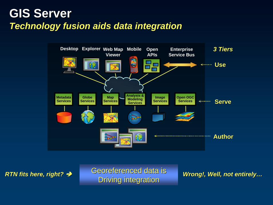
GIS ServerGIS ServerTechnology fusion aids data integrationTechnology fusion aids data integration
Georeferenced data is Georeferenced data is Driving integrationDriving integration
3 Tiers3 Tiers
MetadataServices
GlobeServices
MapServices
Analysis &ModelingServices
ImageServices
Open OGCServices
Web MapWeb MapViewerViewer
DesktopDesktop ExplorerExplorer MobileMobile EnterpriseEnterpriseService BusService Bus
OpenOpenAPIsAPIs
UseUse
ServeServe
AuthorAuthor
RTN fits here, right? RTN fits here, right? Wrong!, Well, not entirelyWrong!, Well, not entirely……
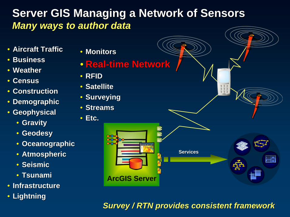
Server GIS Managing a Network of SensorsServer GIS Managing a Network of SensorsMany ways to author dataMany ways to author data
•• Aircraft TrafficAircraft Traffic•• Business Business •• WeatherWeather•• CensusCensus•• ConstructionConstruction•• Demographic Demographic •• GeophysicalGeophysical
•• Gravity Gravity •• GeodesyGeodesy•• OceanographicOceanographic•• AtmosphericAtmospheric•• SeismicSeismic•• TsunamiTsunami
•• InfrastructureInfrastructure•• LightningLightning
Survey / RTN provides consistent frameworkSurvey / RTN provides consistent framework
•• MonitorsMonitors
•• RealReal--time Networktime Network•• RFIDRFID•• SatelliteSatellite•• SurveyingSurveying•• StreamsStreams•• Etc.Etc.
ArcGIS Server
ServicesServices

Server GIS Managing a Network of SensorsServer GIS Managing a Network of SensorsWhat does this realWhat does this real--time stream sensor network have in time stream sensor network have in common with an RTN?common with an RTN?
RTN is ALSO a sensor network!RTN is ALSO a sensor network!

RTN as a Global Network of SensorsRTN as a Global Network of SensorsPractical and scientific role of RTNPractical and scientific role of RTN
RTN as a geodeticRTN as a geodetic
Sensor NetworkSensor Network
•• IonosphereIonosphere•• TroposphereTroposphere•• GeodynamicsGeodynamics•• Reference FrameReference Frame•• SeaSea--levellevel
•• Position/RTKPosition/RTK•• Network correctionsNetwork corrections
ArcGeodesyArcGeodesyGeodetic Data ModelGeodetic Data Model
GeodatabaseGeodatabase GGOS / GEOSSGGOS / GEOSS VisualizeVisualizeVisualizeVisualize
ModelModel
T1
AnalyzeAnalyze
GIS ServerGIS Server

Earth Science Contribution of RTNEarth Science Contribution of RTN
Earth observationEarth observation refers to the refers to the collection, processing, modeling, collection, processing, modeling, and dissemination of data about the and dissemination of data about the Earth system.Earth system.
These data are collected through in These data are collected through in situ, airborne and spacesitu, airborne and space--based based observations, using satellites, buoys, observations, using satellites, buoys, seismometers, and other devices.seismometers, and other devices.
They then can be processed into They then can be processed into forecasts, maps, and other decision forecasts, maps, and other decision support tools, providing valuable and support tools, providing valuable and often lifeoften life--saving information to end saving information to end users.users.
--Group on Earth ObservationsGroup on Earth ObservationsGEO Secretariat GEO Secretariat
Switzerland Switzerland http://http://www.earthobservations.org/about/about_GEO.htmlwww.earthobservations.org/about/about_GEO.html
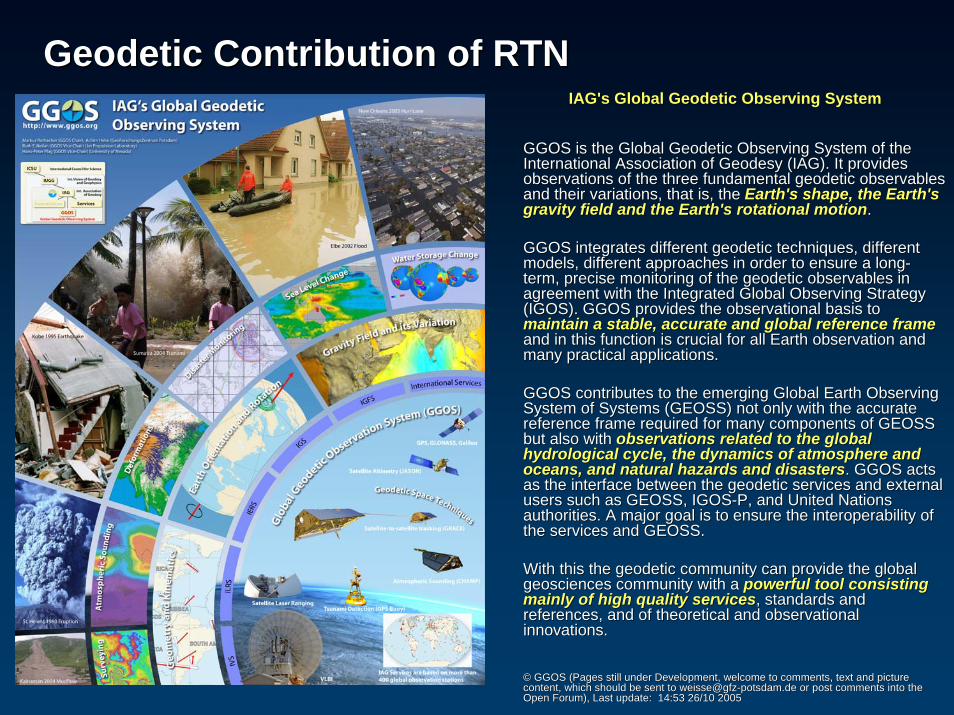
Geodetic Contribution of RTNGeodetic Contribution of RTNIAG'sIAG's Global Geodetic Observing SystemGlobal Geodetic Observing System
GGOS is the Global Geodetic Observing System of the GGOS is the Global Geodetic Observing System of the International Association of Geodesy (IAG). It provides International Association of Geodesy (IAG). It provides observations of the three fundamental geodetic observables observations of the three fundamental geodetic observables and their variations, that is, the and their variations, that is, the Earth's shape, the Earth's Earth's shape, the Earth's gravity field and the Earth's rotational motiongravity field and the Earth's rotational motion. .
GGOS integrates different geodetic techniques, different GGOS integrates different geodetic techniques, different models, different approaches in order to ensure a longmodels, different approaches in order to ensure a long--term, precise monitoring of the geodetic observables in term, precise monitoring of the geodetic observables in agreement with the Integrated Global Observing Strategy agreement with the Integrated Global Observing Strategy (IGOS). GGOS provides the observational basis to (IGOS). GGOS provides the observational basis to maintain a stable, accurate and global reference framemaintain a stable, accurate and global reference frameand in this function is crucial for all Earth observation and and in this function is crucial for all Earth observation and many practical applications. many practical applications.
GGOS contributes to the emerging Global Earth Observing GGOS contributes to the emerging Global Earth Observing System of Systems (GEOSS) not only with the accurate System of Systems (GEOSS) not only with the accurate reference frame required for many components of GEOSS reference frame required for many components of GEOSS but also with but also with observations related to the global observations related to the global hydrological cycle, the dynamics of atmosphere and hydrological cycle, the dynamics of atmosphere and oceans, and natural hazards and disastersoceans, and natural hazards and disasters.. GGOS acts GGOS acts as the interface between the geodetic services and external as the interface between the geodetic services and external users such as GEOSS, IGOSusers such as GEOSS, IGOS--P, and United Nations P, and United Nations authorities. A major goal is to ensure the interoperability of authorities. A major goal is to ensure the interoperability of the services and GEOSS. the services and GEOSS.
With this the geodetic community can provide the global With this the geodetic community can provide the global geosciences community with a geosciences community with a powerful tool consisting powerful tool consisting mainly of high quality servicesmainly of high quality services, standards and , standards and references, and of theoretical and observational references, and of theoretical and observational innovations. innovations.
©© GGOS (Pages still under Development, welcome to comments, text GGOS (Pages still under Development, welcome to comments, text and picture and picture content, which should be sent to content, which should be sent to weisse@[email protected] or post comments into the or post comments into the Open Forum), Last update:Open Forum), Last update: 14:53 26/10 200514:53 26/10 2005

Real Time NetworkReal Time NetworkArcGIS Server manages survey dataArcGIS Server manages survey data
GPS Base StationsGPS Base Stations
InternetInternet
RoverRover
DesktopDesktop Web MapWeb MapViewerViewer
MobileMobile OpenOpenAPIsAPIs
EnterpriseEnterpriseService BusService Bus
AuthorAuthor
UseUse
ServeServe ArcGIS ServerArcGIS Server@@
@@
@@
@@
@@
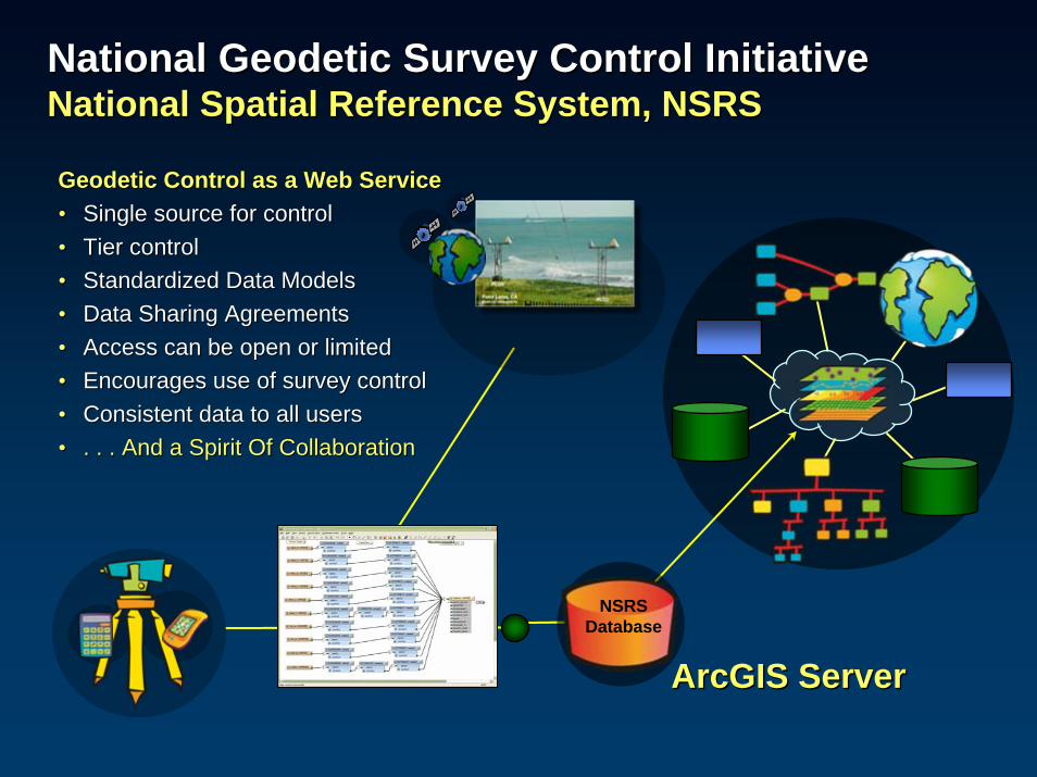
National Geodetic Survey Control InitiativeNational Geodetic Survey Control InitiativeNational Spatial Reference System, NSRSNational Spatial Reference System, NSRS
NSRSDatabase
Geodetic Control as a Web ServiceGeodetic Control as a Web Service•• Single source for controlSingle source for control•• Tier controlTier control•• Standardized Data Models Standardized Data Models •• Data Sharing Agreements Data Sharing Agreements •• Access can be open or limited Access can be open or limited •• Encourages use of survey controlEncourages use of survey control•• Consistent data to all usersConsistent data to all users•• . . . And a Spirit Of Collaboration. . . And a Spirit Of Collaboration
ArcGIS ServerArcGIS Server
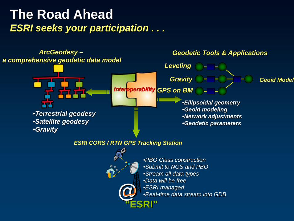
The Road AheadThe Road AheadESRI seeks your participation . . .ESRI seeks your participation . . .
InteroperabilityInteroperability
@@““ESRIESRI””
ESRI CORS / RTN GPS Tracking StationESRI CORS / RTN GPS Tracking Station
••PBO Class constructionPBO Class construction••Submit to NGS and PBOSubmit to NGS and PBO••Stream all data typesStream all data types••Data will be freeData will be free••ESRI managedESRI managed••RealReal--time data stream into GDBtime data stream into GDB
GPS on BMGPS on BM
Geodetic Tools & ApplicationsGeodetic Tools & Applications
LevelingLeveling
GravityGravity Geoid ModelGeoid Model
••Ellipsoidal geometry Ellipsoidal geometry ••Geoid modelingGeoid modeling••Network adjustmentsNetwork adjustments••Geodetic parametersGeodetic parameters
ArcGeodesyArcGeodesy ––a comprehensive geodetic data modela comprehensive geodetic data model
••Terrestrial geodesyTerrestrial geodesy••Satellite geodesySatellite geodesy••GravityGravity

Thanks!Thanks!
Kevin M. Kelly, Kevin M. Kelly, M.A.ScM.A.Sc., OLS., OLSGeodesistGeodesistRedlands, CARedlands, [email protected][email protected]
Real time GPS Networks (RTN) Real time GPS Networks (RTN) and their Implications withand their Implications with
Geographic Information Systems (GIS)Geographic Information Systems (GIS)