Embed Size (px)
Citation preview
RAILROADSIN HISTORICALCONTEXT:
ANNE MCCANTSEDUARDO BEIRA
JOSÉ M. LOPES CORDEIROPAULO LOURENÇO
(eds.)
vol.I 2011
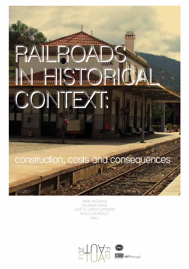
This book includes the proceedings of the first FOZTUA International Conference, organized by FOZTUA project and sponsored by EDP.This first international interdisciplinary meeting about the memory of Tua Valley and Tua railways was held last 7-8-9 October 2011, in the small village of Foz Tua, in the mouth of the Tua River with the Douro River.
The book you hold in your hands is an eclectic one. It represents the work of scholars from a broad array of disciplines: from oral history to structural engineering, from economics to museum design, from digital geo-graphic information systems to the history of public policy, corporate finance, firm management, and en-gineering education. Some might find such breadth daunting, or perhaps tedious, or fear that the intellec-tual value of any resulting product must be diminished for being so diffuse. But we hope to persuade you oth-erwise. For this volume was the outcome of a rather extraordinary academic meeting that brought together over thirty scholars from all these fields and yet oth-ers, to devote three days to a sustained, collective, and truly interdisciplinary conversation on the multiple aspects of a single phenomenon.
(from the preface, by Anne McCants, MIT)
The FOZTUA project
FOZTUA Project is a joint interdisciplinary project sponsored by EDP, in order to study, preserve and disseminate the memory of Tua Valley and Tua railroad. This project intends to challenge the academic community to study the century-long history of the Tua railways and the development of a peripheral region (Tua Valley in Trás os Montes) in a peripheral country (Portugal, 19th century), to publicize the memory and the “stories” of the line, and to discuss its impact in the region.
The project intends to bring together scholars of various aspects of railroad history in order to share their research on other railroad projects, considering their decision-making processes, the management of labor, technical difficulties to overcome, and the economic and social impact of the lines.
RAILROADSIN HISTORICALCONTEXT:
ANNE MCCANTSEDUARDO BEIRA
JOSÉ M. LOPES CORDEIROPAULO LOURENÇO
(eds.)
vol.I 2011

ISBN: 978-989-97134-5-1
Graphic design and layout, and cover design, by Ana Prudente.Samantha Evaristo contributed with revision and editing of the texts from non english authors.
Edited and printed by Inovatec (Portugal) Lda. (V. N. Gaia, Portugal).Cover printing and book binding by Minerva – Artes Gráficas, Lda. (Vila do Conde, Portugal).
• xiii
PREFACEAnne McCants
ABOUT FOZTUA PROJECT AND THE 1st INTERNATIONAL CONFERENCE IN FOZ TUAEduardo Beira
PART 1: TUA VALLEY AND THE PORTUGUESE CONTEXTO VALE DO TUA E O CONTEXTO PORTUGUÊS
The Tua line and the portuguese railway (1856- 1906)A linha do Tua e os caminhos de ferro portugueses (1856-1906) Maria Fernanda Alegria
The significance of the Tua Valley in the context of the Portuguese wolfram boom (1st half of the XX Century)O papel do Vale do Tua na euforia do volfrâmio português (primeira metade do século XX) Maria Otília Lage
Railways in Portugal and Spain: corporate and public policiesOs caminhos de ferro em Portugal e Espanha: políticas públicas e empresariais Luis Lopes dos Santos
___ iii
___ vii
___ 1
___ 3
___ 15
___ 43
INDEX
xiv •
Railways in Trás-os-Montes during the second half of the nineteenth century: projects and achievementsOs caminhos de ferro em Trás os Montes na segunda metade do século XIX: projetos e resultados Hugo Silveira Pereira
The impact of railroad accessibility on the population of Portugal’s Inland North Region (1878-1930). The Tua and the Beira Baixa linesO impacto das acessibilidades ao caminho de ferro no interior norte de Portugal: linhas do Tua e da Beira Baixa Luís Espinha da Silveira, Nuno Miguel Lima and Ana Alcântara
Tua Valley: how different is it now? An introduction to the dynamics of population (1864-2011)O Vale do Tua: quais as diferenças? Uma introdução à dinâmica populacional (1864-2010) Eduardo Beira
Narrative(s) on the construction of the landscape: the Tua Valley Memory CenterNarrativa(s) na construção da paisagem: o Núcleo da Memória do Vale do Tua Maria Manuel Oliveira
PART 2: ECONOMIC IMPACT OF RAILROADS: METHODS AND INTERNATIONAL COMPARISONSO IMPACTO ECONÓMICO DO CAMINHO DE FERRO: METODOLOGIAS E COMPARAÇÕES INTERNACIONAIS
Landownership and the coming of railroad to the American Midwest, 1850-60Propriedade da terra e o impacto da chegada do caminho de ferro ao Midwest Americano, 1850-1860 Jeremy Atack and Robert A. Margo
The evolution of the establishment of the railway network in Britain using GISA instalação da rede de caminhos de ferro no Reino Unido, com base em SIGMarta Felis-Rota and Jordi Henneberg
___ 67
___ 95
___ 119
___ 141
___ 149
___ 151
___ 179
• xv
Development of an historical GIS of railroads in the North East USA 1826-1900: phase IIDesenvolvimento de um SIG histórico dos caminhos de ferro no nordeste dos E.U.A.,1826-1900 Richard Healey and Michael Jones
Globalization, railways, and agriculture in France and Great Britain, 1850 to 1914Globalização, caminhos de ferro e agricultura em França e no Reino Unido, 1850 a 1914 Robert Schwartz and Thomas Thevenin
The Alto Douro and emigration, 1855-1914O Alto Douro e a emigração, 1855-1914 Joaquim da Costa Leite
PART 3: ENGINEERING, FINANCE AND MANAGEMENTENGENHARIA, FINANCIAMENTO E GESTÃO
More than a brass nameplate on the door: foreign ownership and control in the Companhia Real dos Caminhos de Ferro Portugueses (1860s-1890s)Investimento estrangeiro e controlo de gestão na Companhia Real dos Caminhos de Ferro Portugueses (1860-1890)Álvaro Ferreira da Silva
The man behind Tua railways: the chief engineer Dinis da MotaO homem por trás da Linha do Tua: o engenheiro chefe Dinis da Mota José M. Lopes Cordeiro
Becoming engineers in early industrial AmericaA formação de engenheiros nos primórdios industriais da América M. Roe Smith
The building of the Bhor Ghat Railway Incline in western India in the mid-19th centuryA construção do grande declive do caminho de ferro em Bhor Ghat, na Índia Ocidental, em meados do século XIX Ian Kerr
___ 193
___ 207
___ 237
___ 251
___ 253
___ 279
___ 301
___ 343
xvi •
Financing public goods and social overhead capital: some historical lessonsO financiamento de bens públicos e do capital social: algumas lições históricas Anne McCants
PART 4: THE FUTURE OF HISTORICAL RAILROADSO FUTURO DAS LINHAS HISTÓRICAS
Railways: industrial and maritime archaeology, geographic information systems, history and cultureCaminhos de ferro: arqueologia industrial e marítima, sistemas de informação geográfica, história e cultura Dominic Fontana
Dismantling an old railtrack: opportunities in Tua ValleyO desmonte de antigas linhas de caminhos de ferro: oportunidades no Vale do TuaPaulo Lourenço
Two case studies in heritage and valorization of ancient mountain railways in FranceDois casos de valorização de património ferroviário de antigas linhas de montanha em FrançaMichel Cotte
A new role for old railways: tourismUm novo uso para antigas linhas de caminho de ferro: turismo Stefano Maggi
Railways heritage: an overview.Património ferroviário: uma visão global.Guenter Dinholb
___ 357
___ 371
___ 373
___ 383
___ 399
___ 427
___ 445
Luís Espinha da Silveira • Nuno Miguel Lima • Ana Alcântara
• 95
THE IMPACT OF RAILROAD ACCESSIBILITY ON THE POPULATION OF PORTUGAL’S INLAND NORTH REGION (1878-1930).THE TUA AND THE BEIRA BAIXA LINES.O IMPACTO DA ACESSIBILIDADE AO CAMINHO DE FERRO NA POPULAÇÃO DA REGIÃO NORTE INTERIOR DE PORTUGAL (1878-1930). AS LINHAS DO TUA E DA BEIRA BAIXA
Luís Espinha da Silveira, Nuno Miguel Lima, Ana Alcântara(Nova U., Lisbon, Portugal)
Luís Espinha da Silveira is Associate Professor, Faculdade de Ciências Sociais e Humanas, Universidade Nova de Lisboa and a researcher at the Instituto de História Contemporânea, at the same University, where he coordinates the Territory and Society research group. He was the principal researcher of the Portuguese team involved in the international project “The Development of European Waterways, Road and Rail Infrastructures: A Geographical Information System for the History of European Integration (1825–2005)” of the European Science Foundation. Funded by the Fundação para a Ciência e a Tecnologia. Nuno Miguel Lima is a PhD student, Faculdade de Ciências Sociais e Humanas - Universidade Nova de Lisboa, working on Iberian transnational railways, and a researcher at Instituto de História Contemporânea, at the same University. He benefits from a PhD scholarship awarded by the Fundação para a Ciência e a Tecnologia.Ana Alcântara is a researcher at Instituto de História Contemporânea, Faculdade de Ciências Sociais e Humanas - Universidade Nova de Lisboa. She did a MSc dissertation in Geographic Information Systems and Science] about railways and population in Cova da Beira (1878-1930).
Luis Espinha da Silveira é professor associado, Faculdade de Ciencias Sociais e Humanas da Universidade Nova de Lisboa e investigador do Instituto de História Contemporânea da mesma Universidade, onde coordena o grupo de investigação sobre Território e Sociedade. É o principal investigador da equipe portuguesa envolvida no projeto internacional “The Development of European Waterways, Road and Rail Infrastructures: A Geographical Information System for the History of European Integration (1825–2005)”, da European Science Foundation. Este trabalho foi financiado pela Fundação da Ciencia e Tecnologia.Nuno Miguel Lima é um aluno de doutoramento na Faculdade de Ciências Sociais e Humanas da Universidade Nova de Lisboa, onde trabalha sobre caminhos de ferro transnacionais no espaço ibérico, sendo também investigador do Instituto de História Contemporânea da mesma Universidade. Bolseiro daFundação para a Ciência e a Tecnologia.Ana Alcântara is investigadora no Instituto de História Contemporânea, Faculdade de Ciências Sociais
Railroads in historical context: construction, costs and consequences
96 •
e Humanas da Universidade Nova de Lisboa. Apresentou uma dissertação de mestrado em sistemas de informação geográfica sobre os caminhos de ferro na Cova da Beira (1878-1930).
Abstract ResumoHistoriography on Portuguese railroads has not paid much attention neither to their regional effects, nor to the relationship between the operation of this form of transportation and population evolution. In fact, available studies usually adopt a national approach and analyze the contribution of railroads to the overall development of the country.The main argument of this paper is that in the Portuguese case, access to railroads reinforced pre-existing territorial inequalities and promoted different regional dynamics, mainly with regard to population growth, urban development and population mobility.In reality, in the more developed regions, railroad access helped increase population concentration in the areas served by this infrastructure. The railways also favored the growth of pre-existing urban centers and the emergence of new ones. They also encouraged migration into towns, thus contributing to their growth. In the Inland North, where the Tua line is integrated, traditionally affected by greater transportation difficulties, railroads seem to have operated in the opposite direction, contributing to a decline in population relative to the other regions of Portugal. Moreover, this area continued to be characterized by a predominance of modest-sized cities, unable to match the dynamism of the urban centers in the coastal regions or to attract a migrant population to aid in their development. Instead, since the end of the nineteenth century, this region suffered from an increasing emigration that railroads seem to have facilitated. To explain this evolution we must also take into account the economic crisis that affected the agriculture of this part of the country, but the presence of the railroad seems to have been a significant factor. In this paper, we will try to put the Tua line in this context, comparing its effects on population with those caused by the Beira Baixa line in another Portuguese mountainous region around the city of Covilhã.
A historiografia sobre os caminhos de ferro portugueses não tem prestado muita atenção aos seus efeitos regionais ou à relação entre esta forma de transporte e a evolução da população. De facto, os estudos disponíveis adoptam geralmente uma perspetiva nacional e analisam apenas a contribuição dos caminhos de ferro para o desenvolvimento global do país.O principal argumento deste trabalho é que, no caso de Portugal, o acesso aos caminhos de ferro reforçou as desigualdades territoriais anteriores e promoveu diferentes dinâmicas regionais, especialmente relacionadas com o crescimento da
Luís Espinha da Silveira • Nuno Miguel Lima • Ana Alcântara
• 97
população, o desenvolvimento urbano e a mobilidade das populações. Na realidade, nas regiões mais desenvolvidas, o acesso aos caminhos de ferro contribuiu para o aumento da concentração da população nas áreas servidas pela infraestrutura; os caminhos de ferro favoreceram ainda o crescimento dos centros urbanos pré-existentes e a emergência de novos centros. Encorajou também a migração para as cidades e vilas, contribuindo para o seu crescimento. No interior Norte, onde a linha do Tua estava integrada, região tradicionalmente afectada por maiores dificuldades de transporte, o caminho de ferro parece ter operado na direção oposta, contribuindo para um declínio da população relativamente às outras regiões de Portugal. Além disso, esta área continuou a ser caracterizada pelo predomínio de cidades de dimensões modestas, incapazes de concorrer com o dinamismo dos centros urbanos das regiões costeiras ou de atrair uma população migrante capaz de promover o seu desenvolvimento. Ao invés, desde o final do século XIX, esta região sofreu um aumento da emigração que o caminho de ferro parece ter facilitado. Para explicar esta evolução devemos também ter em consideração a crise económica que afetou então a agricultura desta região, embora a presença da linha de caminho de ferro pareça ter sido um fator significativo.Neste trabalho tenta-se pôr a linha do Tua neste contexto, comparando os seus efeitos na população com aqueles causados pela linha da Beira Baixa noutra região montanhosa portuguesa em torno da cidade da Covilhã.

Railroads in historical context: construction, costs and consequences
98 •
Luís Espinha da Silveira • Nuno Miguel Lima • Ana Alcântara
• 99
Instituto de História Contemporânea, Faculdade de Ciências Sociais e Humanas, Universidade Nova de Lisboa. This article was produced within the research project “The Development of European Waterways, Road and Rail Infrastructures: A Geographical Information System for the History of European Integration (1825-2005),” as part of the EUROCORES program of the European Science Foundation. The Portuguese
team was funded by Fundação para a Ciência e a Tecnologia (INVENT/0001/2007).
The impact of railroad accessibility on the population of Portugal’s Inland North
Region (1878-1930).The Tua and the Beira Baixa lines
Luís Espinha da Silveira, Nuno Miguel Lima e Ana Alcântara
Historiography on Portuguese railroads has not paid much attention neither to the regional effects of the construction of this infrastructure, nor to the relation-ship between the operation of this form of transportation and population evolu-tion. The exceptions are represented by the classic work by Maria Fernanda Alegria, who studied the formation of the national market, and by two recent studies, one on the role of railroads in the relocation of industry during the first half of the twentieth century and the other on their link with the urban network, focusing primarily on Lisbon and Oporto1. Other studies focus on the country at large and analyze the contribution of railroads to national development. Usually, they adopt a pessimistic view and emphasize the prevalence of private and for-eign interests, as opposed to those of the nation. They also underline the finan-cial burden of railroad construction for the state and the corruption associated with it, as well as the incapacity of the Portuguese economy to supply the capital
1 Maria Fernanda Alegria, A organização dos transportes em Portugal, 1850-1910: as vias e o tráfego, Lisbon, Centro de Estudos Geográficos, 1990; Maria Eugenia Mata, “As bees attracted to honey. Transport and job mobility in Portugal, 1890-1950”, Journal of Transport History, vol. 29, 2, 2008; Magda Pinheiro, Cidade e caminhos-de-ferro, Lisbon, Centro de Estudos de História Contemporânea, 2008.
Railroads in historical context: construction, costs and consequences
100 •
and industrial goods necessary for the development of the railroad network, lim-iting its contribution to the supply of manpower2.
In previous studies, we tried to show that in Portugal, in a period similar to the one examined here, accessibility to railroads reinforced pre-existing ter-ritorial inequalities and promoted different regional dynamics, with respect to population growth, urban development, internal migration and emigration. We particularly suggested that in the Inland North, railroads seem to have contrib-uted to a decline in population in comparison with the other regions of Portugal and, in contrast to what happened in the rest of the country, they did not stimu-late urban growth. This area, whose boundaries we will explain later, was still unable to attract a migrant population to aid in its development and most likely fueled migration to other regions. Furthermore, it was gradually affected by emigration that the railroad would also have facilitated3.
This paper deepens the evolution of the Inland North and examines two areas included in its territory: Tua, served by the line with the same name, and Cova da Beira, served by the Beira Baixa line.
The research is focused on the period between 1878 and 1930, to cover the ar-rival of the railroad in the Inland North and to exclude the effect of bus services. In some analyses, however, a longer timeframe was considered.
This research team has been particularly interested in exploring the link be-tween space and History and has been applying Geographic Information Sys-tems (GIS) to Portugal’s history. This effort began years ago with the construc-tion of a cartographic infrastructure supported by a GIS, which now includes parish maps of mainland Portugal from 1758 up to 2001 and maps from all the existing administrative divisions above this level4. At the same time, a consid-
2 António Lopes Vieira, The role of Britain and France in the finance of Portuguese railways, 1850-1890: a comparative study in speculation, corruption and inefficiency, Leicester, University of Leicester, 1983; Magda Pinheiro, Chemins de fer, structure financiere de I’Etat et dependance exterieure au Portugal (1850-1890), Paris, Univ. Paris 1, 1986; Álvaro Ferreira da Silva and Lara Tavares, “Transport History in Portugal: a bibliographical overview”, in Michele Merger e Marie-Noelle Polino (eds.), COST 340, towards a European intermodal transport network lessons from history: a critical bibliography, Paris, AHICF, 2004; Maria Eugénia Mata and Lara Tavares, “The value of Portuguese railways for consumers on the eve of the First World War”, TST: Transportes, Servicios y Telecomunicaciones, 7, 2003, pp.80-100; Angela Salgueiro, A Companhia Real dos Caminhos de Ferro Portugueses, 1859-1860, Lisbon, Faculdade de Ciências Sociais e Humanas, 2008.
3 Luis Espinha da Silveira, Daniel Alves, Nuno Miguel Lima, Ana Alcântara, and Josep Puig, “Population and railways in Portugal, 1801-1930”, Journal of Interdisciplinary History, vol. 42, 1, 2011, pp.29-52; idem,”Caminhos de ferro, população e desigualdades territoriais em Portugal, 1801-1930”, Ler História 61, 2011, pp.7-37.
4 The maps used in this article have been developed by several teams since the early 1990s. Initial results were presented at the Ninth International Conference of the Association for History and Computing in 1994, giving rise afterwards to several printed publications - among them, Luis Espinha da Silveira, Margarida Lopes, and Cristina Joanaz de Melo, “Mapping Portuguese Historical Boundaries with a GIS” in Onno Boonstra, Geurt Collenteur, and Bart van Elderen (eds.), Structures and contingencies in computerized historical research, Hilversum, 1995, pp.245-252; Luis Espinha da Silveira, Território e poder: Nas origens do Estado contemporâneo em
Luís Espinha da Silveira • Nuno Miguel Lima • Ana Alcântara
• 101
erable body of data on Portuguese population in the nineteenth and twentieth centuries was collected. Recently, the geographic research scope was extended to the entire Iberian Peninsula.
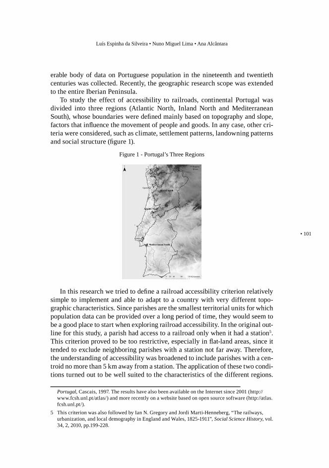
To study the effect of accessibility to railroads, continental Portugal was divided into three regions (Atlantic North, Inland North and Mediterranean South), whose boundaries were defined mainly based on topography and slope, factors that influence the movement of people and goods. In any case, other cri-teria were considered, such as climate, settlement patterns, landowning patterns and social structure (figure 1).
In this research we tried to define a railroad accessibility criterion relatively simple to implement and able to adapt to a country with very different topo-graphic characteristics. Since parishes are the smallest territorial units for which population data can be provided over a long period of time, they would seem to be a good place to start when exploring railroad accessibility. In the original out-line for this study, a parish had access to a railroad only when it had a station5. This criterion proved to be too restrictive, especially in flat-land areas, since it tended to exclude neighboring parishes with a station not far away. Therefore, the understanding of accessibility was broadened to include parishes with a cen-troid no more than 5 km away from a station. The application of these two condi-tions turned out to be well suited to the characteristics of the different regions.
Portugal, Cascais, 1997. The results have also been available on the Internet since 2001 (http://www.fcsh.unl.pt/atlas/) and more recently on a website based on open source software (http://atlas.fcsh.unl.pt/).
5 This criterion was also followed by Ian N. Gregory and Jordi Marti-Henneberg, “The railways, urbanization, and local demography in England and Wales, 1825-1911”, Social Science History, vol. 34, 2, 2010, pp.199-228.
Figure 1 - Portugal’s Three Regions
Railroads in historical context: construction, costs and consequences
102 •
The criteria chosen apply equally to areas where the parishes are small and to others where they are larger, as well as to flat-land and mountainous regions6.
THE CONSTRUCTION OF THE RAILROADS
As Maria Fernanda Alegria showed, Portugal arrived late to the railroad era and built a small network in relation to its population and area of the territory7. Bearing in mind the censuses years, it appears that the pace of construction was irregular, alternating between periods of rapid growth (1856-1864, 1878-1890, 1900-1911) and phases of downturn, corresponding to moments of economic and financial hardship8.
As in many other countries, the capital city played a pivotal role. The first priority was to connect Lisbon with Oporto, Spain and the South. The lines around the second biggest city, Oporto, were already in operation in 1878, mo-ment in which the crossing of the Atlantic North was completed. During the great construction period (1878-1890), railroads arrived in the Inland North, in Algarve and in the coastal region north of Lisbon, a major supply area of the capital. During these years four international connections were also established. At that time, the first section of the Tua line was opened between the station of the same name in the Douro line and Mirandela (1887). From that period on, the focus was on the construction of the regional lines, among others, the Beira Baixa one, opened until Covilhã in 1891 and ended in 1893 when it reached Guarda. The lines in the extreme northeast progressed considerably in the early twentieth century, among them the Tua, which reached Bragança in 1906. As for the regional distribution of the infrastructure, the Atlantic North, with 69.1 km of railroad per 1,000 km2 in 1930 was greatly benefited by comparison with the South (31.9 km) and the Inland North (28.9 km).
THE TUA AND COVA DA BEIRA AREAS
The Tua and Cova da Beira areas were defined by selecting the municipalities crossed by the Tua and Beira Baixa lines. In the first case, the entire line was 6 Data published in the article by Magda Pinheiro, Nuno Miguel Lima and Joana Paulino, “Espaço,
tempo e preço dos transportes: a utilização da rede ferroviária no final do século XIX”, Ler História, 61, 2011, pp.39-64, indicate that the cost of passenger and freight transportation substantially increases beyond 10km away from a station. This result suggests a reconsideration of the distance used so far to define accessibility.
7 Maria Fernanda Alegria, A organização dos transportes em Portugal, p.214.8 Magda Pinheiro, “Transportes”, in Nuno Valerio (ed.), Estatísticas históricas portuguesas, Lisbon,
Instituto Nacional de Estatistica, 2001, pp.372-376.
Luís Espinha da Silveira • Nuno Miguel Lima • Ana Alcântara
• 103
included, but in the second one only the section between the stations of Castelo Novo e Belmonte-Manteigas was included9.
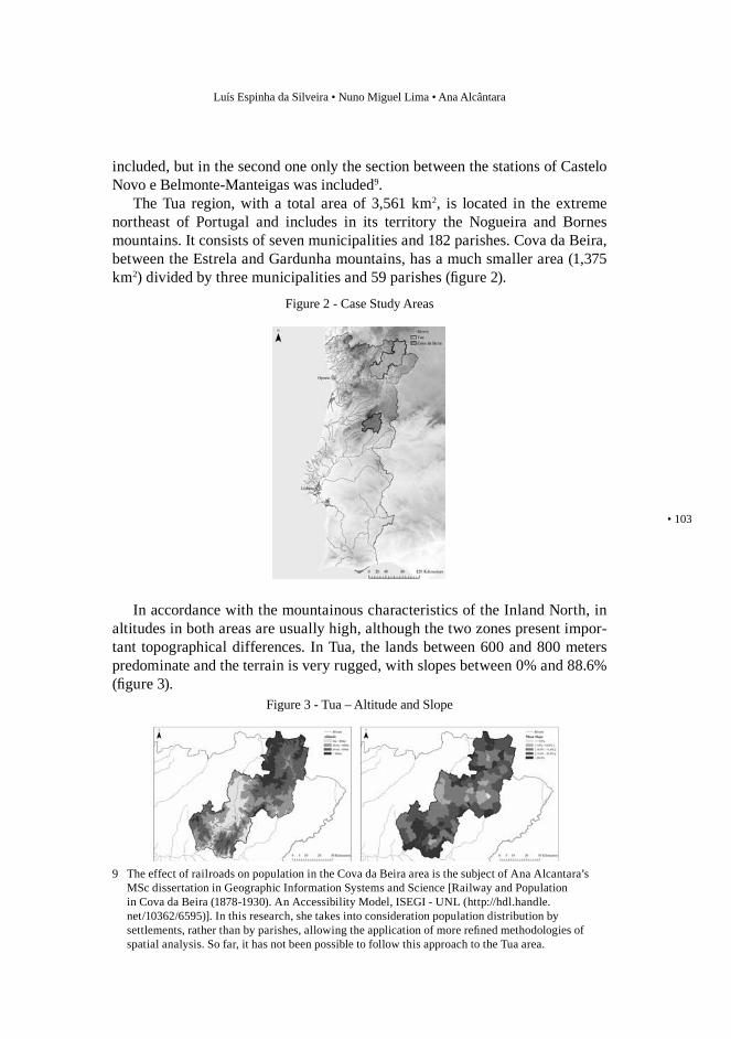
The Tua region, with a total area of 3,561 km2, is located in the extreme northeast of Portugal and includes in its territory the Nogueira and Bornes mountains. It consists of seven municipalities and 182 parishes. Cova da Beira, between the Estrela and Gardunha mountains, has a much smaller area (1,375 km2) divided by three municipalities and 59 parishes (figure 2).
In accordance with the mountainous characteristics of the Inland North, in altitudes in both areas are usually high, although the two zones present impor-tant topographical differences. In Tua, the lands between 600 and 800 meters predominate and the terrain is very rugged, with slopes between 0% and 88.6% (figure 3).
9 The effect of railroads on population in the Cova da Beira area is the subject of Ana Alcantara’s MSc dissertation in Geographic Information Systems and Science [Railway and Population in Cova da Beira (1878-1930). An Accessibility Model, ISEGI - UNL (http://hdl.handle.net/10362/6595)]. In this research, she takes into consideration population distribution by settlements, rather than by parishes, allowing the application of more refined methodologies of spatial analysis. So far, it has not been possible to follow this approach to the Tua area.
Figure 2 - Case Study Areas
Figure 3 - Tua – Altitude and Slope
Railroads in historical context: construction, costs and consequences
104 •
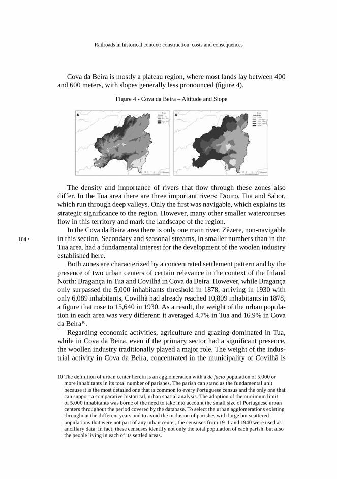
Cova da Beira is mostly a plateau region, where most lands lay between 400 and 600 meters, with slopes generally less pronounced (figure 4).
The density and importance of rivers that flow through these zones also differ. In the Tua area there are three important rivers: Douro, Tua and Sabor, which run through deep valleys. Only the first was navigable, which explains its strategic significance to the region. However, many other smaller watercourses flow in this territory and mark the landscape of the region.
In the Cova da Beira area there is only one main river, Zêzere, non-navigable in this section. Secondary and seasonal streams, in smaller numbers than in the Tua area, had a fundamental interest for the development of the woolen industry established here.
Both zones are characterized by a concentrated settlement pattern and by the presence of two urban centers of certain relevance in the context of the Inland North: Bragança in Tua and Covilhã in Cova da Beira. However, while Bragança only surpassed the 5,000 inhabitants threshold in 1878, arriving in 1930 with only 6,089 inhabitants, Covilhã had already reached 10,809 inhabitants in 1878, a figure that rose to 15,640 in 1930. As a result, the weight of the urban popula-tion in each area was very different: it averaged 4.7% in Tua and 16.9% in Cova da Beira10.
Regarding economic activities, agriculture and grazing dominated in Tua, while in Cova da Beira, even if the primary sector had a significant presence, the woollen industry traditionally played a major role. The weight of the indus-trial activity in Cova da Beira, concentrated in the municipality of Covilhã is
10 The definition of urban center herein is an agglomeration with a de facto population of 5,000 or more inhabitants in its total number of parishes. The parish can stand as the fundamental unit because it is the most detailed one that is common to every Portuguese census and the only one that can support a comparative historical, urban spatial analysis. The adoption of the minimum limit of 5,000 inhabitants was borne of the need to take into account the small size of Portuguese urban centers throughout the period covered by the database. To select the urban agglomerations existing throughout the different years and to avoid the inclusion of parishes with large but scattered populations that were not part of any urban center, the censuses from 1911 and 1940 were used as ancillary data. In fact, these censuses identify not only the total population of each parish, but also the people living in each of its settled areas.
Figure 4 - Cova da Beira – Altitude and Slope
Luís Espinha da Silveira • Nuno Miguel Lima • Ana Alcântara
• 105
confirmed by the industrial survey of 1890 which identified facilities with more than five workers. This source indicates that in Covilhã, there were 100 factories almost exclusively engaged in wool processing, which employed a total of 3,676 workers. These figures compare with the incredibly low number of plants (4) in all the Tua area, employing 36 workers. In addition, large modern industrial units had already been established in Covilhã, using steam energy. This survey, however, leaves out much of craft and domestic industry which was a reality in the two areas in question.
POPULATION
After a long period of crisis, as the economy recovered and efforts to modernize the country produced some results, the annual growth rate (CAGR) of the popu-lation of mainland Portugal, between 1849 and 1911, improved and reached a moderate level (0.79%). Between 1911 and 1920, the population almost stagnated, mainly because of high rates of emigration, the effects of World War I, and the influenza epidemic of 1918; thereafter, its growth resumed, values reaching more than 1 percent per year. This population-growth pattern is the result of a late de-mographic transition and is similar to that of other southern European countries11.
Unlike the Atlantic North and the South, between 1849 and 1911, the popula-tion of the Inland North increased at a rate below the national average (0.54%) and even decreased between 1911 and 1920 (-0.42%). The figures recovered in subsequent years, but again the growth rate (0.64%) was half the value calcu-lated for the whole country and was below the value of the Atlantic North and of the South.
The differences in population evolution among the various regions are in line with the development of their economies. In particular, the slow growth rate in the number of inhabitants of the Inland North is linked to the difficulties of the regional agriculture, which from the last decades of the nineteenth century gradually lost weight in the national context12. The explanation of these facts is
11 In the first half of the nineteenth century, Portugal’s CAGR was lower than Italy’s (0.6%) or Spain’s (0.6%), but thereafter, until the end of the century, Portugal’s growth was similar to the one observed in these countries, though still far from that of other states in northern Europe, such as Belgium (1.2%), the Netherlands (1.5%), and Britain (1.6%). Neil Tranter, Population since the Industrial Revolution: The case of England and Wales, London, 1973, p.43; Massimo Livi Bacci, The Population of Europe: A History, New York, 2000, p. 132; David Reher, “The Demographic Transition Revisited as a Global Process,” Population, Space and Place, X, 2004, pp.22, 35, 37; Teresa Rodrigues Veiga, A população portuguesa no século XIX, Oporto, 2004, pp.20-22; idem, “A transição demográfica,” in Pedro Lains and Ferreira da Silva (eds.), História Económica de Portugal, 1700-200: O século XIX, Lisbon, 2005, pp.37-63; idem (ed.), História da população portuguesa: das longas permanencias a conquista da modernidade, Oporto, CEPESE - Centro de Estudos da População, Economia e Sociedade, 2008.
12 Data published by David Justino indicate that compared with the whole country, the percentage
Railroads in historical context: construction, costs and consequences
106 •
complex and does not correspond to the purpose of this paper, except in what concerns the possible contribution of railroads to the development of population, cities and migration.
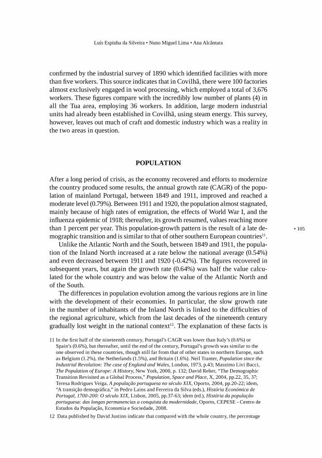
Up to 1911, growth in the population of Cova da Beira was faster (1.01%) and far exceeded that of the country and of the Inland North. In the Tua area, the growth rate was higher than the latter (0.72%). In the years 1911-1920, the areas in question followed the downward trend of the Inland North, but the con-traction was particularly important in Tua (-1.36%). The next decade was more positive everywhere and both Tua and Cova da Beira increased at a rate closer to the national average (respectively 1.05% and 1.04%) (figure 5).
The case study areas were defined according to the railroad presence. There-fore, the percentage of population with access to such transportation was nat-urally high, compared to the Inland North (up to 32.5% in 1930). In Tua, it reached 21.65% at the opening of the Mirandela section (1890) and 39.82% in 1930; in Cova da Beira accessibility was much higher, reaching 59.15% of the population in 1900, shortly after the completion of the line. This difference may be explained by the smaller area encompassed by Cova da Beira and by the pres-ence of a medium-size urban center.
Across the country, the effect of railroad accessibility on population growth is reflected in the fact that parishes with access grew constantly faster than those
of the agricultural production of Vila Real, Bragança, Viseu e Guarda districts, which correspond, roughly to the Inland North region, decreased from 1880 until the 1920s. This evolution applies to grain and wine production, and to sheep and swine breeding from 1870 up to 1925. Moreover, Oporto wine exports also experienced a decline in their share in Portugal’s exports from 1880 until the break of World War I. David Justino, A formação do espaço económico nacional, Lisbon, 1989, II, pp. 136-144. As for the exports, see Pedro Lains, A economia portuguesa no século XIX: crescimento económico e comércio externo, 1851-1913, Lisbon, Imprensa Nacional-Casa da Moeda, 1995, p.92.
1,5
1,0
0,5
0
-0,5
-1,0
-1,5
Figure 5 - Population Growth (CAGR)
CA
GR
1849-1911 1911-1920 1920-1930Portugal Inland North Tua Cova da Beira
Luís Espinha da Silveira • Nuno Miguel Lima • Ana Alcântara
• 107
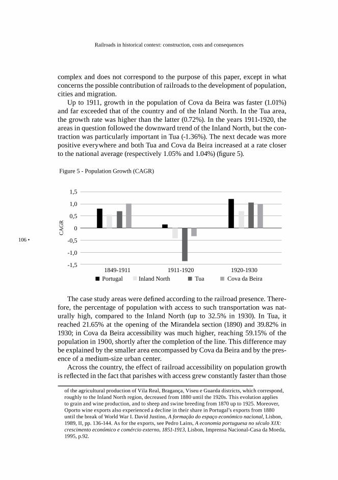
without it, throughout the period from 1878 to 1930. This trend was also found in the Atlantic North and somehow in the South, but not in the Inland North. In fact, in this latter region, between 1878 and 1920, the difference in the growth rates of two groups of parishes (with and without access) was very low and in the decade of 1890-1900 was even unfavorable to locations with access. The growth of these parishes only took off at the end of the period under analysis (1920-1930), fol-lowing a national trend (figure 6).
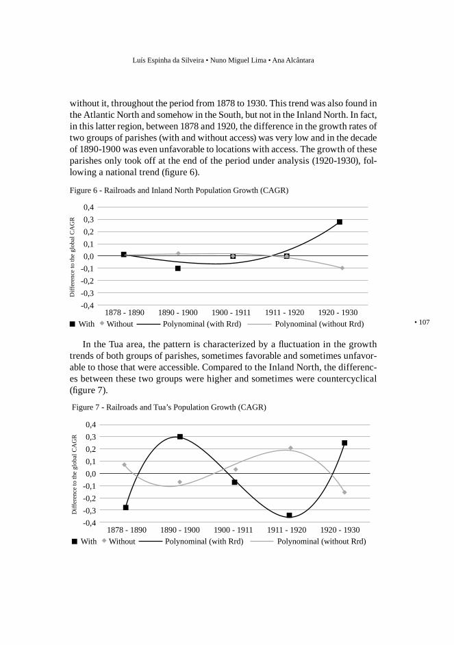
In the Tua area, the pattern is characterized by a fluctuation in the growth trends of both groups of parishes, sometimes favorable and sometimes unfavor-able to those that were accessible. Compared to the Inland North, the differenc-es between these two groups were higher and sometimes were countercyclical (figure 7).
0,40,30,20,10,0
-0,1-0,2-0,3-0,4
Figure 6 - Railroads and Inland North Population Growth (CAGR)
Diff
eren
ce to
the
glob
al C
AG
R
1878 - 1890With Polynominal (without Rrd)Without
1890 - 1900 1900 - 1911 1911 - 1920 1920 - 1930Polynominal (with Rrd)
0,40,30,20,10,0
-0,1-0,2-0,3-0,4
Figure 7 - Railroads and Tua’s Population Growth (CAGR)
Diff
eren
ce to
the
glob
al C
AG
R
1878 - 1890With Polynominal (without Rrd)Without
1890 - 1900 1900 - 1911 1911 - 1920 1920 - 1930Polynominal (with Rrd)
Railroads in historical context: construction, costs and consequences
108 •
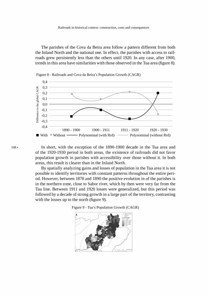
The parishes of the Cova da Beira area follow a pattern different from both the Inland North and the national one. In effect, the parishes with access to rail-roads grew persistently less than the others until 1920. In any case, after 1900, trends in this area have similarities with those observed in the Tua area (figure 8).
0,40,30,20,10,0
-0,1-0,2-0,3-0,4
Figure 8 - Railroads and Cova da Beira’s Population Growth (CAGR)
Diff
eren
ce to
the
glob
al C
AG
R
With Polynominal (without Rrd)Without1890 - 1900 1900 - 1911 1911 - 1920 1920 - 1930
Polynominal (with Rrd)
In short, with the exception of the 1890-1900 decade in the Tua area and of the 1920-1930 period in both areas, the existence of railroads did not favor population growth in parishes with accessibility over those without it. In both areas, this result is clearer than in the Inland North.
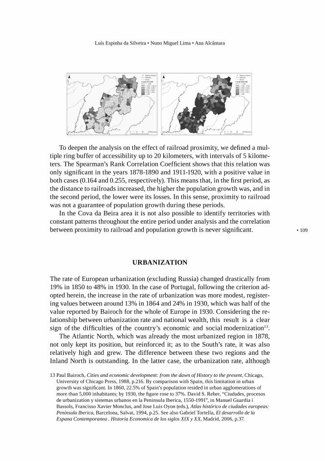
By spatially analyzing gains and losses of population in the Tua area it is not possible to identify territories with constant patterns throughout the entire peri-od. However, between 1878 and 1890 the positive evolution in of the parishes is in the northern zone, close to Sabor river, which by then were very far from the Tua line. Between 1911 and 1920 losses were generalized, but this period was followed by a decade of strong growth in a large part of the territory, contrasting with the losses up to the north (figure 9).
Figure 9 - Tua’s Population Growth (CAGR)
Luís Espinha da Silveira • Nuno Miguel Lima • Ana Alcântara
• 109
To deepen the analysis on the effect of railroad proximity, we defined a mul-tiple ring buffer of accessibility up to 20 kilometers, with intervals of 5 kilome-ters. The Spearman’s Rank Correlation Coefficient shows that this relation was only significant in the years 1878-1890 and 1911-1920, with a positive value in both cases (0.164 and 0.255, respectively). This means that, in the first period, as the distance to railroads increased, the higher the population growth was, and in the second period, the lower were its losses. In this sense, proximity to railroad was not a guarantee of population growth during these periods.
In the Cova da Beira area it is not also possible to identify territories with constant patterns throughout the entire period under analysis and the correlation between proximity to railroad and population growth is never significant.
URBANIZATION
The rate of European urbanization (excluding Russia) changed drastically from 19% in 1850 to 48% in 1930. In the case of Portugal, following the criterion ad-opted herein, the increase in the rate of urbanization was more modest, register-ing values between around 13% in 1864 and 24% in 1930, which was half of the value reported by Bairoch for the whole of Europe in 1930. Considering the re-lationship between urbanization rate and national wealth, this result is a clear sign of the difficulties of the country’s economic and social modernization13.
The Atlantic North, which was already the most urbanized region in 1878, not only kept its position, but reinforced it; as to the South’s rate, it was also relatively high and grew. The difference between these two regions and the Inland North is outstanding. In the latter case, the urbanization rate, although
13 Paul Bairoch, Cities and economic development: from the dawn of History to the present, Chicago, University of Chicago Press, 1988, p.216. By comparison with Spain, this limitation in urban growth was significant. In 1860, 22.5% of Spain’s population resided in urban agglomerations of more than 5,000 inhabitants; by 1930, the figure rose to 37%. David S. Reher, “Ciudades, procesos de urbanization y sistemas urbanos en la Peninsula Iberica, 1550-1991”, in Manuel Guardia i Bassols, Francisso Xavier Monclus, and Jose Luis Oyon (eds.), Atlas histórico de ciudades europeas: Peninsula Iberica, Barcelona, Salvat, 1994, p.25. See also Gabriel Tortella, El desarrollo de la Espana Contemporanea . Historia Economica de los siglos XIX y XX, Madrid, 2006, p.37.
Railroads in historical context: construction, costs and consequences
110 •
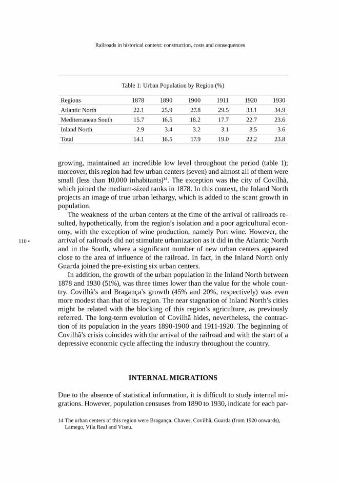
growing, maintained an incredible low level throughout the period (table 1); moreover, this region had few urban centers (seven) and almost all of them were small (less than 10,000 inhabitants)14. The exception was the city of Covilhã, which joined the medium-sized ranks in 1878. In this context, the Inland North projects an image of true urban lethargy, which is added to the scant growth in population.
The weakness of the urban centers at the time of the arrival of railroads re-sulted, hypothetically, from the region’s isolation and a poor agricultural econ-omy, with the exception of wine production, namely Port wine. However, the arrival of railroads did not stimulate urbanization as it did in the Atlantic North and in the South, where a significant number of new urban centers appeared close to the area of influence of the railroad. In fact, in the Inland North only Guarda joined the pre-existing six urban centers.
In addition, the growth of the urban population in the Inland North between 1878 and 1930 (51%), was three times lower than the value for the whole coun-try. Covilhã’s and Bragança’s growth (45% and 20%, respectively) was even more modest than that of its region. The near stagnation of Inland North’s cities might be related with the blocking of this region’s agriculture, as previously referred. The long-term evolution of Covilhã hides, nevertheless, the contrac-tion of its population in the years 1890-1900 and 1911-1920. The beginning of Covilhã’s crisis coincides with the arrival of the railroad and with the start of a depressive economic cycle affecting the industry throughout the country.
INTERNAL MIGRATIONS
Due to the absence of statistical information, it is difficult to study internal mi-grations. However, population censuses from 1890 to 1930, indicate for each par-
14 The urban centers of this region were Bragança, Chaves, Covilhã, Guarda (from 1920 onwards), Lamego, Vila Real and Viseu.
Table 1: Urban Population by Region (%)
Regions 1878 1890 1900 1911 1920 1930Atlantic North 22.1 25.9 27.8 29.5 33.1 34.9Mediterranean South 15.7 16.5 18.2 17.7 22.7 23.6Inland North 2.9 3.4 3.2 3.1 3.5 3.6Total 14.1 16.5 17.9 19.0 22.2 23.8
Luís Espinha da Silveira • Nuno Miguel Lima • Ana Alcântara
• 111
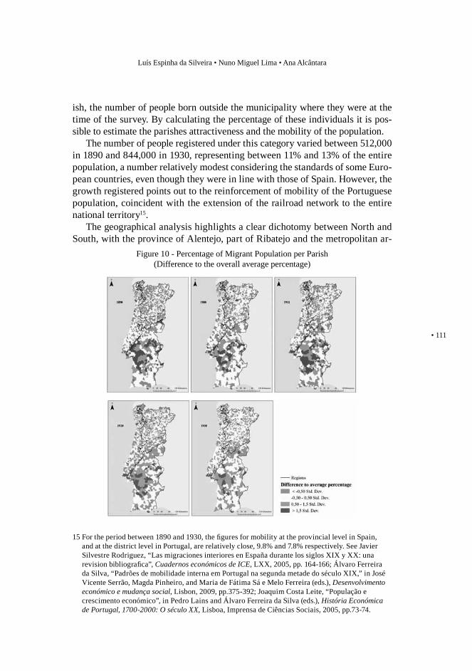
ish, the number of people born outside the municipality where they were at the time of the survey. By calculating the percentage of these individuals it is pos-sible to estimate the parishes attractiveness and the mobility of the population.
The number of people registered under this category varied between 512,000 in 1890 and 844,000 in 1930, representing between 11% and 13% of the entire population, a number relatively modest considering the standards of some Euro-pean countries, even though they were in line with those of Spain. However, the growth registered points out to the reinforcement of mobility of the Portuguese population, coincident with the extension of the railroad network to the entire national territory15.
The geographical analysis highlights a clear dichotomy between North and South, with the province of Alentejo, part of Ribatejo and the metropolitan ar-
15 For the period between 1890 and 1930, the figures for mobility at the provincial level in Spain, and at the district level in Portugal, are relatively close, 9.8% and 7.8% respectively. See Javier Silvestre Rodriguez, “Las migraciones interiores en España durante los siglos XIX y XX: una revision bibliografica”, Cuadernos económicos de ICE, LXX, 2005, pp. 164-166; Álvaro Ferreira da Silva, “Padrões de mobilidade interna em Portugal na segunda metade do século XIX,” in José Vicente Serrão, Magda Pinheiro, and Maria de Fátima Sá e Melo Ferreira (eds.), Desenvolvimento económico e mudança social, Lisbon, 2009, pp.375-392; Joaquim Costa Leite, “População e crescimento económico”, in Pedro Lains and Álvaro Ferreira da Silva (eds.), História Económica de Portugal, 1700-2000: O século XX, Lisboa, Imprensa de Ciências Sociais, 2005, pp.73-74.
Figure 10 - Percentage of Migrant Population per Parish(Difference to the overall average percentage)
Railroads in historical context: construction, costs and consequences
112 •
eas of Lisbon and Oporto appearing as the zones with higher attractiveness. Moreover, the trend observed throughout the period of 1890-1930 shows a ris-ing geographic concentration of migrant population, particularly in urban areas (figure 10).
A more detailed statistical analysis stresses out that a significant portion of this population - on average, nearly 67% throughout the period studied - was registered in the Atlantic North, 20% in the South and the remaining 13% in the Inland North, the least attractive region from this point of view.
Beyond its low attractiveness, in the Inland North migrant population at most accounted for 7.2% of the region’s inhabitants, a value reached in 1900. This score represented half of the South value (15.1% in 1911) and scarcely more than one third of that of the Atlantic North (20.6% in 1911).
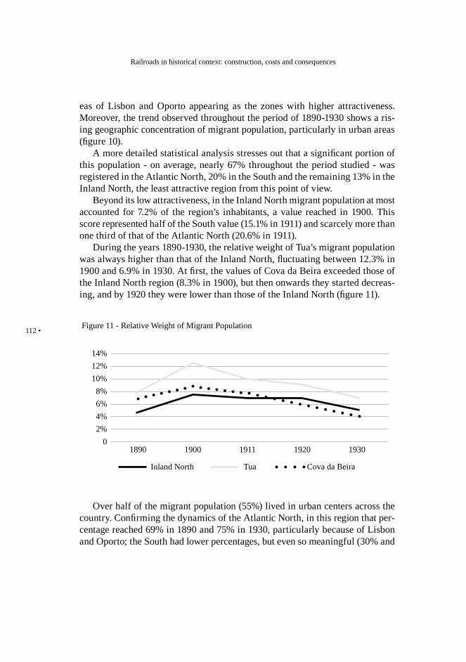
During the years 1890-1930, the relative weight of Tua’s migrant population was always higher than that of the Inland North, fluctuating between 12.3% in 1900 and 6.9% in 1930. At first, the values of Cova da Beira exceeded those of the Inland North region (8.3% in 1900), but then onwards they started decreas-ing, and by 1920 they were lower than those of the Inland North (figure 11).
14%12%10%8%6%4%2%
0
Figure 11 - Relative Weight of Migrant Population
1890 1900 1911 1920 1930
Inland North Tua Cova da Beira
Over half of the migrant population (55%) lived in urban centers across the country. Confirming the dynamics of the Atlantic North, in this region that per-centage reached 69% in 1890 and 75% in 1930, particularly because of Lisbon and Oporto; the South had lower percentages, but even so meaningful (30% and
Luís Espinha da Silveira • Nuno Miguel Lima • Ana Alcântara
• 113
43%, respectively). In the Inland North, the weak urban vitality is once again reflected in the considerably lower importance of urban migrant population, and in its tendency to diminish (16% and 15%).
Although Bragança was a small city, the weight of its migrant population was slightly higher than the correspondent figures for the Inland North urban centers (18.7% and 19.5%). In 1890, Covilhã had a noteworthy value (52.1%), which drastically decreased in the following periods, reaching 23.5% in 1930. To a certain degree, this reduction explains the city’s population contraction between 1911 and 1920.
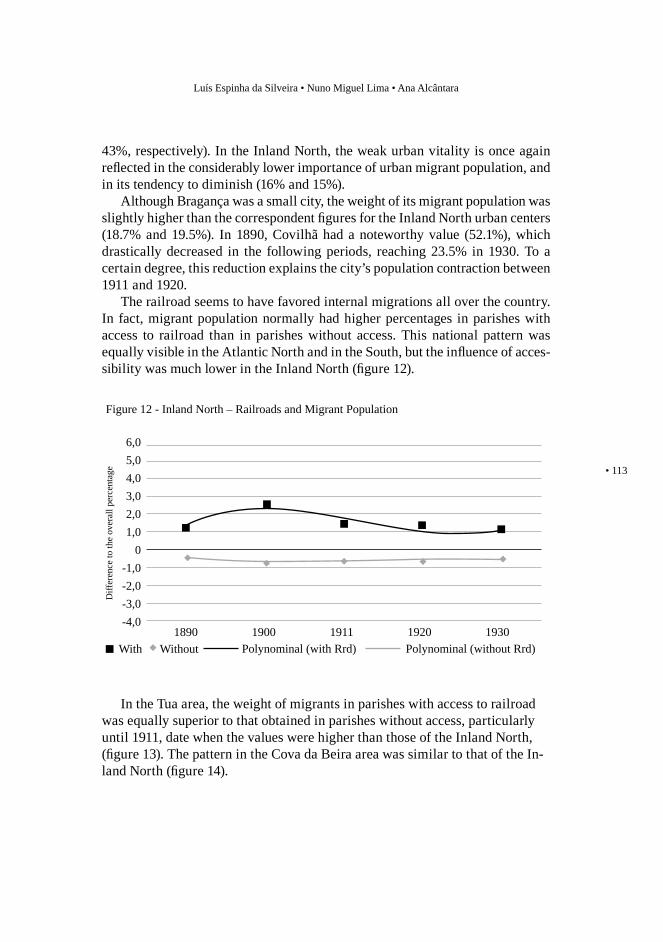
The railroad seems to have favored internal migrations all over the country. In fact, migrant population normally had higher percentages in parishes with access to railroad than in parishes without access. This national pattern was equally visible in the Atlantic North and in the South, but the influence of acces-sibility was much lower in the Inland North (figure 12).
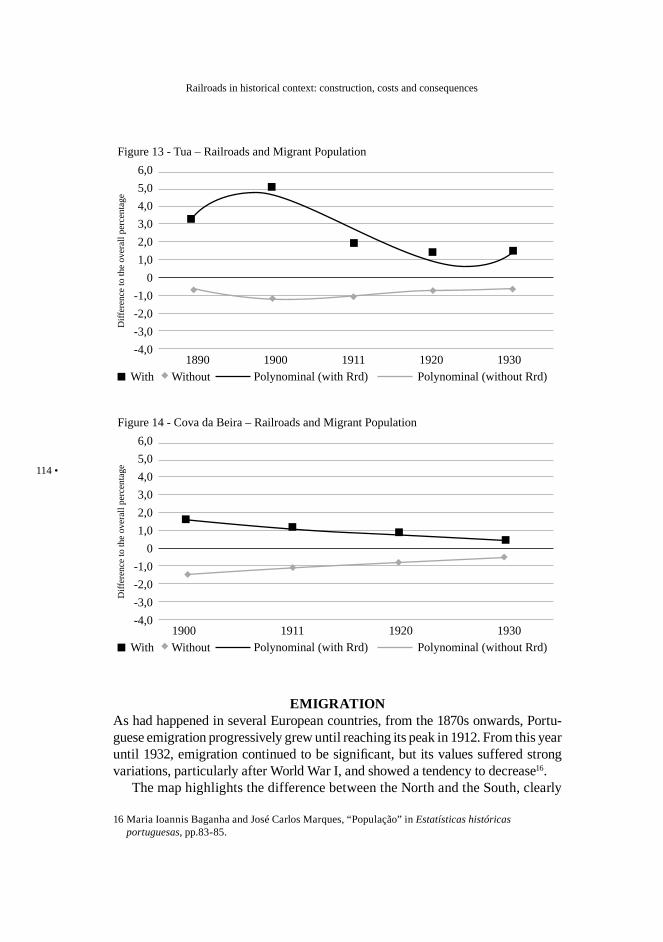
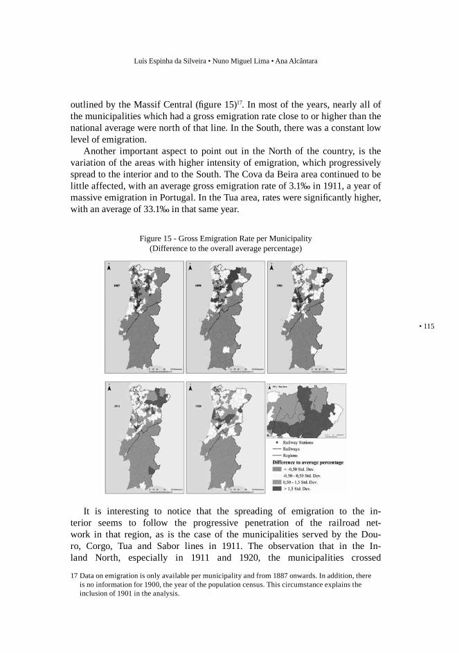
In the Tua area, the weight of migrants in parishes with access to railroad was equally superior to that obtained in parishes without access, particularly until 1911, date when the values were higher than those of the Inland North, (figure 13). The pattern in the Cova da Beira area was similar to that of the In-land North (figure 14).
6,05,04,03,02,01,0
0-1,0-2,0-3,0-4,0
Figure 12 - Inland North – Railroads and Migrant Population
Diff
eren
ce to
the
over
all p
erce
ntag
e
1890With Polynominal (without Rrd)Without
1900 1911 1920 1930Polynominal (with Rrd)
Railroads in historical context: construction, costs and consequences
114 •
EMIGRATIONAs had happened in several European countries, from the 1870s onwards, Portu-guese emigration progressively grew until reaching its peak in 1912. From this year until 1932, emigration continued to be significant, but its values suffered strong variations, particularly after World War I, and showed a tendency to decrease16.
The map highlights the difference between the North and the South, clearly
16 Maria Ioannis Baganha and José Carlos Marques, “População” in Estatísticas históricas portuguesas, pp.83-85.
6,05,04,03,02,01,0
0-1,0-2,0-3,0-4,0
Figure 13 - Tua – Railroads and Migrant Population
Diff
eren
ce to
the
over
all p
erce
ntag
e
1890With Polynominal (without Rrd)Without
1900 1911 1920 1930Polynominal (with Rrd)
6,05,04,03,02,01,0
0-1,0-2,0-3,0-4,0
Figure 14 - Cova da Beira – Railroads and Migrant Population
Diff
eren
ce to
the
over
all p
erce
ntag
e
With Polynominal (without Rrd)Without1900 1911 1920 1930
Polynominal (with Rrd)
Luís Espinha da Silveira • Nuno Miguel Lima • Ana Alcântara
• 115
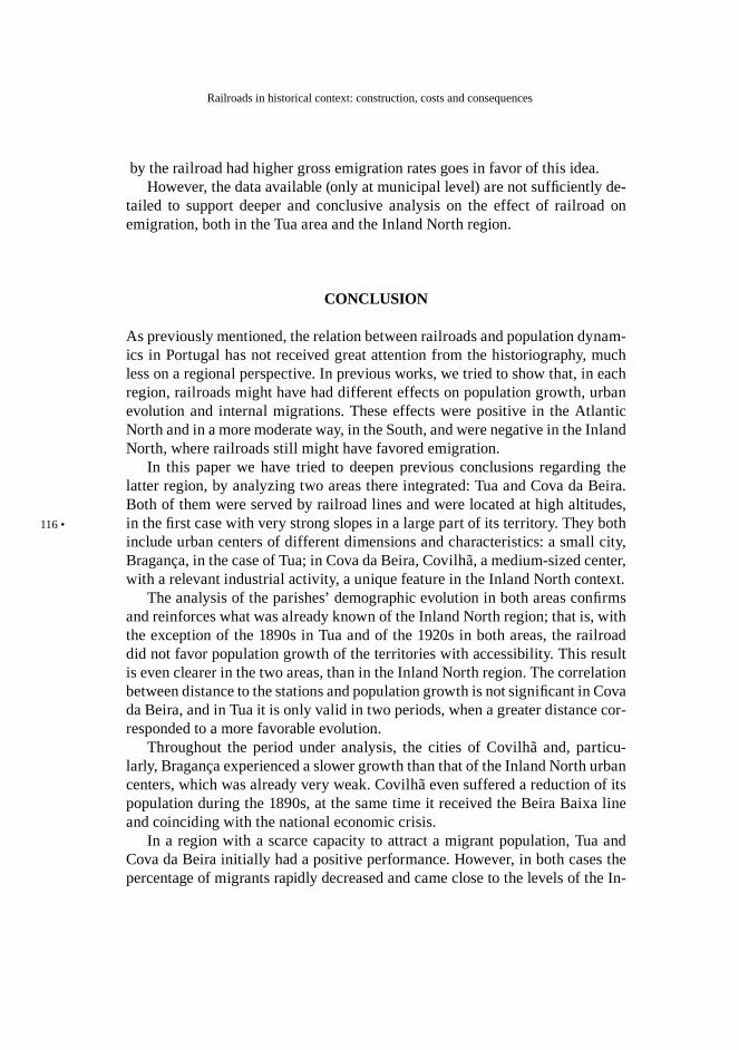
outlined by the Massif Central (figure 15)17. In most of the years, nearly all of the municipalities which had a gross emigration rate close to or higher than the national average were north of that line. In the South, there was a constant low level of emigration.
Another important aspect to point out in the North of the country, is the variation of the areas with higher intensity of emigration, which progressively spread to the interior and to the South. The Cova da Beira area continued to be little affected, with an average gross emigration rate of 3.1‰ in 1911, a year of massive emigration in Portugal. In the Tua area, rates were significantly higher, with an average of 33.1‰ in that same year.
It is interesting to notice that the spreading of emigration to the in-terior seems to follow the progressive penetration of the railroad net-work in that region, as is the case of the municipalities served by the Dou-ro, Corgo, Tua and Sabor lines in 1911. The observation that in the In-land North, especially in 1911 and 1920, the municipalities crossed
17 Data on emigration is only available per municipality and from 1887 onwards. In addition, there is no information for 1900, the year of the population census. This circumstance explains the inclusion of 1901 in the analysis.
Figure 15 - Gross Emigration Rate per Municipality(Difference to the overall average percentage)
Railroads in historical context: construction, costs and consequences
116 •
by the railroad had higher gross emigration rates goes in favor of this idea.However, the data available (only at municipal level) are not sufficiently de-
tailed to support deeper and conclusive analysis on the effect of railroad on emigration, both in the Tua area and the Inland North region.
CONCLUSION
As previously mentioned, the relation between railroads and population dynam-ics in Portugal has not received great attention from the historiography, much less on a regional perspective. In previous works, we tried to show that, in each region, railroads might have had different effects on population growth, urban evolution and internal migrations. These effects were positive in the Atlantic North and in a more moderate way, in the South, and were negative in the Inland North, where railroads still might have favored emigration.
In this paper we have tried to deepen previous conclusions regarding the latter region, by analyzing two areas there integrated: Tua and Cova da Beira. Both of them were served by railroad lines and were located at high altitudes, in the first case with very strong slopes in a large part of its territory. They both include urban centers of different dimensions and characteristics: a small city, Bragança, in the case of Tua; in Cova da Beira, Covilhã, a medium-sized center, with a relevant industrial activity, a unique feature in the Inland North context.
The analysis of the parishes’ demographic evolution in both areas confirms and reinforces what was already known of the Inland North region; that is, with the exception of the 1890s in Tua and of the 1920s in both areas, the railroad did not favor population growth of the territories with accessibility. This result is even clearer in the two areas, than in the Inland North region. The correlation between distance to the stations and population growth is not significant in Cova da Beira, and in Tua it is only valid in two periods, when a greater distance cor-responded to a more favorable evolution.
Throughout the period under analysis, the cities of Covilhã and, particu-larly, Bragança experienced a slower growth than that of the Inland North urban centers, which was already very weak. Covilhã even suffered a reduction of its population during the 1890s, at the same time it received the Beira Baixa line and coinciding with the national economic crisis.
In a region with a scarce capacity to attract a migrant population, Tua and Cova da Beira initially had a positive performance. However, in both cases the percentage of migrants rapidly decreased and came close to the levels of the In-
Luís Espinha da Silveira • Nuno Miguel Lima • Ana Alcântara
• 117
land North. In this region, the railroad slightly favored the attraction of migrants to accessible areas. This idea also applies to Cova da Beira. Until 1911, parishes with accessibilty in Tua showed a greater attractiveness. Before gaining access to the railroad network, migrant population in the city of Covilhã represented an important share of the migrants in the Cova da Beira area (52%), but the reduc-tion from 1890 onwards was drastic.
By the end of the nineteenth century, several parts of the North of Portugal were deeply affected by emigration. The Tua area was among them, contrarily to Cova da Beira. Although in certain cases the visual examination of the maps may suggest an association between emigration and railroad expansion, which is equally suggested by the limited statistical information, the data have very little detail to allow a deeper and more conclusive analysis.
RAILROADSIN HISTORICALCONTEXT: Jeremy Atack (Vanderbilt University) and Robert A. Margo (Boston University) (USA) X Marta Felis-Rota (Universidad Autonoma de Madrid), Jordi Henneberg and Laia Mojica (Universidade de Lleida) (Spain) X Ian Kerr, University of Manitoba (Canada) X Dominc Fontana, Portsmouth University (USA) X Richard Healey and Michael Jones, University of Portsmouth (UK) X Robert Schwartz, Mount Holyoke College (USA) X Michel Cotte, University of Nantes (France) X Stefano Maggi, University of Siena (Italy) X Guenter Dinholb, ÖBB-Infrastruktur AG, Austria X Anne McCants, MIT (USA) X Ellan Shapiro, MIT (USA) X J. Costa Leite, University of Aveiro (Portugal) X Hugo Silveira Pereira, University of Porto (Portugal) X M. Otilia Lage, CITCEM, University of Porto (Portugal) X Luis Santos, Universidad Complutense, Madrid (Spain) X Mª Fernanda Alegria, Centro de Estudos Geográficos da Universidade de Lisboa (Portugal) X Álvaro Ferreira da Silva, Nova School of Business and Economics, U. Nova de Lisboa (Portugal) X Luís Espinha da Silveira, Nuno Miguel Lima e Ana Alcântara, U. Nova de Lisboa (Portugal) X José Manuel Lopes Cordeiro, Department of History, U. Minho (Portugal) X Paulo Lourenço, School of Engineering, University of Minho (Portugal) X Eduardo Beira, School of Engineering, University of Minho (Portugal) X M. Roe Smith (MIT, USA)